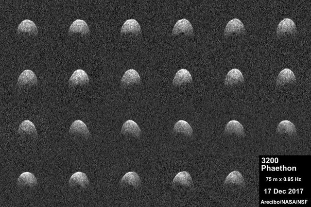
These radar images of near-Earth asteroid 3200 Phaethon were generated by astronomers at the National Science Foundation's Arecibo Observatory on Dec. 17, 2017. Observations of Phaethon were conducted at Arecibo from Dec.15 through 19, 2017. At time of closest approach on Dec. 16 at 3 p.m. PST (6 p.m. EST, 11 p.m. UTC) the asteroid was about 6.4 million miles (10.3 million kilometers) away, or about 27 times the distance from Earth to the moon. The encounter is the closest the object will come to Earth until 2093. An animation is available at https://photojournal.jpl.nasa.gov/catalog/PIA22185
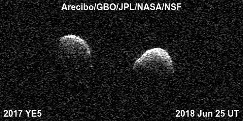
Bi-static radar images of the binary asteroid 2017 YE5 from the Arecibo Observatory and the Green Bank Observatory on June 25. The observations show that the asteroid consists of two separate objects in orbit around each other. A movie is available at https://photojournal.jpl.nasa.gov/catalog/PIA22559
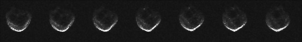
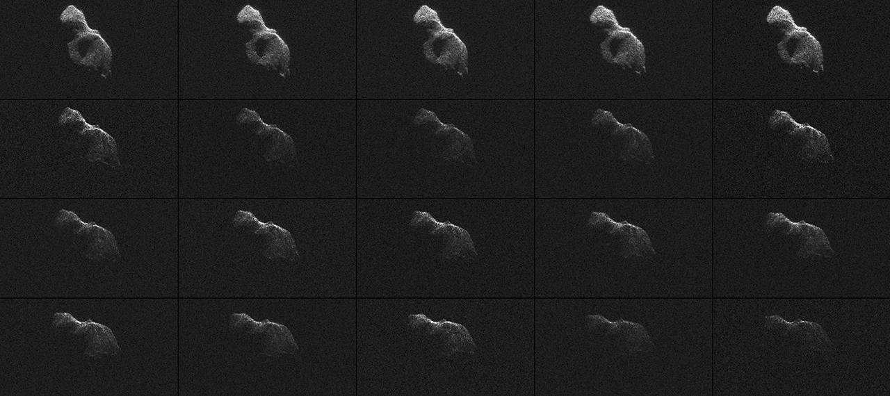
This partial frame from an animation was generated using radar data collected by the National Science Foundation 1,000-foot 305-meter Arecibo Observatory in Puerto Rico.
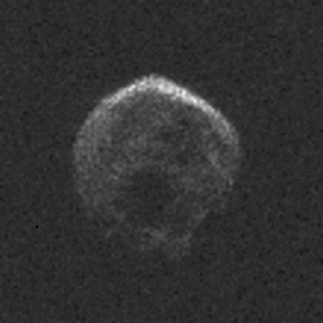
These first radar images of 2015 TB145 from the National Science Foundation 1,000-foot 305-meter Arecibo Observatory in Puerto Rico, indicate the near-Earth object is spherical in shape and approximately 2,000 feet 600 meters in diameter. The radar images were taken on Oct. 30, 2015, and the image resolution is 25 feet (7.5 meters) per pixel. The celestial object is more than likely a dead comet that has shed its volatiles after numerous passes around the sun. http://photojournal.jpl.nasa.gov/catalog/PIA20040

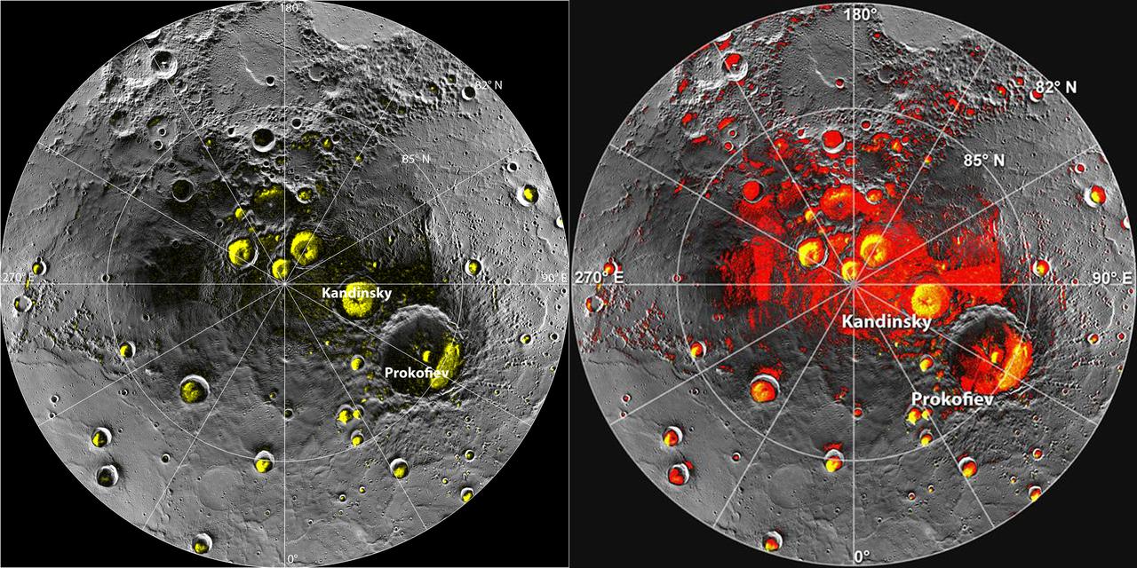
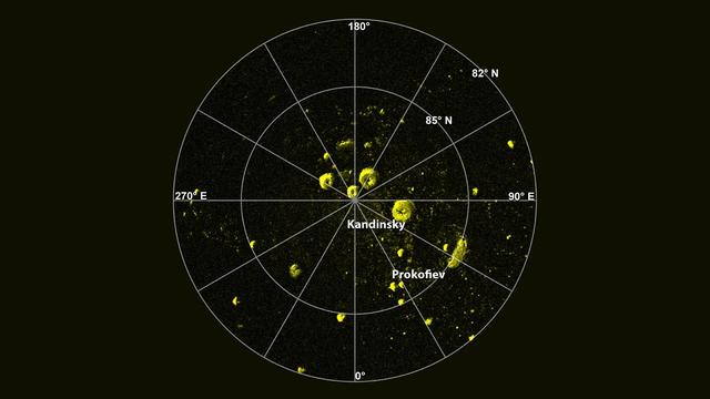
This orthographic projection view from NASA MESSENGER spacecraft provides a look at Mercury north polar region. The yellow regions in many of the craters mark locations that show evidence for water ice, as detected by Earth-based radar observations from Arecibo Observatory in Puerto Rico. MESSENGER has collected compelling new evidence that the deposits are indeed water ice, including imaging within the permanently shaded interiors of some of the craters, such as Prokofiev and Fuller. Instrument: Mercury Dual Imaging System (MDIS) Arecibo Radar Image: In yellow (Harmon et al., 2011, Icarus 211, 37-50) http://photojournal.jpl.nasa.gov/catalog/PIA19411
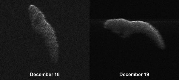
These two radar images of near-Earth asteroid 2003 SD220 were obtained on Dec. 18 and 19 by coordinating observations with the Arecibo Observatory's 1,000-foot (305-meter) antenna in Puerto Rico and the National Science Foundation's (NSF) 330-foot (100-meter) Green Bank Telescope in West Virginia. The radar images reveal the asteroid is at least one mile (1.6 kilometers) long. https://photojournal.jpl.nasa.gov/catalog/PIA22969
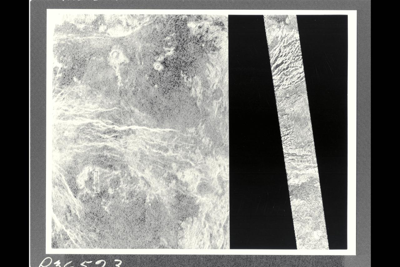
This image shows a comparison between a Magellan image (right) and the highest resolution Earth-based radar image of Venus, obtained by the US National Astronomy and Ionosphere Center's Arecibo Observatory in Puerto Rico. The small white bot in the Arecibo image on the left corresponds to the Magellan image. This portion of a Magellan radar image strip shows a small region on the east flank of a major volcanic upland called Beta Regio. The image is centered a t 23 degrees north latitude and 286.7 degrees east longitude. The ridge and valley network in the middle part of the image is formed by intersecting faults which have broken the Venusian crust into a complex deformed type of surface called tessera, the Latin word for tile. The parallel mountains and valleys resemble the Basin and Range Province kn the western United States. The irregular dark patch near the top of the image is a smooth surface, proboably formed by lava flows in a region about 10 km (6 mi.) across. Similar dark surfaces within the valleys indicate lava flows that are younger than the tessera. The Arecibo image contains probable impact craters, mapped in detail by Magellan. The Magellan image has a resolution of 120 meters, (400 feet). The image segment is 20 km (12.4 mi.) wide adn 150 km (90 mi.) long. The Arecibo image has a resolution of 1-3 km (0.6-1.8 mi.) and is approx. 900 km (550 mi.) across.
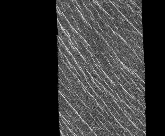
This mosaic shows an area of the Lakshmi region that is located 30 degrees north latitude and 333.3 degrees east longitude. (Longitude on Venus is measured from 0 degrees to 360 degrees east). The area shown measures about 37 kilometers (23 miles) wide and 80 kilometers (50 miles) long. Based on data from the Pioneer Venus Orbiter and the ground-based Arecibo Radar Observatory, it is known that this region is located on the low rise that separates Sedna Planitia and Guinevere Planitia, just to the west of Eistla Regio. Two sets of parallel lineations are seen intersecting almost at right angles. The fainter lineations are spaced at regular intervals of about one kilometer (0.6 mile) and extend beyond the boundary of the image. The width of the faint lineations is at the limit of resolution of the best Magellan images. The brighter, more dominant lineations are less regular and, in places, appear to begin and end where they intersect the fainter lineations. It is not clear whether the two sets of lineations are faults or fractures, but in other Magellan images, these bright lineations are associated with pit craters and volcanic features. This type of terrain has not been seen on Venus nor on other planets. North is at the top of the image. http://photojournal.jpl.nasa.gov/catalog/PIA00085
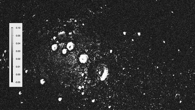
New observations by the MESSENGER spacecraft provide compelling support for the long-held hypothesis that Mercury harbors abundant water ice and other frozen volatile materials in its permanently shadowed polar craters. Three independent lines of evidence support this conclusion: the first measurements of excess hydrogen at Mercury's north pole with MESSENGER's Neutron Spectrometer, the first measurements of the reflectance of Mercury's polar deposits at near-infrared wavelengths with the Mercury Laser Altimeter (MLA), and the first detailed models of the surface and near-surface temperatures of Mercury's north polar regions that utilize the actual topography of Mercury's surface measured by the MLA. These findings are presented in three papers published online today in Science Express. Given its proximity to the Sun, Mercury would seem to be an unlikely place to find ice. But the tilt of Mercury's rotational axis is almost zero — less than one degree — so there are pockets at the planet's poles that never see sunlight. Scientists suggested decades ago that there might be water ice and other frozen volatiles trapped at Mercury's poles. The idea received a boost in 1991, when the Arecibo radio telescope in Puerto Rico detected unusually radar-bright patches at Mercury's poles, spots that reflected radio waves in the way one would expect if there were water ice. Many of these patches corresponded to the location of large impact craters mapped by the Mariner 10 spacecraft in the 1970s. But because Mariner saw less than 50 percent of the planet, planetary scientists lacked a complete diagram of the poles to compare with the images. MESSENGER's arrival at Mercury last year changed that. Images from the spacecraft's Mercury Dual Imaging System taken in 2011 and earlier this year confirmed that radar-bright features at Mercury's north and south poles are within shadowed regions on Mercury's surface, findings that are consistent with the water-ice hypothesis. To read more go to: <a href="http://1.usa.gov/TtNwM2" rel="nofollow">1.usa.gov/TtNwM2</a> Image Credit: NASA/Johns Hopkins University Applied Physics Laboratory/Carnegie Institution of Washington/National Astronomy and Ionosphere Center, Arecibo Observatory <b><a href="http://www.nasa.gov/audience/formedia/features/MP_Photo_Guidelines.html" rel="nofollow">NASA image use policy.</a></b> <b><a href="http://www.nasa.gov/centers/goddard/home/index.html" rel="nofollow">NASA Goddard Space Flight Center</a></b> enables NASA’s mission through four scientific endeavors: Earth Science, Heliophysics, Solar System Exploration, and Astrophysics. Goddard plays a leading role in NASA’s accomplishments by contributing compelling scientific knowledge to advance the Agency’s mission. <b>Follow us on <a href="http://twitter.com/NASA_GoddardPix" rel="nofollow">Twitter</a></b> <b>Like us on <a href="http://www.facebook.com/pages/Greenbelt-MD/NASA-Goddard/395013845897?ref=tsd" rel="nofollow">Facebook</a></b> <b>Find us on <a href="http://instagram.com/nasagoddard?vm=grid" rel="nofollow">Instagram</a></b>
NASA scientists used Earth-based radar to produce these sharp views -- an image montage and a movie sequence -- of the asteroid designated 2014 HQ124 on June 8, 2014.
Radar Image of Mercury North Pole
Radar Love

Radar Bright Deposits in Mercury Polar Craters