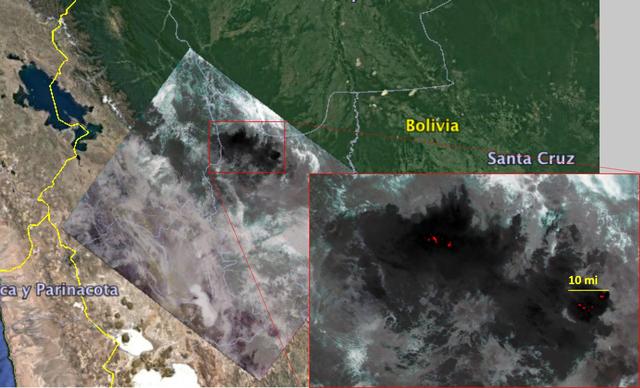
NASA's Ecosystem Spaceborne Thermal Radiometer Experiment on Space Station (ECOSTRESS) captured new imagery of fires in the Amazon regions of Brazil and Bolivia on Aug. 23, 2019. The red areas are where surface temperatures exceeded the maximum measureable temperature of the instrument's sensor (approximately 220 degrees Fahrenheit or 104 degrees Celsius), highlighting the burning areas along the fire fronts. The dark wispy areas indicate thick smoke — thick enough that it obscures much of the fire from view. The measurements cover areas of about 77 by 77 yards (70 by 70 meters) each, or about the size of a football field. https://photojournal.jpl.nasa.gov/catalog/PIA23357
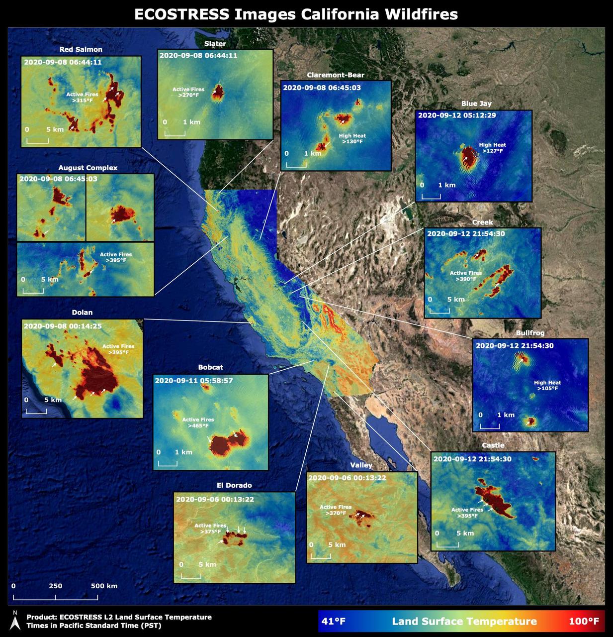
Throughout the month of September 2020, NASA's ECOsystem Spaceborne Thermal Radiometer Experiment on Space Station (ECOSTRESS) imaged multiple wildfires across the state of California. The image above shows the ECOSTRESS land surface temperature of California. Multiple insets highlight a fraction of the multiple fires that have impacted California, with effects seen throughout the U.S. and beyond. The dark red spots show areas of high heat, with arrows pointing out the active fires. The contiguous California image was stitched together from multiple evening (10 p.m.-6 a.m. PDT) ECOSTRESS images from Sept 6 to 12, 2020, to generate a cloud-free statewide map. NASA's Jet Propulsion Laboratory in Southern California built and manages the ECOSTRESS mission for the Earth Science Division in the Science Mission Directorate at NASA Headquarters in Washington. ECOSTRESS is an Earth Venture Instrument mission; the program is managed by NASA's Earth System Science Pathfinder program at NASA's Langley Research Center in Hampton, Virginia. Future studies could use ECOSTRESS data products in a similar fashion as LST was used to assess the fires pictured above. https://photojournal.jpl.nasa.gov/catalog/PIA23721
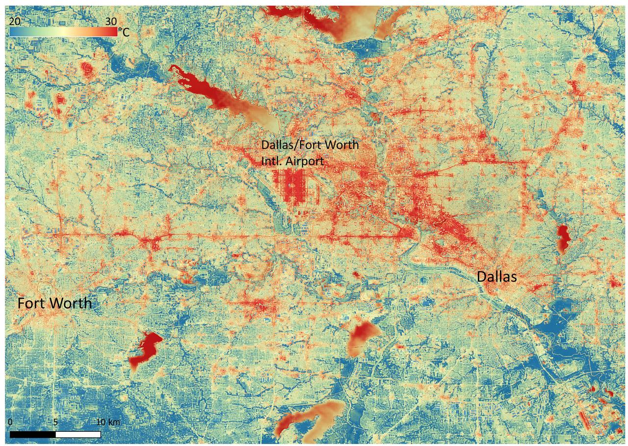
NASA's Ecosystem Spaceborne Thermal Radiometer Experiment on Space Station (ECOSTRESS) instrument recorded this image of ground surface temperatures in Dallas and Fort Worth, Texas, on June 20, 2022, at 7:17 a.m. Central Daylight Time. Even early in the day, manmade urban surfaces near city centers and transportation networks – streets, roads, and highways shown in red and orange – are warmer than the outskirts by up to 18 degrees Fahrenheit (10 degrees Celsius). The paved surfaces at Dallas/Fort Worth International Airport, shown in red near the top-center of the image, had the warmest temperatures, exceeding 86 F (30 C). Natural land surfaces such as vegetation and streams in rural areas, shown in green and blue, are cooler than nearby large bodies of water, shown in red and yellow, that tend to retain more heat overnight due to their higher heat capacity. Cities are usually warmer than open land because of human activities and the materials used in building and construction. Streets are often the hottest part of the built environment due to asphalt paving. Dark-colored surfaces absorb more heat from the Sun than lighter-colored ones; asphalt absorbs up to 95% of solar radiation and retains the heat for hours into the nighttime. ECOSTRESS measures the temperature of the ground, which is hotter than the air temperature during the daytime. The instrument launched to the space station in 2018. Its primary mission is to identify plants' thresholds for water use and water stress, giving insight into their ability to adapt to a warming climate. However, ECOSTRESS is also useful for documenting other heat-related phenomena, like patterns of heat absorption and retention. Its high-resolution images, with a pixel size of about 225 feet (70 meters) by 125 feet (38 meters), are a powerful tool for understanding our environment. https://photojournal.jpl.nasa.gov/catalog/PIA25422
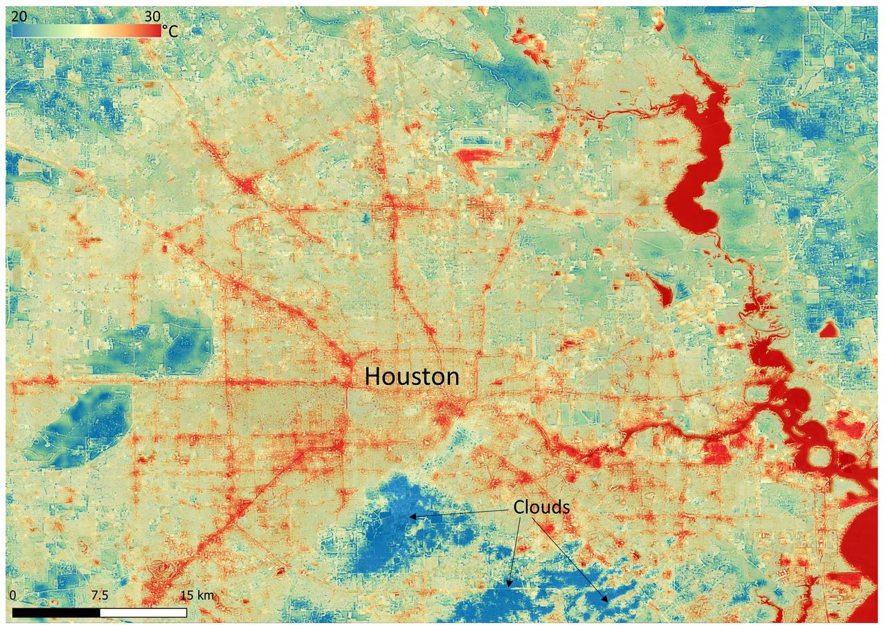
NASA's Ecosystem Spaceborne Thermal Radiometer Experiment on Space Station (ECOSTRESS) instrument recorded this image of ground surface temperatures in Houston and its environs on June 20, 2022, at 6:29 a.m. Central Daylight Time. Even just after sunrise, manmade urban surfaces near the city center and transportation networks – streets, roads, and highways shown in red and orange – were significantly warmer than the outskirts by up to 18 degrees Fahrenheit (10 degrees Celsius). Clouds, which are cool compared with the ground, are shown in blue and labeled in the image. Cities are usually warmer than open land because of human activities and the materials used in building and construction. Streets are often the hottest part of the built environment due to asphalt paving. Dark-colored surfaces absorb more heat from the Sun than lighter-colored ones; asphalt absorbs up to 95% of solar radiation and retains the heat for hours into the nighttime. ECOSTRESS measures the temperature of the ground, which is hotter than the air temperature during the daytime. The instrument launched to the space station in 2018. Its primary mission is to identify plants' thresholds for water use and water stress, giving insight into their ability to adapt to a warming climate. However, ECOSTRESS is also useful for documenting other heat-related phenomena, like patterns of heat absorption and retention. Its high-resolution images, with a pixel size of about 225 feet (70 meters) by 125 feet (38 meters), are a powerful tool for understanding our environment. https://photojournal.jpl.nasa.gov/catalog/PIA25421
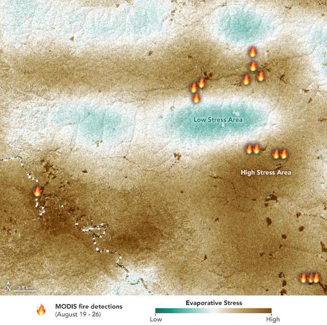
NASA's ECOsystem Spaceborne Thermal Radiometer Experiment on Space Station (ECOSTRESS) sensor measured the water-stress levels of plants when it passed over the Peruvian Amazon rainforest on Aug. 7, 2019, before the fires there began. The map shows areas of plants in distress (brown) and areas of less stress (blue). Water-stressed plants released measurably less water vapor into the air at the time of the summer fires. The fire icons represent fires imaged by NASA's Terra satellite between Aug. 19 and 26. The burn pattern reveals that the fires were concentrated in areas of highly water-stressed plants, pointing to how water-stressed plants can impact the spread of fires. The data may one day help NASA's Earth-observing missions predict the path of future forest or brush fires. https://photojournal.jpl.nasa.gov/catalog/PIA23432
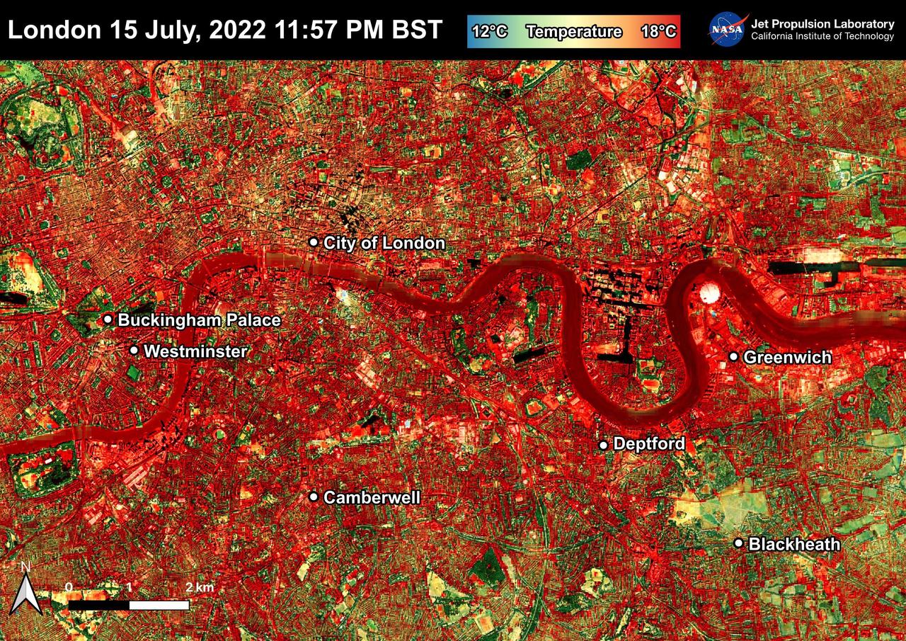
NASA's Ecosystem Spaceborne Thermal Radiometer Experiment on Space Station (ECOSTRESS) instrument recorded this image of ground surface temperatures in London and surrounding areas on July 15, 2022, just before midnight local time. It shows surface temperatures exceeding 68 degrees Fahrenheit (20 degrees Celsius) at 11:57 p.m. British Summer Time. Parts of Europe in mid-July experienced a record-breaking heat wave. The United Kingdom reaching its highest air temperature on record on July 19, 104.5 F (40.3 C) in Coningsby, about 110 miles (177 kilometers) north of London, which itself saw a high of 104.3 F (40.2 C) the same day. That evening, the overnight low was also a record-breaker: 78.4 F (25.8 C) at Kenley Airfield in Greater London. In this image, the red areas indicate hotter temperatures commonly associated with developed areas. These surfaces – roofs, paved streets, and other built structures – remain warm long after the sun sets. Blue and green areas indicate cooler areas commonly associated with parks and other natural land surfaces. Because this image was acquired at night, it shows bodies of water being warmer than the land surface. This is because water tends to change temperature more slowly, so its temperature stays elevated long after land surfaces have cooled down. Cities are usually warmer than open land with natural surfaces because of human activities as well as the materials used in building and construction. Streets are often the hottest part of the built environment due to asphalt paving. Dark-colored surfaces absorb more heat from the Sun than lighter-colored ones; asphalt absorbs up to 95% of solar radiation and retains the heat for hours into nighttime. This image overlays ECOSTRESS surface temperature data on a Google satellite map for context. ECOSTRESS measures the temperature of the ground, which is hotter than the air temperature during the daytime. The instrument launched to the space station in 2018. Its primary mission is to identify plants' thresholds for water use and water stress, giving insight into their ability to adapt to a warming climate. However, ECOSTRESS is also useful for documenting other heat-related phenomena, like patterns of heat absorption and retention. Its high-resolution images, with a pixel size of about 225 feet (70 meters) by 125 feet (38 meters), are a powerful tool for understanding our environment. https://photojournal.jpl.nasa.gov/catalog/PIA25423
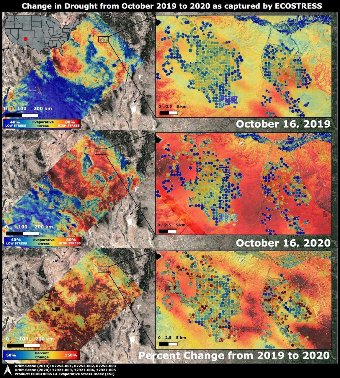
The Western United States has been entrenched in an Extreme and Exceptional drought that has extended from the summer and into the fall of 2020. NASA's ECOsystem Spaceborne Thermal Radiometer Experiment on Space Station (ECOSTRESS) imaged the drought on Oct. 16, 2020, and compared the same area to an image from ECOSTRESS taken a year earlier on Oct. 16, 2019. The bottom image shows the percentage change in plant water stress from 2019 to 2020. The images at left zoom into the Arizona and New Mexico border and Navajo Nation Territory area, featuring the ECOSTRESS Evaporative Stress Index (ESI), which shows plant water stress. The inset images on the right zoom further into the region, showing circular agricultural fields that have been irrigated. Blue colors represent low stress and high water use, whereas red colors represent high stress and low water use. Irrigation is able to alleviate plant water stress in many of the fields while the surrounding landscape suffers from the drought, though numerous agricultural fields are shut down in the drought image. The primary mission of ECOSTRESS, which launched to the International Space Station in June 2018, is to provide insight into plants' health, especially in a drought, by taking their temperature. Plants regulate their temperature by releasing water through tiny pores on their leaves. With sufficient water, they can maintain their temperature. When they lack water, their temperatures rise; ECOSTRESS can measure this change. https://photojournal.jpl.nasa.gov/catalog/PIA24132
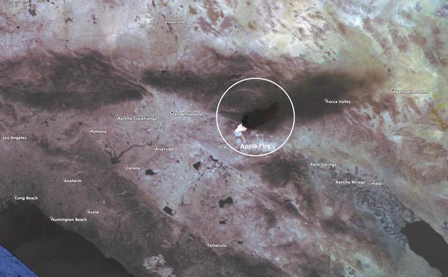
This observation shows the burn area and smoke plume created by the Apple fire in Southern California on Aug. 1, 2020. The observation was made possible by NASA's Ecosystem Spaceborne Thermal Radiometer Experiment on Space Station (ECOSTRESS). Data gathered by the mission can be further refined to measure the temperature of the wildfire, smoke plume and surrounding landscape. ECOSTRESS collected this data when the space station passed over the region at about 1:15 p.m. PST on Saturday, Aug. 1, 2020, when the burn area was approximately 4,000 acres in size. As of Aug. 3, it was more than 26,000 acres. Black smoke can be seen drifting east and over Joshua Tree National Park in the Mojave Desert. With a resolution of about 77 by 77 yards (70 by 70 meters), the image enables surface-temperature conditions down to the size of a football field to be studied. Tasked with detecting plant water use and stress, ECOSTRESS measures the temperature of plants as they heat up when they run out of water. But it can also measure and track heat-related phenomena like fires, heat waves, and volcanoes. https://photojournal.jpl.nasa.gov/catalog/PIA23799
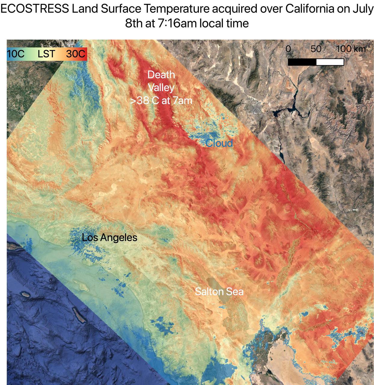
On July 8, NASA's ECOsystem Spaceborne Thermal Radiometer Experiment on Space Station (ECOSTRESS) instrument captured ground surface temperature data over California. In the image, areas in red – including Death Valley – had surpassed 86 degrees Fahrenheit (30 degrees Celsius) by 7:16 a.m. local time, well above average ground surface temperatures for the area. Tasked with detecting plant water use and stress, ECOSTRESS's primary mission is to measure the temperature of plants heating up as they run out of water. But it can also measure and track heat-related phenomena like heat waves, wildfires, and volcanoes. ECOSTRESS observations have a spatial resolution of about 77 by 77 yards (70 by 70 meters), which enables researchers to study surface-temperature conditions down to the size of a football field. Due to the space station's unique orbit, the mission can acquire images of the same regions at different times of the day, as opposed to crossing over each area at the same time of day like satellites in other orbits do. This is advantageous when monitoring plant stress in the same area throughout the day, for example. https://photojournal.jpl.nasa.gov/catalog/PIA23694
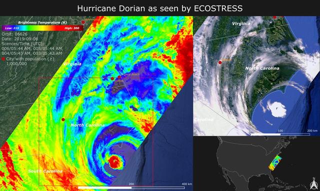
NASA's ECOsystem Spaceborne Thermal Radiometer Experiment on Space Station (ECOSTRESS) imaged the temperature of Hurricane Dorian from the International Space Station on Sept. 6, 2019 as the storm made landfall in North Carolina. ECOSTRESS senses the amount of emitted infrared radiation from Earth, which is converted into an equivalent temperature scale in units of degrees Kelvin. In the image, red colors such as the well-defined eye represent warmer temperatures while purple/blue represent the cooler cloud top temperatures of strong storm clouds with the potential of producing heavy rain. The temperature patterns reveal fine cloud structures that contribute to the formation of the larger hurricane. The width of the image (~400 km) is based on what ECOSTRESS sees as the Space Station flies over any given spot on Earth. ECOSTRESS launched to the space station in June 2018. It can measure variations in temperature to within a few tenths of a degree and is able to detect temperature changes at various times of day over areas as small as a football field. ECOSTRESS' primary mission is to detect plant health from space; however, its measurements can be used to detect other heat-related phenomena — including urban heat, fires, and volcanic activity — as well. Although disaster response is not one of its primary objectives, these highly detailed hurricane temperature estimates can be used to improve weather models. https://photojournal.jpl.nasa.gov/catalog/PIA23422

Data from NASA's ECOSTRESS (Ecosystem Spaceborne Thermal Radiometer Experiment on Space Station) instrument aboard the International Space Station shows three wildfires burning in the mountains east and southeast of the Los Angeles area on Sept. 10, 2024. The Bridge Fire started Sept. 8 in the Angeles National Forest during an intense heat wave that blanketed the area for about a week. As of Sept. 13, the fire was only 3% contained. The Line Fire started Sept. 5 in Highland, within San Bernardino County, and spread toward the mountain communities of Running Springs and Big Bear. After more than a week of battling the blaze, firefighters had the conflagration 21% contained. The Airport Fire ignited Sept. 9 in the foothills of the Santa Ana Mountains east of the Orange County city of Irvine and spread into Riverside County. As of Sept. 13, it was 8% contained. The ECOSTRESS instrument measures the temperature of the land rather than air temperatures that most people are familiar with in weather forecasts. Bright white spots in the active fire areas in the visual above indicate a land surface temperature of over 300 degrees Fahrenheit (149 degrees Celsius). Dark red represents areas closer to 100 F (38 C). https://photojournal.jpl.nasa.gov/catalog/PIA26187
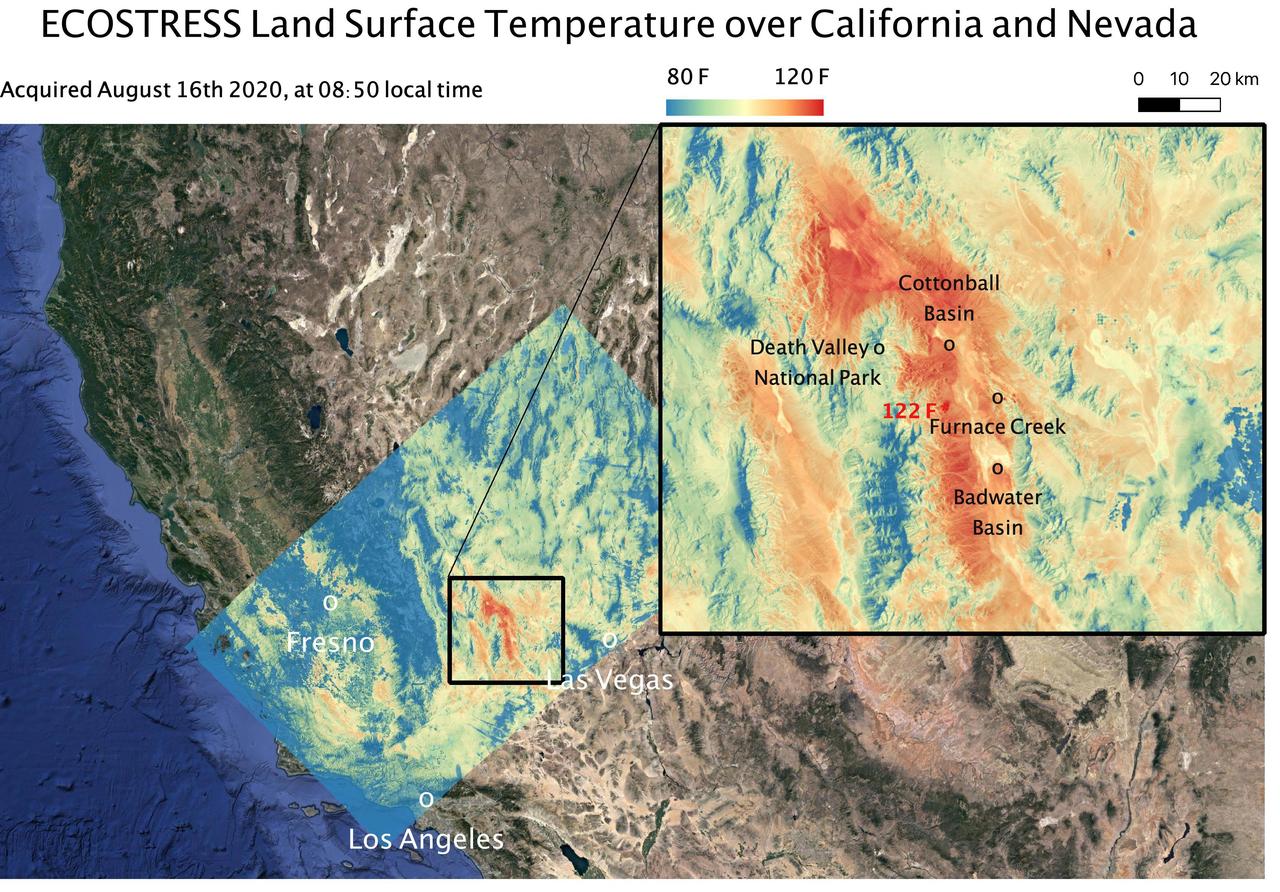
This temperature map shows the land surface temperatures around Death Valley in California's Mojave Desert on Aug. 16, 2020. The observation was made possible by NASA's Ecosystem Spaceborne Thermal Radiometer Experiment on Space Station (ECOSTRESS), which measured a peak land surface temperature of 122.52 degrees Fahrenheit (50.29 degrees Celsius) near Furnace Creek. ECOSTRESS collected this data when the space station passed over California at about 8:50 a.m. PDT (11:50 a.m. EDT) during a record-breaking heat wave that gripped the region. With a resolution of about 77 by 77 yards (70 by 70 meters), the image enables the study of surface-temperature conditions down to the size of a football field. The hottest temperatures are shown in dark red, with the coolest temperatures in blue. ECOSTRESS measures the temperature of plants as they heat up when they run out of water. But it can also measure and track heat-related phenomena like heat waves, fires, and volcanoes. https://photojournal.jpl.nasa.gov/catalog/PIA23787

NASA's ECOsystem Spaceborne Thermal Radiometer Experiment on Space Station (ECOSTRESS) has imaged a temperature profile of an area surrounding a fire-induced tornado in Loyalton, California. A 20,000-acre wildfire early on Saturday, Aug. 15, 2020, had been the source of the tornado. Fire tornados are rare occurrences and happen due to the most unfavorable weather conditions: harsh winds and a surge in heat from a fire. They have the potential to be highly dangerous, leading to many areas to issue a weather alert to their residents to stay cautious and find places of shelter. In this map, there is a concentrated area of high temperature, which is likely where the fire-induced tornado had taken place. Also present in the image are very cold clouds, possibly representing the pyrocumulonimbus cloud that usually forms above a fire tornado. The National Weather Service (NWS) also suggested outflow winds in excess of 60 mph, which points to the event to be an EF1 or EF2 tornado. https://photojournal.jpl.nasa.gov/catalog/PIA23215
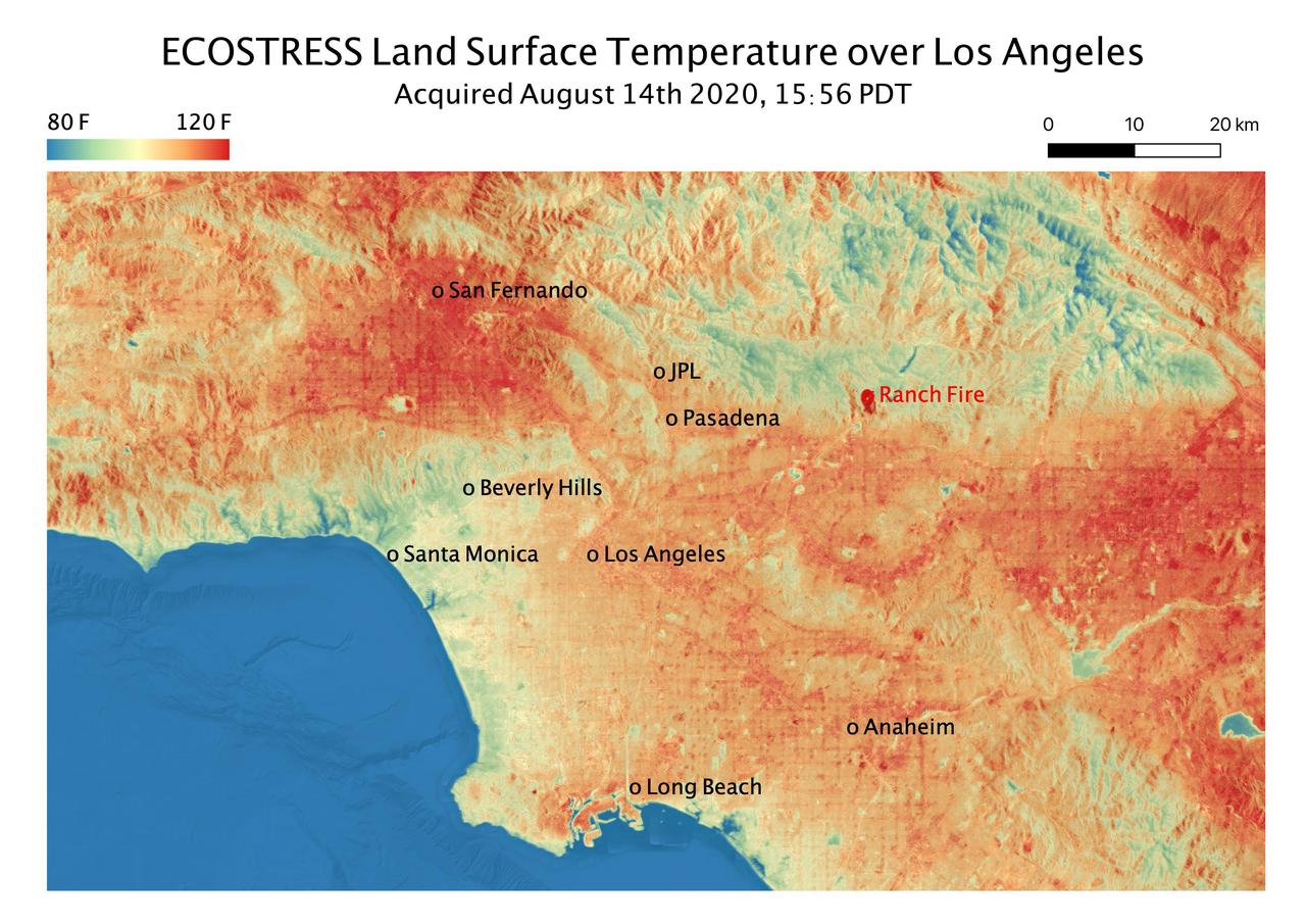
This temperature map shows the land surface temperatures throughout Los Angeles County on Aug. 14, 2020. The observation was made possible by NASA's Ecosystem Spaceborne Thermal Radiometer Experiment on Space Station (ECOSTRESS), which measured a peak land surface temperature in the San Fernando Valley, northwest of downtown Los Angeles, of 128.3 degrees Fahrenheit (53.5 degrees Celsius). ECOSTRESS collected this data as the space station passed over California at about 3:56 p.m. PDT (6:56 p.m. EDT) during a record-breaking heat wave that gripped the region. The Ranch fire, that burned near the city of Azuza was also detected by ECOSTRESS. With a resolution of about 77 by 77 yards (70 by 70 meters), the image enables the study of surface-temperature conditions down to the size of a football field. The hottest temperatures are shown in dark red, with the coolest temperatures in blue. ECOSTRESS measures the temperature of plants as they heat up when they run out of water. But it can also measure and track heat-related phenomena like heat waves, fires, and volcanoes. https://photojournal.jpl.nasa.gov/catalog/PIA23786
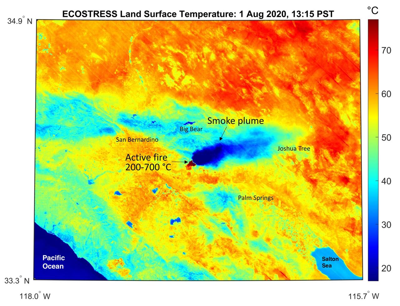
This temperature map shows the stressed and dry vegetation surrounding the Apple fire in Southern California on Aug. 1, 2020. The observation was made possible by NASA's Ecosystem Spaceborne Thermal Radiometer Experiment on Space Station (ECOSTRESS) that measured the temperature of the burn area and tracked the dark smoke plume drifting east from California to Arizona. ECOSTRESS collected this data when the space station passed over the region at about 1:15 p.m. PST on Saturday, Aug. 1, 2020, when the burn area was approximately 4,000 acres in size. Black smoke can be seen drifting east and over Joshua Tree National Park in the Mojave Desert. With a resolution of about 77 by 77 yards (70 by 70 meters), the image enables surface-temperature conditions down to the size of a football field to be studied. In the active burn area, temperatures of between 390-1290 F (200-700 C) were recorded, and in one pixel in the ECOSTRESS image of the burn zone, a peak temperature of 1387 F (753 C) was detected. Tasked with detecting plant water use and stress, ECOSTRESS measures the temperature of plants as they heat up when they run out of water. But it can also measure and track heat-related phenomena like fires, heat waves, and volcanoes. https://photojournal.jpl.nasa.gov/catalog/PIA23798
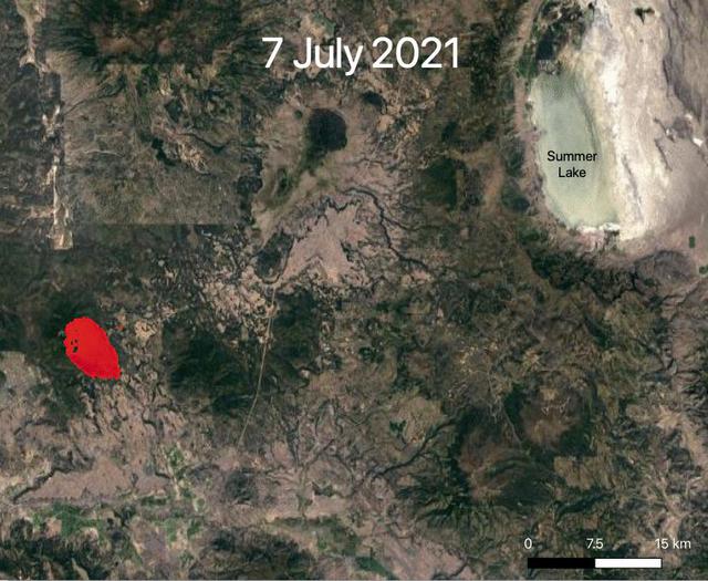
NASA's ECOsystem Spaceborne Thermal Radiometer Experiment on Space Station (ECOSTRESS) is aiding in the fight against fires in the Western U.S. As of July 27, 2021, the Bootleg Fire in southern Oregon had ballooned to more than 410,000 acres, damaging hundreds of buildings and vehicles in its path. ECOSTRESS measures surface temperature from the vantage point of the International Space Station. Researchers of the RADR-Fire team at Pacific Northwest National Laboratory have been experimenting with ECOSTRESS data as part of a new tool now being implemented for first responders like the U.S. Forest Service. In the visualization, ECOSTRESS is tracking the movement of the Bootleg Fire between July 7 and July and identifying its proximity to critical infrastructure — areas in red represent the hottest pixels ECOSTRESS detected. The extreme heat in those areas indicates the fire front, or where resources are most needed. Tasked with detecting plant water use and stress, ECOSTRESS's primary mission is to measure the temperature of plants heating up as they run out of water. But it can also measure and track heat-related phenomena like wildfires, heat waves, and volcanoes. ECOSTRESS observations have a spatial resolution of about 77 by 77 yards (70 by 70 meters), which enables researchers to study surface-temperature conditions down to the size of a football field. Due to the space station's unique orbit, the mission can acquire images of the same regions at different times of the day, as opposed to crossing over each area at the same time of day like satellites in other orbits do. This is advantageous when monitoring plant stress in the same area throughout the day, for example. Movie available at https://photojournal.jpl.nasa.gov/catalog/PIA23695
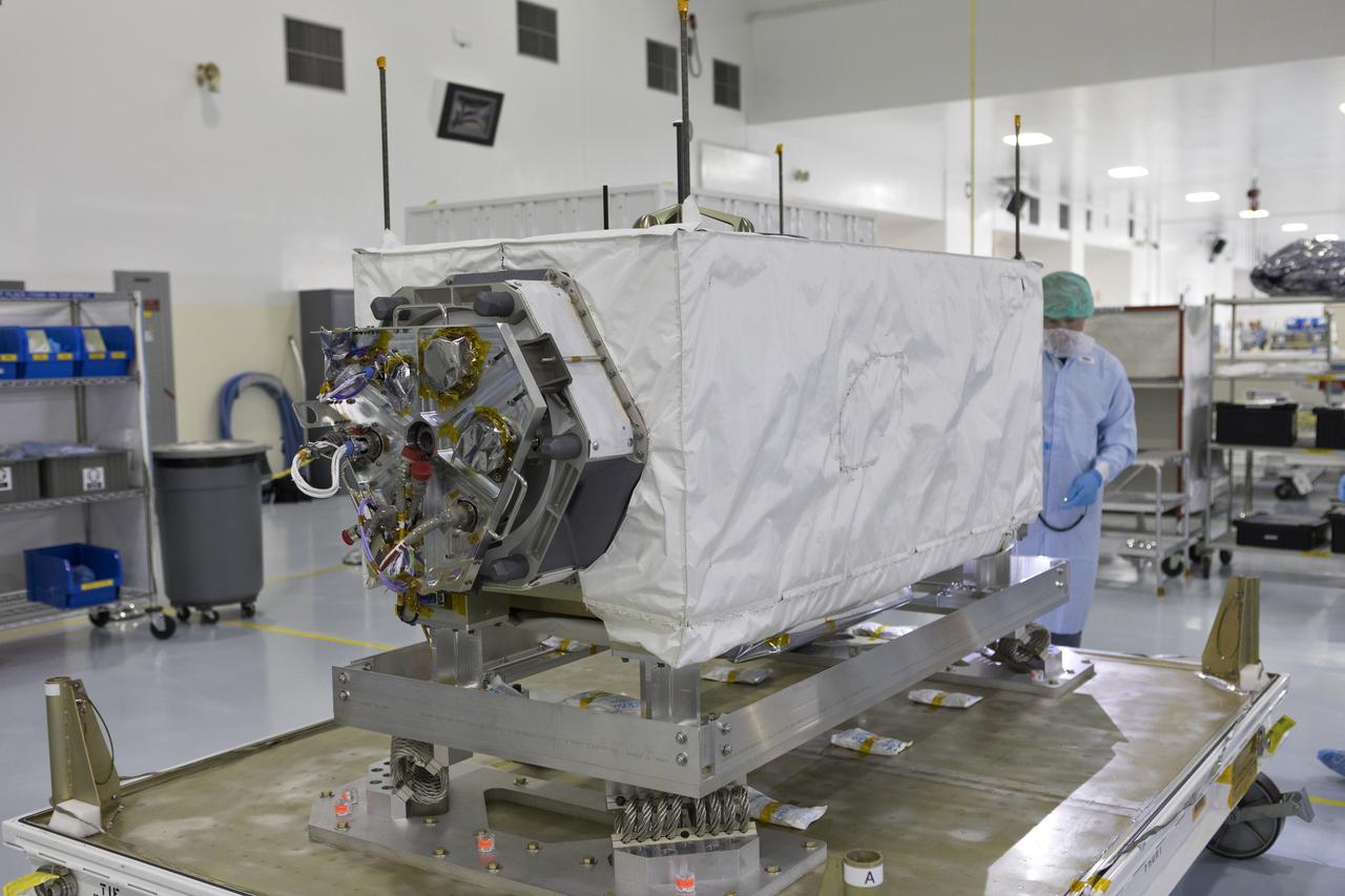
In the Space Station Processing Facility at NASA's Kennedy Space Center in Florida, the ECOsystem Spaceborne Thermal Radiometer Experiment on Space Station (ECOSTRESS) is removed from its shipping container. ECOSTRESS is designed to monitor one of the most basic processes in living plants: the loss of water through the tiny pores in leaves. ECOSTRESS will launch to the International Space Station aboard a Dragon spacecraft launched by a Falcon 9 rocket on the SpaceX CRS-15 mission in June 2018.
In the Space Station Processing Facility at NASA's Kennedy Space Center in Florida, the ECOsystem Spaceborne Thermal Radiometer Experiment on Space Station (ECOSTRESS) has arrived in its shipping container. The container is being inspected and thoroughly cleaned prior to opening. ECOSTRESS is designed to monitor one of the most basic processes in living plants: the loss of water through the tiny pores in leaves. ECOSTRESS will launch to the International Space Station aboard a Dragon spacecraft launched by a Falcon 9 rocket on the SpaceX CRS-15 mission in June 2018.
In the Space Station Processing Facility at NASA's Kennedy Space Center in Florida, the ECOsystem Spaceborne Thermal Radiometer Experiment on Space Station (ECOSTRESS) has arrived in its shipping container. The container is being inspected and thoroughly cleaned prior to opening. ECOSTRESS is designed to monitor one of the most basic processes in living plants: the loss of water through the tiny pores in leaves. ECOSTRESS will launch to the International Space Station aboard a Dragon spacecraft launched by a Falcon 9 rocket on the SpaceX CRS-15 mission in June 2018.
In the Space Station Processing Facility at NASA's Kennedy Space Center in Florida, the ECOsystem Spaceborne Thermal Radiometer Experiment on Space Station (ECOSTRESS) has arrived in its shipping container. The container is being inspected and thoroughly cleaned prior to opening. ECOSTRESS is designed to monitor one of the most basic processes in living plants: the loss of water through the tiny pores in leaves. ECOSTRESS will launch to the International Space Station aboard a Dragon spacecraft launched by a Falcon 9 rocket on the SpaceX CRS-15 mission in June 2018.
In the Space Station Processing Facility at NASA's Kennedy Space Center in Florida, the ECOsystem Spaceborne Thermal Radiometer Experiment on Space Station (ECOSTRESS) is removed from its shipping container. ECOSTRESS is designed to monitor one of the most basic processes in living plants: the loss of water through the tiny pores in leaves. ECOSTRESS will launch to the International Space Station aboard a Dragon spacecraft launched by a Falcon 9 rocket on the SpaceX CRS-15 mission in June 2018.

In the Space Station Processing Facility at NASA's Kennedy Space Center in Florida, the ECOsystem Spaceborne Thermal Radiometer Experiment on Space Station (ECOSTRESS) is inspected shortly after arrival. ECOSTRESS is designed to monitor one of the most basic processes in living plants: the loss of water through the tiny pores in leaves. ECOSTRESS will launch to the International Space Station aboard a Dragon spacecraft launched by a Falcon 9 rocket on the SpaceX CRS-15 mission in June 2018.
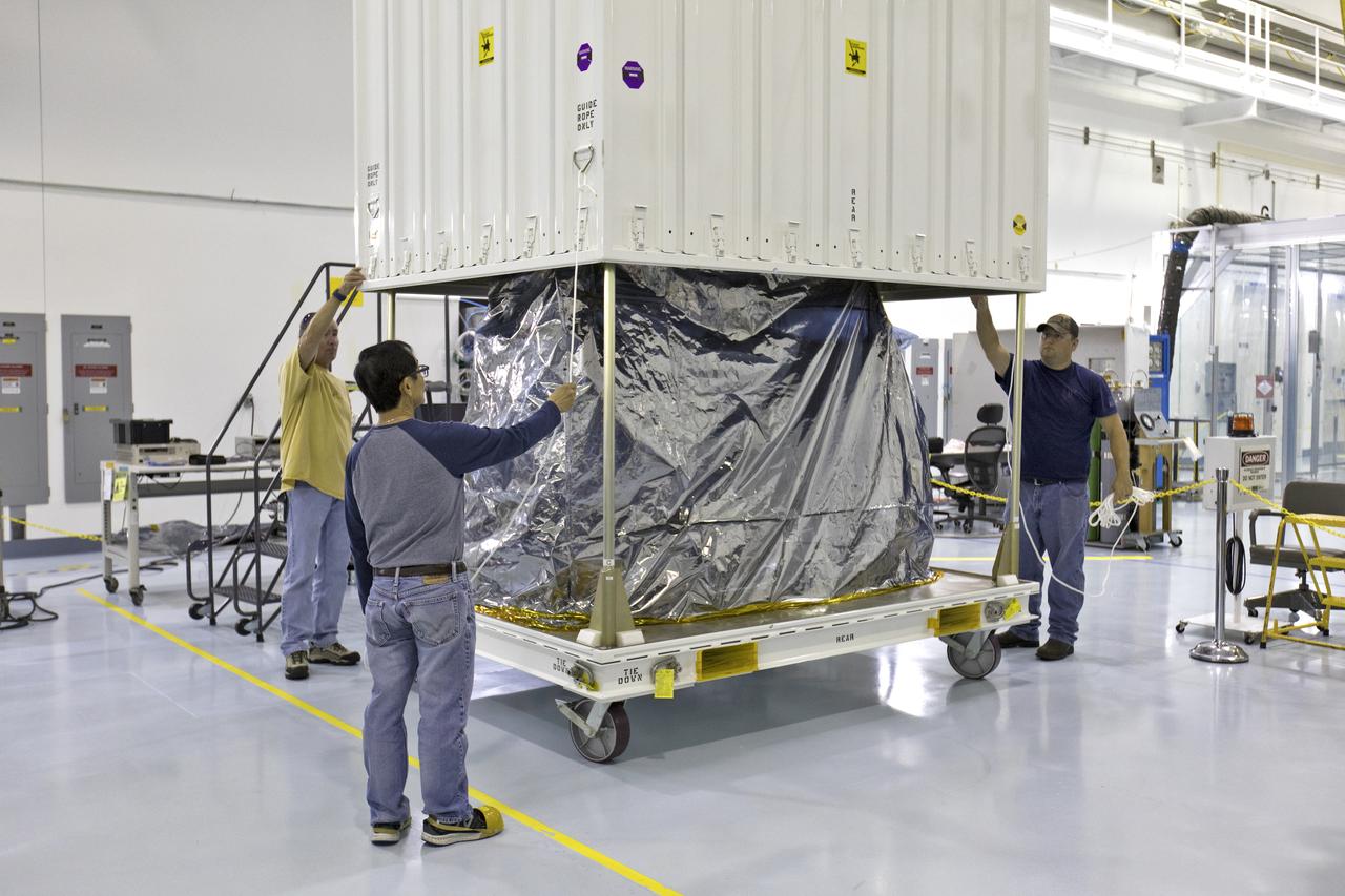
In the Space Station Processing Facility at NASA's Kennedy Space Center in Florida, the ECOsystem Spaceborne Thermal Radiometer Experiment on Space Station (ECOSTRESS) is removed from its shipping container. ECOSTRESS is designed to monitor one of the most basic processes in living plants: the loss of water through the tiny pores in leaves. ECOSTRESS will launch to the International Space Station aboard a Dragon spacecraft launched by a Falcon 9 rocket on the SpaceX CRS-15 mission in June 2018.
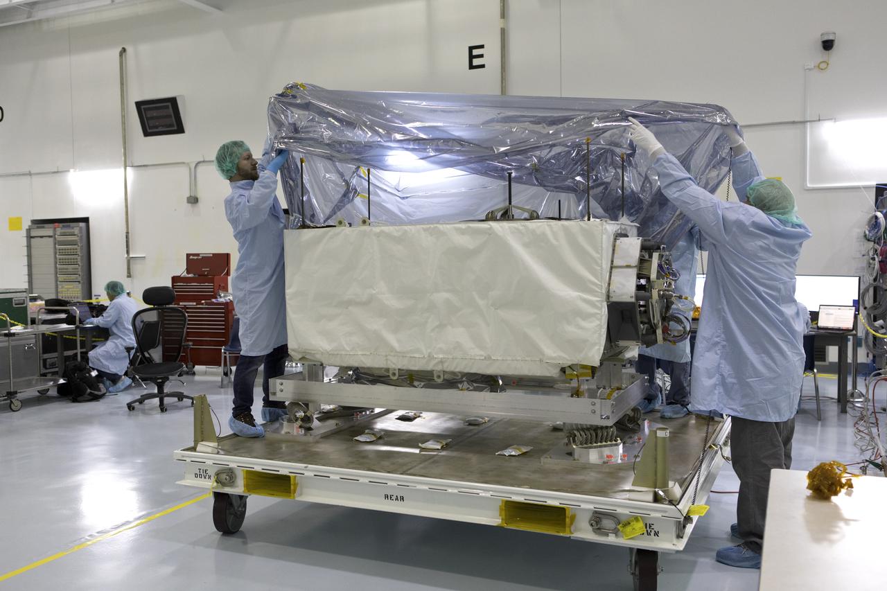
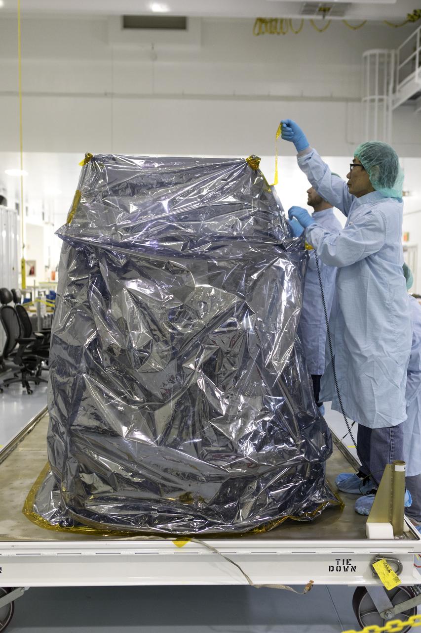
In the Space Station Processing Facility at NASA's Kennedy Space Center in Florida, technicians and engineers removed protective wrapping from the ECOsystem Spaceborne Thermal Radiometer Experiment on Space Station (ECOSTRESS). ECOSTRESS is designed to monitor one of the most basic processes in living plants: the loss of water through the tiny pores in leaves. ECOSTRESS will launch to the International Space Station aboard a Dragon spacecraft launched by a Falcon 9 rocket on the SpaceX CRS-15 mission in June 2018.
In the Space Station Processing Facility at NASA's Kennedy Space Center in Florida, the ECOsystem Spaceborne Thermal Radiometer Experiment on Space Station (ECOSTRESS) is inspected shortly after arrival. ECOSTRESS is designed to monitor one of the most basic processes in living plants: the loss of water through the tiny pores in leaves. ECOSTRESS will launch to the International Space Station aboard a Dragon spacecraft launched by a Falcon 9 rocket on the SpaceX CRS-15 mission in June 2018.
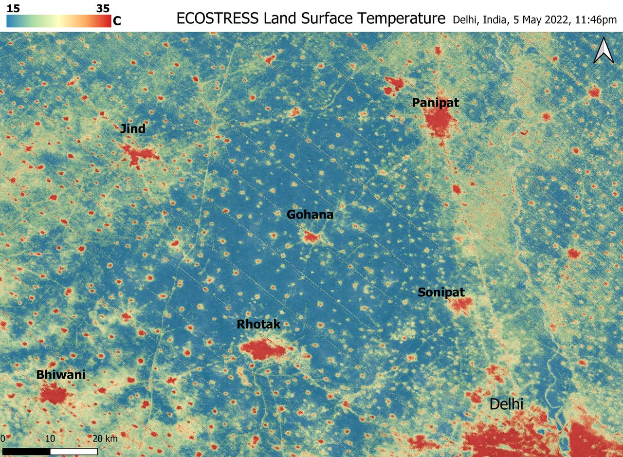
A relentless heat wave has blanketed India and Pakistan since mid-March 2022, causing dozens of deaths, fires, increased air pollution, and reduced crop yields. NASA's Ecosystem Spaceborne Thermal Radiometer Experiment on Space Station instrument (ECOSTRESS) has been measuring these temperatures from space, at the highest spatial resolution of any satellite instrument. This image, taken shortly before local midnight on May 5, shows urban areas and agricultural lands northwest of Delhi that are home to about 28 million people. The image covers about 4,800 square miles (12,350 square kilometers). Cities are usually markedly warmer than the surrounding countryside due to human activities and the materials used in the built environment. The image clearly delineates these urban "heat islands." Nighttime temperatures in Delhi and several smaller villages were above 95 degrees Fahrenheit (35 degrees Celsius), peaking at about 102 degrees F (39 degrees C), while the rural fields nearby had cooled to around 60 degrees F (15 degrees C). This data suggests that city dwellers are experiencing considerably higher temperatures than the average temperatures reported for their regions. ECOSTRESS measures the temperature of the ground itself, which is very similar to air temperature at night (though the ground may be warmer than the air in daylight hours). The instrument launched to the space station in 2018. Its primary mission is to identify plants' thresholds for water use and water stress, giving insight into their ability to adapt to a warming climate. However, ECOSTRESS also records other heat-related phenomena like this heat wave. Its high-resolution images, with a pixel size of about 225 feet (70 meters) by 125 feet (38 meters), are a powerful tool for understanding aspects of the weather event that might be overlooked by traditional observation networks. https://photojournal.jpl.nasa.gov/catalog/PIA24987
The ECOsystem Spaceborne Thermal Radiometer Experiment on Space Station (ECOSTRESS), pictured at the bottom, and the Latching End Effector (LEE), pictured at the top, are integrated into the unpressurized SpaceX Dragon truck June 2, 2018, at the SpaceX facility on Cape Canaveral Air Force Station in Florida. The payloads will be carried to the International Space Station on SpaceX's 15th Commercial Resupply Services mission. ECOSTRESS will measure the temperature of plants and use that information to better understand how much water plants need and how they respond to stress. The Canadian Space Agency is supplying LEE for the Canadarm2 as a spare to replace a failed unit removed by astronauts during a spacewalk in 2017. Each end of the Canadarm2 robotic arm has an identical LEE, which acts like a "hand" to grapple payloads and visiting cargo spaceships.
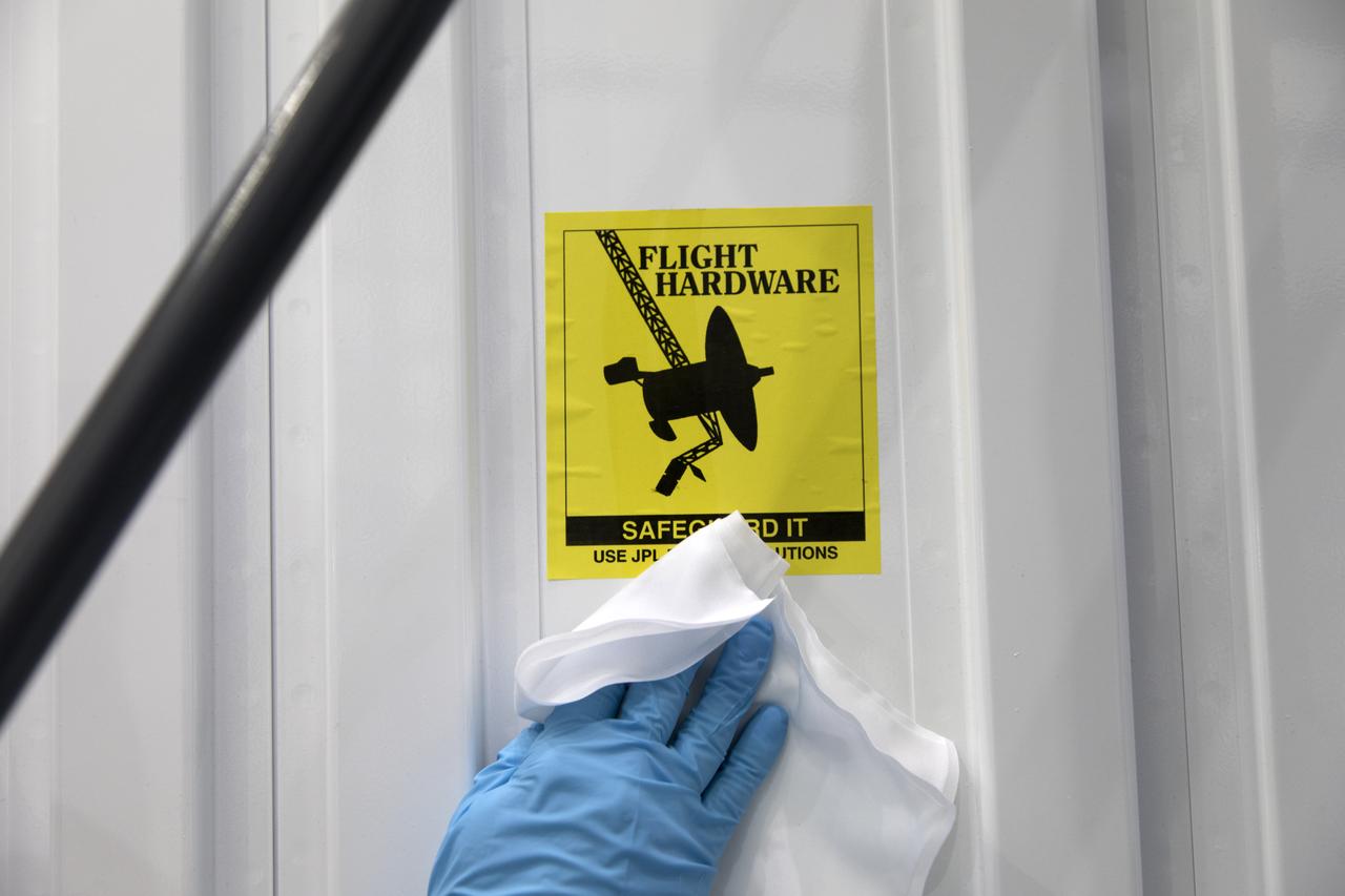
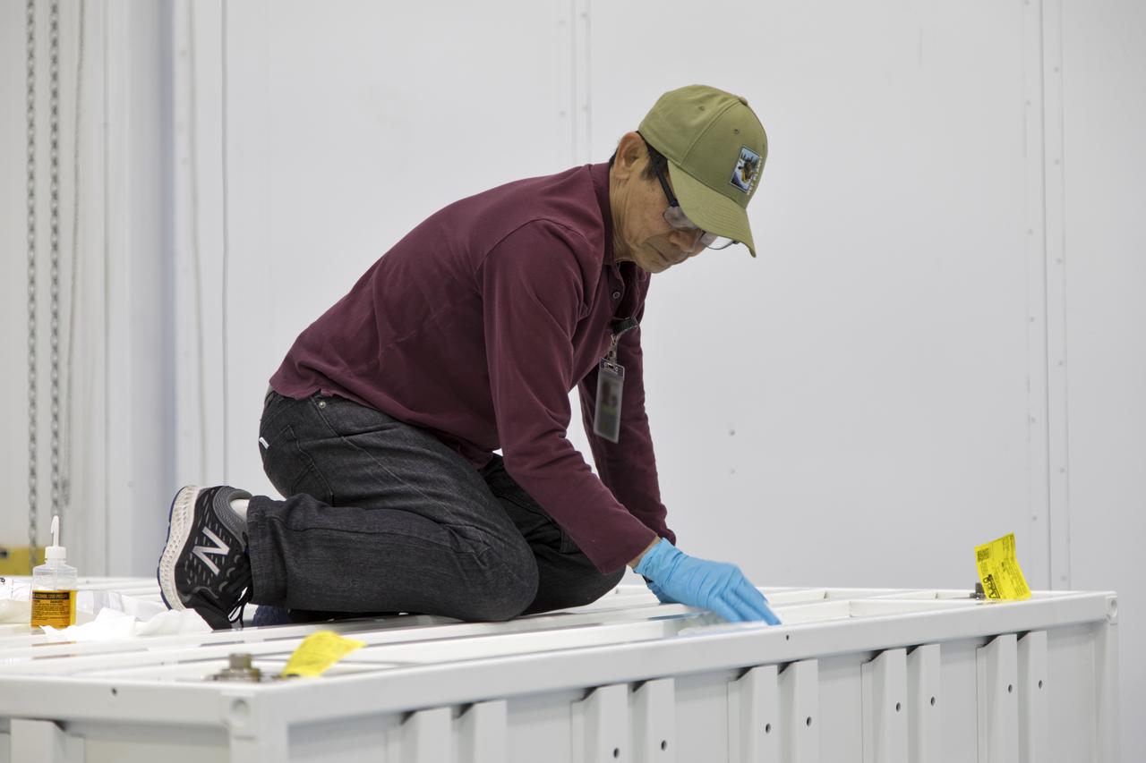
ECOSTRESS Unbagging
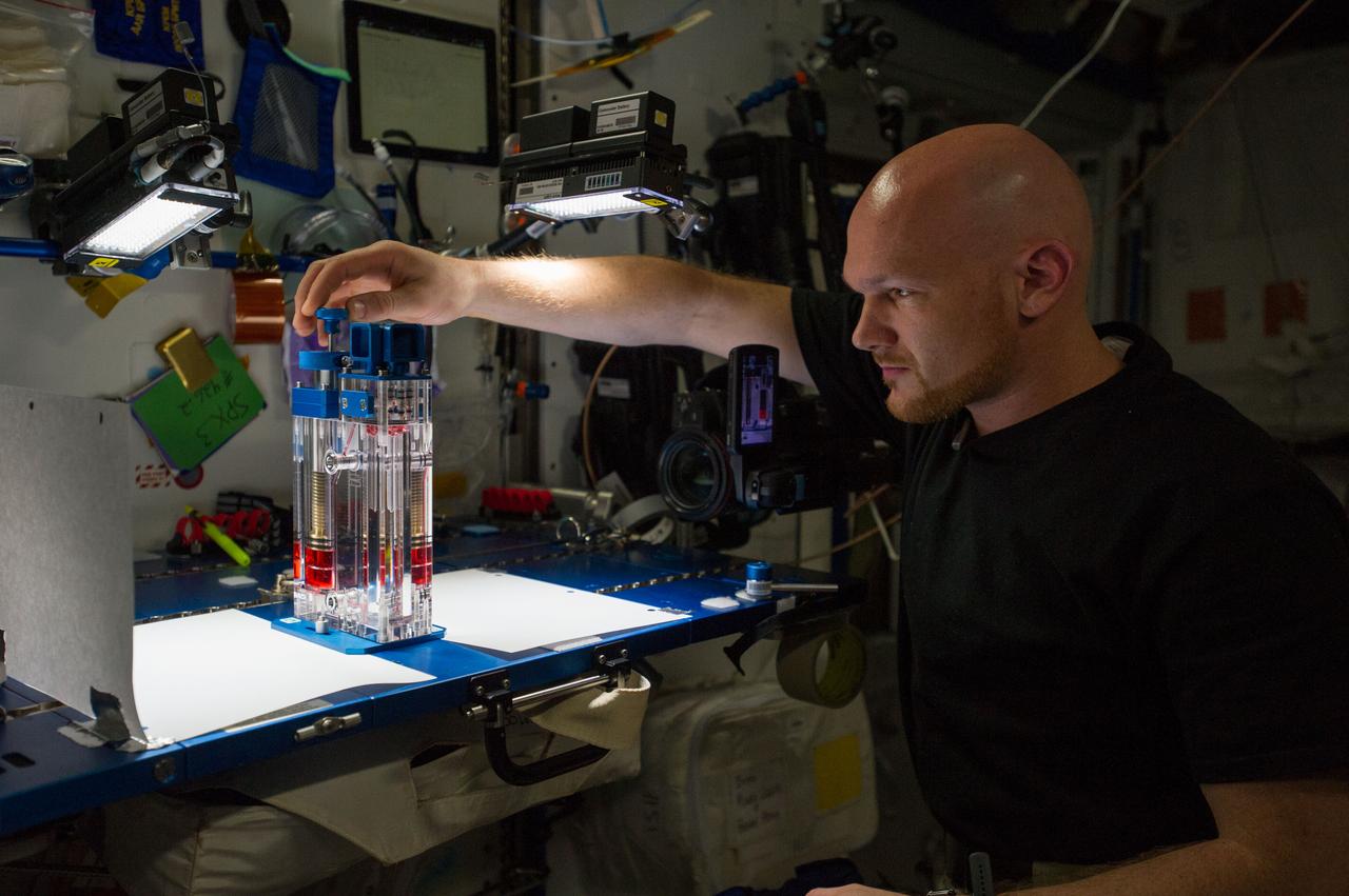
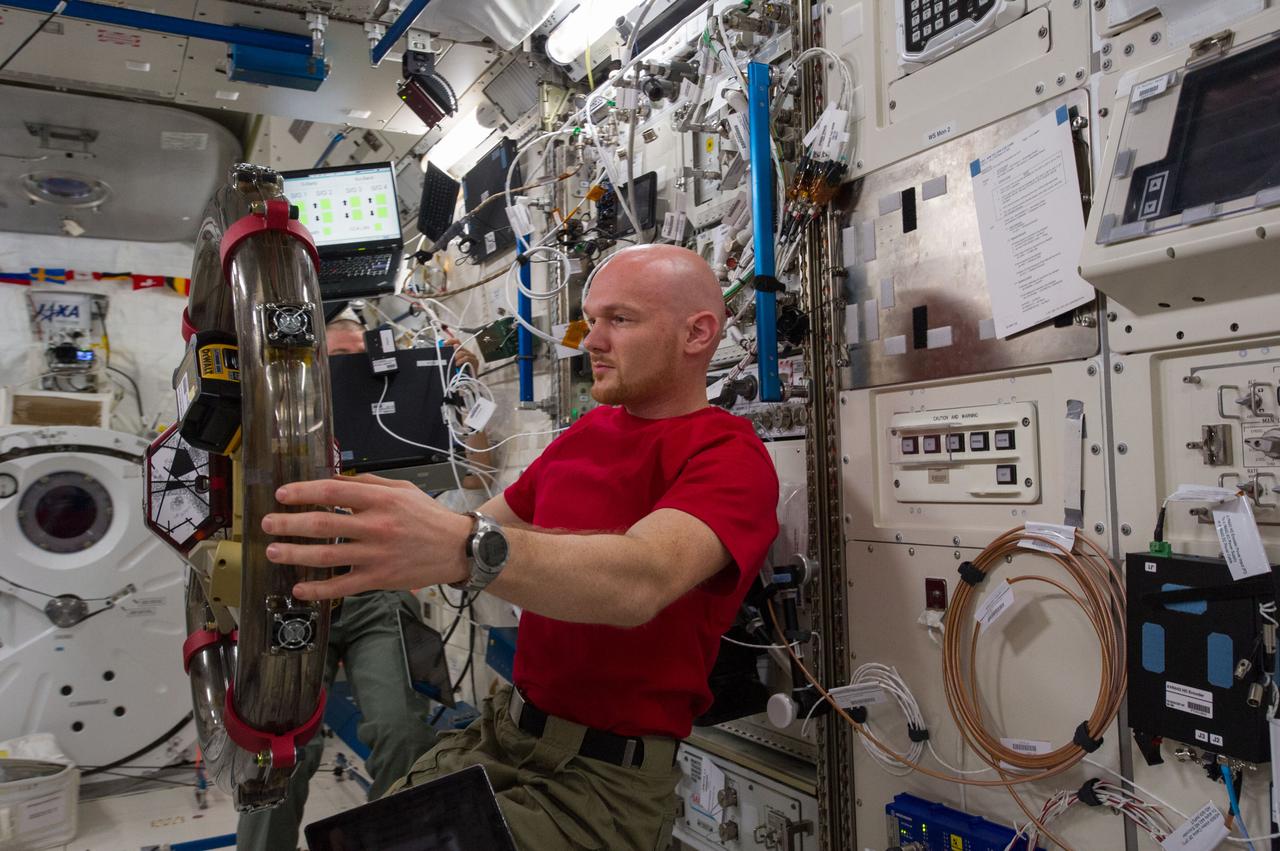
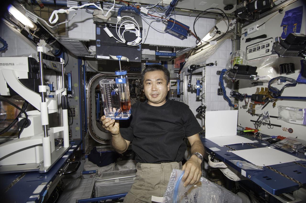
ISS040-E-015543 (19 June 2014) --- European Space Agency astronaut Alexander Gerst, Expedition 40 flight engineer, conducts a session with the Capillary Flow Experiment (CFE-2) in the Harmony node of the International Space Station. CFE is a suite of fluid physics experiments that investigate how fluids behave in microgravity which could benefit water and fuel delivery systems on future spacecraft. Scientists designed the CFE-2 to study properties of fluids and bubbles inside containers with a specific 3-D geometry.
ISS040-E-139549 (9 Sept. 2014) --- In the International Space Station’s Kibo laboratory, NASA astronaut Reid Wiseman, Expedition 40 crew member, works with the bowling ball-sized satellites known as SPHERES (Synchronized Position Hold Engage Reorient Experimental Satellites) to study how liquids behave inside containers in microgravity. The experiment, named SPHERES-Slosh, maneuvers the tiny satellites similar to an actual spacecraft with an externally mounted tank and observes the interaction between the sloshing fluid and the tank/vehicle dynamics.
ISS040-E-023287 (27 June 2014) --- This is a close-up image photographed during a run of the Burning and Suppression of Solids (BASS) experiment onboard the Earth-orbiting International Space Station. Following a series of preparations, NASA astronaut Reid Wiseman (out of frame), Expedition 40 flight engineer, conducted runs of the experiment, which examines the burning and extinction characteristics of a wide variety of fuel samples in microgravity. The experiment is planned for guiding strategies for extinguishing fires in microgravity. BASS results contribute to the combustion computational models used in the design of fire detection and suppression systems in microgravity and on Earth.
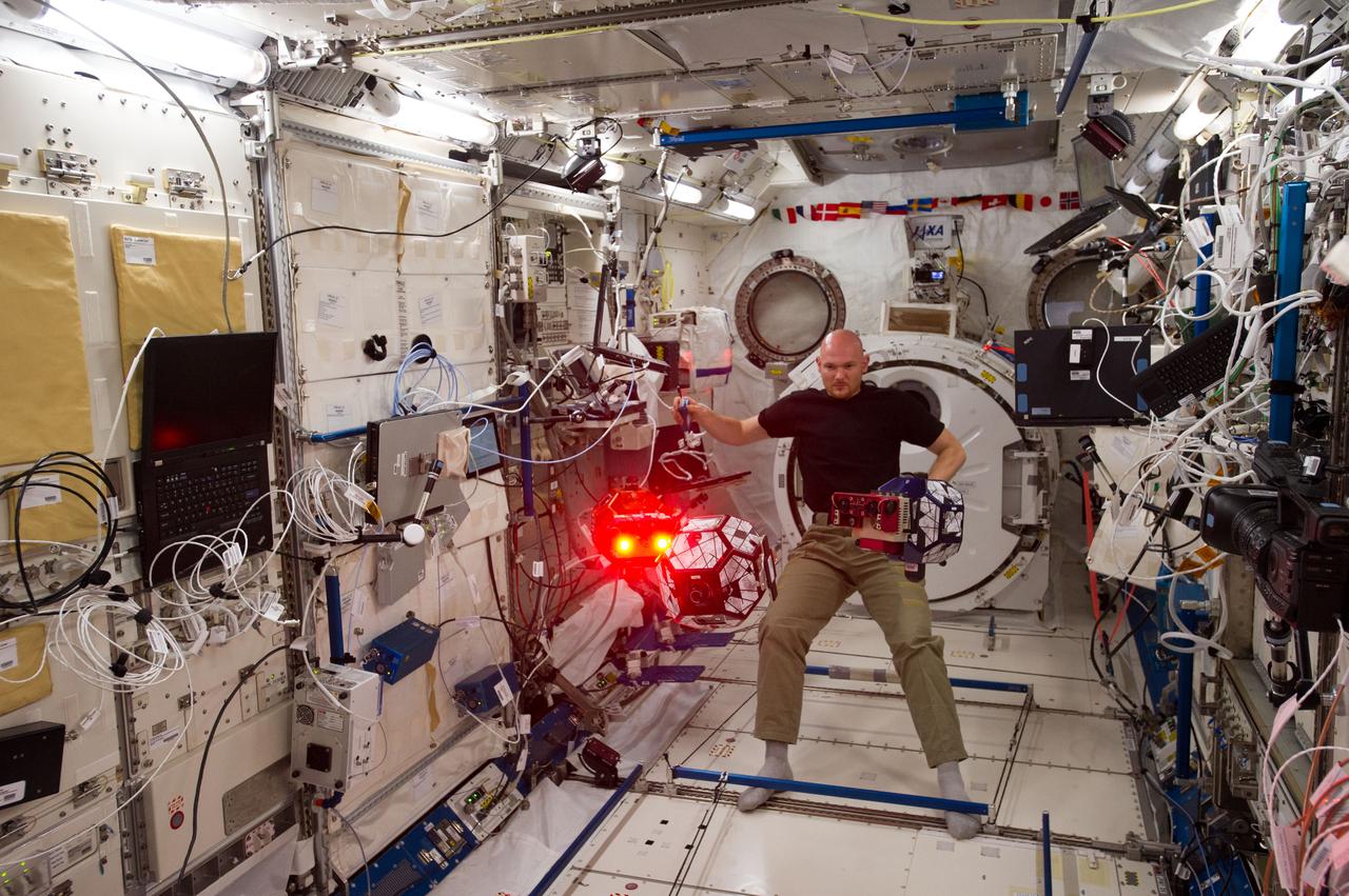
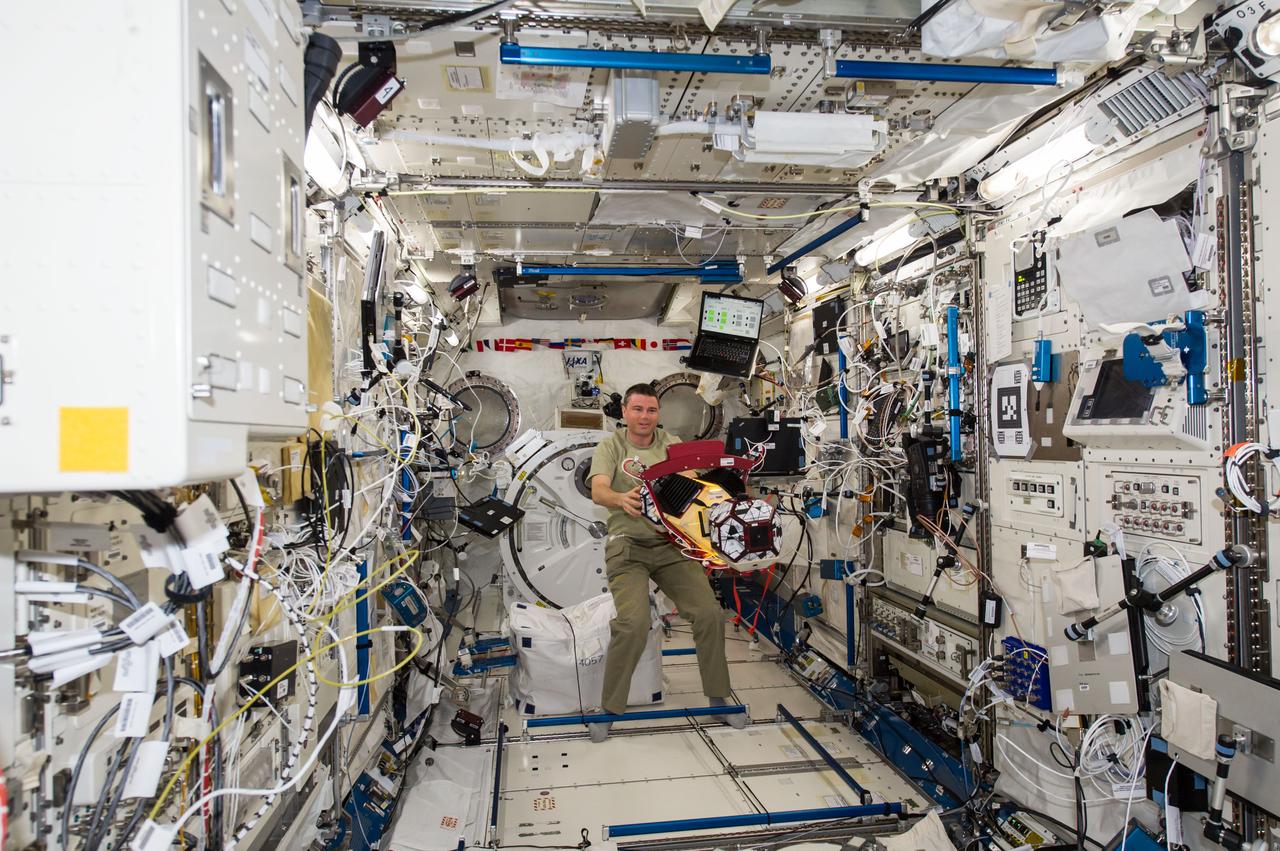
ISS040-E-080130 (25 July 2014) --- In the International Space Station?s Kibo laboratory, European Space Agency astronaut Alexander Gerst, Expedition 40 flight engineer, conducts a session with a trio of soccer-ball-sized robots known as the Synchronized Position Hold, Engage, Reorient, Experimental Satellites, or SPHERES. The free-flying robots were equipped with stereoscopic goggles called the Visual Estimation and Relative Tracking for Inspection of Generic Objects, or VERTIGO, to enable the SPHERES to perform relative navigation based on a 3D model of a target object.
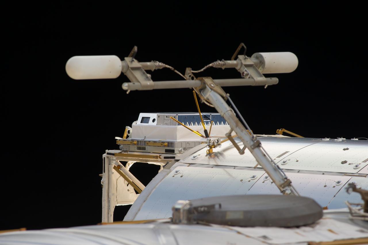
View of the High Definition Earth Viewing (HDEV) flight assembly installed on the exterior of the Columbus European Laboratory module. Image was released by astronaut on Twitter. The High Definition Earth Viewing (HDEV) experiment places four commercially available HD cameras on the exterior of the space station and uses them to stream live video of Earth for viewing online. The cameras are enclosed in a temperature specific housing and are exposed to the harsh radiation of space. Analysis of the effect of space on the video quality, over the time HDEV is operational, may help engineers decide which cameras are the best types to use on future missions. High school students helped design some of the cameras' components, through the High Schools United with NASA to Create Hardware (HUNCH) program, and student teams operate the experiment.
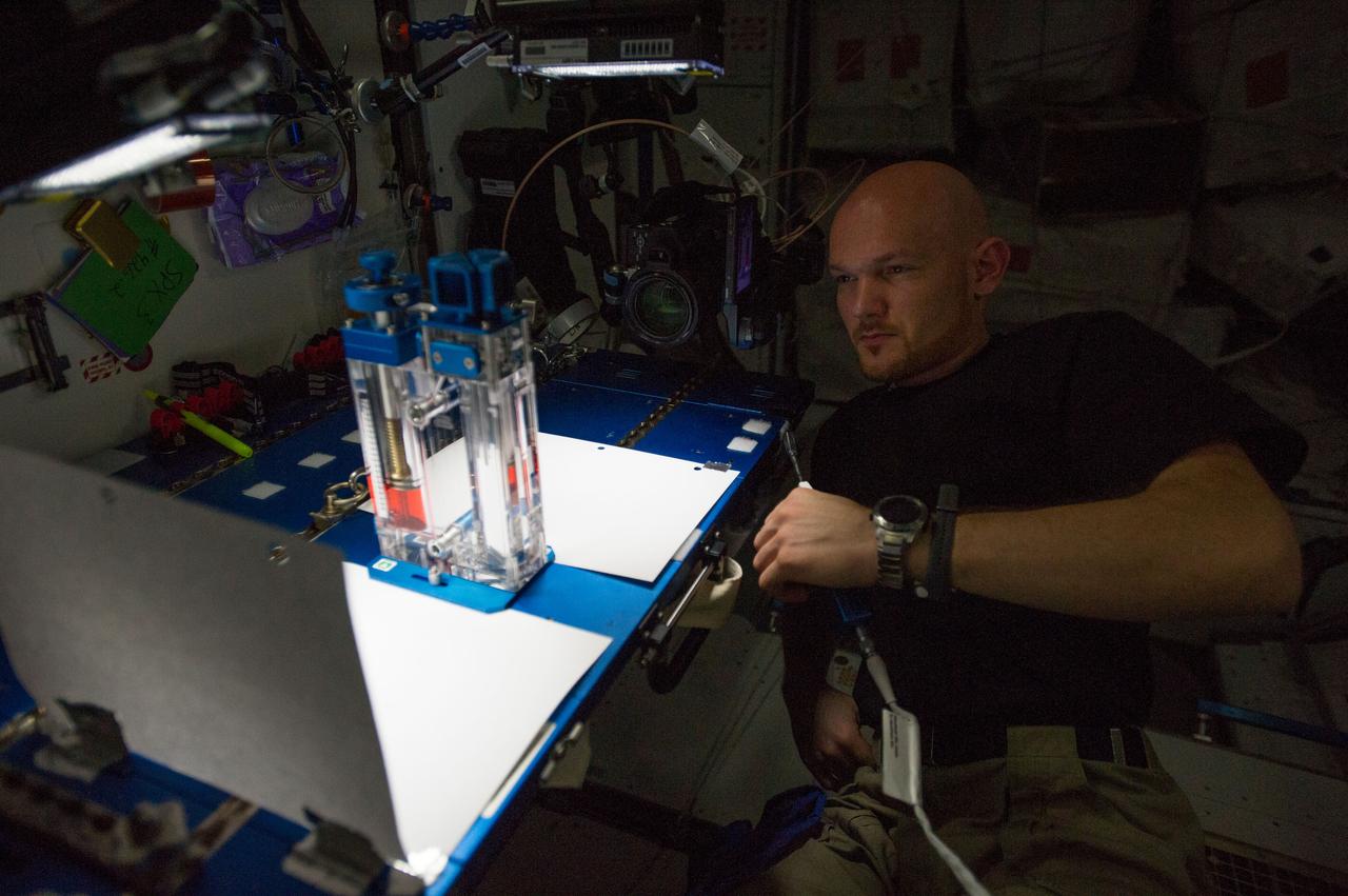
ISS040-E-015532 (19 June 2014) --- European Space Agency astronaut Alexander Gerst, Expedition 40 flight engineer, conducts a session with the Capillary Flow Experiment (CFE-2) in the Harmony node of the International Space Station. CFE is a suite of fluid physics experiments that investigate how fluids behave in microgravity which could benefit water and fuel delivery systems on future spacecraft. Scientists designed the CFE-2 to study properties of fluids and bubbles inside containers with a specific 3-D geometry.
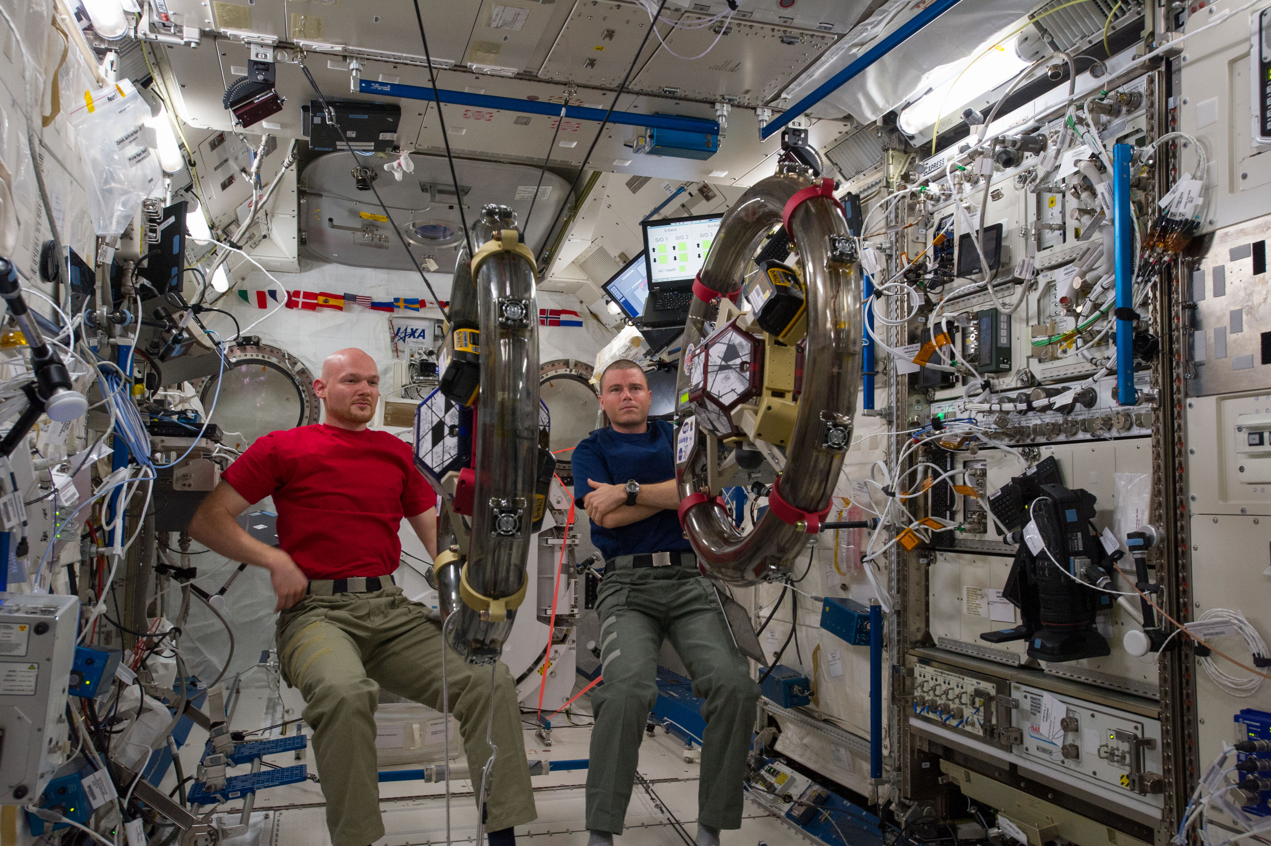
ISS040-E-059478 (10 July 2014) --- In the International Space Station's Kibo laboratory, European Space Agency astronaut Alexander Gerst (left) and NASA astronaut Reid Wiseman, both Expedition 40 flight engineers, conduct a session with a pair of bowling-ball-sized free-flying satellites known as Synchronized Position Hold, Engage, Reorient, Experimental Satellites, or SPHERES. Surrounding the two SPHERES mini-satellites is ring-shaped hardware known as the Resonant Inductive Near-field Generation System, or RINGS. SPHERES-RINGS seeks to demonstrate wireless power transfer between satellites at a distance for enhanced operations.
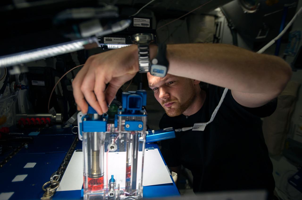
ISS040-E-015536 (19 June 2014) --- European Space Agency astronaut Alexander Gerst, Expedition 40 flight engineer, conducts a session with the Capillary Flow Experiment (CFE-2) in the Harmony node of the International Space Station. CFE is a suite of fluid physics experiments that investigate how fluids behave in microgravity which could benefit water and fuel delivery systems on future spacecraft. Scientists designed the CFE-2 to study properties of fluids and bubbles inside containers with a specific 3-D geometry.
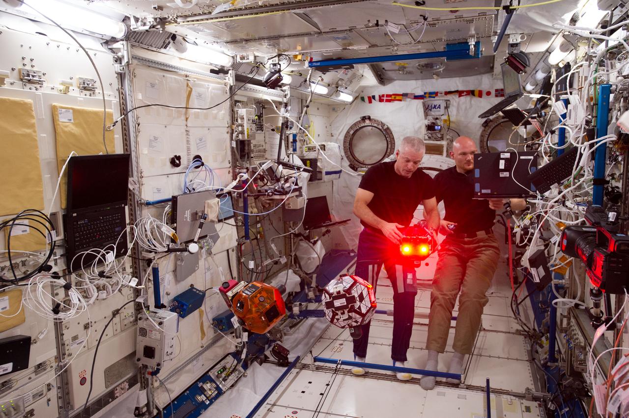
ISS040-E-079910 (25 July 2014) --- In the International Space Station?s Kibo laboratory, NASA astronaut Steve Swanson (left), Expedition 40 commander; and European Space Agency astronaut Alexander Gerst, flight engineer, conduct a session with a trio of soccer-ball-sized robots known as the Synchronized Position Hold, Engage, Reorient, Experimental Satellites, or SPHERES. The free-flying robots were equipped with stereoscopic goggles called the Visual Estimation and Relative Tracking for Inspection of Generic Objects, or VERTIGO, to enable the SPHERES to perform relative navigation based on a 3D model of a target object.
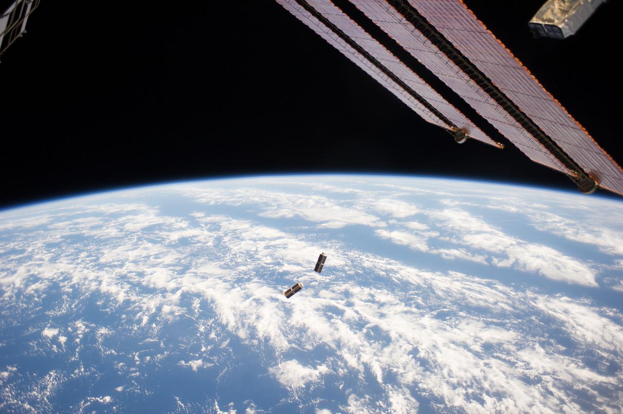
ISS040-E-103545 (19 Aug. 2014) --- In the grasp of the Japanese robotic arm, the CubeSat deployer (mostly out of frame, upper right) releases a pair of NanoRacks CubeSat miniature satellites (center). The Planet Labs Dove satellites that were carried to the International Space Station aboard the Orbital Sciences Cygnus commercial cargo craft are being deployed between Aug. 19 and Aug. 25. A section of the station solar array wings is at top right. A blue and white part of Earth and the blackness of space provide the backdrop for the scene.
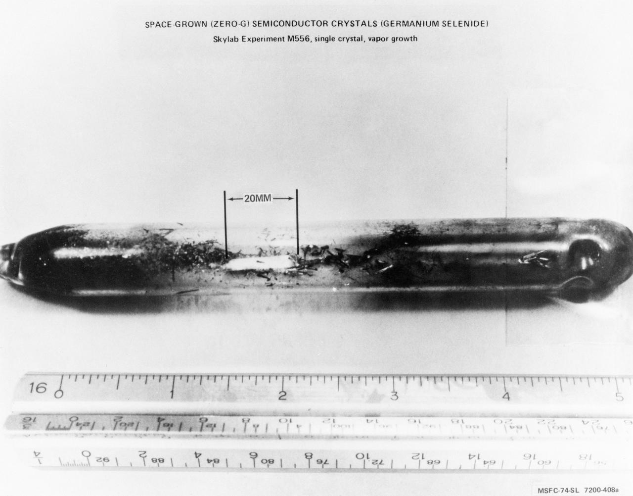
S74-19677 (April 1974) --- This crystal of Germanium Selenide (GeSe) was grown under weightless conditions in an electric furnace aboard the Skylab space station. Experiment M556, Vapor Growth of IV-VI Compounds, was conducted as a comparative test of GeSe crystals grown on Earth and those grown in a weightless environment. Skylab postflight results indicate that crystals grown in a zero-gravity situation demonstrate greater growth and better composite structure than those grown in ground-bases laboratories. The GeSe crystal shown here is 20 millimeters long, the largest crystal ever grown on Earth or in space. Principal Investigator for Experiment M556 is Dr. Harry Wiedemaier, Rensselaer Polytechnic Institute, Troy, New York. (See NASA photograph S74-19676 for an example of an Earth-grown Germanium Selenide crystal.) Photo credit: NASA
ISS040-E-059467 (10 July 2014) --- In the International Space Station's Kibo laboratory, European Space Agency astronaut Alexander Gerst and NASA astronaut Reid Wiseman (mostly obscured), both Expedition 40 flight engineers, conduct a session with a pair of bowling-ball-sized free-flying satellites known as Synchronized Position Hold, Engage, Reorient, Experimental Satellites, or SPHERES. Surrounding the two SPHERES mini-satellites is ring-shaped hardware known as the Resonant Inductive Near-field Generation System, or RINGS. SPHERES-RINGS seeks to demonstrate wireless power transfer between satellites at a distance for enhanced operations.
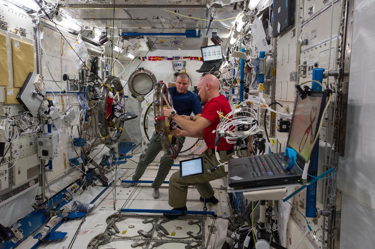
ISS040-E-059344 (10 July 2014) --- In the International Space Station’s Kibo laboratory, NASA astronaut Reid Wiseman (left) and European Space Agency astronaut Alexander Gerst, both Expedition 40 flight engineers, conduct a session with a pair of bowling-ball-sized free-flying satellites known as Synchronized Position Hold, Engage, Reorient, Experimental Satellites, or SPHERES. Surrounding the two SPHERES mini-satellites is ring-shaped hardware known as the Resonant Inductive Near-field Generation System, or RINGS. SPHERES-RINGS seeks to demonstrate wireless power transfer between satellites at a distance for enhanced operations.
ISS040-E-015523 (19 June 2014) --- European Space Agency astronaut Alexander Gerst, Expedition 40 flight engineer, conducts a session with the Capillary Flow Experiment (CFE-2) in the Harmony node of the International Space Station. CFE is a suite of fluid physics experiments that investigate how fluids behave in microgravity which could benefit water and fuel delivery systems on future spacecraft. Scientists designed the CFE-2 to study properties of fluids and bubbles inside containers with a specific 3-D geometry.
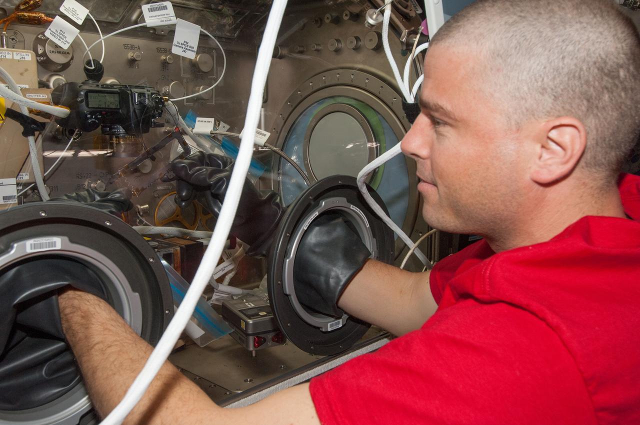
ISS040-E-031397 (2 July 2014) --- NASA astronaut Reid Wiseman, Expedition 40 flight engineer, works with a combustion experiment known as the Burning and Suppression of Solids (BASS) in the Microgravity Science Glovebox (MSG) in the Destiny laboratory of the International Space Station. The experiment seeks to provide insight on how flames burn in space compared to Earth which may provide fire safety benefits aboard future spacecraft.
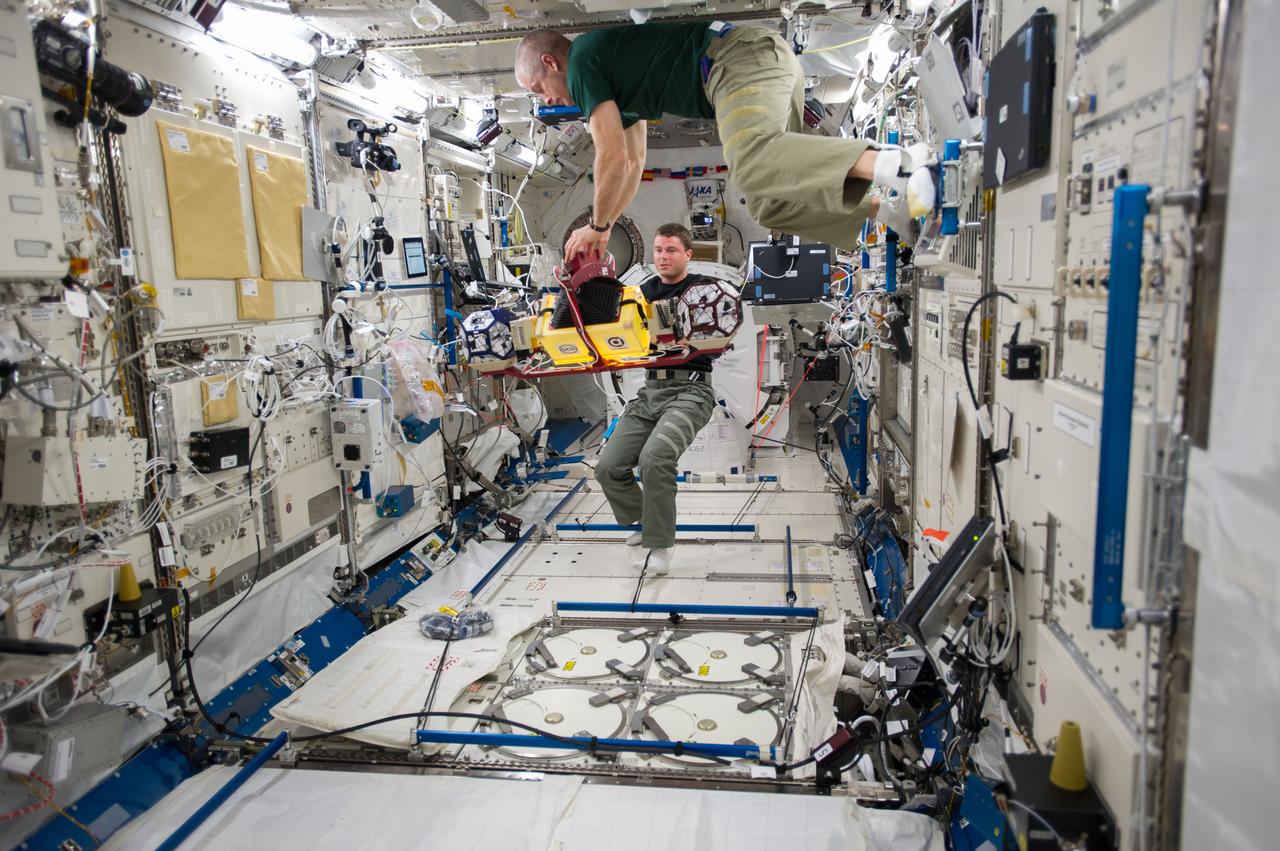
ISS040-E-014615 (18 June 2014) --- In the International Space Station's Kibo laboratory, NASA astronauts Steve Swanson (top), Expedition 40 commander; and Reid Wiseman, flight engineer, conduct test runs of the SPHERES-Slosh experiment, using the soccer-ball-sized, free-flying satellites known as Synchronized Position Hold, Engage, Reorient, Experimental Satellites, or SPHERES. The SPHERES-Slosh investigation uses small robotic satellites on the space station to examine how liquids move around inside containers in microgravity.
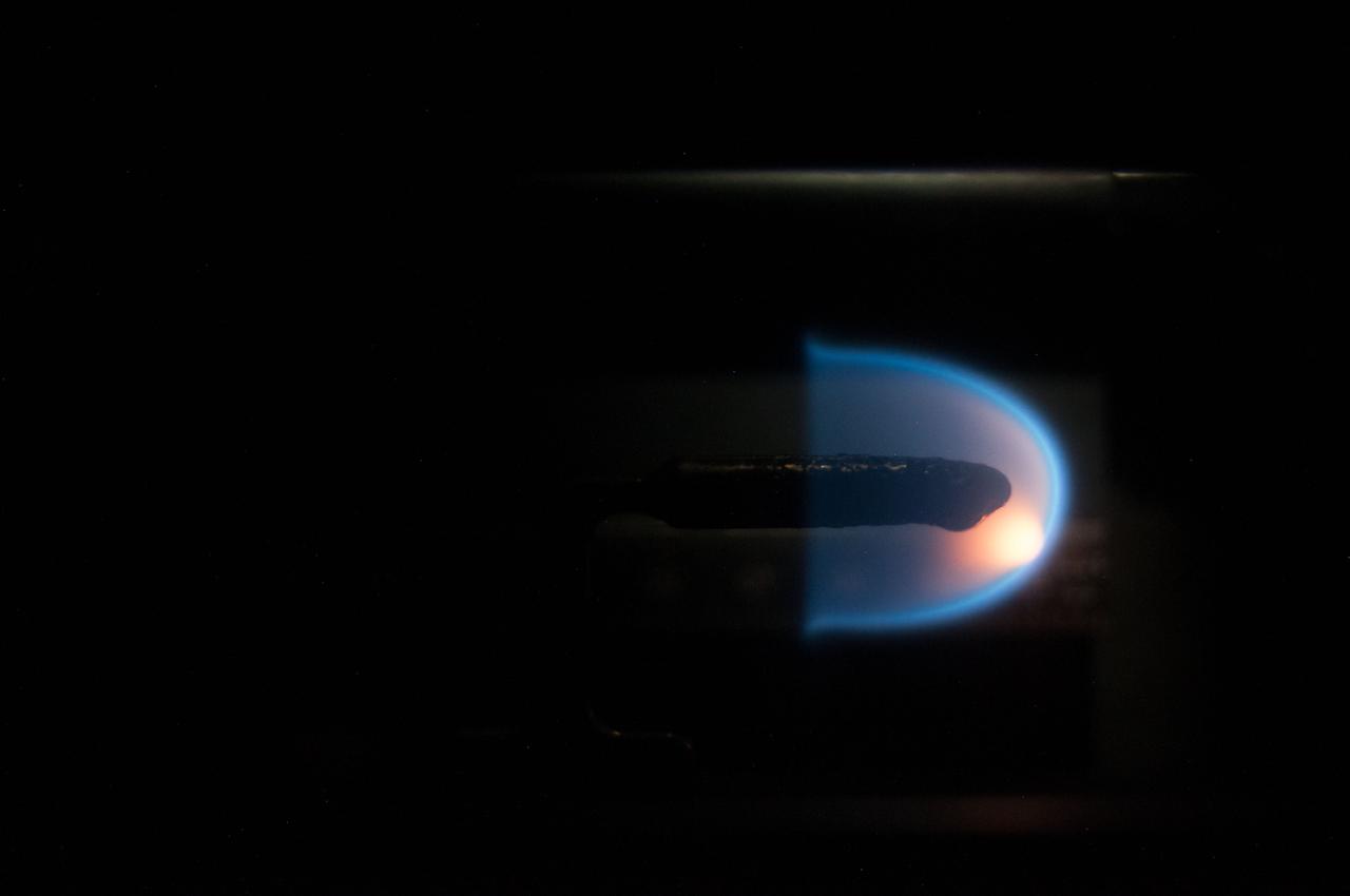
Image taken on card 8 during BASS-II flame test session with reduced O2 partial pressure. Session conducted on GMT 213. The Burning and Suppression of Solids - II (BASS-II) investigation examines the burning and extinction characteristics of a wide variety of fuel samples in microgravity. The BASS-II experiment will guide strategies for materials flammability screening for use in spacecraft as well as provide valuable data on solid fuel burning behavior in microgravity. BASS-II results contribute to the combustion computational models used in the design of fire detection and suppression systems in microgravity and on Earth.

ISS040-E-073120 (23 July 2014) --- This is a close-up image photographed during a run of the Burning and Suppression of Solids (BASS) experiment onboard the Earth-orbiting International Space Station. Following a series of preparations, NASA astronaut Reid Wiseman (out of frame), Expedition 40 flight engineer, conducted runs of the experiment, which examines the burning and extinction characteristics of a wide variety of fuel samples in microgravity. The experiment is planned for guiding strategies for extinguishing fires in microgravity. BASS results contribute to the combustion computational models used in the design of fire detection and suppression systems in microgravity and on Earth.
S65-61788 (For release: 11 Dec. 1965) --- Close-up view of equipment which will be used in the D-8 (Radiation in Spacecraft) experiment on the National Aeronautics and Space Administration's Gemini-6 spaceflight. This experiment is designed to make highly accurate measurements of the absorbed dose rate of radiation which penetrates the Gemini spacecraft, and determine the spatial distribution of dose levels inside the spacecraft particularly in the crew area. This is experimentation of the U.S. Air Force Weapons Laboratory, Kirtland AFB, N.M. LOWER LEFT: The second ionization chamber, this one is unshielded. This chamber can be removed from its bracket by the astronaut who will periodically take measurements at various locations in the spacecraft. Nearby is Passive Dosimeter Unit which is one of five small packets each containing a standard pocket ionization chamber, gamma electron sensitive film, glass needles and thermo luminescent dosimeters which are mounted at various locations in the cabin. UPPER LEFT: Photo illustrates how ionization chamber can be removed from bracket for measurements. LOWER RIGHT: Shield of bulb-shaped chamber will be removed (shown in photo) as the spacecraft passes through the South Atlantic anomaly, the area where the radiation belt dips closest to Earth's surface. UPPER RIGHT: Dome-shaped object is shield covering one of two Tissue Equivalent Ionization Chambers (sensors) which will read out continuously the instantaneous rate at which dose is delivered during the flight. This chamber is mounted permanently. The information will be recorded aboard the spacecraft, and will also be received directly by ground stations. This chamber is shielded to simulate the amount of radiation the crew members are receiving beneath their skin. Photo credit: NASA or National Aeronautics and Space Administration
STS-53 Discovery, Orbiter Vehicle (OV) 103, Department of Defense (DOD) mission Hand-held Earth-oriented Real-time Cooperative, User-friendly, Location, targeting, and Environmental System (Hercules) spaceborne experiment equipment is documented in this table top view. HERCULES is a joint NAVY-NASA-ARMY payload designed to provide real-time high resolution digital electronic imagery and geolocation (latitude and longitude determination) of earth surface targets of interest. HERCULES system consists of (from left to right): a specially modified GRID Systems portable computer mounted atop NASA developed Playback-Downlink Unit (PDU) and the Naval Research Laboratory (NRL) developed HERCULES Attitude Processor (HAP); the NASA-developed Electronic Still Camera (ESC) Electronics Box (ESCEB) including removable imagery data storage disks and various connecting cables; the ESC (a NASA modified Nikon F-4 camera) mounted atop the NRL HERCULES Inertial Measurement Unit (HIMU) containing the three-axis ring-laser gyro.
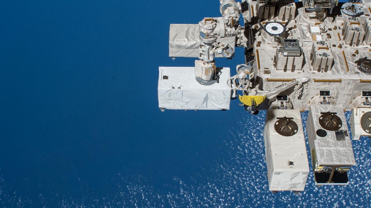
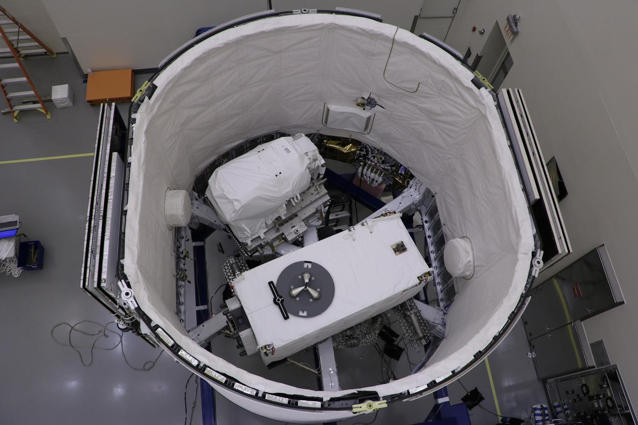
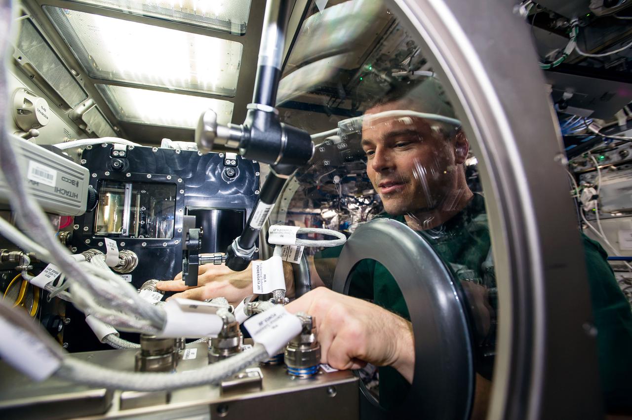
iss056e078527 (7/6/2018) --- Photographic documentation of ECOSTRESS installation onto the Japanese Experiment Module - Exposed Facility (JEM-EF). The ECOsystem Spaceborne Thermal Radiometer Experiment on Space Station (ECOSTRESS) investigation provides the first-ever high spatiotemporal (space-time) resolution thermal infrared measurements of the surface of the Earth from the International Space Station (ISS).
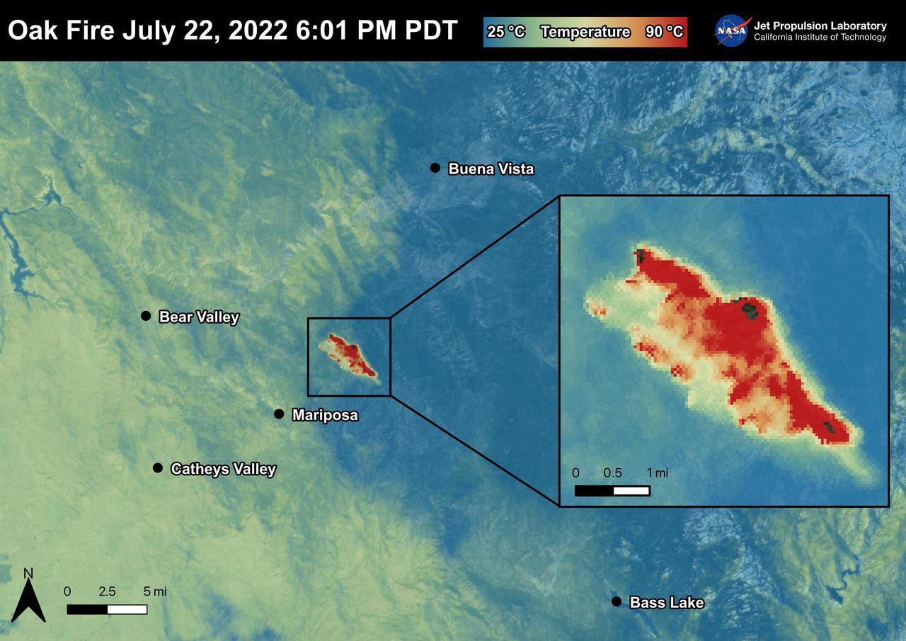
The Oak Fire started on July 22nd, 2022 at 2:10 PM PDT near Carstens Road and Highway 140 in Mariposa County, west of Yosemite. The fire has burned over 19,000 acres. In the first few days of the Oak Fire, over 1,400 structures were threatened, 3 were damaged, and 41 destroyed. Evacuation orders and road closures were issued throughout the region. The Oak Fire was captured in an ECOSTRESS Land Surface Temperature image on July 22nd with temperatures exceeding 90 degrees Celsius. ECOSTRESS is a thermal instrument on the International Space Station that measures the temperature of the ground, which is hotter than the air temperature during the day. It was launched to the space station in 2018. Its primary mission is to identify critical thresholds of water use and water stress in plants and to detect the timing, location, and predictive factors leading to plant water uptake decline and/or cessation. The nature of the high-resolution data provided by ECOSTRESS allows it to record heat related phenomena such as heat waves and wildfires. https://photojournal.jpl.nasa.gov/catalog/PIA25481
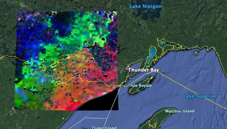
The image shows plants "waking up" west of Lake Superior near the U.S.-Canada border. Plants in the red and pink areas began to wake up around 7 a.m. local time. Those in green areas became active closer to 8 am., while those in blue areas did so closer to 9 a.m. The mission team collected and combined all of ECOSTRESS's morning data for the summer season. In doing so, they observed that the earliest risers were near the lake, with plant activity spreading gradually northwestward as the morning progressed. https://photojournal.jpl.nasa.gov/catalog/PIA23430
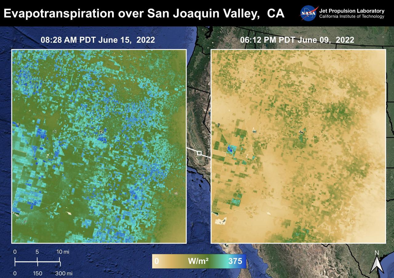
The Central Valley, CA is one of the most productive agricultural regions in the United States and the world. As California is in a continuing drought, it is important to monitor agricultural plant life to ensure maximized productivity. ECOSTRESS has the ability to monitor Evapotranspiration over agricultural fields. This Evapotranspiration image on the right was captured on June 09, 2022 at 06:12 PM PDT. The image on the left was captured by ECOSTRESS on June 15, 2022 at 08:27 AM PDT. Blue indicates high water use while brown indicates dry conditions. ECOSTRESS is a thermal instrument on the International Space Station that measures the temperature of the ground, which is hotter than the air temperature during the day. It was launched to the space station in 2018. Its primary mission is to identify critical thresholds of water use and water stress in plants and to detect the timing, location, and predictive factors leading to plant water uptake decline and/or cessation. The nature of the high-resolution data provided by ECOSTRESS allows it to record heat related phenomena such as heat waves and wildfires. https://photojournal.jpl.nasa.gov/catalog/PIA25486
ISS037-E-025866 (4 Nov. 2013) --- In the International Space Station?s Kibo laboratory, NASA astronaut Michael Hopkins, Expedition 37 flight engineer, conducts a session with a pair of bowling-ball-sized free-flying satellites known as Synchronized Position Hold, Engage, Reorient, Experimental Satellites, or SPHERES. Surrounding the two SPHERES mini-satellites is ring-shaped hardware known as the Resonant Inductive Near-field Generation System, or RINGS. SPHERES-RINGS seeks to demonstrate wireless power transfer between satellites at a distance for enhanced operations.
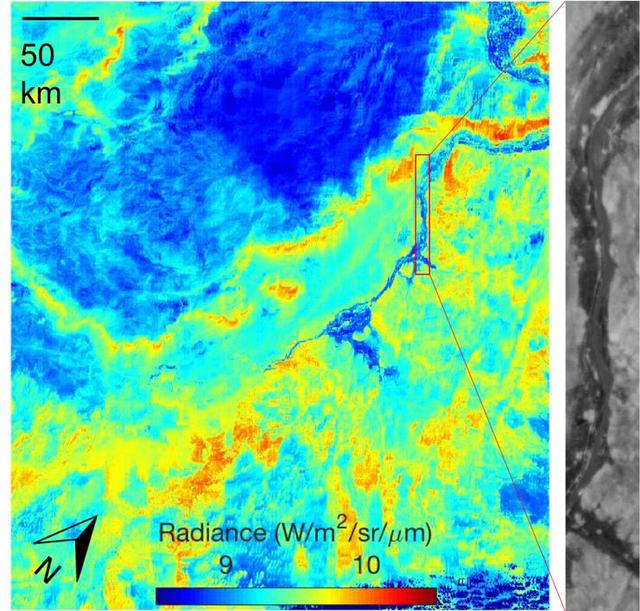
ECOSTRESS acquired this image the night of July 9, 2018, over Egypt. Yellow and red indicate generally higher temperatures. The River Nile is visible as a thin blue line on the main image. The black-and-white inset shows the level of detail available from ECOSTRESS, with the relatively cool Nile River and surrounding vegetation appearing darker. https://photojournal.jpl.nasa.gov/catalog/PIA22590
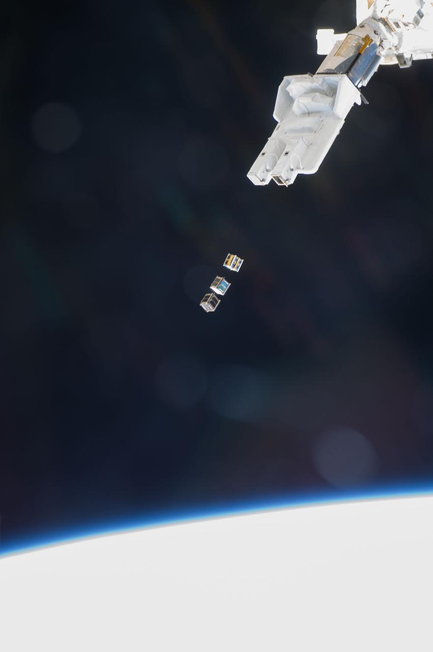
ISS038-E-003870 (19 Nov. 2013) --- Three nanosatellites, known as Cubesats, are deployed from a Small Satellite Orbital Deployer (SSOD) attached to the Kibo laboratory’s robotic arm at 7:10 a.m. (EST) on Nov. 19, 2013. Japan Aerospace Exploration Agency astronaut Koichi Wakata, Expedition 38 flight engineer, monitored the satellite deployment while operating the Japanese robotic arm from inside Kibo. The Cubesats were delivered to the International Space Station Aug. 9, aboard Japan’s fourth H-II Transfer Vehicle, Kounotori-4.

On September 19, 2021 volcanic activity permanently altered the coastline of the small island of La Palma, located off the coast of northwestern Africa. Within seven hours of the initial eruption, the lava flow traveled about 6km to the Atlantic Coast where it continues to extend the coastline out into the ocean. This image taken by the ECOSTRESS module aboard the International Space Station captured the initial Laval flow several hours after the eruption. Dark spots along the coastline represent locations where lava flowed into the ocean, increasing the surface temperature. ECOSTRESS's primary mission is to detect small changes in the temperature of plants to measure evapotranspiration rates. It can use the same instrumentation to detect changes in surface temperature associated with events such as volcanic eruptions. ECOSTRESS observations have a spatial resolution of about 70x70 meters, which enables researchers to study surface-temperature conditions down to the size of a football field. The mission can acquire images of the same region at different times of the day. This is advantageous when monitoring plant stress in the same area throughout the day, for example. https://photojournal.jpl.nasa.gov/catalog/PIA24916
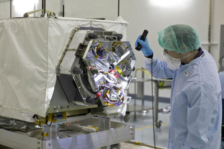
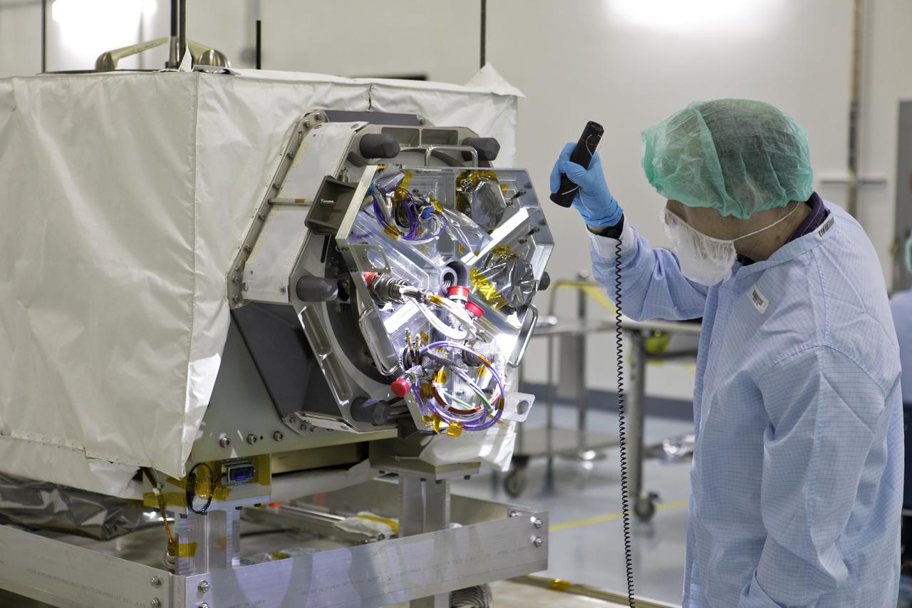
A technician inspects NASA's ECOSTRESS instrument in a clean room at Kennedy Space Center in Florida. ECOSTRESS measures the temperature of plants, which shows how they are regulating their water use in response to heat stress. https://photojournal.jpl.nasa.gov/catalog/PIA22509
ISS040-E-088800 (5 Aug. 2014) --- European Space Agency astronaut Alexander Gerst, Expedition 40 flight engineer, removes hardware for the combustion experiment known as the Burning and Suppression of Solids (BASS-II) from the Microgravity Science Glovebox (MSG) in the Destiny laboratory of the International Space Station. The experiment seeks to provide insight on how flames burn in space compared to Earth which may provide fire safety benefits aboard future spacecraft. NASA astronaut Reid Wiseman, flight engineer, looks on.
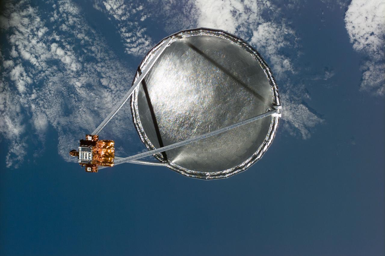
S77-E-5022 (20 May 1996)--- Following its deployment from the Space Shuttle Endeavour, the Spartan 207/Inflatable Antenna Experiment (IAE) payload is backdropped over clouds and water. The view was photographed with an Electronic Still Camera (ESC) and downlinked to flight controllers on the first full day of orbital operations by the six-member crew. Managed by Goddard Space Flight Center (GSFC), Spartan is designed to provide short-duration, free-flight opportunities for a variety of scientific studies. The Spartan configuration on this flight is unique in that the IAE is part of an additional separate unit which is ejected once the experiment is completed. The IAE experiment will lay the groundwork for future technology development in inflatable space structures, which will be launched and then inflated like a balloon on-orbit.

Commander Steve Swanson harvests plants for the VEG-01 investigation. He is harvesting them on the Maintenance Work Area (MWA) in the Node 2/Harmony. The Veg-01 hardware validation test investigation utilizes the Veggie facility on ISS. This investigation will assess on-orbit function and performance of the Veggie,and focus on the growth and development of Outredgeous Lettuce (Lactuca sativa ) seedlings in the spaceflight environment and the effects of the spaceflight environment on composition of microbial flora on the Veggie-grown plants and the Veggie facility. Lettuce plants are harvested on-orbit, frozen at <-80oC and returned to the ground for post-flight evaluation. Microbial sampling swabs will be taken of the Veggie facility and plant material, frozen and returned to the ground for environmental microbiological examination. Rooting pillows and water sample syringes will also be returned for microbial sampling and root analysis.

European Space Agency astronaut Alexander Gerst,Expedition 40 flight engineer,works with samples and hardware for a combustion experiment known as the Burning and Suppression of Solids (BASS) in the Microgravity Science Glovebox (MSG) in the Destiny laboratory of the International Space Station.
ECOSTRESS, NASA's new Earth-observing mission aboard the International Space Station, detected three wildfires burning in the western US on July 28, 2018 -- the Carr and Whaleback fires in California, and the Perry Fire in Nevada. The fires can be seen in red in Figures 1 and 2. Zooming in on the two larger fires shows the heat data in more detail and also reveals the fires' thick smoke plumes. ECOSTRESS launched on June 29 as part of a SpaceX commercial resupply mission to the space station. Its primary mission is to measure surface temperatures to detect plant health; however, it can also detect other heat-related phenomenon like heat waves, volcanoes and wildfires. This is the first image of wildfires acquired from ECOSTRESS. https://photojournal.jpl.nasa.gov/catalog/PIA22490
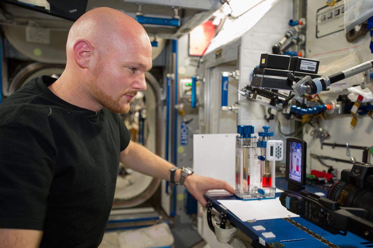
View of Flight Engineer (FE) Mike Hopkins initiating a CFE-2 (Capillary Flow Experiment - 2) Interior Corner Flow - 5 (ICF-5) test run. Liquids behave differently in space than they do on Earth, so containers that can process, hold or transport them must be designed carefully to work in microgravity. The Capillary Flow Experiment-2 furthers research on wetting, which is a liquid's ability to spread across a surface, and its impact over large length scales in strange container shapes in microgravity environments. This work will improve our capabilities to quickly and accurately predict how related processes occur, and allow us to design better systems to process liquids aboard spacecraft (i.e., liquid fuel tanks, thermals fluids, and water processing for life support). Image was released by astronaut on Twitter.
ISS040-E-088856 (5 Aug. 2014) --- NASA astronaut Reid Wiseman, Expedition 40 flight engineer, installs Capillary Channel Flow (CCF) experiment hardware in the Microgravity Science Glovebox (MSG) located in the Destiny laboratory of the International Space Station. CCF is a versatile experiment for studying a critical variety of inertial-capillary dominated flows key to spacecraft systems that cannot be studied on the ground.
S77-E-5094 (25 May 1996) --- Astronaut Marc Garneau, mission specialist representing the Canadian Space Agency (CSA), stands at the Commercial Float Zone Furnace (CFZF) in the Spacehab Module onboard the Earth-orbiting Space Shuttle Endeavour.
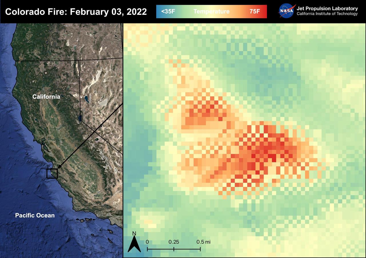
The Colorado Fire began on January 21st, 2022 was started by an escaped fire by the Palo Colorado Road. The wildfire burned 687 acres between Carmel-by-the-Sea and Big Sur. The Colorado Fire was driven towards the coast by strong winds leading to the shut down of the Bixby Bridge and a section of Highway 1. The fire was completely contained as of February 5th, 2022. No injuries or causalities have been reported; one structure was destroyed. The image above shows the fire captured in a Land Surface Temperature image from ECOSTRESS on February 3rd, 2022 at 01:11 PM PDT. As California is currently in a drought, there are concerns that 2022 will see a severe wildfire season; ECOSTRESS allows for the monitoring of the drought and of wildfires. ECOSTRESS is a thermal instrument on the International Space Station that measures the temperature of the ground, which is hotter than the air temperature during the day. It was launched to the space station in 2018. Its primary mission is to identify critical thresholds of water use and water stress in plants and to detect the timing, location, and predictive factors leading to plant water uptake decline and/or cessation. The nature of the high-resolution data provided by ECOSTRESS allows it to record heat related phenomena such as heat waves, droughts and wildfires. https://photojournal.jpl.nasa.gov/catalog/PIA25280
ISS040-E-007368 (5 June 2014) --- NASA astronaut Reid Wiseman, Expedition 40 flight engineer, works with Advanced Colloids Experiment (ACE) samples in the Destiny laboratory of the International Space Station.
Late in the evening on September 27, 2020 the Glass Fire ignited in the foothills of Napa Valley, California. The cause of the fire is still unknown. Within 24 hours it exploded to over 11,000 acres fueled by dehydrated soil and the drought-stricken landscape. Within hours of the start of the fire, ECOSTRESS captured several hotspots near the fire's origin (represented by the brightest yellow spots on the map). Not only is it important to monitor the progress of the fire as it to help protect people and property, dense wildfire smoke can also damage crops. For this reason, it is important to track both the movement of the fire and local weather patterns to predict crop damage from smoke exposure. Wildfires are common in this region of California, however this unseasonable fire ripped through the region with unusual speed and intensity. As wildfire behavior continues to adapt with Climate Change, images like this help scientists and farmers understand the impacts that the new fire season has on crops. This information is helpful in developing plans to increase agricultural resilience to climate change. Tasked with detecting plant water use and stress, ECOSTRESS's primary mission is to measure the temperature of plants heating up as they run out of water. But it can also measure and track heat-related phenomena like wildfires, heat waves, and volcanoes. ECOSTRESS observations have a spatial resolution of about 77 by 77 yards (70 by 70 meters), which enables researchers to study surface-temperature conditions down to the size of a football field. Due to the space station's unique orbit, the mission can acquire images of the same regions at different times of the day, as opposed to crossing over each area at the same time of day like satellites in other orbits do. This is advantageous when monitoring plant stress in the same area throughout the day, for example. https://photojournal.jpl.nasa.gov/catalog/PIA24209
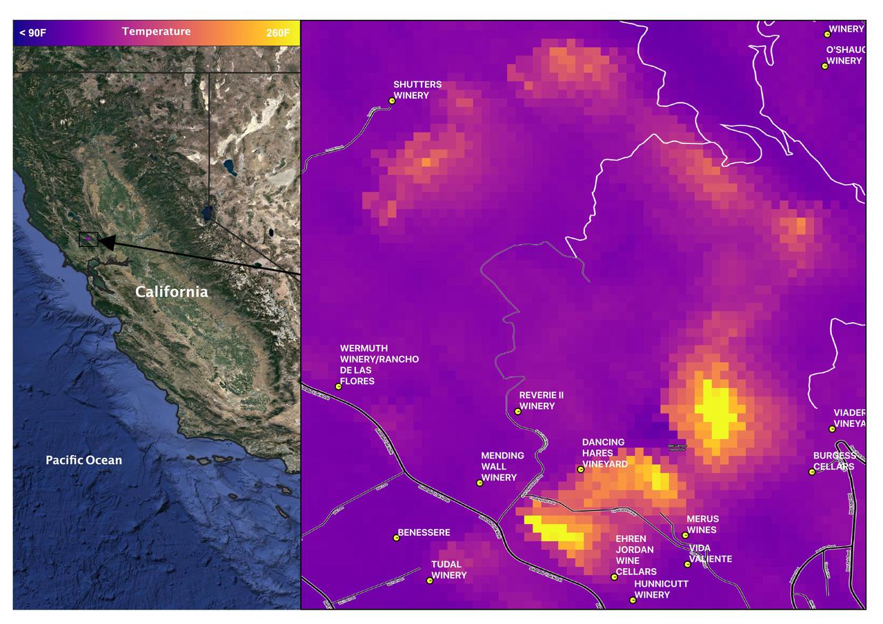
Death Valley, California is a desert valley in the Northern Mojave Desert. During the summer months, Death Valley can become one of the hottest places on Earth. Death Valley is about 85 miles from Mt. Whitney, the highest point in the contiguous United States with an elevation of 14,505 ft. This Land Surface Temperature image captured by ECOSTRESS on July 07, 2022 shows temperatures exceeding 90 degrees Fahrenheit in Death Valley and temperatures below 40 degrees Fahrenheit in the Sierra Nevada Mountain Range. ECOSTRESS is a thermal instrument on the International Space Station that measures the temperature of the ground, which is hotter than the air temperature during the day. It was launched to the space station in 2018. Its primary mission is to identify critical thresholds of water use and water stress in plants and to detect the timing, location, and predictive factors leading to plant water uptake decline and/or cessation. The nature of the high-resolution data provided by ECOSTRESS allows it to record heat related phenomena such as heat waves and wildfires. https://photojournal.jpl.nasa.gov/catalog/PIA25482
ISS041-E-047455 (29 Sept. 2014) --- An Expedition 41 crew member aboard the International Space Station photographed this view of the SpaceX Dragon cargo ship docked to the nadir port of the Harmony node as the station's Canadarm2 and the Special Purpose Dexterous Manipulator move external cargo from Dragon. A blue and white part of Earth and the blackness of space provide the backdrop for the scene.

NASA's ECOSTRESS captured data over Northern California's Dixie Fire, which had ballooned to over 220,000 acres as of July 29, 2021. In the data visualization, the red areas show the hottest pixels – and fire movement – from July 15 to July 24. The most heavily affected areas are south of Lake Almanor in Plumas County. Tasked with detecting plant water use and stress from the vantage point of the International Space Station, ECOSTRESS's primary mission is to measure the temperature of plants heating up as they run out of water. But it can also measure and track heat-related phenomena like wildfires, heat waves, and volcanoes. ECOSTRESS observations have a spatial resolution of about 77 by 77 yards (70 by 70 meters), which enables researchers to study surface-temperature conditions down to the size of a football field. Due to the space station's unique orbit, the mission can acquire images of the same regions at different times of the day, as opposed to crossing over each area at the same time of day like satellites in other orbits do. This is advantageous when monitoring plant stress in the same area throughout the day, for example. Movie available at https://photojournal.jpl.nasa.gov/catalog/PIA23696
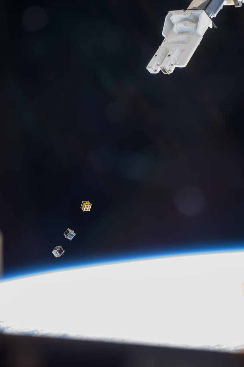
ISS038-E-003874 (19 Nov. 2013) --- Three nanosatellites, known as Cubesats, are deployed from a Small Satellite Orbital Deployer (SSOD) attached to the Kibo laboratory's robotic arm at 7:10 a.m. (EST) on Nov. 19, 2013. Japan Aerospace Exploration Agency astronaut Koichi Wakata, Expedition 38 flight engineer, monitored the satellite deployment while operating the Japanese robotic arm from inside Kibo. The Cubesats were delivered to the International Space Station Aug. 9, aboard Japan's fourth H-II Transfer Vehicle, Kounotori-4.
View of Flight Engineer (FE) Koichi Wakata posing for a photo during a CFE-2 (Capillary Flow Experiment - 2) Interior Corner Flow - 8 (ICF-8) test run. Liquids behave differently in space than they do on Earth, so containers that can process, hold or transport them must be designed carefully to work in microgravity. The Capillary Flow Experiment-2 furthers research on wetting, which is a liquid's ability to spread across a surface, and its impact over large length scales in strange container shapes in microgravity environments. This work will improve capabilities to quickly and accurately predict how related processes occur, and allow us to design better systems to process liquids aboard spacecraft (i.e., liquid fuel tanks, thermals fluids, and water processing for life support). Image was released by astronaut on Twitter.
S73-35080 (July-September 1973) --- A vertical view of northeast Oklahoma and the metropolitan Tulsa area is seen in this Skylab 3 Earth Resources Experiments Package S190-B (five-inch Earth terrain camera) photograph taken from the Skylab space station in Earth orbit. THE PICTURE SHOULD BE HELD WITH THE CLOCK ON THE LEFT AND THE LAKE IN THE CORNER ON THE RIGHT. THE LONG STRETCH OF HIGHWAY (U.S. 75) RUNS STRAIGHT NORTH FROM TULSA. Tulsa, a rapidly expanding city in the heart of the mid-continent oil field, has a population of approximately 330,000. The Arkansas River meanders across the southern (lower) portion of the photograph passing through Tulsa as it flows southeastward. Oologah Reservoir, the long body of water, is located northeast of Tulsa. Lake Hudson is the body of water in the right corner of the picture. Keystone Reservoir is to the west and upstream from Tulsa. Westward from Tulsa U.S. 64 makes a 45 degree bend as it turns northwest to cross the Keystone Reservoir. The thin white line over the Oologah Reservoir is a highway bridge. Bartlesville is on U.S. 75 near the north (top) corner of the picture. The Tulsa International Airport is immediately northeast of downtown Tulsa. Several smaller airfields are visible in the surrounding area. The toll roads and other major highways are clearly visible in the picture. Claremore is northeast of Tulsa on U.S. 66 with the Will Rogers Turnpike passing nearby. Sapulpa is southwest of Tulsa on the Turner Turnpike which leads toward Oklahoma City. The detailed information contained in this photograph can be extracted by direct observation and applied to updating land use and cultural maps of Tulsa and to numerous surrounding satellite cities. All EREP photography is available to the public through the Department of Interior?s Earth Resources Observations Systems Data Center, Sioux Falls, South Dakota, 57198. (Alternate number SL3-83-206) Photo credit: NASA
ISS040-E-088798 (5 Aug. 2014) --- European Space Agency astronaut Alexander Gerst, Expedition 40 flight engineer, removes hardware for the combustion experiment known as the Burning and Suppression of Solids (BASS-II) from the Microgravity Science Glovebox (MSG) in the Destiny laboratory of the International Space Station. The experiment seeks to provide insight on how flames burn in space compared to Earth which may provide fire safety benefits aboard future spacecraft. NASA astronaut Reid Wiseman, flight engineer, looks on.
S88-44517 (13 Aug 1988) --- Student experimenter John C. Vellinger, right, explains operation of an incubator used in his experiment to be carried onboard the Discovery for NASA's STS-29 mission next year. His primary audience is made up of STS-29's five-man crew, who will monitor in-space operation of the experiment, titled "Chicken Embryo Development in Space." Kentucky Fried Chicken.
ISS040-E-088801 (5 Aug. 2014) --- European Space Agency astronaut Alexander Gerst, Expedition 40 flight engineer, removes hardware for the combustion experiment known as the Burning and Suppression of Solids (BASS-II) from the Microgravity Science Glovebox (MSG) in the Destiny laboratory of the International Space Station. The experiment seeks to provide insight on how flames burn in space compared to Earth which may provide fire safety benefits aboard future spacecraft. NASA astronaut Reid Wiseman, flight engineer, looks on.

ISS038-E-003872 (19 Nov. 2013) --- Three nanosatellites, known as Cubesats, are deployed from a Small Satellite Orbital Deployer (SSOD) attached to the Kibo laboratory’s robotic arm at 7:10 a.m. (EST) on Nov. 19, 2013. Japan Aerospace Exploration Agency astronaut Koichi Wakata, Expedition 38 flight engineer, monitored the satellite deployment while operating the Japanese robotic arm from inside Kibo. The Cubesats were delivered to the International Space Station Aug. 9, aboard Japan’s fourth H-II Transfer Vehicle, Kounotori-4.
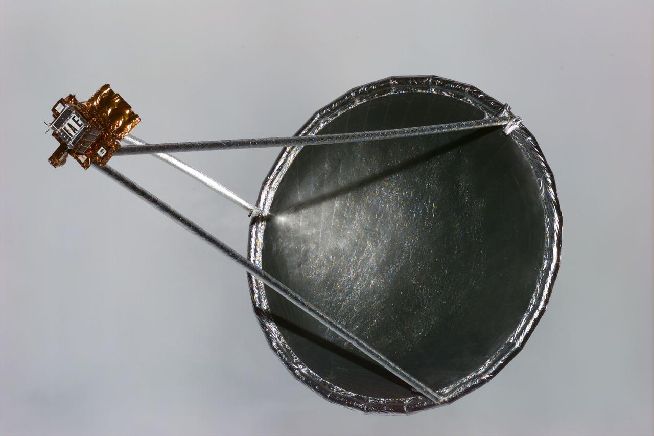
S77-E-5033 (20 May 1996) --- Following its deployment from the Space Shuttle Endeavour, the Spartan 207/Inflatable Antenna Experiment (IAE) payload is backdropped against a wall of grayish clouds. The view was photographed with an Electronic Still Camera (ESC) and downlinked to flight controllers on the first full day of orbital operations by the six-member crew. Managed by Goddard Space Flight Center (GSFC), Spartan is designed to provide short-duration, free-flight opportunities for a variety of scientific studies. The Spartan configuration on this flight is unique in that the IAE is part of an additional separate unit which is ejected once the experiment is completed. The IAE experiment will lay the groundwork for future technology development in inflatable space structures, which will be launched and then inflated like a balloon on-orbit.
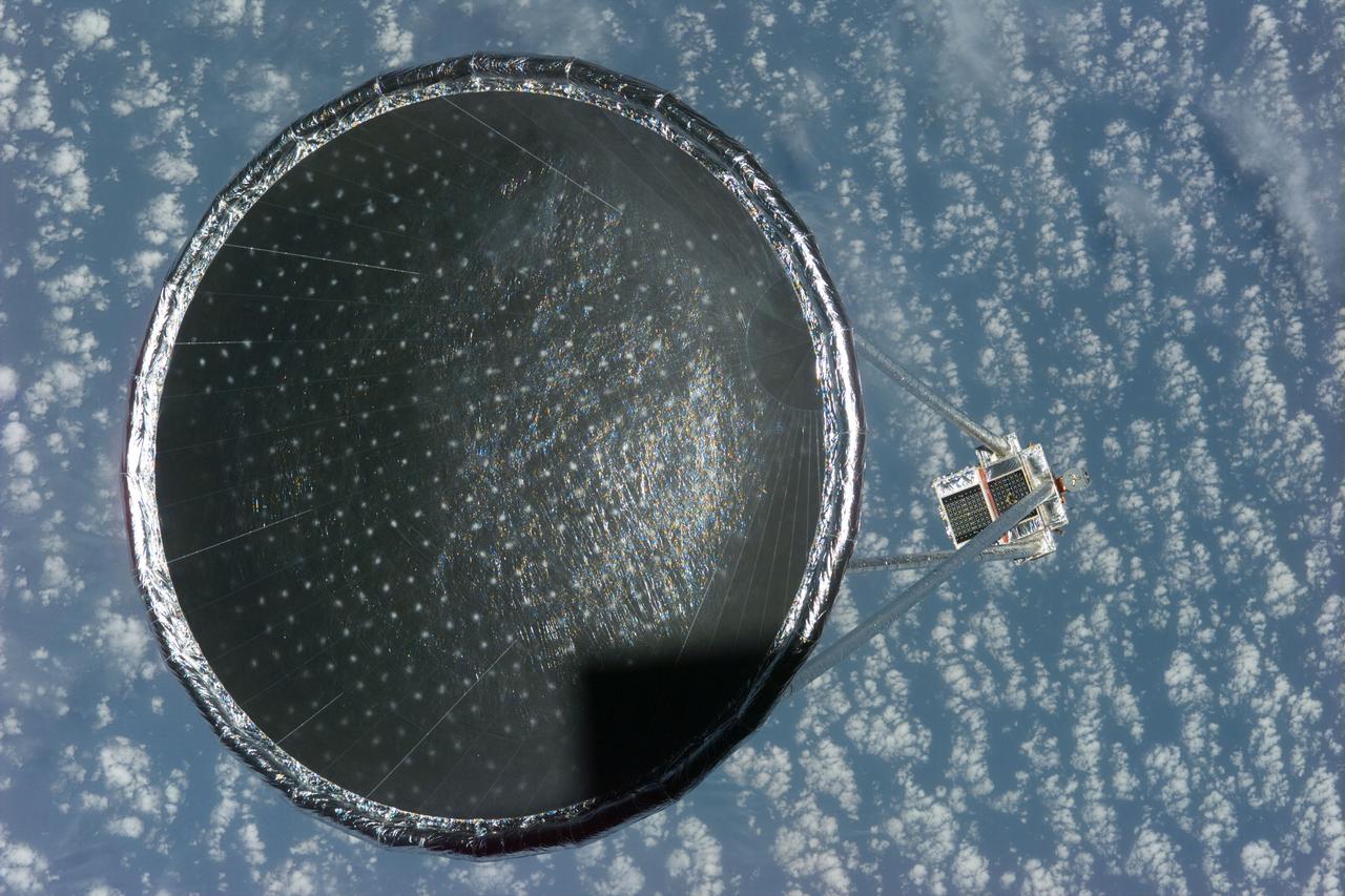
S77-E-5027 (20 May 1996)--- Following its deployment from the Space Shuttle Endeavour, the Spartan 207/Inflatable Antenna Experiment (IAE) payload is backdropped over clouds and water. The view was photographed with an Electronic Still Camera (ESC) and downlinked to flight controllers on the first full day of orbital operations by the six-member crew. Managed by Goddard Space Flight Center (GSFC), Spartan is designed to provide short-duration, free-flight opportunities for a variety of scientific studies. The Spartan configuration on this flight is unique in that the IAE is part of an additional separate unit which is ejected once the experiment is completed. The IAE experiment will lay the groundwork for future technology development in inflatable space structures, which will be launched and then inflated like a balloon on-orbit.
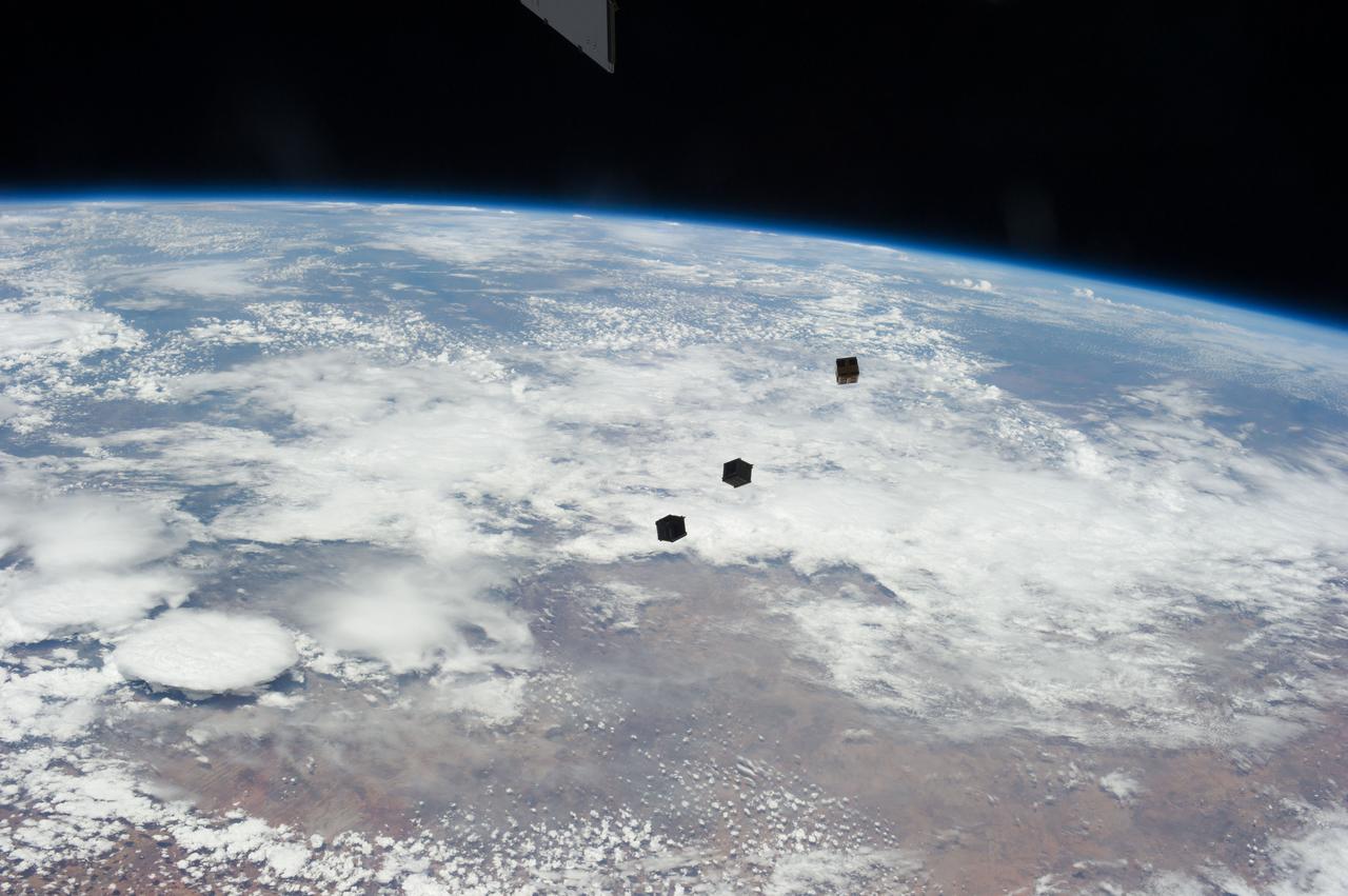
View of three cube satellites (Cubesats), or nanosatellites, shortly after deployment. Image was released by astronaut on Twitter.

S81-26158 (Feb 1981) --- A close-up view of a training version of a STS-40/SLS-1 blood kit. Blood samples from crewmembers are critical to a number of Space Life Sciences-1 (SLS-1) investigations. One day's collection equipment, color coded for each crewmember, is neatly organized in the kit.
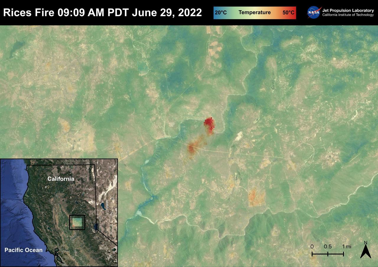
The Rices Fire started on June 28th, 2022 in Northern California near the Yuba River in Nevada County. The fire has burned over 900 acres and has destroyed one structure. French Corral, Birchville, and other communities were evacuated, but orders have since been lifted. There have been some firefighter injuries reported, but not casualties. The fire was captured in an ECOSTRESS Land Surface image on June 29 at 09:09 AM PDT and shows the temperatures surpassing 130 degrees Fahrenheit. ECOSTRESS is a thermal instrument on the International Space Station that measures the temperature of the ground, which is hotter than the air temperature during the day. It was launched to the space station in 2018. Its primary mission is to identify critical thresholds of water use and water stress in plants and to detect the timing, location, and predictive factors leading to plant water uptake decline and/or cessation. The nature of the high-resolution data provided by ECOSTRESS allows it to record heat related phenomena such as heat waves and wildfires. https://photojournal.jpl.nasa.gov/catalog/PIA25485

ISS040-E-009116 (10 June 2014) --- In the International Space Station?s Harmony node, NASA astronaut Steve Swanson, Expedition 40 commander, harvests a crop of red romaine lettuce plants that were grown from seed inside the station?s Veggie facility, a low-cost plant growth chamber that uses a flat-panel light bank for plant growth and crew observation. For the Veg-01 experiment, researchers are testing and validating the Veggie hardware, and the plants will be returned to Earth to determine food safety.
ECOSTRESS captured surface temperature variations in Los Angeles, California between July 22 and August 14 -- a period of extended heat -- at different times of day. The images show how different surfaces within the cityscape warm and cool throughout the day. They have been colored to show the hottest areas in red, warm areas in orange and yellow, and cooler areas in blue. The hottest areas are dark asphalt surfaces that have very little shade during the day and remain warm throughout the night due to their higher heat capacity. They include freeways, airports, oil refineries and parking lots. Clouds and higher-elevation mountainous areas were the coolest. More information is available at https://photojournal.jpl.nasa.gov/catalog/PIA22703
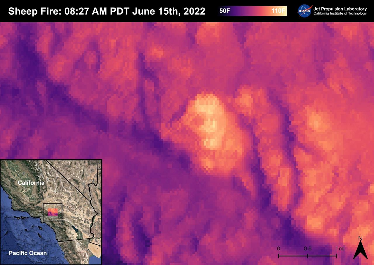
The Sheep Fire started on June 12th, 2022, Northeast of the town of Wrightwood in San Bernardino County. The fire burned 865 acres and was contained on June 19th, 2022. Due to the proximity of the Sheep Fire to Wrightwood, the town was evacuated. The Pacific Crest Trail in the San Gabriel Mountains and part of Highway 2 were closed due to the fire. There were no casualties or injuries as a result of the Sheep Fire. The fire was captured in an ECOSTRESS Land Surface Temperature image on 08:27 AM PDT on June 15th and shows the temperature of the fire surpassing 100 degrees Fahrenheit. As California is currently in a drought, there are concerns that 2022 will see a severe wildfire season; ECOSTRESS allows for the monitoring of the drought and of wildfires. ECOSTRESS is a thermal instrument on the International Space Station that measures the temperature of the ground, which is hotter than the air temperature during the day. It was launched to the space station in 2018. Its primary mission is to identify critical thresholds of water use and water stress in plants and to detect the timing, location, and predictive factors leading to plant water uptake decline and/or cessation. The nature of the high-resolution data provided by ECOSTRESS allows it to record heat related phenomena such as heat waves, droughts and wildfires. https://photojournal.jpl.nasa.gov/catalog/PIA25356
S77-E-5093 (25 May 1996) --- Astronaut Marc Garneau, mission specialist representing the Canadian Space Agency (CSA), makes a visual check of the Commercial Float Zone Furnace (CFZF), a single-rack-mounted facility in the Spacehab Module onboard the Earth-orbiting Space Shuttle Endeavour. The scene was recorded with an Electronic Still Camera (ESC).
S81-25565 (Feb 1981) --- Expected to be a busy item of flight hardware on the Spacelab Life Sciences (SLS-1) mission is this low-gravity centrifuge. To be flown onboard Columbia for STS-40, the centrifuge is able to simulate several gravity levels (0.5 g, 1.0 g, 1.5 g. and 2.0 g). Blood samples, taken during the flight, will be placed in the centrifuge, fixed for post flight analysis and transferred to a freezer.
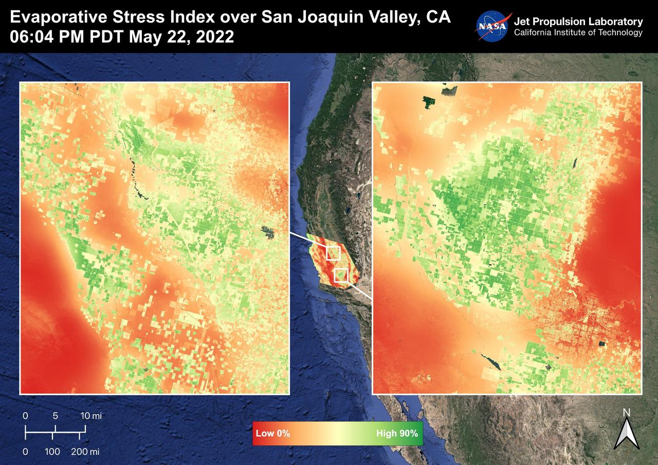
The San Joaquin Valley, CA is one of the most productive agricultural regions in the United States and the world. The image shows the Evaporative Stress Index over the San Joaquin Valley on May 22, 2022 at 06:04 PM PDT where many fields show high ESI values that indicate low plant stress whereas low ESI values indicate high plant stress. ECOSTRESS's ability to detect Evaporative Stress over the agricultural fields can help farmers and decision makers in their choices. As California is in a continuing drought, it is important to monitor that agricultural plant life. ECOSTRESS is a thermal instrument on the International Space Station that measures the temperature of the ground, which is hotter than the air temperature during the day. It was launched to the space station in 2018. Its primary mission is to identify critical thresholds of water use and water stress in plants and to detect the timing, location, and predictive factors leading to plant water uptake decline and/or cessation. The nature of the high-resolution data provided by ECOSTRESS allows it to record heat related phenomena such as heat waves and wildfires. https://photojournal.jpl.nasa.gov/catalog/PIA25487
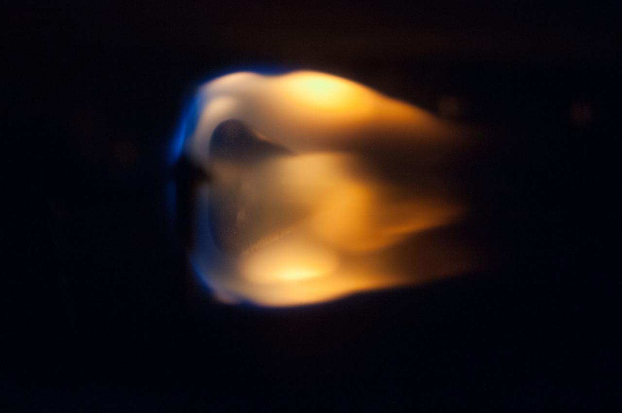
Closeup view inside glovebox showing a candle flame. The Candle Flames in Microgravity experiment is carried onboard Columbia to examine whether candle flames can be sustained in space; to study the interaction and physical properties of diffusion flames. In space, where buoyancy-driven convection is reduced, the role diffusion plays in sustaining candle flames can be isolated. Results have implications for other diffusion flame studies. Diffusion flames are the most common type of flame on Earth.
S73-35079 (July-September 1973) --- A near vertical view of the Caribbean coast of Venezuela is seen in this Skylab 3 Earth Resources Experiment Package S190-B (five-inch Earth terrain camera) photograph taken from the Skylab space station in Earth orbit. The large body of water is the Golfo de Venezuela; and the major land mass is the Peninsula de Paraguana. The view is looking northward from the mouth of the Golfete de Coro and Punta Cardon to Punta Macolla. The peninsula is connected to the Venezuelan mainland by the narrow strip of land in the most easterly corner of the picture. The dry, arid climate on the peninsula is indicated by sparse vegetation and the abundance of sand dunes. The highest point is about 2,700 feet above the sea and is the conspicuous black spot. Old raised shoreline features appear as streaks parallel to the Golfete de Coro. Sand dunes and stream erosion have modified these features. Water of the Golfete de Coro is red from the high sediment content. The streaks in the water off the peninsula is apparently an effect of wind which is blowing sand and water offshore. The EREP investigator Dr. Jose Antonio Galavis, of the Ministerio de Mines e Hidrocarburos, will use this information to map geology and coastal sedimentation in the Peninsula de Paraguana. Federal agencies participating with NASA on the EREP projects are the Departments of Agriculture, Commerce, Interior, the Environmental Protection Agency and the Corps of Engineers. All EREP photography is available to the public through the Department of Interior?s Earth Resources Observations Systems Data Center, Sioux Falls, South Dakota, 57198. (Alternate number SL3-83-237) Photo credit: NASA
STS075-360-021 (22 Feb.- 9 March 1996) --- The loose tether forms a faint diagonal line in this scene recorded on a later fly-by. On Feb. 25, 1996, the crew deployed the Tethered Satellite System (TSS), which later broke free. The seven member crew was launched aboard the space shuttle Columbia on Feb. 22, 1996, and landed on March 9, 1996. Crew members were Andrew M. Allen, mission commander; Scott J. Horowitz, pilot; Franklin R. Chang-Diaz, payload commander; and Maurizio Cheli, European Space Agency (ESA); Jeffrey A. Hoffman and Claude Nicollier, ESA, all mission specialists; along with payload specialist Umberto Guidoni of the Italian Space Agency (ASI).
ISS040-E-011005 (13 June 2014) --- European Space Agency astronaut Alexander Gerst, Expedition 40 flight engineer, works with samples and hardware for a combustion experiment known as the Burning and Suppression of Solids (BASS) in the Microgravity Science Glovebox (MSG) in the Destiny laboratory of the International Space Station. He is wearing a Drager Double Sensor on his forehead which is used on the Circadian Rhythms Experiment. This experiment examines the hypothesis that long-term spaceflights significantly affect the synchronization of the circadian rhythms in humans due to changes of a non-24 hour light-dark cycle.

Close-up view of plant growth taken by the Expedition 37 crew.

S73-35082 (July-Sept. 1973) --- A near vertical view of a portion of west Africa ravaged by drought for the past five years is seen in this Skylab 3 Earth Resources Experiments Package S190-B (five-inch Earth terrain camera) photograph taken from the Skylab space station in Earth orbit. The semi-desert scene is in southeastern Niger about 200 nautical miles east-northeast of the capital city of Niamey. A polygonal-shaped area (dark) in the lower right corner of the picture represents a range-management ranch. The dry stream beds trending diagonally across the photograph locally contain some water or vegetation (green). The beds are sources of water through shallow drilling and contain soils suitable for production of crops. The variety of tans, browns and grays are typical desert colors that represent barren rocks and soil or sand-filled ancient stream valleys. Absence of vegetation is the singular feature of the area. Dr. G. Stuckmann of the Geographic Institute, University of Technology, Mannover, Federal Republic of Germany, will use this photograph in the study of the hydrologic regime of the region through analysis of fossil drainage patterns, geological structures and accumulations of surface water. Federal agencies participating with NASA on the EREP project are the Departments of Agriculture, Commerce, Interior, the Environmental Protection Agency and the Corps of Engineers. All EREP photography is available to the public through the Department of Interior?s Earth Resources Observations Systems Data Center, Sioux Falls, South Dakota, 57198. (Alternate number SL3-86-166) Photo credit: NASA
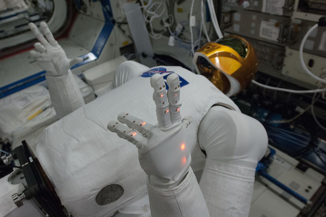
Documentation of Robonaut 2 (R2) in the Destiny U.S. Laboratory during the first use of the Robonaut Tele-operation System. Robonaut is a dexterous humanoid robot designed with the versatility and dexterity to manipulate hardware, work in high risk environments, and respond safely to unexpected obstacles. Image was released by astronaut on Twitter.
S93-25648 (Jan 1993) --- Part of the educational activities onboard the Space Shuttle Endeavour for STS-54 will include several experiments with various toys, some of which are depicted here. The detailed supplementary objective (DSO-802) will allow the Shuttle crewmembers to experiment with the various types of toys in a microgravity environment while talking to pupils who will be able to monitor (via classroom TV sets) the activities at a number of schools.
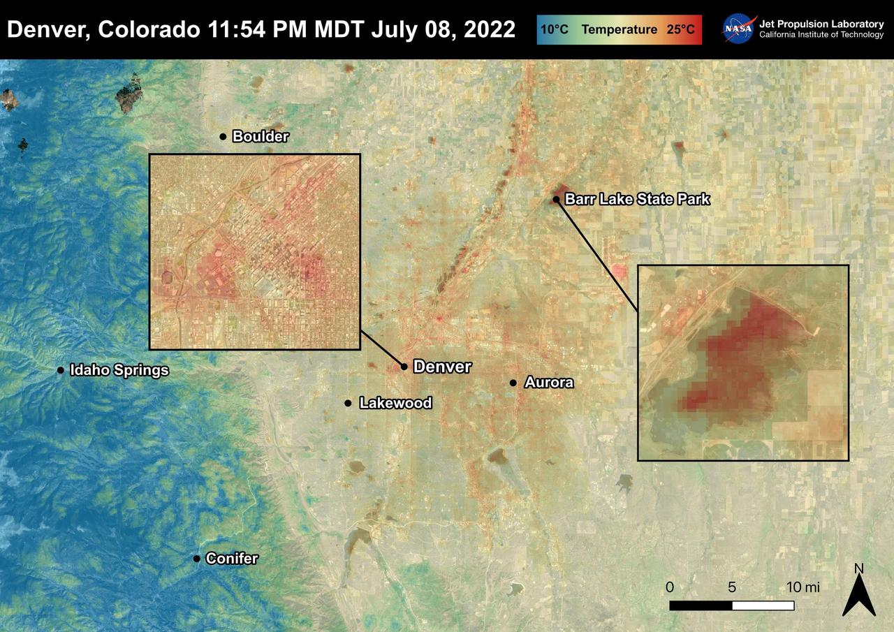
Denver, Colorado reached 96 degrees Fahrenheit on July 8th, 2022. In the two days following, temperatures rose to 101 degrees Fahrenheit. For cities like Denver, heat dissipates more slowly and create urban heat islands. High temperatures due to urban heat, especially at night, can lead to adverse health effects in vulnerable populations like children and the elderly. This image also shows that bodies of water, like Barr Lake, remain warm into the night due to water's high heat capacity. ECOSTRESS captured this Land Surface Temperature image on July 8th, 2022 at 11:54 PM MDT. ECOSTRESS is a thermal instrument on the International Space Station that measures the temperature of the ground, which is hotter than the air temperature during the day. It was launched to the space station in 2018. Its primary mission is to identify critical thresholds of water use and water stress in plants and to detect the timing, location, and predictive factors leading to plant water uptake decline and/or cessation. The nature of the high-resolution data provided by ECOSTRESS allows it to record heat related phenomena such as heat waves and wildfires. https://photojournal.jpl.nasa.gov/catalog/PIA25483
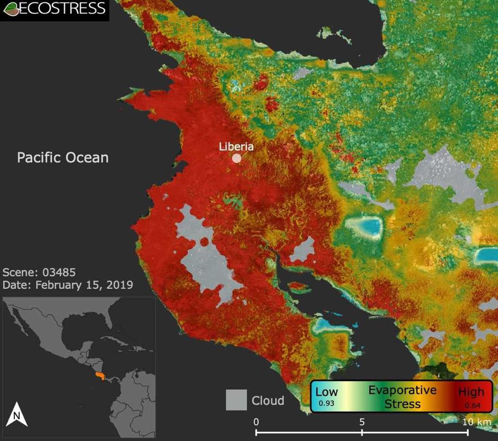
This image shows the ECOSTRESS evaporative stress index for the Guanacaste region of Costa Rica (in red on inset map, left) a few months after the onset of a major Central American drought. Red indicates high plant water stress, yellow is moderate stress and greens/blues are low stress. Light gray is cloud cover. The index measures how much water plants are using relative to how much they would use under optimal conditions; low numbers correlate with high stress. ECOSTRESS launched on June 29, 2018, as part of a SpaceX commercial resupply mission to the International Space Station. Its primary mission is to detect plant health by monitoring Earth's surface temperature. However, surface temperature data are also useful in detecting other heat-related phenomena — like heat waves, volcanoes and fires. https://photojournal.jpl.nasa.gov/catalog/PIA22839
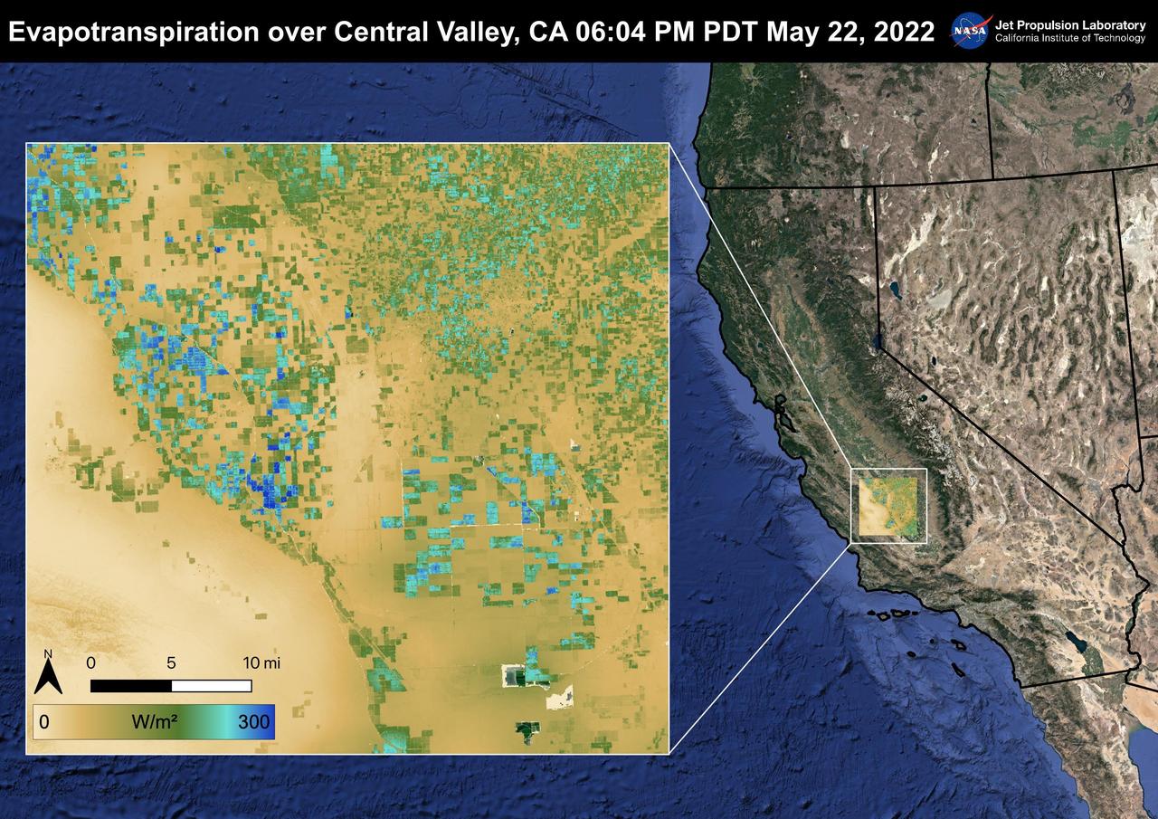
The Central Valley, CA is one of the most productive agricultural regions in the United States and the world. As California is in a continuing drought, it is important to monitor agricultural plant life to ensure maximized productivity. ECOSTRESS has the ability to monitor Evapotranspiration over agricultural fields. This Evapotranspiration image was captured by ECOSTRESS on May 22, 2022 at 06:04 PM PDT. Blue indicates high water use while brown indicates dry conditions. ECOSTRESS is a thermal instrument on the International Space Station that measures the temperature of the ground, which is hotter than the air temperature during the day. It was launched to the space station in 2018. Its primary mission is to identify critical thresholds of water use and water stress in plants and to detect the timing, location, and predictive factors leading to plant water uptake decline and/or cessation. The nature of the high-resolution data provided by ECOSTRESS allows it to record heat related phenomena such as heat waves and wildfires. https://photojournal.jpl.nasa.gov/catalog/PIA25488