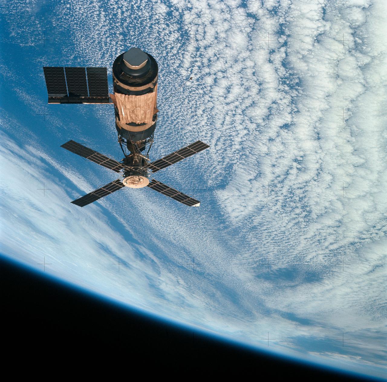
SL4-143-4707 (8 Feb. 1974) --- An overhead view of the Skylab space station cluster in Earth orbit as photographed from the Skylab 4 Command and Service Modules (CSM) during the final fly-around by the CSM before returning home. The space station is contrasted against a cloud-covered Earth. Note the solar shield which was deployed by the second crew of Skylab and from which a micrometeoroid shield has been missing since the cluster was launched on May 14, 1973. The OWS solar panel on the left side was also lost on workshop launch day. Photo credit: NASA
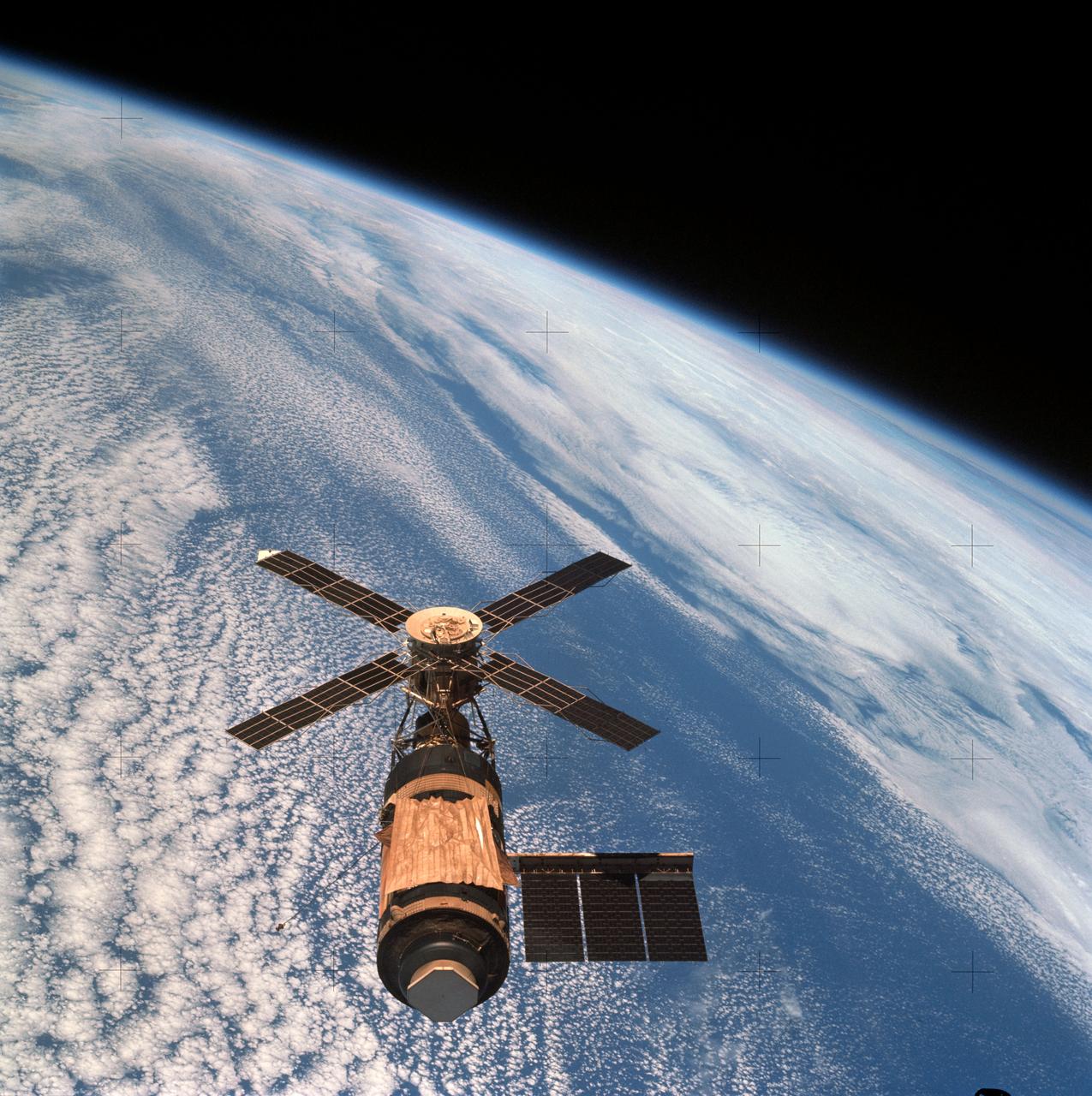
SL4-143-4706 (8 Feb. 1974) --- An overhead view of the Skylab space station cluster in Earth orbit as photographed from the Skylab 4 Command and Service Modules (CSM) during the final fly-around by the CSM before returning home. The space station is contrasted against a cloud-covered Earth. Note the solar shield which was deployed by the second crew of Skylab and from which a micro meteoroid shield has been missing since the cluster was launched on May 14, 1973. The Orbital Workshop (OWS) solar panel on the left side was also lost on workshop launch day. Inside the Command Module (CM) when this picture was made were astronaut Gerald P. Carr, commander; scientist-astronaut Edward G. Gibson, science pilot; and astronaut William R. Pogue, pilot. The crew used a 70mm hand-held Hasselblad camera to take this photograph. Photo credit: NASA
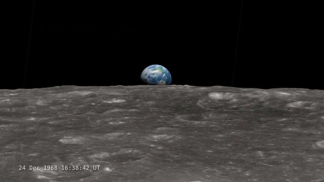
<b>Join NASA's Google+ Hangout on Friday, December 20th 2:00 - 3:00 PM (EST) at <a href="http://go.nasa.gov/18S2TbC" rel="nofollow">go.nasa.gov/18S2TbC</a> </b> It was 45 years ago, on December 24, 1968 when Apollo 8 astronauts captured 'Earthrise' – the first color photograph of Earth taken by a person in lunar orbit. NASA announces a new simulation of the events leading to the creation of 'Earthrise,' one of the iconic photographs of the 20th Century – Earth seen from the moon captured by the crew of Apollo 8. This new simulation allows anyone to virtually ride with the astronauts and experience the awe they felt at the vista in front of them. Apollo 8 Commander Frank Borman and crew members William A. Anders and James A. Lovell photographed the stunning scene as their spacecraft orbited the moon on December 24, 1968. The new computer simulation was created using data from NASA's Lunar Reconnaissance Orbiter, or LRO, spacecraft and includes details not seen in the previous visualization released last year. Participants in this Hangout include: * John Keller, project scientist for the Lunar Reconnaissance Orbiter project * Ernie Wright, project lead with the Scientific Visualization Studio at NASA Goddard Space Flight Center * Andrew Chaikin, space historian, author of the book A Man on the Moon "This will also be the first time we've released a video that's synchronized with the onboard audio recording of the astronauts,", says Ernie Wright. "The new visualization tells us not only what time the photos were taken, but also exactly which way the spacecraft was pointing and therefore which window each photo was taken from." Earthrise is the cover photo of TIME's Great Images of the 20th Century and is among photos on the cover of LIFE's 100 Photographs That Changed the World. <b><a href="http://www.nasa.gov/audience/formedia/features/MP_Photo_Guidelines.html" rel="nofollow">NASA image use policy.</a></b> <b><a href="http://www.nasa.gov/centers/goddard/home/index.html" rel="nofollow">NASA Goddard Space Flight Center</a></b> enables NASA’s mission through four scientific endeavors: Earth Science, Heliophysics, Solar System Exploration, and Astrophysics. Goddard plays a leading role in NASA’s accomplishments by contributing compelling scientific knowledge to advance the Agency’s mission. <b>Follow us on <a href="http://twitter.com/NASA_GoddardPix" rel="nofollow">Twitter</a></b> <b>Like us on <a href="http://www.facebook.com/pages/Greenbelt-MD/NASA-Goddard/395013845897?ref=tsd" rel="nofollow">Facebook</a></b> <b>Find us on <a href="http://instagram.com/nasagoddard?vm=grid" rel="nofollow">Instagram</a></b>

Night Earth Observation from the International Space Station
Earth observations taken during the STS-75 mission from the space shuttle Columbia.
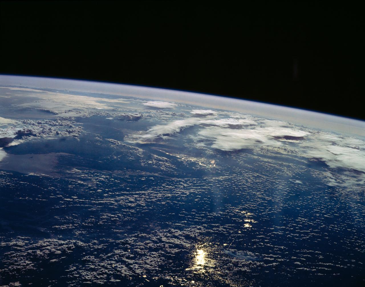
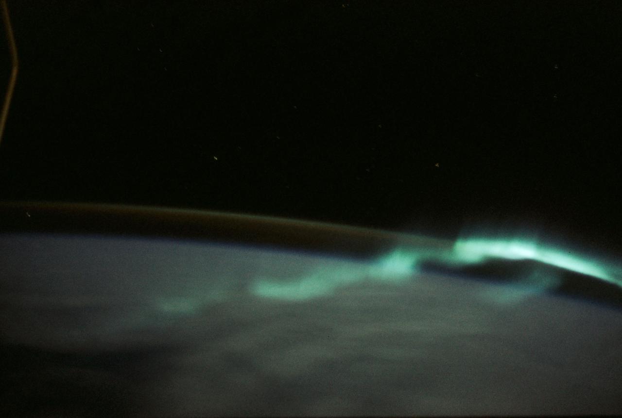
STS039-23-036 (28 April-6 May 1991) --- A 35mm frame of the Aurora Australis, also known as the Southern Lights, photographed from the Space Shuttle Discovery's flight deck by one of its seven crew members. One of the mission objectives was to measure the spectral and spatial characteristics of auroral emissions. While passing over the sunlit portion of Earth, the crew was able to take a number of photos of the various geographic points on the planet; much of the time on nightside passes was devoted to a thorough study and documentation of auroral displays.
STS039-23-020 (28 April-6 May 1991) --- A 35mm frame of the Aurora Australis, also known as the Southern Lights, photographed from Space Shuttle Discovery's flight deck by one of its seven crew members. One of the mission objectives was to measure the spectral and spatial characteristics of auroral emissions. While passing over the sunlighted portion of Earth, the crew was able to take a number of photos of the various geographic points on the planet; much of the time on nightside passes was devoted to a thorough study and documentation of auroral displays.

STS039-25-006 (28 April-6 May 1991) --- A 35mm frame of the Aurora Australis, also known as the Southern Lights, photographed from the Space Shuttle Discovery's flight deck by one of its seven crew members. One of the mission objectives was to measure the spectral and spatial characteristics of auroral emissions. While passing over the sunlighted portion of Earth, the crew was able to take a number of photos of the various geographic points on the planet; much of the time on nightside passes was devoted to a thorough study and documentation of auroral displays.
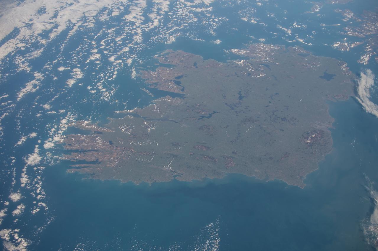
Earth observation taken during a day pass by the Expedition 43 crew aboard the International Space Station (ISS). Sent as part of Twitter message: #HappyStPatrickDay with best wishes from the #E43 crew! From space you can see the âEmerald Isleâ is very green!
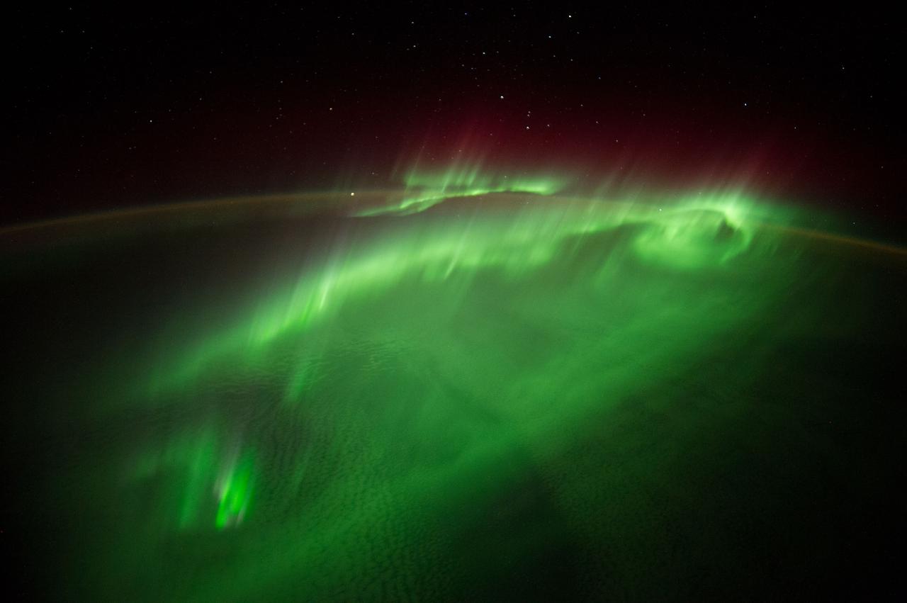
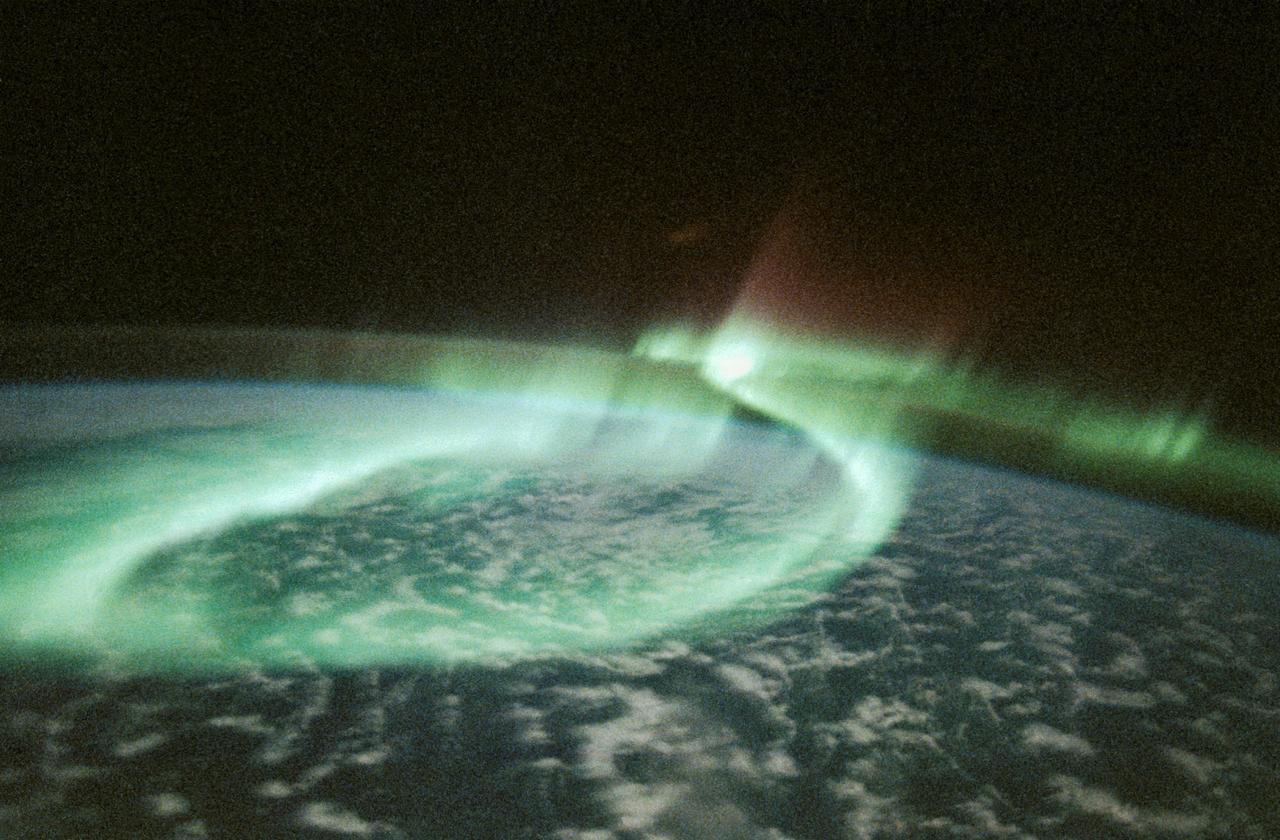
Time lapse (ISS040E117497 thru ISS040E118044) Earth observation taken during a night pass by the Expedition 40 crew aboard the International Space Station (ISS). Folder lists this as: TL SUPER Aurora 4 - from DC-1.
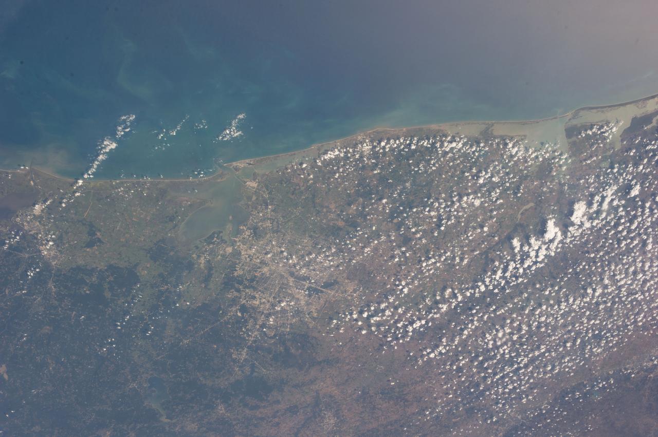
Earth Observation taken during a day pass by the Expedition 40 crew aboard the International Space Station (ISS). On crewmember's Flickr page - From Spain to Italy in a single glimpse.
Time lapse (ISS040E117497 thru ISS040E118044) Earth observation taken during a night pass by the Expedition 40 crew aboard the International Space Station (ISS). Folder lists this as: TL SUPER Aurora 4 - from DC-1.
Earth Observation taken during a day pass by the Expedition 40 crew aboard the International Space Station (ISS). Folder lists this as: Afterglow on clouds. Also sent as Twitter message: Sun highlights a storm from underneath.

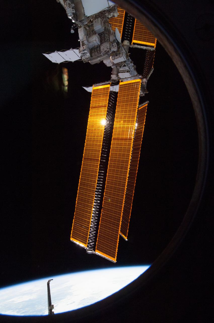
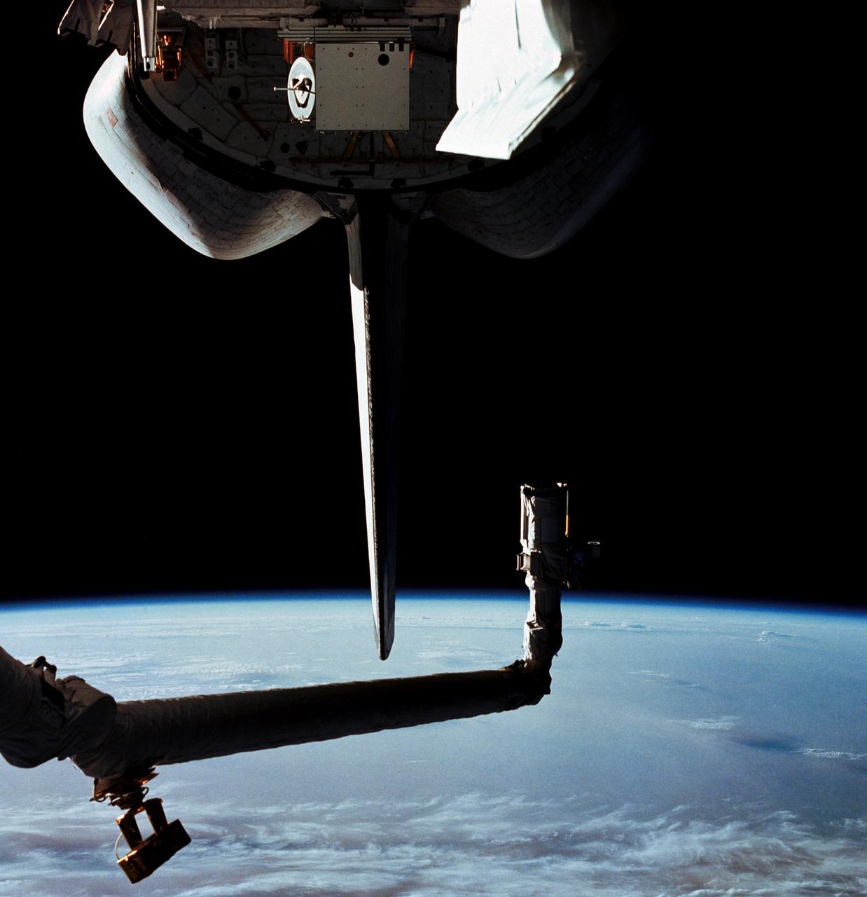
ISS040-E-006193 (1 June 2014) --- Backdropped by a blue and white part of Earth and the blackness of space, solar array wings are featured in this image photographed by an Expedition 40 crew member from a window in the Cupola of the International Space Station.
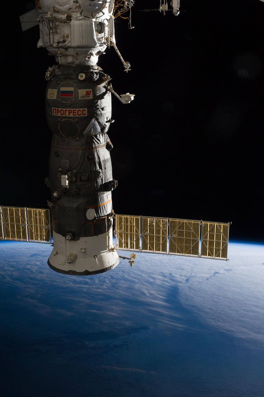
Earth observation taken during day pass by an Expedition 36 crew member on board the International Space Station (ISS). Per Twitter message: Russian Progress vehicle- packed full of trash, closed up & ready to undock from #ISS in just over an hr at GMT 20:44.

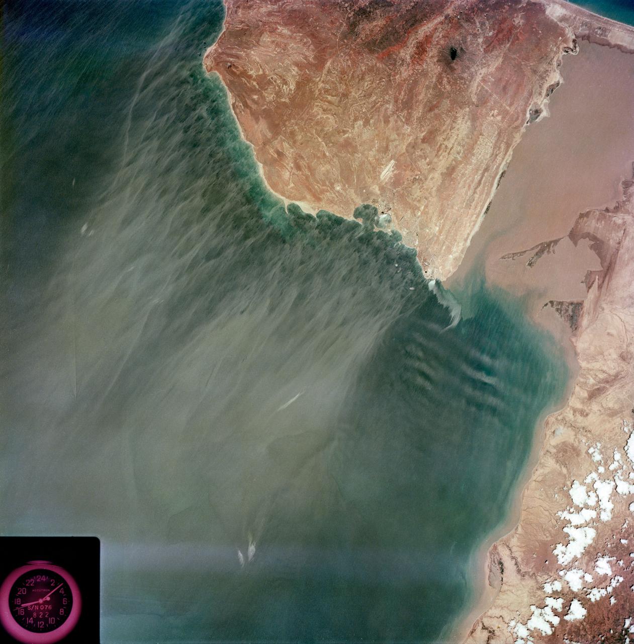
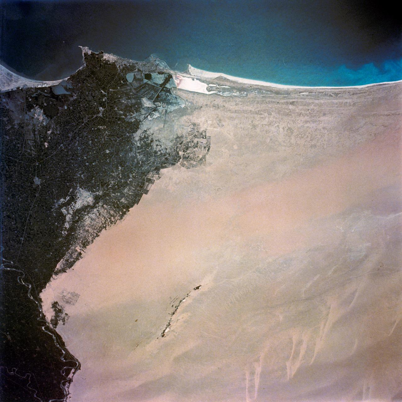
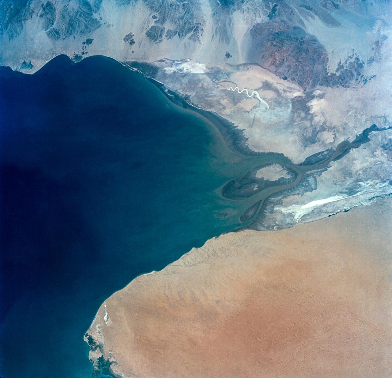
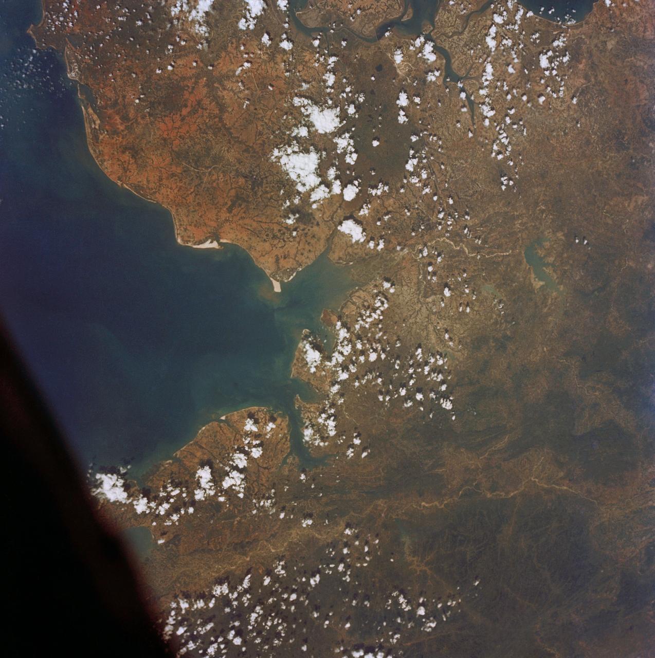
S65-63256 (16 Dec. 1965) --- Cap Blanc and Levrier Bay on the coast of Spanish Sahara and Mauritania, as seen from the Gemini-6 spacecraft during its 15th revolution of Earth. Photo credit: NASA or National Aeronautics and Space Administration
S65-63282 (16 Dec. 1965) --- Area of Indian Ocean, just east of the island of Madagascar, as seen from the Gemini-6 spacecraft during its 15th revolution of Earth. Land mass at top of picture is the Malagasy Republic (Madagascar). Photo credit: NASA or National Aeronautics and Space Administration
Earth observation taken during day pass by an Expedition 36 crew member on board the International Space Station (ISS). Per Twitter message: From southernmost point of orbit over the South Pacific- all clouds seemed to be leading to the South Pole.
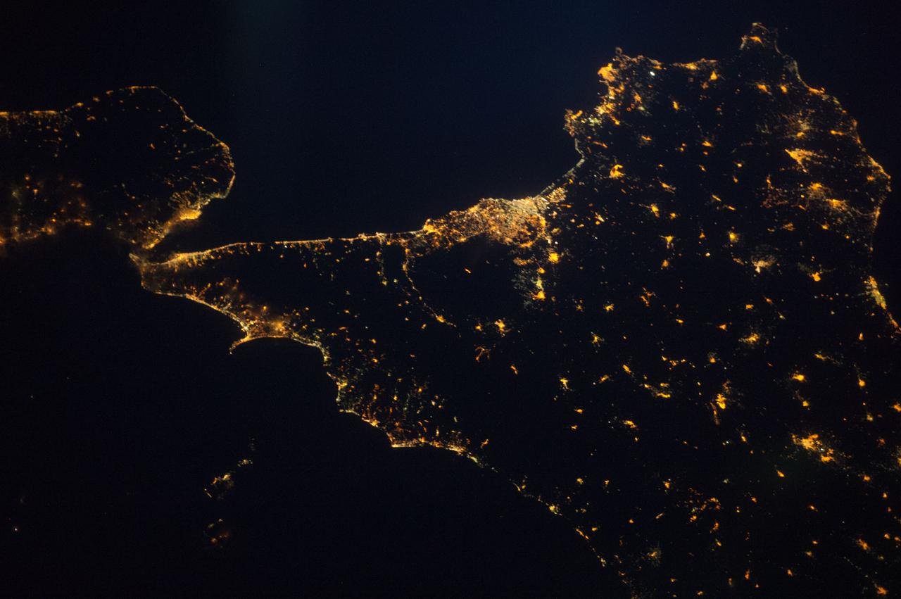
ISS040-E-087282 (1 Aug. 2014) --- The Italian island/province of Sicily is almost totally visible in this nighttime nadir image photographed from 221 nautical miles above Earth by one of the Expedition 40 crew members aboard the International Space Station. The "toe" of Italy's "boot" is in the upper left corner.
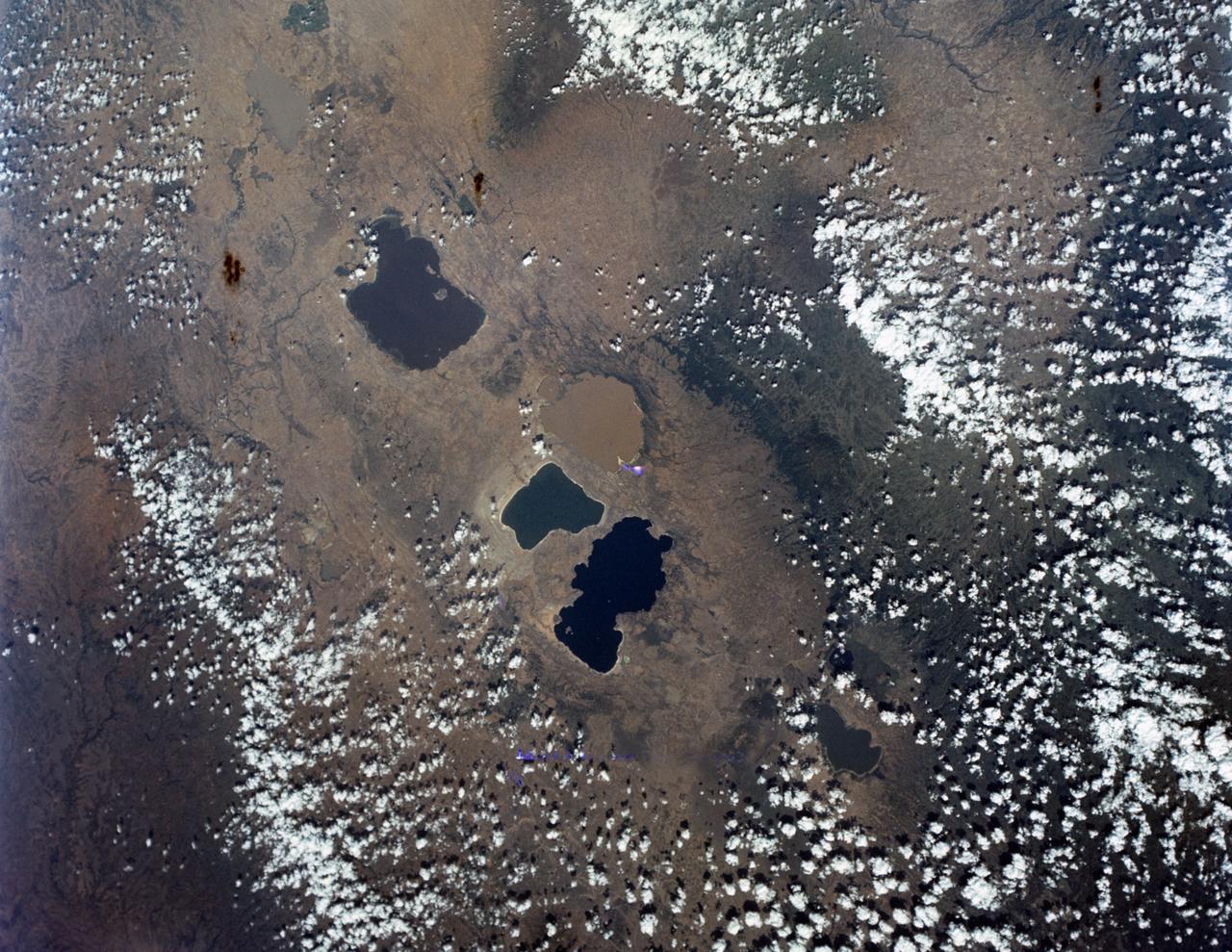
S65-63162 (16 Dec. 1965) --- Central area of Ethiopia, south of Addis Ababa, showing Lakes Zwai, Langana, and Shala, as seen from the Gemini-6 spacecraft during its 14th revolution of Earth. Photo credit: NASA or National Aeronautics and Space Administration
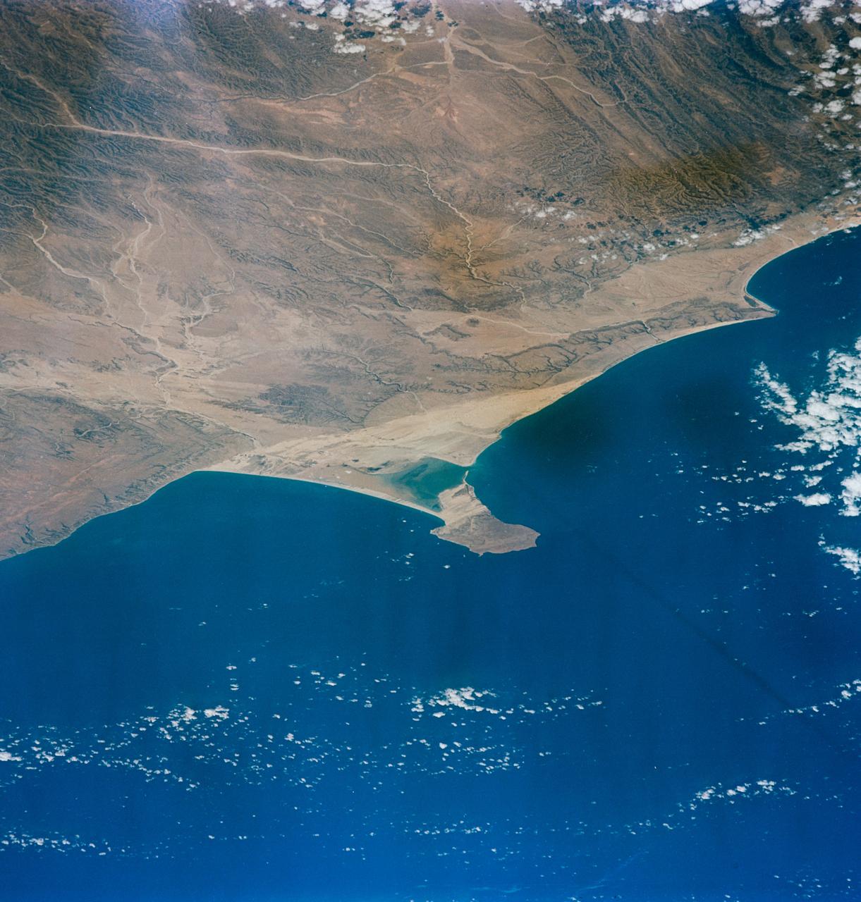
S65-63130 (16 Dec. 1965) --- Ras Hafum, coast of Somali Republic, northeast Africa, as seen from the Gemini-6 spacecraft during its 13th revolution of Earth. Photo credit: NASA or National Aeronautics and Space Administration
Earth observation taken during a day pass by an Expedition 36 crew member on board the International Space Station (ISS). Per Twitter message: Hey, Houston, what were you doing an hour ago when I snapped this picture from #ISS?
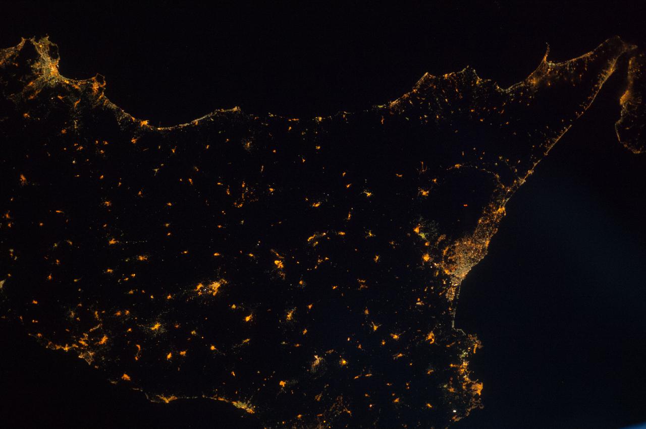
ISS040-E-087275 (1 Aug. 2014) --- Much of the Italian island/province of Sicily is visible in this nighttime nadir image photographed from 221 nautical miles above Earth by one of the Expedition 40 crew members aboard the International Space Station. The tip of the "toe" of Italy's "boot" is barely visible in the upper right corner.
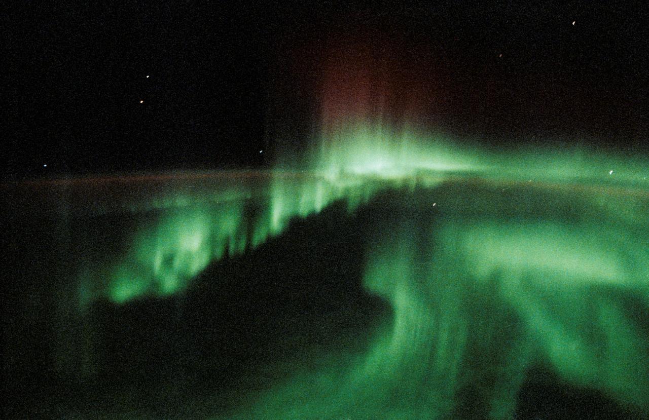
STS047-20-015 (12-20 Sept. 1992) --- This 35mm frame represents one of the more spectacular views of Aurora Australis, photographed by the crew. The crew observed and photographed a great deal of auroral activity from the Earth-orbiting Space Shuttle Endeavour during the eight-day Spacelab-J mission.
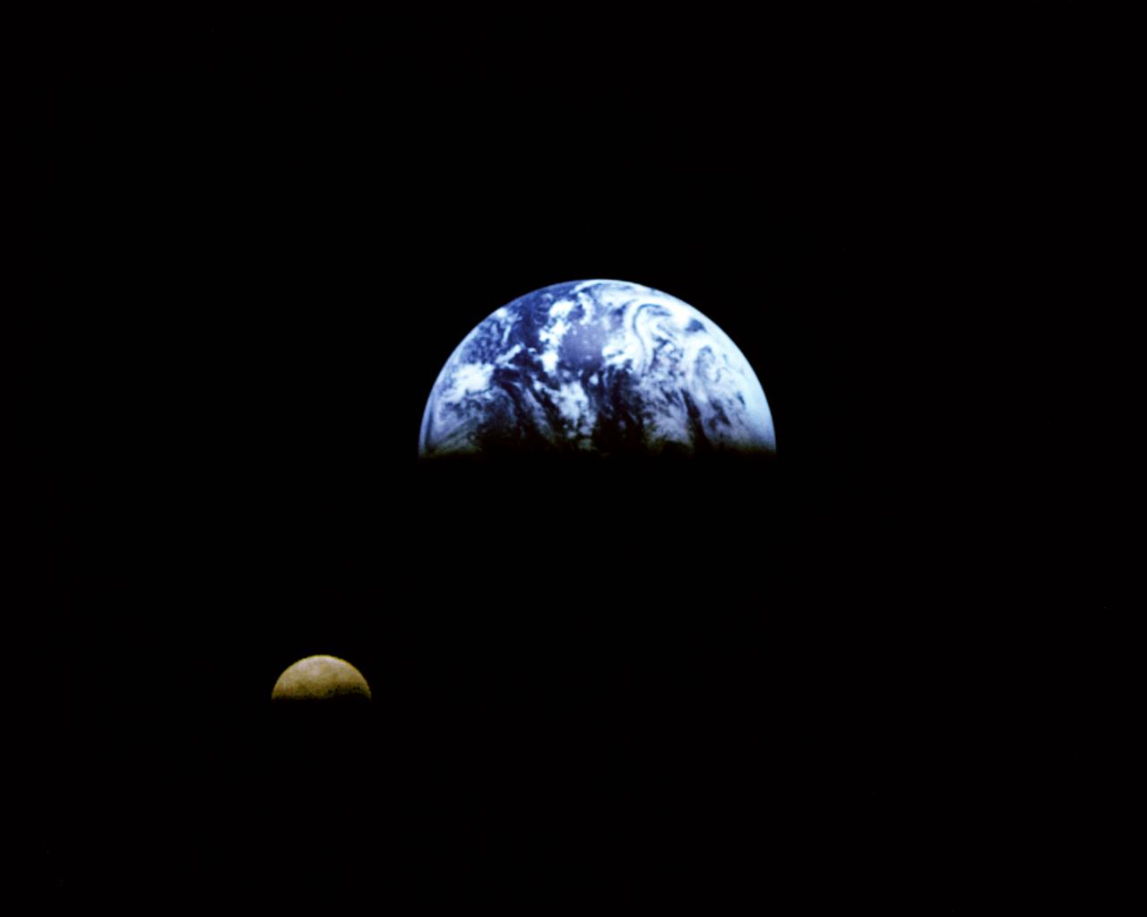
Eight days after its encounter with the Earth, the Galileo spacecraft was able to look back and capture this remarkable view of the Moon in orbit about the Earth, taken from a distance of about 6.2 million kilometers (3.9 million miles). The picture was constructed from images taken through the violet, red, and 1.0-micron infrared filters. The Moon is in the foreground, moving from left to right. The brightly-colored Earth contrasts strongly with the Moon, which reflects only about one-third as much sunlight as the Earth. Contrast and color have been computer-enhanced for both objects to improve visibility. Antarctica is visible through clouds (bottom). The Moon's far side is seen; the shadowy indentation in the dawn terminator is the south-Pole/Aitken Basin, one of the largest and oldest lunar impact features. Alternate Jet Propulsion Laboratory (JPL) number is P-41508. View appears in the Space News Roundup v32 n1 p1, 01-11-93.
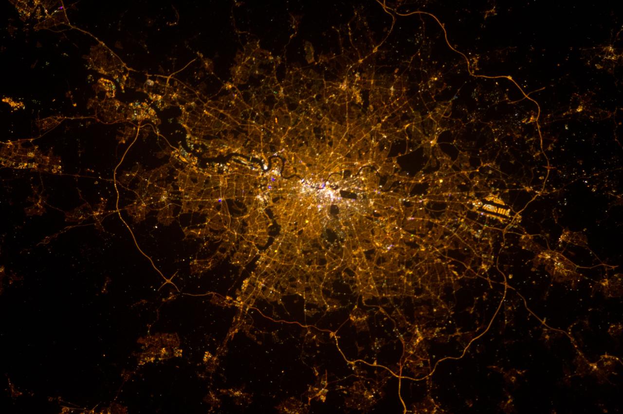
ISS034-E-039331 (2 Feb. 2013) --- This nocturnal photo of London, England was downlinked by the Expedition 34 crew from the International Space Station, flying approximately 240 miles above Earth, on Feb. 2, 2013. Expedition 34 Flight Engineer Chris Hadfield, astronaut with the Canadian Space Agency, added this footnote to his downlink: ?London, on the Thames, from the city to the encircling motorway. Heathrow very visible on the (west).? North is at the bottom making west on the right in this image. It?s the bright feature with dark parallel lines near the outer looping road.
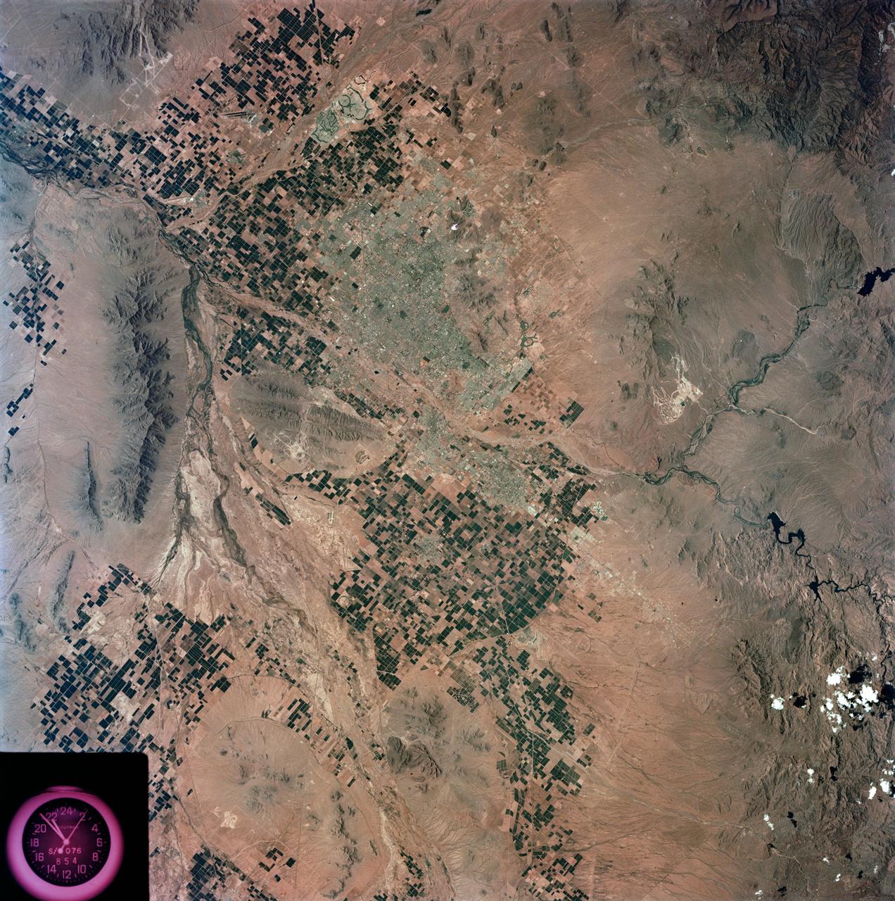
S73-35078 (July-Sept. 1973) --- A nearly vertical view of the Phoenix, Arizona metropolitan area is seen in this Skylab 3 (second manning) Earth Resources Experiments Package S190-B (five-inch Earth terrain camera) photograph taken from the Skylab space station in Earth orbit. Also in the picture are Scottsdale, Paradise Valley, Tempe, Mesa, Komatke, Salt River Indian Reservation and part of the Gila River Indian Reservation. Features which can be delineated from the photograph include: cultural patterns defined by commercial, industrial, agricultural and residential areas; transportation networks consisting of major corridors, primary, secondary and feeder streets; major urban developments in the area such as airports, Squaw Peak City Park, Turf Paradise Race Track and the State Fairgrounds. Phoenix is one of the 27 census cities of interest under study by the U.S. Geological Survey and is the center of the Arizona Regional Ecological Test Site. A large number of investigators will be using the Skylab data. This photo will be compared to earlier ones to document changes in the urban area with time. The landscape is well defined in terms of mountains, alluvial fans and river flood plains. Several different types of natural vegetation and irrigated crop lands can be mapped. Geological features are not well displayed but mining activities are readily identified. Photo credit: NASA
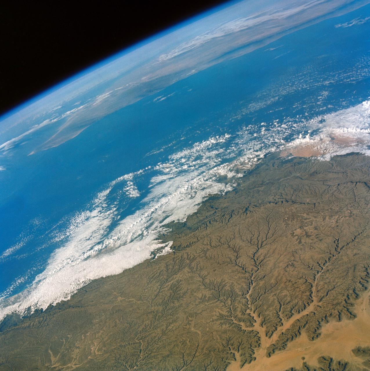
STS052-23-022 (22 Oct.-1 Nov. 1992) --- As the Space Shuttle Columbia orbited Earth in an easterly direction over the Indian Ocean, moonrise was followed quickly by sunrise. The photograph was taken from an altitude of 285 kilometers (154 nautical miles), over Lake Tanganyika in central Africa. The Sun was still 28 degrees below the horizon and not yet illuminating the dark band of low-level clouds on the limb 1,850 kilometers (l,000 nautical miles) away. Ranging from 13--18 kilometers above these low-level clouds is a brown layer at the tropical tropopause. A tropopause is a major atmospheric temperature inversion which isolates the troposphere from the stratosphere and effectively concentrates particulate from both above and below this level.
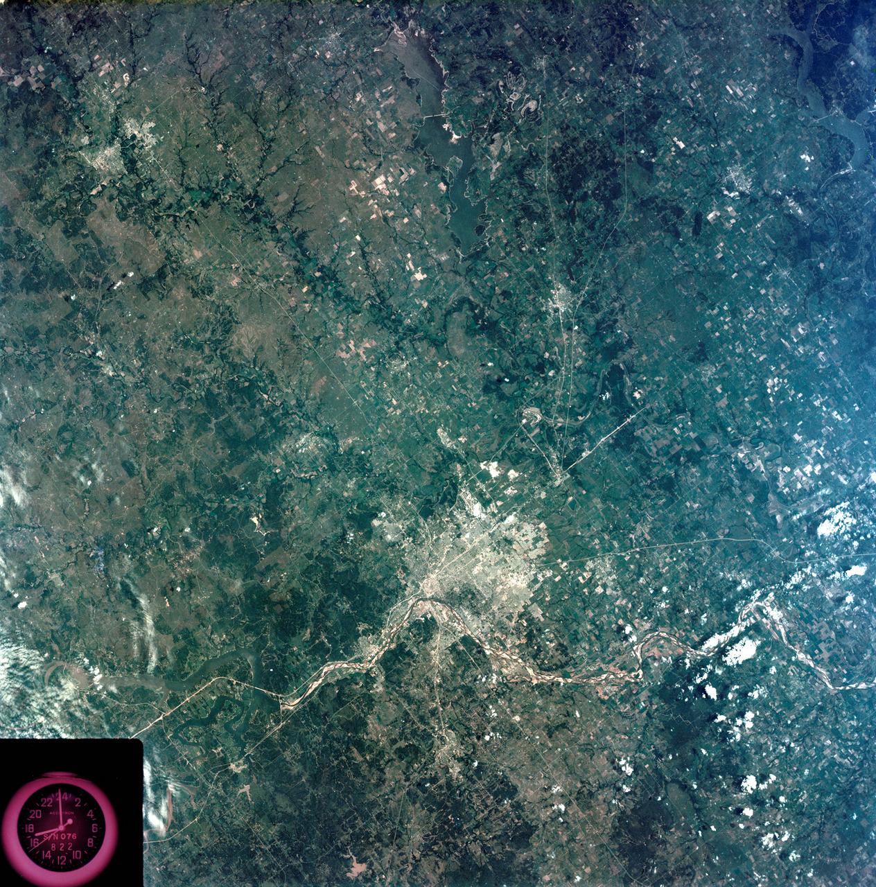
S73-35080 (July-September 1973) --- A vertical view of northeast Oklahoma and the metropolitan Tulsa area is seen in this Skylab 3 Earth Resources Experiments Package S190-B (five-inch Earth terrain camera) photograph taken from the Skylab space station in Earth orbit. THE PICTURE SHOULD BE HELD WITH THE CLOCK ON THE LEFT AND THE LAKE IN THE CORNER ON THE RIGHT. THE LONG STRETCH OF HIGHWAY (U.S. 75) RUNS STRAIGHT NORTH FROM TULSA. Tulsa, a rapidly expanding city in the heart of the mid-continent oil field, has a population of approximately 330,000. The Arkansas River meanders across the southern (lower) portion of the photograph passing through Tulsa as it flows southeastward. Oologah Reservoir, the long body of water, is located northeast of Tulsa. Lake Hudson is the body of water in the right corner of the picture. Keystone Reservoir is to the west and upstream from Tulsa. Westward from Tulsa U.S. 64 makes a 45 degree bend as it turns northwest to cross the Keystone Reservoir. The thin white line over the Oologah Reservoir is a highway bridge. Bartlesville is on U.S. 75 near the north (top) corner of the picture. The Tulsa International Airport is immediately northeast of downtown Tulsa. Several smaller airfields are visible in the surrounding area. The toll roads and other major highways are clearly visible in the picture. Claremore is northeast of Tulsa on U.S. 66 with the Will Rogers Turnpike passing nearby. Sapulpa is southwest of Tulsa on the Turner Turnpike which leads toward Oklahoma City. The detailed information contained in this photograph can be extracted by direct observation and applied to updating land use and cultural maps of Tulsa and to numerous surrounding satellite cities. All EREP photography is available to the public through the Department of Interior?s Earth Resources Observations Systems Data Center, Sioux Falls, South Dakota, 57198. (Alternate number SL3-83-206) Photo credit: NASA
SL2-10-250 (May-June 1973) --- A vertical view of eastern Iowa and northwestern Illinois, as photographed from Skylab space station in Earth orbit. Davenport, Burlington and Muscatine, Iowa; and Rock Island and Moline, Illinois can be delineated on opposite sides of the Mississippi River. The Iowa River and tributaries of it can also be delineated. This photograph was taken with one of six lenses of the Itek-furnished Multispectral Photographic Facility Experiment S190-A mounted in the Multiple Docking Adapter (MDA) of the space station. A six-inch lens, using 70mm medium speed Ektachrome (SO-356) film, was used. Agencies participating with NASA on the EREP project are the Departments of Agriculture, Commerce and Interior; the Environmental Protection Agency and the Corps of Engineers. All EREP photography is available to the public through the Department of Interior's Earth Resources Observations Systems Data Center, Sioux Falls, South Dakota, 57198. Photo credit: NASA
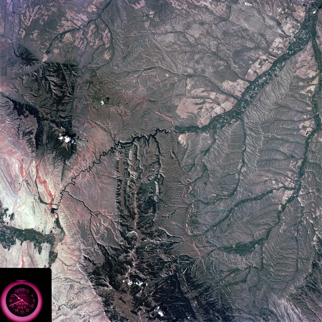
ISS034-E-056100 (21 Feb. 2013) --- One of the most recognizable natural features on Earth, when viewing from space, is the Manicouagan Crater, one of the oldest known impact craters on Earth. Photographed by one of the Expedition 34 crew members onboard the International Space Station, the crater is located primarily in Manicouagan Regional County Municipality in the Côte-Nord region of Québec, Canada, about 300 kilometers (190 miles) north of the city of Baie-Comeau. Manicouagan is one of the oldest large astroblemes still visible on the surface. The crater is a multiple-ring structure about 100 kilometers (60 miles) across, with its 70 kilometer (40 mile) diameter inner ring its most prominent feature; it contains a 70 kilometer (40 mile) diameter annular lake, the Manicouagan Reservoir, surrounding an inner island plateau.
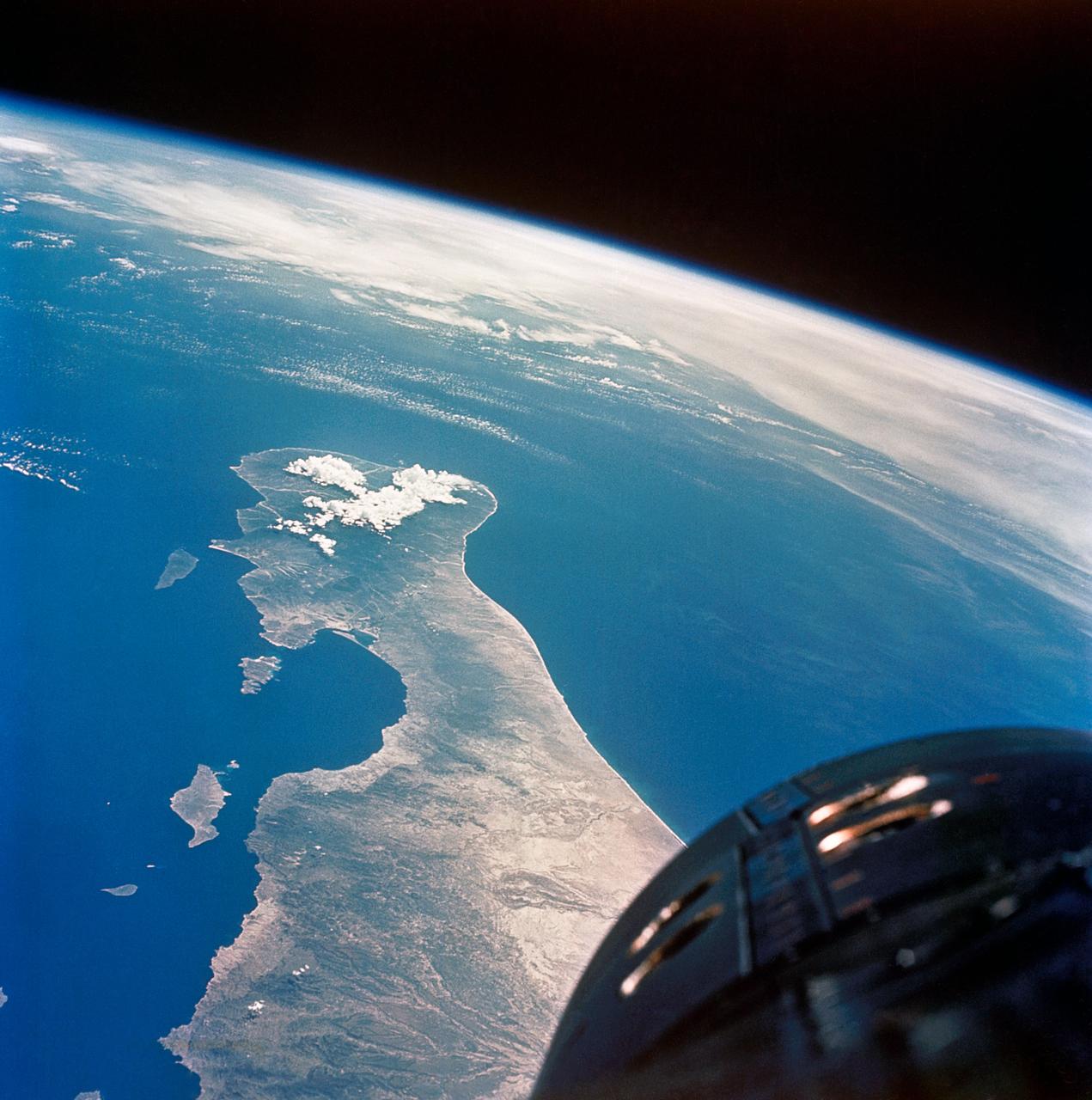
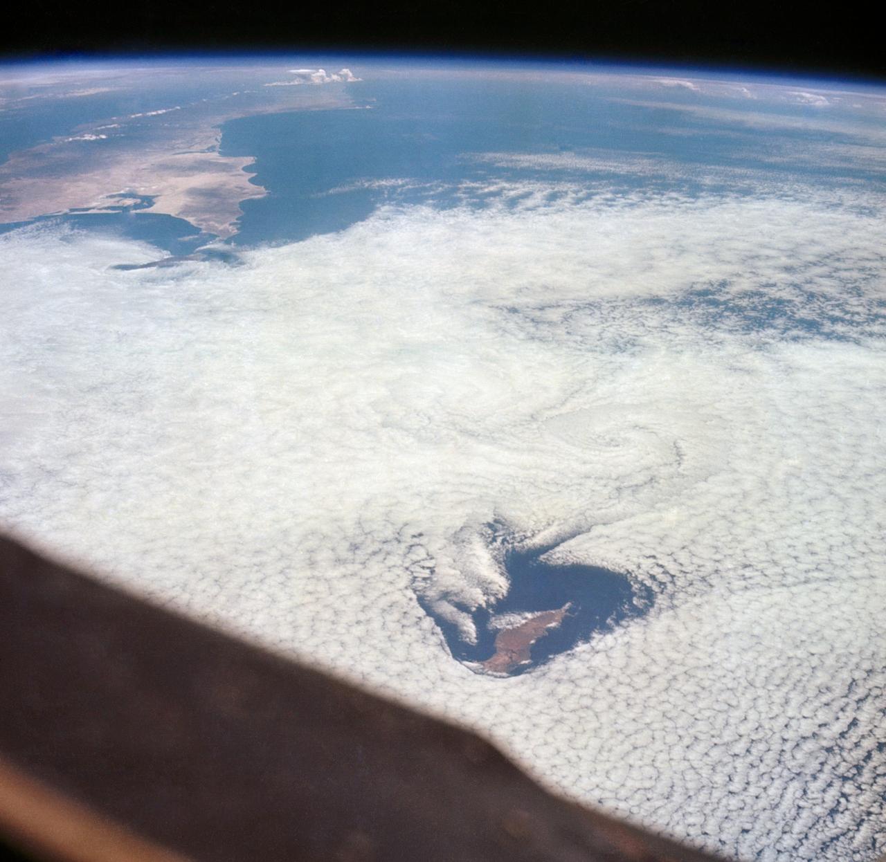
S65-63136 (16 Dec. 1965) --- Shark Bay area on the western coast of Western Australia as seen from the Gemini-6 spacecraft during its 16th revolution of Earth. City of Carnarven, where NASA has a tracking station, is located near the bottom of picture in lower left corner, near mouth of stream. Indian Ocean is body of water at upper right. South is toward top of picture. Photo credit: NASA or National Aeronautics and Space Administration
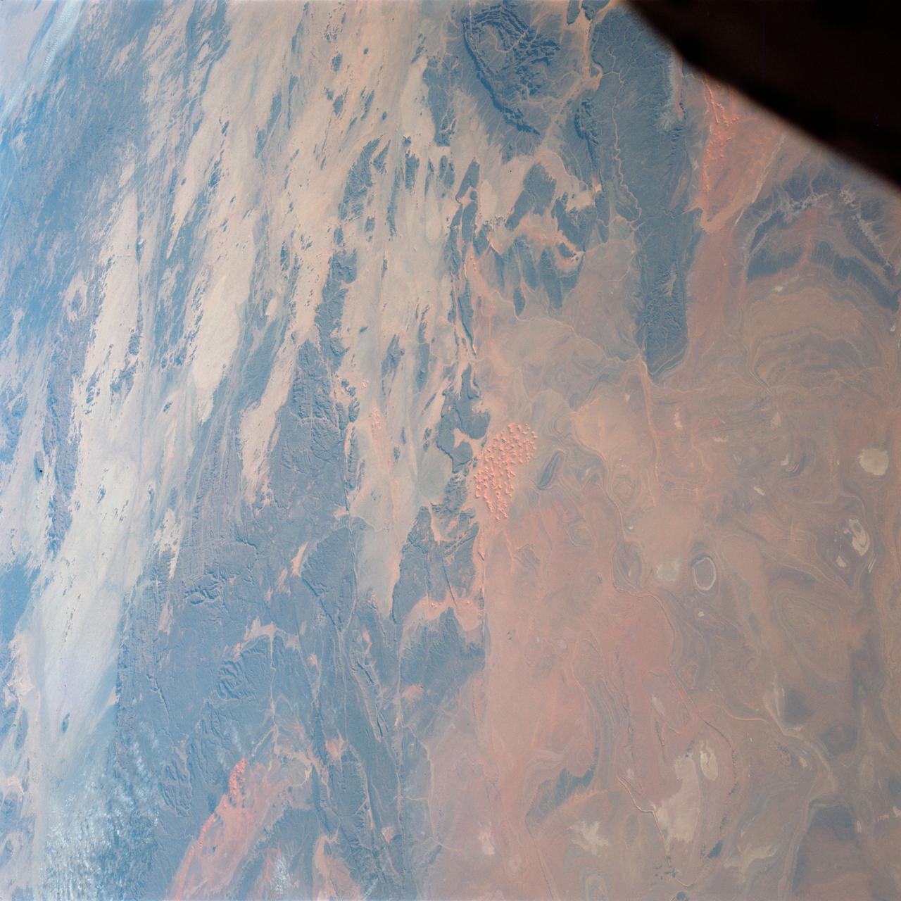
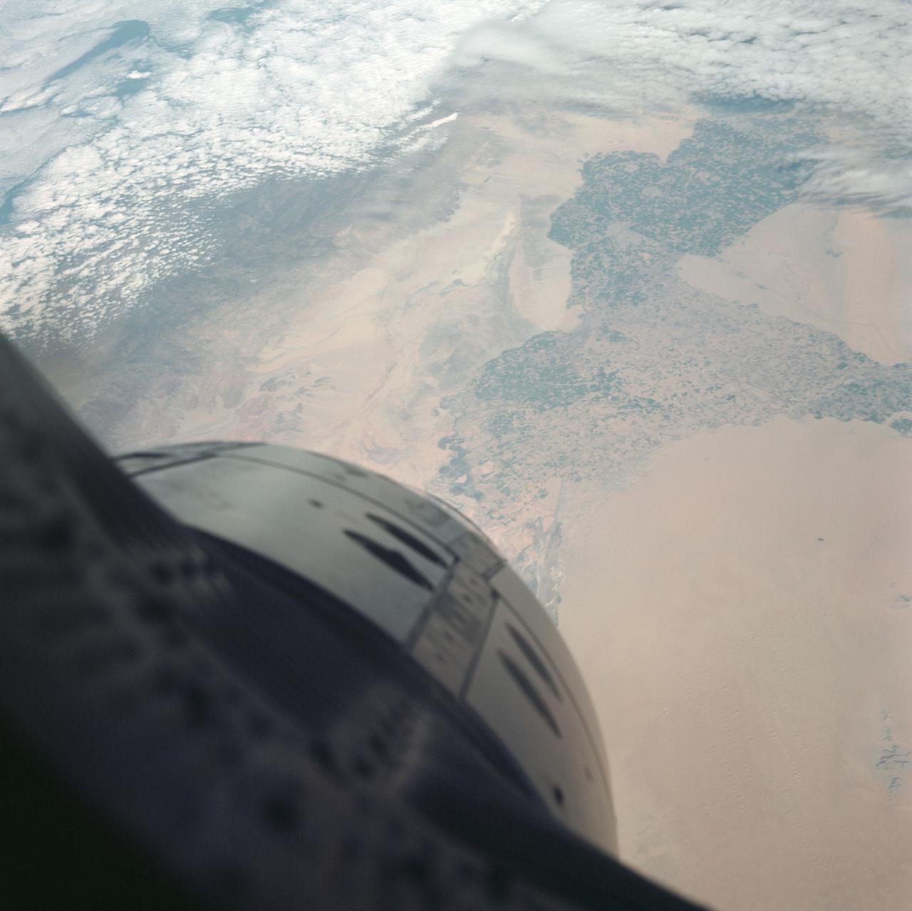
S65-63784 (7 Dec. 1965) --- Algeria, south of Celemb Bechar, as seen from the orbiting Gemini-7 spacecraft during its 42nd revolution of Earth. Note rain runoff on the desert floor. Astronaut Frank Borman and James A. Lovell Jr. were aboard the National Aeronautics and Space Administration?s Gemini-7 spacecraft. The photograph was taken with a modified 70mm Hasselblad camera, using Eastman Kodak, Ektachrome MS (S.O. 217) color film. Photo credit: NASA

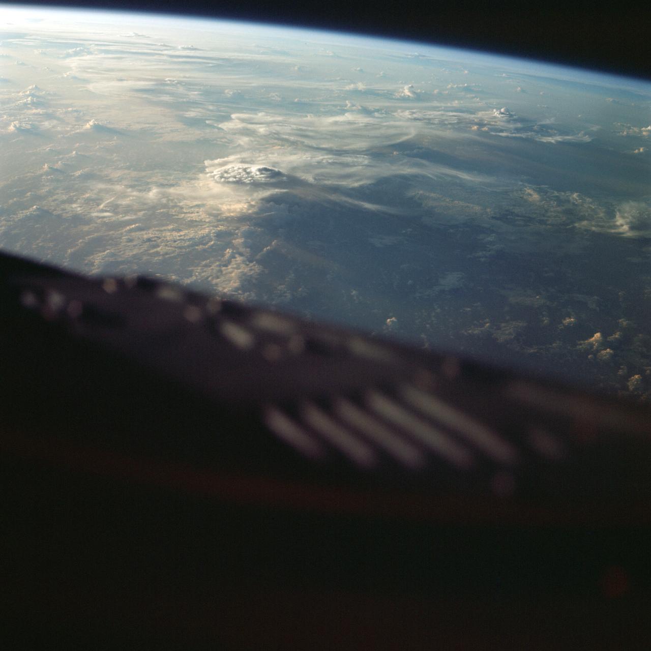
ISS040-E-089379 (7 Aug. 2014) --- One of the Expedition 40 crew members aboard the International Space Station, from an altitude of 221 nautical miles, photographed this image of Typhoon Halong at 08:02:41 GMT on Aug. 7, 2014. The orbital outpost was flying above a point on Earth located at 15.8 degrees north latitude and 142.4 degrees east longitude. One of the solar panels of the orbital outpost is seen on the left side of the scene.
S65-63758 (11 Dec. 1965) --- The states of Puebla, Vera Cruz, Tlaxcala and Oaxaca in Mexico, as seen from the National Aeronautics and Space Administration?s Gemini-7 spacecraft during its 107th revolution of Earth. Taken with a modified 70mm Hasselblad camera, with Eastman Kodak, Ektachrome MS (S.O. 217) color film. Photo credit: NASA
S77-E-5073 (22 May 1996) --- From its position at 175 statute miles above Earth, the Space Shuttle Endeavour has encountered some colorful and attractive scenes heading into sunsets and sunrises. This particular encounter, captured with an Electronic Still Camera (ESC), occurred on flight day four, during which the six-member crew deployed the Passive Aerodynamically Stabilized Magnetically Damped Satellite (PAMS) - Satellite Test Unit (STU).
S65-64029 (13 Dec. 1965) --- Coast of British Guiana, South America, looking south, as seen from the National Aeronautics and Space Administration?s Gemini-7 spacecraft during its 135th revolution of Earth. This photograph was taken with a modified 70mm Hasselblad camera, using Eastman Kodak, Ektachrome MS (S.O. 217) color film. Photo credit: NASA
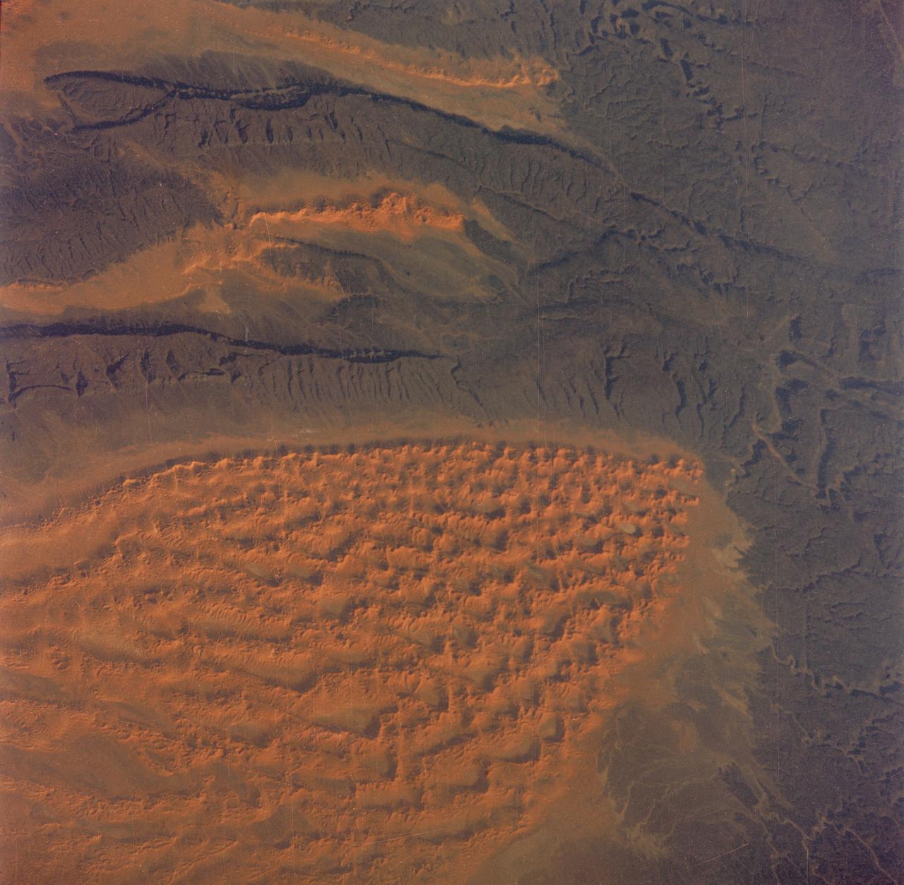
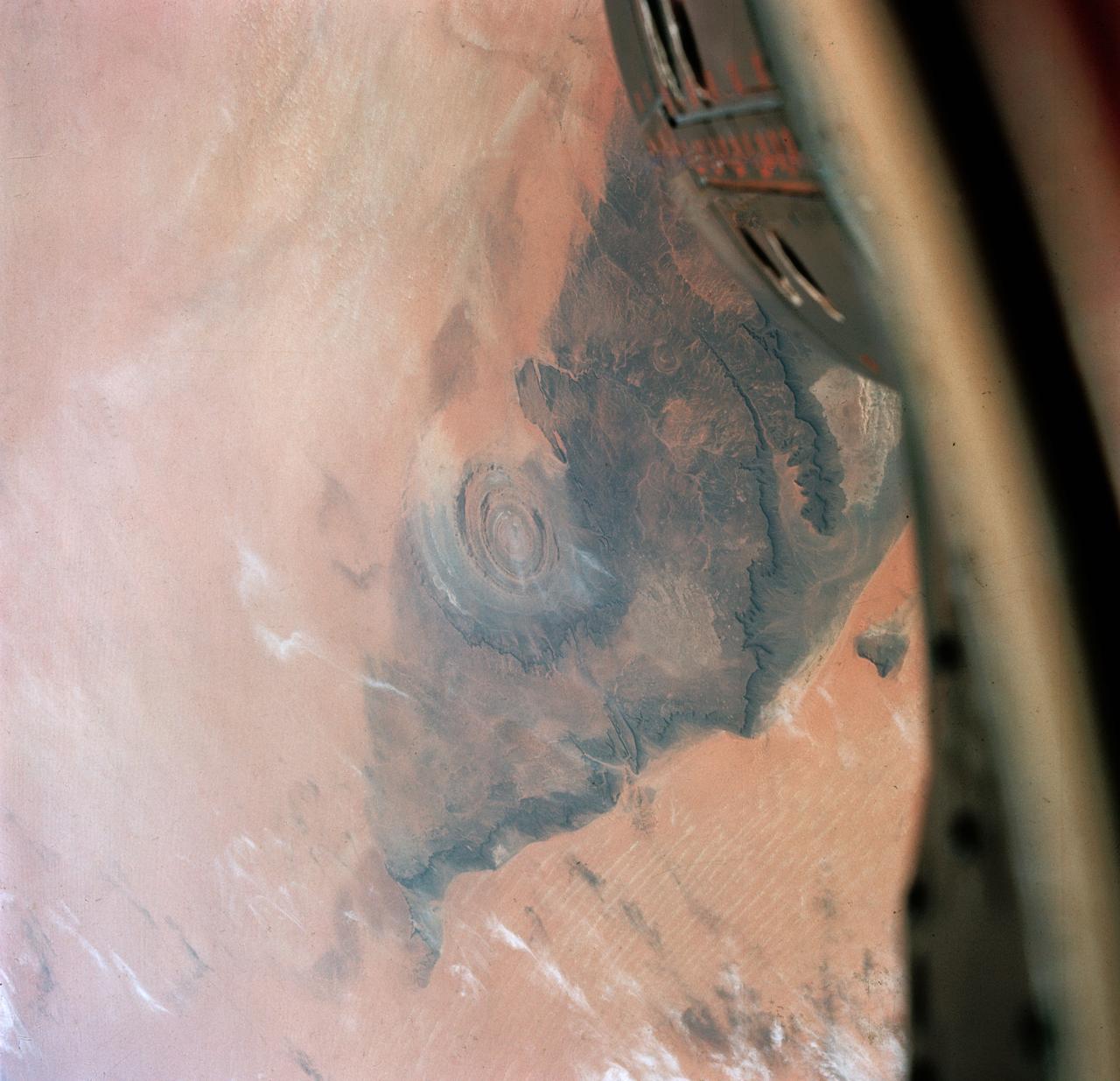
S65-63829 (5 Dec. 1965) --- Algeria, south of the Fort Flatters area, as seen from the National Aeronautics and Space Administration?s Gemini-7 spacecraft during its 13th revolution of Earth. The orange color area is the Tifermine Sand Dunes that reach a height of 1,000 feet. The photograph was taken with a modified 70mm Hasselblad camera, with Eastman Kodak, Ektachrome MS (S.O. 217) color film. Photo credit: NASA
S73-35079 (July-September 1973) --- A near vertical view of the Caribbean coast of Venezuela is seen in this Skylab 3 Earth Resources Experiment Package S190-B (five-inch Earth terrain camera) photograph taken from the Skylab space station in Earth orbit. The large body of water is the Golfo de Venezuela; and the major land mass is the Peninsula de Paraguana. The view is looking northward from the mouth of the Golfete de Coro and Punta Cardon to Punta Macolla. The peninsula is connected to the Venezuelan mainland by the narrow strip of land in the most easterly corner of the picture. The dry, arid climate on the peninsula is indicated by sparse vegetation and the abundance of sand dunes. The highest point is about 2,700 feet above the sea and is the conspicuous black spot. Old raised shoreline features appear as streaks parallel to the Golfete de Coro. Sand dunes and stream erosion have modified these features. Water of the Golfete de Coro is red from the high sediment content. The streaks in the water off the peninsula is apparently an effect of wind which is blowing sand and water offshore. The EREP investigator Dr. Jose Antonio Galavis, of the Ministerio de Mines e Hidrocarburos, will use this information to map geology and coastal sedimentation in the Peninsula de Paraguana. Federal agencies participating with NASA on the EREP projects are the Departments of Agriculture, Commerce, Interior, the Environmental Protection Agency and the Corps of Engineers. All EREP photography is available to the public through the Department of Interior?s Earth Resources Observations Systems Data Center, Sioux Falls, South Dakota, 57198. (Alternate number SL3-83-237) Photo credit: NASA
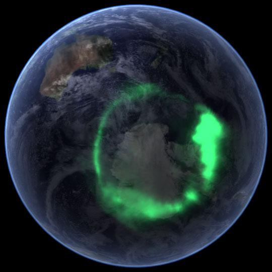
NASA file image acquired September 11, 2005 <b>To view a video of this event go here: <a href="http://www.flickr.com/photos/gsfc/6257608714">www.flickr.com/photos/gsfc/6257608714</a></b> From space, the aurora is a crown of light that circles each of Earth’s poles. The IMAGE satellite captured this view of the aurora australis (southern lights) on September 11, 2005, four days after a record-setting solar flare sent plasma—an ionized gas of protons and electrons—flying towards the Earth. The ring of light that the solar storm generated over Antarctica glows green in the ultraviolet part of the spectrum, shown in this image. The IMAGE observations of the aurora are overlaid onto NASA’s satellite-based Blue Marble image. From the Earth’s surface, the ring would appear as a curtain of light shimmering across the night sky. Like all solar storms, the September storm distorted the shape of the magnetic field that surrounds the Earth. Without buffeting from the solar wind (charged particles like protons and electrons that are ejected from the Sun), the Earth’s magnetic field would look something like a plump doughnut, with the North and South poles forming the slender hole in the center. In reality, the nearly constant solar winds flatten the space side of the “doughnut” into a long tail. The amount of distortion changes when solar storms, such as the flare on September 7, send stronger winds towards the Earth. Changes to the magnetic field release fast-moving particles, which flow with charged particles from the Sun towards the center of the “doughnut” at the Earth’s poles. As the particles sink into the atmosphere, they collide with oxygen and nitrogen, lighting the sky with Nature’s version of neon lights, the aurora. Though scientists knew that the aurora were caused by charged particles from the Sun and their interaction with the Earth’s magnetic field, they had no way to measure the interaction until NASA launched the Imager for Magnetopause-to-Aurora Global Exploration (IMAGE) satellite in 2000. The satellite’s mission was to collect data that would allow scientists to study the structure and dynamics of the Earth’s magnetic field for the first time. Designed to operate for two years, IMAGE sent its last data to Earth in December 2005 after a highly successful five-year mission. Since 2000, IMAGE has provided insight into how the Earth’s powerful magnetic field protects the planet from solar winds. Without the shield the magnetic field provides, the upper atmosphere would evaporate into space under the influence of solar winds. IMAGE has shown scientists what sort of changes the magnetic field undertakes as it diverts solar winds from the Earth. For a summary of the discoveries that IMAGE has made possible, see IMAGE Discovers. Instrument: IMAGE Credit: <a href="http://svs.gsfc.nasa.gov/index.html" rel="nofollow">NASA/Goddard Space Flight Center Scientific Visualization Studio</a> <b><a href="http://www.nasa.gov/audience/formedia/features/MP_Photo_Guidelines.html" rel="nofollow">NASA image use policy.</a></b> <b><a href="http://www.nasa.gov/centers/goddard/home/index.html" rel="nofollow">NASA Goddard Space Flight Center</a></b> enables NASA’s mission through four scientific endeavors: Earth Science, Heliophysics, Solar System Exploration, and Astrophysics. Goddard plays a leading role in NASA’s accomplishments by contributing compelling scientific knowledge to advance the Agency’s mission. <b>Follow us on <a href="http://twitter.com/NASAGoddardPix" rel="nofollow">Twitter</a></b> <b>Like us on <a href="http://www.facebook.com/pages/Greenbelt-MD/NASA-Goddard/395013845897?ref=tsd" rel="nofollow">Facebook</a></b> <b>Find us on <a href="http://instagrid.me/nasagoddard/?vm=grid" rel="nofollow">Instagram</a></b>

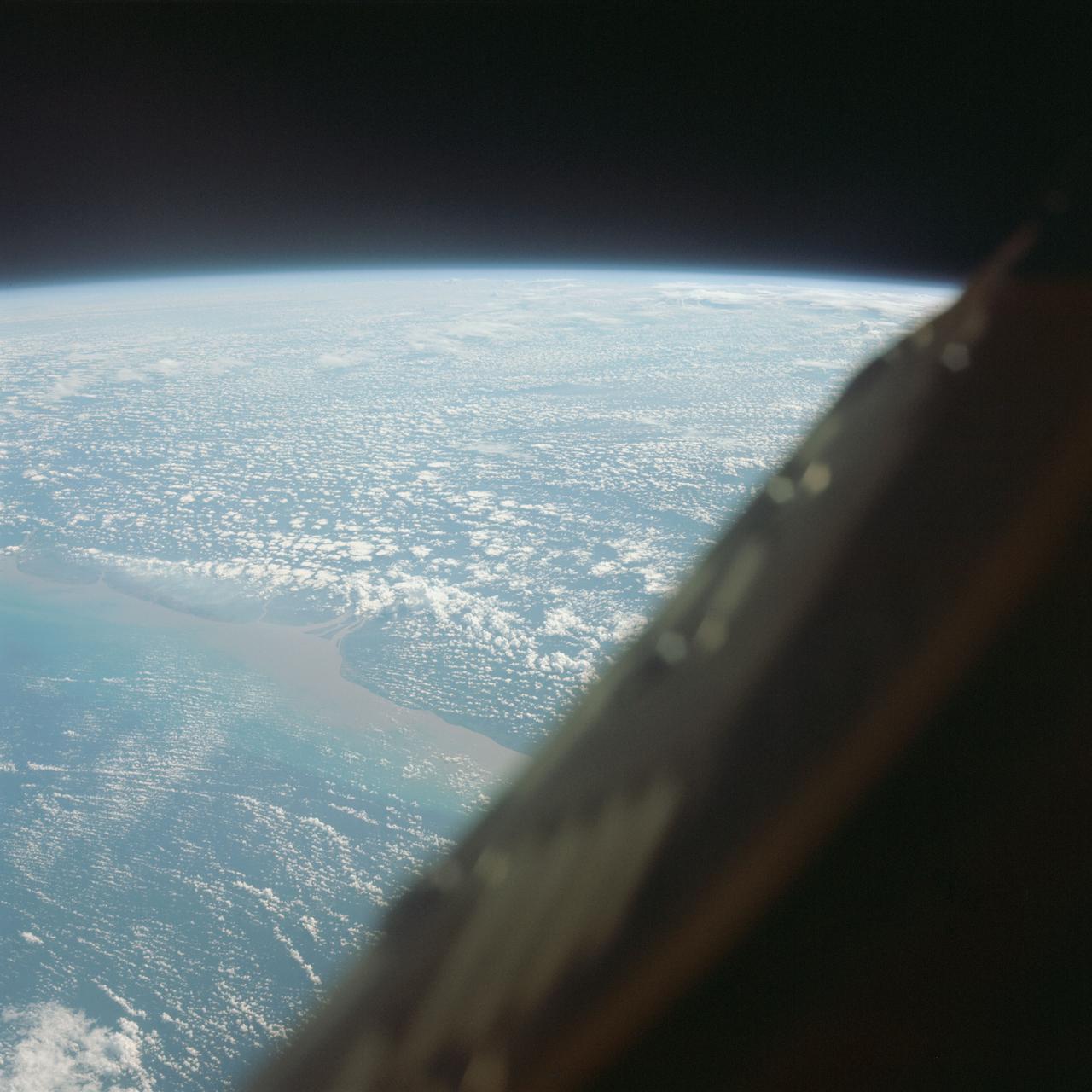
AS13-60-8588 (17 April 1970) --- This photograph of Earth was taken from the National Aeronautics and Space Administration's (NASA) Apollo 13 spacecraft during its trans-Earth journey home. The most visible land mass includes southwestern United States and northwestern Mexico. The peninsula of Baja California is clearly seen. Most of the land area is under heavy cloud cover. The Apollo 13 crew consisted of astronauts James A. Lovell Jr., commander; John L. Swigert Jr., command module pilot; and Fred W. Haise Jr., lunar module pilot.
S73-35081 (July-September 1973) --- A view of approximately 3,600 square miles of north central Wyoming and southern Montana is seen in this Skylab 3 Earth Resources Experiments Package S190-B (five-inch Earth terrain camera) photograph taken from the Skylab space station in Earth orbit. The Big Horn River following northward crosses between the northwest trending Big Horn Mountains and the Pryor Mountains. Yellowtail Reservoir, named after a former chief of the Crow Indian tribe in the center of the picture is impounded by a dam across the small rectangular crop area along the Big Horn River (upper right) and the strip farming (yellow) practiced on the rolling hill along the Big Horn River and its tributaries (upper left corner and right edge). The low sun angle enhances the structural features of the mountains as well as the drainage patterns in the adjacent basins. Rock formation appears in this color photograph as they would to the eye from this altitude. The distinctive redbeds can be traced along the front of the Pryor Mountains and indicate the folding that occurred during mountain building. EREP investigators, Dr. Houston of the University of Wyoming and Dr. Hoppin of the University of Iowa, will analyze the photograph and use the results in geological mapping and mineral resource studies. Lowell, Wyoming (lower left corner) and Hardin, Montana (upper right corner) can be recognized. Federal agencies participating with NASA on the EREP project are the Departments of Agriculture, Commerce, Interior, the Environmental Protection Agency and the Corps of Engineers. All EREP photography is available to the public through the Department of Interior?s Earth Resources Observations Systems Data Center, Sioux Falls, South Dakota, 57198. (Alternate number SL3-86-337) Photo credit: NASA
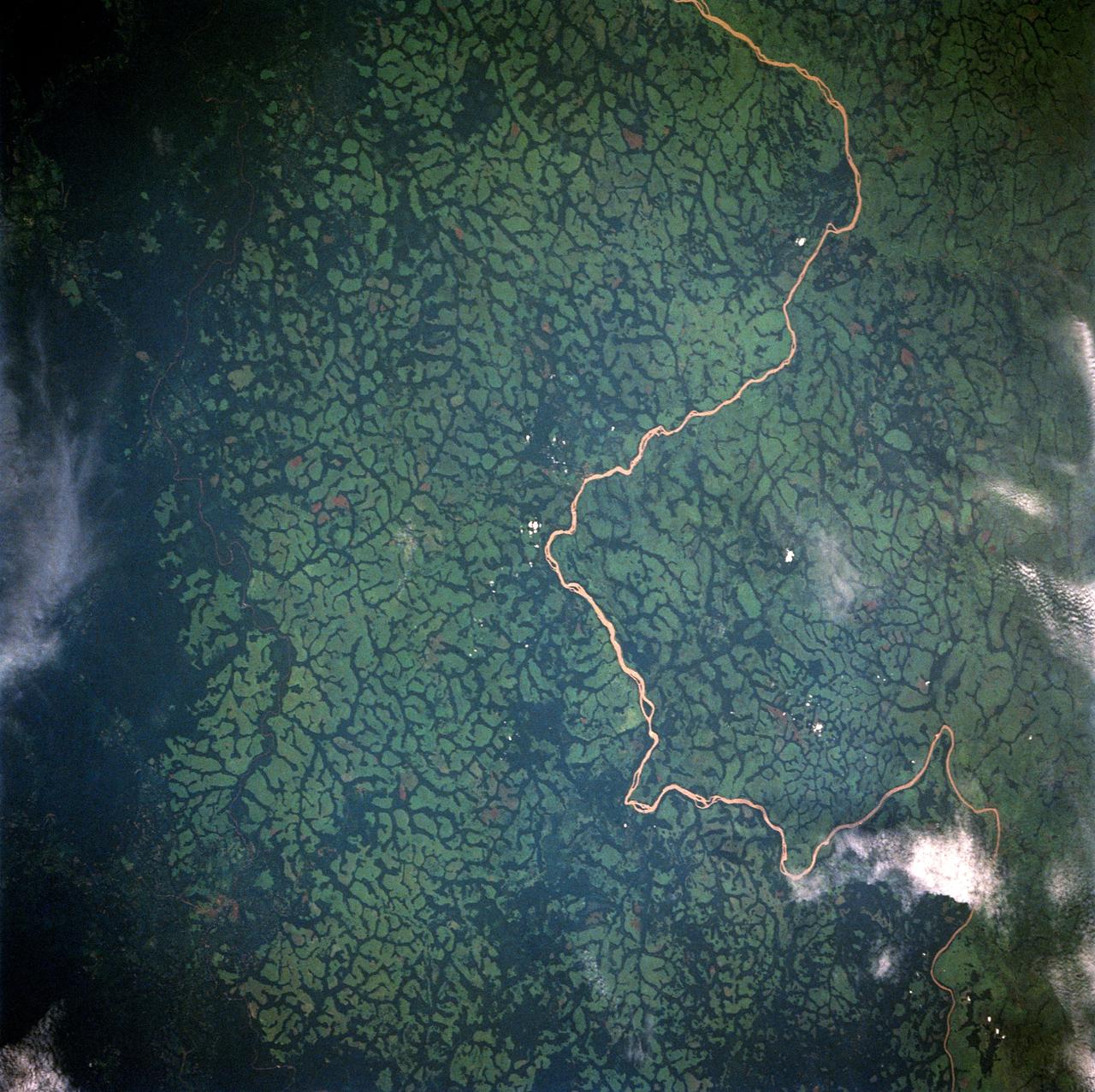
STS049-91-079 (7 - 16 May 1992) --- This 70mm frame, photographed from the Earth-orbiting Space Shuttle Endeavour, features a dendritic drainage pattern in Zaire. Cleared pasture land shows light green in this color photograph, in contrast to the dark, closed-canopy forest of Zaire. Remnant woodland along minor streams indicates the intricate drainage network of this hilly region. Scattered vegetation-free spots show the deep red, tropical soil of the region. The sediment-laden stream is the Vele River just west of the village of Niangara. A crew member used a 70mm handheld Hasselblad camera with a 250mm lens to record the image.
S65-63780 (12 Dec. 1965) --- Wave of clouds along the east flanks of the Andes Mountains cast off an orange glow by the low angle of the sun in the west. The dark area to the left is at Earth's terminator. Astronauts James A. Lovell Jr., pilot, and Frank Borman, command pilot, of the National Aeronautics and Space Administration's (NASA) Gemini-Titan 7 (GT-7) mission took the picture while looking south from northern Bolivia across the Andes Mountains. The intermontane salt basins are visible in the background. This photograph was taken with a modified 70mm Hasselblad camera, with Eastman Kodak, Ektachrome MS (SO 217) color film. Photo credit: NASA

STS006-46-617 (4-9 April 1983) --- This view of sunset over the Amazon Basin was photographed with a 35mm camera from the Earth-orbiting space shuttle Challenger. The reusable vehicle was making its first trip into space and carried a crew of astronauts Paul J. Weitz, Karol J. Bobko, F. Story Musgrave and Donald H. Peterson. Photo credit: NASA
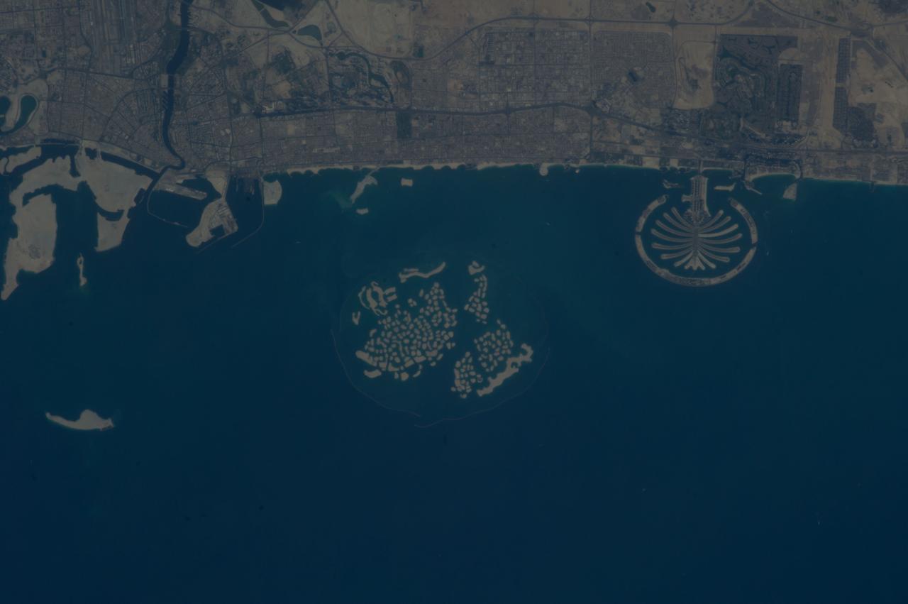
ISS037-E-011470 (14 Oct. 2013) --- Man-made archipelagos near Dubai, United Arab Emirates, are featured in this image photographed by an Expedition 37 crew member on the International Space Station, flying at approximately 220 miles above Earth. The municipality of Dubai is the largest city of the Persian Gulf emirate of the same name, and has built a global reputation for large-scale developments and architectural works. Among the most visible of these developments -- particularly from the perspective of astronauts onboard the space station -- are three man-made archipelagos. The two Palm Islands -- Palm Jumeirah (right) and Palm Jebel Ali (out of frame further to the right) -- appear as stylized palm trees when viewed from above. The World Islands (center frame) evoke a rough map of the world from an air- or space-borne perspective. The Palm Jumeirah project began in 2001 and required more than 50 million cubic meters of dredged sand to raise the islands above the Persian Gulf sea level. Construction of the Palm Jumeirah islands was completed in 2006; for several years now they have been developed for residential and commercial housing and infrastructure. Creation of the World Islands was begun in 2003 and completed in 2008, using 320 million cubic meters of sand and 37 million tons of rock for the surrounding 27 kilometer-long protective breakwater.

S73-35082 (July-Sept. 1973) --- A near vertical view of a portion of west Africa ravaged by drought for the past five years is seen in this Skylab 3 Earth Resources Experiments Package S190-B (five-inch Earth terrain camera) photograph taken from the Skylab space station in Earth orbit. The semi-desert scene is in southeastern Niger about 200 nautical miles east-northeast of the capital city of Niamey. A polygonal-shaped area (dark) in the lower right corner of the picture represents a range-management ranch. The dry stream beds trending diagonally across the photograph locally contain some water or vegetation (green). The beds are sources of water through shallow drilling and contain soils suitable for production of crops. The variety of tans, browns and grays are typical desert colors that represent barren rocks and soil or sand-filled ancient stream valleys. Absence of vegetation is the singular feature of the area. Dr. G. Stuckmann of the Geographic Institute, University of Technology, Mannover, Federal Republic of Germany, will use this photograph in the study of the hydrologic regime of the region through analysis of fossil drainage patterns, geological structures and accumulations of surface water. Federal agencies participating with NASA on the EREP project are the Departments of Agriculture, Commerce, Interior, the Environmental Protection Agency and the Corps of Engineers. All EREP photography is available to the public through the Department of Interior?s Earth Resources Observations Systems Data Center, Sioux Falls, South Dakota, 57198. (Alternate number SL3-86-166) Photo credit: NASA
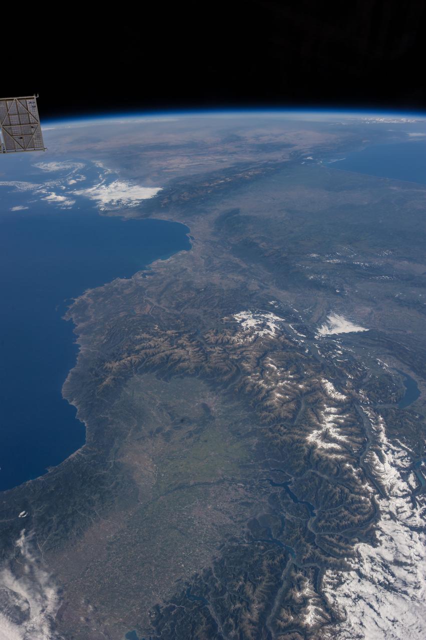
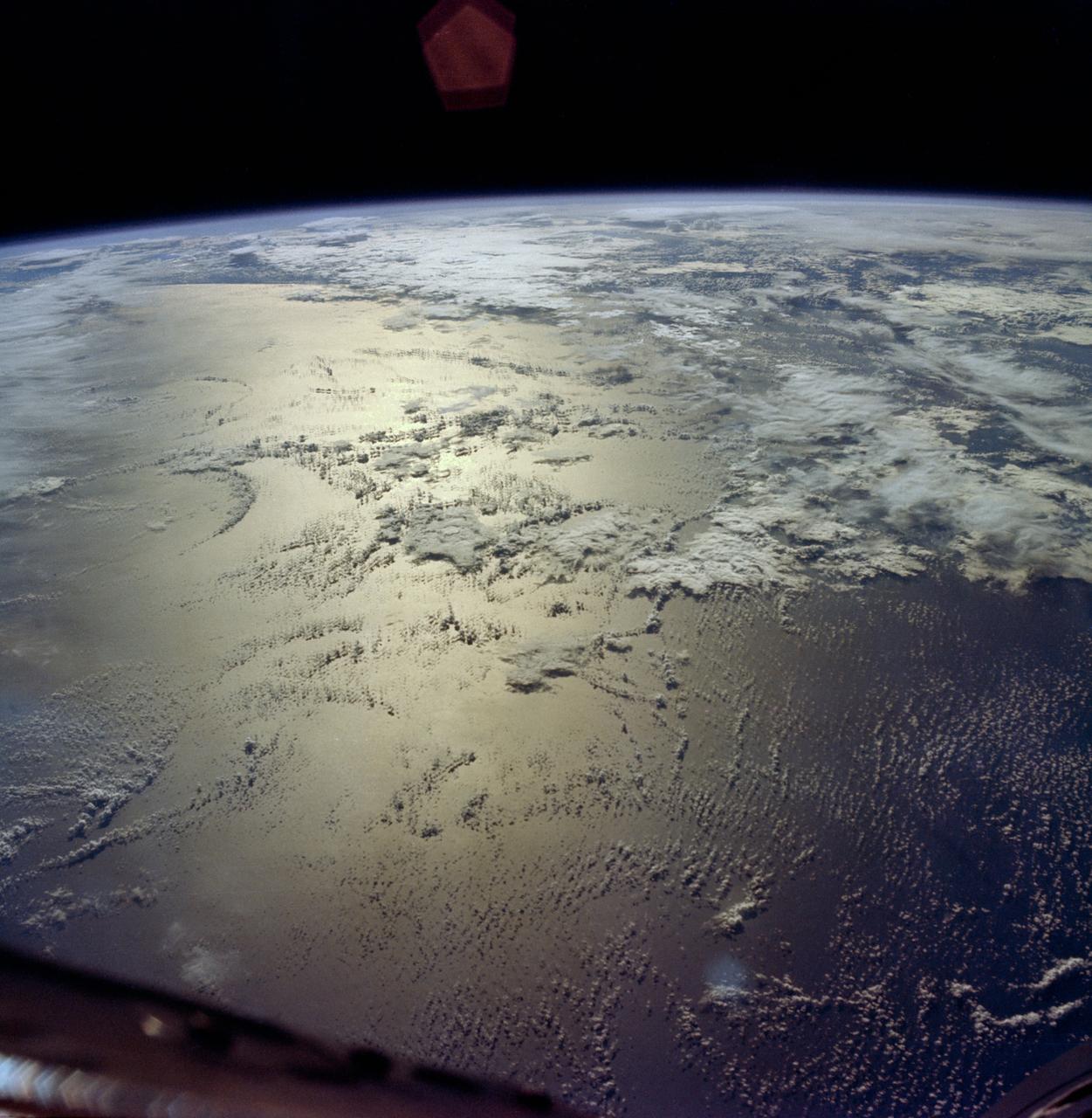
SL3-114-1625 (July-September 1973) --- An excellent view of the expended S-IVB second stage of the Skylab 3/Saturn 1B space vehicle is seen in this photograph taken from the Skylab 3 Command and Service Module (CSM) in Earth orbit. The land mass below is Italy and France, with part of the Mediterranean Sea visible. This photograph was taken with a handheld 70mm Hasselblad camera using a 100mm lens, and medium speed Ektachrome film. Photo credit: NASA
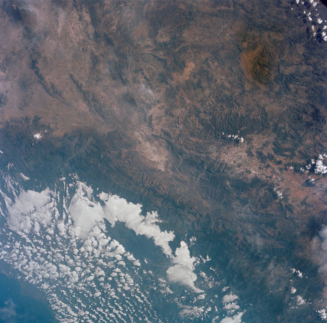
STS054-151-150 (13-19 Jan 1993) --- View west into sun glint off the Rio Salado, Saladillo, and Parana Rivers in Argentina. The Space Shuttle nadir is about 28 degrees north latitude and 57 degrees west longitude. The Andes Mountains are barely visible on Earth's limb. Thunderstorms along the eastern edge of the Andes are typical of this time of year (Southern Hemisphere summer), with anvils moving to the east from the core of the storm.
View of one of the International Space Stations solar arrays is visible from a window in the ISS with an Earth limb in the background. Photo taken by the Expedition 37 crew.

AS04-01-750 (9 Nov. 1967) --- Atlantic Ocean, Antarctica, looking west, as photographed from the Earth-orbital Apollo 4 (Spacecraft 017/Saturn 501) unmanned space mission. This picture was taken when the Spacecraft 017 and the Saturn S-IVB (third) stage was orbiting Earth at an altitude of 8,628 nautical miles.
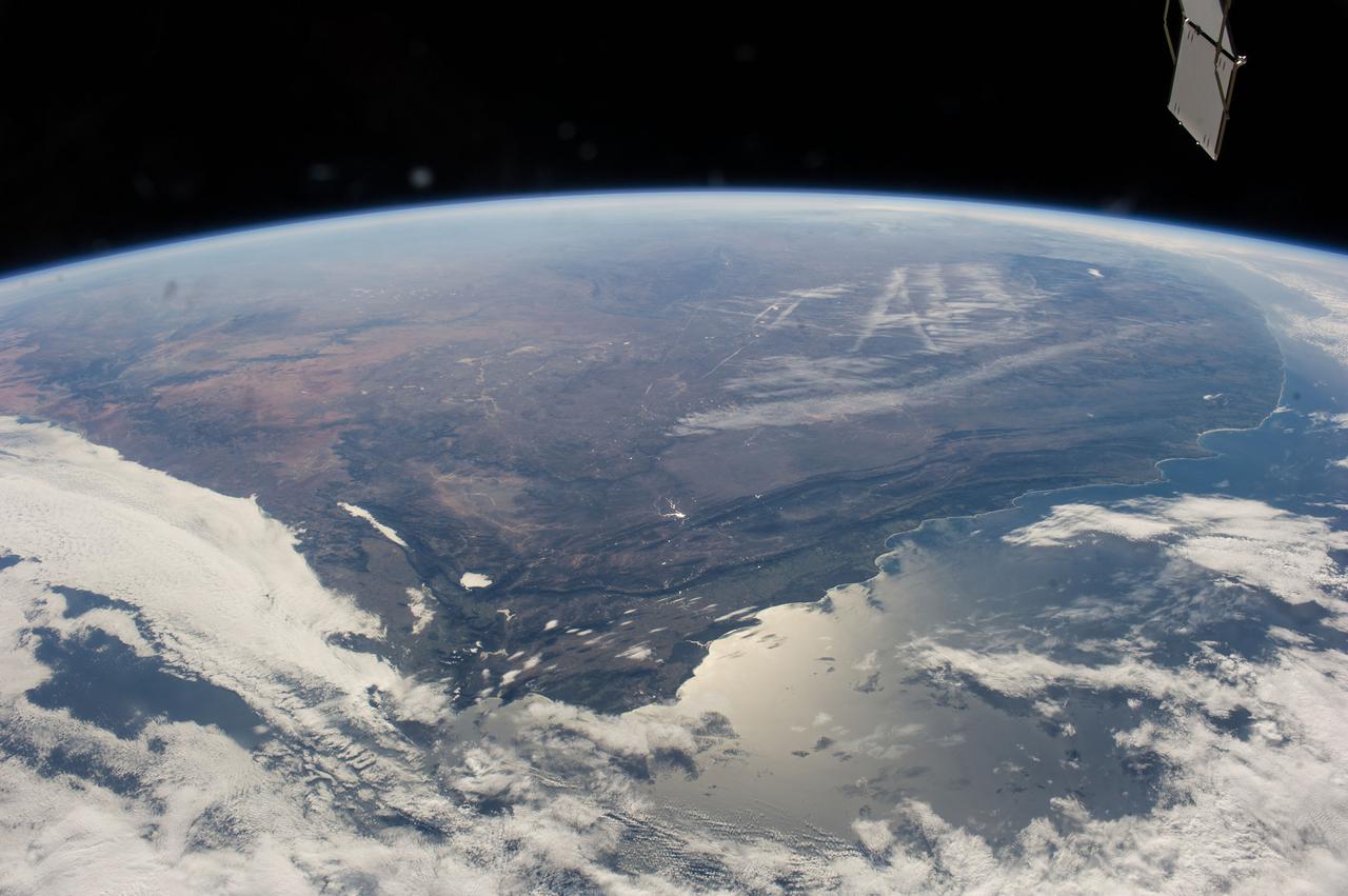
ISS040-E-006271 (31 May 2014) --- One of the Expedition 40 crew members aboard the Earth-orbiting International Space Station captured this panoramic image of South Africa on May 31, 2014. A combination of contrails and a bit of winter mist appears to have formed alphabetic and/or numeric characters in the upper right near the horizon. Sun glint off the south coast is slightly confusing as it is similar in brightness to the west-coast cloud cover, where an Atlantic storm rolls in. The Cape Fold Mountains cross the center of the view, going east from the Cape Town region (clouds obscure the Cape peninsula which normally serves as an icon for this part of Africa). A popular winegrowing region attributable to the Mediterranean climate is the area around Cape Town near lower left. Witwatersrand lies at the top of the picture obscured by the seemingly ever-present winter smoke and smog. The Orange River valley appears as a dark, nearly horizontal line at left.
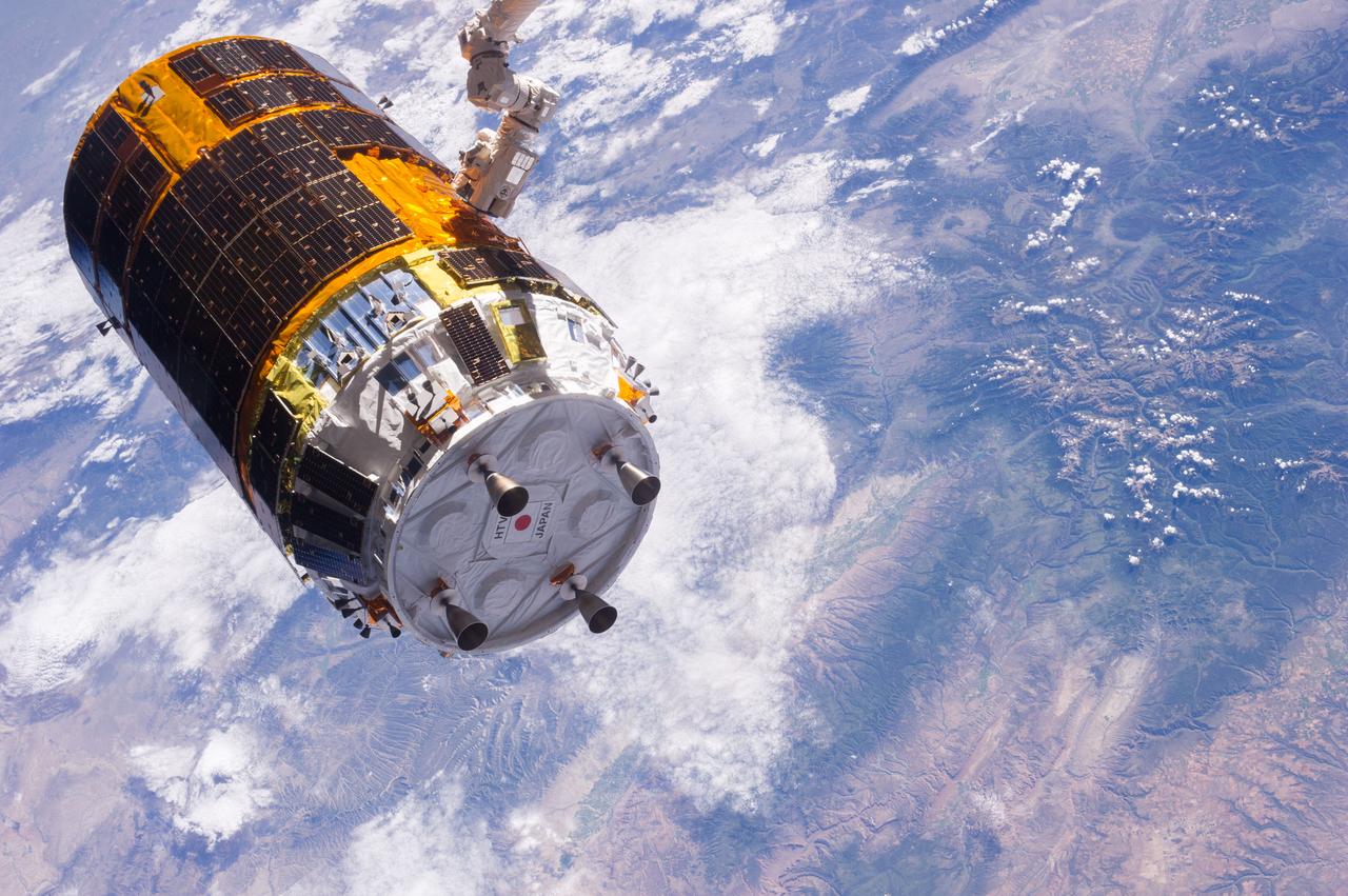
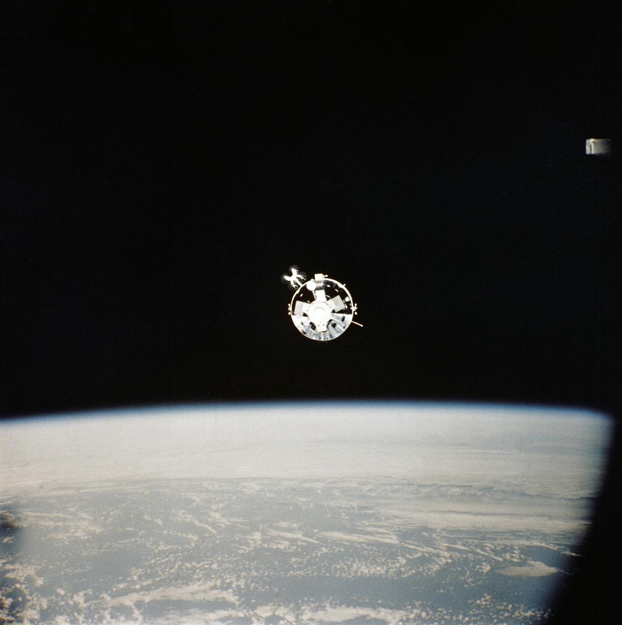
One of the Expedition 36 crew members aboard the International Space Station took this picture of the Japanese HTV-4 unmanned cargo spacecraft,backdropped against a land mass on Earth,following its unberthing but just prior to its release from the orbital outpost's Canadarm2. HTV-4,after backing away from the flying complex,headed for re-entry into Earth's atmosphere,burning upon re-entry. Per Twitter message: Flying over southwestern US, not long before release of #HTV4 by #Canadarm2.
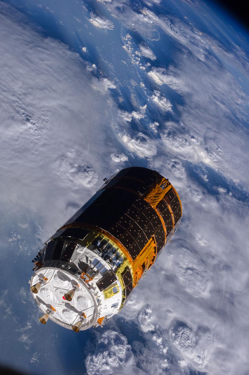
One of the Expedition 36 crew members aboard the International Space Station took this picture of the Japanese HTV-4 unmanned cargo spacecraft,backdropped against the Earth,following its unberthing and release from the orbital outpost. HTV-4,after backing away from the flying complex,headed for re-entry into Earth's atmosphere,burning upon re-entry. Per Twitter message: And, shortly after release of #HTV4, flying over Africa (The storm clouds were amazing).
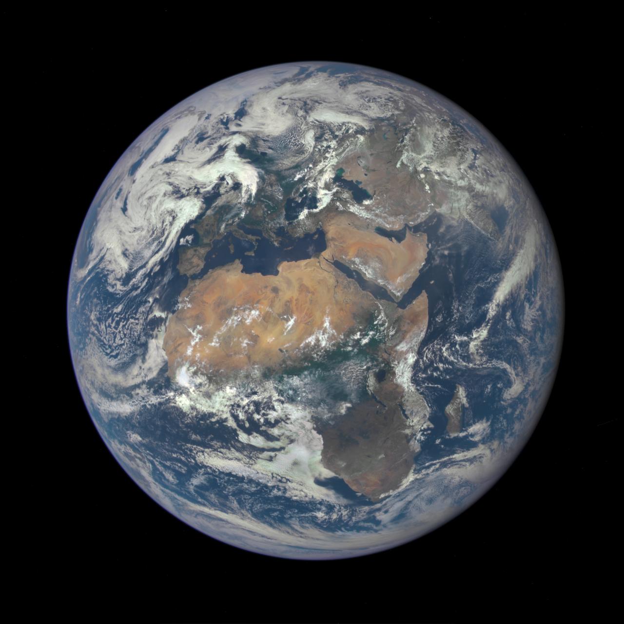
Africa is front and center in this image of Earth taken by a NASA camera on the Deep Space Climate Observatory (DSCOVR) satellite. The image, taken July 6 from a vantage point one million miles from Earth, was one of the first taken by NASA’s Earth Polychromatic Imaging Camera (EPIC). Central Europe is toward the top of the image with the Sahara Desert to the south, showing the Nile River flowing to the Mediterranean Sea through Egypt. The photographic-quality color image was generated by combining three separate images of the entire Earth taken a few minutes apart. The camera takes a series of 10 images using different narrowband filters -- from ultraviolet to near infrared -- to produce a variety of science products. The red, green and blue channel images are used in these Earth images. The DSCOVR mission is a partnership between NASA, the National Oceanic and Atmospheric Administration (NOAA) and the U.S. Air Force, with the primary objective to maintain the nation’s real-time solar wind monitoring capabilities, which are critical to the accuracy and lead time of space weather alerts and forecasts from NOAA. DSCOVR was launched in February to its planned orbit at the first Lagrange point or L1, about one million miles from Earth toward the sun. It’s from that unique vantage point that the EPIC instrument is acquiring images of the entire sunlit face of Earth. Data from EPIC will be used to measure ozone and aerosol levels in Earth’s atmosphere, cloud height, vegetation properties and a variety of other features. Image Credit: NASA <b><a href="http://www.nasa.gov/audience/formedia/features/MP_Photo_Guidelines.html" rel="nofollow">NASA image use policy.</a></b> <b><a href="http://www.nasa.gov/centers/goddard/home/index.html" rel="nofollow">NASA Goddard Space Flight Center</a></b> enables NASA’s mission through four scientific endeavors: Earth Science, Heliophysics, Solar System Exploration, and Astrophysics. Goddard plays a leading role in NASA’s accomplishments by contributing compelling scientific knowledge to advance the Agency’s mission. <b>Follow us on <a href="http://twitter.com/NASAGoddardPix" rel="nofollow">Twitter</a></b> <b>Like us on <a href="http://www.facebook.com/pages/Greenbelt-MD/NASA-Goddard/395013845897?ref=tsd" rel="nofollow">Facebook</a></b> <b>Find us on <a href="http://instagrid.me/nasagoddard/?vm=grid" rel="nofollow">Instagram</a></b>
ISS037-E-009296 (10 Oct. 2013) --- This is one of a series of views that captured a missile launch from Earth as seen on Oct. 10, 2013 by the Expedition 37 crew aboard the International Space Station.
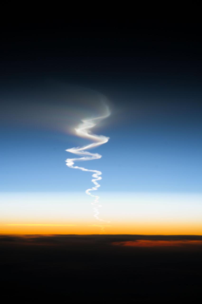
ISS037-E-009224 (10 Oct. 2013) --- This is one of a series of views that captured a missile launch from Earth as seen on Oct. 10, 2013 by the Expedition 37 crew aboard the International Space Station.

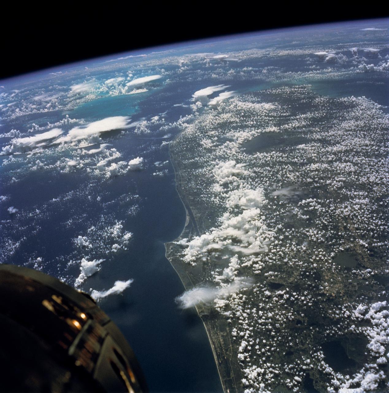
S65-63771 (12 Dec. 1965) --- Kennedy Space Center area on the east coast of Florida as seen from the Gemini-7 spacecraft, during Gemini-6 abort, on its 118th revolution of Earth. Photo credit: NASA
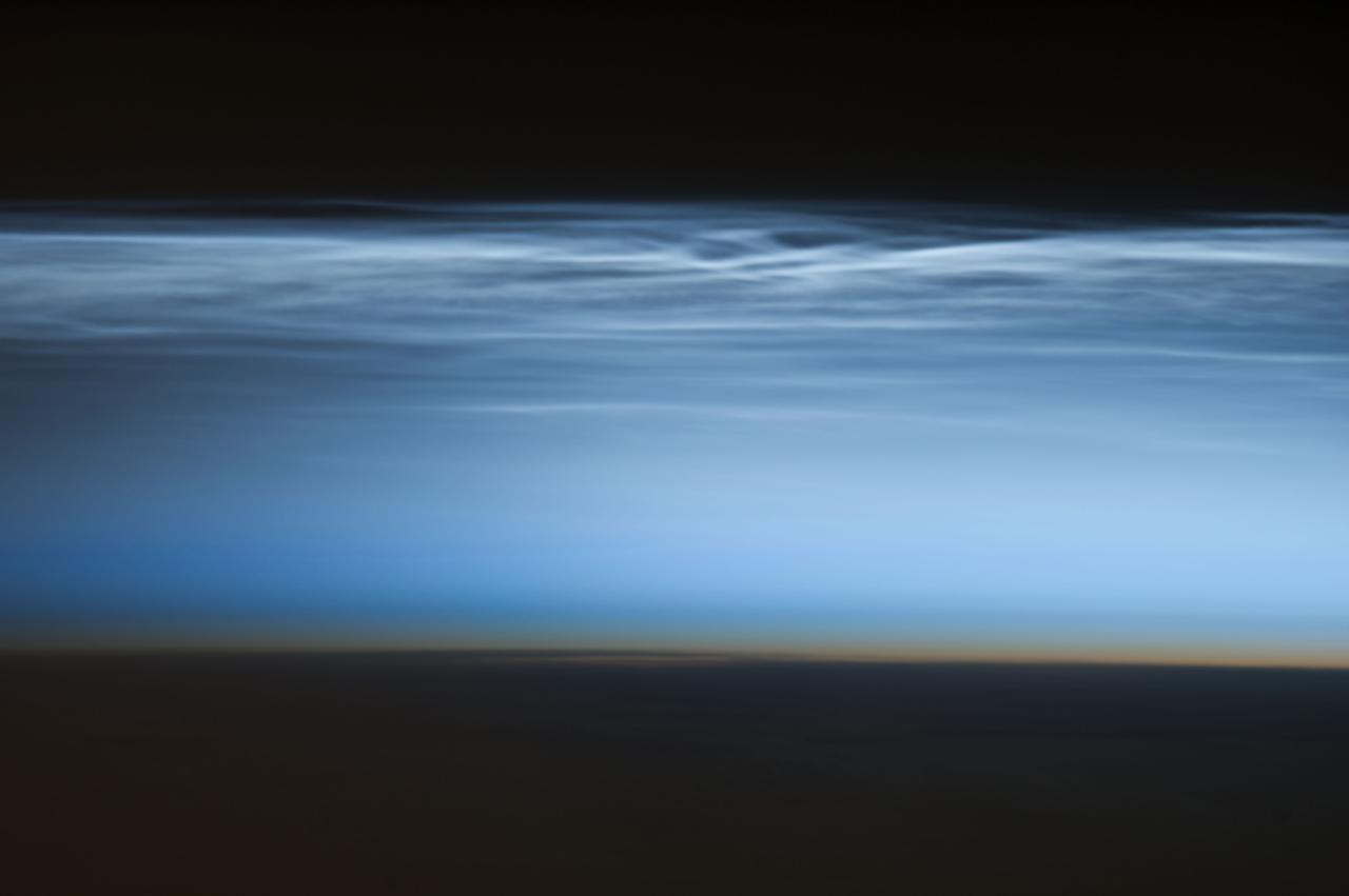
ISS034-E-024622 (5 Jan. 2013) --- Polar mesospheric clouds over the South Pacific Ocean are featured in this image photographed by an Expedition 34 crew member on the International Space Station. Polar mesospheric clouds—also known as noctilucent, or “night shining” clouds—are formed 76 to 85 kilometers above Earth’s surface near the mesosphere-thermosphere boundary of the atmosphere, a region known as the mesopause. At these altitudes, water vapor can freeze into clouds of ice crystals. When the sun is below the horizon such that the ground is in darkness, these high clouds may still be illuminated—lending them their ethereal, “night shining” qualities. Noctilucent clouds have been observed from all human vantage points in both the Northern and Southern Hemispheres – from the surface, in aircraft, and in orbit from the space station—and tend to be most visible during the late spring and early summer seasons. Polar mesospheric clouds also are of interest to scientists studying the atmosphere. While some scientists seek to understand their mechanisms of formation, others have identified them as potential indicators of atmospheric changes resulting from increases in greenhouse gas concentrations. This photograph was taken when the station was over the Pacific Ocean south of French Polynesia. While most polar mesospheric cloud images are taken from the orbital complex with relatively short focal length lens to maximize the field of view, this image was taken with a long lens (400 mm) allowing for additional detail of the cloud forms to be seen. Below the brightly-lit noctilucent clouds in the center of the image, the pale orange band indicates the stratosphere.
41G-120-082 (5-13 Oct. 1984) --- This High oblique view was photographed with a medium format camera aboard the Earth-orbiting space shuttle Challenger. It features the Strait of Gibraltar and the Mediterranean Sea. Unlike vertical photographs from this area taken by crews of previous spaceflights, this oblique view allows extensive viewing into Spain and Morocco. Photo credit: NASA
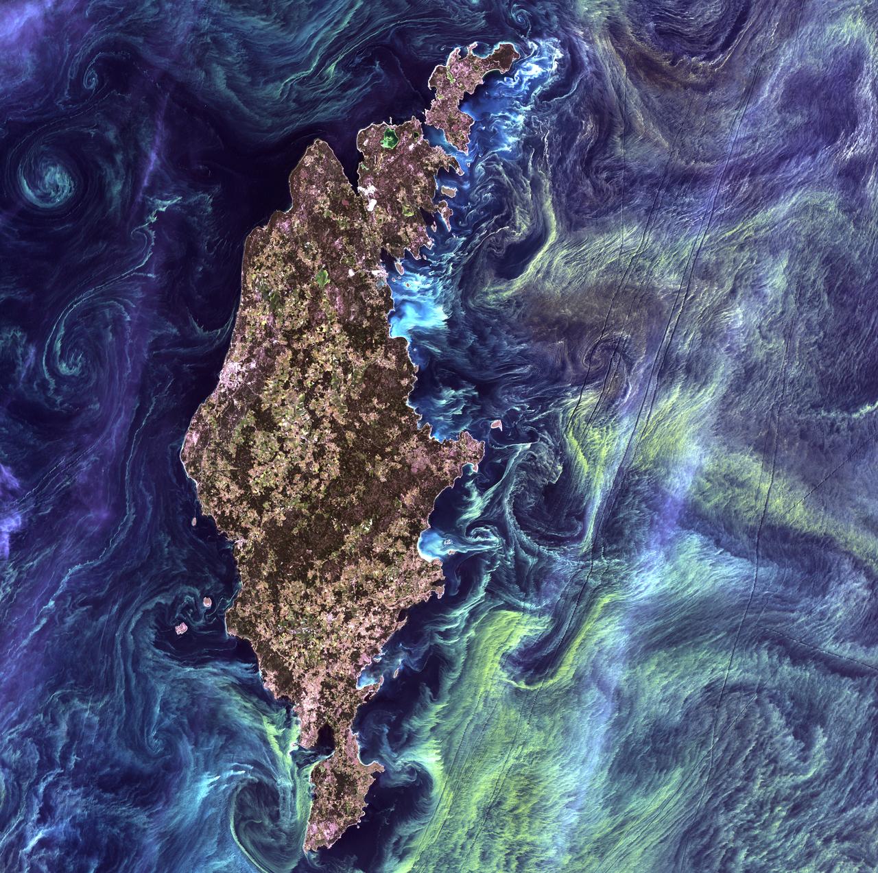
Van Gogh from Space - July 13th, 2005 Description: In the style of Van Gogh's painting "Starry Night," massive congregations of greenish phytoplankton swirl in the dark water around Gotland, a Swedish island in the Baltic Sea. Phytoplankton are microscopic marine plants that form the first link in nearly all ocean food chains. Population explosions, or blooms, of phytoplankton, like the one shown here, occur when deep currents bring nutrients up to sunlit surface waters, fueling the growth and reproduction of these tiny plants. Credit: USGS/NASA/Landsat 7 To learn more about the Landsat satellite go to: <a href="http://landsat.gsfc.nasa.gov/" rel="nofollow">landsat.gsfc.nasa.gov/</a> <b><a href="http://www.nasa.gov/centers/goddard/home/index.html" rel="nofollow">NASA Goddard Space Flight Center</a></b> enables NASA’s mission through four scientific endeavors: Earth Science, Heliophysics, Solar System Exploration, and Astrophysics. Goddard plays a leading role in NASA’s accomplishments by contributing compelling scientific knowledge to advance the Agency’s mission. <b>Follow us on <a href="http://twitter.com/NASA_GoddardPix" rel="nofollow">Twitter</a></b> <b>Join us on <a href="http://www.facebook.com/pages/Greenbelt-MD/NASA-Goddard/395013845897?ref=tsd" rel="nofollow">Facebook</a></b>
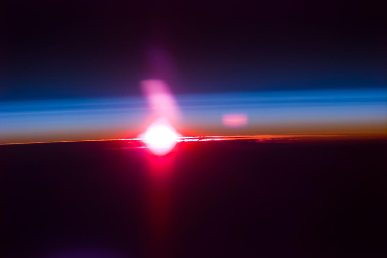
S66-38275 (3-6 June 1966) --- Earth's limb at sunrise as seen from the orbiting Gemini-9 spacecraft during its three-day mission in space. Taken with a modified 70mm Hasselblad camera, using Eastman Kodak, Ektachrome MS (S.O. 217) color film. Photo credit: NASA

Ground-based astronomers will be playing a vital role in NASA Juno mission. Images from the amateur astronomy community are needed to help the JunoCam instrument team predict what features will be visible when the camera images are taken.
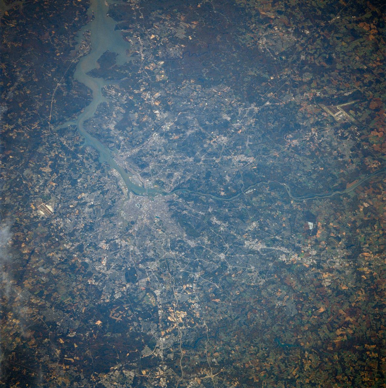
41G-40-071 (5-13 Oct. 1984) --- Washington, D.C. -- the nation's capital -- is at right center in this phtograph from the Earth-orbiting space shuttle Challenger. J.F. Dulles Airport at lower left. Andrews Air Force Base is at right center edge. The Potomac River enters at left center, flows past Washington and as a tidal estuary at lower right. Also visible are the Great Falls of the Potomac. Photo credit: NASA

41G-11-027 (14 Oct. 1984) --- Kathryn D. Sullivan, 41-G mission specialist, uses a pair of binoculars to do some magnified viewing through the forward cabin windows of the Earth-orbiting space shuttle Challenger. The 35mm frame was part of the first photographic release from the eight-day 41-G mission on Oct. 14, 1984. Photo credit: NASA
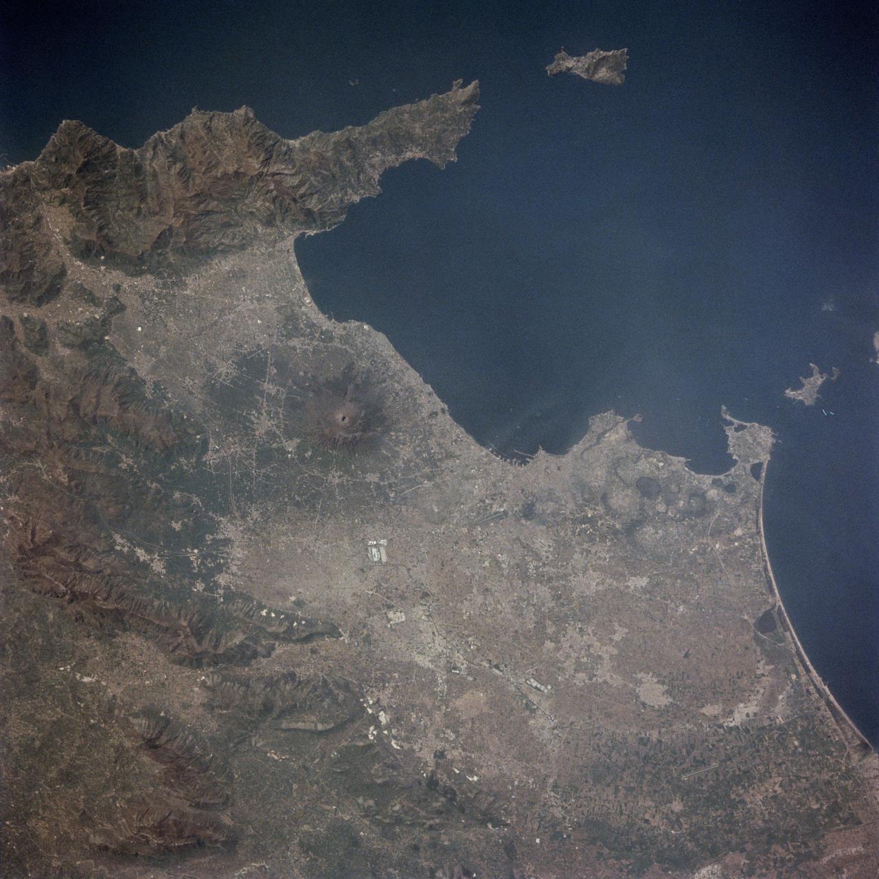
STS001-13-442 (14 April 1981) --- This photograph showing much of Italy was taken with a handheld 70mm camera from 276 kilometers above Earth as the NASA space shuttle Columbia and its crew were marking their last few hours in space on the historic first space mission utilizing a reusable vehicle. Included in the area of the frame are Golfo de Napoli, Napoli (Naples), Castellammare, Amalfi, Capri, Sorrento, Mt. Vesuvius and the ruins of Pompei. Astronauts John W. Young and Robert L. Crippen exposed eight magazines of color 70mm film during their two and one-third days in Earth orbit. Photo credit: NASA
51C-44-026 (24-27 January 1985) --- This oblique view of the Florida peninsula was photographed from the Earth-orbiting Space Shuttle Discovery during the DOD-devoted mission. Many popular features of the state can be delineated in the scene. Kennedy Space Center (KSC), from which this and all Space Shuttle missions are launched, is on the jutting Cape Canaveral, visible on the east Atlantic Coast. The spacecraft was flying at an altitude of 190 nautical miles. A handheld Hasselblad camera, with 70mm Kodak natural color Ektachrome ASA 64 film, was used to expose the frame. Crew members for the flight were astronauts Thomas K. Mattingly, Loren J. Shriver, Ellison S. Onizuka, James F. Buchli, and Gary E. Payton of the United States Air Force.

View of antenna and solar arrays (with an Earth limb in the background) taken from a window in the Russian Soyuz spacecraft currently docked to the International Space Station. Photo taken by an Expedition 36 crewmember. Per Twitter message: View out the window to the right of my seat in Soyuz while docked to ISS.
From 165 nautical miles above the earth, the STS-66 astronauts were able to capture detail in a number of storm systems around the globe during their 11-day stay in space aboard the Space Shuttle Atlantis. A 70mm handheld Hasselblad was used to photograph Hurricane Florence in the Atlantic Ocean, about 400 miles from Bermuda.
STS002-12-833 (13 Nov. 1981) --- Clouds over Earth and black sky form the background for this unique photograph from the space shuttle Columbia in Earth orbit. The photograph was shot through the aft flight deck windows viewing the cargo bay. Part of the scientific payload of the Office of Space and Terrestrial Applications (OSTA-1) is visible in the open cargo bay. The astronauts inside Columbia's cabin were remotely operating the Canadian-built remote manipulator system (RMS). Note television cameras on its elbow and wrist pieces. Photo credit: NASA
AST-32-2675 (17-19 July 1975) --- The American Apollo spacecraft as seen in Earth orbit from the Soviet Soyuz spacecraft during the joint U.S.-USSR Apollo-Soyuz Test Project mission. The Command/Service Module and Docking Module are contrasted against a black-sky background. This is a "head on" view of the Apollo. The horizon of Earth is below. This picture was furnished by the USSR in an exchange of photography taken during the ASTP flight. The American and Soviet spacecraft were joined together in space for approximately 47 hours on July 17-18-19, 1975. Note the docking mechanism on the Docking Module. PHOTO COURTESY: USSR ACADEMY OF SCIENCES
41G-121-139 (5-13 Oct. 1984) --- The Strait of Dover and London, seldom seen in space photography, can be delineated in this medium format camera's scene showing parts of England and France from onboard the Earth-orbiting space shuttle Challenger. Parts of the Thames River can also be traced in the frame. The 41-G crew consisted of astronauts Robert L. Crippen, commander; Jon A. McBride, pilot; and Mission Specialists Kathryn D. Sullivan, Sally K. Ride, and David D. Leestma; along with Canadian astronaut Marc Garneau; and Paul D. Scully-Power, both payload specialists. Photo credit: NASA
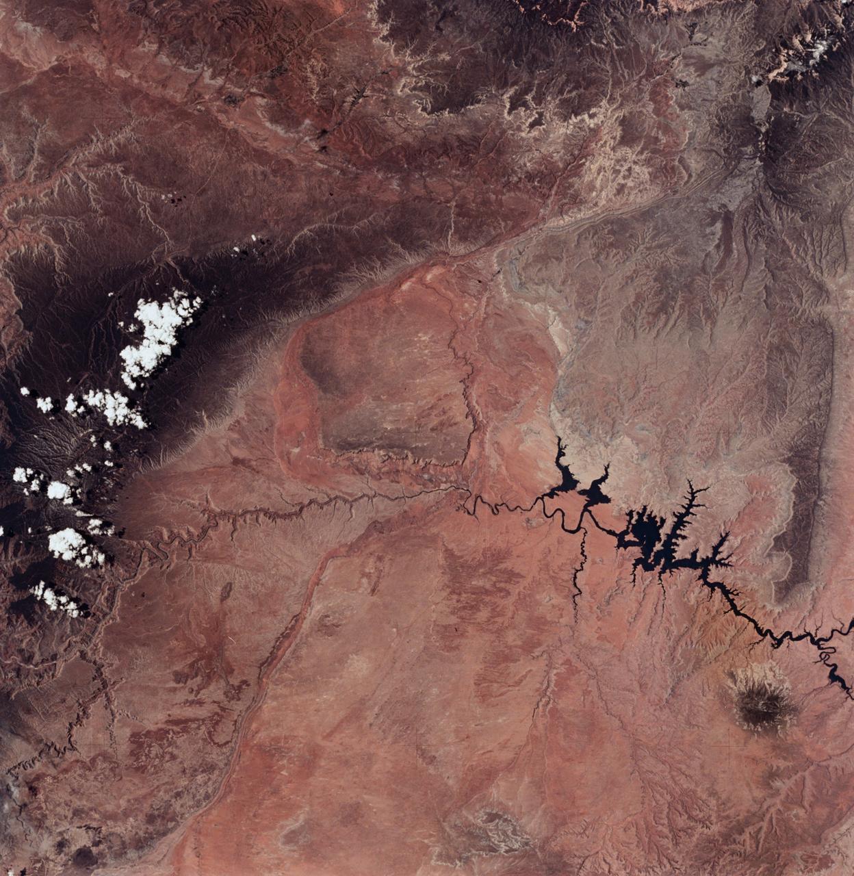
SL2-04-018 (June 1973) --- A vertical view of the Arizona-Utah border area showing the Colorado River and Grand Canyon photographed from the Skylab 1/2 space station in Earth orbit. This picture was taken by one of the six lenses of the Itek-furnished S190-A Multispectral Photographic Facility Experiment in the Multiple Docking Adapter of the space station. Type S0-356 film was used. The row of white clouds extend north-south over the dark colored Kaibab Plateau. The junction of the Colorado and Little Colorado rivers is in the southwest corner of the picture. The body of water is Lake Powell on the Colorado River upstream from the Grand Canyon. The lone peak at the eastern edge of the photograph south of Colorado River is the 10,416-foot Navajo Mountain. The S190-A experiment is part of the Skylab Earth Resources Experiments Package(EREP). Photo credit: NASA
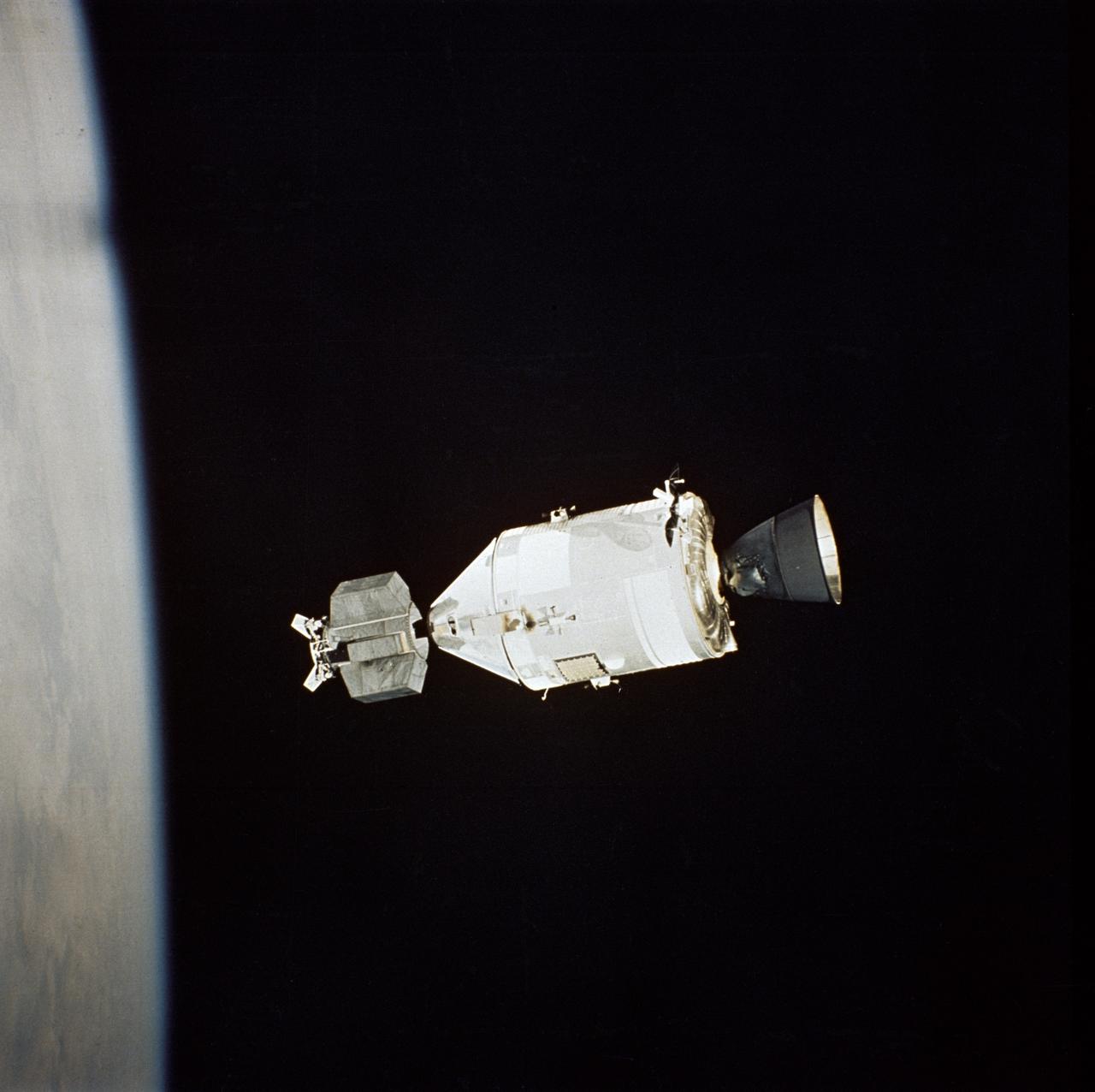
AST-32-2695 (17-19 July 1975) --- The American Apollo spacecraft as seen in Earth orbit from the Soviet Soyuz spacecraft during the joint U.S.-USSR Apollo-Soyuz Test Project mission. The Command/Service Module and Docking Module are contrasted against a black-sky background. The horizon of Earth is below. This picture was furnished by the USSR in an exchange of photography taken during the ASTP flight. The bell-shaped engine nozzle of the service propulsion system protrudes from the rear of the Service Module. Note the docking mechanism on the Docking Module. The American and Soviet spacecraft were joined together in space for approximately 47 hours on July 17-18-19, 1975. PHOTO COURTESY: USSR ACADEMY OF SCIENCES
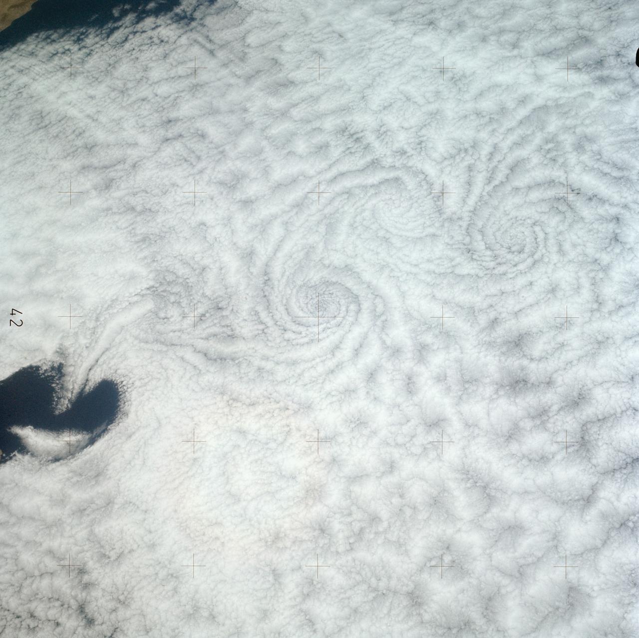
SL3-121-2371 (July-September 1973) --- A pattern of downstream eddies in the stratocumulus clouds over the Pacific Ocean west of Baja California, as photographed by the crewmen of the second Skylab manned mission (Skylab 3) from the space station cluster in Earth orbit. The clouds, produced by the cold California current running to the south and southwest, are prevented from rising by warm air above them. Photo credit: NASA
S65-63826 (5 Dec. 1965) --- Oriente Province, eastern end of Cuba, as seen from the National Aeronautics and Space Administration's Gemini-7 spacecraft during its 14th revolution of Earth. Guantanamo Bay is in the center of the picture on the southern coast of Cuba. Santiago de Cuba is located about one inch from the bottom edge of the picture, or about three inches westward down the coast from Guantanamo. This photograph was taken with a modified 70mm Hasselblad camera, using Eastman Kodak, Ektachrome MS (S.O. 217) color film. Photo credit: NASA
STS049-71-042 (8 May 1992) --- This photograph, taken from the Earth-orbiting Space Shuttle Endeavour, shows a collapsed thunderstorm in the southwestern Pacific Ocean. The clouds were pushed from this circular area of the ocean's surface by relatively cool air that spread downward and outward from a dying thunderstorm. Around the edges of the downdrafted air, new, though smaller, storms are developing. The photo was taken on May 8, 1992, between Borneo and the Philippine island of Mindoro. Two coral atolls can be seen near the center of the photograph. The crew members used a handheld Hasselblad camera, 250-mm lens, color film to expose the image.
S65-45736 (21-29 Aug. 1965) --- Alexandria, Egypt is photographed from the Gemini-5 spacecraft in orbit over Earth.
S65-45763 (21-29 Aug. 1965) --- View of the lower tip of Baja, California and Bahia de la Paz taken from the Gemini-5 spacecraft in orbit over Earth.
S65-18750 (23 March 1965) --- Astronaut John W. Young took this picture over eastern Africa during the Gemini-Titan 3 three-orbit mission on March 23, 1965. The altitude of the Gemini spacecraft "Molly Brown" was 90 miles. Young used a hand-held modified 70mm Hasselblad camera with color film. The lens setting was 250th of a second at f/11.
S65-45737 (22 Aug. 1965) --- Looking northeast, the Strait of Gibraltar, Morocco (foreground) and Spain (background) are photographed from the Gemini-5 spacecraft during its 14th revolution of Earth.
S65-18752 (23 March 1965) --- View of a cloudy part of Earth as seen from the Gemini-3 spacecraft while in orbit.

STS062-106-094 (4-18 March 1994) --- The Greater Houston metropolitan area, completely clear of clouds, was captured on 70mm film by one of the crew members aboard the Space Shuttle Columbia. The belt system on the north, east and south sides of the city can be traced in the frame, though not completed. The west belt is just out of frame on the left side. Houston Intercontinental Airport is at top center. The NASA Johnson Space Center (JSC) and Nassau Bay can be traced inland from the portion of Galveston Bay in the lower right corner. Not only the dome proper of Harris County Domed Stadium is visible but so are two other structures in the Astrodome complex (left center), Astro Arena and Astrohall.
S65-34659 (3-7 June 1965) --- Among the many photographs taken from the Gemini-4 spacecraft during its orbital flight around Earth was this view of the Hahramaut Plateau on the southern portion of the Arabian Peninsula. The Wadi Hahramaut is in the foreground; with the Gulf of Aden (dark blue). This photograph was made with a modified 70mm Hasselblad camera, using Eastman color film, ASA 64, at a lens setting of 250th of a second at f/11.
S65-34673 (3-7 June 1965) --- This photograph shows the north end of the Gulf of California at the mouth of the Colorado River as it was seen from the Gemini-4 spacecraft during orbital flight June 3-7, 1965. This picture was part of the Synoptic Terrain Photography experiments conducted during the flight to obtain high quality photographs of large land areas already mapped by aerial photography. In charge of these experiments was Dr. Paul D. Lowman Jr., NASA geologist from Goddard Space Flight Center, Greenbelt, Md. This picture was taken with a modified 70mm Hasselblad camera using Eastman color film, ASA 64 at a lens setting of 250th of a second at f/11.
S65-18759 (23 March 1965) --- Astronaut John W. Young took this picture of clouds over the Indian Ocean during the Gemini-Titan 3 three-orbit mission on March 23, 1965. Young used a hand-held modified 70mm Hasselblad camera with color film. The lens setting was 250th of a second at f/11.
S65-45731 (21-29 Aug. 1965) --- View of the Gulf of Tonkin, China and the Luichow Peninsula photographed from the Gemini-5 spacecraft in orbit over Earth.
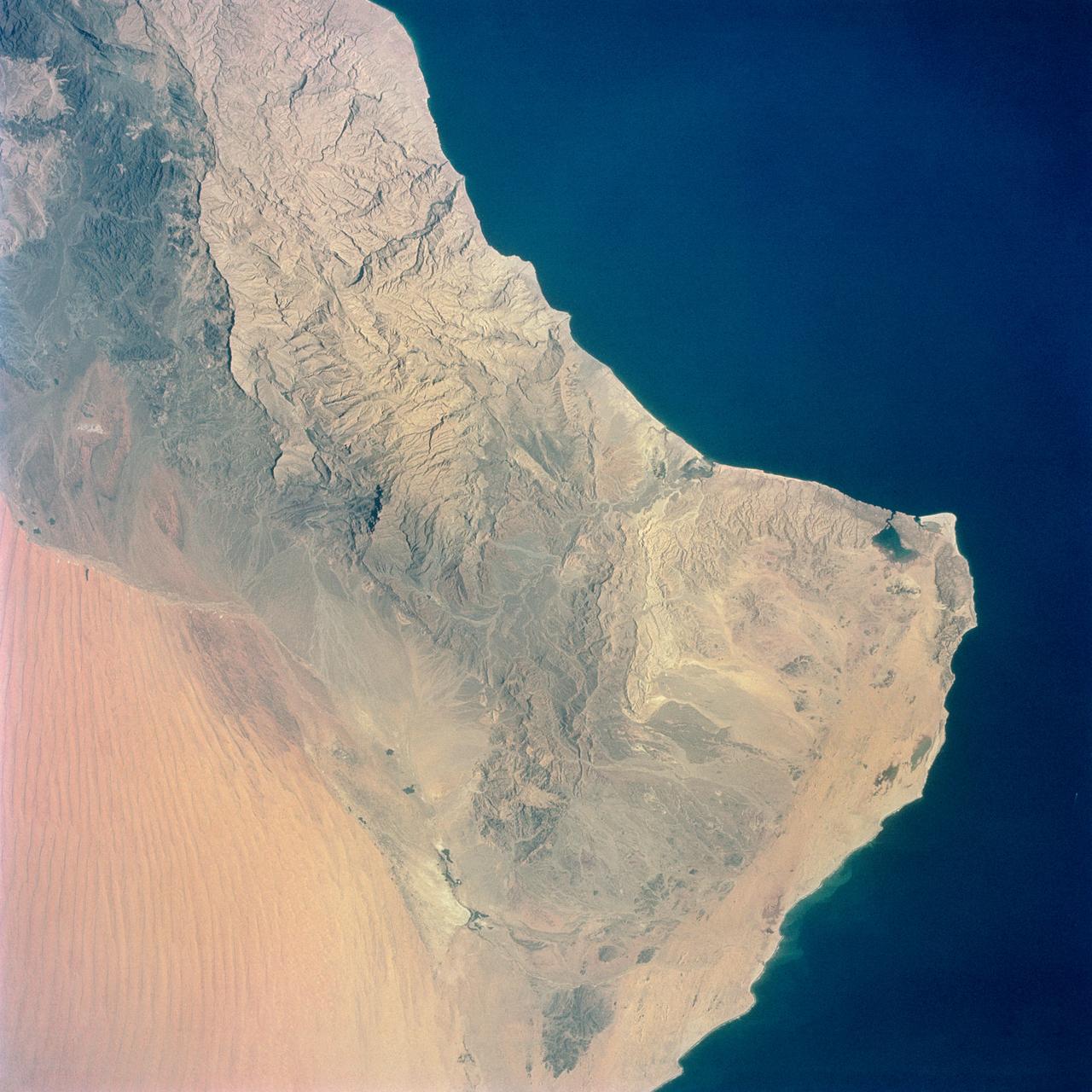
S65-34661 (3-7 June 1965) --- Among the photographs of Earth's terrain taken from the Gemini-4 spacecraft during its orbital mission was this view of the southeastern tip of the Arabian Peninsula with the Gulf of Oman at upper right. Seif dunes (sand) at lower left. This picture was taken with a modified 70mm Hasselblad camera, using Eastman color film, ASA 64 at a setting of 250th of a second at f/11. Dr. Paul Lowman Jr., NASA geologist, was in charge of the Synoptic Terrain Photography.
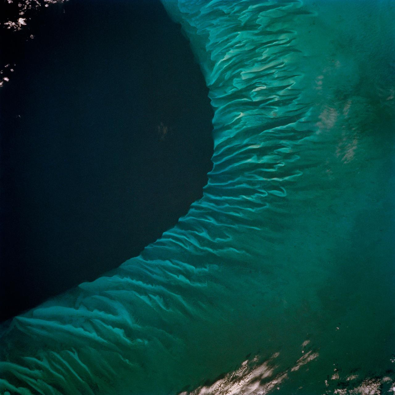
STS062-85-031 (4-18 March 1994) --- The shallow platforms (bright blue) and deep channels (dark blue) of the Bahamas provide a striking visual from space. On a finer scale, delicate patterns are created by the islands, sandbars and tidal channels. This view features a portion of the Tongue of the Ocean, one of the large deep water sounds in the western Bahamas. On the platform along the edge of the Tongue of the Ocean are convoluted sandbars bordering channels which fall into the deeper water. These channels provide an avenue for transport of sediment off the shallow platform (3-10 meters) into the deeper water (1,800 meters).
S65-45753 (21-29 Aug. 1965) --- Cape Kennedy, Florida is featured in this image photographed from the Gemini-5 spacecraft in orbit over Earth.
STS059-58-018 (9-20 April 1994) --- Part of the Space Shuttle Endeavour and its Space Radar Laboratory (SRL-1) payload are backdropped against a colorful display of the Southern Lights (aurora australis). The vehicle was firing a reaction control subsystem thruster (below center) when the 35mm image was exposed.
S65-45748 (21-29 Aug. 1965) --- Looking northeast, the Imperial Valley and Salton Sea in southern California is photographed from the Earth-orbiting Gemini-5 spacecraft. This picture was taken with a modified 70mm Hasselblad camera, using MS Ektachrome thin base film, ASA 64.
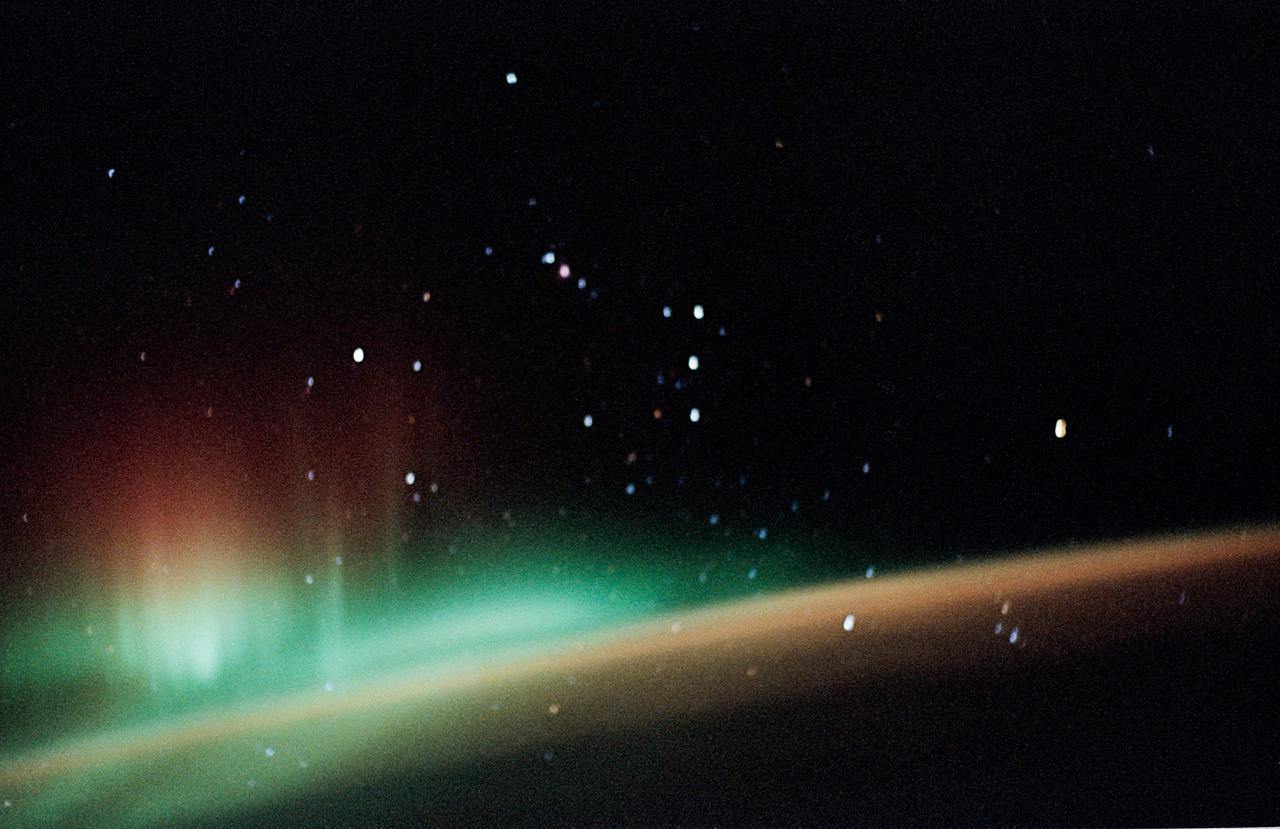
STS059-52-029 (9-20 April 1994) --- The constellation Orion is backdropped against a colorful display of the Southern Lights (aurora australis) in this 35mm image. Six NASA astronauts went on to spend a week and a half aboard the Space Shuttle Endeavour in support of the Space Radar Laboratory (SRL-1) mission.
S65-34776 (3-7 June 1965) --- This photograph shows the Nile Delta, Egypt, the Suez Canal, Israel, Jordan, Syria, Saudi Arabia, and Iraq as seen from the Gemini-Titan 4 (GT-4) spacecraft during its 12th revolution of Earth.
S65-45697 (21-29 Aug. 1965) --- The western coastline of Baja, California and Cedros Island is photographed from the Gemini-5 spacecraft in orbit over Earth.
S65-18740 (23 March 1965) --- Astronaut John W. Young took this picture during the second orbit of the Gemini-Titan 3 three-orbit mission as the spacecraft "Molly Brown" passed over Northern Mexico at an altitude of 90 miles. The light-brown circular area at the lower right is the Sonoran Desert. The lower portion of the picture is Mexico, and the upper part is California. Young used a hand-held modified 70mm Hasselblad camera with color film. The lens setting was 250th of a second at f/11.
S65-45717 (21-29 Aug. 1965) --- View of the Himalayas and Northern India photographed from the Gemini-5 spacecraft in orbit over Earth.
S65-34670 (3-7 June 1965) --- Richat crater in northwest Africa taken from the Gemini-4 spacecraft. Photograph was taken with a modified 70mm Hasselblad camera, using Eastman color film, ASA 64, at a lens setting of 250th of a second at f/11.

STS059-13-030 (9-20 April 1994) --- From the Space Shuttle Endeavour's aft flight deck, astronauts Kevin P. Chilton, pilot, and Linda M. Godwin, payload commander, monitor and photograph clouds on Earth. The two, along with four other NASA astronauts spent a week and a half aboard Endeavour in support of the Space Radar Laboratory (SRL-1)/STS-59 mission.
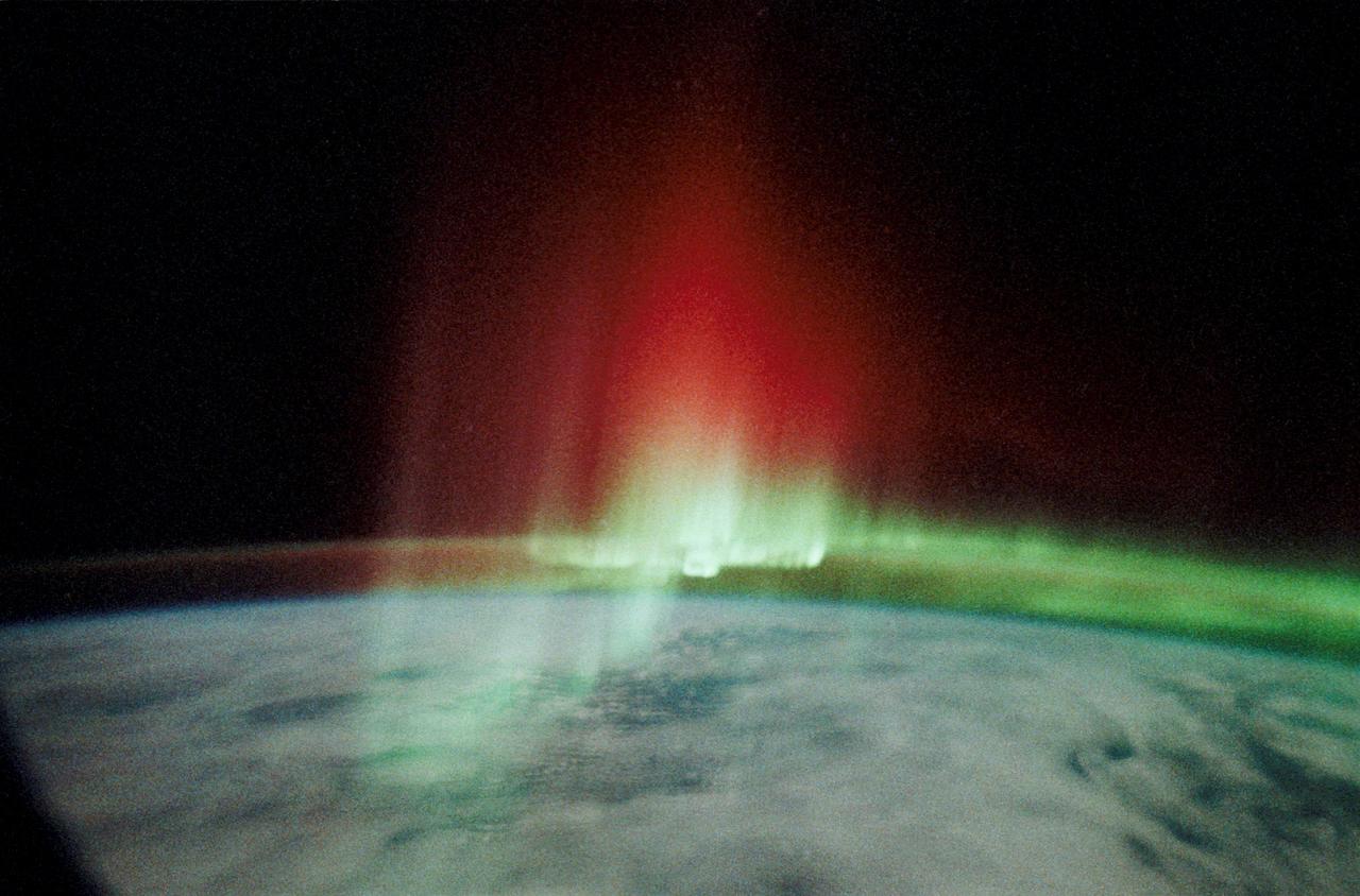
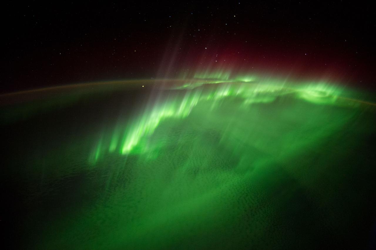
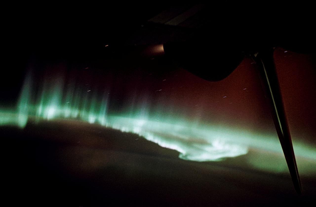
SL3-130-3130 (July-September 1973) --- An excellent view of the southern aurora, luminous bands or streamer of light, in the Southern Hemisphere, as photographed from the Skylab space station in Earth orbit. The space station was moving into the sunlight when this picture was taken. This view is near the edge of the aurora cap. The surface of the Earth is in the foreground. The permanent aurora over the South Pole is in the background. Scientist-astronaut Owen K. Garriott, Skylab 3 science pilot, took this photograph with a hand-held 35mm Nikon camera, with a four-second exposure at f/1.2, using high-speed Ektacrome film. Because auroras are caused by solar activity, they occur at the same time in the Northern and Southern hemispheres. Photo credit: NASA