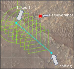
This annotated image of the "South Séítah" region of Jezero Crater depicts the planned ground track of NASA's Ingenuity Mars Helicopter (light blue) during its 15th flight at Mars. The pale blue "X" in the upper left indicates the helicopter's location at takeoff; the pale blue dot at lower right indicates the anticipated landing site. The green lines indicate the expected sightlines that will be captured in the flight's 10 planned color images. The red "X" at upper center of the image marks the current location of NASA's Perseverance rover. The image's background terrain was generated using data collected by the HiRISE camera aboard NASA's Mars Reconnaissance Orbiter. https://photojournal.jpl.nasa.gov/catalog/PIA24977