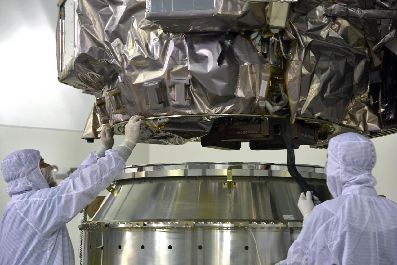
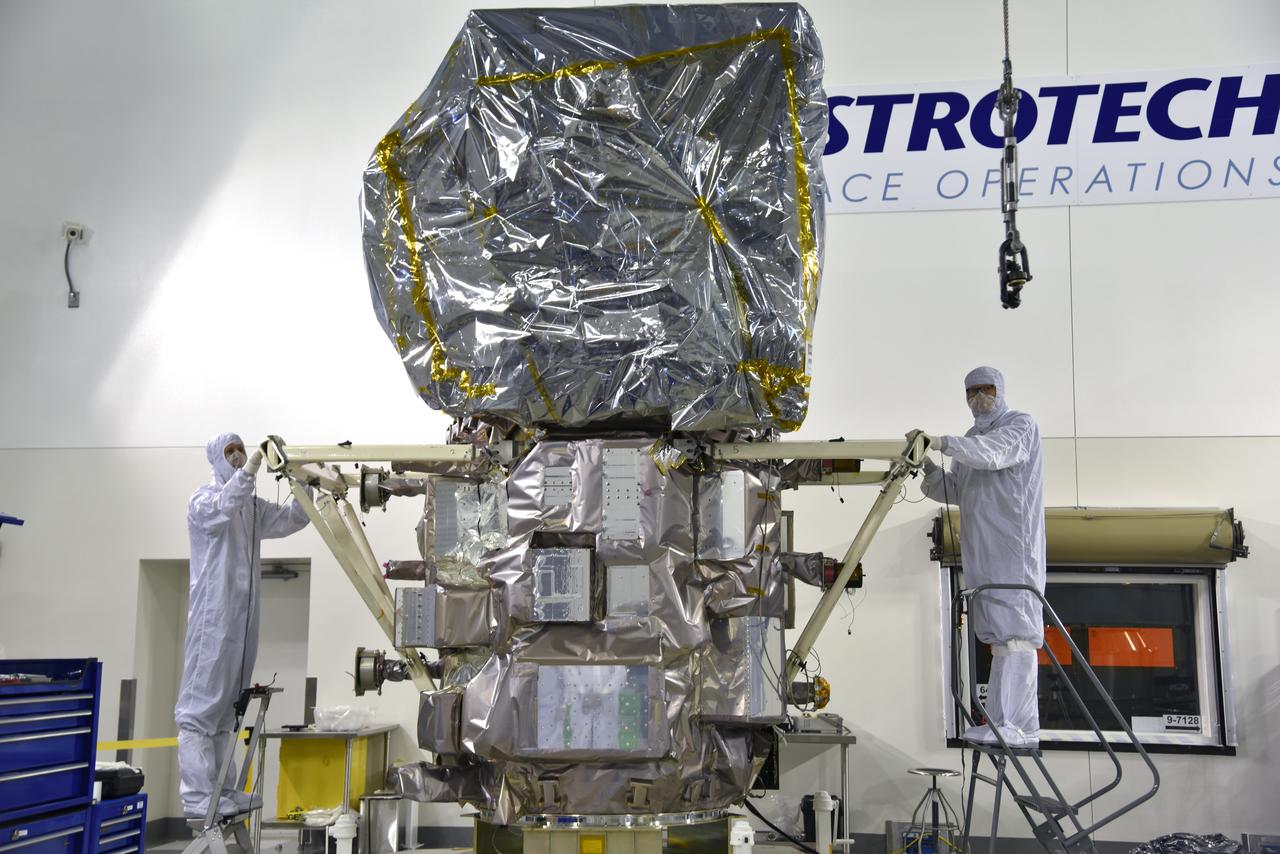
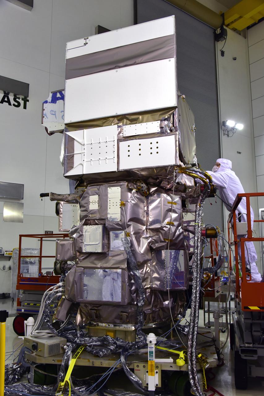
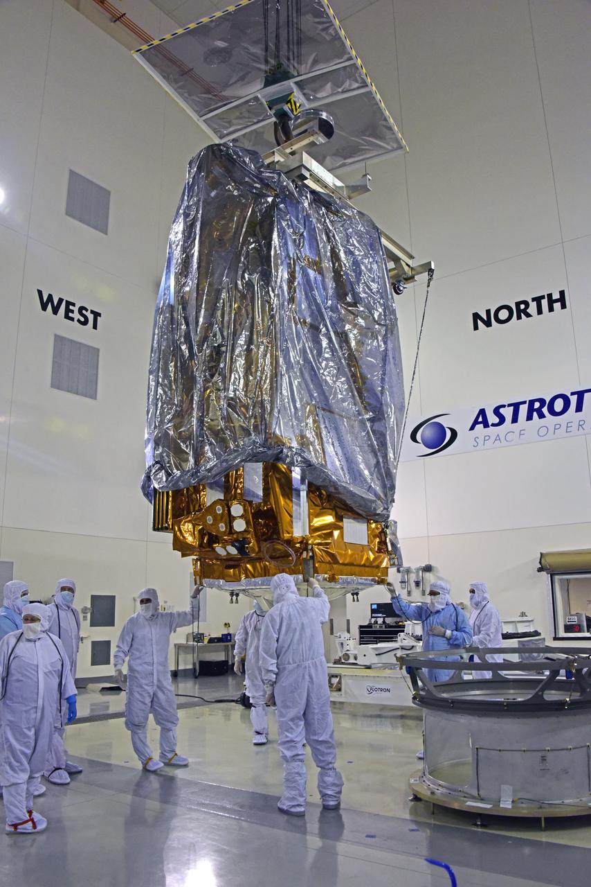
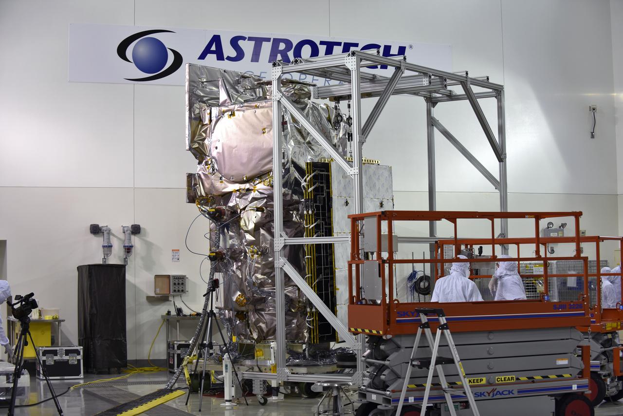
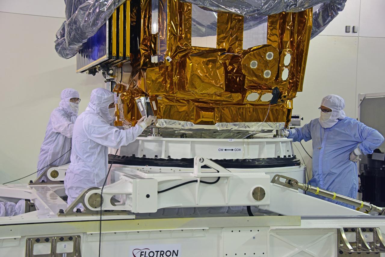
Inside the high bay of the Astrotech Space Operations facility at Vandenberg Air Force Base in California, technicians attach NASA's Ice, Cloud and land Elevation Satellite-2 (ICESat-2) to the payload direct mate adapter, on Aug. 24, 2018. The satellite is being prepared for its scheduled launch from Space Launch Complex 2 at Vandenberg on the final United Launch Alliance Delta II rocket. ICESat-2 will measure the height of a changing Earth, one laser pulse at a time, 10,000 laser pulses a second. The satellite will carry the Advanced Topographic Laser Altimeter System (ATLAS). ICESat-2 will help scientists investigate why, and how much our planet's frozen and icy areas, called the cryosphere, are changing in a warming climate.
Inside the high bay of the Astrotech Space Operations facility at Vandenberg Air Force Base in California, technicians prepare to attach NASA's Ice, Cloud and land Elevation Satellite-2 (ICESat-2) to the payload adapter, on Aug. 20, 2018. The satellite is being prepared for its scheduled launch from Space Launch Complex 2 at Vandenberg on the final United Launch Alliance Delta II rocket. ICESat-2 will measure the height of a changing Earth, one laser pulse at a time, 10,000 laser pulses a second. The satellite will carry the Advanced Topographic Laser Altimeter System (ATLAS). ICESat-2 will help scientists investigate why, and how much our planet's frozen and icy areas, called the cryosphere, are changing in a warming climate.
Inside the Astrotech Space Operations high bay at Vandenberg Air Force Base in California, technicians prepare NASA's Ice, Cloud and land Elevation Satellite-2 (ICESat-2), for installation of the protective canister on Aug. 25, 2018. The satellite will be transported to Space Launch Complex 2 where it will be hoisted up by crane and attached to the United Launch Alliance Delta II rocket. Launch is scheduled for Sept. 15, 2018. ICESat-2 will measure the height of a changing Earth, one laser pulse at a time, 10,000 laser pulses a second. The satellite will carry the Advanced Topographic Laser Altimeter System (ATLAS). ICESat-2 will help scientists investigate why, and how much our planet's frozen and icy areas, called the cryosphere, are changing in a warming climate.
NOAA's Joint Polar Satellite System-1, or JPSS-1, remains wrapped in a protective covering after removal from its shipping container at the Astrotech Processing Facility at Vandenberg Air Force Base in California. Technicians help secure the spacecraft onto a payload attach fitting. JPSS-1 will liftoff aboard a United Launch Alliance Delta II rocket from Vandenberg's Space Launch Complex-2. JPSS-1 is the first in a series of four next-generation environmental satellites in a collaborative program between NOAA and NASA.
Inside the Astrotech Space Operations high bay at Vandenberg Air Force Base in California, technicians prepare the canister, at right, for installation around NASA's Ice, Cloud and land Elevation Satellite-2 (ICESat-2), at left, on Aug. 25, 2018. The satellite will be transported to Space Launch Complex 2 where it will be hoisted up by crane and attached to the United Launch Alliance Delta II rocket. Launch is scheduled for Sept. 15, 2018. ICESat-2 will measure the height of a changing Earth, one laser pulse at a time, 10,000 laser pulses a second. The satellite will carry the Advanced Topographic Laser Altimeter System (ATLAS). ICESat-2 will help scientists investigate why, and how much our planet's frozen and icy areas, called the cryosphere, are changing in a warming climate.
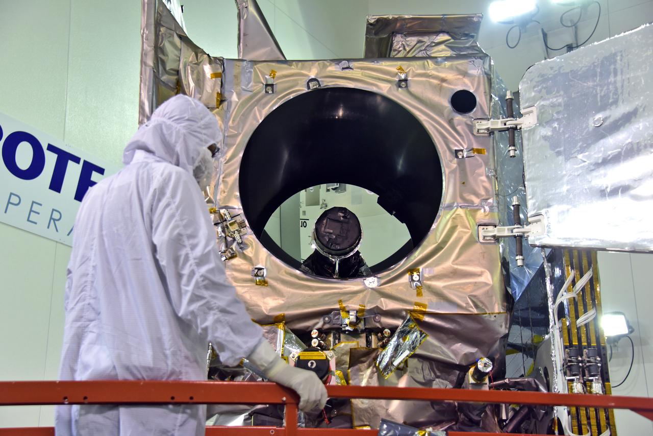
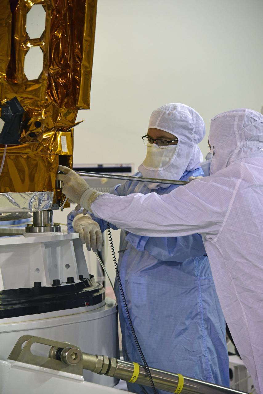
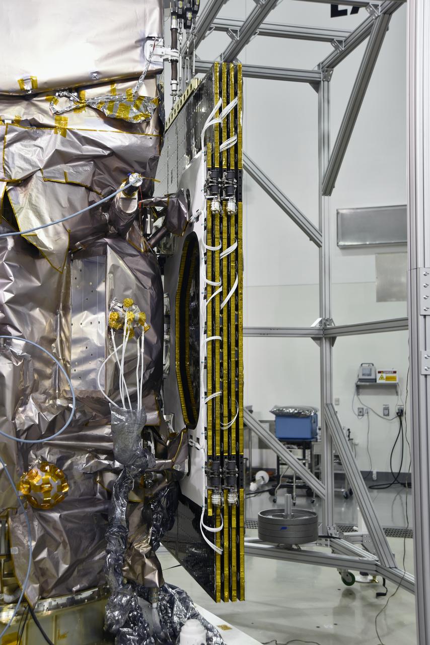
Inside the high bay of the Astrotech Space Operations facility at Vandenberg Air Force Base in California, a technician opens and checks the flight door for the Advanced Topographic Laser Altimeter System (ATLAS) on NASA's Ice, Cloud and land Elevation Satellite-2 (ICESat-2) on June 21, 2018. The satellite is being prepared for its scheduled launch from Space Launch Complex-2 at Vandenberg on the final United Launch Alliance Delta II rocket. ICESat-2 will measure the height of a changing Earth, one laser pulse at a time, 10,000 laser pulses a second. The satellite will carry ATLAS. ICESat-2 will help scientists investigate why, and how much our planet's frozen and icy areas, called the cryosphere, is changing in a warming climate.
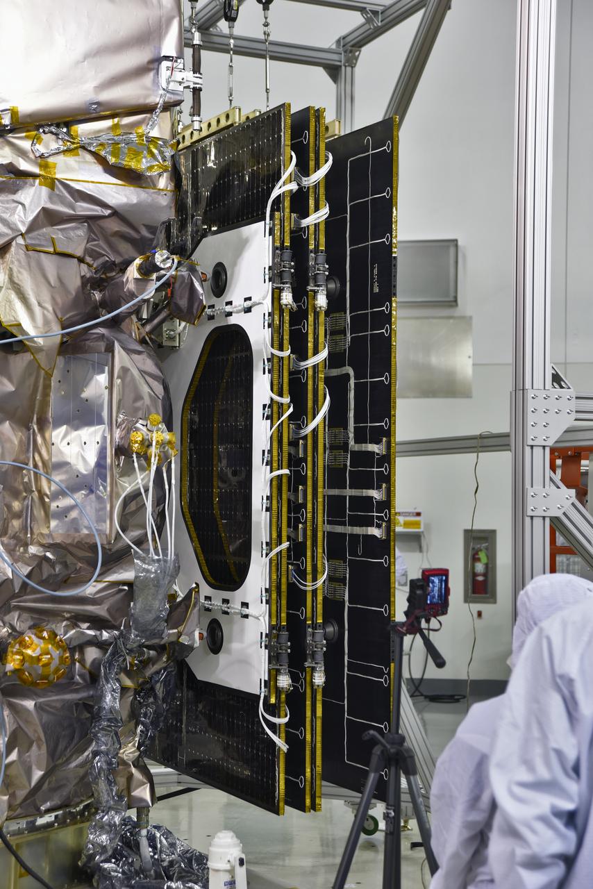
Inside the high bay of the Astrotech Space Operations facility at Vandenberg Air Force Base in California, a solar array first motion test is underway on NASA's Ice, Cloud and land Elevation Satellite-2 (ICESat-2) on June 18, 2018. The satellite is being prepared for its scheduled launch from Space Launch Complex-2 at Vandenberg on the final United Launch Alliance Delta II rocket. ICESat-2 will measure the height of a changing Earth, one laser pulse at a time, 10,000 laser pulses a second. The satellite will carry the Advanced Topographic Laser Altimeter System. ICESat-2 will help scientists investigate why, and how much our planet's frozen and icy areas, called the cryosphere, is changing in a warming climate.
Inside the high bay of the Astrotech Space Operations facility at Vandenberg Air Force Base in California, technicians assist as a crane lowers NASA's Ice, Cloud and land Elevation Satellite-2 (ICESat-2) onto the payload adapter on Aug. 30, 2018. ICESat-2 is being prepared for its scheduled launch from Space Launch Complex 2 at Vandenberg on the final United Launch Alliance Delta II rocket. ICESat-2 will measure the height of a changing Earth, one laser pulse at a time, 10,000 laser pulses a second. The satellite will carry the Advanced Topographic Laser Altimeter System (ATLAS). ICESat-2 will help scientists investigate why, and how much our planet's frozen and icy areas, called the cryosphere, are changing in a warming climate.
Inside the high bay of the Astrotech Space Operations facility at Vandenberg Air Force Base in California, a solar array first motion test is in progress on NASA's Ice, Cloud and land Elevation Satellite-2 (ICESat-2) on June 18, 2018. The satellite is being prepared for its scheduled launch from Space Launch Complex-2 at Vandenberg on the final United Launch Alliance Delta II rocket. ICESat-2 will measure the height of a changing Earth, one laser pulse at a time, 10,000 laser pulses a second. The satellite will carry the Advanced Topographic Laser Altimeter System. ICESat-2 will help scientists investigate why, and how much our planet's frozen and icy areas, called the cryosphere, is changing in a warming climate.
NOAA's Joint Polar Satellite System-1, or JPSS-1, remains wrapped in a protective covering after removal from its shipping container at the Astrotech Processing Facility at Vandenberg Air Force Base in California. Technicians assist as a crane lifts the spacecraft up for its move to a payload attach fitting. JPSS-1 will liftoff aboard a United Launch Alliance Delta II rocket from Vandenberg's Space Launch Complex-2. JPSS-1 is the first in a series of four next-generation environmental satellites in a collaborative program between NOAA and NASA.
Inside the high bay of the Astrotech Space Operations facility at Vandenberg Air Force Base in California, technicians prepare to attach NASA's Ice, Cloud and land Elevation Satellite-2 (ICESat-2) to the payload adapter, on Aug. 20, 2018. The satellite is being prepared for its scheduled launch from Space Launch Complex 2 at Vandenberg on the final United Launch Alliance Delta II rocket. ICESat-2 will measure the height of a changing Earth, one laser pulse at a time, 10,000 laser pulses a second. The satellite will carry the Advanced Topographic Laser Altimeter System (ATLAS). ICESat-2 will help scientists investigate why, and how much our planet's frozen and icy areas, called the cryosphere, are changing in a warming climate.
NOAA's Joint Polar Satellite System-1, or JPSS-1, remains wrapped in a protective covering after removal from its shipping container at the Astrotech Processing Facility at Vandenberg Air Force Base in California. Technicians assist as a crane lowers the spacecraft toward a payload attach fitting. JPSS-1 will liftoff aboard a United Launch Alliance Delta II rocket from Vandenberg's Space Launch Complex-2. JPSS-1 is the first in a series of four next-generation environmental satellites in a collaborative program between NOAA and NASA.
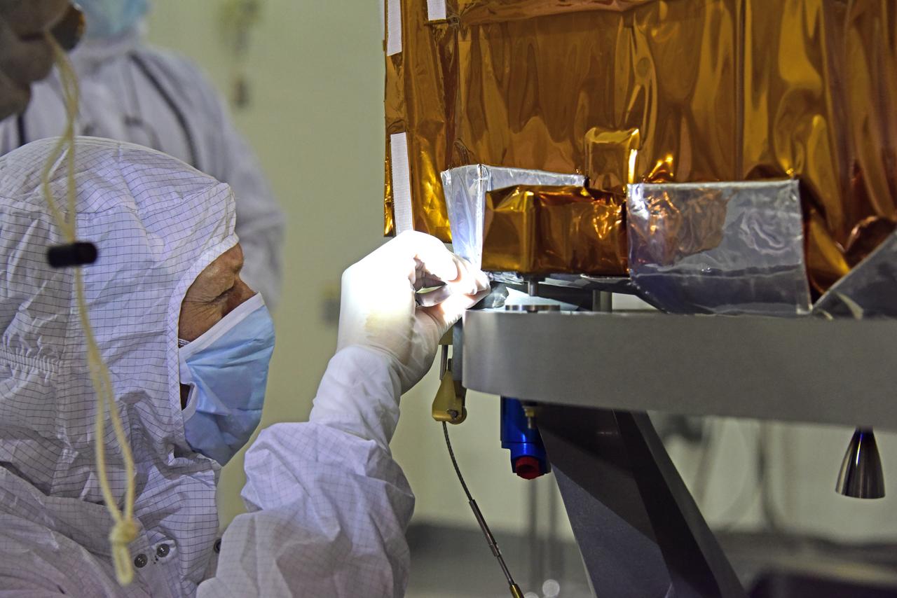
Inside the high bay of the Astrotech Space Operations facility at Vandenberg Air Force Base in California, a technician checks the flight door for the Advanced Topographic Laser Altimeter System (ATLAS) on NASA's Ice, Cloud and land Elevation Satellite-2 (ICESat-2) on June 21, 2018. The satellite is being prepared for its scheduled launch from Space Launch Complex-2 at Vandenberg on the final United Launch Alliance Delta II rocket. ICESat-2 will measure the height of a changing Earth, one laser pulse at a time, 10,000 laser pulses a second. The satellite will carry ATLAS. ICESat-2 will help scientists investigate why, and how much our planet's frozen and icy areas, called the cryosphere, is changing in a warming climate.

Inside the high bay of the Astrotech Space Operations facility at Vandenberg Air Force Base in California, a technician checks the flight door for the Advanced Topographic Laser Altimeter System (ATLAS) on NASA's Ice, Cloud and land Elevation Satellite-2 (ICESat-2) on June 21, 2018. The satellite is being prepared for its scheduled launch from Space Launch Complex-2 at Vandenberg on the final United Launch Alliance Delta II rocket. ICESat-2 will measure the height of a changing Earth, one laser pulse at a time, 10,000 laser pulses a second. The satellite will carry ATLAS. ICESat-2 will help scientists investigate why, and how much our planet's frozen and icy areas, called the cryosphere, is changing in a warming climate.
Inside the high bay of the Astrotech Space Operations facility at Vandenberg Air Force Base in California, technicians help secure NASA's Ice, Cloud and land Elevation Satellite-2 (ICESat-2) to the payload adapter on Aug. 30, 2018. ICESat-2 is being prepared for its scheduled launch from Space Launch Complex 2 at Vandenberg on the final United Launch Alliance Delta II rocket. ICESat-2 will measure the height of a changing Earth, one laser pulse at a time, 10,000 laser pulses a second. The satellite will carry the Advanced Topographic Laser Altimeter System (ATLAS). ICESat-2 will help scientists investigate why, and how much our planet's frozen and icy areas, called the cryosphere, are changing in a warming climate.
Inside the high bay of the Astrotech Space Operations facility at Vandenberg Air Force Base in California, technicians attach NASA's Ice, Cloud and land Elevation Satellite-2 (ICESat-2) to the payload direct mate adapter, on Aug. 24, 2018. The satellite is being prepared for its scheduled launch from Space Launch Complex 2 at Vandenberg on the final United Launch Alliance Delta II rocket. ICESat-2 will measure the height of a changing Earth, one laser pulse at a time, 10,000 laser pulses a second. The satellite will carry the Advanced Topographic Laser Altimeter System (ATLAS). ICESat-2 will help scientists investigate why, and how much our planet's frozen and icy areas, called the cryosphere, are changing in a warming climate.
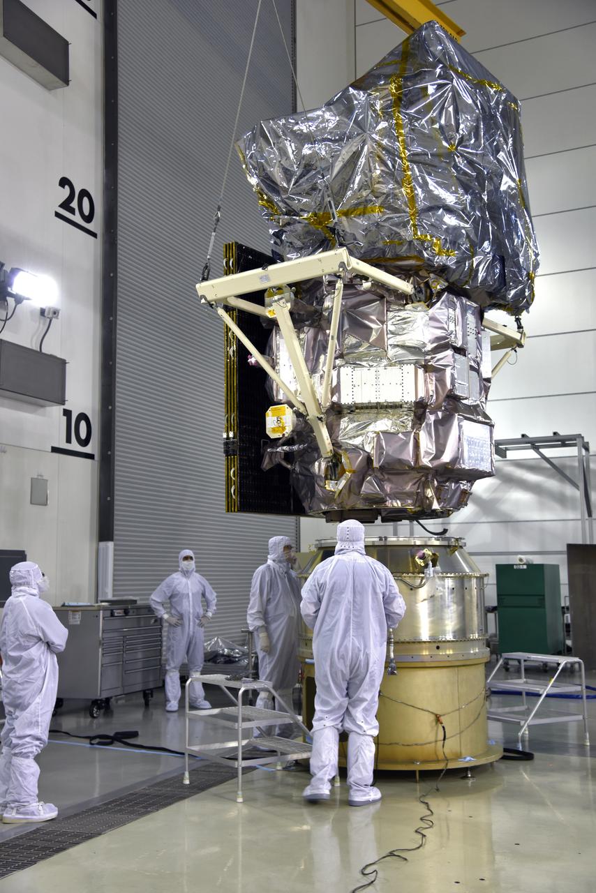
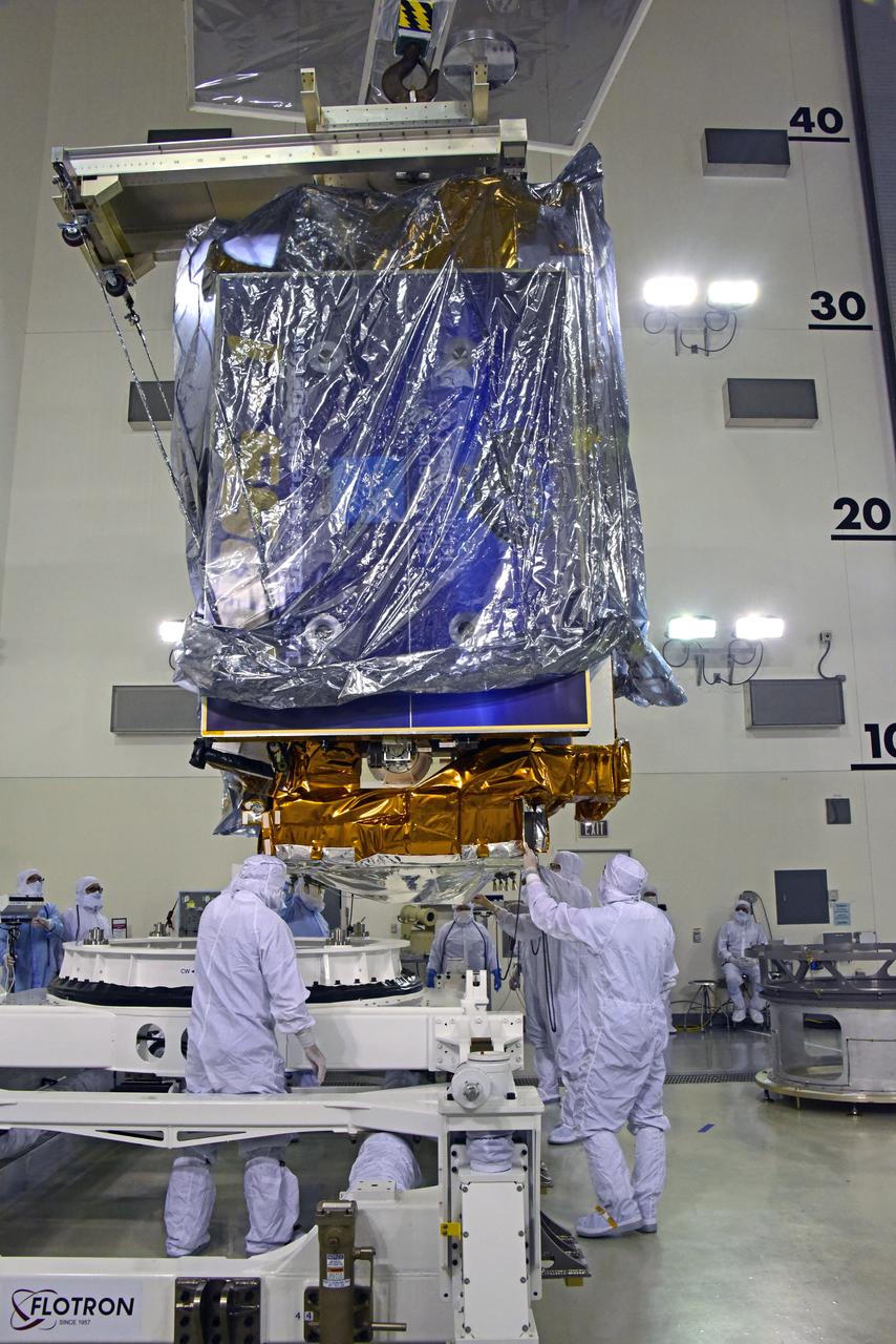
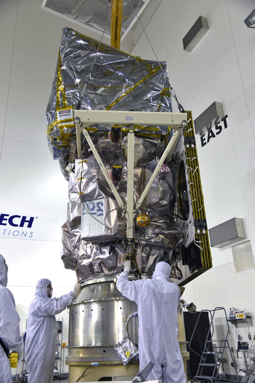
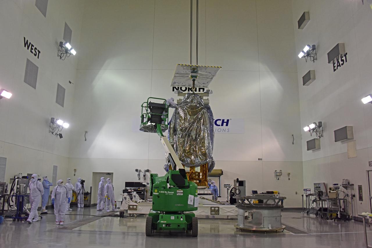
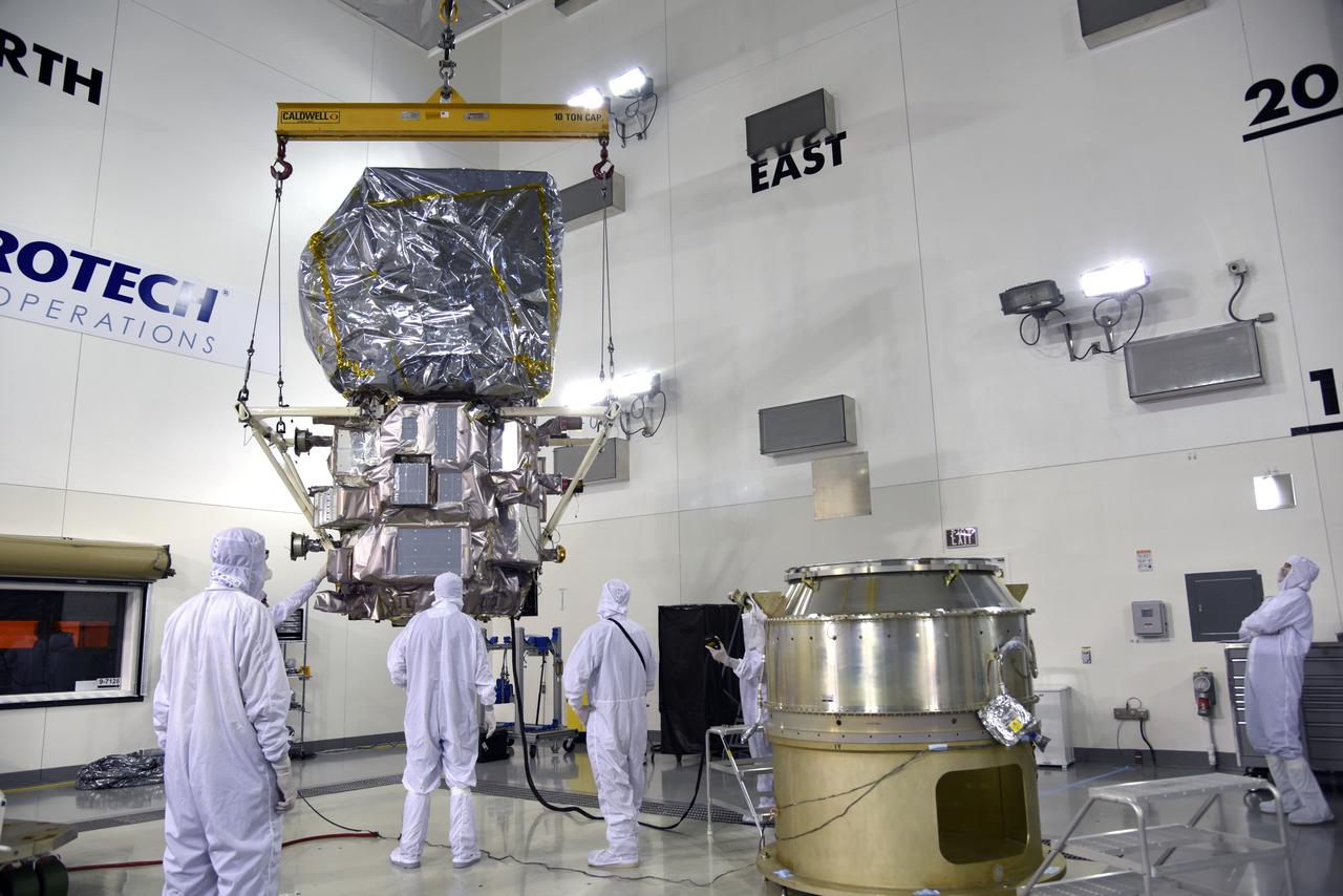
Inside the high bay of the Astrotech Space Operations facility at Vandenberg Air Force Base in California, a crane lifts and moves NASA's Ice, Cloud and land Elevation Satellite-2 (ICESat-2) over the payload adapter on Aug. 30, 2018. The satellite will be attached to the adapter. ICESat-2 is being prepared for its scheduled launch from Space Launch Complex 2 at Vandenberg on the final United Launch Alliance Delta II rocket. ICESat-2 will measure the height of a changing Earth, one laser pulse at a time, 10,000 laser pulses a second. The satellite will carry the Advanced Topographic Laser Altimeter System (ATLAS). ICESat-2 will help scientists investigate why, and how much our planet's frozen and icy areas, called the cryosphere, are changing in a warming climate.
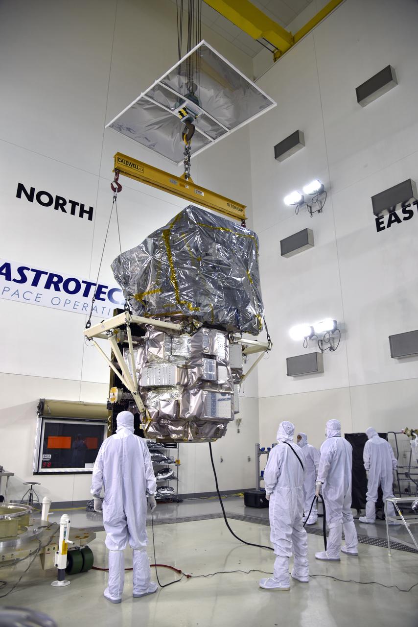
Inside the high bay of the Astrotech Space Operations facility at Vandenberg Air Force Base in California, a crane lifts and moves NASA's Ice, Cloud and land Elevation Satellite-2 (ICESat-2) on Aug. 30, 2018. The satellite will be attached to the payload adapter. ICESat-2 is being prepared for its scheduled launch from Space Launch Complex 2 at Vandenberg on the final United Launch Alliance Delta II rocket. ICESat-2 will measure the height of a changing Earth, one laser pulse at a time, 10,000 laser pulses a second. The satellite will carry the Advanced Topographic Laser Altimeter System (ATLAS). ICESat-2 will help scientists investigate why, and how much our planet's frozen and icy areas, called the cryosphere, are changing in a warming climate.
NOAA's Joint Polar Satellite System-1, or JPSS-1, remains wrapped in a protective covering after removal from its shipping container at the Astrotech Processing Facility at Vandenberg Air Force Base in California. Technicians assist as a crane lifts and moves the spacecraft to a payload attach fitting. JPSS-1 will liftoff aboard a United Launch Alliance Delta II rocket from Vandenberg's Space Launch Complex-2. JPSS-1 is the first in a series of four next-generation environmental satellites in a collaborative program between NOAA and NASA.
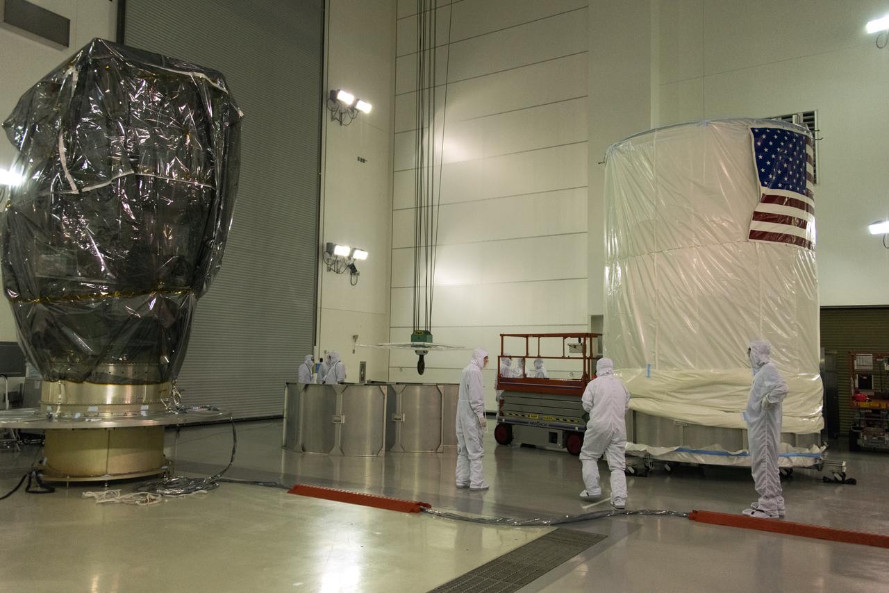
NOAA's Joint Polar Satellite System-1, or JPSS-1, remains wrapped in a protective covering after removal from its shipping container at the Astrotech Processing Facility at Vandenberg Air Force Base in California. A crane is attached to the spacecraft to prepare for its move to a payload attach fitting. JPSS-1 will liftoff aboard a United Launch Alliance Delta II rocket from Vandenberg's Space Launch Complex-2. JPSS-1 is the first in a series of four next-generation environmental satellites in a collaborative program between NOAA and NASA.
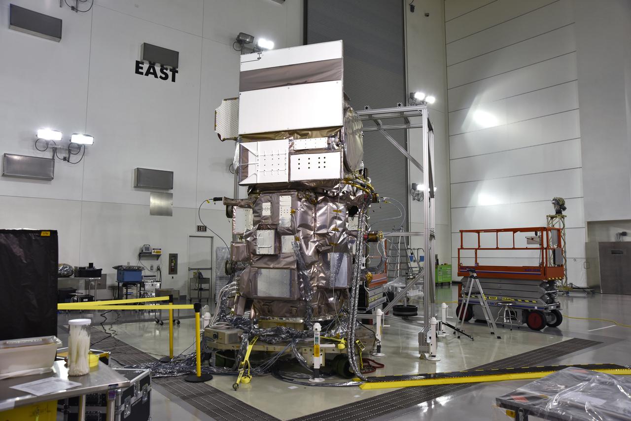
NOAA's Joint Polar Satellite System-1, or JPSS-1, remains wrapped in a protective covering after removal from its shipping container at the Astrotech Processing Facility at Vandenberg Air Force Base in California. The spacecraft is being prepared for its move to a payload attach fitting. JPSS-1 will liftoff aboard a United Launch Alliance Delta II rocket from Vandenberg's Space Launch Complex-2. JPSS-1 is the first in a series of four next-generation environmental satellites in a collaborative program between NOAA and NASA.
Inside the high bay of the Astrotech Space Operations facility at Vandenberg Air Force Base in California, a solar array first motion test is underway on NASA's Ice, Cloud and land Elevation Satellite-2 (ICESat-2) on June 18, 2018. The satellite is being prepared for its scheduled launch from Space Launch Complex-2 at Vandenberg on the final United Launch Alliance Delta II rocket. ICESat-2 will measure the height of a changing Earth, one laser pulse at a time, 10,000 laser pulses a second. The satellite will carry the Advanced Topographic Laser Altimeter System. ICESat-2 will help scientists investigate why, and how much our planet's frozen and icy areas, called the cryosphere, is changing in a warming climate.
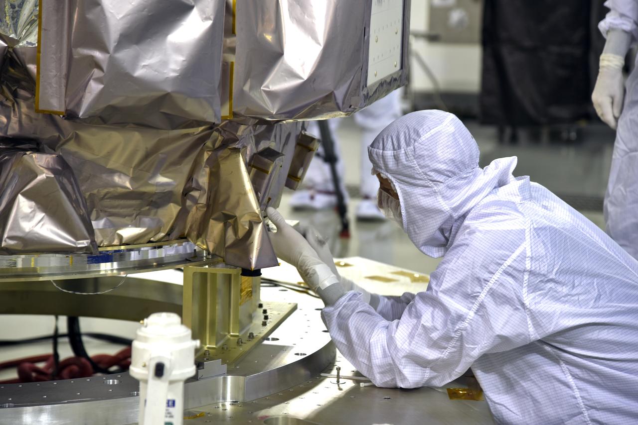
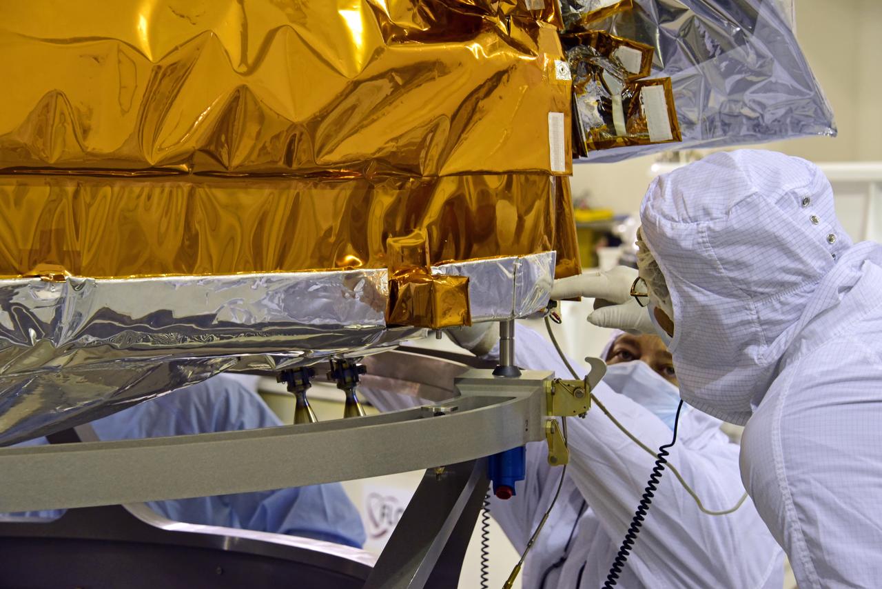
Inside the high bay of the Astrotech Space Operations facility at Vandenberg Air Force Base in California, a technician prepares NASA's Ice, Cloud and land Elevation Satellite-2 (ICESat-2) to be attached to the payload adapter, on Aug. 20, 2018. The satellite is being prepared for its scheduled launch from Space Launch Complex 2 at Vandenberg on the final United Launch Alliance Delta II rocket. ICESat-2 will measure the height of a changing Earth, one laser pulse at a time, 10,000 laser pulses a second. The satellite will carry the Advanced Topographic Laser Altimeter System (ATLAS). ICESat-2 will help scientists investigate why, and how much our planet's frozen and icy areas, called the cryosphere, are changing in a warming climate.
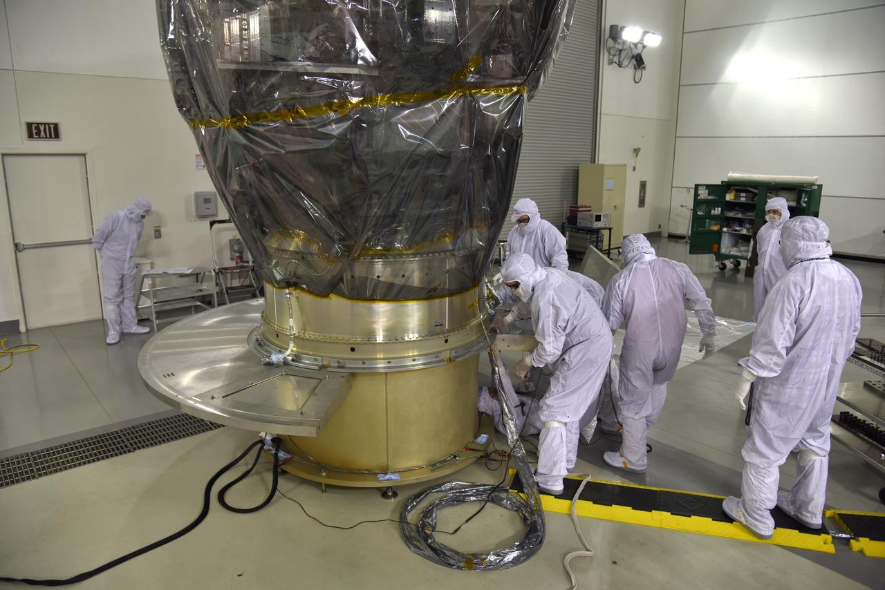
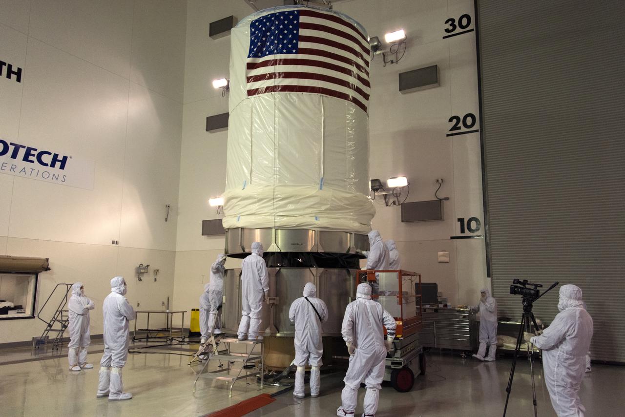
Inside the high bay of the Astrotech Space Operations facility at Vandenberg Air Force Base in California, technicians attach NASA's Ice, Cloud and land Elevation Satellite-2 (ICESat-2) to the payload direct mate adapter, on Aug. 24, 2018. The satellite is being prepared for its scheduled launch from Space Launch Complex 2 at Vandenberg on the final United Launch Alliance Delta II rocket. ICESat-2 will measure the height of a changing Earth, one laser pulse at a time, 10,000 laser pulses a second. The satellite will carry the Advanced Topographic Laser Altimeter System (ATLAS). ICESat-2 will help scientists investigate why, and how much our planet's frozen and icy areas, called the cryosphere, are changing in a warming climate.
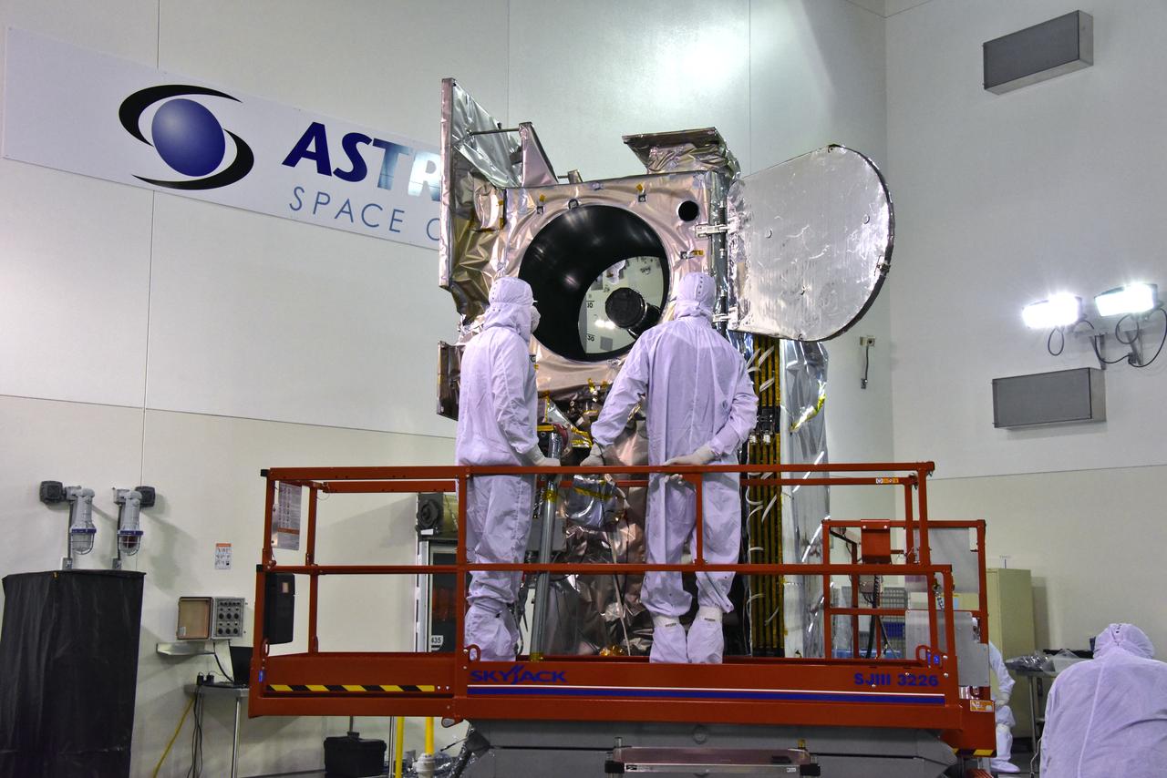
Inside the high bay of the Astrotech Space Operations facility at Vandenberg Air Force Base in California, technicians open and check the flight door for the Advanced Topographic Laser Altimeter System (ATLAS) on NASA's Ice, Cloud and land Elevation Satellite-2 (ICESat-2) on June 18, 2018. The satellite is being prepared for its scheduled launch from Space Launch Complex-2 at Vandenberg on the final United Launch Alliance Delta II rocket. ICESat-2 will measure the height of a changing Earth, one laser pulse at a time, 10,000 laser pulses a second. The satellite will carry ATLAS. ICESat-2 will help scientists investigate why, and how much our planet's frozen and icy areas, called the cryosphere, is changing in a warming climate.
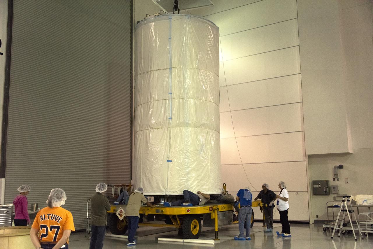
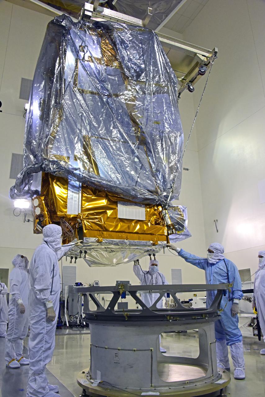
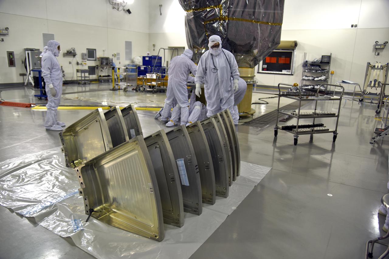
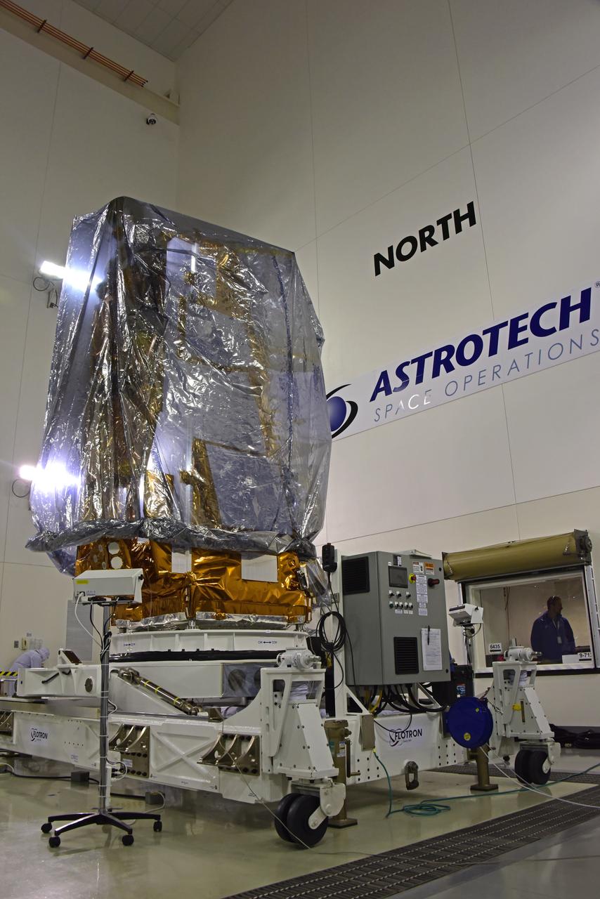
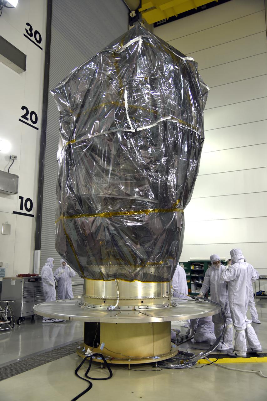
Technicians assist as NASA's Ice, Cloud and land Elevation Satellite-2 (ICESat-2), inside its protective canister, is lowered onto a transport trailer inside the Astrotech Space Operations high bay at Vandenberg Air Force Base in California, on Aug. 25, 2018. The satellite will be transported to Space Launch Complex 2 where it will be hoisted up by crane and attached to the United Launch Alliance Delta II rocket. Launch is scheduled for Sept. 15, 2018. ICESat-2 will measure the height of a changing Earth, one laser pulse at a time, 10,000 laser pulses a second. The satellite will carry the Advanced Topographic Laser Altimeter System (ATLAS). ICESat-2 will help scientists investigate why, and how much our planet's frozen and icy areas, called the cryosphere, are changing in a warming climate.

Inside the high bay of the Astrotech Space Operations facility at Vandenberg Air Force Base in California, technicians attach NASA's Ice, Cloud and land Elevation Satellite-2 (ICESat-2) to the payload direct mate adapter, on Aug. 24, 2018. The satellite is being prepared for its scheduled launch from Space Launch Complex 2 at Vandenberg on the final United Launch Alliance Delta II rocket. ICESat-2 will measure the height of a changing Earth, one laser pulse at a time, 10,000 laser pulses a second. The satellite will carry the Advanced Topographic Laser Altimeter System (ATLAS). ICESat-2 will help scientists investigate why, and how much our planet's frozen and icy areas, called the cryosphere, are changing in a warming climate.

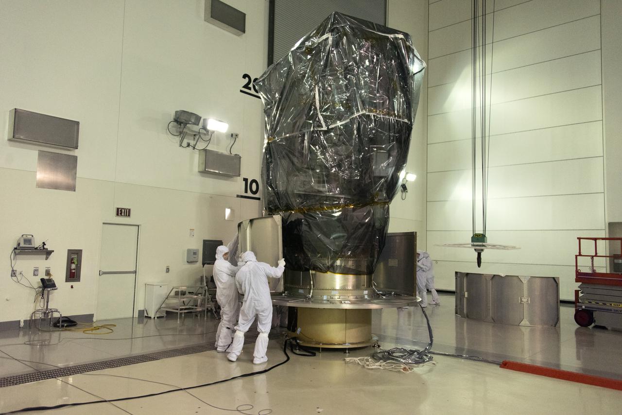
Inside the Astrotech Space Operations high bay at Vandenberg Air Force Base in California, the protective canister is lowered down over NASA's Ice, Cloud and land Elevation Satellite-2 (ICESat-2), on Aug. 25, 2018. The satellite will be transported to Space Launch Complex 2 where it will be hoisted up by crane and attached to the United Launch Alliance Delta II rocket. Launch is scheduled for Sept. 15, 2018. ICESat-2 will measure the height of a changing Earth, one laser pulse at a time, 10,000 laser pulses a second. The satellite will carry the Advanced Topographic Laser Altimeter System (ATLAS). ICESat-2 will help scientists investigate why, and how much our planet's frozen and icy areas, called the cryosphere, are changing in a warming climate.
NOAA's Joint Polar Satellite System-1, or JPSS-1, remains wrapped in a protective covering after removal from its shipping container at the Astrotech Processing Facility at Vandenberg Air Force Base in California. Technicians prepare the spacecraft for its move to a payload attach fitting. JPSS-1 will liftoff aboard a United Launch Alliance Delta II rocket from Vandenberg's Space Launch Complex-2. JPSS-1 is the first in a series of four next-generation environmental satellites in a collaborative program between NOAA and NASA.
NOAA's Joint Polar Satellite System-1, or JPSS-1, remains wrapped in a protective covering after removal from its shipping container at the Astrotech Processing Facility at Vandenberg Air Force Base in California. Technicians prepare the spacecraft for its move to a payload attach fitting. JPSS-1 will liftoff aboard a United Launch Alliance Delta II rocket from Vandenberg's Space Launch Complex-2. JPSS-1 is the first in a series of four next-generation environmental satellites in a collaborative program between NOAA and NASA.
Inside the high bay of the Astrotech Space Operations facility at Vandenberg Air Force Base in California, a solar array first motion test is underway on NASA's Ice, Cloud and land Elevation Satellite-2 (ICESat-2) on June 18, 2018. The satellite is being prepared for its scheduled launch from Space Launch Complex-2 at Vandenberg on the final United Launch Alliance Delta II rocket. ICESat-2 will measure the height of a changing Earth, one laser pulse at a time, 10,000 laser pulses a second. The satellite will carry the Advanced Topographic Laser Altimeter System. ICESat-2 will help scientists investigate why, and how much our planet's frozen and icy areas, called the cryosphere, is changing in a warming climate.
Inside the Astrotech Space Operations high bay at Vandenberg Air Force Base in California, the protective canister is lowered down over NASA's Ice, Cloud and land Elevation Satellite-2 (ICESat-2), on Aug. 25, 2018. The satellite will be transported to Space Launch Complex 2 where it will be hoisted up by crane and attached to the United Launch Alliance Delta II rocket. Launch is scheduled for Sept. 15, 2018. ICESat-2 will measure the height of a changing Earth, one laser pulse at a time, 10,000 laser pulses a second. The satellite will carry the Advanced Topographic Laser Altimeter System (ATLAS). ICESat-2 will help scientists investigate why, and how much our planet's frozen and icy areas, called the cryosphere, are changing in a warming climate.
NOAA's Joint Polar Satellite System-1, or JPSS-1, remains wrapped in a protective covering after removal from its shipping container at the Astrotech Processing Facility at Vandenberg Air Force Base in California. The spacecraft is being prepared for its move to a payload attach fitting. JPSS-1 will liftoff aboard a United Launch Alliance Delta II rocket from Vandenberg's Space Launch Complex-2. JPSS-1 is the first in a series of four next-generation environmental satellites in a collaborative program between NOAA and NASA.

Inside the high bay of the Astrotech Space Operations facility at Vandenberg Air Force Base in California, a solar array first motion test is in progress on NASA's Ice, Cloud and land Elevation Satellite-2 (ICESat-2) on June 18, 2018. The satellite is being prepared for its scheduled launch from Space Launch Complex-2 at Vandenberg on the final United Launch Alliance Delta II rocket. ICESat-2 will measure the height of a changing Earth, one laser pulse at a time, 10,000 laser pulses a second. The satellite will carry the Advanced Topographic Laser Altimeter System. ICESat-2 will help scientists investigate why, and how much our planet's frozen and icy areas, called the cryosphere, is changing in a warming climate.
NOAA's Joint Polar Satellite System-1, or JPSS-1, remains wrapped in a protective covering after removal from its shipping container at the Astrotech Processing Facility at Vandenberg Air Force Base in California. Technicians confirm that the spacecraft is secured onto a payload attach fitting. JPSS-1 will liftoff aboard a United Launch Alliance Delta II rocket from Vandenberg's Space Launch Complex-2. JPSS-1 is the first in a series of four next-generation environmental satellites in a collaborative program between NOAA and NASA.
Inside the high bay of the Astrotech Space Operations facility at Vandenberg Air Force Base in California, a crane lifts and moves NASA's Ice, Cloud and land Elevation Satellite-2 (ICESat-2) on Aug. 30, 2018. The satellite will be attached to the payload adapter. ICESat-2 is being prepared for its scheduled launch from Space Launch Complex 2 at Vandenberg on the final United Launch Alliance Delta II rocket. ICESat-2 will measure the height of a changing Earth, one laser pulse at a time, 10,000 laser pulses a second. The satellite will carry the Advanced Topographic Laser Altimeter System (ATLAS). ICESat-2 will help scientists investigate why, and how much our planet's frozen and icy areas, called the cryosphere, are changing in a warming climate.
Inside the high bay of the Astrotech Space Operations facility at Vandenberg Air Force Base in California, a solar array first motion test is in progress on NASA's Ice, Cloud and land Elevation Satellite-2 (ICESat-2) on June 18, 2018. The satellite is being prepared for its scheduled launch from Space Launch Complex-2 at Vandenberg on the final United Launch Alliance Delta II rocket. ICESat-2 will measure the height of a changing Earth, one laser pulse at a time, 10,000 laser pulses a second. The satellite will carry the Advanced Topographic Laser Altimeter System. ICESat-2 will help scientists investigate why, and how much our planet's frozen and icy areas, called the cryosphere, is changing in a warming climate.
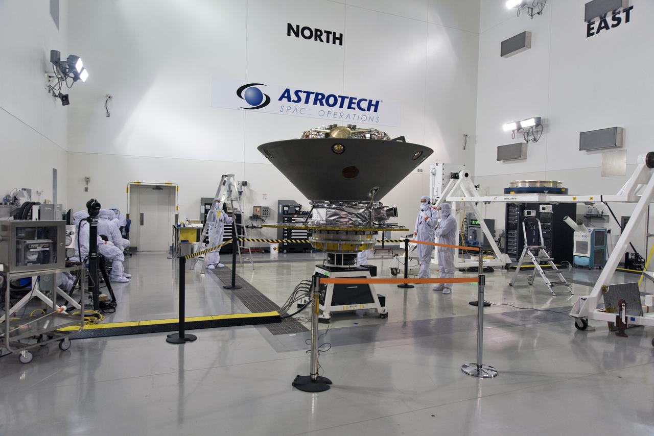
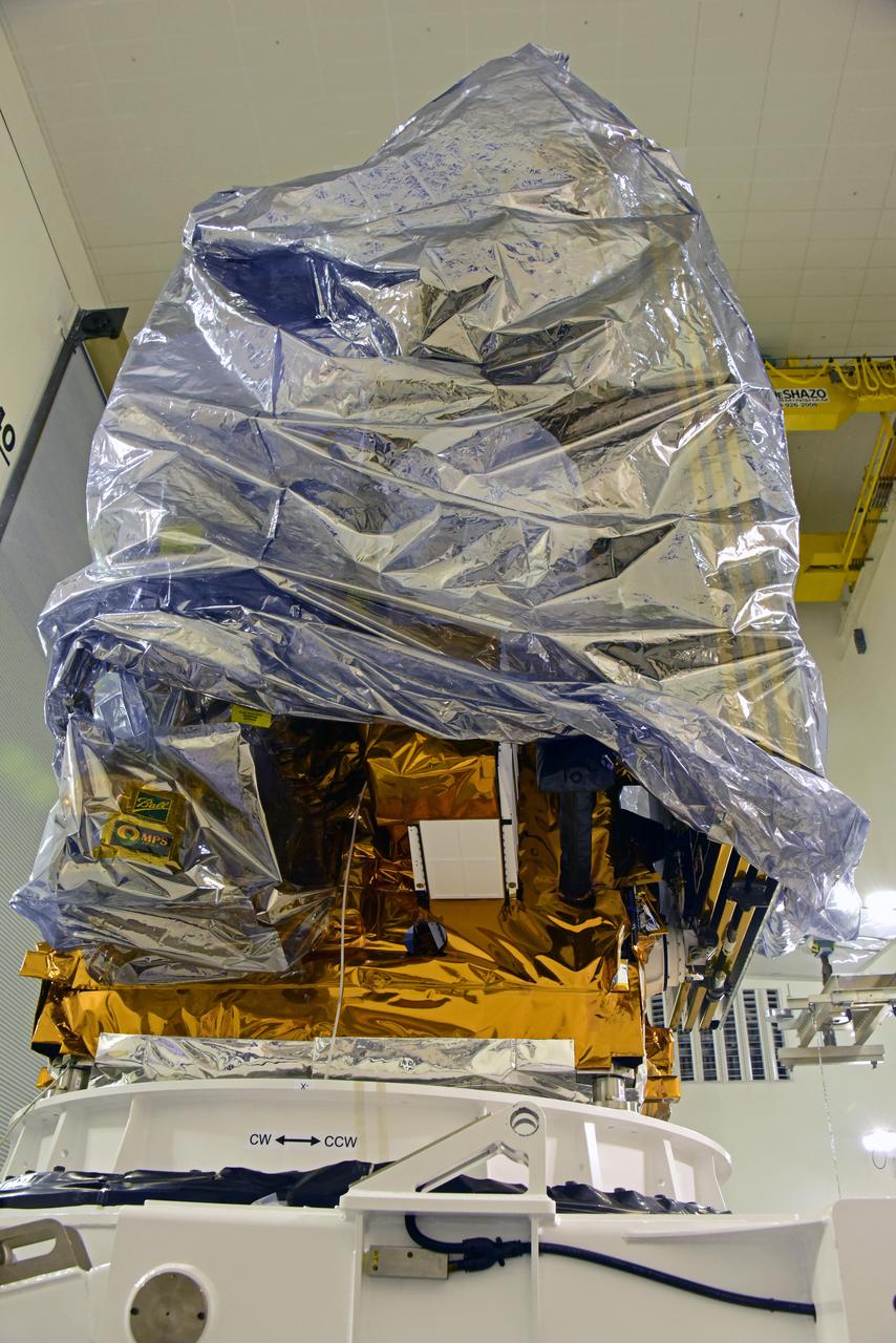
In the Astrotech facility at Vandenberg Air Force Base in California, NASA's Interior Exploration using Seismic Investigations, Geodesy and Heat Transport, or InSight, spacecraft is placed on a spin table during preflight processing. InSight will be the first mission to look deep beneath the Martian surface. It will study the planet's interior by measuring its heat output and listen for marsquakes. The spacecraft will use the seismic waves generated by marsquakes to develop a map of the planet’s deep interior. The resulting insight into Mars’ formation will provide a better understanding of how other rocky planets, including Earth, were created. InSight is scheduled for liftoff May 5, 2018.
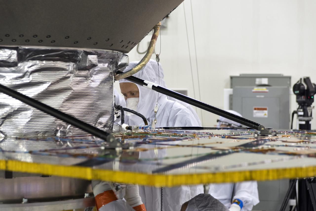
In the Astrotech facility at Vandenberg Air Force Base in California, NASA's Interior Exploration using Seismic Investigations, Geodesy and Heat Transport, or InSight, spacecraft is placed on a spin table during preflight processing. InSight will be the first mission to look deep beneath the Martian surface. It will study the planet's interior by measuring its heat output and listen for marsquakes. The spacecraft will use the seismic waves generated by marsquakes to develop a map of the planet’s deep interior. The resulting insight into Mars’ formation will provide a better understanding of how other rocky planets, including Earth, were created. InSight is scheduled for liftoff May 5, 2018.
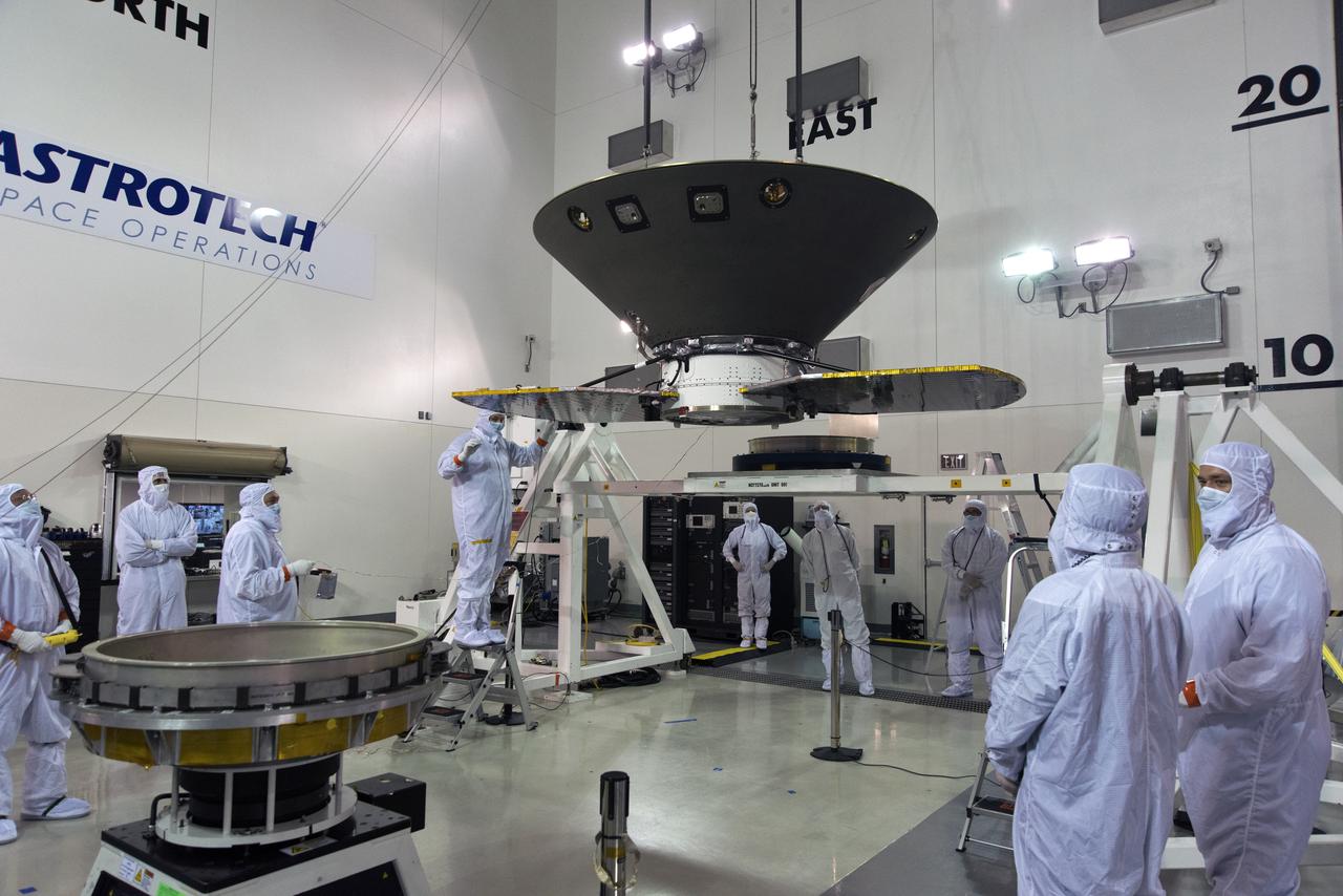
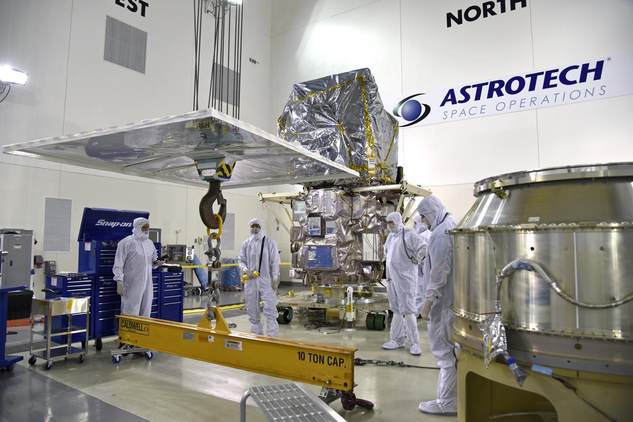
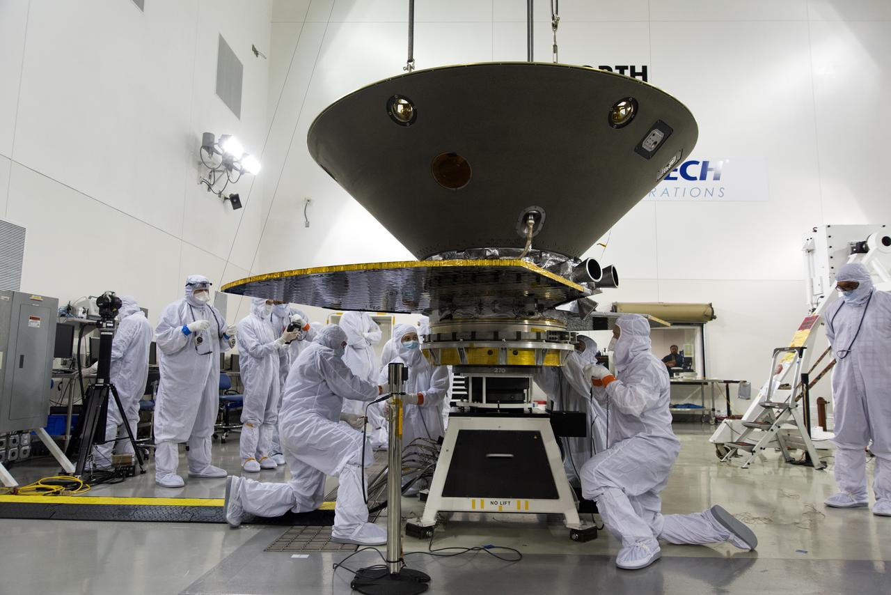
In the Astrotech facility at Vandenberg Air Force Base in California, NASA's Interior Exploration using Seismic Investigations, Geodesy and Heat Transport, or InSight, spacecraft is lifted for placement on a spin table during preflight processing. InSight will be the first mission to look deep beneath the Martian surface. It will study the planet's interior by measuring its heat output and listen for marsquakes. The spacecraft will use the seismic waves generated by marsquakes to develop a map of the planet’s deep interior. The resulting insight into Mars’ formation will provide a better understanding of how other rocky planets, including Earth, were created. InSight is scheduled for liftoff May 5, 2018.
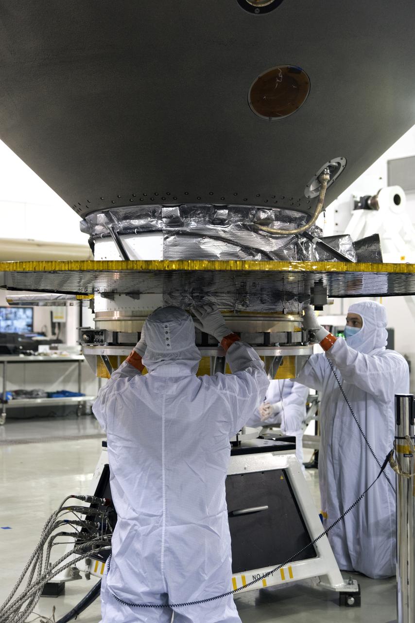
In the Astrotech facility at Vandenberg Air Force Base in California, NASA's Interior Exploration using Seismic Investigations, Geodesy and Heat Transport, or InSight, spacecraft is placed on a spin table during preflight processing. InSight will be the first mission to look deep beneath the Martian surface. It will study the planet's interior by measuring its heat output and listen for marsquakes. The spacecraft will use the seismic waves generated by marsquakes to develop a map of the planet’s deep interior. The resulting insight into Mars’ formation will provide a better understanding of how other rocky planets, including Earth, were created. InSight is scheduled for liftoff May 5, 2018.
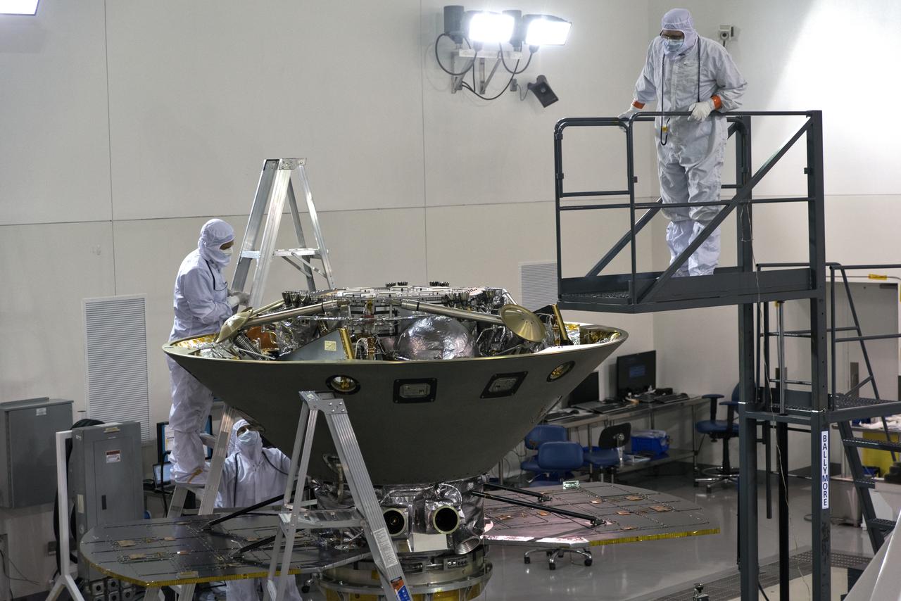
In the Astrotech facility at Vandenberg Air Force Base in California, technicians and engineers inspect NASA's Interior Exploration using Seismic Investigations, Geodesy and Heat Transport, or InSight, spacecraft after it was placed on a spin table during preflight processing. InSight will be the first mission to look deep beneath the Martian surface. It will study the planet's interior by measuring its heat output and listen for marsquakes. The spacecraft will use the seismic waves generated by marsquakes to develop a map of the planet’s deep interior. The resulting insight into Mars’ formation will provide a better understanding of how other rocky planets, including Earth, were created. InSight is scheduled for liftoff May 5, 2018.
In the Astrotech facility at Vandenberg Air Force Base in California, NASA's Interior Exploration using Seismic Investigations, Geodesy and Heat Transport, or InSight, spacecraft is placed on a spin table during preflight processing. InSight will be the first mission to look deep beneath the Martian surface. It will study the planet's interior by measuring its heat output and listen for marsquakes. The spacecraft will use the seismic waves generated by marsquakes to develop a map of the planet’s deep interior. The resulting insight into Mars’ formation will provide a better understanding of how other rocky planets, including Earth, were created. InSight is scheduled for liftoff May 5, 2018.
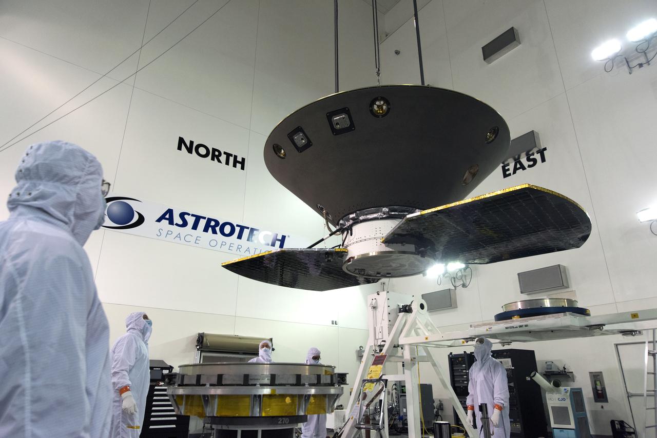
In the Astrotech facility at Vandenberg Air Force Base in California, NASA's Interior Exploration using Seismic Investigations, Geodesy and Heat Transport, or InSight, spacecraft is lifted for placement on a spin table during preflight processing. InSight will be the first mission to look deep beneath the Martian surface. It will study the planet's interior by measuring its heat output and listen for marsquakes. The spacecraft will use the seismic waves generated by marsquakes to develop a map of the planet’s deep interior. The resulting insight into Mars’ formation will provide a better understanding of how other rocky planets, including Earth, were created. InSight is scheduled for liftoff May 5, 2018.