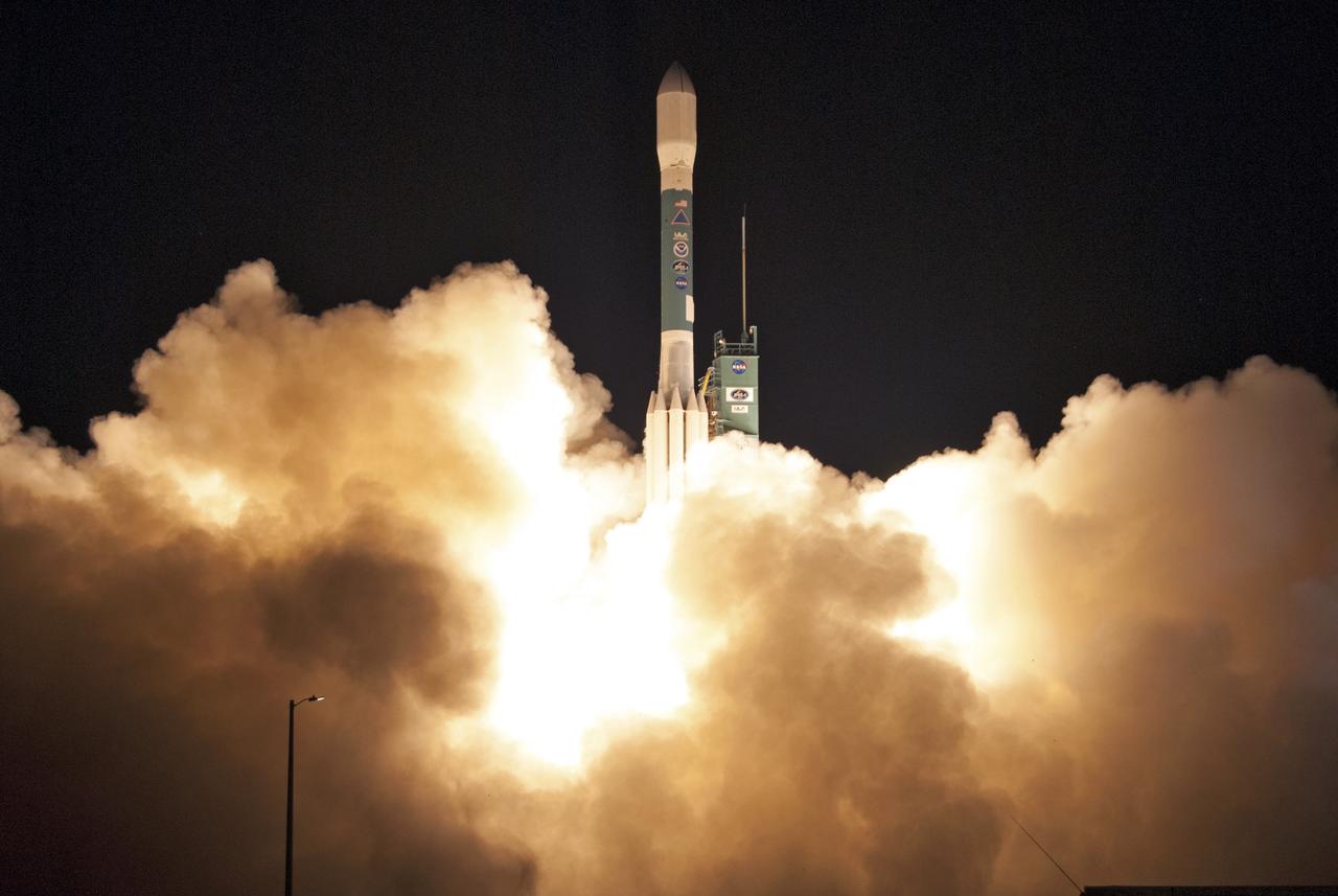
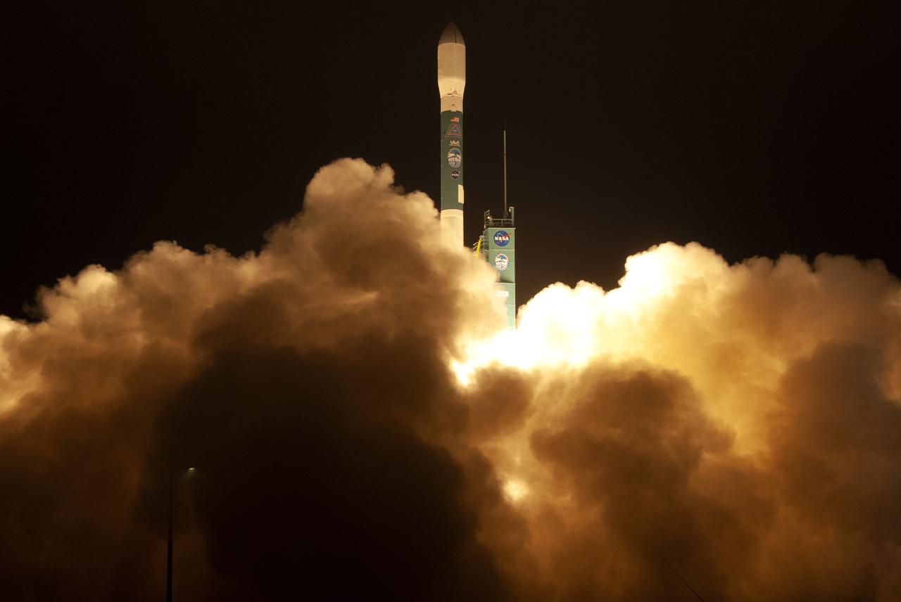
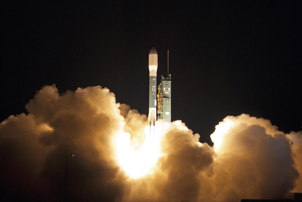
A United Launch Alliance Delta II rocket lifts off from Space Launch Complex 2 at Vandenberg Air Force Base in California carrying the Joint Polar Satellite System-1, or JPSS-1, spacecraft. Built by Ball Aerospace and Technologies Corp. of Boulder, Colorado, JPSS is the first in a series four next-generation environmental satellites in a collaborative program between NOAA and NASA. JPSS-1 will gather measurements of atmospheric, terrestrial and oceanic conditions, including sea and land surface temperatures, vegetation, clouds, rainfall, snow and ice cover, fire locations, atmospheric temperature, water vapor and ozone. Liftoff was at 1:47 a.m. PST (4:47 a.m. EST).
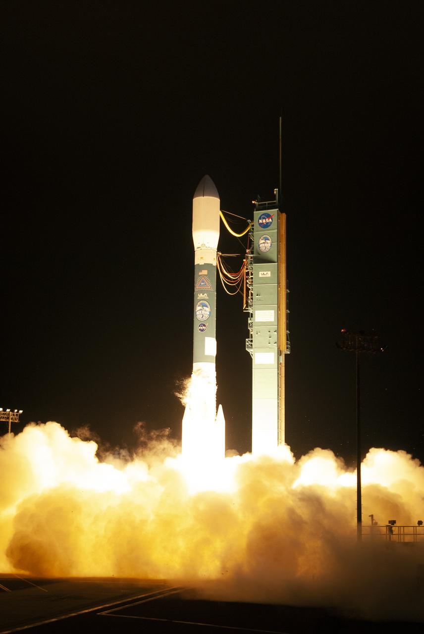
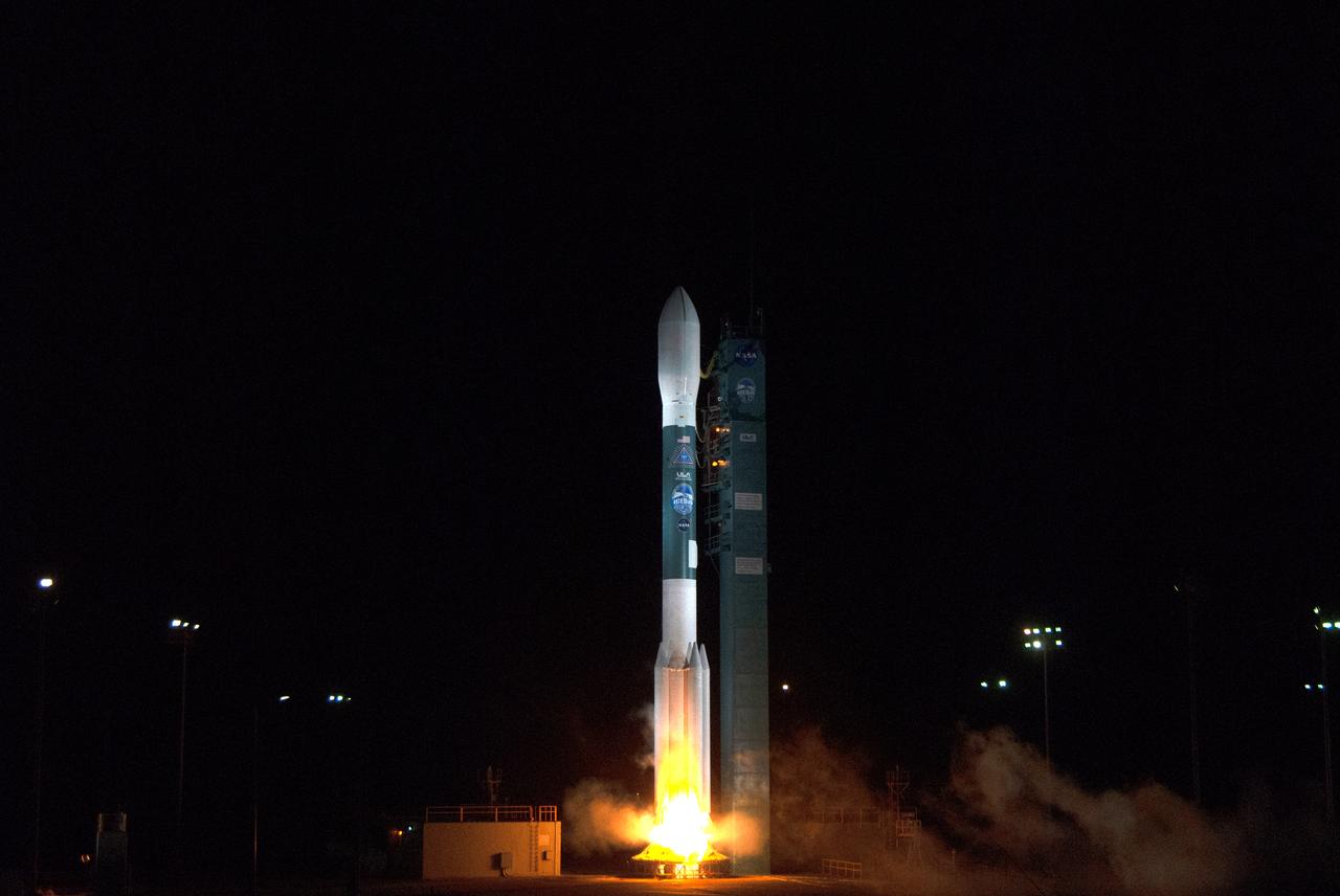
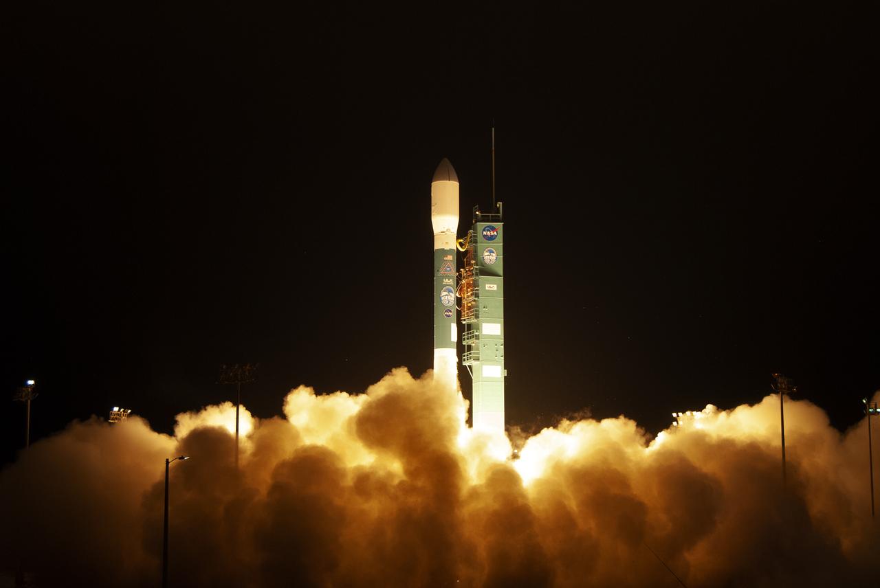
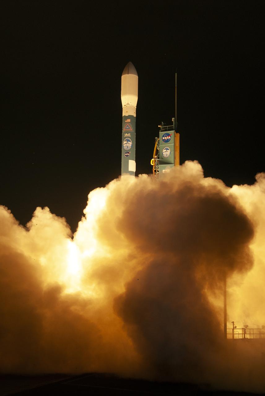
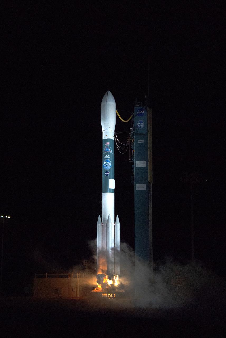
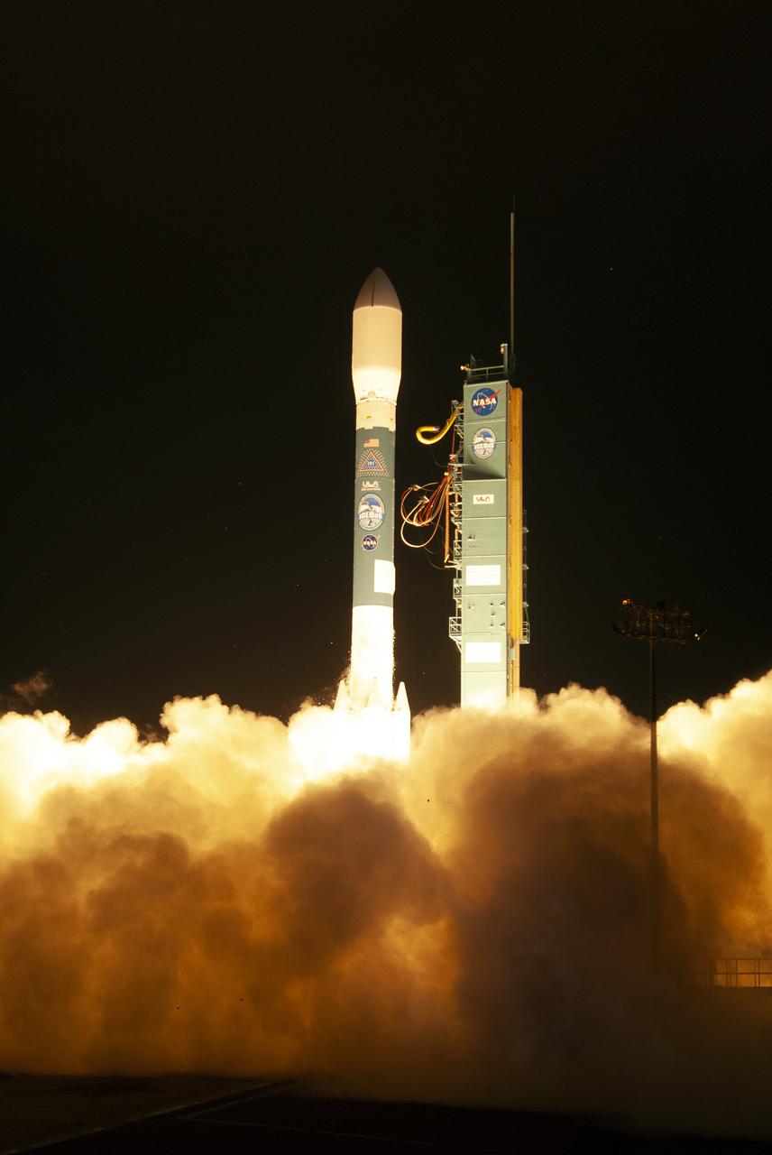
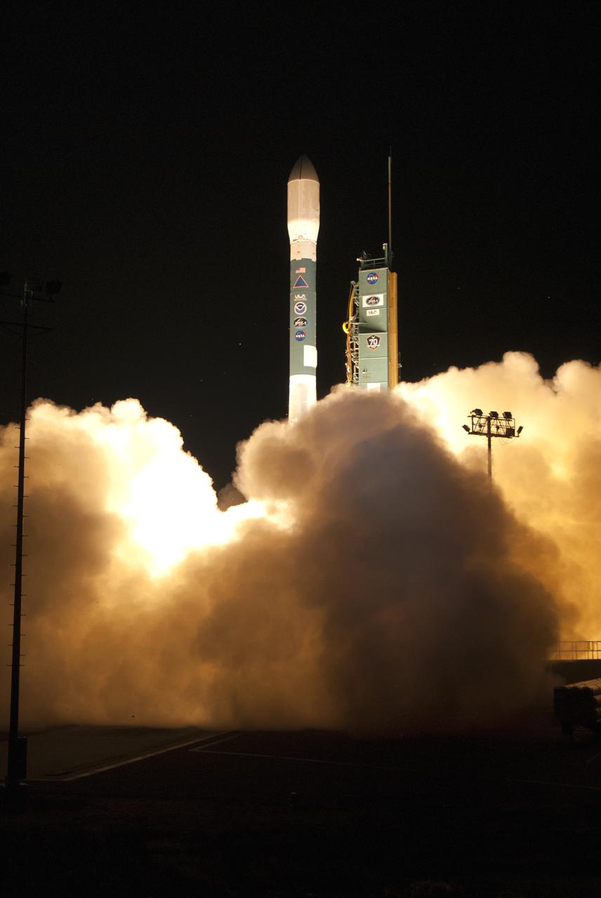
The final United Launch Alliance Delta II rocket lifts off from Space Launch Complex 2 at Vandenberg Air Force Base in California, on Sept. 15, 2018, carrying NASA's Ice, Cloud and land Elevation Satellite-2 (ICESat-2). Liftoff was at 9:02 a.m. EDT (6:02 a.m. PDT). The satellite will measure the height of our changing Earth, one laser pulse at a time, 10,000 laser pulses per second. ICESat-2 will provide scientists with height measurements that create a global portrait of Earth's third dimension, gathering date that can precisely track changes of terrain, including glaciers, sea ice and forests.
A United Launch Alliance Delta II rocket lifts off from Space Launch Complex 2 at Vandenberg Air Force Base in California carrying the Joint Polar Satellite System-1, or JPSS-1, spacecraft. Built by Ball Aerospace and Technologies Corp. of Boulder, Colorado, JPSS is the first in a series four next-generation environmental satellites in a collaborative program between NOAA and NASA. JPSS-1 will gather measurements of atmospheric, terrestrial and oceanic conditions, including sea and land surface temperatures, vegetation, clouds, rainfall, snow and ice cover, fire locations, atmospheric temperature, water vapor and ozone. Liftoff was at 1:47 a.m. PST (4:47 a.m. EST).
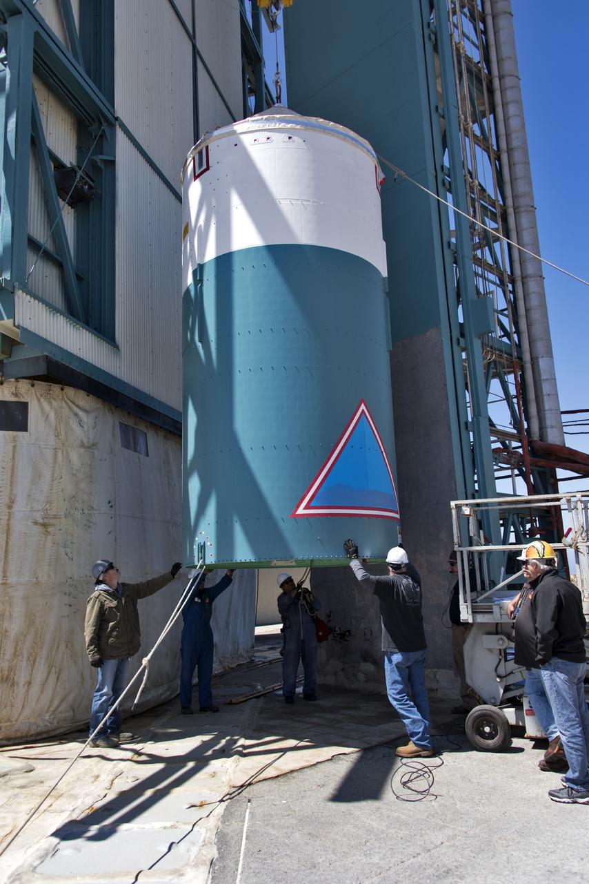
The United Launch Alliance Delta II interstage is lifted up at the Vertical Integration Facility at Space Launch Complex 2 on June 12, 2018, at Vandenberg Air Force Base in California. The interstage will be moved in and mated to the top of the booster, or first stage of the rocket. NASA's Ice, Cloud and land Elevation Satellite-2 (ICESat-2) will launch on the final Delta II rocket. ICESat-2 will measure the height of a changing Earth, one laser pulse at a time, 10,000 laser pulses a second. The satellite will carry a single instrument, the Advanced Topographic Laser Altimeter System. ICESat-2 will help scientists investigate why, and how much our planet's frozen and icy areas, called the cryosphere, is changing in a warming climate.

At Vandenberg Air Force Base in California, a Poly Picosatellite Orbital Deployer, or P-POD, container is installed on the Joint Polar Satellite System-1, or JPSS-1, spacecraft. P-PODS are auxiliary payloads launched aboard NASA expendable launch vehicles carrying up to three small CubeSats. The small cube-shaped satellites are part of NASA’s Educational Launch of Nanosatellite, or ELaNa, missions. The small payloads are designed and built by students from high school-level classes up to college and university students. JPSS is the first in a series of four next-generation environmental satellites in a collaborative program between the NOAA and NASA. Liftoff from Vandenberg's Space Launch Compex-2 atop a United Launch Alliance Delta II rocket is scheduled for 1:47 a.m. PST (4:47 a.m. EST), on Nov. 14, 2017.
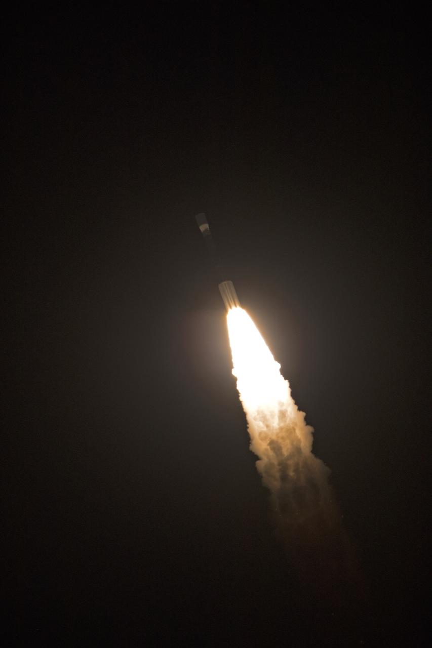
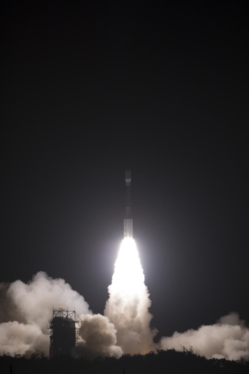
The final United Launch Alliance Delta II rocket lifts off from Space Launch Complex 2 at Vandenberg Air Force Base in California, on Sept. 15, 2018, carrying NASA's Ice, Cloud and land Elevation Satellite-2 (ICESat-2). Liftoff was at 9:02 a.m. EDT (6:02 a.m. PDT). The satellite will measure the height of our changing Earth, one laser pulse at a time, 10,000 laser pulses per second. ICESat-2 will provide scientists with height measurements that create a global portrait of Earth's third dimension, gathering date that can precisely track changes of terrain, including glaciers, sea ice and forests.
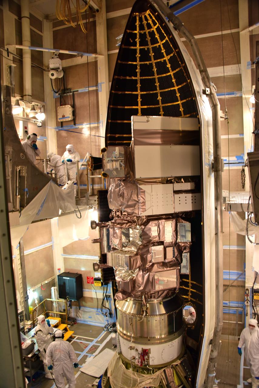
At Vandenberg Air Force Base in California, this wide angle view shows the payload fairing as it is installed encapsulating the Joint Polar Satellite System-1, or JPSS-1, spacecraft atop a United Launch Alliance Delta II rocket at Space Launch Complex 2. Built by Ball Aerospace and Technologies Corp. of Boulder, Colorado, JPSS is the first in a series four next-generation environmental satellites in a collaborative program between the NOAA and NASA. Liftoff is scheduled to take place from Vandenberg's Space Launch Complex 2 at 1:47 a.m. PST (4:47 a.m. EST), on Nov. 14, 2017.
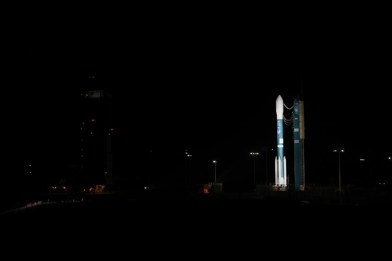
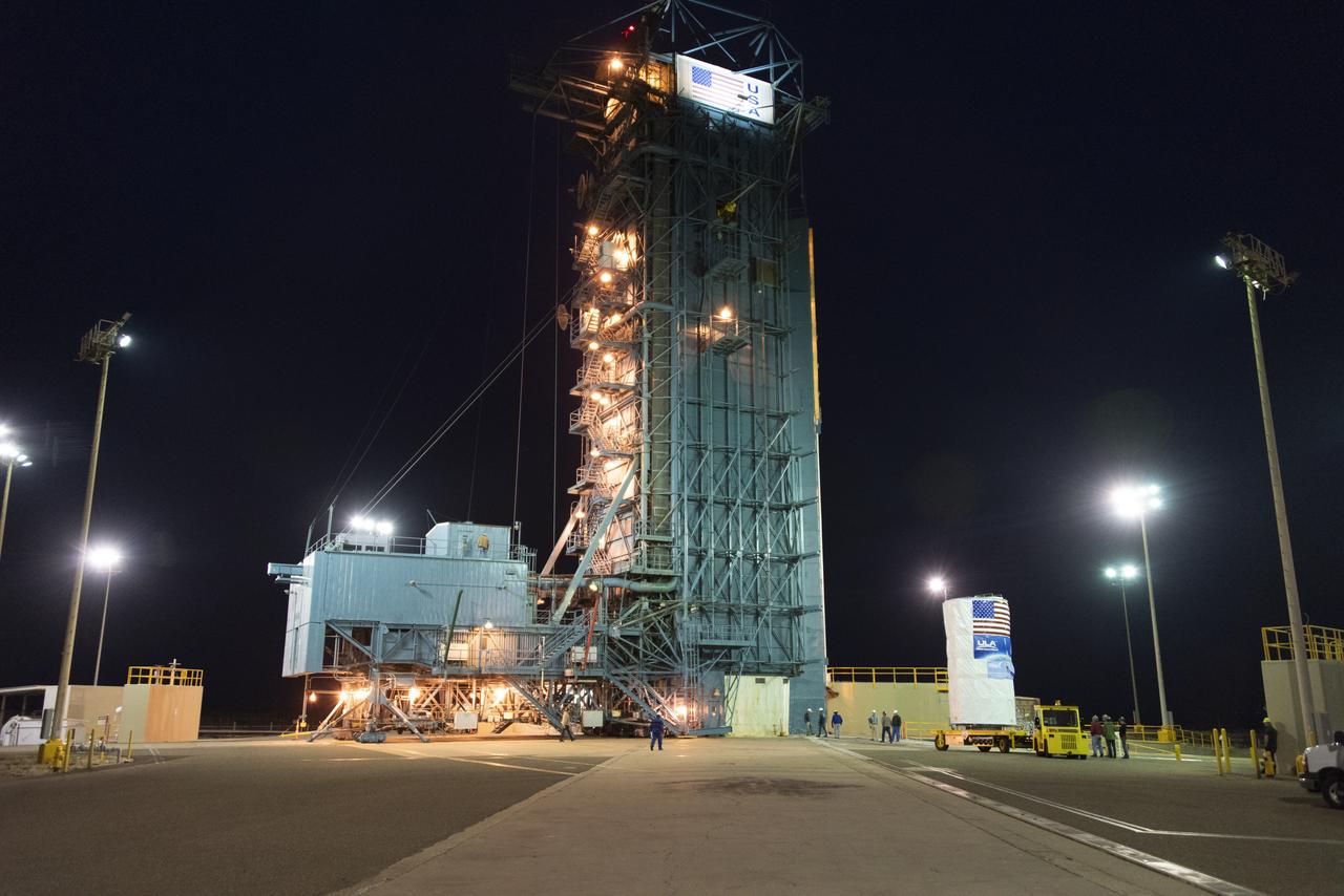
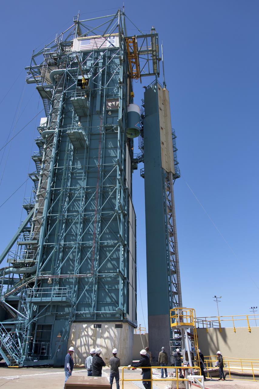
The gantry rolls back at Space Launch Complex 2 at Vandenberg Air Force Base in California, on Sept. 14, 2018, for the final United Launch Alliance Delta II rocket which will carry NASA's Ice, Cloud and land Elevation Satellite-2 (ICESat-2). Liftoff is scheduled for Sept. 15, 2018, at 8:46 a.m. EDT (5:46 a.m. PDT). The satellite will measure the height of our changing Earth, one laser pulse at a time, 10,000 laser pulses per second. ICESat-2 will provide scientists with height measurements that create a global portrait of Earth's third dimension, gathering date that can precisely track changes of terrain, including glaciers, sea ice and forests.
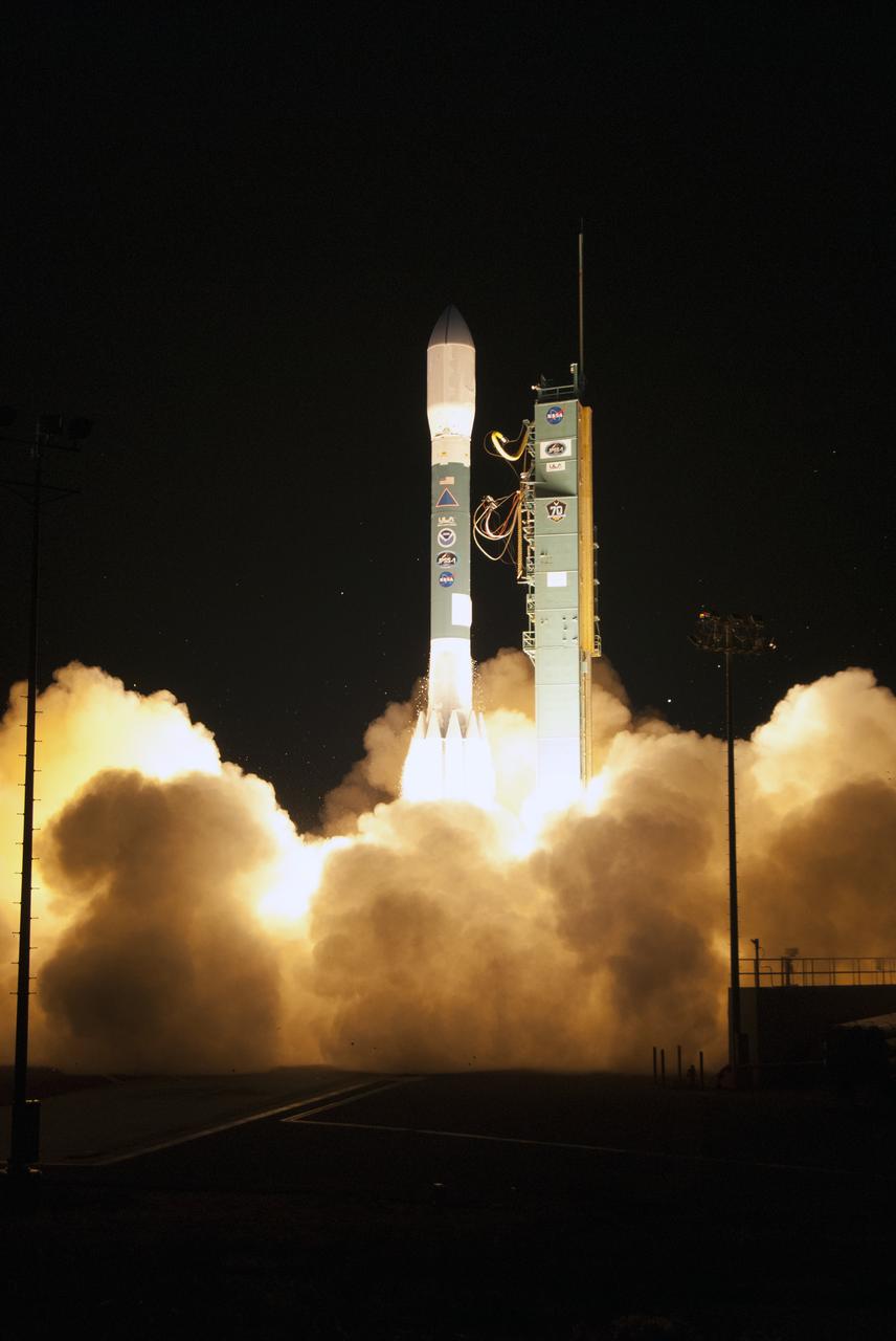
A United Launch Alliance Delta II rocket lifts off from Space Launch Complex 2 at Vandenberg Air Force Base in California carrying the Joint Polar Satellite System-1, or JPSS-1, spacecraft. Built by Ball Aerospace and Technologies Corp. of Boulder, Colorado, JPSS is the first in a series four next-generation environmental satellites in a collaborative program between NOAA and NASA. JPSS-1 will gather measurements of atmospheric, terrestrial and oceanic conditions, including sea and land surface temperatures, vegetation, clouds, rainfall, snow and ice cover, fire locations, atmospheric temperature, water vapor and ozone. Liftoff was at 1:47 a.m. PST (4:47 a.m. EST), Nov. 18, 2017.
The final United Launch Alliance Delta II rocket lifts off from Space Launch Complex 2 at Vandenberg Air Force Base in California, on Sept. 15, 2018, carrying NASA's Ice, Cloud and land Elevation Satellite-2 (ICESat-2). Liftoff was at 9:02 a.m. EDT (6:02 a.m. PDT). The satellite will measure the height of our changing Earth, one laser pulse at a time, 10,000 laser pulses per second. ICESat-2 will provide scientists with height measurements that create a global portrait of Earth's third dimension, gathering date that can precisely track changes of terrain, including glaciers, sea ice and forests.
At Vandenberg Air Force Base in California, technicians and engineers prepare a Poly Picosatellite Orbital Deployer, or P-POD, container for installation on the Joint Polar Satellite System-1, or JPSS-1, spacecraft. P-PODS are auxiliary payloads launched aboard NASA expendable launch vehicles carrying up to three small CubeSats. The small cube-shaped satellites are part of NASA’s Educational Launch of Nanosatellite, or ELaNa, missions. The small payloads are designed and built by students from high school-level classes up to college and university students. JPSS is the first in a series of four next-generation environmental satellites in a collaborative program between the NOAA and NASA. Liftoff from Vandenberg's Space Launch Compex-2 atop a United Launch Alliance Delta II rocket is scheduled for 1:47 a.m. PST (4:47 a.m. EST), on Nov. 14, 2017.
The final United Launch Alliance Delta II rocket lifts off from Space Launch Complex 2 at Vandenberg Air Force Base in California, on Sept. 15, 2018, carrying NASA's Ice, Cloud and land Elevation Satellite-2 (ICESat-2). Liftoff was at 9:02 a.m. EDT (6:02 a.m. PDT). The satellite will measure the height of our changing Earth, one laser pulse at a time, 10,000 laser pulses per second. ICESat-2 will provide scientists with height measurements that create a global portrait of Earth's third dimension, gathering date that can precisely track changes of terrain, including glaciers, sea ice and forests.
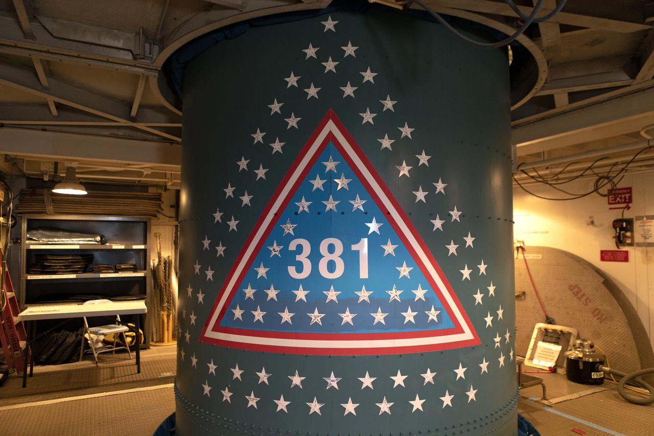
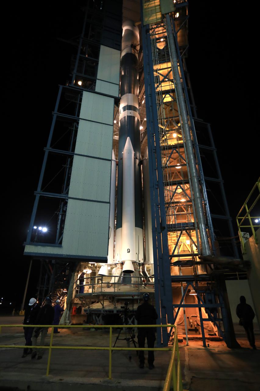
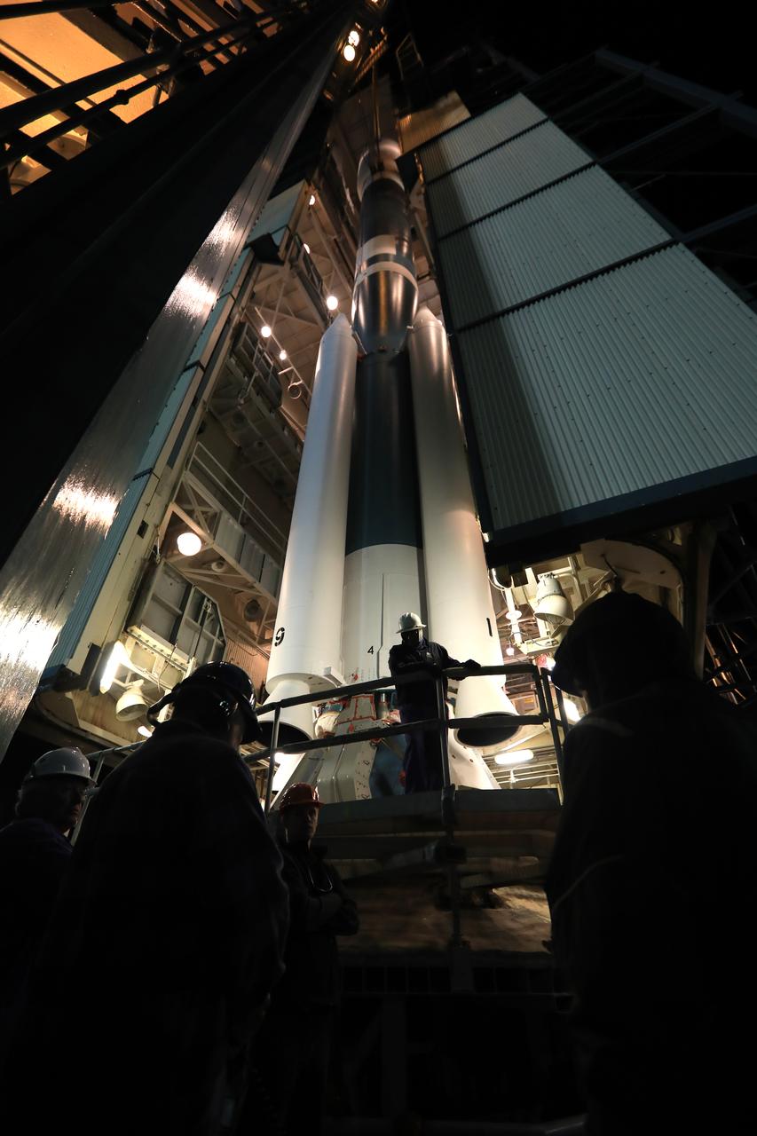
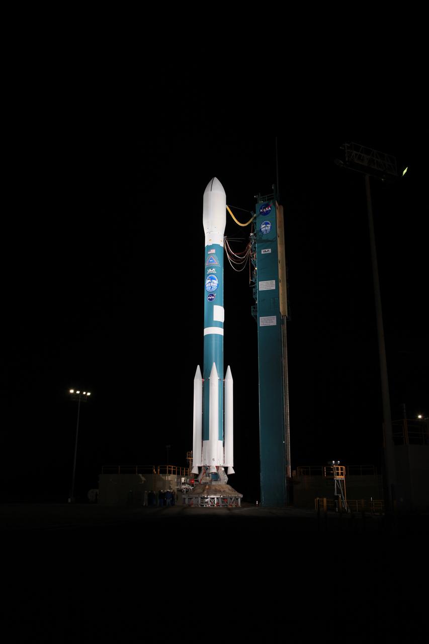
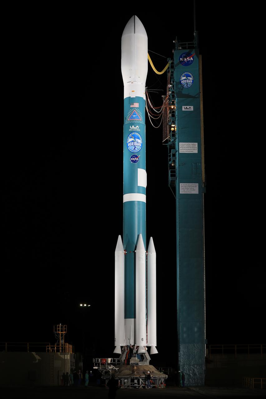
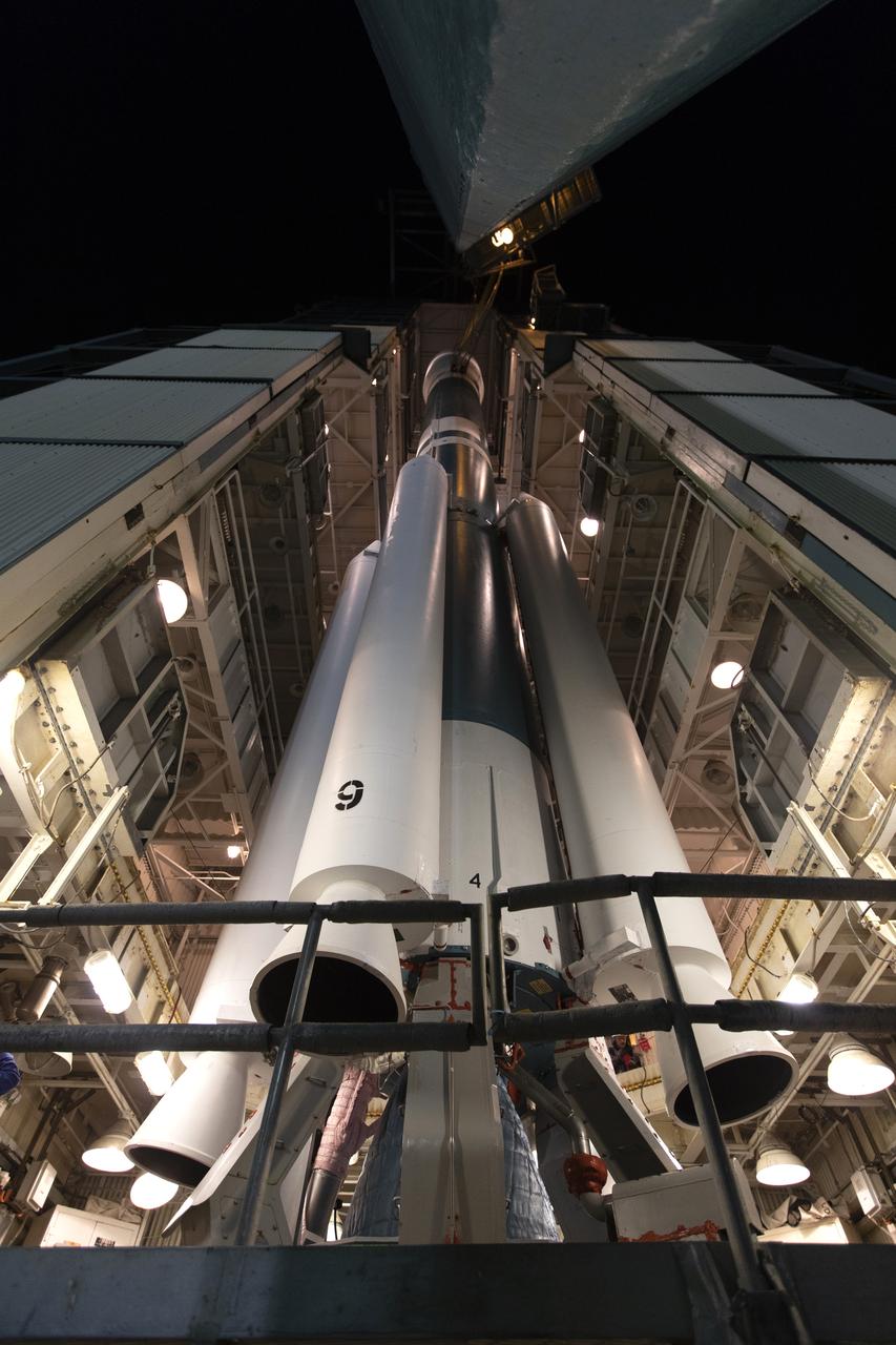
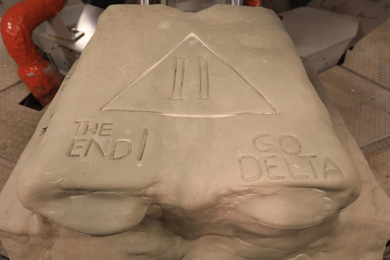
Stars are in view on the first stage of the United Launch Alliance Delta II rocket at Space Launch Complex 2 at Vandenberg Air Force Base in California, on Sept. 13, 2018. Historically, each Delta rocket used to notate the number of launches within the program, beginning in May, 1960, with the first Delta I. This practice was brought back for the final Delta II launch of ICESat-2. The “381” on the rocket signifies that this will be the 381st flight in the Delta family. A star traditionally was placed on the rocket to recognize each mission. For the final Delta II, stars were sent to team members and partners throughout the nation. This rocket boasts more than 150 stars with over 800 signatures of people who have been part of the Delta II program.

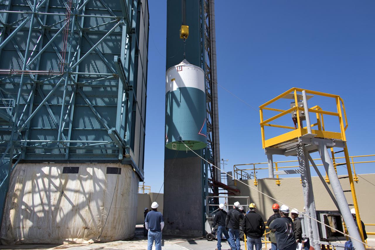
At Vandenberg Air Force Base in California, NASA's Ice, Cloud and land Elevation Satellite-2 (ICESat-2) is hoisted up by crane at the mobile service tower at Space Launch Complex 2, on Aug. 26, 2018. The satellite will be attached to the top of the United Launch Alliance Delta II rocket. Launch is scheduled for Sept. 15, 2018. ICESat-2 will measure the height of a changing Earth, one laser pulse at a time, 10,000 laser pulses a second. The satellite will carry the Advanced Topographic Laser Altimeter System (ATLAS). ICESat-2 will help scientists investigate why, and how much our planet's frozen and icy areas, called the cryosphere, are changing in a warming climate.
At Vandenberg Air Force Base in California, the payload fairing is installed encapsulating the Joint Polar Satellite System-1, or JPSS-1, spacecraft atop a United Launch Alliance Delta II rocket at Space Launch Complex 2. Built by Ball Aerospace and Technologies Corp. of Boulder, Colorado, JPSS is the first in a series four next-generation environmental satellites in a collaborative program between the NOAA and NASA. Liftoff is scheduled to take place from Vandenberg's Space Launch Complex 2 at 1:47 a.m. PST (4:47 a.m. EST), on Nov. 14, 2017.
The gantry rolls back at Space Launch Complex 2 at Vandenberg Air Force Base in California, on Sept. 14, 2018, for the final United Launch Alliance Delta II rocket which will carry NASA's Ice, Cloud and land Elevation Satellite-2 (ICESat-2). Liftoff is scheduled for Sept. 15, 2018, at 8:46 a.m. EDT (5:46 a.m. PDT). The satellite will measure the height of our changing Earth, one laser pulse at a time, 10,000 laser pulses per second. ICESat-2 will provide scientists with height measurements that create a global portrait of Earth's third dimension, gathering date that can precisely track changes of terrain, including glaciers, sea ice and forests.
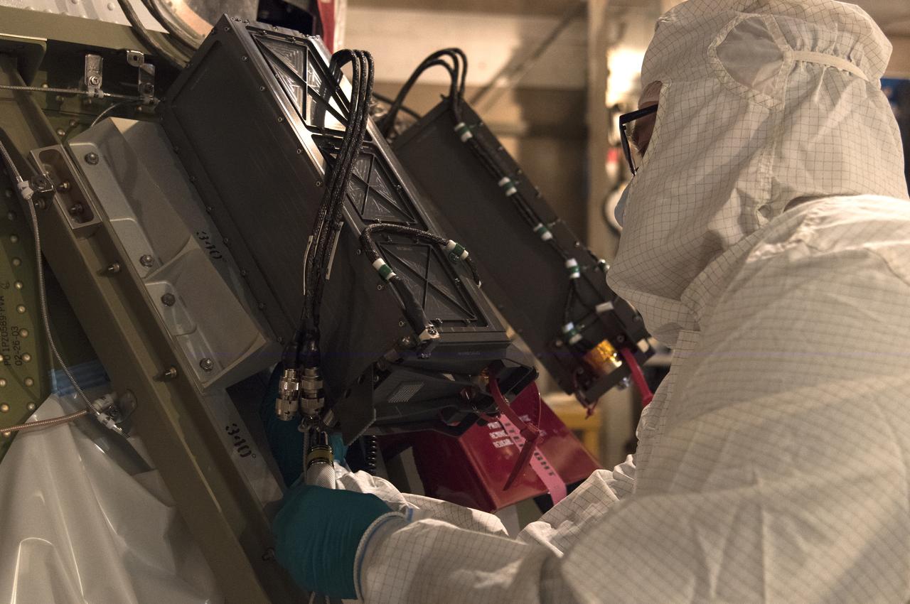
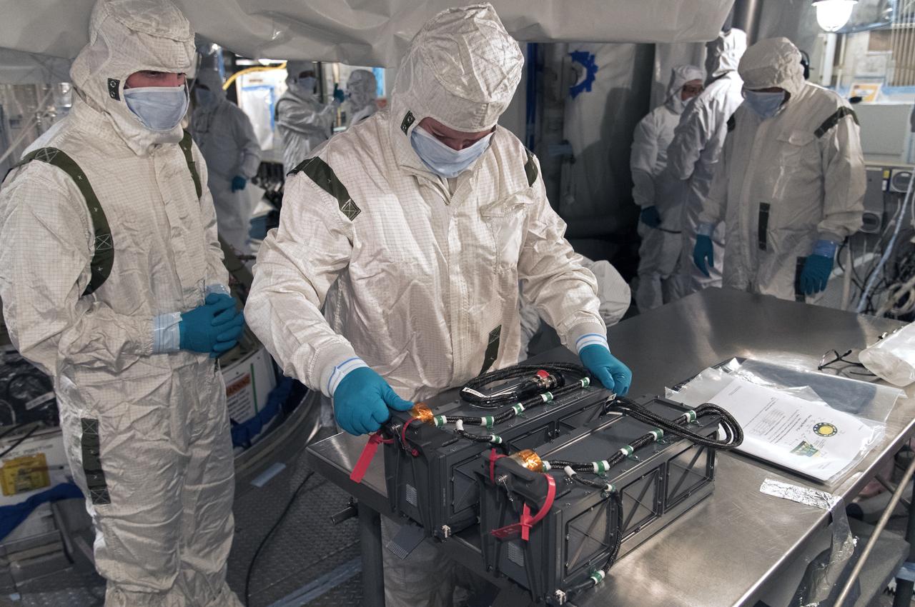
At Space Launch Complex 2 at Vandenberg Air Force Base in California, three poly picosatellite orbital deployers, or P-POD containers, with tiny satellites, called CubeSats inside, are being prepared for installation on the direct mate adapter of the United Launch Alliance Delta II rocket, on Aug. 31, 2018. NASA's Ice, Cloud and land Elevation Satellite-2 (ICESat-2) is ready for launch aboard the final Delta II rocket. Launch is scheduled for Sept. 15, 2018. ICESat-2 will measure the height of a changing Earth, one laser pulse at a time, 10,000 laser pulses a second. The satellite will carry the Advanced Topographic Laser Altimeter System (ATLAS). ICESat-2 will help scientists investigate why, and how much our planet's frozen and icy areas, called the cryosphere, are changing in a warming climate.
The gantry rolls back at Space Launch Complex 2 at Vandenberg Air Force Base in California, on Sept. 14, 2018, for the final United Launch Alliance Delta II rocket which will carry NASA's Ice, Cloud and land Elevation Satellite-2 (ICESat-2). Liftoff is scheduled for Sept. 15, 2018, at 8:46 a.m. EDT (5:46 a.m. PDT). The satellite will measure the height of our changing Earth, one laser pulse at a time, 10,000 laser pulses per second. ICESat-2 will provide scientists with height measurements that create a global portrait of Earth's third dimension, gathering date that can precisely track changes of terrain, including glaciers, sea ice and forests.
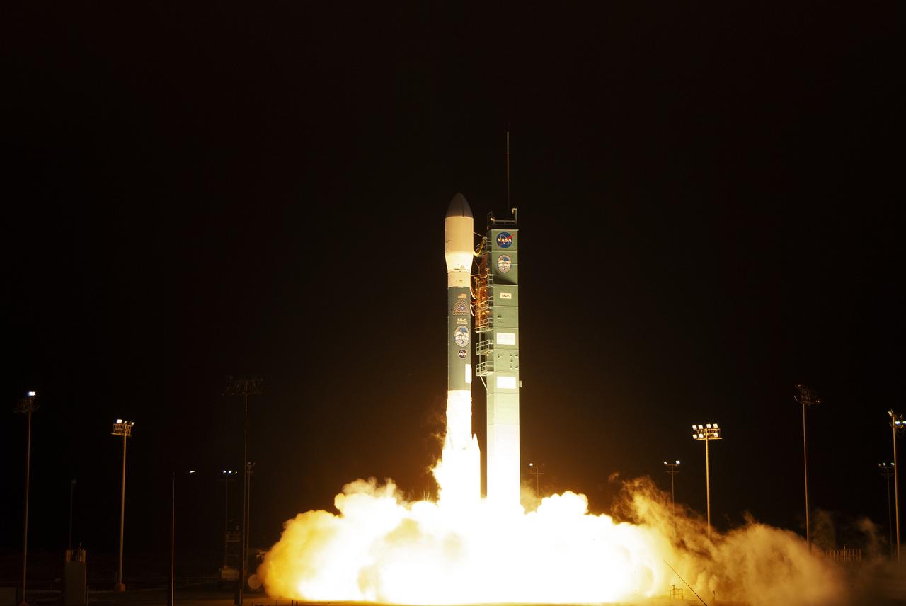
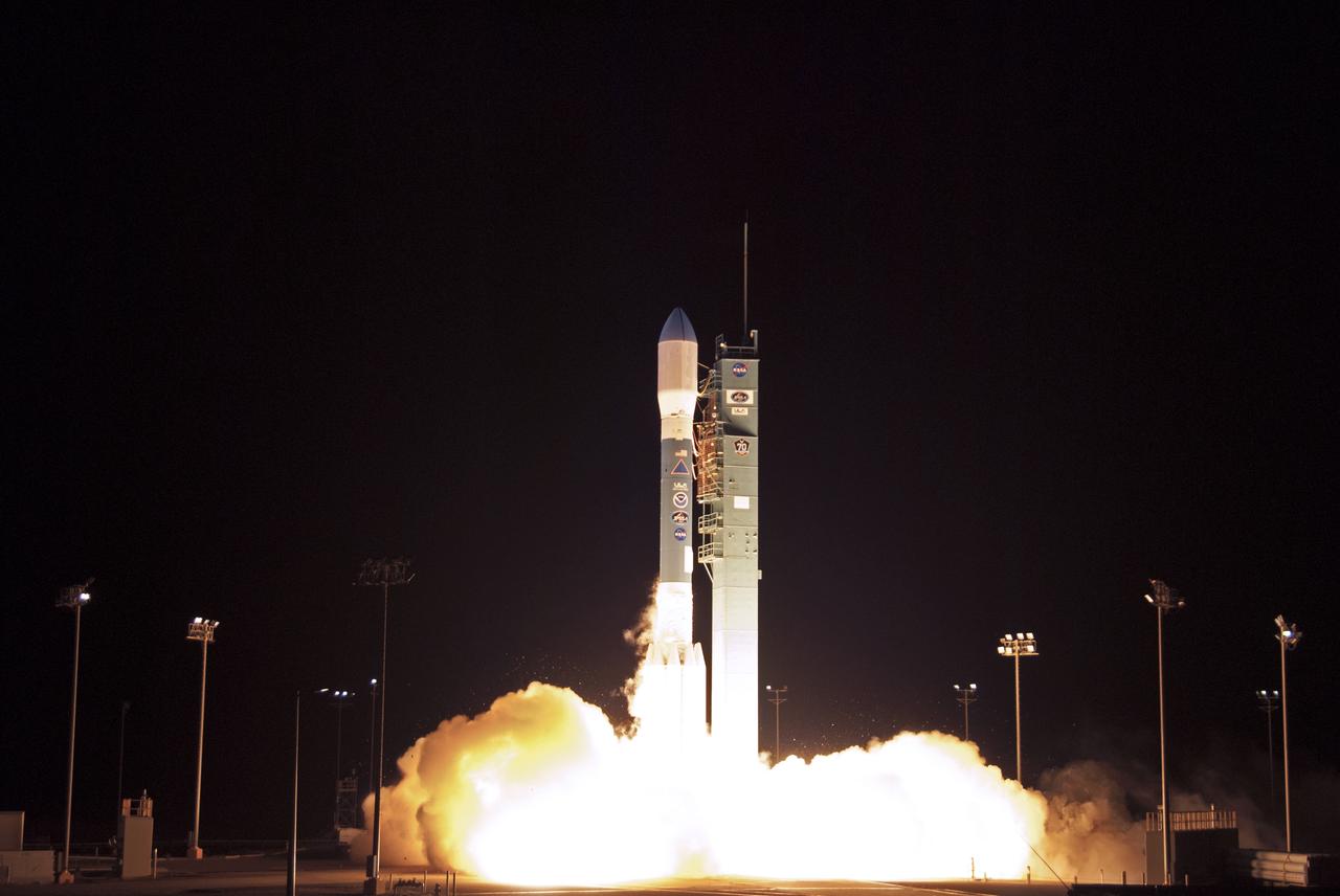
The final United Launch Alliance Delta II rocket lifts off from Space Launch Complex 2 at Vandenberg Air Force Base in California, on Sept. 15, 2018, carrying NASA's Ice, Cloud and land Elevation Satellite-2 (ICESat-2). Liftoff was at 9:02 a.m. EDT (6:02 a.m. PDT). The satellite will measure the height of our changing Earth, one laser pulse at a time, 10,000 laser pulses per second. ICESat-2 will provide scientists with height measurements that create a global portrait of Earth's third dimension, gathering date that can precisely track changes of terrain, including glaciers, sea ice and forests.
At Vandenberg Air Force Base in California, the payload fairing is installed encapsulating the Joint Polar Satellite System-1, or JPSS-1, spacecraft atop a United Launch Alliance Delta II rocket at Space Launch Complex 2. Built by Ball Aerospace and Technologies Corp. of Boulder, Colorado, JPSS is the first in a series four next-generation environmental satellites in a collaborative program between the NOAA and NASA. Liftoff is scheduled to take place from Vandenberg's Space Launch Complex 2 at 1:47 a.m. PST (4:47 a.m. EST), on Nov. 14, 2017.
The gantry rolls back at Space Launch Complex 2 at Vandenberg Air Force Base in California, on Sept. 14, 2018, for the final United Launch Alliance Delta II rocket which will carry NASA's Ice, Cloud and land Elevation Satellite-2 (ICESat-2). Liftoff is scheduled for Sept. 15, 2018, at 8:46 a.m. EDT (5:46 a.m. PDT). The satellite will measure the height of our changing Earth, one laser pulse at a time, 10,000 laser pulses per second. ICESat-2 will provide scientists with height measurements that create a global portrait of Earth's third dimension, gathering date that can precisely track changes of terrain, including glaciers, sea ice and forests.
The gantry rolls back at Space Launch Complex 2 at Vandenberg Air Force Base in California, on Sept. 14, 2018, for the final United Launch Alliance Delta II rocket which will carry NASA's Ice, Cloud and land Elevation Satellite-2 (ICESat-2). Liftoff is scheduled for Sept. 15, 2018, at 8:46 a.m. EDT (5:46 a.m. PDT). The satellite will measure the height of our changing Earth, one laser pulse at a time, 10,000 laser pulses per second. ICESat-2 will provide scientists with height measurements that create a global portrait of Earth's third dimension, gathering date that can precisely track changes of terrain, including glaciers, sea ice and forests.
NASA's Ice, Cloud and land Elevation Satellite-2 (ICESat-2), at right, encased in its protective covering, arrives at the mobile service tower at Space Launch Complex 2 at Vandenberg Air Force Base in California, on Aug. 26, 2018. The satellite will be hoisted up by crane and attached to the United Launch Alliance Delta II rocket. Launch is scheduled for Sept. 15, 2018. ICESat-2 will measure the height of a changing Earth, one laser pulse at a time, 10,000 laser pulses a second. The satellite will carry the Advanced Topographic Laser Altimeter System (ATLAS). ICESat-2 will help scientists investigate why, and how much our planet's frozen and icy areas, called the cryosphere, are changing in a warming climate.
The United Launch Alliance Delta II interstage is lifted up at the Vertical Integration Facility at Space Launch Complex 2 on June 12, 2018, at Vandenberg Air Force Base in California. The interstage will be moved in and mated to the top of the booster, or first stage of the rocket. NASA's Ice, Cloud and land Elevation Satellite-2 (ICESat-2) will launch on the final Delta II rocket. ICESat-2 will measure the height of a changing Earth, one laser pulse at a time, 10,000 laser pulses a second. The satellite will carry a single instrument, the Advanced Topographic Laser Altimeter System. ICESat-2 will help scientists investigate why, and how much our planet's frozen and icy areas, called the cryosphere, is changing in a warming climate.

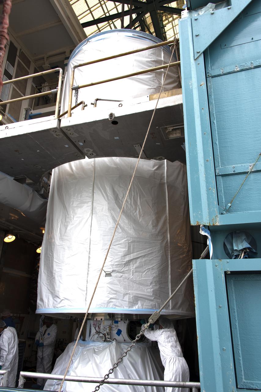
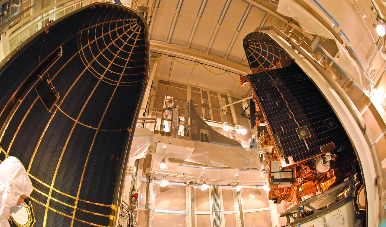
The first half of the United Launch Alliance Delta II payload fairing is secured around NASA's Ice, Cloud and land Elevation Satellite-2 (ICESat-2) on Sept. 4, 2018, at Space Launch Complex 2 at Vandenberg Air Force Base in California. The satellite is being prepared for its scheduled launch on the final Delta II rocket. ICESat-2 will measure the height of a changing Earth, one laser pulse at a time, 10,000 laser pulses a second. The satellite will carry the Advanced Topographic Laser Altimeter System (ATLAS). ICESat-2 will help scientists investigate why, and how much our planet's frozen and icy areas, called the cryosphere, are changing in a warming climate.
The final United Launch Alliance Delta II rocket lifts off from Space Launch Complex 2 at Vandenberg Air Force Base in California, on Sept. 15, 2018, carrying NASA's Ice, Cloud and land Elevation Satellite-2 (ICESat-2). Liftoff was at 9:02 a.m. EDT (6:02 a.m. PDT). The satellite will measure the height of our changing Earth, one laser pulse at a time, 10,000 laser pulses per second. ICESat-2 will provide scientists with height measurements that create a global portrait of Earth's third dimension, gathering date that can precisely track changes of terrain, including glaciers, sea ice and forests.

At Vandenberg Air Force Base in California, technicians and engineers prepare to install a Poly Picosatellite Orbital Deployer, or P-POD, container on the Joint Polar Satellite System-1, or JPSS-1, spacecraft. P-PODS are auxiliary payloads launched aboard NASA expendable launch vehicles carrying up to three small CubeSats. The small cube-shaped satellites are part of NASA’s Educational Launch of Nanosatellite, or ELaNa, missions. The small payloads are designed and built by students from high school-level classes up to college and university students. JPSS is the first in a series of four next-generation environmental satellites in a collaborative program between the NOAA and NASA. Liftoff from Vandenberg's Space Launch Compex-2 atop a United Launch Alliance Delta II rocket is scheduled for 1:47 a.m. PST (4:47 a.m. EST), on Nov. 14, 2017.

The gantry rolls back at Space Launch Complex 2 at Vandenberg Air Force Base in California, on Sept. 14, 2018, for the final United Launch Alliance Delta II rocket which will carry NASA's Ice, Cloud and land Elevation Satellite-2 (ICESat-2). Liftoff is scheduled for Sept. 15, 2018, at 8:46 a.m. EDT (5:46 a.m. PDT). The satellite will measure the height of our changing Earth, one laser pulse at a time, 10,000 laser pulses per second. ICESat-2 will provide scientists with height measurements that create a global portrait of Earth's third dimension, gathering date that can precisely track changes of terrain, including glaciers, sea ice and forests.
A United Launch Alliance Delta II rocket lifts off from Space Launch Complex 2 at Vandenberg Air Force Base in California carrying the Joint Polar Satellite System-1, or JPSS-1, spacecraft. Built by Ball Aerospace and Technologies Corp. of Boulder, Colorado, JPSS is the first in a series four next-generation environmental satellites in a collaborative program between NOAA and NASA. JPSS-1 will gather measurements of atmospheric, terrestrial and oceanic conditions, including sea and land surface temperatures, vegetation, clouds, rainfall, snow and ice cover, fire locations, atmospheric temperature, water vapor and ozone. Liftoff was at 1:47 a.m. PST (4:47 a.m. EST).
The first half of the United Launch Alliance Delta II payload fairing is secured around NASA's Ice, Cloud and land Elevation Satellite-2 (ICESat-2) on Sept. 4, 2018, at Space Launch Complex 2 at Vandenberg Air Force Base in California. The satellite is being prepared for its scheduled launch on the final Delta II rocket. ICESat-2 will measure the height of a changing Earth, one laser pulse at a time, 10,000 laser pulses a second. The satellite will carry the Advanced Topographic Laser Altimeter System (ATLAS). ICESat-2 will help scientists investigate why, and how much our planet's frozen and icy areas, called the cryosphere, are changing in a warming climate.
The United Launch Alliance Delta II interstage is lifted high up at the Vertical Integration Facility at Space Launch Complex 2 on June 12, 2018, at Vandenberg Air Force Base in California. The interstage will be moved in and mated to the top of the booster, or first stage of the rocket. NASA's Ice, Cloud and land Elevation Satellite-2 (ICESat-2) will launch on the final Delta II rocket. ICESat-2 will measure the height of a changing Earth, one laser pulse at a time, 10,000 laser pulses a second. The satellite will carry a single instrument, the Advanced Topographic Laser Altimeter System. ICESat-2 will help scientists investigate why, and how much our planet's frozen and icy areas, called the cryosphere, is changing in a warming climate.

The gantry rolls back at Space Launch Complex 2 at Vandenberg Air Force Base in California, on Sept. 14, 2018, for the final United Launch Alliance Delta II rocket which will carry NASA's Ice, Cloud and land Elevation Satellite-2 (ICESat-2). Liftoff is scheduled for Sept. 15, 2018, at 8:46 a.m. EDT (5:46 a.m. PDT). The satellite will measure the height of our changing Earth, one laser pulse at a time, 10,000 laser pulses per second. ICESat-2 will provide scientists with height measurements that create a global portrait of Earth's third dimension, gathering date that can precisely track changes of terrain, including glaciers, sea ice and forests.
The final United Launch Alliance Delta II rocket lifts off from Space Launch Complex 2 at Vandenberg Air Force Base in California, on Sept. 15, 2018, carrying NASA's Ice, Cloud and land Elevation Satellite-2 (ICESat-2). Liftoff was at 9:02 a.m. EDT (6:02 a.m. PDT). The satellite will measure the height of our changing Earth, one laser pulse at a time, 10,000 laser pulses per second. ICESat-2 will provide scientists with height measurements that create a global portrait of Earth's third dimension, gathering date that can precisely track changes of terrain, including glaciers, sea ice and forests.
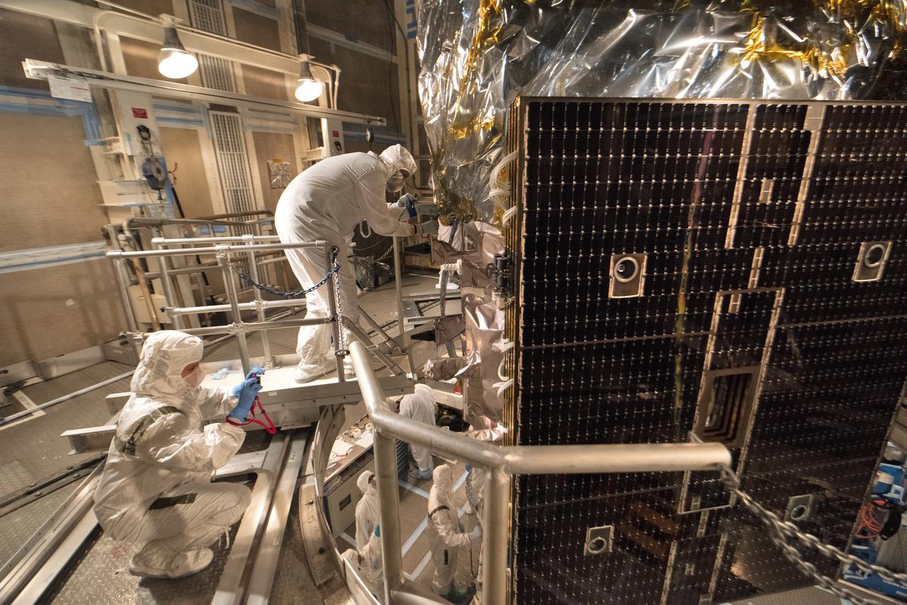
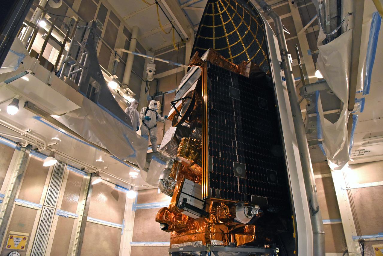
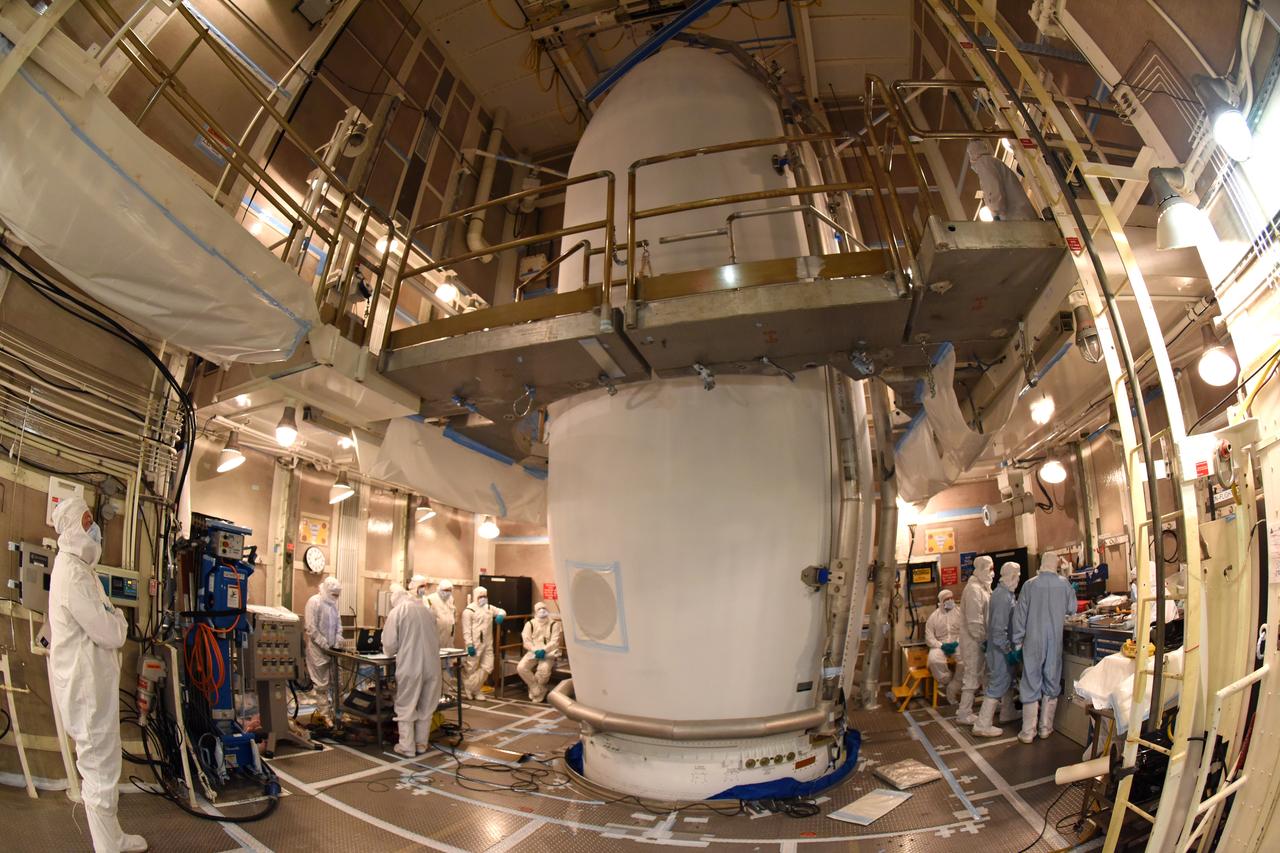
Technicians prepare NASA's Ice, Cloud and land Elevation Satellite-2 (ICESat-2) for encapsulation in the United Launch Alliance Delta II payload fairing on Sept. 4, 2018, at Space Launch Complex 2 at Vandenberg Air Force Base in California. The satellite is being prepared for its scheduled launch on the final Delta II rocket. ICESat-2 will measure the height of a changing Earth, one laser pulse at a time, 10,000 laser pulses a second. The satellite will carry the Advanced Topographic Laser Altimeter System (ATLAS). ICESat-2 will help scientists investigate why, and how much our planet's frozen and icy areas, called the cryosphere, are changing in a warming climate.
The final United Launch Alliance Delta II rocket lifts off from Space Launch Complex 2 at Vandenberg Air Force Base in California, on Sept. 15, 2018, carrying NASA's Ice, Cloud and land Elevation Satellite-2 (ICESat-2). Liftoff was at 9:02 a.m. EDT (6:02 a.m. PDT). The satellite will measure the height of our changing Earth, one laser pulse at a time, 10,000 laser pulses per second. ICESat-2 will provide scientists with height measurements that create a global portrait of Earth's third dimension, gathering date that can precisely track changes of terrain, including glaciers, sea ice and forests.
A United Launch Alliance Delta II rocket lifts off from Space Launch Complex 2 at Vandenberg Air Force Base in California carrying the Joint Polar Satellite System-1, or JPSS-1, spacecraft. Built by Ball Aerospace and Technologies Corp. of Boulder, Colorado, JPSS is the first in a series four next-generation environmental satellites in a collaborative program between NOAA and NASA. JPSS-1 will gather measurements of atmospheric, terrestrial and oceanic conditions, including sea and land surface temperatures, vegetation, clouds, rainfall, snow and ice cover, fire locations, atmospheric temperature, water vapor and ozone. Liftoff was at 1:47 a.m. PST (4:47 a.m. EST).
The gantry rolls back at Space Launch Complex 2 at Vandenberg Air Force Base in California, on Sept. 14, 2018, for the final United Launch Alliance Delta II rocket which will carry NASA's Ice, Cloud and land Elevation Satellite-2 (ICESat-2). Liftoff is scheduled for Sept. 15, 2018, at 8:46 a.m. EDT (5:46 a.m. PDT). The satellite will measure the height of our changing Earth, one laser pulse at a time, 10,000 laser pulses per second. ICESat-2 will provide scientists with height measurements that create a global portrait of Earth's third dimension, gathering date that can precisely track changes of terrain, including glaciers, sea ice and forests.
The first half of the United Launch Alliance Delta II payload fairing is secured around NASA's Ice, Cloud and land Elevation Satellite-2 (ICESat-2) on Sept. 4, 2018, at Space Launch Complex 2 at Vandenberg Air Force Base in California. The satellite is being prepared for its scheduled launch on the final Delta II rocket. ICESat-2 will measure the height of a changing Earth, one laser pulse at a time, 10,000 laser pulses a second. The satellite will carry the Advanced Topographic Laser Altimeter System (ATLAS). ICESat-2 will help scientists investigate why, and how much our planet's frozen and icy areas, called the cryosphere, are changing in a warming climate.
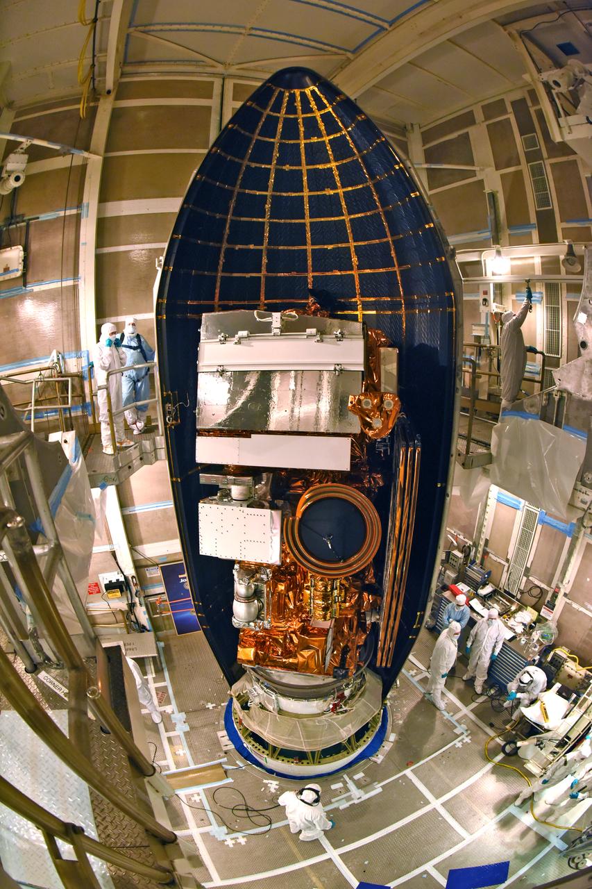
At Vandenberg Air Force Base in California, this wide angle view shows the payload fairing as it is installed encapsulating the Joint Polar Satellite System-1, or JPSS-1, spacecraft atop a United Launch Alliance Delta II rocket at Space Launch Complex 2. Built by Ball Aerospace and Technologies Corp. of Boulder, Colorado, JPSS is the first in a series four next-generation environmental satellites in a collaborative program between the NOAA and NASA. Liftoff is scheduled to take place from Vandenberg's Space Launch Complex 2 at 1:47 a.m. PST (4:47 a.m. EST), on Nov. 14, 2017.
The gantry rolls back at Space Launch Complex 2 at Vandenberg Air Force Base in California, on Sept. 14, 2018, for the final United Launch Alliance Delta II rocket which will carry NASA's Ice, Cloud and land Elevation Satellite-2 (ICESat-2). Liftoff is scheduled for Sept. 15, 2018, at 8:46 a.m. EDT (5:46 a.m. PDT). The satellite will measure the height of our changing Earth, one laser pulse at a time, 10,000 laser pulses per second. ICESat-2 will provide scientists with height measurements that create a global portrait of Earth's third dimension, gathering date that can precisely track changes of terrain, including glaciers, sea ice and forests.
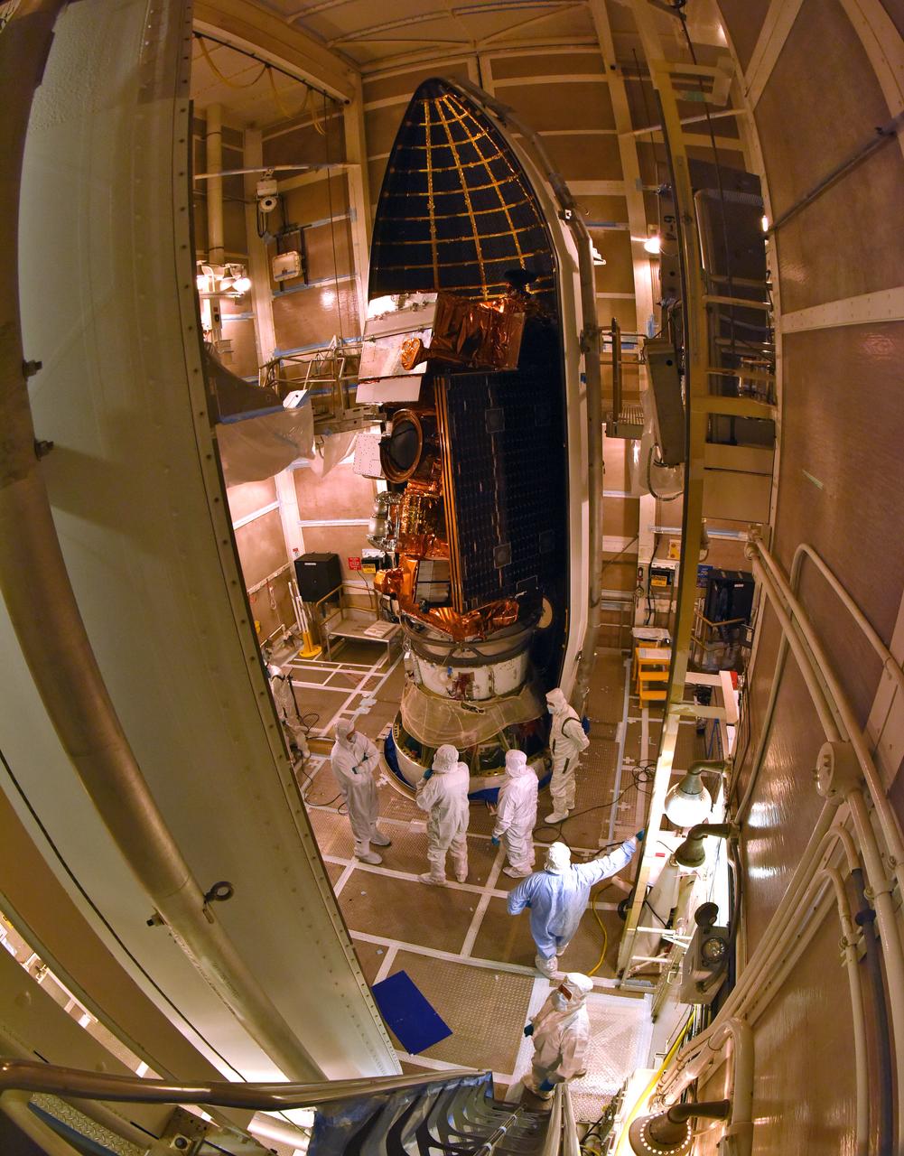
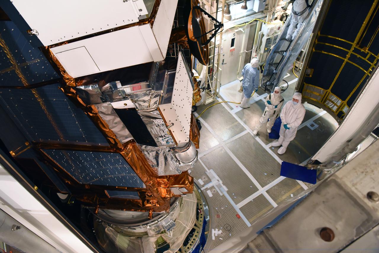
At Vandenberg Air Force Base in California, NASA's Ice, Cloud and land Elevation Satellite-2 (ICESat-2) is inside the mobile service tower at Space Launch Complex 2, on Aug. 26, 2018. The satellite will be attached to the top of the United Launch Alliance Delta II rocket. Launch is scheduled for Sept. 15, 2018. ICESat-2 will measure the height of a changing Earth, one laser pulse at a time, 10,000 laser pulses a second. The satellite will carry the Advanced Topographic Laser Altimeter System (ATLAS). ICESat-2 will help scientists investigate why, and how much our planet's frozen and icy areas, called the cryosphere, are changing in a warming climate.

A United Launch Alliance Delta II rocket lifts off from Space Launch Complex 2 at Vandenberg Air Force Base in California carrying the Joint Polar Satellite System-1, or JPSS-1, spacecraft. Built by Ball Aerospace and Technologies Corp. of Boulder, Colorado, JPSS is the first in a series four next-generation environmental satellites in a collaborative program between NOAA and NASA. JPSS-1 will gather measurements of atmospheric, terrestrial and oceanic conditions, including sea and land surface temperatures, vegetation, clouds, rainfall, snow and ice cover, fire locations, atmospheric temperature, water vapor and ozone. Liftoff was at 1:47 a.m. PST (4:47 a.m. EST).
At Vandenberg Air Force Base in California, the payload fairing is installed encapsulating the Joint Polar Satellite System-1, or JPSS-1, spacecraft atop a United Launch Alliance Delta II rocket at Space Launch Complex 2. Built by Ball Aerospace and Technologies Corp. of Boulder, Colorado, JPSS is the first in a series four next-generation environmental satellites in a collaborative program between the NOAA and NASA. Liftoff is scheduled to take place from Vandenberg's Space Launch Complex 2 at 1:47 a.m. PST (4:47 a.m. EST), on Nov. 14, 2017.
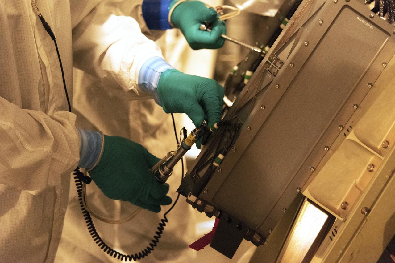
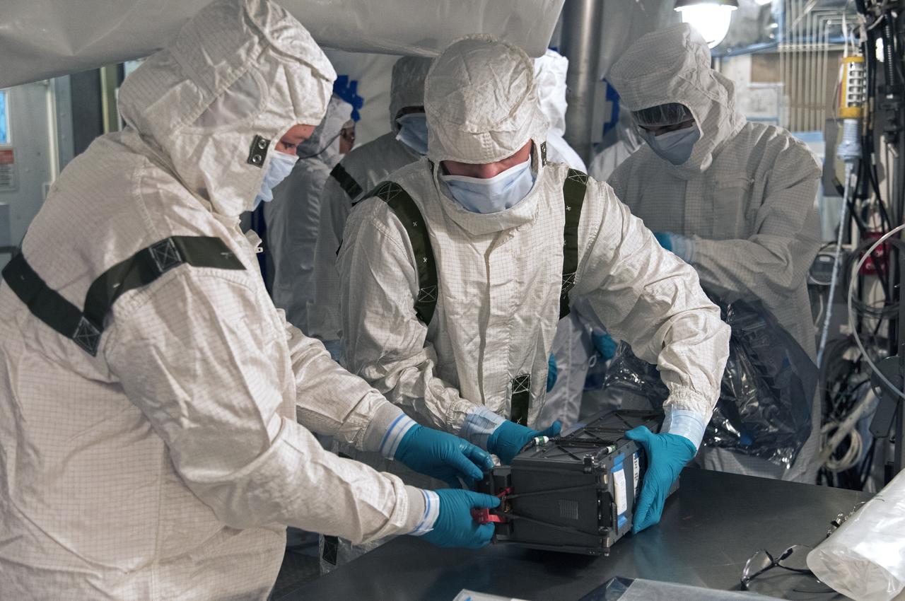
At Space Launch Complex 2 at Vandenberg Air Force Base in California, technicians install a poly picosatellite orbital deployer, or P-POD container, with tiny satellites called CubeSats inside, onto the direct mate adapter of the United Launch Alliance Delta II rocket, on Aug. 31, 2018. NASA's Ice, Cloud and land Elevation Satellite-2 (ICESat-2) is ready for launch aboard the final Delta II rocket. Launch is scheduled for Sept. 15, 2018. ICESat-2 will measure the height of a changing Earth, one laser pulse at a time, 10,000 laser pulses a second. The satellite will carry the Advanced Topographic Laser Altimeter System (ATLAS). ICESat-2 will help scientists investigate why, and how much our planet's frozen and icy areas, called the cryosphere, are changing in a warming climate.
At Vandenberg Air Force Base in California, a Poly Picosatellite Orbital Deployer, or P-POD, container is installed on the Joint Polar Satellite System-1, or JPSS-1, spacecraft. P-PODS are auxiliary payloads launched aboard NASA expendable launch vehicles carrying up to three small CubeSats. The small cube-shaped satellites are part of NASA’s Educational Launch of Nanosatellite, or ELaNa, missions. The small payloads are designed and built by students from high school-level classes up to college and university students. JPSS is the first in a series of four next-generation environmental satellites in a collaborative program between the NOAA and NASA. Liftoff from Vandenberg's Space Launch Compex-2 atop a United Launch Alliance Delta II rocket is scheduled for 1:47 a.m. PST (4:47 a.m. EST), on Nov. 14, 2017.
The gantry rolls back at Space Launch Complex 2 at Vandenberg Air Force Base in California, on Sept. 14, 2018, for the final United Launch Alliance Delta II rocket which will carry NASA's Ice, Cloud and land Elevation Satellite-2 (ICESat-2). Liftoff is scheduled for Sept. 15, 2018, at 8:46 a.m. EDT (5:46 a.m. PDT). The satellite will measure the height of our changing Earth, one laser pulse at a time, 10,000 laser pulses per second. ICESat-2 will provide scientists with height measurements that create a global portrait of Earth's third dimension, gathering date that can precisely track changes of terrain, including glaciers, sea ice and forests.
A United Launch Alliance Delta II rocket lifts off from Space Launch Complex 2 at Vandenberg Air Force Base in California carrying the Joint Polar Satellite System-1, or JPSS-1, spacecraft. Built by Ball Aerospace and Technologies Corp. of Boulder, Colorado, JPSS is the first in a series four next-generation environmental satellites in a collaborative program between NOAA and NASA. JPSS-1 will gather measurements of atmospheric, terrestrial and oceanic conditions, including sea and land surface temperatures, vegetation, clouds, rainfall, snow and ice cover, fire locations, atmospheric temperature, water vapor and ozone. Liftoff was at 1:47 a.m. PST (4:47 a.m. EST), Nov. 18, 2017.

A United Launch Alliance Delta II rocket lifts off from Space Launch Complex 2 at Vandenberg Air Force Base in California carrying the Joint Polar Satellite System-1, or JPSS-1, spacecraft. Built by Ball Aerospace and Technologies Corp. of Boulder, Colorado, JPSS is the first in a series four next-generation environmental satellites in a collaborative program between NOAA and NASA. JPSS-1 will gather measurements of atmospheric, terrestrial and oceanic conditions, including sea and land surface temperatures, vegetation, clouds, rainfall, snow and ice cover, fire locations, atmospheric temperature, water vapor and ozone. Liftoff was at 1:47 a.m. PST (4:47 a.m. EST), Nov. 18, 2017.
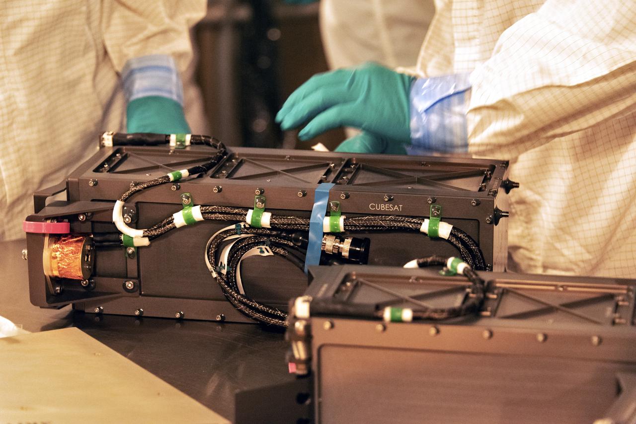
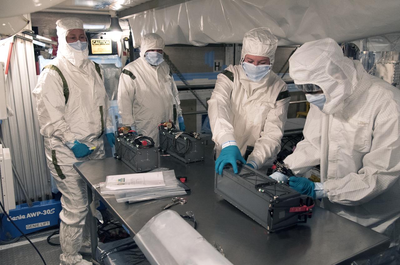
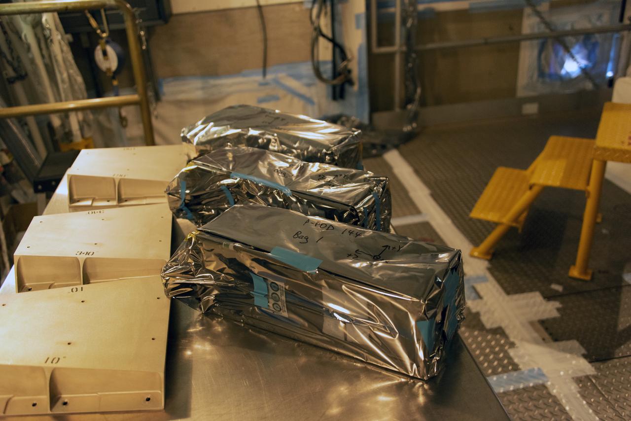
At Space Launch Complex 2 at Vandenberg Air Force Base in California, technicians prepare three poly picosatellite orbital deployers, or P-POD containers, with tiny satellites, called CubeSats inside, for installation on the direct mate adapter of the United Launch Alliance Delta II rocket, on Aug. 31, 2018. NASA's Ice, Cloud and land Elevation Satellite-2 (ICESat-2) is ready for launch aboard the final Delta II rocket. Launch is scheduled for Sept. 15, 2018. ICESat-2 will measure the height of a changing Earth, one laser pulse at a time, 10,000 laser pulses a second. The satellite will carry the Advanced Topographic Laser Altimeter System (ATLAS). ICESat-2 will help scientists investigate why, and how much our planet's frozen and icy areas, called the cryosphere, are changing in a warming climate.
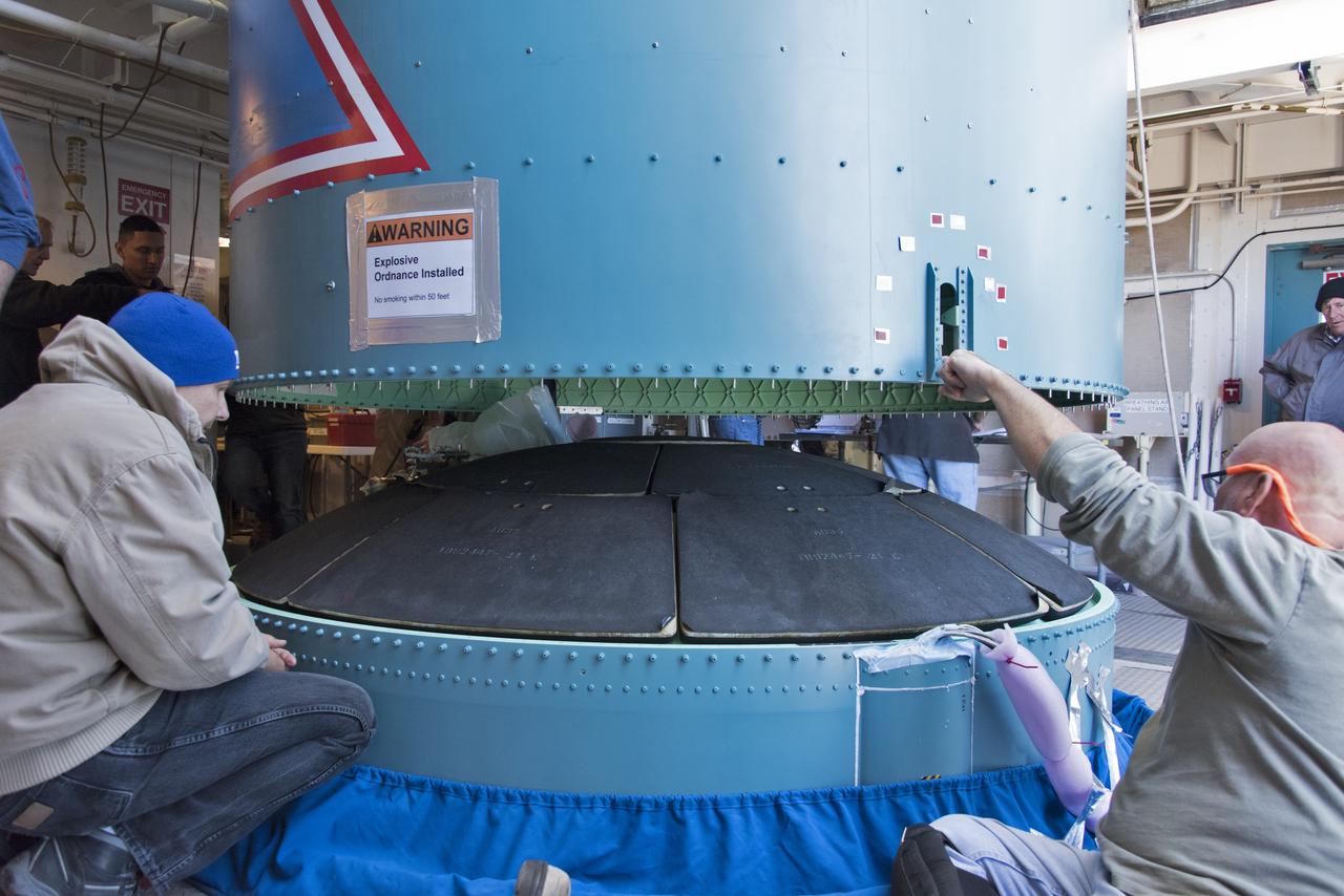
Inside the Vertical Integration Facility at Space Launch Complex 2 at Vandenberg Air Force Base in California, United Launch Alliance (ULA) workers assist as the Delta II interstage is lowered and mated to the booster, or first stage, on June 12, 2018. NASA's Ice, Cloud and land Elevation Satellite-2 (ICESat-2) will launch on the final Delta II rocket. ICESat-2 will measure the height of a changing Earth, one laser pulse at a time, 10,000 laser pulses a second. The satellite will carry a single instrument, the Advanced Topographic Laser Altimeter System. ICESat-2 will help scientists investigate why, and how much our planet's frozen and icy areas, called the cryosphere, is changing in a warming climate.
The gantry rolls back at Space Launch Complex 2 at Vandenberg Air Force Base in California, on Sept. 14, 2018, for the final United Launch Alliance Delta II rocket which will carry NASA's Ice, Cloud and land Elevation Satellite-2 (ICESat-2). Liftoff is scheduled for Sept. 15, 2018, at 8:46 a.m. EDT (5:46 a.m. PDT). The satellite will measure the height of our changing Earth, one laser pulse at a time, 10,000 laser pulses per second. ICESat-2 will provide scientists with height measurements that create a global portrait of Earth's third dimension, gathering date that can precisely track changes of terrain, including glaciers, sea ice and forests.
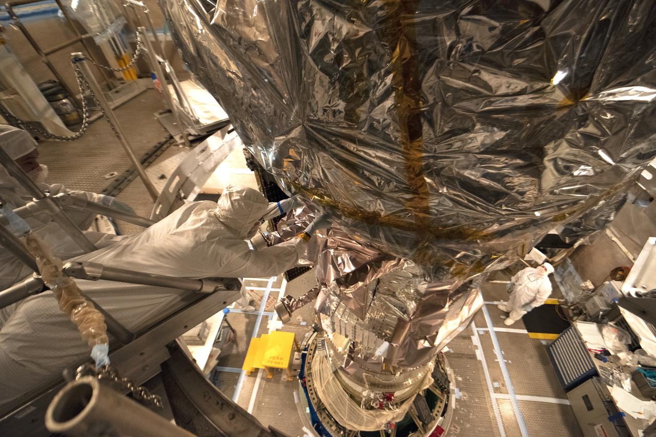
Technicians prepare NASA's Ice, Cloud and land Elevation Satellite-2 (ICESat-2) for encapsulation in the United Launch Alliance Delta II payload fairing on Sept. 4, 2018, at Space Launch Complex 2 at Vandenberg Air Force Base in California. The satellite is being prepared for its scheduled launch on the final Delta II rocket. ICESat-2 will measure the height of a changing Earth, one laser pulse at a time, 10,000 laser pulses a second. The satellite will carry the Advanced Topographic Laser Altimeter System (ATLAS). ICESat-2 will help scientists investigate why, and how much our planet's frozen and icy areas, called the cryosphere, are changing in a warming climate.
A United Launch Alliance Delta II rocket lifts off from Space Launch Complex 2 at Vandenberg Air Force Base in California carrying the Joint Polar Satellite System-1, or JPSS-1, spacecraft. Built by Ball Aerospace and Technologies Corp. of Boulder, Colorado, JPSS is the first in a series four next-generation environmental satellites in a collaborative program between NOAA and NASA. JPSS-1 will gather measurements of atmospheric, terrestrial and oceanic conditions, including sea and land surface temperatures, vegetation, clouds, rainfall, snow and ice cover, fire locations, atmospheric temperature, water vapor and ozone. Liftoff was at 1:47 a.m. PST (4:47 a.m. EST).
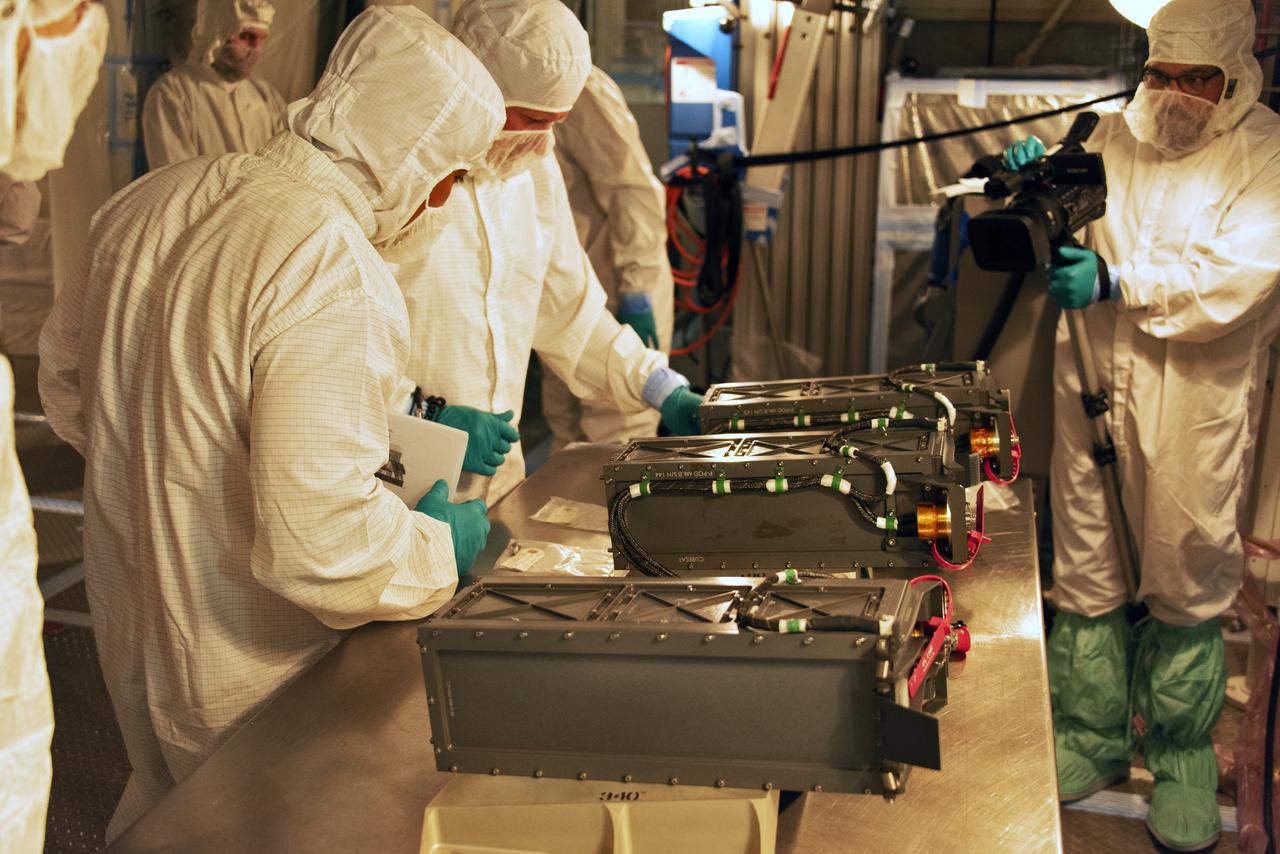
At Space Launch Complex 2 at Vandenberg Air Force Base in California, technicians prepare three poly picosatellite orbital deployers, or P-POD containers, with tiny satellites, called CubeSats inside, for installation on the direct mate adapter of the United Launch Alliance Delta II rocket, on Aug. 31, 2018. NASA's Ice, Cloud and land Elevation Satellite-2 (ICESat-2) is ready for launch aboard the final Delta II rocket. Launch is scheduled for Sept. 15, 2018. ICESat-2 will measure the height of a changing Earth, one laser pulse at a time, 10,000 laser pulses a second. The satellite will carry the Advanced Topographic Laser Altimeter System (ATLAS). ICESat-2 will help scientists investigate why, and how much our planet's frozen and icy areas, called the cryosphere, are changing in a warming climate.
The gantry rolls back at Space Launch Complex 2 at Vandenberg Air Force Base in California, on Sept. 14, 2018, for the final United Launch Alliance Delta II rocket which will carry NASA's Ice, Cloud and land Elevation Satellite-2 (ICESat-2). Liftoff is scheduled for Sept. 15, 2018, at 8:46 a.m. EDT (5:46 a.m. PDT). The satellite will measure the height of our changing Earth, one laser pulse at a time, 10,000 laser pulses per second. ICESat-2 will provide scientists with height measurements that create a global portrait of Earth's third dimension, gathering date that can precisely track changes of terrain, including glaciers, sea ice and forests.
At Vandenberg Air Force Base in California, technicians and engineers prepare a Poly Picosatellite Orbital Deployer, or P-POD, container for installation on the Joint Polar Satellite System-1, or JPSS-1, spacecraft. P-PODS are auxiliary payloads launched aboard NASA expendable launch vehicles carrying up to three small CubeSats. The small cube-shaped satellites are part of NASA’s Educational Launch of Nanosatellite, or ELaNa, missions. The small payloads are designed and built by students from high school-level classes up to college and university students. JPSS is the first in a series of four next-generation environmental satellites in a collaborative program between the NOAA and NASA. Liftoff from Vandenberg's Space Launch Compex-2 atop a United Launch Alliance Delta II rocket is scheduled for 1:47 a.m. PST (4:47 a.m. EST), on Nov. 14, 2017.

At Vandenberg Air Force Base in California, NASA's Ice, Cloud and land Elevation Satellite-2 (ICESat-2) is moved inside the mobile service tower at Space Launch Complex 2, on Aug. 26, 2018. The satellite will be attached to the top of the United Launch Alliance Delta II rocket. Launch is scheduled for Sept. 15, 2018. ICESat-2 will measure the height of a changing Earth, one laser pulse at a time, 10,000 laser pulses a second. The satellite will carry the Advanced Topographic Laser Altimeter System (ATLAS). ICESat-2 will help scientists investigate why, and how much our planet's frozen and icy areas, called the cryosphere, are changing in a warming climate.

The gantry rolls back at Space Launch Complex 2 at Vandenberg Air Force Base in California, on Sept. 14, 2018, for the final United Launch Alliance Delta II rocket which will carry NASA's Ice, Cloud and land Elevation Satellite-2 (ICESat-2). Liftoff is scheduled for Sept. 15, 2018, at 8:46 a.m. EDT (5:46 a.m. PDT). The satellite will measure the height of our changing Earth, one laser pulse at a time, 10,000 laser pulses per second. ICESat-2 will provide scientists with height measurements that create a global portrait of Earth's third dimension, gathering date that can precisely track changes of terrain, including glaciers, sea ice and forests.

At Vandenberg Air Force Base in California, a Poly Picosatellite Orbital Deployer, or P-POD, container is installed on the Joint Polar Satellite System-1, or JPSS-1, spacecraft. P-PODS are auxiliary payloads launched aboard NASA expendable launch vehicles carrying up to three small CubeSats. The small cube-shaped satellites are part of NASA’s Educational Launch of Nanosatellite, or ELaNa, missions. The small payloads are designed and built by students from high school-level classes up to college and university students. JPSS is the first in a series of four next-generation environmental satellites in a collaborative program between the NOAA and NASA. Liftoff from Vandenberg's Space Launch Compex-2 atop a United Launch Alliance Delta II rocket is scheduled for 1:47 a.m. PST (4:47 a.m. EST), on Nov. 14, 2017.
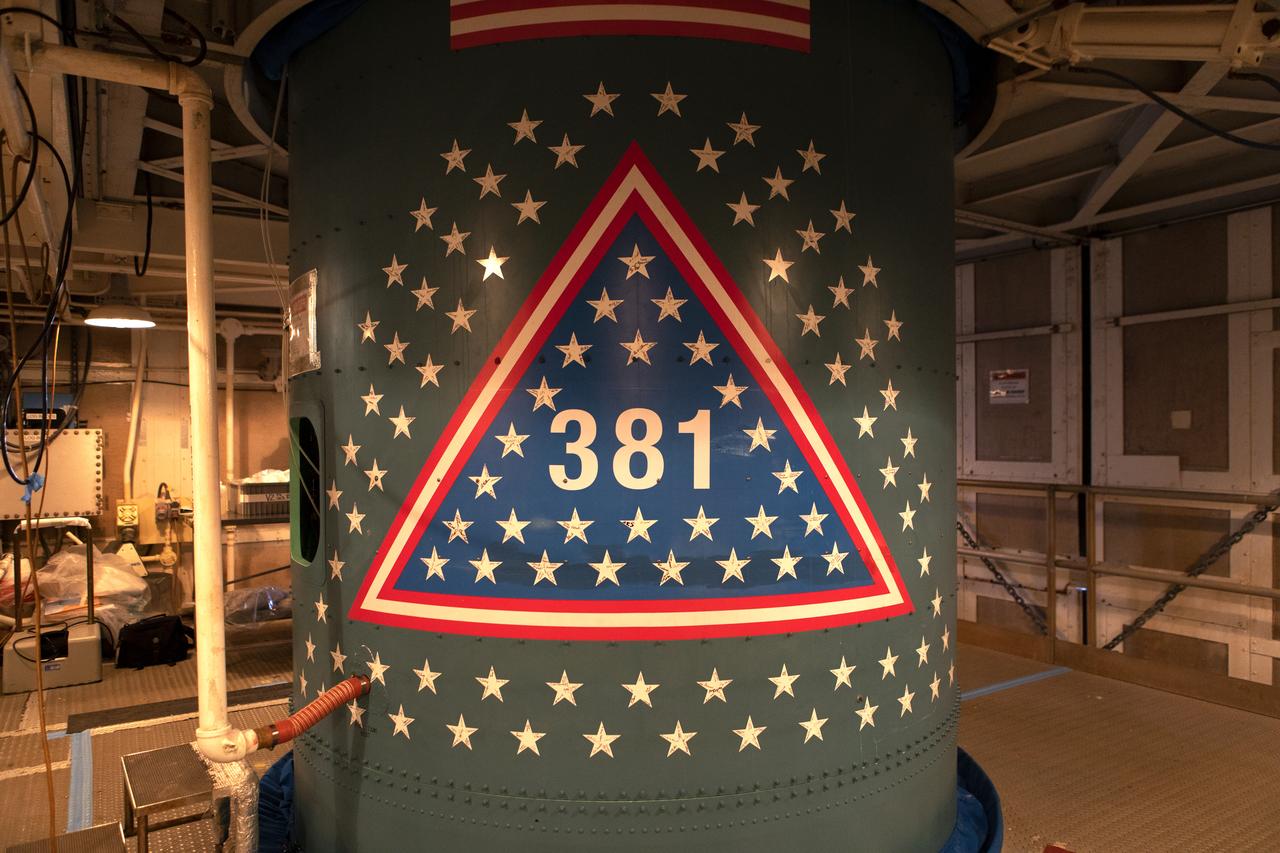
Stars are in view on the first stage of the United Launch Alliance Delta II rocket at Space Launch Complex 2 at Vandenberg Air Force Base in California, on Sept. 13, 2018. Historically, each Delta rocket used to notate the number of launches within the program, beginning in May, 1960, with the first Delta I. This practice was brought back for the final Delta II launch of ICESat-2. The “381” on the rocket signifies that this will be the 381st flight in the Delta family. A star traditionally was placed on the rocket to recognize each mission. For the final Delta II, stars were sent to team members and partners throughout the nation. This rocket boasts more than 150 stars with over 800 signatures of people who have been part of the Delta II program.
At Vandenberg Air Force Base in California, this wide angle view shows the payload fairing as it is installed encapsulating the Joint Polar Satellite System-1, or JPSS-1, spacecraft atop a United Launch Alliance Delta II rocket at Space Launch Complex 2. Built by Ball Aerospace and Technologies Corp. of Boulder, Colorado, JPSS is the first in a series four next-generation environmental satellites in a collaborative program between the NOAA and NASA. Liftoff is scheduled to take place from Vandenberg's Space Launch Complex 2 at 1:47 a.m. PST (4:47 a.m. EST), on Nov. 14, 2017.
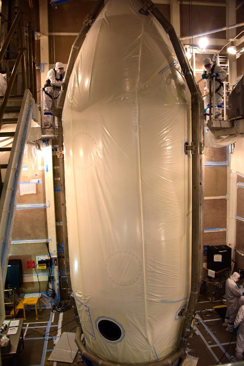
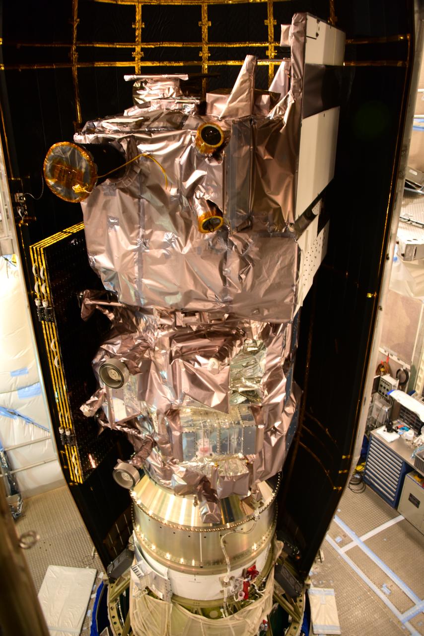
NASA's Ice, Cloud and land Elevation Satellite-2 (ICESat-2) is encapsulated in the United Launch Alliance Delta II payload fairing on Sept. 4, 2018, at Space Launch Complex 2 at Vandenberg Air Force Base in California. The satellite is being prepared for its scheduled launch on the final Delta II rocket. ICESat-2 will measure the height of a changing Earth, one laser pulse at a time, 10,000 laser pulses a second. The satellite will carry the Advanced Topographic Laser Altimeter System (ATLAS). ICESat-2 will help scientists investigate why, and how much our planet's frozen and icy areas, called the cryosphere, are changing in a warming climate.
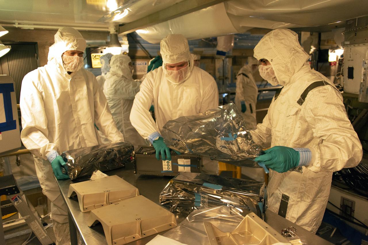
At Space Launch Complex 2 at Vandenberg Air Force Base in California, technicians prepare three poly picosatellite orbital deployers, or P-POD containers, with tiny satellites, called CubeSats inside, for installation on the direct mate adapter of the United Launch Alliance Delta II rocket, on Aug. 31, 2018. NASA's Ice, Cloud and land Elevation Satellite-2 (ICESat-2) is ready for launch aboard the final Delta II rocket. Launch is scheduled for Sept. 15, 2018. ICESat-2 will measure the height of a changing Earth, one laser pulse at a time, 10,000 laser pulses a second. The satellite will carry the Advanced Topographic Laser Altimeter System (ATLAS). ICESat-2 will help scientists investigate why, and how much our planet's frozen and icy areas, called the cryosphere, are changing in a warming climate.
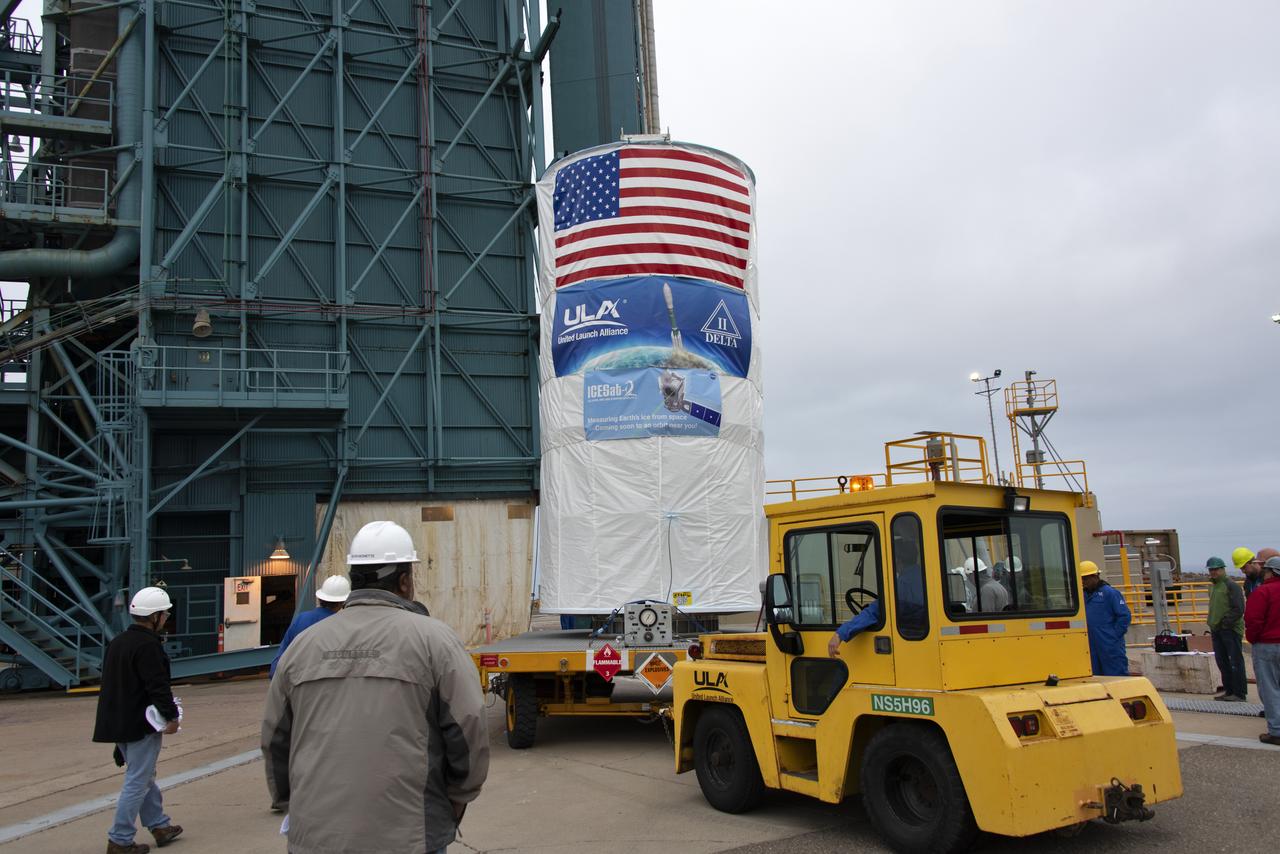
NASA's Ice, Cloud and land Elevation Satellite-2 (ICESat-2), encased in its protective covering, arrives at the mobile service tower at Space Launch Complex 2 at Vandenberg Air Force Base in California, on Aug. 26, 2018. The satellite will be hoisted up by crane and attached to the United Launch Alliance Delta II rocket. Launch is scheduled for Sept. 15, 2018. ICESat-2 will measure the height of a changing Earth, one laser pulse at a time, 10,000 laser pulses a second. The satellite will carry the Advanced Topographic Laser Altimeter System (ATLAS). ICESat-2 will help scientists investigate why, and how much our planet's frozen and icy areas, called the cryosphere, are changing in a warming climate.
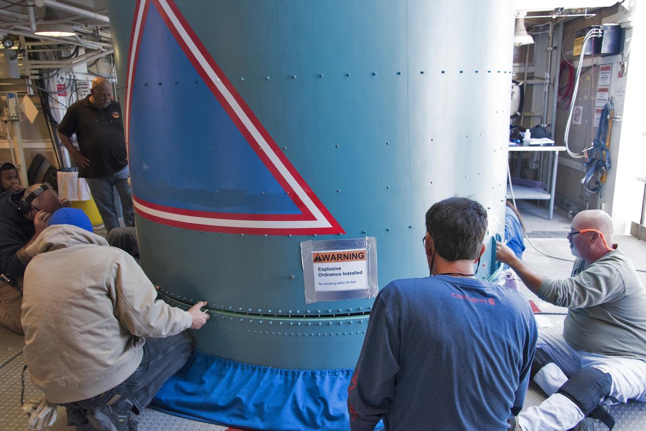
Inside the Vertical Integration Facility at Space Launch Complex 2 at Vandenberg Air Force Base in California, United Launch Alliance (ULA) workers help secure the Delta II interstage to the top of the booster, or first stage, on June 12, 2018. NASA's Ice, Cloud and land Elevation Satellite-2 (ICESat-2) will launch on the final Delta II rocket. ICESat-2 will measure the height of a changing Earth, one laser pulse at a time, 10,000 laser pulses a second. The satellite will carry a single instrument, the Advanced Topographic Laser Altimeter System. ICESat-2 will help scientists investigate why, and how much our planet's frozen and icy areas, called the cryosphere, is changing in a warming climate.
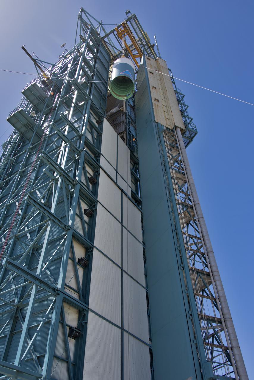
The United Launch Alliance Delta II interstage is lifted high up at the Vertical Integration Facility at Space Launch Complex 2 on June 12, 2018, at Vandenberg Air Force Base in California. The interstage will be moved in and mated to the top of the booster, or first stage of the rocket. NASA's Ice, Cloud and land Elevation Satellite-2 (ICESat-2) will launch on the final Delta II rocket. ICESat-2 will measure the height of a changing Earth, one laser pulse at a time, 10,000 laser pulses a second. The satellite will carry a single instrument, the Advanced Topographic Laser Altimeter System. ICESat-2 will help scientists investigate why, and how much our planet's frozen and icy areas, called the cryosphere, is changing in a warming climate.
At Vandenberg Air Force Base in California, technicians and engineers prepare a Poly Picosatellite Orbital Deployer, or P-POD, container for installation on the Joint Polar Satellite System-1, or JPSS-1, spacecraft. P-PODS are auxiliary payloads launched aboard NASA expendable launch vehicles carrying up to three small CubeSats. The small cube-shaped satellites are part of NASA’s Educational Launch of Nanosatellite, or ELaNa, missions. The small payloads are designed and built by students from high school-level classes up to college and university students. JPSS is the first in a series of four next-generation environmental satellites in a collaborative program between the NOAA and NASA. Liftoff from Vandenberg's Space Launch Compex-2 atop a United Launch Alliance Delta II rocket is scheduled for 1:47 a.m. PST (4:47 a.m. EST), on Nov. 14, 2017.

The gantry rolls back at Space Launch Complex 2 at Vandenberg Air Force Base in California, on Sept. 14, 2018, for the final United Launch Alliance Delta II rocket which will carry NASA's Ice, Cloud and land Elevation Satellite-2 (ICESat-2). Liftoff is scheduled for Sept. 15, 2018, at 8:46 a.m. EDT (5:46 a.m. PDT). The satellite will measure the height of our changing Earth, one laser pulse at a time, 10,000 laser pulses per second. ICESat-2 will provide scientists with height measurements that create a global portrait of Earth's third dimension, gathering date that can precisely track changes of terrain, including glaciers, sea ice and forests.