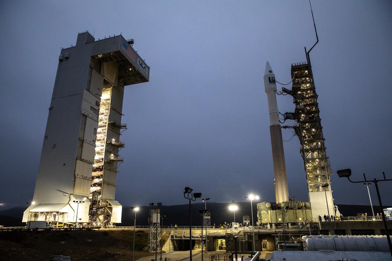
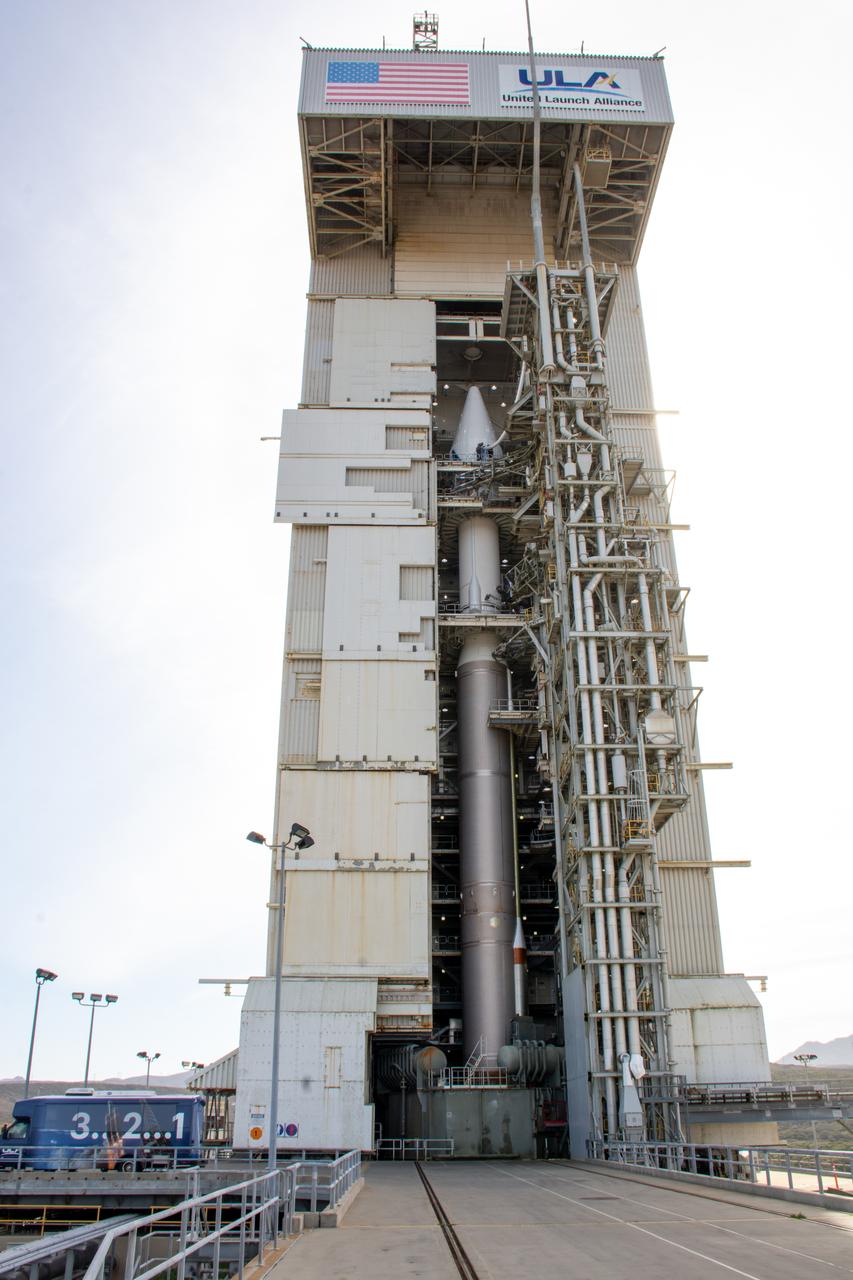
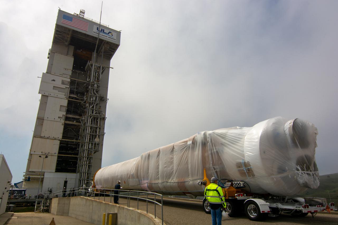
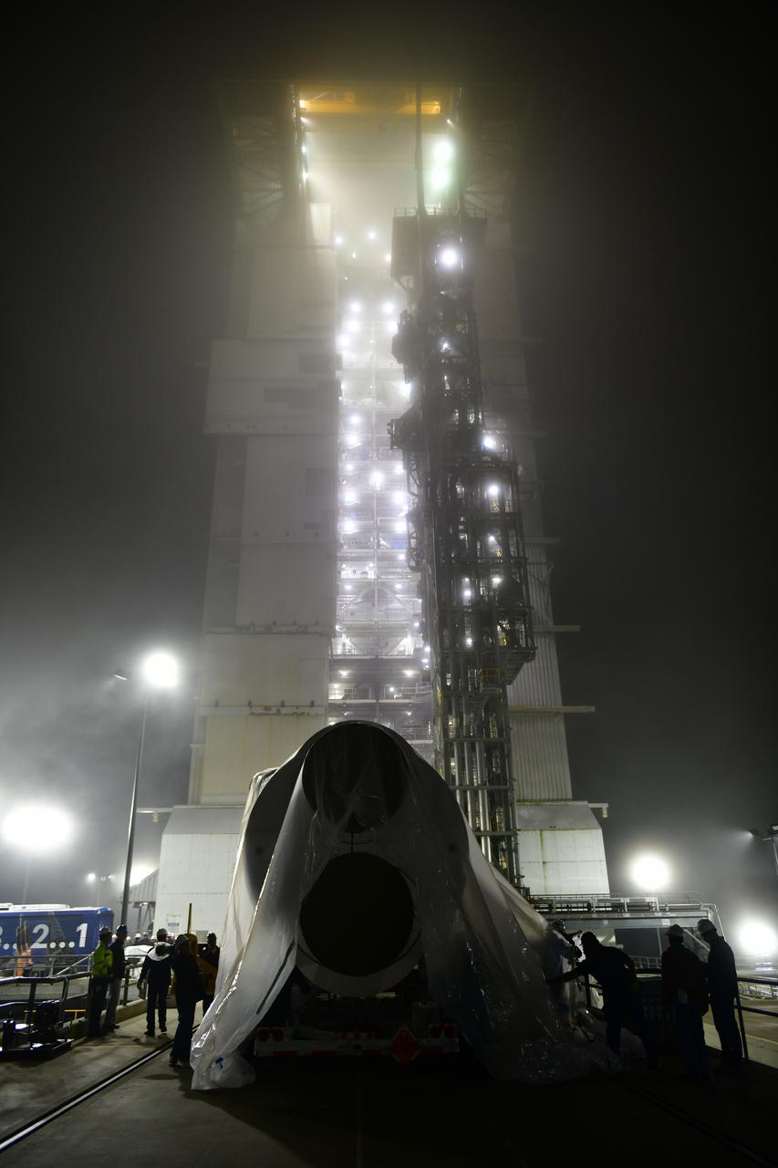
The United Launch Alliance Atlas V 401 rocket with NASA’s Landsat 9 satellite arrives at the launch pad at Space Launch Complex 3 (SLC-3) at Vandenberg Space Force Base in California, on Sept. 27, 2021, after rolling out from the Vertical Integration Facility. Landsat 9 is scheduled to launch at 2:12 p.m. EDT (11:12 a.m. PDT) today, Sept. 27, atop the Atlas V from SLC-3. The launch is managed by NASA’s Launch Services Program based at Kennedy Space Center. The Landsat 9 satellite will continue the nearly 50-year legacy of previous Landsat missions. It will join its sister satellite, Landsat 8, in orbit to monitor key natural and economic resources from orbit. Landsat 9 is managed by the agency’s Goddard Space Flight Center in Greenbelt, Maryland. The satellite will carry two instruments: the Operational Land Imager 2, which collects images of Earth’s landscapes in visible, near infrared and shortwave infrared light, and the Thermal Infrared Sensor 2, which measures the temperature of land surfaces. Like its predecessors, Landsat 9 is a joint mission between NASA and the U.S. Geological Survey.
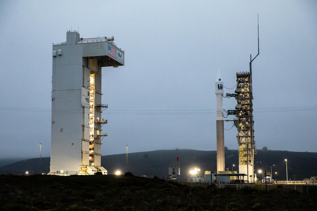
The United Launch Alliance Atlas V 401 rocket with NASA’s Landsat 9 satellite is secured on the launch pad at Space Launch Complex 3 (SLC-3) at Vandenberg Space Force Base in California, on Sept. 27, 2021, after making the trek from the Vertical Integration Facility. Landsat 9 is scheduled to launch at 2:12 p.m. EDT (11:12 a.m. PDT) today, Sept. 27, atop the Atlas V from SLC-3. The launch is managed by NASA’s Launch Services Program based at Kennedy Space Center. The Landsat 9 satellite will continue the nearly 50-year legacy of previous Landsat missions. It will join its sister satellite, Landsat 8, in orbit to monitor key natural and economic resources from orbit. Landsat 9 is managed by the agency’s Goddard Space Flight Center in Greenbelt, Maryland. The satellite will carry two instruments: the Operational Land Imager 2, which collects images of Earth’s landscapes in visible, near infrared and shortwave infrared light, and the Thermal Infrared Sensor 2, which measures the temperature of land surfaces. Like its predecessors, Landsat 9 is a joint mission between NASA and the U.S. Geological Survey.
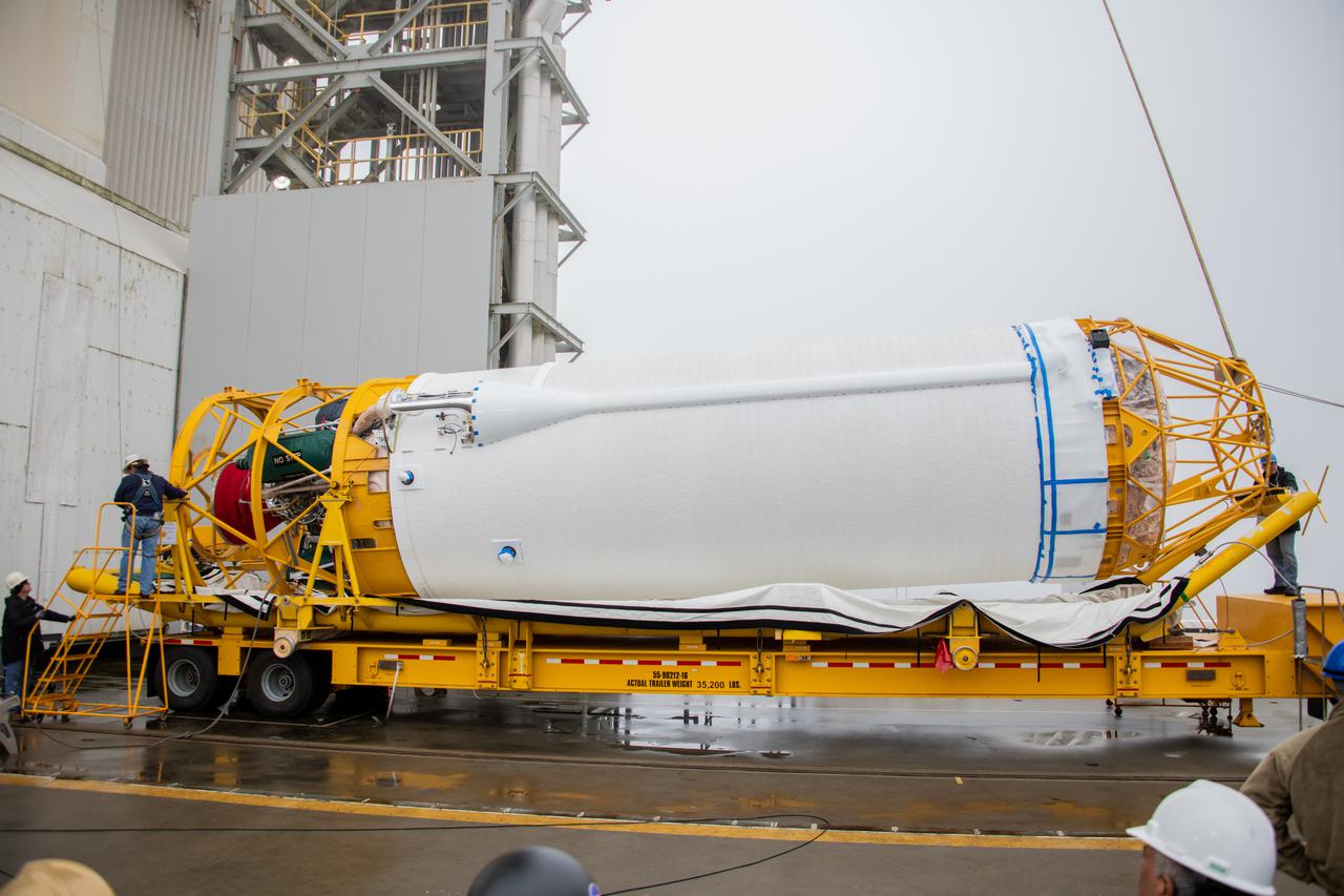
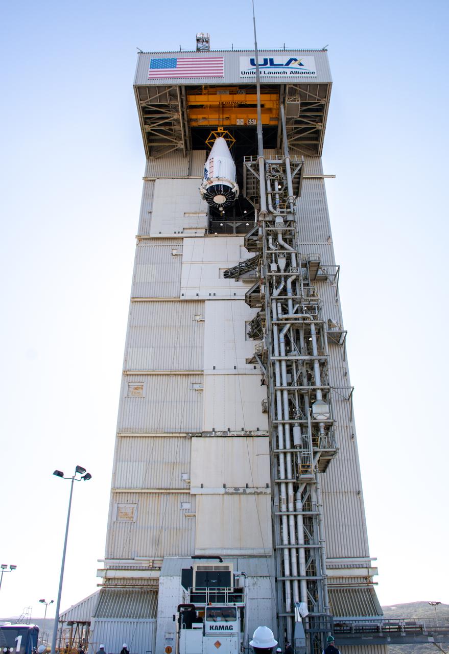
The United Launch Alliance Atlas V booster for NASA’s Landsat 9 mission is moved into the Vertical Integration Facility at Space Launch Complex 3 at Vandenberg Space Force Base in California, on July 13, 2021. The Landsat 9 mission will launch atop the Atlas V rocket from Vandenberg in September 2021. The launch is being managed by NASA’s Launch Services Program based at Kennedy Space Center. The Landsat 9 satellite will continue the nearly 50-year legacy of previous Landsat missions. It will monitor key natural and economic resources from orbit. Landsat 9 is managed by the agency’s Goddard Space Flight Center in Greenbelt, Maryland. The satellite will carry two instruments: the Operational Land Imager 2, which collects images of Earth’s landscapes in visible, near infrared and shortwave infrared light, and the Thermal Infrared Sensor 2, which measures the temperature of land surfaces. Like its predecessors, Landsat 9 is a joint mission between NASA and the U.S. Geological Survey.
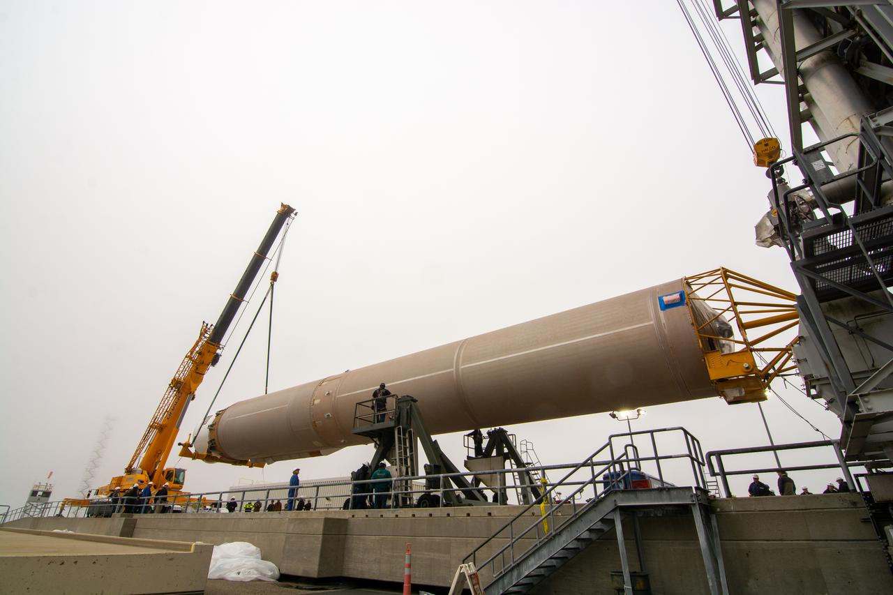
The United Launch Alliance Atlas V booster for NASA’s Landsat 9 mission is lifted by crane and special lifting device for transfer into the Vertical Integration Facility at Space Launch Complex 3 at Vandenberg Space Force Base in California, on July 13, 2021. The Landsat 9 mission will launch atop the Atlas V rocket from Vandenberg in September 2021. The launch is being managed by NASA’s Launch Services Program based at Kennedy Space Center. The Landsat 9 satellite will continue the nearly 50-year legacy of previous Landsat missions. It will monitor key natural and economic resources from orbit. Landsat 9 is managed by the agency’s Goddard Space Flight Center in Greenbelt, Maryland. The satellite will carry two instruments: the Operational Land Imager 2, which collects images of Earth’s landscapes in visible, near infrared and shortwave infrared light, and the Thermal Infrared Sensor 2, which measures the temperature of land surfaces. Like its predecessors, Landsat 9 is a joint mission between NASA and the U.S. Geological Survey.
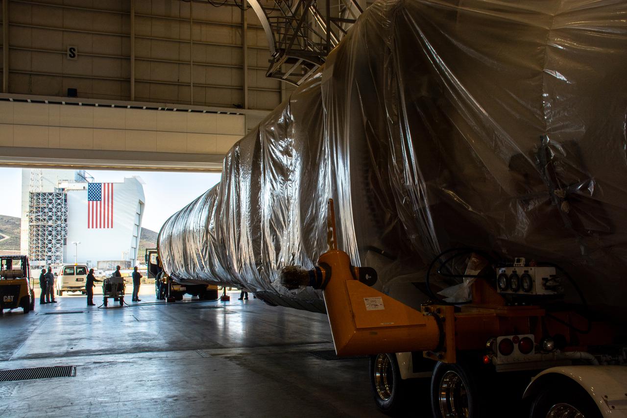
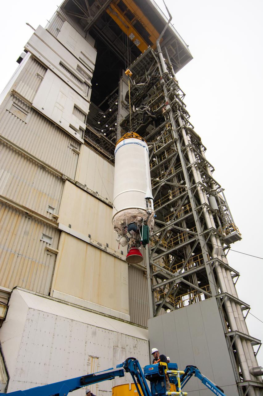
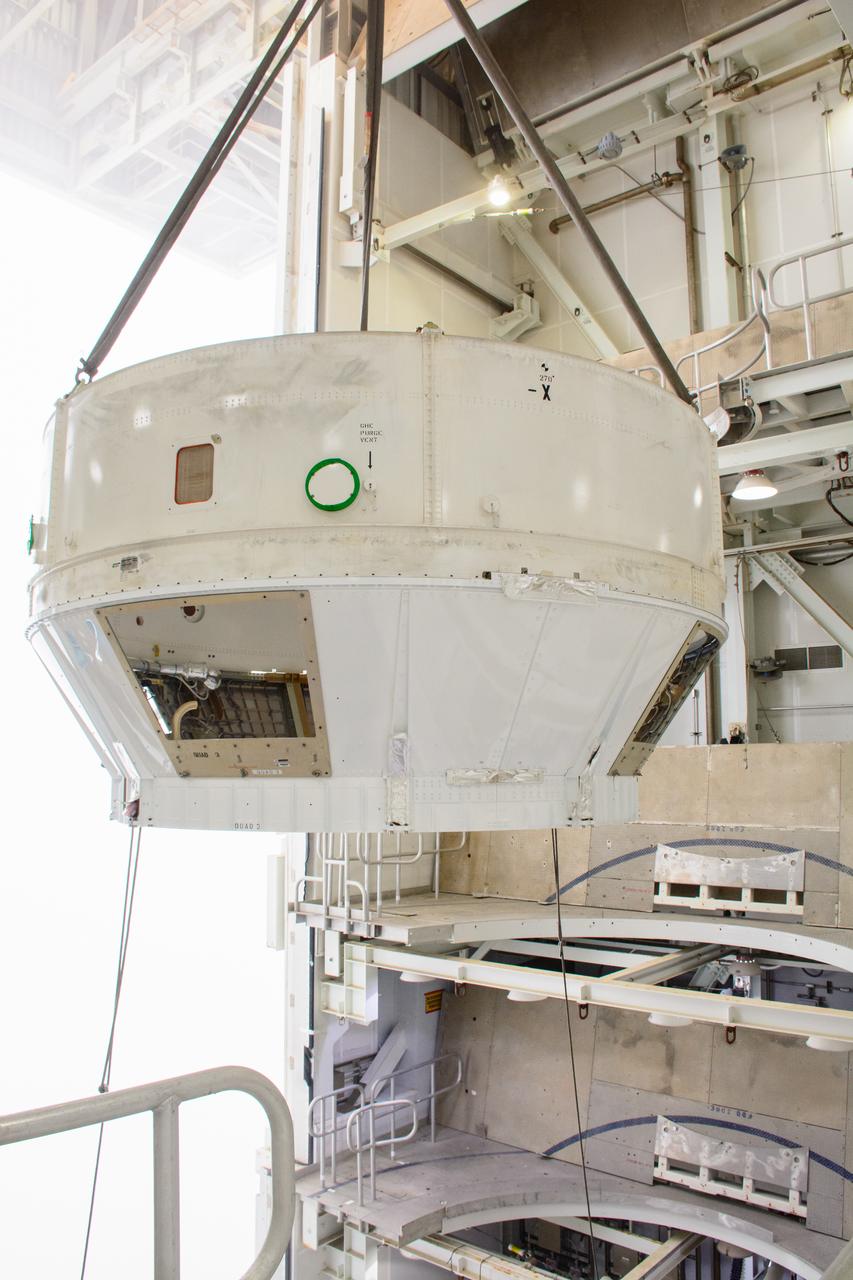
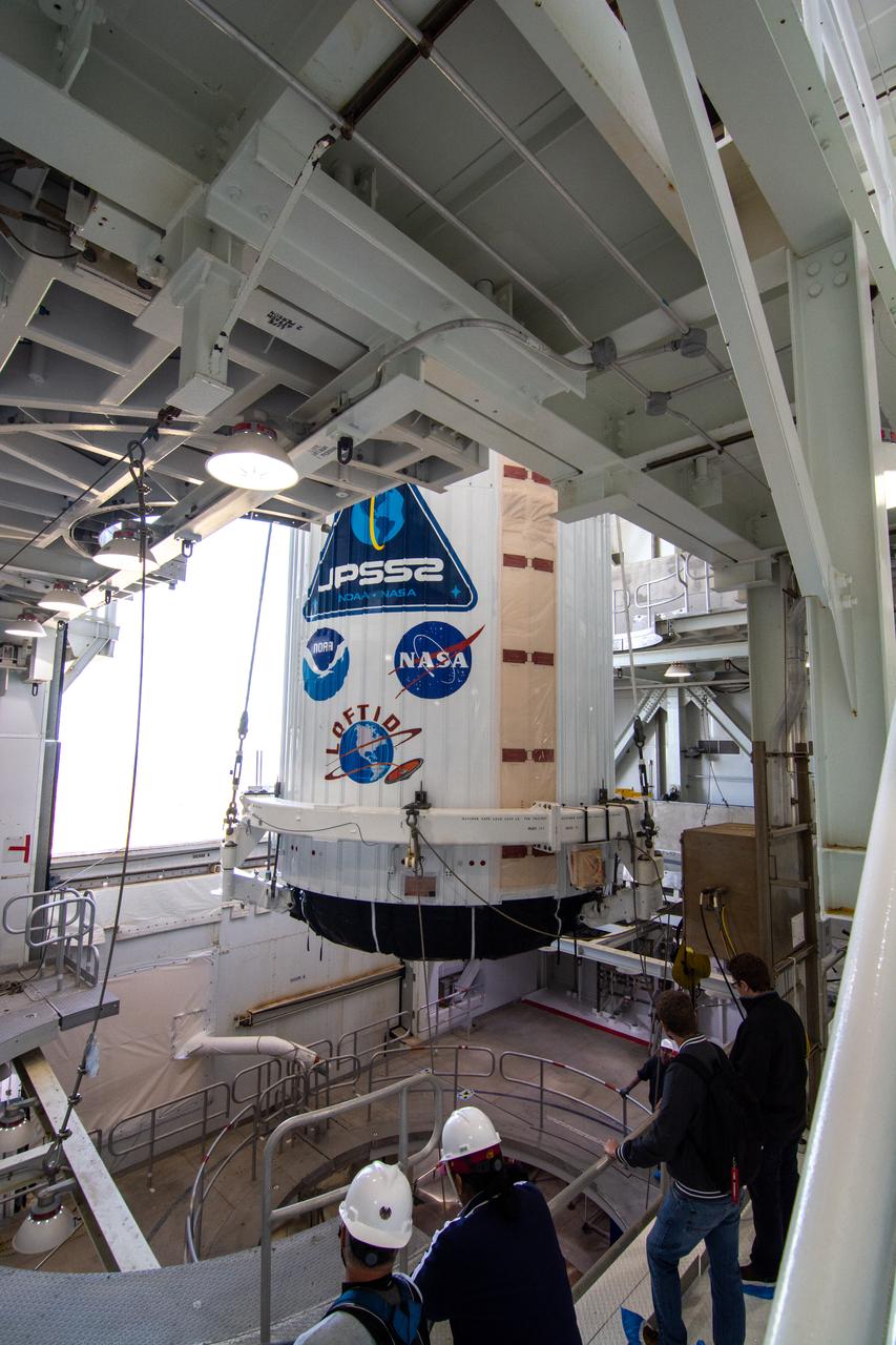
The United Launch Alliance Atlas V payload fairing containing the National Oceanic and Atmospheric Administration’s (NOAA) Joint Polar Satellite System-2 (JPSS-2) is lifted by crane at the vertical integration facility at Space Launch Complex 3 at Vandenberg Space Force Base (VSFB) in California on Oct. 18, 2022. Inside the fairing, JPSS-2 is stacked atop NASA’s Low-Earth Orbit Flight Test of an Inflatable Decelerator (LOFTID) secondary payload. JPSS-2 is the third satellite in the Joint Polar Satellite System series. It is scheduled to lift off from VSFB on Nov. 1 from SLC-3. JPSS-2, which will be renamed NOAA-21 after reaching orbit, will join a constellation of JPSS satellites that orbit from the North to the South pole, circling Earth 14 times a day and providing a full view of the entire globe twice daily. The NOAA/NASA Suomi National Polar-orbiting Partnership (Suomi NPP) satellite, and NOAA-20, previously known as JPSS-1, are both already in orbit. Each satellite carries at least four advanced instruments to measure weather and climate conditions on Earth. LOFTID is dedicated to the memory of Bernard Kutter. LOFTID will demonstrate inflatable heat shield technology that could enable a variety of proposed NASA missions to destinations such as Mars, Venus, and Titan, as well as returning heavier payloads from low-Earth orbit.
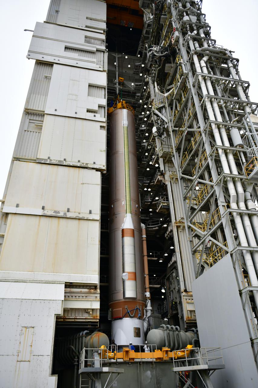
Inside the Vertical Integration Facility at Space Launch Complex 3 at Vandenberg Space Force Base in California, United Launch Alliance workers assist as the Centaur second stage for NASA’s Landsat 9 mission is lowered onto the Atlas V booster on July 15, 2021. The Landsat 9 mission will launch atop the Atlas V rocket from Vandenberg in September 2021. The launch is being managed by NASA’s Launch Services Program based at Kennedy Space Center, America’s multiuser spaceport. The Landsat 9 satellite will continue the nearly 50-year legacy of previous Landsat missions. It will monitor key natural and economic resources from orbit. Landsat 9 is managed by the agency’s Goddard Space Flight Center in Greenbelt, Maryland. The satellite will carry two instruments: the Operational Land Imager 2, which collects images of Earth’s landscapes in visible, near infrared and shortwave infrared light, and the Thermal Infrared Sensor 2, which measures the temperature of land surfaces. Like its predecessors, Landsat 9 is a joint mission between NASA and the U.S. Geological Survey.
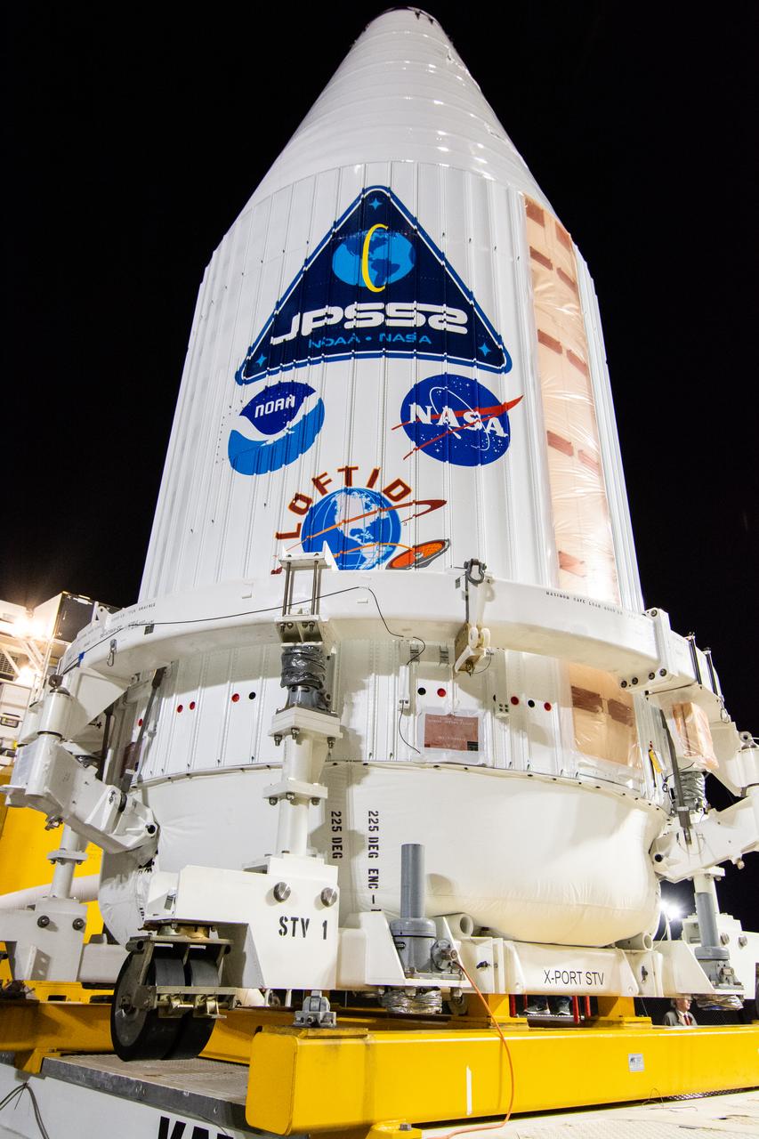
A close-up view of the United Launch Alliance Atlas V payload fairing containing the National Oceanic and Atmospheric Administration’s (NOAA) Joint Polar Satellite System-2 (JPSS-2) as it arrives at the vertical integration facility at Space Launch Complex 3 at Vandenberg Space Force Base (VSFB) in California on Oct. 18, 2022. Inside the fairing, JPSS-2 is stacked atop NASA’s Low-Earth Orbit Flight Test of an Inflatable Decelerator (LOFTID) secondary payload. JPSS-2 is the third satellite in the Joint Polar Satellite System series. It is scheduled to lift off from VSFB on Nov. 1 from SLC-3. JPSS-2, which will be renamed NOAA-21 after reaching orbit, will join a constellation of JPSS satellites that orbit from the North to the South pole, circling Earth 14 times a day and providing a full view of the entire globe twice daily. The NOAA/NASA Suomi National Polar-orbiting Partnership (Suomi NPP) satellite, and NOAA-20, previously known as JPSS-1, are both already in orbit. Each satellite carries at least four advanced instruments to measure weather and climate conditions on Earth. LOFTID is dedicated to the memory of Bernard Kutter. LOFTID will demonstrate inflatable heat shield technology that could enable a variety of proposed NASA missions to destinations such as Mars, Venus, and Titan, as well as returning heavier payloads from low-Earth orbit.
Preparations are underway to lift the interstage and assembly second stage adapters for the United Alliance Atlas V Centaur second stage for NASA’s Landsat 9 mission at Space Launch Complex 3 at Vandenberg Space Force Base in California, on July 14, 2021. The adapters will be stacked atop the Centaur second stage in the Vertical Integration Facility near the launch pad. The Landsat 9 mission will launch atop the Atlas V rocket from Vandenberg in September 2021. The launch is being managed by NASA’s Launch Services Program based at Kennedy Space Center, America’s multiuser spaceport. The Landsat 9 satellite will continue the nearly 50-year legacy of previous Landsat missions. It will monitor key natural and economic resources from orbit. Landsat 9 is managed by the agency’s Goddard Space Flight Center in Greenbelt, Maryland. The satellite will carry two instruments: the Operational Land Imager 2, which collects images of Earth’s landscapes in visible, near infrared and shortwave infrared light, and the Thermal Infrared Sensor 2, which measures the temperature of land surfaces. Like its predecessors, Landsat 9 is a joint mission between NASA and the U.S. Geological Survey.
The United Launch Alliance Atlas V booster for NASA’s Landsat 9 mission departs the Horizontal Integration Facility at Vandenberg Space Force Base in California, on July 12, 2021. The booster will be transported to the Vertical Integration Facility at Space Launch Complex 3. The Landsat 9 mission will launch atop the Atlas V rocket from Vandenberg in September 2021. The launch is being managed by NASA’s Launch Services Program based at Kennedy Space Center. The Landsat 9 satellite will continue the nearly 50-year legacy of previous Landsat missions. It will monitor key natural and economic resources from orbit. Landsat 9 is managed by the agency’s Goddard Space Flight Center in Greenbelt, Maryland. The satellite will carry two instruments: the Operational Land Imager 2, which collects images of Earth’s landscapes in visible, near infrared and shortwave infrared light, and the Thermal Infrared Sensor 2, which measures the temperature of land surfaces. Like its predecessors, Landsat 9 is a joint mission between NASA and the U.S. Geological Survey.
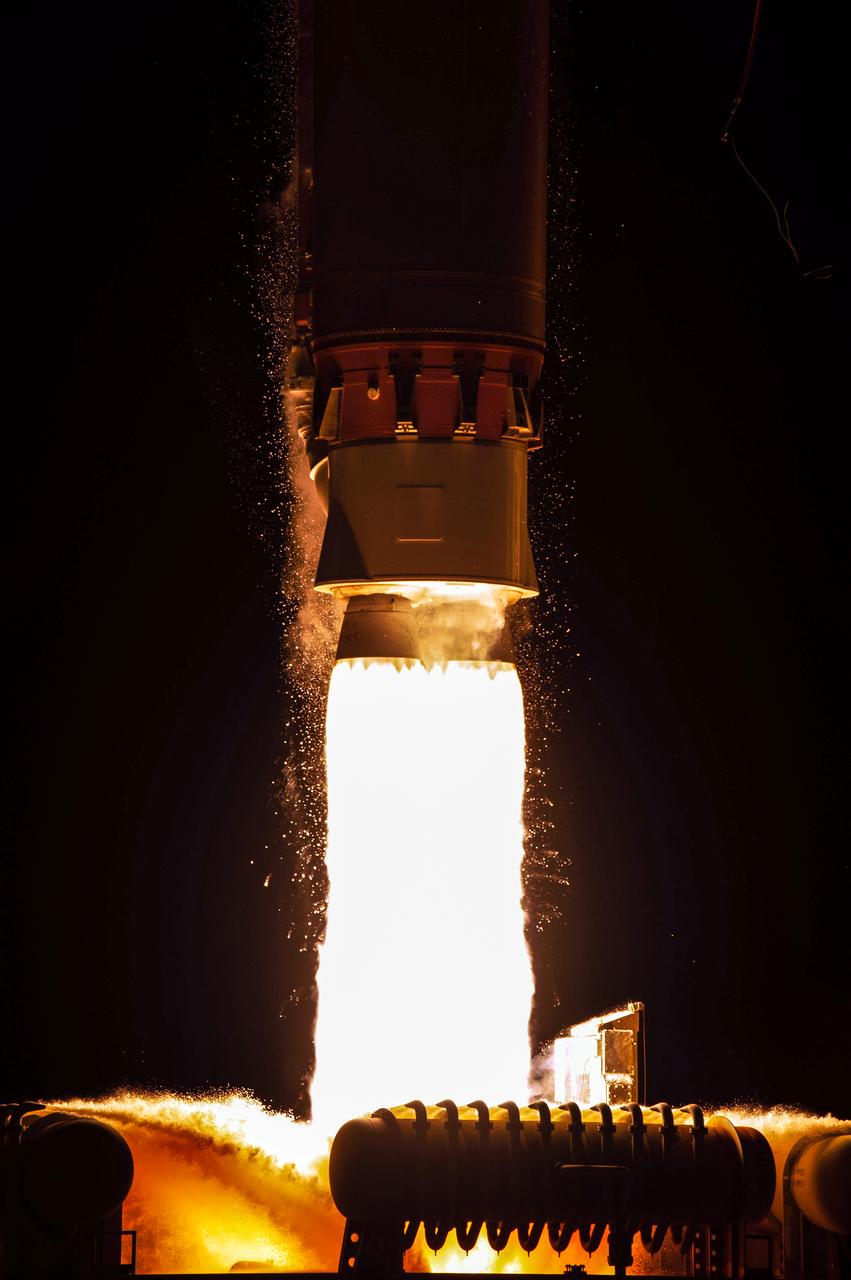
NASA’s Landsat 9 satellite launches on a United Launch Alliance Atlas V 401 rocket from Space Launch Complex 3 at Vandenberg Space Force Station in California on Sept. 27, 2021. Launch time was 2:11 p.m. EDT (11:11 a.m. PDT). The launch is managed by NASA’s Launch Services Program, based at the agency’s Kennedy Space Center in Florida. Landsat 9 will join its sister satellite, Landsat 8, in orbit in collecting images from across the planet every eight days. This calibrated data will continue the Landsat program’s critical role in monitoring the health of Earth and helping people manage essential resources, including crops, irrigation water, and forests. NASA Goddard manages the Landsat 9 mission. Goddard teams also built and tested one of the two instruments on Landsat 9, the Thermal Infrared Sensor 2 (TIRS-2) instrument. TIRS-2 will use thermal imaging to make measurements that can be used to estimate soil moisture and detect the health of plants.
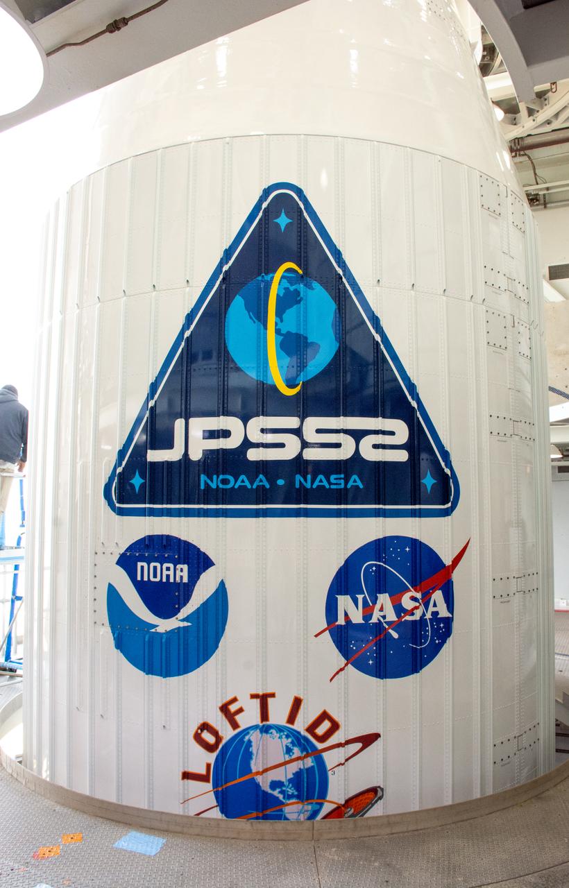
A close-up view of the United Launch Alliance Atlas V payload fairing containing the National Oceanic and Atmospheric Administration’s (NOAA) Joint Polar Satellite System-2 (JPSS-2) and NASA’s Low-Earth Orbit Flight Test of an Inflatable Decelerator (LOFTID) inside the mobile service tower at Space Launch Complex-3 (SLC-3) at Vandenberg Space Force Base in California on Oct. 28, 2022. NASA and ULA are targeting launch for no earlier than Wednesday, Nov. 9, pending range availability. JPSS-2, which will be renamed NOAA-21 after reaching orbit, will join a constellation of JPSS satellites that orbit from the North to the South pole, circling Earth 14 times a day. The NOAA/NASA Suomi National Polar-orbiting Partnership (Suomi NPP) satellite, and NOAA-20, previously known as JPSS-1, are both already in orbit. Each satellite carries at least four advanced instruments to measure weather and climate conditions on Earth. LOFTID will demonstrate inflatable heat shield technology that could enable a variety of proposed NASA missions to destinations such as Mars, Venus, and Titan, as well as returning heavier payloads from low-Earth orbit.
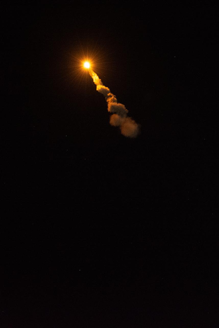
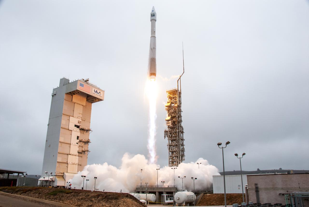
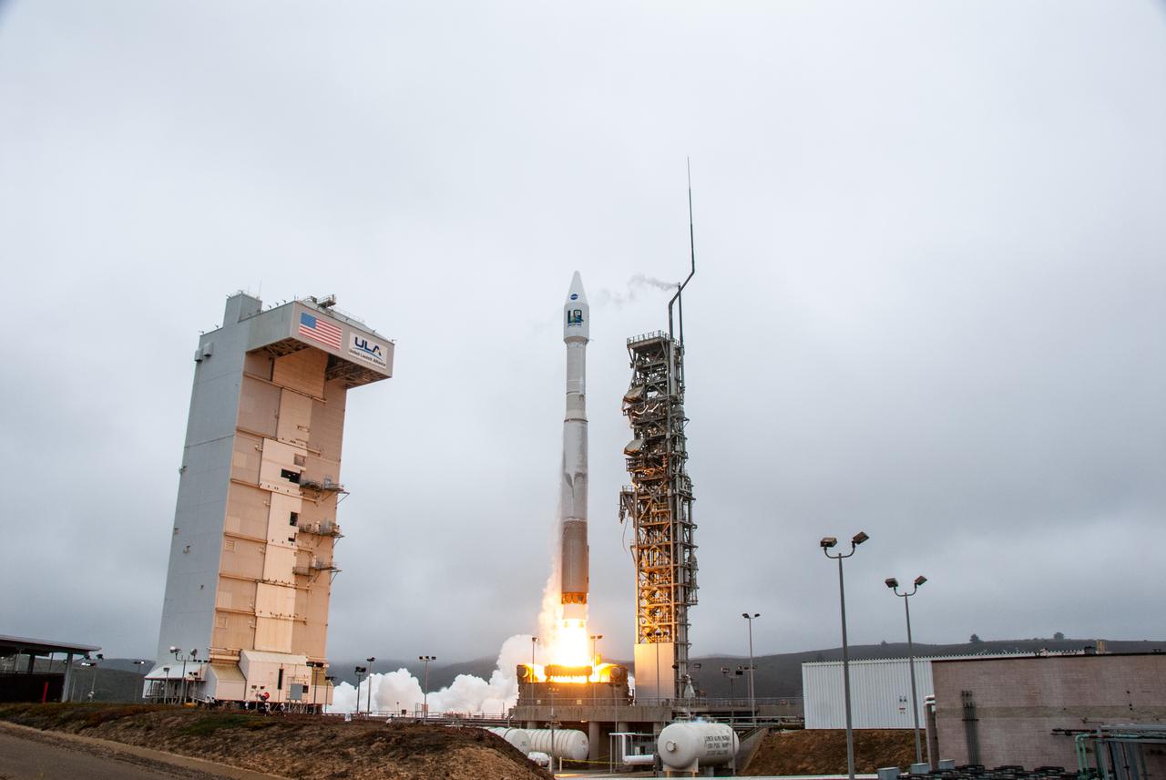
A United launch Alliance Atlas V 401 rocket soars upward after liftoff from Space Launch Complex 3 at Vandenberg Space Force Base in California on Nov. 10, carrying the National Oceanic and Atmospheric Administration’s (NOAA) Joint Polar Satellite System-2 (JPSS-2) and NASA’s Low-Earth Orbit Flight Test of an Inflatable Decelerator (LOFTID) technology demonstration. Launch was at 1:49 a.m. PST. JPSS-2 is the third satellite in the polar satellite series and is expected to capture data to improve weather forecasts, helping scientists predict and prepare for extreme weather events and climate change. After JPSS-2 safely reaches orbit, LOFTID will follow a re-entry trajectory from low-Earth orbit to demonstrate the inflatable heat shield’s ability to slow down and survive re-entry. LOFTID is a partnership with ULA and is dedicated to the memory of Bernard Kutter, one of the company’s engineers who played a key role in developing the technology. LOFTID will demonstrate how the inflatable aeroshell, or heat shield, can slow down and survive re-entry in conditions relevant to many potential applications, whether landing humans on Mars, new missions to Venus and Titan, or returning heavier payloads and samples from low-Earth orbit.
A United Launch Alliance Atlas V 401 rocket lifts off from Space Launch Complex 3 at Vandenberg Space Force Base in California on Nov. 10 carrying the National Oceanic and Atmospheric Administration’s (NOAA) Joint Polar Satellite System-2 (JPSS-2) and NASA’s Low-Earth Orbit Flight Test of an Inflatable Decelerator (LOFTID) technology demonstration. Liftoff was at 2:25 a.m. PDT. JPSS-2 is the third satellite in the polar satellite series and is expected to capture data to improve weather forecasts, helping scientists predict and prepare for extreme weather events and climate change. After JPSS-2 safely reaches orbit, LOFTID will follow a re-entry trajectory from low-Earth orbit to demonstrate the inflatable heat shield’s ability to slow down and survive re-entry. LOFTID is a partnership with ULA and is dedicated to the memory of Bernard Kutter, one of the company’s engineers who played a key role in developing the technology. LOFTID will demonstrate how the inflatable aeroshell, or heat shield, can slow down and survive re-entry in conditions relevant to many potential applications, whether landing humans on Mars, new missions to Venus and Titan, or returning heavier payloads and samples from low-Earth orbit.
Preparations are underway to lift the United Launch Alliance Centaur second stage for NASA’s Landsat 9 mission into the Vertical Integration Facility at Space Launch Complex 3 at Vandenberg Space Force Base in California, on July 15, 2021. The Centaur will be attached to the top of the Atlas V booster. The Landsat 9 mission will launch atop the Atlas V rocket from Vandenberg in September 2021. The launch is being managed by NASA’s Launch Services Program based at Kennedy Space Center, America’s multiuser spaceport. The Landsat 9 satellite will continue the nearly 50-year legacy of previous Landsat missions. It will monitor key natural and economic resources from orbit. Landsat 9 is managed by the agency’s Goddard Space Flight Center in Greenbelt, Maryland. The satellite will carry two instruments: the Operational Land Imager 2, which collects images of Earth’s landscapes in visible, near infrared and shortwave infrared light, and the Thermal Infrared Sensor 2, which measures the temperature of land surfaces. Like its predecessors, Landsat 9 is a joint mission between NASA and the U.S. Geological Survey.
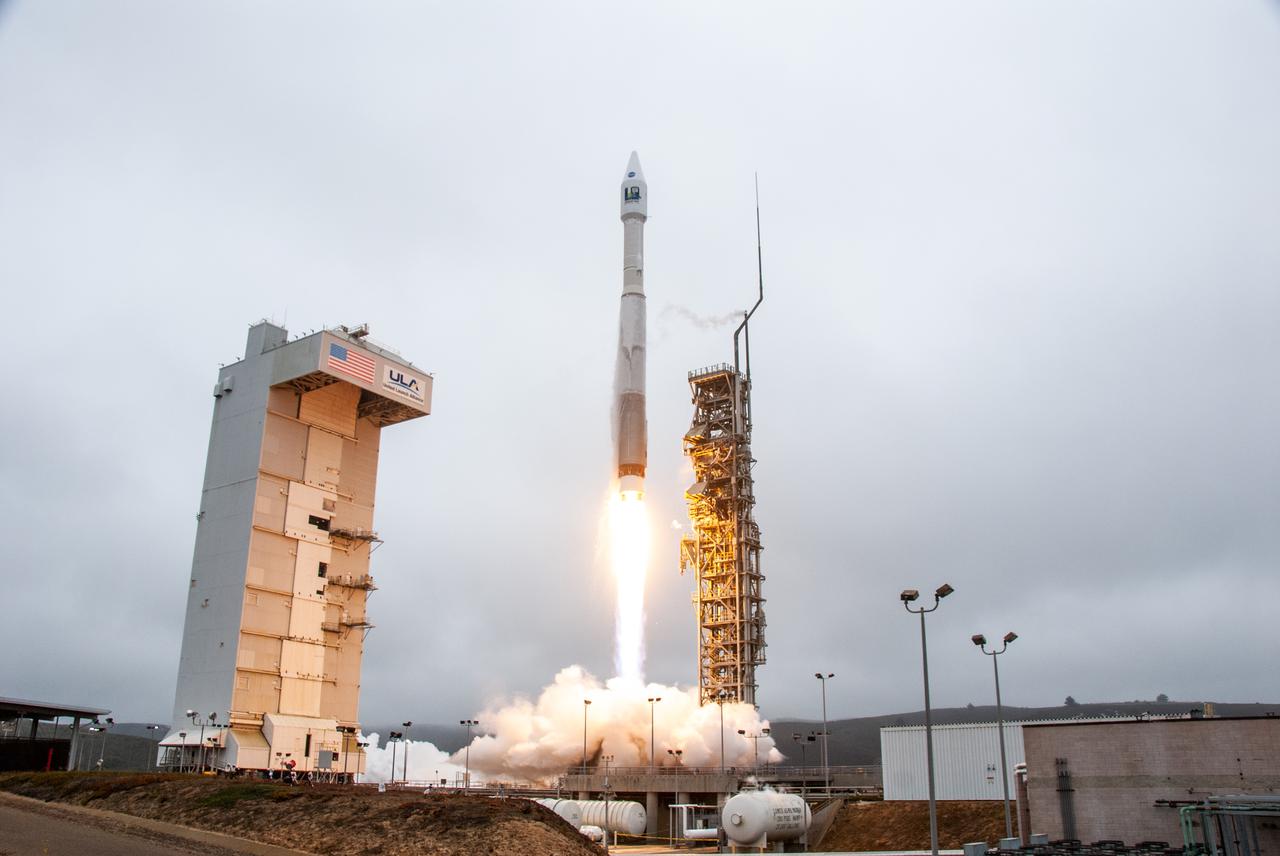
NASA’s Landsat 9 satellite launches on a United Launch Alliance Atlas V 401 rocket from Space Launch Complex 3 at Vandenberg Space Force Station in California on Sept. 27, 2021. Launch time was 2:11 p.m. EDT (11:11 a.m. PDT). The launch is managed by NASA’s Launch Services Program, based at the agency’s Kennedy Space Center in Florida. Landsat 9 will join its sister satellite, Landsat 8, in orbit in collecting images from across the planet every eight days. This calibrated data will continue the Landsat program’s critical role in monitoring the health of Earth and helping people manage essential resources, including crops, irrigation water, and forests. NASA Goddard manages the Landsat 9 mission. Goddard teams also built and tested one of the two instruments on Landsat 9, the Thermal Infrared Sensor 2 (TIRS-2) instrument. TIRS-2 will use thermal imaging to make measurements that can be used to estimate soil moisture and detect the health of plants.
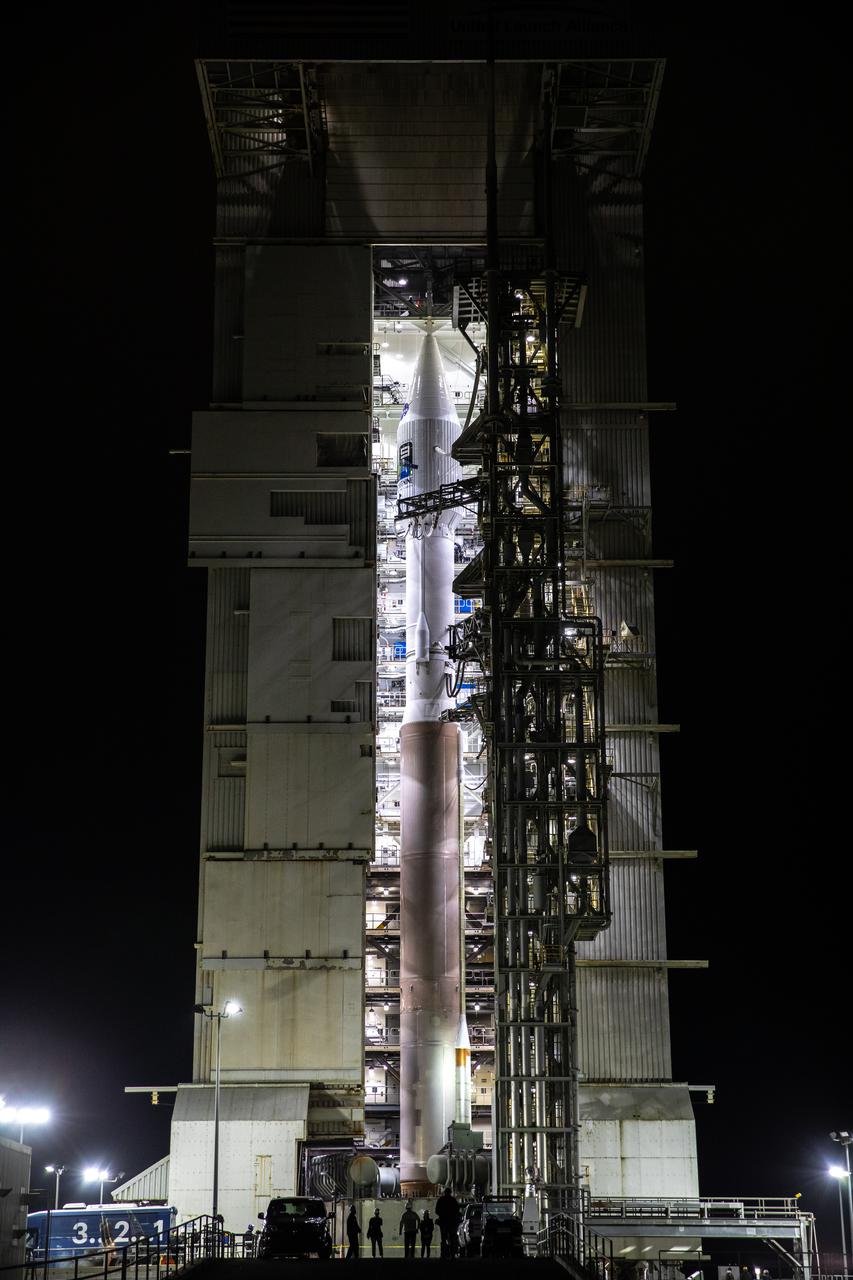
The United Launch Alliance Atlas V 401 rocket with NASA’s Landsat 9 satellite begins rollout from the Vertical Integration Facility to the launch pad at Space Launch Complex 3 (SLC-3) at Vandenberg Space Force Base in California, on Sept. 27, 2021. Landsat 9 is scheduled to launch at 2:12 p.m. EDT (11:12 a.m. PDT) today, Sept. 27, atop the Atlas V from SLC-3. The launch is managed by NASA’s Launch Services Program based at Kennedy Space Center. The Landsat 9 satellite will continue the nearly 50-year legacy of previous Landsat missions. It will join its sister satellite, Landsat 8, in orbit to monitor key natural and economic resources from orbit. Landsat 9 is managed by the agency’s Goddard Space Flight Center in Greenbelt, Maryland. The satellite will carry two instruments: the Operational Land Imager 2, which collects images of Earth’s landscapes in visible, near infrared and shortwave infrared light, and the Thermal Infrared Sensor 2, which measures the temperature of land surfaces. Like its predecessors, Landsat 9 is a joint mission between NASA and the U.S. Geological Survey.
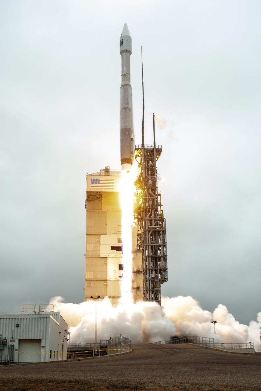
NASA’s Landsat 9 satellite launches on a United Launch Alliance Atlas V 401 rocket from Space Launch Complex 3 at Vandenberg Space Force Station in California on Sept. 27, 2021. Launch time was 2:11 p.m. EDT (11:11 a.m. PDT). The launch is managed by NASA’s Launch Services Program, based at the agency’s Kennedy Space Center in Florida. Landsat 9 will join its sister satellite, Landsat 8, in orbit in collecting images from across the planet every eight days. This calibrated data will continue the Landsat program’s critical role in monitoring the health of Earth and helping people manage essential resources, including crops, irrigation water, and forests. NASA Goddard manages the Landsat 9 mission. Goddard teams also built and tested one of the two instruments on Landsat 9, the Thermal Infrared Sensor 2 (TIRS-2) instrument. TIRS-2 will use thermal imaging to make measurements that can be used to estimate soil moisture and detect the health of plants.
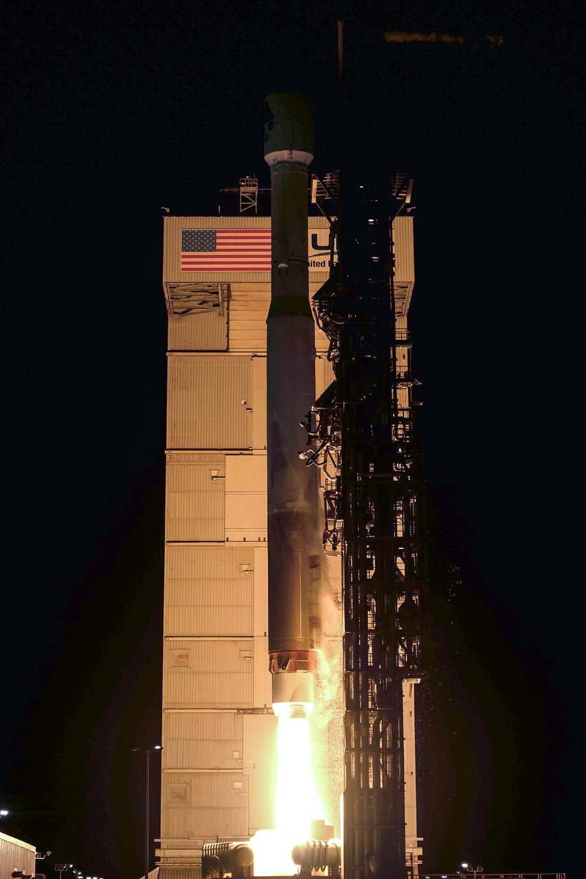
A United Launch Alliance Atlas V 401 rocket lifts off from Space Launch Complex 3 at Vandenberg Space Force Base in California on Nov. 10 carrying the National Oceanic and Atmospheric Administration’s (NOAA) Joint Polar Satellite System-2 (JPSS-2) and NASA’s Low-Earth Orbit Flight Test of an Inflatable Decelerator (LOFTID) technology demonstration. Liftoff was at 2:25 a.m. PDT. JPSS-2 is the third satellite in the polar satellite series and is expected to capture data to improve weather forecasts, helping scientists predict and prepare for extreme weather events and climate change. After JPSS-2 safely reaches orbit, LOFTID will follow a re-entry trajectory from low-Earth orbit to demonstrate the inflatable heat shield’s ability to slow down and survive re-entry. LOFTID is a partnership with ULA and is dedicated to the memory of Bernard Kutter, one of the company’s engineers who played a key role in developing the technology. LOFTID will demonstrate how the inflatable aeroshell, or heat shield, can slow down and survive re-entry in conditions relevant to many potential applications, whether landing humans on Mars, new missions to Venus and Titan, or returning heavier payloads and samples from low-Earth orbit.
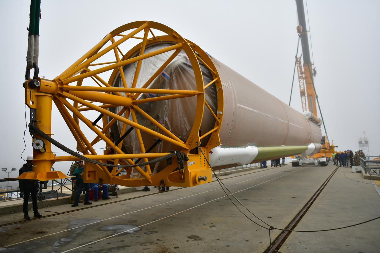
A special lifting device is attached to the United Launch Alliance Atlas V booster for NASA’s Landsat 9 mission at Space Launch Complex 3 at Vandenberg Space Force Base in California, on July 13, 2021. The booster will be lifted and moved into the Vertical Integration Facility. The Landsat 9 mission will launch atop the Atlas V rocket from Vandenberg in September 2021. The launch is being managed by NASA’s Launch Services Program based at Kennedy Space Center. The Landsat 9 satellite will continue the nearly 50-year legacy of previous Landsat missions. It will monitor key natural and economic resources from orbit. Landsat 9 is managed by the agency’s Goddard Space Flight Center in Greenbelt, Maryland. The satellite will carry two instruments: the Operational Land Imager 2, which collects images of Earth’s landscapes in visible, near infrared and shortwave infrared light, and the Thermal Infrared Sensor 2, which measures the temperature of land surfaces. Like its predecessors, Landsat 9 is a joint mission between NASA and the U.S. Geological Survey.
Inside the Vertical Integration Facility at Space Launch Complex 3 at Vandenberg Space Source Base in California, workers help secure the interstage and assembly second stage adapters to the Centaur second stage of the United Launch Alliance Atlas V rocket for NASA’s Landsat 9 mission on July 14, 2021. Landsat 9 will launch atop the Atlas V rocket from Vandenberg in September 2021. The launch is being managed by NASA’s Launch Services Program based at Kennedy Space Center, America’s multiuser spaceport. The Landsat 9 satellite will continue the nearly 50-year legacy of previous Landsat missions. It will monitor key natural and economic resources from orbit. Landsat 9 is managed by the agency’s Goddard Space Flight Center in Greenbelt, Maryland. The satellite will carry two instruments: the Operational Land Imager 2, which collects images of Earth’s landscapes in visible, near infrared and shortwave infrared light, and the Thermal Infrared Sensor 2, which measures the temperature of land surfaces. Like its predecessors, Landsat 9 is a joint mission between NASA and the U.S. Geological Survey.
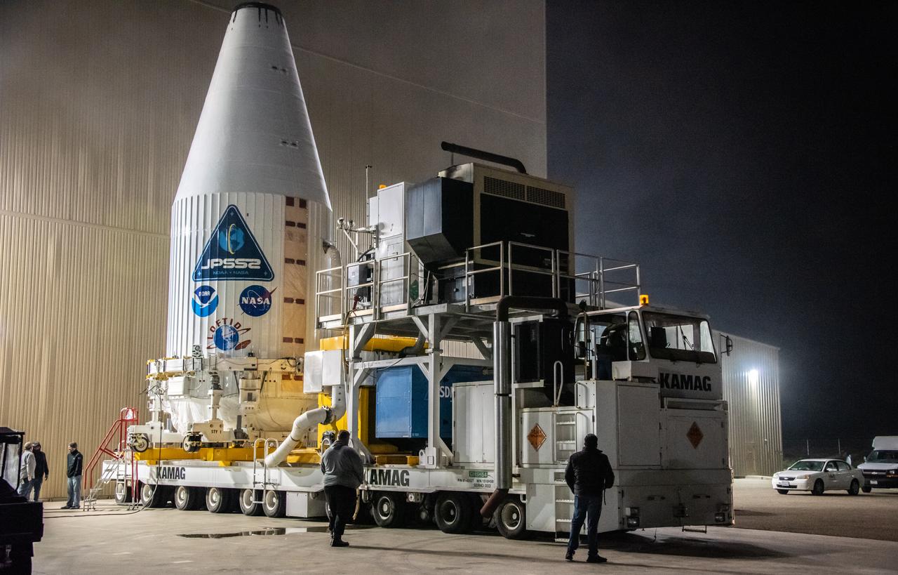
JPSS-2 Boat Tail transport and mate from HIF to SLC-3 and SLC-3, Vandenberg Space Force Base in California.
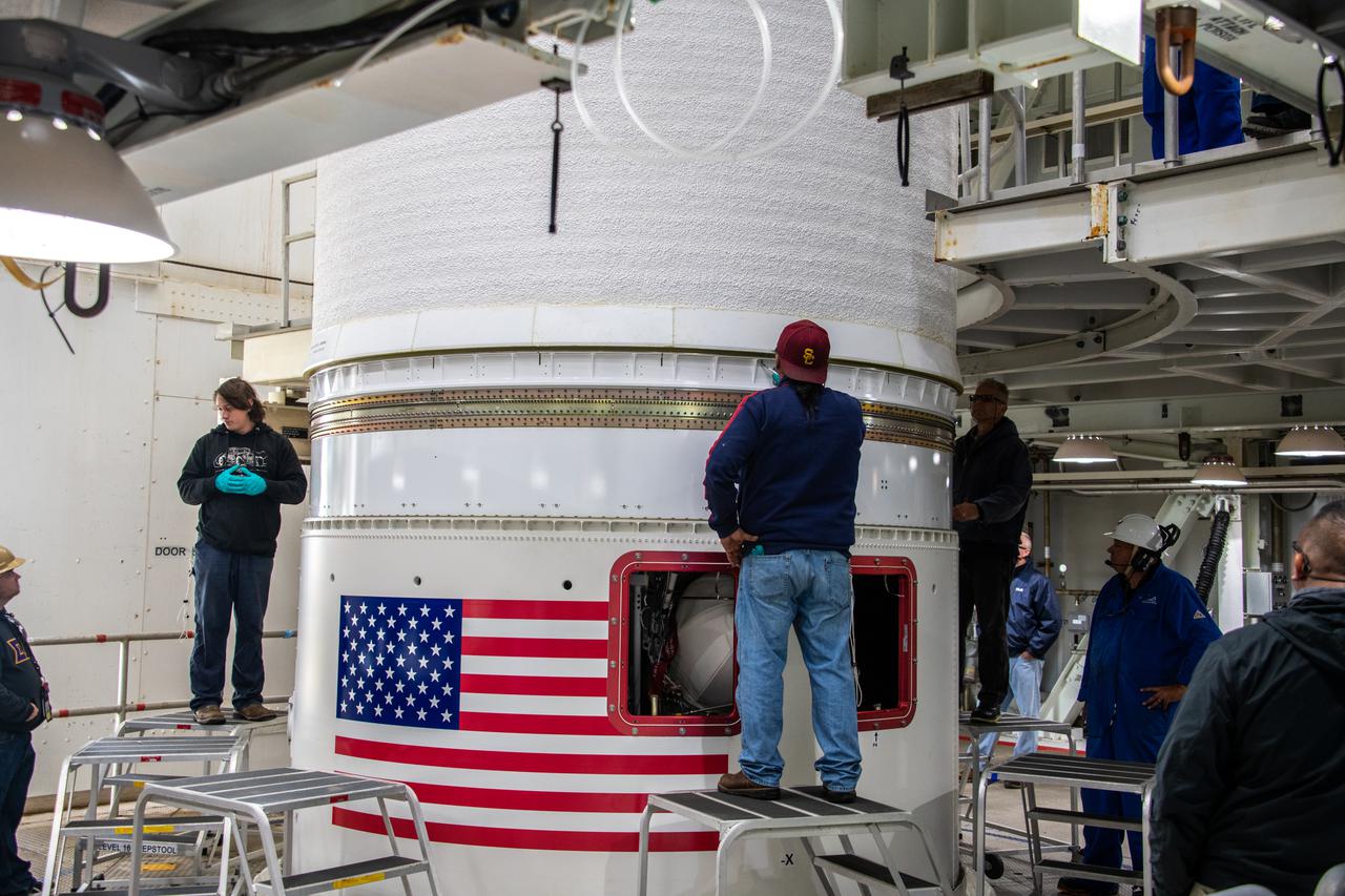
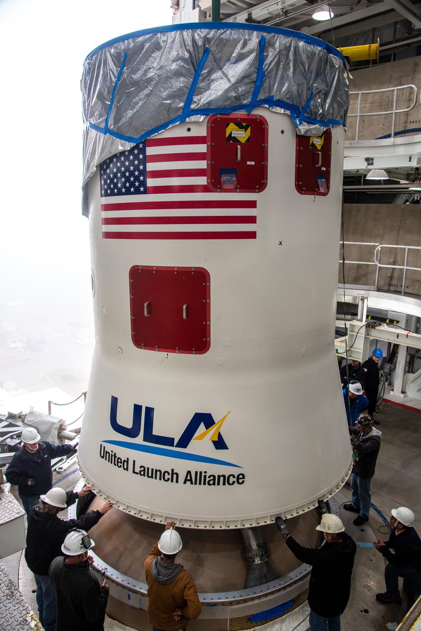
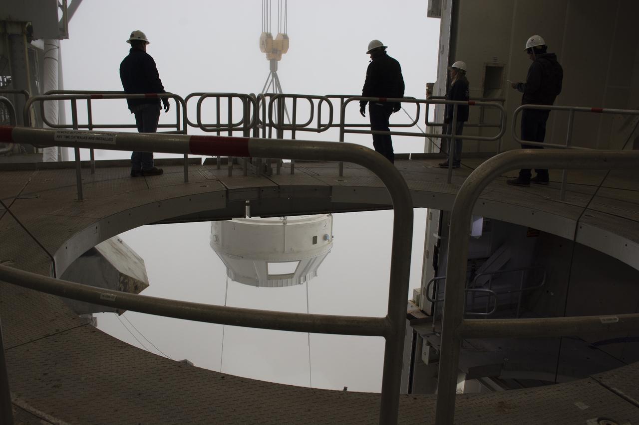
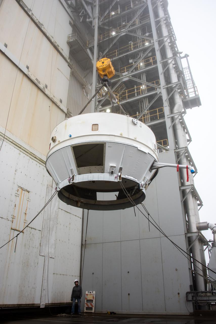
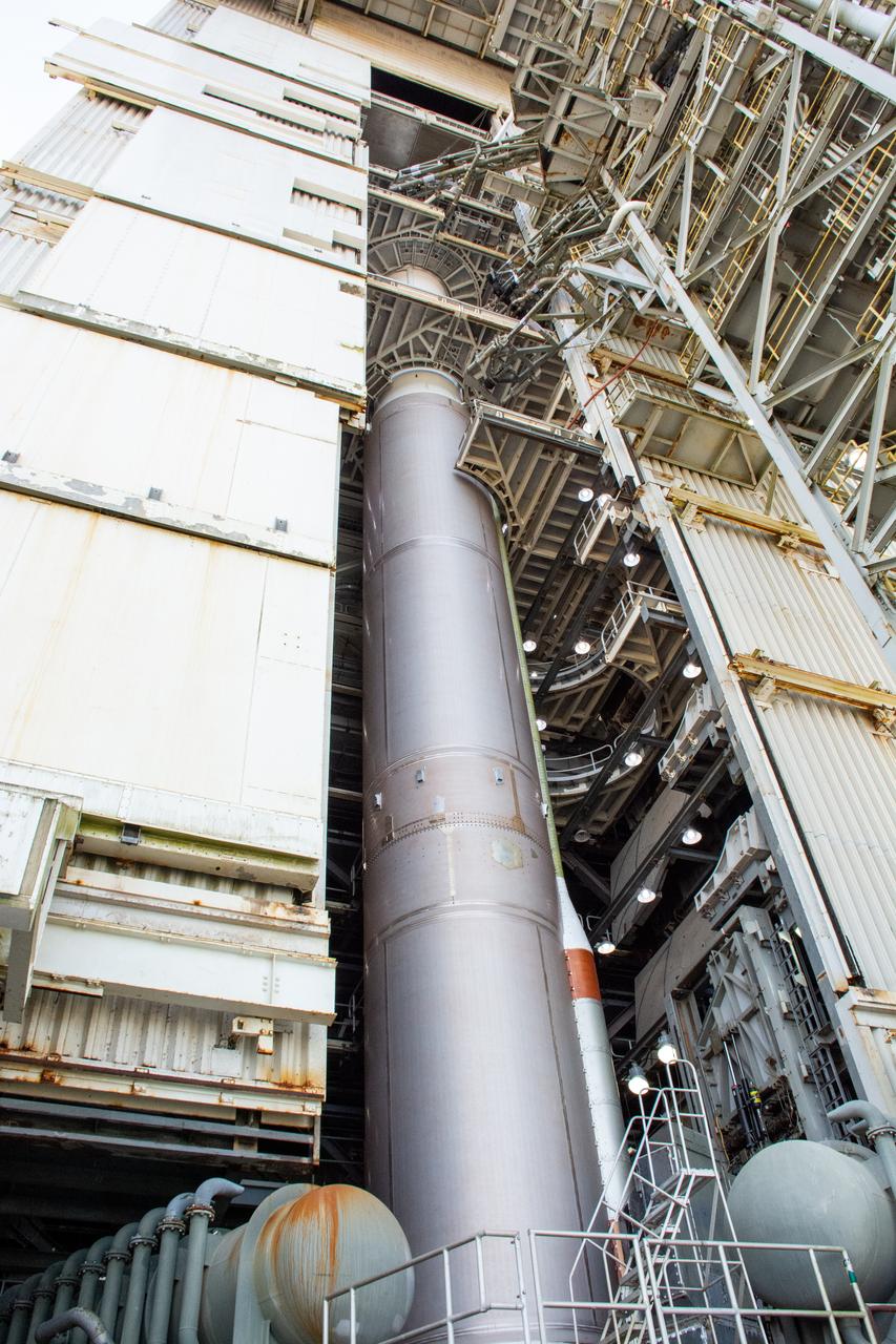
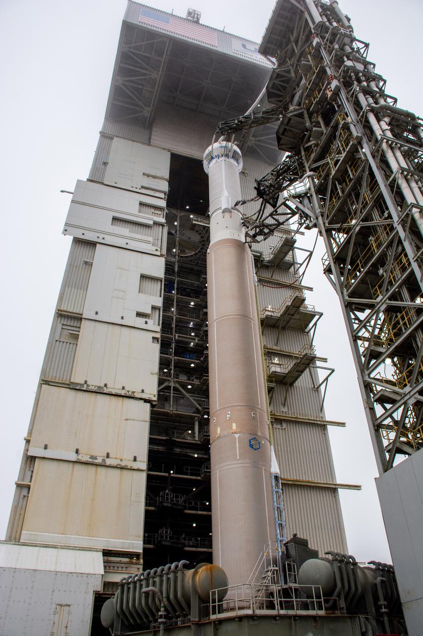
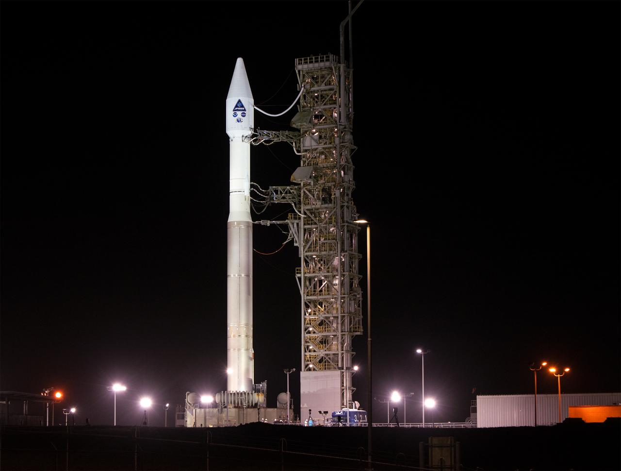
Inside the Vertical Integration Facility (VIF) at Vandenberg Space Force Base in California, technicians secure the United Launch Alliance (ULA) Atlas V boattail onto the rocket’s Centaur upper stage on Oct. 4, 2022, for the National Oceanic and Atmospheric Administration’s (NOAA) and NASA’s Joint Polar Satellite System-2 (JPSS-2) mission. The boattail is the connecting piece of flight hardware that joins that Atlas V upper stage with the payload fairing – the protective casing surrounding the JPSS-2 satellite. Once the payload fairing arrives at the VIF, teams will lower it onto the boattail to complete the Atlas V stack. JPSS-2 is the third satellite in the Joint Polar Satellite System series and will scan the Earth as it orbits from the North to the South Pole, crossing the equator 14 times a day. Operating from 512 miles above Earth, JPSS-2 will capture data to improve weather forecasts, in turn helping scientists predict and prepare for extreme weather events and climate change. Launching as a secondary payload to JPSS-2 is NASA’s Low-Earth Orbit Flight Test of an Inflatable Decelerator (LOFTID), dedicated to the memory of Bernard Kutter. LOFTID is a technology demonstration of an inflatable heat shield that could one day help land humans on Mars. Liftoff is targeted for 2:25 a.m. Pacific time (5:25 a.m. Eastern time) on Nov. 1, 2022, from Vandenberg’s Space Launch Complex-3E.

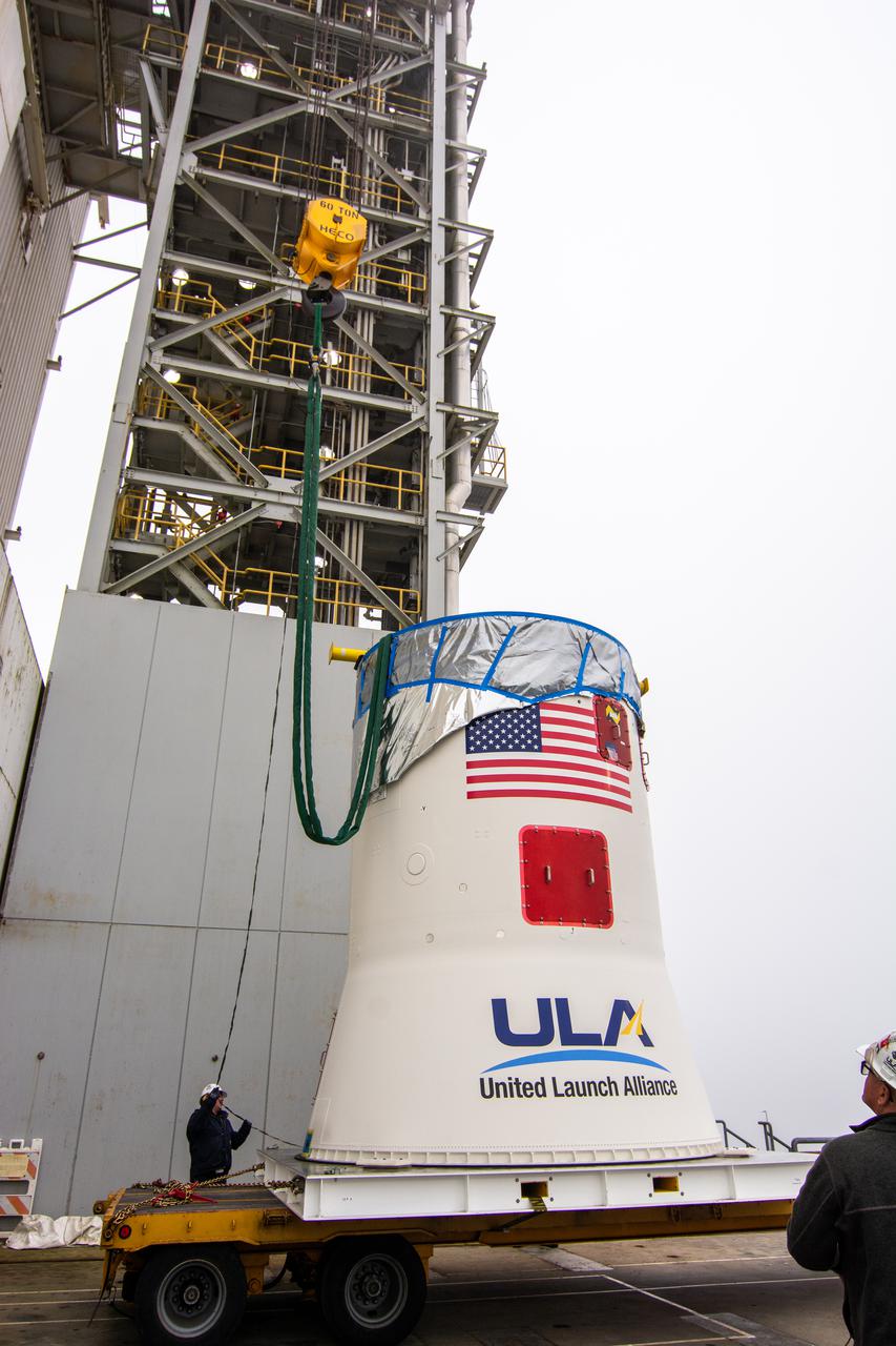
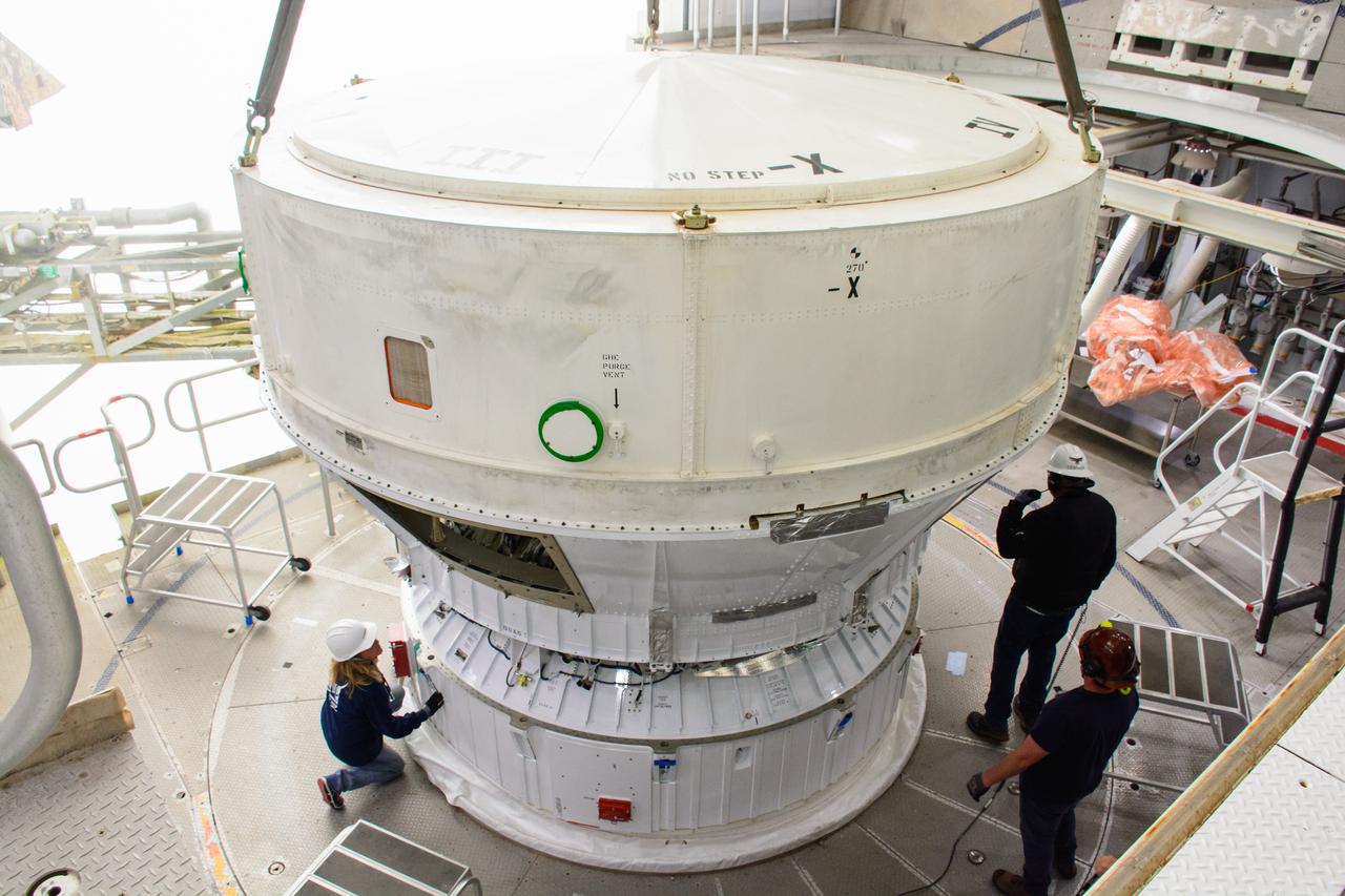
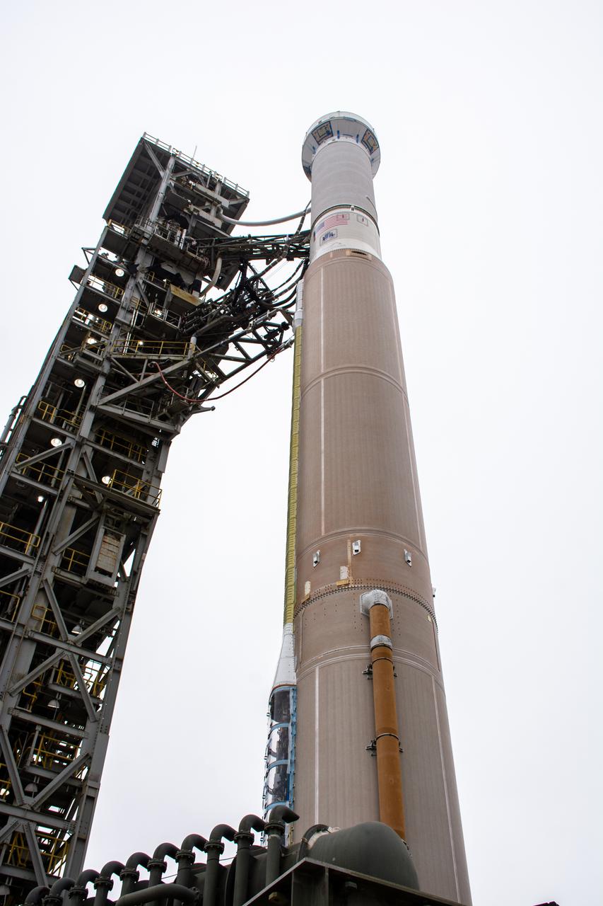
The Atlas V boat tail for the Landsat 9 mission is lifted and mated at Vandenberg Space Force Base’s Space Launch Complex 3 in California on July 17, 2021. The Landsat 9 mission launch, which is being managed by NASA’s Launch Services Program based at Kennedy Space Center in Florida, is targeted for no earlier than Sept. 27, 2021. Landsat 9 will monitor key natural and economic resources from orbit. The satellite will carry two instruments: the Operational Land Imager 2, which collects images of Earth’s landscapes in visible, near infrared and shortwave infrared light, and the Thermal Infrared Sensor 2, which measures the temperature of land surfaces. Landsat 9 is a joint mission between NASA and the U.S. Geological Survey.
Inside the Vertical Integration Facility (VIF) at Vandenberg Space Force Base in California, technicians monitor the United Launch Alliance (ULA) Atlas V boattail as it’s lowered by crane onto the rocket’s Centaur upper stage on Oct. 4, 2022, for the National Oceanic and Atmospheric Administration’s (NOAA) and NASA’s Joint Polar Satellite System-2 (JPSS-2) mission. The boattail is the connecting piece of flight hardware that joins that Atlas V upper stage with the payload fairing – the protective casing surrounding the JPSS-2 satellite. Once the payload fairing arrives at the VIF, teams will lower it onto the boattail to complete the Atlas V stack. JPSS-2 is the third satellite in the Joint Polar Satellite System series and will scan the Earth as it orbits from the North to the South Pole, crossing the equator 14 times a day. Operating from 512 miles above Earth, JPSS-2 will capture data to improve weather forecasts, in turn helping scientists predict and prepare for extreme weather events and climate change. Launching as a secondary payload to JPSS-2 is NASA’s Low-Earth Orbit Flight Test of an Inflatable Decelerator (LOFTID), dedicated to the memory of Bernard Kutter. LOFTID is a technology demonstration of an inflatable heat shield that could one day help land humans on Mars. Liftoff is targeted for 2:25 a.m. Pacific time (5:25 a.m. Eastern time) on Nov. 1, 2022, from Vandenberg’s Space Launch Complex-3E.
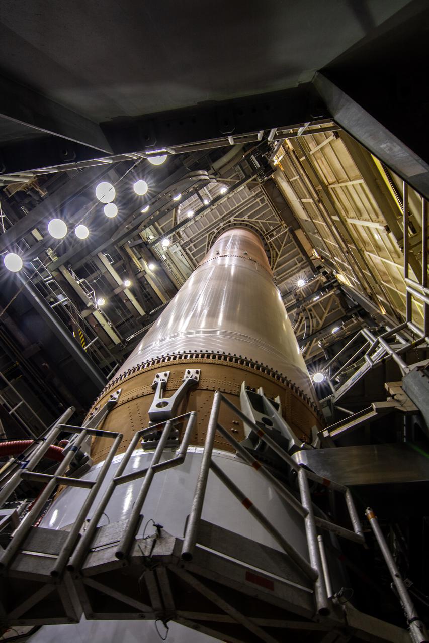
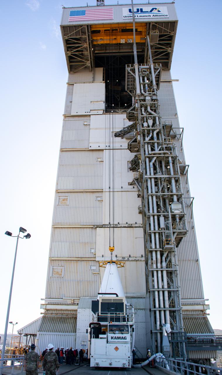
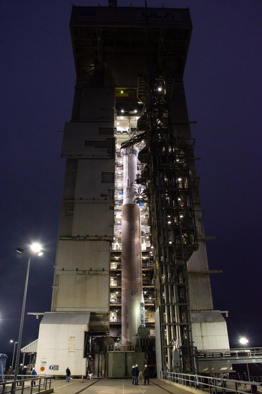
The United Launch Alliance Atlas V booster for NASA’s Landsat 9 mission is positioned inside the Vertical Integration Facility at Space Launch Complex 3 at Vandenberg Space Force Base in California on Aug. 26, 2021. The Landsat 9 mission will launch atop the Atlas V rocket from Vandenberg in September 2021. The launch is being managed by NASA’s Launch Services Program based at Kennedy Space Center. The Landsat 9 satellite will continue the nearly 50-year legacy of previous Landsat missions. It will monitor key natural and economic resources from orbit. Landsat 9 is managed by the agency’s Goddard Space Flight Center in Greenbelt, Maryland. The satellite will carry two instruments: the Operational Land Imager 2, which collects images of Earth’s landscapes in visible, near infrared and shortwave infrared light, and the Thermal Infrared Sensor 2, which measures the temperature of land surfaces. Like its predecessors, Landsat 9 is a joint mission between NASA and the U.S. Geological Survey.
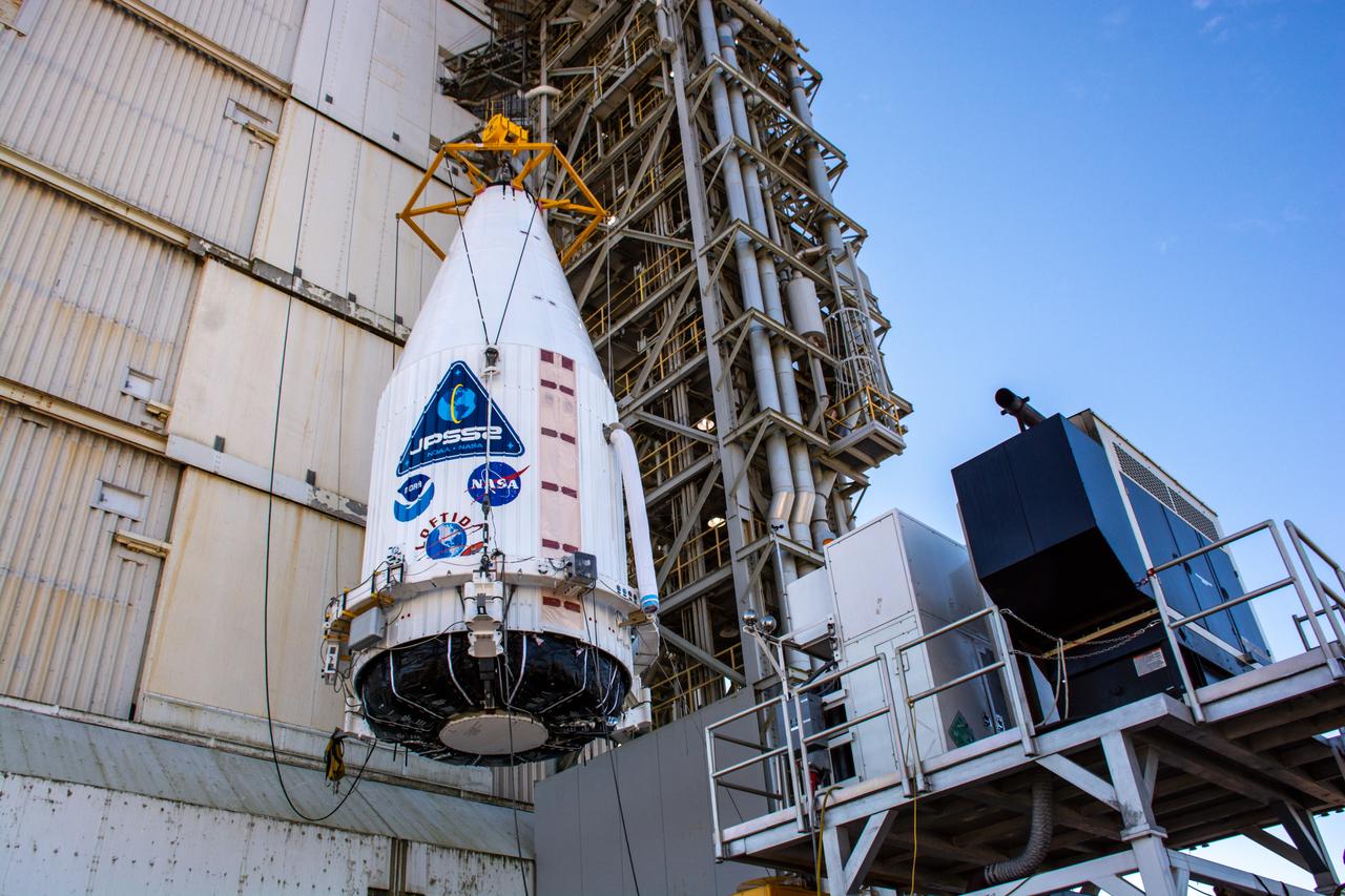
A close-up view of the United Launch Alliance Atlas V payload fairing containing the National Oceanic and Atmospheric Administration’s (NOAA) Joint Polar Satellite System-2 (JPSS-2) as it is hoisted up by crane at the vertical integration facility at Space Launch Complex 3 at Vandenberg Space Force Base (VSFB) in California on Oct. 18, 2022. Inside the fairing, JPSS-2 is stacked atop NASA’s Low-Earth Orbit Flight Test of an Inflatable Decelerator (LOFTID) secondary payload. JPSS-2 is the third satellite in the Joint Polar Satellite System series. It is scheduled to lift off from VSFB on Nov. 1 from SLC-3. JPSS-2, which will be renamed NOAA-21 after reaching orbit, will join a constellation of JPSS satellites that orbit from the North to the South pole, circling Earth 14 times a day and providing a full view of the entire globe twice daily. The NOAA/NASA Suomi National Polar-orbiting Partnership (Suomi NPP) satellite, and NOAA-20, previously known as JPSS-1, are both already in orbit. Each satellite carries at least four advanced instruments to measure weather and climate conditions on Earth. LOFTID is dedicated to the memory of Bernard Kutter. LOFTID will demonstrate inflatable heat shield technology that could enable a variety of proposed NASA missions to destinations such as Mars, Venus, and Titan, as well as returning heavier payloads from low-Earth orbit.
The United Launch Alliance Atlas V 401 rocket with NASA’s Landsat 9 satellite rolls out from the Vertical Integration Facility to the launch pad at Space Launch Complex 3 (SLC-3) at Vandenberg Space Force Base in California, on Sept. 27, 2021. Landsat 9 is scheduled to launch at 2:12 p.m. EDT (11:12 a.m. PDT) today, Sept. 27, atop the Atlas V from SLC-3. The launch is managed by NASA’s Launch Services Program based at Kennedy Space Center. The Landsat 9 satellite will continue the nearly 50-year legacy of previous Landsat missions. It will join its sister satellite, Landsat 8, in orbit to monitor key natural and economic resources from orbit. Landsat 9 is managed by the agency’s Goddard Space Flight Center in Greenbelt, Maryland. The satellite will carry two instruments: the Operational Land Imager 2, which collects images of Earth’s landscapes in visible, near infrared and shortwave infrared light, and the Thermal Infrared Sensor 2, which measures the temperature of land surfaces. Like its predecessors, Landsat 9 is a joint mission between NASA and the U.S. Geological Survey.
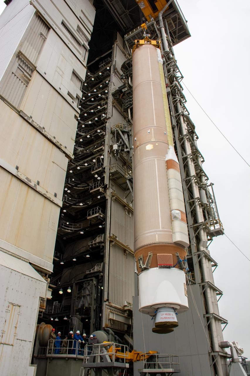
The United Launch Alliance Atlas V booster for NASA’s Landsat 9 mission is lifted by crane for its move into the Vertical Integration Facility at Space Launch Complex 3 at Vandenberg Space Force Base in California, on July 13, 2021. The Landsat 9 mission will launch atop the Atlas V rocket from Vandenberg in September 2021. The launch is being managed by NASA’s Launch Services Program based at Kennedy Space Center. The Landsat 9 satellite will continue the nearly 50-year legacy of previous Landsat missions. It will monitor key natural and economic resources from orbit. Landsat 9 is managed by the agency’s Goddard Space Flight Center in Greenbelt, Maryland. The satellite will carry two instruments: the Operational Land Imager 2, which collects images of Earth’s landscapes in visible, near infrared and shortwave infrared light, and the Thermal Infrared Sensor 2, which measures the temperature of land surfaces. Like its predecessors, Landsat 9 is a joint mission between NASA and the U.S. Geological Survey.
The United Launch Alliance Atlas V booster for NASA’s Landsat 9 mission is lifted by crane and a special lifting advice for transfer into the Vertical Integration Facility at Space Launch Complex 3 at Vandenberg Space Force Base in California, on July 13, 2021. The Landsat 9 mission will launch atop the Atlas V rocket from Vandenberg in September 2021. The launch is being managed by NASA’s Launch Services Program based at Kennedy Space Center. The Landsat 9 satellite will continue the nearly 50-year legacy of previous Landsat missions. It will monitor key natural and economic resources from orbit. Landsat 9 is managed by the agency’s Goddard Space Flight Center in Greenbelt, Maryland. The satellite will carry two instruments: the Operational Land Imager 2, which collects images of Earth’s landscapes in visible, near infrared and shortwave infrared light, and the Thermal Infrared Sensor 2, which measures the temperature of land surfaces. Like its predecessors, Landsat 9 is a joint mission between NASA and the U.S. Geological Survey.
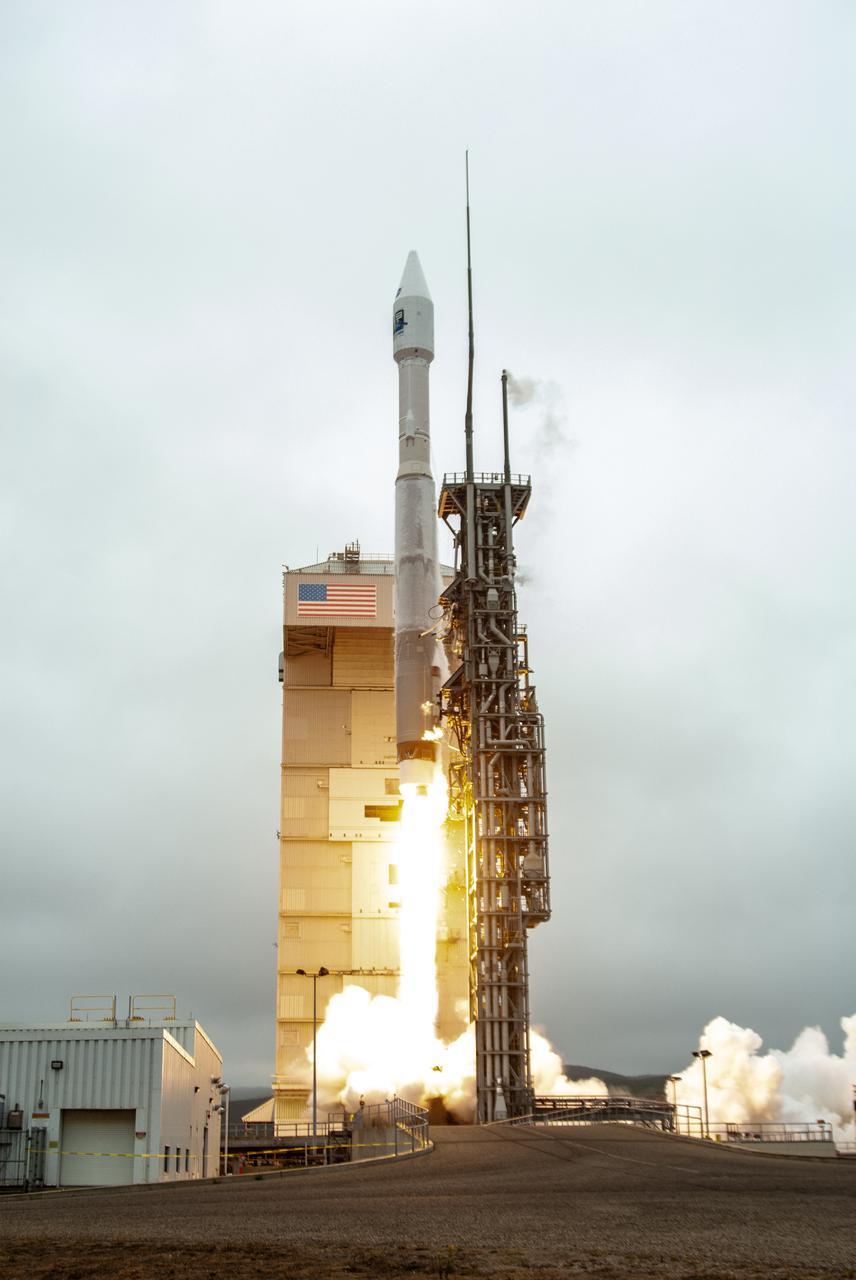
NASA’s Landsat 9 satellite launches on a United Launch Alliance Atlas V 401 rocket from Space Launch Complex 3 at Vandenberg Space Force Station in California on Sept. 27, 2021. Launch time was 2:11 p.m. EDT (11:11 a.m. PDT). The launch is managed by NASA’s Launch Services Program, based at the agency’s Kennedy Space Center in Florida. Landsat 9 will join its sister satellite, Landsat 8, in orbit in collecting images from across the planet every eight days. This calibrated data will continue the Landsat program’s critical role in monitoring the health of Earth and helping people manage essential resources, including crops, irrigation water, and forests. NASA Goddard manages the Landsat 9 mission. Goddard teams also built and tested one of the two instruments on Landsat 9, the Thermal Infrared Sensor 2 (TIRS-2) instrument. TIRS-2 will use thermal imaging to make measurements that can be used to estimate soil moisture and detect the health of plants.
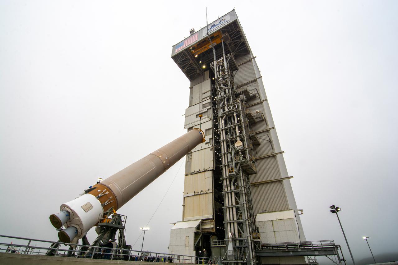
The Atlas V booster for the Landsat 9 satellite undergoes a dress rehearsal at Vandenberg Space Force Base’s Space Launch Complex 3 in California on Sept. 3, 2021. The Landsat 9 mission launch, which is being managed by NASA’s Launch Services Program based at Kennedy Space Center in Florida, is targeted for no earlier than Sept. 27, 2021. Landsat 9 will monitor key natural and economic resources from orbit. The satellite will carry two instruments: the Operational Land Imager 2, which collects images of Earth’s landscapes in visible, near infrared and shortwave infrared light, and the Thermal Infrared Sensor 2, which measures the temperature of land surfaces. Landsat 9 is a joint mission between NASA and the U.S. Geological Survey.
The United Launch Alliance Atlas V payload fairing containing the National Oceanic and Atmospheric Administration’s (NOAA) Joint Polar Satellite System-2 (JPSS-2) is lifted high for transfer into the vertical integration facility at Space Launch Complex 3 at Vandenberg Space Force Base (VSFB) in California on Oct. 18, 2022. Inside the fairing, JPSS-2 is stacked atop NASA’s Low-Earth Orbit Flight Test of an Inflatable Decelerator (LOFTID) secondary payload. JPSS-2 is the third satellite in the Joint Polar Satellite System series. It is scheduled to lift off from VSFB on Nov. 1 from SLC-3. JPSS-2, which will be renamed NOAA-21 after reaching orbit, will join a constellation of JPSS satellites that orbit from the North to the South pole, circling Earth 14 times a day and providing a full view of the entire globe twice daily. The NOAA/NASA Suomi National Polar-orbiting Partnership (Suomi NPP) satellite, and NOAA-20, previously known as JPSS-1, are both already in orbit. Each satellite carries at least four advanced instruments to measure weather and climate conditions on Earth. LOFTID is dedicated to the memory of Bernard Kutter. LOFTID will demonstrate inflatable heat shield technology that could enable a variety of proposed NASA missions to destinations such as Mars, Venus, and Titan, as well as returning heavier payloads from low-Earth orbit.
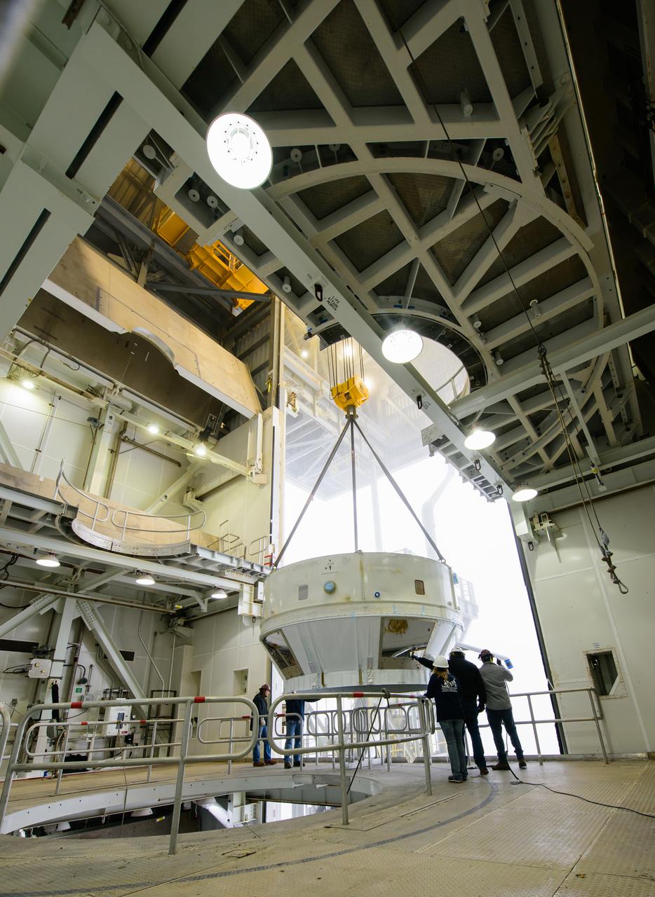
The interstage and assembly second stage adapters for the United Alliance Centaur Atlas V for NASA’s Landsat 9 mission are lifted by crane from a flatbed truck at Space Launch Complex 3 at Vandenberg Space Force Base in California, on July 14, 2021. The adapters will be stacked atop the Centaur second stage in the Vertical Integration Facility near the launch pad. The Landsat 9 mission will launch atop the Atlas V rocket from Vandenberg in September 2021. The launch is being managed by NASA’s Launch Services Program based at Kennedy Space Center, America’s multiuser spaceport. The Landsat 9 satellite will continue the nearly 50-year legacy of previous Landsat missions. It will monitor key natural and economic resources from orbit. Landsat 9 is managed by the agency’s Goddard Space Flight Center in Greenbelt, Maryland. The satellite will carry two instruments: the Operational Land Imager 2, which collects images of Earth’s landscapes in visible, near infrared and shortwave infrared light, and the Thermal Infrared Sensor 2, which measures the temperature of land surfaces. Like its predecessors, Landsat 9 is a joint mission between NASA and the U.S. Geological Survey.
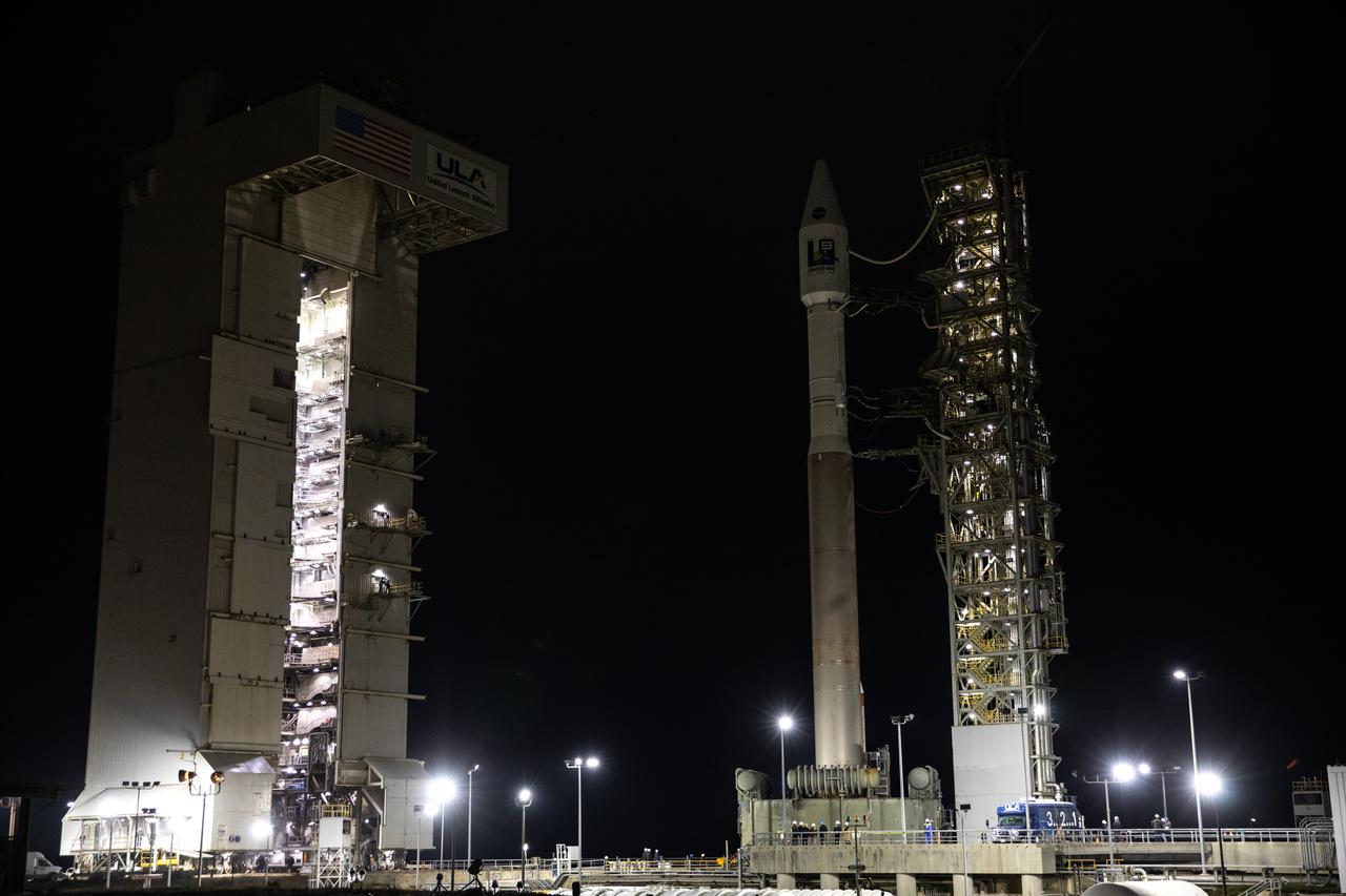
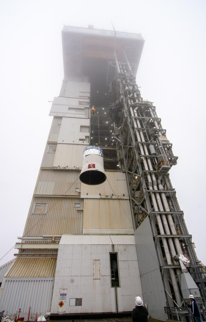
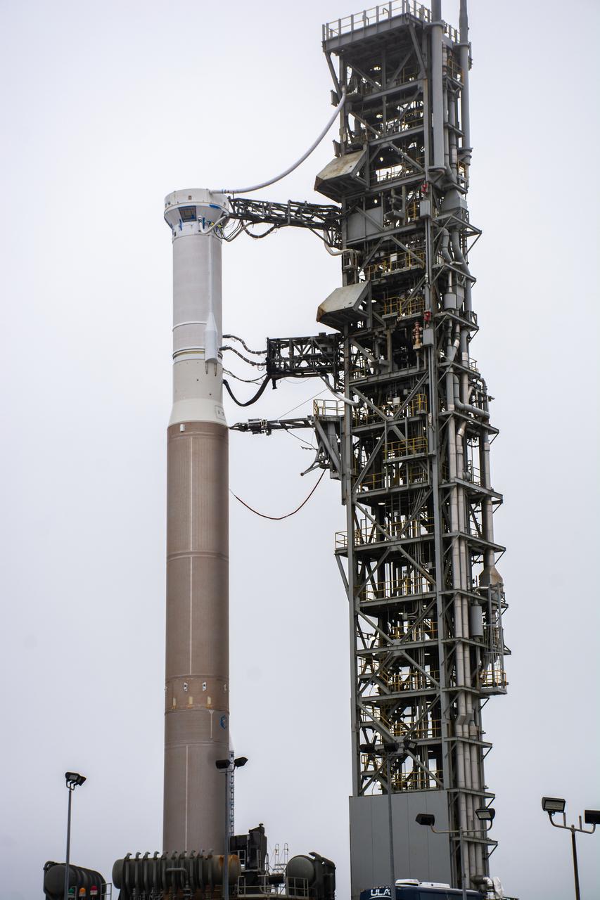
The mobile service tower doors are open at Space Launch Complex-3 (SLC-3) at Vandenberg Space Force Base in California on Oct. 28, 2022, revealing the United Launch Alliance Atlas V rocket with the National Oceanic and Atmospheric Administration’s (NOAA) Joint Polar Satellite System-2 (JPSS-2) and NASA’s Low-Earth Orbit Flight Test of an Inflatable Decelerator (LOFTID) atop. NASA and ULA are targeting launch for no earlier than Wednesday, Nov. 9, pending range availability. JPSS-2, which will be renamed NOAA-21 after reaching orbit, will join a constellation of JPSS satellites that orbit from the North to the South pole, circling Earth 14 times a day. The NOAA/NASA Suomi National Polar-orbiting Partnership (Suomi NPP) satellite, and NOAA-20, previously known as JPSS-1, are both already in orbit. Each satellite carries at least four advanced instruments to measure weather and climate conditions on Earth. LOFTID will demonstrate inflatable heat shield technology that could enable a variety of proposed NASA missions to destinations such as Mars, Venus, and Titan, as well as returning heavier payloads from low-Earth orbit.
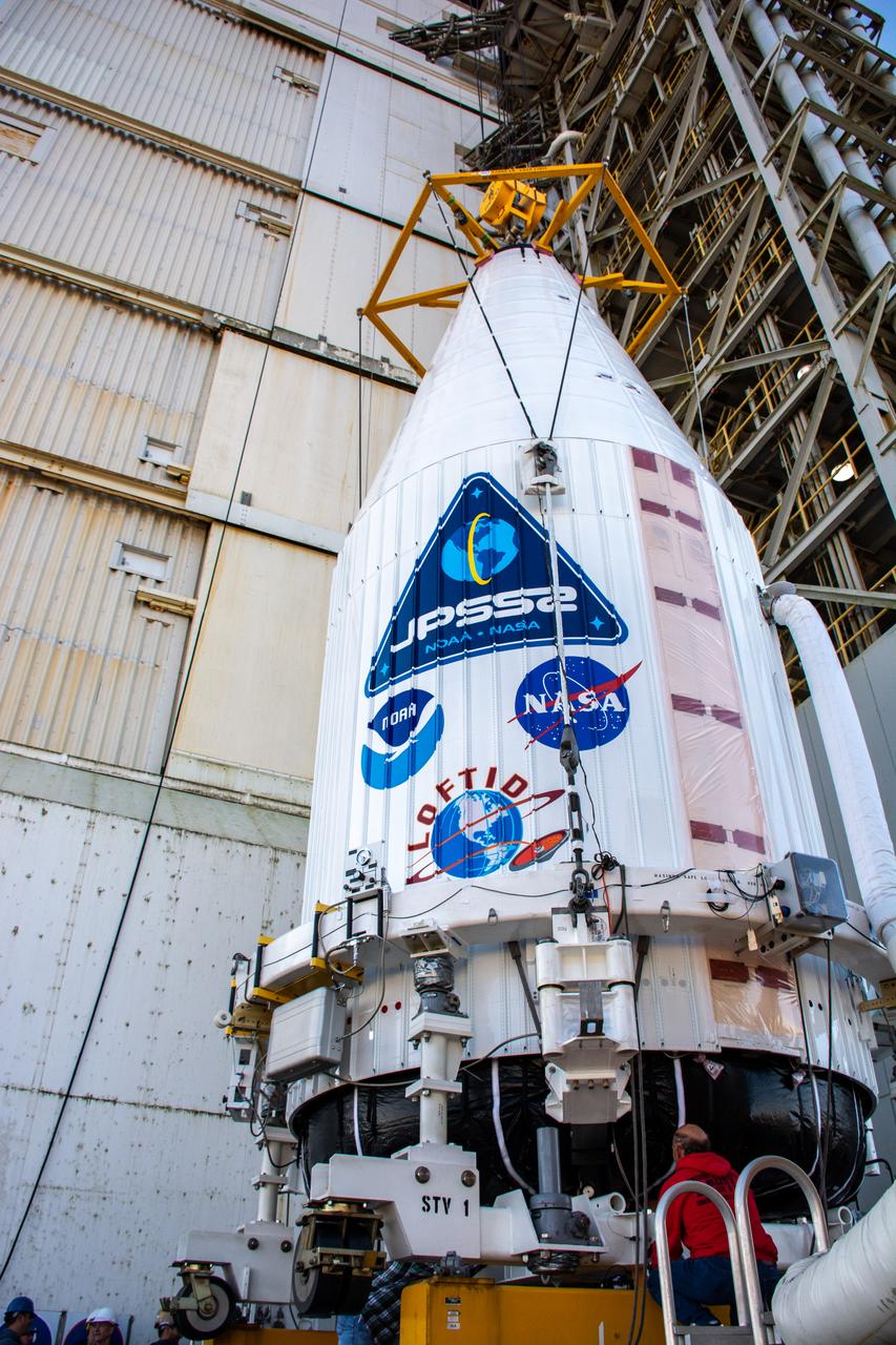
The United Launch Alliance Atlas V payload fairing containing the National Oceanic and Atmospheric Administration’s (NOAA) Joint Polar Satellite System-2 (JPSS-2) is lifted by crane at the vertical integration facility at Space Launch Complex 3 at Vandenberg Space Force Base (VSFB) in California on Oct. 18, 2022. Inside the fairing, JPSS-2 is stacked atop NASA’s Low-Earth Orbit Flight Test of an Inflatable Decelerator (LOFTID) secondary payload. JPSS-2 is the third satellite in the Joint Polar Satellite System series. It is scheduled to lift off from VSFB on Nov. 1 from SLC-3. JPSS-2, which will be renamed NOAA-21 after reaching orbit, will join a constellation of JPSS satellites that orbit from the North to the South pole, circling Earth 14 times a day and providing a full view of the entire globe twice daily. The NOAA/NASA Suomi National Polar-orbiting Partnership (Suomi NPP) satellite, and NOAA-20, previously known as JPSS-1, are both already in orbit. Each satellite carries at least four advanced instruments to measure weather and climate conditions on Earth. LOFTID is dedicated to the memory of Bernard Kutter. LOFTID will demonstrate inflatable heat shield technology that could enable a variety of proposed NASA missions to destinations such as Mars, Venus, and Titan, as well as returning heavier payloads from low-Earth orbit.

A special lifting device is used to move the United Launch Alliance Centaur second stage for NASA’s Landsat 9 mission to the vertical position for lifting into the Vertical Integration Facility at Space Launch Complex 3 at Vandenberg Space Force Base in California, on July 15, 2021. The Centaur will be attached to the top of the Atlas V booster. The Landsat 9 mission will launch atop the Atlas V rocket from Vandenberg in September 2021. The launch is being managed by NASA’s Launch Services Program based at Kennedy Space Center, America’s multiuser spaceport. The Landsat 9 satellite will continue the nearly 50-year legacy of previous Landsat missions. It will monitor key natural and economic resources from orbit. Landsat 9 is managed by the agency’s Goddard Space Flight Center in Greenbelt, Maryland. The satellite will carry two instruments: the Operational Land Imager 2, which collects images of Earth’s landscapes in visible, near infrared and shortwave infrared light, and the Thermal Infrared Sensor 2, which measures the temperature of land surfaces. Like its predecessors, Landsat 9 is a joint mission between NASA and the U.S. Geological Survey.
The interstage and assembly second stage adapters for the United Alliance Atlas V Centaur second stage for NASA’s Landsat 9 mission are lifted by crane at Space Launch Complex 3 at Vandenberg Space Force Base in California, on July 14, 2021. The adapters will be stacked atop the Centaur second stage in the Vertical Integration Facility near the launch pad. The Landsat 9 mission will launch atop the Atlas V rocket from Vandenberg in September 2021. The launch is being managed by NASA’s Launch Services Program based at Kennedy Space Center, America’s multiuser spaceport. The Landsat 9 satellite will continue the nearly 50-year legacy of previous Landsat missions. It will monitor key natural and economic resources from orbit. Landsat 9 is managed by the agency’s Goddard Space Flight Center in Greenbelt, Maryland. The satellite will carry two instruments: the Operational Land Imager 2, which collects images of Earth’s landscapes in visible, near infrared and shortwave infrared light, and the Thermal Infrared Sensor 2, which measures the temperature of land surfaces. Like its predecessors, Landsat 9 is a joint mission between NASA and the U.S. Geological Survey.
The United Launch Alliance Atlas V 401 rocket with NASA’s Landsat 9 satellite rolls out from the Vertical Integration Facility on its way to the launch pad at Space Launch Complex 3 (SLC-3) at Vandenberg Space Force Base in California, on Sept. 27, 2021. Landsat 9 is scheduled to launch at 2:12 p.m. EDT (11:12 a.m. PDT) today, Sept. 27, atop the Atlas V from SLC-3. The launch is managed by NASA’s Launch Services Program based at Kennedy Space Center. The Landsat 9 satellite will continue the nearly 50-year legacy of previous Landsat missions. It will join its sister satellite, Landsat 8, in orbit to monitor key natural and economic resources from orbit. Landsat 9 is managed by the agency’s Goddard Space Flight Center in Greenbelt, Maryland. The satellite will carry two instruments: the Operational Land Imager 2, which collects images of Earth’s landscapes in visible, near infrared and shortwave infrared light, and the Thermal Infrared Sensor 2, which measures the temperature of land surfaces. Like its predecessors, Landsat 9 is a joint mission between NASA and the U.S. Geological Survey.
The United Launch Alliance Atlas V booster for NASA’s Landsat 9 mission arrives at the Vertical Integration Facility at Space Launch Complex 3 at Vandenberg Space Force Base in California, on July 12, 2021. The Landsat 9 mission will launch atop the Atlas V rocket from Vandenberg in September 2021. The launch is being managed by NASA’s Launch Services Program based at Kennedy Space Center. The Landsat 9 satellite will continue the nearly 50-year legacy of previous Landsat missions. It will monitor key natural and economic resources from orbit. Landsat 9 is managed by the agency’s Goddard Space Flight Center in Greenbelt, Maryland. The satellite will carry two instruments: the Operational Land Imager 2, which collects images of Earth’s landscapes in visible, near infrared and shortwave infrared light, and the Thermal Infrared Sensor 2, which measures the temperature of land surfaces. Like its predecessors, Landsat 9 is a joint mission between NASA and the U.S. Geological Survey.

The Atlas V boat tail for the Landsat 9 mission is lifted and mated at Vandenberg Space Force Base’s Space Launch Complex 3 in California on July 17, 2021. The Landsat 9 mission launch, which is being managed by NASA’s Launch Services Program based at Kennedy Space Center in Florida, is targeted for no earlier than Sept. 27, 2021. Landsat 9 will monitor key natural and economic resources from orbit. The satellite will carry two instruments: the Operational Land Imager 2, which collects images of Earth’s landscapes in visible, near infrared and shortwave infrared light, and the Thermal Infrared Sensor 2, which measures the temperature of land surfaces. Landsat 9 is a joint mission between NASA and the U.S. Geological Survey.
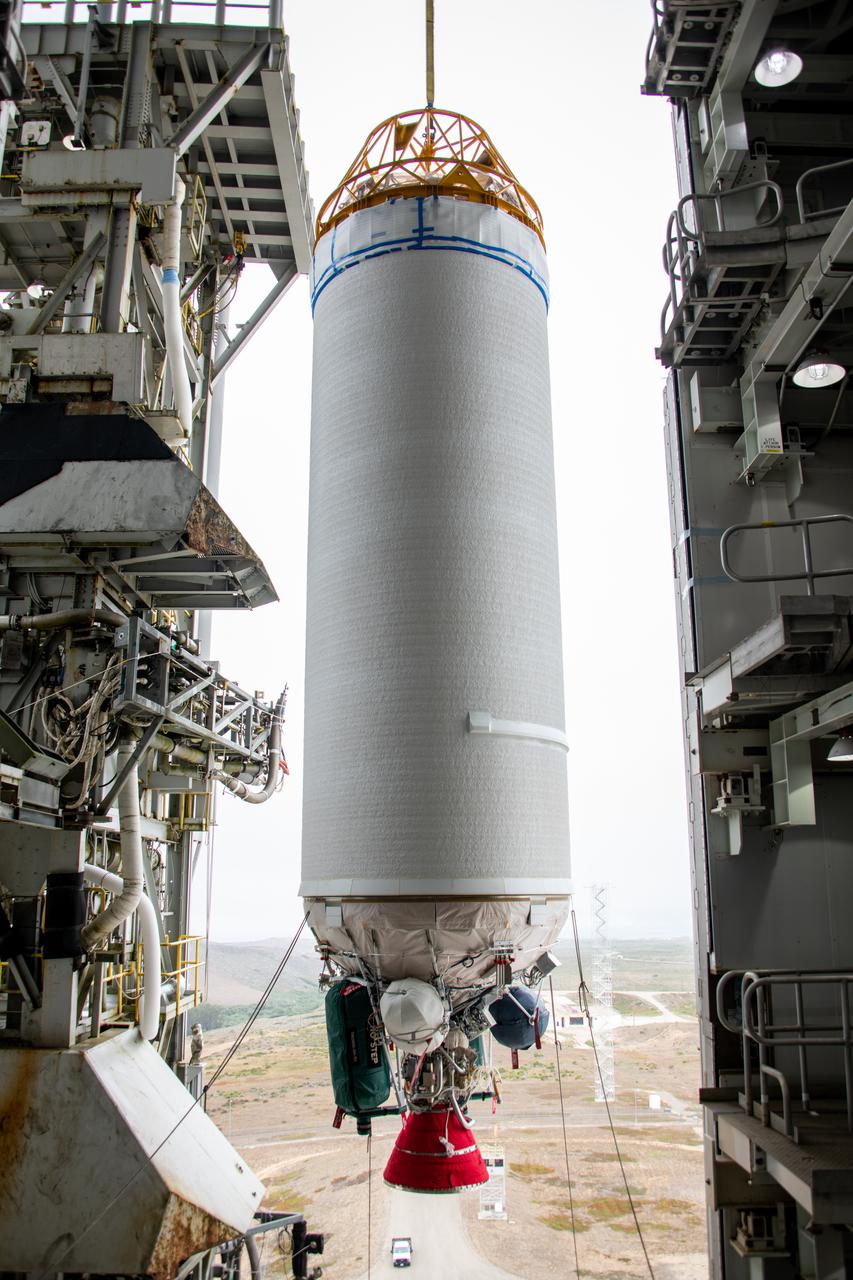
The United Launch Alliance Centaur second stage for NASA’s Landsat 9 mission seems suspended in midair in this view from inside the Vertical Integration Facility at Space Launch Complex 3 at Vandenberg Space Force Base in California, on July 15, 2021. The Centaur will be moved into the integration facility and attached to the top of the Atlas V booster. The Landsat 9 mission will launch atop the Atlas V rocket from Vandenberg in September 2021. The launch is being managed by NASA’s Launch Services Program based at Kennedy Space Center, America’s multiuser spaceport. The Landsat 9 satellite will continue the nearly 50-year legacy of previous Landsat missions. It will monitor key natural and economic resources from orbit. Landsat 9 is managed by the agency’s Goddard Space Flight Center in Greenbelt, Maryland. The satellite will carry two instruments: the Operational Land Imager 2, which collects images of Earth’s landscapes in visible, near infrared and shortwave infrared light, and the Thermal Infrared Sensor 2, which measures the temperature of land surfaces. Like its predecessors, Landsat 9 is a joint mission between NASA and the U.S. Geological Survey.
The Atlas V boat tail for the Landsat 9 mission is lifted and mated at Vandenberg Space Force Base’s Space Launch Complex 3 in California on July 17, 2021. The Landsat 9 mission launch, which is being managed by NASA’s Launch Services Program based at Kennedy Space Center in Florida, is targeted for no earlier than Sept. 27, 2021. Landsat 9 will monitor key natural and economic resources from orbit. The satellite will carry two instruments: the Operational Land Imager 2, which collects images of Earth’s landscapes in visible, near infrared and shortwave infrared light, and the Thermal Infrared Sensor 2, which measures the temperature of land surfaces. Landsat 9 is a joint mission between NASA and the U.S. Geological Survey.
The Atlas V booster for the Landsat 9 satellite undergoes a dress rehearsal at Vandenberg Space Force Base’s Space Launch Complex 3 in California on Sept. 3, 2021. The Landsat 9 mission launch, which is being managed by NASA’s Launch Services Program based at Kennedy Space Center in Florida, is targeted for no earlier than Sept. 27, 2021. Landsat 9 will monitor key natural and economic resources from orbit. The satellite will carry two instruments: the Operational Land Imager 2, which collects images of Earth’s landscapes in visible, near infrared and shortwave infrared light, and the Thermal Infrared Sensor 2, which measures the temperature of land surfaces. Landsat 9 is a joint mission between NASA and the U.S. Geological Survey.
Preparations are underway to lift the United Launch Alliance Atlas V booster for NASA’s Landsat 9 mission up and into the Vertical Integration Facility at Space Launch Complex 3 at Vandenberg Space Force Base in California, on July 13, 2021. The Landsat 9 mission will launch atop the Atlas V rocket from Vandenberg in September 2021. The launch is being managed by NASA’s Launch Services Program based at Kennedy Space Center. The Landsat 9 satellite will continue the nearly 50-year legacy of previous Landsat missions. It will monitor key natural and economic resources from orbit. Landsat 9 is managed by the agency’s Goddard Space Flight Center in Greenbelt, Maryland. The satellite will carry two instruments: the Operational Land Imager 2, which collects images of Earth’s landscapes in visible, near infrared and shortwave infrared light, and the Thermal Infrared Sensor 2, which measures the temperature of land surfaces. Like its predecessors, Landsat 9 is a joint mission between NASA and the U.S. Geological Survey.
Inside the Vertical Integration Facility at Space Launch Complex 3 at Vandenberg Space Source Base in California, workers help secure the interstage and assembly second stage adapters to the Centaur second stage of the United Launch Alliance Atlas V rocket for NASA’s Landsat 9 mission on July 14, 2021. Landsat 9 will launch atop the Atlas V rocket from Vandenberg in September 2021. The launch is being managed by NASA’s Launch Services Program based at Kennedy Space Center, America’s multiuser spaceport. The Landsat 9 satellite will continue the nearly 50-year legacy of previous Landsat missions. It will monitor key natural and economic resources from orbit. Landsat 9 is managed by the agency’s Goddard Space Flight Center in Greenbelt, Maryland. The satellite will carry two instruments: the Operational Land Imager 2, which collects images of Earth’s landscapes in visible, near infrared and shortwave infrared light, and the Thermal Infrared Sensor 2, which measures the temperature of land surfaces. Like its predecessors, Landsat 9 is a joint mission between NASA and the U.S. Geological Survey.
The United Launch Alliance Centaur second stage for NASA’s Landsat 9 mission is lifted high by crane for transfer into the Vertical Integration Facility at Space Launch Complex 3 at Vandenberg Space Force Base in California, on July 15, 2021. The Centaur will be attached to the top of the Atlas V rocket. The Landsat 9 mission will launch atop the Atlas V rocket from Vandenberg in September 2021. The launch is being managed by NASA’s Launch Services Program based at Kennedy Space Center, America’s multiuser spaceport. The Landsat 9 satellite will continue the nearly 50-year legacy of previous Landsat missions. It will monitor key natural and economic resources from orbit. Landsat 9 is managed by the agency’s Goddard Space Flight Center in Greenbelt, Maryland. The satellite will carry two instruments: the Operational Land Imager 2, which collects images of Earth’s landscapes in visible, near infrared and shortwave infrared light, and the Thermal Infrared Sensor 2, which measures the temperature of land surfaces. Like its predecessors, Landsat 9 is a joint mission between NASA and the U.S. Geological Survey.
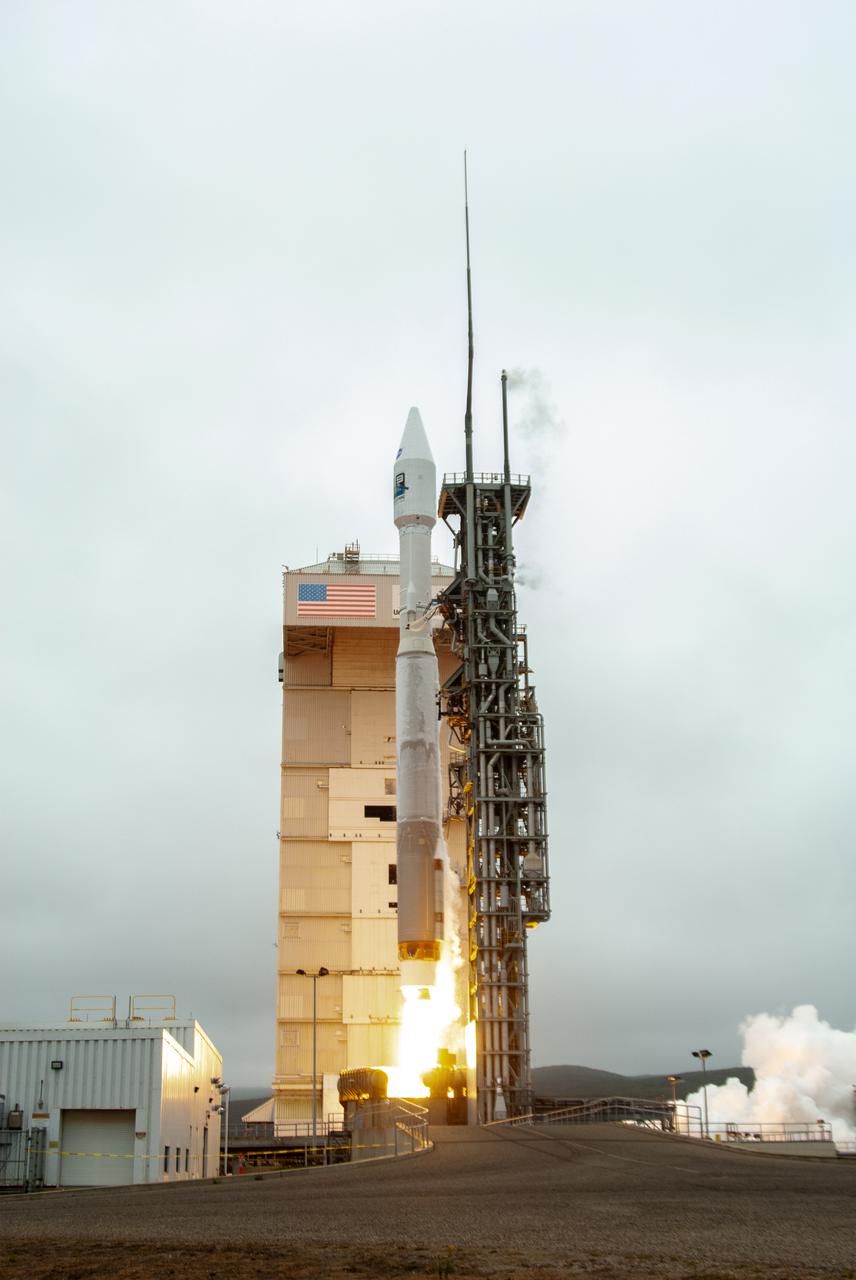
NASA’s Landsat 9 satellite launches on a United Launch Alliance Atlas V 401 rocket from Space Launch Complex 3 at Vandenberg Space Force Station in California on Sept. 27, 2021. Launch time was 2:11 p.m. EDT (11:11 a.m. PDT). The launch is managed by NASA’s Launch Services Program, based at the agency’s Kennedy Space Center in Florida. Landsat 9 will join its sister satellite, Landsat 8, in orbit in collecting images from across the planet every eight days. This calibrated data will continue the Landsat program’s critical role in monitoring the health of Earth and helping people manage essential resources, including crops, irrigation water, and forests. NASA Goddard manages the Landsat 9 mission. Goddard teams also built and tested one of the two instruments on Landsat 9, the Thermal Infrared Sensor 2 (TIRS-2) instrument. TIRS-2 will use thermal imaging to make measurements that can be used to estimate soil moisture and detect the health of plants.
Technicians lower the United Launch Alliance (ULA) Atlas V boattail onto the rocket’s Centaur upper stage inside the Vertical Integration Facility at Vandenberg Space Force Base in California on Oct. 4, 2022, for the National Oceanic and Atmospheric Administration’s (NOAA) and NASA’s Joint Polar Satellite System-2 (JPSS-2) mission. The boattail is the connecting piece of flight hardware that joins that Atlas V upper stage with the payload fairing – the protective casing surrounding the JPSS-2 satellite. Once the payload fairing arrives at the VIF, teams will lower it onto the boattail to complete the Atlas V stack. JPSS-2 is the third satellite in the Joint Polar Satellite System series and will scan the Earth as it orbits from the North to the South Pole, crossing the equator 14 times a day. Operating from 512 miles above Earth, JPSS-2 will capture data to improve weather forecasts, in turn helping scientists predict and prepare for extreme weather events and climate change. Launching as a secondary payload to JPSS-2 is NASA’s Low-Earth Orbit Flight Test of an Inflatable Decelerator (LOFTID), dedicated to the memory of Bernard Kutter. LOFTID is a technology demonstration of an inflatable heat shield that could one day help land humans on Mars. Liftoff is targeted for 2:25 a.m. Pacific time (5:25 a.m. Eastern time) on Nov. 1, 2022, from Vandenberg’s Space Launch Complex-3E.
In this view looking up, the mobile service tower doors are open at Space Launch Complex-3 (SLC-3) at Vandenberg Space Force Base in California on Oct. 28, 2022, revealing the United Launch Alliance Atlas V rocket with the National Oceanic and Atmospheric Administration’s (NOAA) Joint Polar Satellite System-2 (JPSS-2) and NASA’s Low-Earth Orbit Flight Test of an Inflatable Decelerator (LOFTID) atop. NASA and ULA are targeting launch for no earlier than Wednesday, Nov. 9, pending range availability. JPSS-2, which will be renamed NOAA-21 after reaching orbit, will join a constellation of JPSS satellites that orbit from the North to the South pole, circling Earth 14 times a day. The NOAA/NASA Suomi National Polar-orbiting Partnership (Suomi NPP) satellite, and NOAA-20, previously known as JPSS-1, are both already in orbit. Each satellite carries at least four advanced instruments to measure weather and climate conditions on Earth. LOFTID will demonstrate inflatable heat shield technology that could enable a variety of proposed NASA missions to destinations such as Mars, Venus, and Titan, as well as returning heavier payloads from low-Earth orbit.
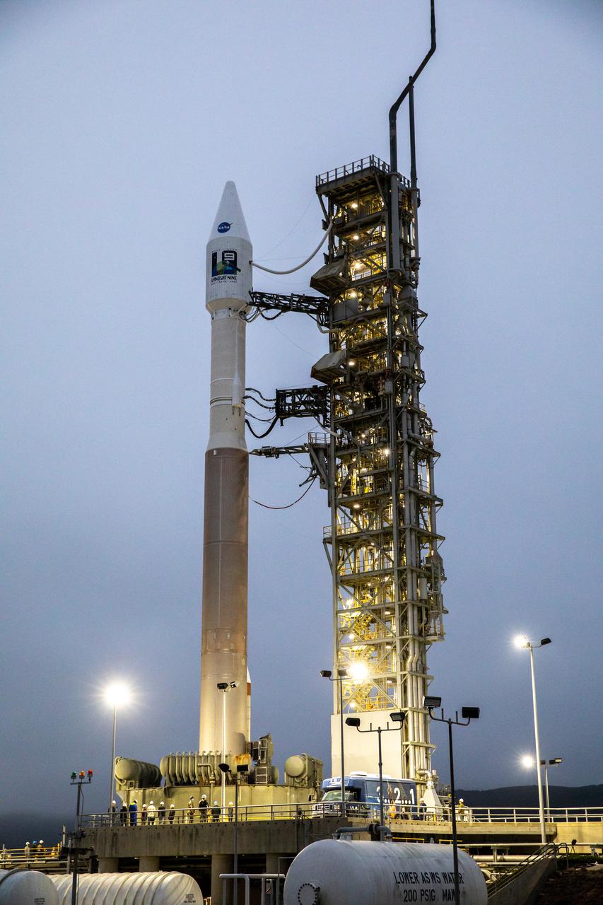
The United Launch Alliance Atlas V 401 rocket with NASA’s Landsat 9 satellite is secured on the launch pad at Space Launch Complex 3 (SLC-3) at Vandenberg Space Force Base in California, on Sept. 27, 2021, after making the trek from the Vertical Integration Facility. Landsat 9 is scheduled to launch at 2:12 p.m. EDT (11:12 a.m. PDT) today, Sept. 27, atop the Atlas V from SLC-3. The launch is managed by NASA’s Launch Services Program based at Kennedy Space Center. The Landsat 9 satellite will continue the nearly 50-year legacy of previous Landsat missions. It will join its sister satellite, Landsat 8, in orbit to monitor key natural and economic resources from orbit. Landsat 9 is managed by the agency’s Goddard Space Flight Center in Greenbelt, Maryland. The satellite will carry two instruments: the Operational Land Imager 2, which collects images of Earth’s landscapes in visible, near infrared and shortwave infrared light, and the Thermal Infrared Sensor 2, which measures the temperature of land surfaces. Like its predecessors, Landsat 9 is a joint mission between NASA and the U.S. Geological Survey.
The United Launch Alliance Atlas V payload fairing containing the National Oceanic and Atmospheric Administration’s (NOAA) Joint Polar Satellite System-2 (JPSS-2) is readied for its move to the vertical integration facility at Space Launch Complex 3 at Vandenberg Space Force Base (VSFB) in California on Oct. 18, 2022. Inside the fairing, JPSS-2 is stacked atop NASA’s Low-Earth Orbit Flight Test of an Inflatable Decelerator (LOFTID) secondary payload. JPSS-2 is the third satellite in the Joint Polar Satellite System series. It is scheduled to lift off from VSFB on Nov. 1 from Space Launch Complex-3. JPSS-2, which will be renamed NOAA-21 after reaching orbit, will join a constellation of JPSS satellites that orbit from the North to the South pole, circling Earth 14 times a day and providing a full view of the entire globe twice daily. The NOAA/NASA Suomi National Polar-orbiting Partnership (Suomi NPP) satellite, and NOAA-20, previously known as JPSS-1, are both already in orbit. Each satellite carries at least four advanced instruments to measure weather and climate conditions on Earth. LOFTID is dedicated to the memory of Bernard Kutter. LOFTID will demonstrate inflatable heat shield technology that could enable a variety of proposed NASA missions to destinations such as Mars, Venus, and Titan, as well as returning heavier payloads from low-Earth orbit.
The United Launch Alliance Atlas V payload fairing containing the National Oceanic and Atmospheric Administration’s (NOAA) Joint Polar Satellite System-2 (JPSS-2) is lowered by crane inside the vertical integration facility at Space Launch Complex 3 at Vandenberg Space Force Base (VSFB) in California on Oct. 18, 2022. The fairing will be attached to the Atlas V rocket. Inside the fairing, JPSS-2 is stacked atop NASA’s Low-Earth Orbit Flight Test of an Inflatable Decelerator (LOFTID) secondary payload. JPSS-2 is the third satellite in the Joint Polar Satellite System series. It is scheduled to lift off from VSFB on Nov. 1 from SLC-3. JPSS-2, which will be renamed NOAA-21 after reaching orbit, will join a constellation of JPSS satellites that orbit from the North to the South pole, circling Earth 14 times a day and providing a full view of the entire globe twice daily. The NOAA/NASA Suomi National Polar-orbiting Partnership (Suomi NPP) satellite, and NOAA-20, previously known as JPSS-1, are both already in orbit. Each satellite carries at least four advanced instruments to measure weather and climate conditions on Earth. LOFTID is dedicated to the memory of Bernard Kutter. LOFTID will demonstrate inflatable heat shield technology that could enable a variety of proposed NASA missions to destinations such as Mars, Venus, and Titan, as well as returning heavier payloads from low-Earth orbit.
Preparations are underway to lift the interstage and assembly second stage adapters for the United Alliance Atlas V Centaur second stage for NASA’s Landsat 9 mission at Space Launch Complex 3 at Vandenberg Space Force Base in California, on July 14, 2021. The adapters will be stacked atop the Centaur second stage in the Vertical Integration Facility near the launch pad. The Landsat 9 mission will launch atop the Atlas V rocket from Vandenberg in September 2021. The launch is being managed by NASA’s Launch Services Program based at Kennedy Space Center, America’s multiuser spaceport. The Landsat 9 satellite will continue the nearly 50-year legacy of previous Landsat missions. It will monitor key natural and economic resources from orbit. Landsat 9 is managed by the agency’s Goddard Space Flight Center in Greenbelt, Maryland. The satellite will carry two instruments: the Operational Land Imager 2, which collects images of Earth’s landscapes in visible, near infrared and shortwave infrared light, and the Thermal Infrared Sensor 2, which measures the temperature of land surfaces. Like its predecessors, Landsat 9 is a joint mission between NASA and the U.S. Geological Survey.
The Atlas V booster for the Landsat 9 satellite undergoes a dress rehearsal at Vandenberg Space Force Base’s Space Launch Complex 3 in California on Sept. 3, 2021. The Landsat 9 mission launch, which is being managed by NASA’s Launch Services Program based at Kennedy Space Center in Florida, is targeted for no earlier than Sept. 27, 2021. Landsat 9 will monitor key natural and economic resources from orbit. The satellite will carry two instruments: the Operational Land Imager 2, which collects images of Earth’s landscapes in visible, near infrared and shortwave infrared light, and the Thermal Infrared Sensor 2, which measures the temperature of land surfaces. Landsat 9 is a joint mission between NASA and the U.S. Geological Survey.
The Atlas V booster for the Landsat 9 satellite undergoes a dress rehearsal at Vandenberg Space Force Base’s Space Launch Complex 3 in California on Sept. 3, 2021. The Landsat 9 mission launch, which is being managed by NASA’s Launch Services Program based at Kennedy Space Center in Florida, is targeted for no earlier than Sept. 27, 2021. Landsat 9 will monitor key natural and economic resources from orbit. The satellite will carry two instruments: the Operational Land Imager 2, which collects images of Earth’s landscapes in visible, near infrared and shortwave infrared light, and the Thermal Infrared Sensor 2, which measures the temperature of land surfaces. Landsat 9 is a joint mission between NASA and the U.S. Geological Survey.

The United Launch Alliance Atlas V booster for NASA’s Landsat 9 mission is lifted for its move into the Vertical Integration Facility at Space Launch Complex 3 at Vandenberg Space Force Base in California, on July 13, 2021. The Landsat 9 mission will launch atop the Atlas V rocket from Vandenberg in September 2021. The launch is being managed by NASA’s Launch Services Program based at Kennedy Space Center. The Landsat 9 satellite will continue the nearly 50-year legacy of previous Landsat missions. It will monitor key natural and economic resources from orbit. Landsat 9 is managed by the agency’s Goddard Space Flight Center in Greenbelt, Maryland. The satellite will carry two instruments: the Operational Land Imager 2, which collects images of Earth’s landscapes in visible, near infrared and shortwave infrared light, and the Thermal Infrared Sensor 2, which measures the temperature of land surfaces. Like its predecessors, Landsat 9 is a joint mission between NASA and the U.S. Geological Survey.
NASA’s Landsat 9 satellite launches on a United Launch Alliance Atlas V 401 rocket from Space Launch Complex 3 at Vandenberg Space Force Station in California on Sept. 27, 2021. Launch time was 2:11 p.m. EDT (11:11 a.m. PDT). The launch is managed by NASA’s Launch Services Program, based at the agency’s Kennedy Space Center in Florida. Landsat 9 will join its sister satellite, Landsat 8, in orbit in collecting images from across the planet every eight days. This calibrated data will continue the Landsat program’s critical role in monitoring the health of Earth and helping people manage essential resources, including crops, irrigation water, and forests. NASA Goddard manages the Landsat 9 mission. Goddard teams also built and tested one of the two instruments on Landsat 9, the Thermal Infrared Sensor 2 (TIRS-2) instrument. TIRS-2 will use thermal imaging to make measurements that can be used to estimate soil moisture and detect the health of plants.
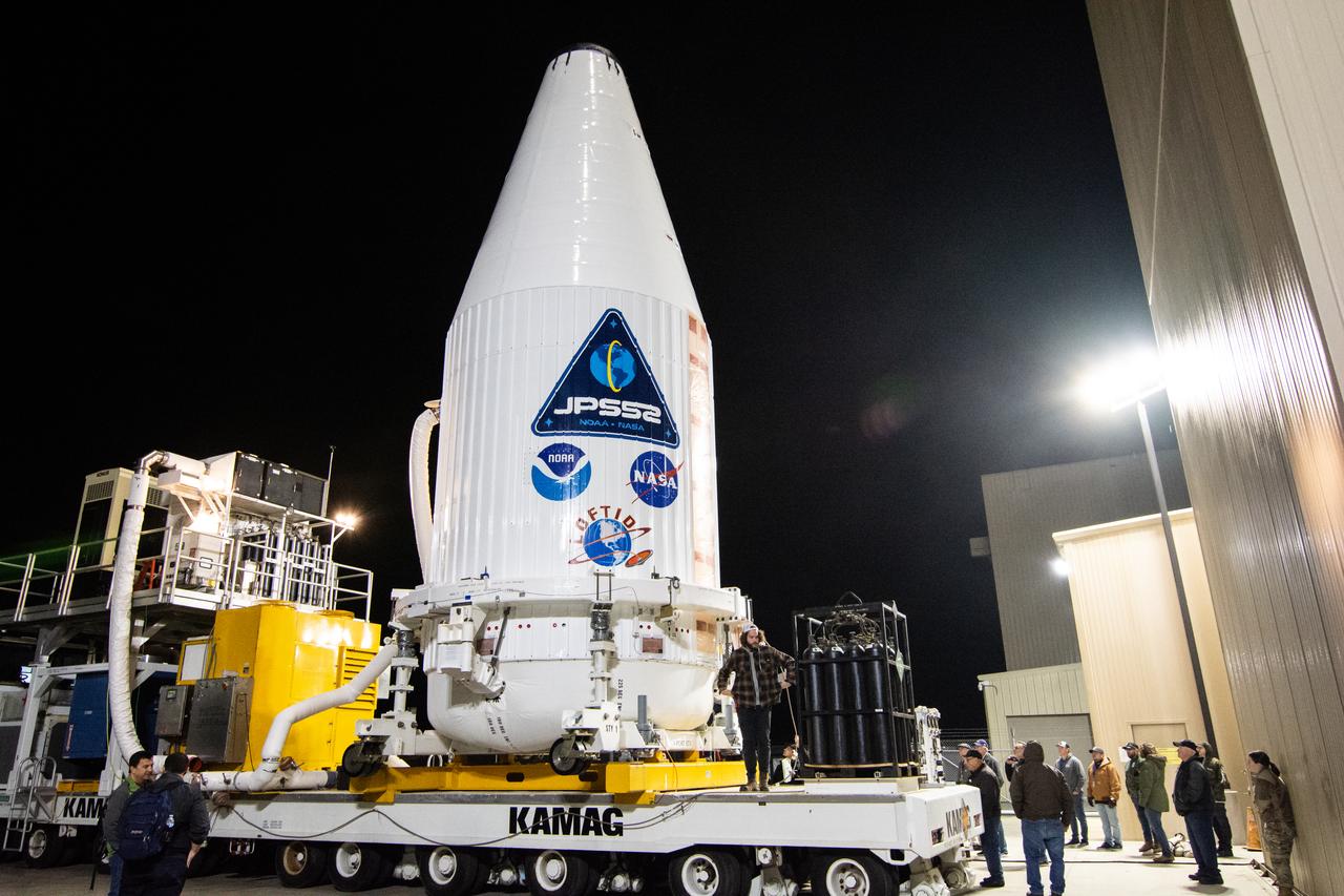
The United Launch Alliance Atlas V payload fairing containing the National Oceanic and Atmospheric Administration’s (NOAA) Joint Polar Satellite System-2 (JPSS-2) begins its journey to the vertical integration facility at Space Launch Complex 3 at Vandenberg Space Force Base (VSFB) in California on Oct. 18, 2022. Inside the fairing, JPSS-2 is stacked atop NASA’s Low-Earth Orbit Flight Test of an Inflatable Decelerator (LOFTID) secondary payload. JPSS-2 is the third satellite in the Joint Polar Satellite System series. It is scheduled to lift off from VSFB on Nov. 1 from SLC-3. JPSS-2, which will be renamed NOAA-21 after reaching orbit, will join a constellation of JPSS satellites that orbit from the North to the South pole, circling Earth 14 times a day and providing a full view of the entire globe twice daily. The NOAA/NASA Suomi National Polar-orbiting Partnership (Suomi NPP) satellite, and NOAA-20, previously known as JPSS-1, are both already in orbit. Each satellite carries at least four advanced instruments to measure weather and climate conditions on Earth. LOFTID is dedicated to the memory of Bernard Kutter. LOFTID will demonstrate inflatable heat shield technology that could enable a variety of proposed NASA missions to destinations such as Mars, Venus, and Titan, as well as returning heavier payloads from low-Earth orbit.
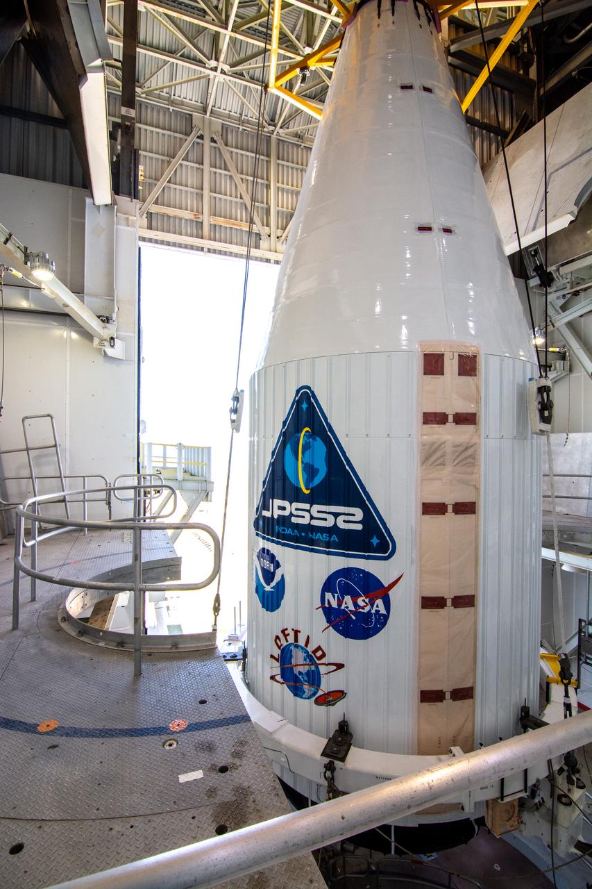
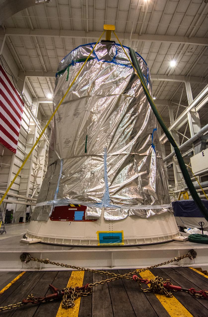
The United Launch Alliance Atlas V payload fairing containing the National Oceanic and Atmospheric Administration’s (NOAA) Joint Polar Satellite System-2 (JPSS-2) arrives inside the vertical integration facility at Space Launch Complex 3 at Vandenberg Space Force Base (VSFB) in California on Oct. 18, 2022. Inside the fairing, JPSS-2 is stacked atop NASA’s Low-Earth Orbit Flight Test of an Inflatable Decelerator (LOFTID) secondary payload. The fairing will be attached to the Atlas V rocket. JPSS-2 is the third satellite in the Joint Polar Satellite System series. It is scheduled to lift off from VSFB on Nov. 1 from SLC-3. JPSS-2, which will be renamed NOAA-21 after reaching orbit, will join a constellation of JPSS satellites that orbit from the North to the South pole, circling Earth 14 times a day and providing a full view of the entire globe twice daily. The NOAA/NASA Suomi National Polar-orbiting Partnership (Suomi NPP) satellite, and NOAA-20, previously known as JPSS-1, are both already in orbit. Each satellite carries at least four advanced instruments to measure weather and climate conditions on Earth. LOFTID is dedicated to the memory of Bernard Kutter. LOFTID will demonstrate inflatable heat shield technology that could enable a variety of proposed NASA missions to destinations such as Mars, Venus, and Titan, as well as returning heavier payloads from low-Earth orbit.
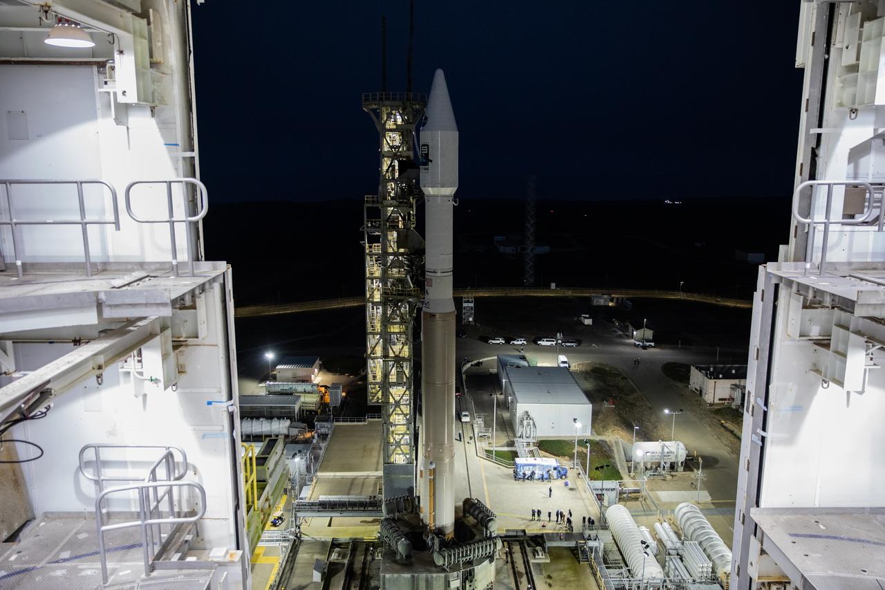
The National Oceanic and Atmospheric Administration’s (NOAA) Joint Polar Satellite System-2 (JPSS-2) satellite with NASA’s Low-Earth Orbit Flight Test of an Inflatable Decelerator (LOFTID) as a secondary payload, stand ready to lift off atop a United Launch Alliance (ULA) Atlas V rocket from Space Launch Complex-3 at Vandenberg Space Force Base in California on Nov. 10.