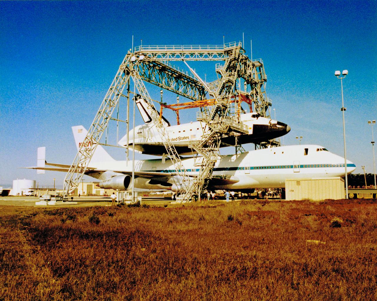
Orbiter at Vandenberg
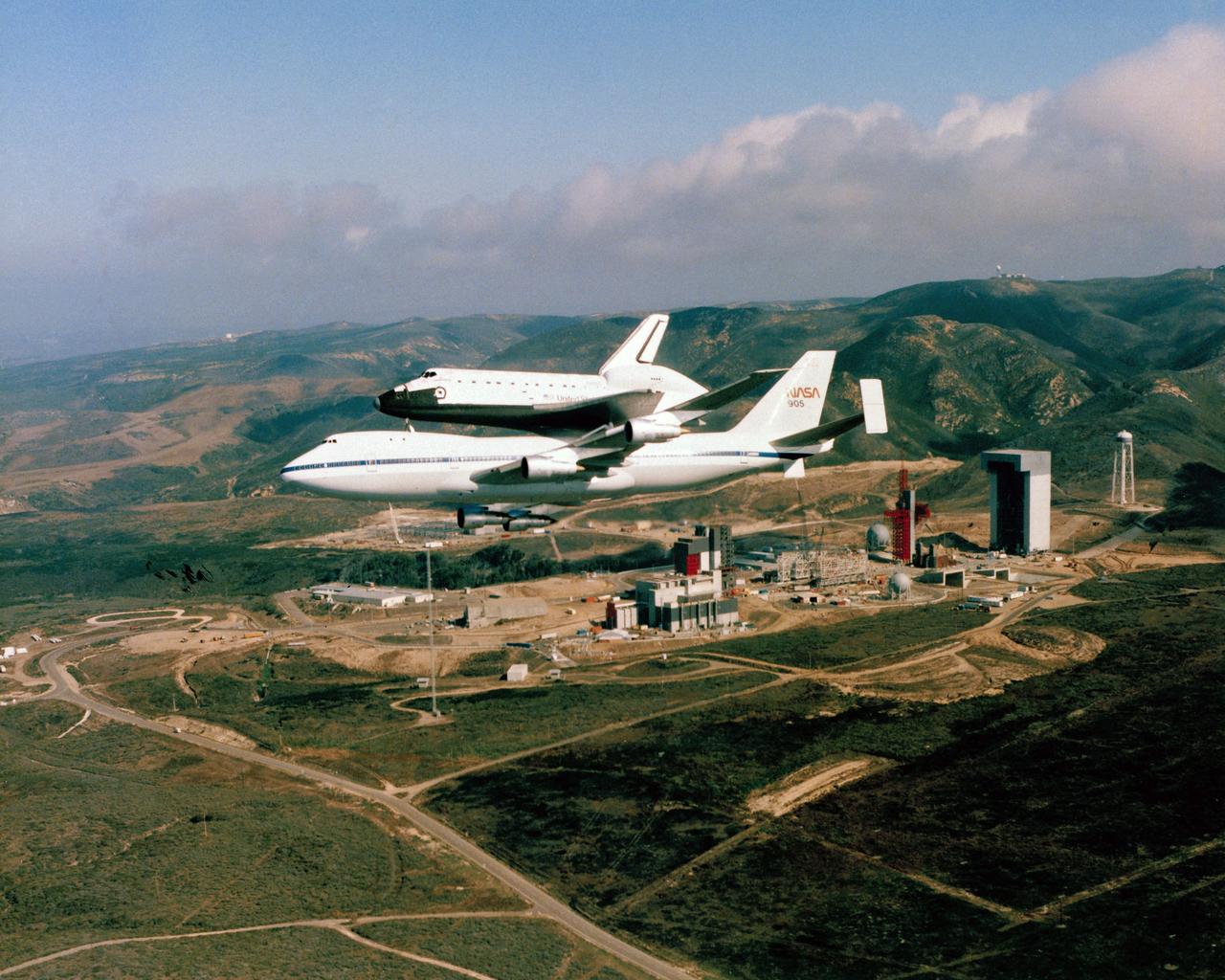
Orbiter at Vandenberg
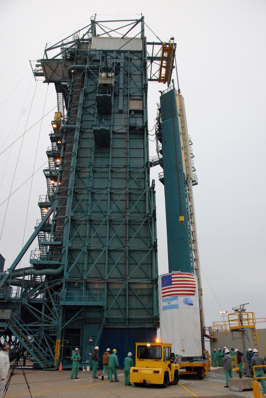
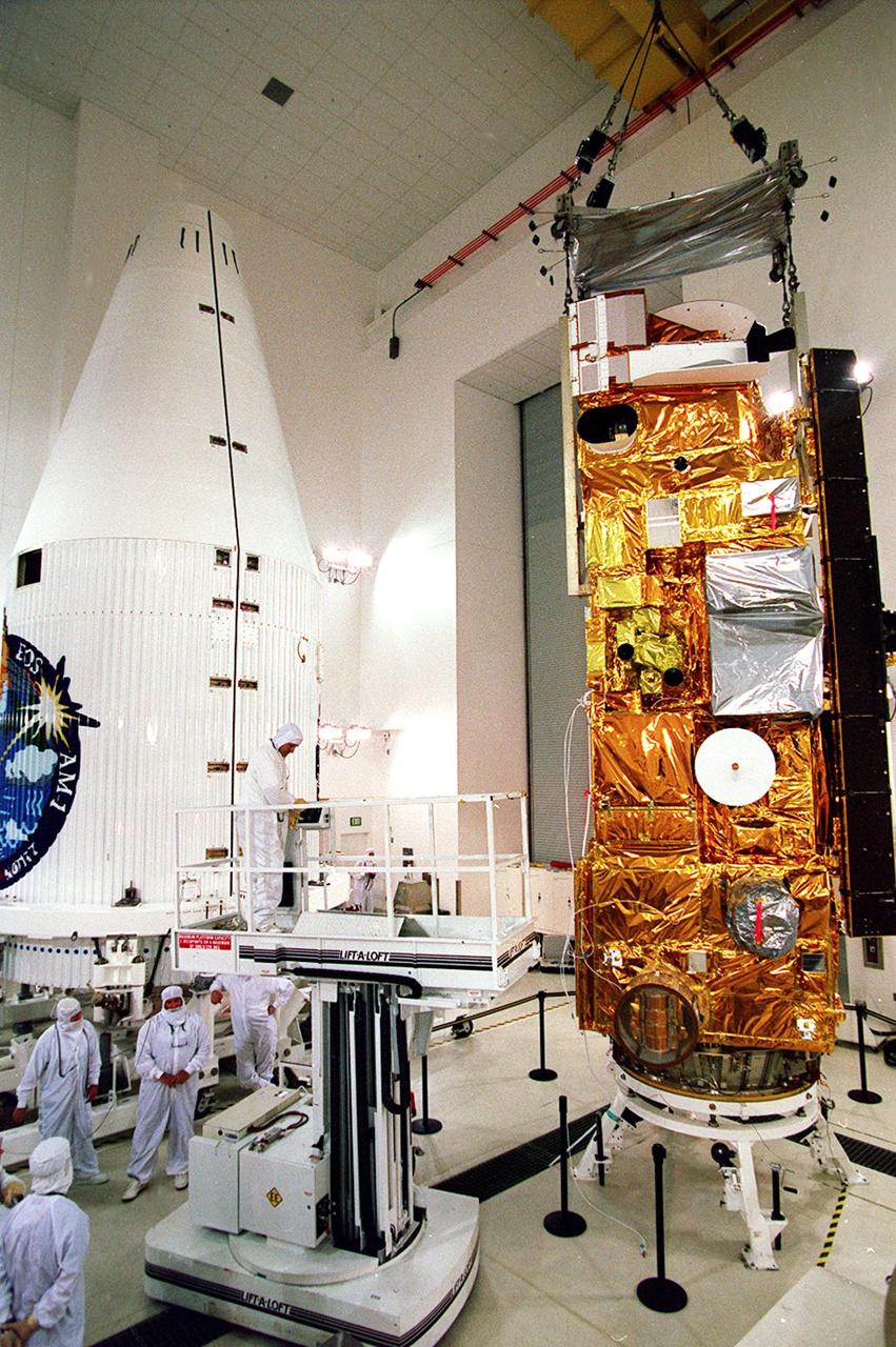
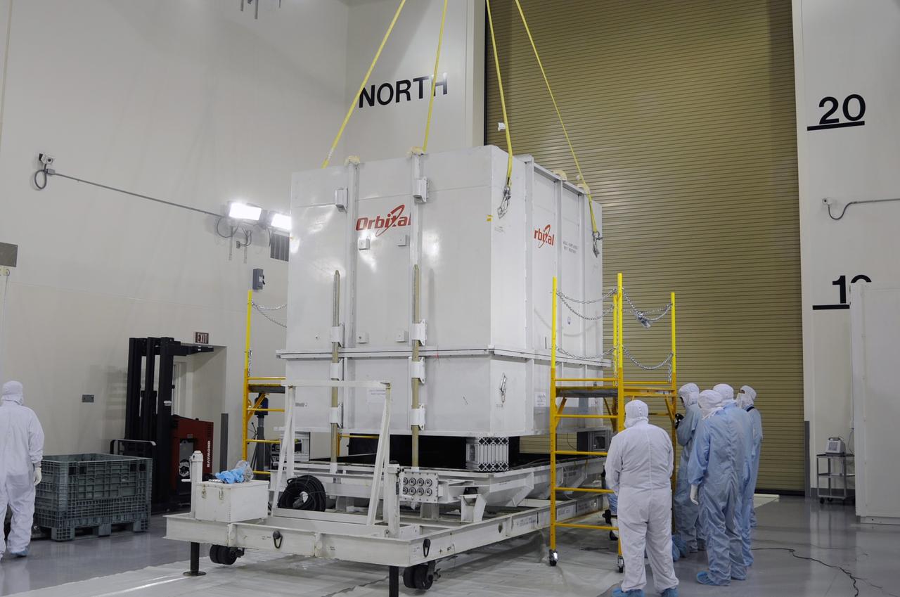
VANDENBERG AIR FORCE BASE, Calif. -- The Space Launch Complex-2 (SLC-2) service tower at Vandenberg Air Force Base in California is moved to allow United Launch Alliance technicians to hoist into position the second stage of the Delta II rocket that will carry NASA's Aquarius satellite into low Earth orbit. Scheduled to launch in June, Aquarius' mission will be to provide monthly maps of global changes in sea surface salinity. By measuring ocean salinity from space, Aquarius will provide new insights into how the massive natural exchange of freshwater between the ocean, atmosphere and sea ice influences ocean circulation, weather and climate. Also going up with the satellite are optical and thermal cameras, a microwave radiometer and the SAC-D spacecraft, which were developed with the help of institutions in Italy, France, Canada and Argentina. Photo credit: VAFB/30th Space Wing
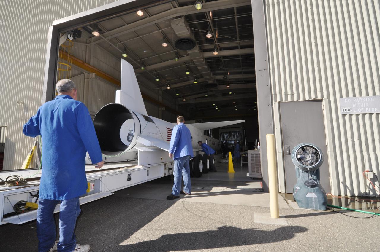
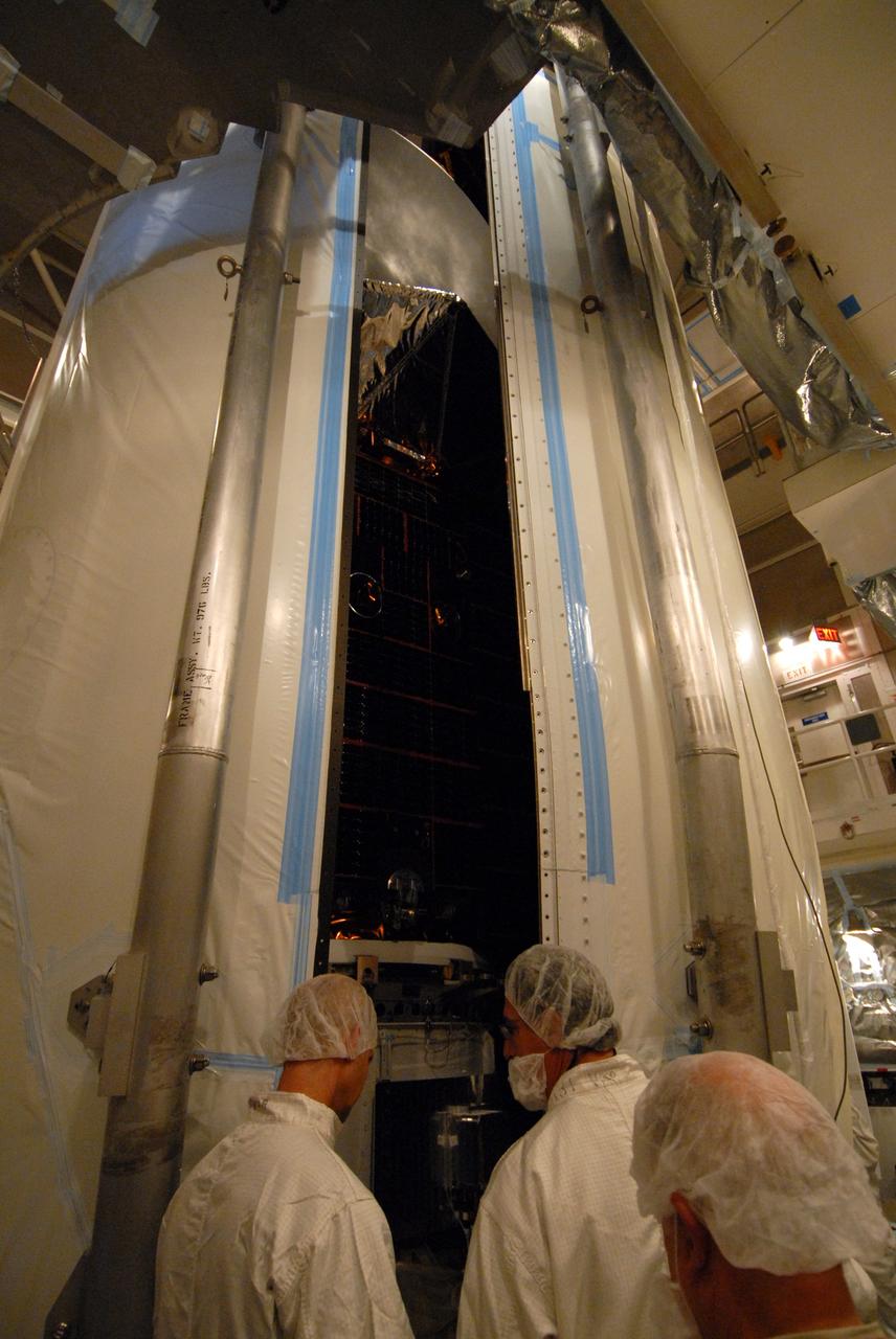
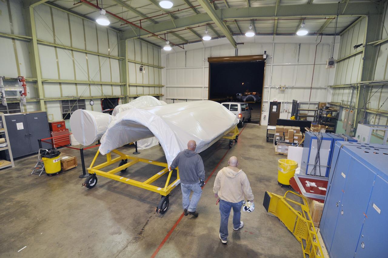
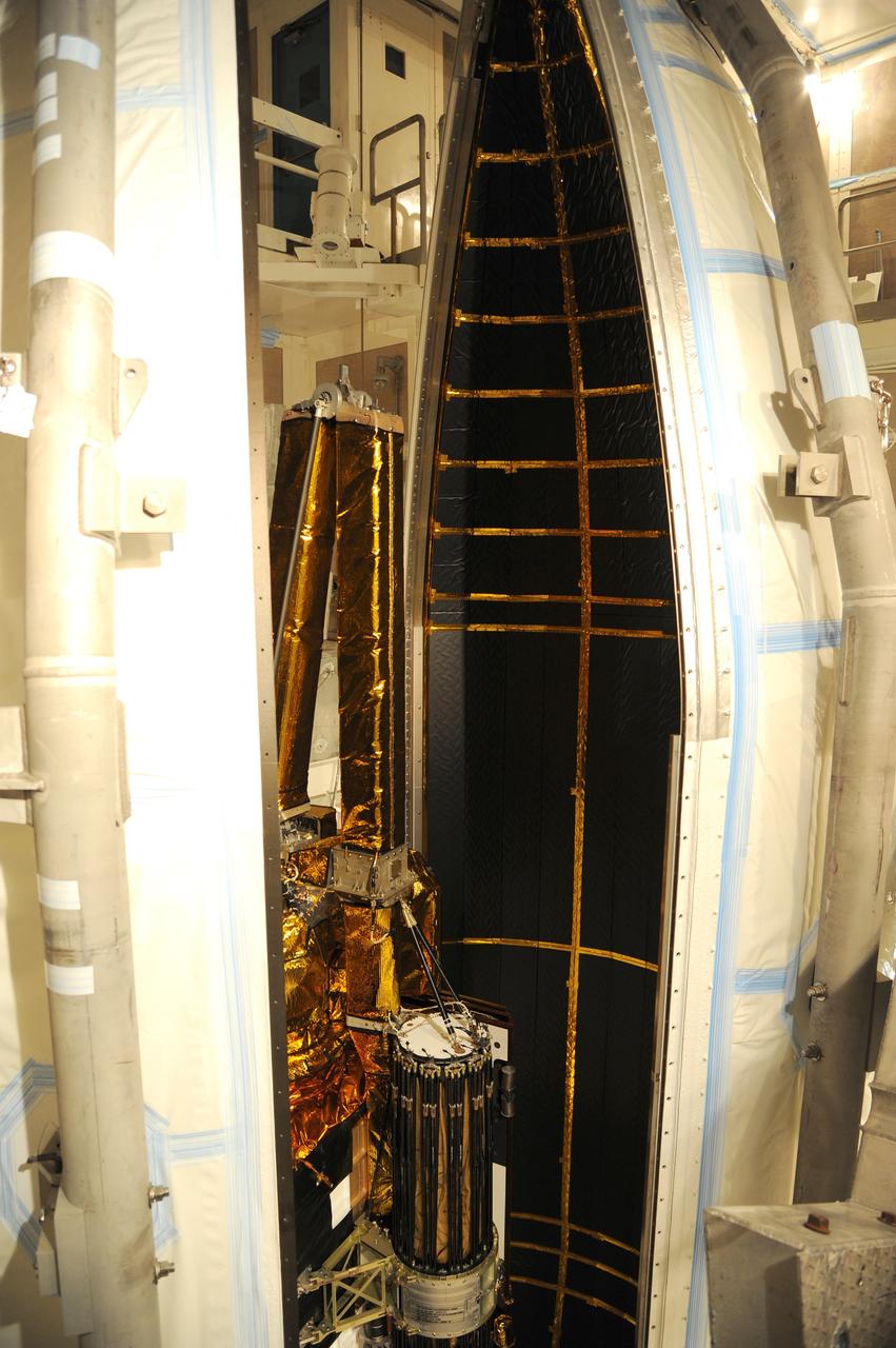
VANDENBERG AIR FORCE BASE, Calif. -- Inside a Pegasus booster processing facility at Vandenberg Air Force Base in California, an overhead crane lifts the first of the fins for the aft end of the Pegasus XL rocket's first stage as technicians guide it into place for installation. The Orbital Sciences Corp. Pegasus rocket will launch the Nuclear Spectroscopic Telescope Array (NuSTAR) into space. After the rocket and spacecraft are processed at Vandenberg, they will be flown on the Orbital Sciences’ L-1011 carrier aircraft to the Ronald Reagan Ballistic Missile Defense Test Site at the Pacific Ocean’s Kwajalein Atoll for launch. The high-energy x-ray telescope will conduct a census for black holes, map radioactive material in young supernovae remnants, and study the origins of cosmic rays and the extreme physics around collapsed stars. For more information, visit science.nasa.gov/missions/nustar/. Photo credit: NASA/Randy Beaudoin, VAFB

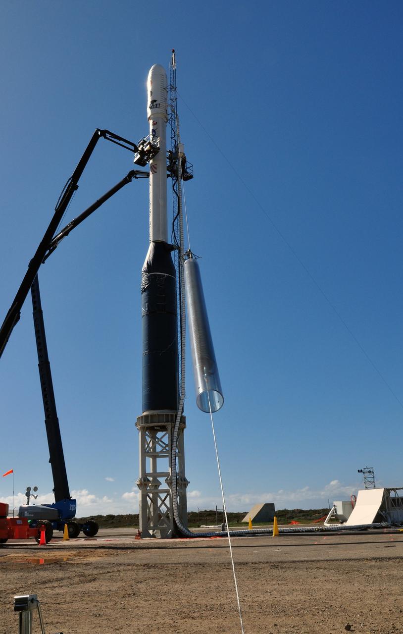
VANDENBERG AIR FORCE BASE, Calif. -- At Space Launch Complex 576-E at Vandenberg Air Force Base in California, workers unlatch the crane's guide wires from the Stage 0/1 interstage, part of the four-stage Taurus XL rocket that will carry NASA's Glory spacecraft into low Earth orbit, after it was lowered into launch position. Once Glory reaches orbit, it will collect data on the properties of aerosols and black carbon. It also will help scientists understand how the sun's irradiance affects Earth's climate. Launch is scheduled for 5:09 a.m. EST Feb. 23. For information, visit www.nasa.gov/glory. Photo credit: NASA/Randy Beaudoin, VAFB
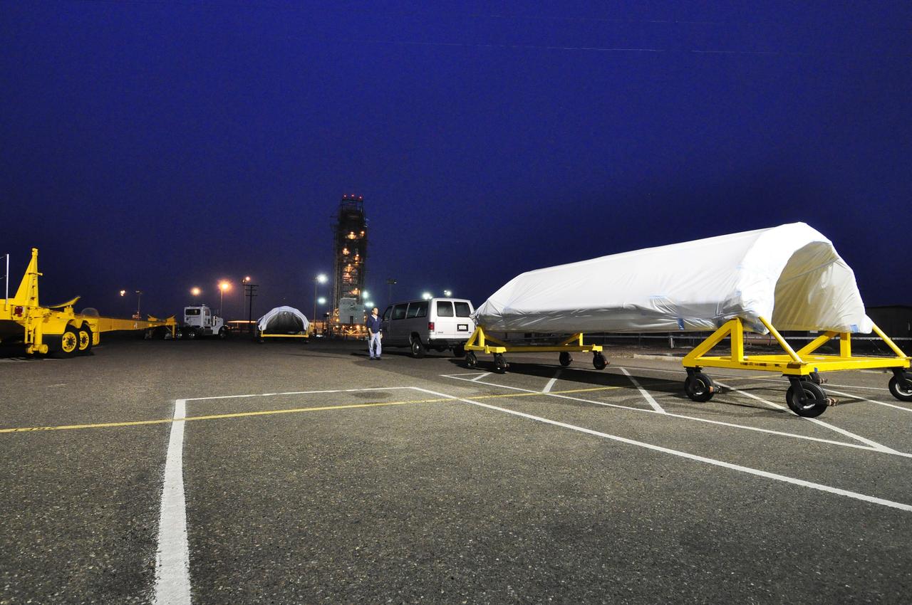
VANDENBERG AIR FORCE BASE, Calif. -- As nighttime descends on Vandenberg Air Force Base in California, the Orbital Sciences Taurus XL rocket and NASA's encapsulated Glory spacecraft await an early morning launch on the pad at Space Launch Complex 576-E. Liftoff originally was scheduled for 5:09 a.m. EST Feb. 23, but was scrubbed for at least 24 hours due to a technical issue that engineers are evaluating. Once Glory reaches orbit, it will collect data on the properties of aerosols and black carbon. It also will help scientists understand how the sun's irradiance affects Earth's climate. For information, visit www.nasa.gov/glory. Photo credit: NASA/Randy Beaudoin, VAFB
VANDENBERG AIR FORCE BASE, Calif. -- On Space Launch Complex 576-E at Vandenberg Air Force Base in California, workers in a bucket begin the process of removing the lifting fixture and sling from NASA's Glory upper stack after it was secured in place to the Taurus XL rocket's Stage 0. The upper stack consists of Stages 1, 2 and 3 of the Taurus as well as the encapsulated Glory spacecraft. The Orbital Sciences Taurus XL rocket will launch Glory into low Earth orbit. Once Glory reaches orbit, it will collect data on the properties of aerosols and black carbon. It also will help scientists understand how the sun's irradiance affects Earth's climate. Launch is scheduled for 5:09 a.m. EST Feb. 23. For information, visit www.nasa.gov/glory. Photo credit: NASA/Randy Beaudoin, VAFB
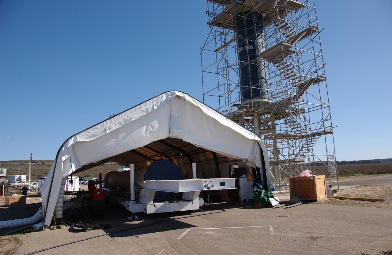
VANDENBERG AIR FORCE BASE, Calif. -- At Space Launch Complex 576-E at Vandenberg Air Force Base in California, workers move NASA's Glory spacecraft, secured on a stationary rail, into a temporary processing tent near the pad where it will be joined with the Taurus XL rocket's third stage. The Orbital Sciences Corp. Taurus XL rocket will carry Glory into low Earth orbit. Once Glory reaches orbit, it will collect data on the properties of aerosols and black carbon. It also will help scientists understand how the sun's irradiance affects Earth's climate. Launch is scheduled for 5:09 a.m. EST Feb. 23. For information, visit www.nasa.gov/glory. Photo credit: NASA/Randy Beaudoin, VAFB
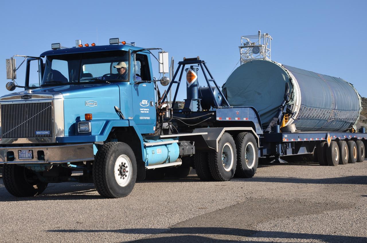
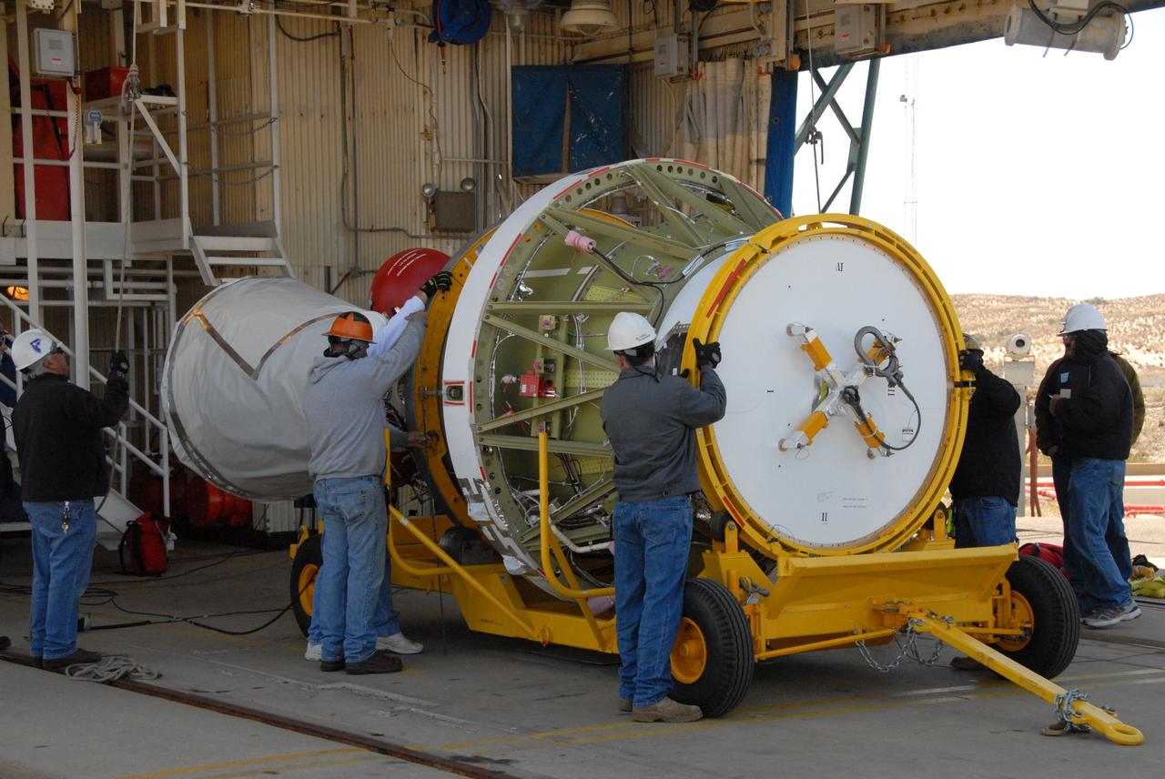
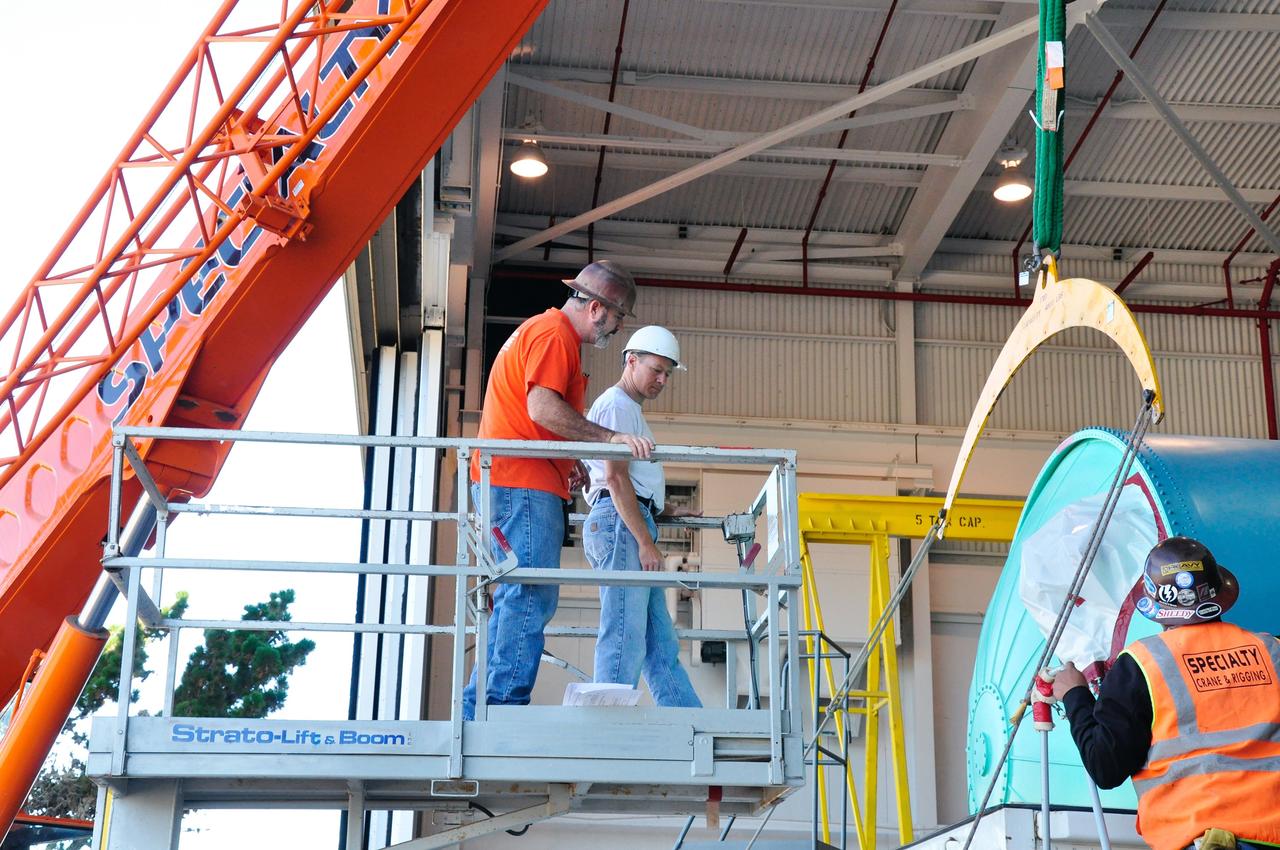
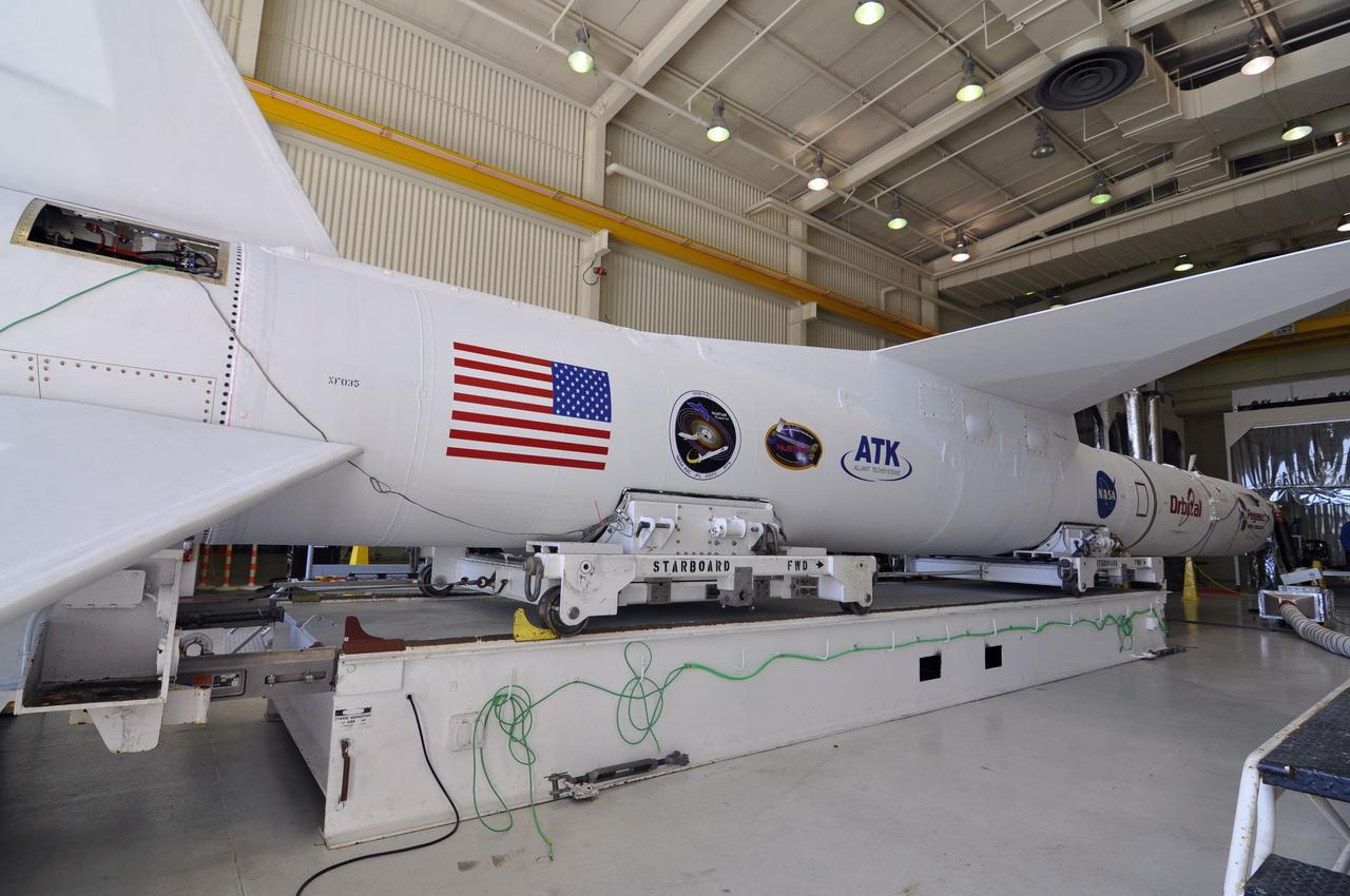
VANDENBERG AIR FORCE BASE, Calif. – A solid rocket motor for the Delta II rocket for NASA's Soil Moisture Active Passive mission, or SMAP, is delivered to the mobile service tower at Space Launch Complex 2 on Vandenberg Air Force Base in California. SMAP will be launched on a Delta II 7320 configuration vehicle featuring a United Launch Alliance first stage booster powered by an Aerojet Rocketdyne RS-27A main engine and three Alliant Techsystems, or ATK, strap-on solid rocket motors. Once on station in Earth orbit, SMAP will provide global measurements of soil moisture and its freeze/thaw state. These measurements will be used to enhance understanding of processes that link the water, energy and carbon cycles, and to extend the capabilities of weather and climate prediction models. SMAP data also will be used to quantify net carbon flux in boreal landscapes and to develop improved flood prediction and drought monitoring capabilities. Launch is scheduled for no earlier than November 2014. To learn more about SMAP, visit http://smap.jpl.nasa.gov. Photo credit: NASA/Randy Beaudoin
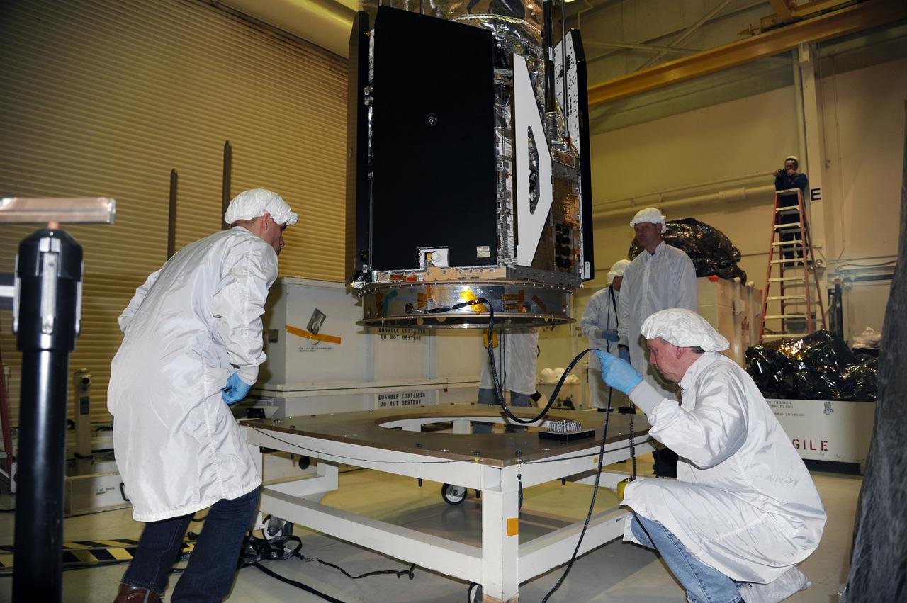
VANDENBERG AIR FORCE BASE, Calif. — In the Orbital Sciences Building 836 at Vandenberg Air Force Base in California, technicians complete mating of the three micro-satellites on the payload support structure. The three satellites make up the Space Technology 5 spacecraft, called ST5, and will be launched by a Pegasus XL rocket. The satellites contain miniaturized redundant components and technologies. Each will validate New Millennium Program selected technologies, such as the Cold Gas Micro-Thruster and X-Band Transponder Communication System. After deployment from the Pegasus, the micro-satellites will be positioned in a “string of pearls” constellation that demonstrates the ability to position them to perform simultaneous multi-point measurements of the magnetic field using highly sensitive magnetometers. The data will help scientists understand and map the intensity and direction of the Earth’s magnetic field, its relation to space weather events, and affects on our planet. With such missions, NASA hopes to improve scientists’ ability to accurately forecast space weather and minimize its harmful effects on space- and ground-based systems. Launch of ST5 is scheduled for Feb. 28 from Vandenberg Air Force Base.
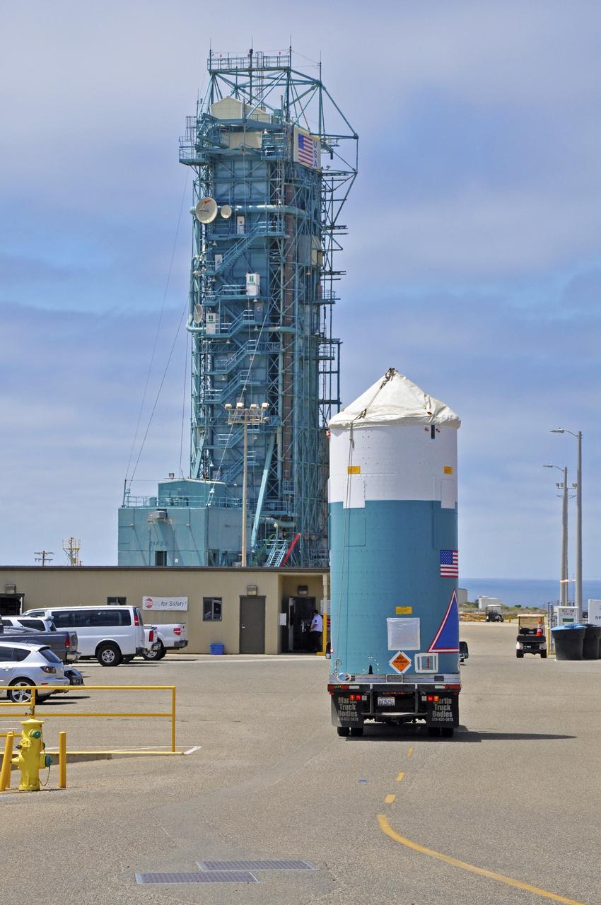
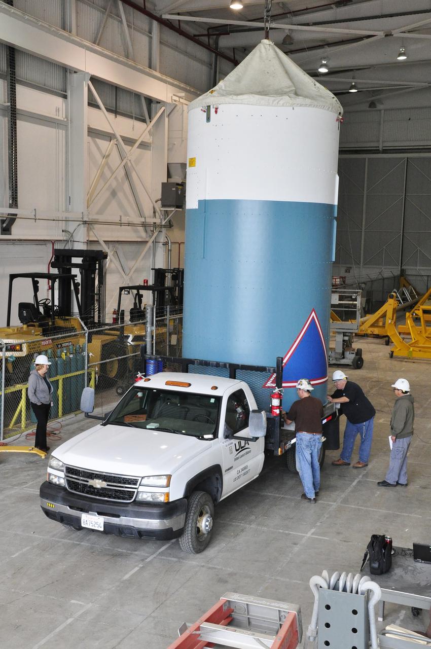
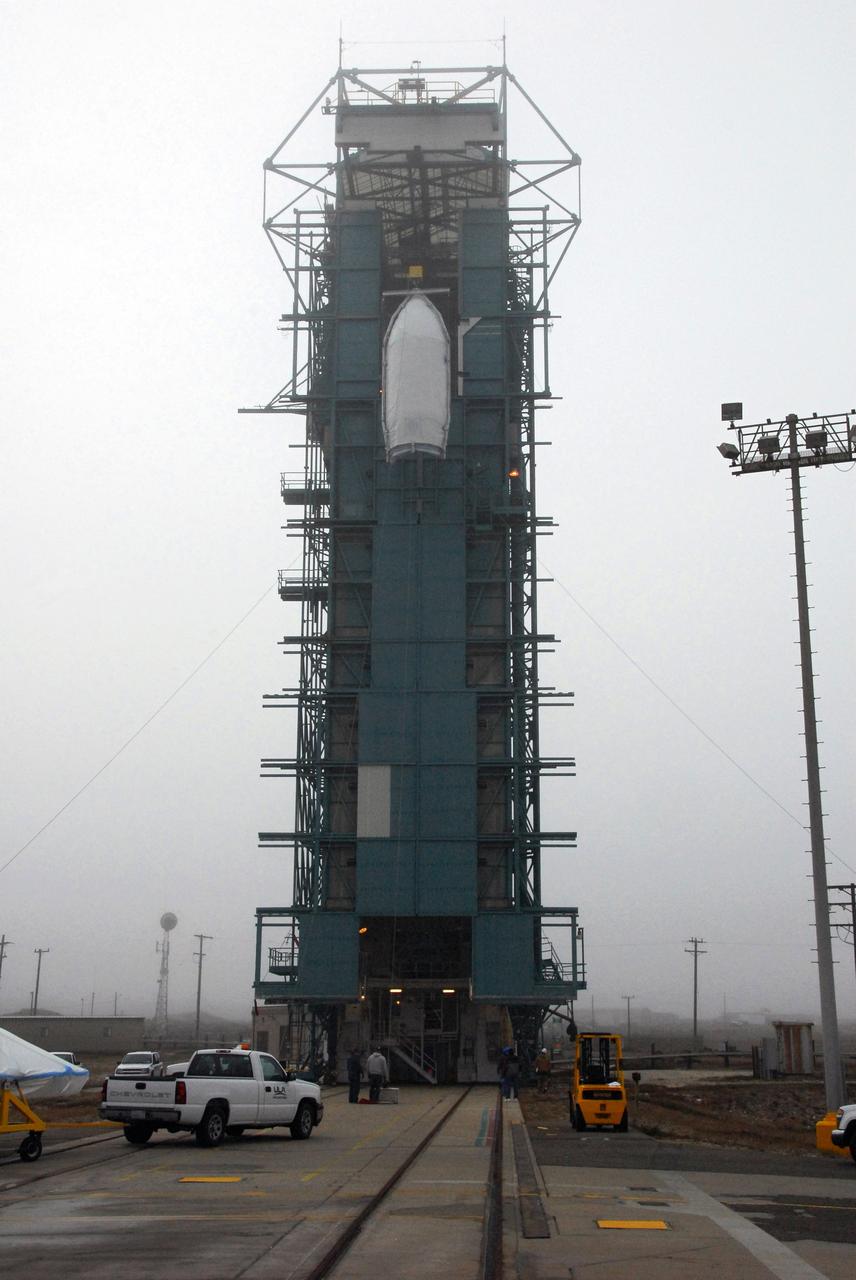
VANDENBERG AIR FORCE BASE, Calif. - NASA's Wide-field Infrared Survey Explorer, or WISE, enclosed in a transportation canister, climbs up the side of the mobile launch tower at Space Launch Complex 2 at Vandenberg Air Force Base in California. WISE will survey the entire sky at infrared wavelengths, creating a cosmic clearinghouse of hundreds of millions of objects which will be catalogued and provide a vast storehouse of knowledge about the solar system, the Milky Way, and the universe. Launch is scheduled for Dec. 9. For additional information, visit http://www.nasa.gov/wise. Photo credit: NASA/Mark Mackley, VAFB
VANDENBERG AIR FORCE BASE, Calif. – The Ocean Surface Topography Mission, or OSTM/Jason 2, spacecraft is being wrapped, or bagged, before fueling, encapsulation and transfer to the launch pad. The launch of the OSTM/Jason 2 aboard a Delta II rocket is scheduled for Friday, June 20, from Vandenberg Air Force Base in California. The launch window extends from 12:46 a.m. to 12:55 a.m. PDT. The satellite will be placed in an 830-mile-high orbit at an inclination of 66 degrees after separating from the Delta II 55 minutes after liftoff. The five primary science instruments of the Ocean Surface Topography Mission aboard the Jason 2 spacecraft are dedicated to measuring ocean surface height. These measurements will be used to evaluate and forecast climate changes and improve weather forecasting. The results also are expected to help forecasters better predict hurricane intensity. Photo credit: NASA
VANDENBERG AIR FORCE BASE, Calif. -- At Vandenberg Air Force Base's processing facility in California, technicians prepare NASA’s NuSTAR spacecraft to be lifted into a tilt-rotation fixture. The spacecraft will be rotated to horizontal for joining with the Pegasus XL rocket. The Orbital Sciences Pegasus will launch NASA's Nuclear Spectroscopic Telescope Array NuSTAR into space. After the rocket and spacecraft are processed at Vandenberg, they will be flown on Orbital's L-1011 carrier aircraft to the Ronald Reagan Ballistic Missile Defense Test Site at the Pacific Ocean’s Kwajalein Atoll for launch. The high-energy x-ray telescope will conduct a census for black holes, map radioactive material in young supernovae remnants, and study the origins of cosmic rays and the extreme physics around collapsed stars. For more information, visit science.nasa.gov/missions/nustar/. Photo credit: NASA/Randy Beaudoin, VAFB
VANDENBERG AIR FORCE BASE, Calif. -- Stage 0 of the Taurus XL launch vehicle for the Orbiting Carbon Observatory arrives at complex 576E at Vandenberg Air Force Base in California. It will be mated with stages 1, 2 and 3 for the launch of OCO. The OCO is a new Earth-orbiting mission sponsored by NASA's Earth System Science Pathfinder Program. It is scheduled to launch Feb. 23. Photo credit: NASA/Randy Beaudoin, VAFB

VANDENBERG AIR FORCE BASE, Calif. – The Delta first-stage booster for NASA's Orbiting Carbon Observatory-2 mission, or OCO-2, makes its way along the roads at Vandenberg Air Force Base in California on its move from the Building 836 hangar to the Horizontal Processing Facility at Space Launch Complex 2. OCO-2 is scheduled to launch aboard a United Launch Alliance Delta II rocket on July 1, 2014. The observatory will collect precise global measurements of carbon dioxide in the Earth's atmosphere and provide scientists with a better idea of the chemical compound's impacts on climate change. Scientists will analyze this data to improve our understanding of the natural processes and human activities that regulate the abundance and distribution of this important atmospheric gas. To learn more about OCO-2, visit http://oco.jpl.nasa.gov. Photo credit: NASA/D. Liberotti, 30th Space Wing, VAFB
VANDENBERG AIR FORCE BASE, Calif. – At Vandenberg Air Force Base in California, technicians monitor the progress as a transporter is moved underneath the Orbital Science’s Pegasus XL inside Orbital’s hangar. The rocket is mated to NASA’s encapsulated Nuclear Spectroscopic Telescope Array, or NuSTAR, out of sight inside the hangar. The transporter will move them to the runway ramp where they will be attached to the underside of Orbital’s L-1011 carrier aircraft. The aircraft will fly the pair from Vandenberg to the Ronald Reagan Ballistic Missile Defense Test Site on the Pacific Ocean’s Kwajalein Atoll for launch. A revised launch date is expected to be set at the Flight Readiness Review. The high-energy X-ray telescope will conduct a census of black holes, map radioactive material in young supernovae remnants, and study the origins of cosmic rays and the extreme physics around collapsed stars. For more information, visit http://www.nasa.gov/nustar. Photo credit: NASA/Randy Beaudoin
VANDENBERG AIR FORCE BASE, Calif. -- Workers in Building 1555 at Vandenberg AFB check the installation of the wing on the Pegasus rocket. The Pegasus will launch NASA's Interstellar Boundary Explorer Mission, or IBEX, satellite from Kwajalein Island in the Marshall Islands, South Pacific. IBEX will make the first map of the boundary between the solar system and interstellar space. IBEX is the first mission designed to detect the edge of the solar system. As the solar wind from the sun flows out beyond Pluto, it collides with the material between the stars, forming a shock front. IBEX contains two neutral atom imagers designed to detect particles from the termination shock at the boundary between the solar system and interstellar space. IBEX also will study galactic cosmic rays, energetic particles from beyond the solar system that pose a health and safety hazard for humans exploring beyond Earth orbit. IBEX will make these observations from a highly elliptical orbit that takes it beyond the interference of the Earth's magnetosphere. IBEX is targeted for launch in September 2008. Photo credit: NASA/ Randy Beaudoin
VANDENBERG AIR FORCE BASE, Calif. -- Stage 2 is separated from stage 3 of an Orbital Sciences Corp. Pegasus rocket in processing facility 1555 at Vandenberg Air Force Base (VAFB) in California to reinstall some RF cabling. The stages were remated after the installation was complete. The rocket is being prepared to launch NASA's Nuclear Spectroscopic Telescope Array (NuSTAR) into space. After the rocket and spacecraft are processed at Vandenberg, they will be flown on the Orbital Sciences' L-1011 carrier aircraft to the Ronald Reagan Ballistic Missile Defense Test Site at the Pacific Ocean's Kwajalein Atoll for launch, targeted for no earlier than March 14. The high-energy x-ray telescope will conduct a census for black holes, map radioactive material in young supernovae remnants, and study the origins of cosmic rays and the extreme physics around collapsed stars. For more information, visit http://www.nasa.gov/nustar. Photo credit: NASA/Randy Beaudoin, VAFB
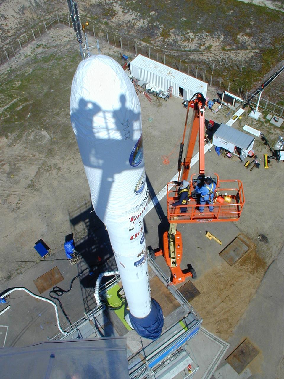
VANDENBERG AIR FORCE BASE, Calif. -- At Vandenberg Air Force Base in California, workers cautiously roll one half of the fairing that will envelop NASA's Glory satellite out of its cargo container. Both halves of the fairing will be installed around the spacecraft to protect it from the weather on the ground as well as from the atmosphere during flight. A four-stage Taurus XL rocket will carry Glory into low Earth orbit. Once Glory reaches orbit, it will collect data on the properties of aerosols and black carbon. It also will help scientists understand how the sun's irradiance affects Earth's climate. Launch is scheduled for 2:09 a.m. PST Nov. 22. For information, visit www.nasa.gov/glory. Photo credit: NASA/Randy Beaudoin, VAFB
VANDENBERG AIR FORCE BASE, Calif. -- Inside the Astrotech processing facility at Vandenberg Air Force Base, the OSTM/Jason-2 spacecraft is lifted to a near-45-degree angle on the tilt dolly. The OSTM, or Ocean Topography Mission, on the Jason-2 satellite is a follow-on to Jason-1. It will take oceanographic studies of sea surface height into an operational mode for continued climate forecasting research and science and industrial applications. This satellite altimetry data will help determine ocean circulation, climate change and sea-level rise. OSTM is a joint effort by the National Oceanic and Atmospheric Administration, NASA, France’s Centre National d’Etudes Spatiales and the European Meteorological Satellite Organisation. OSTM/Jason-2 will be launched aboard a United Launch Alliance Delta II 7320 from Vandenberg on June 15. Photo credit: NASA/Mark Mackley
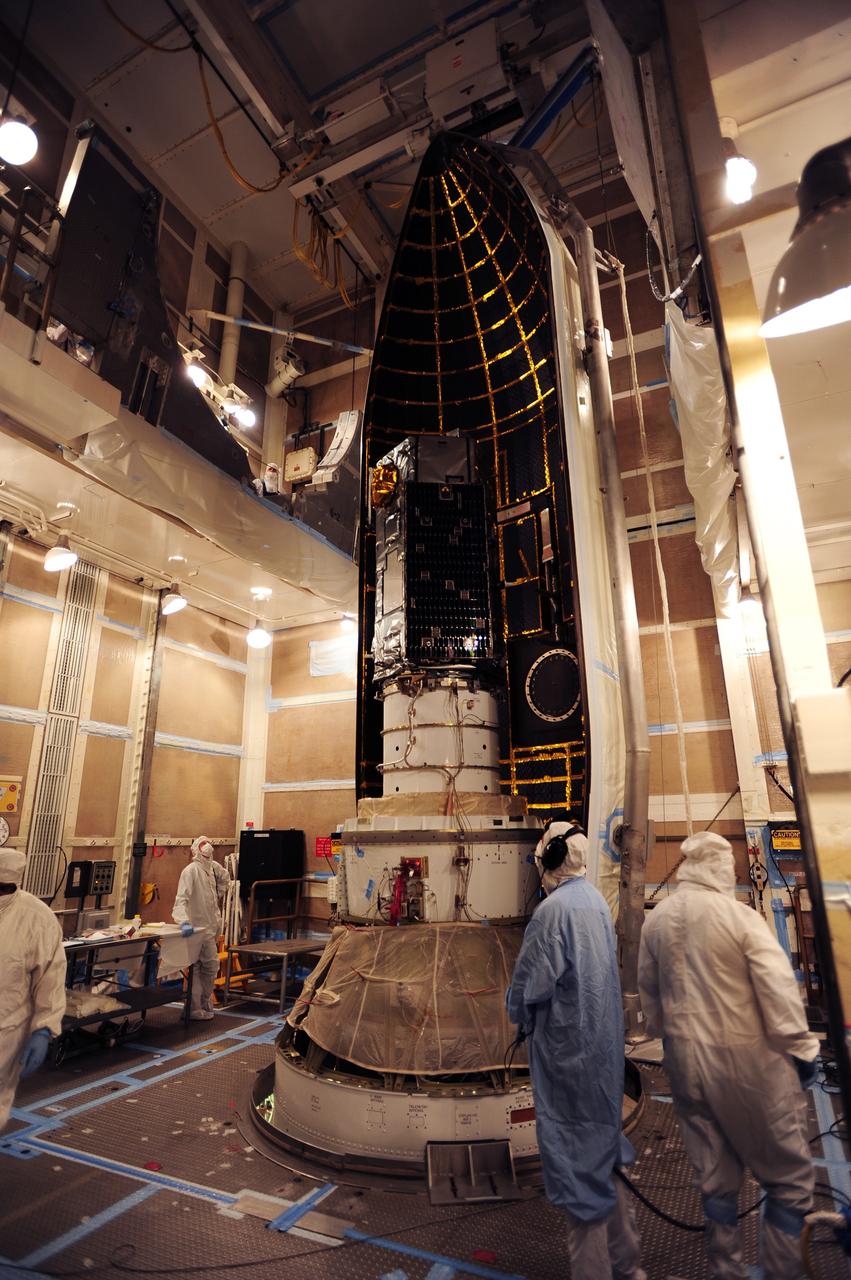
VANDENBERG AIR FORCE BASE, Calif. – At Vandenberg Air Force Base in California, the Pegasus XL rocket with the attached Interface Region Imaging Spectrograph IRIS solar observatory rolled out of the hangar on its transporter to the runway at Vandenberg. There, the rocket and spacecraft were mated with the Orbital Sciences L-1011 carrier aircraft. Scheduled for launch from Vandenberg on June 26, 2013, IRIS will open a new window of discovery by tracing the flow of energy and plasma through the chromospheres and transition region into the sun’s corona using spectrometry and imaging. The IRIS mission will observe how solar material moves, gathers energy and heats up as it travels through a largely unexplored region of the solar atmosphere. The interface region, located between the sun's visible surface and upper atmosphere, is where most of the sun's ultraviolet emission is generated. These emissions impact the near-Earth space environment and Earth's climate. For more information, visit http://www.nasa.gov/iris Photo credit: NASA/Randy Beaudoin
VANDENBERG AIR FORCE BASE, Calif. -- At the Astrotech processing facility on Vandenberg Air Force Base in California, NASA's Wide-field Infrared Survey Explorer, or WISE, is prepared for its move from the test stand for mating to its Payload Attach Fitting. The satellite will survey the entire sky at infrared wavelengths, creating a cosmic clearinghouse of hundreds of millions of objects which will be catalogued and provide a vast storehouse of knowledge about the solar system, the Milky Way, and the universe. Launch is scheduled for Dec. 7. Photo credit: NASA/Doug Kolkow
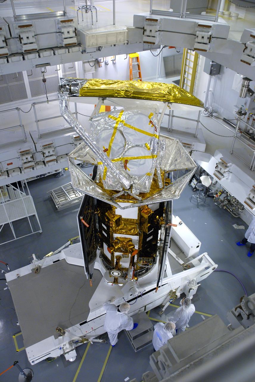
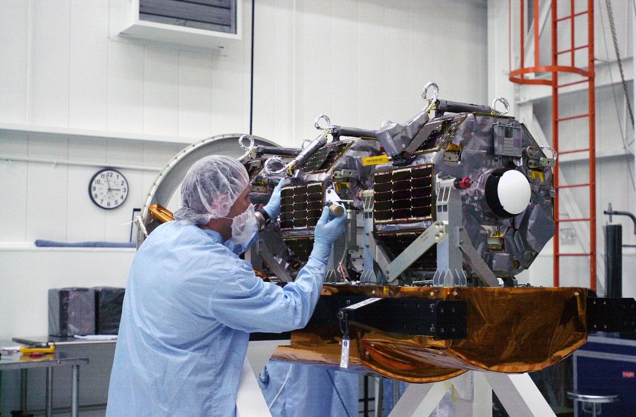
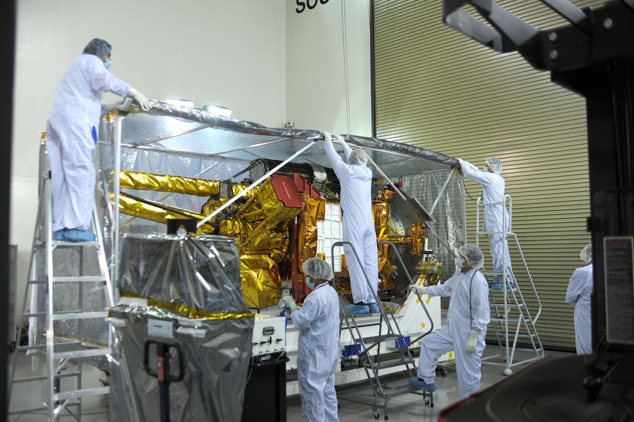
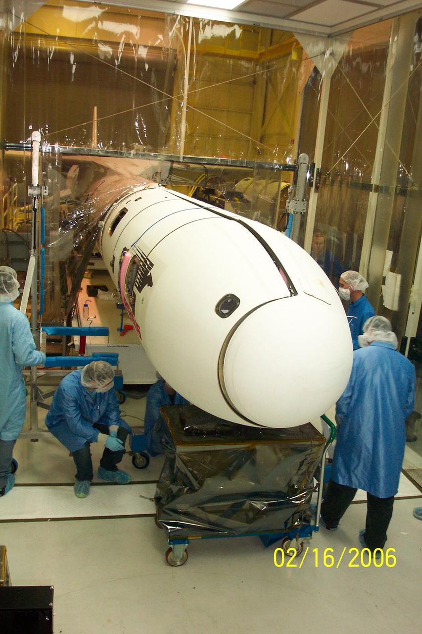
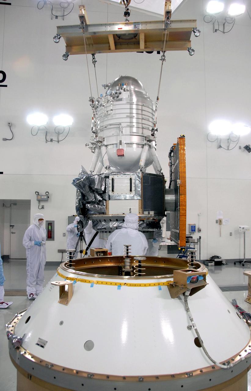
VANDENBERG AIR FORCE BASE, Calif. -- In Space Systems International's Payload Processing Facility at Vandenberg Air Force Base in California, NASA's Aquarius/SAC-D spacecraft is rotated for the final time into a vertical position prior to its installation into a transportation canister. Following delivery to the launch pad, the spacecraft will be integrated to a United Launch Alliance Delta II rocket in preparation for the targeted June liftoff. Aquarius, the NASA-built primary instrument on the SAC-D spacecraft, will provide new insights into how variations in ocean surface salinity relate to fundamental climate processes on its three-year mission. Photo credit: NASA/VAFB
VANDENBERG AIR FORCE BASE, Calif. – The second stage of the Delta II rocket for NASA's Soil Moisture Active Passive mission, or SMAP, is lowered onto the rocket's first stage in the mobile service tower at Space Launch Complex 2 on Vandenberg Air Force Base in California. Operations are underway to install the second stage atop the rocket's first stage. SMAP will launch on a Delta II 7320 configuration vehicle featuring a United Launch Alliance first stage booster powered by an Aerojet Rocketdyne RS-27A main engine and three Alliant Techsystems, or ATK, strap-on solid rocket motors. Once on station in Earth orbit, SMAP will provide global measurements of soil moisture and its freeze/thaw state. These measurements will be used to enhance understanding of processes that link the water, energy and carbon cycles, and to extend the capabilities of weather and climate prediction models. SMAP data also will be used to quantify net carbon flux in boreal landscapes and to develop improved flood prediction and drought monitoring capabilities. Launch is scheduled for no earlier than November 2014. To learn more about SMAP, visit http://smap.jpl.nasa.gov. Photo credit: NASA/Randy Beaudoin
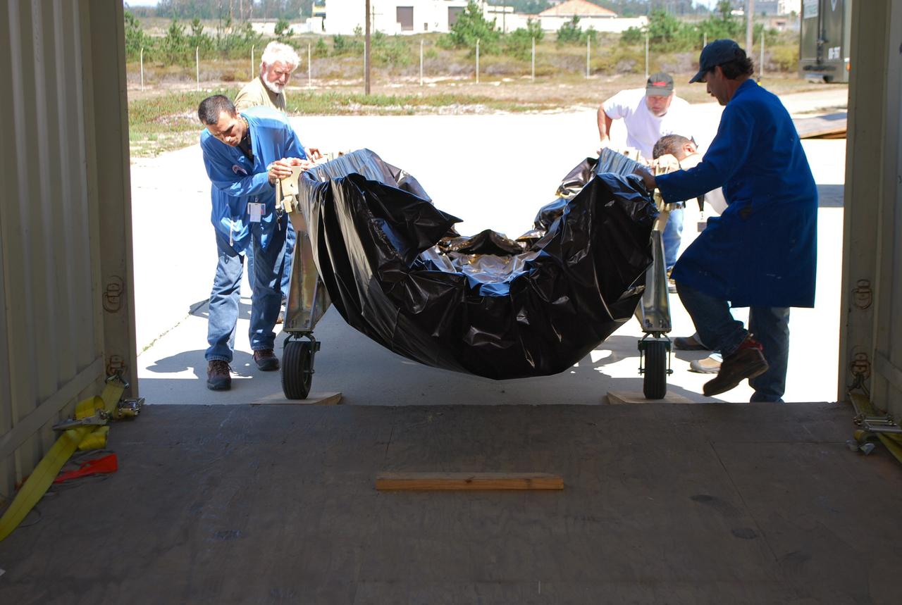
VANDENBERG AIR FORCE BASE, Calif. – The Interstellar Boundary Explorer, or IBEX, spacecraft is driven from the Astrotech building in an environmentally controlled container to Hangar 1555 on Vandenberg Air Force Base in California. In the hangar, IBEX will be mated with the Pegasus XL rocket for launch. The IBEX satellite will make the first map of the boundary between the Solar System and interstellar space. IBEX is targeted for launch from the Kwajalein Atoll, a part of the Marshall Islands in the Pacific Ocean, on Oct. 19 aboard the Pegasus rocket dropped from under the wing of an L-1011 aircraft flying over the Pacific Ocean. The Pegasus will carry the spacecraft approximately 130 miles above Earth and place it in orbit. Photo credit: NASA/Dan Liberotti, VAFB
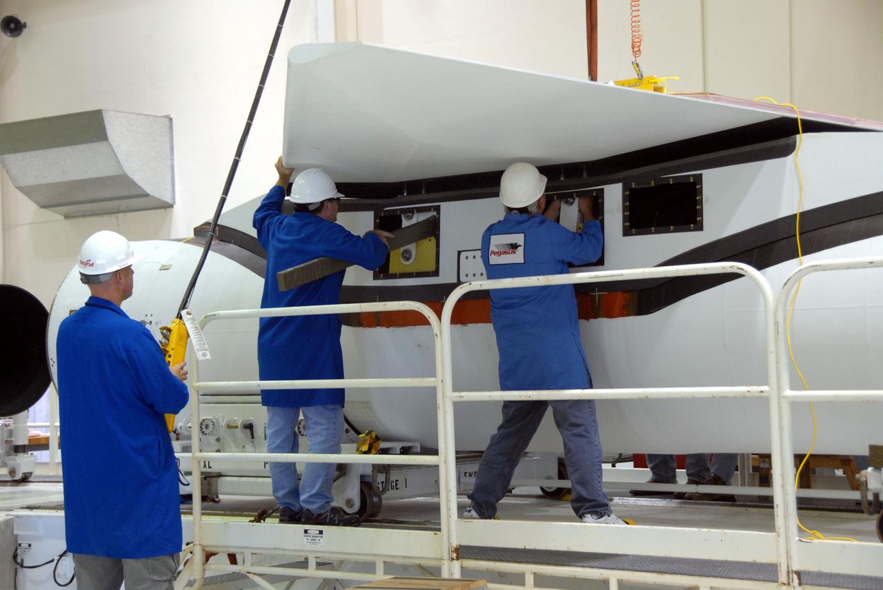
VANDENBERG AFB – Orbital Sciences team members move the second half of the payload fairing before it is placed over NASA's IRIS spacecraft. The fairing connects to the nose of the Orbital Sciences Pegasus XL rocket that will lift the solar observatory into orbit in June. The work is taking place in a hangar at Vandenberg Air Force Base where IRIS, short for Interface Region Imaging Spectrograph, is being prepared for launch on a Pegasus XL rocket. Scheduled for launch from Vandenberg June 26, IRIS will open a new window of discovery by tracing the flow of energy and plasma through the chromospheres and transition region into the sun’s corona using spectrometry and imaging. IRIS fills a crucial gap in our ability to advance studies of the sun-to-Earth connection by tracing the flow of energy and plasma through the foundation of the corona and the region around the sun known as the heliosphere. Photo credit: NASA/Tony Vauclin
VANDENBERG AIR FORCE BASE, Calif. – Inside the Astrotech payload processing facility on Vandenberg Air Force Base in California, engineers and technicians remove a protective covering from NASA's Soil Moisture Active Passive, or SMAP, spacecraft. SMAP will launch on a Delta II 7320 configuration vehicle featuring a United Launch Alliance first stage booster powered by an Aerojet Rocketdyne RS-27A main engine and three Alliant Techsystems, or ATK, strap-on solid rocket motors. Once on station in Earth orbit, SMAP will provide global measurements of soil moisture and its freeze/thaw state. These measurements will be used to enhance understanding of processes that link the water, energy and carbon cycles, and to extend the capabilities of weather and climate prediction models. SMAP data also will be used to quantify net carbon flux in boreal landscapes and to develop improved flood prediction and drought monitoring capabilities. Launch from Space Launch Complex 2 is targeted for Jan. 29, 2015. To learn more about SMAP, visit http://smap.jpl.nasa.gov Photo credit: NASA/ Robert Rasmison
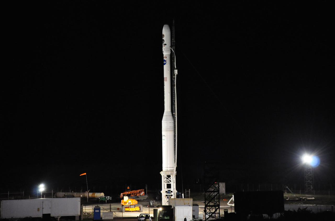
VANDENBERG AIR FORCE BASE, Calif. – The sun sets over the West Cost prior to the launch gantry being rolled back to reveal the United Launch Alliance Delta II rocket with the Soil Moisture Active Passive, or SMAP, satellite aboard, at the Space Launch Complex 2 at Vandenberg Air Force Base, California. SMAP is a remote sensing mission designed to measure and map the Earth's soil moisture distribution and freeze/thaw stat with unprecedented accuracy, resolution and coverage. SMAP will provide global measurements of soil moisture and its freeze/thaw state. These measurements will be used to enhance understanding of processes that link the water, energy and carbon cycles, and to extend the capabilities of weather and climate prediction models. SMAP data also will be used to quantify net carbon flux in boreal landscapes and to develop improved flood prediction and drought monitoring capabilities. Launch is scheduled for Jan. 29, 2015. To learn more about SMAP, visit http://smap.jpl.nasa.gov Photo credit: NASA/Randy Beaudoin
VANDENBERG AIR FORCE BASE, Calif. -- In front of the Astrotech processing facility at Vandenberg Air Force Base, a forklift begins to lift the OSTM/Jason-2 satellite shipping container off the flatbed truck. The OSTM, or Ocean Topography Mission, on the Jason-2 satellite is a follow-on to Jason-1. It will take oceanographic studies of sea surface height into an operational mode for continued climate forecasting research and science and industrial applications. This satellite altimetry data will help determine ocean circulation, climate change and sea-level rise. OSTM is a joint effort by the National Oceanic and Atmospheric Administration, NASA, France’s Centre National d’Etudes Spatiales and the European Meteorological Satellite Organisation. OSTM/Jason-2 will be launched aboard a United Launch Alliance Delta II 7320 from Vandenberg on June 15. Photo credit: NASA/Dan Liberotti
VANDENBERG AIR FORCE BASE, Calif. -- On Level 5 of Space Launch Complex-2 at Vandenberg Air Force Base in California, workers secure the payload fairing that will protect NASA's National Polar-orbiting Operational Environmental Satellite System Preparatory Project (NPP) satellite as it launches aboard a United Launch Alliance Delta II. NPP will be positioned 512 miles above the Earth's surface and will orbit about 16 times each day to observe nearly the entire globe. The NPP mission for NASA and the National Oceanic and Atmospheric Administration (NOAA) is to measure Earth's atmospheric and sea surface temperatures, humidity sounding, land and ocean biological activity, and cloud and aerosol properties. For more information, visit www.nasa.gov/NPP. Photo credit: NASA/VAFB, Roy Allison
VANDENBERG AIR FORCE BASE, Calif. – Technicians monitor a half-section of the Delta II payload fairing as it is moved toward NASA's Orbiting Carbon Observatory-2, or OCO-2, in the mobile service tower at Space Launch Complex 2 on Vandenberg Air Force Base in California. The fairing will protect OCO-2 during launch aboard a United Launch Alliance Delta II rocket, scheduled for 5:56 a.m. EDT on July 1. OCO-2 is NASA’s first mission dedicated to studying atmospheric carbon dioxide, the leading human-produced greenhouse gas driving changes in Earth’s climate. OCO-2 will provide a new tool for understanding the human and natural sources of carbon dioxide emissions and the natural "sinks" that absorb carbon dioxide and help control its buildup. The observatory will measure the global geographic distribution of these sources and sinks and study their changes over time. To learn more about OCO-2, visit http://oco.jpl.nasa.gov. Photo credit: NASA/30th Space Wing, U.S. Air Force
VANDENBERG AFB, Calif. - A mission logo decal for the launch of NASA's IRIS solar observatory aboard an Orbital Sciences Pegasus XL rocket. The decal is on the side of the Pegasus. Engineers are working inside a hangar at Vandenberg Air Force Base where IRIS, short for Interface Region Imaging Spectrograph, is being prepared for launch. Scheduled for launch from Vandenberg June 26, IRIS will open a new window of discovery by tracing the flow of energy and plasma through the chromospheres and transition region into the sun’s corona using spectrometry and imaging. IRIS fills a crucial gap in our ability to advance studies of the sun-to-Earth connection by tracing the flow of energy and plasma through the foundation of the corona and the region around the sun known as the heliosphere. Photo credit: NASA/Randy Beaudoin
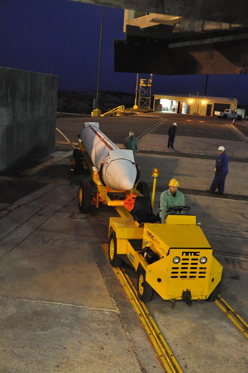
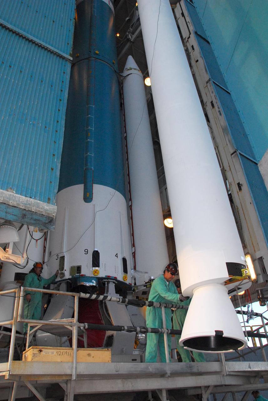
VANDENBERG AIR FORCE BASE, Calif. – The Stage 0 motor for the Taurus XL launch vehicle arrives at Vandenberg Air Force Base in California. The motor will be transported to Orbital Sciences' Hangar 1555. The Taurus XL will launch NASA's Orbiting Carbon Observatory, or OCO, spacecraft targeted for Jan. 15. The OCO is a new Earth-orbiting mission sponsored by NASA's Earth System Science Pathfinder Program. Photo credit: NASA/Randy Beaudoin, VAFB
VANDENBERG AIR FORCE BASE, Calif. -- On Launch Complex 576-E at Vandenberg Air Force Base in California, NASA's Orbiting Carbon Observatory, or OCO, undergoes closeouts for launch. OCO is atop the Orbital Sciences' Taurus XL rocket. OCO is scheduled for launch on the Taurus rocket Feb. 24 from Vandenberg. The spacecraft will collect precise global measurements of carbon dioxide (CO2) in the Earth's atmosphere. Scientists will analyze OCO data to improve our understanding of the natural processes and human activities that regulate the abundance and distribution of this important greenhouse gas. Photo credit: NASA/Richard Nielsen, VAFB

VANDENBERG AIR FORCE BASE, Calif. -- At the Orbital Sciences payload processing facility on Vandenberg Air Force Base in California, workers offload the third stage motor of the Taurus XL rocket for the launch of the Glory spacecraft in June 2009. Glory is a low-Earth orbit scientific research satellite designed to collect data on the properties and distributions of aerosols in the Earth's atmosphere and on solar irradiance for the long-term Earth climate record. Glory will be launched from Vandenberg aboard Orbital's Taurus XL 3110 launch vehicle. Photo credit: NASA/Randy Beaudoin, VAFB
VANDENBERG AIR FORCE BASE, Calif. -- Workers on Space Launch Complex 2 at Vandenberg Air Force Base in California prepare to attach a sling crane onto the Delta II second stage. The sling will lift the second stage into the mobile service tower for installation on the first stage for launch of the OSTM/Jason-2 spacecraft. The OSTM, or Ocean Topography Mission, on the Jason-2 satellite is a follow-on to Jason-1. It will take oceanographic studies of sea surface height into an operational mode for continued climate forecasting research and science and industrial applications. This satellite altimetry data will help determine ocean circulation, climate change and sea-level rise. OSTM is a joint effort by the National Oceanic and Atmospheric Administration, NASA, France’s Centre National d’Etudes Spatiales and the European Meteorological Satellite Organisation. OSTM/Jason-2 will be launched on June 20. Photo credit: NASA
VANDENBERG AIR FORCE BASE, Calif. -- A technician works in the Astrotech payload processing facility at Vandenberg Air Force Base in California before the pieces that will make up the payload fairing for the Glory mission are moved to the East High Bay. The payload fairing will protect the Glory spacecraft from aerodynamic pressures and heating during the first part of its climb into orbit. Once Glory reaches orbit, it will collect data on the properties of aerosols and black carbon. It also will help scientists understand how the sun's irradiance affects Earth's climate. Launch is scheduled for 5:09 a.m. EST Feb. 23. For information, visit www.nasa.gov/glory. Photo credit: NASA/Ed Henry, VAFB
VANDENBERG AIR FORCE BASE, Calif. -- At Vandenberg Air Force Base in California, workers are preparing to unload a payload cone for NASA's Glory mission. The payload cone is an adapter that interfaces the Taurus XL rocket with the spacecraft. A four-stage Taurus XL rocket will carry Glory into low Earth orbit. Once Glory reaches orbit, it will collect data on the properties of aerosols and black carbon. It also will help scientists understand how the sun's irradiance affects Earth's climate. Launch is scheduled for 2:09 a.m. PST Nov. 22. For information, visit www.nasa.gov/glory. Photo credit: NASA/Randy Beaudoin, VAFB
VANDENBERG AIR FORCE BASE, Calif. – At Vandenberg Air Force Base in California, technicians help guide the Star-27 kick motor and nozzle for NASA's Interstellar Boundary Explorer, or IBEX, mission spacecraft. The motor/nozzle will be inserted in the adapter cone (bottom of the foreground). The IBEX satellite will make the first map of the boundary between the Solar System and interstellar space. IBEX is the first mission designed to detect the edge of the Solar System. As the solar wind from the sun flows out beyond Pluto, it collides with the material between the stars, forming a shock front. IBEX contains two neutral atom imagers designed to detect particles from the termination shock at the boundary between the Solar System and interstellar space. IBEX also will study galactic cosmic rays, energetic particles from beyond the Solar System that pose a health and safety hazard for humans exploring beyond Earth orbit. IBEX will make these observations from a highly elliptical orbit that takes it beyond the interference of the Earth's magnetosphere. IBEX is targeted for launch from the Pegasus XL rocket on Oct. 5. Photo credit: NASA/R. Bledsoe
VANDENBERG AIR FORCE BASE, Calif. – Technicians prepare to offload the first stage of a United Launch Alliance Delta II rocket following its arrival at NASA hangar 836 on Vandenberg Air Force Base in California. The launch vehicle will be used to deliver NASA's Soil Moisture Active Passive mission, or SMAP, into orbit. SMAP will provide global measurements of soil moisture and its freeze/thaw state. These measurements will be used to enhance understanding of processes that link the water, energy and carbon cycles, and to extend the capabilities of weather and climate prediction models. SMAP data also will be used to quantify net carbon flux in boreal landscapes and to develop improved flood prediction and drought monitoring capabilities. Launch is scheduled for November 2014. To learn more about SMAP, visit http://smap.jpl.nasa.gov Photo credit: NASA/Randy Beaudoin
VANDENBERG AIR FORCE BASE, Calif. -- Workers attach an overhead crane to the Aquarius/SAC-D spacecraft, secured inside its payload transportation canister, for lifting into the mobile service tower at NASA's Space Launch Complex-2 (SLC-2) at Vandenberg Air Force Base in California. There, the spacecraft will be integrated to a United Launch Alliance Delta II rocket in preparation for the targeted June liftoff. Aquarius, the NASA-built instrument on the SAC-D spacecraft, will provide new insights into how variations in ocean surface salinity relate to fundamental climate processes on its three-year mission. Photo credit: NASA/VAFB
VANDENBERG AIR FORCE BASE, Calif. – The half sections of the 10-foot-diameter fairing for NASA's Soil Moisture Active Passive mission, or SMAP, are delivered to the mobile service tower at Space Launch Complex 2 on Vandenberg Air Force Base in California. The fairing will protect the SMAP spacecraft from the heat and aerodynamic pressure generated during its ascent to orbit aboard a United Launch Alliance Delta II rocket. SMAP will provide global measurements of soil moisture and its freeze/thaw state. These measurements will be used to enhance understanding of processes that link the water, energy and carbon cycles, and to extend the capabilities of weather and climate prediction models. SMAP data will also be used to quantify net carbon flux in boreal landscapes and to develop improved flood prediction and drought monitoring capabilities. Launch is scheduled for no earlier than November 2014. To learn more about SMAP, visit http://smap.jpl.nasa.gov. Photo credit: NASA/Randy Beaudoin

VANDENBERG AIR FORCE BASE, Calif. – Another view of the NOAA-N Prime satellite in the payload processing facility at Vandenberg Air Force Base in California. NOAA-N Prime is the latest polar-orbiting operational environmental weather satellite developed by NASA for the National Oceanic and Atmospheric Administration. It is built by Lockheed Martin and similar to NOAA-N launched on May 20, 2005. Launch of NOAA-N Prime is scheduled for Feb. 4. Photo credit: NASA

VANDENBERG AIR FORCE BASE, Calif. -- Workers adjust the Stage 0 motor of the Orbital Sciences Corp. Taurus XL into launch position on Space Launch Complex 576-E at Vandenberg Air Force Base in California. As part of the four-stage Taurus XL rocket that will carry NASA's Glory spacecraft into low Earth orbit, stages 1, 2 and 3 will join Stage 0 at the launch pad about a week later. Once Glory reaches orbit, it will collect data on the properties of aerosols and black carbon. It also will help scientists understand how the sun's irradiance affects Earth's climate. Launch is scheduled for 5:09 a.m. EST Feb. 23. For information, visit www.nasa.gov/glory. Photo credit: NASA/Don Kosoksa, VAFB
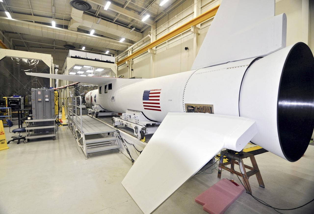
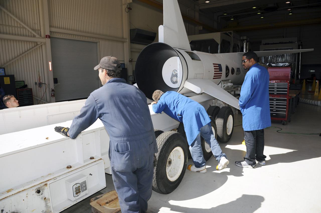
VANDENBERG AIR FORCE BASE, CALIF. -- At Vandenberg Air Force Base in California, technicians discuss the process for mating the first and second stages of the Orbital Sciences Pegasus XL rocket in front of them. The rocket is the launch vehicle for NASA's Aeronomy of Ice in the Mesosphere, or AIM, spacecraft. AIM is the seventh Small Explorers mission under NASA's Explorer Program. The program provides frequent flight opportunities for world-class scientific investigations from space within heliophysics and astrophysics. The AIM spacecraft will fly three instruments designed to study polar mesospheric clouds located at the edge of space, 50 miles above the Earth's surface in the coldest part of the planet's atmosphere. The mission's primary goal is to explain why these clouds form and what has caused them to become brighter and more numerous and appear at lower latitudes in recent years. AIM's results will provide the basis for the study of long-term variability in the mesospheric climate and its relationship to global climate change. AIM is scheduled to be mated to the Pegasus XL during the second week of April, after which final inspections will be conducted. Launch is scheduled for April 25.
VANDENBERG AIR FORCE BASE, Calif. -- Inside the mobile service tower at NASA's Launch Complex-2 at Vandenberg Air Force Base in California, workers monitor the progress as the United Launch Alliance’s Delta II payload fairing closes around the Aquarius/SAC-D spacecraft. Aquarius will be integrated to the Delta II rocket in preparation for the targeted June 9 liftoff. Aquarius, the NASA-built instrument on the SAC-D spacecraft, will provide new insights into how variations in ocean surface salinity relate to fundamental climate processes on its three-year mission. Photo credit: NASA/VAFB
VANDENBERG AIR FORCE BASE, CALIF. -- Seen at Vandenberg Air Force Base in California is the fairing (foreground) for the Orbital Sciences Pegasus XL rocket. In the background is the third stage, under the clean room tent. The rocket is the launch vehicle for NASA's Aeronomy of Ice in the Mesosphere, or AIM, spacecraft. AIM is the seventh Small Explorers mission under NASA's Explorer Program. The program provides frequent flight opportunities for world-class scientific investigations from space within heliophysics and astrophysics. The AIM spacecraft will fly three instruments designed to study polar mesospheric clouds located at the edge of space, 50 miles above the Earth's surface in the coldest part of the planet's atmosphere. The mission's primary goal is to explain why these clouds form and what has caused them to become brighter and more numerous and appear at lower latitudes in recent years. AIM's results will provide the basis for the study of long-term variability in the mesospheric climate and its relationship to global climate change. AIM is scheduled to be mated to the Pegasus XL during the second week of April, after which final inspections will be conducted. Launch is scheduled for April 25.
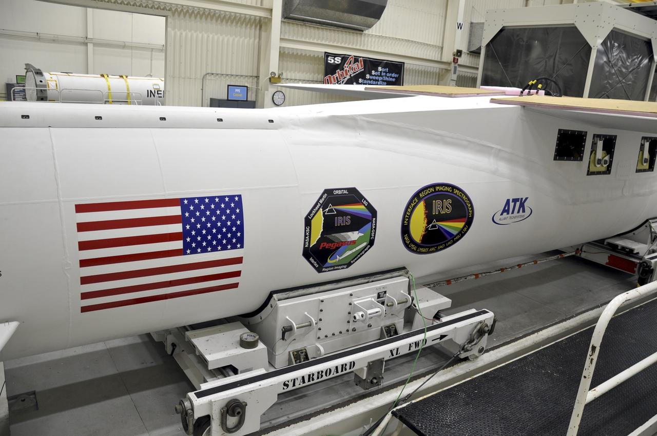
VANDENBERG AFB, Calif. - An Orbital Sciences Pegasus XL rocket undergoes launch preparations inside a hangar at Vandenberg Air Force Base for NASA's IRIS mission, short for Interface Region Imaging Spectrograph. Scheduled for launch from Vandenberg June 26, IRIS will open a new window of discovery by tracing the flow of energy and plasma through the chromospheres and transition region into the sun’s corona using spectrometry and imaging. IRIS fills a crucial gap in our ability to advance studies of the sun-to-Earth connection by tracing the flow of energy and plasma through the foundation of the corona and the region around the sun known as the heliosphere. Photo credit: NASA/Randy Beaudoin
VANDENBERG AIR FORCE BASE, Calif. -- At NASA’s Space Launch Complex-2 at Vandenberg Air Force Base in California, technicians monitor the progress as a solid rocket motor is lifted by crane for attachment to the United Launch Alliance Delta II rocket is lifted by crane. The Delta II will carry NASA’s National Polar-orbiting Operational Environmental Satellite System Preparatory Project (NPP) satellite into space. NPP represents a critical first step in building the next-generation of Earth-observing satellites. NPP will carry the first of the new sensors developed for this satellite fleet, now known as the Joint Polar Satellite System (JPSS) to be launched in 2016. NPP is the bridge between NASA's Earth Observing System (EOS) satellites and the forthcoming series of JPSS satellites. The mission will test key technologies and instruments for the JPSS missions. NPP is targeted to launch Oct. 25. For more information, visit http://www.nasa.gov/NPP. Photo credit: NASA/VAFB, Mark Mackley

VANDENBERG AIR FORCE BASE, Calif. -- At Vandenberg Air Force Base in California, the Taurus XL rocket's Stage 3 motor is on a stationary rail in a temporary processing tent near the pad at Space Launch Complex 576-E. Orbital Sciences' Taurus XL is a four-stage rocket that will carry NASA's Glory spacecraft into low Earth orbit. In early February, the spacecraft is scheduled to arrive at the pad, where it will be attached to the third stage and then stacked atop the remaining stages. Once Glory reaches orbit, it will collect data on the properties of aerosols and black carbon. It also will help scientists understand how the sun's irradiance affects Earth's climate. Launch is scheduled for 5:09 a.m. EST Feb. 23. For information, visit www.nasa.gov/glory. Photo credit: NASA/Randy Beaudoin, VAFB
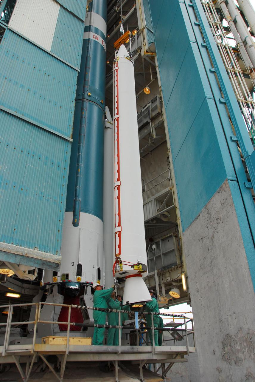
VANDENBERG AIR FORCE BASE, Calif. – Stages 1, 2 and 3 of Orbital Sciences’ Taurus XL launch vehicle for NASA’s Orbiting Carbon Observatory, or OCO, have arrived and are prepared for erection at Space Launch Complex 576-E at Vandenberg Air Force Base in California. The OCO is an Earth-orbiting mission sponsored by NASA's Earth System Science Pathfinder Program. The observatory will collect precise global measurements of carbon dioxide in the Earth's atmosphere. Scientists will analyze the data returned to better understand the natural processes and human activities that regulate the abundance and distribution of this important greenhouse gas. Launch is targeted for 1:51:30 a.m. PST Feb. 24. Photo credit: VAFB
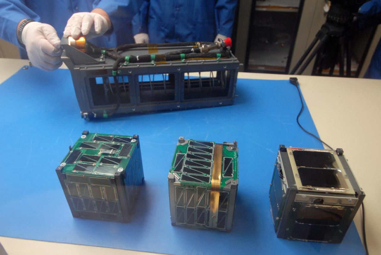
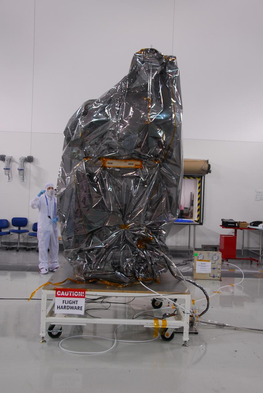
San Luis Obispo, Calif. -- 101116-F-8290C-045 -- Students at California Polytechnic State University Cal Poly prepare to integrate miniature research satellites called CubeSats into a Poly Picosatellite Orbital Deployer PPOD container. The PPOD and CubeSat Project were developed by Cal Poly and Stanford University’s Space Systems Development Lab for use on NASA’s Educational Launch of Nanosatellite ELaNa missions. Each CubeSat measures about 4-inches cubed and is about the same volume as a quart. The CubeSats weigh about 2.2 pounds, must conform to standard aerospace materials and must operate without propulsion. The satellites are being prepared to launch with NASA's Glory spacecraft aboard an Orbital Sciences Corp. Taurus XL rocket, targeted to lift off Feb. 23, 2011, from Vandenberg's Space Launch Complex 576-E. Glory is scheduled to collect data on the properties of aerosols and black carbon from its place in low Earth orbit. It also will help scientists understand how the sun's irradiance affects Earth's climate. Photo credit: U.S. Air Force/Jerry E. Clemens Jr.

VANDENBERG AIR FORCE BASE, Calif. – At Vandenberg Air Force Base in California, technicians install the aft skirt on the Orbital Sciences Corp. Pegasus XL rocket which will launch the Interface Region Imaging Spectrograph, or IRIS, spacecraft. Scheduled for launch from Vandenberg Air Force Base no earlier than Feb. 27, 2013, IRIS will open a new window of discovery by tracing the flow of energy and plasma through the chromospheres and transition region into the sun’s corona using spectrometry and imaging. IRIS fills a crucial gap in our ability to advance studies of the sun-to-Earth connection by tracing the flow of energy and plasma through the foundation of the corona and the region around the sun known as the heliosphere. For more information, visit http://iris.gsfc.nasa.gov Photo credit: NASA/Randy Beaudoin
VANDENBERG AIR FORCE BASE, Calif. - Spacecraft technicians begin to offload NASA's Wide-field Infrared Survey Explorer, or WISE, enclosed in a transportation canister, upon its arrival at Space Launch Complex 2 at Vandenberg Air Force Base in California. WISE will survey the entire sky at infrared wavelengths, creating a cosmic clearinghouse of hundreds of millions of objects which will be catalogued and provide a vast storehouse of knowledge about the solar system, the Milky Way, and the universe. Launch is scheduled for Dec. 9. For additional information, visit http://www.nasa.gov/wise. Photo credit: NASA/Mark Mackley, VAFB
VANDENBERG AIR FORCE BASE, Calif. – Inside a protected clean room tent on Vandenberg Air Force Base in California, workers install the fairing around NASA’s Interstellar Boundary Explorer, or IBEX, spacecraft. The fairing is a molded structure that fits flush with the outside surface of the rocket and forms an aerodynamically smooth nose cone, protecting the spacecraft during launch and ascent. The IBEX satellite will make the first map of the boundary between the Solar System and interstellar space. IBEX is targeted for launch from the Kwajalein Atoll, a part of the Marshall Islands in the Pacific Ocean, on Oct. 19. IBEX will be launched aboard a Pegasus rocket dropped from under the wing of an L-1011 aircraft flying over the Pacific Ocean. The Pegasus will carry the spacecraft approximately 130 miles above Earth and place it in orbit. Photo credit: NASA/Randy Beaudoin, VAFB

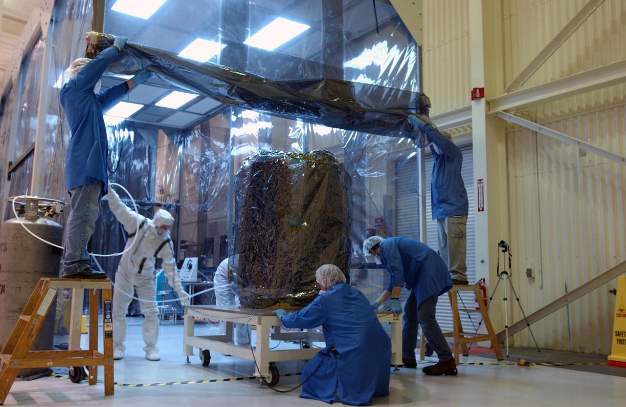
VANDENBERG AIR FORCE BASE, Calif. - Inside the Astrotech Payload Processing Facility on Vandenberg Air Force Base in California, workers secure the transport canister around the dual spacecraft CALIPSO and CloudSat. The spacecraft will be moved to Space Launch Complex 2. CALIPSO stands for Cloud-Aerosol Lidar and Infrared Pathfinder Satellite Observation. It will fly in combination with the CloudSat satellite to provide never-before-seen 3-D perspectives of how clouds and aerosols form, evolve, and affect weather and climate. CALIPSO and CloudSat will join three other satellites in orbit to enhance understanding of climate systems.
VANDENBERG AIR FORCE BASE, Calif. – Preparations are underway to transport a half section of the 10-foot-diameter fairing for NASA's Soil Moisture Active Passive mission, or SMAP, from the Horizontal Integration Facility to the nearby mobile service tower at Space Launch Complex 2 on Vandenberg Air Force Base in California. The fairing will protect the SMAP spacecraft from the heat and aerodynamic pressure generated during its ascent to orbit aboard a United Launch Alliance Delta II rocket. SMAP will provide global measurements of soil moisture and its freeze/thaw state. These measurements will be used to enhance understanding of processes that link the water, energy and carbon cycles, and to extend the capabilities of weather and climate prediction models. SMAP data will also be used to quantify net carbon flux in boreal landscapes and to develop improved flood prediction and drought monitoring capabilities. Launch is scheduled for no earlier than November 2014. To learn more about SMAP, visit http://smap.jpl.nasa.gov. Photo credit: NASA/Randy Beaudoin

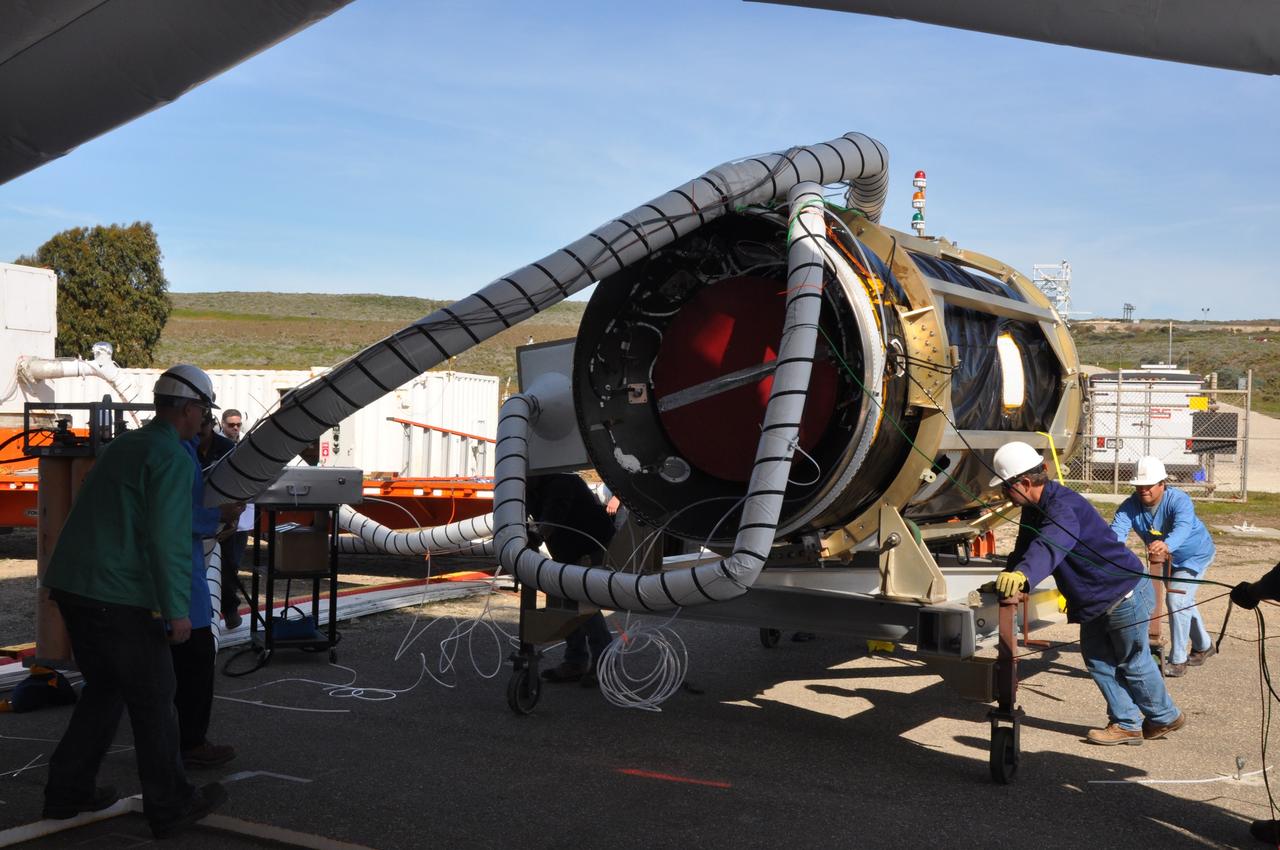
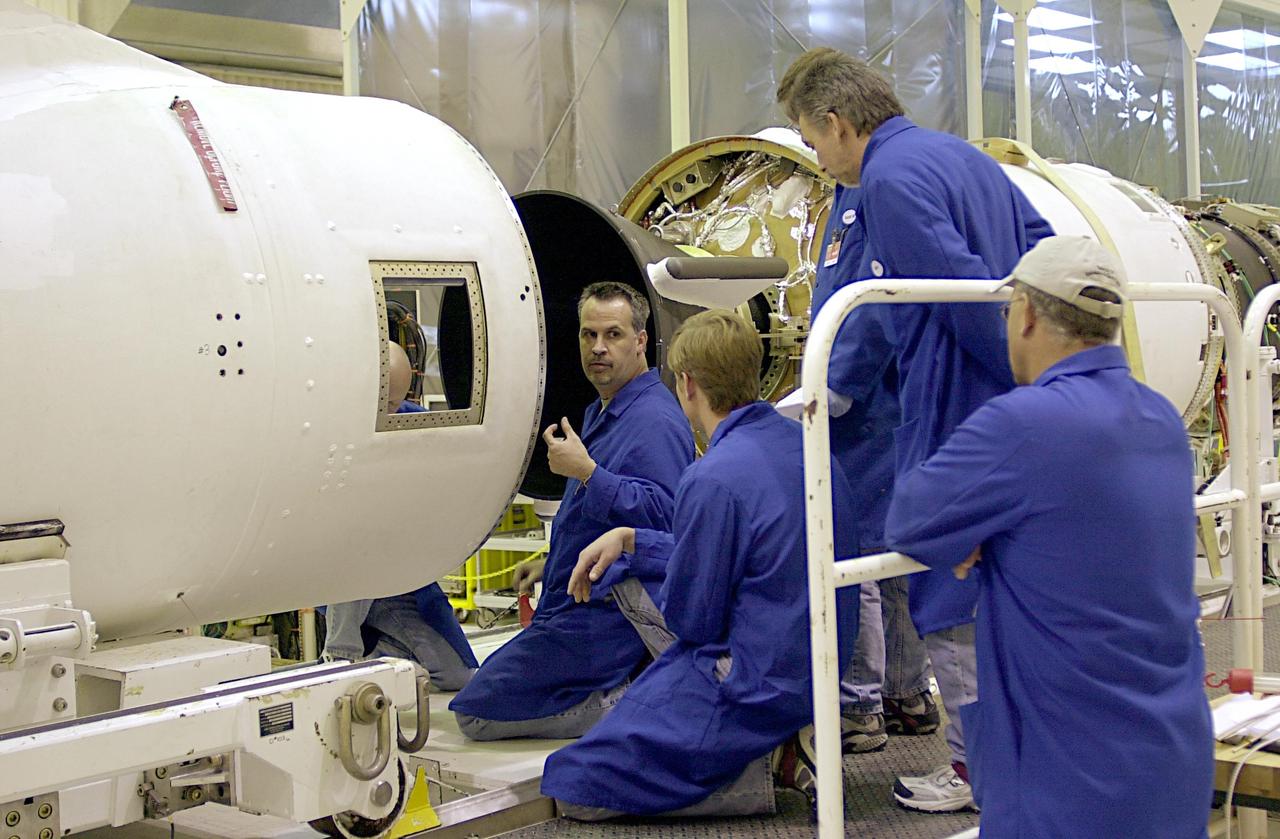
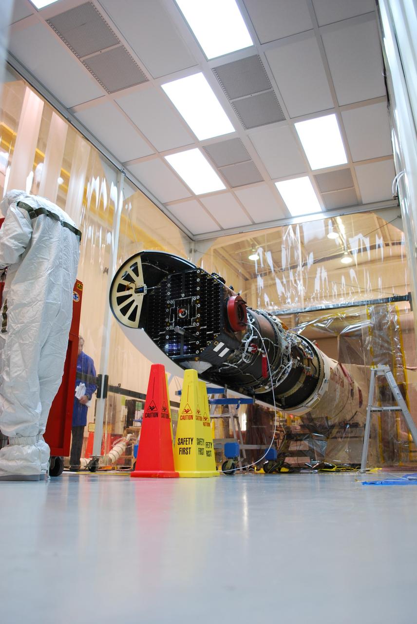
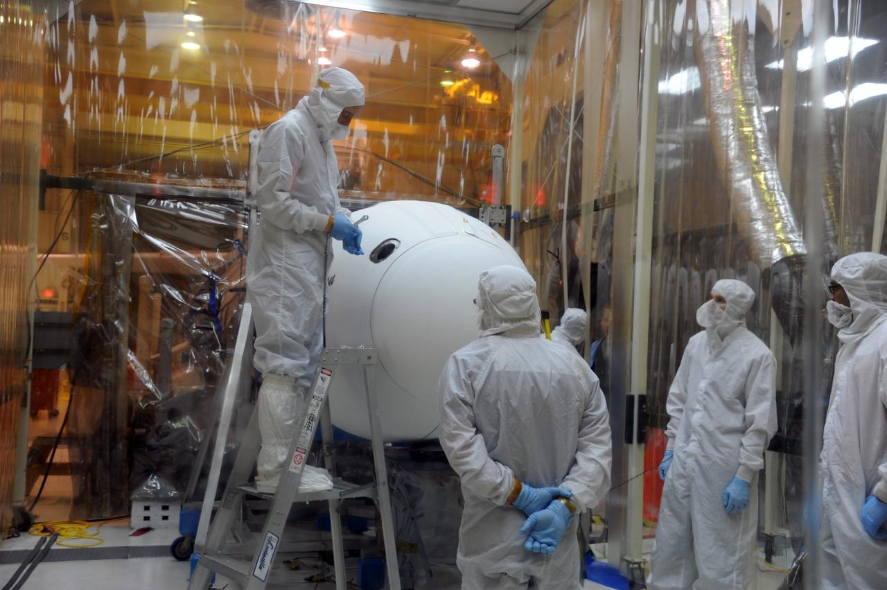
VANDENBERG AIR FORCE BASE, Calif. -- In the airlock of processing facility 1555 at Vandenberg Air Force Base (VAFB) in California, NASA's Nuclear Spectroscopic Telescope Array (NuSTAR), wrapped in a protective shroud, comes into view as the environmentally controlled shipping container is lifted away from the spacecraft. The spacecraft arrived at VAFB Jan. 27 after a cross-country trip which began from Orbital Sciences' manufacturing plant in Dulles, Va., on Jan. 24. Next, NuSTAR will be transferred from the airlock into the processing hangar, joining the Pegasus XL rocket that is set to carry it to space. After checkout and other processing activities are complete, the spacecraft will be integrated with the Pegasus in mid-February and encapsulation in the vehicle fairing will follow. The rocket and spacecraft then will be flown on Orbital's L-1011 carrier aircraft to the Ronald Reagan Ballistic Missile Defense Test Site at the Pacific Ocean's Kwajalein Atoll for launch in March. The high-energy X-ray telescope will conduct a census for black holes, map radioactive material in young supernovae remnants, and study the origins of cosmic rays and the extreme physics around collapsed stars. For more information, visit http://www.nasa.gov/nustar. Photo credit: NASA/Randy Beaudoin, VAFB

VANDENBERG AIR FORCE BASE, Calif. – NASA's Orbiting Carbon Observatory-2, or OCO-2, is connected to the payload attach system inside a clean room in the Astrotech Payload Processing Facility at Vandenberg Air Force Base in California. Launch aboard a United Launch Alliance Delta II rocket is scheduled for July 1, 2014, from Space Launch Complex 2. The observatory will collect precise global measurements of carbon dioxide in the Earth's atmosphere and provide scientists with a better idea of the chemical compound's impacts on climate change. Scientists will analyze this data to improve our understanding of the natural processes and human activities that regulate the abundance and distribution of this important atmospheric gas. To learn more about OCO-2, visit http://oco.jpl.nasa.gov. Photo credit: NASA/U. S. Air Force 30th Space Wing
VANDENBERG AIR FORCE BASE, Calif. – The mobile service tower on Space Launch Complex 2 at Vandenberg Air Force Base in California rolls away from the United Launch Alliance Delta II rocket carrying NASA's Orbiting Carbon Observatory-2, or OCO-2. Launch is scheduled for 5:56 a.m. EDT on July 1. OCO-2 is NASA’s first mission dedicated to studying atmospheric carbon dioxide, the leading human-produced greenhouse gas driving changes in Earth’s climate. OCO-2 will provide a new tool for understanding the human and natural sources of carbon dioxide emissions and the natural "sinks" that absorb carbon dioxide and help control its buildup. The observatory will measure the global geographic distribution of these sources and sinks and study their changes over time. To learn more about OCO-2, visit http://www.nasa.gov/oco2. Photo credit: NASA/Randy Beaudoin
VANDENBERG AIR FORCE BASE, Calif. - At the Astrotech payload processing facility at Vandenberg Air Force Base in California, spacecraft technicians supervise the lift of a transportation canister containing NASA's Wide-field Infrared Survey Explorer, or WISE, from a work stand for its move to Space Launch Complex 2. WISE will survey the entire sky at infrared wavelengths, creating a cosmic clearinghouse of hundreds of millions of objects which will be catalogued and provide a vast storehouse of knowledge about the solar system, the Milky Way, and the universe. Launch aboard a United Launch Alliance Delta II rocket is scheduled for Dec. 9. For additional information, visit http://www.nasa.gov/wise. Photo credit: NASA/Daniel Liberotti, VAFB
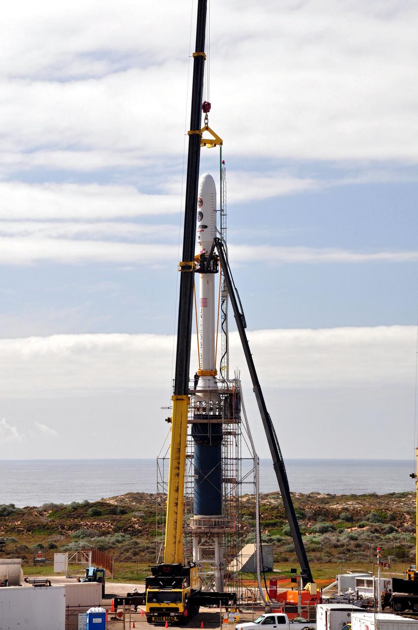
VANDENBERG AIR FORCE BASE, Calif. -- On Launch Complex 576-E at Vandenberg Air Force Base in California, two cranes are used to lift NASA's Orbiting Carbon Observatory, or OCO, spacecraft. It will be raised to vertical and attached to the waiting Stage 0 motor of the Taurus XL launch vehicle in the tower. The OCO is attached to the upper stack, consisting of Stages 1, 2 and 3 of the Taurus. The spacecraft is scheduled for launch aboard Orbital Sciences' Taurus XL rocket Feb. 24 from Vandenberg. The spacecraft will collect precise global measurements of carbon dioxide (CO2) in the Earth's atmosphere. Scientists will analyze OCO data to improve our understanding of the natural processes and human activities that regulate the abundance and distribution of this important greenhouse gas. Photo credit: NASA/Randy Beaudoin, VAFB

VANDENBERG AIR FORCE BASE, CALIF. -- At Vandenberg Air Force Base in California, workers move the stand holding NASA's Aeronomy of Ice in the Mesosphere, or AIM, spacecraft under a clean room tent. AIM is the seventh Small Explorers mission under NASA's Explorer Program. The program provides frequent flight opportunities for world-class scientific investigations from space within heliophysics and astrophysics. The AIM spacecraft will fly three instruments designed to study polar mesospheric clouds located at the edge of space, 50 miles above the Earth's surface in the coldest part of the planet's atmosphere. The mission's primary goal is to explain why these clouds form and what has caused them to become brighter and more numerous and appear at lower latitudes in recent years. AIM's results will provide the basis for the study of long-term variability in the mesospheric climate and its relationship to global climate change. AIM is scheduled to be mated to the Pegasus XL during the second week of April, after which final inspections will be conducted. Launch is scheduled for April 25.
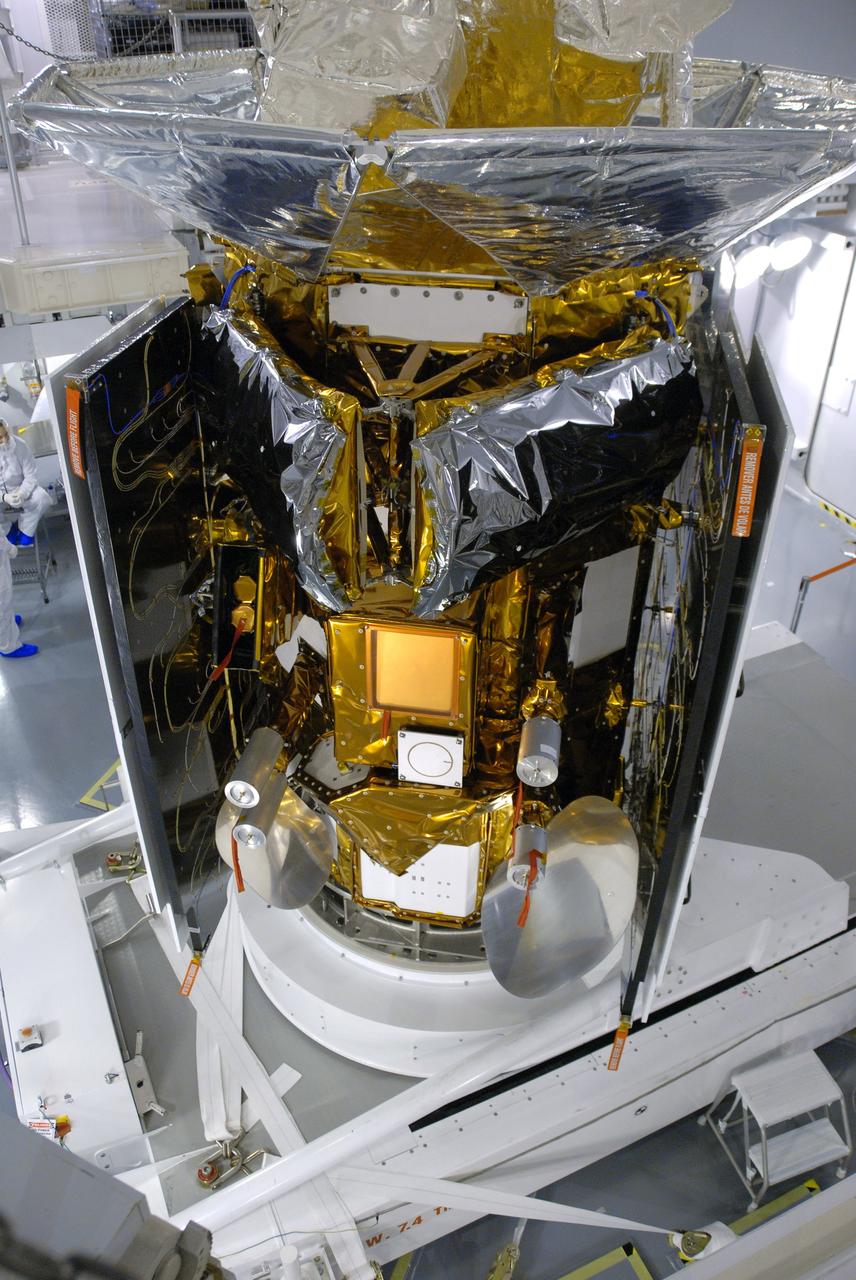
VANDENBERG AIR FORCE BASE, Calif. -- In Space Systems International's Payload Processing Facility at Vandenberg Air Force Base in California, NASA's Aquarius/SAC-D spacecraft is rotated for the final time into a vertical position prior to its installation into a transportation canister. Following delivery to the launch pad, the spacecraft will be integrated to a United Launch Alliance Delta II rocket in preparation for the targeted June liftoff. Aquarius, the NASA-built primary instrument on the SAC-D spacecraft, will provide new insights into how variations in ocean surface salinity relate to fundamental climate processes on its three-year mission. Photo credit: NASA/VAFB

VANDENBERG AIR FORCE BASE, Calif. – In a clean room at Vandenberg Air Force Base in California, technicians complete a second fillet and wing fit check on the Pegasus XL launch vehicle. The Orbital Sciences Corp. Pegasus rocket will launch the Nuclear Spectroscopic Telescope Array (NuSTAR) into space. After the rocket and spacecraft are processed at Vandenberg, they will be flown on the Orbital Sciences’ L-1011 carrier aircraft to the Ronald Reagan Ballistic Missile Defense Test Site at the Pacific Ocean’s Kwajalein Atoll for launch. The high-energy X-ray telescope will conduct a census for black holes, map radioactive material in young supernovae remnants, and study the origins of cosmic rays and the extreme physics around collapsed stars. For more information, visit science.nasa.gov/missions/nustar/. Photo credit: NASA/Randy Beaudoin, VAFB
VANDENBERG AIR FORCE BASE, Calif. – The Delta II interstage adapter, or ISA, for NASA's Soil Moisture Active Passive mission, or SMAP, approaches the mobile service tower at Space Launch Complex 2 on Vandenberg Air Force Base in California. A United Launch Alliance Delta II rocket will loft SMAP into orbit. The ISA connects the Delta II first and second stages and encloses the second stage engine and thrust section. The spacecraft will provide global measurements of soil moisture and its freeze/thaw state. These measurements will be used to enhance understanding of processes that link the water, energy and carbon cycles, and to extend the capabilities of weather and climate prediction models. The data returned also will be used to quantify net carbon flux in boreal landscapes and to develop improved flood prediction and drought monitoring capabilities. Launch is scheduled for November 2014. To learn more about SMAP, visit http://smap.jpl.nasa.gov. Photo credit: NASA/Randy Beaudoin
VANDENBERG AIR FORCE BASE, Calif. -- Inside the Astrotech payload processing facility at Vandenberg Air Force Base in California, NASA's Glory spacecraft will be removed from its protective covering. Next, the spacecraft will be encapsulated in its protective payload fairing before it is transported to Space Launch Complex 576-E and joined with the Taurus XL rocket's third stage. Once Glory reaches orbit, it will collect data on the properties of aerosols and black carbon. It also will help scientists understand how the sun's irradiance affects Earth's climate. Launch is scheduled for 5:09 a.m. EST Feb. 23. For information, visit www.nasa.gov/glory. Photo credit: NASA/Ed Henry, VAFB
VANDENBERG AIR FORCE BASE, Calif. – Workers secure the Delta II interstage adapter, or ISA, for NASA's Soil Moisture Active Passive mission, or SMAP, onto the flatbed of the truck that will transport it to the pad from the Building 836 hangar on south Vandenberg Air Force Base in California. A United Launch Alliance Delta II rocket will loft SMAP into orbit from Vandenberg's Space Launch Complex 2. The ISA connects the Delta II first and second stages and encloses the second stage engine and thrust section. The spacecraft will provide global measurements of soil moisture and its freeze/thaw state. These measurements will be used to enhance understanding of processes that link the water, energy and carbon cycles, and to extend the capabilities of weather and climate prediction models. The data returned also will be used to quantify net carbon flux in boreal landscapes and to develop improved flood prediction and drought monitoring capabilities. Launch is scheduled for November 2014. To learn more about SMAP, visit http://smap.jpl.nasa.gov. Photo credit: NASA/Randy Beaudoin
VANDENBERG AIR FORCE BASE, CALIF. - Inside Orbital Sciences’ Building 1555 at Vandenberg Air Force Base in California, workers continue the installation of the second half of the fairing around the Space Technology 5 (ST5) spacecraft. The ST5, which contains three microsatellites with miniaturized redundant components and technologies, is mated to its launch vehicle, Orbital Sciences' Pegasus XL. Each of the ST5 microsatellites will validate New Millennium Program selected technologies, such as the Cold Gas Micro-Thruster and X-Band Transponder Communication System. After deployment from the Pegasus, the micro-satellites will be positioned in a “string of pearls” constellation that demonstrates the ability to position them to perform simultaneous multi-point measurements of the magnetic field using highly sensitive magnetometers. The data will help scientists understand and map the intensity and direction of the Earth’s magnetic field, its relation to space weather events, and affects on our planet. Launch of ST5 and the Pegasus XL will be from underneath the belly of an L-1011 carrier aircraft on March 14 from Vandenberg Air Force Base.
VANDENBERG AFB, Calif.-- Technicians monitor activity as the transport container delivering NASA's Landsat Data Continuity Mission, or LDCM, satellite is lowered to the floor at the prelaunch processing facility at Vandenberg Air Force Base, Calif. The Landsat Data Continuity Mission LDCM is the future of Landsat satellites. It will continue to obtain valuable data and imagery to be used in agriculture, education, business, science, and government. The Landsat Program provides repetitive acquisition of high resolution multispectral data of the Earth's surface on a global basis. The data from the Landsat spacecraft constitute the longest record of the Earth's continental surfaces as seen from space. It is a record unmatched in quality, detail, coverage, and value. Launch is planned for Feb. 11, 2013. For more information, visit: http://www.nasa.gov/mission_pages/landsat/main/index.html Photo credit: NASA
VANDENBERG AIR FORCE BASE, Calif. -- The Interface Region Imaging Spectrograph, or IRIS, is being readied for mating to the Orbital Sciences Corp. Pegasus XL rocket that will launch the spacecraft. A fairing will be fitted to the nose of the Pegasus to protect the spacecraft from atmospheric heating and stress during launch. Upcoming work includes electrical verification testing. IRIS will open a new window of discovery by tracing the flow of energy and plasma through the chromospheres and transition region into the sun’s corona using spectrometry and imaging. IRIS fills a crucial gap in our ability to advance studies of the sun-to-Earth connection by tracing the flow of energy and plasma through the foundation of the corona and the region around the sun known as the heliosphere. Photo credit: VAFB/Randy Beaudoin
VANDENBERG AIR FORCE BASE, Calif. -- In the airlock of processing facility 1555 at Vandenberg Air Force Base (VAFB) in California, workers monitor NASA's Nuclear Spectroscopic Telescope Array (NuSTAR) as it is lowered onto a handling dolly. The spacecraft arrived at VAFB Jan. 27 after a cross-country trip which began from Orbital Sciences' manufacturing plant in Dulles, Va., on Jan. 24. Next, NuSTAR will be transferred from the airlock into the processing hangar, joining the Pegasus XL rocket that is set to carry it to space. After checkout and other processing activities are complete, the spacecraft will be integrated with the Pegasus in mid-February and encapsulation in the vehicle fairing will follow. The rocket and spacecraft then will be flown on Orbital's L-1011 carrier aircraft to the Ronald Reagan Ballistic Missile Defense Test Site at the Pacific Ocean's Kwajalein Atoll for launch in March. The high-energy X-ray telescope will conduct a census for black holes, map radioactive material in young supernovae remnants, and study the origins of cosmic rays and the extreme physics around collapsed stars. For more information, visit http://www.nasa.gov/nustar. Photo credit: NASA/Randy Beaudoin, VAFB
VANDENBERG AIR FORCE BASE, Calif. -- At the Astrotech processing facility on Vandenberg Air Force Base in California, workers guide NASA's Wide-field Infrared Survey Explorer, or WISE, being lifted by crane from its test stand for mating to its Payload Attach Fitting in the foreground. The satellite will survey the entire sky at infrared wavelengths, creating a cosmic clearinghouse of hundreds of millions of objects which will be catalogued and provide a vast storehouse of knowledge about the solar system, the Milky Way, and the universe. Launch is scheduled for Dec. 7. Photo credit: NASA/Doug Kolkow
VANDENBERG AIR FORCE BASE, Calif. -- A United Launch Alliance Delta II stands tall on Space Launch Complex-2 at Vandenberg Air Force Base in California for the launch of NASA's National Polar-orbiting Operational Environmental Satellite System Preparatory Project (NPP) satellite. Next up for the rocket configuration is the lifting to Level 5 of the payload fairing that will protect NPP as it launches. NPP will be positioned 512 miles above the Earth's surface and will orbit about 16 times each day to observe nearly the entire globe. The NPP mission for NASA and the National Oceanic and Atmospheric Administration (NOAA) is to measure Earth's atmospheric and sea surface temperatures, humidity sounding, land and ocean biological activity, and cloud and aerosol properties. For more information, visit www.nasa.gov/NPP. Photo credit: NASA/VAFB, Roy Allison

VANDENBERG AIR FORCE BASE, Calif. -- Stages 1, 2 and 3 of Orbital Sciences’ Taurus XL launch vehicle for NASA’s Orbiting Carbon Observatory, or OCO, arrive at Space Launch Complex 576-E at Vandenberg Air Force Base in California. The OCO is an Earth-orbiting mission sponsored by NASA's Earth System Science Pathfinder Program. The observatory will collect precise global measurements of carbon dioxide in the Earth's atmosphere. Scientists will analyze the data returned to better understand the natural processes and human activities that regulate the abundance and distribution of this important greenhouse gas. Launch is targeted for 1:51:30 a.m. PST Feb. 24. Photo credit: VAFB
Workers (left) at Vandenberg AFB, Calif., get ready to prepare NASA's Terra spacecraft (right) for encapsulation in the rocket faring (left) before launch. The spacecraft is expected to be launched Dec. 16 aboard a Lockheed Martin Atlas IIAS rocket from the AFB's Space Launch Complex 3 East. Terra comprises five state-of-the-art sets of instruments that will collect data for continuous, long-term records of the state of Earth's land, oceans and atmosphere. Together with data from other satellite systems launched by NASA and other countries, Terra will inaugurate a new self-consistent data record that will be gathered over the next 15 years. From an altitude of 438 miles, Terra will circle the Earth 16 times a day from pole to pole (98 degree inclination), crossing the equator at 10:30 a.m. The five Terra instruments will operate by measuring sunlight reflected by the Earth and heat emitted by the Earth
VANDENBERG AIR FORCE BASE, Calif. -- NASA’s Space Launch Complex-2 at Vandenberg Air Force Base in California, is illuminated against a midnight blue sky as solid rocket motors are attached to the United Launch Alliance Delta II rocket that will carry NASA's National Polar-orbiting Operational Environmental Satellite System Preparatory Project (NPP) satellite into space. NPP represents a critical first step in building the next-generation of Earth-observing satellites. NPP will carry the first of the new sensors developed for this satellite fleet, now known as the Joint Polar Satellite System (JPSS) to be launched in 2016. NPP is the bridge between NASA's Earth Observing System (EOS) satellites and the forthcoming series of JPSS satellites. The mission will test key technologies and instruments for the JPSS missions. NPP is targeted to launch Oct. 25. For more information, visit http://www.nasa.gov/NPP. Photo credit: NASA/VAFB, Mark Mackley
VANDENBERG AIR FORCE BASE, Calif. – Preparations are underway to uncrate NASA's Orbiting Carbon Observatory-2, or OCO-2, newly arrived in the Astrotech payload processing facility on Vandenberg Air Force Base in California. Testing and launch preparations now will get underway for its launch from Space Launch Complex 2 aboard a United Launch Alliance Delta II rocket, scheduled for July 1, 2014. The observatory will collect precise global measurements of carbon dioxide in the Earth's atmosphere and provide scientists with a better idea of the chemical compound's impacts on climate change. Scientists will analyze this data to improve our understanding of the natural processes and human activities that regulate the abundance and distribution of this important atmospheric gas. OCO-2 is a NASA Earth System Science Pathfinder Program mission managed by NASA's Jet Propulsion Laboratory JPL in Pasadena, California, for NASA's Science Mission Directorate in Washington. Orbital Sciences built the spacecraft and provides mission operations under JPL’s leadership. To learn more about OCO-2, visit http://oco.jpl.nasa.gov. Photo credit: NASA/Doug Gruben, 30th Space Wing
VANDENBERG AIR FORCE BASE, Calif. – In Orbital Sciences’ hangar on Vandenberg Air Force Base in California, the Pegasus fairing has been secured around NASA’s Nuclear Spectroscopic Telescope Array, or NuSTAR. Access to the spacecraft was needed for compatibility testing to verify communication with a tracking station in Hawaii. With the change in the launch timeframe to June, this station will be needed to support launch. After processing of Orbital’s Pegasus XL rocket and the spacecraft is complete, they will be flown on Orbital's L-1011 carrier aircraft from Vandenberg, to the U.S. Army's Ronald Reagan Ballistic Missile Defense Test Site on Kwajalein Atoll, part of the Marshall Islands in the Pacific Ocean. The Pegasus, mated to its NuSTAR payload, will be launched from the carrier aircraft 117 nautical miles south of Kwajalein at latitude 6.75 degrees north of the equator. The high-energy X-ray telescope will conduct a census of black holes, map radioactive material in young supernovae remnants, and study the origins of cosmic rays and the extreme physics around collapsed stars. Launch is scheduled for June 13. For more information, visit http://www.nasa.gov/nustar. Photo credit: U.S. Air Force 30th Space Wing/Aaron Taubman, VAFB
VANDENBERG AIR FORCE BASE, CALIF. -- In Building 1555 at North Vandenberg Air Force Base, workers roll the AIM spacecraft into the "tent" where a partial deployment of the solar arrays on the spacecraft will take place. The AIM spacecraft will fly three instruments designed to study polar mesospheric clouds located at the edge of space, 50 miles above the Earth's surface in the coldest part of the planet's atmosphere. The mission's primary goal is to explain why these clouds form and what has caused them to become brighter and more numerous and appear at lower latitudes in recent years. AIM's results will provide the basis for the study of long-term variability in the mesospheric climate and its relationship to global climate change. AIM is scheduled to be mated to the Pegasus XL during the second week of April, after which final inspections will be conducted. Launch is scheduled for April 25.
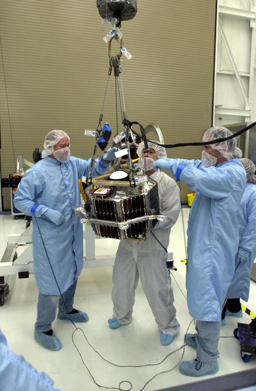
VANDENBERG AIR FORCE BASE, Calif. — In the Orbital Sciences Building 836 at Vandenberg Air Force Base in California, workers are maneuvering a second satellite suspended by an overhead crane. Three micro-satellites are being mounted on a payload support structure. The three satellites make up the Space Technology 5 spacecraft, called ST5, and will be launched by a Pegasus XL rocket. The satellites contain miniaturized redundant components and technologies. Each will validate New Millennium Program selected technologies, such as the Cold Gas Micro-Thruster and X-Band Transponder Communication System. After deployment from the Pegasus, the micro-satellites will be positioned in a “string of pearls” constellation that demonstrates the ability to position them to perform simultaneous multi-point measurements of the magnetic field using highly sensitive magnetometers. The data will help scientists understand and map the intensity and direction of the Earth’s magnetic field, its relation to space weather events, and affects on our planet. With such missions, NASA hopes to improve scientists’ ability to accurately forecast space weather and minimize its harmful effects on space- and ground-based systems. Launch of ST5 is scheduled for Feb. 28 from Vandenberg Air Force Base.
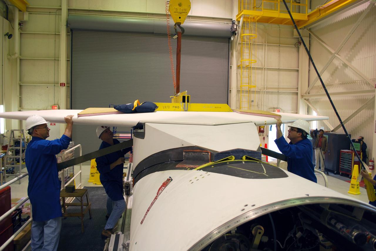
VANDENBERG AIR FORCE BASE, Calif. -- Workers in Building 1555 at Vandenberg AFB maneuver the wing into place on the Pegasus rocket for installation. The Pegasus will launch NASA's Interstellar Boundary Explorer Mission, or IBEX, satellite from Kwajalein Island in the Marshall Islands, South Pacific. IBEX will make the first map of the boundary between the solar system and interstellar space. IBEX is the first mission designed to detect the edge of the solar system. As the solar wind from the sun flows out beyond Pluto, it collides with the material between the stars, forming a shock front. IBEX contains two neutral atom imagers designed to detect particles from the termination shock at the boundary between the solar system and interstellar space. IBEX also will study galactic cosmic rays, energetic particles from beyond the solar system that pose a health and safety hazard for humans exploring beyond Earth orbit. IBEX will make these observations from a highly elliptical orbit that takes it beyond the interference of the Earth's magnetosphere. IBEX is targeted for launch in September 2008. Photo credit: NASA/ Randy Beaudoin
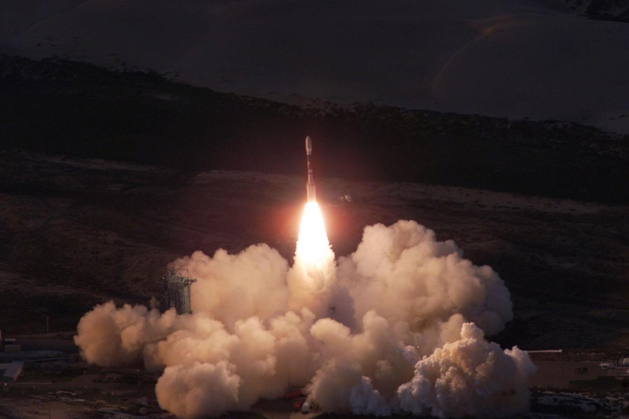
VANDENBERG AIR FORCE BASE, Calif. -- A Delta II rocket appears to erupt from the undulating clouds of smoke below as it launches with the joint NASA/French Space Agency oceanography satellite Jason 1 and Thermosphere Ionosphere Mesosphere Energetics and Dynamics satellite aboard. Liftoff from Launch Complex 2W occurred at 7:07 a.m. PST (10:07 a.m. EST or 15:07 GMT). Jason 1 joins the orbiting Topex/Poseidon satellite to continue observations of the global climate interaction occurring between the sea and the atmosphere as a result of stored solar energy. Instruments on Jason 1 will map variations in ocean surface topography to monitor world ocean circulation, study interactions of the oceans and atmosphere, improve climate predictions and observe events like El Nino. The mission is expected to last three years. The TIMED satellite will study a little-known region above the atmosphere, some 40 to 110 miles from the Earth's surface. Studying this region has been nearly impossible until now because conventional airplanes and balloons cannot reach this high altitude, and it is too low for direct satellite measurements
VANDENBERG AIR FORCE BASE, Calif. – Orbital Sciences’ Pegasus XL rocket, in the background, rests outside the environmental enclosure in Orbital’s hangar on Vandenberg Air Force Base in California. Inside the enclosure, half of the Pegasus fairing has been removed from around NASA’s Nuclear Spectroscopic Telescope Array, or NuSTAR. Access to the spacecraft is needed for compatibility testing to verify communication with a tracking station in Hawaii. With the change in the launch timeframe to June, this station will be needed to support launch. After processing of Orbital’s Pegasus XL rocket and the spacecraft are complete, they will be flown on Orbital's L-1011 carrier aircraft from Vandenberg to the Ronald Reagan Ballistic Missile Defense Test Site on the Pacific Ocean’s Kwajalein Atoll for launch. The high-energy X-ray telescope will conduct a census of black holes, map radioactive material in young supernovae remnants, and study the origins of cosmic rays and the extreme physics around collapsed stars. For more information, visit http://www.nasa.gov/nustar. Photo credit: NASA/Randy Beaudoin, VAFB
VANDENBERG AIR FORCE BASE, Calif. – At Vandenberg Air Force Base in California, technicians monitor the progress as a transporter is moved underneath the Orbital Science’s Pegasus XL at Orbital’s hangar. The rocket is mated to NASA’s encapsulated Nuclear Spectroscopic Telescope Array, or NuSTAR, spacecraft. The transporter will move them to the runway ramp where they will be attached to the underside of Orbital’s L-1011 carrier aircraft. The aircraft will fly the pair from Vandenberg to the Ronald Reagan Ballistic Missile Defense Test Site on the Pacific Ocean’s Kwajalein Atoll for launch. A revised launch date is expected to be set at the Flight Readiness Review. The high-energy X-ray telescope will conduct a census of black holes, map radioactive material in young supernovae remnants, and study the origins of cosmic rays and the extreme physics around collapsed stars. For more information, visit http://www.nasa.gov/nustar. Photo credit: NASA/Randy Beaudoin
VANDENBERG AIR FORCE BASE, Calif. -- On Space Launch Complex 576-E at Vandenberg Air Force Base in California, workers install one of the two umbilical tower guy wires and springs as part of closeout procedures on the Taurus XL rocket in preparation for launch. The umbilical tower attached to the upper stack will fall away from the spacecraft during liftoff. The Orbital Sciences Taurus XL rocket will launch Glory into low Earth orbit. Once Glory reaches orbit, it will collect data on the properties of aerosols and black carbon. It also will help scientists understand how the sun's irradiance affects Earth's climate. Launch is scheduled for 5:09 a.m. EST Feb. 23. For information, visit www.nasa.gov/glory. Photo credit: NASA/Randy Beaudoin, VAFB
VANDENBERG AFB, California – The payload fairing is moved into place around NASA's SMAP spacecraft inside the service structure at Space Launch Complex-2 at Vandenberg AFB, California - the launch site for NASA's SMAP spacecraft. For more, go to www.nasa.gov/smap Photo credit: USAF
VANDENBERG AIR FORCE BASE, Calif. -- At Vandenberg Air Force Base in California, a crane is used to lift and position a solid rocket motor for attachment to the United Launch Alliance Delta II that will carry NASA's National Polar-orbiting Operational Environmental Satellite System Preparatory Project (NPP) satellite at NASA's Space Launch Complex-2. NPP represents a critical first step in building the next-generation of Earth-observing satellites. NPP will carry the first of the new sensors developed for this satellite fleet, now known as the Joint Polar Satellite System (JPSS) to be launched in 2016. NPP is the bridge between NASA's Earth Observing System (EOS) satellites and the forthcoming series of JPSS satellites. The mission will test key technologies and instruments for the JPSS missions. NPP is targeted to launch Oct. 25. For more information, visit http://www.nasa.gov/NPP. Photo credit: NASA/VAFB, Dan Liberotti
VANDENBERG AIR FORCE BASE, Calif. -- On Launch Complex 576-E at Vandenberg Air Force Base in California, Orbital Science's Jose Castillo and Mark Neuse (right) move in to remove the fairing payload access door on NASA's Orbiting Carbon Observatory, or OCO, spacecraft. Orbital Science's Glenn Weigle and Brett Gladish are nearby (shadows on the fairing) to take the GN2 flow reading. The encapsulated OCO tops Orbital Sciences' Taurus XL rocket, which is scheduled to launch Feb. 24. The spacecraft will collect precise global measurements of carbon dioxide (CO2) in the Earth's atmosphere. Scientists will analyze OCO data to improve our understanding of the natural processes and human activities that regulate the abundance and distribution of this important greenhouse gas. Photo courtesy of Glenn Weigle, Orbital Sciences
VANDENBERG AIR FORCE BASE, Calif. – An Orbital Sciences Pegasus XL rocket rests on the transporter in Orbital’s hangar at Vandenberg Air Force Base in California. The rocket has been mated to NASA's Nuclear Spectroscopic Telescope Array, or NuSTAR, encapsulated in a Pegasus payload fairing. The transporter will move them to the runway ramp where they will be attached to the underside of Orbital’s L-1011 carrier aircraft. The aircraft will fly the pair from Vandenberg to the Ronald Reagan Ballistic Missile Defense Test Site on the Pacific Ocean’s Kwajalein Atoll for launch. A revised launch date will be set at the Flight Readiness Review, planned for later this week. The high-energy X-ray telescope will conduct a census of black holes, map radioactive material in young supernovae remnants, and study the origins of cosmic rays and the extreme physics around collapsed stars. For more information, visit http://www.nasa.gov/nustar. Photo credit: NASA/Randy Beaudoin, VAFB
VANDENBERG AIR FORCE BASE, Calif. – At Vandenberg Air Force Base in California, technicians monitor the progress as a transporter is moved underneath the Orbital Science’s Pegasus XL inside Orbital’s hangar. The rocket is mated to NASA’s encapsulated Nuclear Spectroscopic Telescope Array, or NuSTAR, out of sight inside the hangar. The transporter will move them to the runway ramp where they will be attached to the underside of Orbital’s L-1011 carrier aircraft. The aircraft will fly the pair from Vandenberg to the Ronald Reagan Ballistic Missile Defense Test Site on the Pacific Ocean’s Kwajalein Atoll for launch. A revised launch date is expected to be set at the Flight Readiness Review. The high-energy X-ray telescope will conduct a census of black holes, map radioactive material in young supernovae remnants, and study the origins of cosmic rays and the extreme physics around collapsed stars. For more information, visit http://www.nasa.gov/nustar. Photo credit: NASA/Mark Mackiey
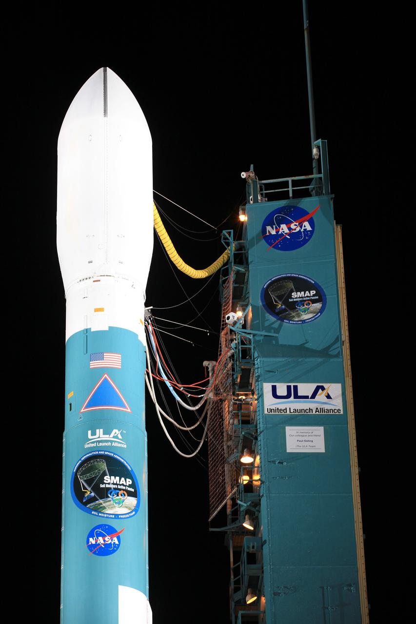
VANDENBERG AIR FORCE BASE, Calif. – The launch gantry is rolled back to reveal the United Launch Alliance Delta II rocket with the Soil Moisture Active Passive, or SMAP, satellite aboard, at the Space Launch Complex 2 at Vandenberg Air Force Base, California. SMAP is a remote sensing mission designed to measure and map the Earth's soil moisture distribution and freeze/thaw stat with unprecedented accuracy, resolution and coverage. SMAP will provide global measurements of soil moisture and its freeze/thaw state. These measurements will be used to enhance understanding of processes that link the water, energy and carbon cycles, and to extend the capabilities of weather and climate prediction models. SMAP data also will be used to quantify net carbon flux in boreal landscapes and to develop improved flood prediction and drought monitoring capabilities. Launch is scheduled for Jan. 29, 2015. To learn more about SMAP, visit http://smap.jpl.nasa.gov Photo credit: NASA/Kim Shiflett
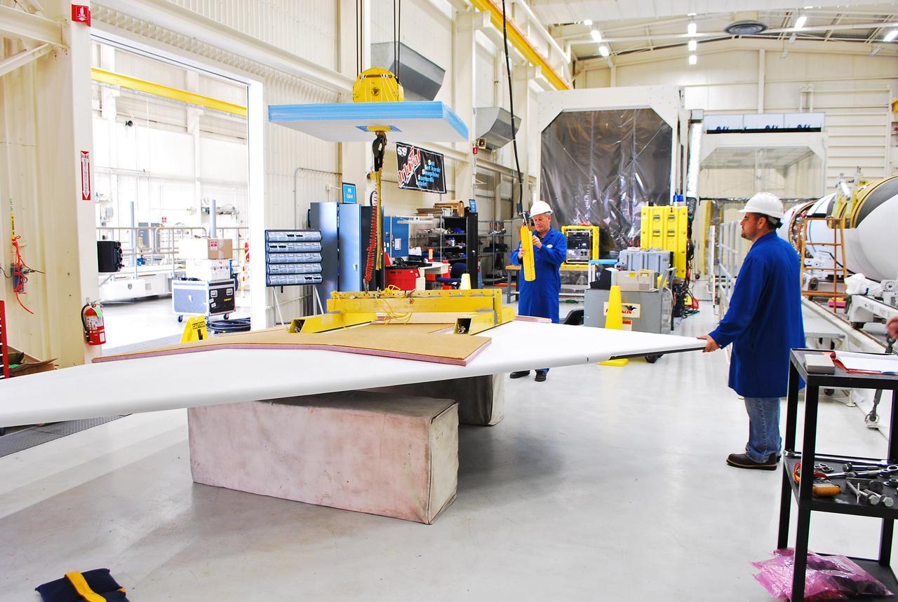
Vandenberg Air Force Base, Calif. – Inside a processing facility at Vandenberg Air Force Base in California, technicians prepare the wing for a fit check with the Orbital Sciences Pegasus XL launch vehicle. NASA’s Interface Region Imaging Spectrograph, or IRIS, spacecraft will launch aboard the Pegasus XL in late 2012. IRIS will open a new window of discovery by tracing the flow of energy and plasma through the chromospheres and transition region into the sun’s corona using spectrometry and imaging. IRIS fills a crucial gap in our ability to advance studies of the sun-to-Earth connection by tracing the flow of energy and plasma through the foundation of the corona and heliosphere, or region around the sun. Photo credit: NASA/Randy Beaudoin
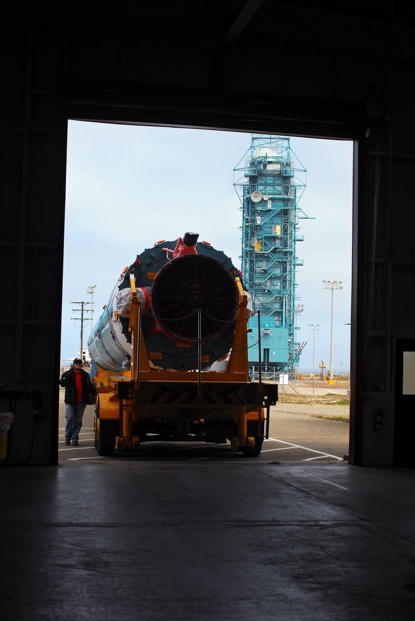
VANDENBERG AIR FORCE BASE, Calif. -- At Vandenberg Air Force Base in California, the first stage of a United Launch Alliance Delta II that will carry the National Polar-orbiting Operational Environmental Satellite System Preparatory Project (NPP) satellite into space has arrived at NASA's Launch Complex-2. The vehicle will undergo initial testing at the United Launch Alliance Delta Mission Checkout Facility. NPP will be positioned 512 miles above the Earth's surface and will orbit about 16 times each day to observe nearly the entire globe. The NPP mission for NASA and the National Oceanic and Atmospheric Administration (NOAA) is to measure Earth's atmospheric and sea surface temperatures, humidity sounding, land and ocean biological activity, and cloud and aerosol properties. For more information, visit www.nasa.gov/NPP. Photo credit: NASA/VAFB

VANDENBERG AIR FORCE BASE, Calif. - At Space Launch Complex 2 at Vandenberg Air Force Base in California, workers receive the first of three solid rocket boosters for the United Launch Alliance Delta II rocket for launch of NASA's Wide-field Infrared Survey Explorer, or WISE, at the pad. WISE will survey the entire sky at infrared wavelengths, creating a cosmic clearinghouse of hundreds of millions of objects which will be catalogued and provide a vast storehouse of knowledge about the solar system, the Milky Way, and the universe. Launch is scheduled for Dec. 7. For additional information, visit http://wise.ssl.berkeley.edu. Photo credit: NASA/VAFB
VANDENBERG AIR FORCE BASE, Calif. – Orbital Sciences’ L-1011 carrier aircraft taxies to the runway at Vandenberg Air Force Base in California. The aircraft is transporting Orbital’s Pegasus rocket and NASA’s Nuclear Spectroscopic Telescope Array, or NuSTAR, to the U.S. Army's Ronald Reagan Ballistic Missile Defense Test Site on Kwajalein Atoll, part of the Marshall Islands in the Pacific Ocean. The Pegasus, mated to its NuSTAR payload, will be launched from the carrier aircraft 117 nautical miles south of Kwajalein at latitude 6.75 degrees north of the equator. The high-energy X-ray telescope will conduct a census of black holes, map radioactive material in young supernovae remnants, and study the origins of cosmic rays and the extreme physics around collapsed stars. Launch is scheduled for June 13. For more information, visit http://www.nasa.gov/nustar. Photo credit: NASA/Randy Beaudoin, VAFB
VANDENBERG AIR FORCE BASE, Calif. -- A view of the flexure springs in the soft ride being mated to the payload attach fitting for NASA's Wide-field Infrared Survey Explorer, or WISE, spacecraft. The satellite will survey the entire sky at infrared wavelengths, creating a cosmic clearinghouse of hundreds of millions of objects, which will be catalogued, providing a vast storehouse of knowledge about the solar system, the Milky Way, and the universe. Launch is scheduled no earlier than Dec. 7. Photo credit: NASA/Doug Kolkow

VANDENBERG AIR FORCE BASE, Calif. – The second stage for NASA's Orbiting Carbon Observatory-2 mission, or OCO-2, is being towed to the Horizontal Processing Facility at Space Launch Complex 2 from the Building 836 hangar on Vandenberg Air Force Base in California. OCO-2 is scheduled to launch aboard a United Launch Alliance Delta II rocket in July. The rocket's second stage will insert OCO-2 into a polar Earth orbit. OCO-2 will collect precise global measurements of carbon dioxide in the Earth's atmosphere and provide scientists with a better idea of the chemical compound's impacts on climate change. Scientists will analyze this data to improve our understanding of the natural processes and human activities that regulate the abundance and distribution of this important atmospheric gas. To learn more about OCO-2, visit http://oco.jpl.nasa.gov. Photo credit: NASA/Randy Beaudoin
VANDENBERG AIR FORCE BASE, Calif. -- With the Space Launch Complex-2 (SLC-2) service tower at Vandenberg Air Force Base in California back in place, United Space Alliance technicians complete the installation of the second stage of a Delta II rocket to the first stage. The rocket is being prepared to launch NASA's Aquarius satellite into low Earth orbit. Scheduled to launch in June, Aquarius' mission will be to provide monthly maps of global changes in sea surface salinity. By measuring ocean salinity from space, Aquarius will provide new insights into how the massive natural exchange of freshwater between the ocean, atmosphere and sea ice influences ocean circulation, weather and climate. Also going up with the satellite are optical and thermal cameras, a microwave radiometer and the SAC-D spacecraft, which were developed with the help of institutions in Italy, France, Canada and Argentina. Photo credit: VAFB/30th Space Wing
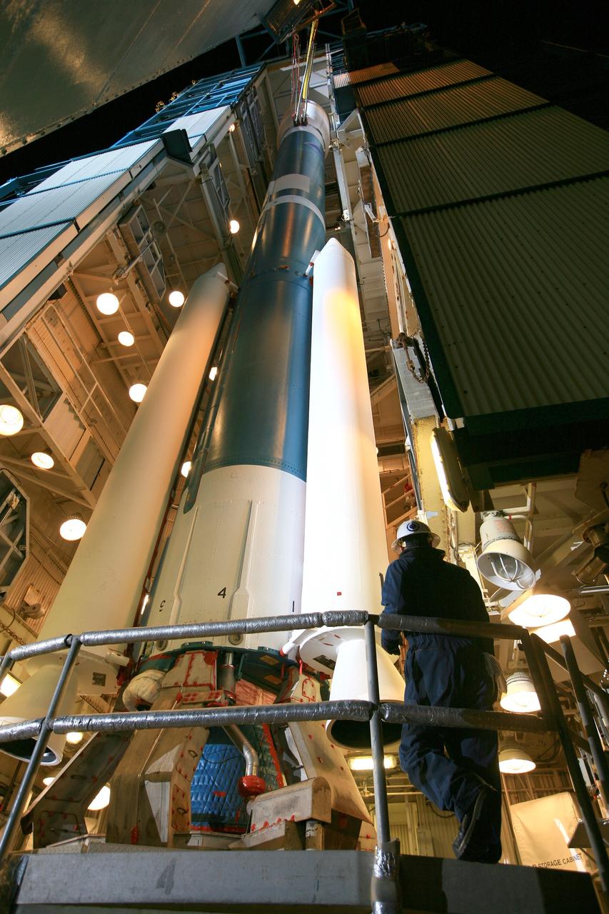
VANDENBERG AIR FORCE BASE, Calif. – The launch gantry is rolled back to reveal the United Launch Alliance Delta II rocket with the Soil Moisture Active Passive, or SMAP, satellite aboard, at the Space Launch Complex 2 at Vandenberg Air Force Base, California. SMAP is a remote sensing mission designed to measure and map the Earth's soil moisture distribution and freeze/thaw stat with unprecedented accuracy, resolution and coverage. SMAP will provide global measurements of soil moisture and its freeze/thaw state. These measurements will be used to enhance understanding of processes that link the water, energy and carbon cycles, and to extend the capabilities of weather and climate prediction models. SMAP data also will be used to quantify net carbon flux in boreal landscapes and to develop improved flood prediction and drought monitoring capabilities. Launch is scheduled for Jan. 29, 2015. To learn more about SMAP, visit http://smap.jpl.nasa.gov Photo credit: NASA/Kim Shiflett