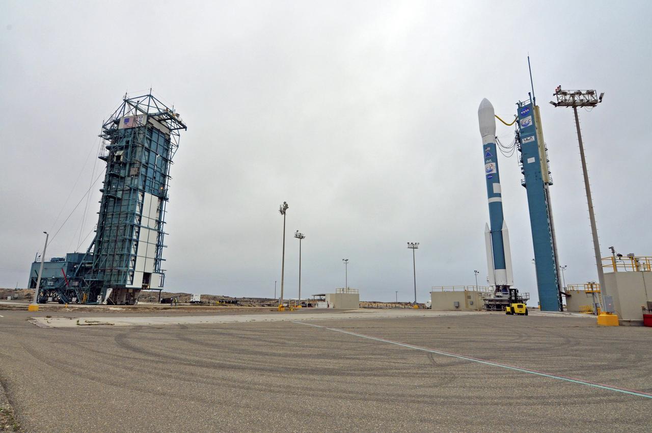
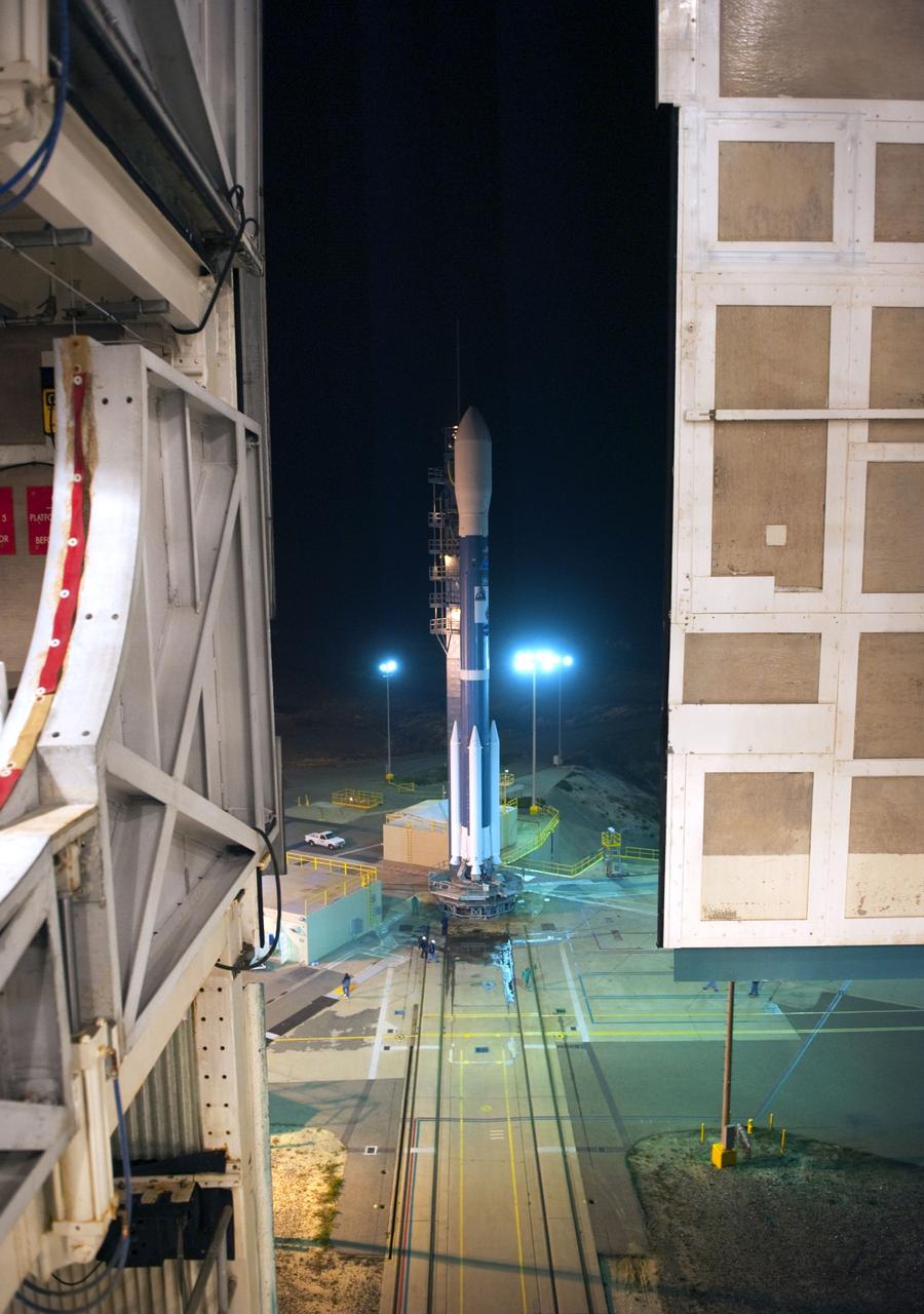
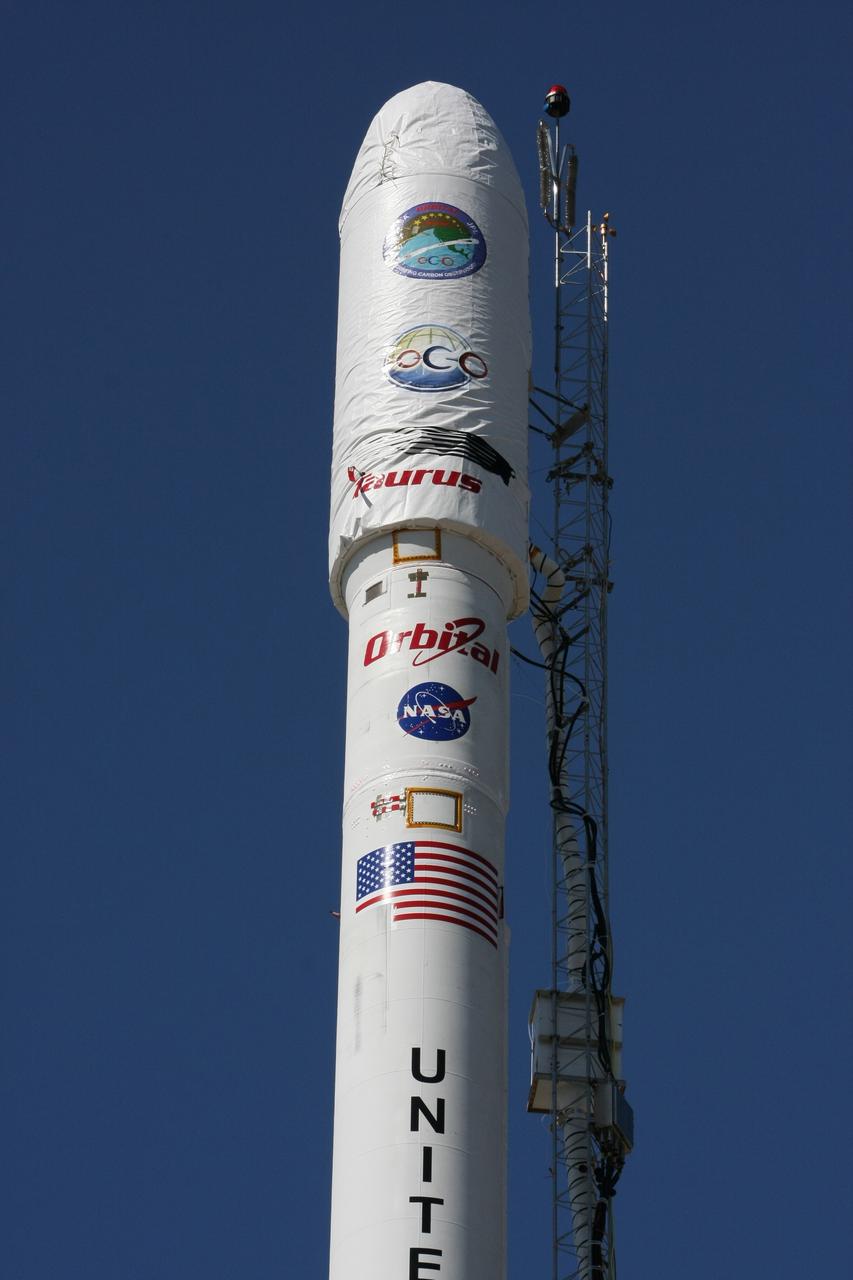
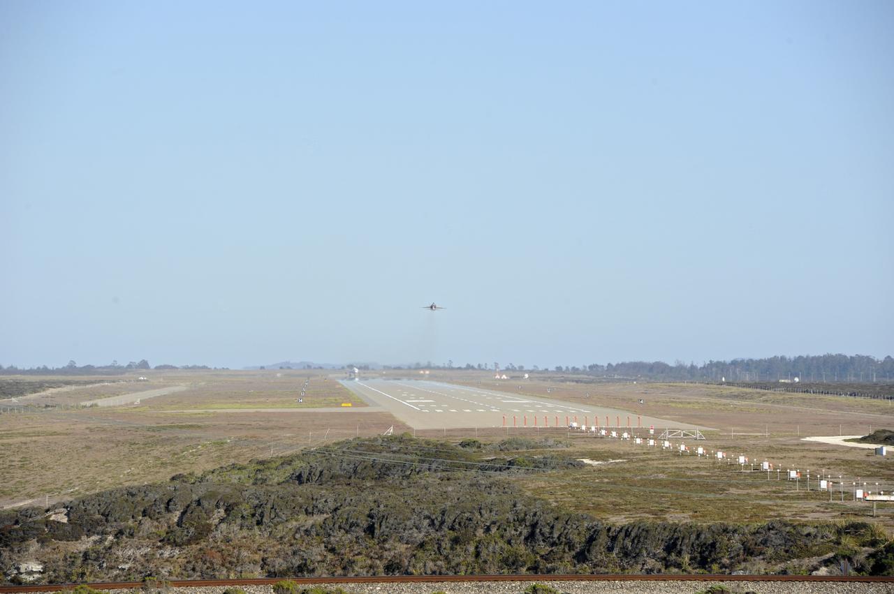
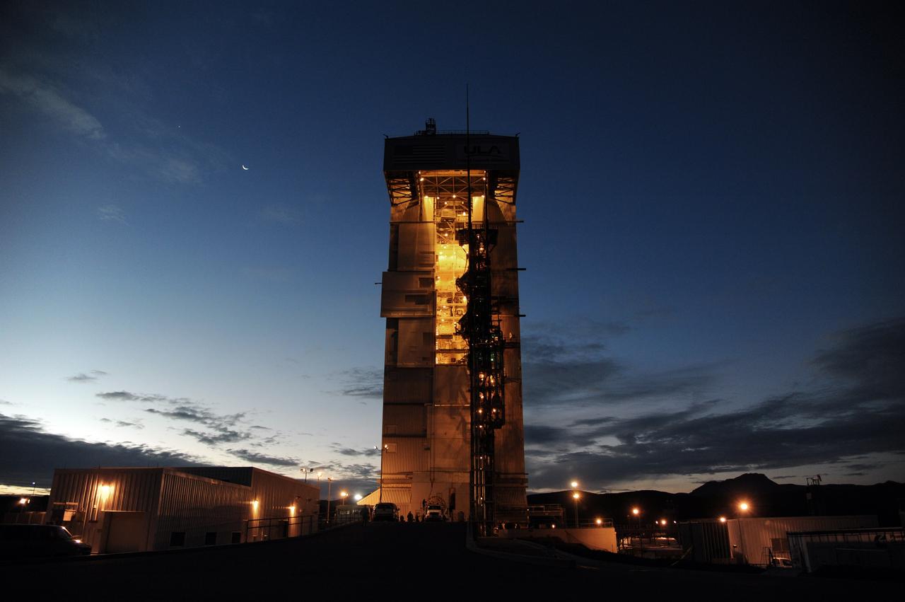
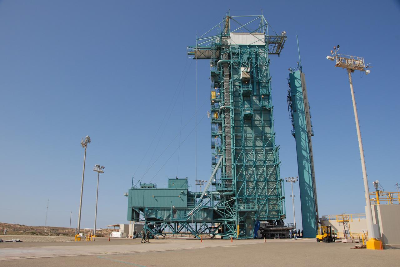
VANDENBERG AIR FORCE BASE, Calif. – NASA's Orbiting Carbon Observatory-2, or OCO-2, stands ready for launch aboard a United Launch Alliance Delta II rocket following rollback of the mobile service tower on Space Launch Complex 2 on Vandenberg Air Force Base in California. Launch of OCO-2 is scheduled for 5:56 a.m. EDT on July 2 following the repair of the pad's water suppression system, which failed on the first launch attempt July 1. OCO-2 is NASA’s first mission dedicated to studying atmospheric carbon dioxide, the leading human-produced greenhouse gas driving changes in Earth’s climate. OCO-2 will provide a new tool for understanding the human and natural sources of carbon dioxide emissions and the natural "sinks" that absorb carbon dioxide and help control its buildup. The observatory will measure the global geographic distribution of these sources and sinks and study their changes over time. To learn more about OCO-2, visit http://www.nasa.gov/oco2. Photo credit: NASA/Randy Beaudoin
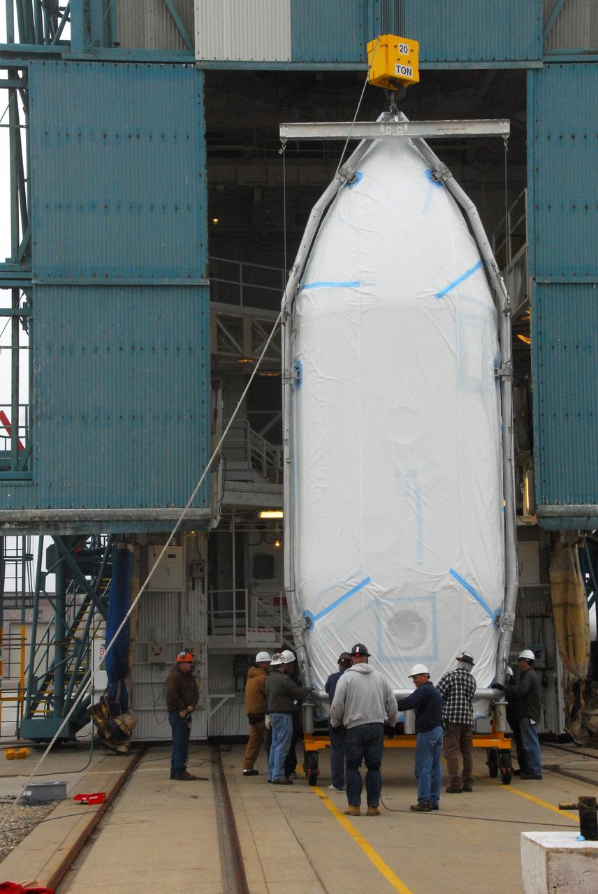
VANDENBERG AIR FORCE BASE, Calif. -- The payload fairing that will protect NASA's National Polar-orbiting Operational Environmental Satellite System Preparatory Project (NPP) satellite as it launches aboard a United Launch Alliance Delta II begins its lift to Level 5 of Space Launch Complex-2 at Vandenberg Air Force Base in California. NPP will be positioned 512 miles above the Earth's surface and will orbit about 16 times each day to observe nearly the entire globe. The NPP mission for NASA and the National Oceanic and Atmospheric Administration (NOAA) is to measure Earth's atmospheric and sea surface temperatures, humidity sounding, land and ocean biological activity, and cloud and aerosol properties. For more information, visit www.nasa.gov/NPP. Photo credit: NASA/VAFB, Roy Allison
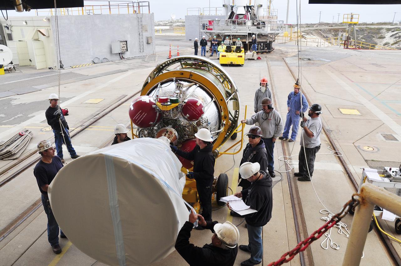
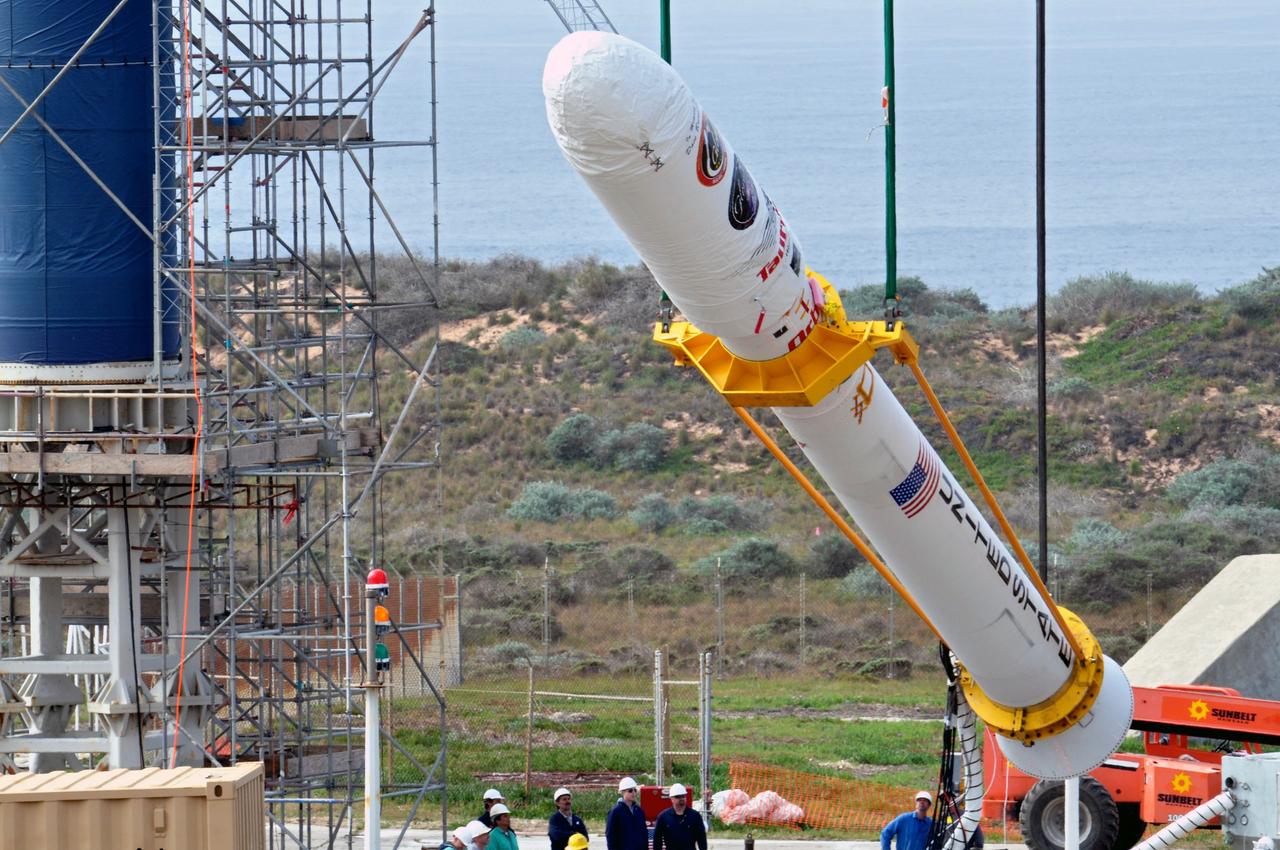
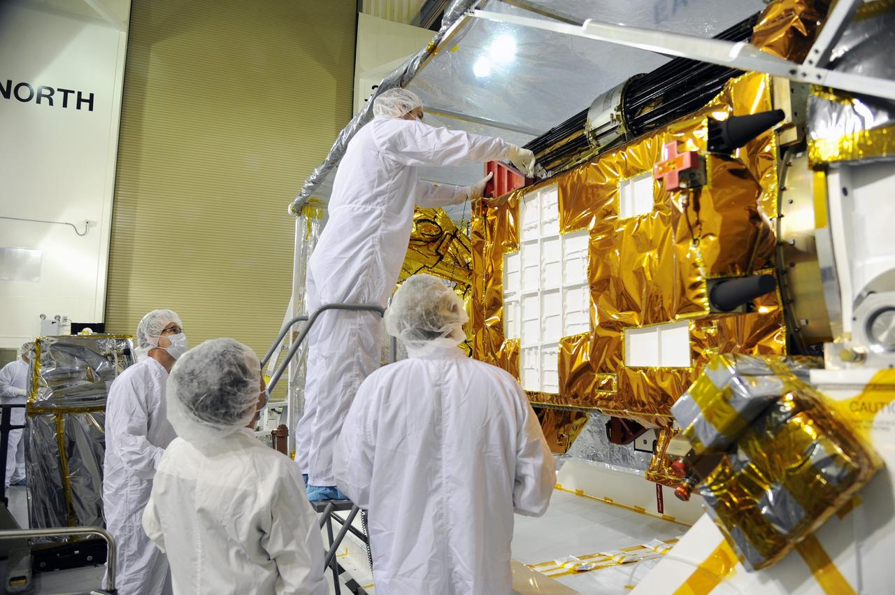
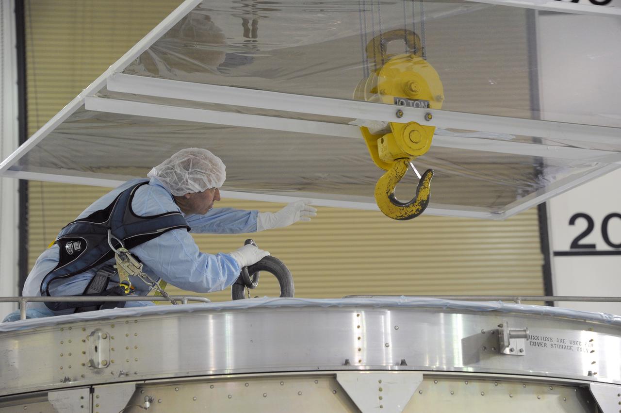
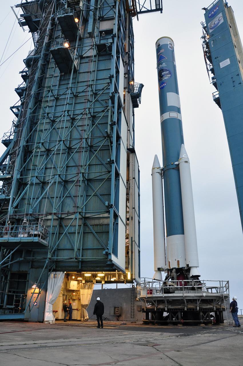
VANDENBERG AIR FORCE BASE, Calif. – Workers prepare the second stage of the Delta II rocket for NASA's Soil Moisture Active Passive mission, or SMAP, for its lift into the mobile service tower at Space Launch Complex 2 on Vandenberg Air Force Base in California. Operations are underway to install the second stage atop the rocket's first stage. SMAP will launch on a Delta II 7320 configuration vehicle featuring a United Launch Alliance first stage booster powered by an Aerojet Rocketdyne RS-27A main engine and three Alliant Techsystems, or ATK, strap-on solid rocket motors. Once on station in Earth orbit, SMAP will provide global measurements of soil moisture and its freeze/thaw state. These measurements will be used to enhance understanding of processes that link the water, energy and carbon cycles, and to extend the capabilities of weather and climate prediction models. SMAP data also will be used to quantify net carbon flux in boreal landscapes and to develop improved flood prediction and drought monitoring capabilities. Launch is scheduled for no earlier than November 2014. To learn more about SMAP, visit http://smap.jpl.nasa.gov. Photo credit: NASA/Randy Beaudoin
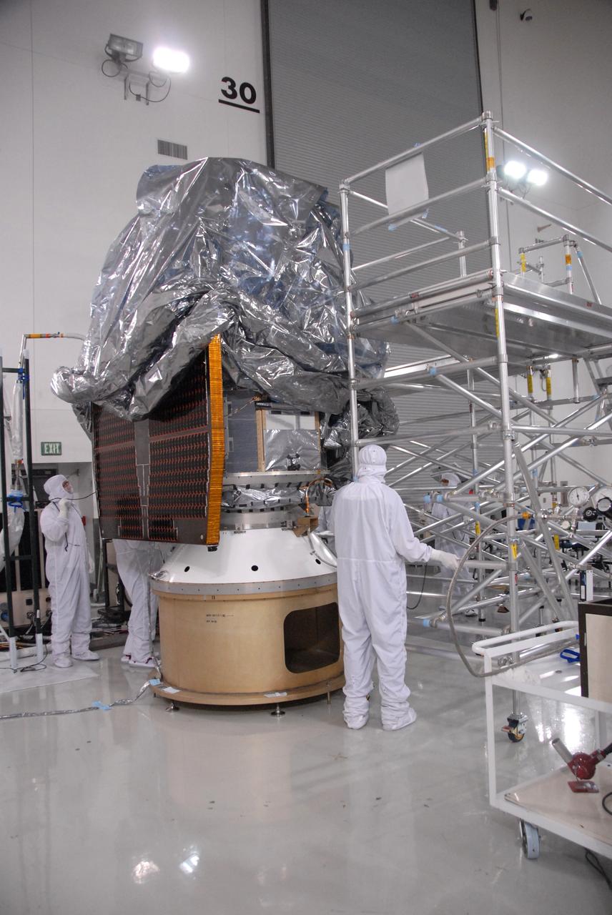
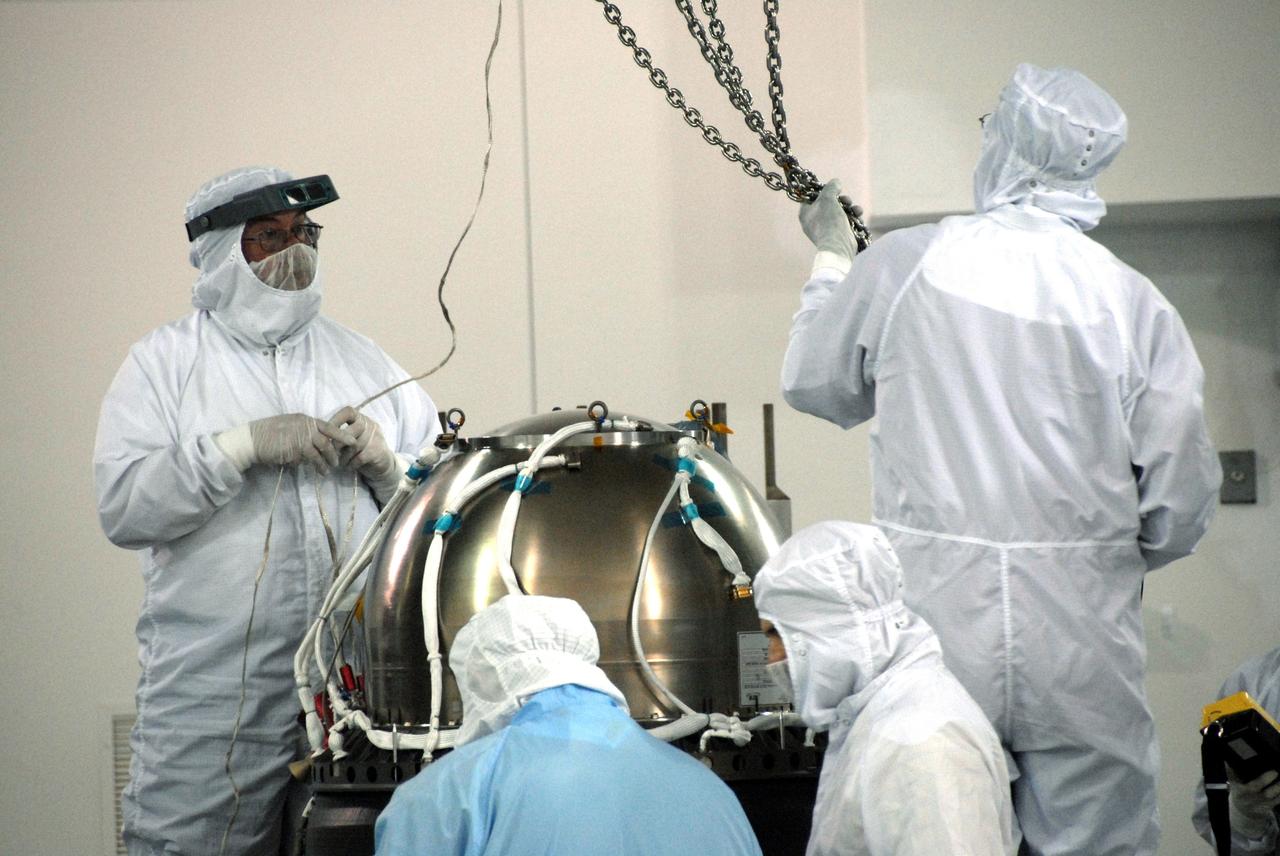
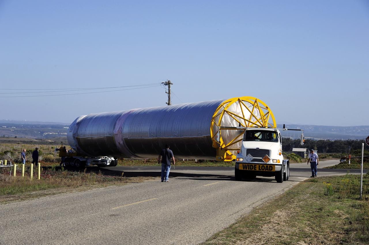
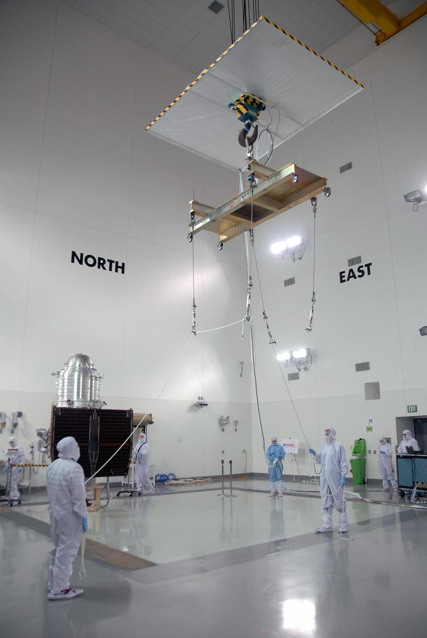
VANDENBERG AIR FORCE BASE, Calif. - At the Astrotech payload processing facility at Vandenberg Air Force Base in California, spacecraft technicians carefully lower an environmental covering over NASA's Wide-field Infrared Survey Explorer, or WISE, to protect it from contamination during its move to Space Launch Complex 2. WISE will survey the entire sky at infrared wavelengths, creating a cosmic clearinghouse of hundreds of millions of objects which will be catalogued and provide a vast storehouse of knowledge about the solar system, the Milky Way, and the universe. Launch aboard a United Launch Alliance Delta II rocket is scheduled for Dec. 9. For additional information, visit http://www.nasa.gov/wise. Photo credit: NASA
VANDENBERG AIR FORCE BASE, Calif. -- On Space Launch Complex 576-E at Vandenberg Air Force Base in California, Orbital Sciences workers monitor NASA's Glory upper stack as a crane lifts it from a stationary rail for attachment to the Taurus XL rocket's Stage 0. The upper stack consists of Stages 1, 2 and 3 of the Taurus as well as the encapsulated Glory spacecraft. Workers put the non-flight environmental shield over the fairing prior to assembly. The Orbital Sciences Taurus XL rocket will launch Glory into low Earth orbit. Once Glory reaches orbit, it will collect data on the properties of aerosols and black carbon. It also will help scientists understand how the sun's irradiance affects Earth's climate. Launch is scheduled for 5:09 a.m. EST Feb. 23. For information, visit www.nasa.gov/glory. Photo credit: NASA/Randy Beaudoin, VAFB
VANDENBERG AIR FORCE BASE, Calif. – Workers prepare to inspect instrument and optics covers on NASA's Soil Moisture Active Passive, or SMAP, spacecraft in the Astrotech payload processing facility on Vandenberg Air Force Base in California during a post-shipment inspection. The spacecraft was delivered to the launch site today from NASA's Jet Propulsion Laboratory in Pasadena, California. SMAP will launch on a Delta II 7320 configuration vehicle featuring a United Launch Alliance first stage booster powered by an Aerojet Rocketdyne RS-27A main engine and three Alliant Techsystems, or ATK, strap-on solid rocket motors. Once on station in Earth orbit, SMAP will provide global measurements of soil moisture and its freeze/thaw state. These measurements will be used to enhance understanding of processes that link the water, energy and carbon cycles, and to extend the capabilities of weather and climate prediction models. SMAP data also will be used to quantify net carbon flux in boreal landscapes and to develop improved flood prediction and drought monitoring capabilities. Launch from Space Launch Complex 2 is targeted for Jan. 29, 2015. To learn more about SMAP, visit http://smap.jpl.nasa.gov. Photo credit: NASA/Robert Rasmison
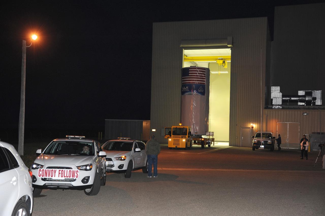
VANDENBERG AFB, Calif. -- NASA's Landsat Data Continuity Mission, or LDCM, satellite during post-arrival inspections at the Astrotech processing facility at Vandenberg Air Force Base, Calif. The Landsat Data Continuity Mission LDCM is the future of Landsat satellites. It will continue to obtain valuable data and imagery to be used in agriculture, education, business, science, and government. The Landsat Program provides repetitive acquisition of high resolution multispectral data of the Earth's surface on a global basis. The data from the Landsat spacecraft constitute the longest record of the Earth's continental surfaces as seen from space. It is a record unmatched in quality, detail, coverage, and value. Launch is planned for Feb. 11, 2013. For more information, visit: http://www.nasa.gov/mission_pages/landsat/main/index.html Photo credit: NASA
VANDENBERG AIR FORCE BASE, Calif. -- At Vandenberg Air Force Base in California, a solid rocket motor for the United Launch Alliance Delta II that will carry NASA's National Polar-orbiting Operational Environmental Satellite System Preparatory Project (NPP) satellite is hoisted up at NASA's Space Launch Complex-2. NPP represents a critical first step in building the next-generation of Earth-observing satellites. NPP will carry the first of the new sensors developed for this satellite fleet, now known as the Joint Polar Satellite System (JPSS) to be launched in 2016. NPP is the bridge between NASA's Earth Observing System (EOS) satellites and the forthcoming series of JPSS satellites. The mission will test key technologies and instruments for the JPSS missions. NPP is targeted to launch Oct. 25. For more information, visit http://www.nasa.gov/NPP. Photo credit: NASA/VAFB, Dan Liberotti
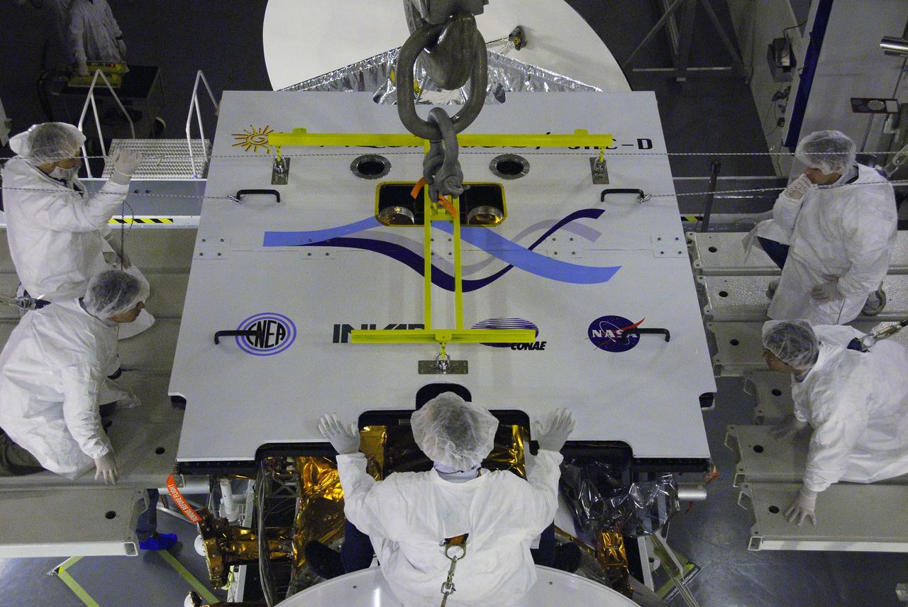
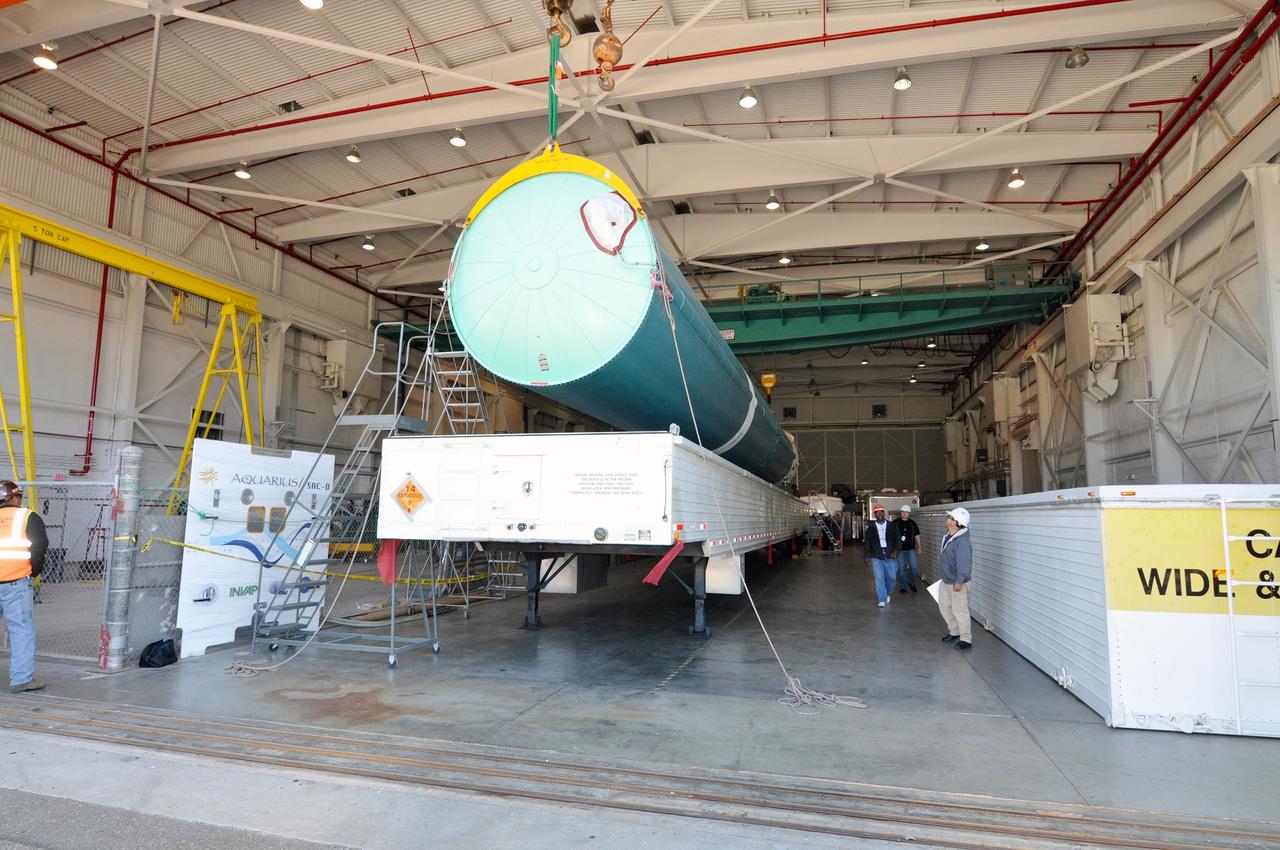
VANDENBERG AIR FORCE BASE, Calif. -- At NASA's Launch Complex-2 at Vandenberg Air Force Base in California the United Launch Alliance Delta II rocket with the Aquarius/SAC-D spacecraft atop is prepared for launch. Liftoff is slated for 7:20 PDT/10:20 EDT today. Aquarius, the NASA-built instrument on the SAC-D spacecraft will provide new insights into how variations in ocean surface salinity relate to fundamental climate processes on its three-year mission. For more information visit: www.nasa.gov/aquarius. Photo credit: NASA/VAFB
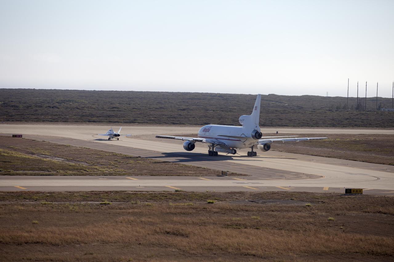
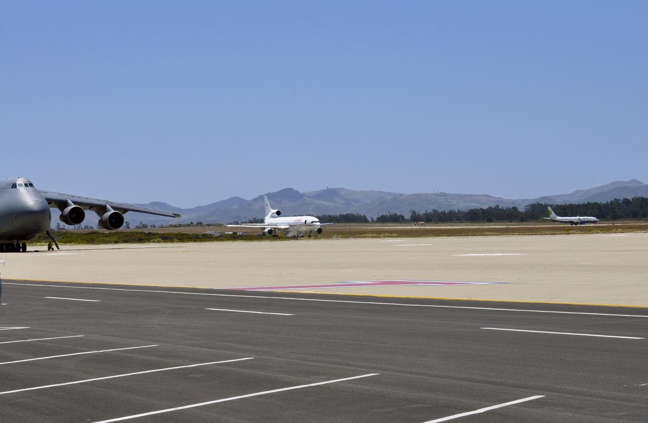
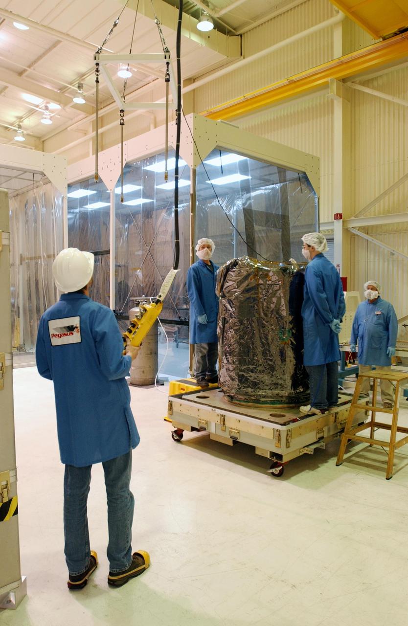
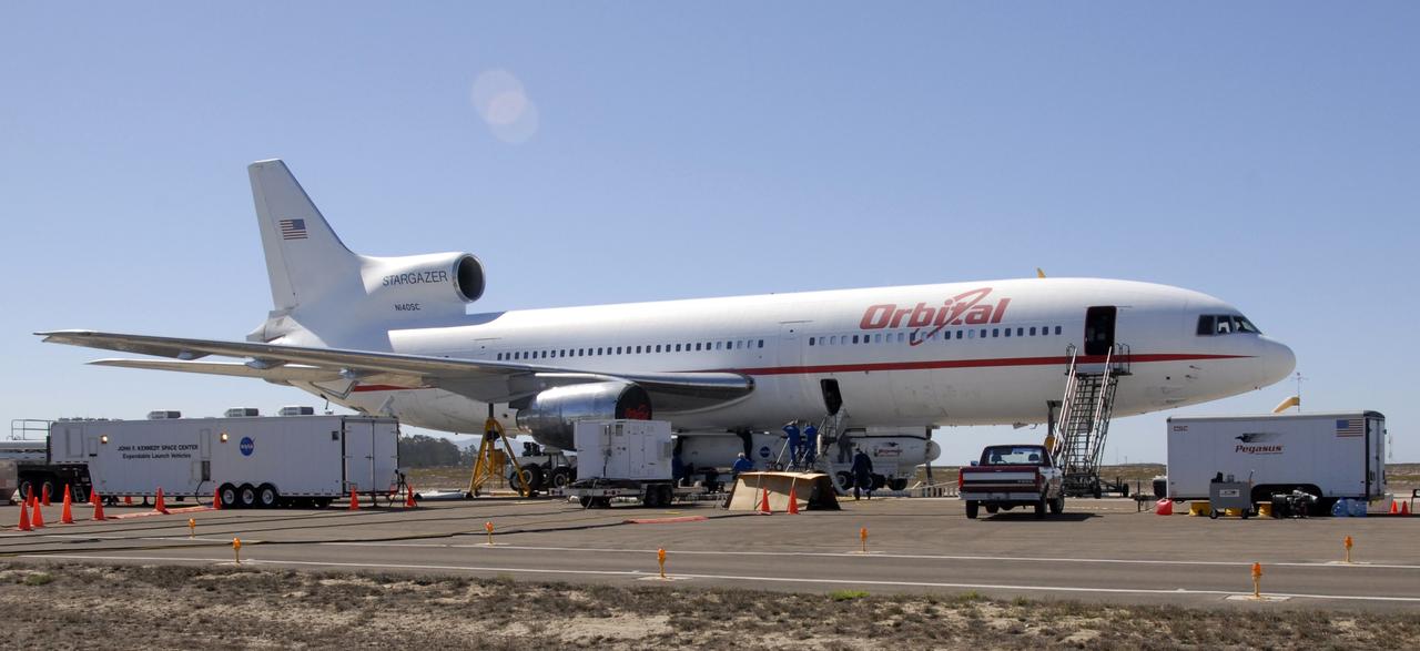
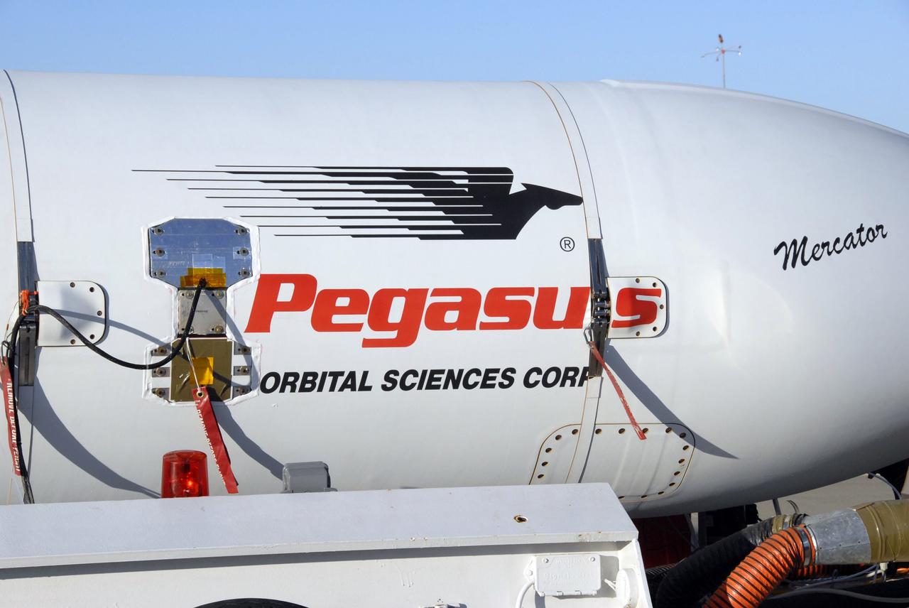
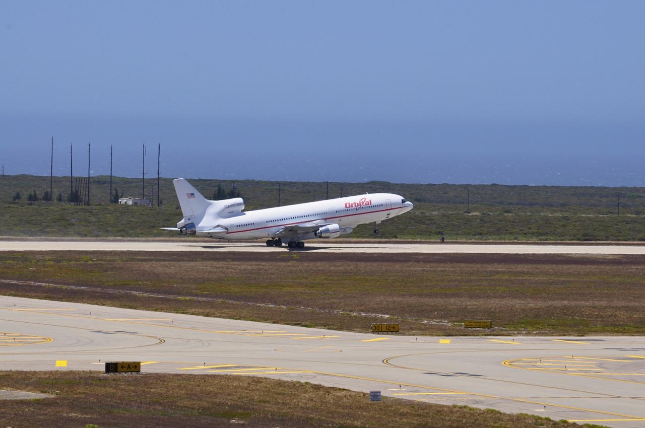
VANDENBERG AIR FORCE BASE, Calif. – A NASA F-18 and an Orbital Sciences L-1011 carrier aircraft taxi to the runway at Vandenberg Air Force Base, Calif., before taking off on a mission to launch NASA's IRIS spacecraft into low-Earth orbit. IRIS, short for Interface Region Imaging Spectrograph, was launched aboard an Orbital Sciences Pegasus XL rocket released from the L-1011. Photo credit: NASA/Daniel Casper
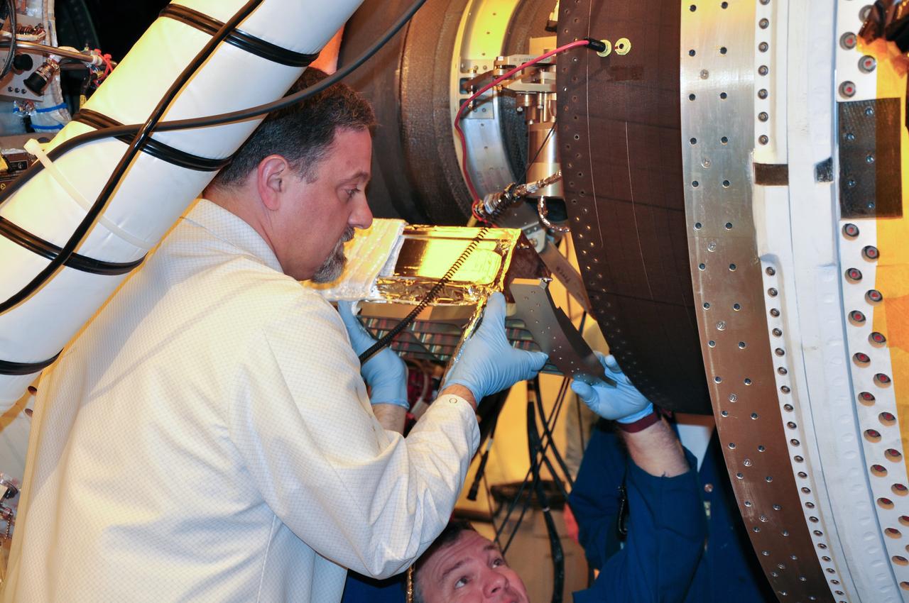
VANDENBERG AIR FORCE BASE, Calif. -- Technicians pull a protective plastic cover over NASA's NuSTAR spacecraft and the tilt-rotation fixture inside Orbital Sciences' processing facility at Vandenberg Air Force Base, Calif. The spacecraft will be rotated to horizontal for joining with the Pegasus XL rocket. The Orbital Sciences Pegasus will launch NASA's Nuclear Spectroscopic Telescope Array NuSTAR into space. After the rocket and spacecraft are processed at Vandenberg, they will be flown on Orbital's L-1011 carrier aircraft to the Ronald Reagan Ballistic Missile Defense Test Site at the Pacific Ocean’s Kwajalein Atoll for launch. The high-energy x-ray telescope will conduct a census for black holes, map radioactive material in young supernovae remnants, and study the origins of cosmic rays and the extreme physics around collapsed stars. For more information, visit science.nasa.gov/missions/nustar/. Photo credit: NASA/Randy Beaudoin, VAFB
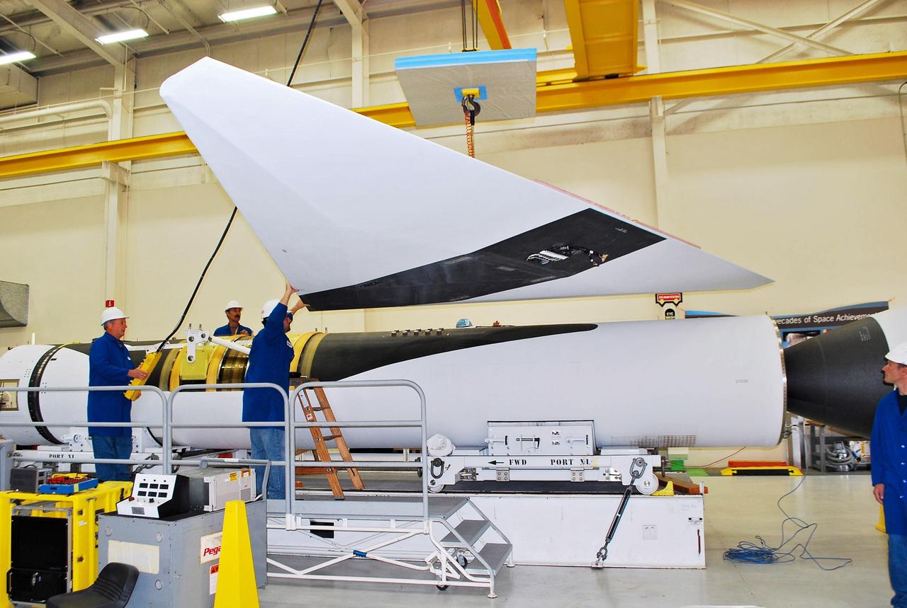
VANDENBERG AIR FORCE BASE, Calif. -- The wing of the Pegasus XL launch vehicle awaits processing in a clean room at Vandenberg Air Force Base in California. The Orbital Sciences Corp. Pegasus rocket will launch the Nuclear Spectroscopic Telescope Array (NuSTAR) into space. After the rocket and spacecraft are processed at Vandenberg, they will be flown on the Orbital Sciences' L-1011 carrier aircraft to the Ronald Reagan Ballistic Missile Defense Test Site at the Pacific Ocean’s Kwajalein Atoll for launch. The high-energy X-ray telescope will conduct a census for black holes, map radioactive material in young supernovae remnants, and study the origins of cosmic rays and the extreme physics around collapsed stars. For more information, visit science.nasa.gov/missions/nustar/. Photo credit: NASA/Randy Beaudoin, VAFB
VANDENBERG AIR FORCE BASE, Calif. – The Miami Air International Boeing 737 airplane, at right, accompanying Orbital Sciences’ L-1011 carrier aircraft, takes off from Vandenberg Air Force Base in California for the U.S. Army's Ronald Reagan Ballistic Missile Defense Test Site on Kwajalein Atoll, part of the Marshall Islands in the Pacific Ocean. Forty-nine passengers, including the launch team, are traveling to Kwajalein aboard the charter flight. The launch team is made up of employees of NASA, Orbital Sciences and a.i. solutions. Orbital’s L-1011, at left, transporting their Pegasus rocket and NASA’s Nuclear Spectroscopic Telescope Array, or NuSTAR, will follow close behind. The Pegasus, mated to its NuSTAR payload, will be launched from the carrier aircraft 117 nautical miles south of Kwajalein at latitude 6.75 degrees north of the equator. The high-energy X-ray telescope will conduct a census of black holes, map radioactive material in young supernovae remnants, and study the origins of cosmic rays and the extreme physics around collapsed stars. Launch is scheduled for June 13. For more information, visit http://www.nasa.gov/nustar. Photo credit: NASA/Randy Beaudoin, VAFB
VANDENBERG AIR FORCE BASE, Calif. - The Delta II payload fairing will soon enfold NASA's Wide-field Infrared Survey Explorer, or WISE, in the White Room at Space Launch Complex 2 at Vandenberg Air Force Base in California. The fairing protects the spacecraft from aerodynamic forces during launch. WISE will survey the entire sky at infrared wavelengths, creating a cosmic clearinghouse of hundreds of millions of objects which will be catalogued and provide a vast storehouse of knowledge about the solar system, the Milky Way, and the universe. Launch is scheduled for Dec. 9. For additional information, visit http://www.nasa.gov/wise. Photo credit: NASA/VAFB
VANDENBERG AIR FORCE BASE, CALIF. -- In a clean-room environment at North Vandenberg Air Force Base, technicians remove covers from instruments in the AIM spacecraft while solar panels are partially deployed. The AIM spacecraft will fly three instruments designed to study polar mesospheric clouds located at the edge of space, 50 miles above the Earth's surface in the coldest part of the planet's atmosphere. The mission's primary goal is to explain why these clouds form and what has caused them to become brighter and more numerous and appear at lower latitudes in recent years. AIM's results will provide the basis for the study of long-term variability in the mesospheric climate and its relationship to global climate change. AIM is scheduled to be mated to the Pegasus XL during the second week of April, after which final inspections will be conducted. Launch is scheduled for April 25.
VANDENBERG AIR FORCE BASE, Calif. – In Building 1555, the wings of the Pegasus XL launch vehicle are checked for fit. The Pegasus will launch NASA's Interstellar Boundary Explorer Mission, or IBEX, satellite from Kwajalein Island in the Marshall Islands, South Pacific. IBEX will make the first map of the boundary between the solar system and interstellar space. IBEX is the first mission designed to detect the edge of the solar system. As the solar wind from the sun flows out beyond Pluto, it collides with the material between the stars, forming a shock front. IBEX contains two neutral atom imagers designed to detect particles from the termination shock at the boundary between the solar system and interstellar space. IBEX also will study galactic cosmic rays, energetic particles from beyond the solar system that pose a health and safety hazard for humans exploring beyond Earth orbit. IBEX will make these observations from a highly elliptical orbit that takes it beyond the interference of the Earth's magnetosphere. Photo credit: NASA/Randy Beaudoin
VANDENBERG AIR FORCE BASE, Calif. – At Vandenberg Air Force Base in California, technicians detach the cables from NASA's Interstellar Boundary Explorer, or IBEX, spacecraft Star-27 kick motor and nozzle after their insertion into the adapter cone. The IBEX satellite will make the first map of the boundary between the Solar System and interstellar space. IBEX is the first mission designed to detect the edge of the Solar System. As the solar wind from the sun flows out beyond Pluto, it collides with the material between the stars, forming a shock front. IBEX contains two neutral atom imagers designed to detect particles from the termination shock at the boundary between the Solar System and interstellar space. IBEX also will study galactic cosmic rays, energetic particles from beyond the Solar System that pose a health and safety hazard for humans exploring beyond Earth orbit. IBEX will make these observations from a highly elliptical orbit that takes it beyond the interference of the Earth's magnetosphere. IBEX is targeted for launch from the Pegasus XL rocket on Oct. 5. Photo credit: NASA/R. Bledsoe

VANDENBERG AIR FORCE BASE, Calif. - At Space Launch Complex 2 at Vandenberg Air Force Base in California, the first of three solid rocket boosters for the United Launch Alliance Delta II rocket for launch of NASA's Wide-field Infrared Survey Explorer, or WISE, is positioned next to the rocket's first stage in the pad's mobile service tower. WISE will survey the entire sky at infrared wavelengths, creating a cosmic clearinghouse of hundreds of millions of objects which will be catalogued and provide a vast storehouse of knowledge about the solar system, the Milky Way, and the universe. Launch is scheduled for Dec. 7. For additional information, visit http://wise.ssl.berkeley.edu. Photo credit: NASA/VAFB
VANDENBERG AIR FORCE BASE, Calif. - At the Astrotech payload processing facility at Vandenberg Air Force Base in California, spacecraft technicians prepare to cover NASA's Wide-field Infrared Survey Explorer, or WISE, for its move to Space Launch Complex 2. WISE will survey the entire sky at infrared wavelengths, creating a cosmic clearinghouse of hundreds of millions of objects which will be catalogued and provide a vast storehouse of knowledge about the solar system, the Milky Way, and the universe. Launch aboard a United Launch Alliance Delta II rocket is scheduled for Dec. 9. For additional information, visit http://www.nasa.gov/wise. Photo credit: NASA

VANDENBERG AIR FORCE BASE, Calif. – At Vandenberg Air Force Base in California, the second half of the fairing that will encapsulate NASA's Glory satellite during launch aboard a Taurus XL rocket is offloaded and moved toward Building 1555. There, the black protective covering will be removed so that the fairing half can be thoroughly cleaned before it is installed around the spacecraft. The four-stage rocket and satellite are being prepared for a launch to low Earth orbit from Vandenberg's Space Launch Complex 576-E. Once Glory reaches orbit, it will collect data on the properties of aerosols and black carbon. It also will help scientists understand how the sun's irradiance affects Earth's climate. Photo credit: NASA/Randy Beaudoin, VAFB
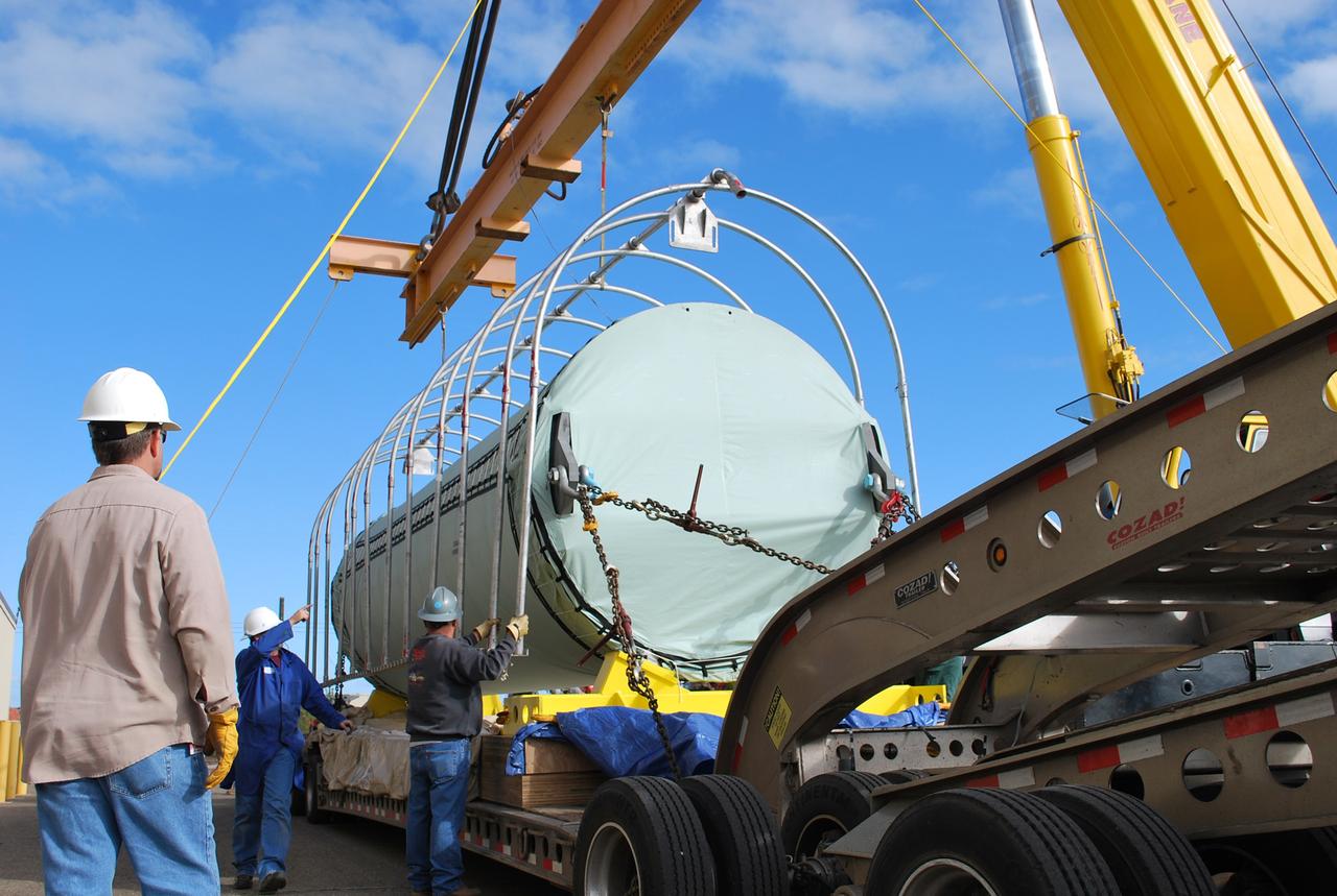
VANDENBERG AIR FORCE BASE, Calif. – After arrival of the cargo plane, the shipping container holding the OSTM/Jason-2 satellite is offloaded at Vandenberg Air Force Base. The satellite will be taken to the Astrotech processing facility. The OSTM, or Ocean Topography Mission, on the Jason-2 satellite is a follow-on to Jason-1. It will take oceanographic studies of sea surface height into an operational mode for continued climate forecasting research and science and industrial applications. This satellite altimetry data will help determine ocean circulation, climate change and sea-level rise. OSTM is a joint effort by the National Oceanic and Atmospheric Administration, NASA, France’s Centre National d’Etudes Spatiales and the European Meteorological Satellite Organisation. OSTM/Jason-2 will be launched aboard a United Launch Alliance Delta II 7320 from Vandenberg on June 15. Photo credit: NASA/Steve Greenberg, JPL
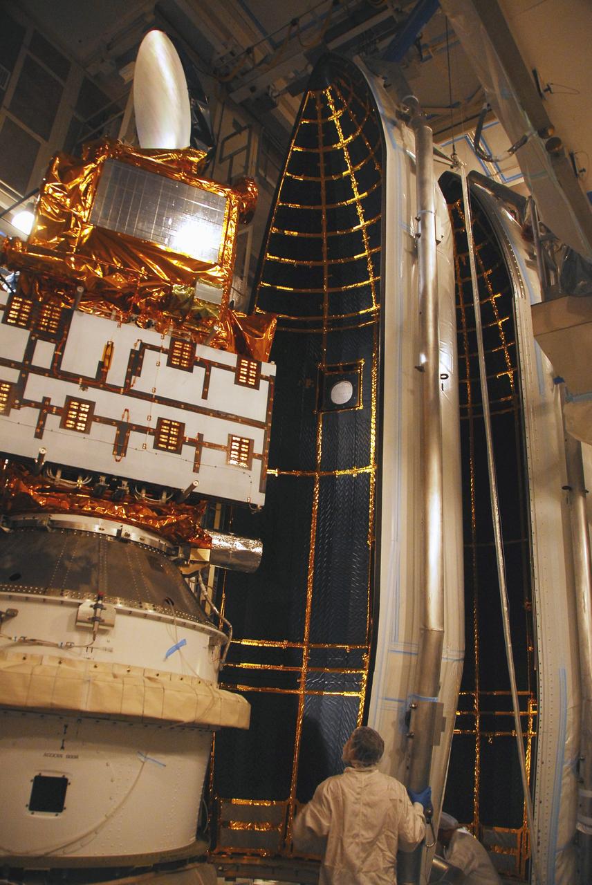
VANDENBERG AIR FORCE BASE, Calif. – In the mobile service tower at Space Launch Complex 2 at Vandenberg Air Force Base in California, technicians are inspecting the NASA's Orbiting Carbon Observatory-2, or OCO-2, satellite. The task is taking place prior to encapsulation in its payload fairing atop a United Launch Alliance Delta II rocket. Launch is scheduled for 2:56 a.m. PDT 5:56 a.m. EDT on July 1. OCO-2 is NASA’s first mission dedicated to studying atmospheric carbon dioxide, the leading human-produced greenhouse gas driving changes in Earth’s climate. OCO-2 will provide a new tool for understanding the human and natural sources of carbon dioxide emissions and the natural "sinks" that absorb carbon dioxide and help control its buildup. The observatory will measure the global geographic distribution of these sources and sinks and study their changes over time. To learn more about OCO-2, visit http://oco.jpl.nasa.gov Photo credit: NASA/Mark Mackley
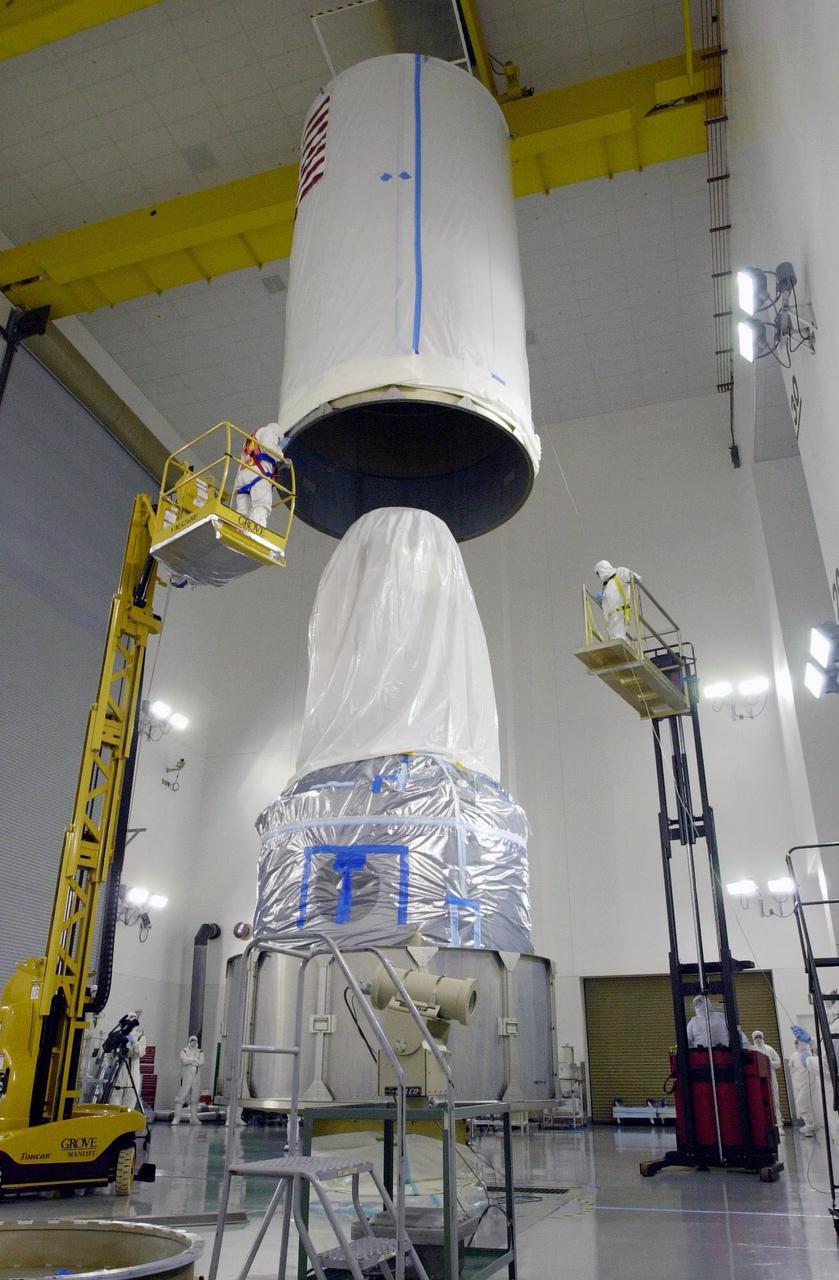
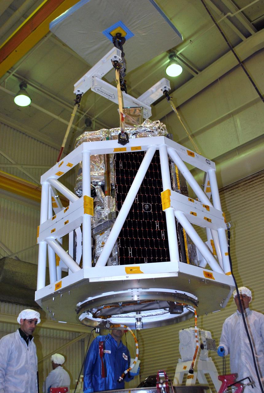
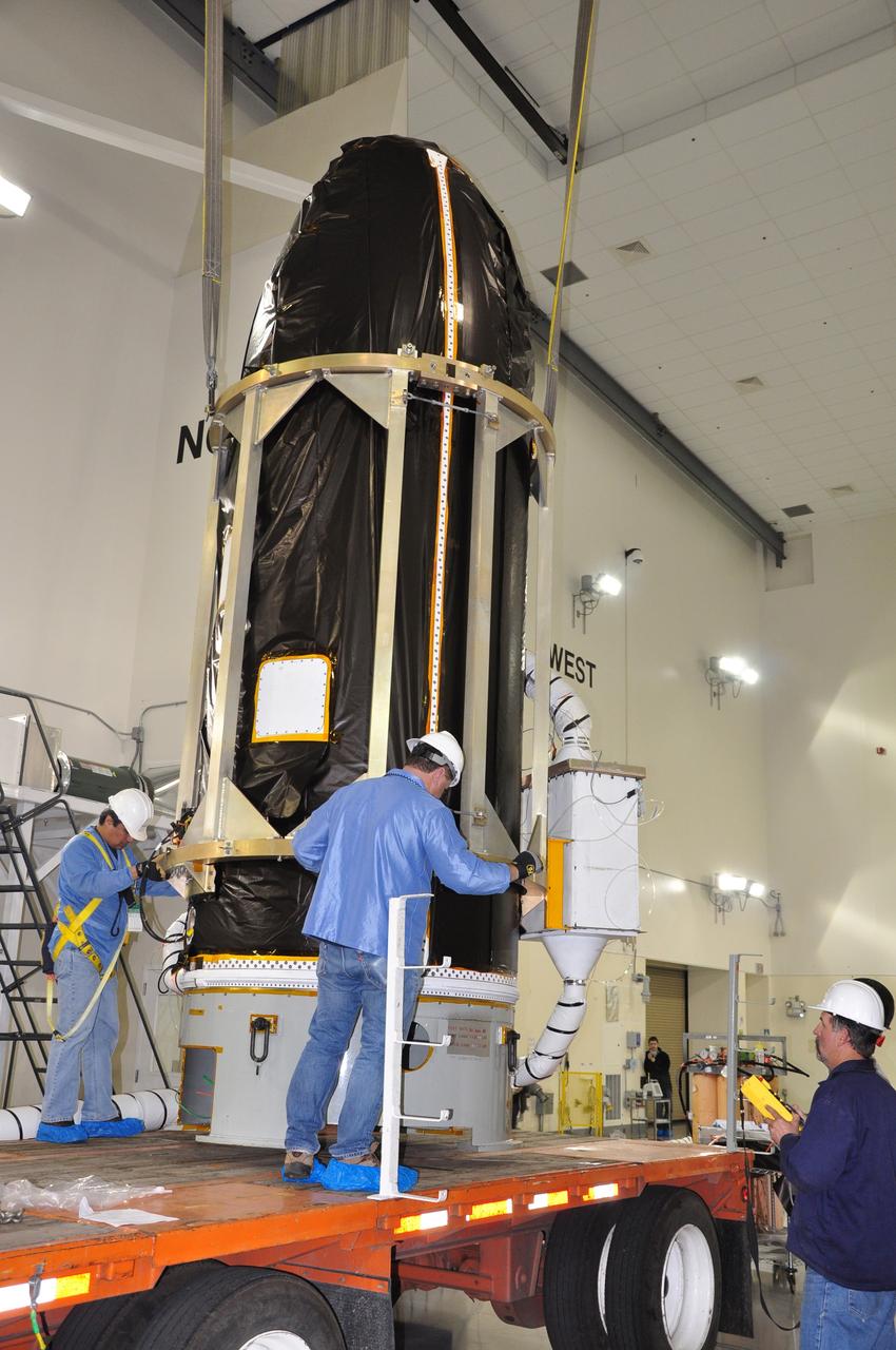
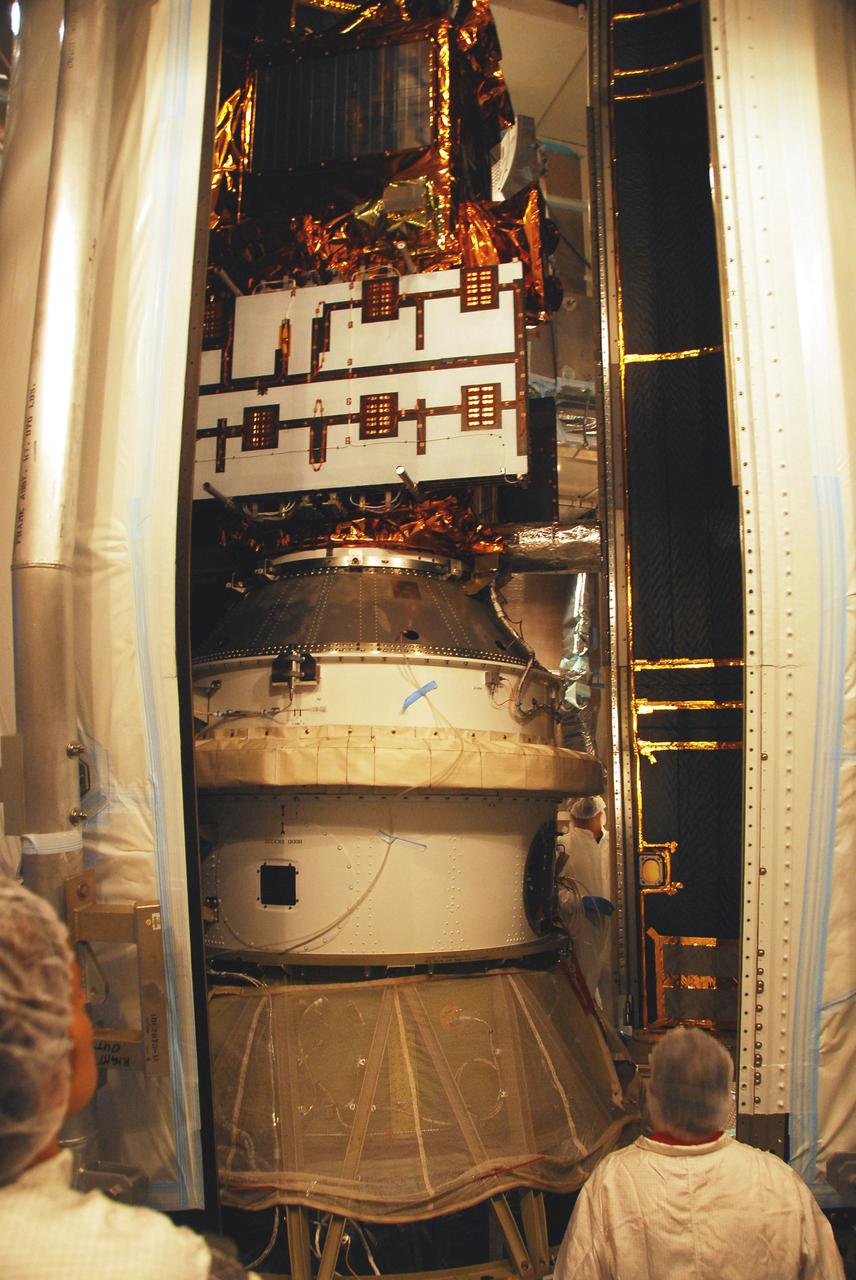
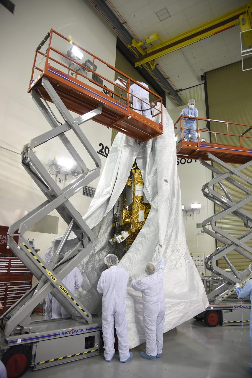
VANDENBERG AIR FORCE BASE, Calif. - Inside the Astrotech Payload Processing Facility on Vandenberg Air Force Base in California, the transport canister is lowered toward the covered dual spacecraft CALIPSO and CloudSat below. Once inside the canister, the spacecraft will be moved to Space Launch Complex 2. There the spacecraft will be lifted and mated with a Boeing Delta II rocket for launch on April 21. CALIPSO stands for Cloud-Aerosol Lidar and Infrared Pathfinder Satellite Observation. It will fly in combination with the CloudSat satellite to provide never-before-seen 3-D perspectives of how clouds and aerosols form, evolve, and affect weather and climate. CALIPSO and CloudSat will join three other satellites in orbit to enhance understanding of climate systems.
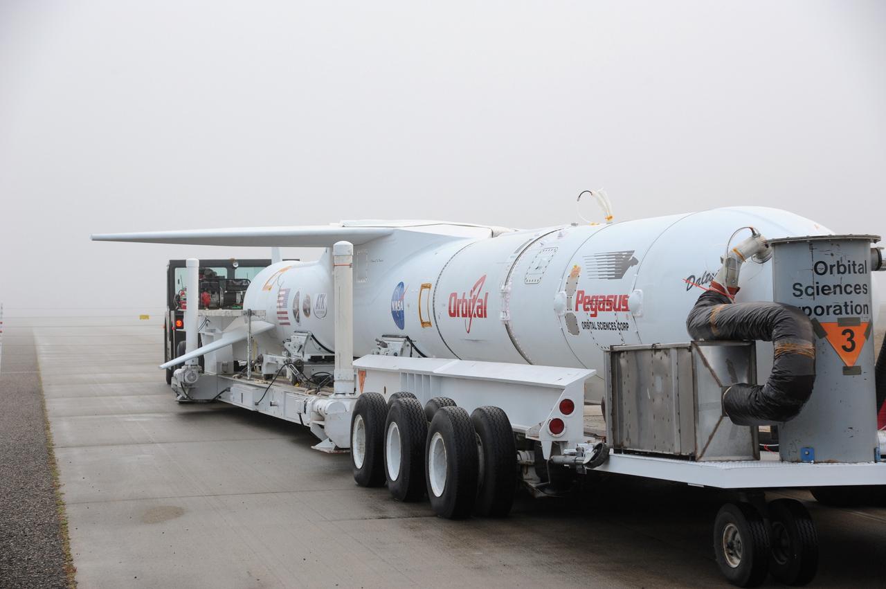
VANDENBERG AIR FORCE BASE, Calif. – Fog engulfs NASA’s Nuclear Spectroscopic Telescope Array, or NuSTAR, mated to Orbital Sciences’ Pegasus XL rocket, as it arrives at the “hot pad,” located on the ramp adjacent to the runway on Vandenberg Air Force Base in California. At the hot pad, the rocket will be attached beneath Orbital’s L-1011 carrier aircraft. The duo will be flown from Vandenberg to the U.S. Army's Ronald Reagan Ballistic Missile Defense Test Site on Kwajalein Atoll, part of the Marshall Islands in the Pacific Ocean. The Pegasus and its NuSTAR payload will be launched June 13 from the carrier aircraft 117 nautical miles south of Kwajalein at latitude 6.75 degrees north of the equator. The high-energy X-ray telescope will conduct a census of black holes, map radioactive material in young supernovae remnants, and study the origins of cosmic rays and the extreme physics around collapsed stars. For more information, visit http://www.nasa.gov/nustar. Photo credit: NASA/Chris Wiant, VAFB
VANDENBERG AIR FORCE BASE, Calif. -- At Vandenberg Air Force Base in California, the third stage of the Pegasus XL rocket that will launch the Nuclear Spectroscopic Telescope Array (NuSTAR) to orbit arrives at Building 1555 for processing. After the rocket and spacecraft are processed at Vandenberg, they will be shipped to the Ronald Reagan Ballistic Missile Defense Test Site located at the Pacific Ocean's Kwajalein Atoll for launch. The high-energy X-ray telescope will conduct a census for black holes, map radioactive material in young supernovae remnants, and study the origins of cosmic rays and the extreme physics around collapsed stars. Photo credit: NASA/Dan Liberotti, VAFB
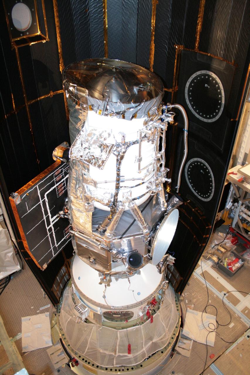
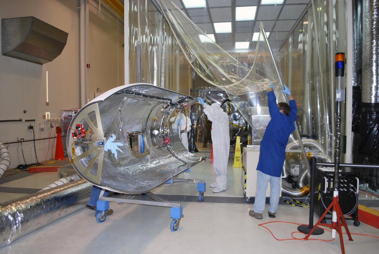
VANDENBERG AIR FORCE BASE, Calif. -- Inside the Astrotech payload processing facility at Vandenberg Air Force Base in California, NASA's Glory spacecraft is revealed after technicians removed the protective covering surrounding it. Next, the spacecraft will be encapsulated in its protective payload fairing before it is transported to Space Launch Complex 576-E and joined with the Taurus XL rocket's third stage. The Orbital Sciences Corp. Taurus XL rocket will carry Glory into low Earth orbit. Once the spacecraft reaches orbit, it will collect data on the properties of aerosols and black carbon. It also will help scientists understand how the sun's irradiance affects Earth's climate. Launch is scheduled for 5:09 a.m. EST Feb. 23. For information, visit www.nasa.gov/glory. Photo credit: NASA/Don Kososka, VAFB
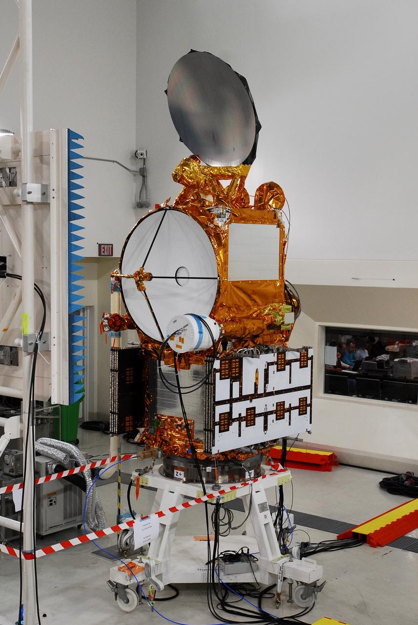
VANDENBERG AIR FORCE BASE, Calif. -- In Space Systems International's Payload Processing Facility at Vandenberg Air Force Base in California, technicians guide an overhead crane lowering the second solar array toward the Aquarius/SAC-D spacecraft. Following final tests, the spacecraft will be integrated to a United Launch Alliance Delta II rocket in preparation for the targeted June launch. Aquarius, the NASA-built primary instrument on the SAC-D spacecraft, will provide new insights into how variations in ocean surface salinity relate to fundamental climate processes on its three-year mission. Photo credit: NASA/VAFB
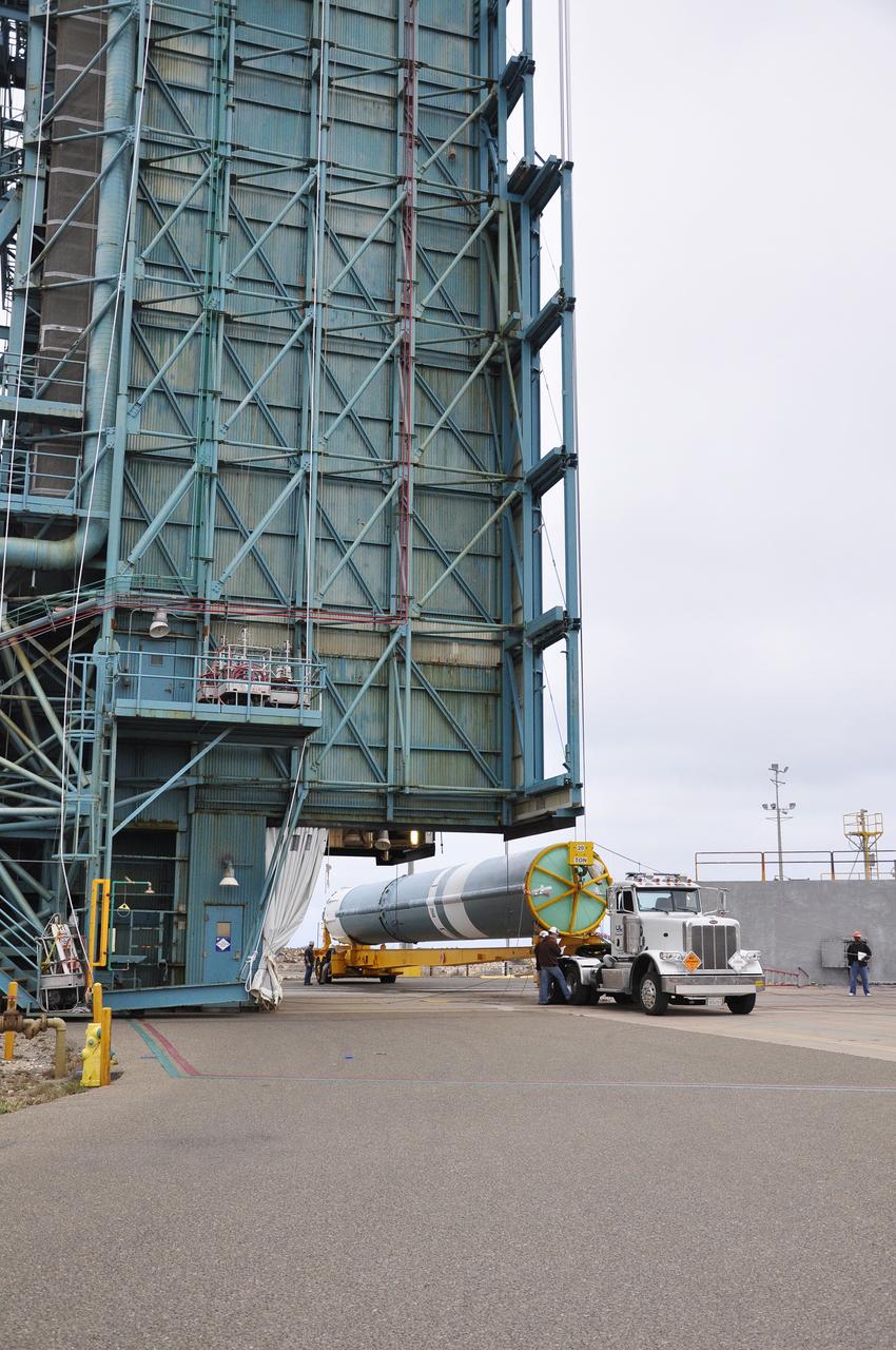
VANDENBERG AFB, California – A convoy assembles to take NASA's SMAP spacecraft from the Astrotech processing facility to Space Launch Complex-2 for placement atop a Delta II rocket for launch. For more, go to www.nasa.gov/smap Photo credit: USAF
VANDENBERG AIR FORCE BASE, Calif. -- NASA's NuSTAR spacecraft is lifted inside Orbital Sciences' processing facility at Vandenberg Air Force Base, Calif. The spacecraft will be rotated to horizontal for joining with the Pegasus XL rocket. The Orbital Sciences Pegasus will launch NASA's Nuclear Spectroscopic Telescope Array NuSTAR into space. After the rocket and spacecraft are processed at Vandenberg, they will be flown on Orbital's L-1011 carrier aircraft to the Ronald Reagan Ballistic Missile Defense Test Site at the Pacific Ocean’s Kwajalein Atoll for launch. The high-energy x-ray telescope will conduct a census for black holes, map radioactive material in young supernovae remnants, and study the origins of cosmic rays and the extreme physics around collapsed stars. For more information, visit science.nasa.gov/missions/nustar/. Photo credit: NASA/Randy Beaudoin, VAFB
VANDENBERG AIR FORCE BASE, Calif. – After arrival of the Stage 0 motor for the Taurus XL launch vehicle at Vandenberg Air Force Base in California, a crane lifts off the protective cage. The motor will be transported to Orbital Sciences' Hangar 1555. The Taurus XL will launch NASA's Orbiting Carbon Observatory, or OCO, spacecraft targeted for Jan. 15. The OCO is a new Earth-orbiting mission sponsored by NASA's Earth System Science Pathfinder Program. Photo credit: NASA/Randy Beaudoin, VAFB
VANDENBERG AIR FORCE BASE, CALIF. -- Inside a clean room at Vandenberg Air Force Base in California, workers stand beside NASA's Aeronomy of Ice in the Mesosphere, or AIM, spacecraft, waiting for an overhead crane they will attach. AIM is the seventh Small Explorers mission under NASA's Explorer Program. The program provides frequent flight opportunities for world-class scientific investigations from space within heliophysics and astrophysics. The AIM spacecraft will fly three instruments designed to study polar mesospheric clouds located at the edge of space, 50 miles above the Earth's surface in the coldest part of the planet's atmosphere. The mission's primary goal is to explain why these clouds form and what has caused them to become brighter and more numerous and appear at lower latitudes in recent years. AIM's results will provide the basis for the study of long-term variability in the mesospheric climate and its relationship to global climate change. AIM is scheduled to be mated to the Pegasus XL during the second week of April, after which final inspections will be conducted. Launch is scheduled for April 25.
VANDENBERG AIR FORCE BASE, Calif. -- At Space Launch Complex 576-E at Vandenberg Air Force Base in California, the Stage 0/1 interstage is attached to Stage 0 of the four-stage Taurus XL rocket that will carry NASA's Glory spacecraft into low Earth orbit. Once Glory reaches orbit, it will collect data on the properties of aerosols and black carbon. It also will help scientists understand how the sun's irradiance affects Earth's climate. Launch is scheduled for 5:09 a.m. EST Feb. 23. For information, visit www.nasa.gov/glory. Photo credit: NASA/Roy Allison, VAFB
VANDENBERG AFB, Calif. – A truck moves the first stage booster of a United Launch Alliance Atlas V to Space Launch Complex-3E at Vandenberg Air Force Base, Calif. in preparation for the launch of the Landsat Data Continuity Mission. The Landsat Data Continuity Mission, or LDCM, is the future of Landsat satellites. It will continue to obtain valuable data and imagery to be used in agriculture, education, business, science, and government. The Landsat Program provides repetitive acquisition of high resolution multispectral data of the Earth's surface on a global basis. The data from the Landsat spacecraft constitute the longest record of the Earth's continental surfaces as seen from space. It is a record unmatched in quality, detail, coverage, and value. Launch is planned for Feb. 2013. Photo credit: NASA/Roy Allison

VANDENBERG AIR FORCE BASE, Calif. -- At Vandenberg Air Force Base in California, workers unload the cargo carrier that holds one half of the fairing that will envelop NASA's Glory satellite. Both halves of the fairing will be installed around the spacecraft to protect it from the weather on the ground as well as from the atmosphere during flight. A four-stage Taurus XL rocket will carry Glory into low Earth orbit. Once Glory reaches orbit, it will collect data on the properties of aerosols and black carbon. It also will help scientists understand how the sun's irradiance affects Earth's climate. Launch is scheduled for 2:09 a.m. PST Nov. 22. For information, visit www.nasa.gov/glory. Photo credit: NASA/Randy Beaudoin, VAFB
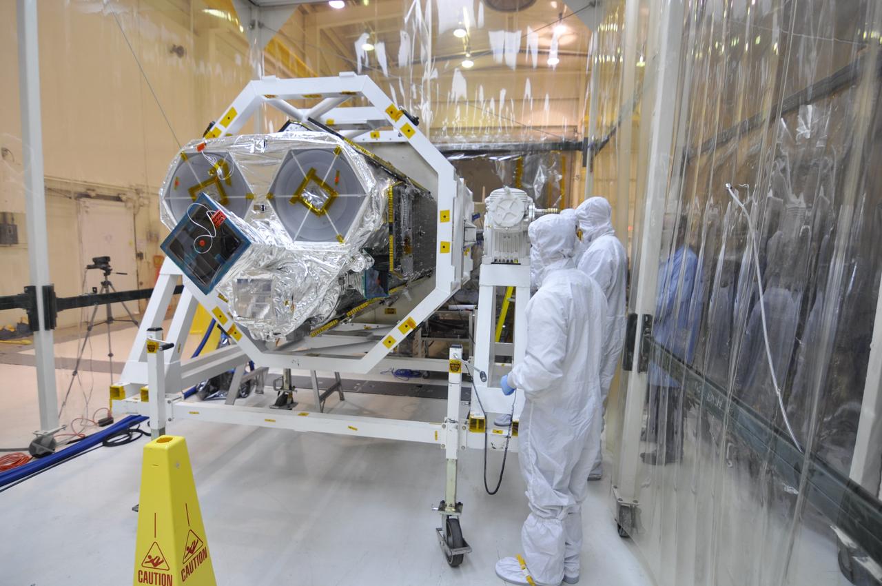
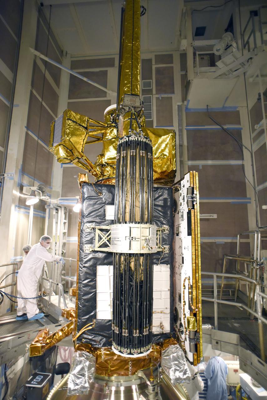
VANDENBERG AIR FORCE BASE, Calif. – Inside an environmental enclosure at Vandenberg Air Force Base's processing facility in California, technicians monitor NASA's Nuclear Spectroscopic Telescope Array, or NuSTAR, secured inside a turnover rotation fixture, as it moves toward interface with its Orbital Sciences Pegasus XL rocket. The technicians are dressed in clean room attire, known as bunny suits. The conjoining of the spacecraft with the rocket is a major milestone in prelaunch preparations. After processing of the rocket and spacecraft are complete, they will be flown on Orbital's L-1011 carrier aircraft from Vandenberg to the Ronald Reagan Ballistic Missile Defense Test Site on the Pacific Ocean’s Kwajalein Atoll for launch. The high-energy x-ray telescope will conduct a census of black holes, map radioactive material in young supernovae remnants, and study the origins of cosmic rays and the extreme physics around collapsed stars. For more information, visit http://www.nasa.gov/nustar. Photo credit: NASA/Randy Beaudoin, VAFB
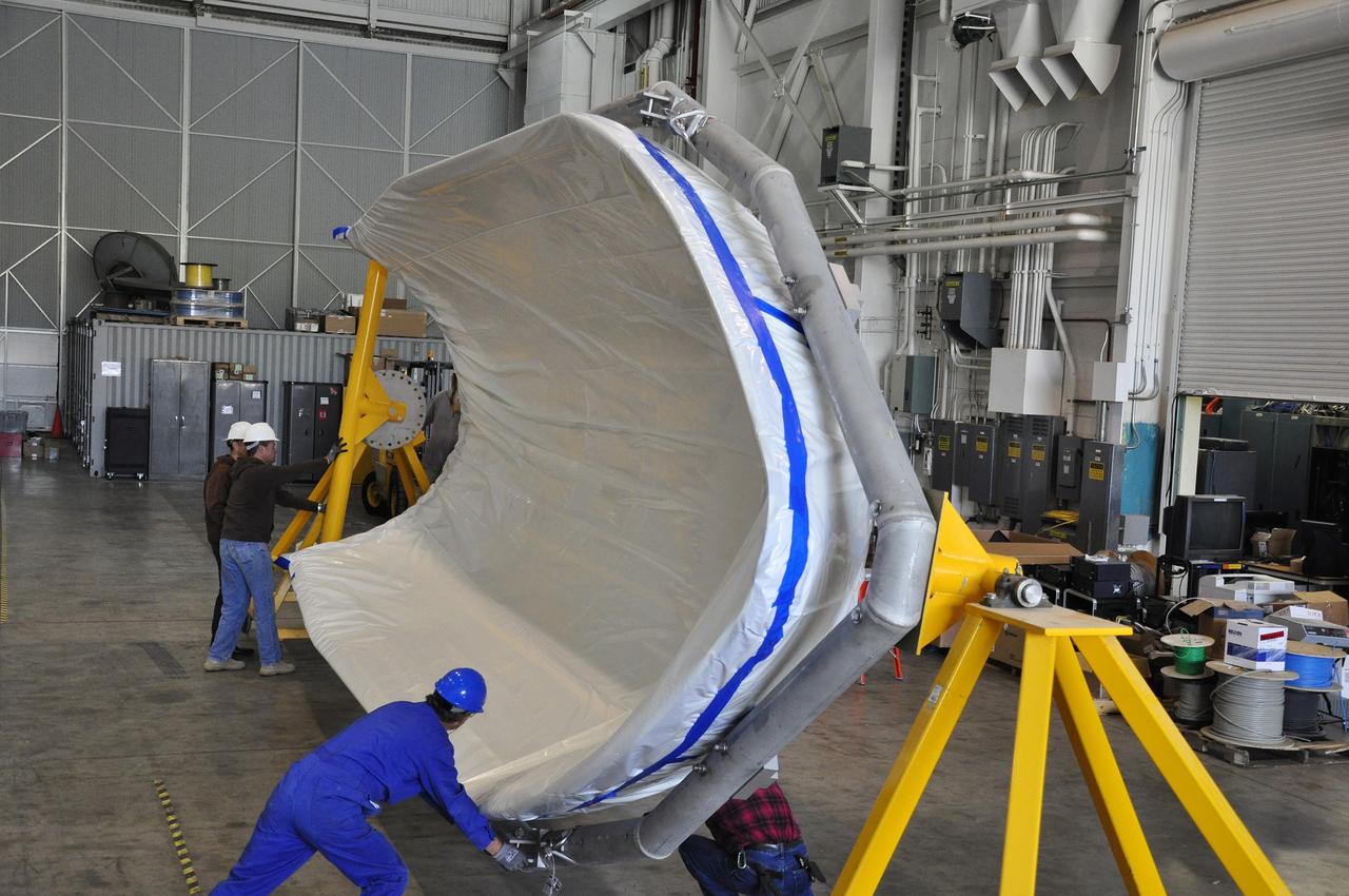
VANDENBERG AIR FORCE BASE, Calif. – Teamwork is required to transfer a section of the fairing for NASA's Nuclear Spectroscopic Telescope Array, or NuSTAR, into the clean room of the Orbital Sciences processing facility at Vandenberg Air Force Base in California. The fairing will enclose and protect the spacecraft from the heat and aerodynamic pressure generated during ascent to orbit aboard an Orbital Sciences Pegasus XL rocket. After processing of the rocket and spacecraft are complete, they will be flown on Orbital's L-1011 carrier aircraft from Vandenberg to the Ronald Reagan Ballistic Missile Defense Test Site on the Pacific Ocean’s Kwajalein Atoll for launch in March. The high-energy x-ray telescope will conduct a census of black holes, map radioactive material in young supernovae remnants, and study the origins of cosmic rays and the extreme physics around collapsed stars. For more information, visit http://www.nasa.gov/nustar. Photo credit: NASA/Randy Beaudoin, VAFB
VANDENBERG AIR FORCE BASE, Calif. -- At the Astrotech processing facility on Vandenberg Air Force Base in California, workers prepare NASA's Wide-field Infrared Survey Explorer, or WISE, to be lifted from its test stand to determine its exact weight. The satellite will survey the entire sky at infrared wavelengths, creating a cosmic clearinghouse of hundreds of millions of objects which will be catalogued and provide a vast storehouse of knowledge about the solar system, the Milky Way, and the universe. Launch is scheduled for Dec. 7. Photo credit: NASA/Doug Kolkow
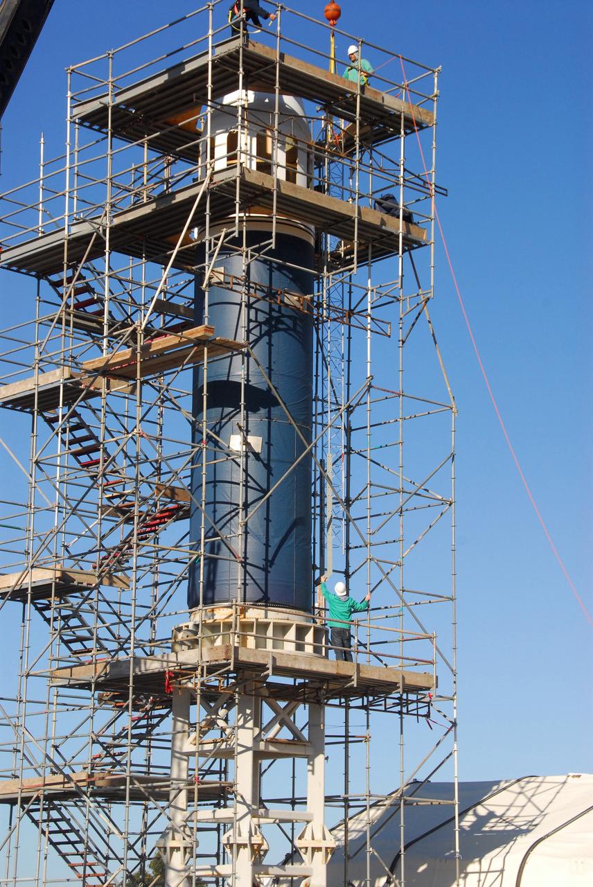
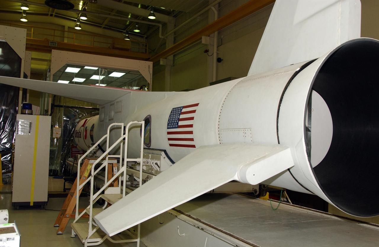
VANDENBERG AIR FORCE BASE, Calif. -- On Launch Complex 576-E at Vandenberg Air Force Base in California, NASA's Orbiting Carbon Observatory, or OCO, spacecraft awaits a GN2 instrument purge flow test in preparation for launch Feb. 24. The spacecraft sits atop Orbital Sciences' Taurus XL rocket. At right is a portion of the umbilical tower attached to the upper stack. The spacecraft sits atop Orbital Sciences' Taurus XL rocket. At right is a portion of the umbilical tower attached to the upper stack. The spacecraft will collect precise global measurements of carbon dioxide (CO2) in the Earth's atmosphere. Scientists will analyze OCO data to improve our understanding of the natural processes and human activities that regulate the abundance and distribution of this important greenhouse gas. Photo courtesy of Jim Stowers, Orbital Sciences
VANDENBERG AIR FORCE BASE, Calif. -- At Vandenberg Air Force Base's Astrotech processing facility in California, workers maneuver the overhead crane that will lift NASA's Wide-field Infrared Survey Explorer, or WISE, spacecraft from the travel dolly to a work stand. The satellite will survey the entire sky at infrared wavelengths, creating a cosmic clearinghouse of hundreds of millions of objects, which will be catalogued, providing a vast storehouse of knowledge about the solar system, the Milky Way, and the universe. Launch is scheduled no earlier than Dec. 10. Photo credit: NASA/Moore, VAFB

VANDENBERG AIR FORCE BASE, Calif. -- Space Launch Complex 576-E, Vandenberg Air Force Base in California, a worker checks the integration of the Taurus XL Stages 1 and 2. The Taurus is the launch vehicle for NASA's Orbiting Carbon Observatory, called OCO, a new Earth-orbiting mission sponsored by NASA's Earth System Science Pathfinder Program. The observatory is targeted to launch Feb. 23 from Space Launch Complex 576-E at Vandenberg. Photo credit: NASA/VAFB
VANDENBERG AIR FORCE BASE, Calif. – A NASA F-18 takes off from Vandenberg Air Force Base, Calif., on a mission to record the launch of NASA's IRIS spacecraft into low-Earth orbit. IRIS, short for Interface Region Imaging Spectrograph, was launched aboard an Orbital Sciences Pegasus XL rocket released from an L-1011 carrier aircraft. Photo credit: VAFB/Chris Wiant

VANDENBERG AFB, Calif. -- A Boeing Delta II rocket soars above the clouds here today at Vandenberg AFB, Calif. The NASA payloads aboard the rocket are the ICESat, an Ice Cloud and land Elevation Satellite, and CHIPSat, a Cosmic Hot Interstellar Plasma Spectrometer. ICESat, a 661-pound satellite, is a benchmark satellite for the Earth Observing System that will help scientists determine if the global sea level is rising or falling. It will observe the ice sheets that blanket the Earth’s poles to determine if they are growing or shrinking. It will assist in developing an understanding of how changes in the Earth’s atmosphere and climate affect polar ice masses and global sea level. The Geoscience Laser Altimeter System is the sole instrument on the satellite. CHIPSat, a suitcase-size 131-pound satellite, will provide information about the origin, physical processes and properties of the hot gas contained in the interstellar medium. This launch marks the first Delta from Vandenberg this year. (USAF photo by: SSgt. Lee A Osberry Jr.)
VANDENBERG AIR FORCE BASE, Calif. - At Space Launch Complex 2 at Vandenberg Air Force Base in California, the interstage of the United Launch Alliance Delta II rocket for launch of NASA's Wide-field Infrared Survey Explorer, or WISE, is lifted from its transporter. WISE will survey the entire sky at infrared wavelengths, creating a cosmic clearinghouse of hundreds of millions of objects which will be catalogued and provide a vast storehouse of knowledge about the solar system, the Milky Way, and the universe. Launch is scheduled for Dec. 7. For additional information, visit http://wise.ssl.berkeley.edu. Photo credit: NASA/Roy Allison, VAFB
VANDENBERG AFB, California – NASA's SMAP spacecraft inside the service structure at Space Launch Complex-2 at Vandenberg AFB, California. For more, go to www.nasa.gov/smap Photo credit: USAF
VANDENBERG AIR FORCE BASE, Calif. – Workers prepare to rotate a section of the fairing for NASA's Soil Moisture Active Passive mission, or SMAP, in a lifting device in the Building 836 high bay on Vandenberg Air Force Base in California. The fairing will protect the SMAP spacecraft from the heat and aerodynamic pressure generated during its ascent to orbit aboard a United Launch Alliance Delta II rocket from Space Launch Complex 2. SMAP will provide global measurements of soil moisture and its freeze/thaw state. These measurements will be used to enhance understanding of processes that link the water, energy and carbon cycles, and to extend the capabilities of weather and climate prediction models. SMAP data will also be used to quantify net carbon flux in boreal landscapes and to develop improved flood prediction and drought monitoring capabilities. Launch is scheduled for November 2014. To learn more about SMAP, visit http://smap.jpl.nasa.gov. Photo credit: NASA/Randy Beaudoin
VANDENBERG AIR FORCE BASE, Calif. – The Delta II interstage adapter, or ISA, for NASA's Soil Moisture Active Passive mission, or SMAP, is lowered into place on the rocket's first stage in the mobile service tower at Space Launch Complex 2 on Vandenberg Air Force Base in California. Processing of the United Launch Alliance Delta II rocket that will loft SMAP into orbit is underway at the pad. The ISA connects the Delta II first and second stages and encloses the second stage engine and thrust section. The spacecraft will provide global measurements of soil moisture and its freeze/thaw state. These measurements will be used to enhance understanding of processes that link the water, energy and carbon cycles, and to extend the capabilities of weather and climate prediction models. The data returned also will be used to quantify net carbon flux in boreal landscapes and to develop improved flood prediction and drought monitoring capabilities. Launch is scheduled for November 2014. To learn more about SMAP, visit http://smap.jpl.nasa.gov. Photo credit: NASA/Randy Beaudoin
VANDENBERG AIR FORCE BASE, Calif. – Inside the Astrotech payload processing facility on Vandenberg Air Force Base in California, engineers and technicians rotate NASA's Soil Moisture Active Passive, or SMAP, spacecraft to begin processing. SMAP will launch on a Delta II 7320 configuration vehicle featuring a United Launch Alliance first stage booster powered by an Aerojet Rocketdyne RS-27A main engine and three Alliant Techsystems, or ATK, strap-on solid rocket motors. Once on station in Earth orbit, SMAP will provide global measurements of soil moisture and its freeze/thaw state. These measurements will be used to enhance understanding of processes that link the water, energy and carbon cycles, and to extend the capabilities of weather and climate prediction models. SMAP data also will be used to quantify net carbon flux in boreal landscapes and to develop improved flood prediction and drought monitoring capabilities. Launch from Space Launch Complex 2 is targeted for Jan. 29, 2015. To learn more about SMAP, visit http://smap.jpl.nasa.gov Photo credit: NASA/ Randy Beaudoin
VANDENBERG AIR FORCE BASE, Calif. -- In pre-dawn hours at Vandenberg Air Force Base in California, the mobile service tower/umbilical tower and launcher on Space Launch Complex 2 are being prepared for the arrival of the Delta II first stage for the OSTM/Jason-2 spacecraft. The OSTM, or Ocean Topography Mission, on the Jason-2 satellite is a follow-on to Jason-1. It will take oceanographic studies of sea surface height into an operational mode for continued climate forecasting research and science and industrial applications. This satellite altimetry data will help determine ocean circulation, climate change and sea-level rise. OSTM is a joint effort by the National Oceanic and Atmospheric Administration, NASA, France’s Centre National d’Etudes Spatiales and the European Meteorological Satellite Organisation. OSTM/Jason-2 will be launched aboard a United Launch Alliance Delta II 7320 from Vandenberg on June 15. Photo credit: NASA/Dan Liberotti
VANDENBERG AIR FORCE BASE, Calif. – At Vandenberg Air Force Base in California, the Pegasus XL rocket with the attached Interface Region Imaging Spectrograph IRIS solar observatory rolled out of the hangar on its transporter to the runway at Vandenberg. There, the rocket and spacecraft were mated with the Orbital Sciences L-1011 carrier aircraft. Scheduled for launch from Vandenberg on June 26, 2013, IRIS will open a new window of discovery by tracing the flow of energy and plasma through the chromospheres and transition region into the sun’s corona using spectrometry and imaging. The IRIS mission will observe how solar material moves, gathers energy and heats up as it travels through a largely unexplored region of the solar atmosphere. The interface region, located between the sun's visible surface and upper atmosphere, is where most of the sun's ultraviolet emission is generated. These emissions impact the near-Earth space environment and Earth's climate. For more information, visit http://www.nasa.gov/iris Photo credit: NASA/Randy Beaudoin
VANDENBERG AFB, Calif. – A Centaur upper stage is prepared for lifting onto the first stage booster of a United Launch Alliance Atlas V at the launch pad at Space Launch Complex-3E at Vandenberg Air Force Base, Calif. in preparation for the launch of the Landsat Data Continuation Mission. The Landsat Data Continuity Mission LDCM is the future of Landsat satellites. It will continue to obtain valuable data and imagery to be used in agriculture, education, business, science, and government. The Landsat Program provides repetitive acquisition of high resolution multispectral data of the Earth's surface on a global basis. The data from the Landsat spacecraft constitute the longest record of the Earth's continental surfaces as seen from space. It is a record unmatched in quality, detail, coverage, and value. Launch is planned for Feb. 2013. Photo credit: NASA/Roy Allison
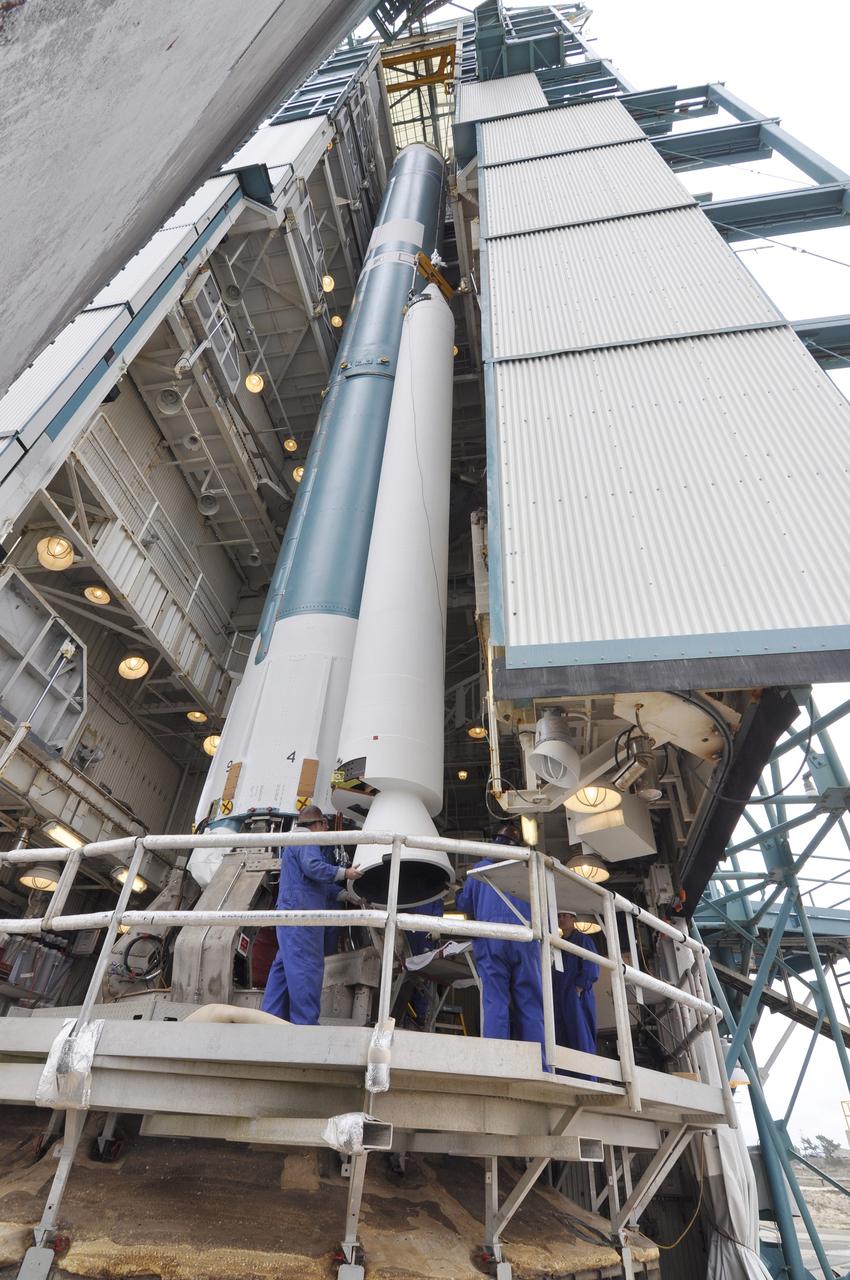
VANDENBERG AIR FORCE BASE, Calif. -- At Vandenberg Air Force Base in California, the interstage of the United Launch Alliance Delta II that will carry NASA's National Polar-orbiting Operational Environmental Satellite System Preparatory Project (NPP) satellite into space arrives at NASA's Space Launch Complex-2. The interstage provides an interface between the launch vehicle's first and second stages. NPP represents a critical first step in building the next-generation of Earth-observing satellites. NPP will carry the first of the new sensors developed for this satellite fleet, now known as the Joint Polar Satellite System (JPSS) to be launched in 2016. NPP is the bridge between NASA's Earth Observing System (EOS) satellites and the forthcoming series of JPSS satellites. The mission will test key technologies and instruments for the JPSS missions. For more information, visit http://www.nasa.gov/NPP. Photo credit: NASA/VAFB, Rudy Bledsoe
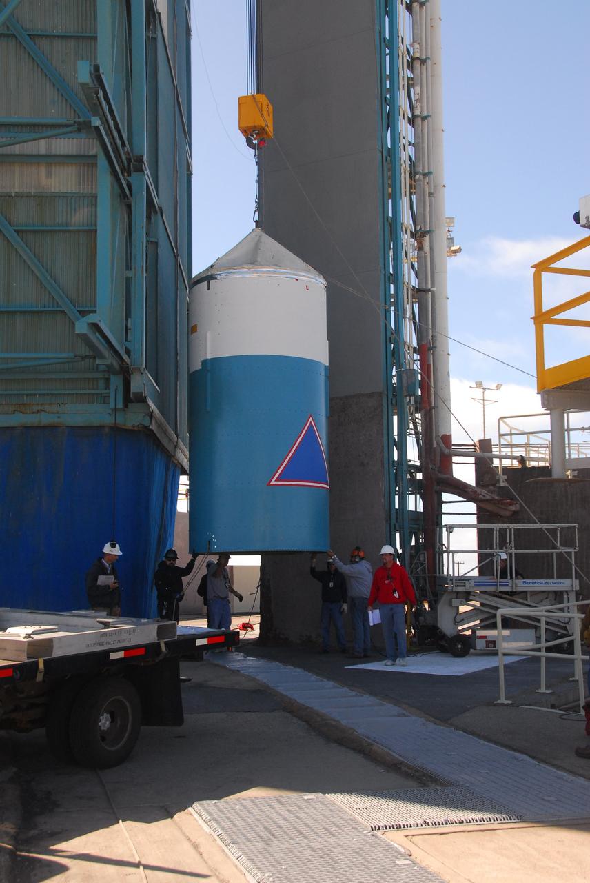
VANDENBERG AIR FORCE BASE, Calif. -- At Vandenberg Air Force Base in California, the protective payload fairing that will surround NASA's Glory spacecraft arrives at the Astrotech payload processing facility. Once encapsulated, the spacecraft will be transported to Space Launch Complex 576-E and joined with the Taurus XL rocket's third stage. Once Glory reaches orbit, it will collect data on the properties of aerosols and black carbon. It also will help scientists understand how the sun's irradiance affects Earth's climate. Launch is scheduled for 5:09 a.m. EST Feb. 23. For information, visit www.nasa.gov/glory. Photo credit: NASA/Ed Henry, VAFB
VANDENBERG AIR FORCE BASE, Fla. -- NASA’s Interstellar Boundary Explorer, or IBEX, spacecraft and mated Pegasus XL rocket are being attached to Orbital Sciences’ L-1011 aircraft for launch. IBEX is targeted for launch from the Kwajalein Atoll, a part of the Marshall Islands in the Pacific Ocean, on Oct. 19. IBEX will be launched aboard the Pegasus rocket dropped from under the wing of the L-1011 aircraft flying over the Pacific Ocean. The Pegasus will carry the spacecraft approximately 130 miles above Earth and place it in orbit. The IBEX satellite will make the first map of the boundary between the Solar System and interstellar space. Photo credit: NASA/Mark Mackley, VAFB
VANDENBERG AIR FORCE BASE, Calif. -- On Space Launch Complex 2 at Vandenberg Air Force Base in California, the mobile service tower with the Delta II first stage moves closer to the umbilical tower/launcher at right. The Delta II is the launch vehicle for the OSTM/Jason-2 spacecraft. The OSTM, or Ocean Topography Mission, on the Jason-2 satellite is a follow-on to Jason-1. It will take oceanographic studies of sea surface height into an operational mode for continued climate forecasting research and science and industrial applications. This satellite altimetry data will help determine ocean circulation, climate change and sea-level rise. OSTM is a joint effort by the National Oceanic and Atmospheric Administration, NASA, France’s Centre National d’Etudes Spatiales and the European Meteorological Satellite Organisation. OSTM/Jason-2 will be launched aboard a United Launch Alliance Delta II 7320 from Vandenberg on June 15. Photo credit: NASA/Dan Liberotti
VANDENBERG AIR FORCE BASE, Calif. -- At Space Launch Complex 576-E at Vandenberg Air Force Base in California, workers prepare NASA's Glory spacecraft, encapsulated in its protective fairing, to be lifted off of a transport. It will then be joined with the Taurus XL rocket's third stage, already delivered to a temporary processing tent near the pad. The Orbital Sciences Corp. Taurus XL rocket will carry Glory into low Earth orbit. Once Glory reaches orbit, it will collect data on the properties of aerosols and black carbon. It also will help scientists understand how the sun's irradiance affects Earth's climate. Launch is scheduled for 5:09 a.m. EST Feb. 23. For information, visit www.nasa.gov/glory. Photo credit: NASA/Jerry E. Clemens Jr., VAFB
VANDENBERG AIR FORCE BASE, Calif. – In Building 1555, workers secure the fillet into place on the Pegasus XL launch vehicle. The Pegasus will launch NASA's Interstellar Boundary Explorer Mission, or IBEX, satellite from Kwajalein Island in the Marshall Islands, South Pacific. IBEX will make the first map of the boundary between the solar system and interstellar space. IBEX is the first mission designed to detect the edge of the solar system. As the solar wind from the sun flows out beyond Pluto, it collides with the material between the stars, forming a shock front. IBEX contains two neutral atom imagers designed to detect particles from the termination shock at the boundary between the solar system and interstellar space. IBEX also will study galactic cosmic rays, energetic particles from beyond the solar system that pose a health and safety hazard for humans exploring beyond Earth orbit. IBEX will make these observations from a highly elliptical orbit that takes it beyond the interference of the Earth's magnetosphere. Photo credit: NASA/Randy Beaudoin
VANDENBERG AIR FORCE BASE, CALIF. -- In a clean-room environment at North Vandenberg Air Force Base, a technician begins the illumination testing of the AIM spacecraft at left. The AIM spacecraft will fly three instruments designed to study those clouds located at the edge of space, 50 miles above the Earth's surface in the coldest part of the planet's atmosphere. The mission's primary goal is to explain why these clouds form and what has caused them to become brighter and more numerous and appear at lower latitudes in recent years. AIM's results will provide the basis for the study of long-term variability in the mesospheric climate and its relationship to global climate change. AIM is scheduled to be mated to the Pegasus XL during the second week of April, after which final inspections will be conducted. Launch is scheduled for April 25.
VANDENBERG AIR FORCE BASE, Calif. -- At Space Launch Complex 576-E at Vandenberg Air Force Base in California, technicians install the Poly Picosatellite Orbital Deployer, or P-POD, assembly to the aft end of the Taurus rocket's third stage. The P-POD holds three CubeSats or tiny satellites, designed and created by university and college students that will be carried on the Taurus rocket along with the Glory spacecraft. The Orbital Sciences Corp. Taurus XL rocket will carry Glory into low Earth orbit. Once Glory reaches orbit, it will collect data on the properties of aerosols and black carbon. It also will help scientists understand how the sun's irradiance affects Earth's climate. Launch is scheduled for 5:09 a.m. EST Feb. 23. For information, visit www.nasa.gov/glory. Photo credit: NASA/Randy Beaudoin, VAFB
VANDENBERG AIR FORCE BASE, Calif. -- At Astrotech's payload processing facility at Vandenberg Air Force Base in California, workers guide NASA's Glory spacecraft, now completely enclosed in its payload fairing, as it is lowered onto a transporter in the airlock for its move to Space Launch Complex 576-E. There it will be joined with the Taurus XL rocket's third stage. The hose connected to the fairing is an environmental purge that keeps the spacecraft dry and temperature controlled. The Orbital Sciences Corp. Taurus XL rocket will carry Glory into low Earth orbit. Once Glory reaches orbit, it will collect data on the properties of aerosols and black carbon. It also will help scientists understand how the sun's irradiance affects Earth's climate. Launch is scheduled for 5:09 a.m. EST Feb. 23. For information, visit www.nasa.gov/glory. Photo credit: NASA/Randy Beaudoin, VAFB
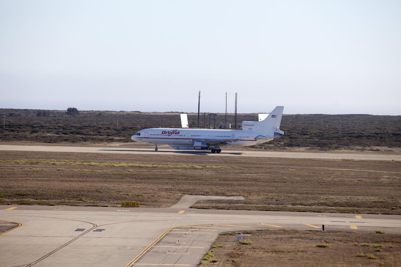
VANDENBERG AIR FORCE BASE, Calif. – An Orbital Sciences L-1011 carrier aircraft taxis to the runway at Vandenberg Air Force Base, Calif., before taking off on a mission to launch NASA's IRIS spacecraft into low-Earth orbit. IRIS, short for Interface Region Imaging Spectrograph, was launched aboard an Orbital Sciences Pegasus XL rocket released from the L-1011. Photo credit: NASA/Daniel Casper
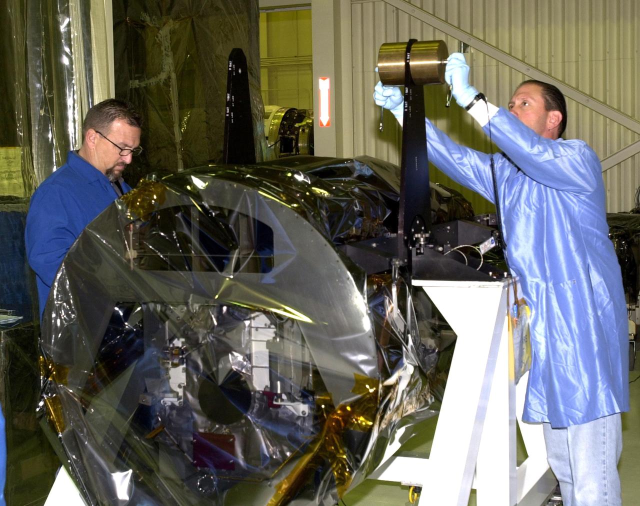
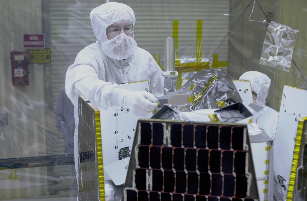
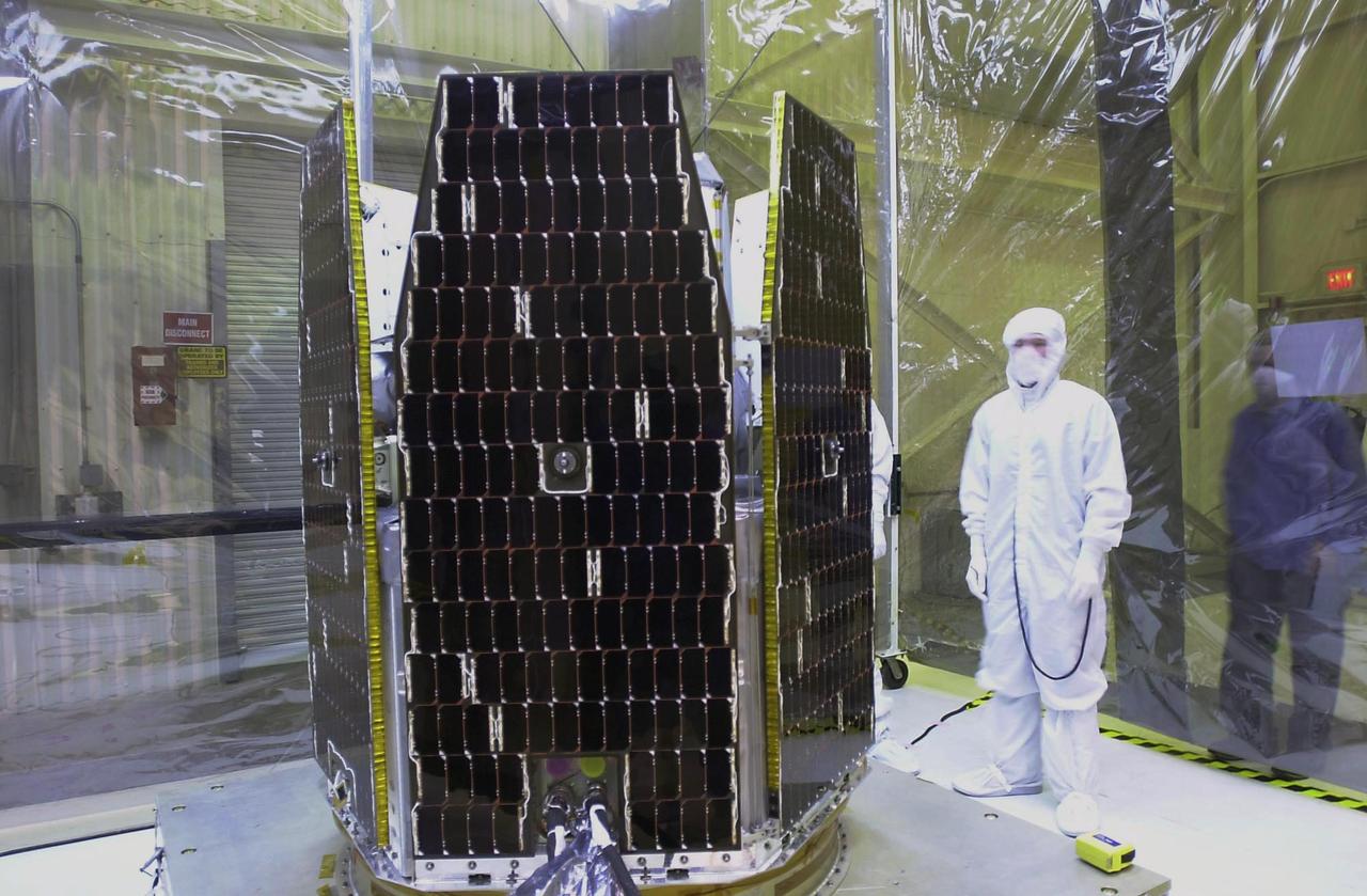
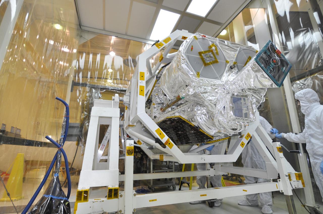
VANDENBERG AIR FORCE BASE, Calif. — Inside Orbital Sciences’ Building 1555 at Vandenberg Air Force Base in California, the wrapped Space Technology 5 (ST5) spacecraft is being prepared for mating to the Pegasus XL launch vehicle. The satellites contain miniaturized redundant components and technologies. Each will validate New Millennium Program selected technologies, such as the Cold Gas Micro-Thruster and X-Band Transponder Communication System. After deployment from the Pegasus, the micro-satellites will be positioned in a “string of pearls” constellation that demonstrates the ability to position them to perform simultaneous multi-point measurements of the magnetic field using highly sensitive magnetometers. The data will help scientists understand and map the intensity and direction of the Earth’s magnetic field, its relation to space weather events, and affects on our planet. With such missions, NASA hopes to improve scientists’ ability to accurately forecast space weather and minimize its harmful effects on space- and ground-based systems. Launch of ST5 is scheduled for Feb. 28 from Vandenberg Air Force Base.
VANDENBERG AIR FORCE BASE, CALIF. -- At Vandenberg Air Force Base in California, the second and third stages of the Orbital Sciences Pegasus XL rocket wait for mating. The rocket is the launch vehicle for the NASA's Aeronomy of Ice in the Mesosphere, or AIM, spacecraft. AIM is the seventh Small Explorers mission under NASA's Explorer Program. The program provides frequent flight opportunities for world-class scientific investigations from space within heliophysics and astrophysics. The AIM spacecraft will fly three instruments designed to study polar mesospheric clouds located at the edge of space, 50 miles above the Earth's surface in the coldest part of the planet's atmosphere. The mission's primary goal is to explain why these clouds form and what has caused them to become brighter and more numerous and appear at lower latitudes in recent years. AIM's results will provide the basis for the study of long-term variability in the mesospheric climate and its relationship to global climate change. AIM is scheduled to be mated to the Pegasus XL during the second week of April, after which final inspections will be conducted. Launch is scheduled for April 25.
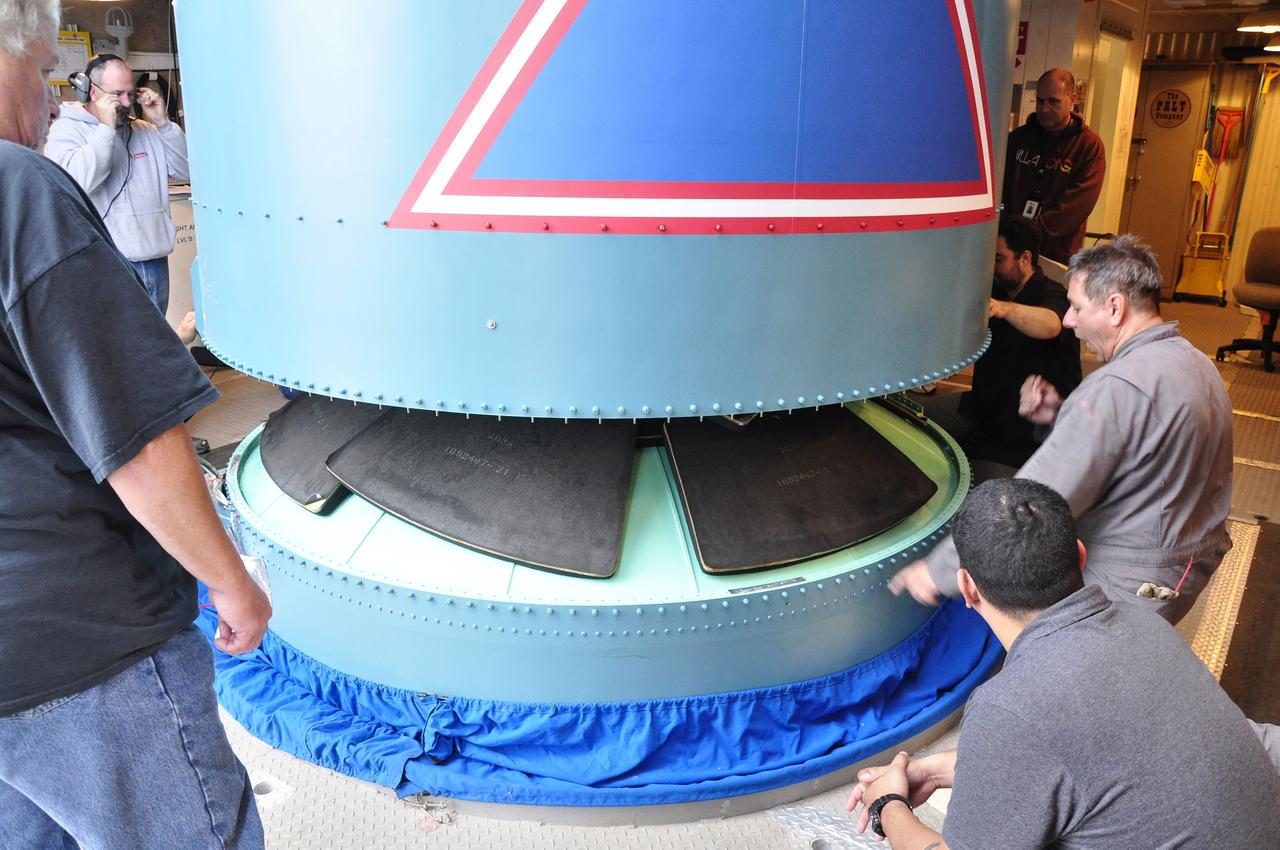
VANDENBERG AIR FORCE BASE, Calif. – Solid rocket motor installation progresses on the Delta II rocket for NASA's Soil Moisture Active Passive mission, or SMAP, with the attachment of the second motor to the rocket's first stage in the mobile service tower at Space Launch Complex 2 on Vandenberg Air Force Base in California. SMAP will be launched on a Delta II 7320 configuration vehicle featuring a United Launch Alliance first stage booster powered by an Aerojet Rocketdyne RS-27A main engine and three Alliant Techsystems, or ATK, strap-on solid rocket motors. Once on station in Earth orbit, SMAP will provide global measurements of soil moisture and its freeze/thaw state. These measurements will be used to enhance understanding of processes that link the water, energy and carbon cycles, and to extend the capabilities of weather and climate prediction models. SMAP data also will be used to quantify net carbon flux in boreal landscapes and to develop improved flood prediction and drought monitoring capabilities. Launch is scheduled for no earlier than November 2014. To learn more about SMAP, visit http://smap.jpl.nasa.gov. Photo credit: NASA/Randy Beaudoin
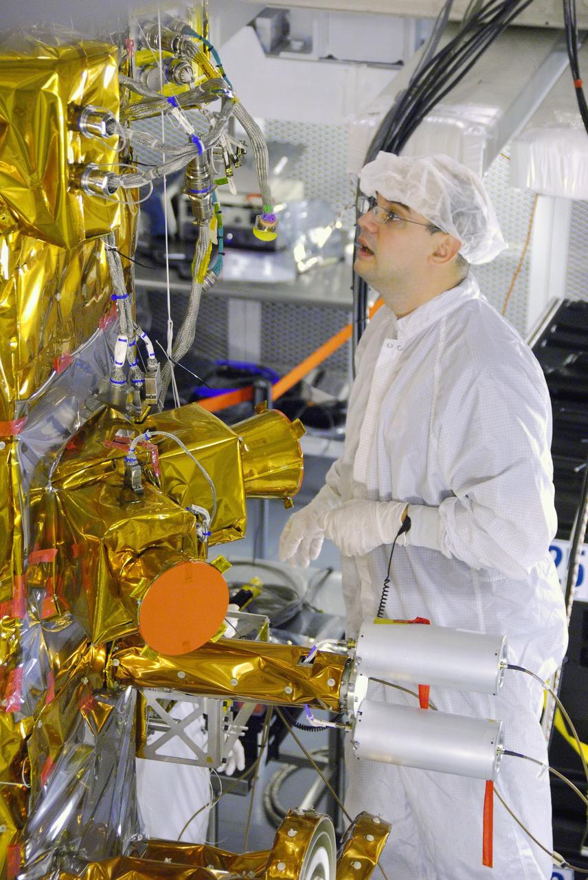
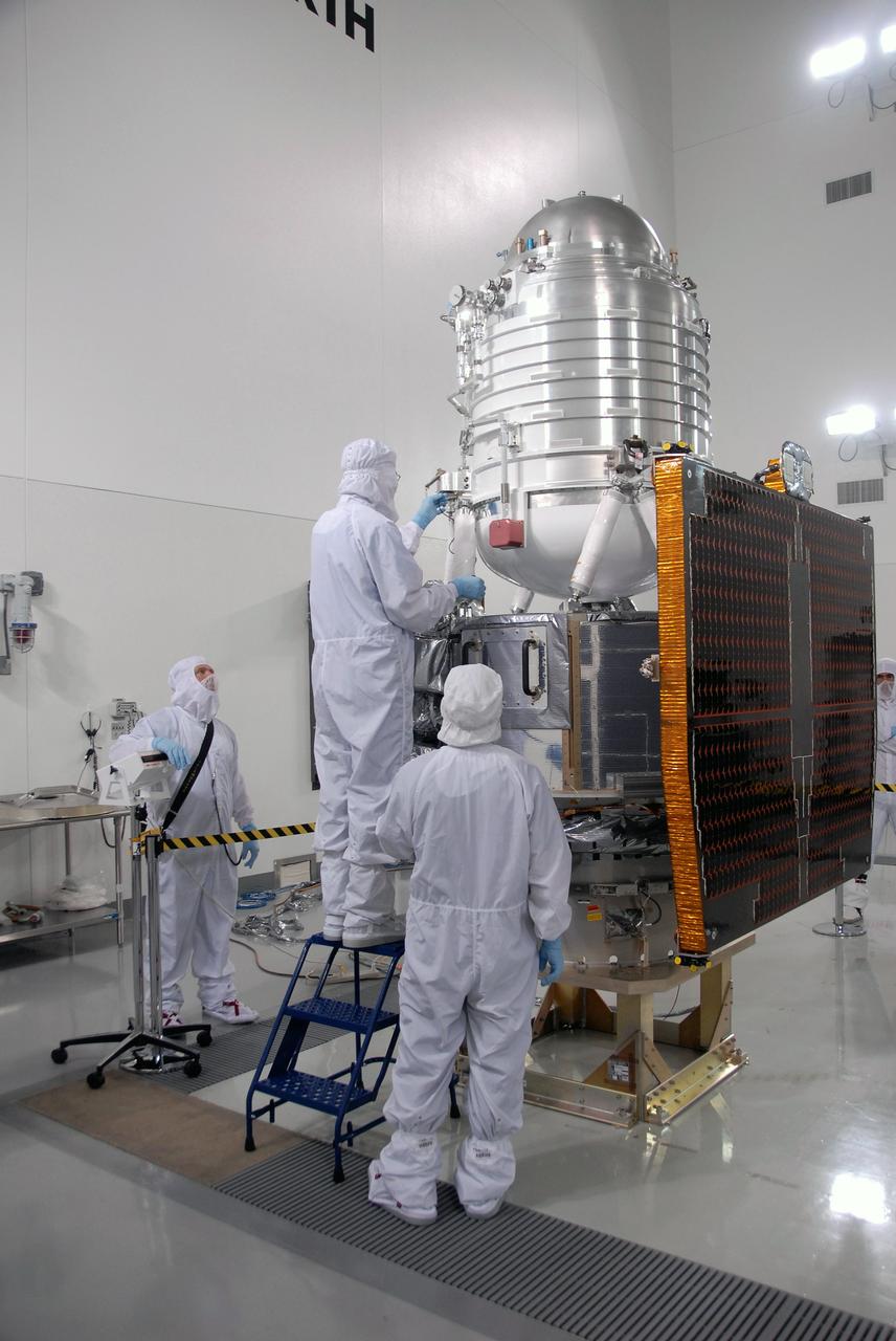
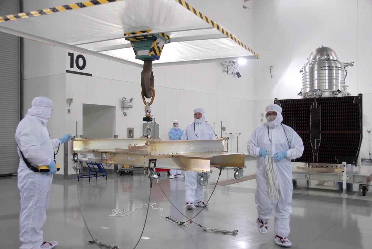
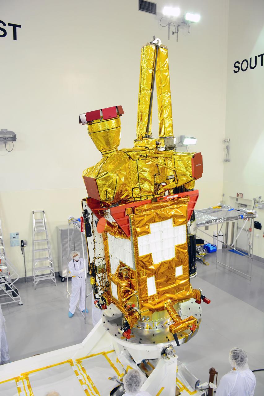
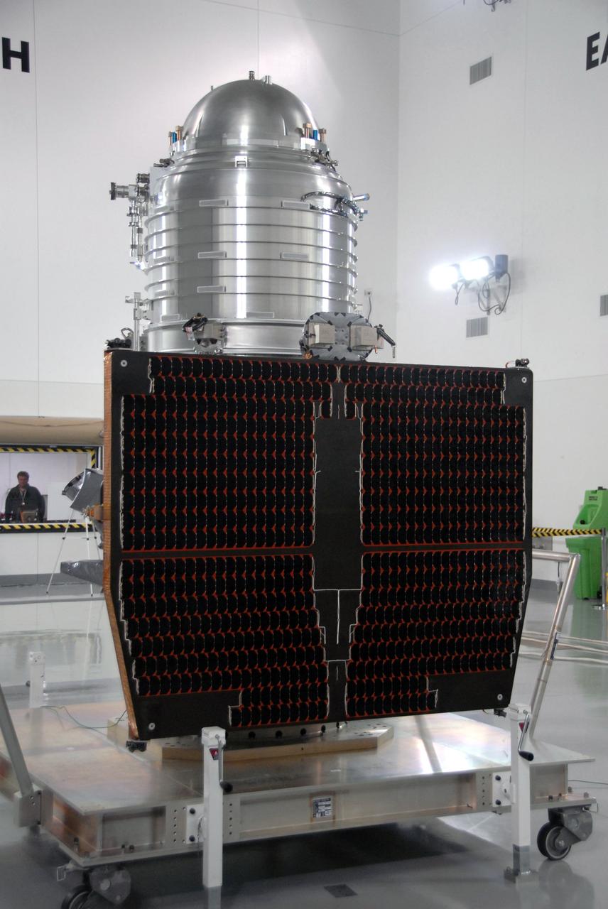
VANDENBERG AIR FORCE BASE, Calif. -- In Space Systems International's Payload Processing Facility at Vandenberg Air Force Base in California, technicians prepare to rotate the Aquarius/SAC-D spacecraft from a vertical to horizontal position for testing. Following final tests, the spacecraft will be integrated to a United Launch Alliance Delta II rocket in preparation for the targeted June launch. Aquarius, the NASA-built primary instrument on the SAC-D spacecraft, will provide new insights into how variations in ocean surface salinity relate to fundamental climate processes on its three-year mission. Photo credit: NASA/Randy Beaudoin, VAFB
VANDENBERG AIR FORCE BASE, Calif. – The Ocean Surface Topography Mission, or OSTM/Jason 2, spacecraft is being prepared for bagging before encapsulation and transfer to the launch pad. The launch of the Ocean Surface Topography Mission, or OSTM/Jason 2, aboard a Delta II rocket is scheduled for Friday, June 20, from Vandenberg Air Force Base in California. The launch window extends from 12:46 a.m. to 12:55 a.m. PDT. The satellite will be placed in an 830-mile-high orbit at an inclination of 66 degrees after separating from the Delta II 55 minutes after liftoff. The five primary science instruments of the Ocean Surface Topography Mission aboard the Jason 2 spacecraft are dedicated to measuring ocean surface height. These measurements will be used to evaluate and forecast climate changes and improve weather forecasting. The results also are expected to help forecasters better predict hurricane intensity. Photo credit: NASA
VANDENBERG AIR FORCE BASE, Fla. -- A closeup of Orbital Sciences’ Pegasus XL rocket for NASA’s Interstellar Boundary Explorer, or IBEX, spacecraft as it is enroute to the ramp on Vandenberg Air Force Base in California. There, the rocket will be attached to Orbital Sciences’ L-1011 aircraft for launch. IBEX is targeted for launch from the Kwajalein Atoll, a part of the Marshall Islands in the Pacific Ocean, on Oct. 19. IBEX will be launched aboard the Pegasus rocket dropped from under the wing of the L-1011 aircraft flying over the Pacific Ocean. The Pegasus will carry the spacecraft approximately 130 miles above Earth and place it in orbit. The IBEX satellite will make the first map of the boundary between the Solar System and interstellar space. Photo credit: NASA/Mark Mackley, VAFB
VANDENBERG AIR FORCE BASE, Calif. – The first stage of the United Launch Alliance Delta II rocket for NASA's Soil Moisture Active Passive mission, or SMAP, is delivered to the base of the mobile service tower at Space Launch Complex 2 on Vandenberg Air Force Base in California. SMAP will provide global measurements of soil moisture and its freeze/thaw state. These measurements will be used to enhance understanding of processes that link the water, energy and carbon cycles, and to extend the capabilities of weather and climate prediction models. SMAP data also will be used to quantify net carbon flux in boreal landscapes and to develop improved flood prediction and drought monitoring capabilities. Launch is scheduled for November 2014. To learn more about SMAP, visit http://smap.jpl.nasa.gov. Photo credit: NASA/Randy Beaudoin
VANDENBERG AIR FORCE BASE, Calif. --At Vandenberg Air Force Base's Astrotech processing facility in California, the fixed panel solar panel is seen on NASA's Wide-field Infrared Survey Explorer, or WISE, spacecraft. WISE will be moved from the travel dolly it's on to a work stand. The satellite will survey the entire sky at infrared wavelengths, creating a cosmic clearinghouse of hundreds of millions of objects, which will be catalogued, providing a vast storehouse of knowledge about the solar system, the Milky Way, and the universe. Launch is scheduled no earlier than Dec. 10. Photo credit: NASA/Moore, VAFB
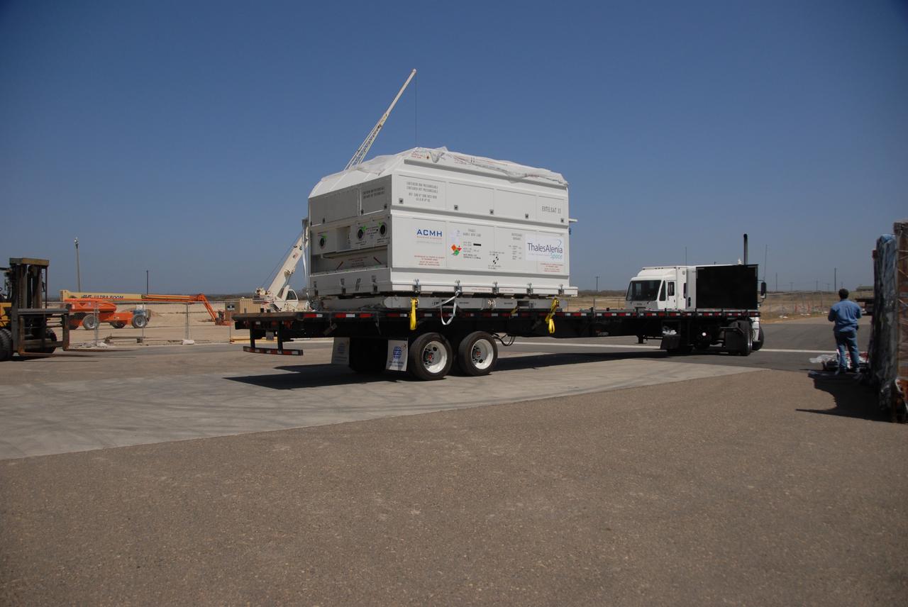
VANDENBERG AIR FORCE BASE, Calif. -- At Vandenberg Air Force Base, the truck carrying the OSTM/Jason-2 satellite arrives at the Astrotech processing facility. The OSTM, or Ocean Topography Mission, on the Jason-2 satellite is a follow-on to Jason-1. It will take oceanographic studies of sea surface height into an operational mode for continued climate forecasting research and science and industrial applications. This satellite altimetry data will help determine ocean circulation, climate change and sea-level rise. OSTM is a joint effort by the National Oceanic and Atmospheric Administration, NASA, France’s Centre National d’Etudes Spatiales and the European Meteorological Satellite Organisation. OSTM/Jason-2 will be launched aboard a United Launch Alliance Delta II 7320 from Vandenberg on June 15. Photo credit: NASA/Dan Liberotti
VANDENBERG AIR FORCE BASE, Calif. – Workers rotate a section of the fairing for NASA's Soil Moisture Active Passive mission, or SMAP, in a lifting device in the Building 836 high bay on Vandenberg Air Force Base in California. The fairing will protect the SMAP spacecraft from the heat and aerodynamic pressure generated during its ascent to orbit aboard a United Launch Alliance Delta II rocket from Space Launch Complex 2. SMAP will provide global measurements of soil moisture and its freeze/thaw state. These measurements will be used to enhance understanding of processes that link the water, energy and carbon cycles, and to extend the capabilities of weather and climate prediction models. SMAP data will also be used to quantify net carbon flux in boreal landscapes and to develop improved flood prediction and drought monitoring capabilities. Launch is scheduled for November 2014. To learn more about SMAP, visit http://smap.jpl.nasa.gov. Photo credit: NASA/Randy Beaudoin
VANDENBERG AIR FORCE BASE, CALIF. -Inside Orbital Sciences’ Building 1555 at Vandenberg Air Force Base in California is the Pegasus XL launch vehicle and the Space Technology 5 (ST5) spacecraft being prepared for encapsulation before launch. The ST5, mated to Orbital Sciences' Pegasus XL launch vehicle, contains three microsatellites with miniaturized redundant components and technologies. Each will validate New Millennium Program selected technologies, such as the Cold Gas Micro-Thruster and X-Band Transponder Communication System. After deployment from the Pegasus, the micro-satellites will be positioned in a “string of pearls” constellation that demonstrates the ability to position them to perform simultaneous multi-point measurements of the magnetic field using highly sensitive magnetometers. The data will help scientists understand and map the intensity and direction of the Earth’s magnetic field, its relation to space weather events, and affects on our planet. With such missions, NASA hopes to improve scientists’ ability to accurately forecast space weather and minimize its harmful effects on space- and ground-based systems. Launch of ST5 is scheduled from the belly of an L-1011 carrier aircraft no earlier than March 14 from Vandenberg Air Force Base.
VANDENBERG AIR FORCE BASE, Calif. – In the mobile service tower on Space Launch Complex 2, the second half of the fairing moves close to the Ocean Surface Topography Mission, or OSTM/Jason 2, spacecraft to complete encapsulation. The fairing is a molded structure that fits flush with the outside surface of the Delta II upper stage booster and forms an aerodynamically smooth nose cone, protecting the spacecraft during launch and ascent. The launch of the OSTM/Jason-2 is scheduled for June 20 from Vandenberg Air Force Base. The launch window extends from 12:46 a.m. to 12:55 a.m. PDT. The satellite will be placed in an 830-mile-high orbit at an inclination of 66 degrees after separating from the Delta II 55 minutes after liftoff. The five primary science instruments of the Ocean Surface Topography Mission aboard the Jason 2 spacecraft are dedicated to measuring the height of the ocean surface. These measurements will be used to evaluate and forecast climate changes and improve weather forecasting. The results also are expected to help forecasters better predict hurricane intensity.
VANDENBERG AIR FORCE BASE, Calif. – Inside an environmental enclosure at Vandenberg Air Force Base's processing facility in California, NASA's Nuclear Spectroscopic Telescope Array, or NuSTAR, secured inside a turnover rotation fixture, moves toward interface with its Orbital Sciences Pegasus XL rocket. The uniting of the spacecraft with the rocket is a major milestone in prelaunch preparations. After processing of the rocket and spacecraft are complete, they will be flown on Orbital's L-1011 carrier aircraft from Vandenberg to the Ronald Reagan Ballistic Missile Defense Test Site on the Pacific Ocean’s Kwajalein Atoll for launch. The high-energy x-ray telescope will conduct a census of black holes, map radioactive material in young supernovae remnants, and study the origins of cosmic rays and the extreme physics around collapsed stars. For more information, visit http://www.nasa.gov/nustar. Photo credit: NASA/Randy Beaudoin, VAFB
VANDENBERG AFB, California – Technicians and engineers place a transportation canister around NASA's SMAP spacecraft so it can be taken from the Astrotech processing facility to Space Launch Complex-2 for placement atop a Delta II rocket for launch. For more, go to www.nasa.gov/smap Photo credit: USAF/John Davila

VANDENBERG AIR FORCE BASE, Calif. -- At Space Launch Complex 576-E at Vandenberg Air Force Base in California, technicians unwrap the Poly Picosatellite Orbital Deployer, or P-POD, assembly before installation to the aft end of the Taurus rocket's third stage. The P-POD holds three CubeSats or tiny satellites, designed and created by university and college students that will be carried on the Taurus rocket along with the Glory spacecraft. The Orbital Sciences Corp. Taurus XL rocket will carry Glory into low Earth orbit. Once Glory reaches orbit, it will collect data on the properties of aerosols and black carbon. It also will help scientists understand how the sun's irradiance affects Earth's climate. Launch is scheduled for 5:09 a.m. EST Feb. 23. For information, visit www.nasa.gov/glory. Photo credit: NASA/Randy Beaudoin, VAFB
VANDENBERG AIR FORCE BASE, Calif. – The launch gantry is rolled back to reveal the United Launch Alliance Delta II rocket with the Soil Moisture Active Passive, or SMAP, satellite aboard, at Space Launch Complex 2 on Vandenberg Air Force Base in California. SMAP is a remote sensing mission designed to measure and map the Earth's soil moisture distribution and freeze/thaw stat with unprecedented accuracy, resolution and coverage. SMAP will provide global measurements of soil moisture and its freeze/thaw state. These measurements will be used to enhance understanding of processes that link the water, energy and carbon cycles, and to extend the capabilities of weather and climate prediction models. SMAP data also will be used to quantify net carbon flux in boreal landscapes and to develop improved flood prediction and drought monitoring capabilities. Launch is scheduled for Jan. 29, 2015. To learn more about SMAP, visit http://www.nasa.gov/smap. Photo credit: NASA/Randy Beaudoin
VANDENBERG AIR FORCE BASE, Calif. -- At the Astrotech processing facility on Vandenberg Air Force Base in California, a crane is moved into position to lift NASA's Wide-field Infrared Survey Explorer, or WISE, from its test stand to determine its exact weight. The satellite will survey the entire sky at infrared wavelengths, creating a cosmic clearinghouse of hundreds of millions of objects which will be catalogued and provide a vast storehouse of knowledge about the solar system, the Milky Way, and the universe. Launch is scheduled for Dec. 7. Photo credit: NASA/Doug Kolkow
VANDENBERG AIR FORCE BASE, Calif. – Inside the Astrotech payload processing facility on Vandenberg Air Force Base in California, engineers and technicians mount NASA's Soil Moisture Active Passive, or SMAP, spacecraft on a work platform. SMAP will launch on a Delta II 7320 configuration vehicle featuring a United Launch Alliance first stage booster powered by an Aerojet Rocketdyne RS-27A main engine and three Alliant Techsystems, or ATK, strap-on solid rocket motors. Once on station in Earth orbit, SMAP will provide global measurements of soil moisture and its freeze/thaw state. These measurements will be used to enhance understanding of processes that link the water, energy and carbon cycles, and to extend the capabilities of weather and climate prediction models. SMAP data also will be used to quantify net carbon flux in boreal landscapes and to develop improved flood prediction and drought monitoring capabilities. Launch from Space Launch Complex 2 is targeted for Jan. 29, 2015. To learn more about SMAP, visit http://smap.jpl.nasa.gov Photo credit: NASA/ Randy Beaudoin
VANDENBERG AIR FORCE BASE, Calif. – A crane is used to offload the first stage of a United Launch Alliance Delta II rocket following its arrival at NASA hangar 836 on Vandenberg Air Force Base in California. The launch vehicle will be used to deliver NASA's Soil Moisture Active Passive mission, or SMAP, into orbit. SMAP will provide global measurements of soil moisture and its freeze/thaw state. These measurements will be used to enhance understanding of processes that link the water, energy and carbon cycles, and to extend the capabilities of weather and climate prediction models. SMAP data also will be used to quantify net carbon flux in boreal landscapes and to develop improved flood prediction and drought monitoring capabilities. Launch is scheduled for November 2014. To learn more about SMAP, visit http://smap.jpl.nasa.gov Photo credit: NASA/Randy Beaudoin

VANDENBERG AIR FORCE BASE, Calif. – At Vandenberg Air Force Base in California, Orbital Sciences Corp. technician Mike Lerma checks the fit of the Taurus XL rocket's first and second stages in Building 1555. The Orbital Sciences Taurus XL rocket, targeted to lift off Feb. 23, 2011, from Vandenberg's Space Launch Complex 576-E, will take NASA's Glory satellite into low Earth. Glory is scheduled to collect data on the properties of aerosols and black carbon. It also will help scientists understand how the sun's irradiance affects Earth's climate. Photo credit: NASA/Randy Beaudoin, VAFB
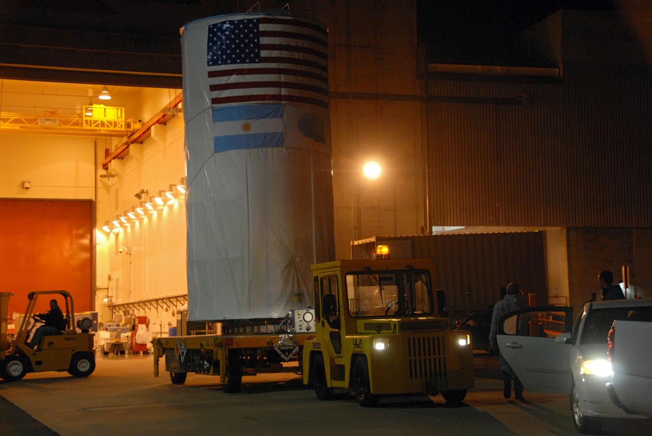
VANDENBERG AIR FORCE BASE, Calif. -- The Aquarius/SAC-D spacecraft, secured inside its payload transportation canister, is being transferred to NASA's Space Launch Complex-2 (SLC-2) at Vandenberg Air Force Base in California. There, the spacecraft will be integrated to a United Launch Alliance Delta II rocket in preparation for the targeted June liftoff. Aquarius, the NASA-built instrument on the SAC-D spacecraft, will provide new insights into how variations in ocean surface salinity relate to fundamental climate processes on its three-year mission. Photo credit: NASA/VAFB
VANDENBERG AIR FORCE BASE, Calif. -- A security guard waits to clear NASA's National Polar-orbiting Operational Environmental Satellite System Preparatory Project (NPP) satellite through the gates of Vandenberg Air Force Base in California. NPP represents a critical first step in building the next-generation of Earth-observing satellites. NPP will carry the first of the new sensors developed for this satellite fleet, now known as the Joint Polar Satellite System (JPSS), to be launched in 2016. NPP is the bridge between NASA's Earth Observing System (EOS) satellites and the forthcoming series of JPSS satellites. The mission will test key technologies and instruments for the JPSS missions. NPP is targeted to launch Oct. 25 from Space Launch Complex-2 aboard a United Launch Alliance Delta II rocket. For more information, visit http://www.nasa.gov/NPP. Photo credit: NASA/Dave Uveges, VAFB

VANDENBERG AIR FORCE BASE, Calif. – At Vandenberg Air Force Base in California, a crane lifts the Taurus XL Stage 0 motor to move it to a flatbed truck. The motor will be transported to Orbital Sciences' Hangar 1555. The Taurus XL will launch NASA's Orbiting Carbon Observatory, or OCO, spacecraft targeted for Jan. 15. The OCO is a new Earth-orbiting mission sponsored by NASA's Earth System Science Pathfinder Program. Photo credit: NASA/Randy Beaudoin, VAFB
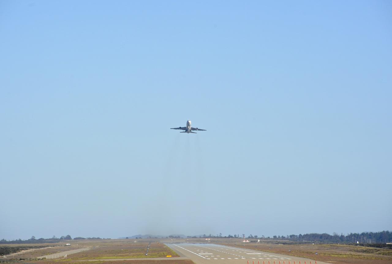
VANDENBERG AIR FORCE BASE, Calif. – An Orbital Sciences L-1011 carrier aircraft takes off from Vandenberg Air Force Base, Calif., on a mission to launch NASA's IRIS spacecraft into low-Earth orbit. IRIS, short for Interface Region Imaging Spectrograph, was launched aboard an Orbital Sciences Pegasus XL rocket released from the L-1011.Photo credit: VAFB/Chris Wiant
VANDENBERG AIR FORCE BASE, Calif. – The mobile service tower at Space Launch Complex 2 on Vandenberg Air Force Base in California is rolled back from the first stage of the Delta II rocket for NASA's Soil Moisture Active Passive mission, or SMAP, during preparations for the arrival of the rocket's second stage. Operations are underway to install the second stage atop the rocket's first stage. SMAP will launch on a Delta II 7320 configuration vehicle featuring a United Launch Alliance first stage booster powered by an Aerojet Rocketdyne RS-27A main engine and three Alliant Techsystems, or ATK, strap-on solid rocket motors. Once on station in Earth orbit, SMAP will provide global measurements of soil moisture and its freeze/thaw state. These measurements will be used to enhance understanding of processes that link the water, energy and carbon cycles, and to extend the capabilities of weather and climate prediction models. SMAP data also will be used to quantify net carbon flux in boreal landscapes and to develop improved flood prediction and drought monitoring capabilities. Launch is scheduled for no earlier than November 2014. To learn more about SMAP, visit http://smap.jpl.nasa.gov. Photo credit: NASA/Randy Beaudoin
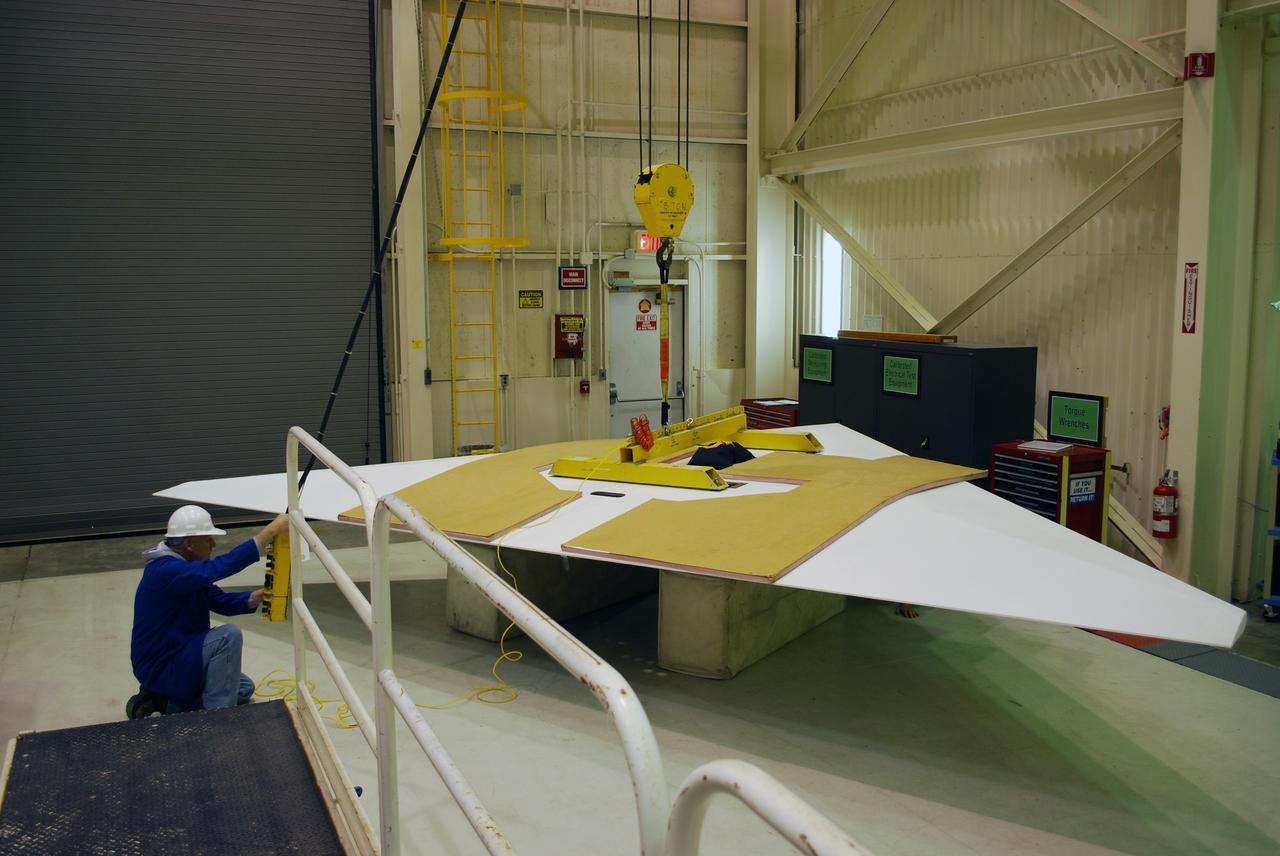
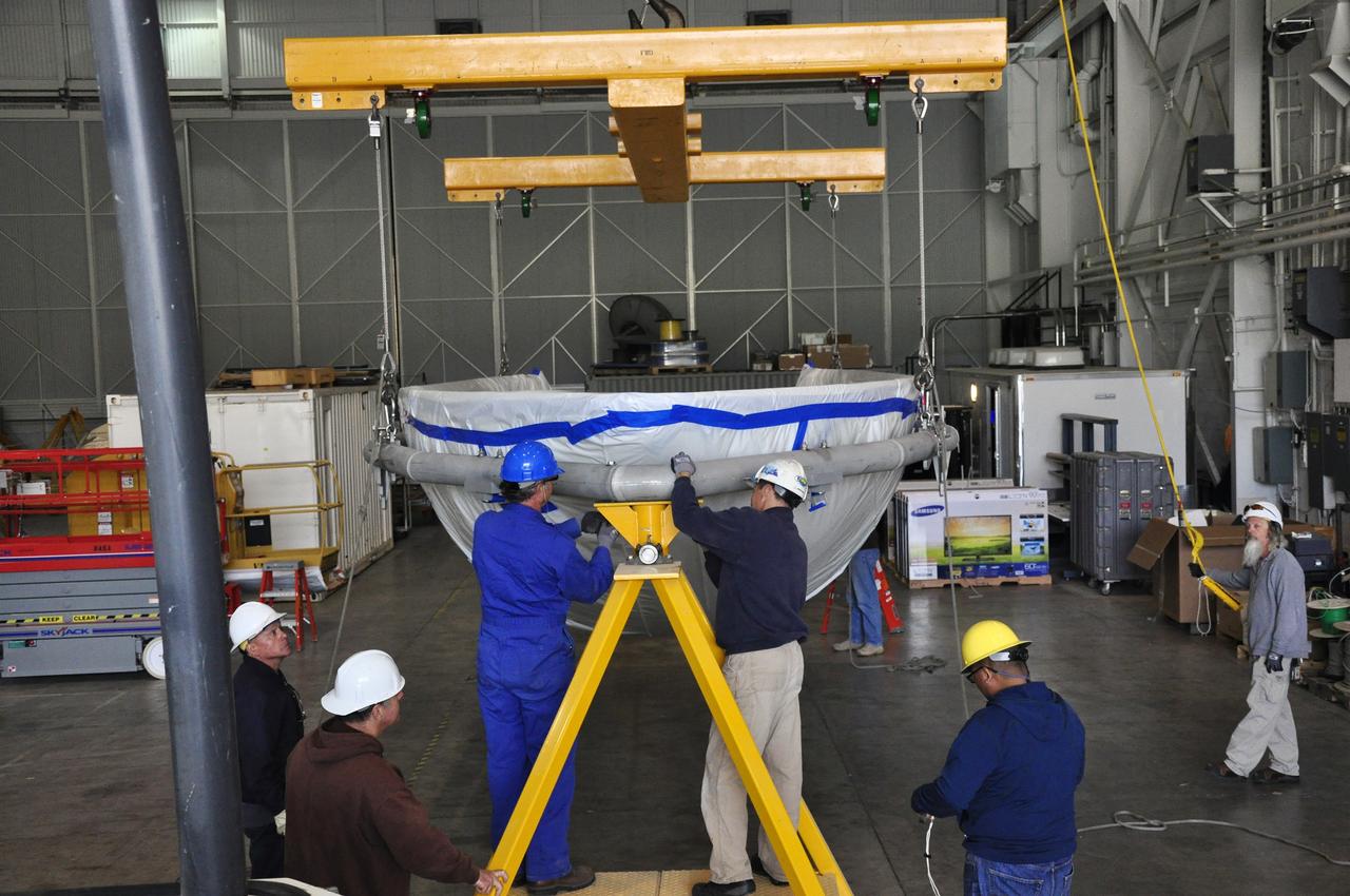
Vandenberg Air Force Base, Calif. – Inside a processing facility at Vandenberg Air Force Base in California, technicians assist as a crane lowers the wing closer for a fit check with the Orbital Sciences Pegasus XL launch vehicle. NASA’s Interface Region Imaging Spectrograph, or IRIS, spacecraft will launch aboard the Pegasus XL in late 2012. IRIS will open a new window of discovery by tracing the flow of energy and plasma through the chromospheres and transition region into the sun’s corona using spectrometry and imaging. IRIS fills a crucial gap in our ability to advance studies of the sun-to-Earth connection by tracing the flow of energy and plasma through the foundation of the corona and heliosphere, or region around the sun. Photo credit: NASA/Randy Beaudoin

VANDENBERG AIR FORCE BASE, Calif. – Representatives from social media outlets are provided with a series of briefings on NASA's Orbiting Carbon Observatory-2, or OCO-2, at a NASA Social held on Vandenberg Air Force Base in California. Launch of OCO-2 aboard a United Launch Alliance Delta II rocket from Space Launch Complex 2 is scheduled for 5:56 a.m. EDT on July 1. The social media users selected to attend the two-day event on June 30 and July 1 are given the same access as news media in an effort to align their experience with those of traditional media. OCO-2 is NASA’s first mission dedicated to studying atmospheric carbon dioxide, the leading human-produced greenhouse gas driving changes in Earth’s climate. OCO-2 will provide a new tool for understanding the human and natural sources of carbon dioxide emissions and the natural "sinks" that absorb carbon dioxide and help control its buildup. The observatory will measure the global geographic distribution of these sources and sinks and study their changes over time. To learn more about OCO-2, visit http://www.nasa.gov/oco2. Photo credit: NASA/Ben Smegelsky

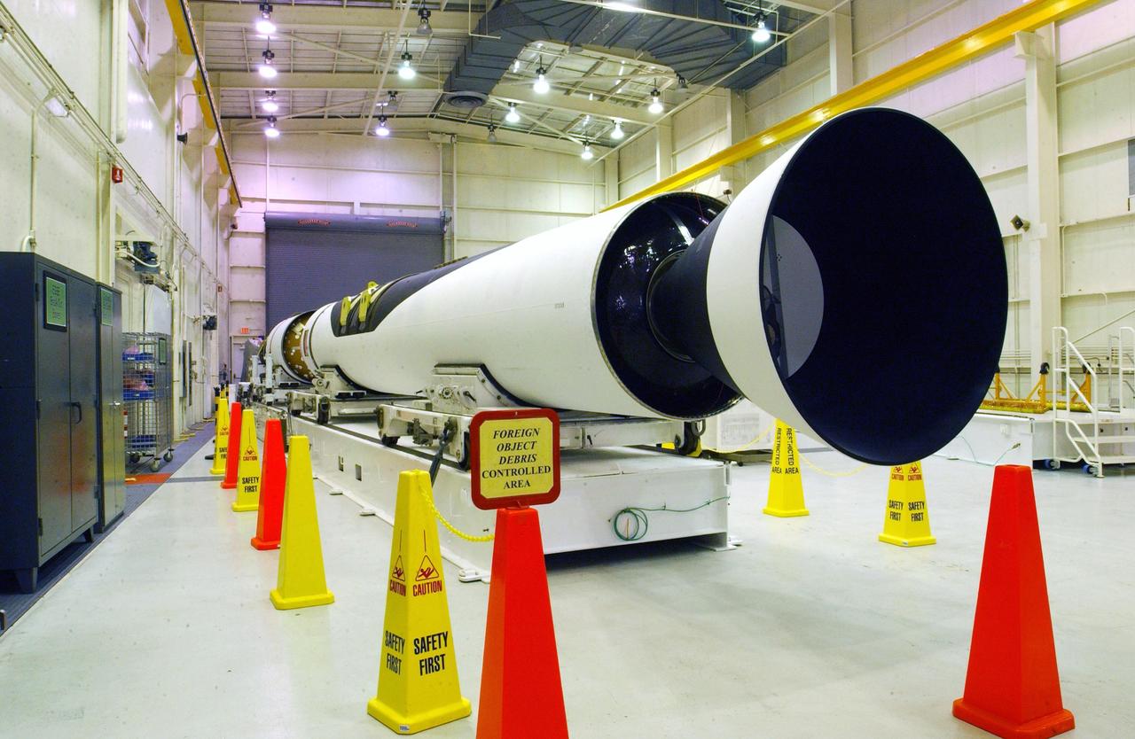
VANDENBERG AIR FORCE BASE, Calif. -- The Stage 1, 2 and 3 motors of the Taurus XL rocket are being prepared for transfer to Space Launch Complex 576-E at Vandenberg Air Force Base in California. The Taurus is the launch vehicle for NASA's Orbiting Carbon Observatory, or OCO, which is a new Earth-orbiting mission sponsored by NASA's Earth System Science Pathfinder Program. The observatory is scheduled to launch Feb. 23 from Vandenberg. The spacecraft will collect precise global measurements of carbon dioxide (CO2) in the Earth's atmosphere. Scientists will analyze OCO data to improve our understanding of the natural processes and human activities that regulate the abundance and distribution of this important greenhouse gas. This improved understanding will enable more reliable forecasts of future changes in the abundance and distribution of CO2 in the atmosphere and the effect that these changes may have on the Earth's climate. Photo credit: NASA/Randy Beaudoin, VAFB
VANDENBERG AIR FORCE BASE, CALIF. - At Vandenberg Air Force Base, Calif., the Pegasus launch vehicle is moved toward its hangar. The Pegasus will carry the SciSat-1 spacecraft in a 400-mile-high polar orbit to investigate processes that control the distribution of ozone in the upper atmosphere. The data from the satellite will provide Canadian and international scientists with improved measurements relating to global ozone processes and help policymakers assess existing environmental policy and develop protective measures for improving the health of our atmosphere, preventing further ozone depletion. The mission is designed to last two years.
VANDENBERG AIR FORCE BASE, Calif. – Orbital Sciences’ L-1011 carrier aircraft lifts off the runway as it departs from Vandenberg Air Force Base in California. The aircraft is transporting Orbital’s Pegasus rocket and NASA’s Nuclear Spectroscopic Telescope Array, or NuSTAR, to the U.S. Army's Ronald Reagan Ballistic Missile Defense Test Site on Kwajalein Atoll, part of the Marshall Islands in the Pacific Ocean. The Pegasus, mated to its NuSTAR payload, will be launched from the carrier aircraft 117 nautical miles south of Kwajalein at latitude 6.75 degrees north of the equator. The high-energy X-ray telescope will conduct a census of black holes, map radioactive material in young supernovae remnants, and study the origins of cosmic rays and the extreme physics around collapsed stars. Launch is scheduled for June 13. For more information, visit http://www.nasa.gov/nustar. Photo credit: NASA/Randy Beaudoin, VAFB
VANDENBERG AIR FORCE BASE, Calif. – In the mobile service tower on Space Launch Complex 2, the first half of the fairing (at right) is moved closer toward the Ocean Surface Topography Mission, or OSTM/Jason 2, spacecraft for encapsulation. The fairing is a molded structure that fits flush with the outside surface of the Delta II upper stage booster and forms an aerodynamically smooth nose cone, protecting the spacecraft during launch and ascent. The launch of the OSTM/Jason-2 is scheduled for June 20 from Vandenberg Air Force Base. The launch window extends from 12:46 a.m. to 12:55 a.m. PDT. The satellite will be placed in an 830-mile-high orbit at an inclination of 66 degrees after separating from the Delta II 55 minutes after liftoff. The five primary science instruments of the Ocean Surface Topography Mission aboard the Jason 2 spacecraft are dedicated to measuring the height of the ocean surface. These measurements will be used to evaluate and forecast climate changes and improve weather forecasting. The results also are expected to help forecasters better predict hurricane intensity.
VANDENBERG AIR FORCE BASE, Calif. – Inside the Astrotech payload processing facility at Vandenberg Air Force Base in California, engineers and technicians place a protective cover over NASA's Soil Moisture Active Passive mission, or SMAP, satellite prior the spacecraft being transported to the launch pad. SMAP will provide global measurements of soil moisture and its freeze/thaw state. These measurements will be used to enhance understanding of processes that link the water, energy and carbon cycles, and to extend the capabilities of weather and climate prediction models. SMAP data also will be used to quantify net carbon flux in boreal landscapes and to develop improved flood prediction and drought monitoring capabilities. Launch is scheduled for Jan. 29, 2015. To learn more about SMAP, visit http://smap.jpl.nasa.gov Photo credit: Jeremy Moore, USAF Photo Squadron

VANDENBERG AIR FORCE BASE, Calif. – On the ramp of Vandenberg Air Force Base in California, a Boeing 737 aircraft waits to accompany Orbital Sciences’ L-1011 aircraft when it takes off with NASA’s Interstellar Boundary Explorer, or IBEX, spacecraft and Pegasus XL rocket. The L-1011 will head for the Reagan Test Site at Kwajalein Atoll in the South Pacific. The 737 will fly ahead of the L-1011 as a pathfinder. Launch vehicle engineers are aboard in the unlikely event their expertise is needed. The IBEX satellite will make the first map of the boundary between the Solar System and interstellar space. IBEX is targeted for launch Oct. 19. The Pegasus rocket will be dropped from under the wing of the L-1011 over the Pacific Ocean to carry the spacecraft approximately 130 miles above Earth and place it in orbit. Photo credit: NASA/Randy Beaudoin, VAFB
VANDENBERG AIR FORCE BASE, Calif. -- At Vandenberg Air Force Base's Astrotech processing facility in California, workers check NASA's Wide-field Infrared Survey Explorer, or WISE, spacecraft as it is lowered onto a work stand. The satellite will survey the entire sky at infrared wavelengths, creating a cosmic clearinghouse of hundreds of millions of objects, which will be catalogued, providing a vast storehouse of knowledge about the solar system, the Milky Way, and the universe. Launch is scheduled no earlier than Dec. 10. Photo credit: NASA/Moore, VAFB
Vandenberg Air Force Base, Calif. – At Vandenberg Air Force Base in California, technicians prepare to offload the first stage of the Orbital Sciences Pegasus XL rocket from the truck in which it was transported. NASA’s Interface Region Imaging Spectrograph, or IRIS, spacecraft will launch aboard the Pegasus XL in late 2012. IRIS will open a new window of discovery by tracing the flow of energy and plasma through the chromospheres and transition region into the sun’s corona using spectrometry and imaging. IRIS fills a crucial gap in our ability to advance studies of the sun-to-Earth connection by tracing the flow of energy and plasma through the foundation of the corona and heliosphere, or region around the sun. Photo credit: NASA/Randy Beaudoin
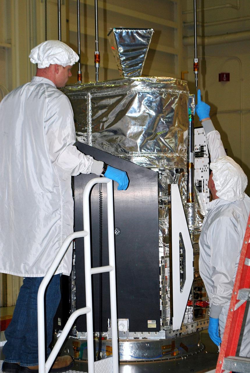
VANDENBERG AIR FORCE BASE, Calif. – In processing facility 1555 at Vandenberg Air Force Base in California, spacecraft technicians attach NASA's Nuclear Spectroscopic Telescope Array (NuSTAR) to a lifting device during preparations to raise it from its workstand. A Pegasus XL rocket is being prepared to launch NuSTAR into space in March. Once processing of the rocket and spacecraft are completed at Vandenberg, they will be flown on the Orbital Sciences’ L-1011 carrier aircraft to the Ronald Reagan Ballistic Missile Defense Test Site at the Pacific Ocean’s Kwajalein Atoll for launch. NuSTAR, a high-energy x-ray telescope, will conduct a census for black holes, map radioactive material in young supernovae remnants, and study the origins of cosmic rays and the extreme physics around collapsed stars. For more information, visit http://www.nasa.gov/nustar. Photo credit: NASA/Randy Beaudoin, VAFB
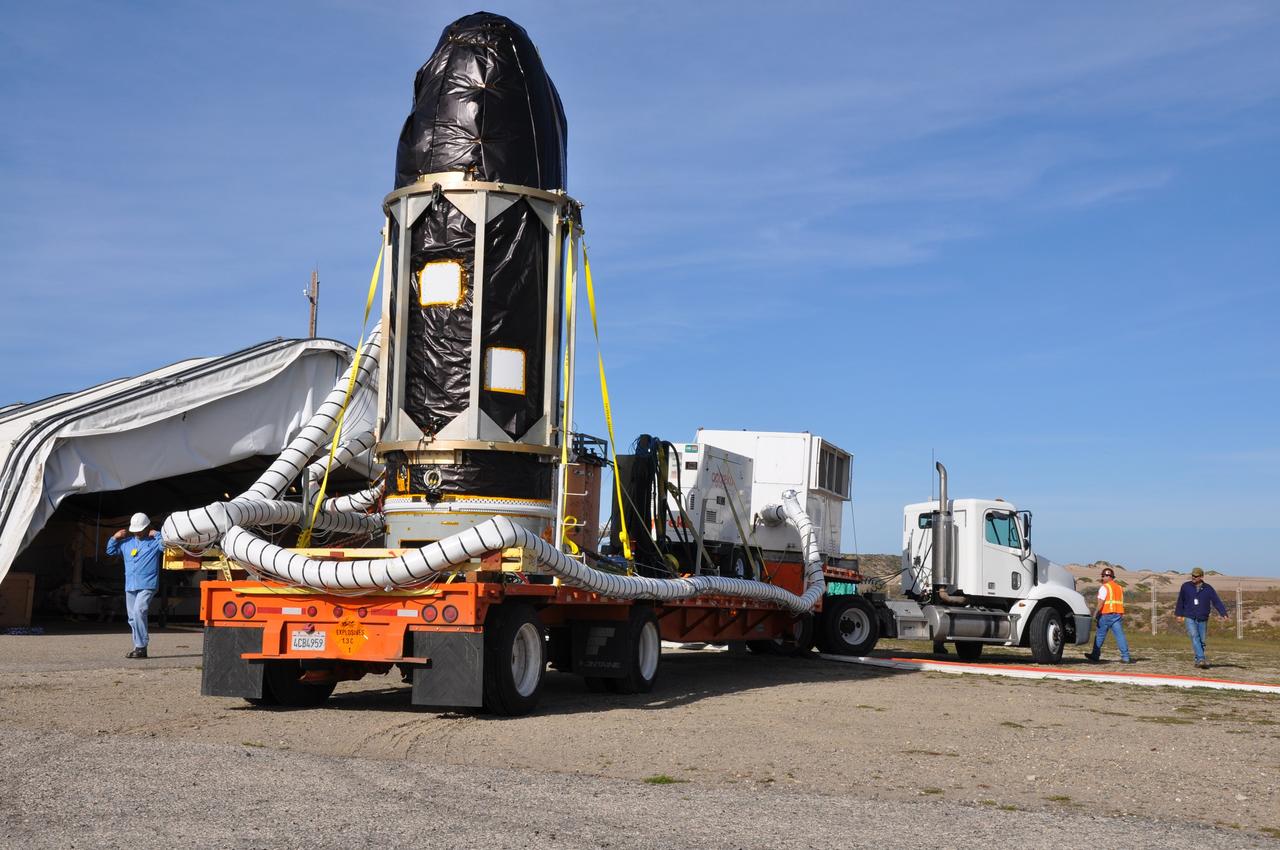
VANDENBERG AIR FORCE BASE, Calif. -- At Vandenberg Air Force Base in California, NASA's Glory spacecraft, encapsulated in its protective fairing, has arrived at Space Launch Complex 576-E. There it will be joined with the Taurus XL rocket's third stage, already delivered to a temporary processing tent near the pad. The Orbital Sciences Corp. Taurus XL rocket will carry Glory into low Earth orbit. Once Glory reaches orbit, it will collect data on the properties of aerosols and black carbon. It also will help scientists understand how the sun's irradiance affects Earth's climate. Launch is scheduled for 5:09 a.m. EST Feb. 23. For information, visit www.nasa.gov/glory. Photo credit: NASA/Randy Beaudoin, VAFB
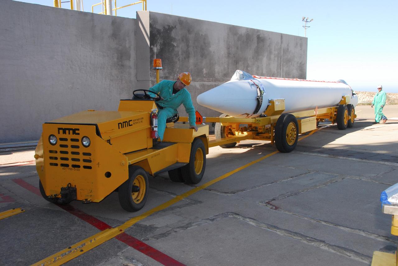
VANDENBERG AIR FORCE BASE, Calif. -- At Vandenberg Air Force Base in California, a solid rocket motor for the United Launch Alliance Delta II that will carry NASA’s National Polar-orbiting Operational Environmental Satellite System Preparatory Project (NPP) satellite into space arrives at NASA’s Space Launch Complex-2. NPP represents a critical first step in building the next-generation of Earth-observing satellites. NPP will carry the first of the new sensors developed for this satellite fleet, now known as the Joint Polar Satellite System (JPSS) to be launched in 2016. NPP is the bridge between NASA's Earth Observing System (EOS) satellites and the forthcoming series of JPSS satellites. The mission will test key technologies and instruments for the JPSS missions. NPP is targeted to launch Oct. 25. For more information, visit http://www.nasa.gov/NPP. Photo credit: NASA/VAFB, Mark Mackley
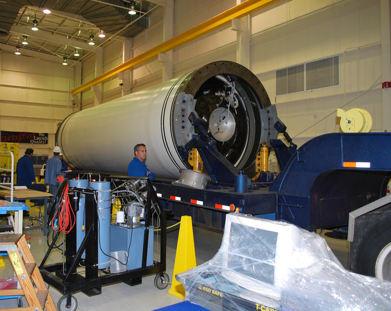
VANDENBERG AIR FORCE BASE, Calif. – The Taurus XL Stage 0 motor has been moved into Orbital Sciences' Hangar 1555 at Vandenberg Air Force Base in California. The Taurus XL will launch NASA's Orbiting Carbon Observatory, or OCO, spacecraft targeted for Jan. 15. The OCO is a new Earth-orbiting mission sponsored by NASA's Earth System Science Pathfinder Program. Photo credit: NASA/Randy Beaudoin, VAFB
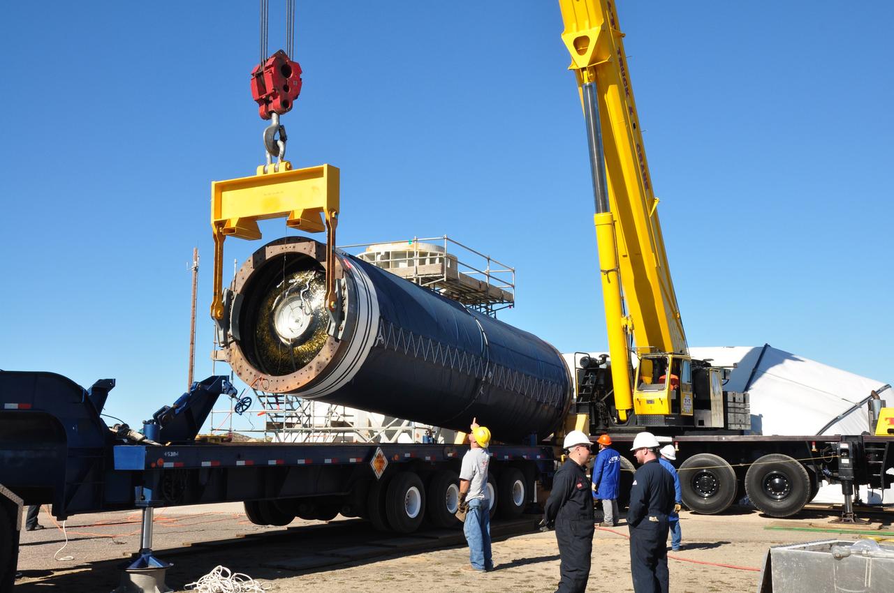
VANDENBERG AIR FORCE BASE, Calif. -- The Stage 0 motor of the Orbital Sciences Corp. Taurus XL is hoisted into launch position by crane at Space Launch Complex 576-E at Vandenberg Air Force Base in California. As part of the four-stage Taurus XL rocket that will carry NASA's Glory spacecraft into low Earth orbit, stages 1, 2 and 3 will join Stage 0 at the launch pad about a week later. Once Glory reaches orbit, it will collect data on the properties of aerosols and black carbon. It also will help scientists understand how the sun's irradiance affects Earth's climate. Launch is scheduled for 5:09 a.m. EST Feb. 23. For information, visit www.nasa.gov/glory. Photo credit: NASA/Randy Beaudoin, VAFB