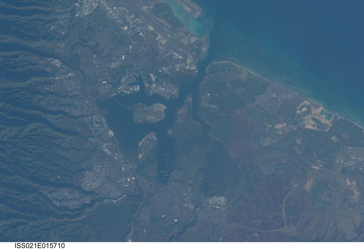
ISS021-E-015710 (27 Oct. 2009) --- Pearl Harbor, Hawaii is featured in this image photographed by an Expedition 21 crew member on the International Space Station. This detailed view illustrates the southern coastline of the Hawaiian island of Oahu including Pearl Harbor. On Dec. 7, 1941 ? 68 years ago ? a surprise attack by the Japanese Navy on Pearl Harbor and other targets on the island of Oahu precipitated the entry of the United States into World War II. Today, Pearl Harbor is still in use as a major United States Navy installation, and with Honolulu is one of the most heavily developed parts of the Island. Comparison between this image and a detailed astronaut photograph of Pearl Harbor taken in 2003 suggests that little observable land use or land cover change has occurred in the area over the past six years. The most significant change is the addition of more naval vessels to the Reserve Fleet anchorage in Middle Loch (center). The urban areas of Waipahu, Pearl City, and Aliamanu border the Harbor to the northwest, north, and east. The built-up areas, recognized by linear streets and white rooftops, contrast sharply with the reddish volcanic soils and green vegetated hillslopes of the surrounding areas.
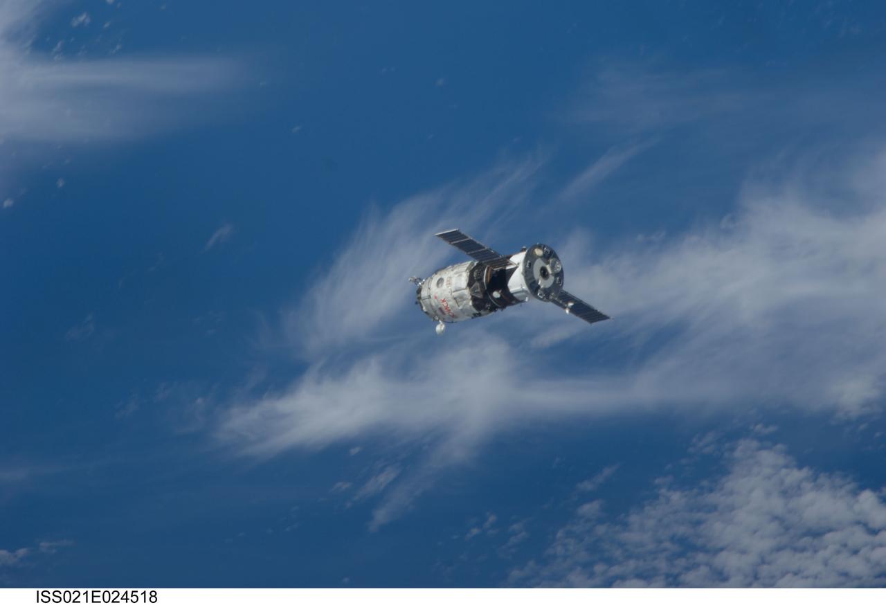
ISS021-E-024518 (12 Nov. 2009) --- Backdropped by a blue and white part of Earth, the new unpiloted Russian Mini-Research Module 2 (MRM2), also known as Poisk, approaches the International Space Station. The MRM2 docked to the space-facing port of the Zvezda Service Module at 9:41 a.m. (CST) on Nov. 12, 2009. It began its trip to the station when it was launched aboard a Soyuz rocket from the Baikonur Cosmodrome in Kazakhstan on Nov. 10. Poisk is a Russian term that translates to search, seek and explore. It will provide an additional docking port for visiting Russian spacecrafts and will serve as an extra airlock for spacewalkers wearing Russian Orlan spacesuits. Poisk joins a Russian Progress resupply vehicle and two Russian Soyuz spacecraft currently docked at the station.
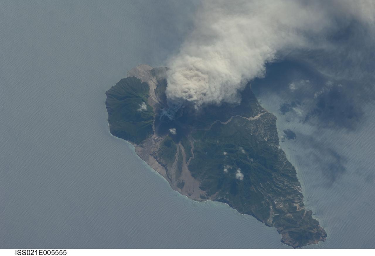
ISS021-E-005555 (11 Oct. 2009) --- This picture of the active Soufriere Hills volcano on Montserrat Island was photographed on Oct. 11, 2009 by the Expedition 21 crew members onboard the International Space Station. Meteorologists and other scientists note that this area is nearly always cloudy so it is considered rare when astronauts get good images of the plumes or volcanic activity. Soufriere Hills is identified as a "stratovolcano" by geologists because it is built of layers (the “strato” part of the name) of both lavas and pyroclastic flows from older eruptions. Another name for this kind of volcano is a "composite volcano" referring to the fact that when it erupts it produces both lava and fragmented deposits during explosive eruptions. Scientists point out that the magma feeding the Soufriere Hills volcano is created by the subduction of local tectonic plates – stratovolcanoes are commonly associated with this type of geologic environment. Photo credit: NASA
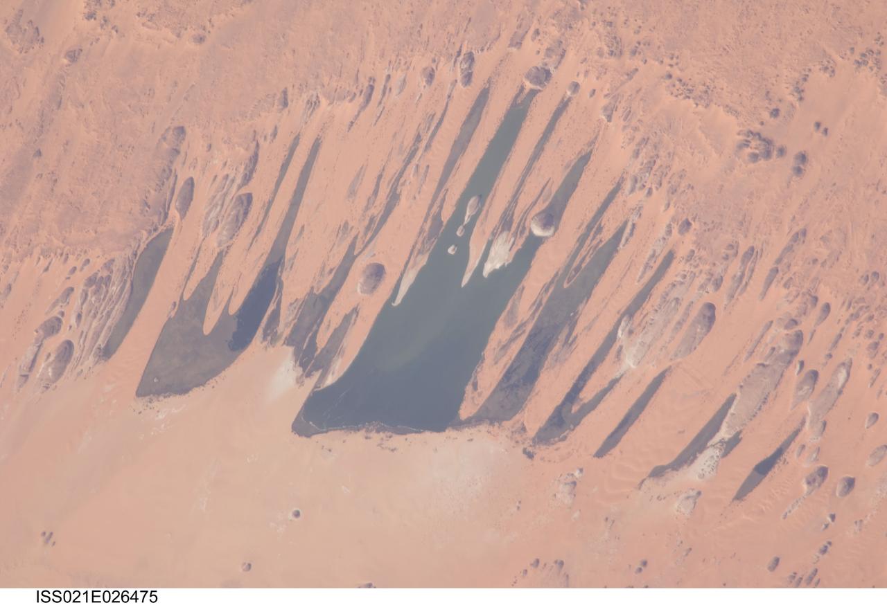
ISS021-E-026475 (14 Nov. 2009) --- Ounianga Lakes in the Sahara Desert, in the nation of Chad are featured in this image photographed by an Expedition 21 crew member on the International Space Station. This view features one of the largest of a series of ten, mostly fresh water lakes in the Ounianga basin in the heart of the Sahara Desert of northeastern Chad. According to scientists, the lakes are the remnant of a single large lake, probably tens of kilometers long that once occupied this remote area approximately 14,800 to 5,500 years ago. As the climate dried out during the subsequent millennia, the lake was reduced in size and large wind-driven sand dunes invaded the original depression dividing it into several smaller basins. The area shown in this image measures approximately 11 x 9 kilometers, with the dark water surfaces of the lake segregated almost completely by orange linear sand dunes that stream into the depression from the northeast. The almost year-round northeast winds and cloudless skies make for very high evaporation (an evaporation rate of greater than six meters per year has been measured in one of the nearby lakes). Despite this, only one of the ten lakes is saline. According to scientists, the reason for the apparent paradox of fresh water lakes in the heart of the desert lies in the fact that fresh water from a very large aquifer reaches the surface in the Ounianga depression in the form of the lakes. The aquifer is large enough to keep supplying the small lakes with water despite the high evaporation rate. Mats of floating reeds also reduce the evaporation in places. The lakes form a hydrological system that is unique in the Sahara Desert. Scientists believe the aquifer was charged with fresh water, and the large original lake evolved, during the so-called African Humid Period (approximately 14,800 to 5,500 years ago) when the West African summer monsoon was stronger than it is today. Associated southerly winds brought Atlantic moisture well north of modern limits, producing sufficient rainfall in the central Sahara to foster an almost complete savanna vegetation cover. Pollen data from lake sediments of the original 50-meters-deep Ounianga Lake suggests to scientists that a mild tropical climate with a wooded grassland savanna existed in the region. This vegetation association is now only encountered 300 kilometers further south. Ferns grew in the stream floodplains which must have been occasionally flooded. Even shrubs that now occur only on the very high, cool summits (greater than 2,900 meters, greater than 9,500 feet) of the Tibesti Mts. have been found in the Ounianga lake sediments.
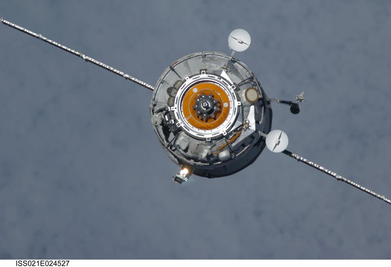
ISS021-E-024527 (12 Nov. 2009) --- The new unpiloted Russian Mini-Research Module 2 (MRM2), also known as Poisk, approaches the International Space Station. The MRM2 docked to the space-facing port of the Zvezda Service Module at 9:41 a.m. (CST) on Nov. 12, 2009. It began its trip to the station when it was launched aboard a Soyuz rocket from the Baikonur Cosmodrome in Kazakhstan on Nov. 10. Poisk is a Russian term that translates to search, seek and explore. It will provide an additional docking port for visiting Russian spacecrafts and will serve as an extra airlock for spacewalkers wearing Russian Orlan spacesuits. Poisk joins a Russian Progress resupply vehicle and two Russian Soyuz spacecraft currently docked at the station.
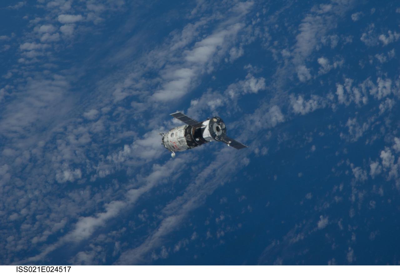
ISS021-E-024517 (12 Nov. 2009) --- Backdropped by a blue and white part of Earth, the new unpiloted Russian Mini-Research Module 2 (MRM2), also known as Poisk, approaches the International Space Station. The MRM2 docked to the space-facing port of the Zvezda Service Module at 9:41 a.m. (CST) on Nov. 12, 2009. It began its trip to the station when it was launched aboard a Soyuz rocket from the Baikonur Cosmodrome in Kazakhstan on Nov. 10. Poisk is a Russian term that translates to search, seek and explore. It will provide an additional docking port for visiting Russian spacecrafts and will serve as an extra airlock for spacewalkers wearing Russian Orlan spacesuits. Poisk joins a Russian Progress resupply vehicle and two Russian Soyuz spacecraft currently docked at the station.
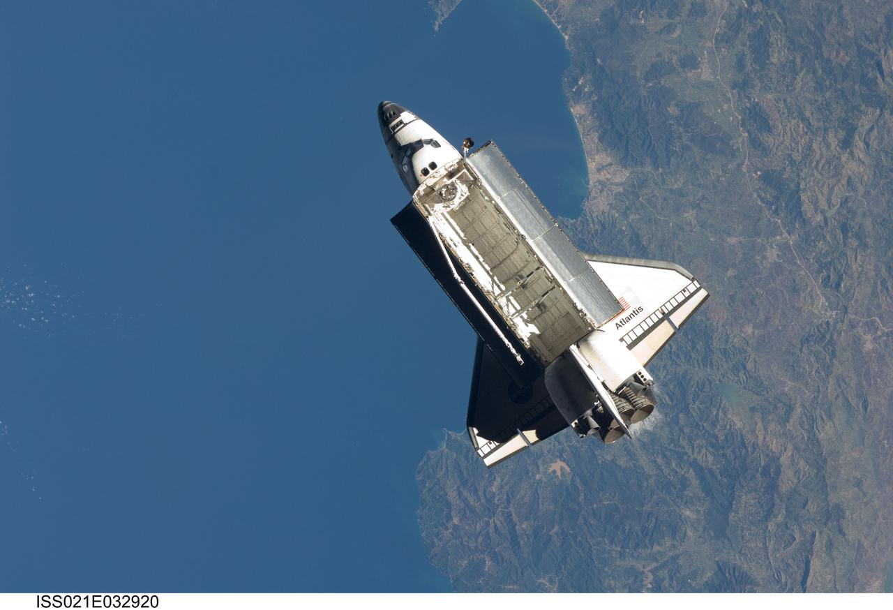
ISS021-E-032920 (25 Nov. 2009) --- Seen over the Mediterranean Sea, near the Algerian coast, the space shuttle Atlantis (STS-129) is featured in this image photographed by an Expedition 21 crew member on the International Space Station soon after the shuttle and station began their post-undocking relative separation. Undocking of the two spacecraft occurred at 3:53 a.m. (CST) on Nov. 25, 2009.
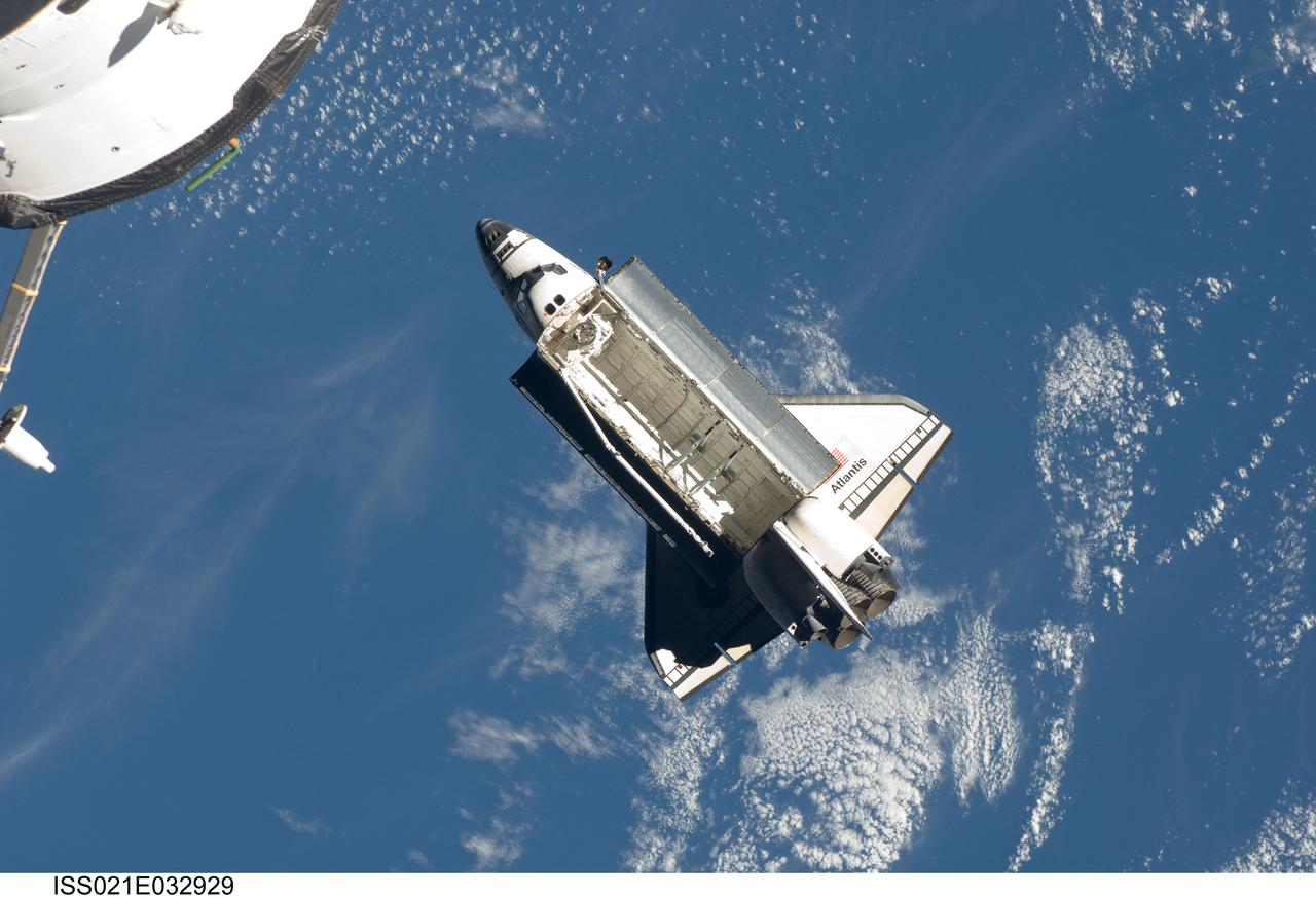
ISS021-E-032929 (25 Nov. 2009) --- Backdropped by a blue and white part of Earth, space shuttle Atlantis (STS-129) is featured in this image photographed by an Expedition 21 crew member on the International Space Station soon after the shuttle and station began their post-undocking relative separation. Undocking of the two spacecraft occurred at 3:53 a.m. (CST) on Nov. 25, 2009.
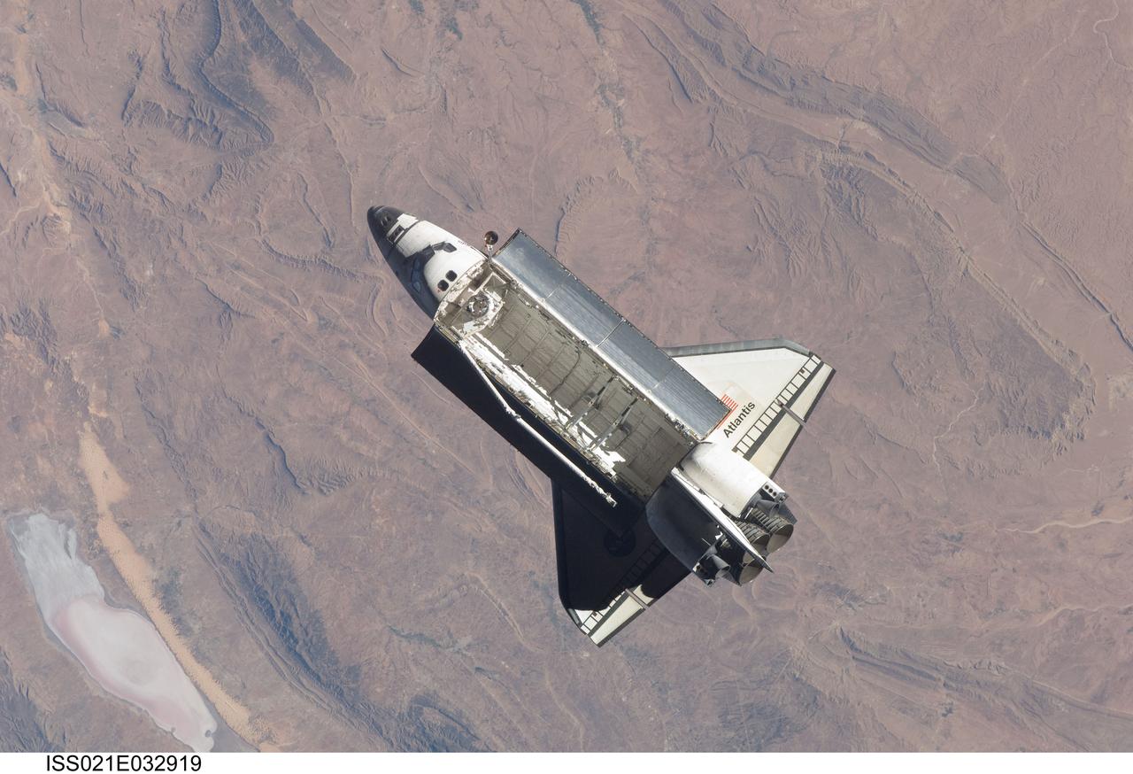
ISS021-E-032919 (25 Nov. 2009) --- Backdropped by rugged Earth terrain, space shuttle Atlantis (STS-129) is featured in this image photographed by an Expedition 21 crew member on the International Space Station soon after the shuttle and station began their post-undocking relative separation. Undocking of the two spacecraft occurred at 3:53 a.m. (CST) on Nov. 25, 2009.
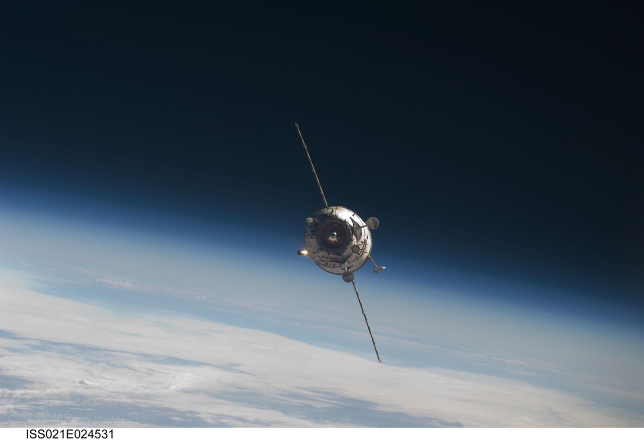
ISS021-E-024531 (12 Nov. 2009) --- Backdropped by Earth’s horizon and the blackness of space, the new unpiloted Russian Mini-Research Module 2 (MRM2), also known as Poisk, approaches the International Space Station. The MRM2 docked to the space-facing port of the Zvezda Service Module at 9:41 a.m. (CST) on Nov. 12, 2009. It began its trip to the station when it was launched aboard a Soyuz rocket from the Baikonur Cosmodrome in Kazakhstan on Nov. 10. Poisk is a Russian term that translates to search, seek and explore. It will provide an additional docking port for visiting Russian spacecrafts and will serve as an extra airlock for spacewalkers wearing Russian Orlan spacesuits. Poisk joins a Russian Progress resupply vehicle and two Russian Soyuz spacecraft currently docked at the station.
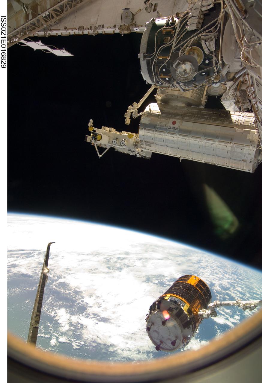
ISS021-E-016829 (30 Oct. 2009) --- Backdropped by Earth’s horizon and the blackness of space, the International Space Station's Canadarm2 unberths the unpiloted Japanese H-II Transfer Vehicle (HTV) in preparation for its release from the station. European Space Agency astronaut Frank De Winne, Expedition 21 commander; NASA astronaut Nicole Stott and Canadian Space Agency astronaut Robert Thirsk, both flight engineers, used the station’s robotic arm to grab the HTV cargo craft, filled with trash and unneeded items, and unberth it from the Harmony node’s nadir port. The HTV was successfully unberthed at 10:18 a.m. (CDT) on Oct. 30, 2009, and released from the station’s Canadarm2 at 12:32 p.m.
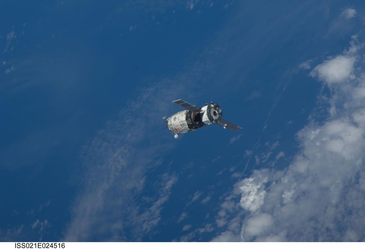
ISS021-E-024516 (12 Nov. 2009) --- Backdropped by a blue and white part of Earth, the new unpiloted Russian Mini-Research Module 2 (MRM2), also known as Poisk, approaches the International Space Station. The MRM2 docked to the space-facing port of the Zvezda Service Module at 9:41 a.m. (CST) on Nov. 12, 2009. It began its trip to the station when it was launched aboard a Soyuz rocket from the Baikonur Cosmodrome in Kazakhstan on Nov. 10. Poisk is a Russian term that translates to search, seek and explore. It will provide an additional docking port for visiting Russian spacecrafts and will serve as an extra airlock for spacewalkers wearing Russian Orlan spacesuits. Poisk joins a Russian Progress resupply vehicle and two Russian Soyuz spacecraft currently docked at the station.
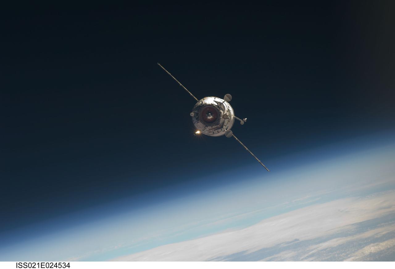
ISS021-E-024534 (12 Nov. 2009) --- Backdropped by Earth’s horizon and the blackness of space, the new unpiloted Russian Mini-Research Module 2 (MRM2), also known as Poisk, approaches the International Space Station. The MRM2 docked to the space-facing port of the Zvezda Service Module at 9:41 a.m. (CST) on Nov. 12, 2009. It began its trip to the station when it was launched aboard a Soyuz rocket from the Baikonur Cosmodrome in Kazakhstan on Nov. 10. Poisk is a Russian term that translates to search, seek and explore. It will provide an additional docking port for visiting Russian spacecrafts and will serve as an extra airlock for spacewalkers wearing Russian Orlan spacesuits. Poisk joins a Russian Progress resupply vehicle and two Russian Soyuz spacecraft currently docked at the station.
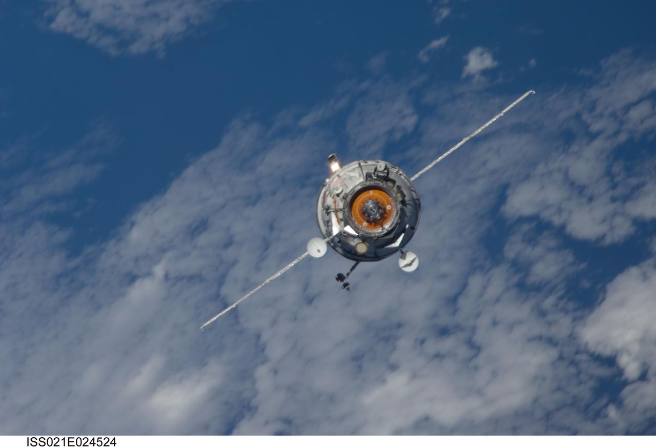
ISS021-E-024524 (12 Nov. 2009) --- Backdropped by a blue and white part of Earth, the new unpiloted Russian Mini-Research Module 2 (MRM2), also known as Poisk, approaches the International Space Station. The MRM2 docked to the space-facing port of the Zvezda Service Module at 9:41 a.m. (CST) on Nov. 12, 2009. It began its trip to the station when it was launched aboard a Soyuz rocket from the Baikonur Cosmodrome in Kazakhstan on Nov. 10. Poisk is a Russian term that translates to search, seek and explore. It will provide an additional docking port for visiting Russian spacecrafts and will serve as an extra airlock for spacewalkers wearing Russian Orlan spacesuits. Poisk joins a Russian Progress resupply vehicle and two Russian Soyuz spacecraft currently docked at the station.
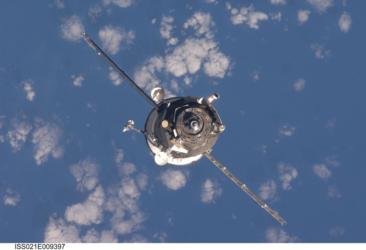
ISS021-E-009397 (17 Oct. 2009) --- An unpiloted ISS Progress resupply vehicle approaches the International Space Station, bringing 1,918 pounds of propellant, 110 pounds of oxygen and air, 926 pounds of water and 1,750 pounds of spare parts and supplies for the Expedition 21 crew members aboard the station. Progress 35 docked to the Pirs Docking Compartment at 8:40 p.m. (CDT), Oct. 17, 2009, after a three-day flight from the Baikonur Cosmodrome in Kazakhstan.
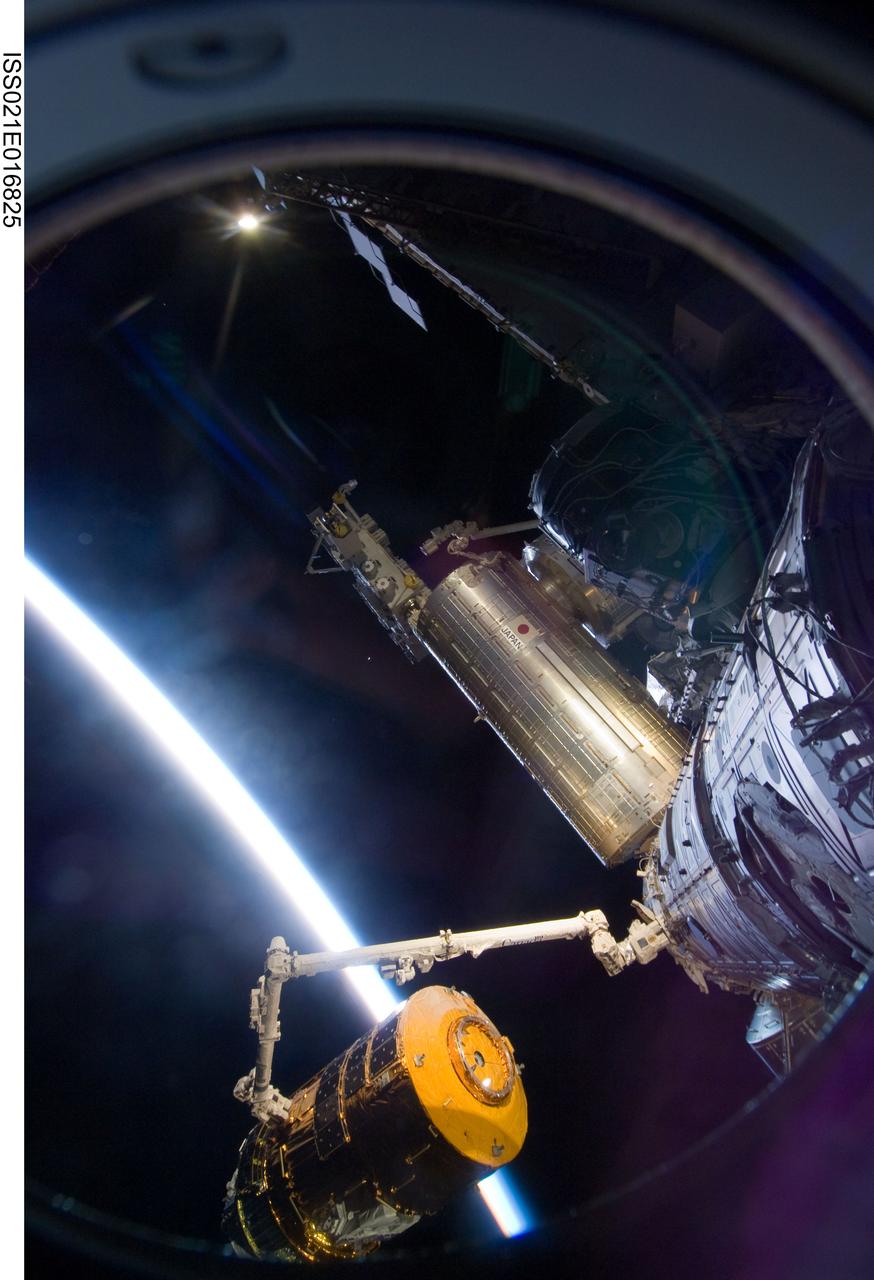
ISS021-E-016825 (30 Oct. 2009) --- Backdropped by the thin line of Earth’s atmosphere and the blackness of space, the International Space Station's Canadarm2 unberths the unpiloted Japanese H-II Transfer Vehicle (HTV) in preparation for its release from the station. European Space Agency astronaut Frank De Winne, Expedition 21 commander; NASA astronaut Nicole Stott and Canadian Space Agency astronaut Robert Thirsk, both flight engineers, used the station’s robotic arm to grab the HTV cargo craft, filled with trash and unneeded items, and unberth it from the Harmony node’s nadir port. The HTV was successfully unberthed at 10:18 a.m. (CDT) on Oct. 30, 2009, and released from the station’s Canadarm2 at 12:32 p.m.
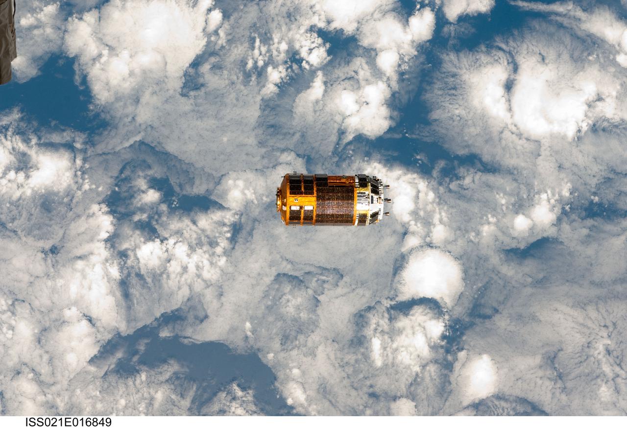
ISS021-E-016849 (30 Oct. 2009) --- Backdropped by a blue and white part of Earth, the unpiloted Japanese H-II Transfer Vehicle (HTV), filled with trash and unneeded items, departs from the International Space Station. European Space Agency astronaut Frank De Winne, Expedition 21 commander; NASA astronaut Nicole Stott and Canadian Space Agency astronaut Robert Thirsk, both flight engineers, used the station’s Canadarm2 robotic arm to grab the HTV cargo craft and unberth it from the Harmony node’s nadir port. The HTV was successfully unberthed at 10:18 a.m. (CDT) on Oct. 30, 2009, and released from the station’s Canadarm2 at 12:32 p.m.
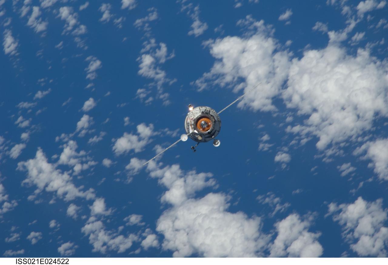
ISS021-E-024522 (12 Nov. 2009) --- Backdropped by a blue and white part of Earth, the new unpiloted Russian Mini-Research Module 2 (MRM2), also known as Poisk, approaches the International Space Station. The MRM2 docked to the space-facing port of the Zvezda Service Module at 9:41 a.m. (CST) on Nov. 12, 2009. It began its trip to the station when it was launched aboard a Soyuz rocket from the Baikonur Cosmodrome in Kazakhstan on Nov. 10. Poisk is a Russian term that translates to search, seek and explore. It will provide an additional docking port for visiting Russian spacecrafts and will serve as an extra airlock for spacewalkers wearing Russian Orlan spacesuits. Poisk joins a Russian Progress resupply vehicle and two Russian Soyuz spacecraft currently docked at the station.
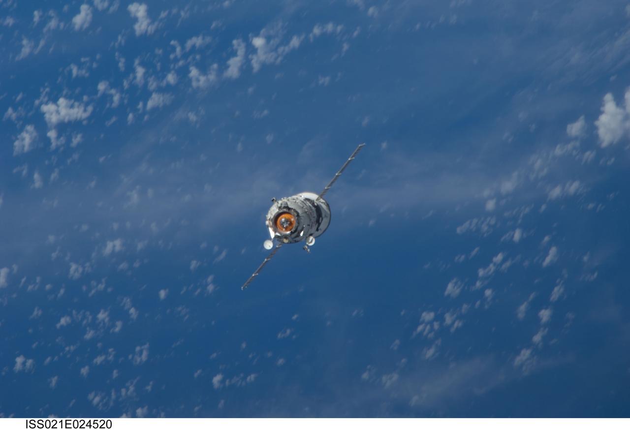
ISS021-E-024520 (12 Nov. 2009) --- Backdropped by a blue and white part of Earth, the new unpiloted Russian Mini-Research Module 2 (MRM2), also known as Poisk, approaches the International Space Station. The MRM2 docked to the space-facing port of the Zvezda Service Module at 9:41 a.m. (CST) on Nov. 12, 2009. It began its trip to the station when it was launched aboard a Soyuz rocket from the Baikonur Cosmodrome in Kazakhstan on Nov. 10. Poisk is a Russian term that translates to search, seek and explore. It will provide an additional docking port for visiting Russian spacecrafts and will serve as an extra airlock for spacewalkers wearing Russian Orlan spacesuits. Poisk joins a Russian Progress resupply vehicle and two Russian Soyuz spacecraft currently docked at the station.
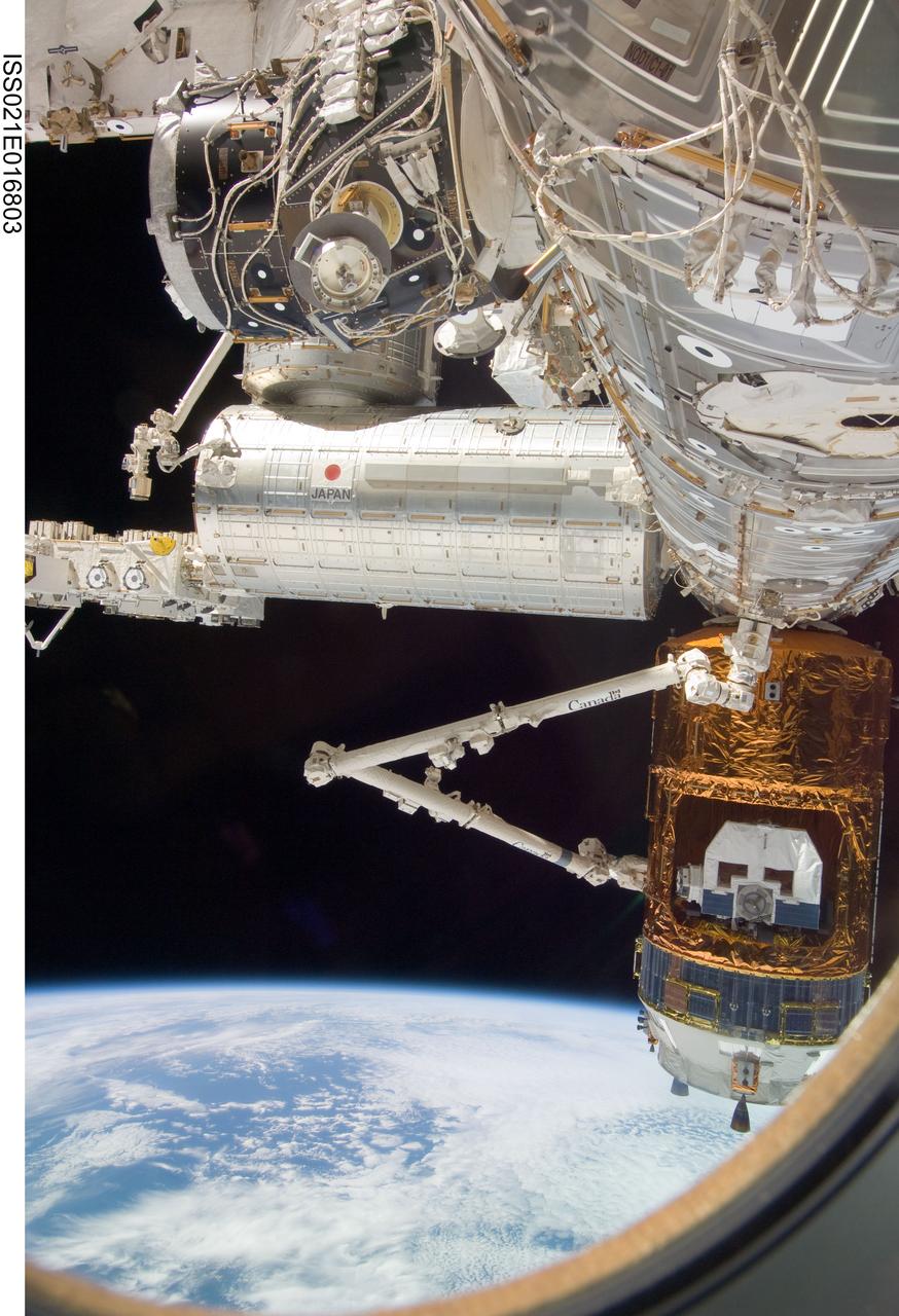
ISS021-E-016803 (30 Oct. 2009) --- Backdropped by Earth’s horizon and the blackness of space, the International Space Station's Canadarm2 grapples the unpiloted Japanese H-II Transfer Vehicle (HTV) in preparation for its release from the station. European Space Agency astronaut Frank De Winne, Expedition 21 commander; NASA astronaut Nicole Stott and Canadian Space Agency astronaut Robert Thirsk, both flight engineers, used the station’s robotic arm to grab the HTV cargo craft, filled with trash and unneeded items, and unberth it from the Harmony node’s nadir port. The HTV was successfully unberthed at 10:18 a.m. (CDT) on Oct. 30, 2009, and released from the station’s Canadarm2 at 12:32 p.m.
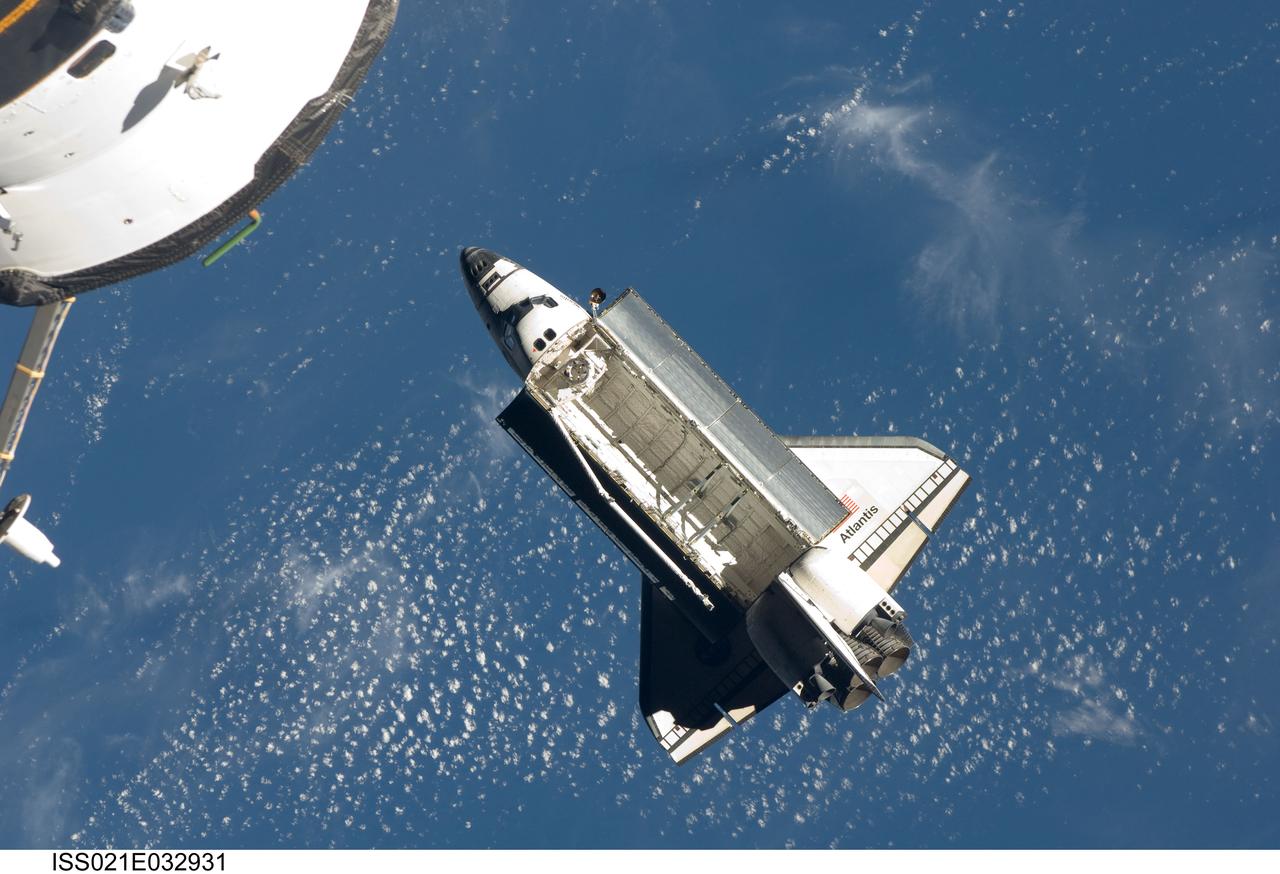
ISS021-E-032931 (25 Nov. 2009) --- Backdropped by a blue and white part of Earth, space shuttle Atlantis (STS-129) is featured in this image photographed by an Expedition 21 crew member on the International Space Station soon after the shuttle and station began their post-undocking relative separation. Undocking of the two spacecraft occurred at 3:53 a.m. (CST) on Nov. 25, 2009.
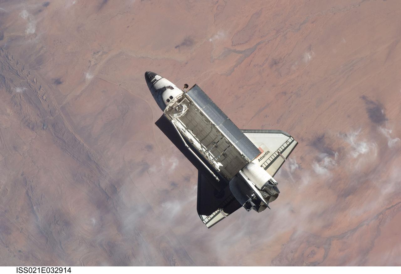
ISS021-E-032914 (25 Nov. 2009) --- Backdropped by a colorful part of Earth, space shuttle Atlantis (STS-129) is featured in this image photographed by an Expedition 21 crew member on the International Space Station soon after the shuttle and station began their post-undocking relative separation. Undocking of the two spacecraft occurred at 3:53 a.m. (CST) on Nov. 25, 2009.
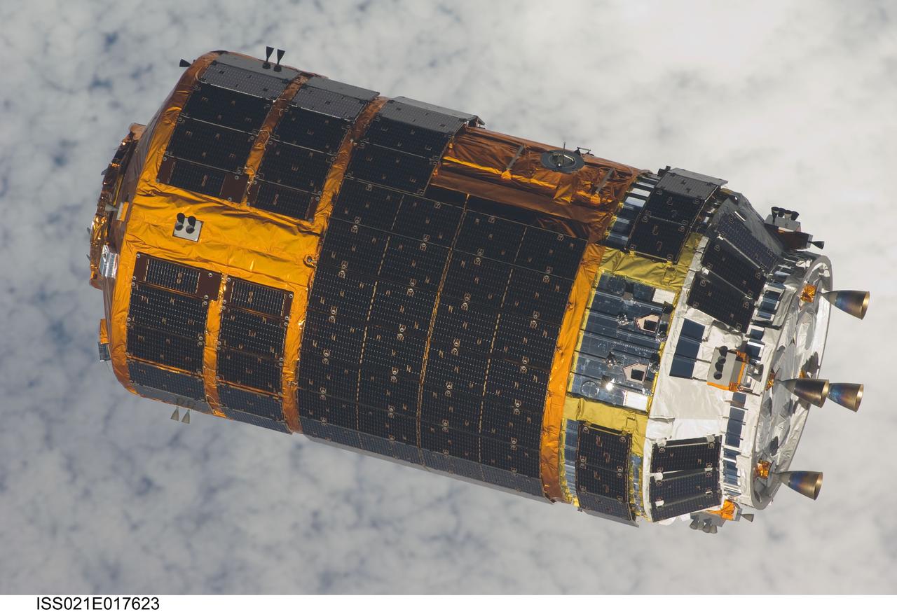
ISS021-E-017623 (30 Oct. 2009) --- Backdropped by a cloud-covered part of Earth, the unpiloted Japanese H-II Transfer Vehicle (HTV), filled with trash and unneeded items, departs from the International Space Station. European Space Agency astronaut Frank De Winne, Expedition 21 commander; NASA astronaut Nicole Stott and Canadian Space Agency astronaut Robert Thirsk, both flight engineers, used the station’s Canadarm2 robotic arm to grab the HTV cargo craft and unberth it from the Harmony node’s nadir port. The HTV was successfully unberthed at 10:18 a.m. (CDT) on Oct. 30, 2009, and released from the station’s Canadarm2 at 12:32 p.m.
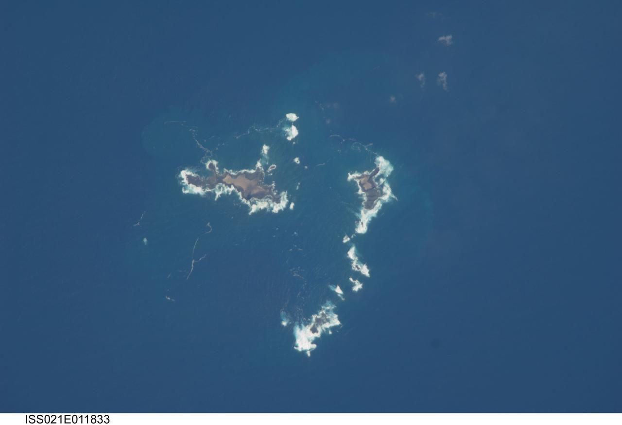
ISS021-E-011833 (22 Oct. 2009) --- The southern Savage Islands in the Atlantic Ocean are featured in this image photographed by an Expedition 21 crew member on the International Space Station. The Savage Islands, or Ilhas Selvagens in Portuguese, comprise a small archipelago in the eastern North Atlantic Ocean between the archipelago of Madeira to the north and the Canary Islands to the south. Like other island groups, the Savage Islands are thought to have been produced by volcanism related to a mantle plume or ?hot spot?. Mantle plumes are relatively fixed regions of upwelling magma that can feed volcanoes on an overlying tectonic plate. Active volcanoes form over the plume, and become dormant as they are carried away on the moving tectonic plate. Scientists believe that over geologic time, this creates a line of older extinct volcanoes, seamounts, and islands extending from the leading active volcanoes that are currently over the plume. This view illustrates the smaller and more irregularly-shaped Ilheus do Norte, Ilheu de Fora, and Selvagem Pequena. Spain and Portugal both claim sovereignty over the Savage Islands. All of the islands of the archipelago are ringed by bright white breaking waves along the fringing beaches. Coral reefs that surround the Savage Islands make it very difficult to land boats there, and there is no permanent settlement on the islands.
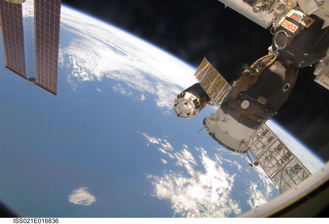
ISS021-E-016836 (30 Oct. 2009) --- Backdropped by Earth’s horizon and the blackness of space, the International Space Station's Canadarm2 (mostly obscured) unberths the unpiloted Japanese H-II Transfer Vehicle (HTV) in preparation for its release from the station. European Space Agency astronaut Frank De Winne, Expedition 21 commander; NASA astronaut Nicole Stott and Canadian Space Agency astronaut Robert Thirsk, both flight engineers, used the station’s robotic arm to grab the HTV cargo craft, filled with trash and unneeded items, and unberth it from the Harmony node’s nadir port. The HTV was successfully unberthed at 10:18 a.m. (CDT) on Oct. 30, 2009, and released from the station’s Canadarm2 at 12:32 p.m. A Russian Soyuz spacecraft, docked to the station, is visible in the foreground.
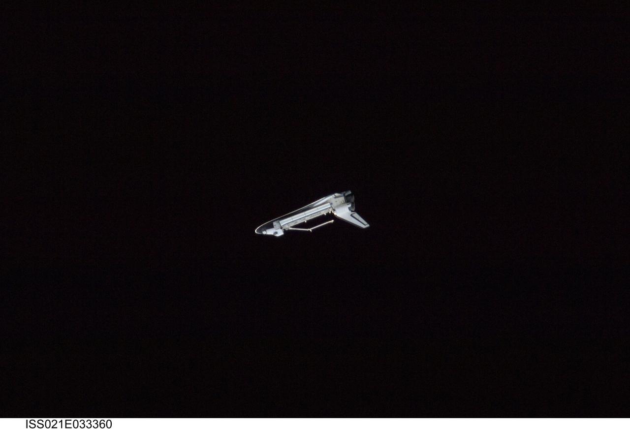
ISS021-E-033360 (25 Nov. 2009) --- Surrounded by the blackness of space, this profile view of the space shuttle Atlantis was photographed by an Expedition 21 crew member on the International Space Station soon after the shuttle and station began their post-undocking relative separation. Undocking of the two spacecraft occurred at 3:53 a.m. (CST) on Nov. 25, 2009.
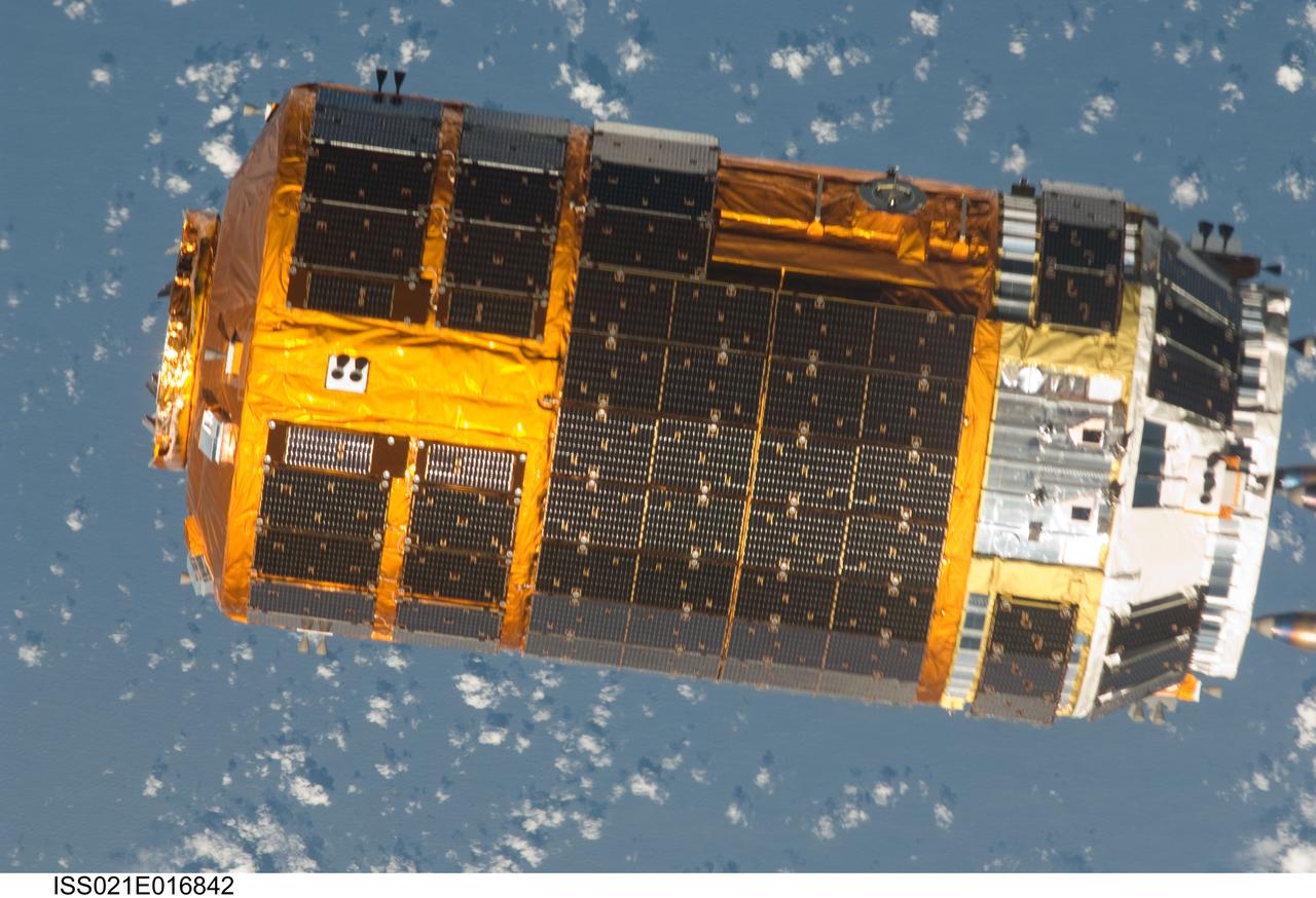
ISS021-E-016842 (30 Oct. 2009) --- Backdropped by a blue and white part of Earth, the unpiloted Japanese H-II Transfer Vehicle (HTV), filled with trash and unneeded items, departs from the International Space Station. European Space Agency astronaut Frank De Winne, Expedition 21 commander; NASA astronaut Nicole Stott and Canadian Space Agency astronaut Robert Thirsk, both flight engineers, used the station’s Canadarm2 robotic arm to grab the HTV cargo craft and unberth it from the Harmony node’s nadir port. The HTV was successfully unberthed at 10:18 a.m. (CDT) on Oct. 30, 2009, and released from the station’s Canadarm2 at 12:32 p.m.
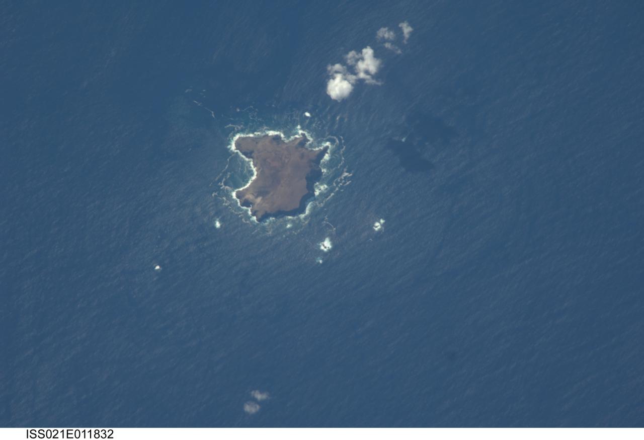
ISS021-E-011832 (22 Oct. 2009) --- The northern Savage Islands in the Atlantic Ocean are featured in this image photographed by an Expedition 21 crew member on the International Space Station. The Savage Islands, or Ilhas Selvagens in Portuguese, comprise a small archipelago in the eastern North Atlantic Ocean between the archipelago of Madeira to the north and the Canary Islands to the south. Like other island groups, the Savage Islands are thought to have been produced by volcanism related to a mantle plume or “hot spot”. Mantle plumes are relatively fixed regions of upwelling magma that can feed volcanoes on an overlying tectonic plate. Active volcanoes form over the plume, and become dormant as they are carried away on the moving tectonic plate. Scientists believe that over geologic time, this creates a line of older extinct volcanoes, seamounts, and islands extending from the leading active volcanoes that are currently over the plume. This view illustrates Selvagem Grande, the largest of the islands with an approximate area of four square kilometers. All of the islands of the archipelago are ringed by bright white breaking waves along the fringing beaches. Coral reefs that surround the Savage Islands make it very difficult to land boats there, and there is no permanent settlement on the islands.
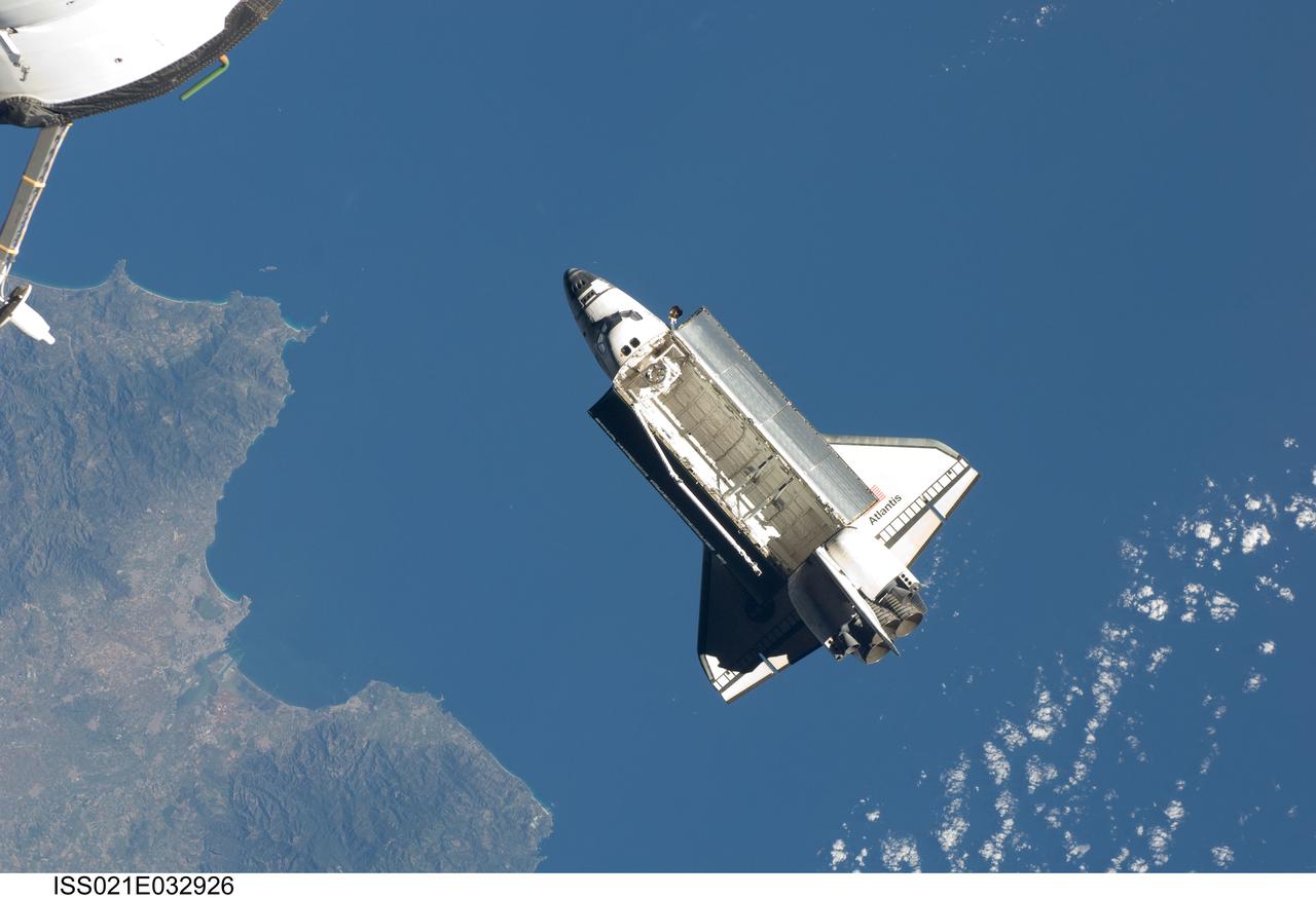
ISS021-E-032926 (25 Nov. 2009) --- Seen over the Mediterranean Sea, the space shuttle Atlantis (STS-129) is featured in this image photographed by an Expedition 21 crew member on the International Space Station soon after the shuttle and station began their post-undocking relative separation. Undocking of the two spacecraft occurred at 3:53 a.m. (CST) on Nov. 25, 2009.
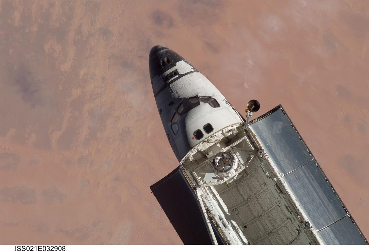
ISS021-E-032908 (25 Nov. 2009) --- A partial view of space shuttle Atlantis (STS-129) is featured in this image photographed by an Expedition 21 crew member on the International Space Station soon after the shuttle and station began their post-undocking relative separation. Undocking of the two spacecraft occurred at 3:53 a.m. (CST) on Nov. 25, 2009.
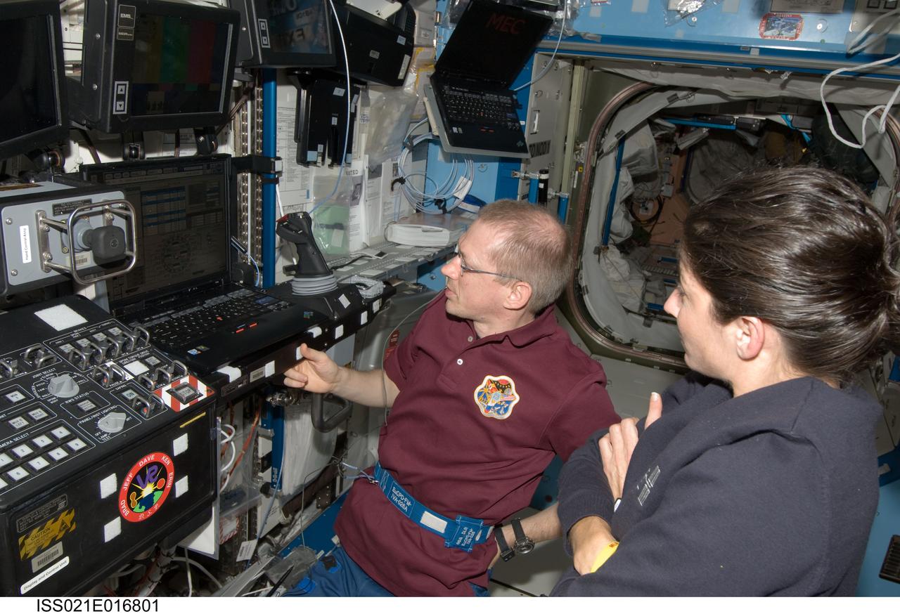
ISS021-E-016801 (30 Oct. 2009) --- European Space Agency astronaut Frank De Winne, Expedition 21 commander; and NASA astronaut Nicole Stott, flight engineer, view computer monitors at the Canadarm2 workstation in the Destiny laboratory of the International Space Station during the preparation for the release of the Japanese H-II Transfer Vehicle (HTV) from the station. De Winne, Stott and Canadian Space Agency astronaut Robert Thirsk (out of frame) used the station’s robotic arm to grab the HTV cargo craft, filled with trash and unneeded items, and unberth it from the Harmony node’s nadir port. The HTV was successfully unberthed at 10:18 a.m. (CDT) on Oct. 30, 2009, and released from the station’s Canadarm2 at 12:32 p.m.
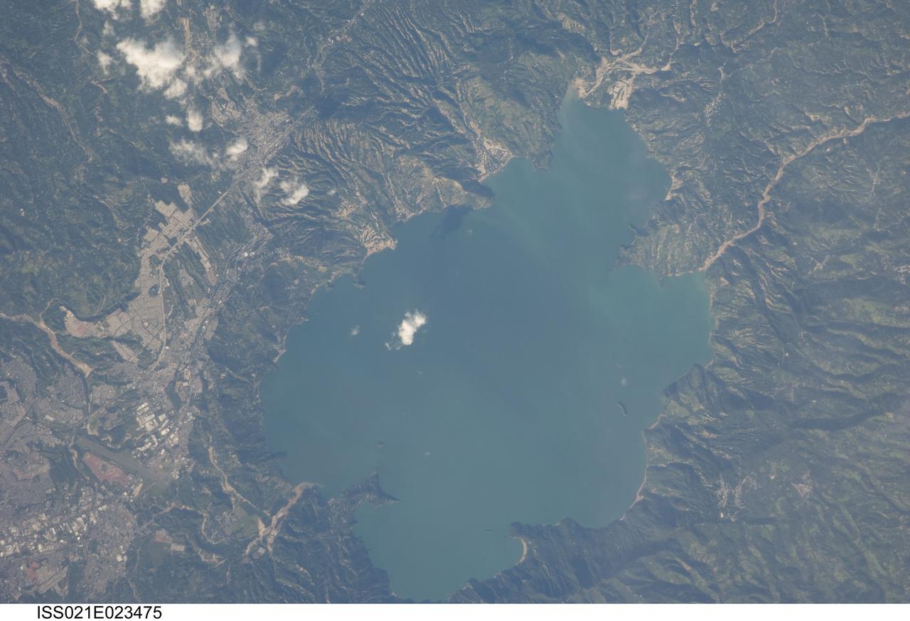
ISS021-E-023475 (11 Nov. 2009) --- Lake Ilopango, El Salvador is featured in this image photographed by an Expedition 21 crew member on the International Space Station. The Central American country of El Salvador occupies a land area nearly the same as the US State of Massachusetts, and includes numerous historically active volcanoes. This detailed photograph highlights the Ilopango Caldera that is located approximately 16 kilometers to the east of the capital city of San Salvador. Calderas are the geologic record of powerful volcanic eruptions that empty out a volcano?s magma chamber ? following the eruption, the overlying volcanic structure collapses into the newly-formed void, leaving a large crater-like feature (the caldera). The last caldera-forming eruption at Ilopango occurred during the 5th century AD; it was a powerful event that produced pyroclastic flows that destroyed early Mayan cities in the region. Later volcanic activity included the formation of several lava domes within the lake-filled caldera and near the shoreline. The only historical eruption at Ilopango took place in 1879-80. This activity resulted in the formation of a lava dome in the center of Lake Ilopango, the summit of which forms small islets today known as Islas Quemadas. The city of Ilopango borders the lake to the west (left) while green vegetated hillslopes ring the rest of the shoreline. White patchy cumulus clouds are also visible in the image (center and upper left).

ISS021-E-009384 (17 Oct. 2009) --- An unpiloted ISS Progress resupply vehicle approaches the International Space Station, bringing 1,918 pounds of propellant, 110 pounds of oxygen and air, 926 pounds of water and 1,750 pounds of spare parts and supplies for the Expedition 21 crew members aboard the station. Progress 35 docked to the Pirs Docking Compartment at 8:40 p.m. (CDT), Oct. 17, 2009, after a three-day flight from the Baikonur Cosmodrome in Kazakhstan.
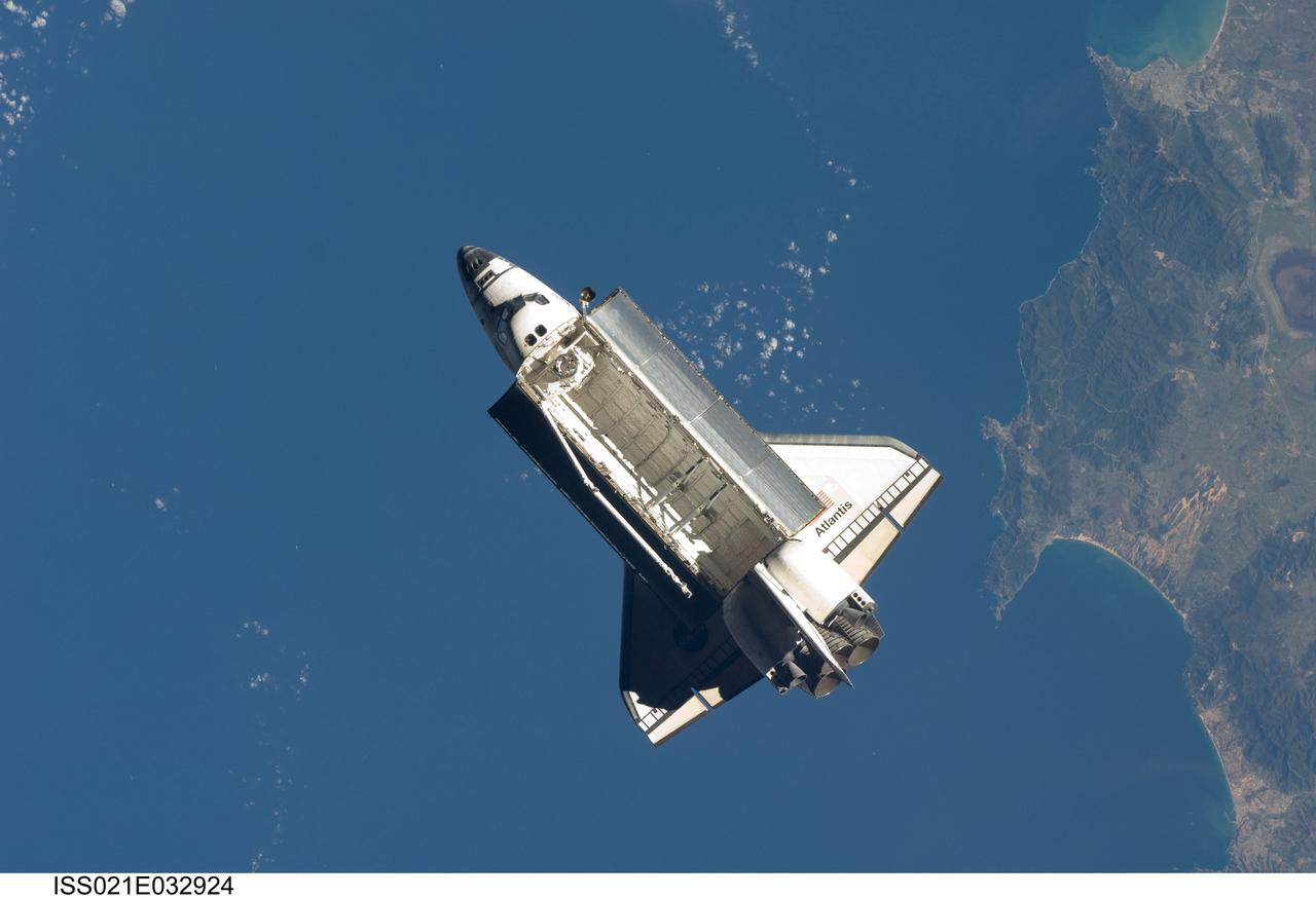
ISS021-E-032924 (25 Nov. 2009) --- Seen over the Mediterranean Sea, near the Algerian coast, the space shuttle Atlantis (STS-129) is featured in this image photographed by an Expedition 21 crew member on the International Space Station soon after the shuttle and station began their post-undocking relative separation. Undocking of the two spacecraft occurred at 3:53 a.m. (CST) on Nov. 25, 2009.
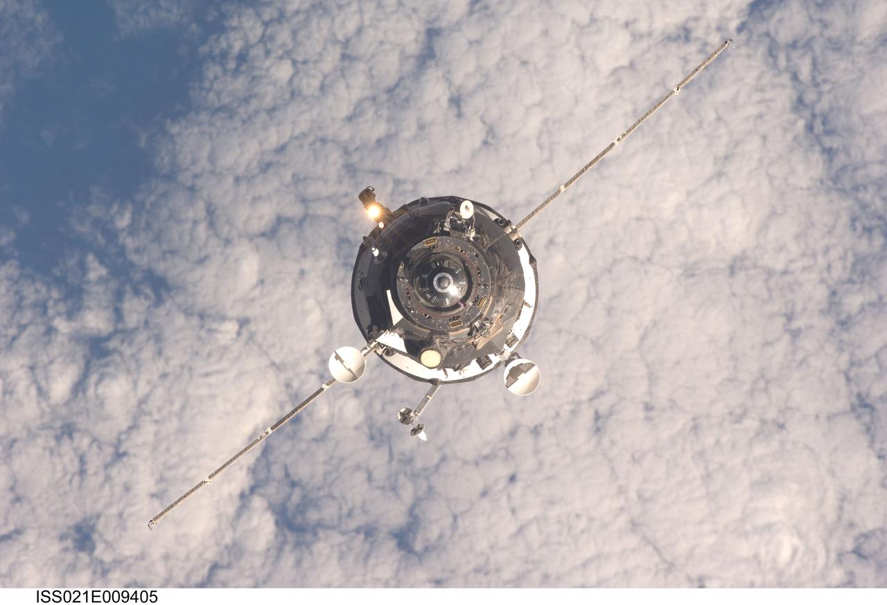
ISS021-E-009405 (17 Oct. 2009) --- An unpiloted ISS Progress resupply vehicle approaches the International Space Station, bringing 1,918 pounds of propellant, 110 pounds of oxygen and air, 926 pounds of water and 1,750 pounds of spare parts and supplies for the Expedition 21 crew members aboard the station. Progress 35 docked to the Pirs Docking Compartment at 8:40 p.m. (CDT), Oct. 17, 2009, after a three-day flight from the Baikonur Cosmodrome in Kazakhstan.
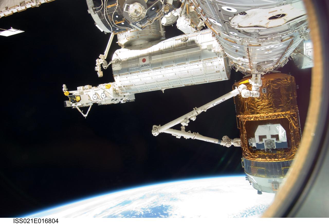
ISS021-E-016804 (30 Oct. 2009) --- Backdropped by Earth’s horizon and the blackness of space, the International Space Station's Canadarm2 grapples the unpiloted Japanese H-II Transfer Vehicle (HTV) in preparation for its release from the station. European Space Agency astronaut Frank De Winne, Expedition 21 commander; NASA astronaut Nicole Stott and Canadian Space Agency astronaut Robert Thirsk, both flight engineers, used the station’s robotic arm to grab the HTV cargo craft, filled with trash and unneeded items, and unberth it from the Harmony node’s nadir port. The HTV was successfully unberthed at 10:18 a.m. (CDT) on Oct. 30, 2009, and released from the station’s Canadarm2 at 12:32 p.m.
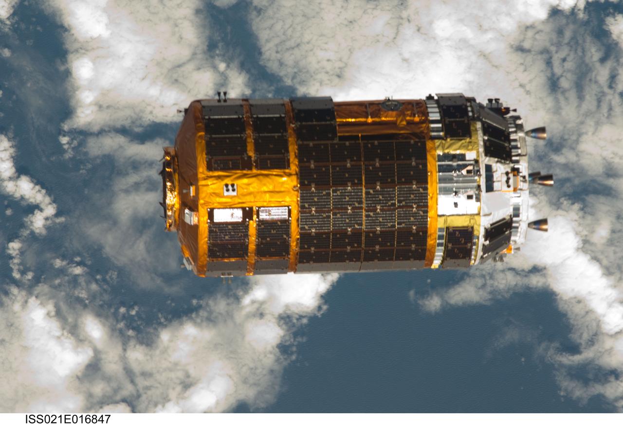
ISS021-E-016847 (30 Oct. 2009) --- Backdropped by a blue and white part of Earth, the unpiloted Japanese H-II Transfer Vehicle (HTV), filled with trash and unneeded items, departs from the International Space Station. European Space Agency astronaut Frank De Winne, Expedition 21 commander; NASA astronaut Nicole Stott and Canadian Space Agency astronaut Robert Thirsk, both flight engineers, used the station’s Canadarm2 robotic arm to grab the HTV cargo craft and unberth it from the Harmony node’s nadir port. The HTV was successfully unberthed at 10:18 a.m. (CDT) on Oct. 30, 2009, and released from the station’s Canadarm2 at 12:32 p.m.
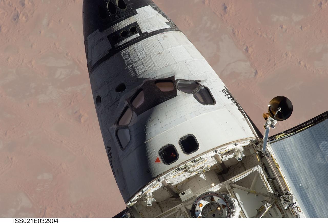
ISS021-E-032904 (25 Nov. 2009) --- The forward section of space shuttle Atlantis (STS-129) is featured in this image photographed by an Expedition 21 crew member on the International Space Station soon after the shuttle and station began their post-undocking relative separation. Undocking of the two spacecraft occurred at 3:53 a.m. (CST) on Nov. 25, 2009.
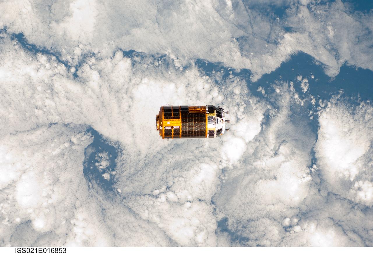
ISS021-E-016853 (30 Oct. 2009) --- Backdropped by a blue and white part of Earth, the unpiloted Japanese H-II Transfer Vehicle (HTV), filled with trash and unneeded items, departs from the International Space Station. European Space Agency astronaut Frank De Winne, Expedition 21 commander; NASA astronaut Nicole Stott and Canadian Space Agency astronaut Robert Thirsk, both flight engineers, used the station’s Canadarm2 robotic arm to grab the HTV cargo craft and unberth it from the Harmony node’s nadir port. The HTV was successfully unberthed at 10:18 a.m. (CDT) on Oct. 30, 2009, and released from the station’s Canadarm2 at 12:32 p.m.
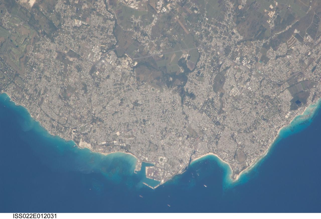
ISS022-E-012031 (16 Dec. 2009) --- Greater Bridgetown area, Barbados is featured in this image photographed by an Expedition 22 crew member on the International Space Station. Bridgetown is the capital city of the island nation of Barbados, located to the east of the Lesser Antilles Island chain. While Barbados is considered to be part of the Lesser Antilles, it is located within the western Atlantic Ocean rather than the Caribbean Sea region. Bridgetown is the largest city in Barbados in addition to being the seat of government. Barbados is a member of the British Commonwealth, and considers Queen Elizabeth II to be its constitutional monarch. Bridgetown, and the surrounding towns that make up the Greater Bridgetown area, is located along the southwestern coastline of the island. The metropolitan area is readily recognized in this image due to the gray and white rooftops and street grids (center) that contrast with green vegetated fields and riparian areas of the island?s interior to the northeast (top center). Bridgetown is a major port destination for both commercial and cruise ships serving the eastern Caribbean ? several ships are visible within Carlisle Bay. Water color in the image changes from light blue along the coastline ? indicating shallow water ? to the dark blue of deeper water away from the island.
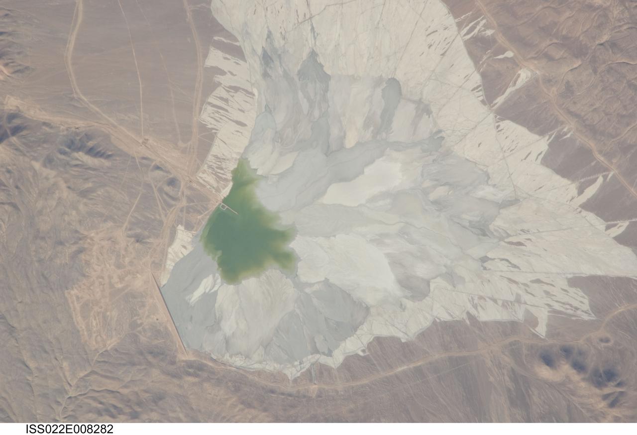
ISS022-E-008282 (9 Dec. 2009) --- One of the world?s leading copper mines, Escondida, in the Atacama Desert of Chile, is featured in this image photographed by an Expedition 22 crew member on the International Space Station. The copper mining industry is a major part of the Chilean economy. The mine is located 170 kilometers southeast of Chile?s port city of Antofagasta, in the hyper arid northern Atacama Desert at an elevation of 3,050 meters (approximately 10,000 feet) above sea level. Escondida produces mainly copper concentrates; assisted by gravity, the concentrates are piped as slurry down to the smaller port of Coloso just south of Antofagasta where they are dewatered for shipping. The photograph features a large light tan and gray waste or ?spoil? materials impoundment area (center) of the mine complex. The copper-bearing waste, which is a large proportion of the material excavated from open pits to the north (not in frame), is poured into the impoundment area as a liquid (green region at photo?s center), and dries to the lighter-toned spoil seen in the image. The spoil is held behind a retaining dam, just a little more than one kilometer in length, visible as a straight line at lower left. ?Escondida? means ?hidden? in Spanish, and refers to the fact that the copper ore body was buried beneath hundreds of meters of barren rock and had to be located by a laborious drilling program following a geologic trend established from other copper occurrences.
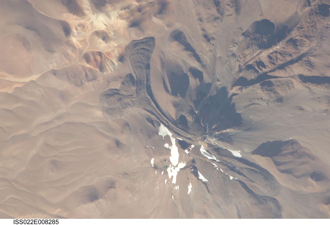
ISS022-E-008285 (9 Dec. 2009) --- Llullaillaco volcano on the Argentina-Chile border is featured in this image photographed by an Expedition 22 crew member on the International Space Station. The summit of Llullaillaco volcano has an elevation of 6,739 meters above sea level, making it the highest historically active volcano in the world. The current Llullaillaco stratovolcano ? a typically high, cone-shaped volcano built from successive layers of thick lava flows and eruption products like ash and rock fragments ? is built on top of an older stratovolcano. The last explosive eruption of the volcano occurred in 1877 based on historical records. This detailed photograph of Llullaillaco illustrates an interesting volcanic feature known as a coulee (top left). Coulees are formed from highly viscous, thick lavas that flow onto a steep surface; as they flow slowly downwards, the top of the flow cools and forms a series of parallel ridges oriented at 90 degrees to the direction of flow (somewhat similar in appearance to the pleats of an accordion). The sides of the flow can also cool faster than the center, leading to the formation of wall-like structures known as flow levees (center).
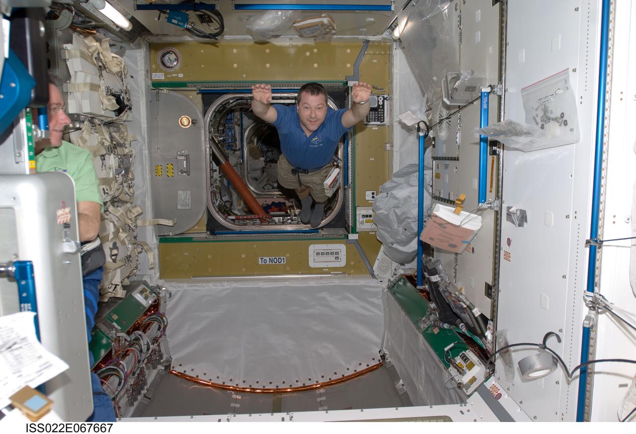
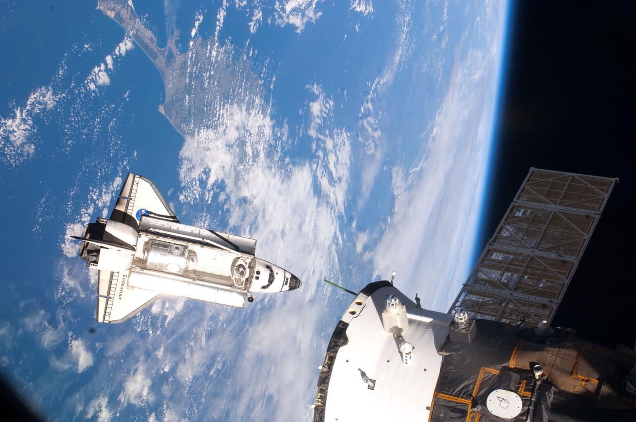
ISS022-E-067667 (14 Feb. 2010) --- NASA astronaut Nicholas Patrick, STS-130 mission specialist, floats freely in newly-installed Tranquility node of the International Space Station while space shuttle Endeavour remains docked with the station.
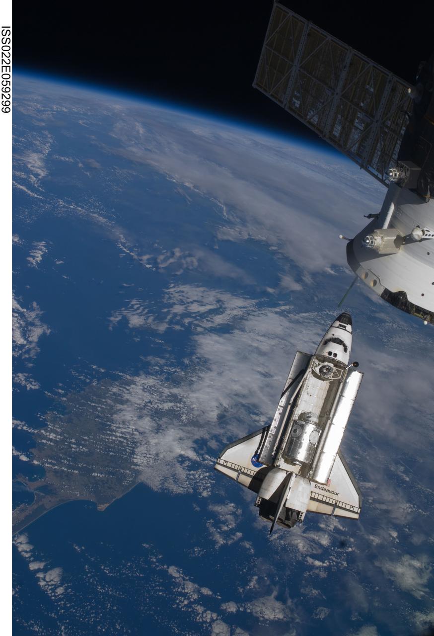
ISS022-E-059299 (9 Feb. 2010) --- Seen flying above part of North Island, New Zealand, the space shuttle Endeavour is featured in this image photographed by an Expedition 22 crew member during STS-130 rendezvous and docking operations with the International Space Station. Docking occurred at 11:06 p.m. (CST) on Feb. 9, 2010.
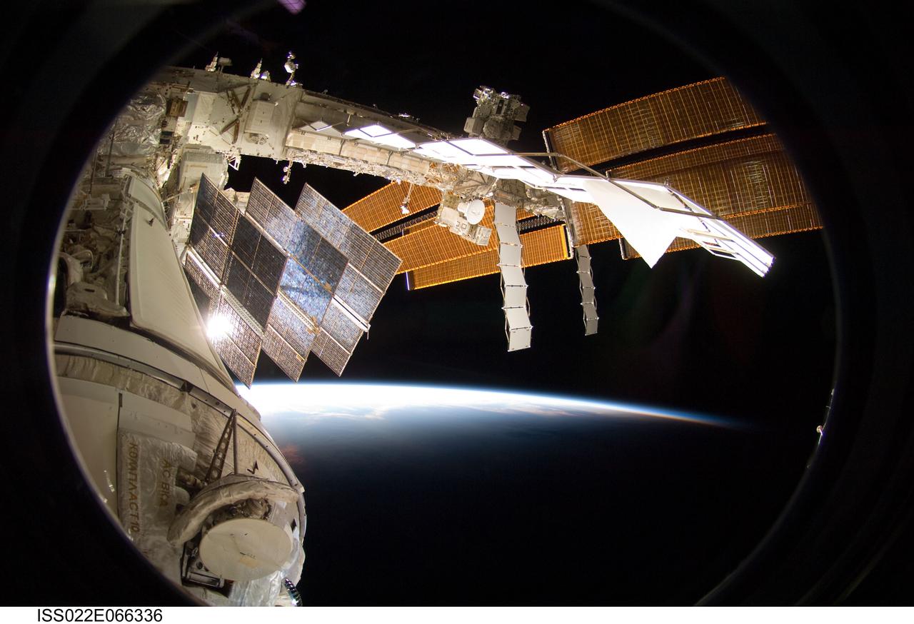
ISS022-E-066336 (15 Feb. 2010) --- Backdropped by Earth?s horizon and the blackness of space, a portion of the International Space Station is featured in this image photographed by a crew member on the ISS while space shuttle Endeavour (STS-130) remains docked with the station.
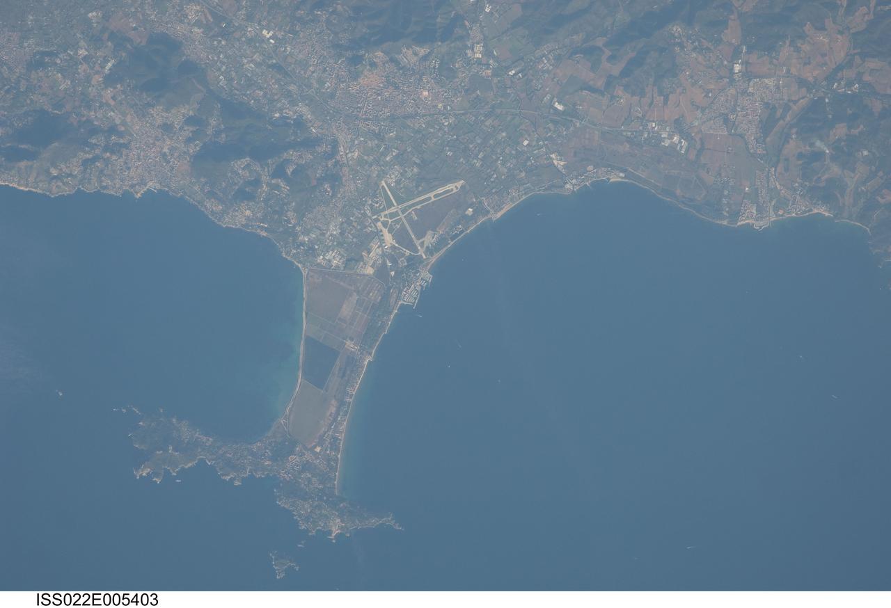
ISS022-E-005403 (2 Dec. 2009) --- Giens Peninsula, France is featured in this image photographed by an Expedition 22 crew member on the International Space Station. This detailed image depicts the Giens Peninsula located along the Mediterranean coastline of France. The peninsula is part of the Cote d?Azur, also known as the French Riviera, the coastal region bounded by the Rhone River to the west, to the north by the Rhone Alps, and the east by the Italian border. The peninsula itself, extended out southwards from the city of Hyeres to the resort community of Giens, is formed from two tombolos. A tombolo is a ridge of beach material (typically sand) built by wave action that connects an island to the mainland. Tombolos, like many coastal features, typically change dramatically over geologic time due to fluctuating sediment supply, coastal currents, sea levels and storm events. The tombolos of the Giens Peninsula have been modified by human activities including sand dune removal, construction of roadways, and replacement of the original sand by other materials. The long-term survival of these tombolos will be determined by the effects of these changes on the natural coastal processes, with potential sea level rise presenting an additional threat. In addition to Giens, three other urban areas are visible in this image; Carqueiranne, Hyeres, and La Londe-les-Maures. The urban areas are recognizable by both light pink rooftops and grey street grids. These contrast with green to brown vegetated areas including agricultural fields (between Hyeres and La Londe-les-Maures, top center) and dark green vegetated hillslopes (between Hyeres and Carqueiranne, top left). Small white dots and streaks in the Mediterranean Sea are actually yachts and other pleasure craft.
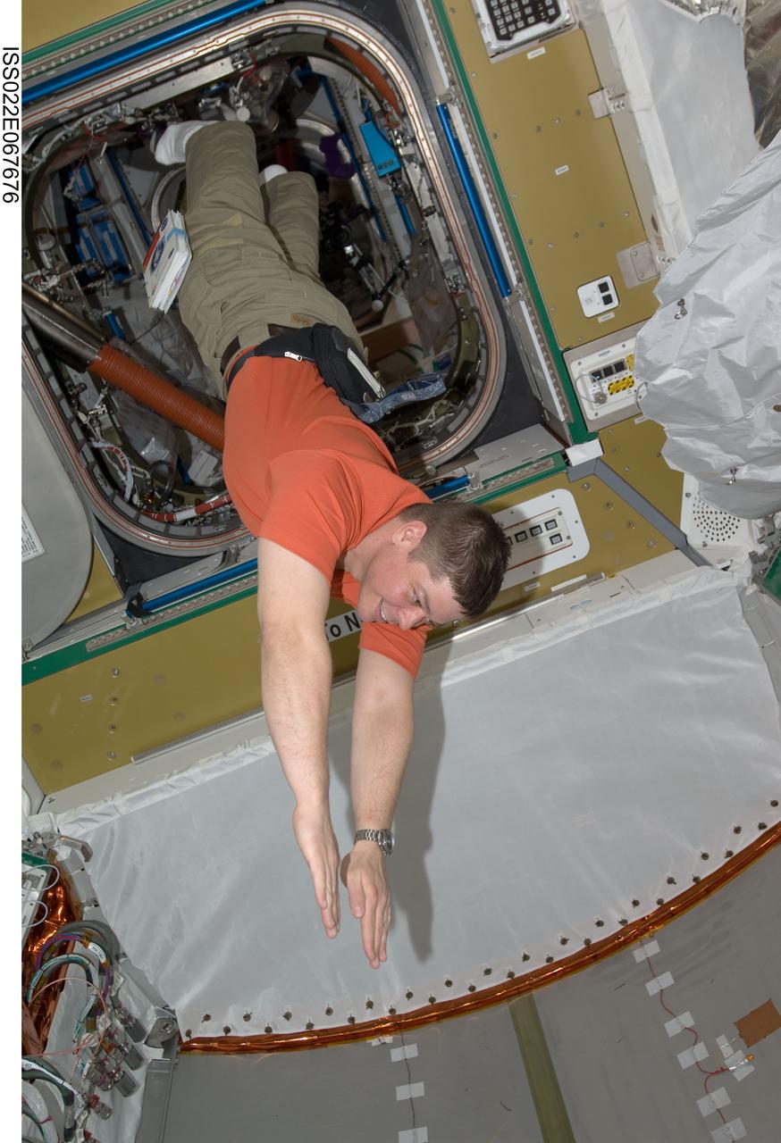
ISS022-E-067676 (14 Feb. 2010) --- NASA astronaut Robert Behnken, STS-130 mission specialist, floats freely in newly-installed Tranquility node of the International Space Station while space shuttle Endeavour remains docked with the station.
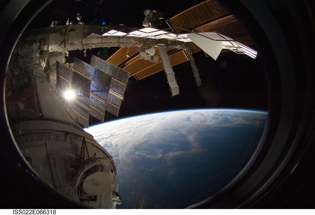
ISS022-E-066318 (15 Feb. 2010) --- Backdropped by Earth?s horizon and the blackness of space, a portion of the International Space Station is featured in this image photographed by a crew member on the ISS while space shuttle Endeavour (STS-130) remains docked with the station.
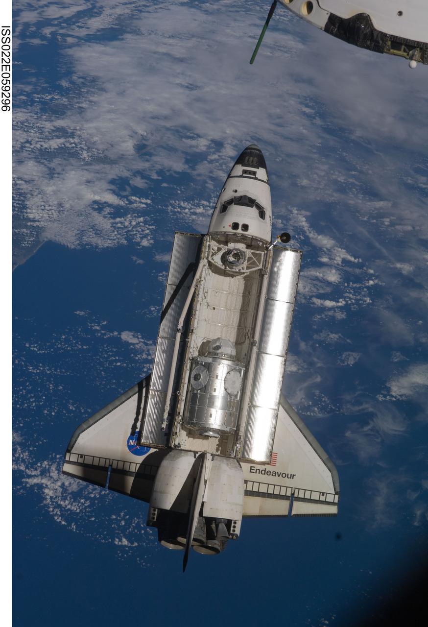
ISS022-E-059296 (9 Feb. 2010) --- Backdropped by a blue and white part of Earth, space shuttle Endeavour is featured in this image photographed by an Expedition 22 crew member as the shuttle approaches the International Space Station during STS-130 rendezvous and docking operations. Docking occurred at 11:06 p.m. (CST) on Feb. 9, 2010.
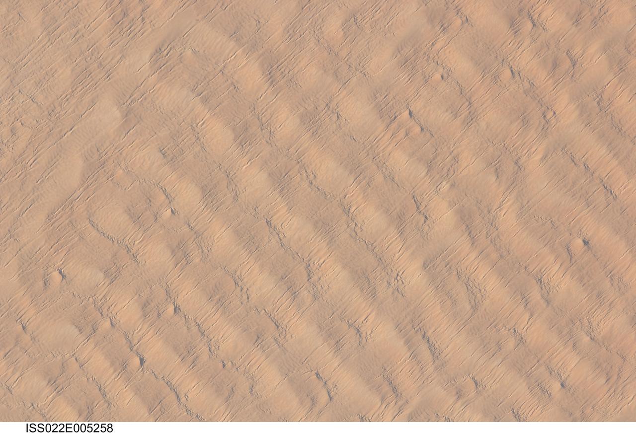
ISS022-E-005258 (1 Dec. 2009) --- This detailed hand-held digital camera?s image recorded from the International Space Station highlights sand dunes in the Fachi-Bilma erg, or sand sea, which is part of the central eastern Tenere Desert. The Tenere occupies much of southeastern Niger and is considered to be part of the larger Sahara Desert that stretches across northern Africa. Much of the Sahara is comprised of ergs ? with an area of approximately 150,000 square kilometers, the Fachi-Bilma is one of the larger sand seas. Two major types of dunes are visible in the image. Large, roughly north-south oriented transverse dunes fill the image frame. This type of dune tends to form at roughly right angles to the dominant northeasterly winds. The dune crests are marked in this image by darker, steeper sand accumulations that cast shadows. The lighter-toned zones between are lower interdune ?flats?. The large dunes appear to be highly symmetrical with regard to their crests. This suggests that the crest sediments are coarser, preventing the formation of a steeper slip face on the downwind side of the dune by wind-driven motion of similarly-sized sand grains. According to NASA scientists, this particular form of transverse dune is known as a zibar, and is thought to form by winnowing of smaller sand grains by the wind, leaving the coarser grains to form dune crests. A second set of thin linear dunes oriented at roughly right angles to the zibar dunes appears to be formed on the larger landforms and is therefore a younger landscape feature. These dunes appear to be forming from finer grains in the same wind field as the larger zibars. The image was taken with digital still camera fitted with a 400 mm lens, and is provided by the ISS Crew Earth Observations experiment and Image Science & Analysis Laboratory, Johnson Space Center.

ISS022-E-066322 (15 Feb. 2010) --- Backdropped by Earth?s horizon and the blackness of space, a portion of the International Space Station is featured in this image photographed by a crew member on the ISS while space shuttle Endeavour (STS-130) remains docked with the station.
ISS022-E-059298 (9 Feb. 2010) --- Seen flying above part of North Island, New Zealand, the space shuttle Endeavour is featured in this image photographed by an Expedition 22 crew member during STS-130 rendezvous and docking operations with the International Space Station. Docking occurred at 11:06 p.m. (CST) on Feb. 9, 2010.