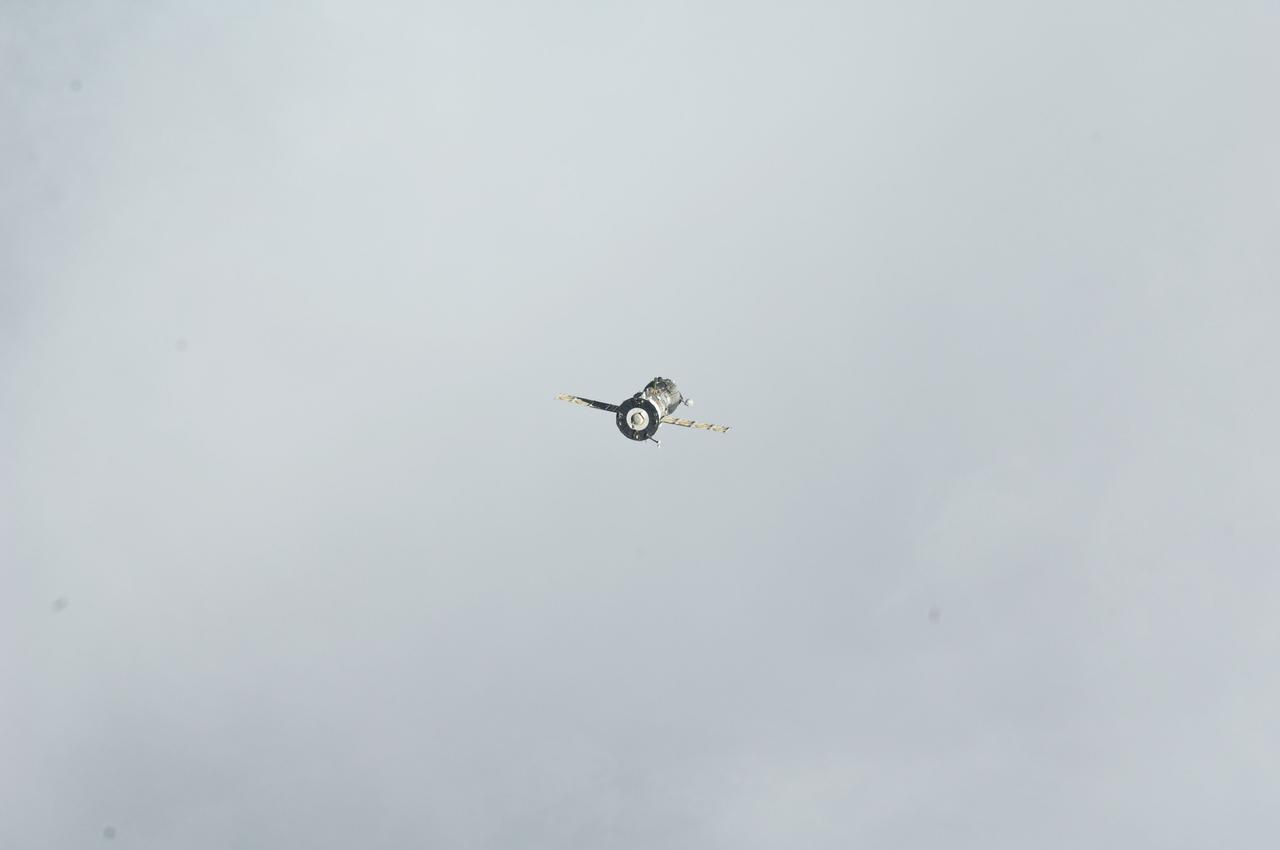
ISS029-E-005030 (16 Sept. 2011) --- Backdropped against a grayish sky, the Soyuz TMA-21 spacecraft departs from the International Space Station and heads toward a landing in a remote area outside the town of Zhezkazgan, Kazakhstan, on Sept. 16, 2011. NASA astronaut Ron Garan, flight engineer, along with Expedition 28 commander Andrey Borisenko and flight engineer Alexander Samokutyaev, both of the Russian Federal Space Agency, are returning from more than five months onboard the International Space Station where they served as members of the Expedition 27 and 28 crews.
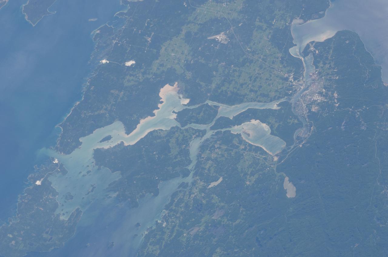
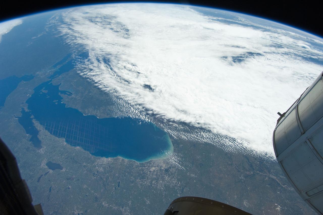
ISS028-E-010162 (29 June 2011) --- Sault Ste Marie, Ontario and Michigan are featured in this image photographed by an Expedition 28 crew member on the International Space Station. The twin cities of Sault Ste Marie are located across the St. Mary?s River that forms part of the international boundary between Canada (Province of Ontario) and the United States (State of Michigan). This photograph highlights the two cities, together with the region of lakes and islands that separates Lakes Huron and Superior, two of the Great Lakes of North America. Smaller lakes include Lake George to the west; the large forested islands of St. Joseph and Drummond are visible at lower left. The Sault Ste Marie urban areas (upper right) have a distinctive gray to white coloration in the image, contrasting with the deep green of forested areas in Ontario and the lighter green of agricultural fields in Michigan. The coloration of water surfaces in the lakes and rivers varies from blue to blue-green to silver, and is likely caused by varying degrees of sediment and sunglint ? light reflecting back to the observer on the space station from the water surface, much as light reflects from a mirror. Prior to formalization of the US/Canada border in 1817, Sault Ste Marie was a single community. Archeological evidence suggests that the region had been occupied by Native Americans at least five hundred years ago. A mission ? the first European settlement in Michigan ? was established there in 1668 by the French Jesuit Father Jacques Marquette. Today, shipping locks and canals in both urban areas are an important part of the Great Lakes shipping traffic system.
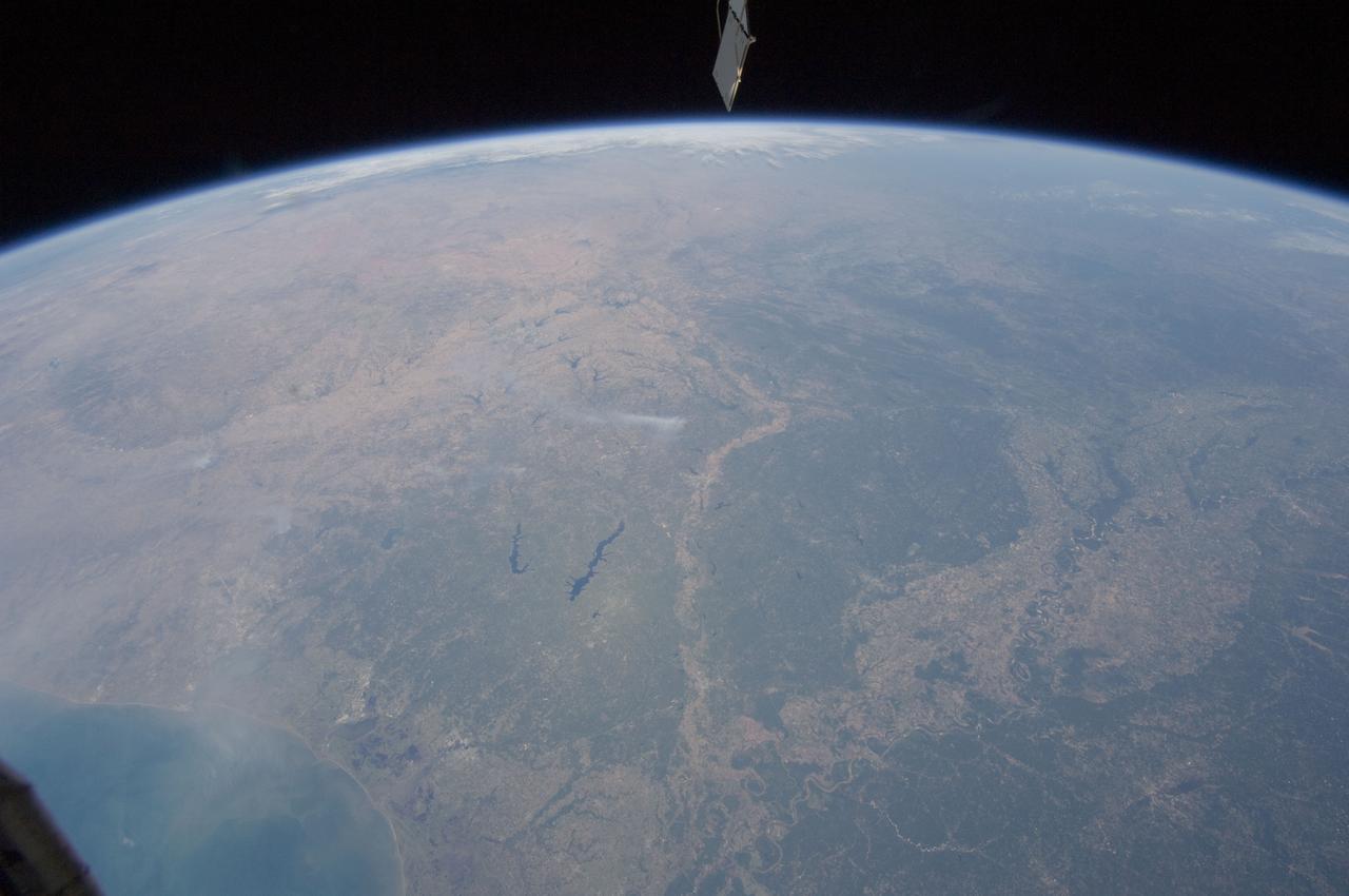
ISS028-E-044746 (7 Sept. 2011) --- From over the Pacific Ocean, one of the Expedition 28 crew members aboard the International Space Station snapped this picture showing Baja California, the Gulf of Cortez and parts of California on Sept. 7, 2011.
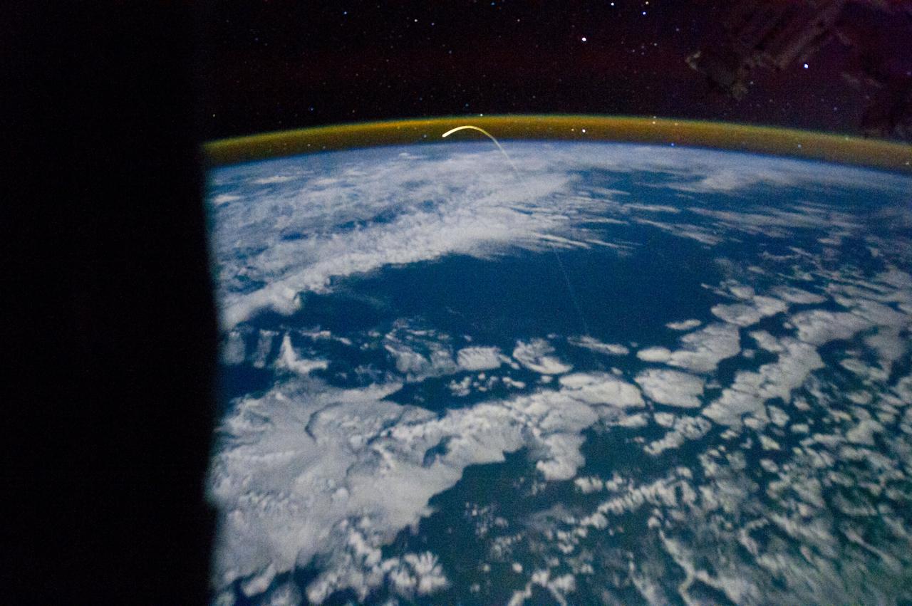
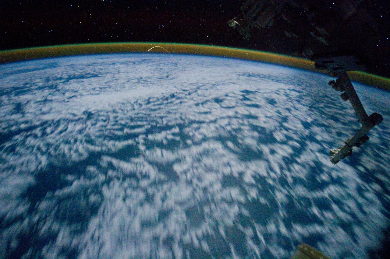
ISS028-E-016952 (14 July 2011) --- One of the members of the joint crews for STS-135 and International Space Station Expedition 28 exposed this image of Atlantis and its robot arm over Earth's horizon and its faint thin line of airglow, a station solar array panel and the Japanese Experiment Module Exposed Facility (JEF).

ISS028-E-035407 (31 Aug. 2011) --- Katia was a tropical storm gathering energy over the Atlantic Ocean when one of the Expedition 28 crew members took this oblique photo on Aug. 31 from aboard the International Space Station. The picture, taken with a 12-mm focal length, was captured at 14:10:16 GMT. Later in the day Katia was upgraded to hurricane status. Two Russian spacecraft -- a Progress and a Soyuz -- can be seen parked at the orbital outpost on the left side of the frame.
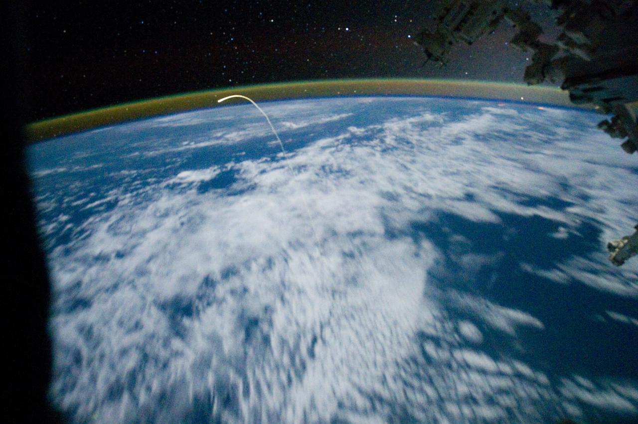
ISS028-E-018218 (21 July 2011) --- This unprecedented view of the space shuttle Atlantis, appearing like a bean sprout against clouds and city lights, on its way home, was photographed by the Expedition 28 crew of the International Space Station. Airglow over Earth can be seen in the background.
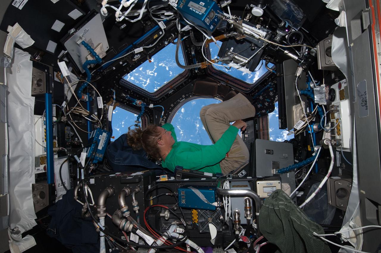
ISS028-E-017074 (16 July 2011) --- When asked by a reporter if she noticed a difference in the International Space Station on her current visit with the Atlantis STS-135 crew, versus an earlier lengthy visit, NASA astronaut Sandy Magnus mentioned the Cupola's addition, which was not on the station during her earlier stay there. This is one of series of photos showing Magnus, mission specialist for the Space Shuttle Program's final flight, taking advantage of the zero gravity of space and the panoramic view provided by the multi-windowed Cupola.
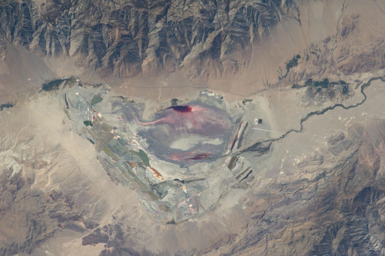
ISS028-E-035137 (30 Aug. 2011) --- Owens Lake in California is featured in this image photographed by an Expedition 28 crew member on the International Space Station. This photograph highlights the mostly dry bed of Owens Lake, located in the Owens River Valley between the Inyo Mountains and the Sierra Nevada. Shallow groundwater, springs, and seeps support minor wetlands and a central brine pool. Two bright red areas along the margins of the brine pool indicate the presence of halophilic, or salt-loving organisms known as Achaeans. Grey and white materials within the lake bed are exposed lakebed sediments and salt crusts. The towns of Olancha and Lone Pine are delineated by the presence of green vegetation indicating a more constant availability of water. According to scientists, the present-day Owens Lake was part of a much larger lake and river system that existed during the Pleistocene Epoch (approximately 3 million to approximately 12,000 years ago) along the current northeastern border of California with Nevada. Meltwater from alpine glaciers in the Sierra Nevada filled the regional valleys of the Basin and Range to form several glacial lakes that were ancestral to the now-dry lakebeds (or playas) of Owens, Searles Lake, and China Lake. While Searles and China Lakes dried out due to regional changes to a hotter and drier climate over thousands of years, Owens Lake became desiccated largely due to the diversion of Owens River water in the early 20th century to serve the needs of the City of Los Angeles, CA located 266 kilometers to the south. Following complete desiccation of the lakebed in 1926, significant amounts of windblown dust were produced ? indeed, the term ?Keeler fog? was coined by residents of the now largely abandoned town on the eastern side of Owens Lake due to the dust. In addition to adverse health effects on local residents, dust from Owens Lake has been linked to visibility reduction in nearby national parks, forests, and wilderness areas. Recently, efforts to control dust evolution from the lakebed have been undertaken by the City of Los Angeles.
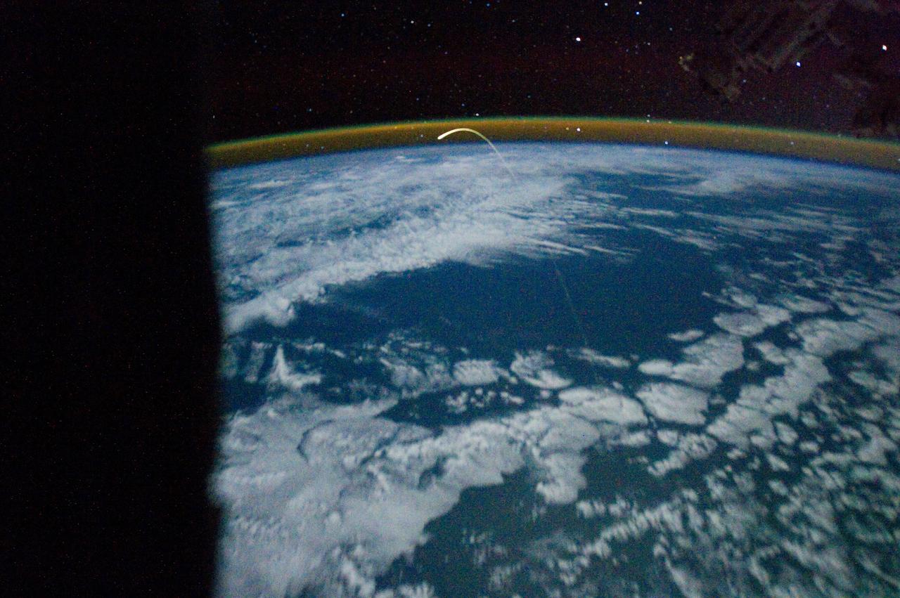
ISS028-E-018200 (21 July 2011) --- This unprecedented view of the space shuttle Atlantis, appearing like a bean sprout against clouds and city lights, on its way home, was photographed by the Expedition 28 crew of the International Space Station. Airglow over Earth can be seen in the background.

ISS028-E-014909 (8 July 2011) --- Russian cosmonauts Andrey Borisenko (left), Expedition 28 commander; Alexander Samokutyaev (center) and Sergei Volkov, both flight engineers, are pictured with Russian Elektron oxygen generator systems in the Zvezda Service Module of the International Space Station.
ISS029-E-007455 (18 Sept. 2011) --- This is one of a series of night time images photographed by one of the Expedition 29 crew members from the International Space Station. It features Aurora Australis, airglow, Earth?s Terminator and the southeastern Indian Ocean. Nadir coordinates are 51.78 degrees south latitude and 124.41 degrees east longitude.
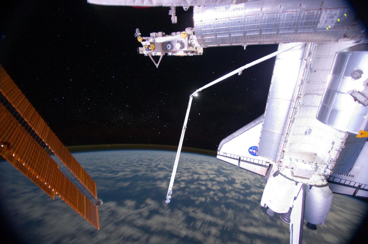
ISS028-E-016955 (14 July 2011) --- One of the members of the joint crews for STS-135 and International Space Station Expedition 28 exposed this image of Atlantis and its robot arm over Earth's horizon and its faint thin line of airglow, a station solar array panel and the Japanese Experiment Module Exposed Facility (JEF).
ISS028-E-020969 (3 Aug. 2011) --- Russian cosmonauts Sergei Volkov and Alexander Samokutyaev (out of frame), both Expedition 28 flight engineers, attired in Russian Orlan spacesuits, participate in a session of extravehicular activity (EVA) on the Russian segment of the International Space Station. During the six-hour, 23-minute spacewalk, Volkov and Samokutyaev moved a cargo boom from one airlock to another, installed a prototype laser communications system and deployed an amateur radio micro-satellite.

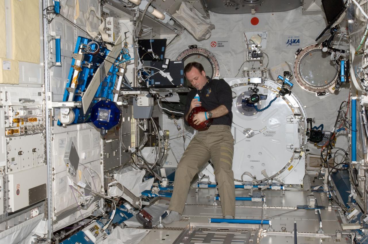
ISS029-E-005506 (16 Sept. 2011) --- Japan Aerospace Exploration Agency astronaut Satoshi Furukawa, Expedition 29 flight engineer, prepares to rehydrate a food packet at the galley in the Zvezda Service Module of the International Space Station.
ISS028-E-044831 (7 Sept. 2011) --- While many of the Great Lakes and their surrounding areas are covered by the remnants of Tropical Storm Lee and upper level low over Michigan and southeastern Canada, Lake Michigan and Chicago are mostly clear and can be easily delineated (lower left center) in this image. The view was photographed by one of the Expedition 28 crew members aboard the International Space Station on Sept. 7, 2011.
ISS028-E-033315 (19 Aug. 2011) --- City lights illuminate this night time view of southern California, Mexico's Baja California and the Gulf of Cortez, as photographed by one the Expedition 28 crew members onboard the International Space Station flying at altitude of approximately 220 miles. A 15-mm focal length was used to capture the time lapse image. The thin line of Earth's atmosphere is visible above the horizon.

ISS028-E-020303 (2 Aug. 2011) --- NASA astronaut Ron Garan (foreground) and Japan Aerospace Exploration Agency astronaut Satoshi Furukawa, both Expedition 28 flight engineers, use computers in the International Space Station?s Kibo laboratory to monitor the Japanese Experiment Module Remote Manipulator System (JEMRMS) located on the exterior of the station.

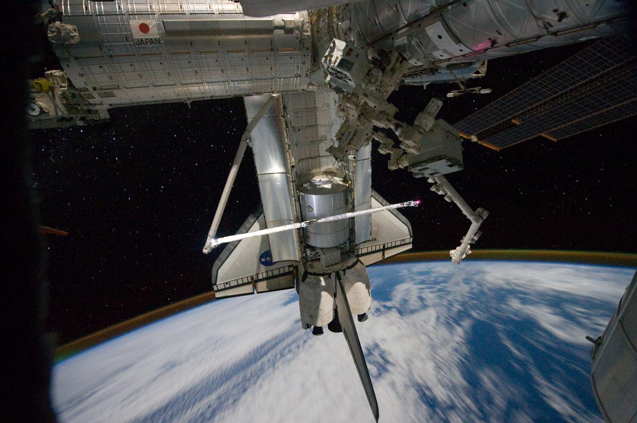
ISS028-E-016148 (12 July 2011) --- NASA astronaut Ron Garan, Expedition 28 flight engineer, is pictured in the International Space Station's Quest airlock prior to a July 12 spacewalk he performed outside the docked station and space shuttle Atlantis with station crewmate Mike Fossum (out of frame). NASA astronauts Garan and Fossum a short time later joined forces to complete some needed chores during the six and half hour spacewalk.
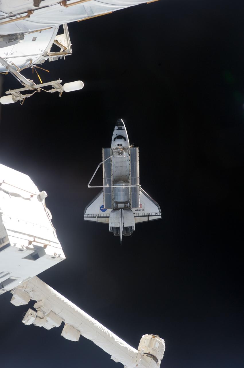
ISS028-E-018032 (19 July 2011) --- This picture of the space shuttle Atlantis was photographed from the International Space Station as the orbiting complex and the shuttle performed their relative separation in the early hours of July 19, 2011. The Raffaello multi-purpose logistics module, which transported tons of supplies to the complex, can be seen in the cargo bay. It is filled with different materials from the station for return to Earth. Onboard the station were Russian cosmonauts Andrey Borisenko, Expedition 28 commander; Sergei Volkov and Alexander Samokutyaev, both flight engineers; Japan Aerospace Exploration astronaut Satoshi Furukawa, and NASA astronauts Mike Fossum and Ron Garan, all flight engineers. Onboard the shuttle were NASA astronauts Chris Ferguson, STS-135 commander; Doug Hurley, pilot; Sandy Magnus and Rex Walheim, both mission specialists.
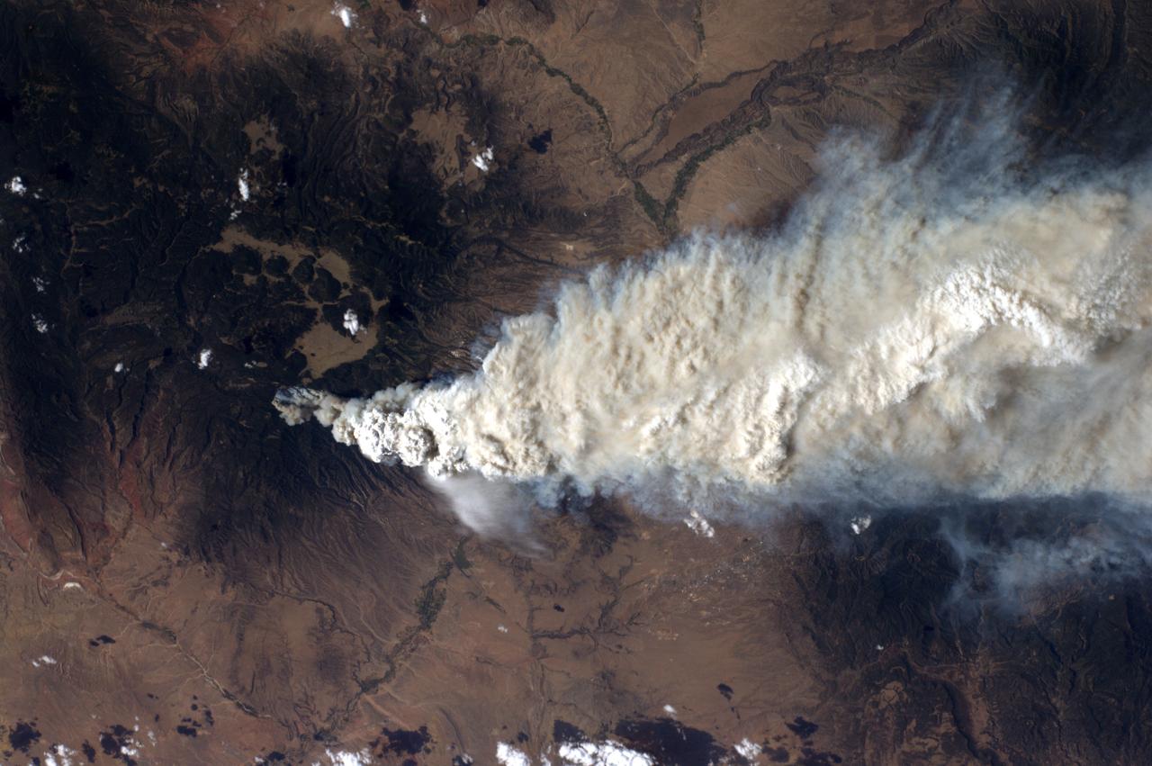
ISS028-E-010044 (27 June 2011) --- A crew member aboard the International Space Station, flying at an altitude of approximately 235 statute miles on June 27, 2011, exposed this still photograph of a major fire in the Jemez Mountains of the Santa Fe National Forest in north-central New Mexico. The fire is just southwest of Los Alamos National Laboratories.
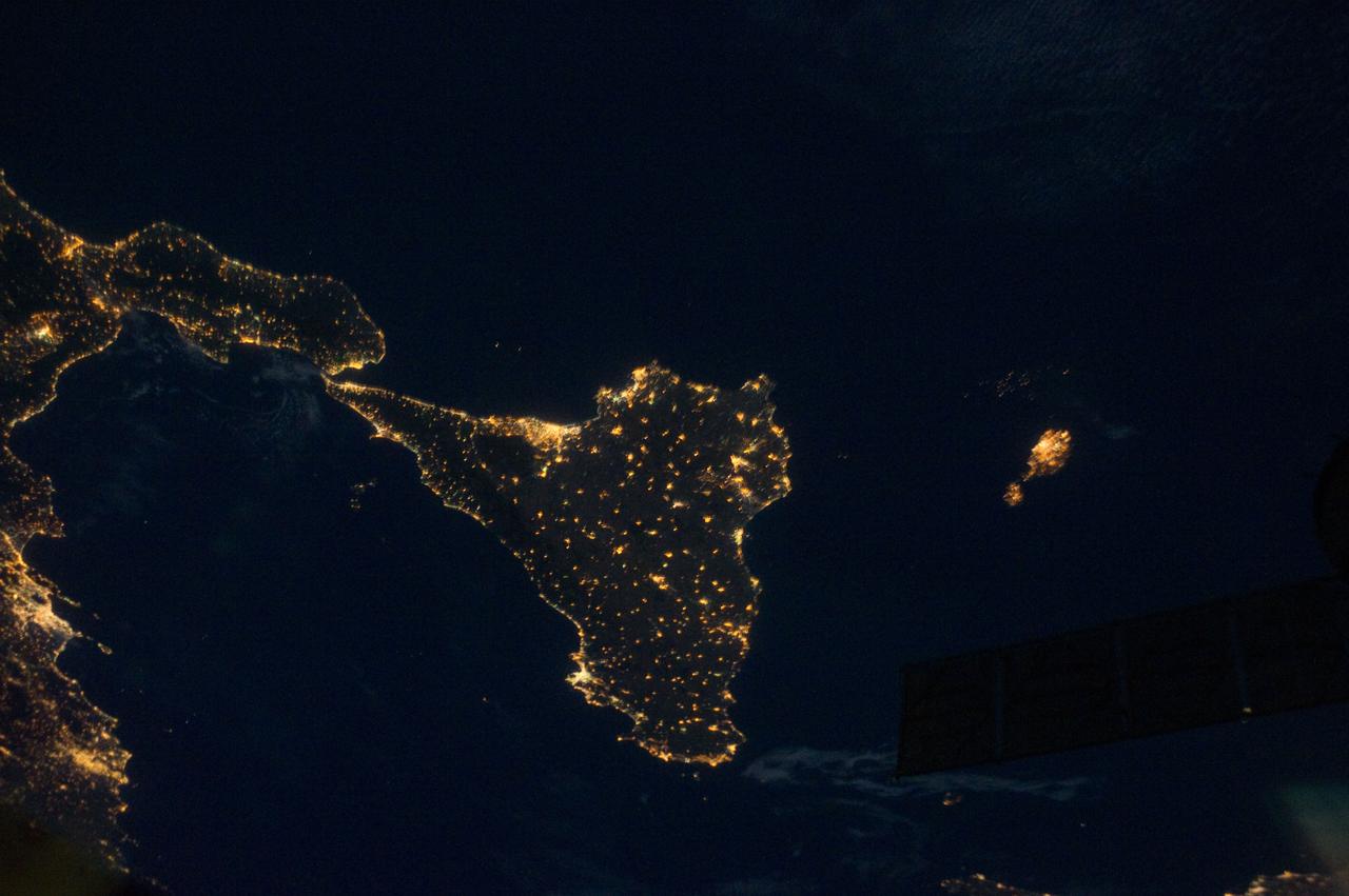
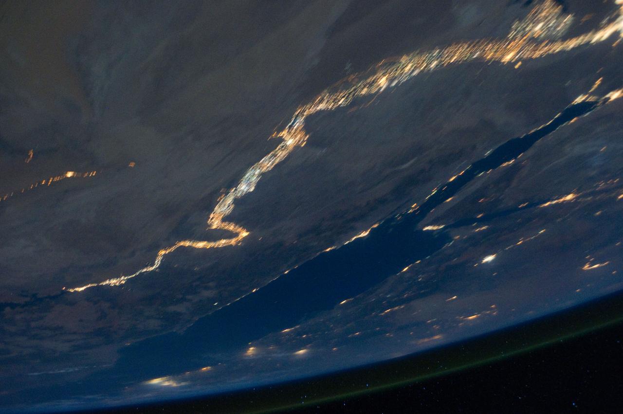
ISS028-E-033104 (18 Aug. 2011) --- Sicily is featured in this night time image captured by one of the Expedition 28 crew members aboard the International Space Station, approximately 220 miles above Earth. The land mass at left edge is part of the "toe" of Italy's "boot." A 38-mm lens was used to record the image.
ISS028-E-010043 (27 June 2011) --- A crew member aboard the International Space Station, flying at an altitude of approximately 235 statute miles on June 27, 2011, exposed this still photograph of a major fire in the Jemez Mountains of the Santa Fe National Forest in north-central New Mexico. The fire is just southwest of Los Alamos National Laboratories, which can be seen just right of center.

ISS028-E-020311 (2 Aug. 2011) --- From inside the International Space Station?s Kibo laboratory, Japan Aerospace Exploration Agency astronaut Satoshi Furukawa (foreground) and NASA astronaut Ron Garan, both Expedition 28 flight engineers, monitor the Japanese Experiment Module Remote Manipulator System (JEMRMS) located on the exterior of the station.
ISS029-E-005343 (16 Sept. 2011) --? One of the Expedition 29 crew members aboard the International Space Station, approximately 220 miles above Earth, took this night time picture showing clouds, lightning, airglow, Earth's terminator and lights of civilization along the central west coast of Africa. Nadir coordinates are 9.04 degrees south latitude and 10.18 degrees east longitude.
ISS029-E-007502 (18 Sept. 2011) --- This is one of a series of night time images photographed by one of the Expedition 29 crew members from the International Space Station. It features Aurora Australis, airglow, and parts of the southeast Indian Ocean. Nadir coordinates are 50.58 degrees south latitude and 138.28 degrees east longitude.
ISS029-E-031157 (15 Oct. 2011) --- One of the Expedition 29 crew members aboard the International Space Station recorded this oblique view showing the Mediterranean Sea area, including the Nile River and the river's delta, and the Sinai Peninsula, on Oct. 15, 2011. Cyprus is visible at left. At first look, the image appears to have been photographed in daylight, but actually it was taken at 01:01:08 GMT. Some areas of the photo like the river and river delta appear as the brightest areas because of either man-made lighting (mostly incandescent) or man-made lighting reflected off nearby surfaces. The other areas appear to be illuminated naturally by moonlight, starlight, or back-scattered light from the atmosphere. A 20-mm focal length was used to record the image.
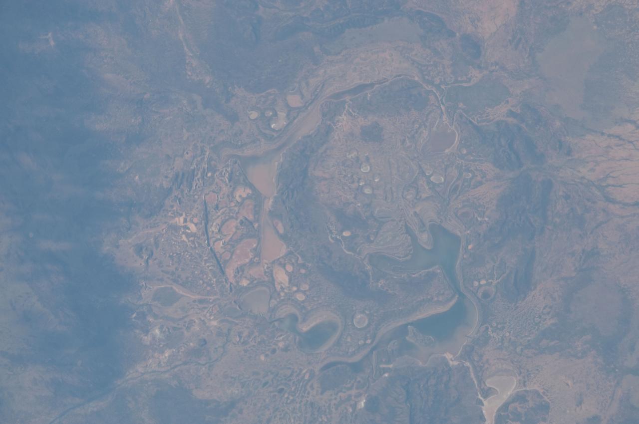
ISS028-E-014782 (6 July 2011) --- The Shoemaker (formerly Teague) Impact Structure, located in Western Australia in a drainage basin south of the Waldburg Range, presents an other-worldly appearance in this detailed photograph recorded from onboard the International Space Station on July 6. The Shoemaker impact site is approximately 30 kilometers in diameter, and is clearly defined by concentric ring structures formed in sedimentary rocks (brown to dark brown, image center) that were deformed by the impact event approximately 1630 million years ago, according to the Earth Impact Database. Several saline and ephemeral lakes?Nabberu, Teague, Shoemaker, and numerous smaller ponds?occupy the land surface between the concentric ring structures. Differences in color result from both water depth and suspended sediments, with some bright salt crusts visible around the edges of smaller ponds (image center The Teague Impact Structure was renamed Shoemaker in honor of the late Dr. Eugene M. Shoemaker, a pioneer in the field of impact crater studies and planetary geology, and founder of the Astrogeology Branch of the United States Geological Survey. The image was recorded with a digital still camera using a 200 mm lens, and is provided by the ISS Crew Earth Observations experiment and Image Science & Analysis Laboratory, Johnson Space Center.

ISS028-E-016153 (12 July 2011) --- NASA astronaut Ron Garan, Expedition 28 flight engineer, is pictured over International Space Station's Destiny lab. With support from crewmates inside the station and shuttle , NASA astronauts Garan and Mike Fossum (out of frame) joined forces to complete some needed chores during a six and half hour spacewalk.
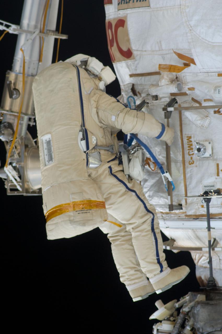
ISS028-E-020928 (3 Aug. 2011) --- Russian cosmonauts Sergei Volkov and Alexander Samokutyaev (out of frame), both Expedition 28 flight engineers, attired in Russian Orlan spacesuits, participate in a session of extravehicular activity (EVA) on the Russian segment of the International Space Station. During the six-hour, 23-minute spacewalk, Volkov and Samokutyaev moved a cargo boom from one airlock to another, installed a prototype laser communications system and deployed an amateur radio micro-satellite.
ISS028-E-020962 (3 Aug. 2011) --- Russian cosmonauts Sergei Volkov and Alexander Samokutyaev, both Expedition 28 flight engineers, attired in Russian Orlan spacesuits, participate in a session of extravehicular activity (EVA) on the Russian segment of the International Space Station. During the six-hour, 23-minute spacewalk, Volkov and Samokutyaev moved a cargo boom from one airlock to another, installed a prototype laser communications system and deployed an amateur radio micro-satellite.

ISS028-E-019589 (29 July 2011) --- Japan Aerospace Exploration Agency astronaut Satoshi Furukawa, Expedition 28 flight engineer, uses a still camera to photograph a microbial capture device in the Tranquility node of the International Space Station.
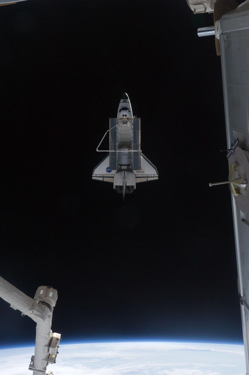
ISS028-E-018039 (19 July 2011) --- This picture of the space shuttle Atlantis was photographed from the International Space Station as the orbiting complex and the shuttle performed their relative separation in the early hours of July 19, 2011. The Raffaello multi-purpose logistics module, which transported tons of supplies to the complex, can be seen in the cargo bay. It is filled with different materials from the station for return to Earth. Onboard the station were Russian cosmonauts Andrey Borisenko, Expedition 28 commander; Sergei Volkov and Alexander Samokutyaev, both flight engineers; Japan Aerospace Exploration astronaut Satoshi Furukawa, and NASA astronauts Mike Fossum and Ron Garan, all flight engineers. Onboard the shuttle were NASA astronauts Chris Ferguson, STS-135 commander; Doug Hurley, pilot; Sandy Magnus and Rex Walheim, both mission specialists.
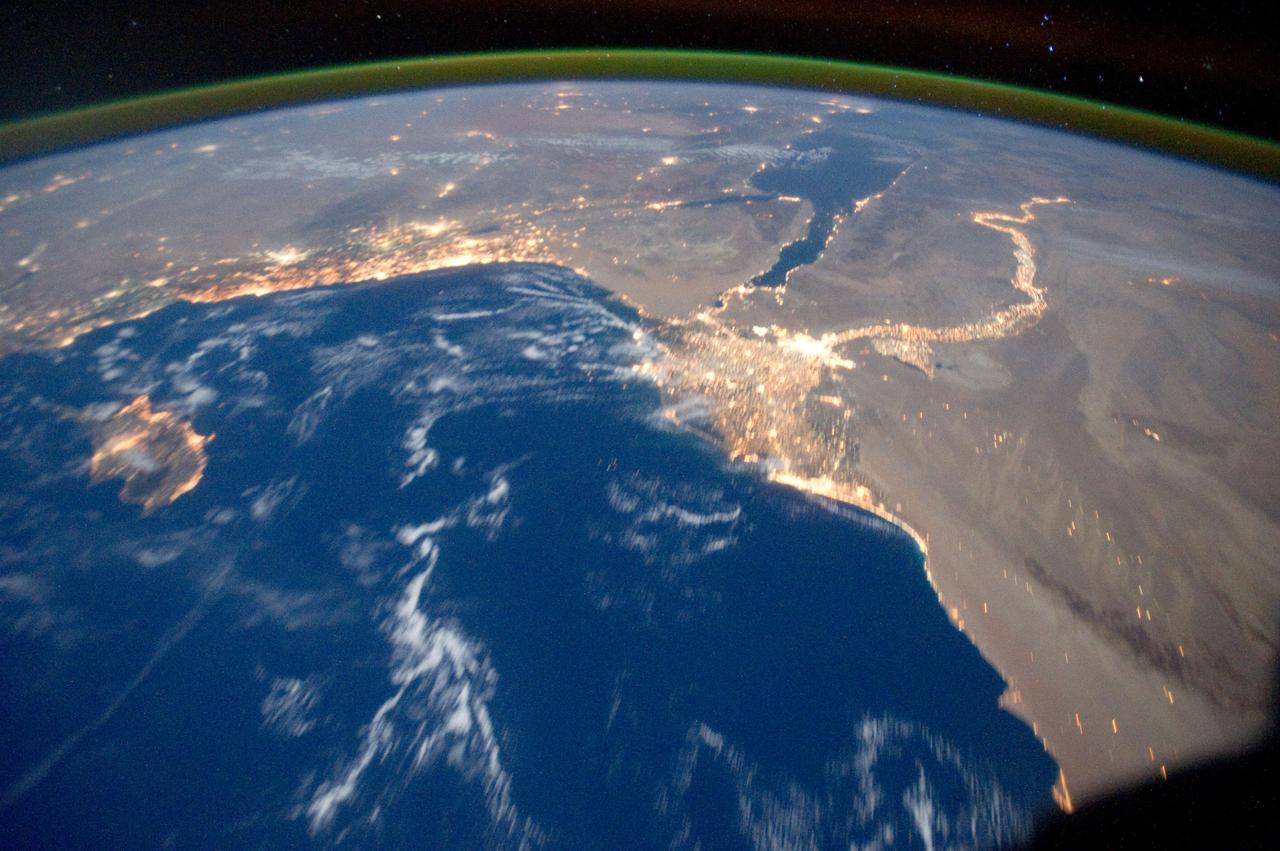
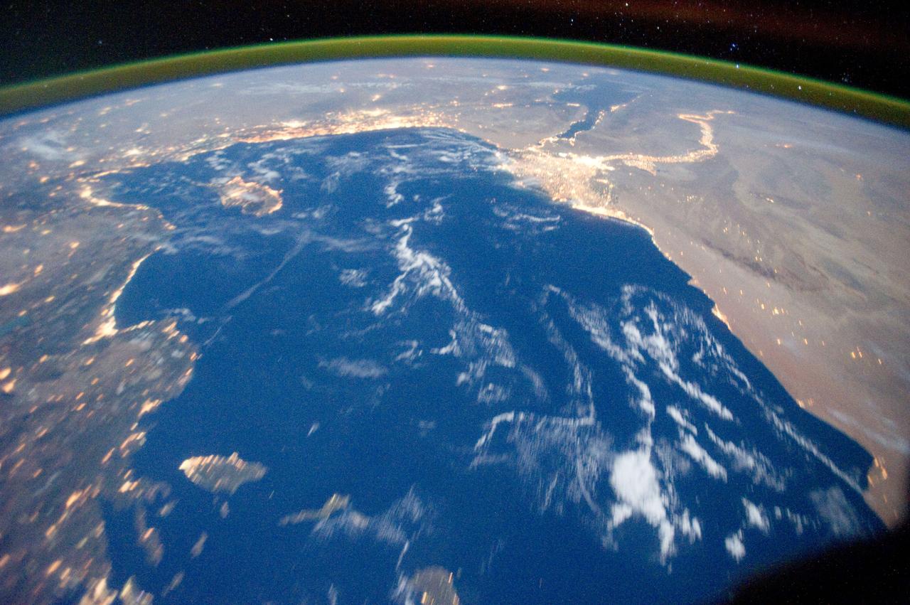
ISS028-E-033124 (18 Aug. 2011) --- The Nile River and the Sinai Peninsula can be easily delineated in this night time photo captured by one of the Expedition 28 crew members aboard the International Space Station, flying at an altitude of approximately 220 miles. A 42-mm focal length was used to record the image.

ISS029-E-021997 (2 Oct. 2011) --- This is one of a series of night time images photographed by one of the Expedition 29 crew members from the International Space Station. It features Central and Eastern Europe. The view includes the northeast portion of Italy, Germany, Poland, and Hungary. The station was over Corsica at 44.19 degrees north latitude and 12.13 degrees east longitude.

ISS028-E-020926 (3 Aug. 2011) --- Russian cosmonauts Sergei Volkov and Alexander Samokutyaev (out of frame), both Expedition 28 flight engineers, attired in Russian Orlan spacesuits, participate in a session of extravehicular activity (EVA) on the Russian segment of the International Space Station. During the six-hour, 23-minute spacewalk, Volkov and Samokutyaev moved a cargo boom from one airlock to another, installed a prototype laser communications system and deployed an amateur radio micro-satellite.
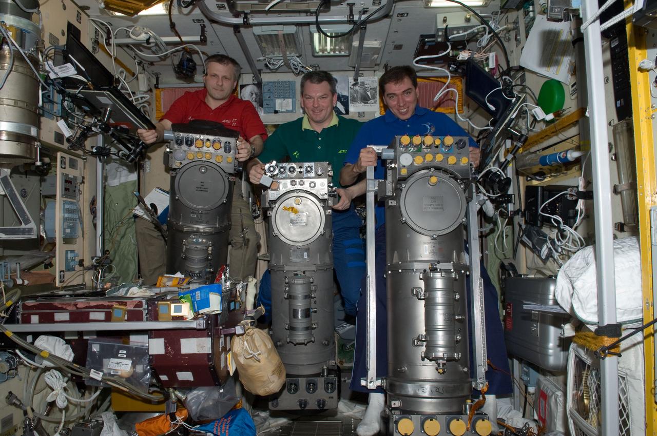
ISS028-E-014908 (8 July 2011) --- Russian cosmonauts Andrey Borisenko (left), Expedition 28 commander; Alexander Samokutyaev (center) and Sergei Volkov, both flight engineers, are pictured with Russian Elektron oxygen generator systems in the Zvezda Service Module of the International Space Station.
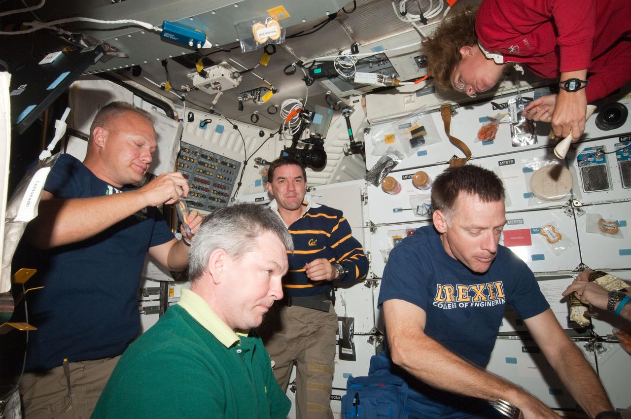
ISS028-E-016601 (14 July 2011) --- The four STS-135 crewmembers, quite accustomed to going en masse to the International Space Station, reverse roles for the occasion of the "All-American Meal" on the middeck of the space shuttle Atlantis. Russian cosmonaut Alexander Samokutyaev, Expedition 28 flight engineer, shares the meal the Atlantis crew in the frame and with five of his station crewmates, who are out of frame. The STS-135 crewmembers are NASA astronauts Chris Ferguson (right), mission commander, along with Doug Hurley (left), pilot; and Sandy Magnus and Rex Walheim, both mission specialists.
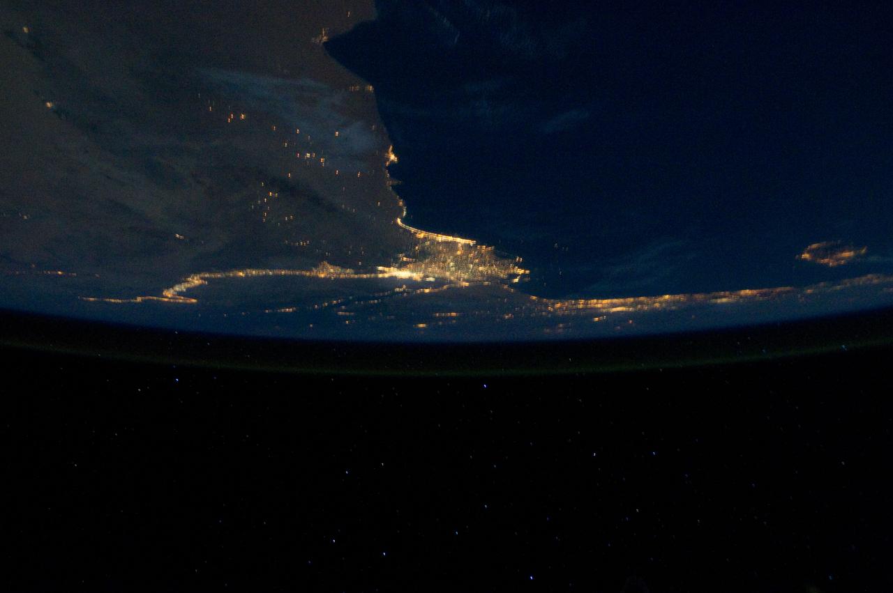
ISS028-E-033108 (18 Aug. 2011) --- The Nile River Delta and part of the Mediterranean Sea can be seen in this night time photo captured by one of the Expedition 28 crew members aboard the International Space Station, flying at an altitude of approximately 220 miles. A 38-mm focal length was used to record the image.
ISS029-E-005352 (16 Sept. 2011) --? One of the Expedition 29 crew members aboard the International Space Station, flying at an altitude of approximately 220 miles, took this night time picture showing Africa's Congo coast, clouds, airglow and Earth's terminator. Nadir coordinates are 5.32 degrees south latitude and 12.86 degrees east longitude.
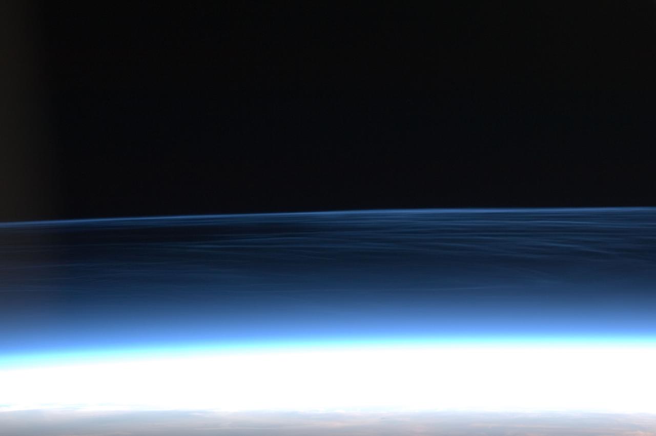
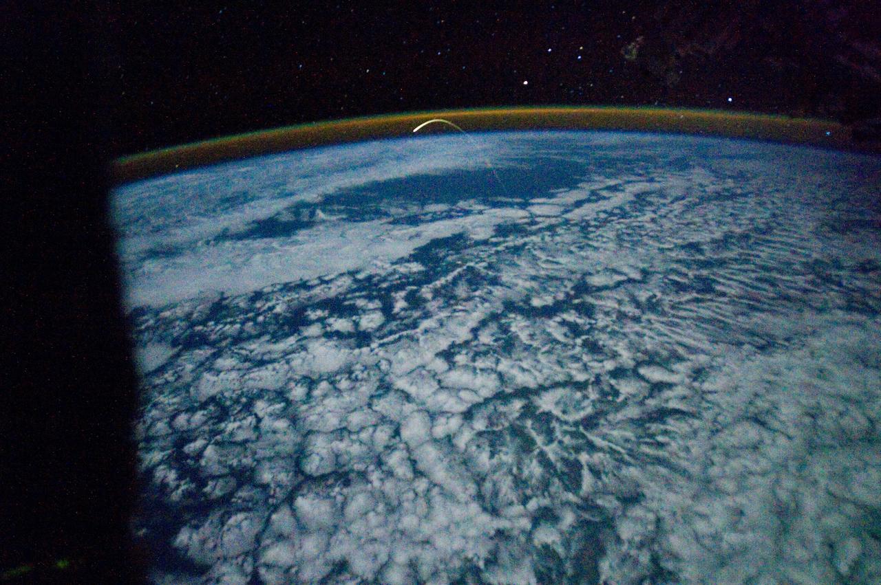
ISS028-E-020276 (2 Aug. 2011) --- This photograph of polar mesospheric clouds was acquired at an altitude of just over 202 nautical miles (about 322 kilometers) in the evening hours (03:19:54 Greenwich Mean Time) on Aug. 2, 2011, as the International Space Station was passing over the English Channel. The nadir coordinates of the station were 49.1 degrees north latitude and 5.5 degrees west longitude. Polar mesospheric clouds (also known as noctilucent, or ?night-shining? clouds) are transient, upper atmospheric phenomena that are usually observed in the summer months at high latitudes (greater than 50 degrees) of both the Northern and Southern Hemispheres. They appear bright and cloudlike while in deep twilight. They are illuminated by sunlight when the lower layers of the atmosphere are in the darkness of Earth?s shadow. The horizon of Earth appears at the bottom of the image, with some layers of the lower atmosphere already illuminated by the rising sun. The higher, bluish-colored clouds look much like wispy cirrus clouds, which can be found as high as 60,000 feet (18 kilometers) in the atmosphere. However noctilucent clouds, as seen here, are observed in the mesosphere at altitudes of 250,000 to 280,000 feet (about 76 to 85 kilometers). Astronaut observations of polar mesospheric clouds over northern Europe in the summer are not uncommon.
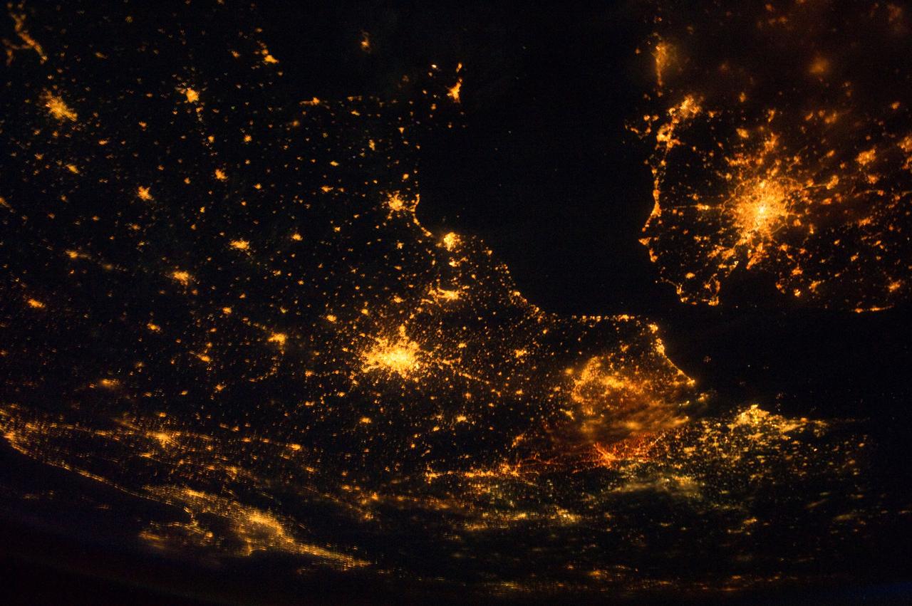
ISS028-E-024360 (10 Aug. 2011) --- This night time view of northwestern Europe is featured in this image photographed by an Expedition 28 crew member on the International Space Station. Several of the oldest cities of northwestern Europe are highlighted in this photograph taken at 00:25:26 Greenwich Mean Time (GMT). While the landscape is dotted with numerous clusters of lights from individual urban areas, the metropolitan areas of London (United Kingdom), Paris (France), Brussels (Belgium) and Amsterdam (Netherlands) stand out due to their large light ?footprints?. The metropolitan area of Milan, Italy is also visible at lower left. This photograph was taken with a short camera lens, providing the large field of view recorded in the image. To give a sense of scale, the centers of the London and Paris metropolitan areas are approximately 340 kilometers distant from each other. The image is also oblique, or taken while looking outward at an angle from the station; this tends to foreshorten the image, making the distance between Paris and Milan (approximately 640 kilometers) appear less than that of Paris to London. In contrast to the land surface defined by the city lights, the English Channel at right presents a uniform dark appearance. Similarly, the Alps (bottom center) to the north of Milan are also largely devoid of lights. While much of the atmosphere was clear at the time the image was taken, the lights of the Brussels metropolitan area are dimmed by thin cloud cover.
ISS029-E-005312 (16 Sept. 2011) --? One of the Expedition 29 crew members aboard the International Space Station, flying at an altitude of approximately 220 miles, took this picture over the South Atlantic Ocean, showing airglow, a number of stars and moon glint (on lower left side of image). Nadir coordinates are 37.17 degrees south latitude and 16.7 degrees west longitude.
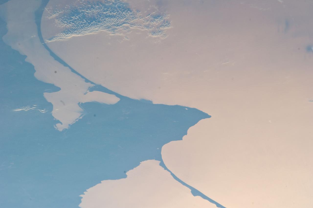
ISS028-E-024146 (2 Aug. 2011) --- Kaliningrad and Baltic Sea, Russia are featured in this image photographed by an Expedition 28 crew member on the International Space Station. This striking photograph reveals detail of the two great lagoons to the north and south of Kaliningrad, each protected from the open waters of the Baltic Sea by the thin perfect curves of current-generated sand spits. A broad arm of agricultural country separates the freshwater lagoons?known as Kurshsky Bay (or the Curonian Lagoon further north in Lithuania, just outside the top of the image) and the Vistula Lagoon. From the crew member perspective in low Earth orbit, land surfaces usually appear brighter than water, which normally appears darker and often black. Reflected sunlight, or sunglint, inverts this pattern. The reflected light in this image is a pink or coppery hue, indicating the likely existence of smog in the air since smog particles enhance the red part of the light spectrum. Camera settings used to acquire sunglint images result in high contrast that reveals excellent detail of coastlines and surface features of waterbodies, but masks land surface detail. The thin, 50 kilometer-long barge canal leading from the Baltic Sea to Kaliningrad is visible but the great port of Kaliningrad itself is not. Other human patterns on this intensively developed landscape such as towns, highways and farm boundaries are likewise masked in the image. The area has a long human history. The growth of the Vistula spit finally cut off the north Polish city of Elblag (just outside the bottom of the image) from the Baltic Sea in the 13th century. To reconnect Elblag directly with the Baltic Sea, the EU is considering funding the digging of another canal through the spit at lower right, despite ecological concerns. Kaliningrad was heavily damaged during WWII and then annexed by Russia and cleared of its German population. As the only Russian port on the Baltic Sea to be ice-free year-round, Kaliningrad then gained importance strategically as home of the Baltic Fleet.
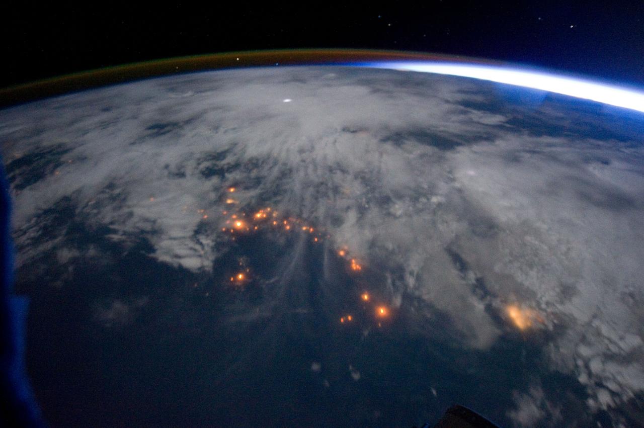
ISS028-E-037977 (6 Sept. 2011) --- The Texas wild fires that have destroyed and continue to destroy thousands of acres of timber and prairie land, as well as hundreds of residences, are visible basically over many of the dozens of affected points across the nation's second largest state. The Expedition 28 crew members on the International Space Station, flying approximately 220 miles above Earth, recorded this wide panoramic image of Texas and beyond, from a point over the Gulf of Mexico, at 16:11:22 GMT, Sept. 6, 2011.
ISS029-E-005026 (16 Sept. 2011) --- Backdropped against clouds, the Soyuz TMA-21 spacecraft departs from the International Space Station and heads toward a landing in a remote area outside the town of Zhezkazgan, Kazakhstan, on Sept. 16, 2011. NASA astronaut Ron Garan, flight engineer, along with Expedition 28 commander Andrey Borisenko and flight engineer Alexander Samokutyaev, both of the Russian Federal Space Agency, are returning from more than five months onboard the International Space Station where they served as members of the Expedition 27 and 28 crews.
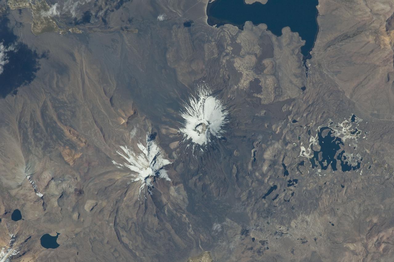
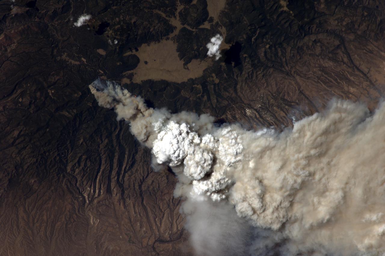
ISS029-E-020003 (7 Oct. 2011) --- Parinacota Volcano in the Chile-Bolivia border region, South America is featured in this image photographed by an Expedition 29 crew member on the International Space Station. Volcan Parinacota (?flamingo lake? in the regional Aymara language) is a potentially active stratovolcano located on the Altiplano, a high plateau situated within the Andes Mountains of west-central South America. While no direct observations of eruptive activity are recorded, surface exposure age-dating of lava flows suggests that activity occurred as recently as 290 AD approximately 300 years, according to scientists. Local Aymara stories also suggest that the volcano has erupted during the past 1,000 years. This detailed photograph highlights the symmetrical cone of Parinacota, with its well-developed summit crater (elevation 6,348 meters above sea level) at center. Dark brown to dark gray surfaces to the east and west of the summit include lava flows, pyroclastic deposits, and ash. A companion volcano, Pomerape, is located across a low saddle to the north ? scientists believe this volcano last erupted during the Pleistocene Epoch (extending from approximately 3 million to 12,000 years ago). The summits of both volcanoes are covered by white permanent snowpack and small glaciers. Together, the two volcanoes form the Nevados de Payachata volcanic area. Eruptive activity at Parinacota has directly influenced development of the local landscape beyond the emplacement of volcanic deposits ? approximately 8,000 years ago the western flank of the volcano collapsed, creating a debris avalanche that traveled 22 kilometers to the west. This debris avalanche blocked drainages, leading to the formation of Lake Chungara to the south (upper right). The uneven, hummocky surface of the debris avalanche deposit provides ample catchments for water, as evidenced by the numerous small ponds and Cotacotani Lake to the west.
ISS028-E-037979 (6 Sept. 2011) --- The Texas wild fires that have destroyed and continue to destroy thousands of acres of timber and prairie land, as well as hundreds of residences, are visible basically over many of the dozens of affected points across the nation's second largest state. The Expedition 28 crew members on the International Space Station, flying approximately 220 miles above Earth, recorded this wide panoramic image of Texas and beyond, from a point over the Gulf of Mexico, at 16:18:12 GMT, Sept. 6, 2011.
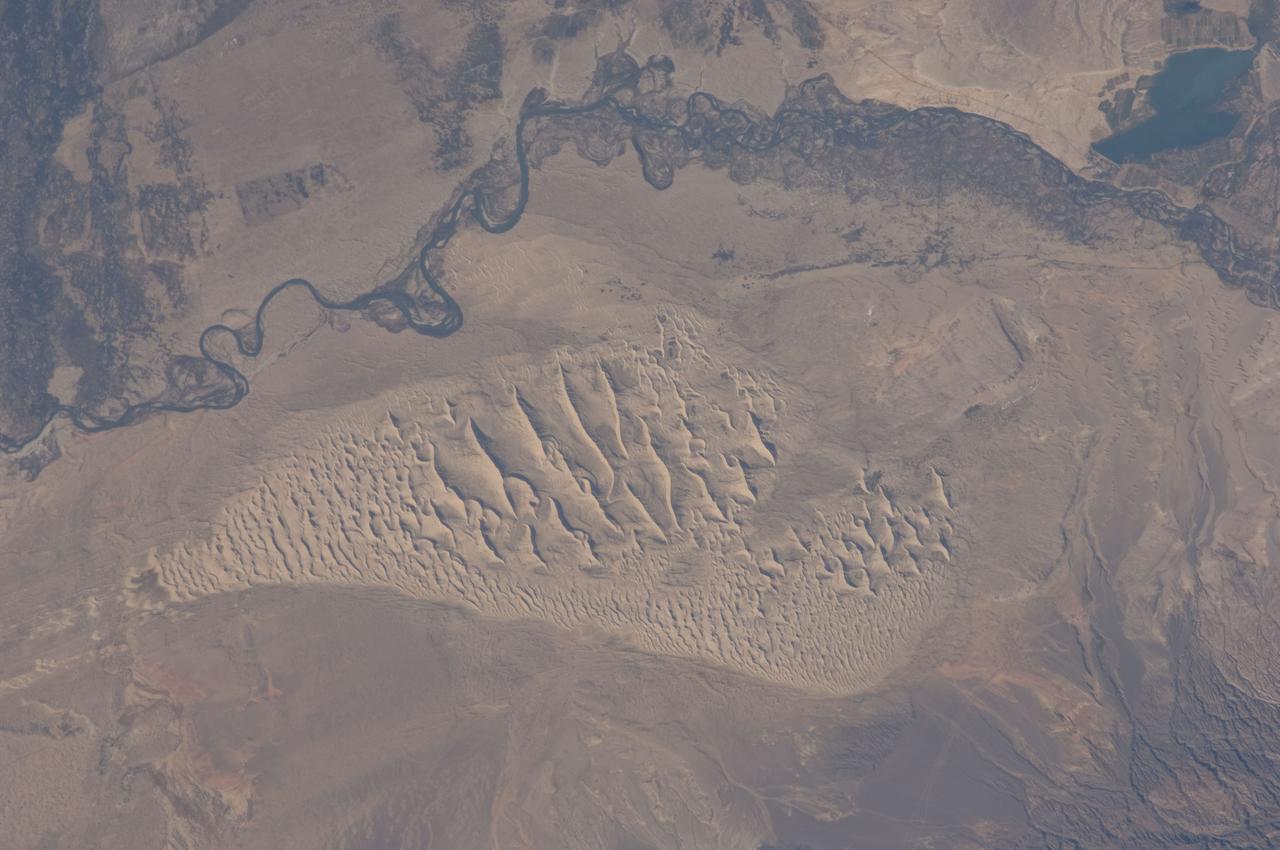
ISS028-E-044444 (8 Sept. 2011) --- This image, photographed by an Expedition 28 crew member on the International Space Station, highlights a sand dune field within the Burqin-Haba River-Jimunai Desert near the borders of China, Mongolia, Russia and Kazakhstan. The dune field (approximately 32 kilometers long) is located immediately to the west-northwest of the city of Burqin (not shown), and is part of the Junggar Basin, a region of active petroleum production in northwestern China. The Irtysh River, with associated wetlands and riparian vegetation (appearing grey-green in the image) flows from its headwaters in the Altay Mountains to the east towards Siberia to the west (right to left). Tan sandy linear dunes at center on the south side of the Irtysh River dominate the view. The linear dunes are formed from mobile barchan (crescent-shaped) dunes moving from left to right in this view; the barchans eventually merge to form the large linear dunes some of which reach 50-100 meters in height. Sand moving along the southern edge of the dune field appears to be feeding a southeastern lobe with a separate population of linear dunes (lower right). The Burqin-Haba River-Jimunai Desert area also includes darker gravel covered surfaces that form pavements known locally as gobi. These are somewhat indistinguishable from vegetated areas arresting some of the dunes at the resolution of the image, but tend to be located on the flat regions between the dunes.
ISS029-E-005021 (16 Sept. 2011) --- Backdropped against blue skies, the Soyuz TMA- 21 spacecraft departs from the International Space Station and heads toward a landing in a remote area outside the town of Zhezkazgan, Kazakhstan, on Sept. 16, 2011. NASA astronaut Ron Garan, flight engineer, along with Expedition 28 commander Andrey Borisenko and flight engineer Alexander Samokutyaev, both of the Russian Federal Space Agency, are returning from more than five months onboard the International Space Station where they served as members of the Expedition 27 and 28 crews.
ISS028-E-018188 (21 July 2011) --- This unprecedented view of the space shuttle Atlantis, appearing like a bean sprout against clouds and city lights, on its way home, was photographed by the Expedition 28 crew of the International Space Station. Airglow over Earth can be seen in the background.
ISS029-E-007500 (18 Sept. 2011) --- This is one of a series of night time images photographed by one of the Expedition 29 crew members from the International Space Station. It features the Aurora Australis, airglow and parts of the southeastern Indian Ocean. Nadir coordinates are 50.66 degrees south latitude and 137.70 degrees east longitude.
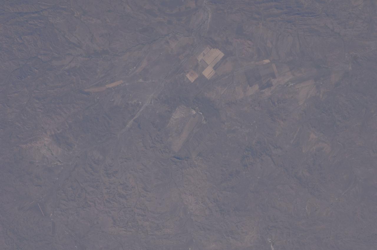
ISS028-E-044433 (8 Sept. 2011) --- Bigach Impact Crater in Kazakhstan is featured in this image photographed by an Expedition 28 crew member on the International Space Station. Some meteor impact craters, like Barringer Crater in Arizona, are easily recognizable on the landscape due to well-preserved form and features. Other impact structures, such as Bigach Impact Crater in northeastern Kazakhstan are harder to recognize due to their age, modification by subsequent geologic processes, or even human alteration of the landscape. According to scientists, at approximately 5 million years old, Bigach is a relatively young geologic feature; however active tectonic processes in the region have caused movement of parts of the structure along faults, leading to a somewhat angular appearance (center). The roughly circular rim of the eight kilometers in diameter structure is still discernable around the relatively flat interior in this photograph. In addition to modification by faulting and erosion, the interior of the impact structure has also been used for agricultural activities, as indicated by the presence of tan regular graded fields. Other rectangular agricultural fields are visible to the northeast and east. The closest settlement, Novopavlovka, is barely visible near the top of the image.
ISS028-E-045031 (8 Sept. 2011) --- This panoramic view of Texas, the Gulf of Mexico and surrounding area was photographed by one of the Expedition 28 crew members aboard the International Space Station. Big smoke near the Red River is from the Magnolia/Longview complex of fires; the fire just northwest of Houston (right center) is the Waller fire. A great deal of thicker smoke haze can be spotted coming from indeterminate sources.
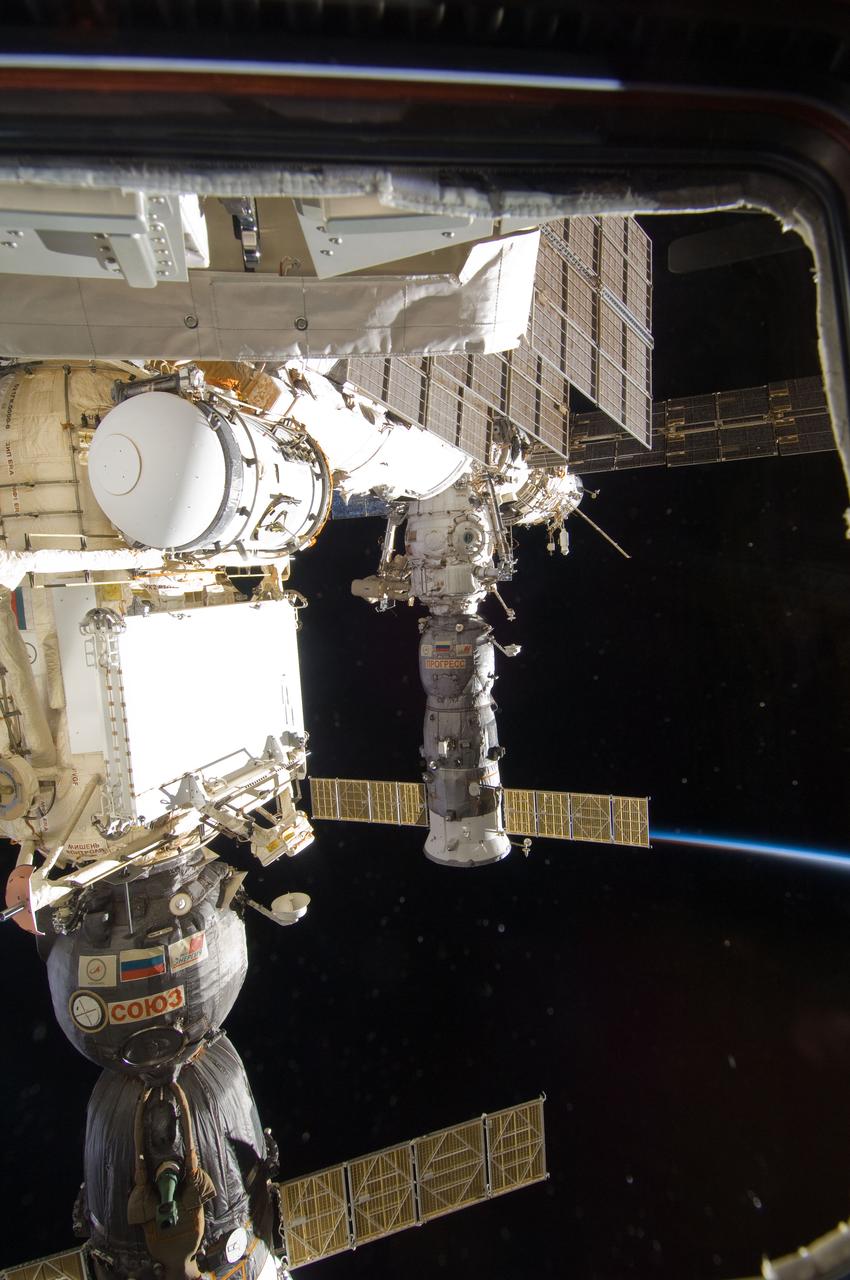
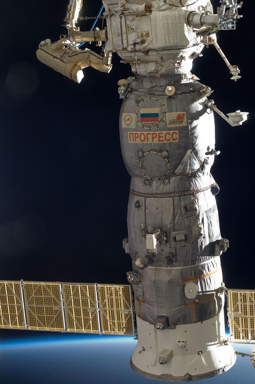
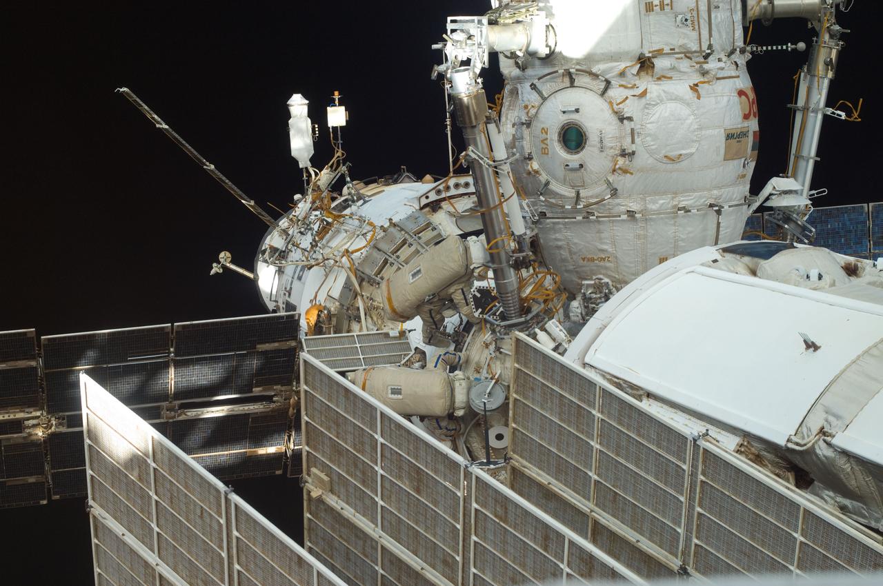
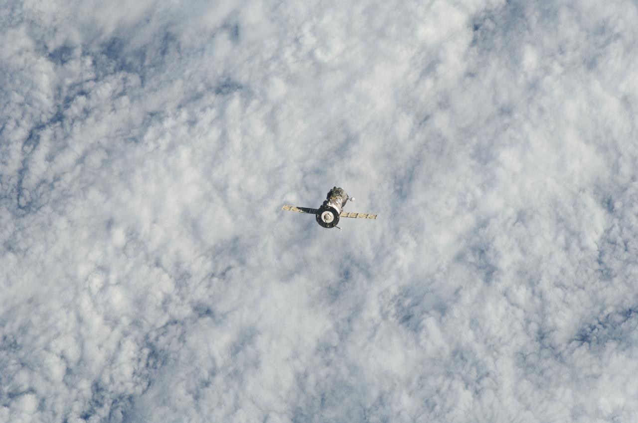
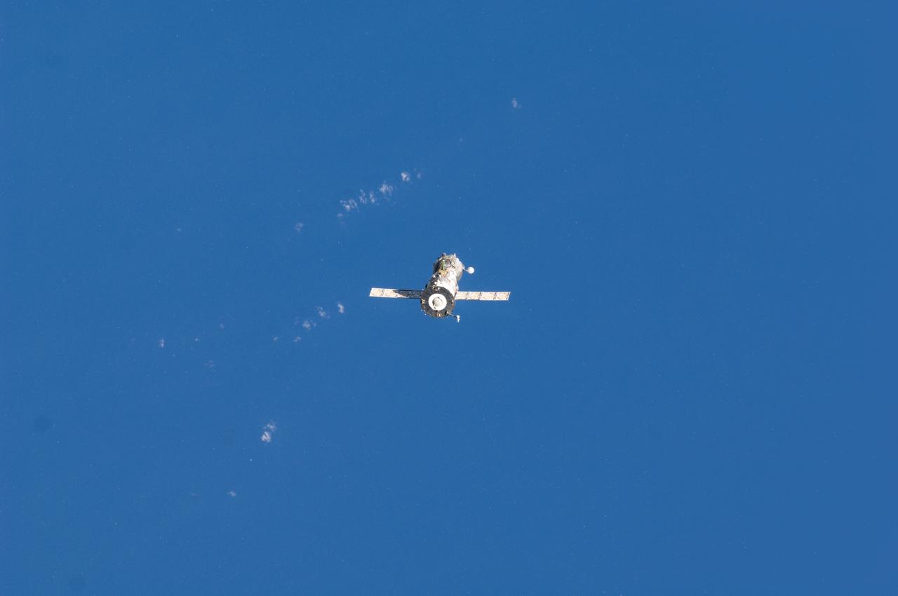
ISS028-E-020898 (3 Aug. 2011) --- Soyuz and Progress spacecraft docked to the International Space Station are featured in this image photographed during a session of extravehicular activity (EVA). Earth’s thin line of atmosphere and the blackness of space provide the backdrop for the scene.

ISS029-E-005064 (16 Sept. 2011) --- Backdropped by Earth?s horizon and the blackness of space, a docked Russian Soyuz spacecraft is featured in this image photographed by an Expedition 29 crew member on the International Space Station.
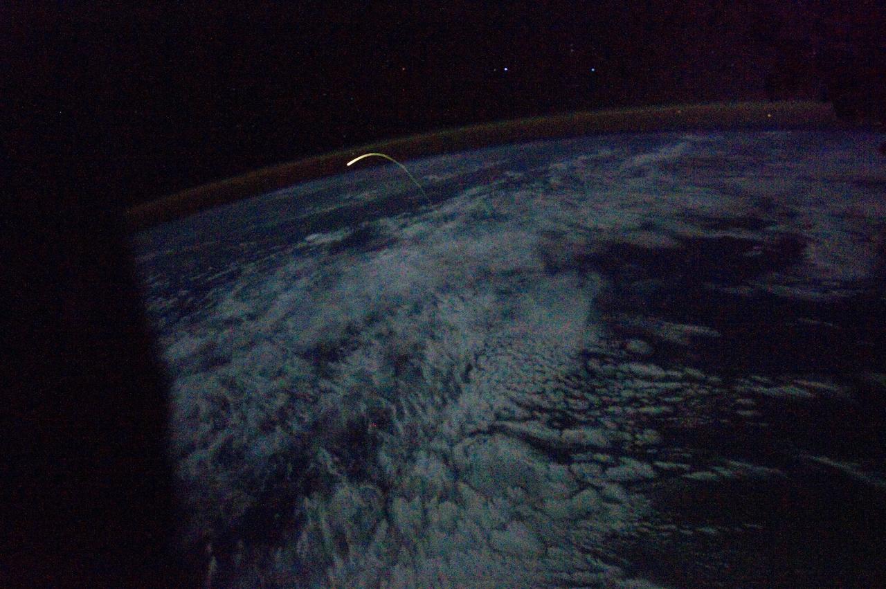
ISS028-E-018216 (21 July 2011) --- This unprecedented view of the space shuttle Atlantis, appearing like a bean sprout against the darkness of space, a faint line of airglow over a dark cloud-covered Earth, on its way home, was photographed by the crew of the International Space Station. Airglow over Earth can be seen in the background.

ISS028-E-016122 (12 July 2011) --- NASA astronaut Ron Garan, Expedition 28 flight engineer, uses a tether to secure his position during the July 12 spacewalk he performed outside the docked International Space Station and space shuttle Atlantis with station crewmate Mike Fossum (out of frame). The Persian Gulf can be seen on the Earth below. With support from crewmates inside the station and shuttle, NASA astronauts Garan and Fossum joined forces to complete some needed chores during the six and half hour spacewalk.
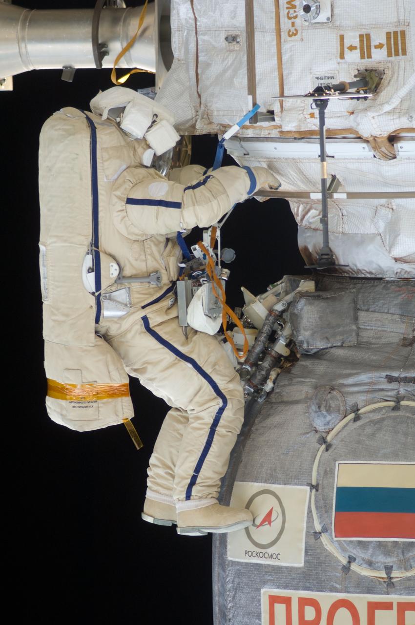
ISS028-E-020931 (3 Aug. 2011) --- Russian cosmonauts Sergei Volkov and Alexander Samokutyaev (out of frame), both Expedition 28 flight engineers, attired in Russian Orlan spacesuits, participate in a session of extravehicular activity (EVA) on the Russian segment of the International Space Station. During the six-hour, 23-minute spacewalk, Volkov and Samokutyaev moved a cargo boom from one airlock to another, installed a prototype laser communications system and deployed an amateur radio micro-satellite.
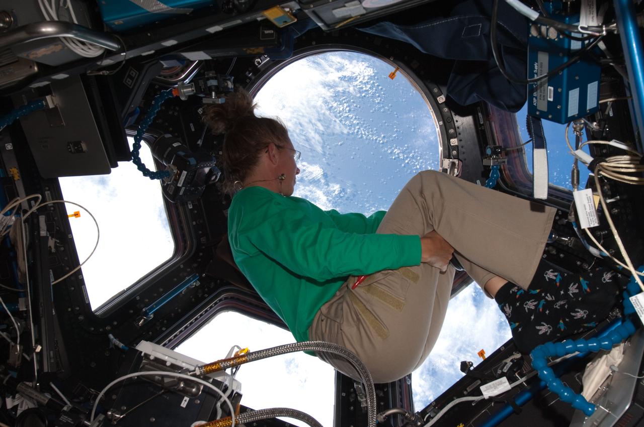
ISS028-E-017042 (16 July 2011) --- When asked by a reporter if she noticed a difference in the International Space Station on her current visit with the Atlantis STS-135 crew, versus an earlier lengthy visit, NASA astronaut Sandy Magnus mentioned the Cupola's addition, which was not on the station during her earlier stay there. This is one of series of photos showing Magnus, mission specialist for the Space Shuttle Program's final flight, taking advantage of the zero gravity of space and the panoramic view provided by the multi-windowed Cupola.
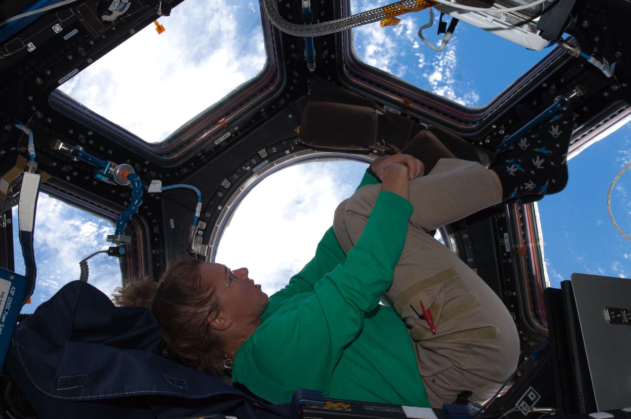
ISS028-E-017067 (16 July 2011) --- When asked by a reporter if she noticed a difference in the International Space Station on her current visit with the Atlantis STS-135 crew, versus an earlier lengthy visit, NASA astronaut Sandy Magnus mentioned the Cupola's addition, which was not on the station during her earlier stay there. This is one of series of photos showing Magnus, mission specialist for the Space Shuttle Program's final flight, taking advantage of the zero gravity of space and the panoramic view provided by the multi-windowed Cupola.
ISS028-E-018217 (21 July 2011) --- This unprecedented view of the space shuttle Atlantis, appearing like a bean sprout against clouds and city lights, on its way home, was photographed by the Expedition 28 crew on the International Space Station. Airglow over Earth can be seen in the background.
ISS028-E-025567 (16 Aug. 2011) --- NASA astronaut Ron Garan, Expedition 28 flight engineer, uses a communication system while holding one of the Synchronized Position Hold, Engage, Reorient, Experimental Satellites (SPHERES) in the Kibo laboratory of the International Space Station. A second SPHERES is at left.
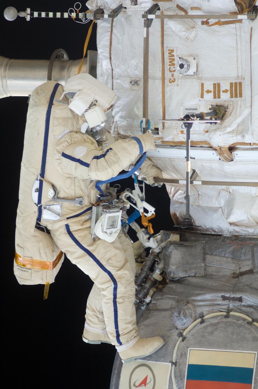
ISS028-E-020930 (3 Aug. 2011) --- Russian cosmonauts Sergei Volkov and Alexander Samokutyaev (out of frame), both Expedition 28 flight engineers, attired in Russian Orlan spacesuits, participate in a session of extravehicular activity (EVA) on the Russian segment of the International Space Station. During the six-hour, 23-minute spacewalk, Volkov and Samokutyaev moved a cargo boom from one airlock to another, installed a prototype laser communications system and deployed an amateur radio micro-satellite.
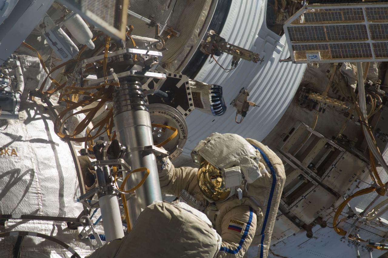
ISS028-E-020919 (3 Aug. 2011) --- Russian cosmonauts Sergei Volkov and Alexander Samokutyaev (out of frame), both Expedition 28 flight engineers, attired in Russian Orlan spacesuits, participate in a session of extravehicular activity (EVA) on the Russian segment of the International Space Station. During the six-hour, 23-minute spacewalk, Volkov and Samokutyaev moved a cargo boom from one airlock to another, installed a prototype laser communications system and deployed an amateur radio micro-satellite.
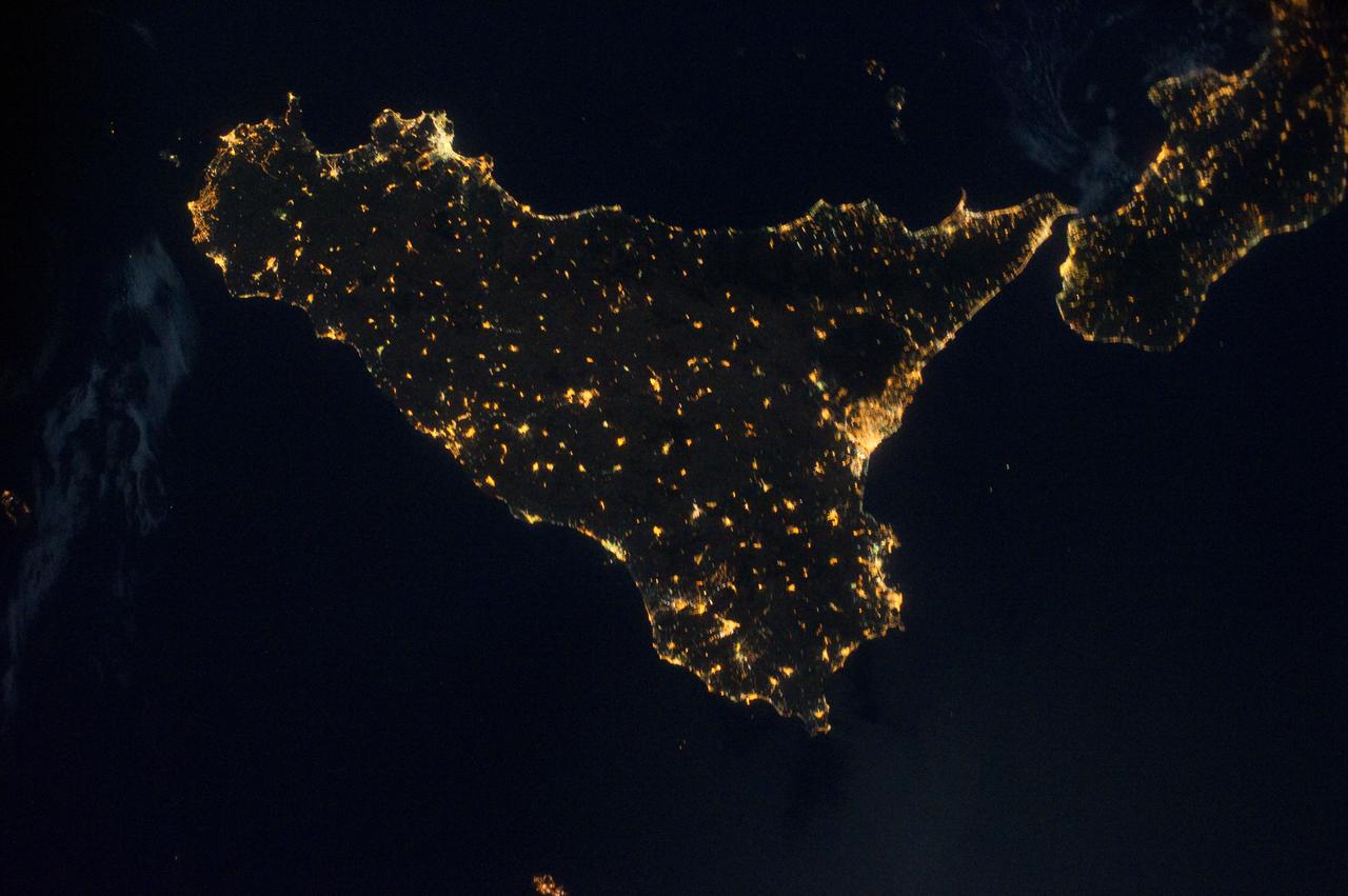
ISS028-E-033099 (18 Aug. 2011) --- Sicily is featured in this night time image captured by one of the Expedition 28 crew members aboard the International Space Station, approximately 220 miles above Earth. The land mass in upper right corner is part of the "toe" of Italy's "boot." A 32-mm focal length was used to record the image.
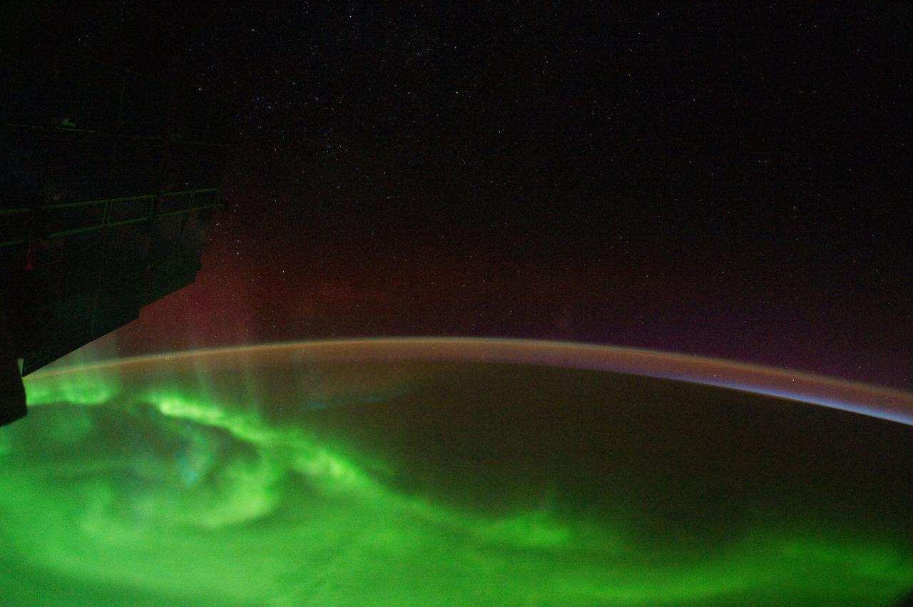
ISS029-E-007473 (18 Sept. 2011) --- This is one of a series of night time images photographed by one of the Expedition 29 crew members from the International Space Station. It features Aurora Australis, airglow, Earth?s Terminator and parts of the southeast Indian Ocean. Nadir coordinates are 51.53 degrees south latitude and 129.80 degrees east longitude.
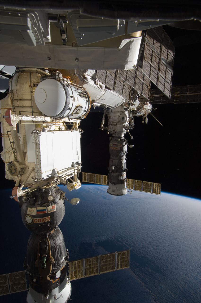
ISS028-E-020889 (3 Aug. 2011) --- Soyuz and Progress spacecraft docked to the International Space Station are featured in this image photographed during a session of extravehicular activity (EVA). Earth’s horizon and the blackness of space provide the backdrop for the scene.
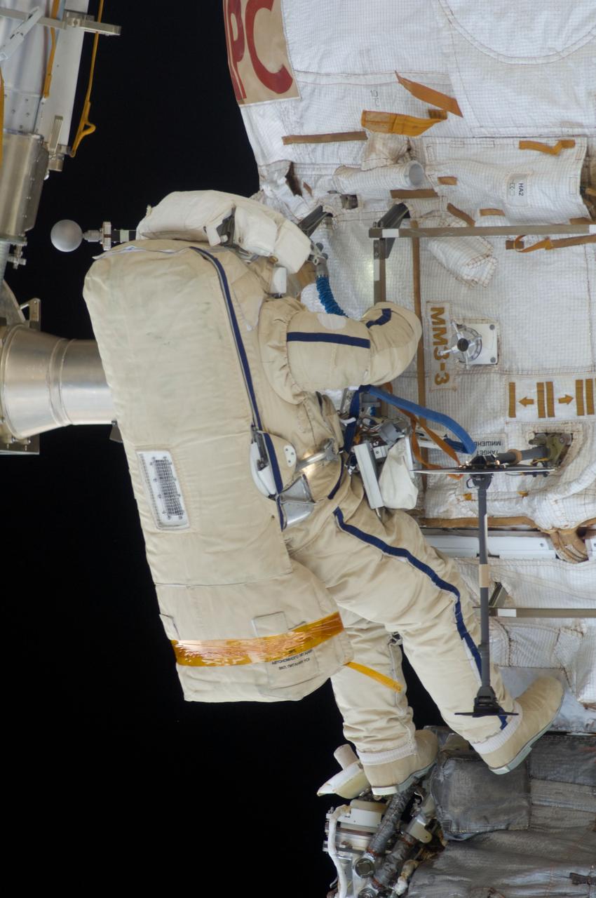
ISS028-E-020929 (3 Aug. 2011) --- Russian cosmonauts Sergei Volkov and Alexander Samokutyaev (out of frame), both Expedition 28 flight engineers, attired in Russian Orlan spacesuits, participate in a session of extravehicular activity (EVA) on the Russian segment of the International Space Station. During the six-hour, 23-minute spacewalk, Volkov and Samokutyaev moved a cargo boom from one airlock to another, installed a prototype laser communications system and deployed an amateur radio micro-satellite.
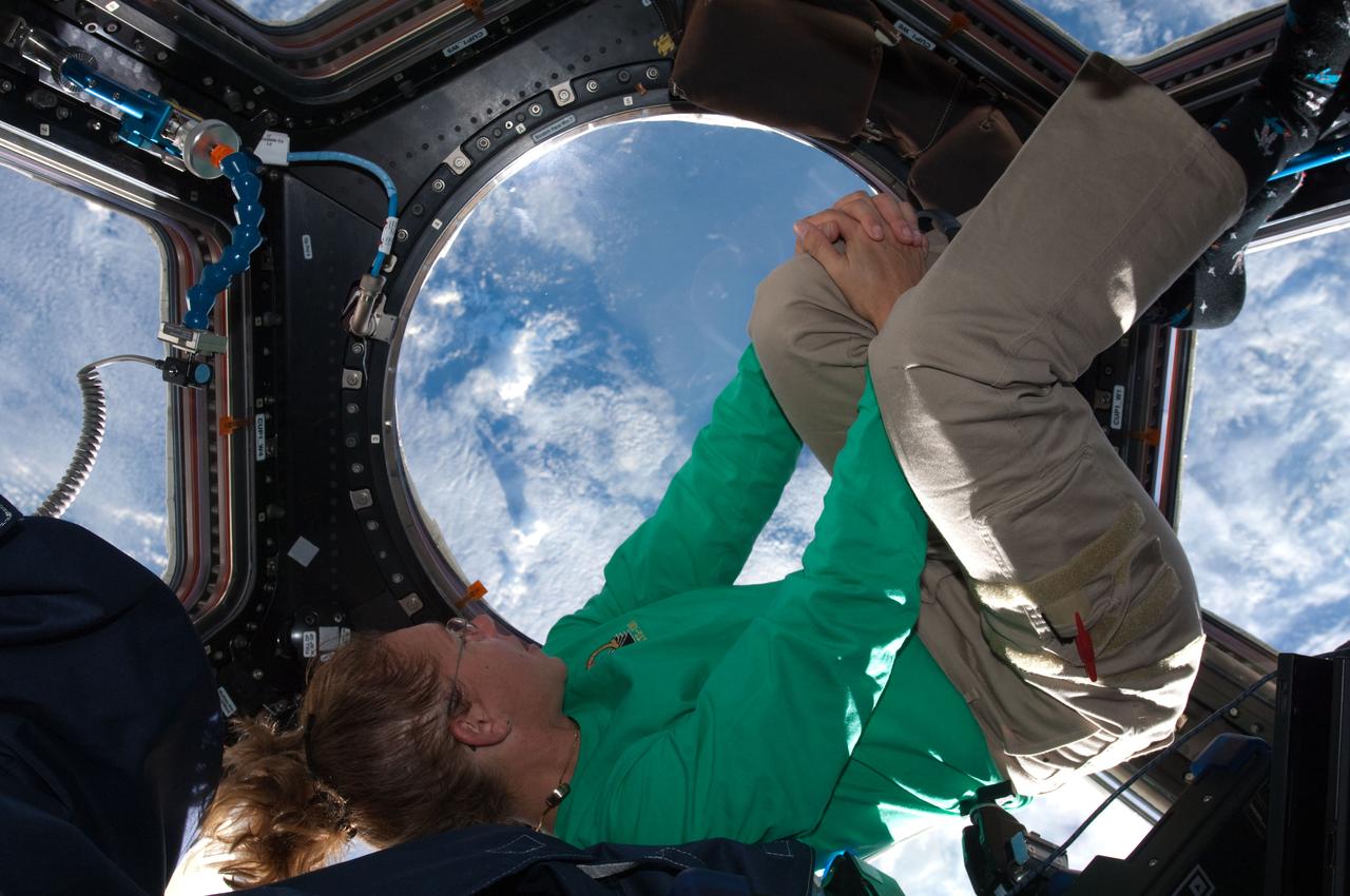
ISS028-E-017083 (16 July 2011) --- When asked by a reporter if she noticed a difference in the International Space Station on her current visit with the Atlantis STS-135 crew, versus an earlier lengthy visit, NASA astronaut Sandy Magnus mentioned the Cupola's addition, which was not on the station during her earlier stay there. This is one of series of photos showing Magnus, mission specialist for the Space Shuttle Program's final flight, taking advantage of the zero gravity of space and the panoramic view provided by the multi-windowed Cupola.
ISS028-E-033307 (19 Aug. 2011) --- City lights illuminate this night time view of southern California, Mexico's Baja California and the Gulf of Cortez, as photographed by one the Expedition 28 crew members onboard the International Space Station flying at altitude of approximately 220 miles. The Salton Sea can be seen in the lower right quadrant of the frame. A solar panel and part of one of the space station's modules are silhouetted at right. A 15-mm focal length was used to capture the time lapse image. The thin line of Earth's atmosphere is visible above the horizon.
ISS029-E-031143 (15 Oct. 2011) --- One of the Expedition 29 crew members aboard the International Space Station recorded this oblique view showing the Mediterranean Sea area, including parts of Turkey, the Nile River and the river's delta, and the Sinai Peninsula, on Oct. 15, 2011. At first look, the image appears to have been photographed in daylight, but actually it was taken at 01:01:26 GMT. Some areas of the photo like the river and river delta appear as the brightest areas because of either man-made lighting (mostly incandescent) or man-made lighting reflected off nearby surfaces. The other areas appear to be illuminated naturally by moonlight, starlight, or back-scattered light from the atmosphere. A 20-mm focal length was used to record the image.
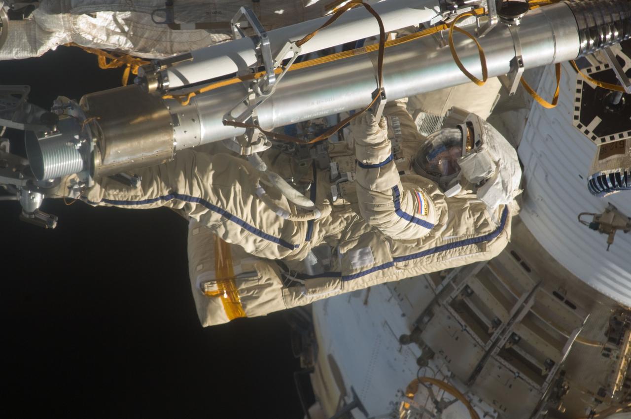
ISS028-E-020911 (3 Aug. 2011) --- Russian cosmonauts Sergei Volkov and Alexander Samokutyaev (out of frame), both Expedition 28 flight engineers, attired in Russian Orlan spacesuits, participate in a session of extravehicular activity (EVA) on the Russian segment of the International Space Station. During the six-hour, 23-minute spacewalk, Volkov and Samokutyaev moved a cargo boom from one airlock to another, installed a prototype laser communications system and deployed an amateur radio micro-satellite.

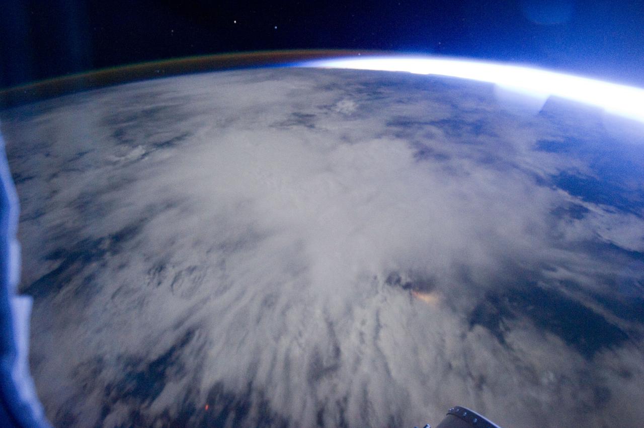
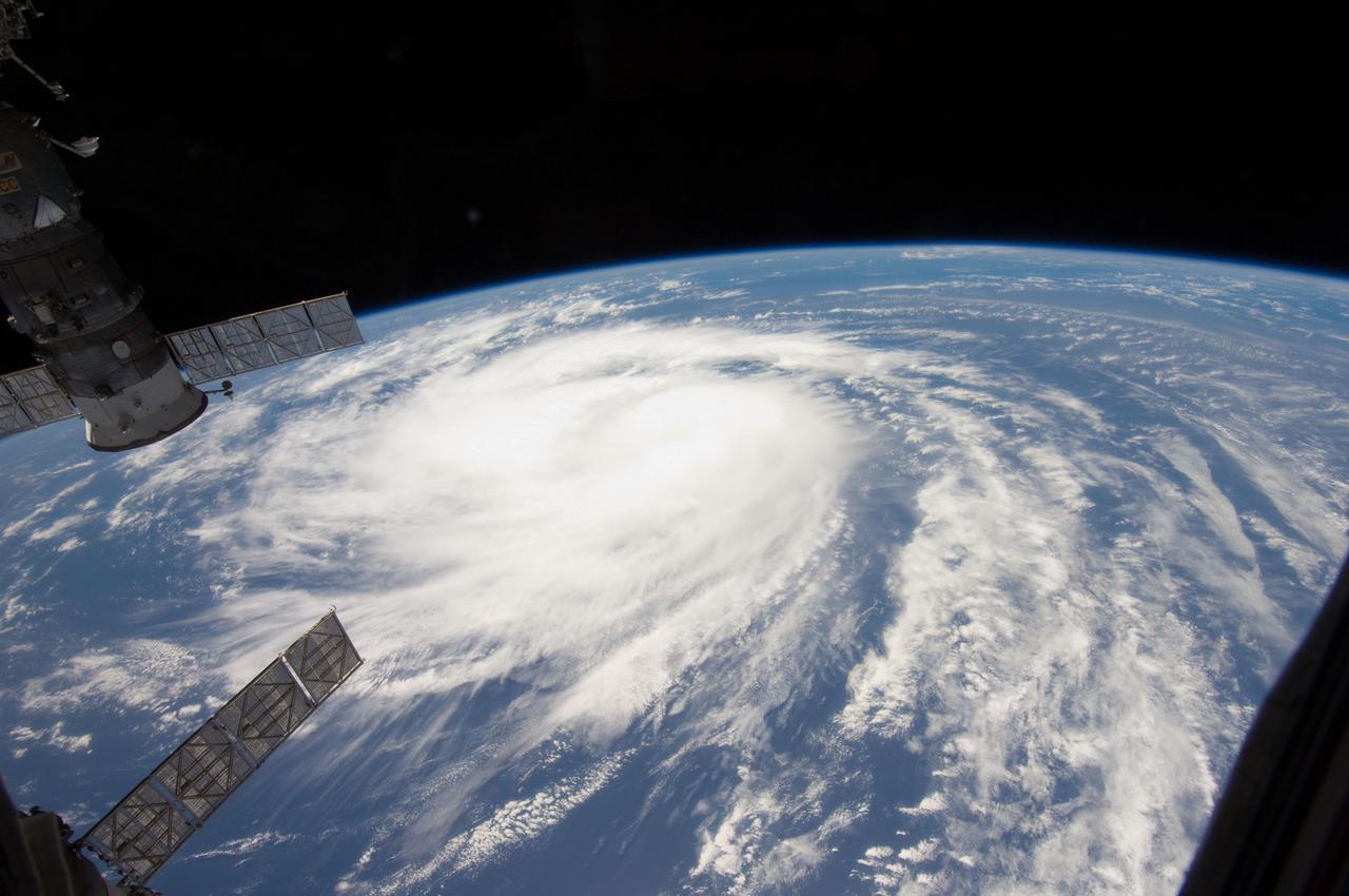
ISS028-E-034423 (26 Aug. 2011) --- This image of Hurricane Irene on Aug. 26 was photographed by one of the Expedition 28 crew members on board the International Space Station. The eye was at 31.2 degrees north latitude and 77.5 degrees west longitude moving due north 360 degrees at 14 miles per hour. Winds were 98 miles per hour, gusting to 120.8 miles per hour. Part of Florida's peninsula can be seen on the left and the northwest Bahamas are in lower left. One of the station?s trusses? radiator panels is at the upper center edge of the frame.
ISS028-E-018199 (21 July 2011) --- This unprecedented view of the space shuttle Atlantis, appearing like a bean sprout against clouds and city lights, on its way home, was photographed by the Expedition 28 crew of the International Space Station. Airglow over Earth can be seen in the background.
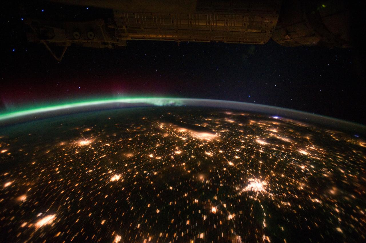
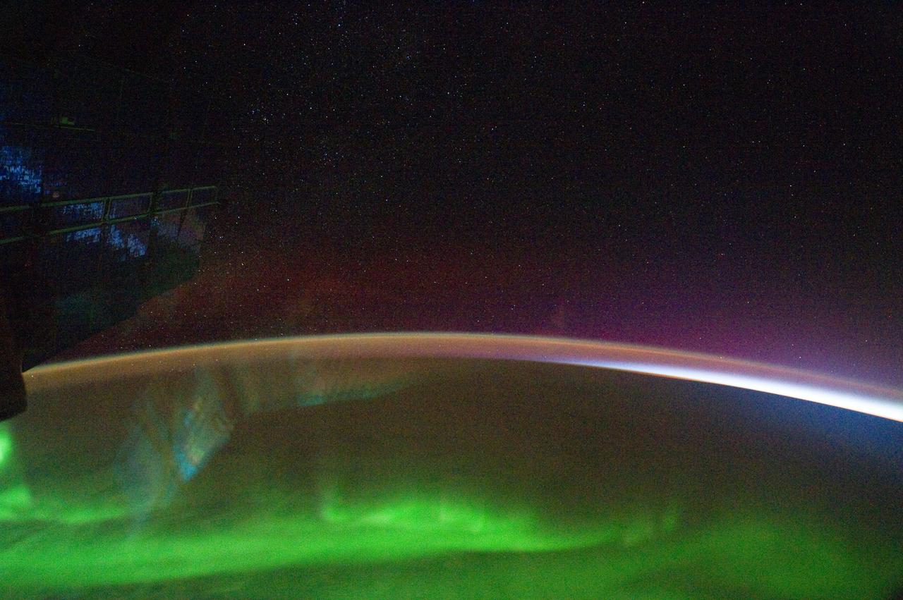
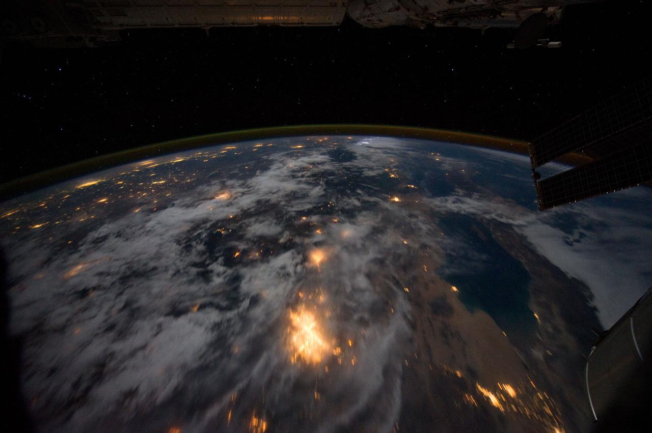
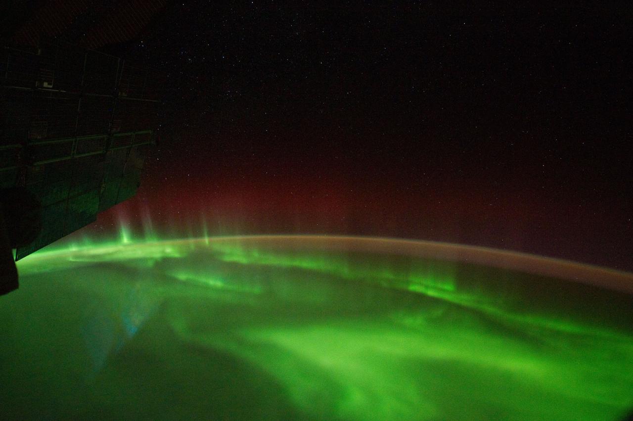
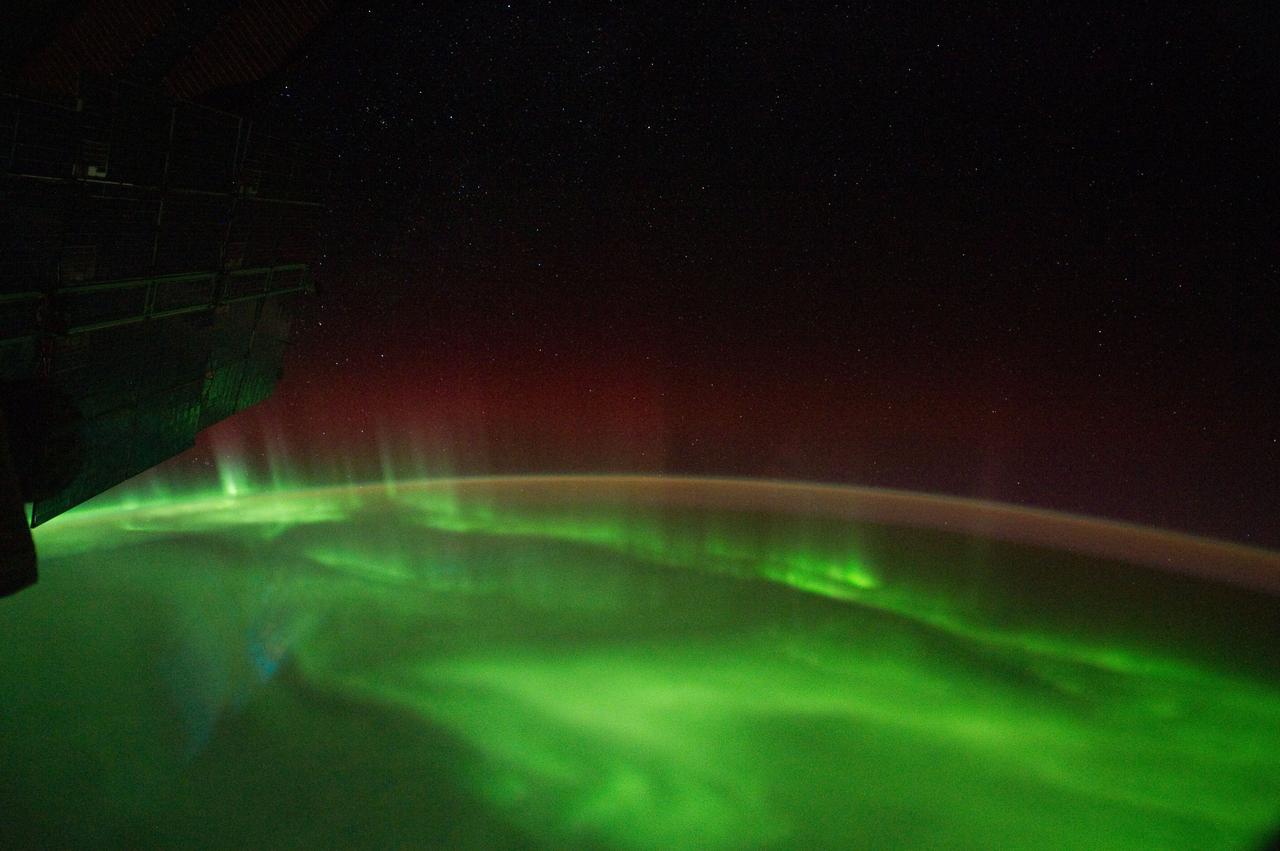
ISS029-E-012564 (29 Sept. 2011) --- The Midwestern United States at night with Aurora Borealis is featured in this image photographed by an Expedition 29 crew member on the International Space Station. The night skies viewed from the space station are illuminated with light from many sources. For example, the Midwestern United States presents a night-time appearance not unlike a patchwork quilt when viewed from orbit. The artificial light from human settlements appears everywhere with a characteristic yellow tinge in this photograph. But green light of the Aurora Borealis also appears strongly in this view (top left)—even seeming to be reflected off Earth’s surface—in Canada—beneath the aurora. A small white patch of light is almost certainly lightning from a storm on the East coast (top right). Part of the International Space Station appears across the top of the image. This photograph highlights the Chicago, IL, metropolitan area as the largest cluster of lights at center, next to the dark patch of Lake Michigan. The other largest metropolitan areas include St. Louis, MO (lower right), Minneapolis–St. Paul, MN (left) and the Omaha–Council Bluffs region on the Nebraska–Iowa border (lower left). City light clusters give an immediate sense of relative city size; demographers have used night time satellite imagery to make estimates of city populations, especially in the developing world where city growth can be very rapid. The U.S. northeast seaboard lies in the most oblique (meaning viewed at an angle) part of the image at top right, just beyond the Appalachian Mts., a dark winding zone without major cities. Scales change significantly in oblique views: Omaha is only 200 kilometers from Des Moines, but appears roughly the same distance from Minneapolis—which is actually 375 kilometers to the north of Des Moines. In addition to the major metropolitan areas, the rectangular NS/EW-oriented pattern of townships is clearly visible in the rural, lower left part of the image. This pattern instantly gives the sense of north orientation (toward the top left corner) and is a distinctive characteristic of the United States, so that ISS crew members can quickly know which continent they are flying over even at night. In contrast to the regular township pattern, interstate highways converge on St. Louis (e.g. Hwy 44), Chicago and other large cities, much like wheel spokes around a central hub. Rivers—major visual features in daylight—become almost invisible at night. The course of the Mississippi River appears as a slightly meandering zone from Minneapolis through St. Louis (dashed line)—the river course continues out of the lower right corner of the image.
ISS028-E-035382 (31 Aug. 2011) --- Katia was a tropical storm gathering energy over the Atlantic Ocean when one of the Expedition 28 crew members took this photo on Aug. 31 from aboard the International Space Station. The picture, taken with a 12-mm focal length, was captured at 14:09:01 GMT. Later in the day Katia was upgraded to hurricane status. Two Russian spacecraft -- a Progress and a Soyuz --can be seen parked at the orbital outpost on the left side of the frame.

ISS028-E-020307 (2 Aug. 2011) --- NASA astronaut Ron Garan (foreground) and Japan Aerospace Exploration Agency astronaut Satoshi Furukawa, both Expedition 28 flight engineers, use computers in the International Space Station?s Kibo laboratory to monitor the Japanese Experiment Module Remote Manipulator System (JEMRMS) located on the exterior of the station.
ISS028-E-037978 (6 Sept. 2011) --- Wildfire smoke plumes in Texas are featured in this image photographed by an Expedition 28 crew member on the International Space Station. This panoramic view of east-central Texas highlights numerous smoke plumes caused by wildfires burning across the state. The image was taken using a short focal length lens (12-mm), which captures a wide field of view at the cost of fine feature resolution. Smoke plumes are clearly visible in the image to the east of Austin; to the north of Houston; to the northwest of Lake Sam Rayburn and Toledo Bend Reservoir; and to the west of Shreveport, LA. More diffuse smoke moving offshore into the Gulf of Mexico is visible at bottom. Part of an ISS photovoltaic radiator panel is visible at top center. Record-setting drought conditions have affected much of Texas since early 2011 and have dried out both forest and grassland, providing ample fuel for wildfires. Relatively high winds and low humidity levels have also contributed to the rapid spread and expansion of fires. According to a Texas Forest Service (TXFS) Incident Management Situation Report dated Sept. 7, 2011, TXFS had responded to 172 fires affecting an area of 546.53 square kilometers (135,051 acres) over the preceding seven days. Fires near Bastrop, TX to the east of Austin had destroyed 785 homes as of Sept. 7, 2011.

ISS028-E-016121 (12 July 2011) --- NASA astronaut Ron Garan, Expedition 28 flight engineer, uses a tether to secure his position during the July 12 spacewalk he performed outside the docked International Space Station and space shuttle Atlantis with station crewmate Mike Fossum (out of frame). The Persian Gulf can be seen on the Earth below. With support from crewmates inside the station and shuttle, NASA astronauts Garan and Fossum joined forces to complete some needed chores during the six and half hour spacewalk.

ISS028-E-020924 (3 Aug. 2011) --- Russian cosmonauts Sergei Volkov and Alexander Samokutyaev (out of frame), both Expedition 28 flight engineers, attired in Russian Orlan spacesuits, participate in a session of extravehicular activity (EVA) on the Russian segment of the International Space Station. During the six-hour, 23-minute spacewalk, Volkov and Samokutyaev moved a cargo boom from one airlock to another, installed a prototype laser communications system and deployed an amateur radio micro-satellite.
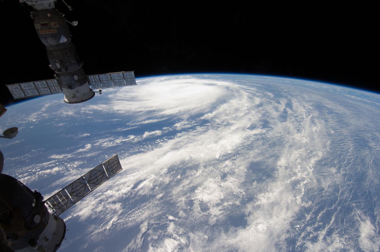
ISS028-E-035404 (31 Aug. 2011) --- Katia was a tropical storm gathering energy over the Atlantic Ocean when one of the Expedition 28 crew members took this high oblique photo on Aug. 31 from aboard the International Space Station. The picture, taken with a 12-mm focal length, was captured at 14:10:07 GMT. Later in the day Katia was upgraded to hurricane status. Two Russian spacecraft -- a Progress and a Soyuz -- can be seen parked at the orbital outpost on the left side of the frame.
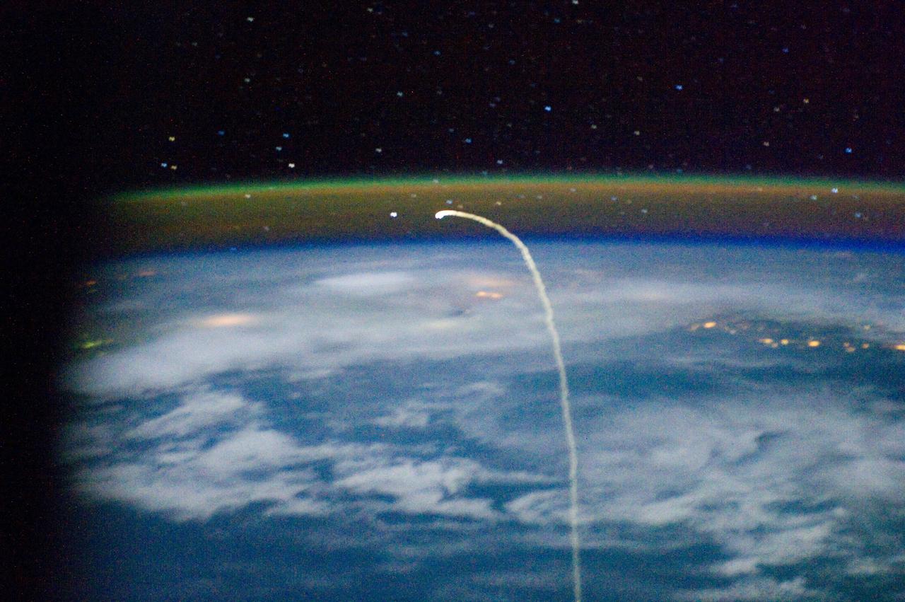
ISS028-E-018221 (21 July 2011) --- This unprecedented view of the space shuttle Atlantis, appearing like a bean sprout against clouds and city lights, on its way home, was photographed by the Expedition 28 crew of the International Space Station. Airglow over Earth can be seen in the background.

ISS029-E-021987 (2 Oct. 2011) --- This is one of a series of night time images photographed by one of the Expedition 29 crew members from the International Space Station. It features Central and Eastern Europe, extending from the Netherlands to Hungary and Italy to northern Poland. Overall, the view includes the Netherlands, Italy, Germany, Poland, and Hungary. When the photo was taken on Oct 2, 2011, the station was over Corsica at 43.18 degrees north latitude and 9.95 degrees east longitude.
ISS028-E-018177 (21 July 2011) --- This unprecedented view of the space shuttle Atlantis, appearing like a bean sprout against clouds and city lights, on its way home, was photographed by the Expedition 28 crew of the International Space Station. Airglow over Earth can be seen in the background.
ISS028-E-020965 (3 Aug. 2011) --- Russian cosmonauts Sergei Volkov and Alexander Samokutyaev (out of frame), both Expedition 28 flight engineers, attired in Russian Orlan spacesuits, participate in a session of extravehicular activity (EVA) on the Russian segment of the International Space Station. During the six-hour, 23-minute spacewalk, Volkov and Samokutyaev moved a cargo boom from one airlock to another, installed a prototype laser communications system and deployed an amateur radio micro-satellite.
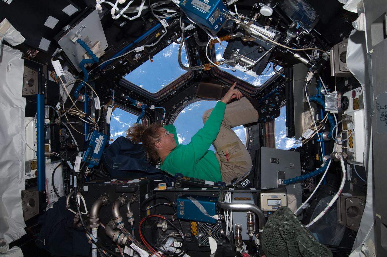
ISS028-E-017077 (16 July 2011) --- When asked by a reporter if she noticed a difference in the International Space Station on her current visit with the Atlantis STS-135 crew, versus an earlier lengthy visit, NASA astronaut Sandy Magnus mentioned the Cupola's addition, which was not on the station during her earlier stay there. This is one of series of photos showing Magnus, mission specialist for the Space Shuttle Program's final flight, taking advantage of the zero gravity of space and the panoramic view provided by the multi-windowed Cupola.
ISS028-E-017801 (18 July 2011) --- This view of the space shuttle Atlantis while still docked with the International Space Station was taken by a crew member aboard the station on the final day of joint activities between the crew members for the STS-135 and Expedition 28 missions. The robotic arm on the shuttle appears to be saluting "good-bye" to the station. Earth's airglow is seen as a thin blue line above the horizon. The Raffaello multi-purpose logistics module, full of items to be returned to Earth, is seen in the aft cargo bay.