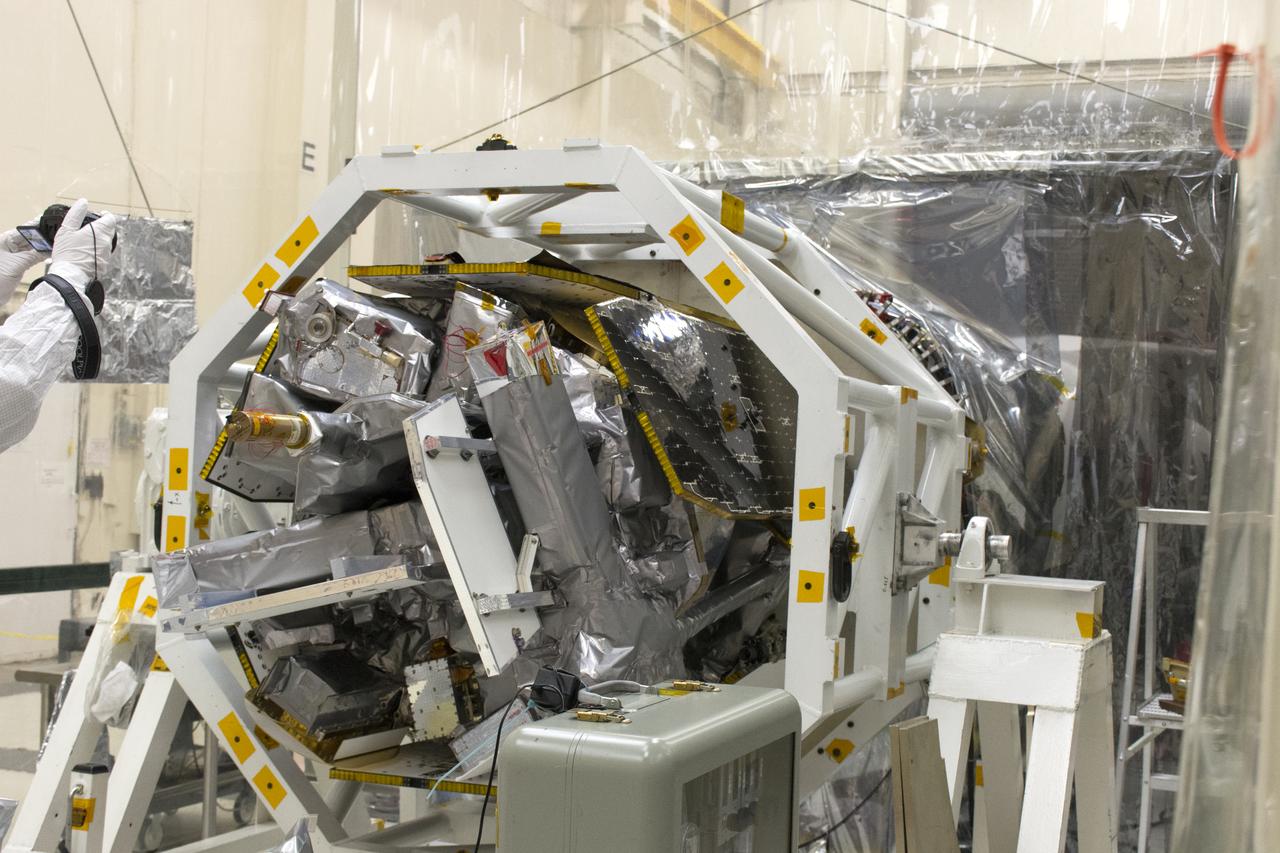
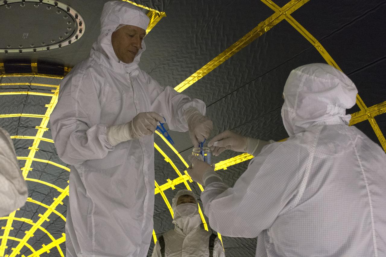
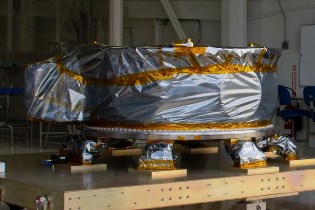
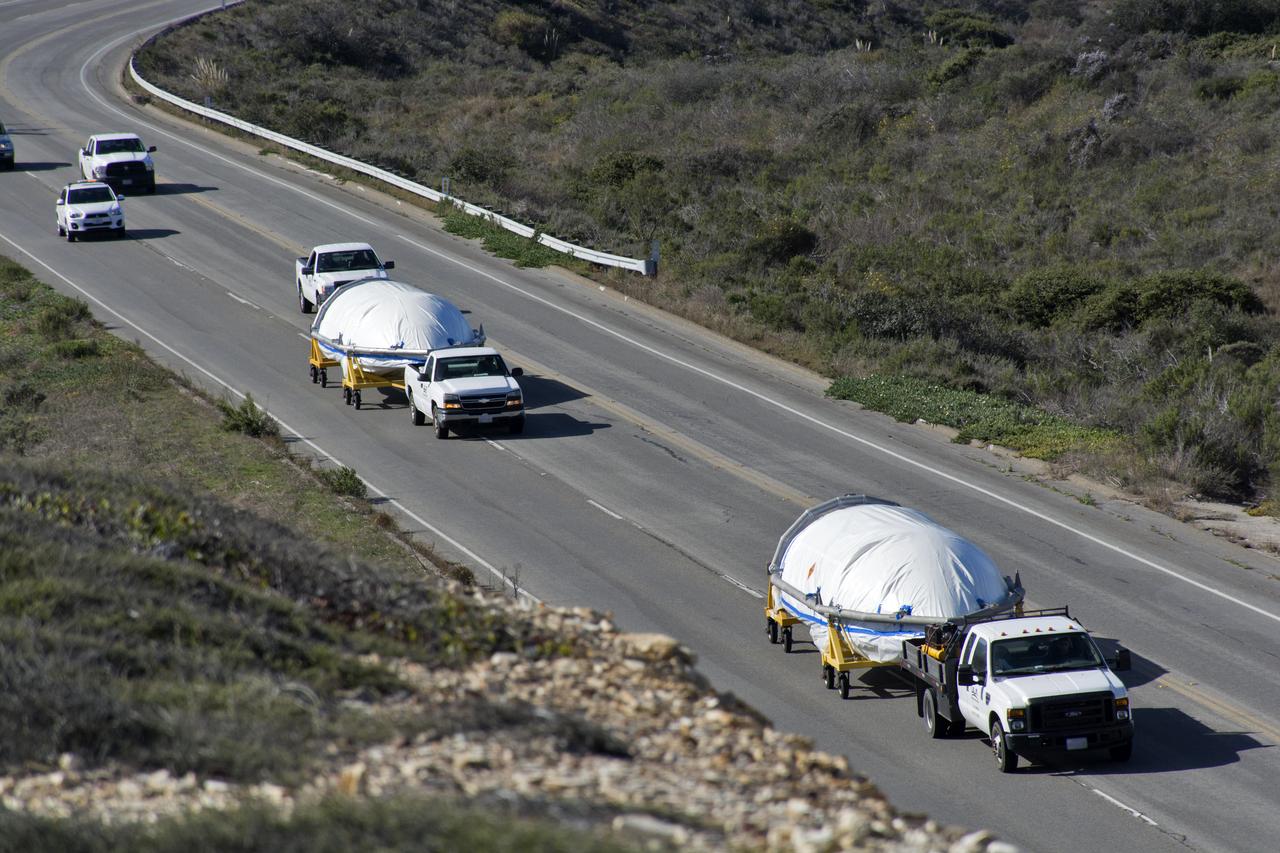
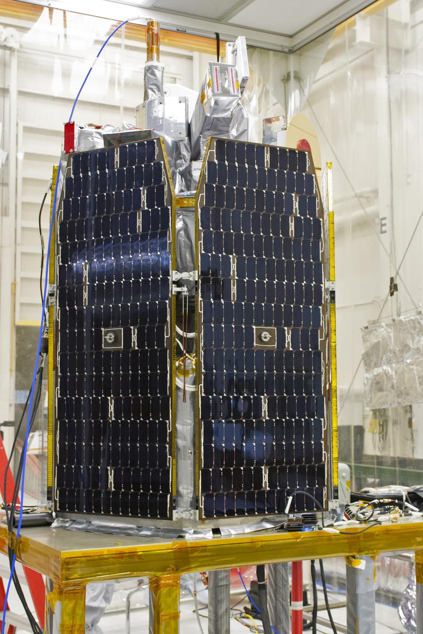
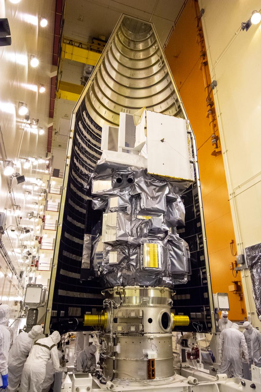
Inside Building 1555 at Vandenberg Air Force Base in California, technicians and engineers install one of eight NASA Cyclone Global Navigation Satellite System (CYGNSS) spacecraft on its deployment module. Processing activities will prepare the spacecraft for launch aboard an Orbital ATK Pegasus XL rocket. When preparations are competed at Vandenberg, the rocket will be transported to NASA’s Kennedy Space Center in Florida attached to the Orbital ATK L-1011 carrier aircraft with in its payload fairing. CYGNSS will launch on the Pegasus XL rocket from the Skid Strip at Cape Canaveral Air Force Station. CYGNSS will make frequent and accurate measurements of ocean surface winds throughout the life cycle of tropical storms and hurricanes. The data that CYGNSS provides will enable scientists to probe key air-sea interaction processes that take place near the core of storms, which are rapidly changing and play a critical role in the beginning and intensification of hurricanes.

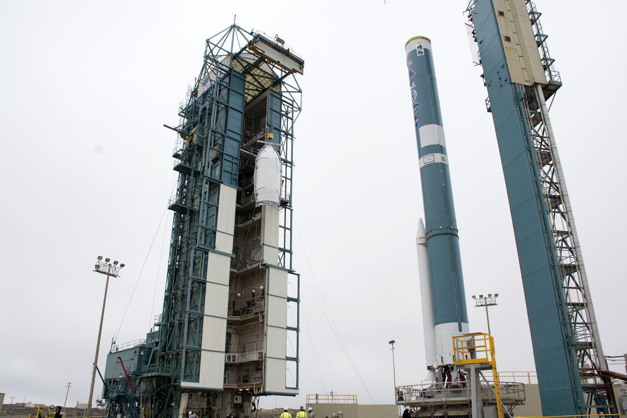
Technicians and engineers at Space Launch Complex 2 at Vandenberg Air Force Base in California, lift a United Launch Alliance/Orbital ATK solid rocket motor for mating to a Delta II rocket in preparation for launch of the Joint Polar Satellite System-1 (JPSS-1) later this year. JPSS, a next-generation environmental satellite system, is a collaborative program between the National Oceanic and Atmospheric Administration (NOAA) and NASA.
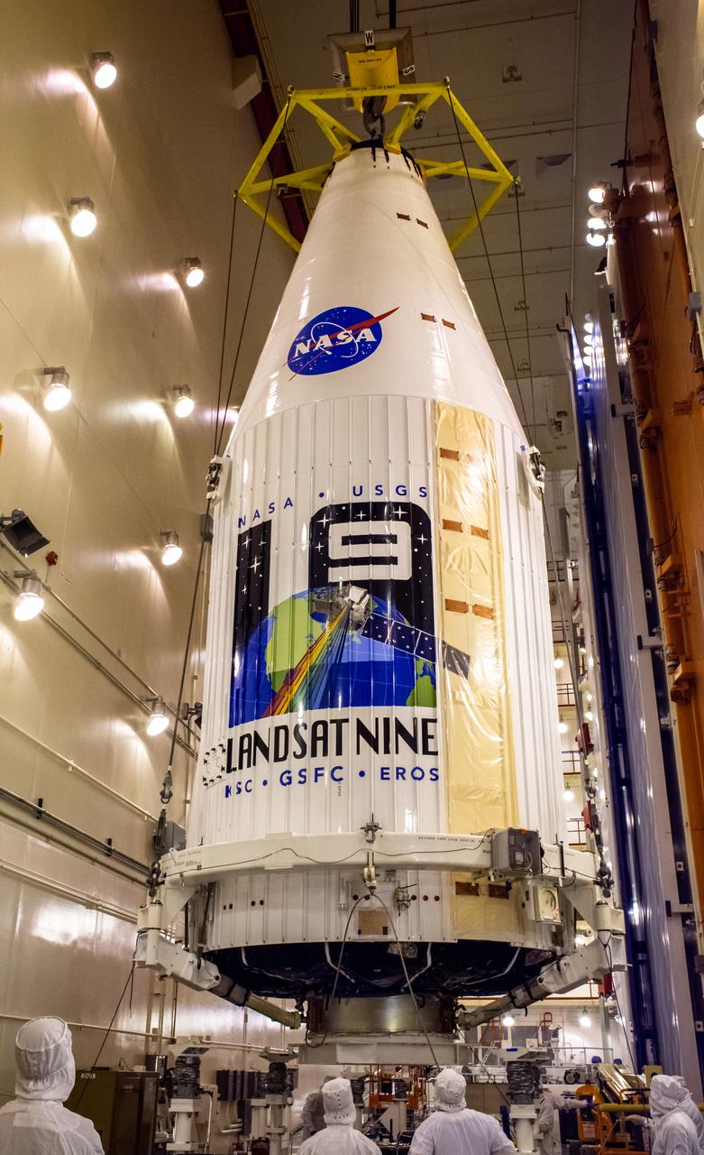
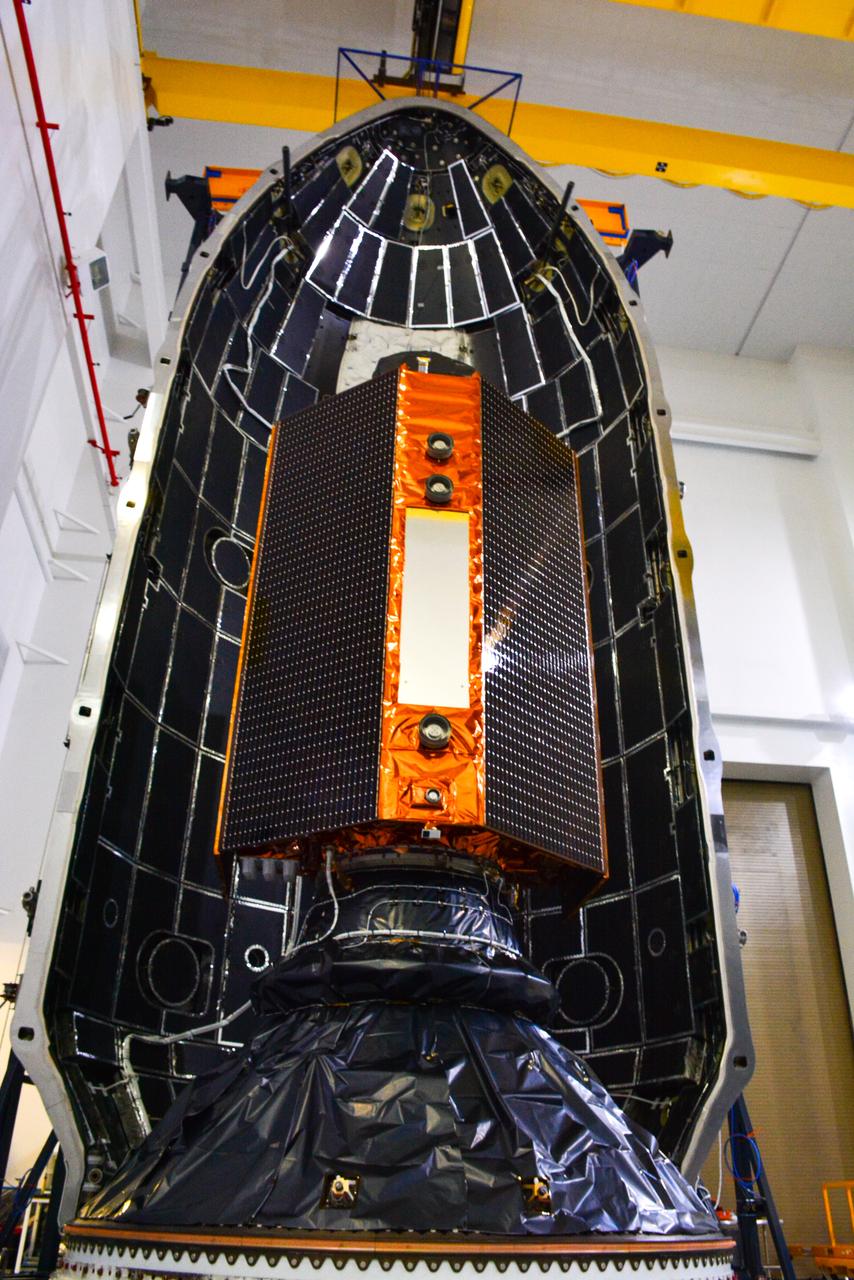
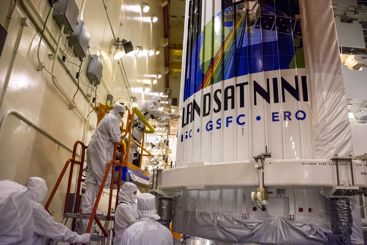
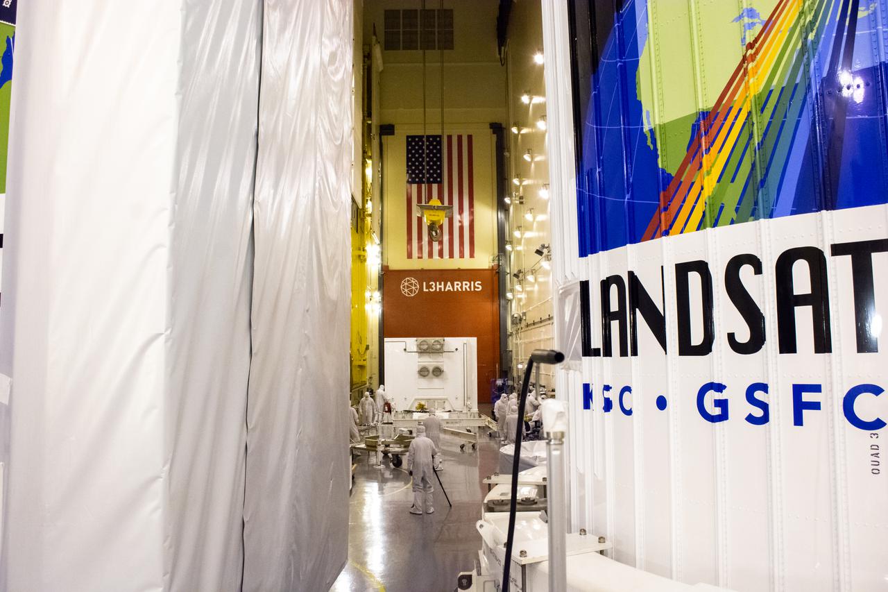
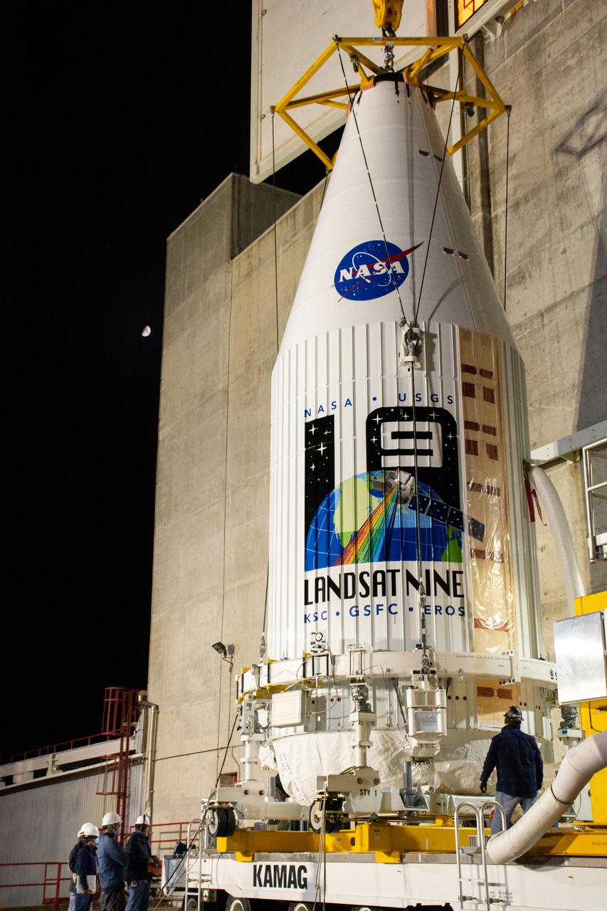
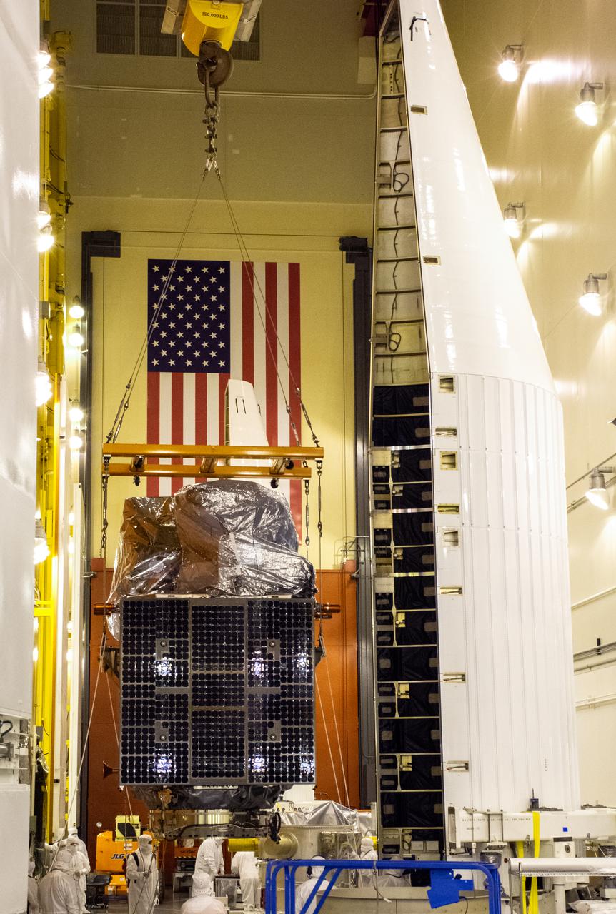
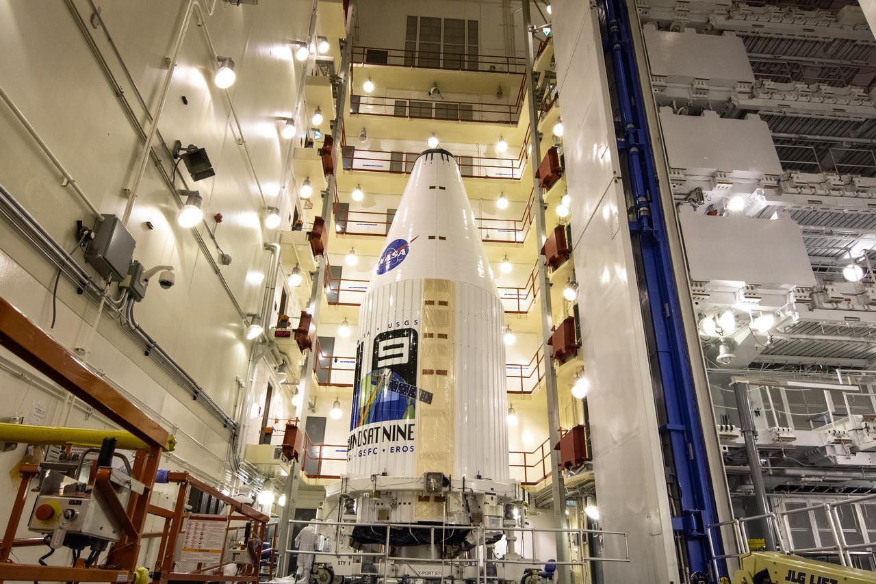
Inside the Integrated Processing Facility at Vandenberg Space Force Base in California, the Landsat 9 spacecraft, secured in the United Launch Alliance (ULA) payload fairing, is moved by crane toward the transfer tower for closeout operations on Aug. 19, 2021. Landsat 9 will launch on a ULA Atlas V rocket from Space Launch Complex 3 at Vandenberg in September 2021. The launch is being managed by NASA’s Launch Services Program based at Kennedy Space Center, America’s multi-user spaceport. The Landsat 9 satellite will continue the nearly 50-year legacy of previous Landsat missions. It will monitor key natural and economic resources from orbit. Landsat 9 is managed by the agency’s Goddard Space Flight Center in Greenbelt, Maryland. The satellite will carry two instruments: the Operational Land Imager 2, which collects images of Earth’s landscapes in visible, near infrared and shortwave infrared light, and the Thermal Infrared Sensor 2, which measures the temperature of land surfaces. Like its predecessors, Landsat 9 is a joint mission between NASA and the U.S. Geological Survey.
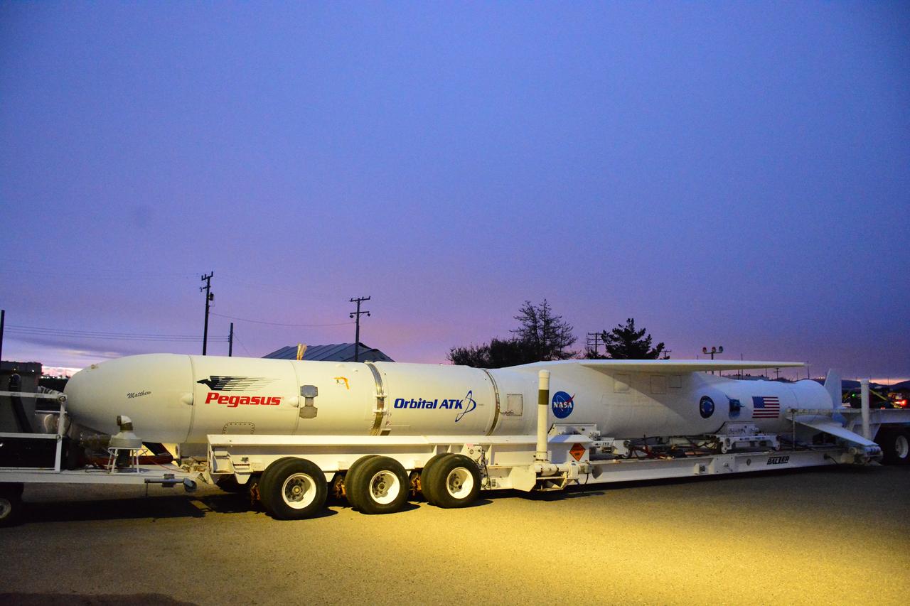
The U.S.-European Sentinel-6 Michael Freilich ocean-monitoring satellite is being encapsulated in the SpaceX Falcon 9 rocket’s payload fairing on Nov. 3, 2020, inside SpaceX’s Payload Processing Facility at Vandenberg Air Force Base (VAFB) in California. Sentinel-6 is scheduled to launch on Nov. 21, 2020, at 12:17 p.m. EST (9:17 a.m. PST), from Space Launch Complex 4E at VAFB. The Launch Services Program at NASA’s Kennedy Space Center in Florida is responsible for launch management.
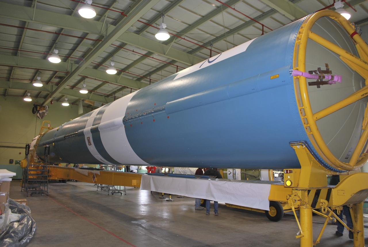
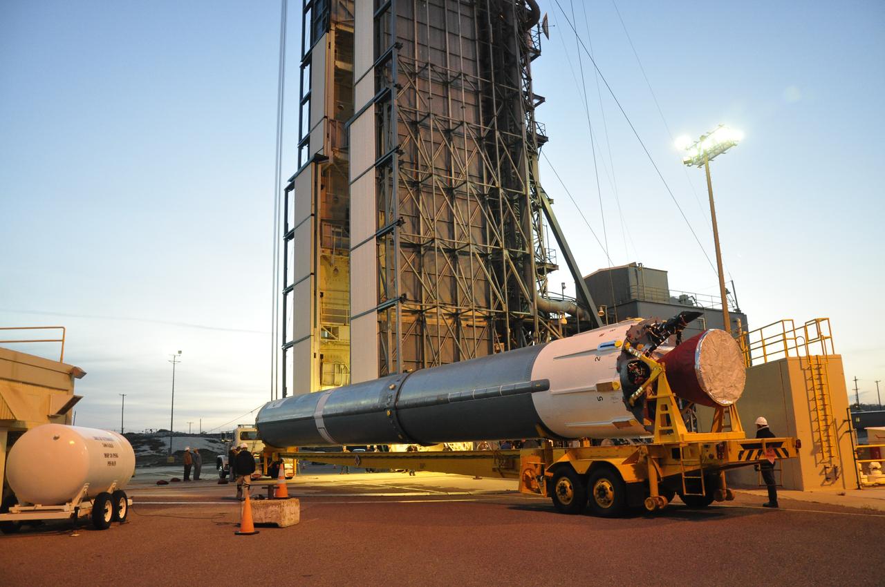
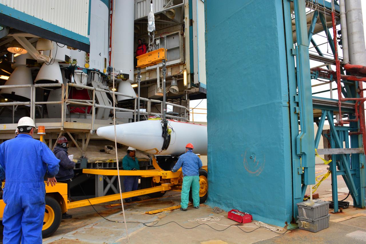
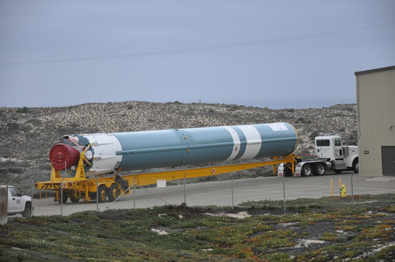
A United Launch Alliance Atlas V booster is transported to Space Launch Complex 3 at Vandenberg Air Force Base in California. The rocket will launch NASA's Interior Exploration using Seismic Investigations, Geodesy and Heat Transport, or InSight, mission to land on Mars. InSight is the first mission to explore the Red Planet's deep interior. It will investigate processes that shaped the rocky planets of the inner solar system including Earth. Liftoff is scheduled for May 5, 2018.
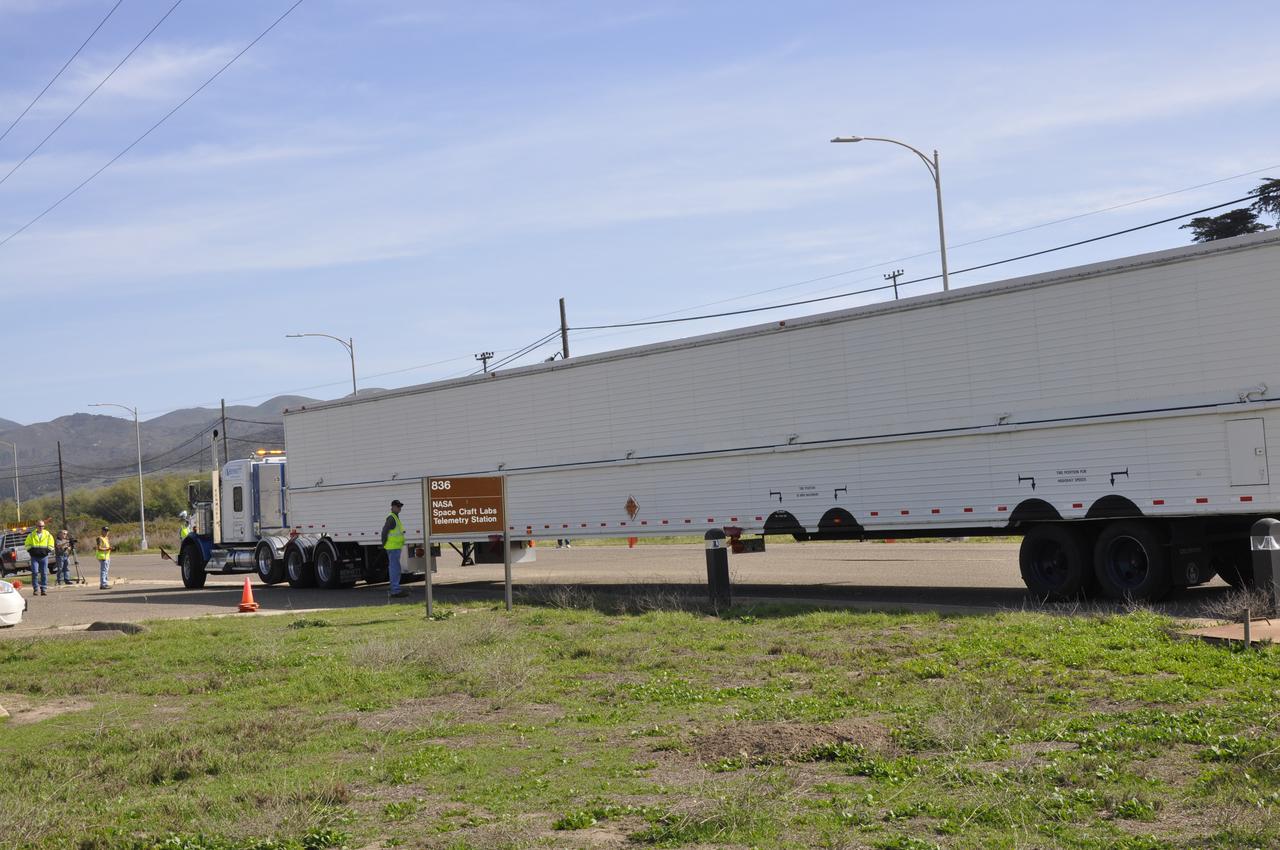
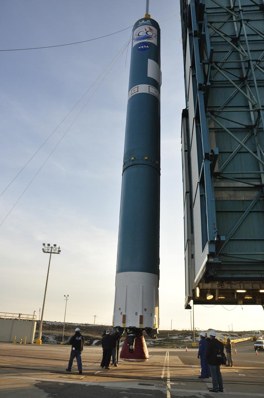
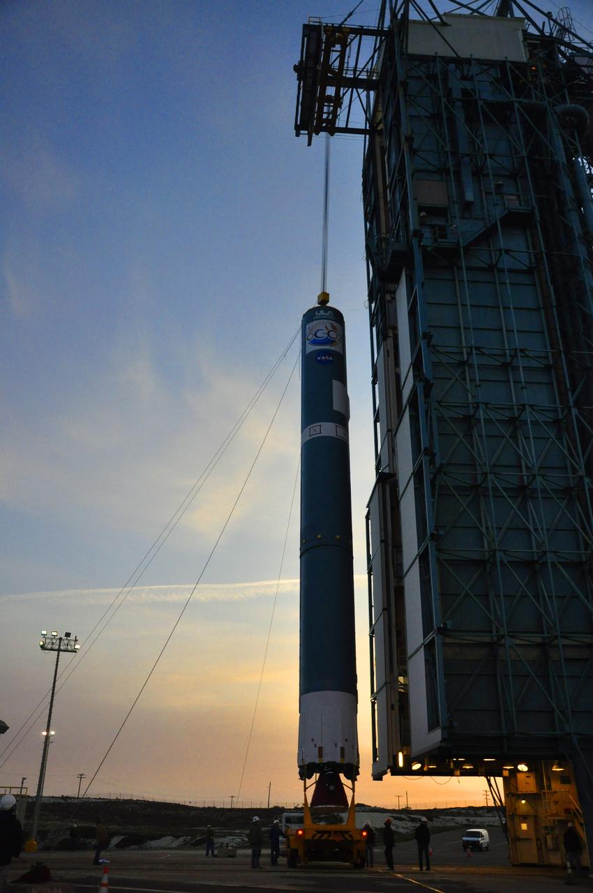
VANDENBERG AIR FORCE BASE, Calif. – The truck transporting the Delta first-stage booster for NASA's Orbiting Carbon Observatory-2 mission, or OCO-2, arrives outside the Building 836 hangar at Space Launch Complex 2 on Vandenberg Air Force Base in California. OCO-2 is scheduled to launch aboard a United Launch Alliance Delta II rocket in July. The observatory will collect precise global measurements of carbon dioxide in the Earth's atmosphere and provide scientists with a better idea of the chemical compound's impacts on climate change. Scientists will analyze this data to improve our understanding of the natural processes and human activities that regulate the abundance and distribution of this important atmospheric gas. To learn more about OCO-2, visit http://oco.jpl.nasa.gov. Photo credit: NASA/Randy Beaudoin
At Vandenberg Air Force Base in California, an Orbital ATK Pegasus XL rocket is transported from the hangar at Building 1555 to be mated to L-1011 carrier aircraft near Vandenberg's runway. On board Pegasus are eight NASA Cyclone Global Navigation Satellite System, or CYGNSS, spacecraft. When preparations are competed at Vandenberg, the L-1011/Pegasus XL combination will be flown to NASA’s Kennedy Space Center in Florida. On Dec. 12, 2016, the carrier aircraft is scheduled to take off from the Skid Strip at Cape Canaveral Air Force Station and CYGNSS will launch on the Pegasus XL rocket with the L-1011 flying off shore. CYGNSS satellites will make frequent and accurate measurements of ocean surface winds throughout the life cycle of tropical storms and hurricanes. The data that CYGNSS provides will enable scientists to probe key air-sea interaction processes that take place near the core of storms, which are rapidly changing and play a critical role in the beginning and intensification of hurricanes.
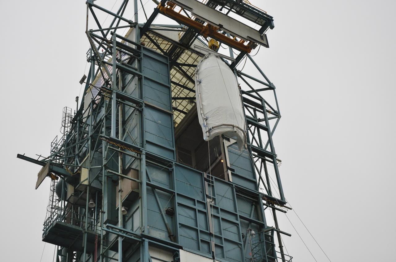
Technicians install the Northrop Grumman Pegasus XL payload fairings around NASA's Ionospheric Connection Explorer (ICON) inside Building 1555 at Vandenberg Air Force Base in California, on Aug. 22, 2018. The Pegasus XL rocket, attached beneath the company's L-1011 Stargazer aircraft, will launch ICON from the Skid Strip at Cape Canaveral Air Force Station in Florida. Launch is scheduled for Oct. 26. ICON will study the frontier of space - the dynamic zone high in Earth's atmosphere where terrestrial weather from below meets space weather above. The explorer will help determine the physics of Earth's space environment and pave the way for mitigating its effects on our technology and communications systems.
The Landsat 9 PSR to EFS C29 lift and mate inside the Integrated Processing Facility at Vandenberg Space Force Base in California.
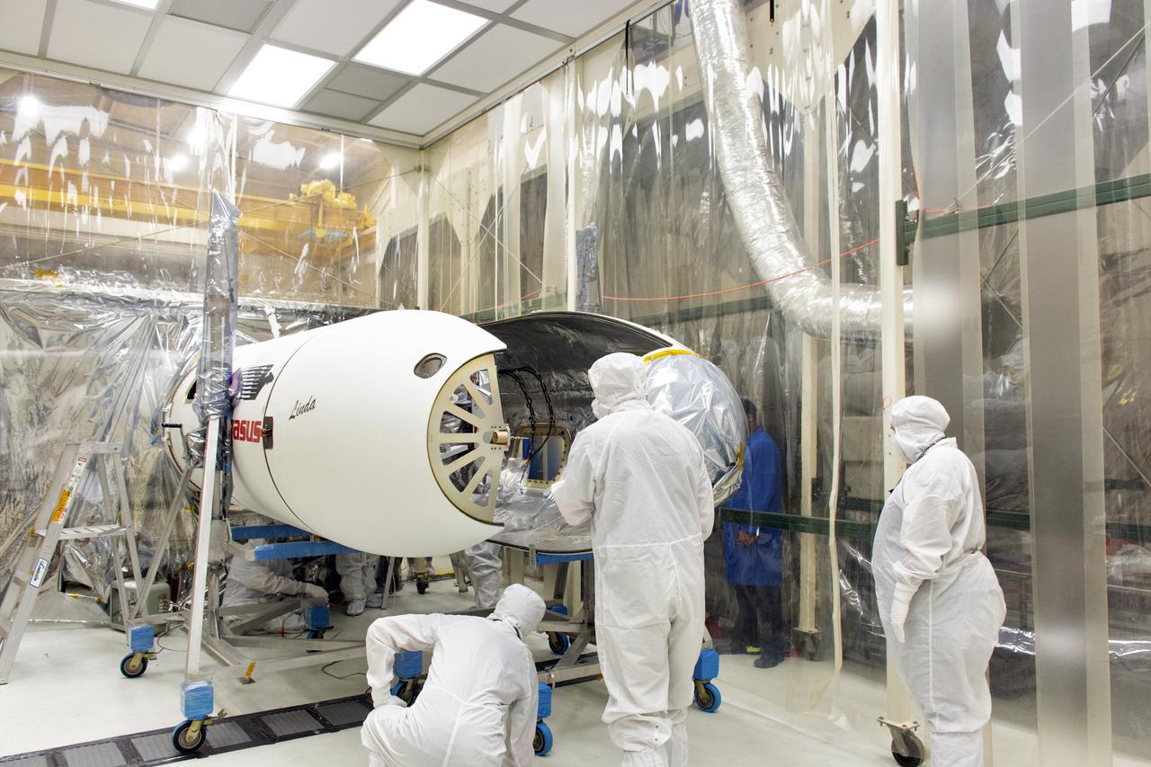
NASA's Ionospheric Connection Explorer (ICON) is in the horizontal position May 11, 2018, inside a clean room in Building 1555 at Vandenberg Air Force Base in California. ICON is being prepared to be attached to the Orbital ATK Pegasus XL rocket. The explorer will launch on June 15, 2018, from Kwajalein Atoll in the Marshall Islands (June 14 in the continental United States) on the Pegasus XL rocket, which is attached to the company's L-1011 Stargazer aircraft. ICON will study the frontier of space - the dynamic zone high in Earth's atmosphere where terrestrial weather from below meets space weather above. The explorer will help determine the physics of Earth's space environment and pave the way for mitigating its effects on our technology, communications systems and society.
Technicians integrate the Sentinel-6B spacecraft to the payload attach fitting inside the Astrotech Space Operations payload processing facility at Vandenberg Space Force Base in California on Wednesday, Nov. 5, 2025. The payload attach fitting is part of the system that connects Sentinel-6B to the second stage of the SpaceX Falcon 9 rocket that will carry it to orbit. A collaboration between NASA, ESA (European Space Agency), EUMETSAT (European Organisation for the Exploitation of Meteorological Satellites), and the National Oceanic and Atmospheric Administration (NOAA), Sentinel-6B is designed to measure sea levels down to roughly an inch for about 90% of the world’s oceans. NASA is targeting launch no earlier than Sunday, Nov. 16, on a SpaceX Falcon 9 rocket from Space Launch Complex 4 East at Vandenberg.
VANDENBERG AIR FORCE BASE, Calif. – The Delta first-stage booster for NASA's Orbiting Carbon Observatory-2 mission, or OCO-2, is towed to the Horizontal Processing Facility at Space Launch Complex 2 on Vandenberg Air Force Base in California. OCO-2 is scheduled to launch aboard a United Launch Alliance Delta II rocket in July. The observatory will collect precise global measurements of carbon dioxide in the Earth's atmosphere and provide scientists with a better idea of the chemical compound's impacts on climate change. Scientists will analyze this data to improve our understanding of the natural processes and human activities that regulate the abundance and distribution of this important atmospheric gas. To learn more about OCO-2, visit http://oco.jpl.nasa.gov. Photo credit: NASA/Randy Beaudoin
Northrop Grumman's L-1011 Stargazer aircraft is at the hot pad at Vandenberg Air Force Base in California on May 26, 2018. Preparations are underway to attach the company's Pegasus XL rocket, containing NASA's Ionospheric Connection Explorer (ICON), beneath the aircraft. The explorer will launch on June 15, 2018, from Kwajalein Atoll in the Marshall Islands (June 14 in the continental United States). ICON will study the frontier of space - the dynamic zone high in Earth's atmosphere where terrestrial weather from below meets space weather above. The explorer will help determine the physics of Earth's space environment and pave the way for mitigating its effects on our technology, communications systems and society.
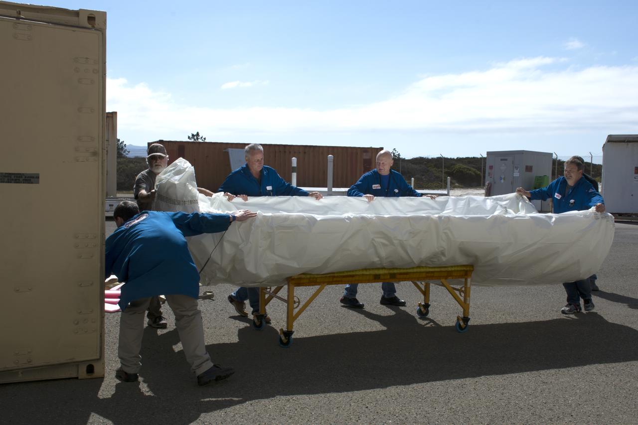
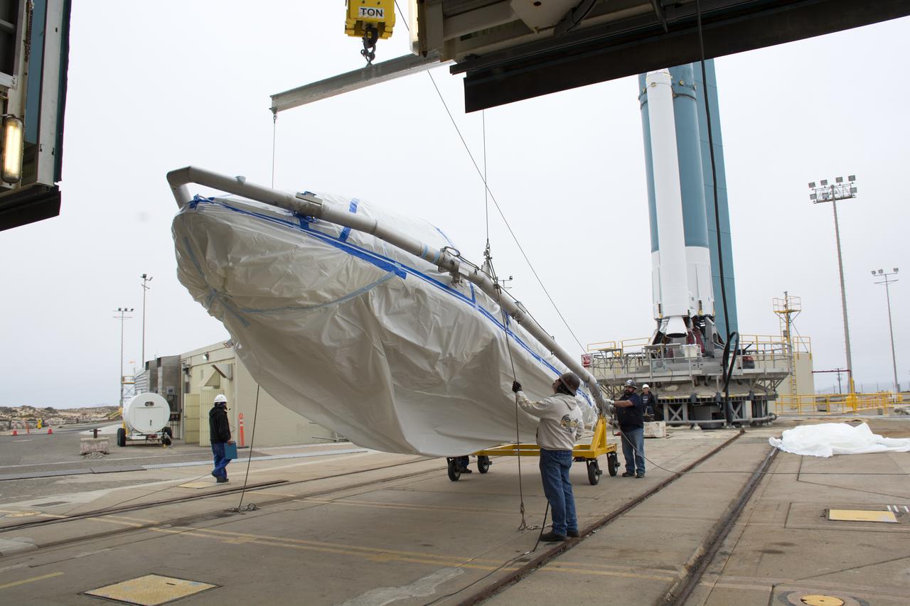
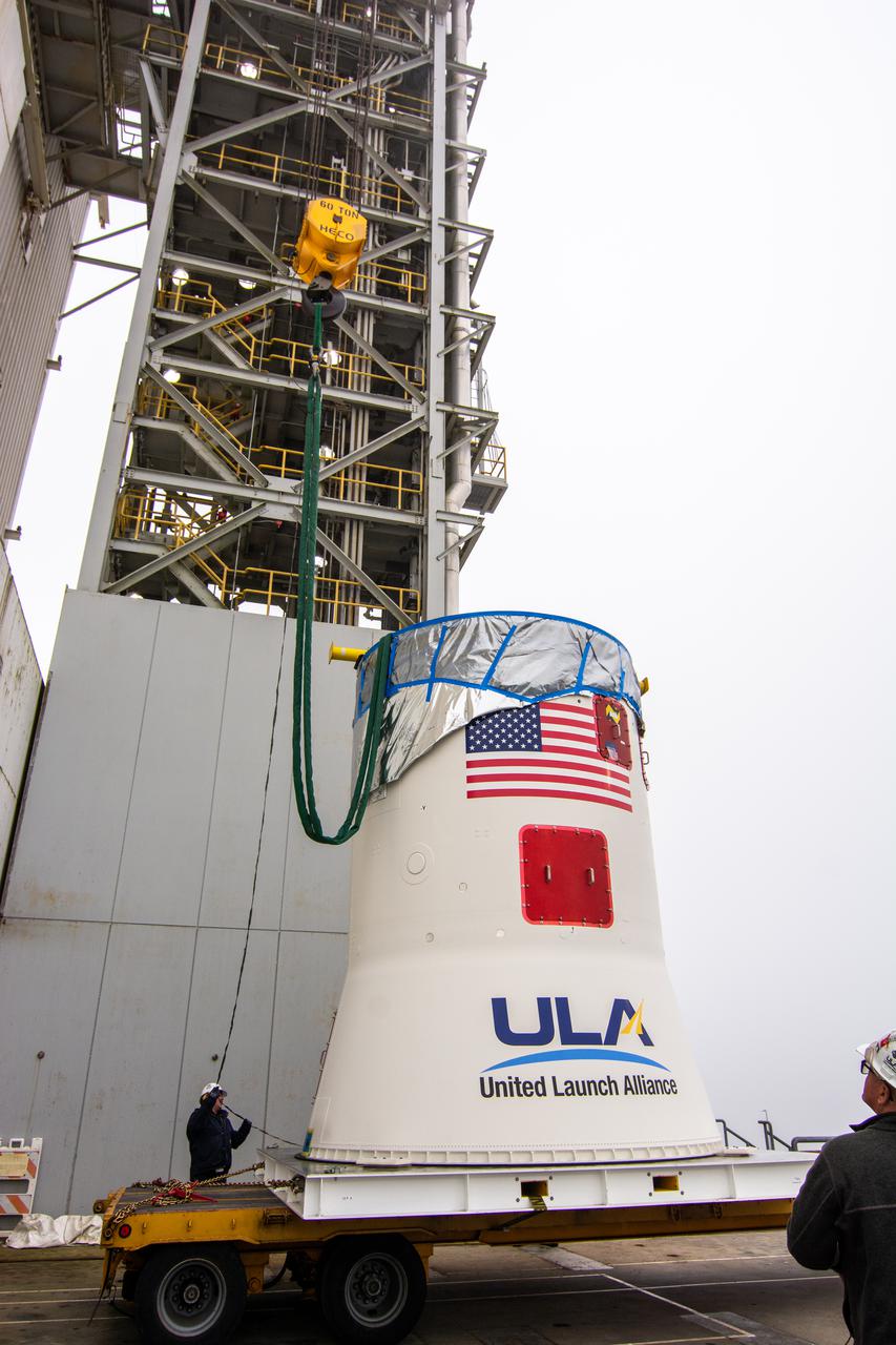
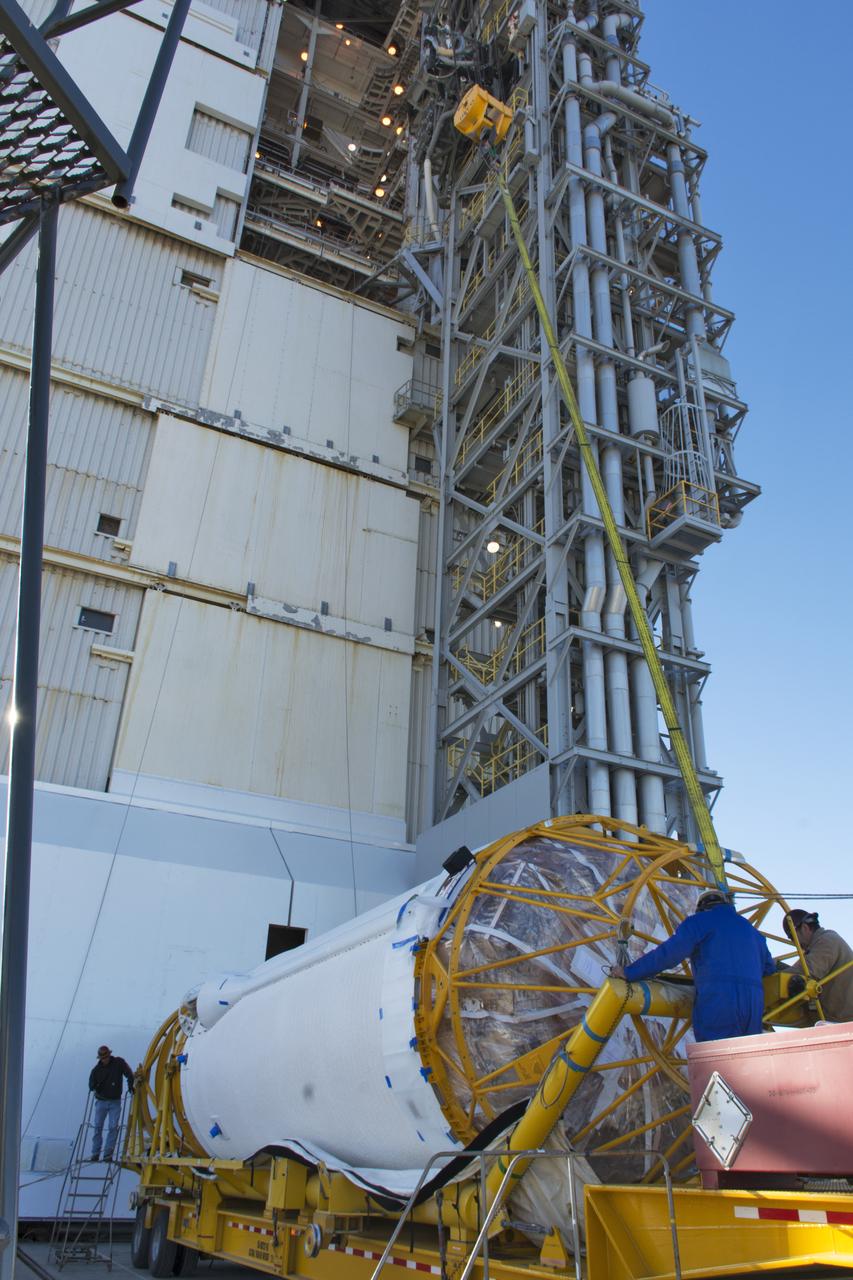
Technicians with Orbital ATK remove the first half of the Pegasus payload fairing for NASA’s Cyclone Global Navigation Satellite System (CYGNSS) from its shipping container and prepare it for the move to nearby Building 1555 at Vandenberg Air Force Base in California. CYGNSS is being prepared at Vandenberg, and then will be transported to NASA’s Kennedy Space Center in Florida aboard the Orbital ATK Pegasus XL rocket which will be attached to the Orbital ATK L-1011 carrier aircraft. CYGNSS will launch on the Pegasus XL rocket from the Skid Strip at Cape Canaveral Air Force Station. CYGNSS will make frequent and accurate measurements of ocean surface winds throughout the life cycle of tropical storms and hurricanes. The data that CYGNSS provides will enable scientists to probe key air-sea interaction processes that take place near the core of storms, which are rapidly changing and play a critical role in the beginning and intensification of hurricanes.
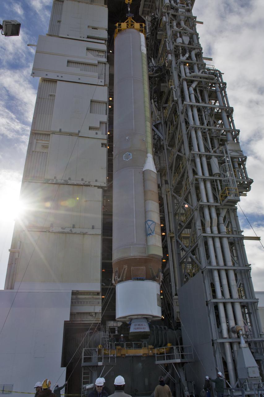
A crane lifts a United Launch Alliance Atlas V booster at Space Launch Complex 3 at Vandenberg Air Force Base in California. The rocket will launch NASA's Interior Exploration using Seismic Investigations, Geodesy and Heat Transport, or InSight, mission to land on Mars. InSight is the first mission to explore the Red Planet's deep interior. It will investigate processes that shaped the rocky planets of the inner solar system including Earth. Liftoff is scheduled for May 5, 2018.
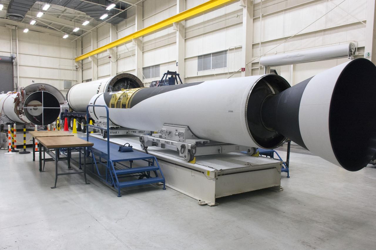
The first stage motor for the Orbital ATK Pegasus XL rocket was moved inside Building 1555 at Vandenberg Air Force Base in California. In the background are the second and third stage segments. The rocket is being prepared for NASA's Ionospheric Connection Explorer, or ICON, mission. ICON will launch from the Kwajalein Atoll aboard the Pegasus XL on Dec. 8, 2017. ICON will study the frontier of space - the dynamic zone high in Earth's atmosphere where terrestrial weather from below meets space weather above. The explorer will help determine the physics of Earth's space environment and pave the way for mitigating its effects on our technology, communications systems and society.
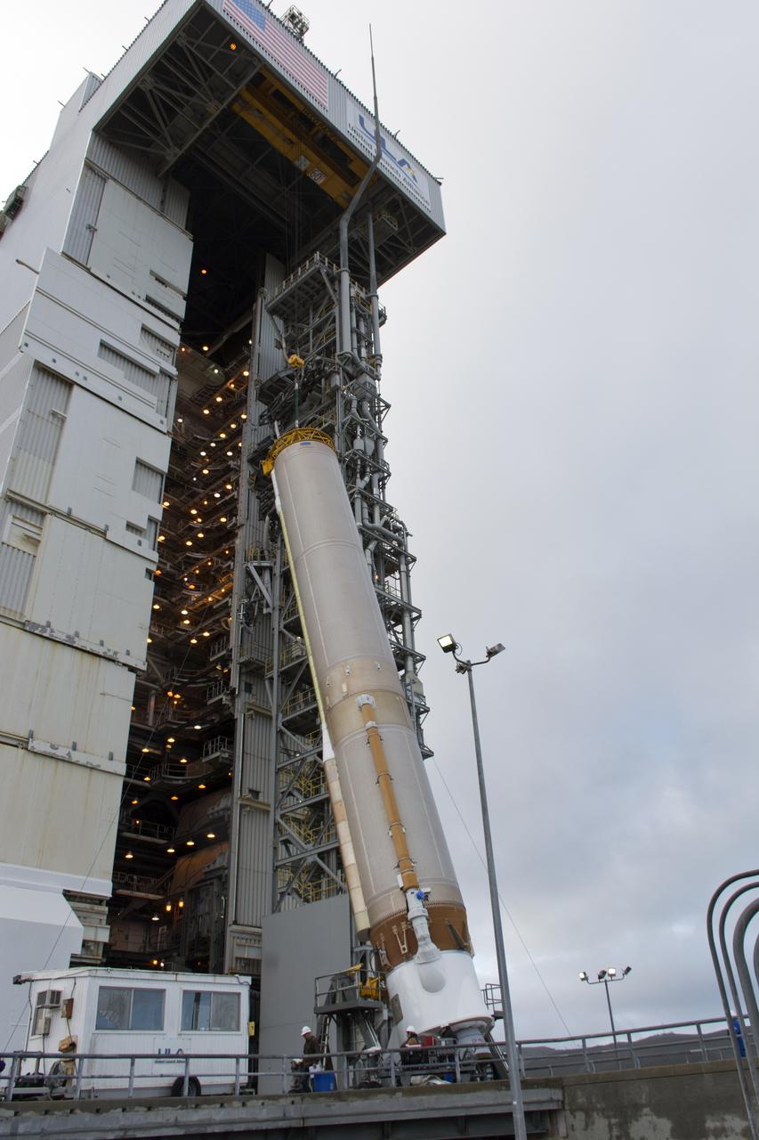
VANDENBERG AIR FORCE BASE, Calif. – The United Launch Alliance Delta II rocket for NASA's Orbiting Carbon Observatory-2 mission, or OCO-2, is lifted into a vertical position beside the mobile service tower at Space Launch Complex 2 on Vandenberg Air Force Base in California. Launch is scheduled for July 2014. The observatory will collect precise global measurements of carbon dioxide in the Earth's atmosphere and provide scientists with a better idea of the chemical compound's impacts on climate change. Scientists will analyze this data to improve our understanding of the natural processes and human activities that regulate the abundance and distribution of this important atmospheric gas. To learn more about OCO-2, visit http://oco.jpl.nasa.gov. Photo credit: NASA/Randy Beaudoin
Inside the Integrated Processing Facility at Vandenberg Space Force Base in California, United Launch Alliance (ULA) technicians prepare to remove the contamination barrier and access door from the two ULA Atlas V rocket payload fairings for NASA’s Landsat 9 satellite on June 24, 2021. The fairings will encapsulate the satellite for its launch atop the Atlas V from Vandenberg in September 2021. The launch is being managed by NASA’s Launch Services Program based at Kennedy Space Center in Florida. Landsat 9 will continue the nearly 50-year legacy of previous Landsat missions. It will monitor key natural and economic resources from orbit. Landsat 9 is managed by the agency’s Goddard Space Flight Center in Greenbelt, Maryland. It will carry two instruments: the Operational Land Imager 2, which collects images of Earth’s landscapes in visible, near-infrared and shortwave infrared light, and the Thermal Infrared Sensor 2, which measures the temperature of land surfaces. Like its predecessors, Landsat 9 is a joint mission between NASA and the U.S. Geological Survey.
At Vandenberg Air Force Base in California, a cover is installed on a Centaur upper stage in preparation for its transport to Space Launch Complex 3. The Centaur will be mounted atop a United Launch Alliance Atlas V rocket to boost NASA's Interior Exploration using Seismic Investigations, Geodesy and Heat Transport, or InSight, mission to land on Mars. InSight is the first mission to explore the Red Planet's deep interior. It will investigate processes that shaped the rocky planets of the inner solar system including Earth. Liftoff is scheduled for May 5, 2018.
The United Launch Alliance Atlas V booster for NASA’s Landsat 9 mission is lifted by crane and special lifting device for transfer into the Vertical Integration Facility at Space Launch Complex 3 at Vandenberg Space Force Base in California, on July 13, 2021. The Landsat 9 mission will launch atop the Atlas V rocket from Vandenberg in September 2021. The launch is being managed by NASA’s Launch Services Program based at Kennedy Space Center. The Landsat 9 satellite will continue the nearly 50-year legacy of previous Landsat missions. It will monitor key natural and economic resources from orbit. Landsat 9 is managed by the agency’s Goddard Space Flight Center in Greenbelt, Maryland. The satellite will carry two instruments: the Operational Land Imager 2, which collects images of Earth’s landscapes in visible, near infrared and shortwave infrared light, and the Thermal Infrared Sensor 2, which measures the temperature of land surfaces. Like its predecessors, Landsat 9 is a joint mission between NASA and the U.S. Geological Survey.

The first stage motor for the Orbital ATK Pegasus XL rocket is moved into Building 1555 at Vandenberg Air Force Base in California. The rocket is being prepared for NASA's Ionospheric Connection Explorer, or ICON, mission. ICON will launch from the Kwajalein Atoll aboard the Pegasus XL on Dec. 8, 2017. ICON will study the frontier of space - the dynamic zone high in Earth's atmosphere where terrestrial weather from below meets space weather above. The explorer will help determine the physics of Earth's space environment and pave the way for mitigating its effects on our technology, communications systems and society.

A technician assists with connections as NASA's Ionospheric Connection Explorer (ICON) is attached to the Orbital ATK Pegasus XL rocket May 14, 2018, inside a clean room in Building 1555 at Vandenberg Air Force Base in California. The explorer will launch on June 15, 2018, from Kwajalein Atoll in the Marshall Islands (June 14 in the continental United States) on the Pegasus XL rocket, which is attached to the company's L-1011 Stargazer aircraft. ICON will study the frontier of space - the dynamic zone high in Earth's atmosphere where terrestrial weather from below meets space weather above. The explorer will help determine the physics of Earth's space environment and pave the way for mitigating its effects on our technology, communications systems and society.
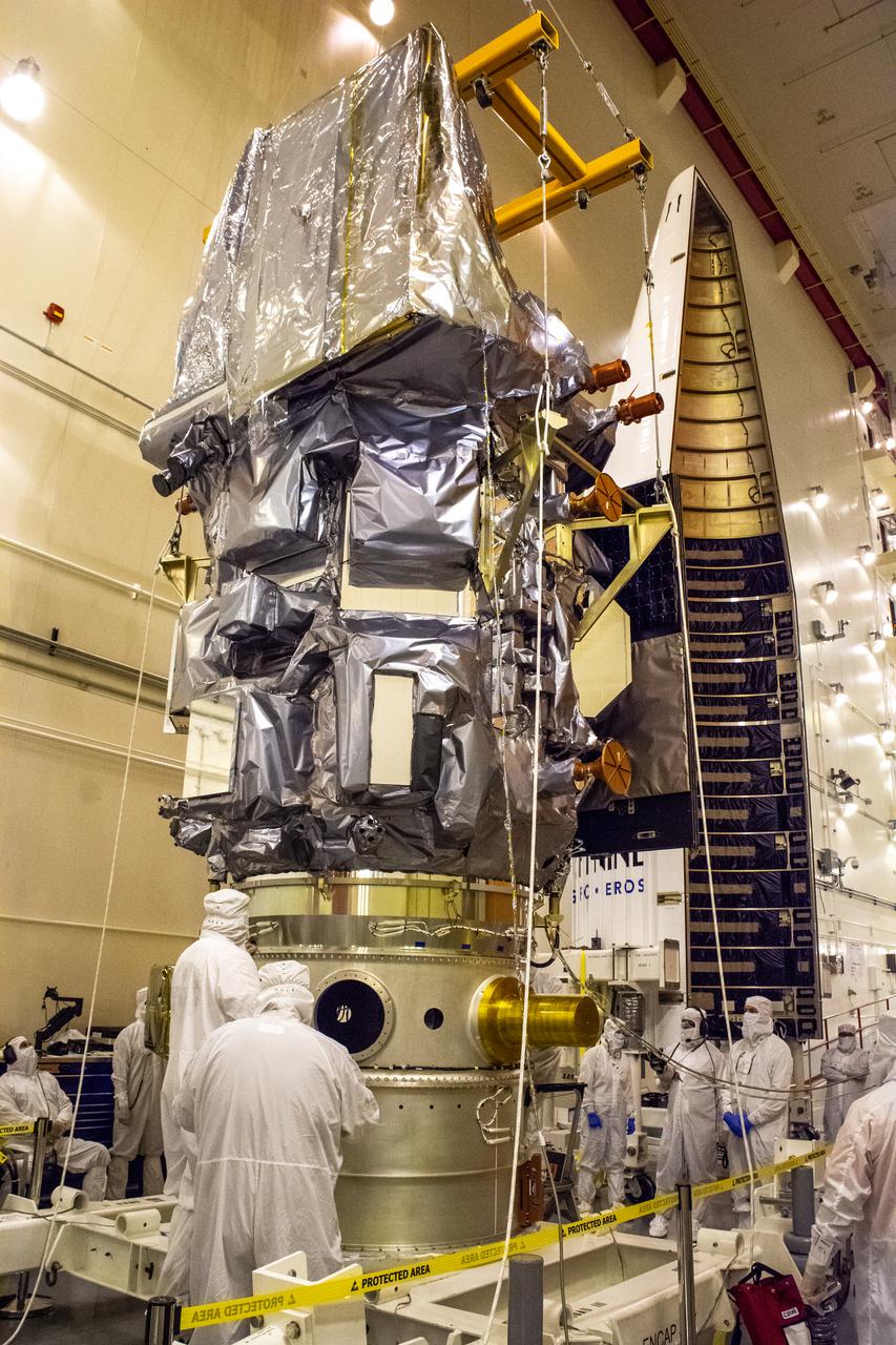
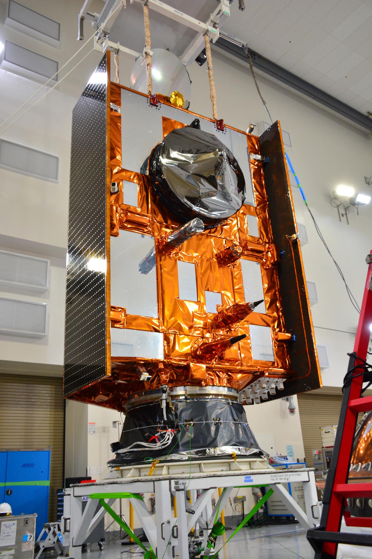
Technicians move the Landsat 9 spacecraft over to the evolved expendable vehicle secondary payload adapter (ESPA) for mating operations inside the Vertical Integration Facility at Vandenberg Space Force Base in California on Aug. 11, 2021. The ESPA connects Landsat 9 and the payload adapter (PMA) – the PMA then will attach to the second stage of a United Launch Alliance Atlas V rocket. Landsat 9 will launch on the Atlas V from Space Launch Complex 3 at Vandenberg in September 2021. The launch is being managed by NASA’s Launch Services Program based at Kennedy Space Center, America’s multi-user spaceport. The Landsat 9 satellite will continue the nearly 50-year legacy of previous Landsat missions. It will monitor key natural and economic resources from orbit. Landsat 9 is managed by the agency’s Goddard Space Flight Center in Greenbelt, Maryland. The satellite will carry two instruments: the Operational Land Imager 2, which collects images of Earth’s landscapes in visible, near infrared and shortwave infrared light, and the Thermal Infrared Sensor 2, which measures the temperature of land surfaces. Like its predecessors, Landsat 9 is a joint mission between NASA and the U.S. Geological Survey.
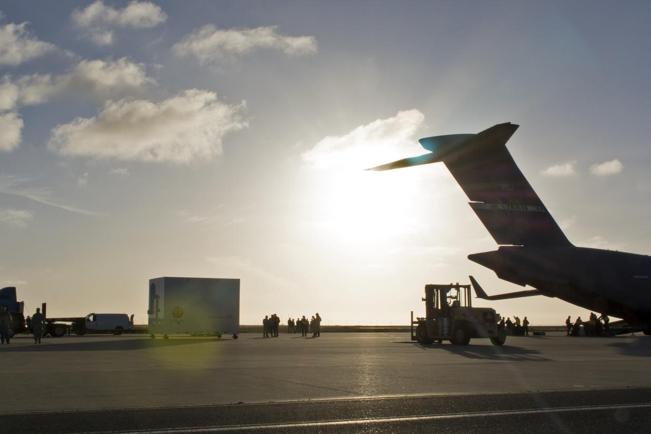
After a U.S. Air Force C-17 aircraft arrived at Vandenberg Air Force Base in California, ground crews offload NASA's Interior Exploration using Seismic Investigations, Geodesy and Heat Transport, or InSight, spacecraft designed to land on Mars. InSight was developed and built by Lockheed-Martin Space Systems in Denver, Colorado, and is scheduled for liftoff is May 5, 2018. InSight is the first mission to explore the Red Planet's deep interior. It will investigate processes that shaped the rocky planets of the inner solar system including Earth.
Inside Building 1555 at Vandenberg Air Force Base in California, technicians and engineers install one of eight NASA Cyclone Global Navigation Satellite System (CYGNSS) spacecraft on its deployment module. Processing activities will prepare the spacecraft for launch aboard an Orbital ATK Pegasus XL rocket. When preparations are competed at Vandenberg, the rocket will be transported to NASA’s Kennedy Space Center in Florida attached to the Orbital ATK L-1011 carrier aircraft with in its payload fairing. CYGNSS will launch on the Pegasus XL rocket from the Skid Strip at Cape Canaveral Air Force Station. CYGNSS will make frequent and accurate measurements of ocean surface winds throughout the life cycle of tropical storms and hurricanes. The data that CYGNSS provides will enable scientists to probe key air-sea interaction processes that take place near the core of storms, which are rapidly changing and play a critical role in the beginning and intensification of hurricanes.
The Landsat 9 spacecraft (observatory) cover is removed inside the Integrated Processing Facility at Vandenberg Space Force Base in California.
A United Launch Alliance Atlas V booster is transported to Space Launch Complex 3 at Vandenberg Air Force Base in California. The rocket will launch NASA's Interior Exploration using Seismic Investigations, Geodesy and Heat Transport, or InSight, mission to land on Mars. InSight is the first mission to explore the Red Planet's deep interior. It will investigate processes that shaped the rocky planets of the inner solar system including Earth. Liftoff is scheduled for May 5, 2018.
A crane lifts a United Launch Alliance Atlas V booster at Space Launch Complex 3 at Vandenberg Air Force Base in California. The rocket will launch NASA's Interior Exploration using Seismic Investigations, Geodesy and Heat Transport, or InSight, mission to land on Mars. InSight is the first mission to explore the Red Planet's deep interior. It will investigate processes that shaped the rocky planets of the inner solar system including Earth. Liftoff is scheduled for May 5, 2018.

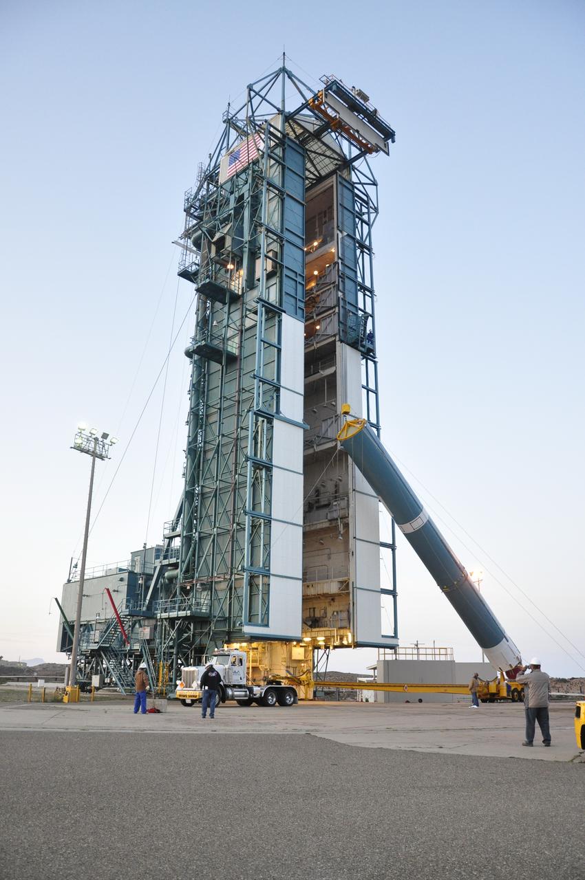
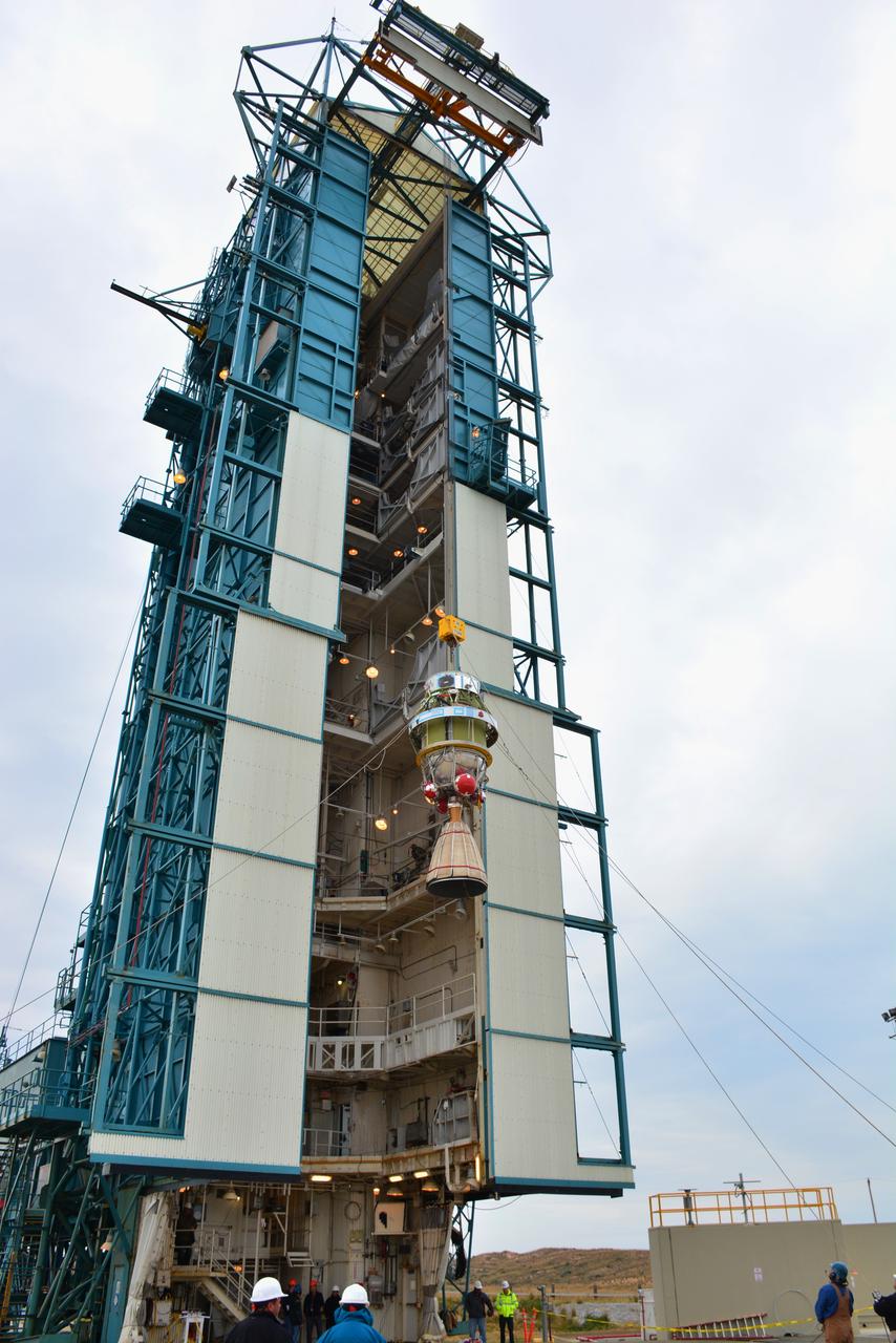
InSight Atlas V tower roll testing at Launch Complex 3, located at Vandenberg Air Force Base in California.
A bi-sector half of the payload fairing for a United Launch Alliance Delta II rocket is lifted upright for its move into the mobile service tower on Space Launch Complex 2 at Vandenberg Air Force Base in California. Preparations are underway for launch of the Joint Polar Satellite System (JPSS-1) spacecraft in 2017. JPSS-1 is part of the next-generation environmental satellite system, a collaborative program between the National Oceanic and Atmospheric Administration (NOAA) and NASA. To learn more about JPSS-1, visit http://www.jpss.noaa.gov.
At Vandenberg Air Force Base in California, a United Launch Alliance Centaur upper stage is prepared for transport to Space Launch Complex 3 for mating atop an Atlas V booster. The rocket will launch NASA's Interior Exploration using Seismic Investigations, Geodesy and Heat Transport, or InSight, mission to land on Mars. InSight is the first mission to explore the Red Planet's deep interior. It will investigate processes that shaped the rocky planets of the inner solar system including Earth. Liftoff is scheduled for May 5, 2018.
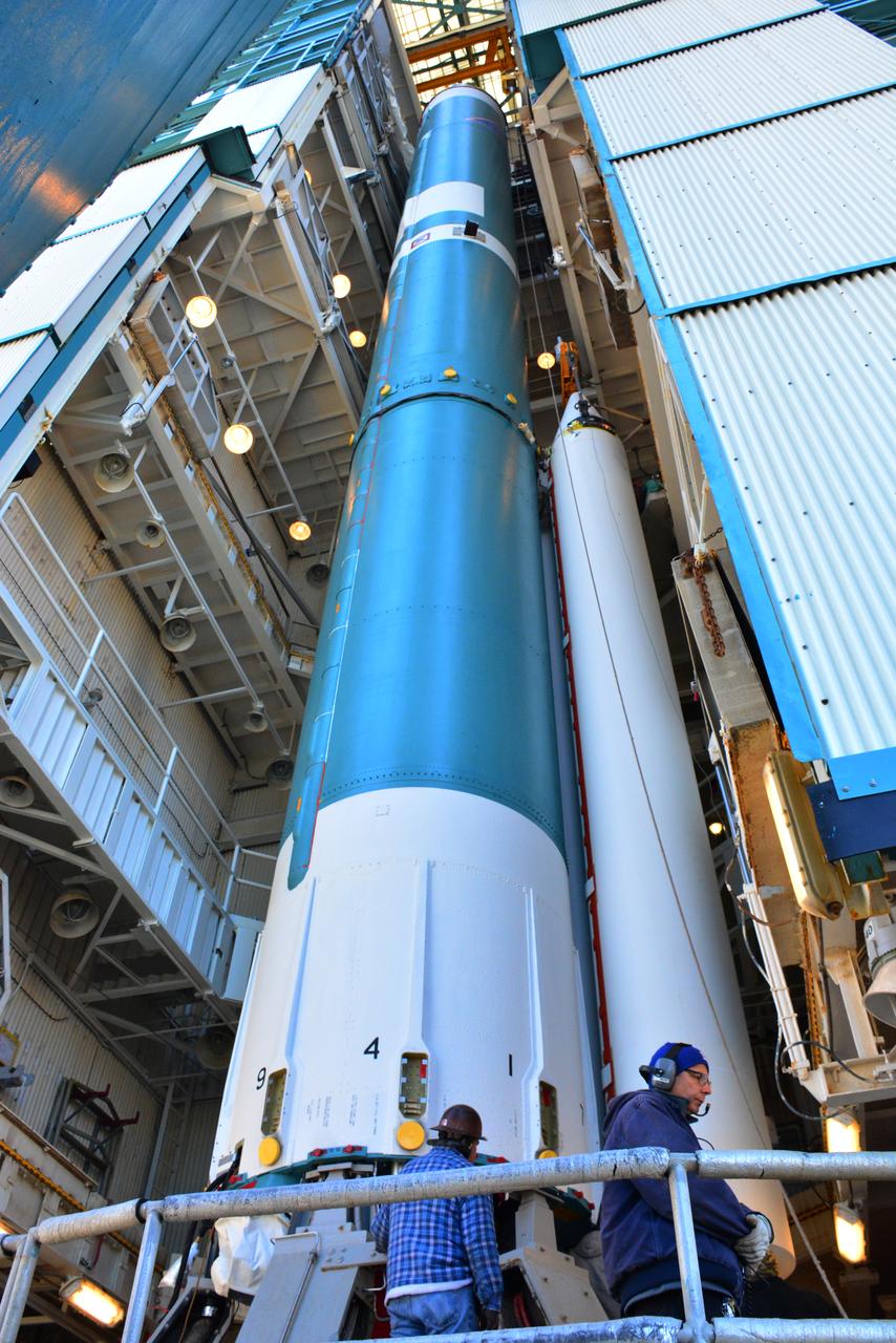
The United Launch Alliance Delta II second stage is lifted high up at the Vertical Integration Facility at Space Launch Complex 2 on June 12, 2018, at Vandenberg Air Force Base in California. The second stage will be attached to the top of the booster, or first stage of the rocket. NASA's Ice, Cloud and land Elevation Satellite-2 (ICESat-2) will launch on the final Delta II rocket. ICESat-2 will measure the height of a changing Earth, one laser pulse at a time, 10,000 laser pulses a second. The satellite will carry a single instrument, the Advanced Topographic Laser Altimeter System. ICESat-2 will help scientists investigate why, and how much our planet's frozen and icy areas, called the cryosphere, is changing in a warming climate.

VANDENBERG AIR FORCE BASE, Calif. – A worker maneuvers the transporter towing the Delta first-stage booster for NASA's Orbiting Carbon Observatory-2 mission, or OCO-2, at the Horizontal Processing Facility at Space Launch Complex 2 on Vandenberg Air Force Base in California. OCO-2 is scheduled to launch aboard a United Launch Alliance Delta II rocket in July. The observatory will collect precise global measurements of carbon dioxide in the Earth's atmosphere and provide scientists with a better idea of the chemical compound's impacts on climate change. Scientists will analyze this data to improve our understanding of the natural processes and human activities that regulate the abundance and distribution of this important atmospheric gas. To learn more about OCO-2, visit http://oco.jpl.nasa.gov. Photo credit: NASA/Randy Beaudoin
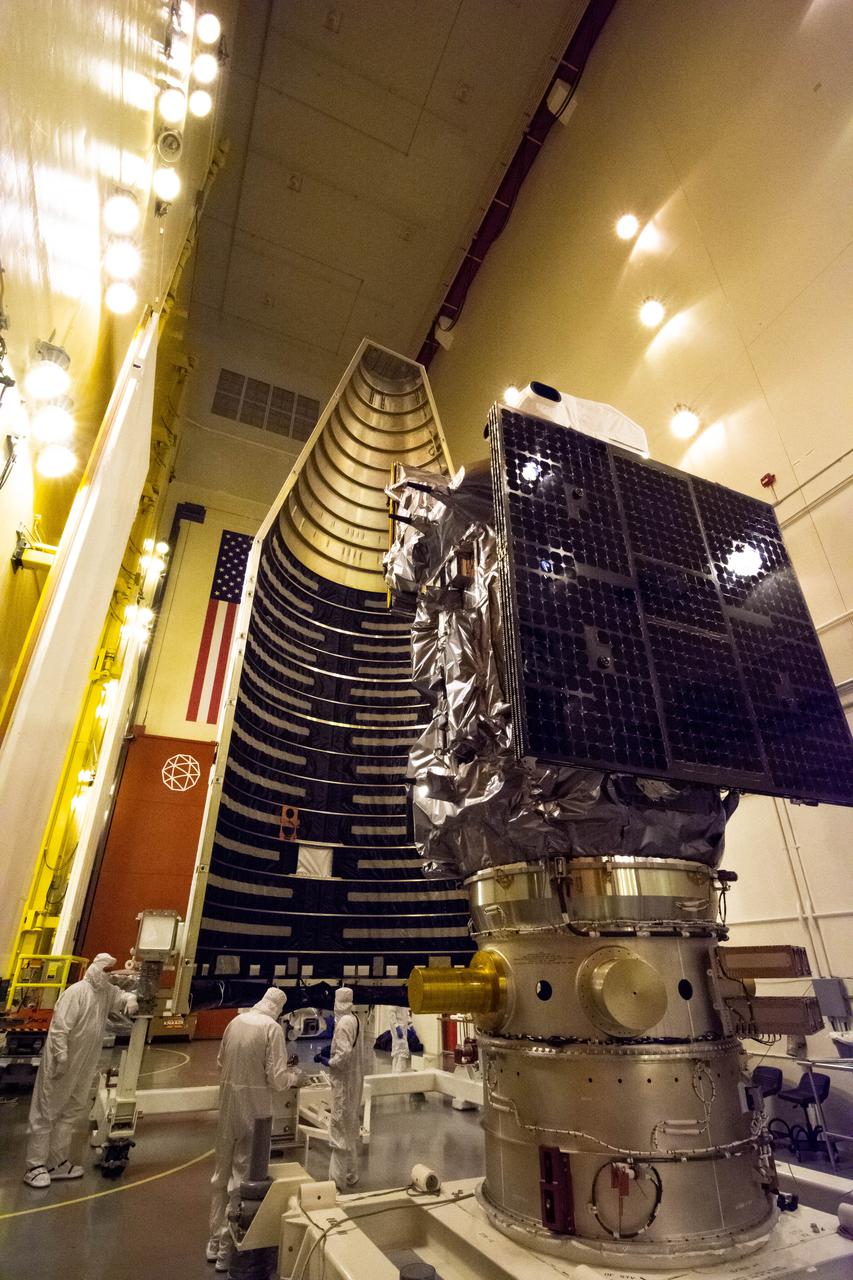
A crew offloaded the United Launch Alliance (ULA) Atlas V payload fairing from its transport container in building B7525 at Vandenberg Space Force Base (VSFB) in California on Aug. 8, 2022, for NASA and the National Oceanic and Atmospheric Administration’s (NOAA) Joint Polar Satellite System-2 (JPSS-2) satellite mission. JPSS-2 is the third satellite in the Joint Polar Satellite System series. It is scheduled to lift off from VSFB on Nov. 1 from Space Launch Complex-3 East. JPSS-2 will scan the globe as it orbits from the North to the South Pole, crossing the equator 14 times a day. From 512 miles above Earth, it will capture data that inform weather forecasts, extreme weather events, and climate change. The Visible Infrared Radiometer Suite instrument will collect imagery for global observations of the land, atmosphere, cryosphere, and oceans. Launching as a secondary payload to JPSS-2 is NASA’s Low-Earth Orbit Flight Test of an Inflatable Decelerator (LOFTID), dedicated to the memory of Bernard Kutter. LOFTID is a demonstration of a hypersonic inflatable aerodynamic decelerator, or aeroshell, technology that could one day help land humans on Mars.
Inside the Integrated Processing Facility at Vandenberg Space Force Base in California, technicians prepare the Landsat 9 spacecraft for encapsulation on Aug. 16, 2021. The two halves of the United Launch Alliance (ULA) payload fairing will surround and encase Landsat 9 to protect it during launch atop the ULA Atlas V rocket. Landsat 9 will launch on the Atlas V rocket from Space Launch Complex 3 at Vandenberg in September 2021. The launch is being managed by NASA’s Launch Services Program based at Kennedy Space Center, America’s multi-user spaceport. The Landsat 9 satellite will continue the nearly 50-year legacy of previous Landsat missions. It will monitor key natural and economic resources from orbit. Landsat 9 is managed by the agency’s Goddard Space Flight Center in Greenbelt, Maryland. The satellite will carry two instruments: the Operational Land Imager 2, which collects images of Earth’s landscapes in visible, near infrared and shortwave infrared light, and the Thermal Infrared Sensor 2, which measures the temperature of land surfaces. Like its predecessors, Landsat 9 is a joint mission between NASA and the U.S. Geological Survey.
At Space Launch Complex 3 at Vandenberg Air Force Base in California technicians and engineers prepare a United Launch Alliance Centaur upper stage for lifting and mating atop an Atlas V booster. The rocket will launch NASA's Interior Exploration using Seismic Investigations, Geodesy and Heat Transport, or InSight, mission to land on Mars. InSight is the first mission to explore the Red Planet's deep interior. It will investigate processes that shaped the rocky planets of the inner solar system including Earth. Liftoff is scheduled for May 5, 2018.
VANDENBERG AIR FORCE BASE, Calif. – Half of the fairing for NASA's Orbiting Carbon Observatory-2 mission, or OCO-2, is lifted into a vertical position at Space Launch Complex 2 on Vandenberg Air Force Base in California. Operations are underway to hoist this section of the fairing into the Delta II launcher's environmental enclosure, or clean room, at the top of the tower. The fairing will protect OCO-2 during launch aboard a United Launch Alliance Delta II rocket from Space Launch Complex 2 in July. The observatory will collect precise global measurements of carbon dioxide in the Earth's atmosphere and provide scientists with a better idea of the chemical compound's impacts on climate change. Scientists will analyze this data to improve our understanding of the natural processes and human activities that regulate the abundance and distribution of this important atmospheric gas. To learn more about OCO-2, visit http://oco.jpl.nasa.gov. Photo credit: NASA/Randy Beaudoin
A bi-sector half of the payload fairing for a United Launch Alliance Delta II rocket is lifted toward level 4 of the mobile service tower on Space Launch Complex 2 at Vandenberg Air Force Base in California. Preparations are underway for launch of the Joint Polar Satellite System (JPSS-1) spacecraft in 2017. JPSS-1 is part of the next-generation environmental satellite system, a collaborative program between the National Oceanic and Atmospheric Administration (NOAA) and NASA. To learn more about JPSS-1, visit http://www.jpss.noaa.gov.
The United Launch Alliance Atlas V payload fairing containing the National Oceanic and Atmospheric Administration’s (NOAA) Joint Polar Satellite System-2 (JPSS-2) is lifted by crane at the vertical integration facility at Space Launch Complex 3 at Vandenberg Space Force Base (VSFB) in California on Oct. 18, 2022. Inside the fairing, JPSS-2 is stacked atop NASA’s Low-Earth Orbit Flight Test of an Inflatable Decelerator (LOFTID) secondary payload. JPSS-2 is the third satellite in the Joint Polar Satellite System series. It is scheduled to lift off from VSFB on Nov. 1 from SLC-3. JPSS-2, which will be renamed NOAA-21 after reaching orbit, will join a constellation of JPSS satellites that orbit from the North to the South pole, circling Earth 14 times a day and providing a full view of the entire globe twice daily. The NOAA/NASA Suomi National Polar-orbiting Partnership (Suomi NPP) satellite, and NOAA-20, previously known as JPSS-1, are both already in orbit. Each satellite carries at least four advanced instruments to measure weather and climate conditions on Earth. LOFTID is dedicated to the memory of Bernard Kutter. LOFTID will demonstrate inflatable heat shield technology that could enable a variety of proposed NASA missions to destinations such as Mars, Venus, and Titan, as well as returning heavier payloads from low-Earth orbit.

Inside Building 836 at Vandenberg Air Force Base in California, the first half of the payload fairing for the United Launch Alliance (ULA) Delta II rocket is lifted out of its shipping container. NASA's Ice, Cloud and land Elevation Satellite-2 (ICESat-2) is scheduled to launch on the final ULA Delta II rocket later this year. ICESat-2 will measure the height of a changing Earth, one laser pulse at a time, 10,000 laser pulses a second. The satellite will carry a single instrument, the Advanced Topographic Laser Altimeter System. ICESat-2 will help scientists investigate why, and how much our planet's frozen and icy areas, called the cryosphere, is changing in a warming climate.
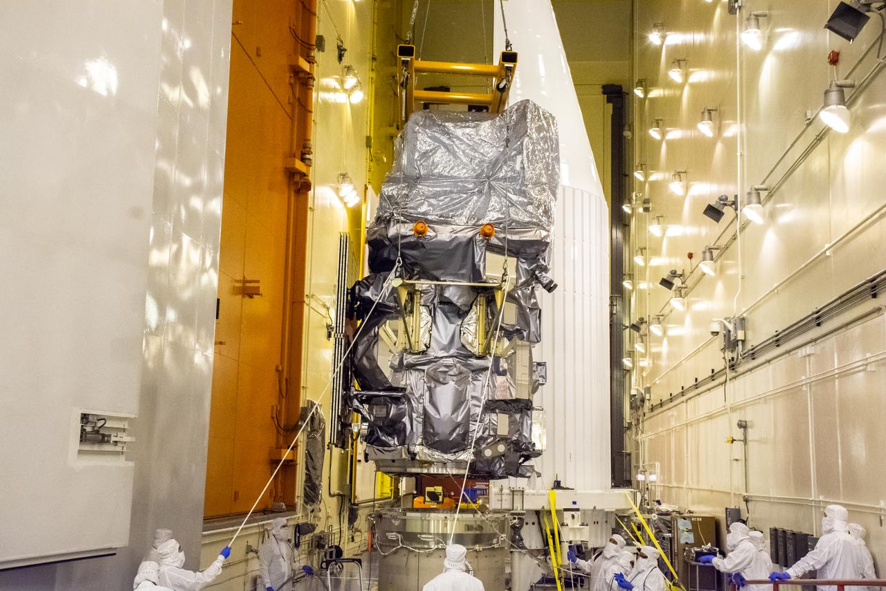
Technicians begin to attach the Landsat 9 spacecraft to the evolved expendable vehicle secondary payload adapter (ESPA) inside the Vertical Integration Facility at Vandenberg Space Force Base in California on Aug. 11, 2021. The ESPA connects Landsat 9 and the payload adapter (PMA) – the PMA then will attach to the second stage of a United Launch Alliance Atlas V rocket. Landsat 9 will launch on the Atlas V from Space Launch Complex 3 at Vandenberg in September 2021. The launch is being managed by NASA’s Launch Services Program based at Kennedy Space Center, America’s multi-user spaceport. The Landsat 9 satellite will continue the nearly 50-year legacy of previous Landsat missions. It will monitor key natural and economic resources from orbit. Landsat 9 is managed by the agency’s Goddard Space Flight Center in Greenbelt, Maryland. The satellite will carry two instruments: the Operational Land Imager 2, which collects images of Earth’s landscapes in visible, near infrared and shortwave infrared light, and the Thermal Infrared Sensor 2, which measures the temperature of land surfaces. Like its predecessors, Landsat 9 is a joint mission between NASA and the U.S. Geological Survey.
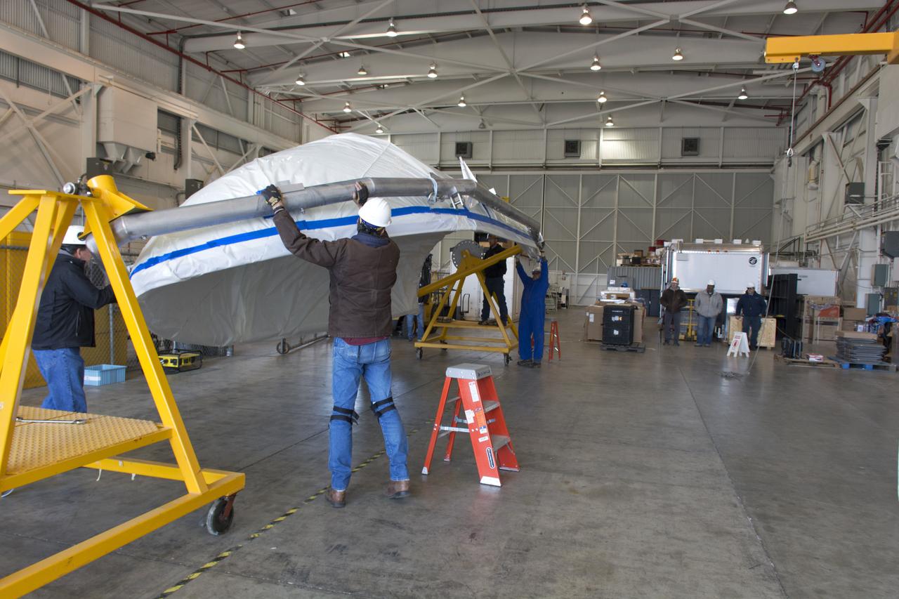
Workers transfer the wing for the Orbital ATK Pegasus XL rocket from a truck to a forklift at Building 1555 at Vandenberg Air Force Base in California. The rocket is being prepared for NASA's Ionospheric Connection Explorer, or ICON, mission. ICON will launch from the Kwajalein Atoll aboard the Pegasus XL on Dec. 8, 2017. ICON will study the frontier of space - the dynamic zone high in Earth's atmosphere where terrestrial weather from below meets space weather above. The explorer will help determine the physics of Earth's space environment and pave the way for mitigating its effects on our technology, communications systems and society.
On Friday, April 6, 2018, in NASA’s Building 8337 at Vandenberg Air Force Base in California, technicians and engineers clean and take samples from the payload fairing the will protect NASA's Ice, Cloud and land Elevation Satellite-2, or ICESat-2, satellite during launch. Liftoff atop a United Launch Alliance Delta II rocket is scheduled for Sept. 12, 2018, from Space Launch Complex-2 at Vandenberg. It will be the last for the venerable Delta II rocket. ICESat-2, which is being built and tested by Orbital ATK in Gilbert, Arizona, will carry a single instrument called the Advanced Topographic Laser Altimeter System, or ATLAS. The ATLAS instrument is being built and tested at NASA’s Goddard Space Flight Center in Greenbelt Maryland. Once in orbit, the satellite is designed to measure the height of a changing Earth, one laser pulse at a time, 10,000 laser pulses a second. ICESat-2 will help scientists investigate why, and how much, Earth’s frozen and icy areas, called the cryosphere, are changing.
The solar panels on NASA's Ionospheric Connection Explorer (ICON) are being deployed to test them inside Building 1555 at Vandenberg Air Force Base in California on Aug. 10, 2019. ICON will launch on a Pegasus XL rocket, attached beneath the company's L-1011 Stargazer aircraft, from the Skid Strip at Cape Canaveral Air Force Station in Florida. Launch is scheduled for Oct. 10. ICON will study the frontier of space - the dynamic zone high in Earth's atmosphere where terrestrial weather from below meets space weather above. The explorer will help determine the physics of Earth's space environment and pave the way for mitigating its effects on our technology and communications systems.
Technicians integrate the Sentinel-6B spacecraft to the payload attach fitting inside the Astrotech Space Operations payload processing facility at Vandenberg Space Force Base in California on Wednesday, Nov. 5, 2025. The payload attach fitting is part of the system that connects Sentinel-6B to the second stage of the SpaceX Falcon 9 rocket that will carry it to orbit. A collaboration between NASA, ESA (European Space Agency), EUMETSAT (European Organisation for the Exploitation of Meteorological Satellites), and the National Oceanic and Atmospheric Administration (NOAA), Sentinel-6B is designed to measure sea levels down to roughly an inch for about 90% of the world’s oceans. NASA is targeting launch no earlier than Sunday, Nov. 16, on a SpaceX Falcon 9 rocket from Space Launch Complex 4 East at Vandenberg.
A crane lifts a United Launch Alliance Atlas V booster at Space Launch Complex 3 at Vandenberg Air Force Base in California. The rocket will launch NASA's Interior Exploration using Seismic Investigations, Geodesy and Heat Transport, or InSight, mission to land on Mars. InSight is the first mission to explore the Red Planet's deep interior. It will investigate processes that shaped the rocky planets of the inner solar system including Earth. Liftoff is scheduled for May 5, 2018.
VANDENBERG AIR FORCE BASE, Calif. – Half of the fairing for NASA's Orbiting Carbon Observatory-2 mission, or OCO-2, arrives at the portal to the environmental enclosure, or clean room, at the top of the Delta II launcher at Space Launch Complex 2 on Vandenberg Air Force Base in California. The fairing will protect OCO-2 during launch aboard a United Launch Alliance Delta II rocket from Space Launch Complex 2 in July. The observatory will collect precise global measurements of carbon dioxide in the Earth's atmosphere and provide scientists with a better idea of the chemical compound's impacts on climate change. Scientists will analyze this data to improve our understanding of the natural processes and human activities that regulate the abundance and distribution of this important atmospheric gas. To learn more about OCO-2, visit http://oco.jpl.nasa.gov. Photo credit: NASA/Randy Beaudoin
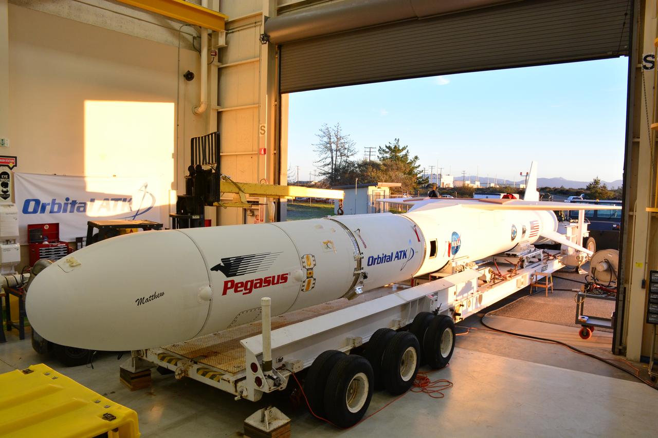
The Northrop Grumman Pegasus XL rocket, with NASA's Ionospheric Connection Explorer (ICON) secured in its payload fairing, rolls out to the runway at Vandenberg Air Force Base in California on Sept. 25, 2019. The Pegasus XL rocket will be attached beneath the company's L-1011 Stargazer aircraft for the flight to Cape Canaveral Air Force Station (CCAFS) in Florida. ICON will launch from the Skid Strip at CCAFS. Launch is scheduled for Oct. 10, 2019. ICON will study the frontier of space - the dynamic zone high in Earth's atmosphere where terrestrial weather from below meets space weather above. The explorer will help determine the physics of Earth's space environment and pave the way for mitigating its effects on our technology and communications systems.
VANDENBERG AIR FORCE BASE, Calif. – A worker surveys the Delta first-stage booster for NASA's Orbiting Carbon Observatory-2 mission, or OCO-2, secured in a transportation hardware cradle, that he delivered to the Horizontal Processing Facility at Space Launch Complex 2 on Vandenberg Air Force Base in California. OCO-2 is scheduled to launch aboard a United Launch Alliance Delta II rocket in July. The observatory will collect precise global measurements of carbon dioxide in the Earth's atmosphere and provide scientists with a better idea of the chemical compound's impacts on climate change. Scientists will analyze this data to improve our understanding of the natural processes and human activities that regulate the abundance and distribution of this important atmospheric gas. To learn more about OCO-2, visit http://oco.jpl.nasa.gov. Photo credit: NASA/Randy Beaudoin
At Vandenberg Air Force Base in California, on Tuesday, April 17, 2018, a United Launch Alliance (ULA) Delta II booster is transported to Space Launch Complex-2 where it will launch NASA's Ice, Cloud and land Elevation Satellite-2, or ICESat-2, satellite. This will be the last flight for the venerable Delta II rocket. ICESat-2, which is being built and tested by Orbital ATK in Gilbert, Arizona, will carry a single instrument called the Advanced Topographic Laser Altimeter System, or ATLAS. The ATLAS instrument is being built and tested at NASA’s Goddard Space Flight Center in Greenbelt Maryland. Once in orbit, the satellite is designed to measure the height of a changing Earth, one laser pulse at a time, 10,000 laser pulses a second. ICESat-2 will help scientists investigate why, and how much, Earth’s frozen and icy areas, called the cryosphere, are changing.

VANDENBERG AIR FORCE BASE, Calif. – Preparations are underway to transport the United Launch Alliance Delta II rocket for NASA's Orbiting Carbon Observatory-2 mission, or OCO-2, from the Horizontal Processing Facility to the mobile service tower at Space Launch Complex 2 on Vandenberg Air Force Base in California. Launch is scheduled for July 2014. The observatory will collect precise global measurements of carbon dioxide in the Earth's atmosphere and provide scientists with a better idea of the chemical compound's impacts on climate change. Scientists will analyze this data to improve our understanding of the natural processes and human activities that regulate the abundance and distribution of this important atmospheric gas. To learn more about OCO-2, visit http://oco.jpl.nasa.gov. Photo credit: NASA/Randy Beaudoin
VANDENBERG AIR FORCE BASE, Calif. – The Delta first-stage booster for NASA's Orbiting Carbon Observatory-2 mission, or OCO-2, rests on a transportation cradle in the Horizontal Integration Facility at Space Launch Complex 2 on Vandenberg Air Force Base in California. OCO-2 is scheduled to launch aboard a United Launch Alliance Delta II rocket in July. The observatory will collect precise global measurements of carbon dioxide in the Earth's atmosphere and provide scientists with a better idea of the chemical compound's impacts on climate change. Scientists will analyze this data to improve our understanding of the natural processes and human activities that regulate the abundance and distribution of this important atmospheric gas. To learn more about OCO-2, visit http://oco.jpl.nasa.gov. Photo credit: NASA/Randy Beaudoin
VANDENBERG AIR FORCE BASE, Calif. – Preparations are underway to lift the United Launch Alliance Delta II rocket for NASA's Orbiting Carbon Observatory-2 mission, or OCO-2, into the mobile service tower at Space Launch Complex 2 on Vandenberg Air Force Base in California. Launch is scheduled for July 2014. The observatory will collect precise global measurements of carbon dioxide in the Earth's atmosphere and provide scientists with a better idea of the chemical compound's impacts on climate change. Scientists will analyze this data to improve our understanding of the natural processes and human activities that regulate the abundance and distribution of this important atmospheric gas. To learn more about OCO-2, visit http://oco.jpl.nasa.gov. Photo credit: NASA/Randy Beaudoin
Inside Building 1555 at Vandenberg Air Force Base in California, technicians and engineers install one of eight NASA Cyclone Global Navigation Satellite System (CYGNSS) spacecraft on its deployment module. Processing activities will prepare the spacecraft for launch aboard an Orbital ATK Pegasus XL rocket. When preparations are competed at Vandenberg, the rocket will be transported to NASA’s Kennedy Space Center in Florida attached to the Orbital ATK L-1011 carrier aircraft with in its payload fairing. CYGNSS will launch on the Pegasus XL rocket from the Skid Strip at Cape Canaveral Air Force Station. CYGNSS will make frequent and accurate measurements of ocean surface winds throughout the life cycle of tropical storms and hurricanes. The data that CYGNSS provides will enable scientists to probe key air-sea interaction processes that take place near the core of storms, which are rapidly changing and play a critical role in the beginning and intensification of hurricanes.
The Landsat 9 EFS is mated to the C29 inside the Integrated Processing Facility at Vandenberg Space Force Base in California.
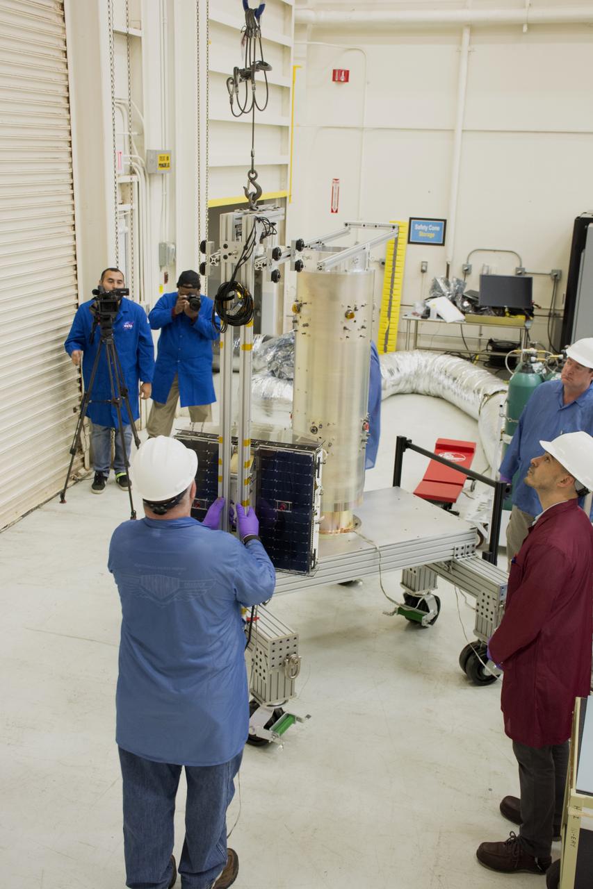
Technicians remove the satellite for the Landsat 9 mission from its shipping container following its arrival at Vandenberg Space Force Base in California on July 7, 2021. The Landsat 9 mission will launch atop a United Launch Alliance Atlas V rocket from Vandenberg in September 2021. The launch is being managed by NASA’s Launch Services Program based at Kennedy Space Center in Florida, America’s multi-user spaceport. The Landsat 9 satellite will continue the nearly 50-year legacy of previous Landsat missions. It will monitor key natural and economic resources from orbit. Landsat 9 is managed by the agency’s Goddard Space Flight Center in Greenbelt, Maryland. The satellite will carry two instruments: the Operational Land Imager 2, which collects images of Earth’s landscapes in visible, near infrared and shortwave infrared light, and the Thermal Infrared Sensor 2, which measures the temperature of land surfaces. Like its predecessors, Landsat 9 is a joint mission between NASA and the U.S. Geological Survey.
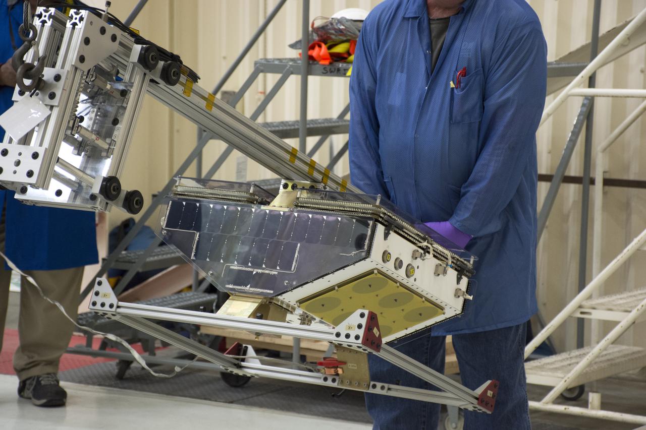
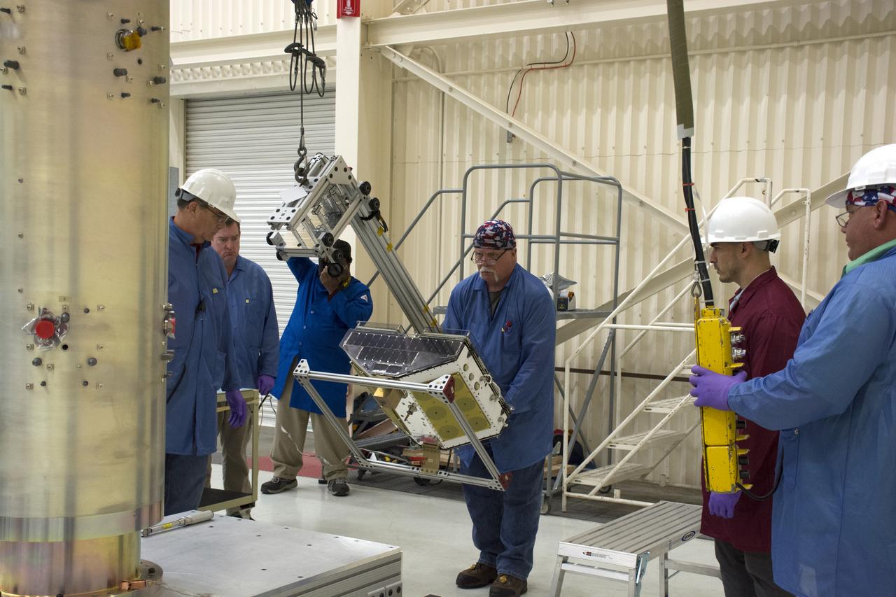
At Vandenberg Air Force Base in California, twin communications-relay CubeSats, called Mars Cube One (MarCO) are prepared for installation on an Atlas V rocket. MarCO constitutes a technology demonstration being built by NASA's Jet Propulsion Laboratory, Pasadena in California. They will launch in on the same United Launch Alliance Atlas V rocket as NASA's Interior Exploration using Seismic Investigations, Geodesy and Heat Transport, or InSight, spacecraft to land on Mars. CubeSats are a class of spacecraft based on a standardized small size and modular use of off-the-shelf technologies. Many have been made by university students, and dozens have been launched into Earth orbit using extra payload mass available on launches of larger spacecraft. InSight is the first mission to explore the Red Planet's deep interior. InSight is scheduled for liftoff May 5, 2018. InSight will be the first mission to look deep beneath the Martian surface. It will study the planet's interior by measuring its heat output and listen for marsquakes. InSight will use the seismic waves generated by marsquakes to develop a map of the planet’s deep interior. The resulting insight into Mars’ formation will provide a better understanding of how other rocky planets, including Earth, were created. NASA’s Jet Propulsion Laboratory in Pasadena, California, manages the InSight mission for the agency’s Science Mission Directorate. InSight is part of NASA's Discovery Program, managed by its Marshall Space Flight Center in Huntsville, Alabama. The spacecraft, including cruise stage and lander, was built and tested by Lockheed Martin Space in Denver. Several European partners, including France's space agency, the Centre National d'Étude Spatiales, and the German Aerospace Center, are supporting the mission. United Launch Alliance of Centennial, Colorado, is providing the Atlas V launch service. NASA’s Launch Services Program, based at its Kennedy Space Center in Florida, is responsible for laun
Technicians attach NASA's Ionospheric Connection Explorer (ICON) to the Northrop Grumman Pegasus XL rocket inside Building 1555 at Vandenberg Air Force Base in California on Sept. 10, 2019. Preparations are underway to perform a black light test on Pegasus before the port and starboard payload fairings are installed around ICON. The Pegasus XL rocket, attached beneath the company's L-1011 Stargazer aircraft, will launch ICON from the Skid Strip at Cape Canaveral Air Force Station in Florida. Launch is scheduled for Oct. 9, 2019. ICON will study the frontier of space - the dynamic zone high in Earth's atmosphere where terrestrial weather from below meets space weather above. The explorer will help determine the physics of Earth's space environment and pave the way for mitigating its effects on our technology and communications systems.
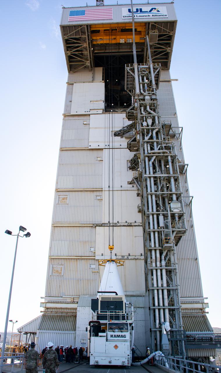
The Landsat 9 payload is hoisted out of the transfer tower inside the Integration Processing Facility at Vandenberg Space Force Base in California on Sept. 14, 2021, in preparation for transport to Vandenberg’s Space Launch Complex 3. The Landsat 9 mission launch, which is being managed by NASA’s Launch Services Program based at Kennedy Space Center in Florida, is targeted for no earlier than Sept. 27, 2021. Landsat 9 will launch on a United Launch Alliance Atlas V rocket. The satellite will monitor key natural and economic resources from orbit. Landsat 9 is a joint mission between NASA and the U.S. Geological Survey.
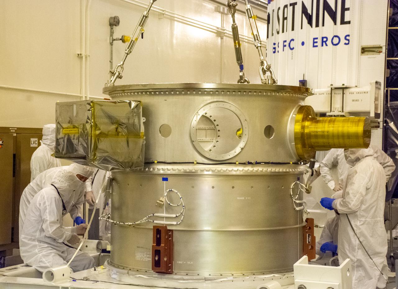
The Evolved Expendable Launch Vehicle Secondary Payload Adapter for NASA’s Landsat 9 mission is moved into a processing facility at Vandenberg Space Force Base in California, on June 14, 2021. The Landsat 9 mission will launch atop a United Launch Alliance Atlas V from Vandenberg in September 2021. The launch is being managed by NASA’s Launch Services Program based at Kennedy Space Center. The Landsat 9 satellite will continue the nearly 50-year legacy of previous Landsat missions. It will monitor key natural and economic resources from orbit. Landsat 9 is managed by the agency’s Goddard Space Flight Center in Greenbelt, Maryland. The satellite will carry two instruments: the Operational Land Imager 2, which collects images of Earth’s landscapes in visible, near infrared and shortwave infrared light, and the Thermal Infrared Sensor 2, which measures the temperature of land surfaces. Like its predecessors, Landsat 9 is a joint mission between NASA and the U.S. Geological Survey.
VANDENBERG AIR FORCE BASE, Calif. – The United Launch Alliance Delta II rocket for NASA's Orbiting Carbon Observatory-2 mission, or OCO-2, hangs in a vertical position beside the mobile service tower at Space Launch Complex 2 on Vandenberg Air Force Base in California. Launch is scheduled for July 2014. The observatory will collect precise global measurements of carbon dioxide in the Earth's atmosphere and provide scientists with a better idea of the chemical compound's impacts on climate change. Scientists will analyze this data to improve our understanding of the natural processes and human activities that regulate the abundance and distribution of this important atmospheric gas. To learn more about OCO-2, visit http://oco.jpl.nasa.gov. Photo credit: NASA/Randy Beaudoin
Technicians and engineers at Space Launch Complex 2 at Vandenberg Air Force Base in California, prepare to lift a United Launch Alliance/Orbital ATK solid rocket motor for mating to a Delta II rocket in preparation for launch of the Joint Polar Satellite System-1 (JPSS-1) later this year. JPSS, a next-generation environmental satellite system, is a collaborative program between the National Oceanic and Atmospheric Administration (NOAA) and NASA.
The Landsat 9 payload is hoisted out of the transfer tower at the Integration Processing Facility in preparation for transport to SLC-3 at Vandenberg Air Force Base in California.
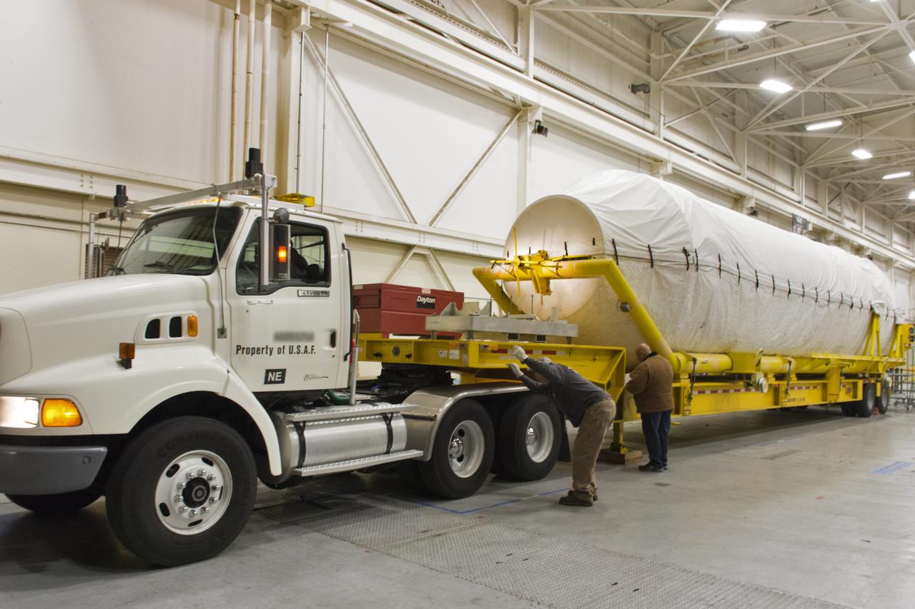
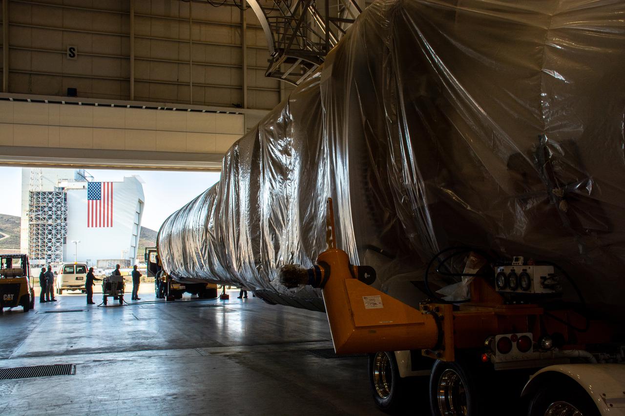
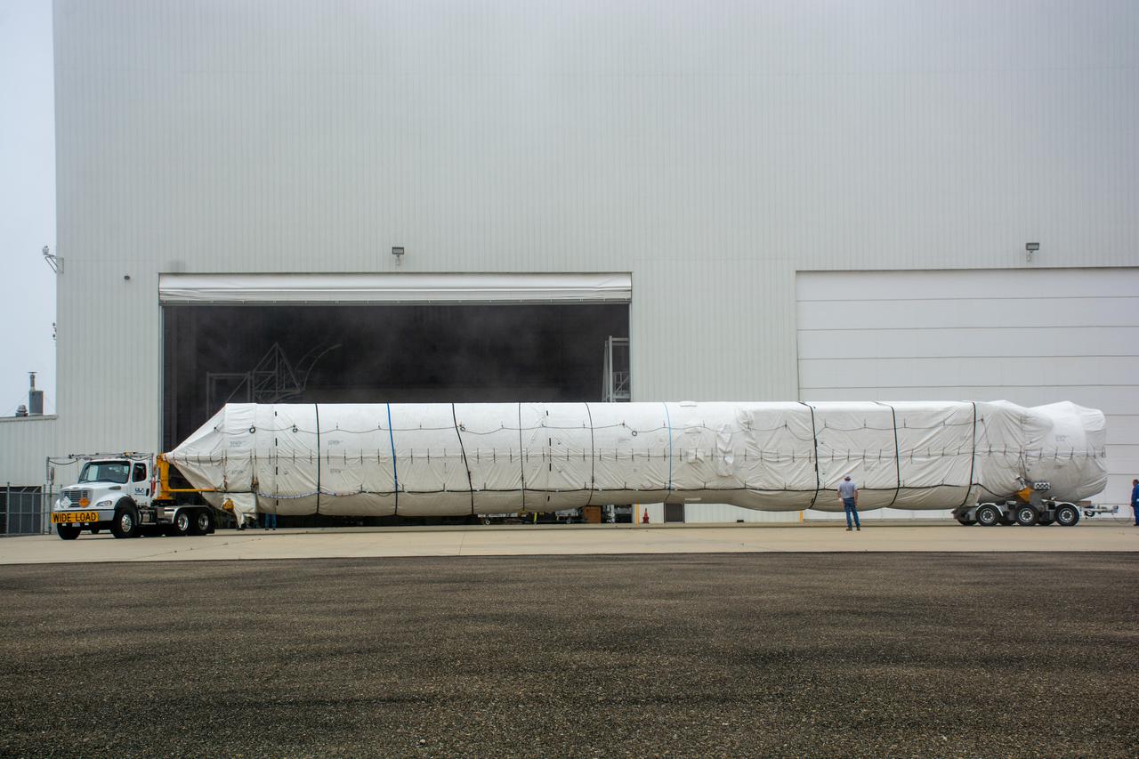
Both halves of the United Launch Alliance (ULA) Delta II rocket payload fairing are transported by convoy to ULA's Building B8337 at Vandenberg Air Force Base in California. NASA's Ice, Cloud and land Elevation Satellite-2 (ICESat-2) will launch later this year on the final Delta II rocket. ICESat-2 will measure the height of a changing Earth, one laser pulse at a time, 10,000 laser pulses a second. The satellite will carry a single instrument, the Advanced Topographic Laser Altimeter System. ICESat-2 will help scientists investigate why, and how much our planet's frozen and icy areas, called the cryosphere, is changing in a warming climate.

A flatbed truck arrives at Vandenberg Air Force Base in California, carrying the payload fairing for the United Launch Alliance (ULA) Delta II rocket that will launch NASA's Ice, Cloud and land Elevation Satellite-2 (ICESat-2). ICESat-2 will measure the height of a changing Earth, one laser pulse at a time, 10,000 laser pulses a second. The satellite will carry a single instrument, the Advanced Topographic Laser Altimeter System. ICESat-2 will help scientists investigate why, and how much our planet's frozen and icy areas, called the cryosphere, is changing in a warming climate. ICESat-2 is scheduled to launch on the final ULA Delta II rocket later this year.
Inside Building 1555 at Vandenberg Air Force Base in California, technicians and engineers offload the first stage motor for the Orbital ATK Pegasus XL rocket which will launch eight NASA Cyclone Global Navigation Satellite System, or CYGNSS, spacecraft. When preparations are completed at Vandenberg, the rocket, with CYGNSS in its payload fairing, will be attached to the Orbital ATK L-1011 carrier aircraft and transported to NASA’s Kennedy Space Center in Florida. On Dec. 12, 2016, the carrier aircraft is scheduled to take off from the Skid Strip at Cape Canaveral Air Force Station and CYGNSS will launch on the Pegasus XL rocket with the L-1011 flying off shore. CYGNSS will make frequent and accurate measurements of ocean surface winds throughout the life cycle of tropical storms and hurricanes. The data that CYGNSS provides will enable scientists to probe key air-sea interaction processes that take place near the core of storms, which are rapidly changing and play a critical role in the beginning and intensification of hurricanes.
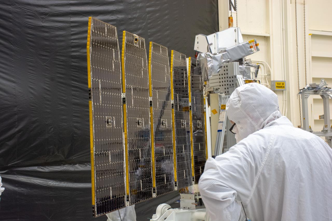
Technicians extend the solar array on NASA's Ionospheric Connection Explorer (ICON) during a deployment test inside Building 1555 at Vandenberg Air Force Base in California on Aug. 10, 2019. ICON will launch on a Pegasus XL rocket, attached beneath the company's L-1011 Stargazer aircraft, from the Skid Strip at Cape Canaveral Air Force Station in Florida. Launch is scheduled for Oct. 10. ICON will study the frontier of space - the dynamic zone high in Earth's atmosphere where terrestrial weather from below meets space weather above. The explorer will help determine the physics of Earth's space environment and pave the way for mitigating its effects on our technology and communications systems.
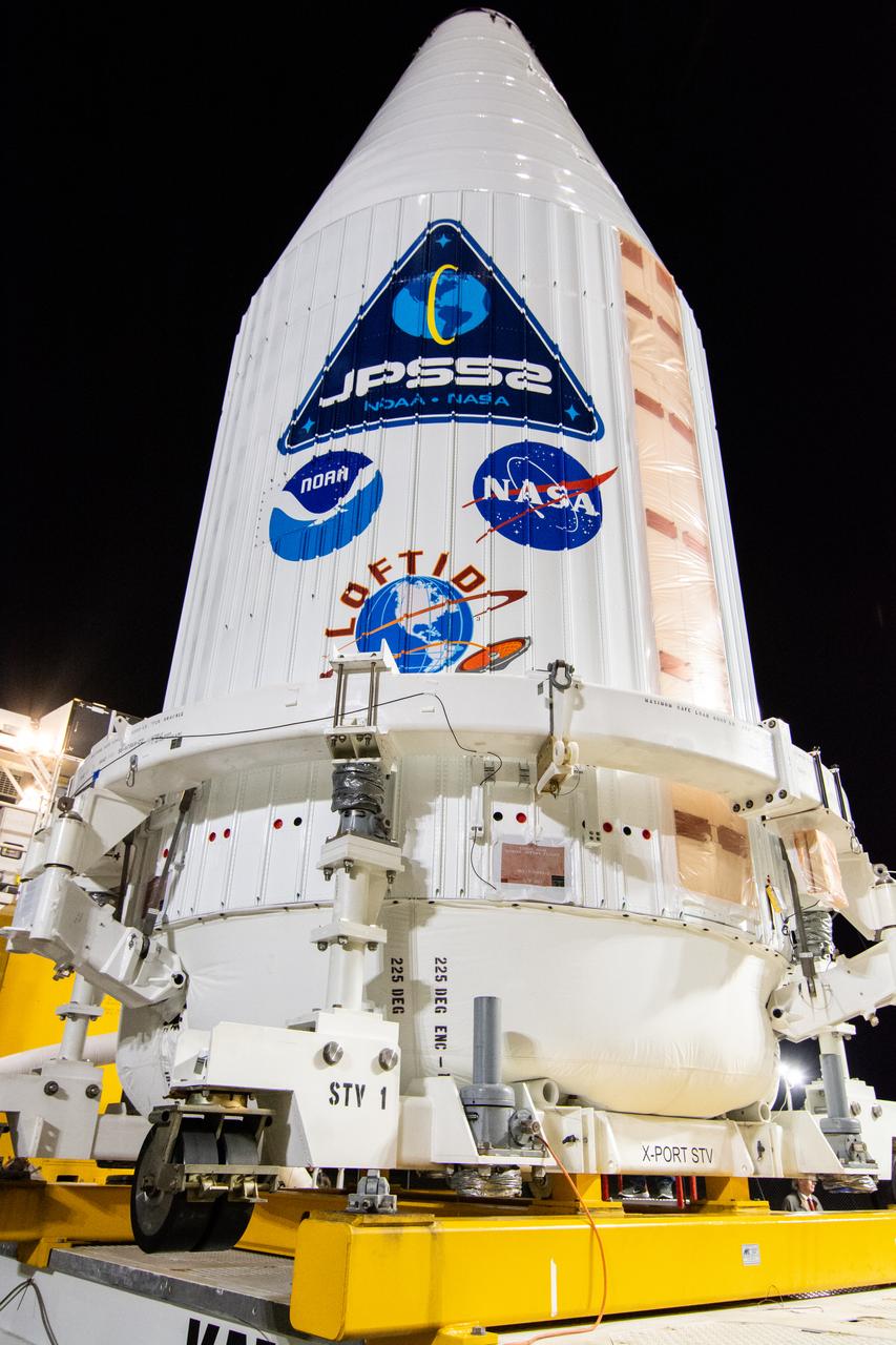
A close-up view of the United Launch Alliance Atlas V payload fairing containing the National Oceanic and Atmospheric Administration’s (NOAA) Joint Polar Satellite System-2 (JPSS-2) as it arrives at the vertical integration facility at Space Launch Complex 3 at Vandenberg Space Force Base (VSFB) in California on Oct. 18, 2022. Inside the fairing, JPSS-2 is stacked atop NASA’s Low-Earth Orbit Flight Test of an Inflatable Decelerator (LOFTID) secondary payload. JPSS-2 is the third satellite in the Joint Polar Satellite System series. It is scheduled to lift off from VSFB on Nov. 1 from SLC-3. JPSS-2, which will be renamed NOAA-21 after reaching orbit, will join a constellation of JPSS satellites that orbit from the North to the South pole, circling Earth 14 times a day and providing a full view of the entire globe twice daily. The NOAA/NASA Suomi National Polar-orbiting Partnership (Suomi NPP) satellite, and NOAA-20, previously known as JPSS-1, are both already in orbit. Each satellite carries at least four advanced instruments to measure weather and climate conditions on Earth. LOFTID is dedicated to the memory of Bernard Kutter. LOFTID will demonstrate inflatable heat shield technology that could enable a variety of proposed NASA missions to destinations such as Mars, Venus, and Titan, as well as returning heavier payloads from low-Earth orbit.
Technicians and engineers at Space Launch Complex 2 at Vandenberg Air Force Base in California, lift a United Launch Alliance/Orbital ATK solid rocket motor for mating to a Delta II rocket in preparation for launch of the Joint Polar Satellite System-1 (JPSS-1) later this year. JPSS, a next-generation environmental satellite system, is a collaborative program between the National Oceanic and Atmospheric Administration (NOAA) and NASA.

Inside the Integrated Processing Facility at Vandenberg Space Force Base in California, technicians monitor the progress as the Landsat 9 spacecraft is lifted by crane from the base of its protective container on July 8, 2021. Landsat 9 is being prepared for its launch atop the ULA Atlas V from Vandenberg in September 2021. The launch is being managed by NASA’s Launch Services Program based at Kennedy Space Center in Florida. Landsat 9 will continue the nearly 50-year legacy of previous Landsat missions. It will monitor key natural and economic resources from orbit. Landsat 9 is managed by the agency’s Goddard Space Flight Center in Greenbelt, Maryland. It will carry two instruments: the Operational Land Imager 2, which collects images of Earth’s landscapes in visible, near-infrared and shortwave infrared light, and the Thermal Infrared Sensor 2, which measures the temperature of land surfaces. Like its predecessors, Landsat 9 is a joint mission between NASA and the U.S. Geological Survey.
VANDENBERG AIR FORCE BASE, Calif. – The Delta first-stage booster for NASA's Orbiting Carbon Observatory-2 mission, or OCO-2, secured in a transportation hardware cradle, is towed to the Horizontal Processing Facility at Space Launch Complex 2 on Vandenberg Air Force Base in California. OCO-2 is scheduled to launch aboard a United Launch Alliance Delta II rocket in July. The observatory will collect precise global measurements of carbon dioxide in the Earth's atmosphere and provide scientists with a better idea of the chemical compound's impacts on climate change. Scientists will analyze this data to improve our understanding of the natural processes and human activities that regulate the abundance and distribution of this important atmospheric gas. To learn more about OCO-2, visit http://oco.jpl.nasa.gov. Photo credit: NASA/Randy Beaudoin
At Vandenberg Air Force Base in California, a United Launch Alliance Delta II second stage is hoisted into the gantry at Space Launch Complex 2. It will be mounted atop first stage of the rocket as preparations continue for the launch of the Joint Polar Satellite System-1 (JPSS-1) later this year. JPSS, a next-generation environmental satellite system, is a collaborative program between the National Oceanic and Atmospheric Administration (NOAA) and NASA.
The Landsat 9 PSR to EFS C29 lift and mate inside the Integrated Processing Facility at Vandenberg Space Force Base in California.

The Landsat 9 instrument cover is removed from the spacecraft inside the Integrated Processing Facility (IPF) at Vandenberg Space Force Base in California.
Preparations are underway to lift the interstage and assembly second stage adapters for the United Alliance Atlas V Centaur second stage for NASA’s Landsat 9 mission at Space Launch Complex 3 at Vandenberg Space Force Base in California, on July 14, 2021. The adapters will be stacked atop the Centaur second stage in the Vertical Integration Facility near the launch pad. The Landsat 9 mission will launch atop the Atlas V rocket from Vandenberg in September 2021. The launch is being managed by NASA’s Launch Services Program based at Kennedy Space Center, America’s multiuser spaceport. The Landsat 9 satellite will continue the nearly 50-year legacy of previous Landsat missions. It will monitor key natural and economic resources from orbit. Landsat 9 is managed by the agency’s Goddard Space Flight Center in Greenbelt, Maryland. The satellite will carry two instruments: the Operational Land Imager 2, which collects images of Earth’s landscapes in visible, near infrared and shortwave infrared light, and the Thermal Infrared Sensor 2, which measures the temperature of land surfaces. Like its predecessors, Landsat 9 is a joint mission between NASA and the U.S. Geological Survey.
Inside Building 836 at Vandenberg Air Force Base in California, the first half of the payload fairing for the United Launch Alliance (ULA) Delta II rocket has been lifted out of its shipping container. The metal framing around it is being secured on a stand that allows the fairing to be rotated. NASA's Ice, Cloud and land Elevation Satellite-2 (ICESat-2) is scheduled to launch on the final ULA Delta II rocket later this year. ICESat-2 will measure the height of a changing Earth, one laser pulse at a time, 10,000 laser pulses a second. The satellite will carry a single instrument, the Advanced Topographic Laser Altimeter System. ICESat-2 will help scientists investigate why, and how much our planet's frozen and icy areas, called the cryosphere, is changing in a warming climate.
The United Launch Alliance Atlas V booster for NASA’s Landsat 9 mission departs the Horizontal Integration Facility at Vandenberg Space Force Base in California, on July 12, 2021. The booster will be transported to the Vertical Integration Facility at Space Launch Complex 3. The Landsat 9 mission will launch atop the Atlas V rocket from Vandenberg in September 2021. The launch is being managed by NASA’s Launch Services Program based at Kennedy Space Center. The Landsat 9 satellite will continue the nearly 50-year legacy of previous Landsat missions. It will monitor key natural and economic resources from orbit. Landsat 9 is managed by the agency’s Goddard Space Flight Center in Greenbelt, Maryland. The satellite will carry two instruments: the Operational Land Imager 2, which collects images of Earth’s landscapes in visible, near infrared and shortwave infrared light, and the Thermal Infrared Sensor 2, which measures the temperature of land surfaces. Like its predecessors, Landsat 9 is a joint mission between NASA and the U.S. Geological Survey.
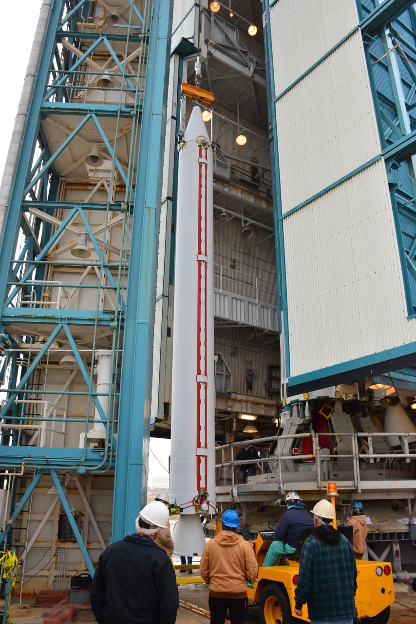
At Vandenberg Air Force Base in California, the aft stub adapter (ASA) and interstage adapter (ISA) for a United Launch Alliance (ULA) Atlas V rocket are transported to Space Launch Complex 3. The launch vehicle will send NASA's Interior Exploration using Seismic Investigations, Geodesy and Heat Transport, or InSight, spacecraft to land on Mars. InSight is the first mission to explore the Red Planet's deep interior. InSight is scheduled for liftoff May 5, 2018. InSight will be the first mission to look deep beneath the Martian surface. It will study the planet's interior by measuring its heat output and listen for marsquakes. InSight will use the seismic waves generated by marsquakes to develop a map of the planet’s deep interior. The resulting insight into Mars’ formation will provide a better understanding of how other rocky planets, including Earth, were created. NASA’s Jet Propulsion Laboratory in Pasadena, California, manages the InSight mission for the agency’s Science Mission Directorate. InSight is part of NASA's Discovery Program, managed by its Marshall Space Flight Center in Huntsville, Alabama. The spacecraft, including cruise stage and lander, was built and tested by Lockheed Martin Space in Denver. Several European partners, including France's space agency, the Centre National d'Étude Spatiales, and the German Aerospace Center, are supporting the mission. United Launch Alliance of Centennial, Colorado, is providing the Atlas V launch service. NASA’s Launch Services Program, based at its Kennedy Space Center in Florida, is responsible for launch management.
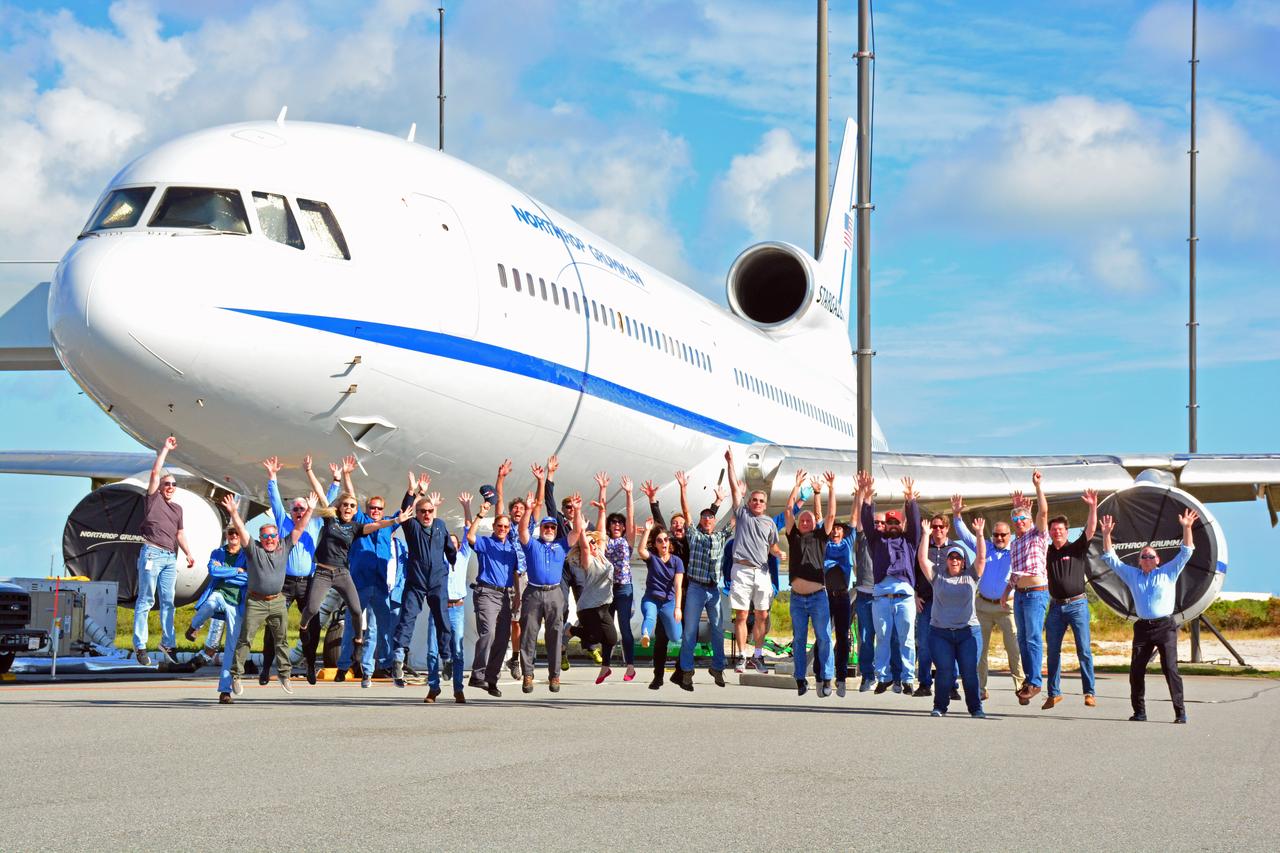
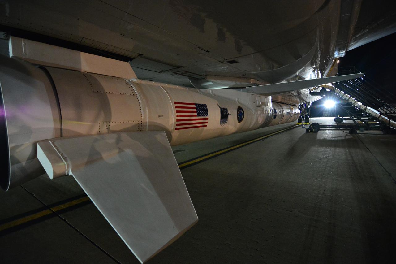
Members of the launch team for NASA’s Ionospheric Connection Explorer (ICON) gather for a joyous group photo in front of the Northrop Grumman L-1011 Stargazer aircraft carrying the Pegasus XL rocket at the Skid Strip at Florida’s Cape Canaveral Air Force Station, Nov. 10, 2019. Hours later, the rocket containing ICON air-launched from beneath the aircraft off the coast of Daytona Beach. ICON will study the frontier of space - the dynamic zone high in Earth's atmosphere where terrestrial weather from below meets space weather above. The explorer will help determine the physics of Earth's space environment and pave the way for mitigating its effects on our technology, communications systems and society.
Encapsulated within the United Launch Alliance (ULA) payload fairing, the Landsat 9 spacecraft undergoes final preparations before launch inside the Integrated Processing Facility at Vandenberg Space Force Base in California on Aug. 25, 2021. Landsat 9 will launch on a ULA Atlas V rocket from Space Launch Complex 3 at Vandenberg in September 2021. The launch is being managed by NASA’s Launch Services Program based at Kennedy Space Center, America’s multi-user spaceport. The Landsat 9 satellite will continue the nearly 50-year legacy of previous Landsat missions and monitor key natural and economic resources from orbit. Landsat 9 is managed by the agency’s Goddard Space Flight Center in Greenbelt, Maryland. The satellite will carry two instruments: the Operational Land Imager 2, which collects images of Earth’s landscapes in visible, near infrared and shortwave infrared light, and the Thermal Infrared Sensor 2, which measures the temperature of land surfaces. Like its predecessors, Landsat 9 is a joint mission between NASA and the U.S. Geological Survey.
VANDENBERG AIR FORCE BASE, Calif. – The United Launch Alliance Delta II rocket for NASA's Orbiting Carbon Observatory-2 mission, or OCO-2, is lifted from its transporter beside the mobile service tower at Space Launch Complex 2 on Vandenberg Air Force Base in California. Launch is scheduled for July 2014. The observatory will collect precise global measurements of carbon dioxide in the Earth's atmosphere and provide scientists with a better idea of the chemical compound's impacts on climate change. Scientists will analyze this data to improve our understanding of the natural processes and human activities that regulate the abundance and distribution of this important atmospheric gas. To learn more about OCO-2, visit http://oco.jpl.nasa.gov. Photo credit: NASA/Randy Beaudoin
Inside Building 1555 at Vandenberg Air Force Base in California, one of eight NASA Cyclone Global Navigation Satellite System (CYGNSS) spacecraft is inspected. Processing activities will prepare the spacecraft for launch aboard an Orbital ATK Pegasus XL rocket. When preparations are competed at Vandenberg, the rocket will be transported to NASA’s Kennedy Space Center in Florida attached to the Orbital ATK L-1011 carrier aircraft with in its payload fairing. CYGNSS will launch on the Pegasus XL rocket from the Skid Strip at Cape Canaveral Air Force Station. CYGNSS will make frequent and accurate measurements of ocean surface winds throughout the life cycle of tropical storms and hurricanes. The data that CYGNSS provides will enable scientists to probe key air-sea interaction processes that take place near the core of storms, which are rapidly changing and play a critical role in the beginning and intensification of hurricanes.
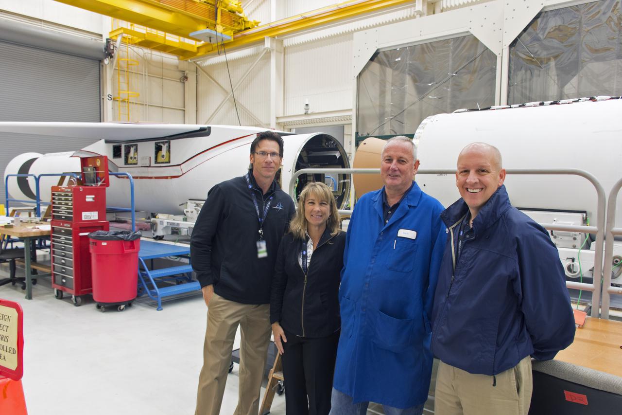
Managers of NASA's Launch Services Program (LSP) at Kennedy Space Center visit the processing facility for the Pegasus XL rocket at Vandenberg Air Force Base in California. From left, are Chuck Dovale, deputy manager; Amanda Mitskevich, manager; Eric Denbrook, launch vehicle processing at VAFB; and Tim Dunn, NASA assistant launch manager for ICON. The Pegasus XL rocket is being prepared for the agency's Ionospheric Connection Explorer, or ICON, mission. ICON will launch from the Kwajalein Atoll aboard the Pegasus XL on Dec. 8, 2017. ICON will study the frontier of space - the dynamic zone high in Earth's atmosphere where terrestrial weather from below meets space weather above. The explorer will help determine the physics of Earth's space environment and pave the way for mitigating its effects on our technology, communications systems and society.
Technicians and engineers at Space Launch Complex 2 at Vandenberg Air Force Base in California, mate a United Launch Alliance/Orbital ATK solid rocket motor to a Delta II rocket in preparation for launch of the Joint Polar Satellite System-1 (JPSS-1) later this year. JPSS, a next-generation environmental satellite system, is a collaborative program between the National Oceanic and Atmospheric Administration (NOAA) and NASA.
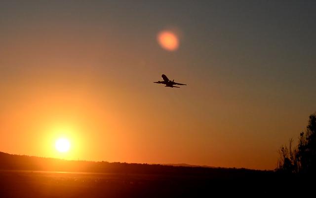
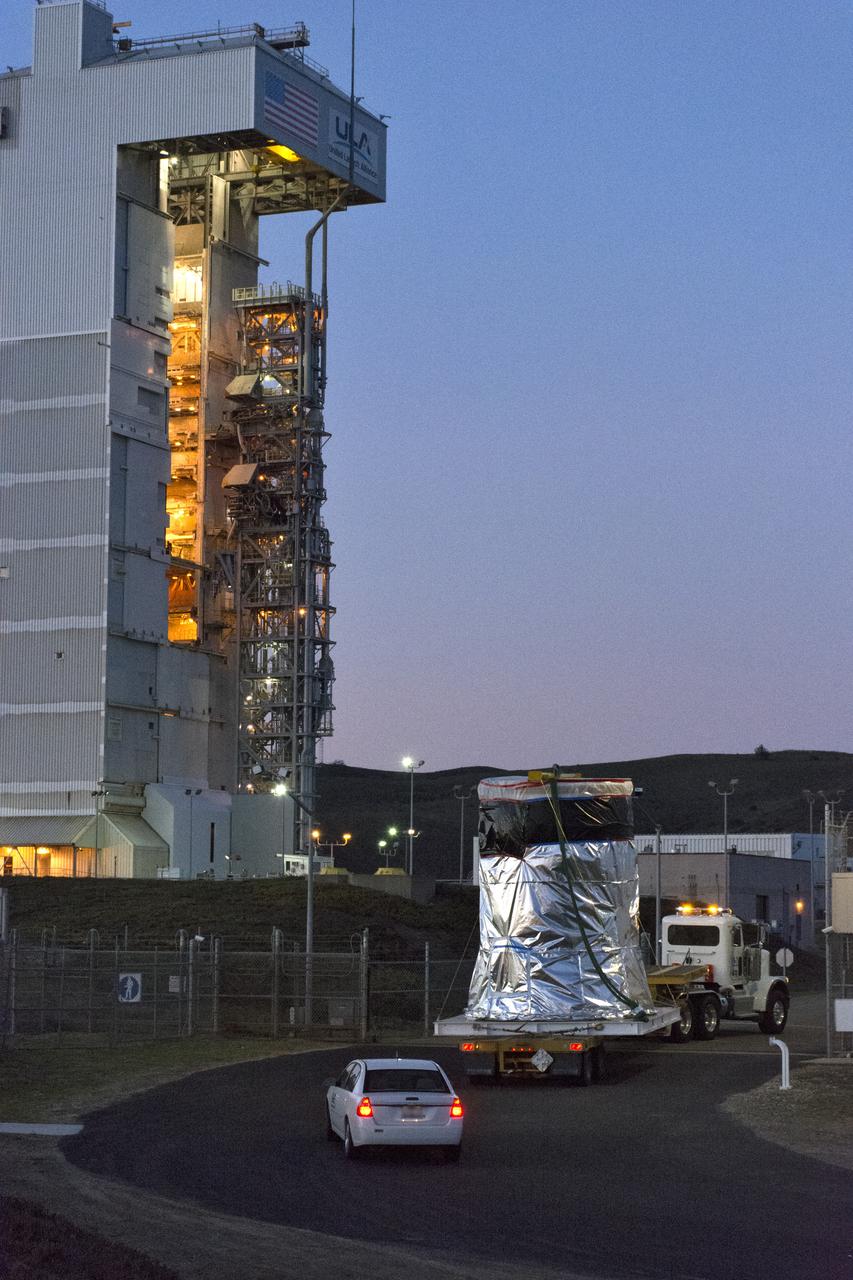
The Orbital ATK L-1011 Stargazer, with a Pegasus XL rocket mated to the underside of the aircraft, takes off at sunrise from Vandenberg Air Force Base in California. On board Pegasus XL are eight NASA Cyclone Global Navigation Satellite System, or CYGNSS, spacecraft. The CYGNSS/Pegasus XL combination is being flown to NASA’s Kennedy Space Center in Florida. On Dec. 12, 2016, the carrier aircraft is scheduled to take off from the Skid Strip at Cape Canaveral Air Force Station and CYGNSS will launch on the Pegasus XL rocket with the L-1011 flying off shore. CYGNSS satellites will make frequent and accurate measurements of ocean surface winds throughout the life cycle of tropical storms and hurricanes. The data that CYGNSS provides will help scientists to probe key air-sea interaction processes that take place near the core of storms, which are rapidly changing and play a crucial role in the beginning and intensification of hurricanes.
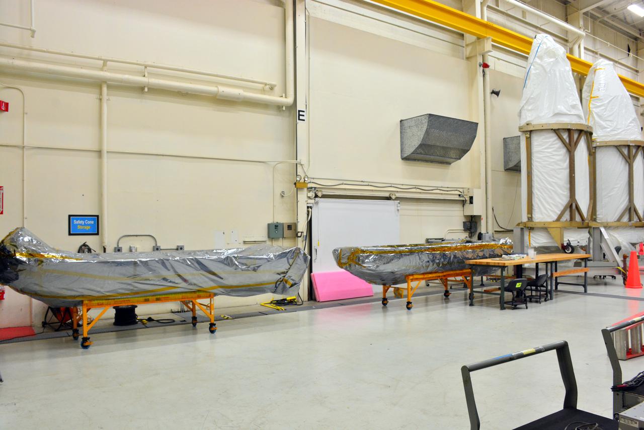
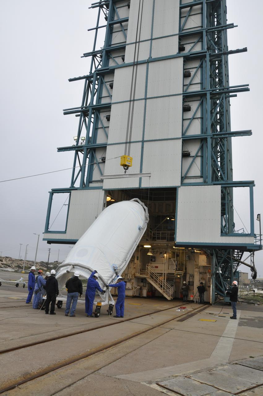
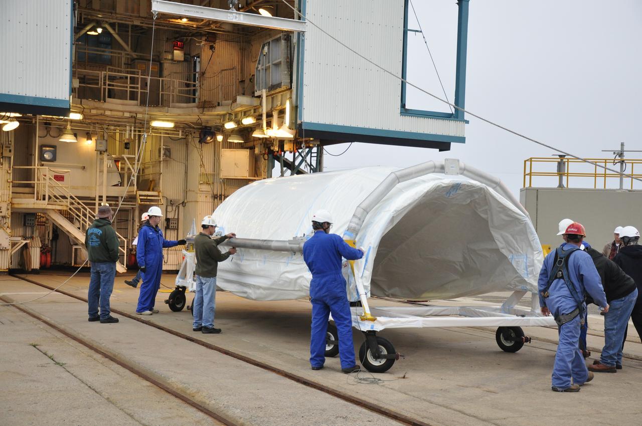
The payload fairing halves for Orbital ATK's Pegasus XL rocket are staged inside Building 1555 at Vandenberg Air Force Base in California on Aug. 23, 2017. The Pegasus rocket is being prepared for NASA's Ionospheric Connection Explorer (ICON) mission. The explorer will launch on June 15, 2018, from Kwajalein Atoll in the Marshall Islands (June 14 in the continental United States) on the Pegasus XL, which is attached to the company's L-1011 Stargazer aircraft. ICON will study the frontier of space - the dynamic zone high in Earth's atmosphere where terrestrial weather from below meets space weather above. The explorer will help determine the physics of Earth's space environment and pave the way for mitigating its effects on our technology, communications systems and society.
NASA's Ionospheric Connection Explorer (ICON) is prepared for a solar array illumination test in a clean room inside Building 1555 at Vandenberg Air Force Base in California on May 4, 2018. The test checks for any imperfections and confirms that the solar arrays are functioning properly. The explorer will launch on June 15, 2018, from Kwajalein Atoll in the Marshall Islands (June 14 in the continental United States) on Orbital ATK's Pegasus XL rocket, which is attached to the company's L-1011 Stargazer aircraft. ICON will study the frontier of space - the dynamic zone high in Earth's atmosphere where terrestrial weather from below meets space weather above. The explorer will help determine the physics of Earth's space environment and pave the way for mitigating its effects on our technology, communications systems and society.
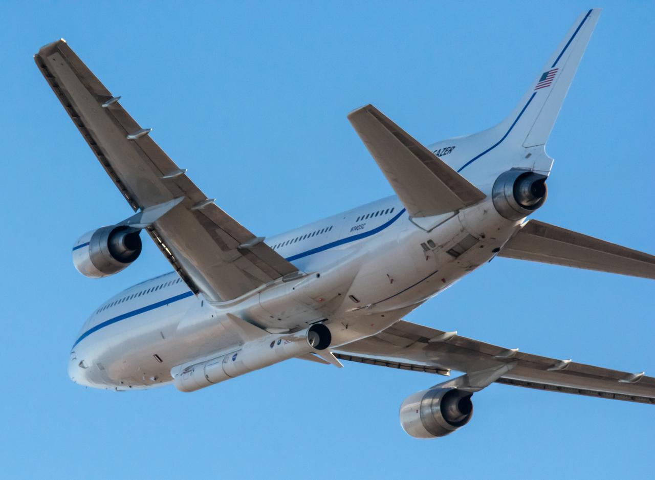
Northrop Grumman's L-1011 Stargazer takes off from Vandenberg Air Force Base in California on Oct. 1, 2019. The company's Pegasus XL rocket, containing NASA's Ionospheric Connection Explorer (ICON), is attached beneath the aircraft. The explorer is targeted to launch on Oct. 9, 2019, from Cape Canaveral Air Force Station in Florida. ICON will study the frontier of space - the dynamic zone high in Earth's atmosphere where terrestrial weather from below meets space weather above.
The satellite for the Landsat 9 mission, secured inside its shipping container, arrives at the Integrated Processing Facility at Vandenberg Space Force Base in California on July 7, 2021. The Landsat 9 mission will launch atop a United Launch Alliance Atlas V rocket from Vandenberg in September 2021. The launch is being managed by NASA’s Launch Services Program based at Kennedy Space Center in Florida, America’s multi-user spaceport. The Landsat 9 satellite will continue the nearly 50-year legacy of previous Landsat missions. It will monitor key natural and economic resources from orbit. Landsat 9 is managed by the agency’s Goddard Space Flight Center in Greenbelt, Maryland. The satellite will carry two instruments: the Operational Land Imager 2, which collects images of Earth’s landscapes in visible, near infrared and shortwave infrared light, and the Thermal Infrared Sensor 2, which measures the temperature of land surfaces. Like its predecessors, Landsat 9 is a joint mission between NASA and the U.S. Geological Survey.
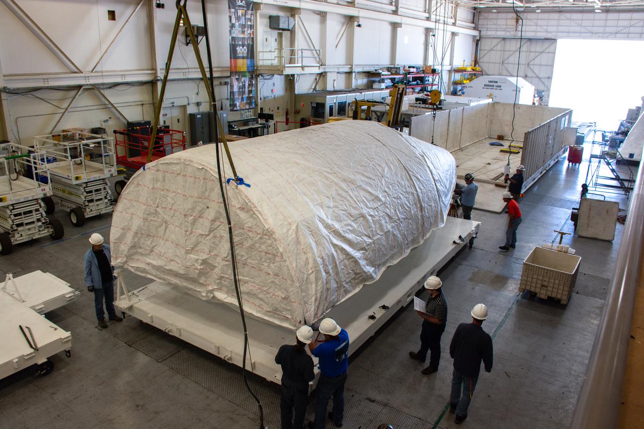
Parts for NASA’s Cyclone Global Navigation Satellite System (CYGNSS) arrive in a shipping container at Building 1555 at Vandenberg Air Force Base in California. CYGNSS is being prepared at Vandenberg, and then will be transported to NASA’s Kennedy Space Center in Florida in the Orbital ATK Pegasus XL rocket which will be attached to the Orbital ATK L-1011 carrier aircraft. CYNSS will launch on the Pegasus XL rocket from the Skid Strip at Cape Canaveral Air Force Station. CYGNSS will make frequent and accurate measurements of ocean surface winds throughout the life cycle of tropical storms and hurricanes. The data that CYGNSS provides will enable scientists to probe key air-sea interaction processes that take place near the core of storms, which are rapidly changing and play a critical role in the beginning and intensification of hurricanes.
At Space Launch Complex 3 at Vandenberg Air Force Base in California technicians and engineers prepare a United Launch Alliance Centaur upper stage for lifting and mating atop an Atlas V booster. The rocket will launch NASA's Interior Exploration using Seismic Investigations, Geodesy and Heat Transport, or InSight, mission to land on Mars. InSight is the first mission to explore the Red Planet's deep interior. It will investigate processes that shaped the rocky planets of the inner solar system including Earth. Liftoff is scheduled for May 5, 2018.
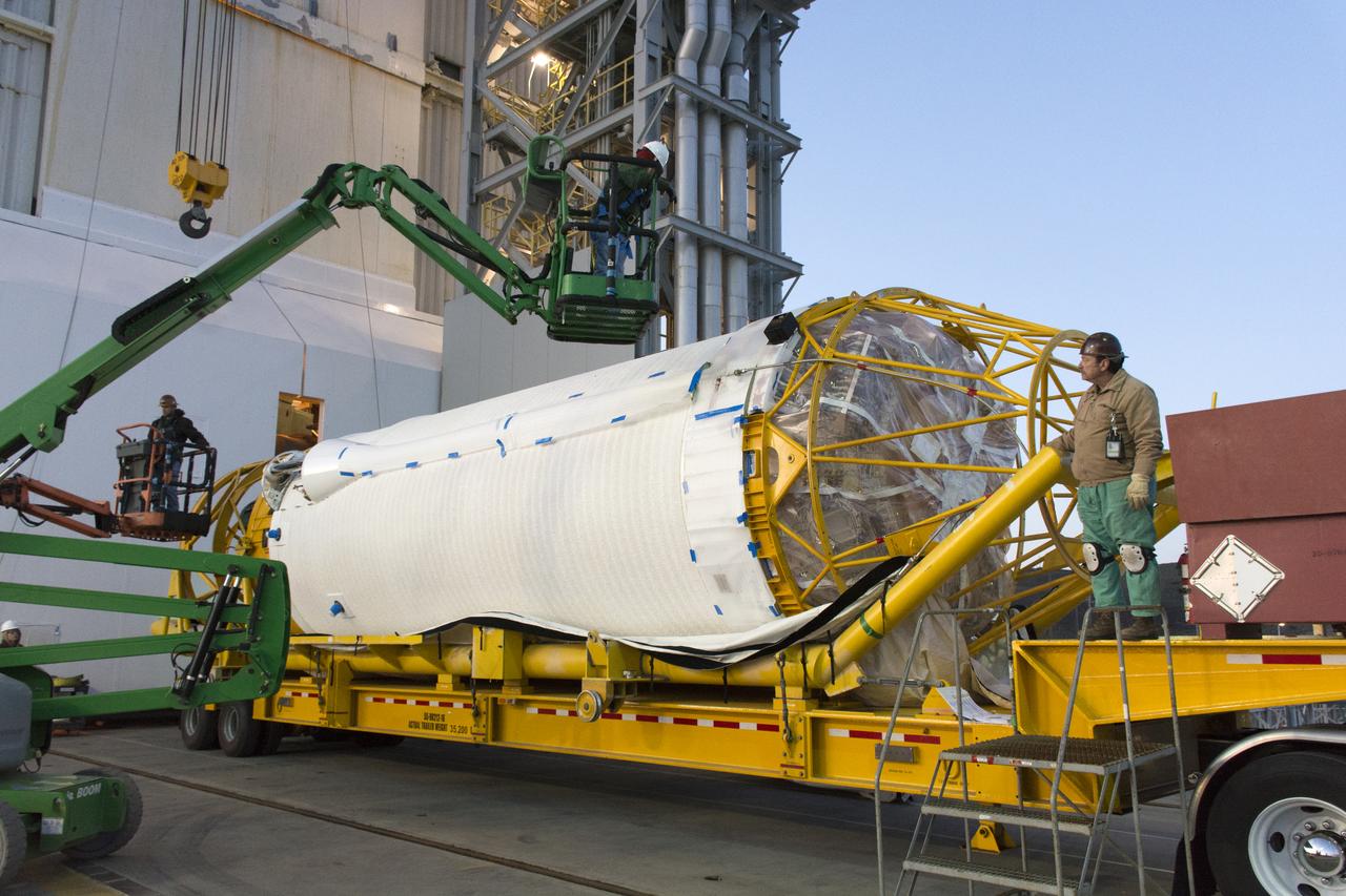
At Vandenberg Air Force Base in California, the boattail adaptor interface that will connect the Centaur upper stage to the payload fairing arrives for NASA's upcoming Interior Exploration using Seismic Investigations, Geodesy and Heat Transport, or InSight, mission to land on Mars. InSight will liftoff atop a United Launch Alliance Atlas V rocket to send the spacecraft on the first mission to explore the Red Planet's deep interior. It will investigate processes that shaped the rocky planets of the inner solar system including Earth. Liftoff from Vandenberg is scheduled for May 5, 2018.
Both halves of the United Launch Alliance (ULA) Delta II rocket payload fairing are transported by convoy to ULA's Building B8337 at Vandenberg Air Force Base in California. NASA's Ice, Cloud and land Elevation Satellite-2 (ICESat-2) will launch later this year on the final Delta II rocket. ICESat-2 will measure the height of a changing Earth, one laser pulse at a time, 10,000 laser pulses a second. The satellite will carry a single instrument, the Advanced Topographic Laser Altimeter System. ICESat-2 will help scientists investigate why, and how much our planet's frozen and icy areas, called the cryosphere, is changing in a warming climate.
Inside Building 1555 at Vandenberg Air Force Base in California, the eight NASA Cyclone Global Navigation Satellite System (CYGNSS) spacecraft installed on their deployment module undergo inspections prior to NASA’s Kennedy Space Center in Florida. Processing activities will prepare the spacecraft for launch aboard an Orbital ATK Pegasus XL rocket. When preparations are competed at Vandenberg, the rocket will be transported to Kennedy attached to the Orbital ATK L-1011 carrier aircraft with in its payload fairing. CYGNSS will launch on the Pegasus XL rocket from the Skid Strip at Cape Canaveral Air Force Station. CYGNSS will make frequent and accurate measurements of ocean surface winds throughout the life cycle of tropical storms and hurricanes. The data that CYGNSS provides will enable scientists to probe key air-sea interaction processes that take place near the core of storms, which are rapidly changing and play a critical role in the beginning and intensification of hurricanes.
Inside the Integrated Processing Facility at Vandenberg Space Force Base in California, the Landsat 9 spacecraft is moved into position for encapsulation on Aug. 16, 2021. The two halves of the United Launch Alliance (ULA) payload fairing will surround and encase Landsat 9 to protect it during launch atop the ULA Atlas V rocket. Landsat 9 will launch on the Atlas V rocket from Space Launch Complex 3 at Vandenberg in September 2021. The launch is being managed by NASA’s Launch Services Program based at Kennedy Space Center, America’s mult-iuser spaceport. The Landsat 9 satellite will continue the nearly 50-year legacy of previous Landsat missions. It will monitor key natural and economic resources from orbit. Landsat 9 is managed by the agency’s Goddard Space Flight Center in Greenbelt, Maryland. The satellite will carry two instruments: the Operational Land Imager 2, which collects images of Earth’s landscapes in visible, near infrared and shortwave infrared light, and the Thermal Infrared Sensor 2, which measures the temperature of land surfaces. Like its predecessors, Landsat 9 is a joint mission between NASA and the U.S. Geological Survey.
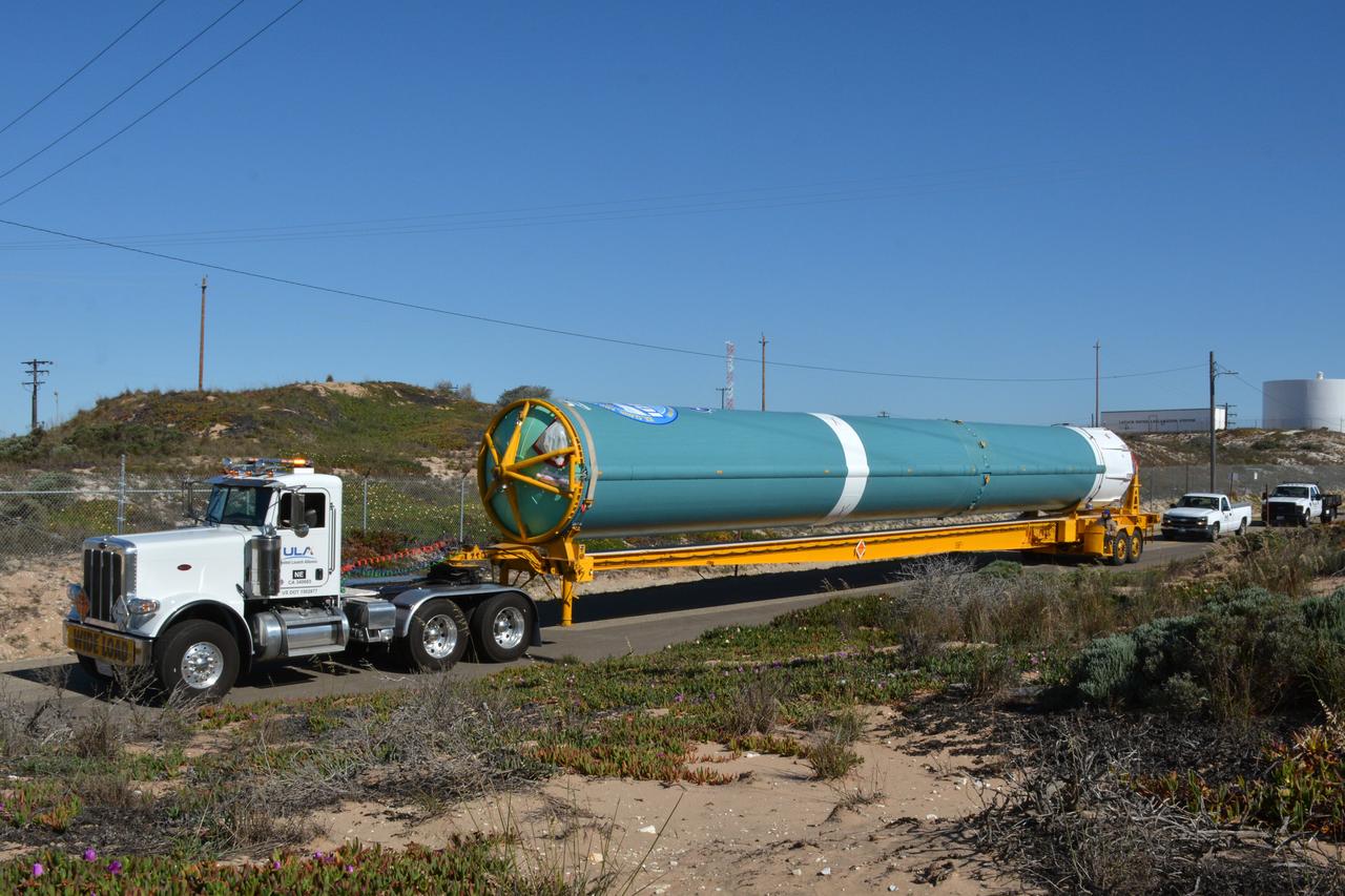
The United Launch Alliance (ULA) Atlas V booster for NASA’s Landsat 9 mission is transported by flatbed truck to the Horizontal Integration Facility at Vandenberg Space Force Base in California, on June 29, 2021. The Landsat 9 mission will launch atop a ULA Atlas V rocket from Vandenberg in September 2021. The launch is being managed by NASA’s Launch Services Program based at Kennedy Space Center. The Landsat 9 satellite will continue the nearly 50-year legacy of previous Landsat missions. It will monitor key natural and economic resources from orbit. Landsat 9 is managed by the agency’s Goddard Space Flight Center in Greenbelt, Maryland. The satellite will carry two instruments: the Operational Land Imager 2, which collects images of Earth’s landscapes in visible, near infrared and shortwave infrared light, and the Thermal Infrared Sensor 2, which measures the temperature of land surfaces. Like its predecessors, Landsat 9 is a joint mission between NASA and the U.S. Geological Survey.
At Vandenberg Air Force Base in California, an Orbital ATK Pegasus XL rocket is placed on an assembly integration transporter for the move from the hangar at Building 1555 to be mated to L-1011 carrier aircraft near Vandenberg's runway. On board Pegasus are eight NASA Cyclone Global Navigation Satellite System, or CYGNSS, spacecraft. When preparations are competed at Vandenberg, the L-1011/Pegasus XL combination will be flown to NASA’s Kennedy Space Center in Florida. On Dec. 12, 2016, the carrier aircraft is scheduled to take off from the Skid Strip at Cape Canaveral Air Force Station and CYGNSS will launch on the Pegasus XL rocket with the L-1011 flying off shore. CYGNSS satellites will make frequent and accurate measurements of ocean surface winds throughout the life cycle of tropical storms and hurricanes. The data that CYGNSS provides will enable scientists to probe key air-sea interaction processes that take place near the core of storms, which are rapidly changing and play a critical role in the beginning and intensification of hurricanes.
An Orbital ATK Pegasus XL rocket is mated to the underside of the company's L-1011 Stargazer aircraft. The Stargazer is being prepared for takeoff from Vandenberg Air Force Base in California. On board Pegasus XL are eight NASA Cyclone Global Navigation Satellite System, or CYGNSS, spacecraft. When preparations are competed at Vandenberg, the /Pegasus XL combination will be flown to NASA’s Kennedy Space Center in Florida. On Dec. 12, 2016, the carrier aircraft is scheduled to take off from the Skid Strip at Cape Canaveral Air Force Station and CYGNSS will launch on the Pegasus XL rocket with the L-1011 flying off shore. CYGNSS satellites will make frequent and accurate measurements of ocean surface winds throughout the life cycle of tropical storms and hurricanes. The data that CYGNSS provides will help scientists to probe key air-sea interaction processes that take place near the core of storms, which are rapidly changing and play a crucial role in the beginning and intensification of hurricanes.
VANDENBERG AIR FORCE BASE, Calif. – Workers remove the protective wrap from half of the fairing for NASA's Orbiting Carbon Observatory-2 mission, or OCO-2, newly arrived at Space Launch Complex 2 on Vandenberg Air Force Base in California. Operations are underway to hoist this section of the fairing into the Delta II launcher's environmental enclosure, or clean room, at the top of the tower. The fairing will protect OCO-2 during launch aboard a United Launch Alliance Delta II rocket from Space Launch Complex 2 in July. The observatory will collect precise global measurements of carbon dioxide in the Earth's atmosphere and provide scientists with a better idea of the chemical compound's impacts on climate change. Scientists will analyze this data to improve our understanding of the natural processes and human activities that regulate the abundance and distribution of this important atmospheric gas. To learn more about OCO-2, visit http://oco.jpl.nasa.gov. Photo credit: NASA/Randy Beaudoin

The Landsat 9 instrument cover is removed from the spacecraft inside the Integrated Processing Facility (IPF) at Vandenberg Space Force Base in California.