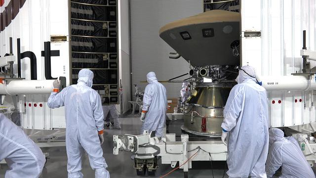
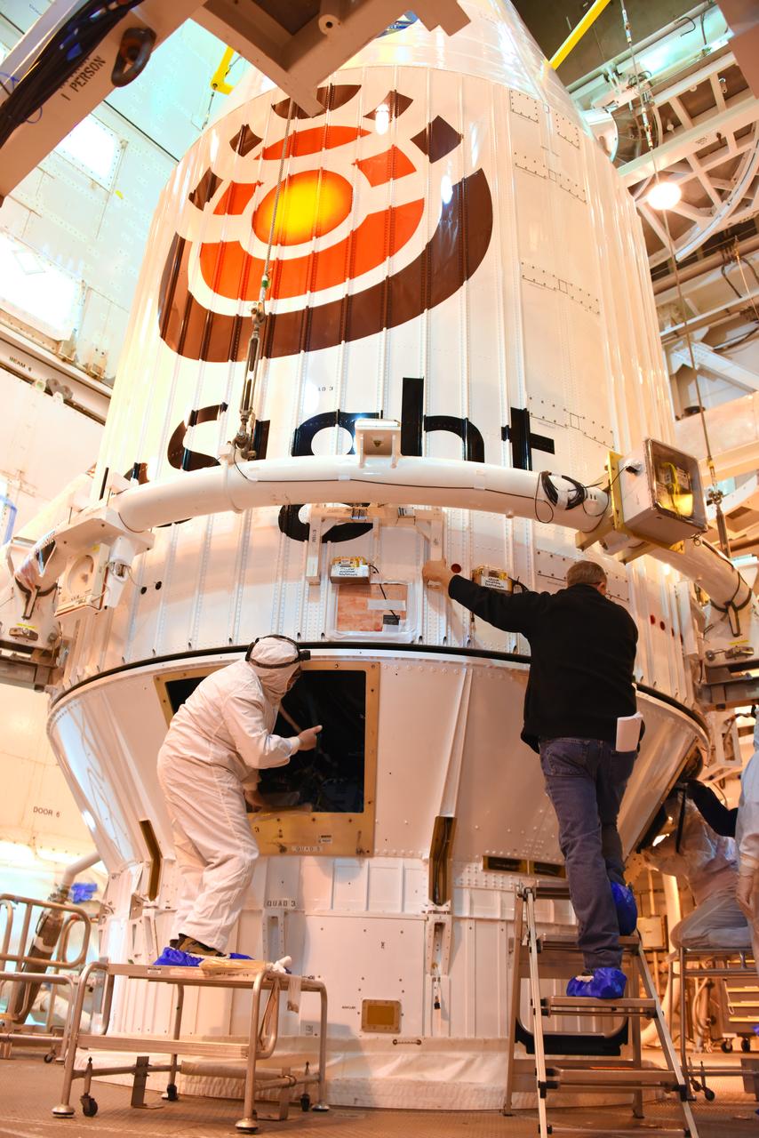
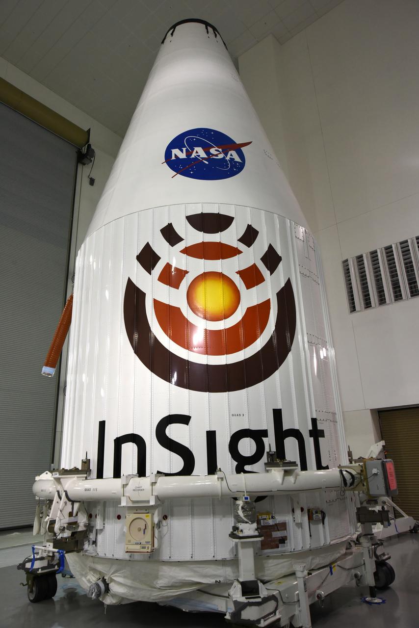
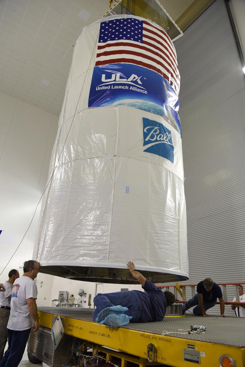
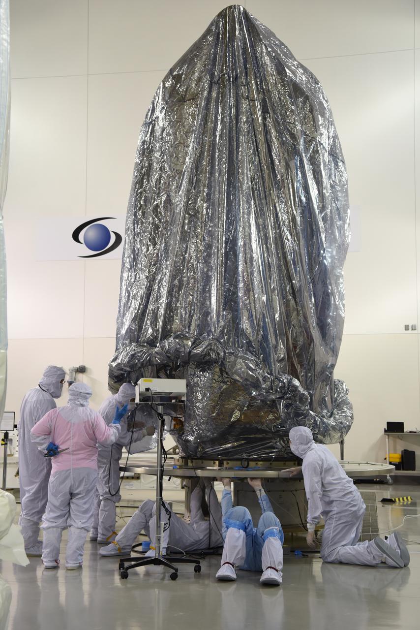
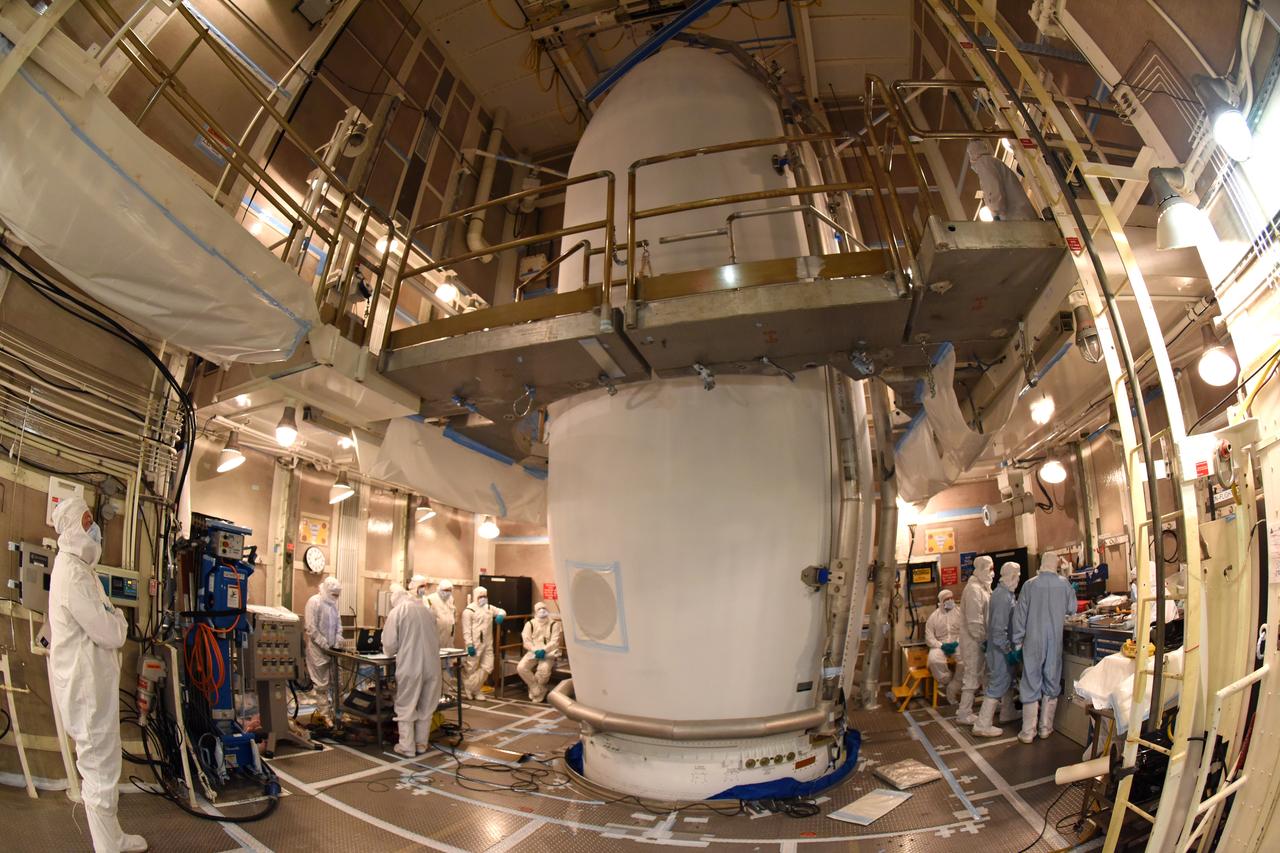
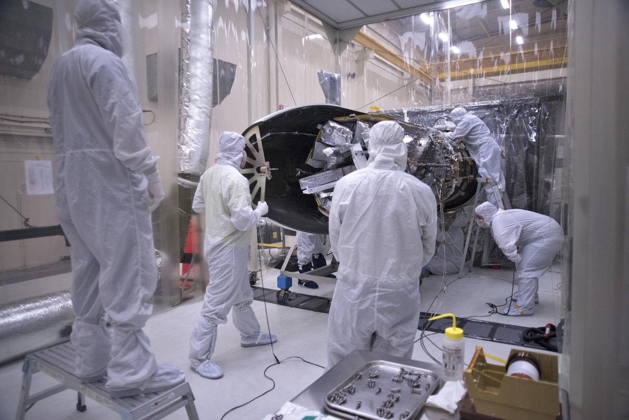
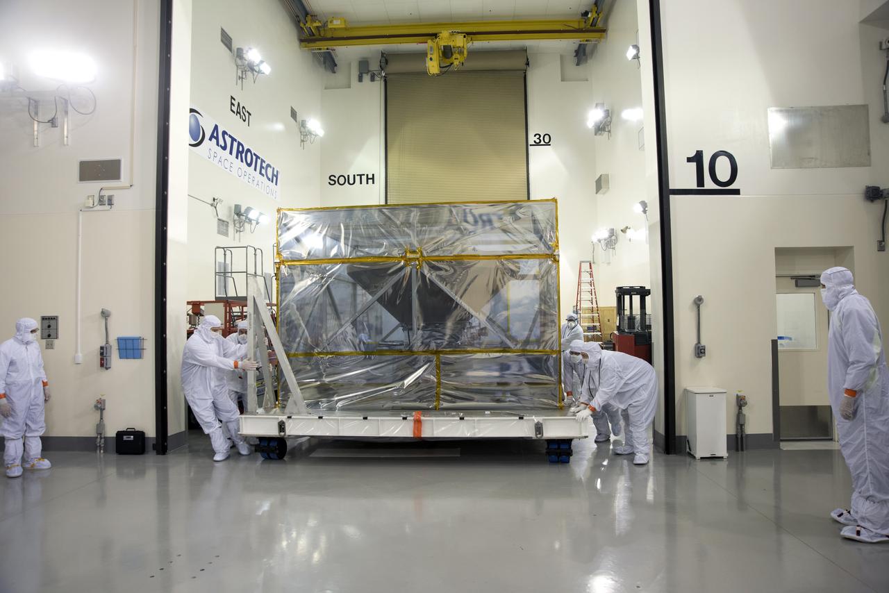
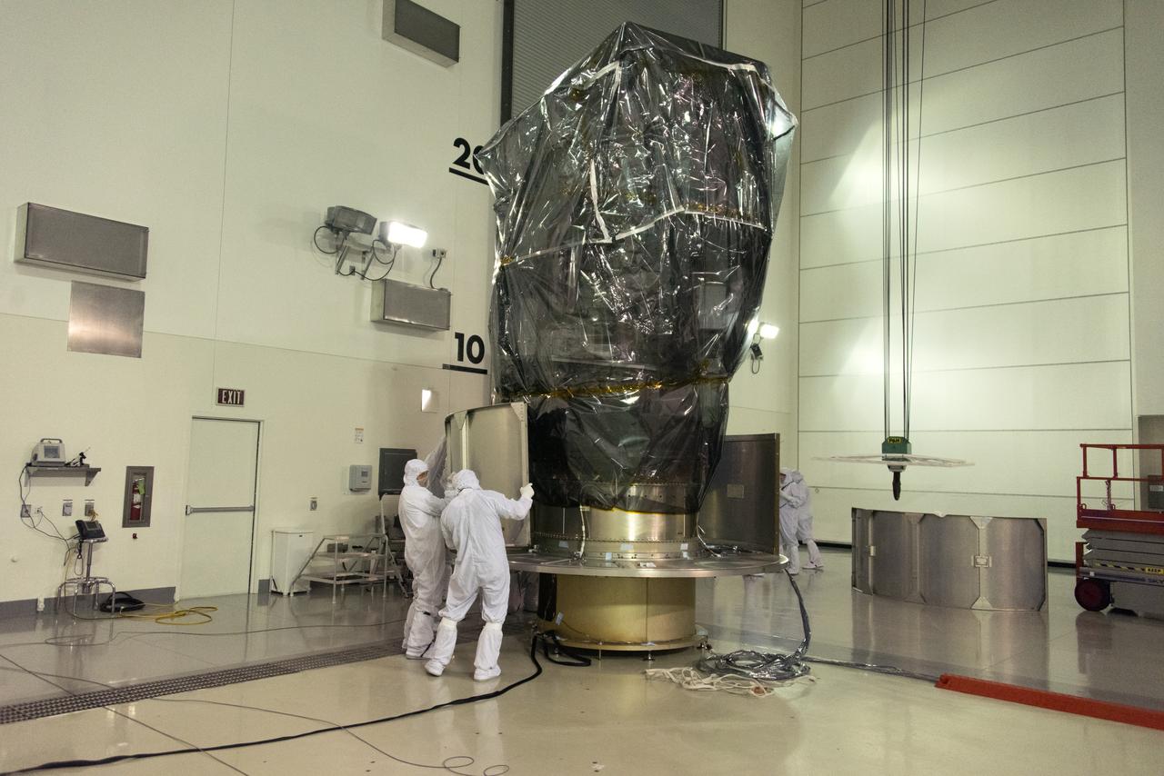
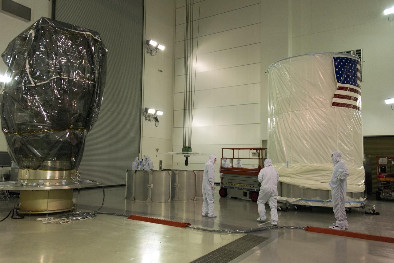
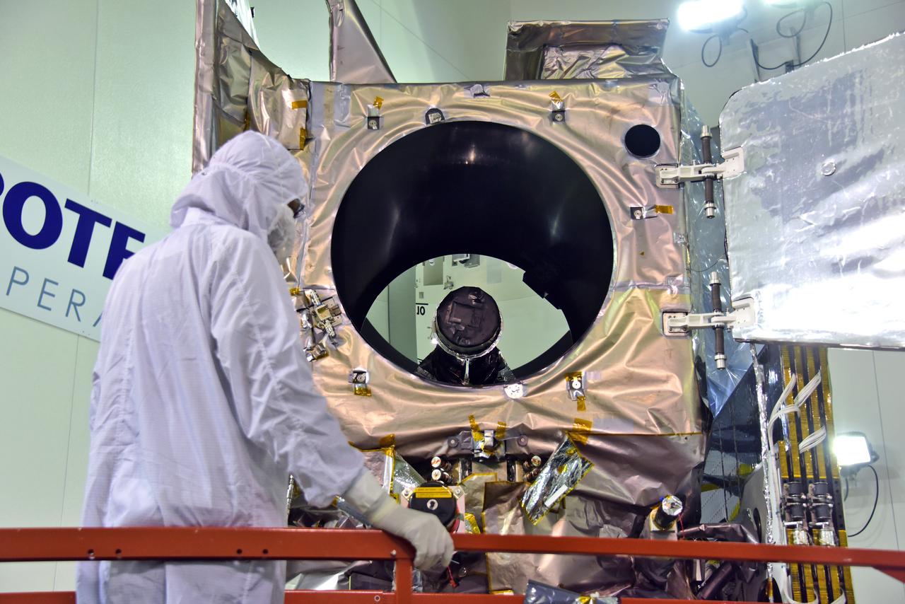
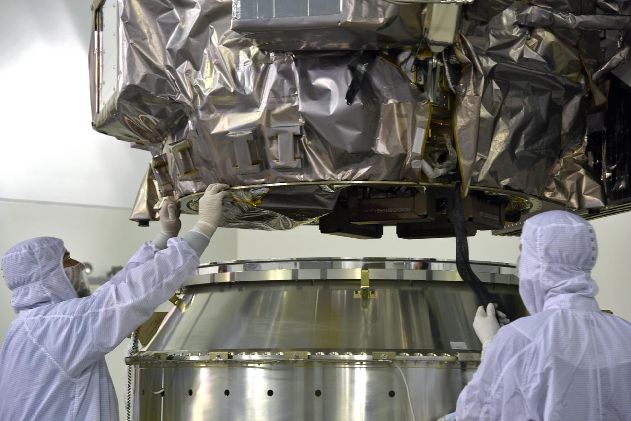
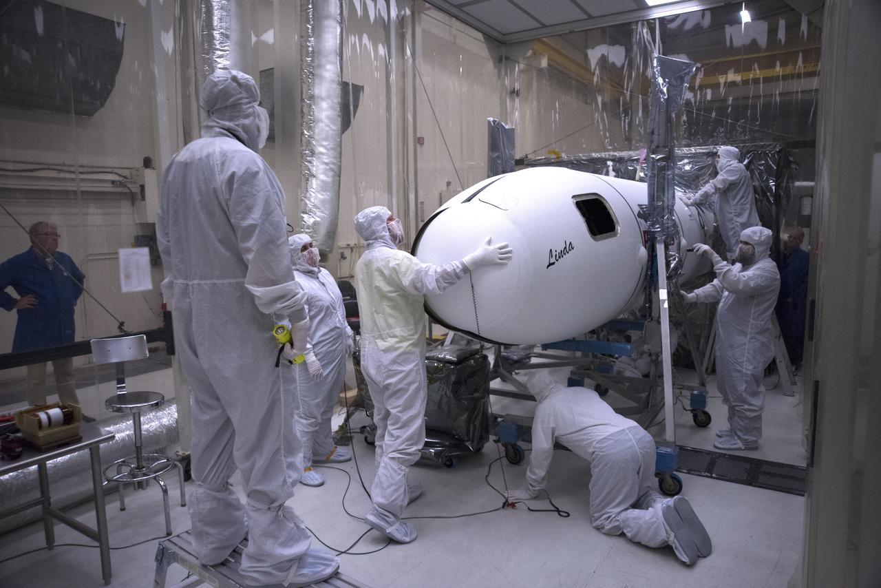
In the Astrotech facility at Vandenberg Air Force Base in California, technicians and engineers encapsulate NASA's Interior Exploration using Seismic Investigations, Geodesy and Heat Transport, or InSight, Mars lander in its payload fairing. InSight will be the first mission to look deep beneath the Martian surface. It will study the planet's interior by measuring its heat output and listen for marsquakes. The spacecraft will use the seismic waves generated by marsquakes to develop a map of the planet’s deep interior. The resulting insight into Mars’ formation will provide a better understanding of how other rocky planets, including Earth, were created. InSight is scheduled for liftoff May 5, 2018.
In the Astrotech facility at Vandenberg Air Force Base in California, technicians and engineers encapsulate NASA's Interior Exploration using Seismic Investigations, Geodesy and Heat Transport, or InSight, Mars lander in its payload fairing. InSight will be the first mission to look deep beneath the Martian surface. It will study the planet's interior by measuring its heat output and listen for marsquakes. The spacecraft will use the seismic waves generated by marsquakes to develop a map of the planet’s deep interior. The resulting insight into Mars’ formation will provide a better understanding of how other rocky planets, including Earth, were created. InSight is scheduled for liftoff May 5, 2018.
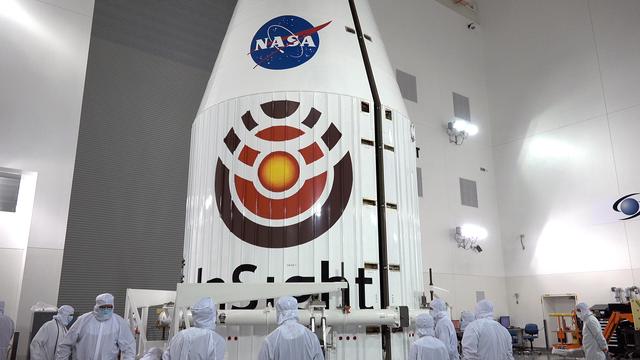
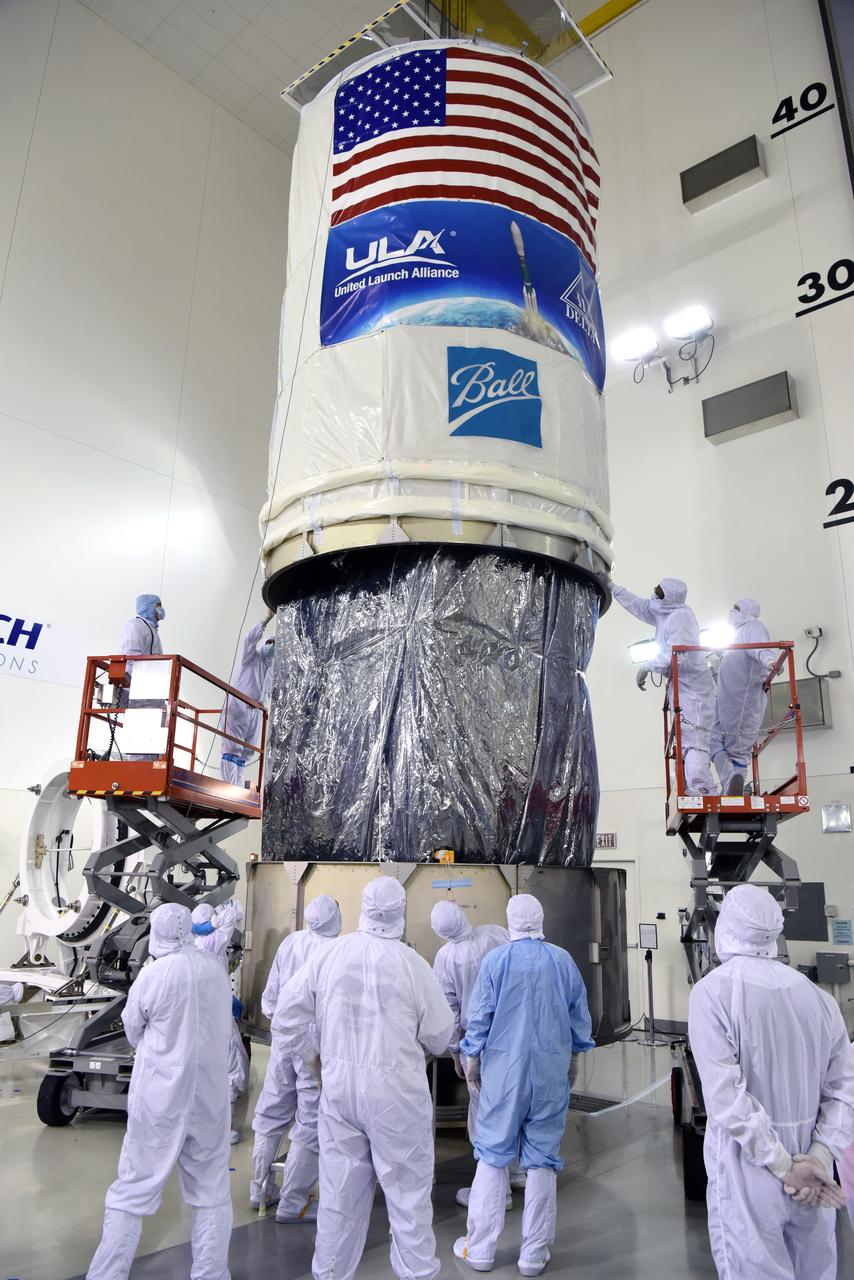
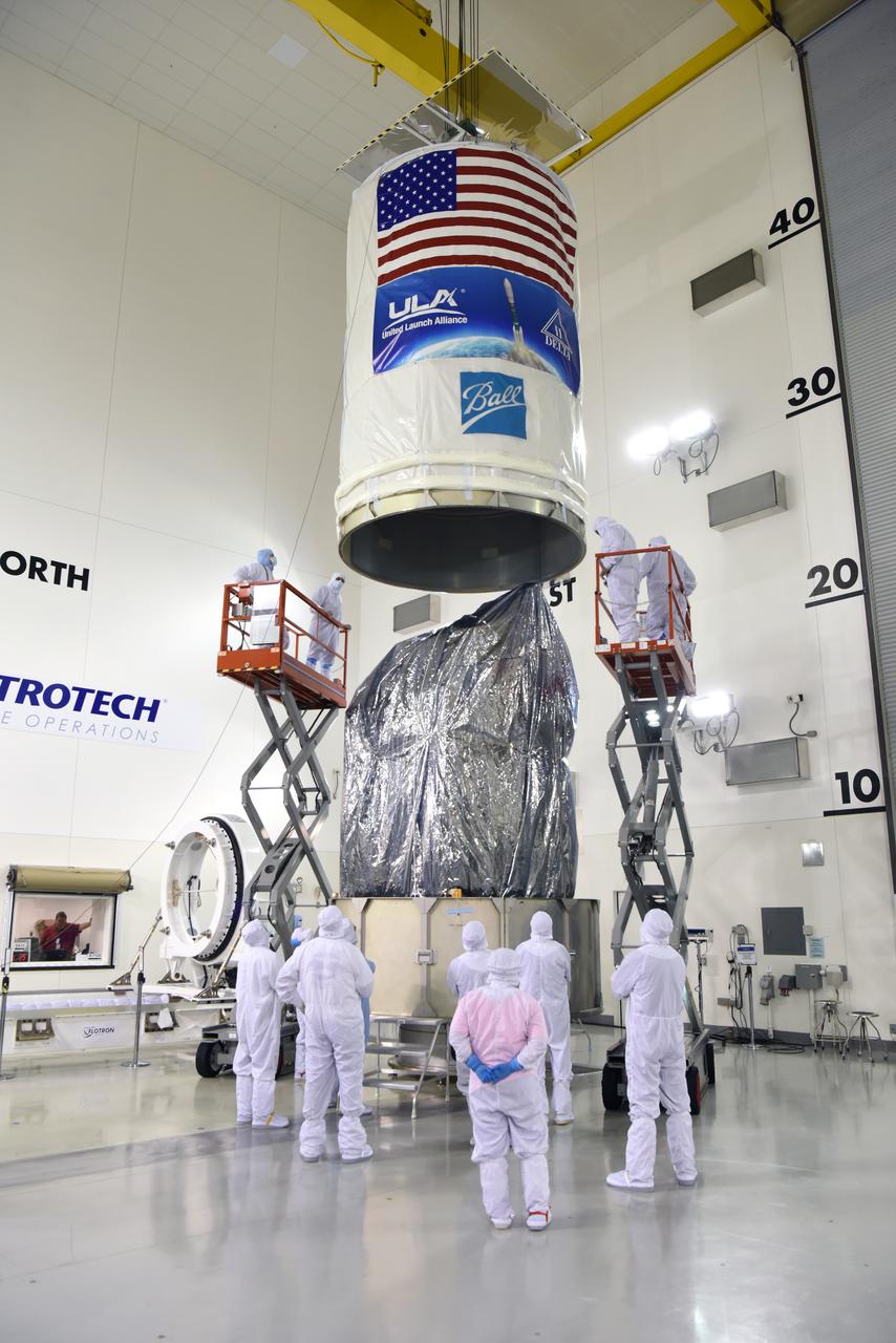
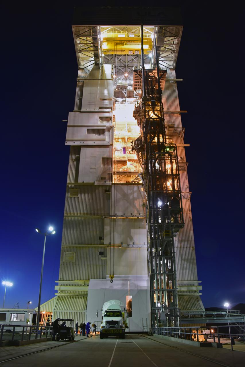
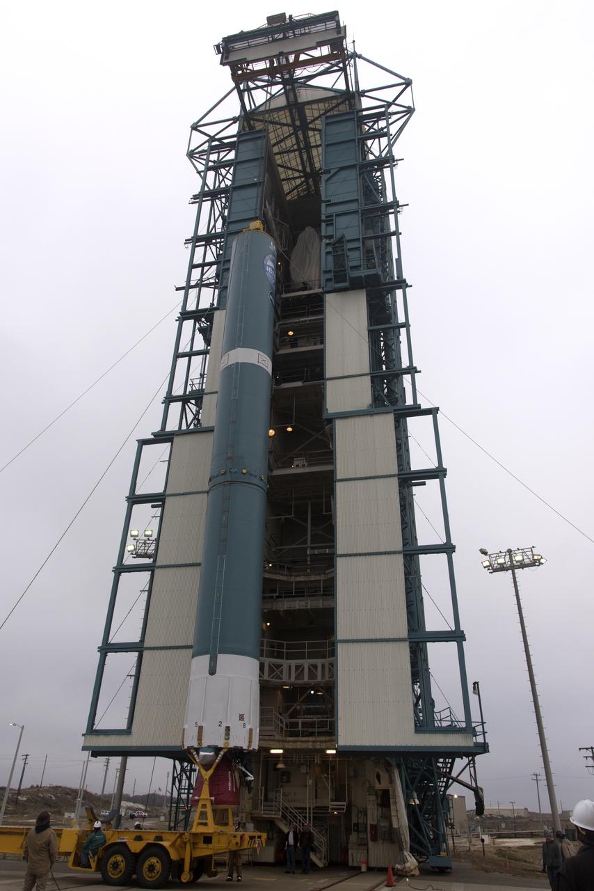
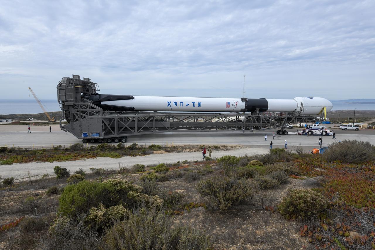
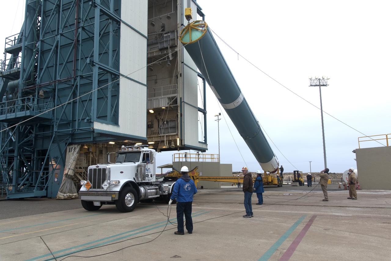
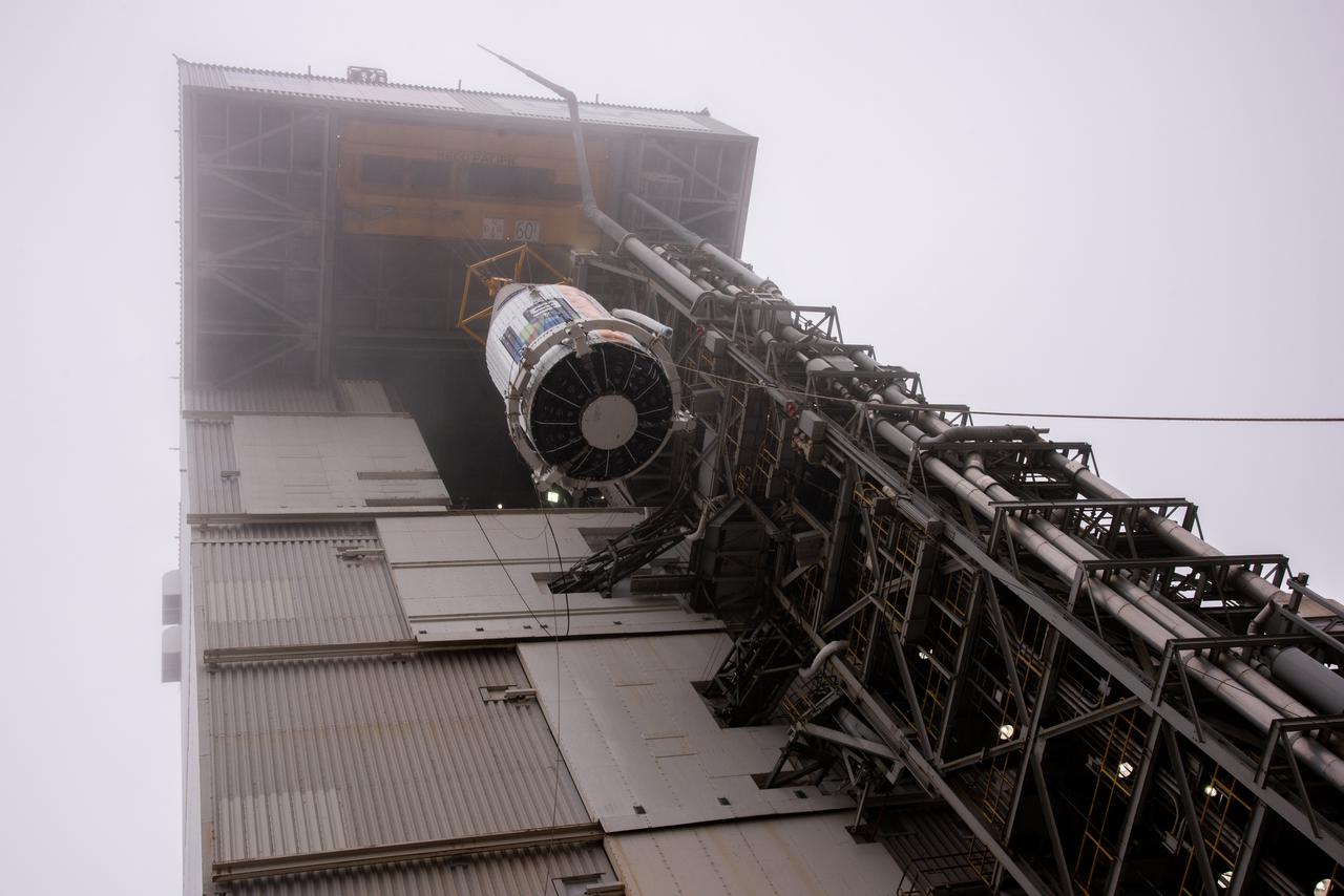
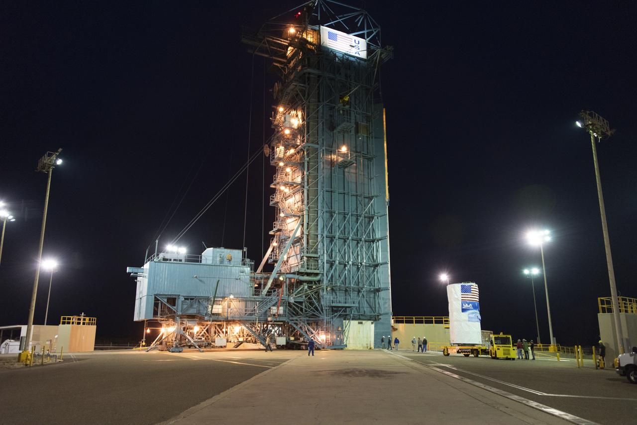
At Space Launch Complex 3 at Vandenberg Air Force Base in California, technicians and engineers position NASA's Interior Exploration using Seismic Investigations, Geodesy and Heat Transport, or InSight, Mars lander atop a United Launch Alliance Atlas V rocket. InSight will be the first mission to look deep beneath the Martian surface. It will study the planet's interior by measuring its heat output and listen for marsquakes. The spacecraft will use the seismic waves generated by marsquakes to develop a map of the planet’s deep interior. The resulting insight into Mars’ formation will provide a better understanding of how other rocky planets, including Earth, were created. InSight is scheduled for liftoff May 5, 2018.
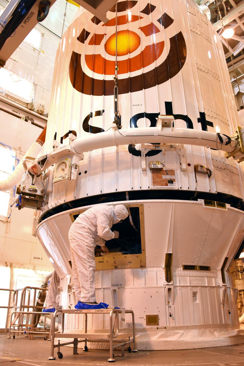
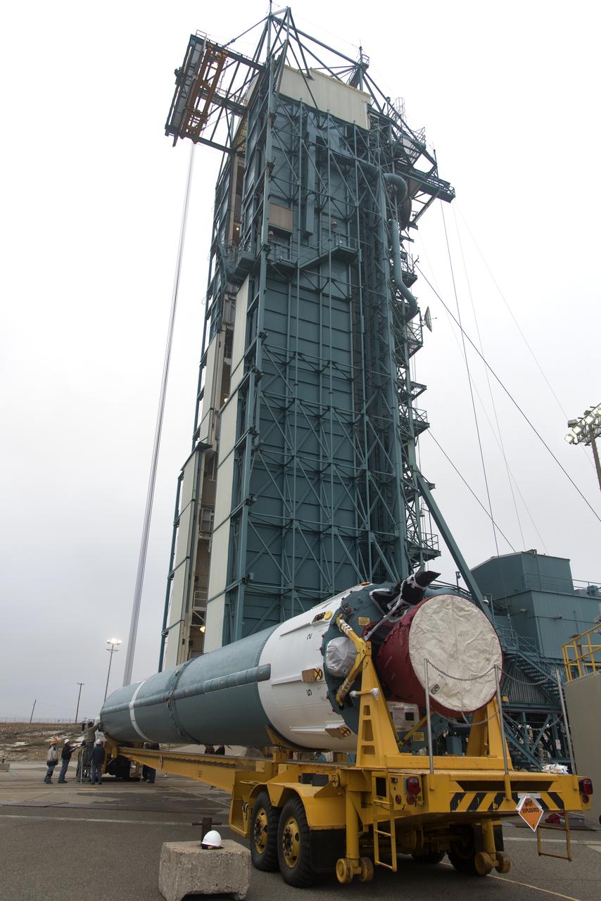
At Space Launch Complex 3 at Vandenberg Air Force Base in California, a crane is used to lift NASA's Interior Exploration using Seismic Investigations, Geodesy and Heat Transport, or InSight, Mars lander for mating atop a United Launch Alliance Atlas V rocket. InSight will be the first mission to look deep beneath the Martian surface. It will study the planet's interior by measuring its heat output and listen for marsquakes. The spacecraft will use the seismic waves generated by marsquakes to develop a map of the planet’s deep interior. The resulting insight into Mars’ formation will provide a better understanding of how other rocky planets, including Earth, were created. InSight is scheduled for liftoff May 5, 2018.

In the Astrotech facility at Vandenberg Air Force Base in California, NASA's Interior Exploration using Seismic Investigations, Geodesy and Heat Transport, or InSight, Mars lander is encapsulated in its payload fairing. InSight will be the first mission to look deep beneath the Martian surface. It will study the planet's interior by measuring its heat output and listen for marsquakes. The spacecraft will use the seismic waves generated by marsquakes to develop a map of the planet’s deep interior. The resulting insight into Mars’ formation will provide a better understanding of how other rocky planets, including Earth, were created. InSight is scheduled for liftoff May 5, 2018.
At Space Launch Complex 3 at Vandenberg Air Force Base in California, technicians and engineers position NASA's Interior Exploration using Seismic Investigations, Geodesy and Heat Transport, or InSight, Mars lander atop a United Launch Alliance Atlas V rocket. InSight will be the first mission to look deep beneath the Martian surface. It will study the planet's interior by measuring its heat output and listen for marsquakes. The spacecraft will use the seismic waves generated by marsquakes to develop a map of the planet’s deep interior. The resulting insight into Mars’ formation will provide a better understanding of how other rocky planets, including Earth, were created. InSight is scheduled for liftoff May 5, 2018.
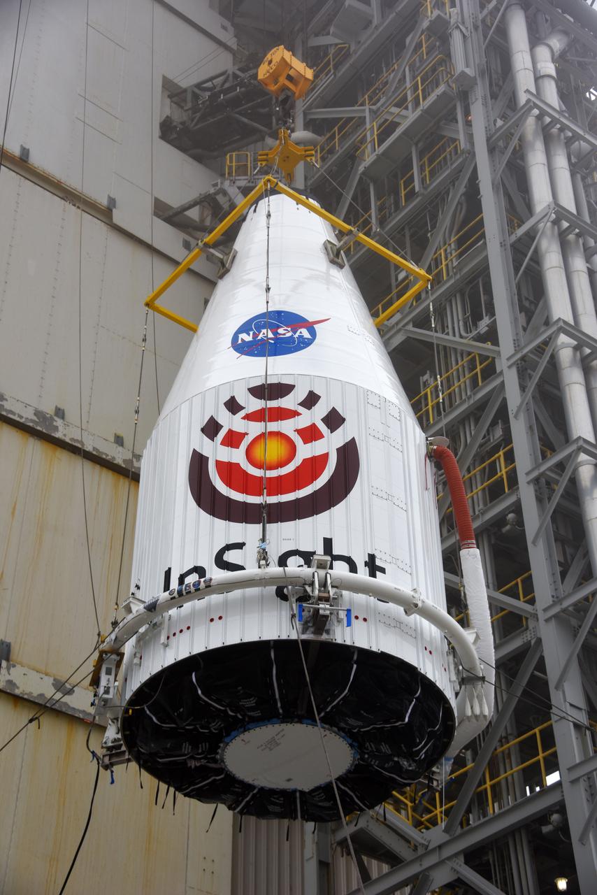
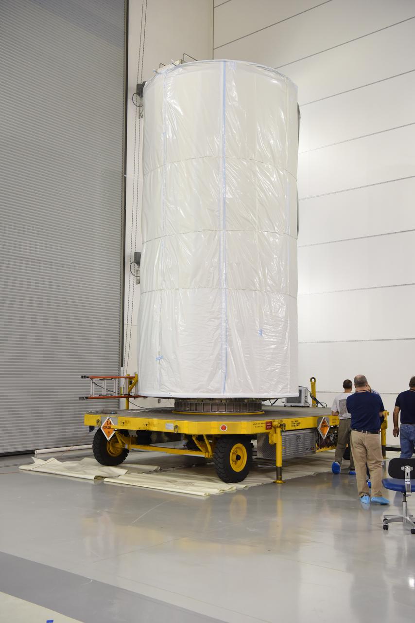
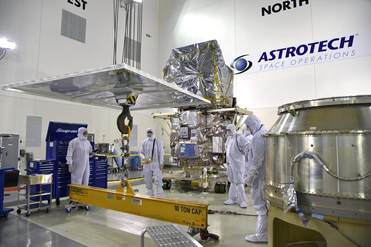
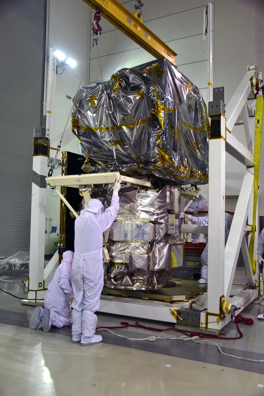
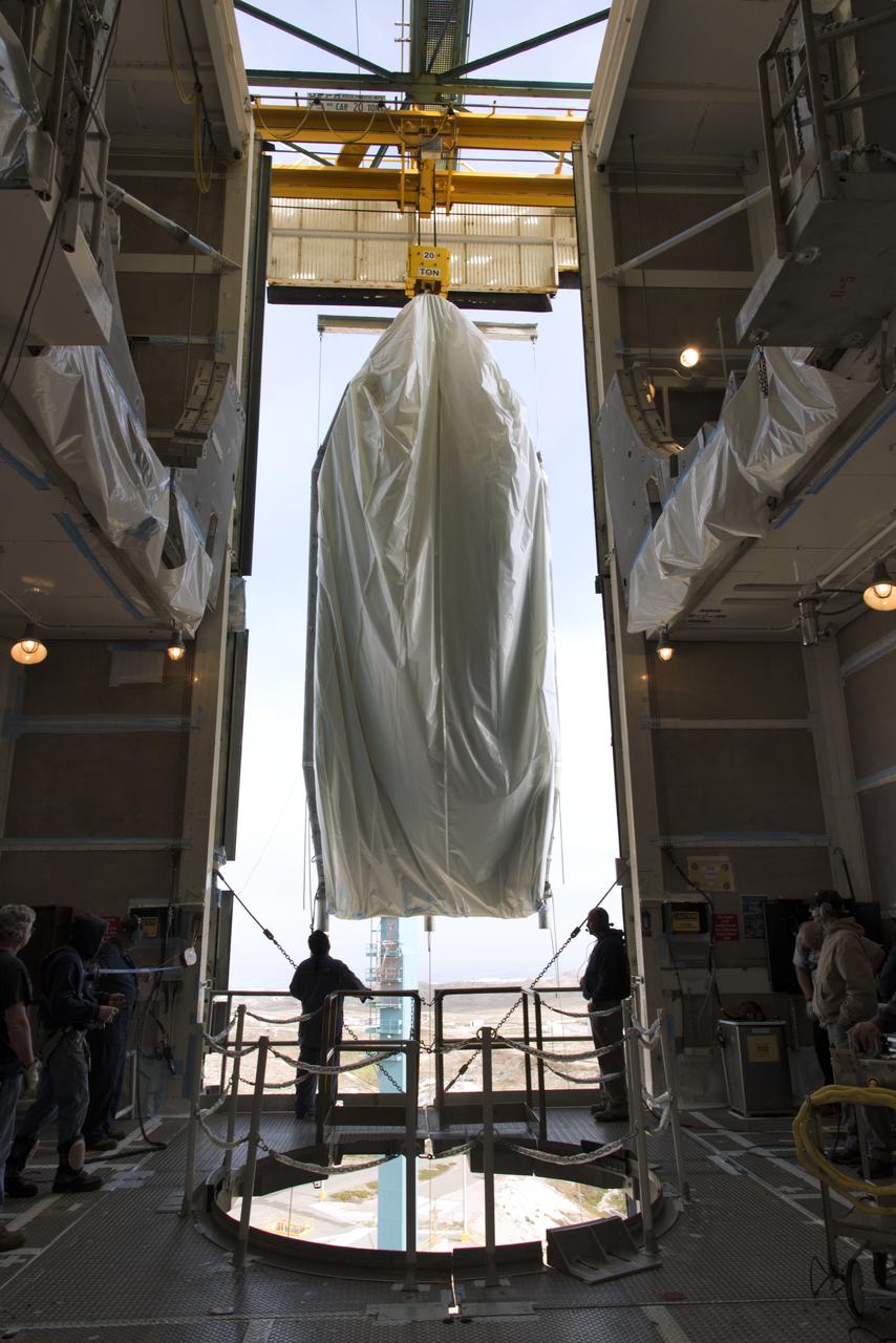
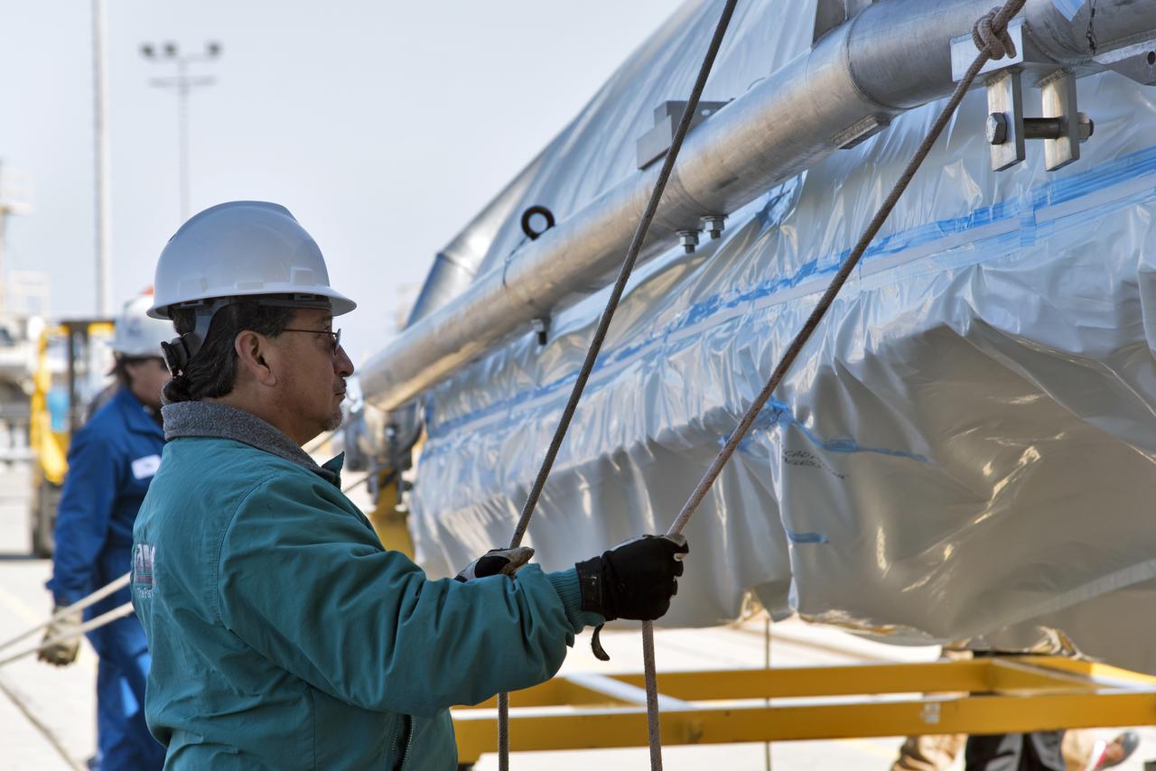
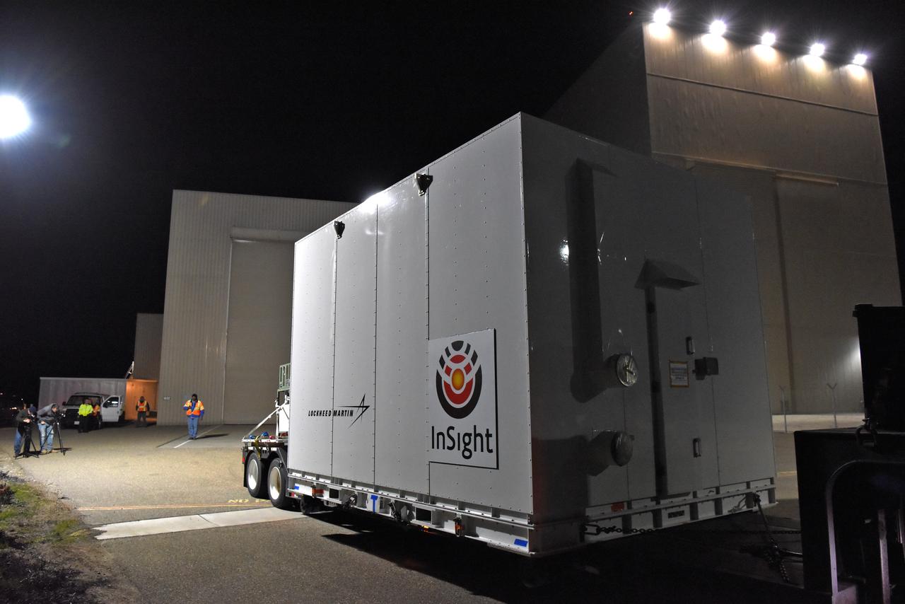
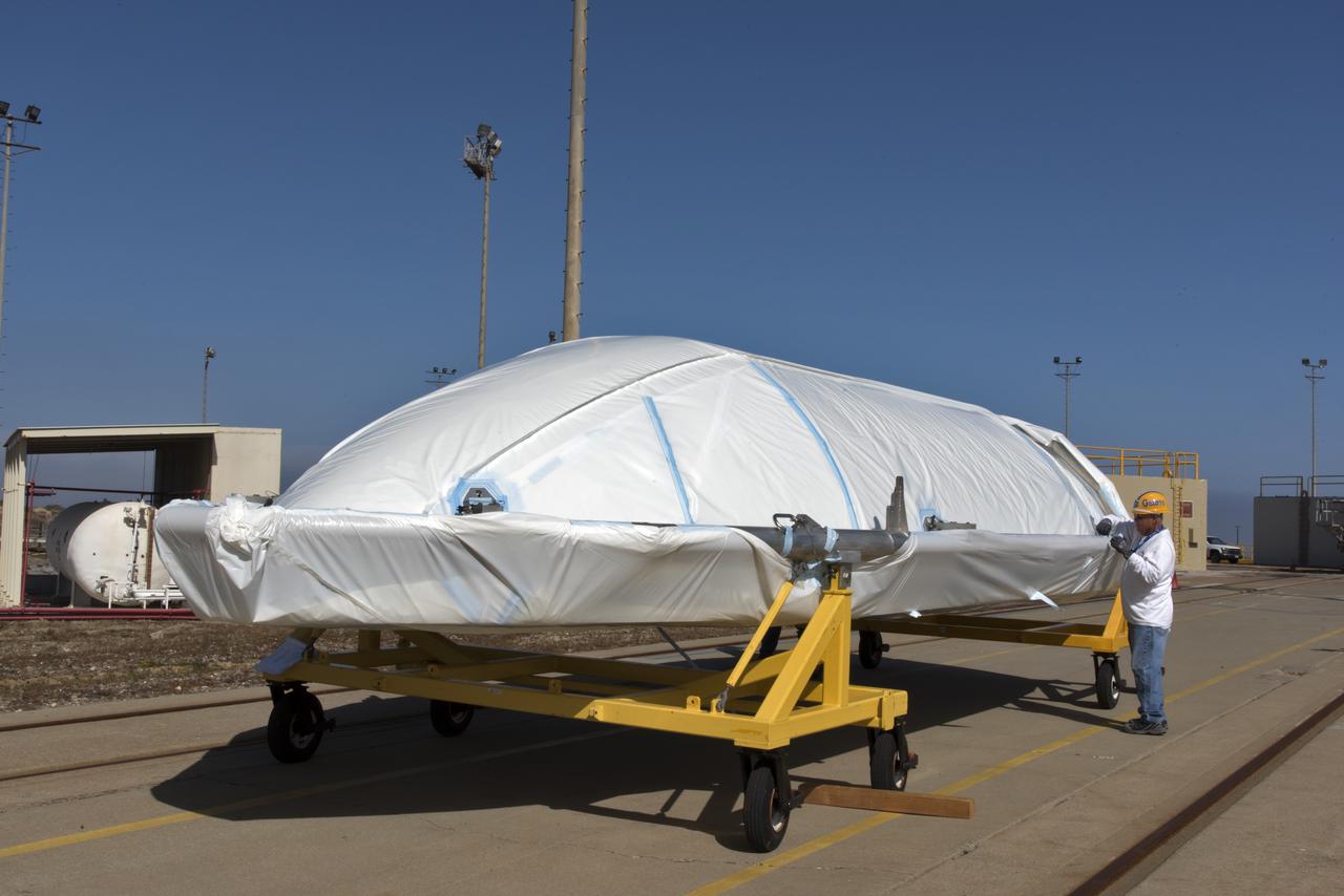
Encapsulated in its payload fairing NASA's Interior Exploration using Seismic Investigations, Geodesy and Heat Transport, or InSight, Mars lander is prepared for transport to Space Launch Complex 3 at Vandenberg Air Force Base in California. InSight will be the first mission to look deep beneath the Martian surface. It will study the planet's interior by measuring its heat output and listen for marsquakes. The spacecraft will use the seismic waves generated by marsquakes to develop a map of the planet’s deep interior. The resulting insight into Mars’ formation will provide a better understanding of how other rocky planets, including Earth, were created. InSight is scheduled for liftoff May 5, 2018.
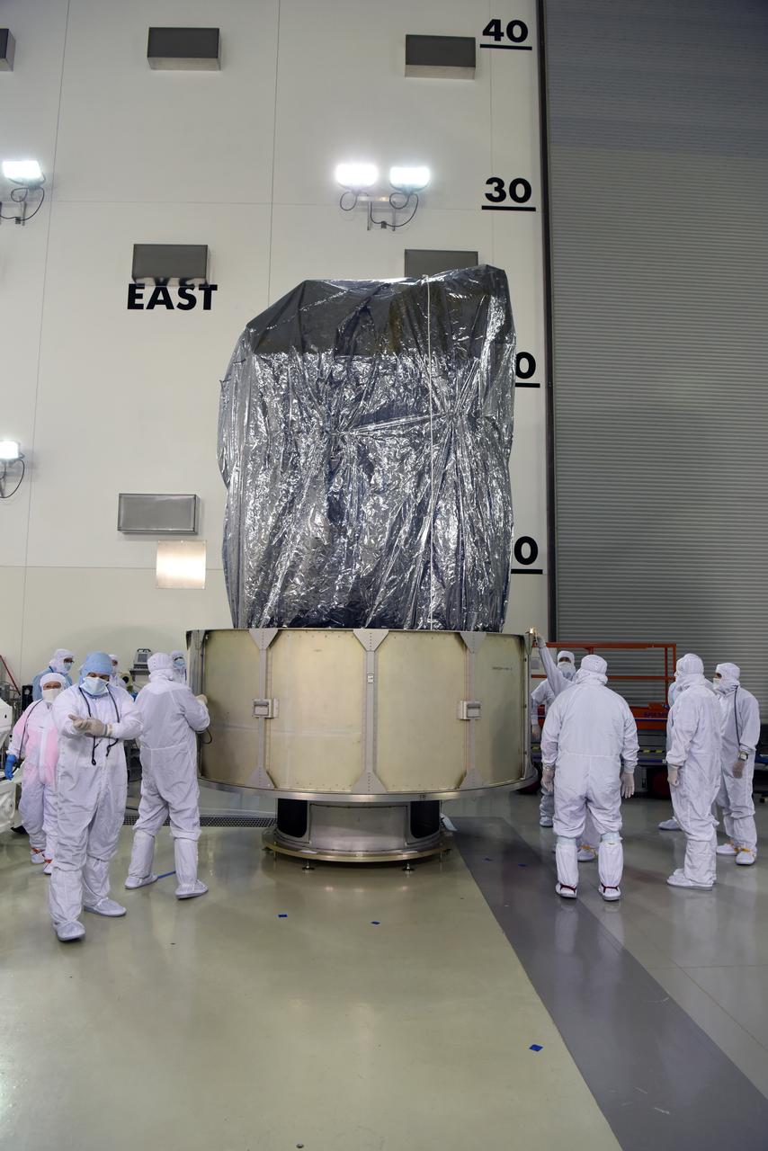
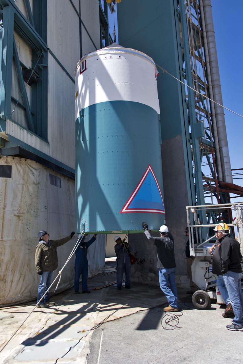
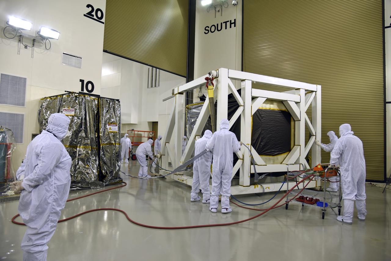
In the Astrotech Processing Facility at Vandenberg Air Force Base in California, technicians and engineers place the Joint Polar Satellite System-1, or JPSS-1, spacecraft in a protective container. It then will be mounted on a transport trailer for its move to Space Launch Complex 2. At the pad, JPSS-1 will be lifted for mating atop a United Launch Alliance Delta II rocket. Built by Ball Aerospace and Technologies Corp. of Boulder, Colorado, JPSS is the first in a series four next-generation environmental satellites in a collaborative program between the NOAA and NASA. Liftoff is scheduled to take place from Vandenberg's Space Launch Complex 2.

At Vandenberg Air Force Base in California, a Poly Picosatellite Orbital Deployer, or P-POD, container is installed on the Joint Polar Satellite System-1, or JPSS-1, spacecraft. P-PODS are auxiliary payloads launched aboard NASA expendable launch vehicles carrying up to three small CubeSats. The small cube-shaped satellites are part of NASA’s Educational Launch of Nanosatellite, or ELaNa, missions. The small payloads are designed and built by students from high school-level classes up to college and university students. JPSS is the first in a series of four next-generation environmental satellites in a collaborative program between the NOAA and NASA. Liftoff from Vandenberg's Space Launch Compex-2 atop a United Launch Alliance Delta II rocket is scheduled for 1:47 a.m. PST (4:47 a.m. EST), on Nov. 14, 2017.
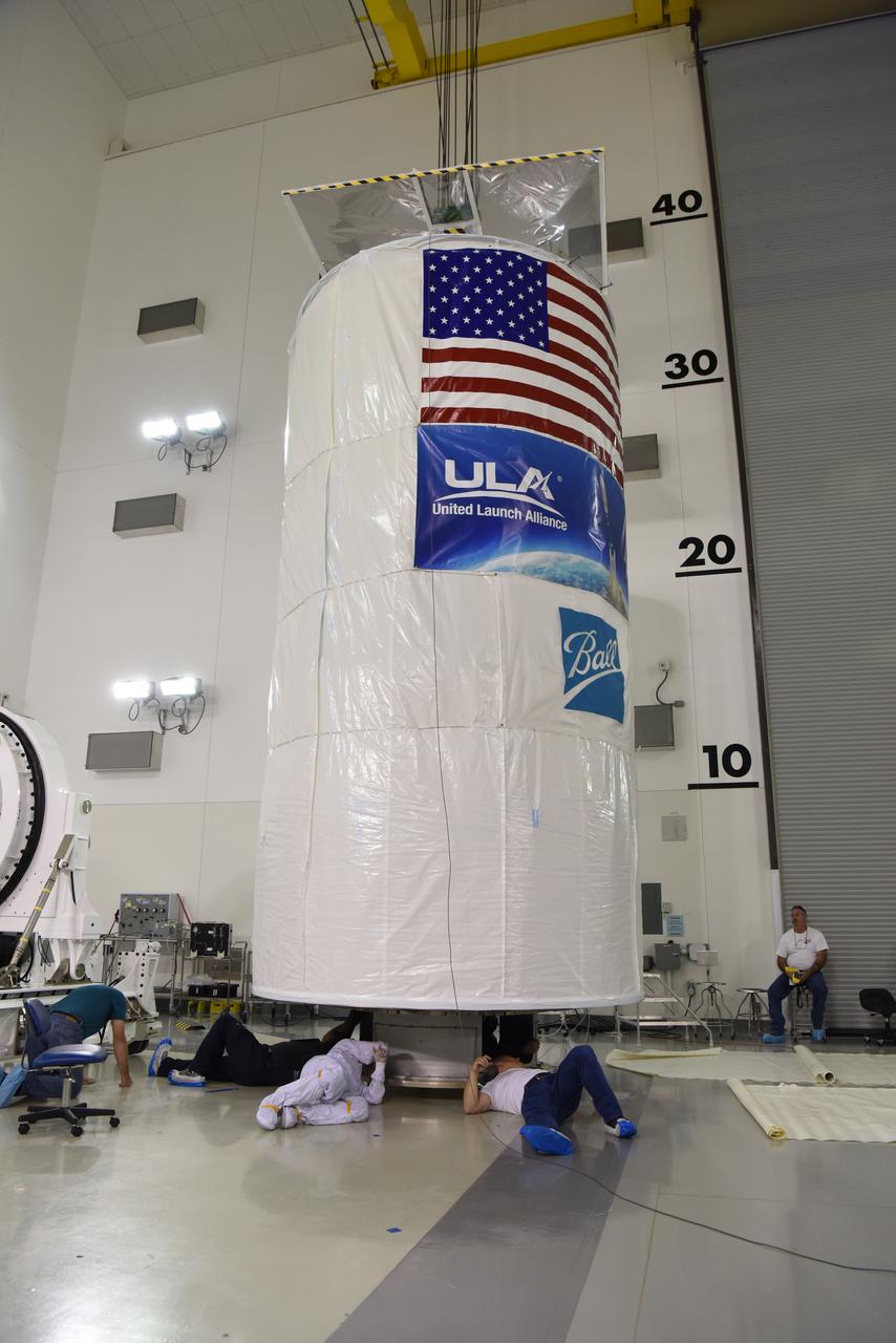
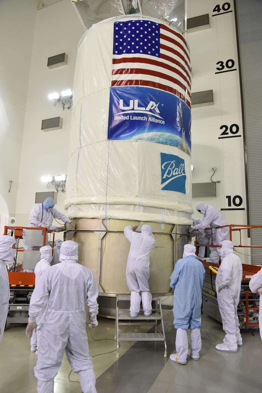
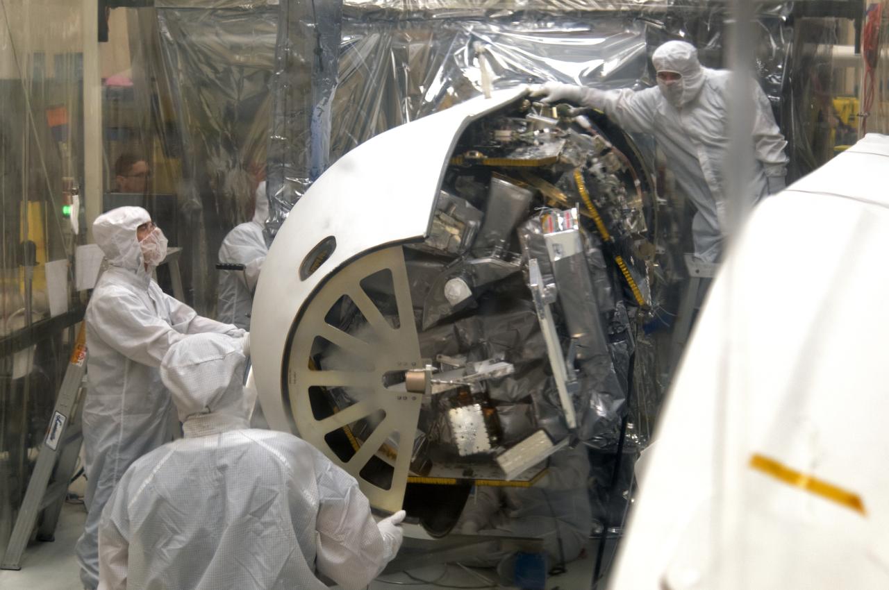
At Vandenberg Air Force Base in California, this wide angle view shows the payload fairing as it is installed encapsulating the Joint Polar Satellite System-1, or JPSS-1, spacecraft atop a United Launch Alliance Delta II rocket at Space Launch Complex 2. Built by Ball Aerospace and Technologies Corp. of Boulder, Colorado, JPSS is the first in a series four next-generation environmental satellites in a collaborative program between the NOAA and NASA. Liftoff is scheduled to take place from Vandenberg's Space Launch Complex 2 at 1:47 a.m. PST (4:47 a.m. EST), on Nov. 14, 2017.
In the Astrotech Processing Facility at Vandenberg Air Force Base in California, technicians and engineers place the Joint Polar Satellite System-1, or JPSS-1, spacecraft in a protective container. It then will be mounted on a transport trailer for its move to Space Launch Complex 2. At the pad, JPSS-1 will be lifted for mating atop a United Launch Alliance Delta II rocket. Built by Ball Aerospace and Technologies Corp. of Boulder, Colorado, JPSS is the first in a series four next-generation environmental satellites in a collaborative program between the NOAA and NASA. Liftoff is scheduled to take place from Vandenberg's Space Launch Complex 2.
At Vandenberg Air Force Base in California, technicians and engineers prepare a Poly Picosatellite Orbital Deployer, or P-POD, container for installation on the Joint Polar Satellite System-1, or JPSS-1, spacecraft. P-PODS are auxiliary payloads launched aboard NASA expendable launch vehicles carrying up to three small CubeSats. The small cube-shaped satellites are part of NASA’s Educational Launch of Nanosatellite, or ELaNa, missions. The small payloads are designed and built by students from high school-level classes up to college and university students. JPSS is the first in a series of four next-generation environmental satellites in a collaborative program between the NOAA and NASA. Liftoff from Vandenberg's Space Launch Compex-2 atop a United Launch Alliance Delta II rocket is scheduled for 1:47 a.m. PST (4:47 a.m. EST), on Nov. 14, 2017.
At Vandenberg Air Force Base in California, the payload fairing is installed encapsulating the Joint Polar Satellite System-1, or JPSS-1, spacecraft atop a United Launch Alliance Delta II rocket at Space Launch Complex 2. Built by Ball Aerospace and Technologies Corp. of Boulder, Colorado, JPSS is the first in a series four next-generation environmental satellites in a collaborative program between the NOAA and NASA. Liftoff is scheduled to take place from Vandenberg's Space Launch Complex 2 at 1:47 a.m. PST (4:47 a.m. EST), on Nov. 14, 2017.
In the Astrotech Processing Facility at Vandenberg Air Force Base in California, the Joint Polar Satellite System-1, or JPSS-1, spacecraft in a protective container is placed on a transport trailer for the trip to Space Launch Complex 2. At the pad, JPSS-1 will be lifted for mating atop a United Launch Alliance Delta II rocket. Built by Ball Aerospace and Technologies Corp. of Boulder, Colorado, JPSS is the first in a series four next-generation environmental satellites in a collaborative program between the NOAA and NASA. Liftoff is scheduled to take place from Vandenberg's Space Launch Complex 2.
At Vandenberg Air Force Base in California, the payload fairing is installed encapsulating the Joint Polar Satellite System-1, or JPSS-1, spacecraft atop a United Launch Alliance Delta II rocket at Space Launch Complex 2. Built by Ball Aerospace and Technologies Corp. of Boulder, Colorado, JPSS is the first in a series four next-generation environmental satellites in a collaborative program between the NOAA and NASA. Liftoff is scheduled to take place from Vandenberg's Space Launch Complex 2 at 1:47 a.m. PST (4:47 a.m. EST), on Nov. 14, 2017.
In the Astrotech Processing Facility at Vandenberg Air Force Base in California, the Joint Polar Satellite System-1, or JPSS-1, spacecraft is prepared for departure in a protective container to Space Launch Complex 2. At the pad, JPSS-1 will be lifted for mating atop a United Launch Alliance Delta II rocket. Built by Ball Aerospace and Technologies Corp. of Boulder, Colorado, JPSS is the first in a series four next-generation environmental satellites in a collaborative program between the NOAA and NASA. Liftoff is scheduled to take place from Vandenberg's Space Launch Complex 2.
JPSS-1 Spacecraft Canning and Lift to Transport Trailer at the Astrotech facility located at Vandenberg Air Force Station in California.
In the Astrotech Processing Facility at Vandenberg Air Force Base in California, the Joint Polar Satellite System-1, or JPSS-1, spacecraft is prepared for departure in a protective container to Space Launch Complex 2. At the pad, JPSS-1 will be lifted for mating atop a United Launch Alliance Delta II rocket. Built by Ball Aerospace and Technologies Corp. of Boulder, Colorado, JPSS is the first in a series four next-generation environmental satellites in a collaborative program between the NOAA and NASA. Liftoff is scheduled to take place from Vandenberg's Space Launch Complex 2.
In the Astrotech Processing Facility at Vandenberg Air Force Base in California, the Joint Polar Satellite System-1, or JPSS-1, spacecraft is wrapped in a protective covering prior to being placed it in a protective container. It then will be mounted on a transport trailer for its move to Space Launch Complex 2. At the pad, JPSS-1 will be lifted for mating atop a United Launch Alliance Delta II rocket. Built by Ball Aerospace and Technologies Corp. of Boulder, Colorado, JPSS is the first in a series four next-generation environmental satellites in a collaborative program between the NOAA and NASA. Liftoff is scheduled to take place from Vandenberg's Space Launch Complex 2.

At Vandenberg Air Force Base in California, technicians and engineers prepare to install a Poly Picosatellite Orbital Deployer, or P-POD, container on the Joint Polar Satellite System-1, or JPSS-1, spacecraft. P-PODS are auxiliary payloads launched aboard NASA expendable launch vehicles carrying up to three small CubeSats. The small cube-shaped satellites are part of NASA’s Educational Launch of Nanosatellite, or ELaNa, missions. The small payloads are designed and built by students from high school-level classes up to college and university students. JPSS is the first in a series of four next-generation environmental satellites in a collaborative program between the NOAA and NASA. Liftoff from Vandenberg's Space Launch Compex-2 atop a United Launch Alliance Delta II rocket is scheduled for 1:47 a.m. PST (4:47 a.m. EST), on Nov. 14, 2017.
In the Astrotech Processing Facility at Vandenberg Air Force Base in California, the Joint Polar Satellite System-1, or JPSS-1, spacecraft is wrapped in a protective covering prior to technicians and engineers placing it in a protective container. It then will be mounted on a transport trailer for its move to Space Launch Complex 2. At the pad, JPSS-1 will be lifted for mating atop a United Launch Alliance Delta II rocket. Built by Ball Aerospace and Technologies Corp. of Boulder, Colorado, JPSS is the first in a series four next-generation environmental satellites in a collaborative program between the NOAA and NASA. Liftoff is scheduled to take place from Vandenberg's Space Launch Complex 2.
In the Astrotech Processing Facility at Vandenberg Air Force Base in California, technicians and engineers place the Joint Polar Satellite System-1, or JPSS-1, spacecraft in a protective container. It then will be mounted on a transport trailer for its move to Space Launch Complex 2. At the pad, JPSS-1 will be lifted for mating atop a United Launch Alliance Delta II rocket. Built by Ball Aerospace and Technologies Corp. of Boulder, Colorado, JPSS is the first in a series four next-generation environmental satellites in a collaborative program between the NOAA and NASA. Liftoff is scheduled to take place from Vandenberg's Space Launch Complex 2.
At Vandenberg Air Force Base in California, this wide angle view shows the payload fairing as it is installed encapsulating the Joint Polar Satellite System-1, or JPSS-1, spacecraft atop a United Launch Alliance Delta II rocket at Space Launch Complex 2. Built by Ball Aerospace and Technologies Corp. of Boulder, Colorado, JPSS is the first in a series four next-generation environmental satellites in a collaborative program between the NOAA and NASA. Liftoff is scheduled to take place from Vandenberg's Space Launch Complex 2 at 1:47 a.m. PST (4:47 a.m. EST), on Nov. 14, 2017.
At Vandenberg Air Force Base in California, the payload fairing is installed encapsulating the Joint Polar Satellite System-1, or JPSS-1, spacecraft atop a United Launch Alliance Delta II rocket at Space Launch Complex 2. Built by Ball Aerospace and Technologies Corp. of Boulder, Colorado, JPSS is the first in a series four next-generation environmental satellites in a collaborative program between the NOAA and NASA. Liftoff is scheduled to take place from Vandenberg's Space Launch Complex 2 at 1:47 a.m. PST (4:47 a.m. EST), on Nov. 14, 2017.
At Vandenberg Air Force Base in California, a Poly Picosatellite Orbital Deployer, or P-POD, container is installed on the Joint Polar Satellite System-1, or JPSS-1, spacecraft. P-PODS are auxiliary payloads launched aboard NASA expendable launch vehicles carrying up to three small CubeSats. The small cube-shaped satellites are part of NASA’s Educational Launch of Nanosatellite, or ELaNa, missions. The small payloads are designed and built by students from high school-level classes up to college and university students. JPSS is the first in a series of four next-generation environmental satellites in a collaborative program between the NOAA and NASA. Liftoff from Vandenberg's Space Launch Compex-2 atop a United Launch Alliance Delta II rocket is scheduled for 1:47 a.m. PST (4:47 a.m. EST), on Nov. 14, 2017.
At Vandenberg Air Force Base in California, technicians and engineers prepare a Poly Picosatellite Orbital Deployer, or P-POD, container for installation on the Joint Polar Satellite System-1, or JPSS-1, spacecraft. P-PODS are auxiliary payloads launched aboard NASA expendable launch vehicles carrying up to three small CubeSats. The small cube-shaped satellites are part of NASA’s Educational Launch of Nanosatellite, or ELaNa, missions. The small payloads are designed and built by students from high school-level classes up to college and university students. JPSS is the first in a series of four next-generation environmental satellites in a collaborative program between the NOAA and NASA. Liftoff from Vandenberg's Space Launch Compex-2 atop a United Launch Alliance Delta II rocket is scheduled for 1:47 a.m. PST (4:47 a.m. EST), on Nov. 14, 2017.

At Vandenberg Air Force Base in California, a Poly Picosatellite Orbital Deployer, or P-POD, container is installed on the Joint Polar Satellite System-1, or JPSS-1, spacecraft. P-PODS are auxiliary payloads launched aboard NASA expendable launch vehicles carrying up to three small CubeSats. The small cube-shaped satellites are part of NASA’s Educational Launch of Nanosatellite, or ELaNa, missions. The small payloads are designed and built by students from high school-level classes up to college and university students. JPSS is the first in a series of four next-generation environmental satellites in a collaborative program between the NOAA and NASA. Liftoff from Vandenberg's Space Launch Compex-2 atop a United Launch Alliance Delta II rocket is scheduled for 1:47 a.m. PST (4:47 a.m. EST), on Nov. 14, 2017.
At Vandenberg Air Force Base in California, this wide angle view shows the payload fairing as it is installed encapsulating the Joint Polar Satellite System-1, or JPSS-1, spacecraft atop a United Launch Alliance Delta II rocket at Space Launch Complex 2. Built by Ball Aerospace and Technologies Corp. of Boulder, Colorado, JPSS is the first in a series four next-generation environmental satellites in a collaborative program between the NOAA and NASA. Liftoff is scheduled to take place from Vandenberg's Space Launch Complex 2 at 1:47 a.m. PST (4:47 a.m. EST), on Nov. 14, 2017.
In the Astrotech Processing Facility at Vandenberg Air Force Base in California, the Joint Polar Satellite System-1, or JPSS-1, spacecraft in a protective container is mounted on a transport trailer for the trip to Space Launch Complex 2. At the pad, JPSS-1 will be lifted for mating atop a United Launch Alliance Delta II rocket. Built by Ball Aerospace and Technologies Corp. of Boulder, Colorado, JPSS is the first in a series four next-generation environmental satellites in a collaborative program between the NOAA and NASA. Liftoff is scheduled to take place from Vandenberg's Space Launch Complex 2.
At Vandenberg Air Force Base in California, technicians and engineers prepare a Poly Picosatellite Orbital Deployer, or P-POD, container for installation on the Joint Polar Satellite System-1, or JPSS-1, spacecraft. P-PODS are auxiliary payloads launched aboard NASA expendable launch vehicles carrying up to three small CubeSats. The small cube-shaped satellites are part of NASA’s Educational Launch of Nanosatellite, or ELaNa, missions. The small payloads are designed and built by students from high school-level classes up to college and university students. JPSS is the first in a series of four next-generation environmental satellites in a collaborative program between the NOAA and NASA. Liftoff from Vandenberg's Space Launch Compex-2 atop a United Launch Alliance Delta II rocket is scheduled for 1:47 a.m. PST (4:47 a.m. EST), on Nov. 14, 2017.
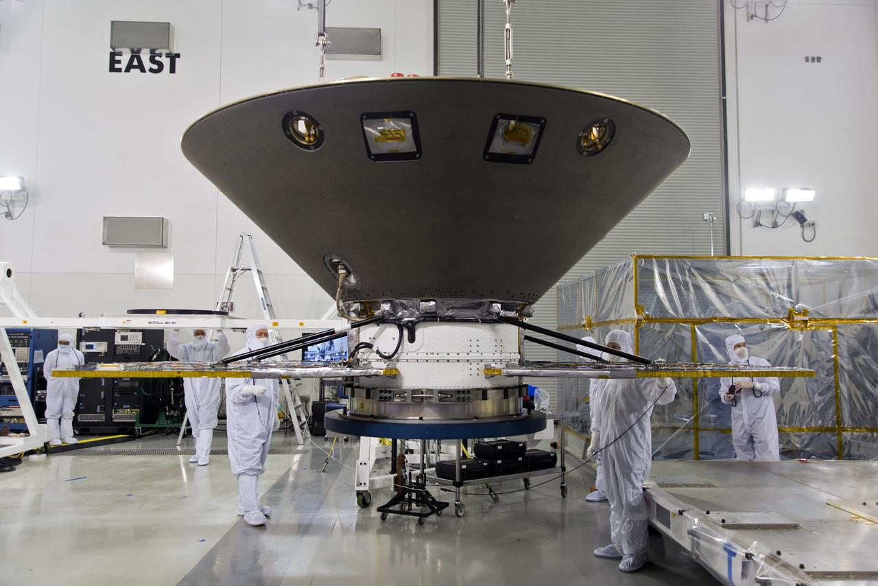
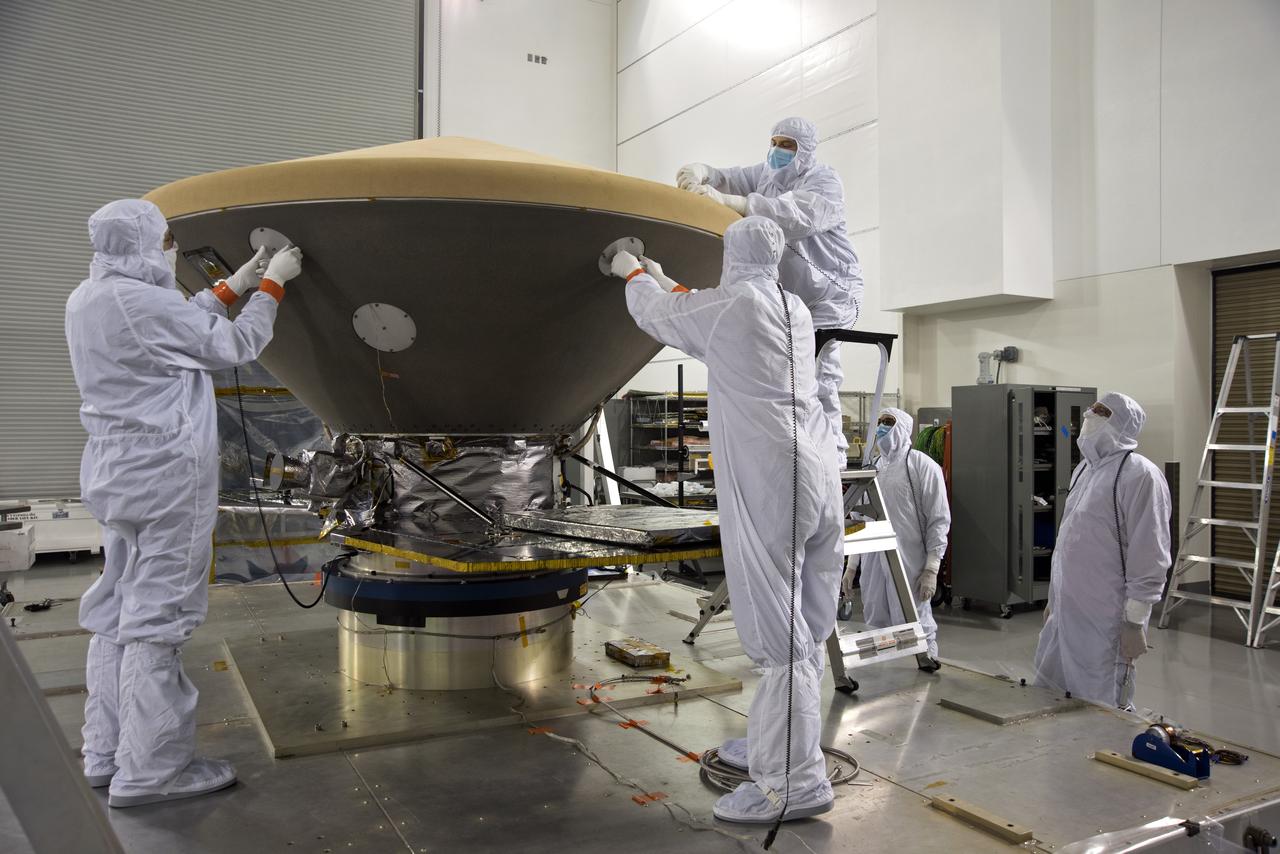
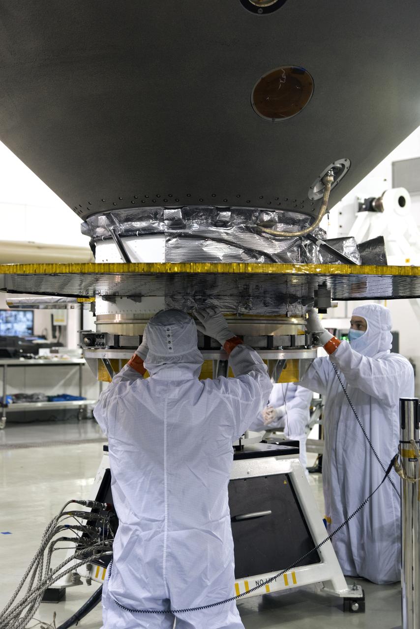
Inside the high bay of the Astrotech Space Operations facility at Vandenberg Air Force Base in California, technicians attach NASA's Ice, Cloud and land Elevation Satellite-2 (ICESat-2) to the payload direct mate adapter, on Aug. 24, 2018. The satellite is being prepared for its scheduled launch from Space Launch Complex 2 at Vandenberg on the final United Launch Alliance Delta II rocket. ICESat-2 will measure the height of a changing Earth, one laser pulse at a time, 10,000 laser pulses a second. The satellite will carry the Advanced Topographic Laser Altimeter System (ATLAS). ICESat-2 will help scientists investigate why, and how much our planet's frozen and icy areas, called the cryosphere, are changing in a warming climate.
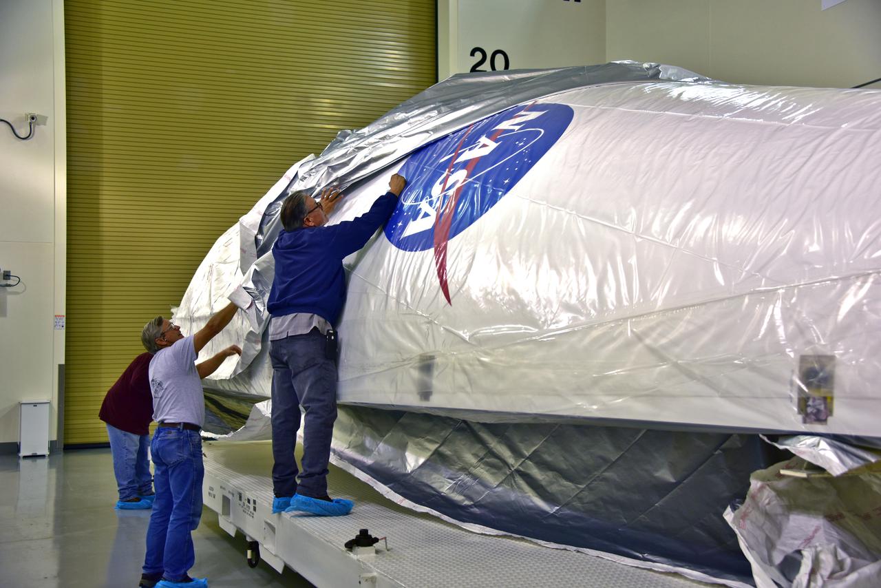
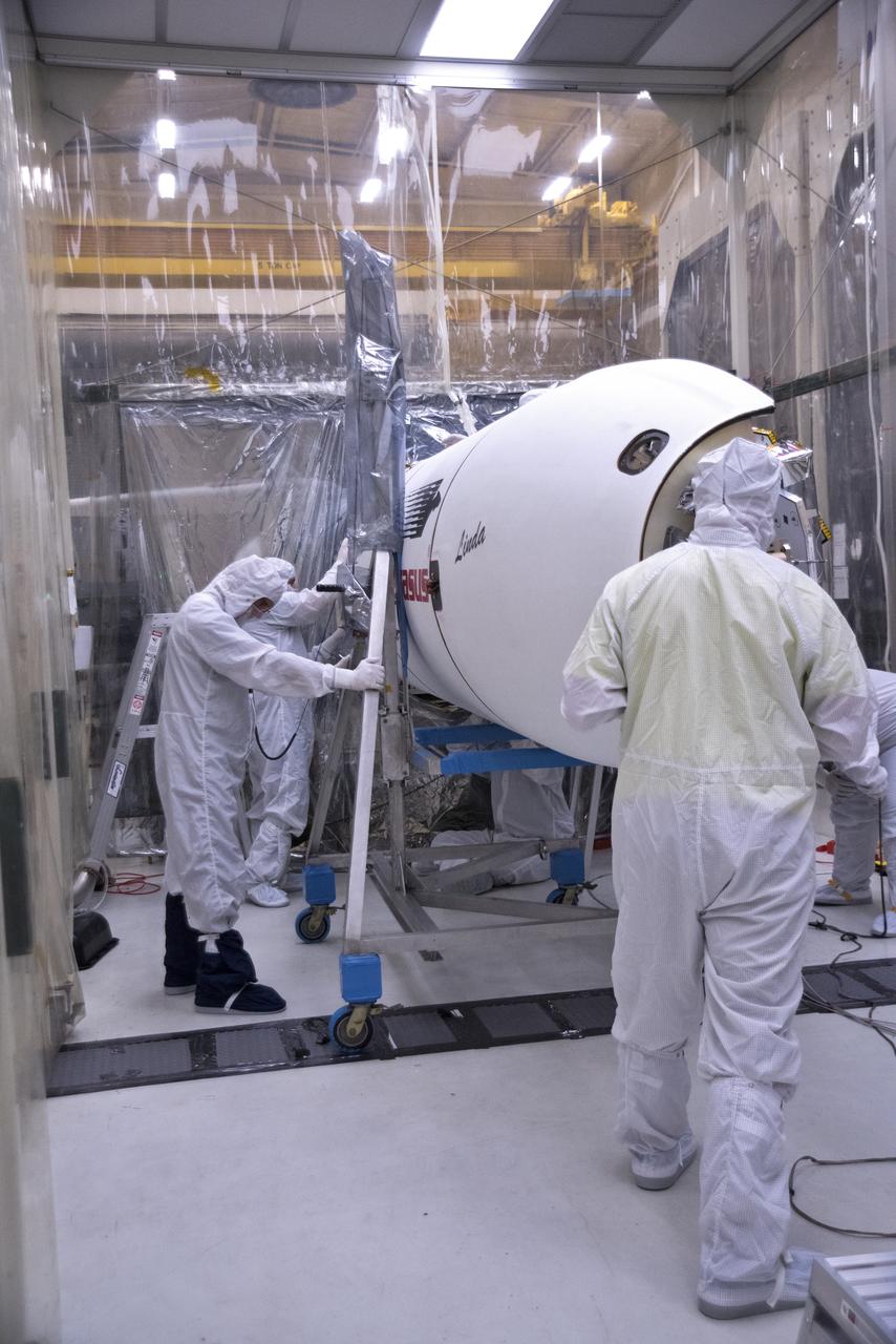
In the Astrotech facility at Vandenberg Air Force Base in California, technicians remove protective wrapping from the United Launch Alliance (ULA) payload fairing for NASA's upcoming Interior Exploration using Seismic Investigations, Geodesy and Heat Transport, or InSight, spacecraft designed to land on Mars. InSight is the first mission to explore the Red Planet's deep interior. It will investigate processes that shaped the rocky planets of the inner solar system including Earth. Liftoff atop a ULA Atlas V rocket is scheduled for May 5, 2018.
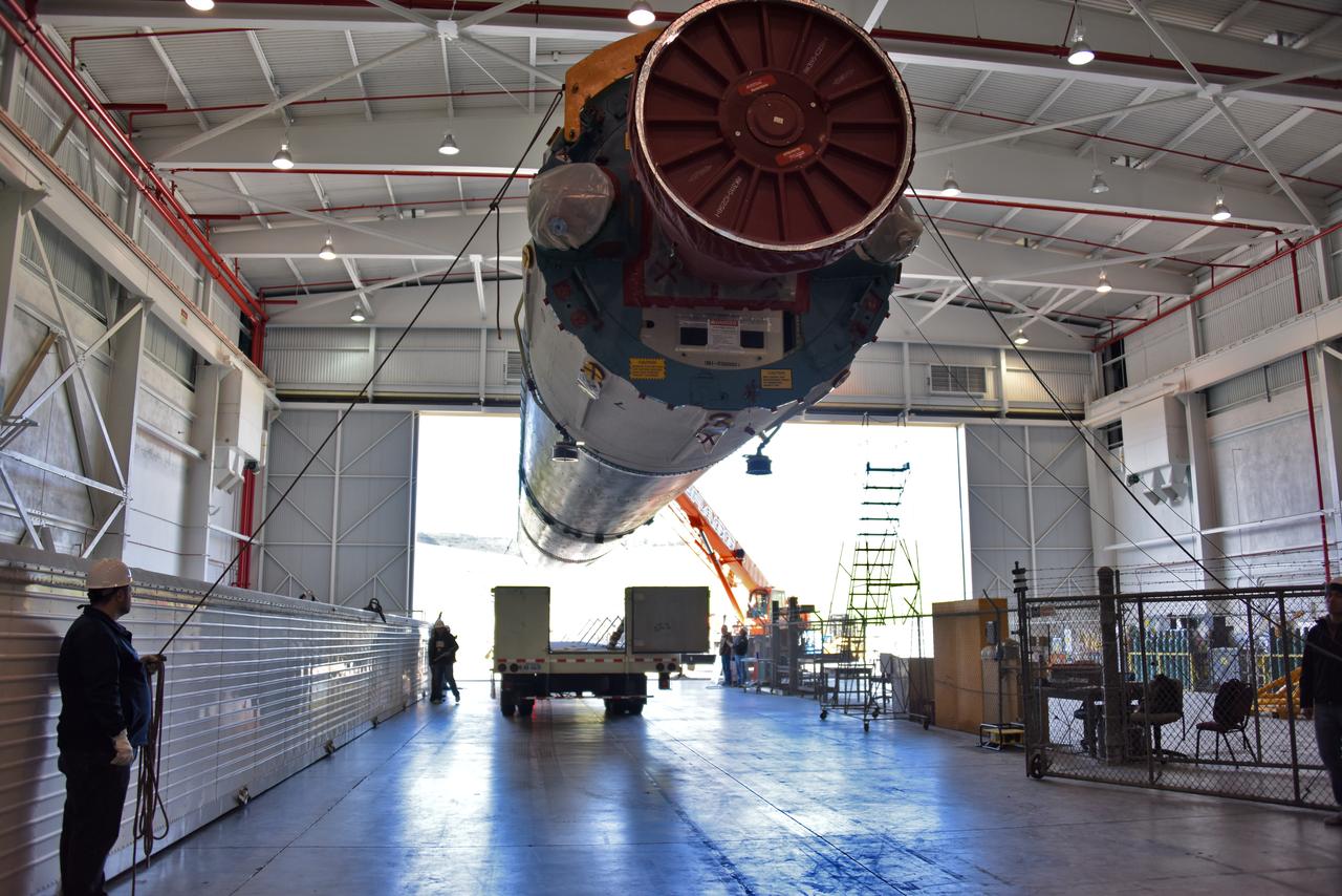
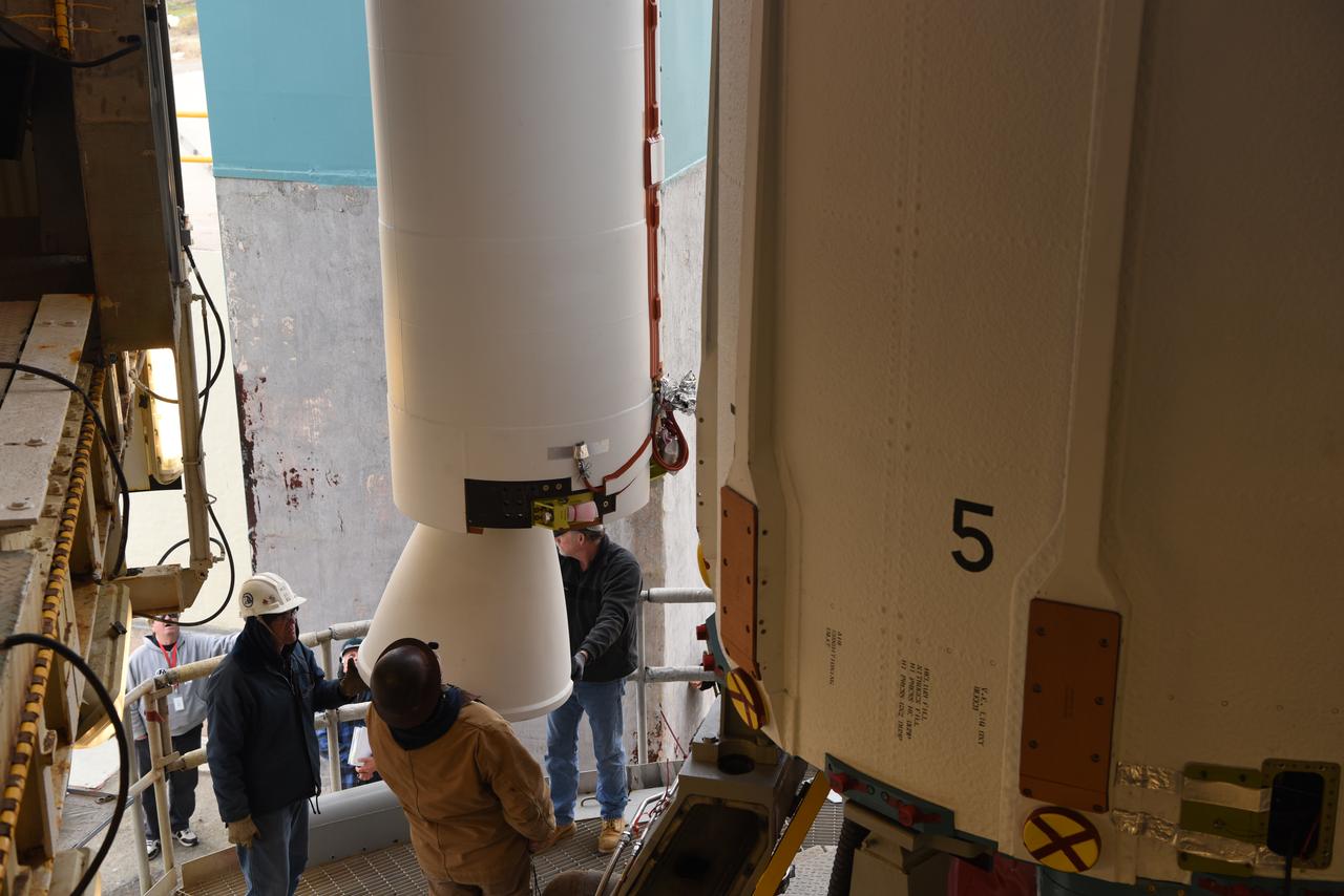
A United Launch Alliance Centaur upper stage arrives at Space Launch Complex 3 at Vandenberg Air Force Base in California. The rocket will launch NASA's Interior Exploration using Seismic Investigations, Geodesy and Heat Transport, or InSight, mission to land on Mars. InSight is the first mission to explore the Red Planet's deep interior. It will investigate processes that shaped the rocky planets of the inner solar system including Earth. Liftoff is scheduled for May 5, 2018.
Inside a clean room in Building 1555 at Vandenberg Air Force Base in California, technicians install the first half of the Northrop Grumman Pegasus XL payload fairing around NASA's Ionospheric Connection Explorer (ICON) on Oct. 4, 2018. ICON is being prepared for its launch on the Pegasus XL, which is attached to the company's L-1011 Stargazer aircraft, from the Skid Strip at Cape Canaveral Air Force Station in Florida. Launch is scheduled for Oct. 26. ICON will study the frontier of space - the dynamic zone high in Earth's atmosphere where terrestrial weather from below meets space weather above. The explorer will help determine the physics of Earth's space environment and pave the way for mitigating its effects on our technology, communications systems and society.
Inside the high bay of the Astrotech Space Operations facility at Vandenberg Air Force Base in California, technicians prepare to attach NASA's Ice, Cloud and land Elevation Satellite-2 (ICESat-2) to the payload adapter, on Aug. 20, 2018. The satellite is being prepared for its scheduled launch from Space Launch Complex 2 at Vandenberg on the final United Launch Alliance Delta II rocket. ICESat-2 will measure the height of a changing Earth, one laser pulse at a time, 10,000 laser pulses a second. The satellite will carry the Advanced Topographic Laser Altimeter System (ATLAS). ICESat-2 will help scientists investigate why, and how much our planet's frozen and icy areas, called the cryosphere, are changing in a warming climate.
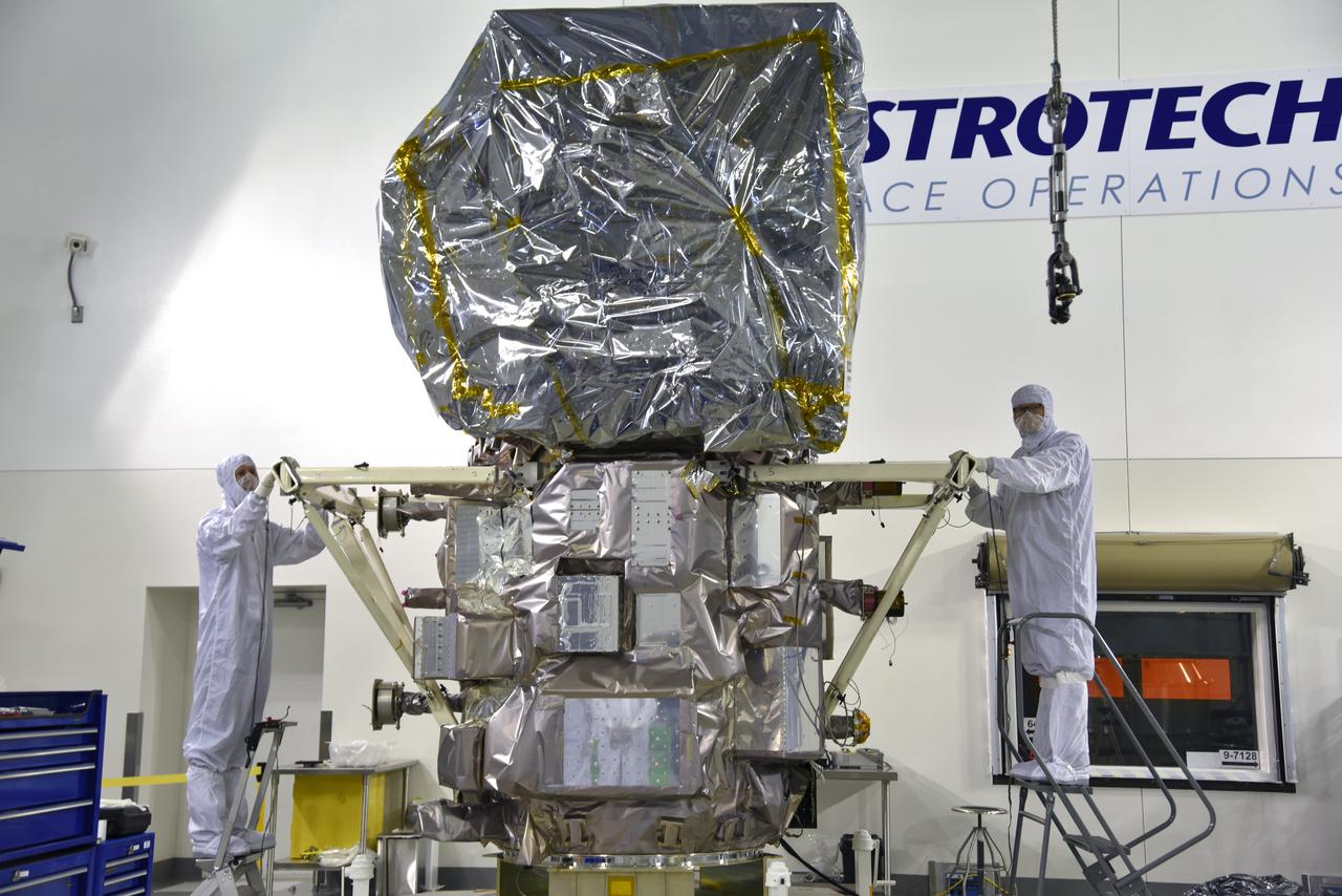
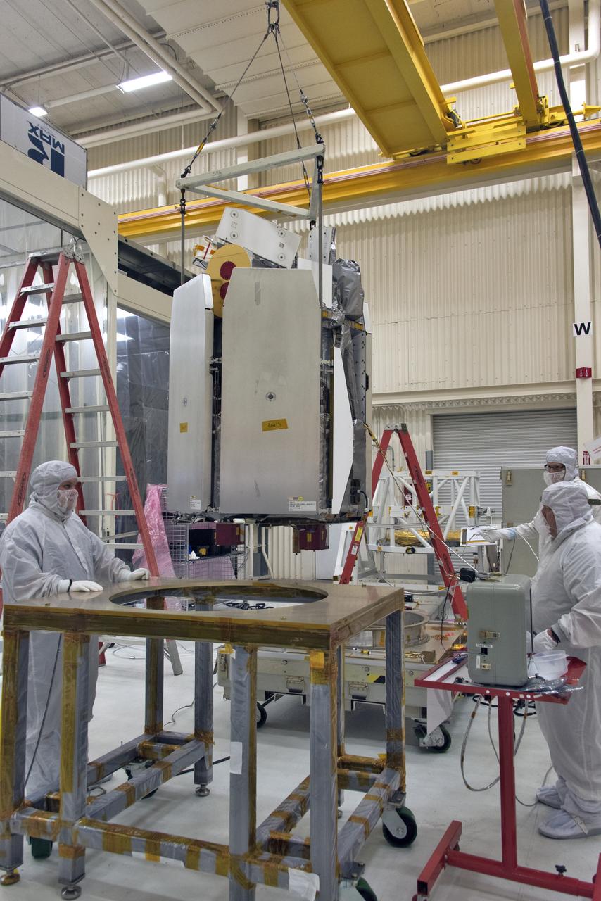
Technicians assist as a crane rotates NASA's Ice, Cloud and land Elevation Satellite-2 (ICESat-2) into position for removal and lift to a work stand in the high bay of the Astrotech Space Operations facility on June 14, 2018, at Vandenberg Air Force Base in California. ICESat-2 was shipped from the Northrop Grumman facility in Gilbert, Arizona, where it was built and tested. The satellite is scheduled to launch from Space Launch Complex-2 at Vandenberg on the final United Launch Alliance Delta II rocket. ICESat-2 will measure the height of a changing Earth, one laser pulse at a time, 10,000 laser pulses a second. The satellite will carry the Advanced Topographic Laser Altimeter System. ICESat-2 will help scientists investigate why, and how much our planet's frozen and icy areas, called the cryosphere, is changing in a warming climate.
The United Launch Alliance Delta II interstage is lifted up at the Vertical Integration Facility at Space Launch Complex 2 on June 12, 2018, at Vandenberg Air Force Base in California. The interstage will be moved in and mated to the top of the booster, or first stage of the rocket. NASA's Ice, Cloud and land Elevation Satellite-2 (ICESat-2) will launch on the final Delta II rocket. ICESat-2 will measure the height of a changing Earth, one laser pulse at a time, 10,000 laser pulses a second. The satellite will carry a single instrument, the Advanced Topographic Laser Altimeter System. ICESat-2 will help scientists investigate why, and how much our planet's frozen and icy areas, called the cryosphere, is changing in a warming climate.
At NASA's Building 836, the Spacecraft Labs Telemetry Station at Vandenberg Air Force Base in California, a United Launch Alliance Delta II booster is removed from its shipping container. After it is offloaded, preliminary checkouts and preflight processing will begin leading to launch of the agency's Ice, Cloud and land Elevation Satellite-2, or ICESat-2. Liftoff from Space Launch Complex-2 at Vandenberg is scheduled for Sept. 12, 2018, and will be the last for the venerable Delta II rocket. Once in orbit, the satellite is designed to measure the height of a changing Earth, one laser pulse at a time, 10,000 laser pulses a second. The satellite will carry a single instrument, the Advanced Topographic Laser Altimeter System. ICESat-2 will help scientists investigate why, and how much, Earth's frozen and icy areas are changing. These area make up Earth's the cryosphere.
In the Astrotech facility at Vandenberg Air Force Base in California, NASA's Interior Exploration using Seismic Investigations, Geodesy and Heat Transport, or InSight, spacecraft is placed on a spin table during preflight processing. InSight will be the first mission to look deep beneath the Martian surface. It will study the planet's interior by measuring its heat output and listen for marsquakes. The spacecraft will use the seismic waves generated by marsquakes to develop a map of the planet’s deep interior. The resulting insight into Mars’ formation will provide a better understanding of how other rocky planets, including Earth, were created. InSight is scheduled for liftoff May 5, 2018.
Inside a clean room in Building 1555 at Vandenberg Air Force Base in California, technicians install the first half of the Northrop Grumman Pegasus XL payload fairing around NASA's Ionospheric Connection Explorer (ICON) on Oct. 4, 2018. ICON is being prepared for its launch on the Pegasus XL, which is attached to the company's L-1011 Stargazer aircraft, from the Skid Strip at Cape Canaveral Air Force Station in Florida. Launch is scheduled for Oct. 26. ICON will study the frontier of space - the dynamic zone high in Earth's atmosphere where terrestrial weather from below meets space weather above. The explorer will help determine the physics of Earth's space environment and pave the way for mitigating its effects on our technology, communications systems and society.
At Vandenberg Air Force Base in California, NASA's Interior Exploration using Seismic Investigations, Geodesy and Heat Transport, or InSight, spacecraft is uncrated inside the Astrotech processing facility. InSight was developed and built by Lockheed-Martin Space Systems in Denver, Colorado, and is scheduled for liftoff is May 5, 2018. InSight is the first mission to land on Mars and explore the Red Planet's deep interior. It will investigate processes that shaped the rocky planets of the inner solar system including Earth.
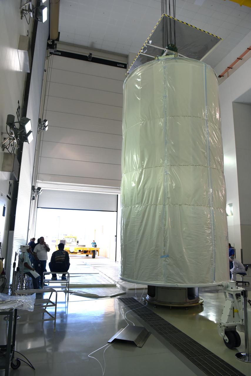
NASA's Ice, Cloud and land Elevation Satellite-2 (ICESat-2) arrives in its shipping container aboard a heavy transport truck on June 12, 2018, at Vandenberg Air Force Base in California. ICESat-2 was shipped from the Northrop Grumman facility in Gilbert, Arizona, where it was built and tested. The satellite is scheduled to launch Sept. 12, 2018, on the final United Launch Alliance Delta II rocket from Space Launch Complex-2 at Vandenberg. ICESat-2 will measure the height of a changing Earth, one laser pulse at a time, 10,000 laser pulses a second. The satellite will carry the Advanced Topographic Laser Altimeter System. ICESat-2 will help scientists investigate why, and how much our planet's frozen and icy areas, called the cryosphere, is changing in a warming climate.
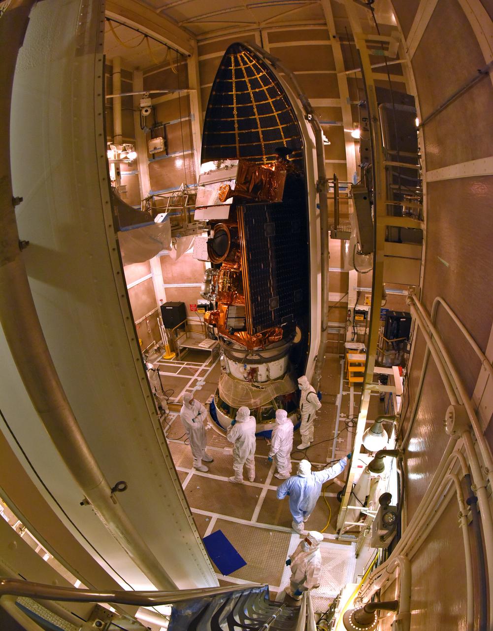
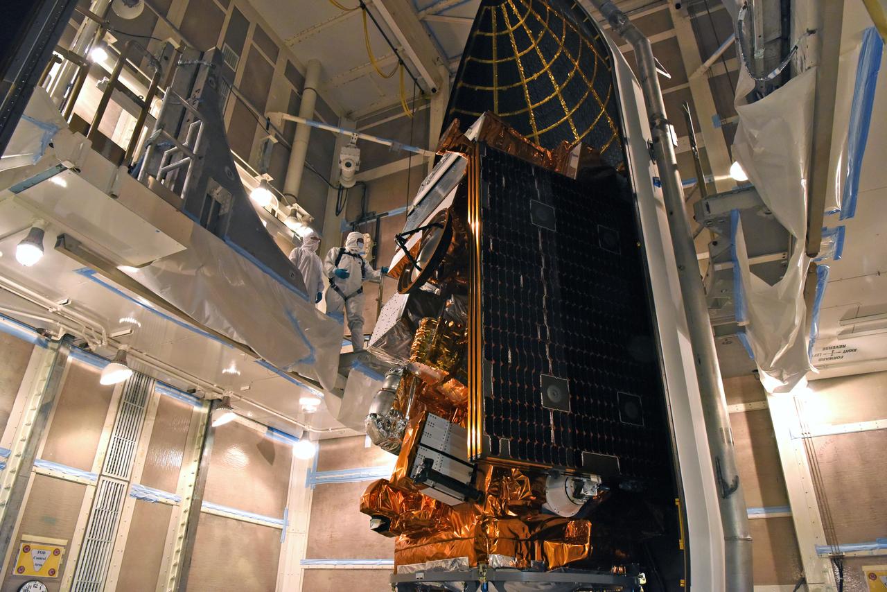
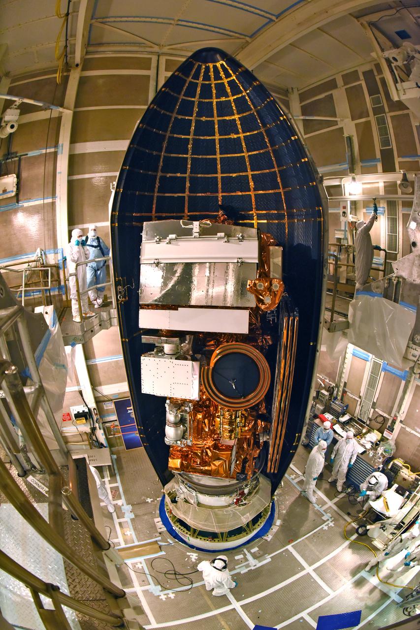
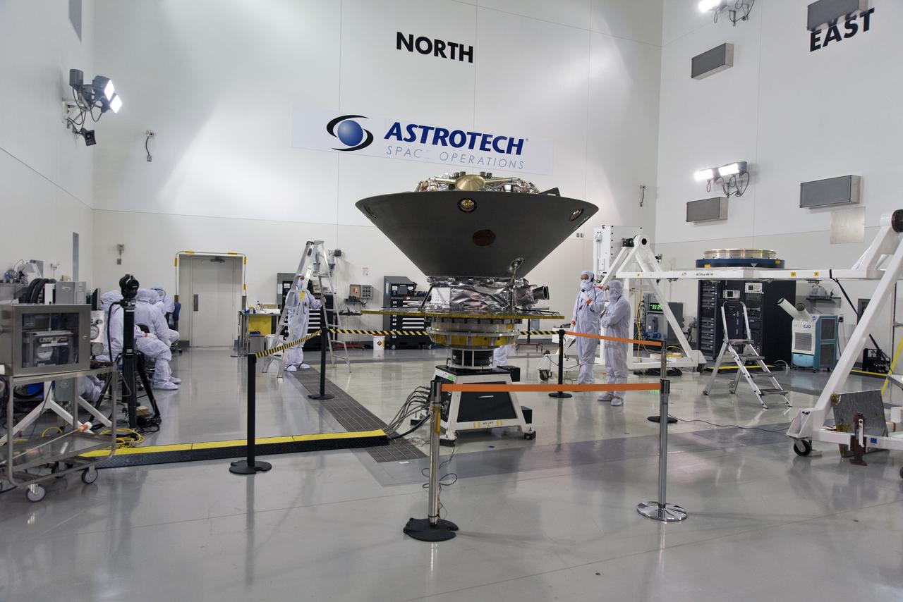
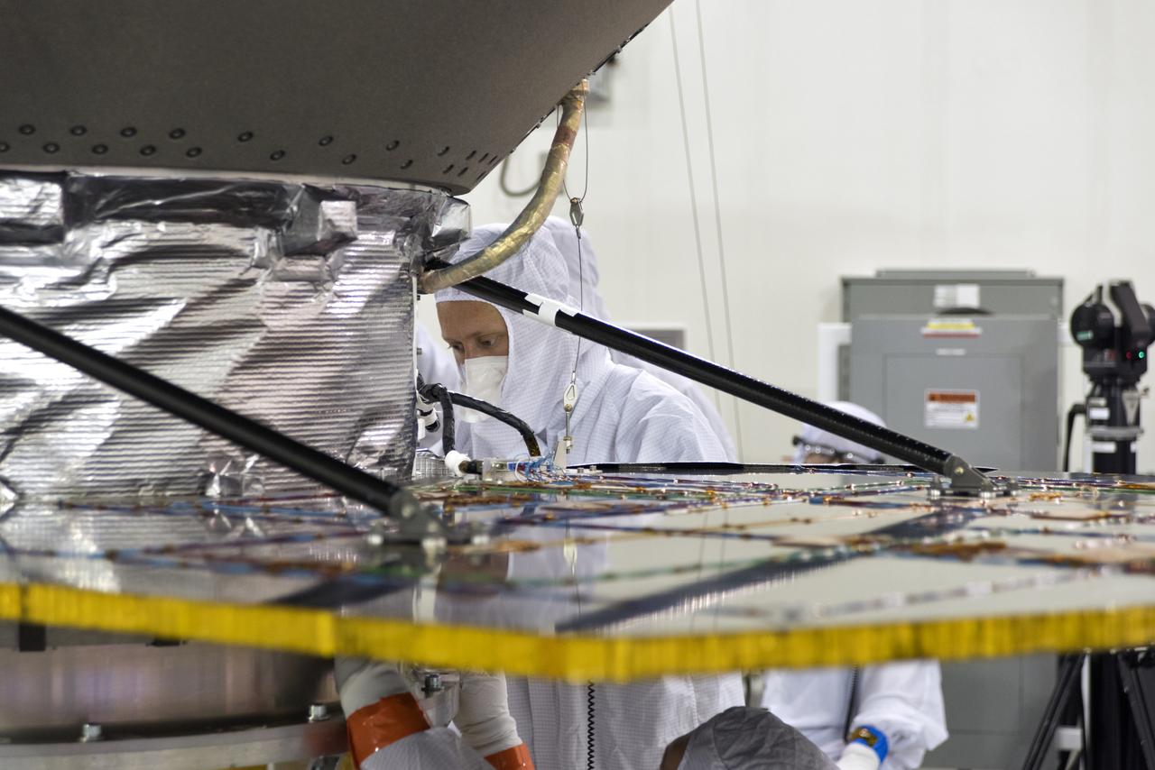
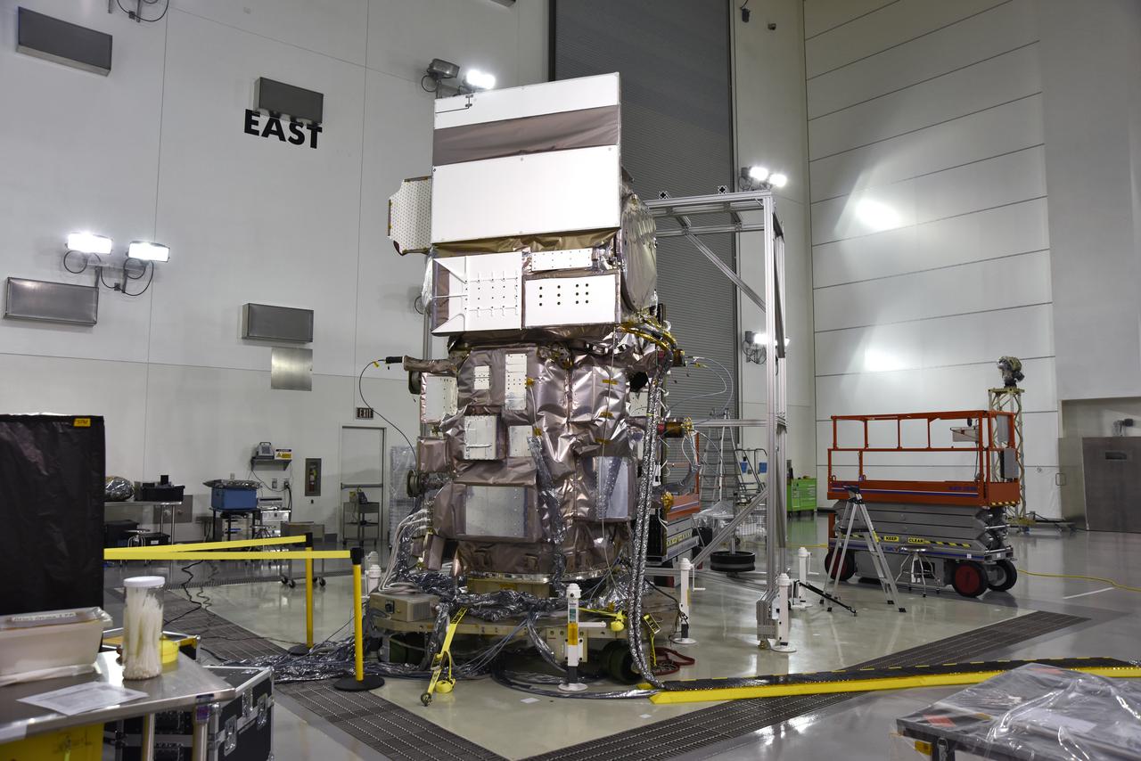
NASA's Interior Exploration using Seismic Investigations, Geodesy and Heat Transport, or InSight, at right, is in a clean room inside the Astrotech processing facility at Vandenberg Air Force Base in California. The spacecraft's protective heat shield is in view at left. InSight is scheduled for liftoff on a United Launch Alliance Atlas V rocket May 5, 2018. InSight will be the first mission to look deep beneath the Martian surface. It will study the planet's interior by measuring its heat output and listen for marsquakes. InSight will use the seismic waves generated by marsquakes to develop a map of the planet’s deep interior. The resulting insight into Mars’ formation will provide a better understanding of how other rocky planets, including Earth, were created. NASA’s Jet Propulsion Laboratory in Pasadena, California, manages the InSight mission for the agency’s Science Mission Directorate. InSight is part of NASA's Discovery Program, managed by its Marshall Space Flight Center in Huntsville, Alabama. The spacecraft, including cruise stage and lander, was built and tested by Lockheed Martin Space in Denver. Several European partners, including France's space agency, the Centre National d'Étude Spatiales, and the German Aerospace Center, are supporting the mission. United Launch Alliance of Centennial, Colorado, is providing the Atlas V launch service. NASA’s Launch Services Program, based at its Kennedy Space Center in Florida, is responsible for launch management.
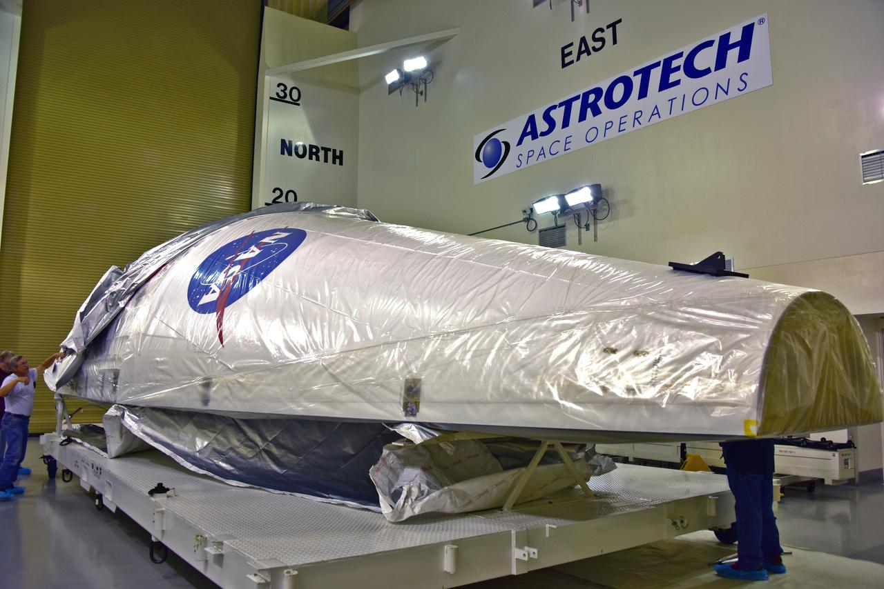
The United Launch Alliance (ULA) payload fairing for NASA's upcoming Interior Exploration using Seismic Investigations, Geodesy and Heat Transport, or InSight, mission to land on Mars has just arrived at the Astrotech facility at Vandenberg Air Force Base in California. InSight is the first mission to explore the Red Planet's deep interior. It will investigate processes that shaped the rocky planets of the inner solar system including Earth. Liftoff atop a ULA Atlas V rocket is scheduled for May 5, 2018.
Inside the Astrotech Space Operations high bay at Vandenberg Air Force Base in California, technicians prepare NASA's Ice, Cloud and land Elevation Satellite-2 (ICESat-2), for installation of the protective canister on Aug. 25, 2018. The satellite will be transported to Space Launch Complex 2 where it will be hoisted up by crane and attached to the United Launch Alliance Delta II rocket. Launch is scheduled for Sept. 15, 2018. ICESat-2 will measure the height of a changing Earth, one laser pulse at a time, 10,000 laser pulses a second. The satellite will carry the Advanced Topographic Laser Altimeter System (ATLAS). ICESat-2 will help scientists investigate why, and how much our planet's frozen and icy areas, called the cryosphere, are changing in a warming climate.
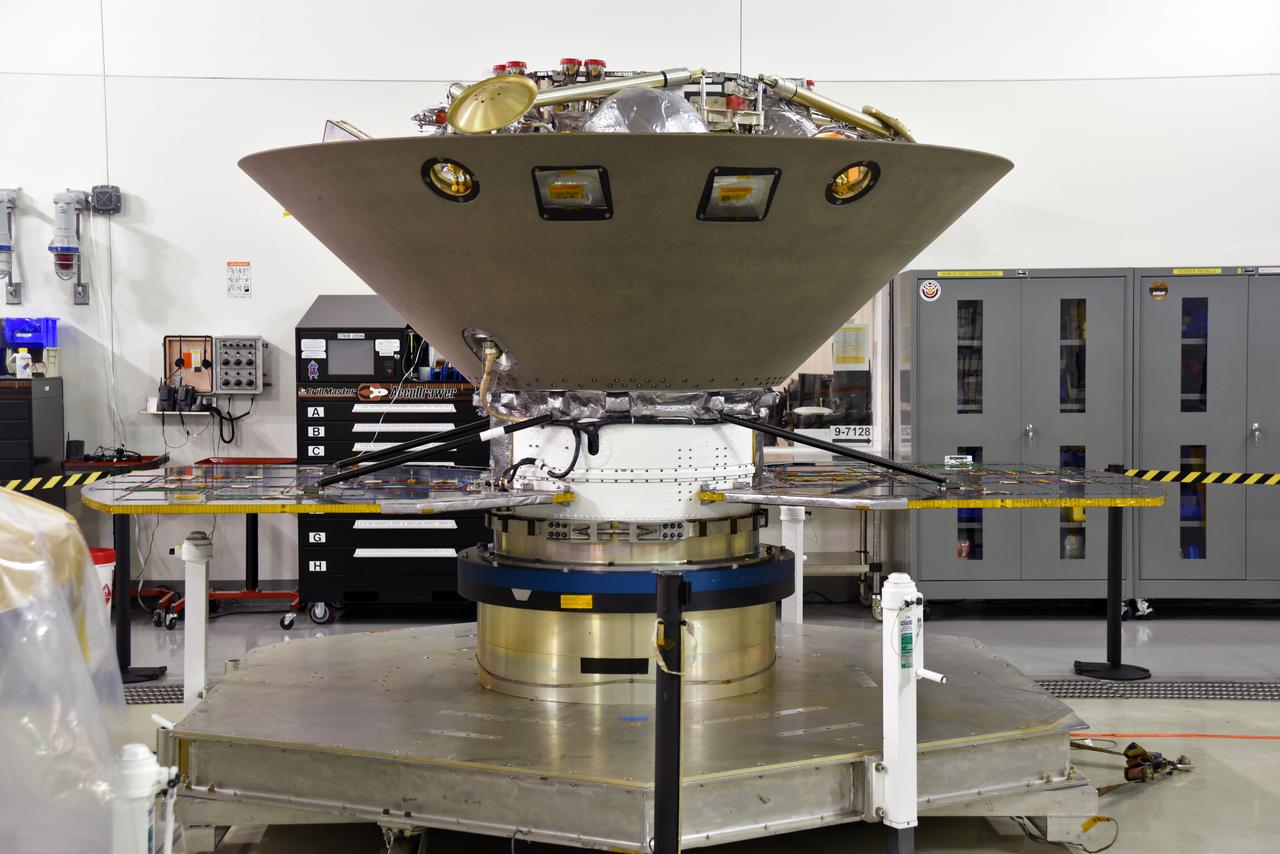
NASA's Interior Exploration using Seismic Investigations, Geodesy and Heat Transport, or InSight, is in a clean room inside the Astrotech processing facility at Vandenberg Air Force Base in California. InSight is scheduled for liftoff on a United Launch Alliance Atlas V rocket May 5, 2018. InSight will be the first mission to look deep beneath the Martian surface. It will study the planet's interior by measuring its heat output and listen for marsquakes. InSight will use the seismic waves generated by marsquakes to develop a map of the planet’s deep interior. The resulting insight into Mars’ formation will provide a better understanding of how other rocky planets, including Earth, were created. NASA’s Jet Propulsion Laboratory in Pasadena, California, manages the InSight mission for the agency’s Science Mission Directorate. InSight is part of NASA's Discovery Program, managed by its Marshall Space Flight Center in Huntsville, Alabama. The spacecraft, including cruise stage and lander, was built and tested by Lockheed Martin Space in Denver. Several European partners, including France's space agency, the Centre National d'Étude Spatiales, and the German Aerospace Center, are supporting the mission. United Launch Alliance of Centennial, Colorado, is providing the Atlas V launch service. NASA’s Launch Services Program, based at its Kennedy Space Center in Florida, is responsible for launch management.
NASA's Ice, Cloud and land Elevation Satellite-2 (ICESat-2) is moved into the high bay of the Astrotech processing facility on June 13, 2018, at Vandenberg Air Force Base in California. ICESat-2 was shipped from the Northrop Grumman facility in Gilbert, Arizona, where it was built and tested. The satellite is scheduled to launch from Space Launch Complex-2 at Vandenberg on the final United Launch Alliance Delta II rocket. ICESat-2 will measure the height of a changing Earth, one laser pulse at a time, 10,000 laser pulses a second. The satellite will carry the Advanced Topographic Laser Altimeter System. ICESat-2 will help scientists investigate why, and how much our planet's frozen and icy areas, called the cryosphere, is changing in a warming climate.
Technicians assist as the second half of the United Launch Alliance (ULA) Delta II rocket payload fairing is lifted up into the Vertical Integration Facility at Space Launch Complex 2 at Vandenberg Air Force Base in California, on June 4, 2018. NASA's Ice, Cloud and land Elevation Satellite-2 (ICESat-2) will launch later this year on the final Delta II rocket. ICESat-2 will measure the height of a changing Earth, one laser pulse at a time, 10,000 laser pulses a second. The satellite will carry a single instrument, the Advanced Topographic Laser Altimeter System. ICESat-2 will help scientists investigate why, and how much our planet's frozen and icy areas, called the cryosphere, is changing in a warming climate.
The United Launch Alliance Delta II first stage is lifted to vertical on the stand at Space Launch Complex 2 on June 8, 2018, at Vandenberg Air Force Base in California. The booster will be lifted and moved into the mobile service tower. NASA's Ice, Cloud and land Elevation Satellite-2 (ICESat-2) will launch on the final Delta II rocket. ICESat-2 will measure the height of a changing Earth, one laser pulse at a time, 10,000 laser pulses a second. The satellite will carry a single instrument, the Advanced Topographic Laser Altimeter System. ICESat-2 will help scientists investigate why, and how much our planet's frozen and icy areas, called the cryosphere, is changing in a warming climate.

After a U.S. Air Force C-17 aircraft arrived at Vandenberg Air Force Base in California, ground crews offload NASA's Interior Exploration using Seismic Investigations, Geodesy and Heat Transport, or InSight, spacecraft designed to land on Mars. InSight was developed and built by Lockheed-Martin Space Systems in Denver, Colorado, and is scheduled for liftoff is May 5, 2018. InSight is the first mission to explore the Red Planet's deep interior. It will investigate processes that shaped the rocky planets of the inner solar system including Earth.

At Vandenberg Air Force Base in California, NASA's Ice, Cloud and land Elevation Satellite-2 (ICESat-2) is hoisted up by crane at the mobile service tower at Space Launch Complex 2, on Aug. 26, 2018. The satellite will be attached to the top of the United Launch Alliance Delta II rocket. Launch is scheduled for Sept. 15, 2018. ICESat-2 will measure the height of a changing Earth, one laser pulse at a time, 10,000 laser pulses a second. The satellite will carry the Advanced Topographic Laser Altimeter System (ATLAS). ICESat-2 will help scientists investigate why, and how much our planet's frozen and icy areas, called the cryosphere, are changing in a warming climate.

Inside a clean room in Building 1555 at Vandenberg Air Force Base in California, technicians begin to install the first half of the Northrop Grumman Pegasus XL payload fairing around NASA's Ionospheric Connection Explorer (ICON) on Aug. 22, 2018. ICON is being prepared for its launch on the Pegasus XL rocket, which is attached beneath the company's L-1011 Stargazer aircraft. Launch is scheduled for Oct. 26, from the Skid Strip at Cape Canaveral Air Force Station in Florida. ICON will study the frontier of space - the dynamic zone high in Earth's atmosphere where terrestrial weather from below meets space weather above. The explorer will help determine the physics of Earth's space environment and pave the way for mitigating its effects on our technology, communications systems and society.

The solid rocket motor for mating to the United Launch Alliance Delta II launch vehicle is lifted up at the Vertical Integration Facility (VIF) at Space Launch Complex 2 on June 14, 2018, at Vandenberg Air Force Base in California. The solid rocket motor will be attached to the rocket. NASA's Ice, Cloud and land Elevation Satellite-2 (ICESat-2) will launch on the final Delta II rocket. ICESat-2 will measure the height of a changing Earth, one laser pulse at a time, 10,000 laser pulses a second. The satellite will carry a single instrument, the Advanced Topographic Laser Altimeter System. ICESat-2 will help scientists investigate why, and how much our planet's frozen and icy areas, called the cryosphere, is changing in a warming climate.
A United Launch Alliance Delta II booster arrives at NASA's Building 836, the Spacecraft Labs Telemetry Station at Vandenberg Air Force Base in California. It will be offloaded and begin preliminary checkouts and preflight processing for launch of the agency's Ice, Cloud and land Elevation Satellite-2, or ICESat-2. Liftoff from Space Launch Complex-2 at Vandenberg is scheduled for Sept. 12, 2018, and will be the last for the venerable Delta II rocket. Once in orbit, the satellite is designed to measure the height of a changing Earth, one laser pulse at a time, 10,000 laser pulses a second. The satellite will carry a single instrument, the Advanced Topographic Laser Altimeter System. ICESat-2 will help scientists investigate why, and how much, Earth's frozen and icy areas are changing. These area make up Earth's the cryosphere.
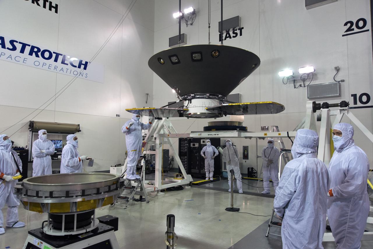
Technicians secure NASA's Ionospheric Connection Explorer (ICON) on the spacecraft separation system May 9, 2018, in a clean room inside Building 1555 at Vandenberg Air Force Base in California. The explorer will launch on June 15, 2018, from Kwajalein Atoll in the Marshall Islands (June 14 in the continental United States) on Orbital ATK's Pegasus XL rocket, which is attached to the company's L-1011 Stargazer aircraft. ICON will study the frontier of space - the dynamic zone high in Earth's atmosphere where terrestrial weather from below meets space weather above. The explorer will help determine the physics of Earth's space environment and pave the way for mitigating its effects on our technology, communications systems and society.
The first half of the United Launch Alliance (ULA) Delta II rocket payload fairing is lifted up and into the Vertical Integration Facility at Space Launch Complex 2 at Vandenberg Air Force Base in California, on June 4, 2018. NASA's Ice, Cloud and land Elevation Satellite-2 (ICESat-2) will launch later this year on the final Delta II rocket. ICESat-2 will measure the height of a changing Earth, one laser pulse at a time, 10,000 laser pulses a second. The satellite will carry a single instrument, the Advanced Topographic Laser Altimeter System. ICESat-2 will help scientists investigate why, and how much our planet's frozen and icy areas, called the cryosphere, is changing in a warming climate.
Inside the Astrotech Space Operations high bay at Vandenberg Air Force Base in California, technicians prepare the canister, at right, for installation around NASA's Ice, Cloud and land Elevation Satellite-2 (ICESat-2), at left, on Aug. 25, 2018. The satellite will be transported to Space Launch Complex 2 where it will be hoisted up by crane and attached to the United Launch Alliance Delta II rocket. Launch is scheduled for Sept. 15, 2018. ICESat-2 will measure the height of a changing Earth, one laser pulse at a time, 10,000 laser pulses a second. The satellite will carry the Advanced Topographic Laser Altimeter System (ATLAS). ICESat-2 will help scientists investigate why, and how much our planet's frozen and icy areas, called the cryosphere, are changing in a warming climate.
In the Astrotech facility at Vandenberg Air Force Base in California, NASA's Interior Exploration using Seismic Investigations, Geodesy and Heat Transport, or InSight, spacecraft is placed on a spin table during preflight processing. InSight will be the first mission to look deep beneath the Martian surface. It will study the planet's interior by measuring its heat output and listen for marsquakes. The spacecraft will use the seismic waves generated by marsquakes to develop a map of the planet’s deep interior. The resulting insight into Mars’ formation will provide a better understanding of how other rocky planets, including Earth, were created. InSight is scheduled for liftoff May 5, 2018.
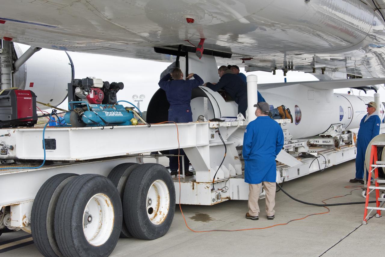
Technicians secure Northrop Grumman's Pegasus XL rocket, containing NASA's Ionospheric Connection Explorer (ICON), beneath the company's L-1011 Stargazer aircraft at the hot pad at Vandenberg Air Force Base in California, on Oct. 14, 2018. The Stargazer will take off from the hot pad and travel to Cape Canaveral Air Force Station in Florida. The Pegasus XL rocket will launch ICON from the Skid Strip at the Cape. ICON will study the frontier of space - the dynamic zone high in Earth's atmosphere where terrestrial weather from below meets space weather above. The explorer will help determine the physics of Earth's space environment and pave the way for mitigating its effects on our technology and communications systems.
At NASA's Building 836, the Spacecraft Labs Telemetry Station at Vandenberg Air Force Base in California, a United Launch Alliance Delta II booster has been removed from its shipping container. Preliminary checkouts and preflight processing will begin leading to launch of the agency's Ice, Cloud and land Elevation Satellite-2, or ICESat-2. Liftoff from Space Launch Complex-2 at Vandenberg is scheduled for Sept. 12, 2018, and will be the last for the venerable Delta II rocket. Once in orbit, the satellite is designed to measure the height of a changing Earth, one laser pulse at a time, 10,000 laser pulses a second. The satellite will carry a single instrument, the Advanced Topographic Laser Altimeter System. ICESat-2 will help scientists investigate why, and how much, Earth's frozen and icy areas are changing. These area make up Earth's the cryosphere.

At Space Launch Complex 3 at Vandenberg Air Force Base in California, a technician assists as the aft stub adapter (ASA) and interstage adapter (ISA) for a United Launch Alliance (ULA) Atlas V is lifted by crane for mating atop a Centaur upper stage. The launch vehicle will send NASA's Interior Exploration using Seismic Investigations, Geodesy and Heat Transport, or InSight, spacecraft to land on Mars. InSight is the first mission to explore the Red Planet's deep interior. InSight is scheduled for liftoff May 5, 2018. InSight will be the first mission to look deep beneath the Martian surface. It will study the planet's interior by measuring its heat output and listen for marsquakes. InSight will use the seismic waves generated by marsquakes to develop a map of the planet’s deep interior. The resulting insight into Mars’ formation will provide a better understanding of how other rocky planets, including Earth, were created. NASA’s Jet Propulsion Laboratory in Pasadena, California, manages the InSight mission for the agency’s Science Mission Directorate. InSight is part of NASA's Discovery Program, managed by its Marshall Space Flight Center in Huntsville, Alabama. The spacecraft, including cruise stage and lander, was built and tested by Lockheed Martin Space in Denver. Several European partners, including France's space agency, the Centre National d'Étude Spatiales, and the German Aerospace Center, are supporting the mission. United Launch Alliance of Centennial, Colorado, is providing the Atlas V launch service. NASA’s Launch Services Program, based at its Kennedy Space Center in Florida, is responsible for launch management.
Inside the high bay of the Astrotech Space Operations facility at Vandenberg Air Force Base in California, a technician opens and checks the flight door for the Advanced Topographic Laser Altimeter System (ATLAS) on NASA's Ice, Cloud and land Elevation Satellite-2 (ICESat-2) on June 21, 2018. The satellite is being prepared for its scheduled launch from Space Launch Complex-2 at Vandenberg on the final United Launch Alliance Delta II rocket. ICESat-2 will measure the height of a changing Earth, one laser pulse at a time, 10,000 laser pulses a second. The satellite will carry ATLAS. ICESat-2 will help scientists investigate why, and how much our planet's frozen and icy areas, called the cryosphere, is changing in a warming climate.
The SpaceX Falcon 9 rocket, topped with the Sentinel-6 Michael Freilich satellite secured inside its payload fairing, rolls from SpaceX’s Payload Processing Facility at Vandenberg Air Force Base in California to Space Launch Complex 4 on Nov. 20, 2020. The Sentinel-6/Jason-CS (Continuity of Service) mission consists of the Sentinel-6 Michael Freilich satellite, which will be followed by its twin, the Sentinel-6B satellite, in 2025. The Sentinel-6/Jason-CS mission is part of Copernicus, the European Union’s Earth observation program, managed by the European Commission. Continuing the legacy of the Jason series missions, Sentinel-6/Jason-CS will extend the records of sea level into their fourth decade, collecting accurate measurements of sea surface height for more than 90% of the world’s seas, and providing crucial information for operational oceanography, marine meteorology, and climate studies. Sentinel-6 Michael Freilich launched Nov. 21, 2020, at 9:17 PST (12:17 EST). NASA’s Launch Services Program at Kennedy Space Center was responsible for launch management.
United Launch Alliance (ULA) technicians assist as the solid rocket motor is lifted up and moved toward the Delta II launch vehicle in the Vertical Integration Facility (VIF) at Space Launch Complex 2 on June 14, 2018, at Vandenberg Air Force Base in California. The solid rocket motor will be attached to the rocket. NASA's Ice, Cloud and land Elevation Satellite-2 (ICESat-2) will launch on the final ULA Delta II rocket. ICESat-2 will measure the height of a changing Earth, one laser pulse at a time, 10,000 laser pulses a second. The satellite will carry a single instrument, the Advanced Topographic Laser Altimeter System. ICESat-2 will help scientists investigate why, and how much our planet's frozen and icy areas, called the cryosphere, is changing in a warming climate.
Inside the high bay of the Astrotech Space Operations facility at Vandenberg Air Force Base in California, a solar array first motion test is underway on NASA's Ice, Cloud and land Elevation Satellite-2 (ICESat-2) on June 18, 2018. The satellite is being prepared for its scheduled launch from Space Launch Complex-2 at Vandenberg on the final United Launch Alliance Delta II rocket. ICESat-2 will measure the height of a changing Earth, one laser pulse at a time, 10,000 laser pulses a second. The satellite will carry the Advanced Topographic Laser Altimeter System. ICESat-2 will help scientists investigate why, and how much our planet's frozen and icy areas, called the cryosphere, is changing in a warming climate.
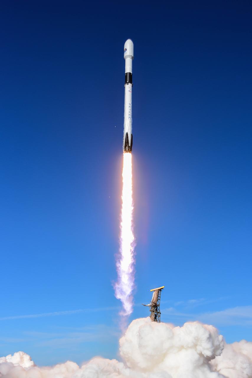
The SpaceX Falcon 9 rocket carrying the Sentinel-6 Michael Freilich spacecraft lifts off from Space Launch Complex 4 at Vandenberg Air Force Base in California, Nov. 21, 2020, at 9:17 a.m. PST (12:17 p.m. EST). The Sentinel-6/Jason-CS (Continuity of Service) mission consists of the Sentinel-6 Michael Freilich satellite, which will be followed by its twin, the Sentinel-6B satellite, in 2025. The Sentinel-6/Jason-CS mission is part of Copernicus, the European Union’s Earth observation program, managed by the European Commission. Continuing the legacy of the Jason series missions, Sentinel-6/Jason-CS will extend the records of sea level into their fourth decade, collecting accurate measurements of sea surface height for more than 90% of the world’s seas, and providing crucial information for operational oceanography, marine meteorology, and climate studies. NASA’s Launch Services Program at Kennedy Space Center was responsible for launch management.
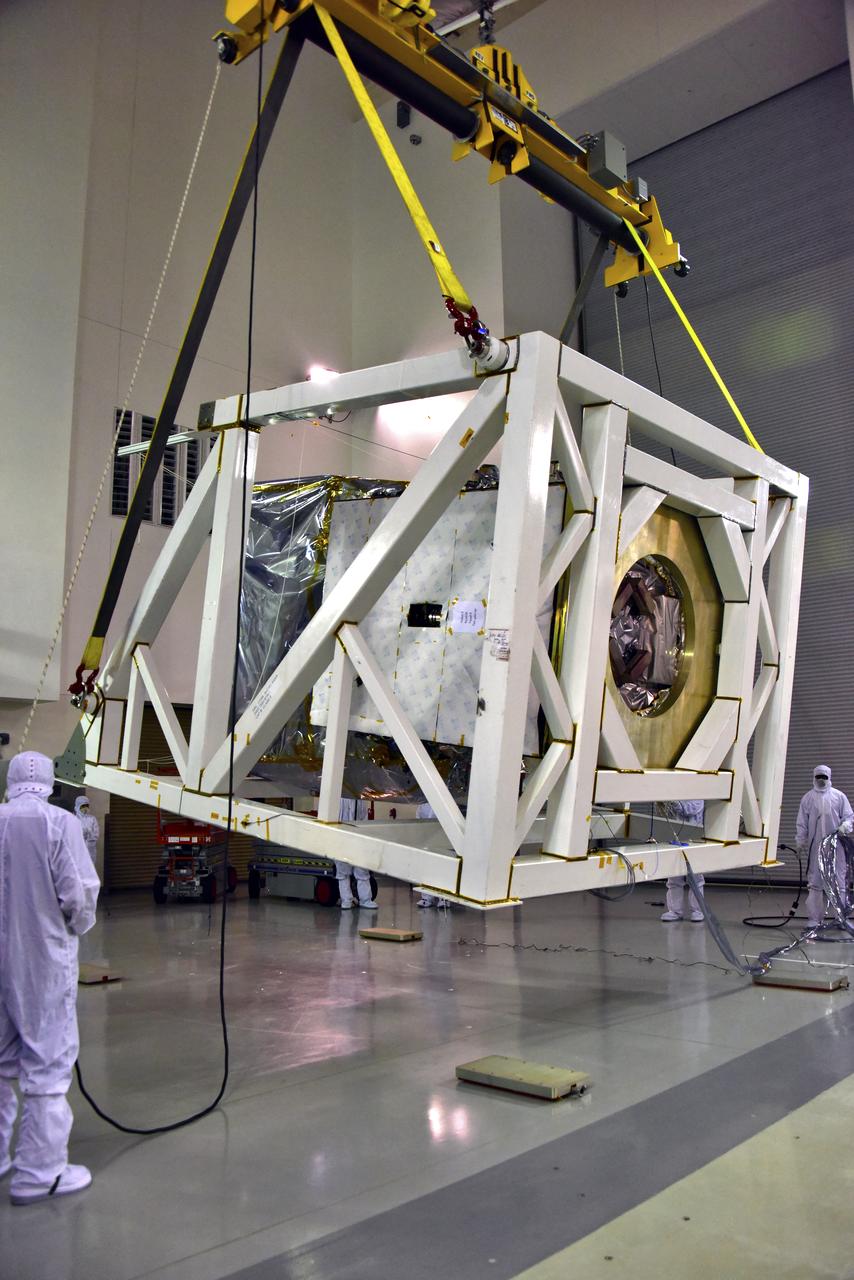
Inside the Astrotech processing facility at Vandenberg Air Force Base in California, NASA's Interior Exploration using Seismic Investigations, Geodesy and Heat Transport, or InSight, spacecraft is prepared to be lifted on to a rotation fixture for further testing. InSight was developed and built by Lockheed-Martin Space Systems in Denver, Colorado, and is scheduled for liftoff is May 5, 2018. InSight is the first mission to land on Mars and explore the Red Planet's deep interior. It will investigate processes that shaped the rocky planets of the inner solar system including Earth.
Inside a clean room in Building 1555 at Vandenberg Air Force Base in California, technicians install the first half of the Northrop Grumman Pegasus XL payload fairing around NASA's Ionospheric Connection Explorer (ICON) on Aug. 22, 2018. ICON is being prepared for its launch on the Pegasus XL rocket, which is attached beneath the company's L-1011 Stargazer aircraft. Launch is scheduled for Oct. 26, from the Skid Strip at Cape Canaveral Air Force Station in Florida. ICON will study the frontier of space - the dynamic zone high in Earth's atmosphere where terrestrial weather from below meets space weather above. The explorer will help determine the physics of Earth's space environment and pave the way for mitigating its effects on our technology, communications systems and society.
The solid rocket motor for mating to the United Launch Alliance Delta II launch vehicle is lifted up at the Vertical Integration Facility (VIF) at Space Launch Complex 2 on June 14, 2018, at Vandenberg Air Force Base in California. The solid rocket motor will be attached to the rocket. NASA's Ice, Cloud and land Elevation Satellite-2 (ICESat-2) will launch on the final Delta II rocket. ICESat-2 will measure the height of a changing Earth, one laser pulse at a time, 10,000 laser pulses a second. The satellite will carry a single instrument, the Advanced Topographic Laser Altimeter System. ICESat-2 will help scientists investigate why, and how much our planet's frozen and icy areas, called the cryosphere, is changing in a warming climate.
Inside the high bay of the Astrotech Space Operations facility at Vandenberg Air Force Base in California, technicians assist as a crane lowers NASA's Ice, Cloud and land Elevation Satellite-2 (ICESat-2) onto the payload adapter on Aug. 30, 2018. ICESat-2 is being prepared for its scheduled launch from Space Launch Complex 2 at Vandenberg on the final United Launch Alliance Delta II rocket. ICESat-2 will measure the height of a changing Earth, one laser pulse at a time, 10,000 laser pulses a second. The satellite will carry the Advanced Topographic Laser Altimeter System (ATLAS). ICESat-2 will help scientists investigate why, and how much our planet's frozen and icy areas, called the cryosphere, are changing in a warming climate.
At NASA's Building 836, the Spacecraft Labs Telemetry Station at Vandenberg Air Force Base in California, a United Launch Alliance Delta II booster is removed from its shipping container. After it is offloaded, preliminary checkouts and preflight processing will begin leading to launch of the agency's Ice, Cloud and land Elevation Satellite-2, or ICESat-2. Liftoff from Space Launch Complex-2 at Vandenberg is scheduled for Sept. 12, 2018, and will be the last for the venerable Delta II rocket. Once in orbit, the satellite is designed to measure the height of a changing Earth, one laser pulse at a time, 10,000 laser pulses a second. The satellite will carry a single instrument, the Advanced Topographic Laser Altimeter System. ICESat-2 will help scientists investigate why, and how much, Earth's frozen and icy areas are changing. These area make up Earth's the cryosphere.
In the Astrotech facility at Vandenberg Air Force Base in California, NASA's Interior Exploration using Seismic Investigations, Geodesy and Heat Transport, or InSight, spacecraft is lifted for placement on a spin table during preflight processing. InSight will be the first mission to look deep beneath the Martian surface. It will study the planet's interior by measuring its heat output and listen for marsquakes. The spacecraft will use the seismic waves generated by marsquakes to develop a map of the planet’s deep interior. The resulting insight into Mars’ formation will provide a better understanding of how other rocky planets, including Earth, were created. InSight is scheduled for liftoff May 5, 2018.
Inside the high bay of the Astrotech Space Operations facility at Vandenberg Air Force Base in California, a solar array first motion test is in progress on NASA's Ice, Cloud and land Elevation Satellite-2 (ICESat-2) on June 18, 2018. The satellite is being prepared for its scheduled launch from Space Launch Complex-2 at Vandenberg on the final United Launch Alliance Delta II rocket. ICESat-2 will measure the height of a changing Earth, one laser pulse at a time, 10,000 laser pulses a second. The satellite will carry the Advanced Topographic Laser Altimeter System. ICESat-2 will help scientists investigate why, and how much our planet's frozen and icy areas, called the cryosphere, is changing in a warming climate.
United Launch Alliance (ULA) workers assist as the Delta II first stage is lifted to vertical at Space Launch Complex 2 on June 8, 2018, at Vandenberg Air Force Base in California. The booster will be moved into the mobile service tower. NASA's Ice, Cloud and land Elevation Satellite-2 (ICESat-2) will launch on the final Delta II rocket. ICESat-2 will measure the height of a changing Earth, one laser pulse at a time, 10,000 laser pulses a second. The satellite will carry a single instrument, the Advanced Topographic Laser Altimeter System. ICESat-2 will help scientists investigate why, and how much our planet's frozen and icy areas, called the cryosphere, is changing in a warming climate.
At Space Launch Complex 2 at Vandenberg Air Force Base in California, three poly picosatellite orbital deployers, or P-POD containers, with tiny satellites, called CubeSats inside, are being prepared for installation on the direct mate adapter of the United Launch Alliance Delta II rocket, on Aug. 31, 2018. NASA's Ice, Cloud and land Elevation Satellite-2 (ICESat-2) is ready for launch aboard the final Delta II rocket. Launch is scheduled for Sept. 15, 2018. ICESat-2 will measure the height of a changing Earth, one laser pulse at a time, 10,000 laser pulses a second. The satellite will carry the Advanced Topographic Laser Altimeter System (ATLAS). ICESat-2 will help scientists investigate why, and how much our planet's frozen and icy areas, called the cryosphere, are changing in a warming climate.
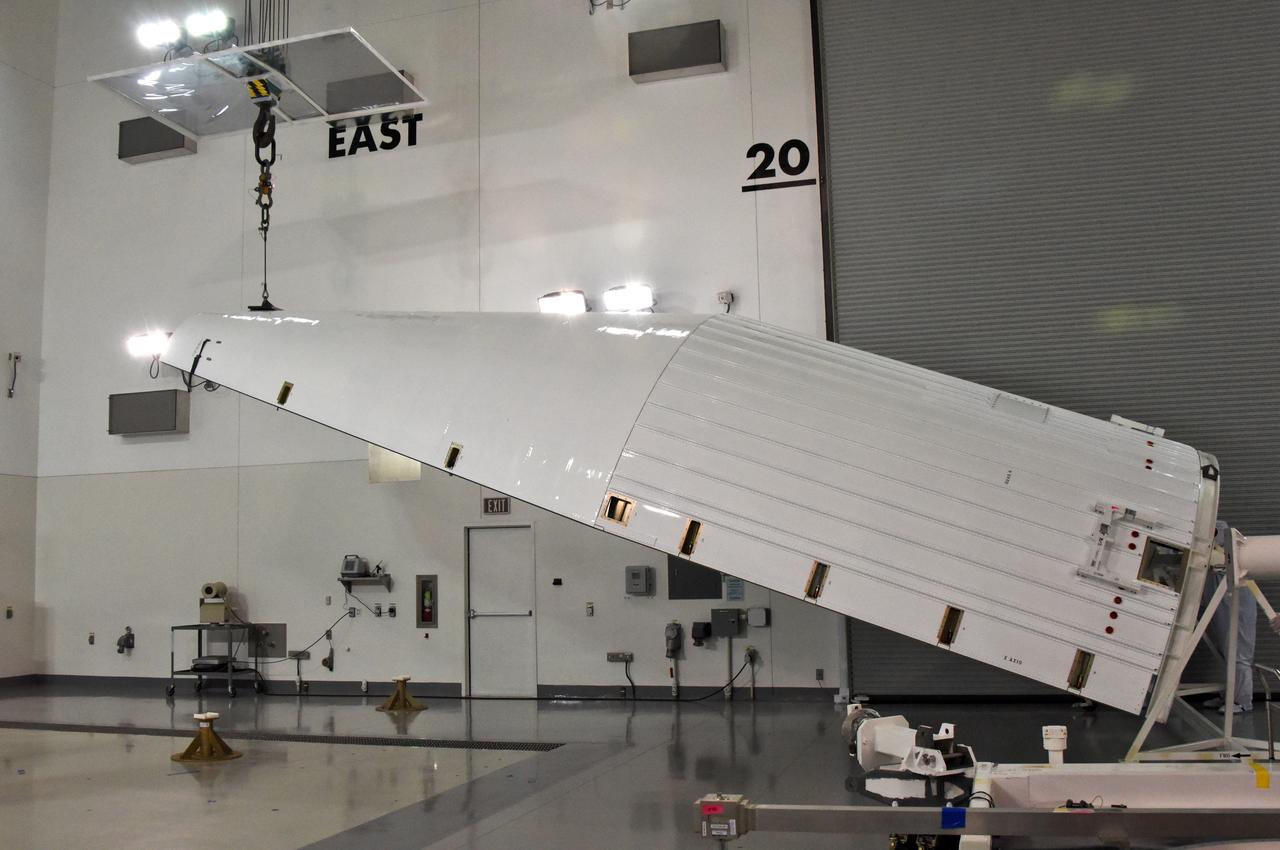
Inside the Astrotech processing facility at Vandenberg Air Force Base in California, NASA's Interior Exploration using Seismic Investigations, Geodesy and Heat Transport, or InSight, spacecraft is rotated on a fixture for further testing. InSight was developed and built by Lockheed-Martin Space Systems in Denver, Colorado, and is scheduled for liftoff is May 5, 2018. InSight is the first mission to land on Mars and explore the Red Planet's deep interior. It will investigate processes that shaped the rocky planets of the inner solar system including Earth.
Inside a clean room in Building 1555 at Vandenberg Air Force Base in California, technicians install the second half of the Northrop Grumman Pegasus XL payload fairing around NASA's Ionospheric Connection Explorer (ICON) on Aug. 22, 2018. ICON is being prepared for its launch on the Pegasus XL rocket, which is attached beneath the company's L-1011 Stargazer aircraft. Launch is scheduled for Oct 26, from the Skid Strip at Cape Canaveral Air Force Station in Florida. ICON will study the frontier of space - the dynamic zone high in Earth's atmosphere where terrestrial weather from below meets space weather above. The explorer will help determine the physics of Earth's space environment and pave the way for mitigating its effects on our technology, communications systems and society.
Inside a clean room in Building 1555 at Vandenberg Air Force Base in California, technicians install the second half of the Northrop Grumman Pegasus XL payload fairing around NASA's Ionospheric Connection Explorer (ICON) on Oct. 4, 2018. ICON is being prepared for its launch on the Pegasus XL, which is attached to the company's L-1011 Stargazer aircraft, from the Skid Strip at Cape Canaveral Air Force Station in Florida. Launch is scheduled for Oct. 26. ICON will study the frontier of space - the dynamic zone high in Earth's atmosphere where terrestrial weather from below meets space weather above. The explorer will help determine the physics of Earth's space environment and pave the way for mitigating its effects on our technology, communications systems and society.
Inside the Astrotech processing facility at Vandenberg Air Force Base in California, technicians and engineers inspect the heatshield for NASA's Interior Exploration using Seismic Investigations, Geodesy and Heat Transport, or InSight, spacecraft. InSight was developed and built by Lockheed-Martin Space Systems in Denver, Colorado, and is scheduled for liftoff is May 5, 2018. InSight is the first mission to land on Mars and explore the Red Planet's deep interior. It will investigate processes that shaped the rocky planets of the inner solar system including Earth.
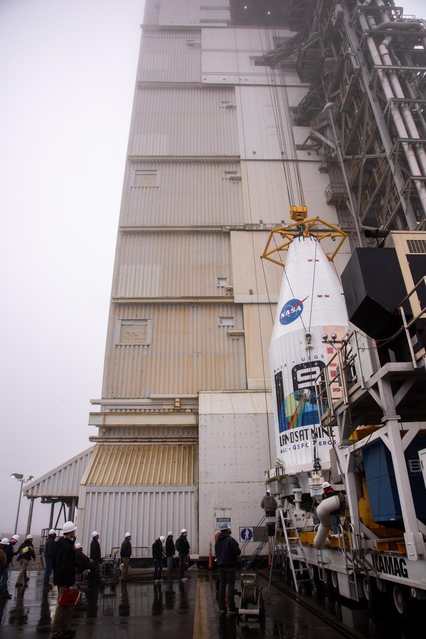
The Landsat 9 spacecraft is lifted and mated to the United Launch Alliance Atlas V rocket at Space Launch Complex 3 at Vandenberg Space Force Base in California on Sept. 15, 2021, in preparation for liftoff no earlier than Sept. 27, 2021. The launch is being managed by NASA’s Launch Services Program based at Kennedy Space Center in Florida. Landsat 9 will monitor key natural and economic resources from orbit. The satellite will carry two instruments: the Operational Land Imager 2, which collects images of Earth’s landscapes in visible, near infrared and shortwave infrared light, and the Thermal Infrared Sensor 2, which measures the temperature of land surfaces. Landsat 9 is a joint mission between NASA and the U.S. Geological Survey.
In the Astrotech facility at Vandenberg Air Force Base in California, NASA's Interior Exploration using Seismic Investigations, Geodesy and Heat Transport, or InSight, spacecraft is placed on a spin table during preflight processing. InSight will be the first mission to look deep beneath the Martian surface. It will study the planet's interior by measuring its heat output and listen for marsquakes. The spacecraft will use the seismic waves generated by marsquakes to develop a map of the planet’s deep interior. The resulting insight into Mars’ formation will provide a better understanding of how other rocky planets, including Earth, were created. InSight is scheduled for liftoff May 5, 2018.
The second half of the United Launch Alliance (ULA) Delta II rocket payload fairing is being prepared for the move to the Vertical Integration Facility at Space Launch Complex 2 at Vandenberg Air Force Base in California, on June 4, 2018. NASA's Ice, Cloud and land Elevation Satellite-2 (ICESat-2) will launch later this year on the final Delta II rocket. ICESat-2 will measure the height of a changing Earth, one laser pulse at a time, 10,000 laser pulses a second. The satellite will carry a single instrument, the Advanced Topographic Laser Altimeter System. ICESat-2 will help scientists investigate why, and how much our planet's frozen and icy areas, called the cryosphere, is changing in a warming climate.
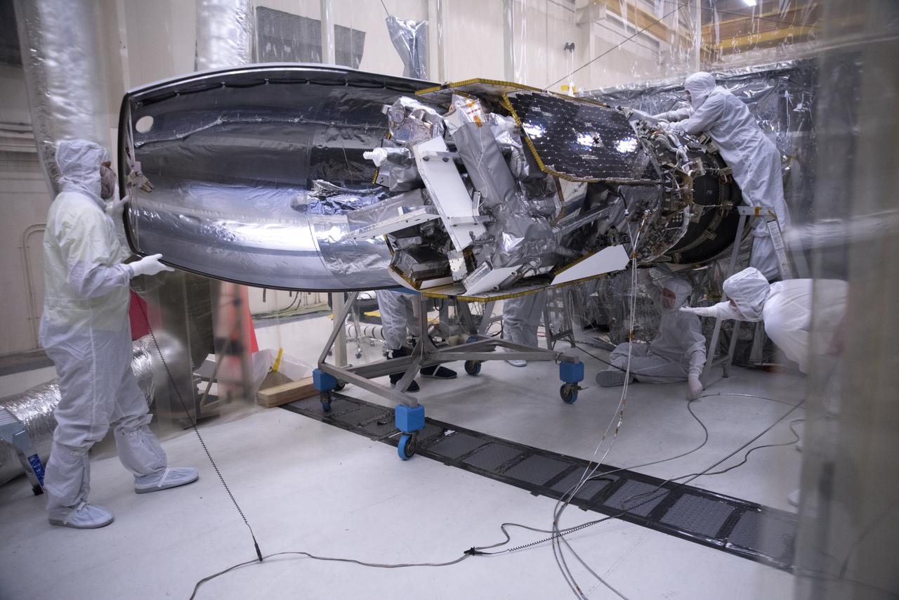
Inside a clean room in Building 1555 at Vandenberg Air Force Base in California, technicians install the first half of the Northrop Grumman Pegasus XL payload fairing around NASA's Ionospheric Connection Explorer (ICON) on Oct. 4, 2018. ICON is being prepared for its launch on the Pegasus XL, which is attached to the company's L-1011 Stargazer aircraft, from the Skid Strip at Cape Canaveral Air Force Station in Florida. Launch is scheduled for Oct. 26. ICON will study the frontier of space - the dynamic zone high in Earth's atmosphere where terrestrial weather from below meets space weather above. The explorer will help determine the physics of Earth's space environment and pave the way for mitigating its effects on our technology, communications systems and society.
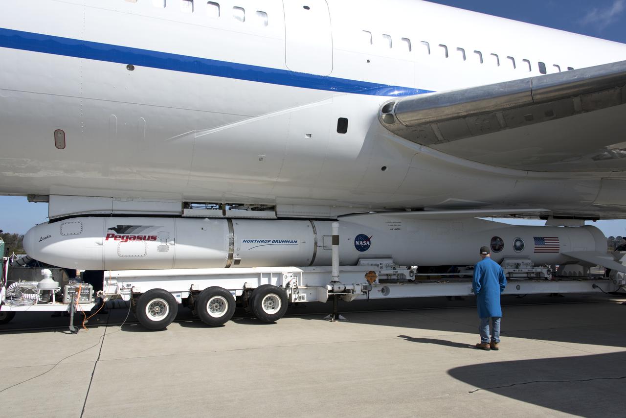
Northrop Grumman's Pegasus XL rocket, containing NASA's Ionospheric Connection Explorer (ICON), is attached beneath the company's L-1011 Stargazer aircraft at the hot pad at Vandenberg Air Force Base in California, on Oct. 14, 2018. The Stargazer will take off from the hot pad and travel to Cape Canaveral Air Force Station in Florida. The Pegasus XL rocket will launch ICON from the Skid Strip at the Cape. ICON will study the frontier of space - the dynamic zone high in Earth's atmosphere where terrestrial weather from below meets space weather above. The explorer will help determine the physics of Earth's space environment and pave the way for mitigating its effects on our technology and communications systems.
Inside the high bay of the Astrotech Space Operations facility at Vandenberg Air Force Base in California, technicians prepare to attach NASA's Ice, Cloud and land Elevation Satellite-2 (ICESat-2) to the payload adapter, on Aug. 20, 2018. The satellite is being prepared for its scheduled launch from Space Launch Complex 2 at Vandenberg on the final United Launch Alliance Delta II rocket. ICESat-2 will measure the height of a changing Earth, one laser pulse at a time, 10,000 laser pulses a second. The satellite will carry the Advanced Topographic Laser Altimeter System (ATLAS). ICESat-2 will help scientists investigate why, and how much our planet's frozen and icy areas, called the cryosphere, are changing in a warming climate.
The Landsat 9 spacecraft is lifted and mated to the United Launch Alliance Atlas V rocket at Space Launch Complex 3 at Vandenberg Space Force Base in California on Sept. 15, 2021, in preparation for liftoff no earlier than Sept. 27, 2021. The launch is being managed by NASA’s Launch Services Program based at Kennedy Space Center in Florida. Landsat 9 will monitor key natural and economic resources from orbit. The satellite will carry two instruments: the Operational Land Imager 2, which collects images of Earth’s landscapes in visible, near infrared and shortwave infrared light, and the Thermal Infrared Sensor 2, which measures the temperature of land surfaces. Landsat 9 is a joint mission between NASA and the U.S. Geological Survey.
The United Launch Alliance Delta II first stage arrives at Space Launch Complex 2 on June 8, 2018, at Vandenberg Air Force Base in California. The booster will be lifted to vertical and moved into the mobile service tower. NASA's Ice, Cloud and land Elevation Satellite-2 (ICESat-2) will launch on the final Delta II rocket. ICESat-2 will measure the height of a changing Earth, one laser pulse at a time, 10,000 laser pulses a second. The satellite will carry a single instrument, the Advanced Topographic Laser Altimeter System. ICESat-2 will help scientists investigate why, and how much our planet's frozen and icy areas, called the cryosphere, is changing in a warming climate.
Protective doors have been closed on the mobile service tower at Space Launch Complex 2 at Vandenberg Air Force Base in California, on June 8, 2018. The United Launch Alliance Delta II first stage is lifted up and secured inside the tower. NASA's Ice, Cloud and land Elevation Satellite-2 (ICESat-2) will launch on the final Delta II rocket. ICESat-2 will measure the height of a changing Earth, one laser pulse at a time, 10,000 laser pulses a second. The satellite will carry a single instrument, the Advanced Topographic Laser Altimeter System. ICESat-2 will help scientists investigate why, and how much our planet's frozen and icy areas, called the cryosphere, is changing in a warming climate.
The first half of the United Launch Alliance (ULA) Delta II rocket payload fairing is lifted up and into the Vertical Integration Facility at Space Launch Complex 2 at Vandenberg Air Force Base in California, on June 4, 2018. NASA's Ice, Cloud and land Elevation Satellite-2 (ICESat-2) will launch later this year on the final Delta II rocket. ICESat-2 will measure the height of a changing Earth, one laser pulse at a time, 10,000 laser pulses a second. The satellite will carry a single instrument, the Advanced Topographic Laser Altimeter System. ICESat-2 will help scientists investigate why, and how much our planet's frozen and icy areas, called the cryosphere, is changing in a warming climate.
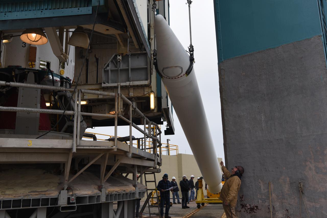
In the Astrotech facility at Vandenberg Air Force Base in California, the payload fairing for the United Launch Alliance (ULA) Atlas V for NASA's upcoming Interior Exploration using Seismic Investigations, Geodesy and Heat Transport, or InSight, mission to land on Mars is lifted to the vertical position. InSight is the first mission to explore the Red Planet's deep interior. It will investigate processes that shaped the rocky planets of the inner solar system including Earth. Liftoff atop a ULA Atlas V rocket is scheduled for May 5, 2018.
At Vandenberg Air Force Base in California, NASA's Interior Exploration using Seismic Investigations, Geodesy and Heat Transport, or InSight, spacecraft arrives at the Astrotech processing facility. InSight was developed and built by Lockheed-Martin Space Systems in Denver, Colorado, and is scheduled for liftoff is May 5, 2018. InSight is the first mission to land on Mars and explore the Red Planet's deep interior. It will investigate processes that shaped the rocky planets of the inner solar system including Earth.
NASA's Ice, Cloud and land Elevation Satellite-2 (ICESat-2), at right, encased in its protective covering, arrives at the mobile service tower at Space Launch Complex 2 at Vandenberg Air Force Base in California, on Aug. 26, 2018. The satellite will be hoisted up by crane and attached to the United Launch Alliance Delta II rocket. Launch is scheduled for Sept. 15, 2018. ICESat-2 will measure the height of a changing Earth, one laser pulse at a time, 10,000 laser pulses a second. The satellite will carry the Advanced Topographic Laser Altimeter System (ATLAS). ICESat-2 will help scientists investigate why, and how much our planet's frozen and icy areas, called the cryosphere, are changing in a warming climate.
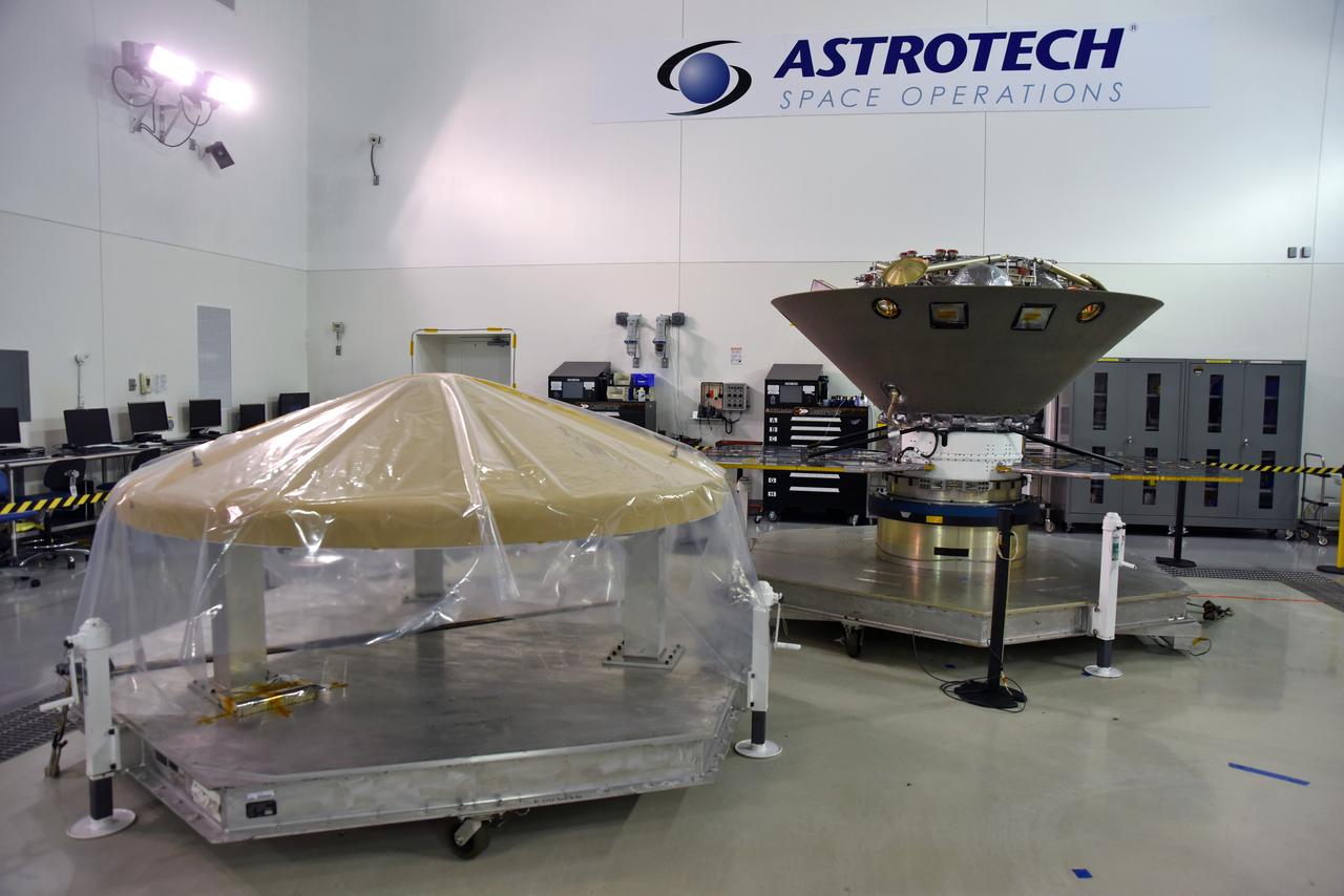
NASA's Interior Exploration using Seismic Investigations, Geodesy and Heat Transport, or InSight, is in a clean room inside the Astrotech processing facility at Vandenberg Air Force Base in California. The spacecraft's protective heat shield is in view at left. InSight is scheduled for liftoff on a United Launch Alliance Atlas V rocket May 5, 2018. InSight will be the first mission to look deep beneath the Martian surface. It will study the planet's interior by measuring its heat output and listen for marsquakes. InSight will use the seismic waves generated by marsquakes to develop a map of the planet’s deep interior. The resulting insight into Mars’ formation will provide a better understanding of how other rocky planets, including Earth, were created. NASA’s Jet Propulsion Laboratory in Pasadena, California, manages the InSight mission for the agency’s Science Mission Directorate. InSight is part of NASA's Discovery Program, managed by its Marshall Space Flight Center in Huntsville, Alabama. The spacecraft, including cruise stage and lander, was built and tested by Lockheed Martin Space in Denver. Several European partners, including France's space agency, the Centre National d'Étude Spatiales, and the German Aerospace Center, are supporting the mission. United Launch Alliance of Centennial, Colorado, is providing the Atlas V launch service. NASA’s Launch Services Program, based at its Kennedy Space Center in Florida, is responsible for launch management.
The second half of the United Launch Alliance (ULA) Delta II rocket payload fairing is being prepared for the move to the Vertical Integration Facility at Space Launch Complex 2 at Vandenberg Air Force Base in California, on June 4, 2018. NASA's Ice, Cloud and land Elevation Satellite-2 (ICESat-2) will launch later this year on the final Delta II rocket. ICESat-2 will measure the height of a changing Earth, one laser pulse at a time, 10,000 laser pulses a second. The satellite will carry a single instrument, the Advanced Topographic Laser Altimeter System. ICESat-2 will help scientists investigate why, and how much our planet's frozen and icy areas, called the cryosphere, is changing in a warming climate.
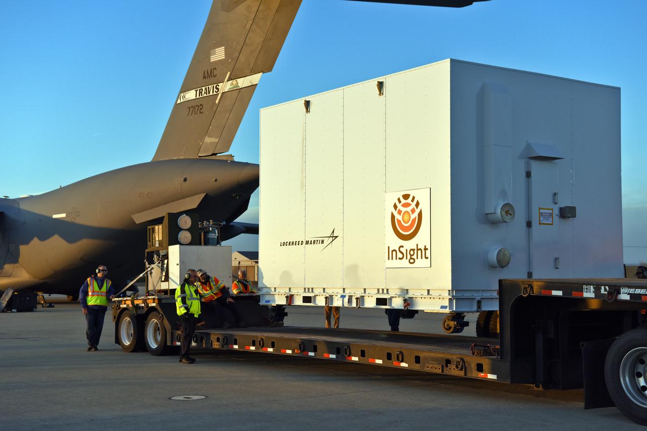
After a U.S. Air Force C-17 aircraft arrived at Vandenberg Air Force Base in California, ground crews loaded NASA's Interior Exploration using Seismic Investigations, Geodesy and Heat Transport, or InSight, spacecraft in a transport truck for delivery to the Astrotech processing facility. InSight was developed and built by Lockheed-Martin Space Systems in Denver, Colorado, and is scheduled for liftoff is May 5, 2018. InSight is the first mission to land on Mars and explore the Red Planet's deep interior. It will investigate processes that shaped the rocky planets of the inner solar system including Earth.
A solar array illumination test is performed on NASA's Ionospheric Connection Explorer (ICON) in a clean room on May 4, 2018, inside Building 1555 at Vandenberg Air Force Base in California. The test checks for any imperfections and confirms that the solar arrays are functioning properly. The explorer will launch on June 15, 2018, from Kwajalein Atoll in the Marshall Islands (June 14 in the continental United States) on Orbital ATK's Pegasus XL rocket, which is attached to the company's L-1011 Stargazer aircraft. ICON will study the frontier of space - the dynamic zone high in Earth's atmosphere where terrestrial weather from below meets space weather above. The explorer will help determine the physics of Earth's space environment and pave the way for mitigating its effects on our technology, communications systems and society.
Inside a clean room in Building 1555 at Vandenberg Air Force Base in California, technicians begin to install the first half of the Northrop Grumman Pegasus XL payload fairing around NASA's Ionospheric Connection Explorer (ICON) on Aug. 22, 2018. ICON is being prepared for its launch on the Pegasus XL rocket, which is attached beneath the company's L-1011 Stargazer aircraft. Launch is scheduled for Oct. 26, from the Skid Strip at Cape Canaveral Air Force Station in Florida. ICON will study the frontier of space - the dynamic zone high in Earth's atmosphere where terrestrial weather from below meets space weather above. The explorer will help determine the physics of Earth's space environment and pave the way for mitigating its effects on our technology, communications systems and society.
NASA's Ice, Cloud and land Elevation Satellite-2 (ICESat-2) is lifted in its fixture inside the high bay of the Astrotech Space Operations facility on June 14, 2018, at Vandenberg Air Force Base in California. ICESat-2 was shipped from the Northrop Grumman facility in Gilbert, Arizona, where it was built and tested. The satellite is scheduled to launch from Space Launch Complex-2 at Vandenberg on the final United Launch Alliance Delta II rocket. ICESat-2 will measure the height of a changing Earth, one laser pulse at a time, 10,000 laser pulses a second. The satellite will carry the Advanced Topographic Laser Altimeter System. ICESat-2 will help scientists investigate why, and how much our planet's frozen and icy areas, called the cryosphere, is changing in a warming climate.
A crane lifts and moves NASA's Ionospheric Connection Explorer (ICON) to a work stand on May 1, 2018, inside Building 1555 at Vandenberg Air Force Base in California. The explorer will launch on June 15, 2018, from Kwajalein Atoll in the Marshall Islands (June 14 in the continental United States) on Orbital ATK's Pegasus XL rocket, which is attached to the company's L-1011 Stargazer aircraft. ICON will study the frontier of space - the dynamic zone high in Earth's atmosphere where terrestrial weather from below meets space weather above. The explorer will help determine the physics of Earth's space environment and pave the way for mitigating its effects on our technology, communications systems and society.
At Space Launch Complex 3 at Vandenberg Air Force Base in California technicians and engineers mate a United Launch Alliance Centaur upper stage atop an Atlas V booster. The rocket will launch NASA's Interior Exploration using Seismic Investigations, Geodesy and Heat Transport, or InSight, mission to land on Mars. InSight is the first mission to explore the Red Planet's deep interior. It will investigate processes that shaped the rocky planets of the inner solar system including Earth. Liftoff is scheduled for May 5, 2018.