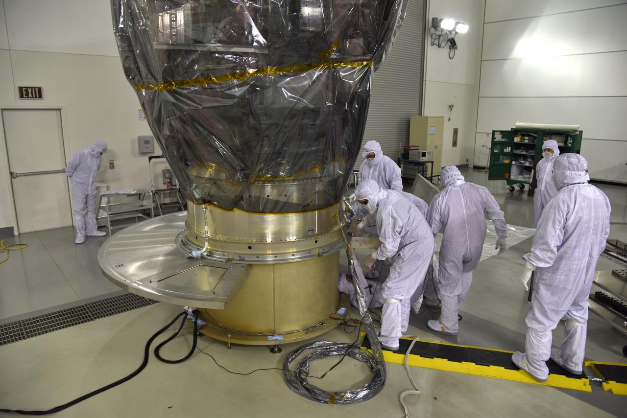
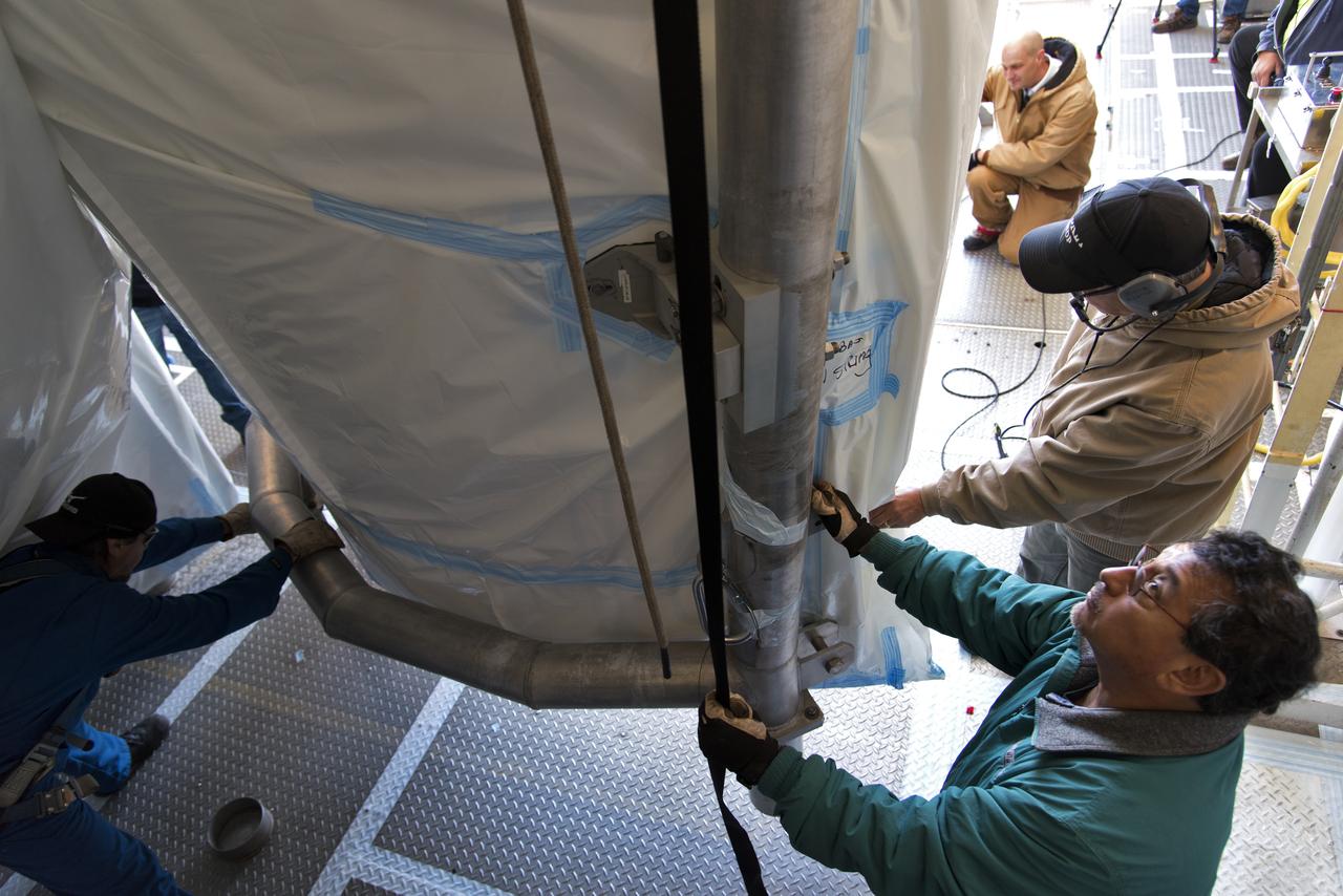
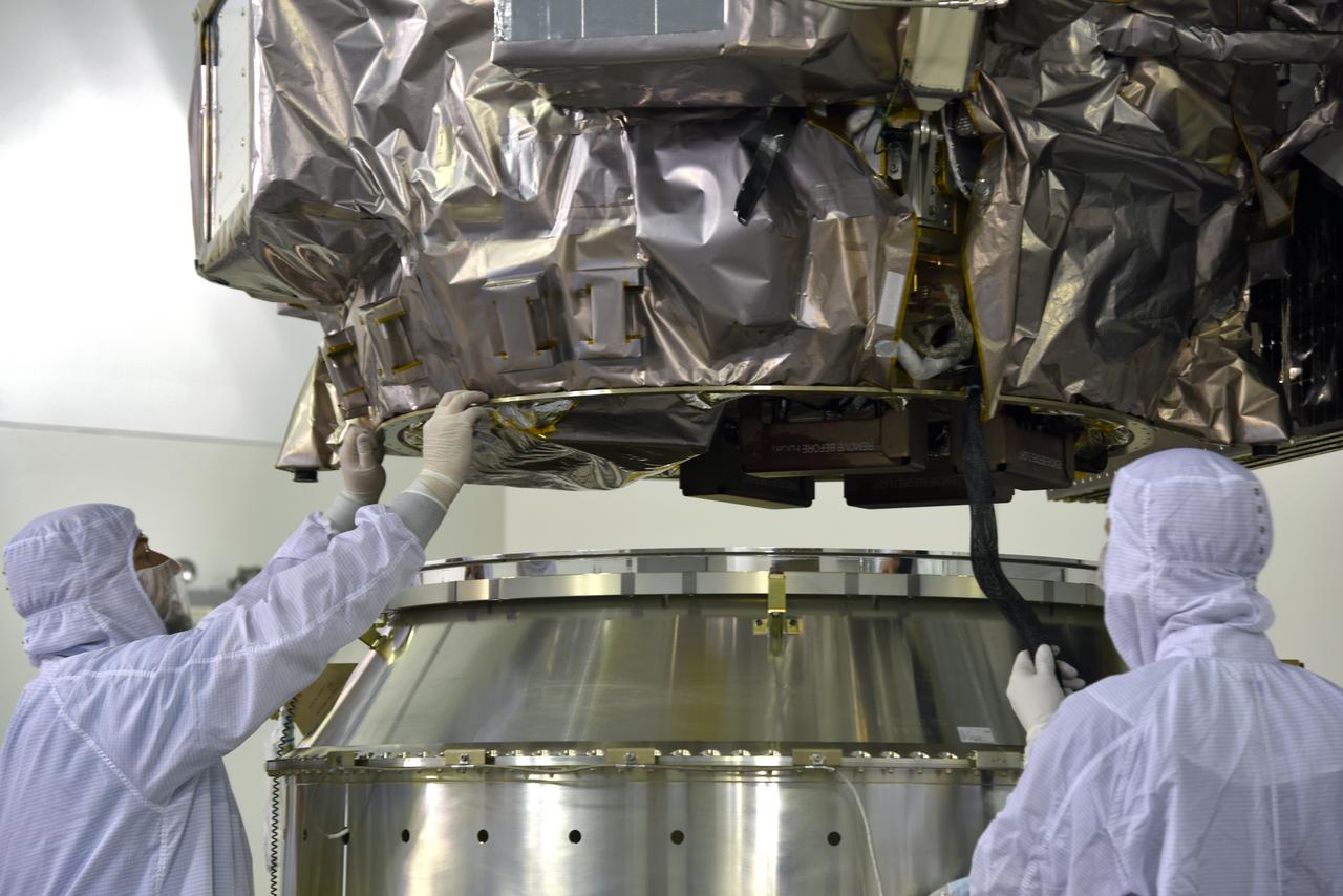
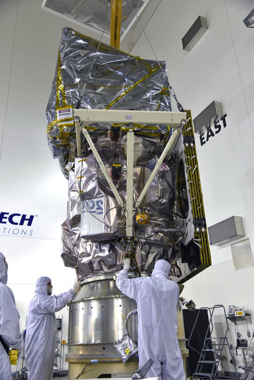
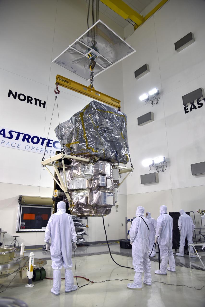
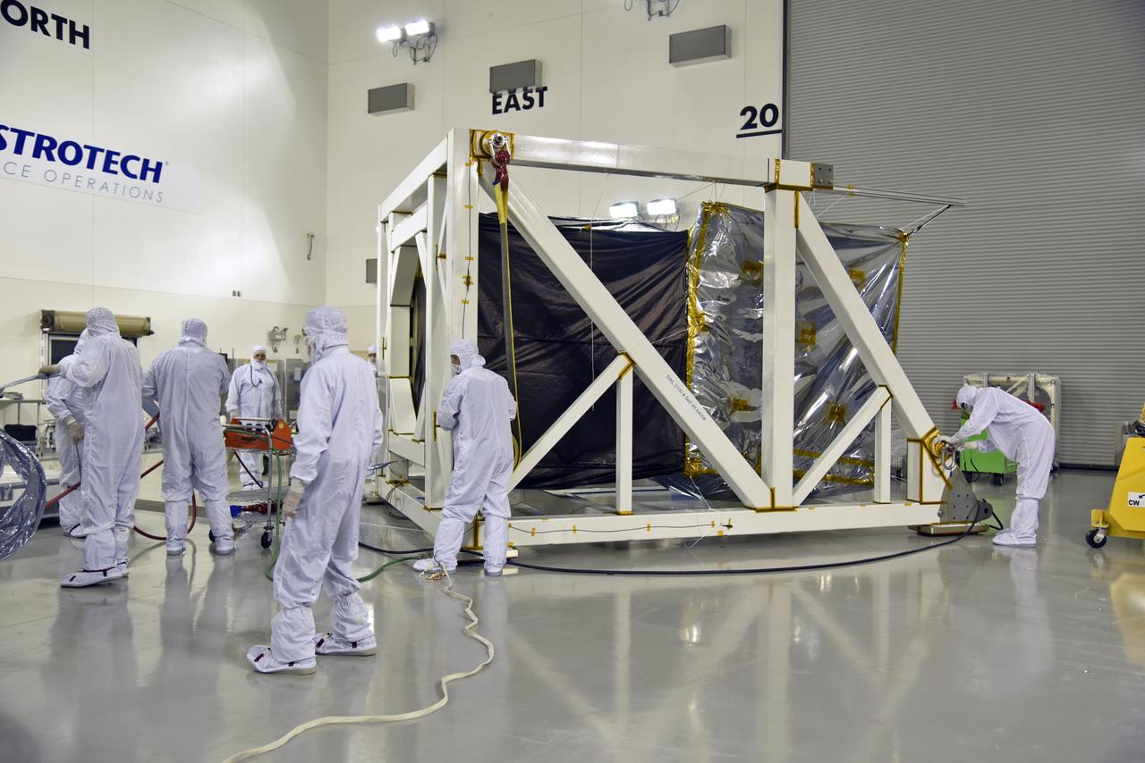
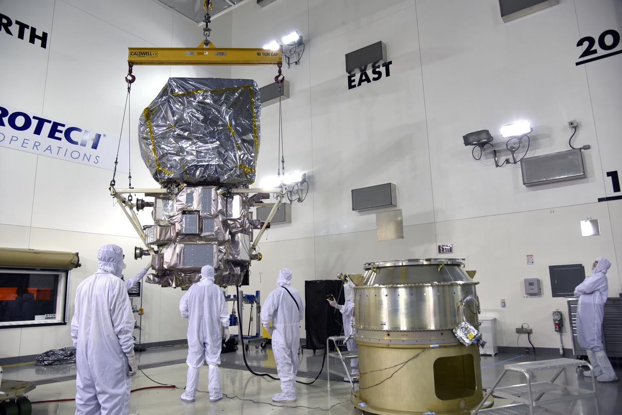
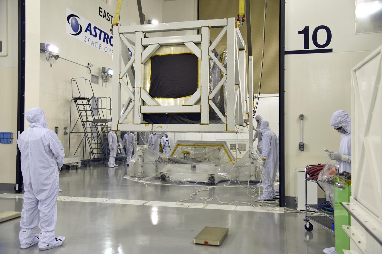
Inside the high bay of the Astrotech Space Operations facility at Vandenberg Air Force Base in California, technicians attach NASA's Ice, Cloud and land Elevation Satellite-2 (ICESat-2) to the payload direct mate adapter, on Aug. 24, 2018. The satellite is being prepared for its scheduled launch from Space Launch Complex 2 at Vandenberg on the final United Launch Alliance Delta II rocket. ICESat-2 will measure the height of a changing Earth, one laser pulse at a time, 10,000 laser pulses a second. The satellite will carry the Advanced Topographic Laser Altimeter System (ATLAS). ICESat-2 will help scientists investigate why, and how much our planet's frozen and icy areas, called the cryosphere, are changing in a warming climate.
Inside the high bay of the Astrotech Space Operations facility at Vandenberg Air Force Base in California, technicians prepare to attach NASA's Ice, Cloud and land Elevation Satellite-2 (ICESat-2) to the payload adapter, on Aug. 20, 2018. The satellite is being prepared for its scheduled launch from Space Launch Complex 2 at Vandenberg on the final United Launch Alliance Delta II rocket. ICESat-2 will measure the height of a changing Earth, one laser pulse at a time, 10,000 laser pulses a second. The satellite will carry the Advanced Topographic Laser Altimeter System (ATLAS). ICESat-2 will help scientists investigate why, and how much our planet's frozen and icy areas, called the cryosphere, are changing in a warming climate.
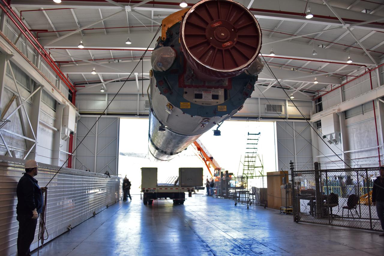
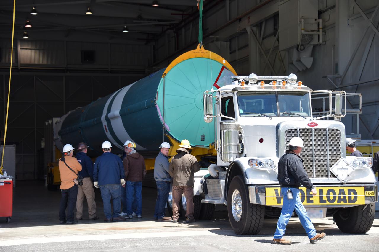
At NASA's Building 836, the Spacecraft Labs Telemetry Station at Vandenberg Air Force Base in California, a United Launch Alliance Delta II booster is removed from its shipping container. After it is offloaded, preliminary checkouts and preflight processing will begin leading to launch of the agency's Ice, Cloud and land Elevation Satellite-2, or ICESat-2. Liftoff from Space Launch Complex-2 at Vandenberg is scheduled for Sept. 12, 2018, and will be the last for the venerable Delta II rocket. Once in orbit, the satellite is designed to measure the height of a changing Earth, one laser pulse at a time, 10,000 laser pulses a second. The satellite will carry a single instrument, the Advanced Topographic Laser Altimeter System. ICESat-2 will help scientists investigate why, and how much, Earth's frozen and icy areas are changing. These area make up Earth's the cryosphere.
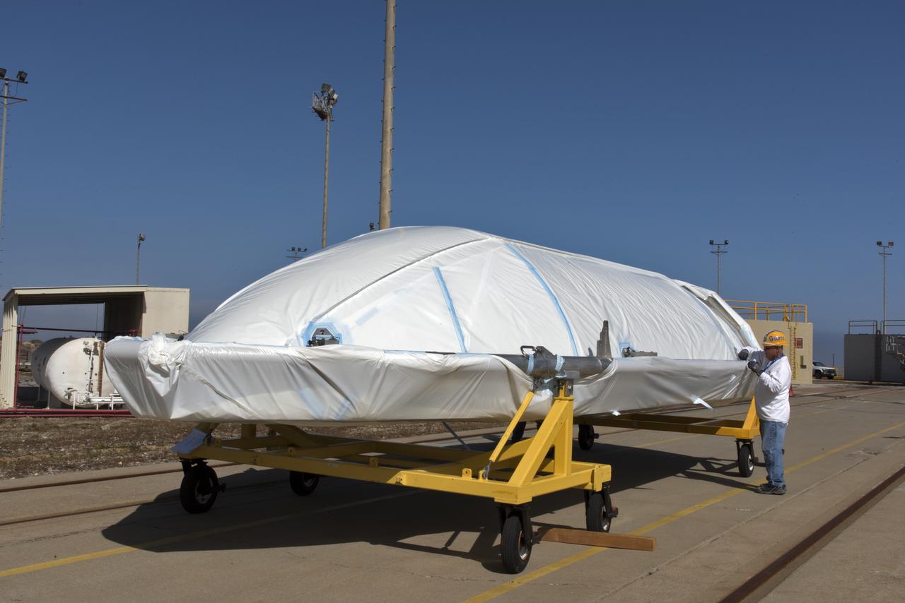
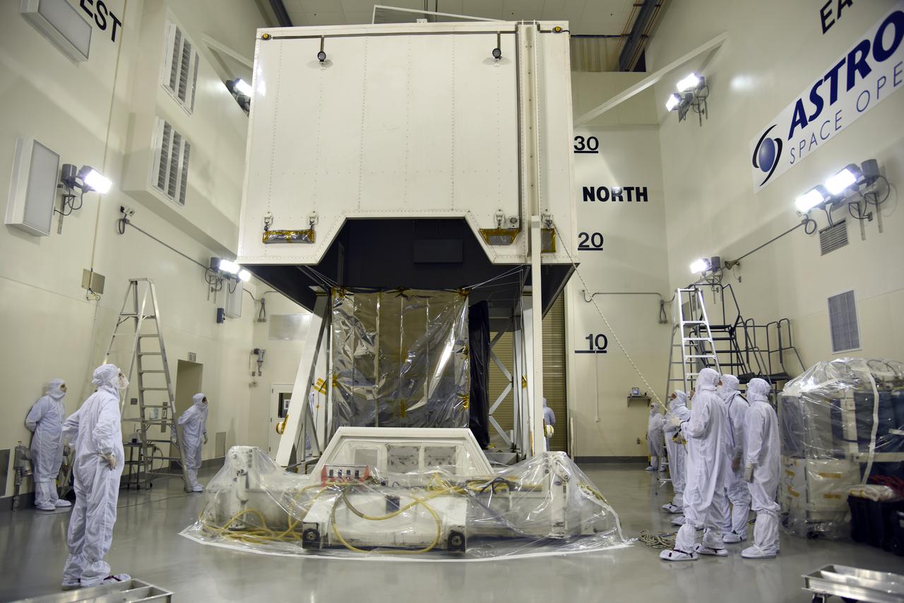
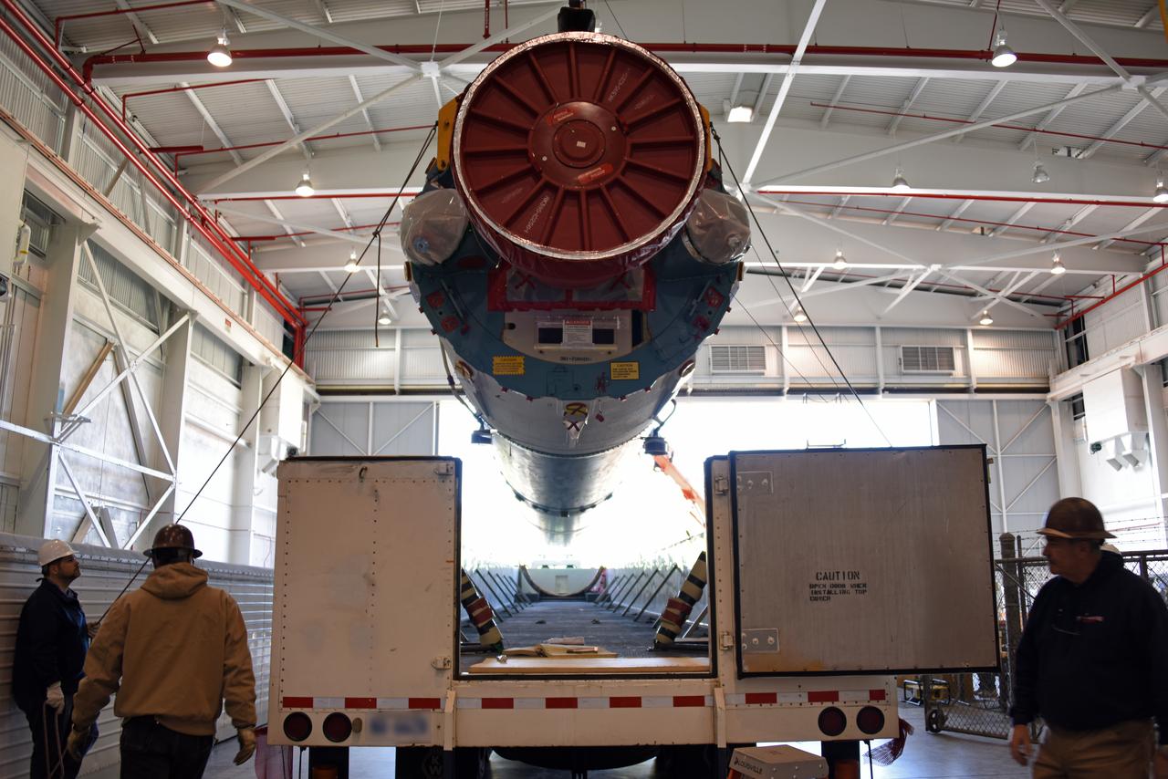
NASA's Ice, Cloud and land Elevation Satellite-2 (ICESat-2) is moved into the high bay of the Astrotech processing facility on June 13, 2018, at Vandenberg Air Force Base in California. ICESat-2 was shipped from the Northrop Grumman facility in Gilbert, Arizona, where it was built and tested. The satellite is scheduled to launch from Space Launch Complex-2 at Vandenberg on the final United Launch Alliance Delta II rocket. ICESat-2 will measure the height of a changing Earth, one laser pulse at a time, 10,000 laser pulses a second. The satellite will carry the Advanced Topographic Laser Altimeter System. ICESat-2 will help scientists investigate why, and how much our planet's frozen and icy areas, called the cryosphere, is changing in a warming climate.
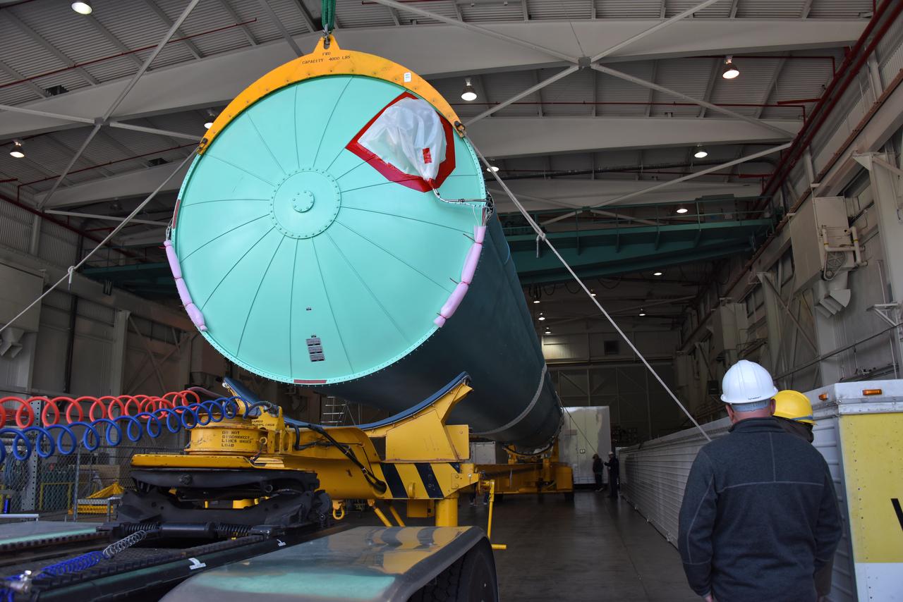
Technicians assist as the second half of the United Launch Alliance (ULA) Delta II rocket payload fairing is lifted up into the Vertical Integration Facility at Space Launch Complex 2 at Vandenberg Air Force Base in California, on June 4, 2018. NASA's Ice, Cloud and land Elevation Satellite-2 (ICESat-2) will launch later this year on the final Delta II rocket. ICESat-2 will measure the height of a changing Earth, one laser pulse at a time, 10,000 laser pulses a second. The satellite will carry a single instrument, the Advanced Topographic Laser Altimeter System. ICESat-2 will help scientists investigate why, and how much our planet's frozen and icy areas, called the cryosphere, is changing in a warming climate.
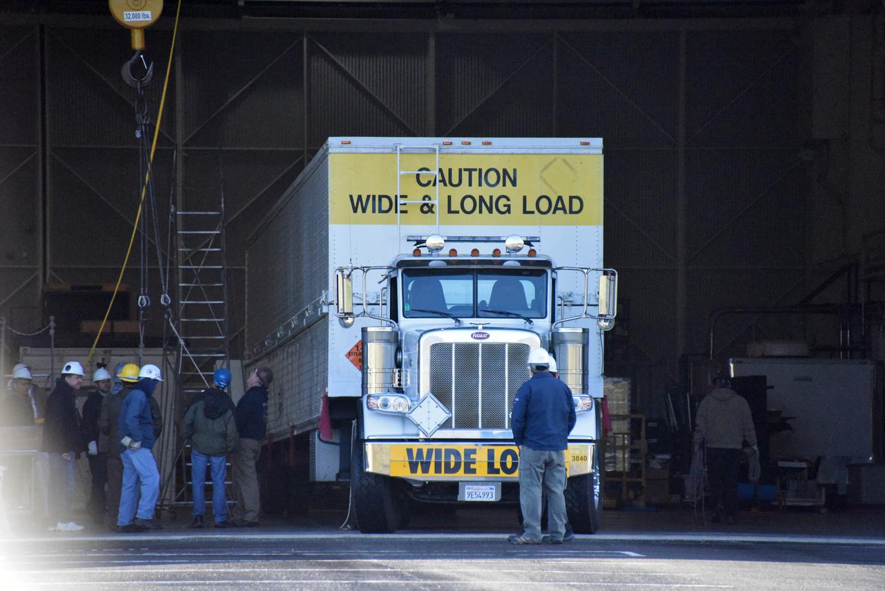
A United Launch Alliance Delta II booster arrives at NASA's Building 836, the Spacecraft Labs Telemetry Station at Vandenberg Air Force Base in California. It will be offloaded and begin preliminary checkouts and preflight processing for launch of the agency's Ice, Cloud and land Elevation Satellite-2, or ICESat-2. Liftoff from Space Launch Complex-2 at Vandenberg is scheduled for Sept. 12, 2018, and will be the last for the venerable Delta II rocket. Once in orbit, the satellite is designed to measure the height of a changing Earth, one laser pulse at a time, 10,000 laser pulses a second. The satellite will carry a single instrument, the Advanced Topographic Laser Altimeter System. ICESat-2 will help scientists investigate why, and how much, Earth's frozen and icy areas are changing. These area make up Earth's the cryosphere.
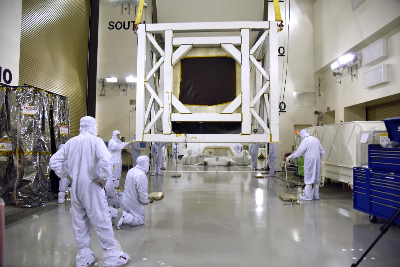
The first half of the United Launch Alliance (ULA) Delta II rocket payload fairing is lifted up and into the Vertical Integration Facility at Space Launch Complex 2 at Vandenberg Air Force Base in California, on June 4, 2018. NASA's Ice, Cloud and land Elevation Satellite-2 (ICESat-2) will launch later this year on the final Delta II rocket. ICESat-2 will measure the height of a changing Earth, one laser pulse at a time, 10,000 laser pulses a second. The satellite will carry a single instrument, the Advanced Topographic Laser Altimeter System. ICESat-2 will help scientists investigate why, and how much our planet's frozen and icy areas, called the cryosphere, is changing in a warming climate.
At NASA's Building 836, the Spacecraft Labs Telemetry Station at Vandenberg Air Force Base in California, a United Launch Alliance Delta II booster has been removed from its shipping container. Preliminary checkouts and preflight processing will begin leading to launch of the agency's Ice, Cloud and land Elevation Satellite-2, or ICESat-2. Liftoff from Space Launch Complex-2 at Vandenberg is scheduled for Sept. 12, 2018, and will be the last for the venerable Delta II rocket. Once in orbit, the satellite is designed to measure the height of a changing Earth, one laser pulse at a time, 10,000 laser pulses a second. The satellite will carry a single instrument, the Advanced Topographic Laser Altimeter System. ICESat-2 will help scientists investigate why, and how much, Earth's frozen and icy areas are changing. These area make up Earth's the cryosphere.
Inside the high bay of the Astrotech Space Operations facility at Vandenberg Air Force Base in California, technicians assist as a crane lowers NASA's Ice, Cloud and land Elevation Satellite-2 (ICESat-2) onto the payload adapter on Aug. 30, 2018. ICESat-2 is being prepared for its scheduled launch from Space Launch Complex 2 at Vandenberg on the final United Launch Alliance Delta II rocket. ICESat-2 will measure the height of a changing Earth, one laser pulse at a time, 10,000 laser pulses a second. The satellite will carry the Advanced Topographic Laser Altimeter System (ATLAS). ICESat-2 will help scientists investigate why, and how much our planet's frozen and icy areas, called the cryosphere, are changing in a warming climate.
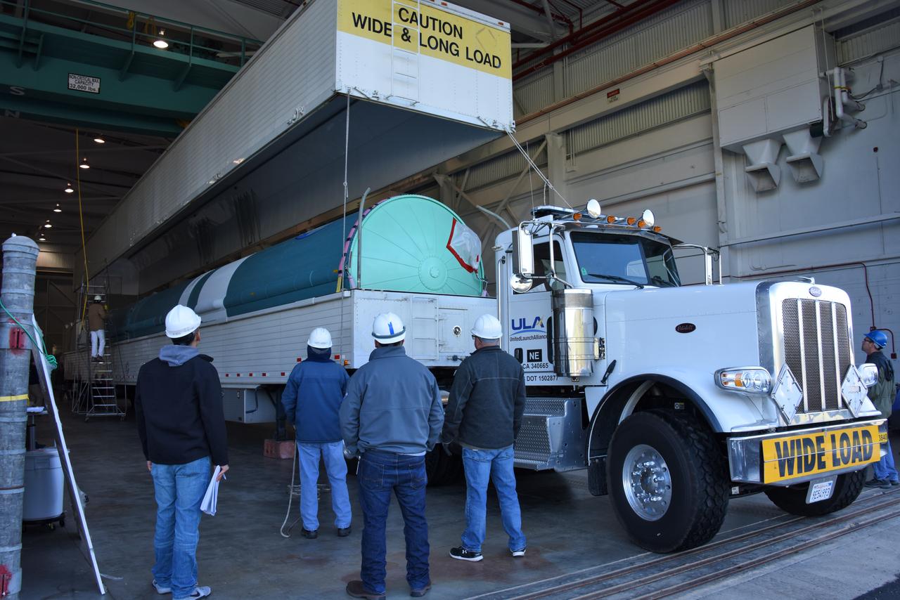
At NASA's Building 836, the Spacecraft Labs Telemetry Station at Vandenberg Air Force Base in California, a United Launch Alliance Delta II booster is removed from its shipping container. After it is offloaded, preliminary checkouts and preflight processing will begin leading to launch of the agency's Ice, Cloud and land Elevation Satellite-2, or ICESat-2. Liftoff from Space Launch Complex-2 at Vandenberg is scheduled for Sept. 12, 2018, and will be the last for the venerable Delta II rocket. Once in orbit, the satellite is designed to measure the height of a changing Earth, one laser pulse at a time, 10,000 laser pulses a second. The satellite will carry a single instrument, the Advanced Topographic Laser Altimeter System. ICESat-2 will help scientists investigate why, and how much, Earth's frozen and icy areas are changing. These area make up Earth's the cryosphere.
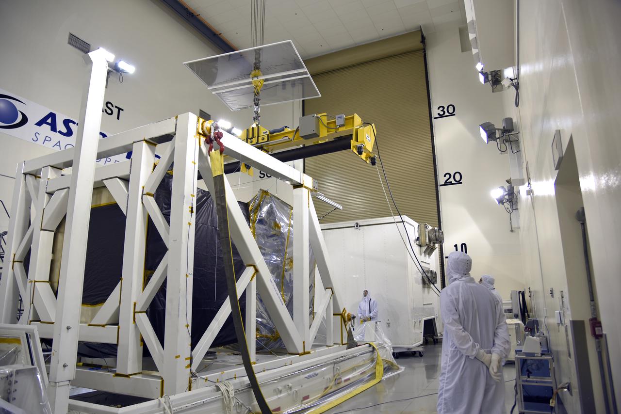
The second half of the United Launch Alliance (ULA) Delta II rocket payload fairing is being prepared for the move to the Vertical Integration Facility at Space Launch Complex 2 at Vandenberg Air Force Base in California, on June 4, 2018. NASA's Ice, Cloud and land Elevation Satellite-2 (ICESat-2) will launch later this year on the final Delta II rocket. ICESat-2 will measure the height of a changing Earth, one laser pulse at a time, 10,000 laser pulses a second. The satellite will carry a single instrument, the Advanced Topographic Laser Altimeter System. ICESat-2 will help scientists investigate why, and how much our planet's frozen and icy areas, called the cryosphere, is changing in a warming climate.
Inside the high bay of the Astrotech Space Operations facility at Vandenberg Air Force Base in California, technicians prepare to attach NASA's Ice, Cloud and land Elevation Satellite-2 (ICESat-2) to the payload adapter, on Aug. 20, 2018. The satellite is being prepared for its scheduled launch from Space Launch Complex 2 at Vandenberg on the final United Launch Alliance Delta II rocket. ICESat-2 will measure the height of a changing Earth, one laser pulse at a time, 10,000 laser pulses a second. The satellite will carry the Advanced Topographic Laser Altimeter System (ATLAS). ICESat-2 will help scientists investigate why, and how much our planet's frozen and icy areas, called the cryosphere, are changing in a warming climate.
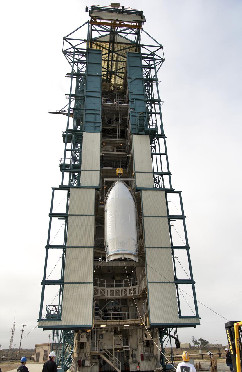
The first half of the United Launch Alliance (ULA) Delta II rocket payload fairing is lifted up and into the Vertical Integration Facility at Space Launch Complex 2 at Vandenberg Air Force Base in California, on June 4, 2018. NASA's Ice, Cloud and land Elevation Satellite-2 (ICESat-2) will launch later this year on the final Delta II rocket. ICESat-2 will measure the height of a changing Earth, one laser pulse at a time, 10,000 laser pulses a second. The satellite will carry a single instrument, the Advanced Topographic Laser Altimeter System. ICESat-2 will help scientists investigate why, and how much our planet's frozen and icy areas, called the cryosphere, is changing in a warming climate.
The second half of the United Launch Alliance (ULA) Delta II rocket payload fairing is being prepared for the move to the Vertical Integration Facility at Space Launch Complex 2 at Vandenberg Air Force Base in California, on June 4, 2018. NASA's Ice, Cloud and land Elevation Satellite-2 (ICESat-2) will launch later this year on the final Delta II rocket. ICESat-2 will measure the height of a changing Earth, one laser pulse at a time, 10,000 laser pulses a second. The satellite will carry a single instrument, the Advanced Topographic Laser Altimeter System. ICESat-2 will help scientists investigate why, and how much our planet's frozen and icy areas, called the cryosphere, is changing in a warming climate.
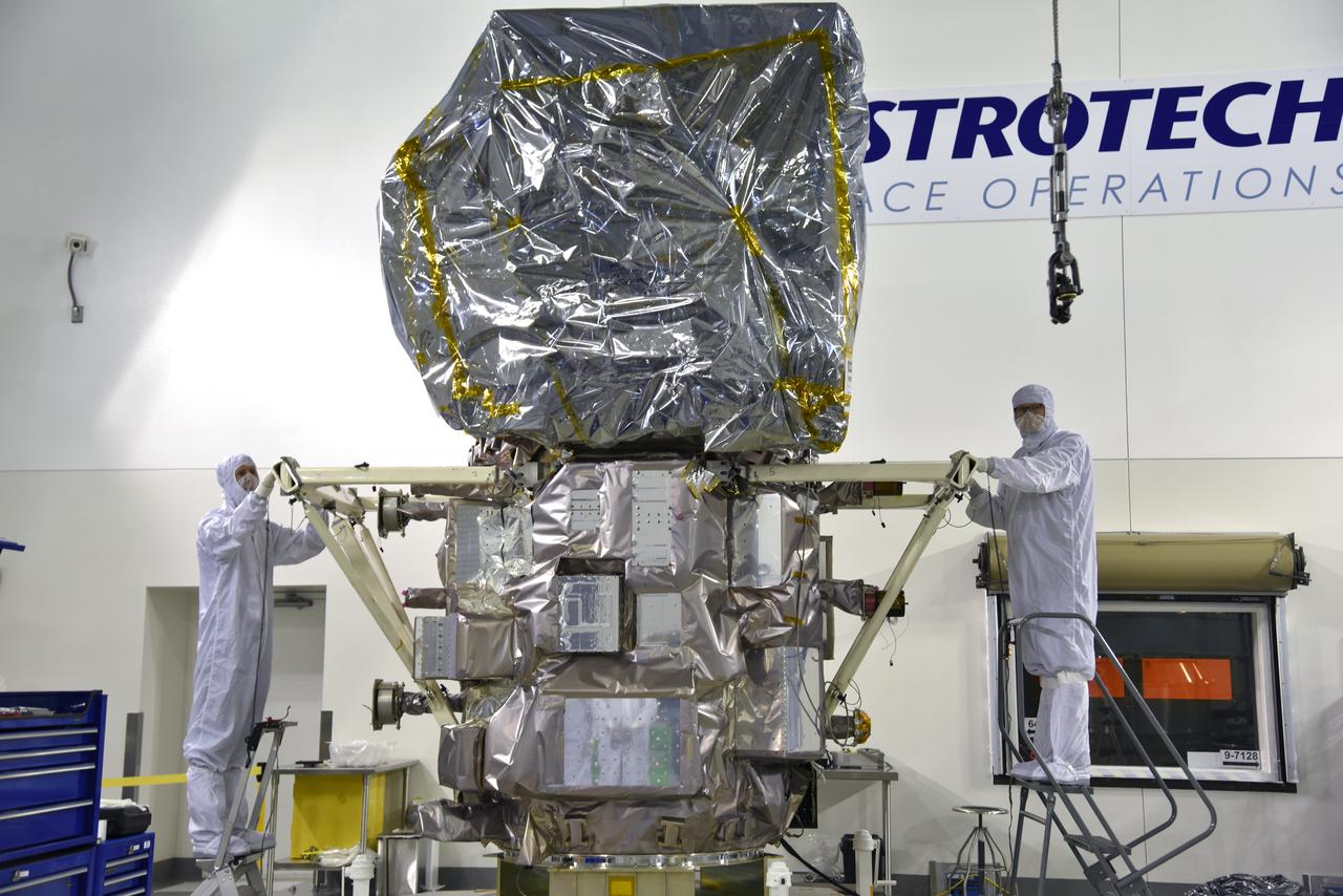
Inside the high bay of the Astrotech Space Operations facility at Vandenberg Air Force Base in California, technicians help secure NASA's Ice, Cloud and land Elevation Satellite-2 (ICESat-2) to the payload adapter on Aug. 30, 2018. ICESat-2 is being prepared for its scheduled launch from Space Launch Complex 2 at Vandenberg on the final United Launch Alliance Delta II rocket. ICESat-2 will measure the height of a changing Earth, one laser pulse at a time, 10,000 laser pulses a second. The satellite will carry the Advanced Topographic Laser Altimeter System (ATLAS). ICESat-2 will help scientists investigate why, and how much our planet's frozen and icy areas, called the cryosphere, are changing in a warming climate.
Inside the high bay of the Astrotech Space Operations facility at Vandenberg Air Force Base in California, technicians attach NASA's Ice, Cloud and land Elevation Satellite-2 (ICESat-2) to the payload direct mate adapter, on Aug. 24, 2018. The satellite is being prepared for its scheduled launch from Space Launch Complex 2 at Vandenberg on the final United Launch Alliance Delta II rocket. ICESat-2 will measure the height of a changing Earth, one laser pulse at a time, 10,000 laser pulses a second. The satellite will carry the Advanced Topographic Laser Altimeter System (ATLAS). ICESat-2 will help scientists investigate why, and how much our planet's frozen and icy areas, called the cryosphere, are changing in a warming climate.
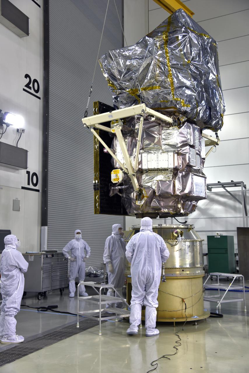
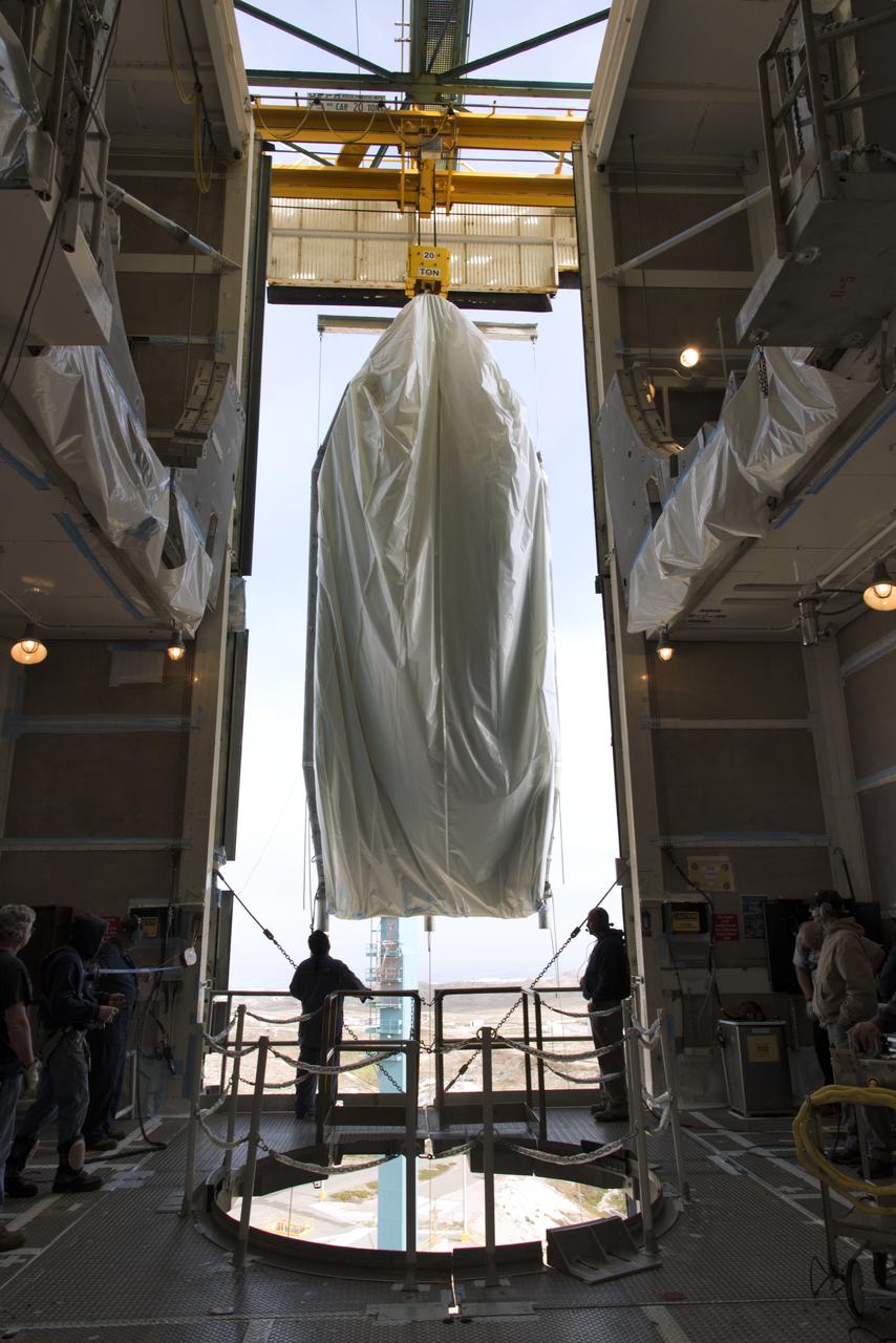
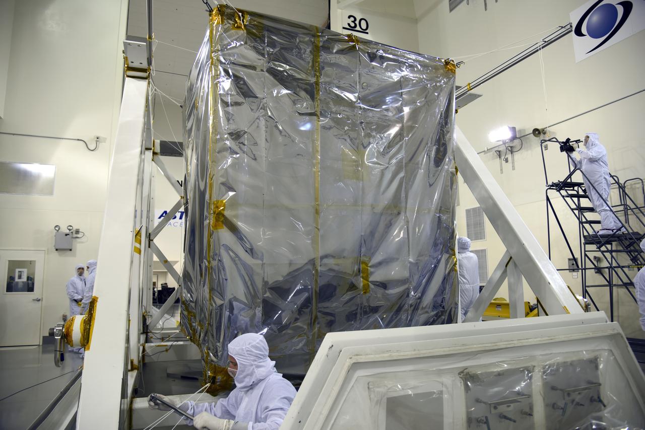
Inside the high bay of the Astrotech Space Operations facility at Vandenberg Air Force Base in California, a crane lifts and moves NASA's Ice, Cloud and land Elevation Satellite-2 (ICESat-2) over the payload adapter on Aug. 30, 2018. The satellite will be attached to the adapter. ICESat-2 is being prepared for its scheduled launch from Space Launch Complex 2 at Vandenberg on the final United Launch Alliance Delta II rocket. ICESat-2 will measure the height of a changing Earth, one laser pulse at a time, 10,000 laser pulses a second. The satellite will carry the Advanced Topographic Laser Altimeter System (ATLAS). ICESat-2 will help scientists investigate why, and how much our planet's frozen and icy areas, called the cryosphere, are changing in a warming climate.
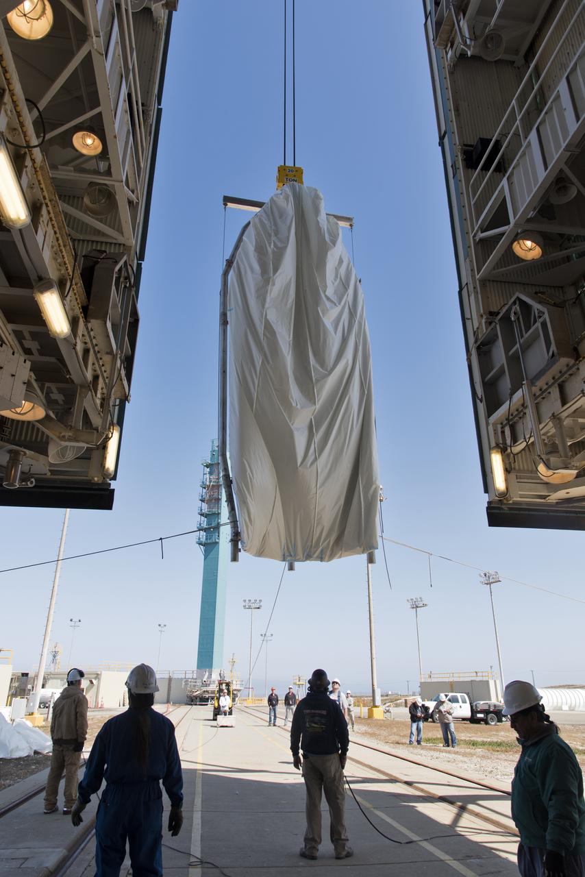
The second half of the United Launch Alliance (ULA) Delta II rocket payload fairing is lifted up into the Vertical Integration Facility at Space Launch Complex 2 at Vandenberg Air Force Base in California, on June 4, 2018. NASA's Ice, Cloud and land Elevation Satellite-2 (ICESat-2) will launch later this year on the final Delta II rocket. ICESat-2 will measure the height of a changing Earth, one laser pulse at a time, 10,000 laser pulses a second. The satellite will carry a single instrument, the Advanced Topographic Laser Altimeter System. ICESat-2 will help scientists investigate why, and how much our planet's frozen and icy areas, called the cryosphere, is changing in a warming climate.
Inside the high bay of the Astrotech Space Operations facility at Vandenberg Air Force Base in California, a crane lifts and moves NASA's Ice, Cloud and land Elevation Satellite-2 (ICESat-2) on Aug. 30, 2018. The satellite will be attached to the payload adapter. ICESat-2 is being prepared for its scheduled launch from Space Launch Complex 2 at Vandenberg on the final United Launch Alliance Delta II rocket. ICESat-2 will measure the height of a changing Earth, one laser pulse at a time, 10,000 laser pulses a second. The satellite will carry the Advanced Topographic Laser Altimeter System (ATLAS). ICESat-2 will help scientists investigate why, and how much our planet's frozen and icy areas, called the cryosphere, are changing in a warming climate.
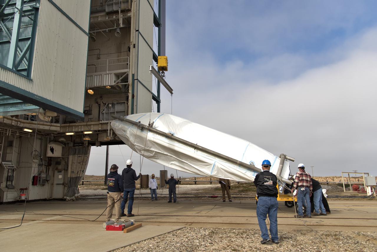
The first half of the United Launch Alliance (ULA) Delta II rocket payload fairing is transported to the Vertical Integration Facility at Space Launch Complex 2 at Vandenberg Air Force Base in California, on June 4, 2018. NASA's Ice, Cloud and land Elevation Satellite-2 (ICESat-2) will launch later this year on the final Delta II rocket. ICESat-2 will measure the height of a changing Earth, one laser pulse at a time, 10,000 laser pulses a second. The satellite will carry a single instrument, the Advanced Topographic Laser Altimeter System. ICESat-2 will help scientists investigate why, and how much our planet's frozen and icy areas, called the cryosphere, is changing in a warming climate.
At NASA's Building 836, the Spacecraft Labs Telemetry Station at Vandenberg Air Force Base in California, a United Launch Alliance Delta II booster has been removed from its shipping container. Preliminary checkouts and preflight processing will begin leading to launch of the agency's Ice, Cloud and land Elevation Satellite-2, or ICESat-2. Liftoff from Space Launch Complex-2 at Vandenberg is scheduled for Sept. 12, 2018, and will be the last for the venerable Delta II rocket. Once in orbit, the satellite is designed to measure the height of a changing Earth, one laser pulse at a time, 10,000 laser pulses a second. The satellite will carry a single instrument, the Advanced Topographic Laser Altimeter System. ICESat-2 will help scientists investigate why, and how much, Earth's frozen and icy areas are changing. These area make up Earth's the cryosphere.
The first half of the United Launch Alliance (ULA) Delta II rocket payload fairing is transported to the Vertical Integration Facility at Space Launch Complex 2 at Vandenberg Air Force Base in California, on June 4, 2018. NASA's Ice, Cloud and land Elevation Satellite-2 (ICESat-2) will launch later this year on the final Delta II rocket. ICESat-2 will measure the height of a changing Earth, one laser pulse at a time, 10,000 laser pulses a second. The satellite will carry a single instrument, the Advanced Topographic Laser Altimeter System. ICESat-2 will help scientists investigate why, and how much our planet's frozen and icy areas, called the cryosphere, is changing in a warming climate.
Inside the high bay of the Astrotech Space Operations facility at Vandenberg Air Force Base in California, a technician prepares NASA's Ice, Cloud and land Elevation Satellite-2 (ICESat-2) to be attached to the payload adapter, on Aug. 20, 2018. The satellite is being prepared for its scheduled launch from Space Launch Complex 2 at Vandenberg on the final United Launch Alliance Delta II rocket. ICESat-2 will measure the height of a changing Earth, one laser pulse at a time, 10,000 laser pulses a second. The satellite will carry the Advanced Topographic Laser Altimeter System (ATLAS). ICESat-2 will help scientists investigate why, and how much our planet's frozen and icy areas, called the cryosphere, are changing in a warming climate.
Inside the high bay of the Astrotech Space Operations facility at Vandenberg Air Force Base in California, technicians attach NASA's Ice, Cloud and land Elevation Satellite-2 (ICESat-2) to the payload direct mate adapter, on Aug. 24, 2018. The satellite is being prepared for its scheduled launch from Space Launch Complex 2 at Vandenberg on the final United Launch Alliance Delta II rocket. ICESat-2 will measure the height of a changing Earth, one laser pulse at a time, 10,000 laser pulses a second. The satellite will carry the Advanced Topographic Laser Altimeter System (ATLAS). ICESat-2 will help scientists investigate why, and how much our planet's frozen and icy areas, called the cryosphere, are changing in a warming climate.

Inside the high bay of the Astrotech Space Operations facility at Vandenberg Air Force Base in California, technicians attach NASA's Ice, Cloud and land Elevation Satellite-2 (ICESat-2) to the payload direct mate adapter, on Aug. 24, 2018. The satellite is being prepared for its scheduled launch from Space Launch Complex 2 at Vandenberg on the final United Launch Alliance Delta II rocket. ICESat-2 will measure the height of a changing Earth, one laser pulse at a time, 10,000 laser pulses a second. The satellite will carry the Advanced Topographic Laser Altimeter System (ATLAS). ICESat-2 will help scientists investigate why, and how much our planet's frozen and icy areas, called the cryosphere, are changing in a warming climate.
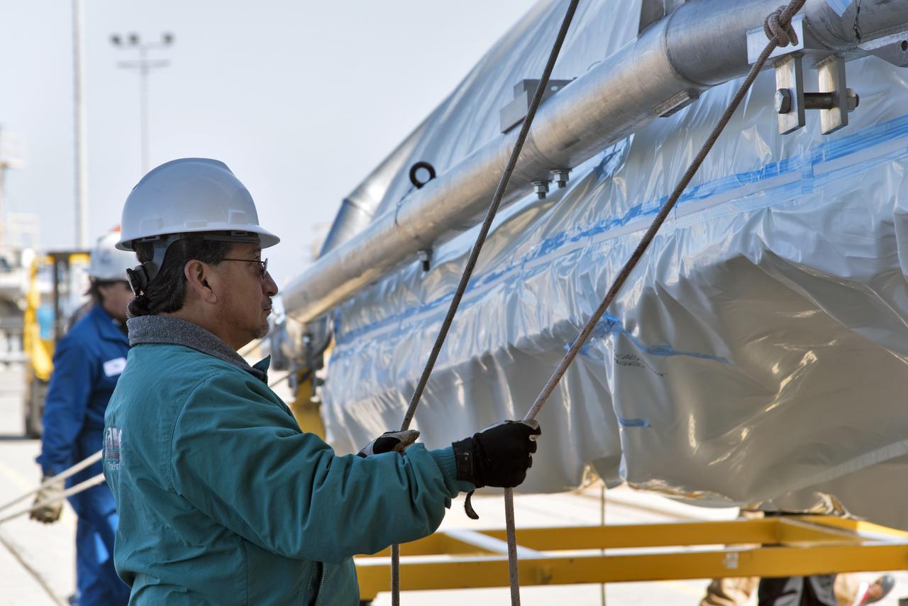
NASA's Ice, Cloud and land Elevation Satellite-2 (ICESat-2) is being secured in the high bay of the Astrotech processing facility on June 13, 2018, at Vandenberg Air Force Base in California. ICESat-2 was shipped from the Northrop Grumman facility in Gilbert, Arizona, where it was built and tested. The satellite is scheduled to launch from Space Launch Complex-2 at Vandenberg on the final United Launch Alliance Delta II rocket. ICESat-2 will measure the height of a changing Earth, one laser pulse at a time, 10,000 laser pulses a second. The satellite will carry the Advanced Topographic Laser Altimeter System. ICESat-2 will help scientists investigate why, and how much our planet's frozen and icy areas, called the cryosphere, is changing in a warming climate.
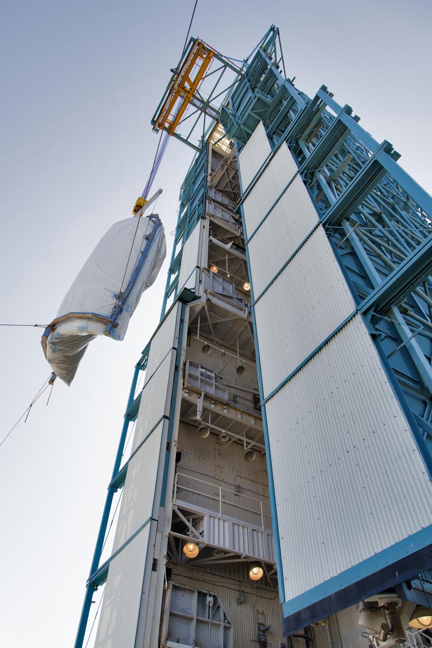
The second half of the United Launch Alliance (ULA) Delta II rocket payload fairing is lifted up into the Vertical Integration Facility at Space Launch Complex 2 at Vandenberg Air Force Base in California, on June 4, 2018. NASA's Ice, Cloud and land Elevation Satellite-2 (ICESat-2) will launch later this year on the final Delta II rocket. ICESat-2 will measure the height of a changing Earth, one laser pulse at a time, 10,000 laser pulses a second. The satellite will carry a single instrument, the Advanced Topographic Laser Altimeter System. ICESat-2 will help scientists investigate why, and how much our planet's frozen and icy areas, called the cryosphere, is changing in a warming climate.
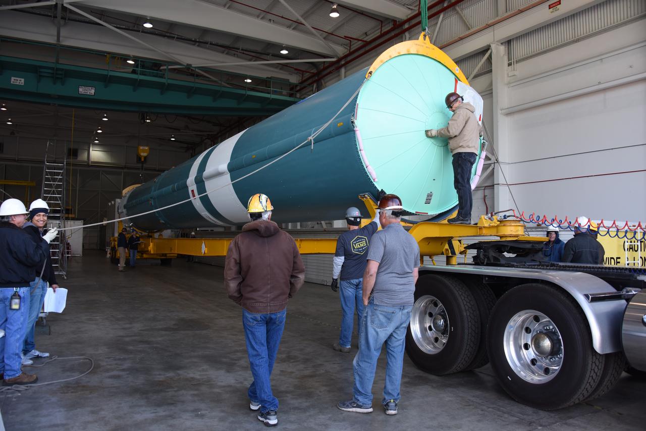
At NASA's Building 836, the Spacecraft Labs Telemetry Station at Vandenberg Air Force Base in California, a United Launch Alliance Delta II booster has been removed from its shipping container. Preliminary checkouts and preflight processing will begin leading to launch of the agency's Ice, Cloud and land Elevation Satellite-2, or ICESat-2. Liftoff from Space Launch Complex-2 at Vandenberg is scheduled for Sept. 12, 2018, and will be the last for the venerable Delta II rocket. Once in orbit, the satellite is designed to measure the height of a changing Earth, one laser pulse at a time, 10,000 laser pulses a second. The satellite will carry a single instrument, the Advanced Topographic Laser Altimeter System. ICESat-2 will help scientists investigate why, and how much, Earth's frozen and icy areas are changing. These area make up Earth's the cryosphere.
NASA's Ice, Cloud and land Elevation Satellite-2 (ICESat-2) is uncrated inside the airlock of the Astrotech processing facility on June 13, 2018, at Vandenberg Air Force Base in California. ICESat-2 was shipped from the Northrop Grumman facility in Gilbert, Arizona, where it was built and tested. The satellite is scheduled to launch from Space Launch Complex-2 at Vandenberg on the final United Launch Alliance Delta II rocket. ICESat-2 will measure the height of a changing Earth, one laser pulse at a time, 10,000 laser pulses a second. The satellite will carry the Advanced Topographic Laser Altimeter System. ICESat-2 will help scientists investigate why, and how much our planet's frozen and icy areas, called the cryosphere, is changing in a warming climate.
NASA's Ice, Cloud and land Elevation Satellite-2 (ICESat-2) is uncrated inside the airlock of the Astrotech processing facility on June 13, 2018, at Vandenberg Air Force Base in California. ICESat-2 was shipped from the Northrop Grumman facility in Gilbert, Arizona, where it was built and tested. The satellite is scheduled to launch from Space Launch Complex-2 at Vandenberg on the final United Launch Alliance Delta II rocket. ICESat-2 will measure the height of a changing Earth, one laser pulse at a time, 10,000 laser pulses a second. The satellite will carry the Advanced Topographic Laser Altimeter System. ICESat-2 will help scientists investigate why, and how much our planet's frozen and icy areas, called the cryosphere, is changing in a warming climate.
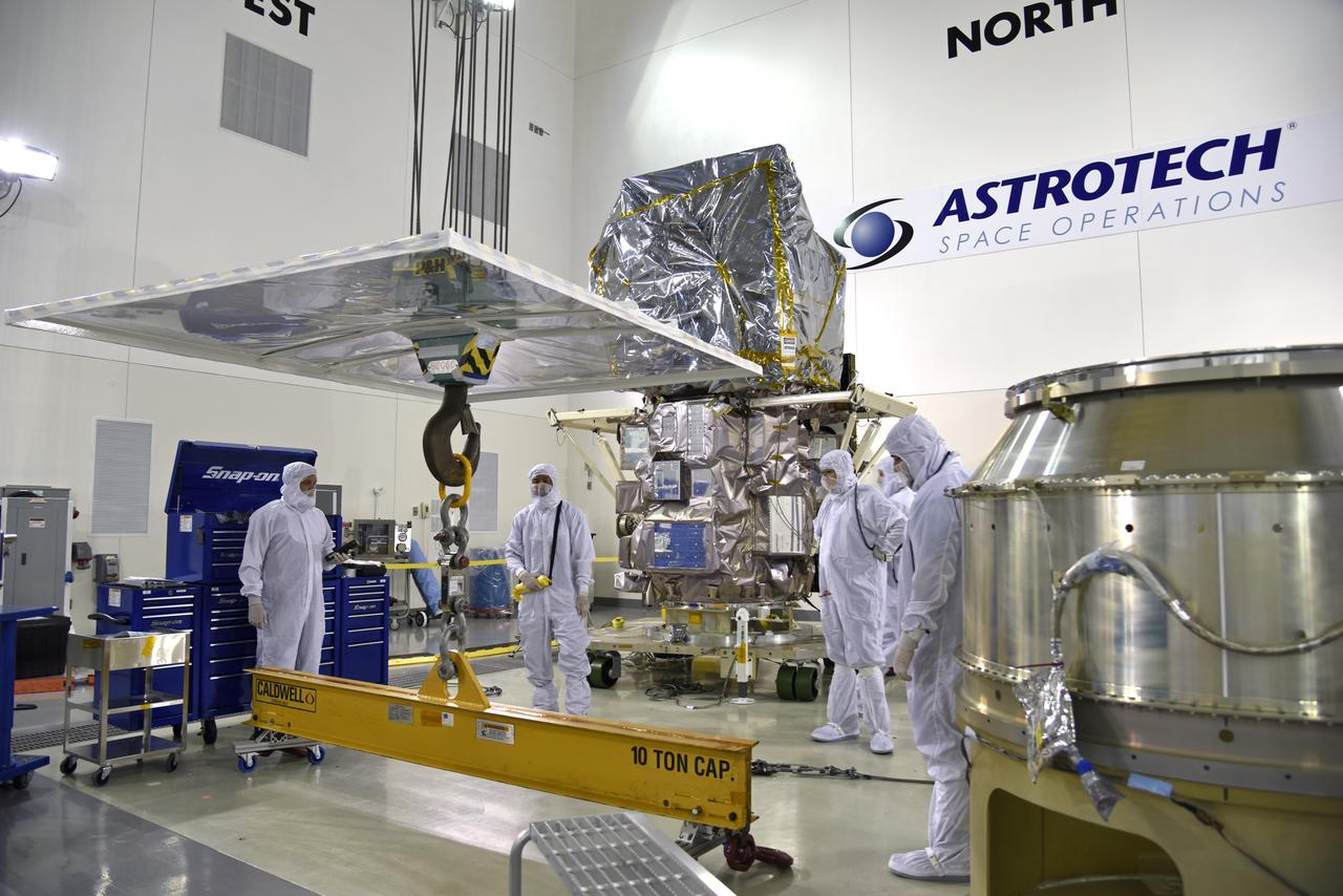
Technicians assist as a crane moves NASA's Ice, Cloud and land Elevation Satellite-2 (ICESat-2) into the high bay of the Astrotech processing facility on June 13, 2018, at Vandenberg Air Force Base in California. ICESat-2 was shipped from the Northrop Grumman facility in Gilbert, Arizona, where it was built and tested. The satellite is scheduled to launch from Space Launch Complex-2 at Vandenberg on the final United Launch Alliance Delta II rocket. ICESat-2 will measure the height of a changing Earth, one laser pulse at a time, 10,000 laser pulses a second. The satellite will carry the Advanced Topographic Laser Altimeter System. ICESat-2 will help scientists investigate why, and how much our planet's frozen and icy areas, called the cryosphere, is changing in a warming climate.
NASA's Ice, Cloud and land Elevation Satellite-2 (ICESat-2) is uncrated and is being prepared for its move to the high bay of the Astrotech processing facility on June 13, 2018, at Vandenberg Air Force Base in California. ICESat-2 was shipped from the Northrop Grumman facility in Gilbert, Arizona, where it was built and tested. The satellite is scheduled to launch from Space Launch Complex-2 at Vandenberg on the final United Launch Alliance Delta II rocket. ICESat-2 will measure the height of a changing Earth, one laser pulse at a time, 10,000 laser pulses a second. The satellite will carry the Advanced Topographic Laser Altimeter System. ICESat-2 will help scientists investigate why, and how much our planet's frozen and icy areas, called the cryosphere, is changing in a warming climate.
Inside the high bay of the Astrotech Space Operations facility at Vandenberg Air Force Base in California, a crane lifts and moves NASA's Ice, Cloud and land Elevation Satellite-2 (ICESat-2) on Aug. 30, 2018. The satellite will be attached to the payload adapter. ICESat-2 is being prepared for its scheduled launch from Space Launch Complex 2 at Vandenberg on the final United Launch Alliance Delta II rocket. ICESat-2 will measure the height of a changing Earth, one laser pulse at a time, 10,000 laser pulses a second. The satellite will carry the Advanced Topographic Laser Altimeter System (ATLAS). ICESat-2 will help scientists investigate why, and how much our planet's frozen and icy areas, called the cryosphere, are changing in a warming climate.
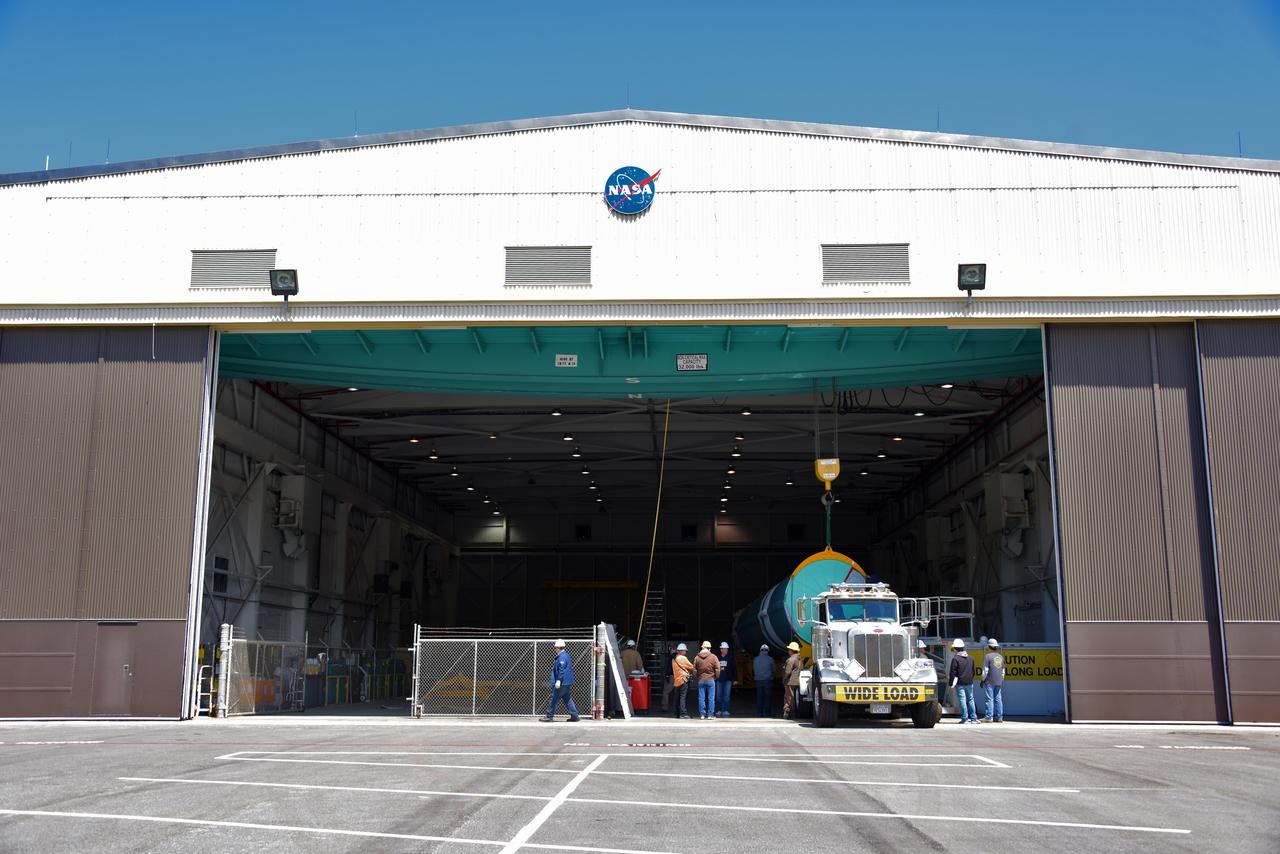
At NASA's Building 836, the Spacecraft Labs Telemetry Station at Vandenberg Air Force Base in California, a United Launch Alliance Delta II booster has been removed from its shipping container. Preliminary checkouts and preflight processing will begin leading to launch of the agency's Ice, Cloud and land Elevation Satellite-2, or ICESat-2. Liftoff from Space Launch Complex-2 at Vandenberg is scheduled for Sept. 12, 2018, and will be the last for the venerable Delta II rocket. Once in orbit, the satellite is designed to measure the height of a changing Earth, one laser pulse at a time, 10,000 laser pulses a second. The satellite will carry a single instrument, the Advanced Topographic Laser Altimeter System. ICESat-2 will help scientists investigate why, and how much, Earth's frozen and icy areas are changing. These area make up Earth's the cryosphere.
At NASA's Building 836, the Spacecraft Labs Telemetry Station at Vandenberg Air Force Base in California, a United Launch Alliance Delta II booster is removed from its shipping container. After it is offloaded, preliminary checkouts and preflight processing will begin leading to launch of the agency's Ice, Cloud and land Elevation Satellite-2, or ICESat-2. Liftoff from Space Launch Complex-2 at Vandenberg is scheduled for Sept. 12, 2018, and will be the last for the venerable Delta II rocket. Once in orbit, the satellite is designed to measure the height of a changing Earth, one laser pulse at a time, 10,000 laser pulses a second. The satellite will carry a single instrument, the Advanced Topographic Laser Altimeter System. ICESat-2 will help scientists investigate why, and how much, Earth's frozen and icy areas are changing. These area make up Earth's the cryosphere.
A crane is used to move NASA's Ice, Cloud and land Elevation Satellite-2 (ICESat-2) into the high bay of the Astrotech processing facility on June 13, 2018, at Vandenberg Air Force Base in California. ICESat-2 was shipped from the Northrop Grumman facility in Gilbert, Arizona, where it was built and tested. The satellite is scheduled to launch from Space Launch Complex-2 at Vandenberg on the final United Launch Alliance Delta II rocket. ICESat-2 will measure the height of a changing Earth, one laser pulse at a time, 10,000 laser pulses a second. The satellite will carry the Advanced Topographic Laser Altimeter System. ICESat-2 will help scientists investigate why, and how much our planet's frozen and icy areas, called the cryosphere, is changing in a warming climate.