
CSUNSat-1 Team (Adam Kaplan, James Flynn, Donald Eckels) working on their CubeSat at California State University Northridge. The primary mission of CSUNSat1 is to space test an innovative low temperature capable energy storage system developed by the Jet Propulsion Laboratory, raising its TRL level to 7 from 4 to 5. The success of this energy storage system will enable future missions, especially those in deep space to do more science while requiring less energy, mass and volume. This CubeSat was designed, built, programmed, and tested by a team of over 70 engineering and computer science students at CSUN. The primary source of funding for CSUNSat1 comes from NASA’s Smallest Technology Partnership program. Launched by NASA’s CubeSat Launch Initiative NET April 18, 2017 ELaNa XVII mission on the seventh Orbital-ATK Cygnus Commercial Resupply Services (OA-7) to the International Space Station and deployed on tbd.

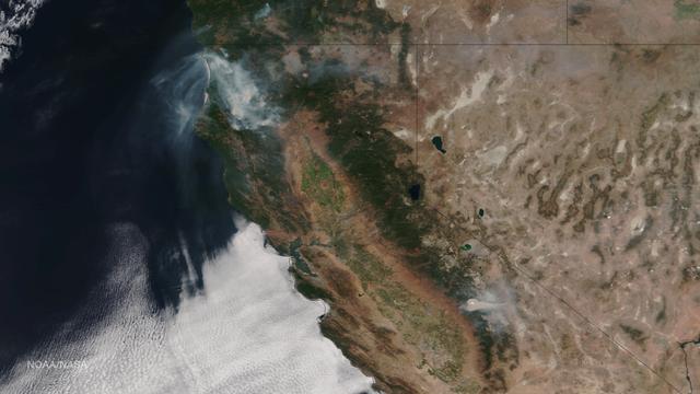
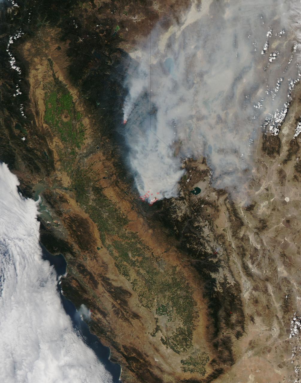
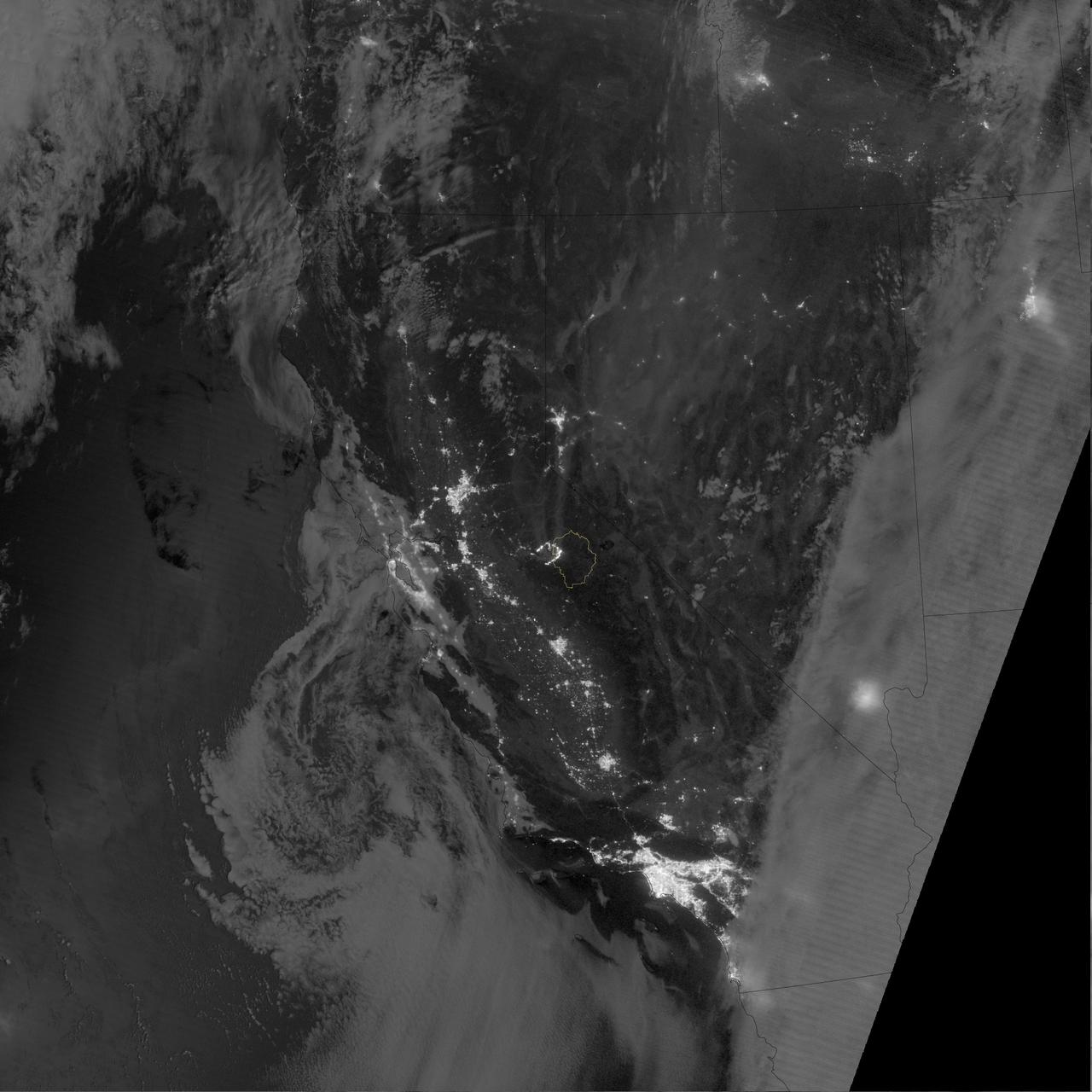
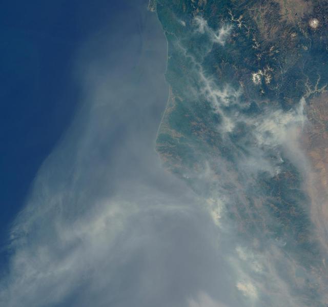
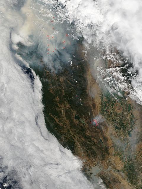
iss071e462173 (Aug. 8, 2024) --- Wildfires in northern California are pictured from the International Space Station as it orbited 261 miles above the Pacific Ocean off the coast of Washington's Olympic National Forest.
Very hot, dry and unstable conditions in California and across the Pacific Northwest add to the challenges facing firefighters as they battle blazes around the region. Cal Fire is urging Californians to be extremely cautious, especially for the next few days, as the current conditions increase the dangers authorities face. This image was taken by NASA-NOAA's Suomi NPP satellite's VIIRS instrument around 2145 UTC (5:45 p.m. EDT) on August 17, 2015. Northern California is seeing smoke from the River Complex, Route Complex, South Complex, Fork Complex and Mad River Complex fires combine over a large area of the Shasta-Trinity National Forest west of Redding, California, while the Rough Fire in Fresno County is spreading toward the Black Rock Reservoir, causing evacuations and road closures. Fires across the Pacific Northwest aren't limited to California. Please see the Suomi NPP VIIRS composites in NOAA View to see the growth and extent of fires over the past weeks. Credit: NASA/NOAA via <b><a href="www.nnvl.noaa.gov/" rel="nofollow"> NOAA Environmental Visualization Laboratory</a></b>
The October fires in Northern California were some of the most destructive in the state's history. The burned area on the right side of the image is the ATLAS fire, that burned east of Napa; the fire consumed 51,000 acres and destroyed almost 500 structures. The burned area on the left is part of the Nuns fire that burned between Sonoma and Napa; it consumed 110,000 acres, and destroyed almost 7,000 structures. The images were acquired September 7, 2016 and October 28, 2017, cover an area of 34.5 by 39 kilometers, and are located near 38.3 degrees north, 122.3 degrees east. https://photojournal.jpl.nasa.gov/catalog/PIA22019

This February 8, 2016 composite image reveals the complex distribution of phytoplankton in one of Earth's eastern boundary upwelling systems — the California Current. Recent work suggests that our warming climate my be increasing the intensity of upwelling in such regions with possible repercussions for the species that comprise those ecosystems. NASA's OceanColor Web is supported by the Ocean Biology Processing Group (OBPG) at NASA's Goddard Space Flight Center. Our responsibilities include the collection, processing, calibration, validation, archive and distribution of ocean-related products from a large number of operational, satellite-based remote-sensing missions providing ocean color, sea surface temperature and sea surface salinity data to the international research community since 1996. Credit: NASA/Goddard/Suomin-NPP/VIIRS <b><a href="http://www.nasa.gov/audience/formedia/features/MP_Photo_Guidelines.html" rel="nofollow">NASA image use policy.</a></b> <b><a href="http://www.nasa.gov/centers/goddard/home/index.html" rel="nofollow">NASA Goddard Space Flight Center</a></b> enables NASA’s mission through four scientific endeavors: Earth Science, Heliophysics, Solar System Exploration, and Astrophysics. Goddard plays a leading role in NASA’s accomplishments by contributing compelling scientific knowledge to advance the Agency’s mission. <b>Follow us on <a href="http://twitter.com/NASAGoddardPix" rel="nofollow">Twitter</a></b> <b>Like us on <a href="http://www.facebook.com/pages/Greenbelt-MD/NASA-Goddard/395013845897?ref=tsd" rel="nofollow">Facebook</a></b> <b>Find us on <a href="http://instagrid.me/nasagoddard/?vm=grid" rel="nofollow">Instagram</a></b>

The Italian Tecnam aircraft fuselage, P2006T, arrived in California and will be integrated with the wing for electric propulsion becoming X-57, or Maxwell.
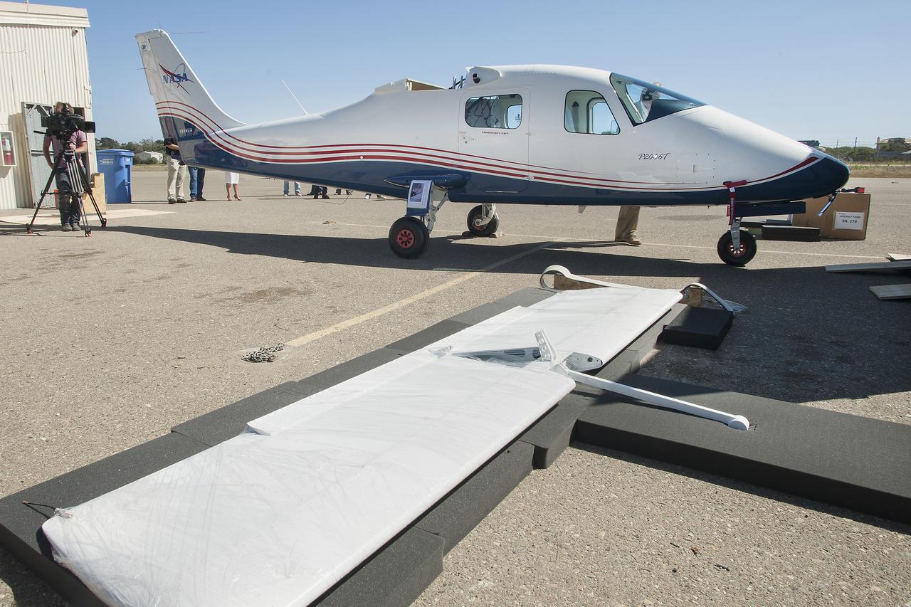
Preparations are underway to inspect, weigh and balance the Tecnam fuselage before it heads to Mojave, California, for wing integration.
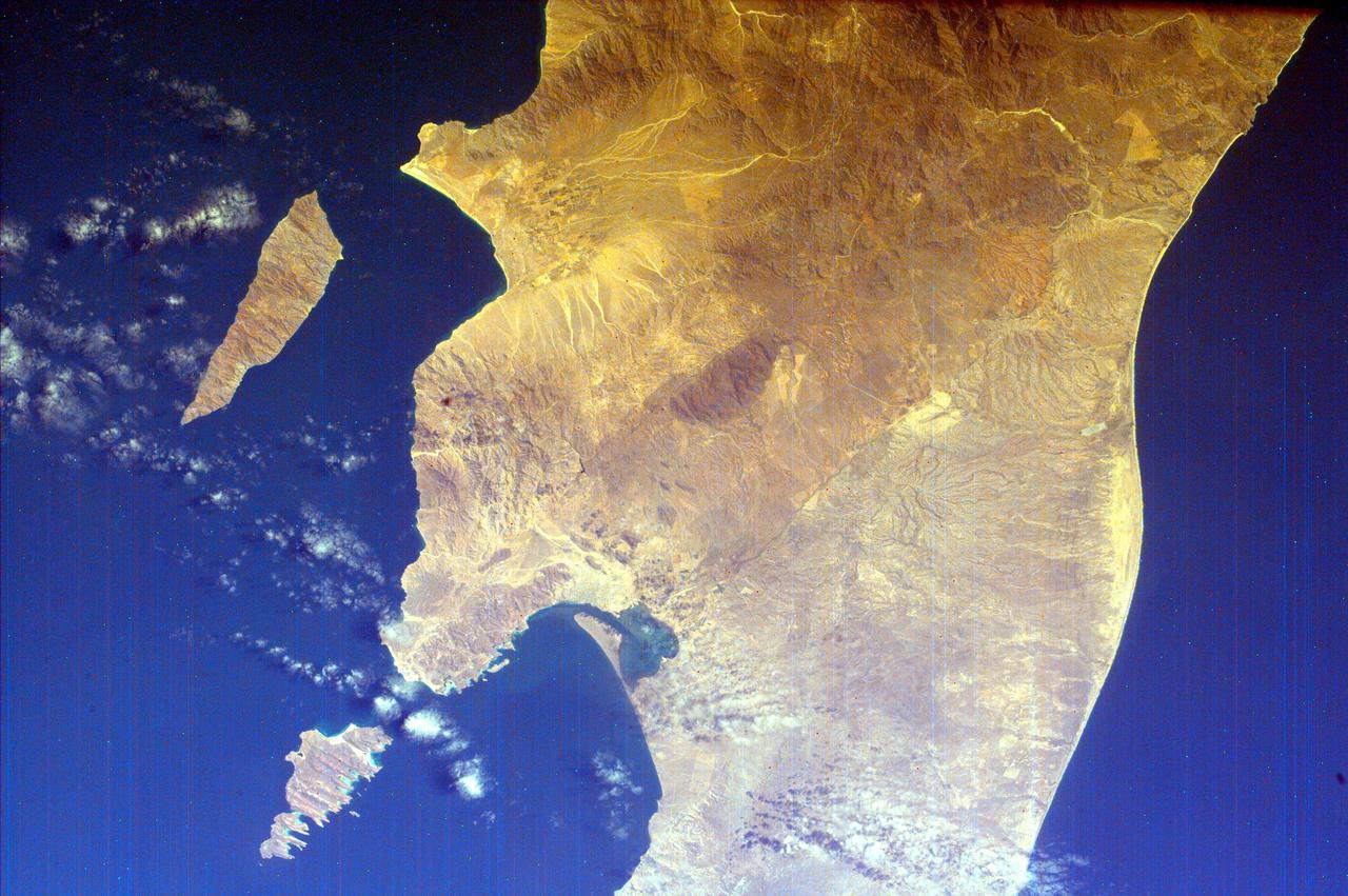
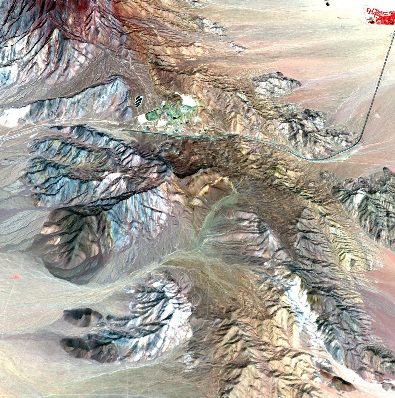
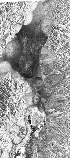
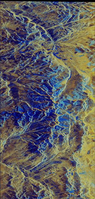
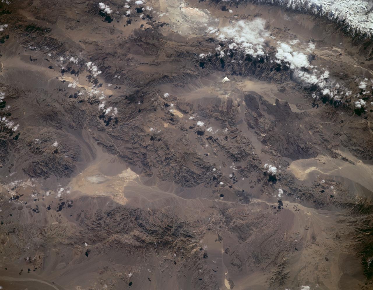
This spaceborne radar image shows part of the Mojave Desert in the vicinity of Barstow, California and reveals evidence of human activities in the arid environment of the southern California deserts.
This is an image of the southern portion of the Baja California Peninsula taken by NASA EarthKAM on February 12, 2000. The Pacific Ocean lies to the west and the Gulf of California to the east.
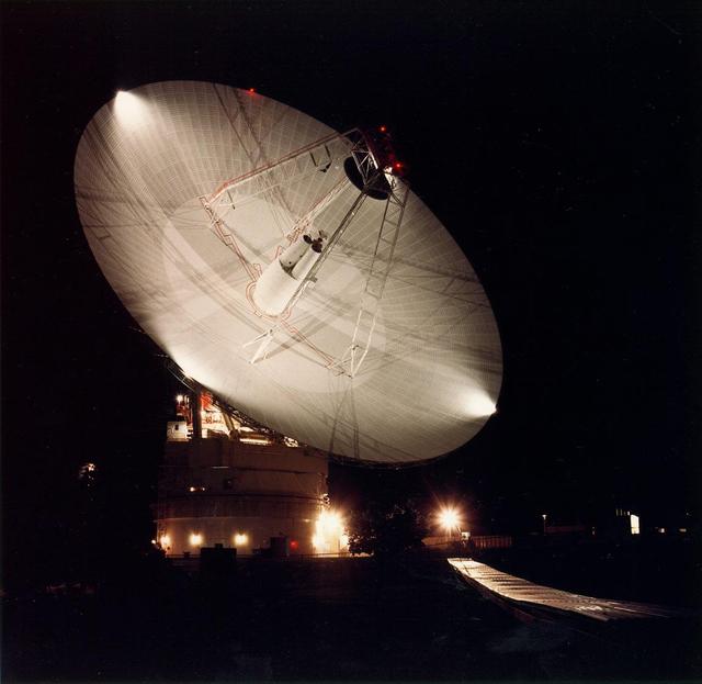
Night shot of the 70m antenna at Goldstone, California. The parabolic dish is 70m 230 ft. in diameter. The Goldstone Deep Space Communications Complex, located in the Mojave Desert in California, is one of three complexes which comprise NASA DSN.
This image of California Hayward fault is an interferogram created using a pair of images taken by ESA ERS-1 and ERS-2 in June 1992 and September 1997 over the central San Francisco Bay in California.

As firefighters continue to work toward full containment of the rash of wildfires burning in Northern California, a new image from the Advanced Spaceborne Thermal Emission and Reflection Radiometer (ASTER) instrument on NASA's Terra satellite shows the growing fire scar on the landscape. In this ASTER image, acquired Oct. 21, 2017, vegetation is red, while burned areas appear dark gray. The image covers an area of 38 by 39 miles (60.5 by 63 kilometers) and is located near 38.5 degrees north, 122.4 degrees west. https://photojournal.jpl.nasa.gov/catalog/PIA22049
Wind Streaks of Daedalia, Mars, and Amboy, California

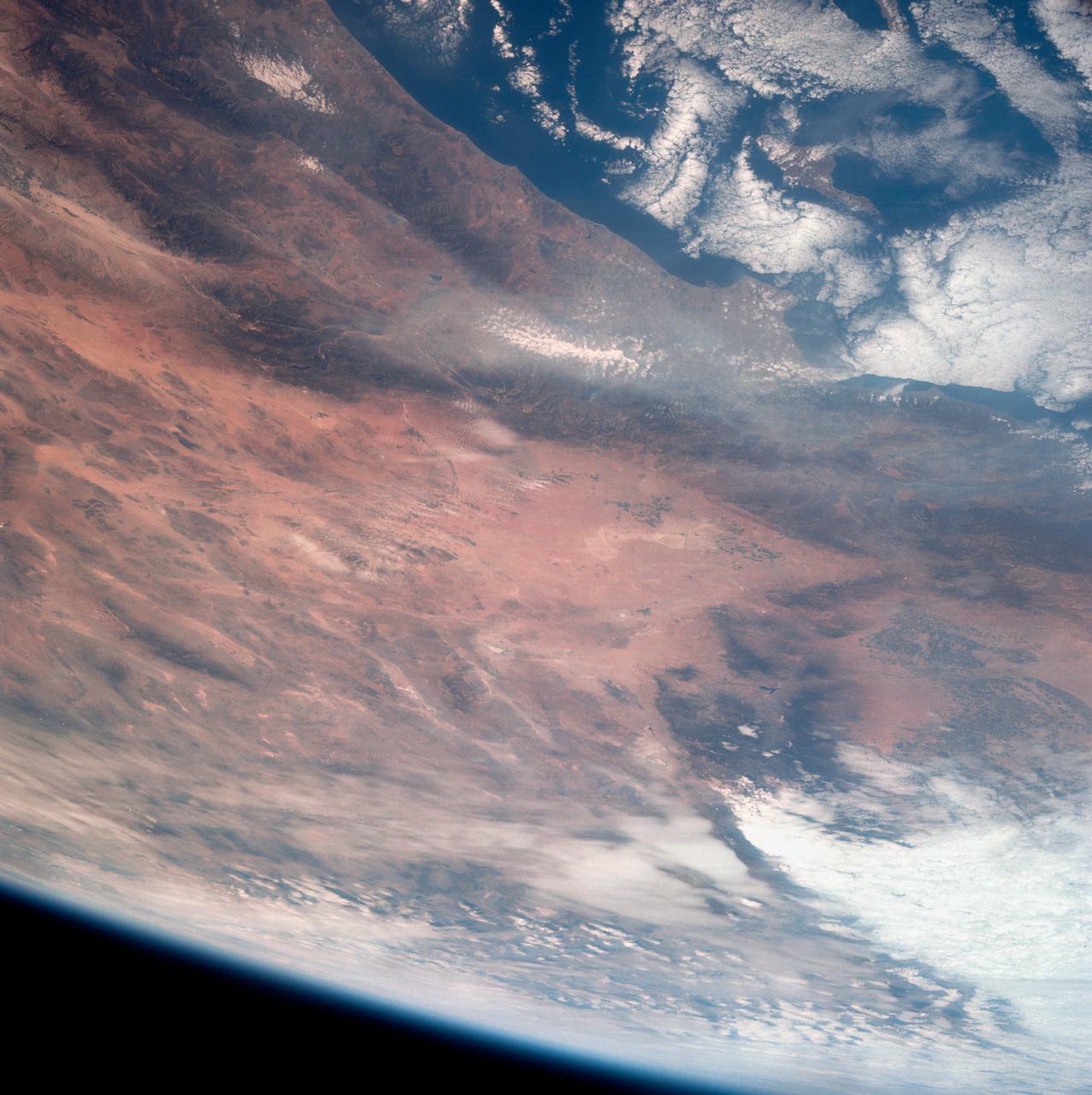
iss071e439835 (Aug. 7, 2024) --- Wildfires just northwest of California's Eagle Lake and Honey Lake (far left) are pictured from the International Space Station as it orbited 260 miles above The Golden State.
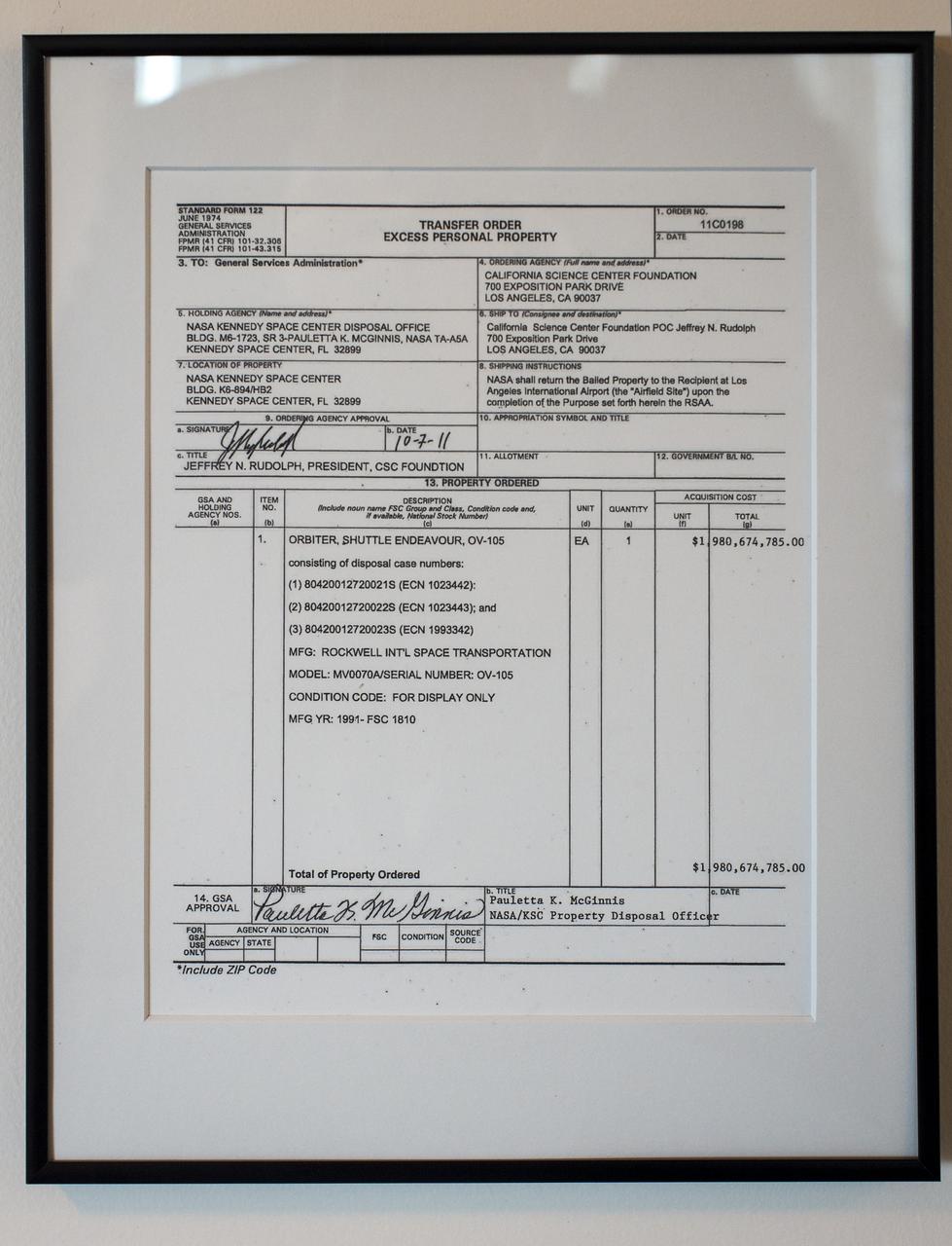
A government Transfer Order for Excess Personal Property is seen framed outside the office of President and CEO, California Science Center, Jeffrey N. Rudolph, on Tuesday, Oct. 30, 2012, in Los Angeles. The grand opening ceremony for the California Science center's Samuel Oschin Space Shuttle Endeavour Display Pavilion took place on Tuesday, Oct. 30, 2012. Endeavour, built as a replacement for space shuttle Challenger, completed 25 missions, spent 299 days in orbit, and orbited Earth 4,671 times while traveling 122,883,151 miles. Photo Credit: (NASA/Bill Ingalls)
According to the NBCnews.com, Southern California firefighters were battling a growing, brush-fueled wildfire early Friday that had reached the beach in Ventura County and was pushing toward the upscale city of Malibu, officials said. Dubbed the Springs Fire, this "monster" of a wildfire has been made worse by howling Santa Ana winds and unusually dry vegetation. As of 2 am local time in California on Friday the 3rd, it was within "seven or eight miles" of Malibu, Ventura County Fire Department spokesman Bill Nash said. Weather conditions are not cooperating in the containment of this fire. The Weather Channel has predicted dry winds from offshore that will bring gusts of 40 to 50 miles per hour to the Southern California region on Friday the 3rd which could easily spread the fire. A complication to the winds is the extremely dry plant life left from a season in which only about five inches of rain fell in the area. The Springs Fire grew to 10,000 acres and was ten percent contained as of early Friday morning, according to the California Department of Forestry and Fire Prevention. Evacuations took place Thursday, and as of Friday morning 15 homes had been damaged. More than 2,000 homes and 100 commercial properties were under threat from the fire and those numbers could grow with weather conditions today (May 3). Currently the fire is burning in a rural area outside of Malibu, but it doesn't have to go very far to get to some expensive homes and more populated areas. It's current direction has it burning down the mountainside toward Malibu. Firefighters expect to receive help from tankers and helicopters in the air Friday morning, according to a release from the Ventura County Fire Department. The cause of the fire remained under investigation Friday. There had been no lightning or other natural fire-starting phenomenon in the area when the blaze began, Nash said. This natural-color satellite image was collected by the Moderate Resolution Imaging Spectroradiometer (MODIS) aboard the Aqua satellite on May 02, 2013. Actively burning areas, detected by MODIS’s thermal bands, are outlined in red. NASA image courtesy Jeff Schmaltz LANCE/EOSDIS MODIS Rapid Response Team, GSFC. Caption by Lynn Jenner with information from NBCnews.com <b><a href="http://www.nasa.gov/audience/formedia/features/MP_Photo_Guidelines.html" rel="nofollow">NASA image use policy.</a></b> <b><a href="http://www.nasa.gov/centers/goddard/home/index.html" rel="nofollow">NASA Goddard Space Flight Center</a></b> enables NASA’s mission through four scientific endeavors: Earth Science, Heliophysics, Solar System Exploration, and Astrophysics. Goddard plays a leading role in NASA’s accomplishments by contributing compelling scientific knowledge to advance the Agency’s mission. <b>Follow us on <a href="http://twitter.com/NASA_GoddardPix" rel="nofollow">Twitter</a></b> <b>Like us on <a href="http://www.facebook.com/pages/Greenbelt-MD/NASA-Goddard/395013845897?ref=tsd" rel="nofollow">Facebook</a></b> <b>Find us on <a href="http://instagram.com/nasagoddard?vm=grid" rel="nofollow">Instagram</a></b>

Media, social media, and NASA Armstrong (then Dryden) Flight Research Center employees and family wait for a press conference on the center’s back ramp on Sept. 20, 2012, in Edwards, California.

Tires from space shuttle Endeavour's final flight are on display at the California Science Center's, California Experience gallery, Tuesday, Oct. 30, 2012, in Los Angeles. The grand opening ceremony for the California Science center's Samuel Oschin Space Shuttle Endeavour Display Pavilion took place on Tuesday, Oct. 30, 2012. Endeavour, built as a replacement for space shuttle Challenger, completed 25 missions, spent 299 days in orbit, and orbited Earth 4,671 times while traveling 122,883,151 miles. Photo Credit: (NASA/Bill Ingalls)
Low clouds filled California’s Central Valley in late January, 2015. Such winter fog is considered a common phenomenon, and can be so dense that it snarls traffic, causes fender-benders, and can make symptoms worse in those with respiratory disease. At the same time, the moist winter fog helps keep temperatures low in the rich agricultural region by reflecting sunlight and keeping the ground from warming, which helps keep the abundant fruit and nut trees dormant, allowing for bountiful harvests. Scientific studies have reported that winter fogs (also called Thule fogs) are occurring less frequently in the Central Valley. One study, by Dennis Baldocchi and Eric Waller, was published in May, 2014. It finds that since 1981 the number of fog days between November and February has decreased by 46 percent. The severe drought that California has experienced in recent years may also have decreased the number of fog events even more since 2012. The Moderate Resolution Imaging Spectroradiometer (MODIS) aboard NASA’s Terra satellite captured this true-color image on January 24, 2015. Credit: NASA/GSFC/Jeff Schmaltz/MODIS Land Rapid Response Team <b><a href="http://www.nasa.gov/audience/formedia/features/MP_Photo_Guidelines.html" rel="nofollow">NASA image use policy.</a></b> <b><a href="http://www.nasa.gov/centers/goddard/home/index.html" rel="nofollow">NASA Goddard Space Flight Center</a></b> enables NASA’s mission through four scientific endeavors: Earth Science, Heliophysics, Solar System Exploration, and Astrophysics. Goddard plays a leading role in NASA’s accomplishments by contributing compelling scientific knowledge to advance the Agency’s mission. <b>Follow us on <a href="http://twitter.com/NASAGoddardPix" rel="nofollow">Twitter</a></b> <b>Like us on <a href="http://www.facebook.com/pages/Greenbelt-MD/NASA-Goddard/395013845897?ref=tsd" rel="nofollow">Facebook</a></b> <b>Find us on <a href="http://instagram.com/nasagoddard?vm=grid" rel="nofollow">Instagram</a></b>
These images from NASATerra satellite are of Southern California acquired on March 14, 2000 during Terra orbit 1273. North is at the top.

Space shuttle Endeavour and its host NASA 747 Shuttle Carrier Aircraft make a final flight over Edwards Air Force Base on Sept. 21, 2012. NASA’s Armstrong Flight Research Center in Edwards, California, is visible on the upper right of the frame.
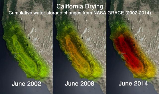
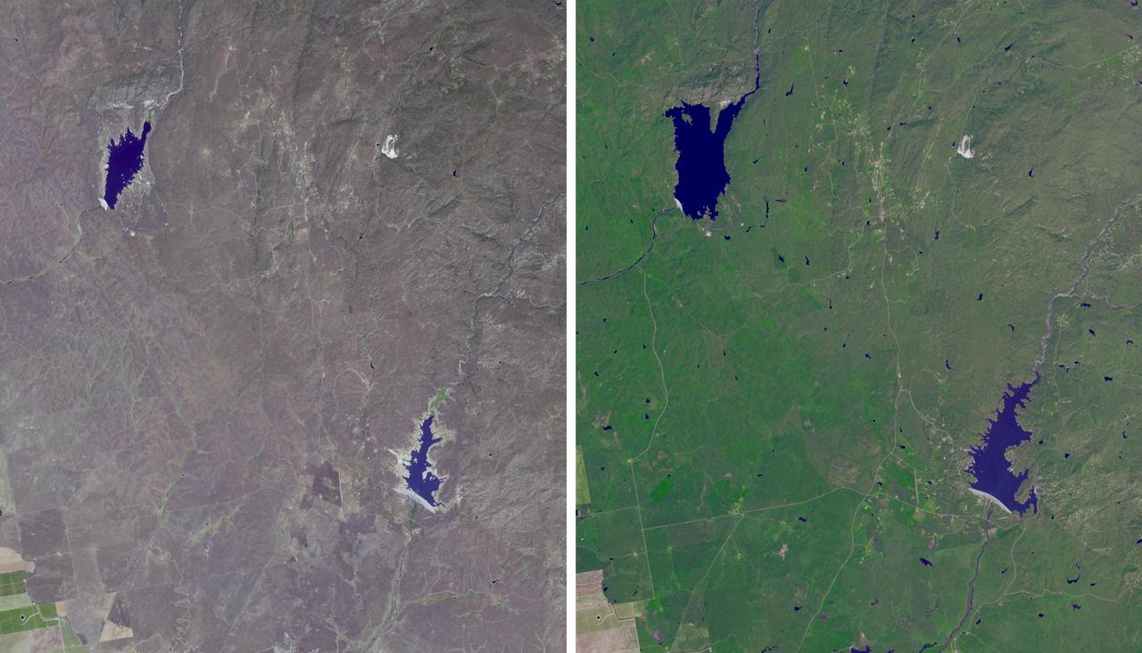
This trio of images depicts satellite observations of declining water storage in California as seen by NASA Gravity Recovery and Climate Experiment satellites in June 2002 left, June 2008 center and June 2014 right.
Visible image of a California storm in March, 2003, as seen by the Atmospheric Infrared Sounder AIRS on NASA Aqua satellite. http://photojournal.jpl.nasa.gov/catalog/PIA00402
Wasco, California advertises itself as the Rose Capital of the World; over 8000 acres are devoted to cultivation of existing and new varieties of roses, shipped to every state in the U.S. and all over the world.
On August 23, 2013, the Moderate Resolution Imaging Spectroradiometer (MODIS) on NASA’s Aqua satellite acquired this image of the drought-fueled Rim fire burning in central California, near Yosemite National Park. Red outlines indicate hot spots where MODIS detected unusually warm surface temperatures associated with fires. Winds blew a thick smoke plume toward the northeast. A smaller fire—American fire—burned to the north. The lower image is a photograph that shows the fire burning at night on August 21. Started on August 17, 2013, the fast-moving fire had already charred more than 100,000 acres (40,000 hectares) by August 23, despite the efforts of more than 2,000 firefighters. Hundreds of people were forced to evacuate their homes, and roads in the area were closed. As of August 23, no structures had been reported destroyed, but the fire threatened the towns of Groveland and Pine Mountain Lake. By late August, wildfires had burned 3.4 million acres in the United States, making 2013 somewhat less active than other recent years. Over the last decade, fires charred 5.7 million acres on average by August 22, according to statistics published the National Interagency Fire Center. NASA image by Jeff Schmaltz, LANCE/EOSDIS Rapid Response. Caption by Adam Voiland. Instrument: Aqua - MODIS Credit: <b><a href="http://www.earthobservatory.nasa.gov/" rel="nofollow"> NASA Earth Observatory</a></b> <b><a href="http://www.nasa.gov/audience/formedia/features/MP_Photo_Guidelines.html" rel="nofollow">NASA image use policy.</a></b> <b><a href="http://www.nasa.gov/centers/goddard/home/index.html" rel="nofollow">NASA Goddard Space Flight Center</a></b> enables NASA’s mission through four scientific endeavors: Earth Science, Heliophysics, Solar System Exploration, and Astrophysics. Goddard plays a leading role in NASA’s accomplishments by contributing compelling scientific knowledge to advance the Agency’s mission. <b>Follow us on <a href="http://twitter.com/NASA_GoddardPix" rel="nofollow">Twitter</a></b> <b>Like us on <a href="http://www.facebook.com/pages/Greenbelt-MD/NASA-Goddard/395013845897?ref=tsd" rel="nofollow">Facebook</a></b> <b>Find us on <a href="http://instagram.com/nasagoddard?vm=grid" rel="nofollow">Instagram</a></b>
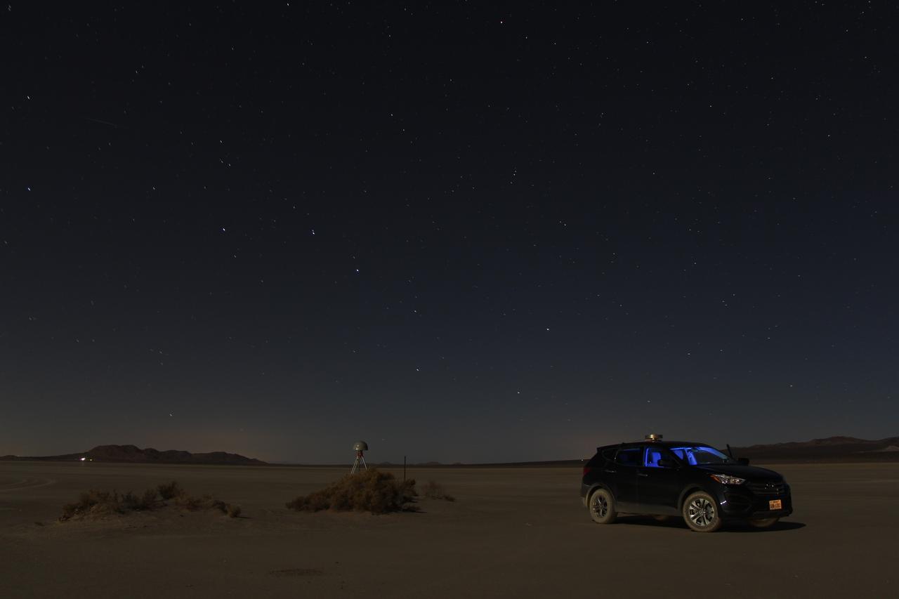
At first glance a dry lake bed in the southern California desert seems like the last place to prepare to study ice. But on Oct. 2, 2014, NASA’s Operation IceBridge carried out a ground-based GPS survey of the El Mirage lake bed in California’s Mojave Desert. Members of the IceBridge team are currently at NASA’s Armstrong Flight Research Center, preparing instruments aboard the DC-8 research aircraft for flights over Antarctica. Part of this preparation involves test flights over the desert, where researchers verify their instruments are working properly. El Mirage serves as a prime location for testing the mission’s laser altimeter, the Airborne Topographic Mapper, because the lake bed has a flat surface and reflects light similarly to snow and ice. This photo, taken shortly after the survey, shows the GPS-equipped survey vehicle and a stationary GPS station (left of the vehicle) on the lake bed with the constellation Ursa Major in the background. By driving the vehicle in parallel back and forth lines over a predefined area and comparing those GPS elevation readings with measurements from the stationary GPS, researchers are able to build an elevation map that will be used to precisely calibrate the laser altimeter for ice measurements. Credit: NASA/John Sonntag Operation IceBridge is scheduled to begin research flights over Antarctica on Oct. 15, 2014. The mission will be based out of Punta Arenas, Chile, until Nov. 23. For more information about IceBridge, visit: <a href="http://www.nasa.gov/icebridge" rel="nofollow">www.nasa.gov/icebridge</a> <b><a href="http://www.nasa.gov/audience/formedia/features/MP_Photo_Guidelines.html" rel="nofollow">NASA image use policy.</a></b> <b><a href="http://www.nasa.gov/centers/goddard/home/index.html" rel="nofollow">NASA Goddard Space Flight Center</a></b> enables NASA’s mission through four scientific endeavors: Earth Science, Heliophysics, Solar System Exploration, and Astrophysics. Goddard plays a leading role in NASA’s accomplishments by contributing compelling scientific knowledge to advance the Agency’s mission. <b>Follow us on <a href="http://twitter.com/NASAGoddardPix" rel="nofollow">Twitter</a></b> <b>Like us on <a href="http://www.facebook.com/pages/Greenbelt-MD/NASA-Goddard/395013845897?ref=tsd" rel="nofollow">Facebook</a></b> <b>Find us on <a href="http://instagram.com/nasagoddard?vm=grid" rel="nofollow">Instagram</a></b>
STS001-12-305 (12-14 April 1981) --- California, San Francisco Bay photographed by a crew member on the space shuttle Columbia (STS-1). The coast is seen from near Santa Cruz northward to Point Reyes. The great valley is in the foreground. Photo credit: NASA
This is a radar image of Los Angeles, California, taken on October 2, 1994.
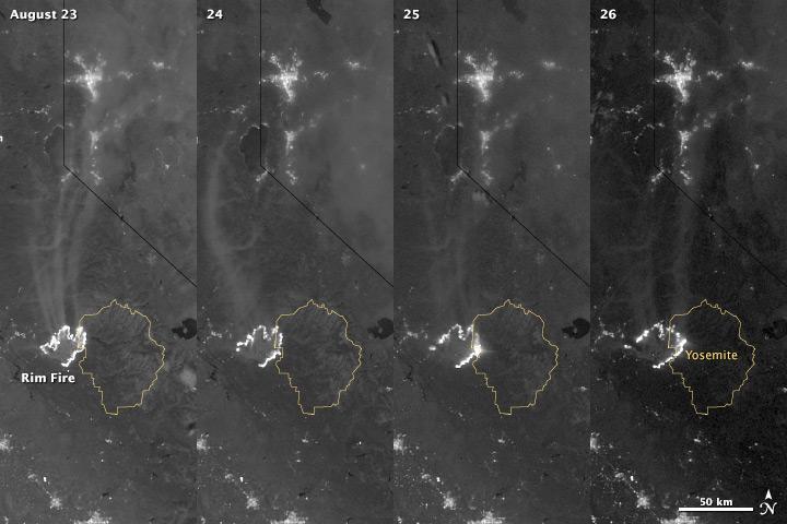
The winter of 2013 was among the driest on record for California, setting the stage for an active fire season. By August 26, the Rim Fire had made its way into the record books. At just 15 percent contained, the fire is now the 13th largest in California since records began in 1932. Apart from being large, the fire is also threatening one of the United States’ greatest natural treasures: Yosemite National Park. The Visible Infrared Imaging Radiometer Suite (VIIRS) on the Suomi NPP satellite tracked the growth of the fire between August 23 and August 26 in this series of nighttime images. The VIIRS day-night band is extremely sensitive to low light, making it possible to see the fire front from space. The brightest, most intense parts of the fire glow white, exceeding the brightness of the lights of Reno, Nevada to the north. Pale gray smoke streams north away from the fire throughout the sequence. The perimeter of the fire grows from day to day along different fronts, depending on winds and fire fighting efforts. On August 24, fire fighters focused their efforts on containing the western edge of the fire to prevent it from burning into Tuolumne City and the populated Highway 108 corridor. They also fought the eastern edge of the fire to protect Yosemite National Park. These efforts are evident in the image: Between August 23 and 24, the eastern edge of the fire held steady, and the western edge receded. The fire grew in the southeast. On the morning of August 25 fire managers reported that the fire was growing in the north and east. In the image, the most intense activity is just inside Yosemite National Park. Fire fighters reported that the Rim Fire continued to be extremely active on its eastern front on the morning of August 26, and this activity is visible in the image. By 8:00 a.m., the fire had burned 149,780 acres. The fire forced firefighters in Yosemite National Park to take measures to protect the Merced and Tuolumne Groves of Giant Sequoias, but the National Park Service reported that the trees were not in imminent danger. While parts of the park are closed, webcams show that most of the park has not been impacted. The Rim Fire started on the afternoon of August 17. It has destroyed 23 structures and threatened 4,500 other buildings. Its cause is under investigation. More details: <a href="http://1.usa.gov/18ilEAA" rel="nofollow">1.usa.gov/18ilEAA</a> NASA Earth Observatory image by Jesse Allen and Robert Simmon, using VIIRS Day Night Band data. Caption by Holli Riebeek. Instrument: Suomi NPP - VIIRS <b><a href="http://www.nasa.gov/audience/formedia/features/MP_Photo_Guidelines.html" rel="nofollow">NASA image use policy.</a></b> <b><a href="http://www.nasa.gov/centers/goddard/home/index.html" rel="nofollow">NASA Goddard Space Flight Center</a></b> enables NASA’s mission through four scientific endeavors: Earth Science, Heliophysics, Solar System Exploration, and Astrophysics. Goddard plays a leading role in NASA’s accomplishments by contributing compelling scientific knowledge to advance the Agency’s mission. <b>Follow us on <a href="http://twitter.com/NASA_GoddardPix" rel="nofollow">Twitter</a></b> <b>Like us on <a href="http://www.facebook.com/pages/Greenbelt-MD/NASA-Goddard/395013845897?ref=tsd" rel="nofollow">Facebook</a></b> <b>Find us on <a href="http://instagram.com/nasagoddard?vm=grid" rel="nofollow">Instagram</a></b>
The winter of 2013 was among the driest on record for California, setting the stage for an active fire season. By August 26, the Rim Fire had made its way into the record books. At just 15 percent contained, the fire is now the 13th largest in California since records began in 1932. Apart from being large, the fire is also threatening one of the United States’ greatest natural treasures: Yosemite National Park. The Visible Infrared Imaging Radiometer Suite (VIIRS) on the Suomi NPP satellite tracked the growth of the fire between August 23 and August 26 in a series of nighttime images. The VIIRS day-night band is extremely sensitive to low light, making it possible to see the fire front from space. The brightest, most intense parts of the fire glow white, exceeding the brightness of the lights of Reno, Nevada to the north. Pale gray smoke streams north away from the fire throughout the sequence. The perimeter of the fire grows from day to day along different fronts, depending on winds and fire fighting efforts. On August 24, fire fighters focused their efforts on containing the western edge of the fire to prevent it from burning into Tuolumne City and the populated Highway 108 corridor. They also fought the eastern edge of the fire to protect Yosemite National Park. These efforts are evident in the image: Between August 23 and 24, the eastern edge of the fire held steady, and the western edge receded. The fire grew in the southeast. On the morning of August 25 fire managers reported that the fire was growing in the north and east. In the image, the most intense activity is just inside Yosemite National Park. Fire fighters reported that the Rim Fire continued to be extremely active on its eastern front on the morning of August 26, and this activity is visible in the image. By 8:00 a.m., the fire had burned 149,780 acres. The fire forced firefighters in Yosemite National Park to take measures to protect the Merced and Tuolumne Groves of Giant Sequoias, but the National Park Service reported that the trees were not in imminent danger. While parts of the park are closed, webcams show that most of the park has not been impacted. The Rim Fire started on the afternoon of August 17. It has destroyed 23 structures and threatened 4,500 other buildings. Its cause is under investigation. More details: <a href="http://1.usa.gov/18ilEAA" rel="nofollow">1.usa.gov/18ilEAA</a> NASA Earth Observatory image by Jesse Allen and Robert Simmon, using VIIRS Day Night Band data. Caption by Holli Riebeek. Instrument: Suomi NPP - VIIRS <b><a href="http://www.nasa.gov/audience/formedia/features/MP_Photo_Guidelines.html" rel="nofollow">NASA image use policy.</a></b> <b><a href="http://www.nasa.gov/centers/goddard/home/index.html" rel="nofollow">NASA Goddard Space Flight Center</a></b> enables NASA’s mission through four scientific endeavors: Earth Science, Heliophysics, Solar System Exploration, and Astrophysics. Goddard plays a leading role in NASA’s accomplishments by contributing compelling scientific knowledge to advance the Agency’s mission. <b>Follow us on <a href="http://twitter.com/NASA_GoddardPix" rel="nofollow">Twitter</a></b> <b>Like us on <a href="http://www.facebook.com/pages/Greenbelt-MD/NASA-Goddard/395013845897?ref=tsd" rel="nofollow">Facebook</a></b> <b>Find us on <a href="http://instagram.com/nasagoddard?vm=grid" rel="nofollow">Instagram</a></b>

Space shuttle Endeavour and its host NASA 747 Shuttle Carrier Aircraft land at Edwards Air Force Base in California. It completed its third leg of a four-segment final ferry flight from NASA’s Kennedy Space Center in Florida to Los Angeles International Airport on Sept. 20, 2012. The landing was preceded by NASA’s Armstrong (then Dryden) Flight Research Center pilot Bill Brockett’s low-level flyby of the center and the Edwards flight line.

Space shuttle Endeavour and its host NASA 747 Shuttle Carrier Aircraft fly over Disneyland in 2012 on its way to the Los Angeles International Airport, and an overland journey to the California Science Center. Californians gazed at the morning sky Sept. 21 looking to see Endeavour over their community. The final leg of Endeavour’s flight from NASA’s Kennedy Space Center, Florida, offered many people an opportunity to witness the historic flight.
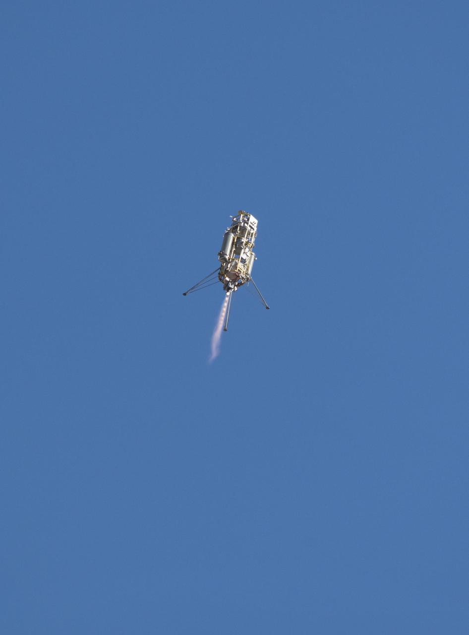
A prototype of the Lander Vision System for NASA Mars 2020 mission was tested in this Dec. 9, 2014, flight of a Masten Space Systems Xombie vehicle at Mojave Air and Space Port in California. http://photojournal.jpl.nasa.gov/catalog/PIA20848
iss071e014306 (April 20, 2024) -- The Gulf of California and Baja California were photographed by NASA astronaut Mike Barratt as the International Space Station orbited nearly 260 miles above.
The October 2007 wildfires, including the Witch Wildland fire, plagued southern California and were some of the worst on record. Image from NASA Terra satellite.
Lightning strikes have sparked more than a thousand fires in northern California. Cape Mendocino is at the center of the image and Mt. Shasta is near the upper right.
This image of the Mountain Pass rare open-pit earth mine was acquired by NASA Terra spacecraft in southeastern California near the Nevada border.
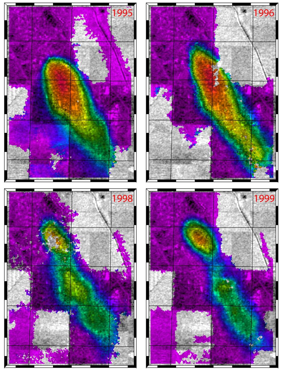
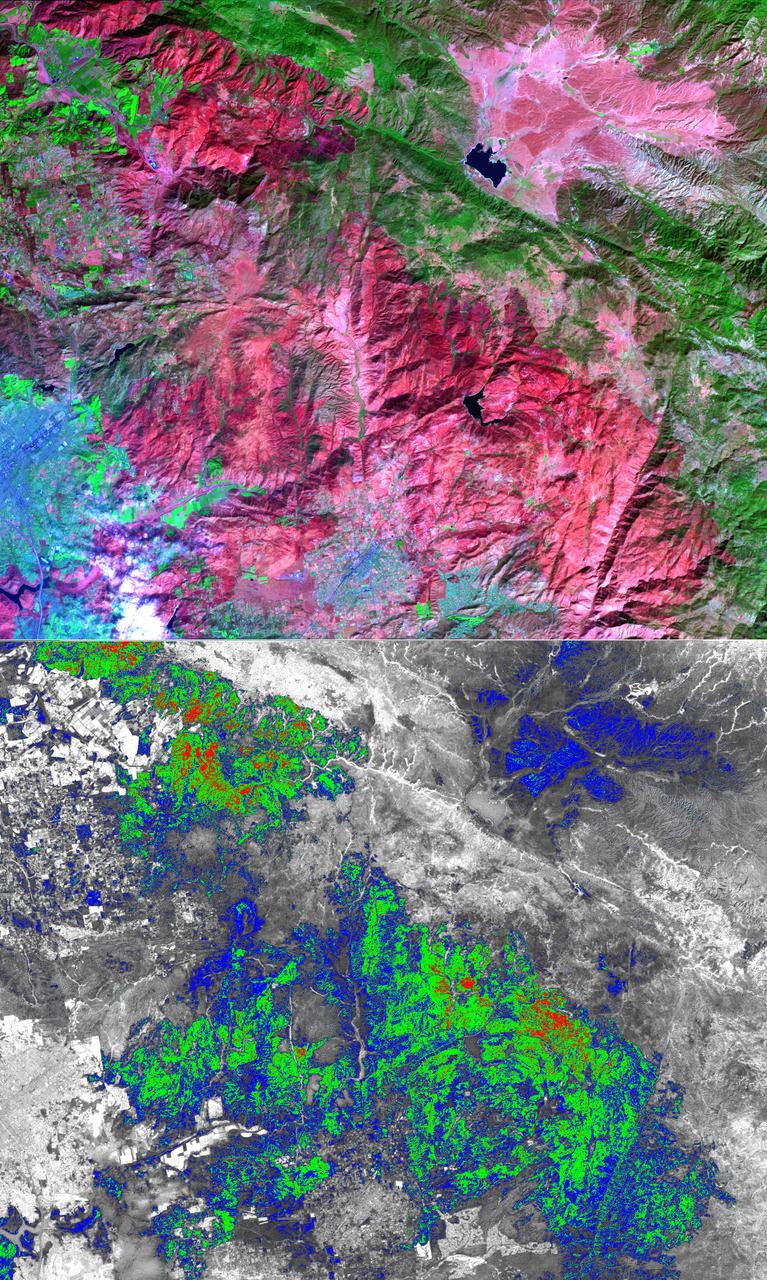
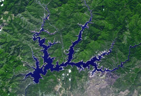
This figure shows a comparison of interferograms from four different years mapping the rapid ground subsidence over the Lost Hills oil field in California.
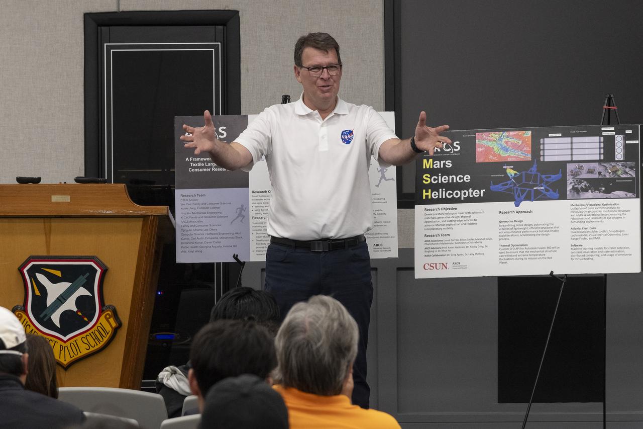
Brad Flick, center director at NASA’s Armstrong Flight Research Center in Edwards, California, talks to students from California State University, Northridge, California. As part of the university’s Autonomy Research Center for science, technology, engineering, entrepreneurship, arts, humanities, and mathematics, the students displayed posters and answered questions about their technologies May 23 at the Air Force Test Pilot School auditorium on Edwards Air Force Base, California.
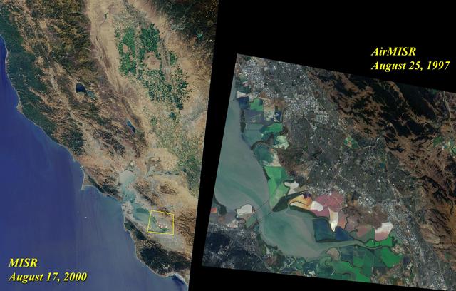
This image acquired on August 17, 2000 during Terra orbit 3545 shows Northern California and San Francisco Bay.
This frame from an animation depicts variations in surface elevation resulting from the discharge and recharge of groundwater basins in Southern California.
This is a spaceborne radar image of the city of Sacramento, the capital of California. Urban areas appear pink and the surrounding agricultural areas are green and blue.
AST-14-881 (16 July 1975) --- An excellent view of Los Angeles, California, as photographed from the Apollo spacecraft in Earth orbit during the joint U.S.-USSR Apollo-Soyuz Test Project (ASTP) mission. Downtown Los Angeles is near the center of the picture. The photograph was taken at an altitude of 193 kilometers (120 statute miles), with a 70mm Hasselblad camera using SO-242 high-definition Ektachrome film.

California Governor Jerry Brown speaks from a podium underneath the space shuttle Endeavour during the grand opening ceremony for the California Science center's Samuel Oschin Space Shuttle Endeavour Display Pavilion, Tuesday, Oct. 30, 2012, in Los Angeles. Endeavour, built as a replacement for space shuttle Challenger, completed 25 missions, spent 299 days in orbit, and orbited Earth 4,671 times while traveling 122,883,151 miles. Photo Credit: (NASA/Bill Ingalls)

Space shuttle Endeavour and its host NASA 747 Shuttle Carrier Aircraft fly by the Golden Gate Bridge in 2012 on its way to the Los Angeles International Airport and an overland journey to the California Science Center. Californians looked up at the morning sky Sept. 21 to catch a glimpse of Endeavour. The final leg of Endeavour’s flight from NASA’s Kennedy Space Center, Florida, offered many people an opportunity to witness the historic flight. Space shuttle Endeavour and its host NASA 747 Shuttle Carrier Aircraft fly by the Golden Gate Bridge in 2012 on its way to the Los Angeles International Airport and an overland journey to the California Science Center. Californians looked up at the morning sky Sept. 21 to catch a glimpse of Endeavour. The final leg of Endeavour’s flight from NASA’s Kennedy Space Center, Florida, offered many people an opportunity to witness the historic flight.
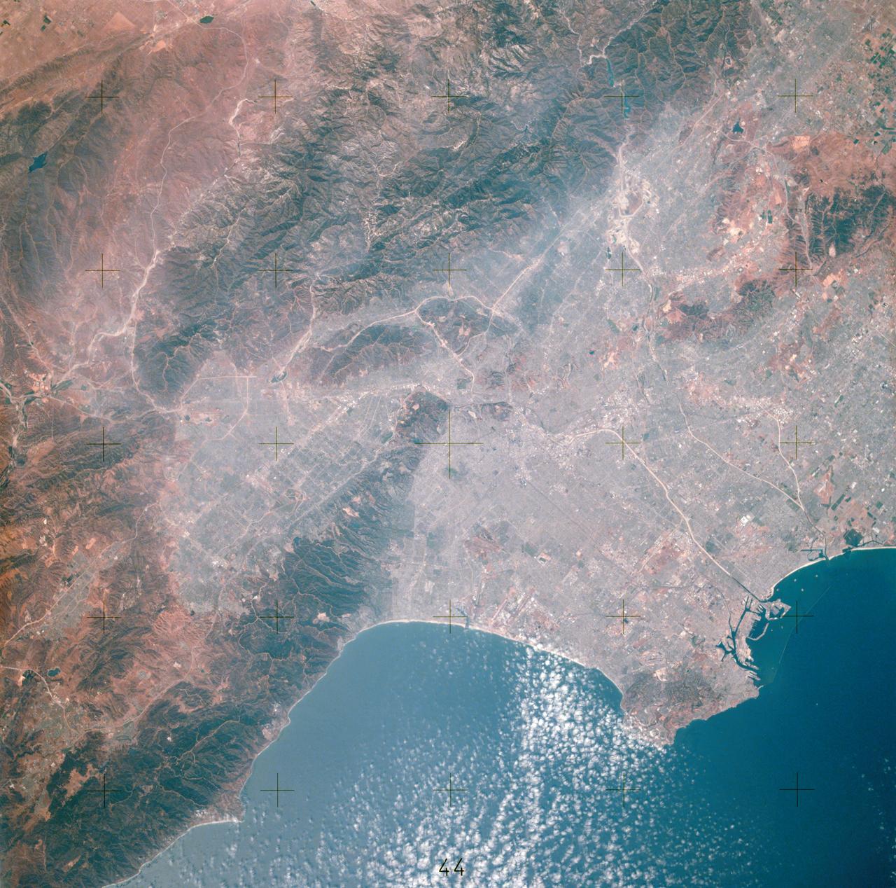
This view of southern California as seen from the Apollo 7 spacecraft during its 18th revolution of the earth. Photographed from an altitude of 124 nautical miles. The coast of California can be seen from Point Mugu southward to Oceanside. Santa Catalina can be seen below the off shore clouds. Details of the Los Angeles area are obscured by pollution which extends from Banning westard for 100 miles to beyond Malibu. In the upper portion of the photograph can be seen (left to right) the San Joaquin Valley beyond Bakersfield, the Techachapi Mountains, the Sierra Nevada, Owens Valley, Death Valley and the Mojave Desert.
This satellite image shows smoke from several fires in Oregon and California on Aug. 2, 2015. The Moderate Resolution Imaging Spectroradiometer (MODIS) instrument that flies aboard NASA's Aqua satellite captured an image of smoke from these fires Aug. 2 at 21:05 UTC (5:05 p.m. EDT). The multiple red pixels are heat signatures detected by MODIS. The smoke appears to be a light brown color. InciWeb is an interagency all-risk incident information management system that coordinates with federal, state and local agencies to manage wildfires. In Oregon smoke from the Cable Crossing Fire, the Stouts Fire and the Potter Mountain Complex Fire commingle. The Cable Crossing Fire was reported burning on forestlands protected by the Douglas Forest Protective Association (DFPA) at approximately 3:25 p.m. on Tuesday, July 28, 2015, near Oregon Highway 138 East, near Mile Post 23, east of Glide. South of the Cable Crossing Fire is the Stouts Fire also in forestlands of the DFPA. This fire was reported on Thursday, July 30, 2015, burning approximately 11 miles east of Canyonville near the community of Milo. East of the other fires is the Potter Mountain Complex Fire. These fires are located in the Deschutes Forest consists of eight fires. According to Inciweb they were started by dry lightning on Saturday, Aug. 2, at approximately 5:30 p.m. about five miles north of Toketee Lake. In northern California, smoke from the River Complex Fire, the Fork Complex Fire and the Shf July Lightning Fire was visible in the MODIS image. The River Complex currently consists of seven reported and observed fires on the Six Rivers and Shasta Trinity National Forests. Originally identified as 18 fires, some have burned together. Inciweb noted that in the Six Rivers National Forest there are fires in the Trinity Alps Wilderness. Those fires include the Groves Fire and the Elk Fire. In the Shasta-Trinity National Forest the fires include the Happy Fire at 2,256 acres, Daily Fire at 16 acres, the Look Fire at 7 acres, Onion Fire at 136 acres and Smokey Fire at 1 acre. In the same forest, south of the River Complex is the Fork Complex fire. Inciweb reported that the Fork Complex consists of (at current count) over 40 fires, all of which were ignited by lightning between July 29 and 31, 2015. To the southwest of this complex is the Mad River Complex. This is a series of seven lightning fires that started on July 30, 2015 after a lightning storm moved through Northern California. To the east of this and the other fires, burns another near Redding, California, called the Shf July Lightning Fire. This is also under the Shasta-Trinity National Forest management. At 8 p.m. PDT on Aug. 2, Inciweb reported that approximately 15 lightning strikes occurred within 24 hours throughout the Shasta Trinity National Forest and resulted in two new fires. The Caves fire, east of Mt. Shasta, is approximately one-tenth of an acre. The Bluejay fire, east of Shasta Lake, is approximately four acres. Image credit: NASA Goddard's MODIS Rapid Response Team, Jeff Schmaltz <b><a href="http://www.nasa.gov/audience/formedia/features/MP_Photo_Guidelines.html" rel="nofollow">NASA image use policy.</a></b> <b><a href="http://www.nasa.gov/centers/goddard/home/index.html" rel="nofollow">NASA Goddard Space Flight Center</a></b> enables NASA’s mission through four scientific endeavors: Earth Science, Heliophysics, Solar System Exploration, and Astrophysics. Goddard plays a leading role in NASA’s accomplishments by contributing compelling scientific knowledge to advance the Agency’s mission. <b>Follow us on <a href="http://twitter.com/NASAGoddardPix" rel="nofollow">Twitter</a></b> <b>Like us on <a href="http://www.facebook.com/pages/Greenbelt-MD/NASA-Goddard/395013845897?ref=tsd" rel="nofollow">Facebook</a></b> <b>Find us on <a href="http://instagrid.me/nasagoddard/?vm=grid" rel="nofollow">Instagram</a></b>

Nhut Ho, director of the NASA-sponsored Autonomy Research Center for science, technology, engineering, entrepreneurship, arts, humanities, and mathematics at California State University, Northridge, left, spoke to Brad Flick, center director at NASA’s Armstrong Flight Research Center in Edwards, California. The men were attending a student poster event, where students showcased their technologies and answered questions May 23 at the Air Force Test Pilot School auditorium on Edwards Air Force Base, California.
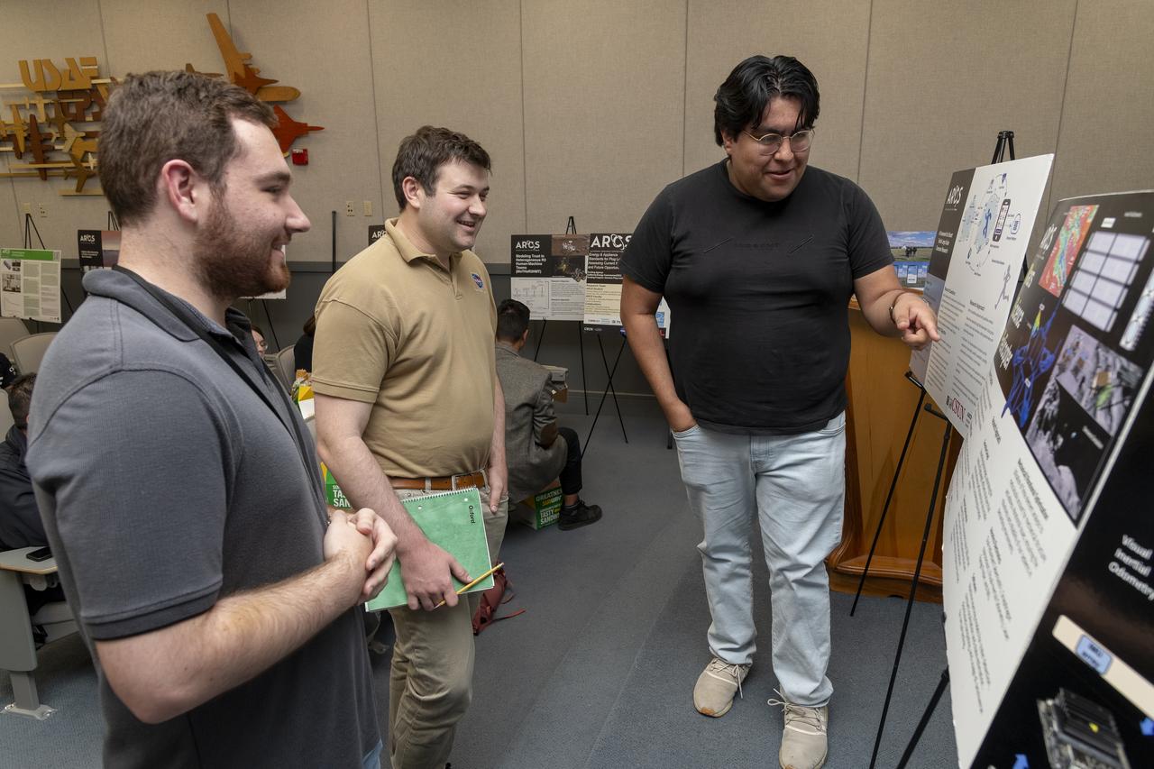
Two men from NASA’s Armstrong Flight Research Center in Edwards, California, ask Jared Carrillo, a student from the California State University, Northridge, Autonomy Research Center for science, technology, engineering, entrepreneurship, arts, humanities, and mathematics, about his work on the Mars Science Helicopter. Students displayed posters and answered questions about their technologies May 23 at the Air Force Test Pilot School auditorium on Edwards Air Force Base, California.
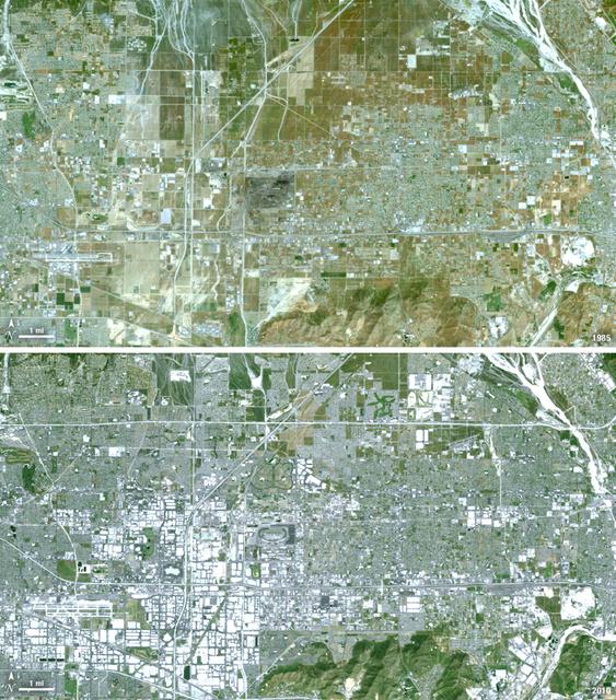
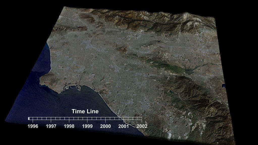
Thirty-five miles due east of downtown Los Angeles lies the city of Ontario, California. In 1881 two Canadian brothers established the town, naming it after their native city. By 1891 Ontario, Calif., was incorporated as a city. The farming-based economy (olives, citrus, dairy) of the city helped it grow to 20,000 by the 1960s. Subsequently, warehousing and freight trafficking took over as the major industry and the city’s population was over 160,000 by 2010. The L.A./Ontario International Airport is now America’s 15th busiest cargo airport. In these natural color Landsat 5 images, the massive growth of the city between 1985 and 2010 can be seen. The airport, found in the southwest portion of the images, added a number of runways and large warehousing structures now dominate the once rural areas surrounding the airport. In these images vegetation is green and brown and urban structures are bright white and gray. (Note there is a large dry riverbed in the northeast corner that is also bright white, but its nonlinear appearance sets it apart visually). ---- NASA and the U.S. Department of the Interior through the U.S. Geological Survey (USGS) jointly manage Landsat, and the USGS preserves a 40-year archive of Landsat images that is freely available over the Internet. The next Landsat satellite, now known as the Landsat Data Continuity Mission (LDCM) and later to be called Landsat 8, is scheduled for launch in 2013. In honor of Landsat’s 40th anniversary in July 2012, the USGS released the LandsatLook viewer – a quick, simple way to go forward and backward in time, pulling images of anywhere in the world out of the Landsat archive. <b><a href="http://www.nasa.gov/audience/formedia/features/MP_Photo_Guidelines.html" rel="nofollow">NASA image use policy.</a></b> <b><a href="http://www.nasa.gov/centers/goddard/home/index.html" rel="nofollow">NASA Goddard Space Flight Center</a></b> enables NASA’s mission through four scientific endeavors: Earth Science, Heliophysics, Solar System Exploration, and Astrophysics. Goddard plays a leading role in NASA’s accomplishments by contributing compelling scientific knowledge to advance the Agency’s mission. <b>Follow us on <a href="http://twitter.com/NASA_GoddardPix" rel="nofollow">Twitter</a></b> <b>Like us on <a href="http://www.facebook.com/pages/Greenbelt-MD/NASA-Goddard/395013845897?ref=tsd" rel="nofollow">Facebook</a></b> <b>Find us on <a href="http://instagrid.me/nasagoddard/?vm=grid" rel="nofollow">Instagram</a></b>

Space shuttle Endeavour and its host NASA 747 Shuttle Carrier Aircraft fly over the Los Angeles Coliseum in 2012 on its way to the Los Angeles International Airport, and an overland journey to the California Science Center. Californians looked up at the morning sky Sept. 21 looking for Endeavour over their community. The final leg of Endeavour’s flight from NASA’s Kennedy Space Center, Florida, offered many people an opportunity to witness the historic flight.
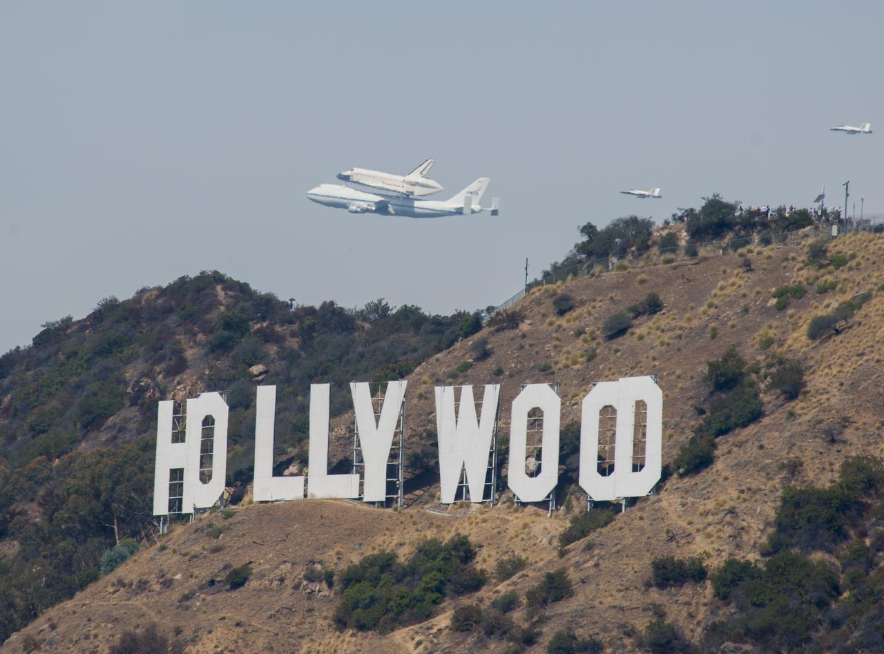
Space shuttle Endeavour and its host NASA 747 Shuttle Carrier Aircraft fly over the Hollywood sign in 2012 on its way to the Los Angeles International Airport, and an overland journey to the California Science Center. Californians looked up at the morning sky Sept. 21 looking to see Endeavour fly over their community. The final leg of Endeavour’s flight from NASA’s Kennedy Space Center, Florida, offered many people an opportunity to witness the historic flight.

Space shuttle Endeavour and its host NASA 747 Shuttle Carrier Aircraft fly by the Bay Bridge in 2012 on its way to the Los Angeles International Airport and an overland journey to the California Science Center. The final leg of Endeavour’s flight from NASA’s Kennedy Space Center, Florida, offered many people an opportunity to witness the historic flight.

Space shuttle Endeavour and its host NASA 747 Shuttle Carrier Aircraft fly over the Santa Monica Pier in 2012 on its way to the Los Angeles International Airport, and an overland journey to the California Science Center. Californians gazed at the morning sky Sept. 21 looking for Endeavour over their community. The final leg of Endeavour’s flight from NASA’s Kennedy Space Center, Florida, offered many people an opportunity to witness the historic flight.
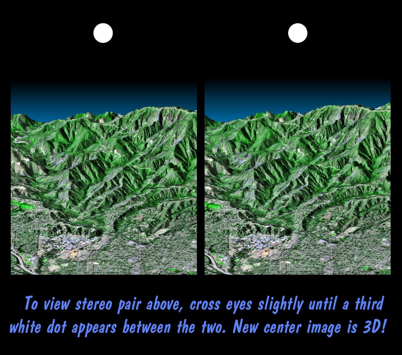
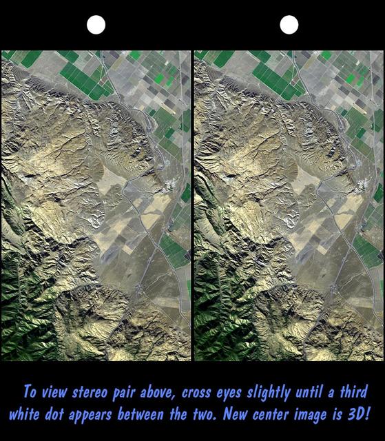
This stereoscopic image pair is a perspective view that shows the western part of the city of Pasadena, California, looking north toward the San Gabriel Mountains. Portions of the cities of Altadena and La Canada Flintridge are also shown.

This infrared image from NASA Wide-field Infrared Survey Explorer features one of the bright stars in the constellation Perseus, named Menkhib, along with a large star forming cloud commonly called the California Nebula.
In northern California, east of Mt. Shasta, the footprints of clear-cut logging activities are evident in this ASTER image. Newer logged-out parcels are brighter blue-green. Where secondary growth has started, the logged tracts appear "fuzzy." Note that some of the logged-out tracts are located within the Shasta National Forest. The image was acquired July 2, 2018, covers an area of 37 by 56.5 kilometers, and is located at 42.5 degrees north, 122 degrees west. https://photojournal.jpl.nasa.gov/catalog/PIA22613
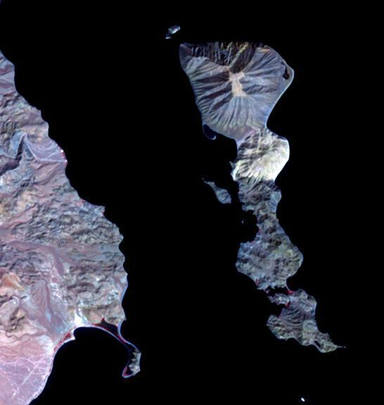
Located in the Gulf of California, Smith Island sits just off the eastern shore of Mexico's Baja Peninsula. The 7 kilometers long island is dominated by Volcan Coronado on the northern end. The uninhabited island is a refuge for a rich marine assemblage, including sea lion colonies. The image was acquired September 23, 2023, covers an area of 8.2 by 9.5 km, and is located at 29.1 degrees north, 113.5 degrees west. https://photojournal.jpl.nasa.gov/catalog/PIA26284
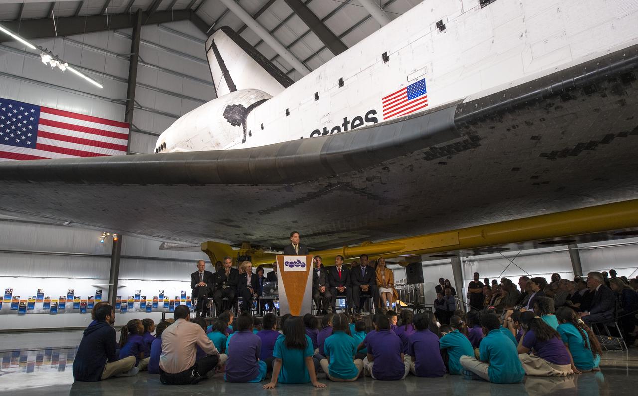
President and CEO of the California Science Center Jeffrey N. Rudolph speaks from a podium underneath the space shuttle Endeavour during the grand opening ceremony for the center's Samuel Oschin Space Shuttle Endeavour Display Pavilion, Tuesday, Oct. 30, 2012, in Los Angeles. Endeavour, built as a replacement for space shuttle Challenger, completed 25 missions, spent 299 days in orbit, and orbited Earth 4,671 times while traveling 122,883,151 miles. Photo Credit: (NASA/Bill Ingalls)
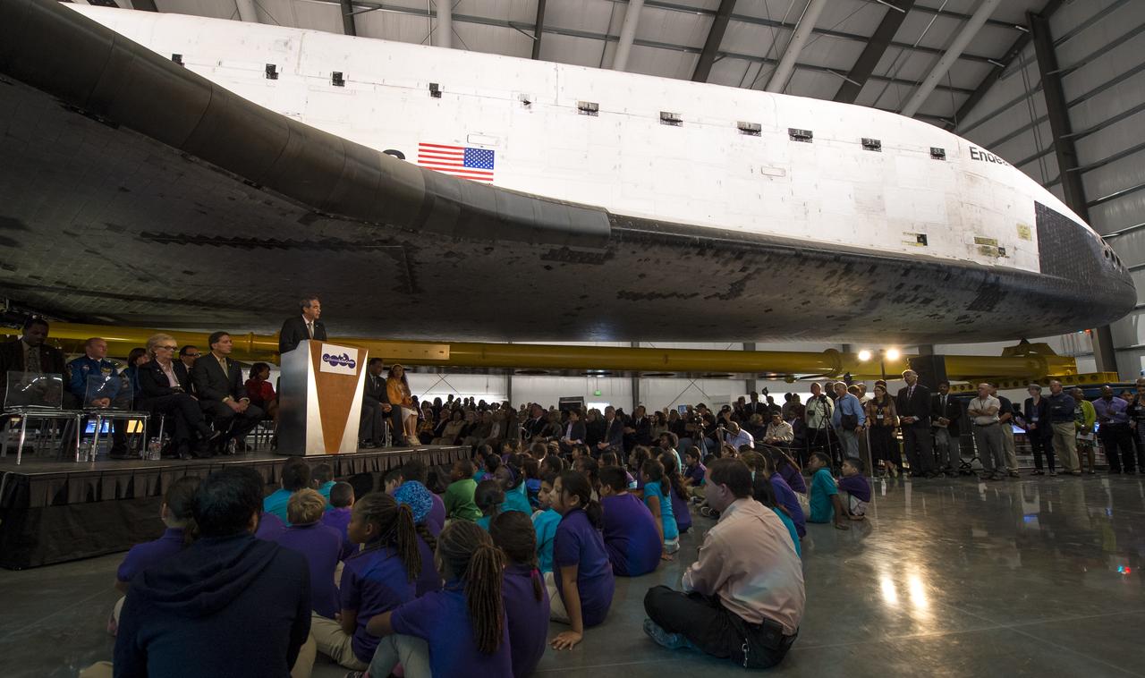
David D. McBride, director of NASA's Dryden Flight Research Center, speaks from a podium underneath the space shuttle Endeavour during the grand opening ceremony for the California Science center's Samuel Oschin Space Shuttle Endeavour Display Pavilion, Tuesday, Oct. 30, 2012, in Los Angeles. Endeavour, built as a replacement for space shuttle Challenger, completed 25 missions, spent 299 days in orbit, and orbited Earth 4,671 times while traveling 122,883,151 miles. Photo Credit: (NASA/Bill Ingalls)

A police officer is seen underneath the wing of the space shuttle Endeavour during the grand opening ceremony for the California Science center's Samuel Oschin Space Shuttle Endeavour Display Pavilion, Tuesday, Oct. 30, 2012, in Los Angeles. Endeavour, built as a replacement for space shuttle Challenger, completed 25 missions, spent 299 days in orbit, and orbited Earth 4,671 times while traveling 122,883,151 miles. Photo Credit: (NASA/Bill Ingalls)

Mayor of Los Angeles Antonio Villaraigosa addresses a class of fourth graders during the grand opening ceremony for the California Science center's Samuel Oschin Space Shuttle Endeavour Display Pavilion, Tuesday, Oct. 30, 2012, in Los Angeles. Endeavour, built as a replacement for space shuttle Challenger, completed 25 missions, spent 299 days in orbit, and orbited Earth 4,671 times while traveling 122,883,151 miles. Photo Credit: (NASA/Bill Ingalls)
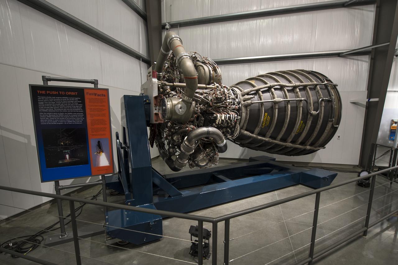
A space shuttle main engine (SSME) is on display near the space shuttle Endeavour at the California Science center's Samuel Oschin Space Shuttle Endeavour Display Pavilion, Tuesday, Oct. 30, 2012, in Los Angeles. Endeavour, built as a replacement for space shuttle Challenger, completed 25 missions, spent 299 days in orbit, and orbited Earth 4,671 times while traveling 122,883,151 miles. Photo Credit: (NASA/Bill Ingalls)

David D. McBride, director of NASA's Dryden Flight Research Center, speaks from a podium underneath the space shuttle Endeavour during the grand opening ceremony for the California Science center's Samuel Oschin Space Shuttle Endeavour Display Pavilion, Tuesday, Oct. 30, 2012, in Los Angeles. Endeavour, built as a replacement for space shuttle Challenger, completed 25 missions, spent 299 days in orbit, and orbited Earth 4,671 times while traveling 122,883,151 miles. Photo Credit: (NASA/Bill Ingalls)

President and CEO of the California Science Center Jeffrey N. Rudolph speaks from a podium underneath the space shuttle Endeavour during the grand opening ceremony for the center's Samuel Oschin Space Shuttle Endeavour Display Pavilion, Tuesday, Oct. 30, 2012, in Los Angeles. Endeavour, built as a replacement for space shuttle Challenger, completed 25 missions, spent 299 days in orbit, and orbited Earth 4,671 times while traveling 122,883,151 miles. Photo Credit: (NASA/Bill Ingalls)

Members of the Debbie Allen Dance Academy perform “Men in Black” choreographed by the legendary Debbie Allen during the grand opening ceremony for the California Science center's Samuel Oschin Space Shuttle Endeavour Display Pavilion, Tuesday, Oct. 30, 2012, in Los Angeles. Endeavour, built as a replacement for space shuttle Challenger, completed 25 missions, spent 299 days in orbit, and orbited Earth 4,671 times while traveling 122,883,151 miles. Photo Credit: (NASA/Bill Ingalls)
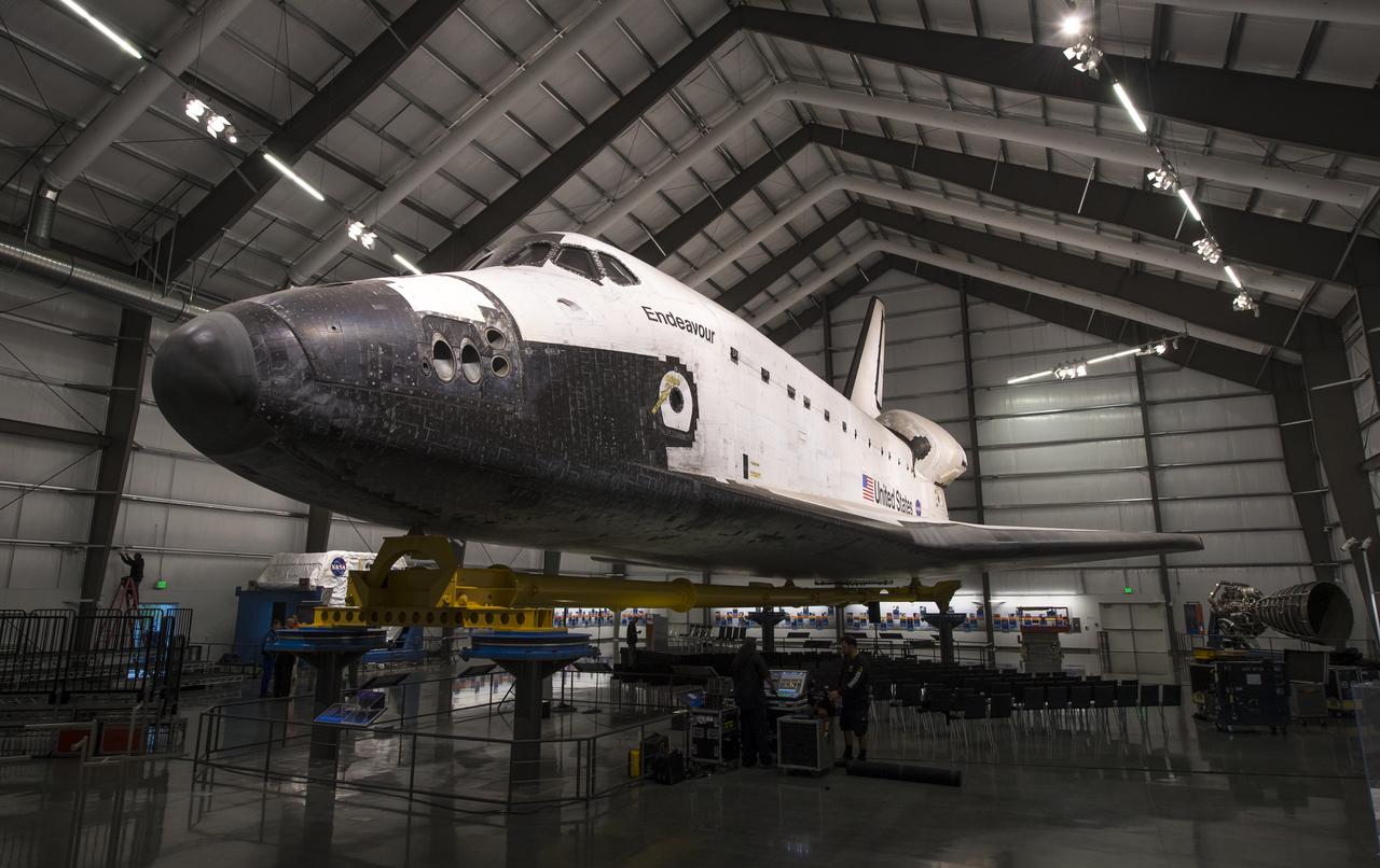
The space shuttle Endeavour is seen as workers prepare for the grand opening ceremony for the California Science center's Samuel Oschin Space Shuttle Endeavour Display Pavilion, Tuesday, Oct. 30, 2012, in Los Angeles. Endeavour, built as a replacement for space shuttle Challenger, completed 25 missions, spent 299 days in orbit, and orbited Earth 4,671 times while traveling 122,883,151 miles. Photo Credit: (NASA/Bill Ingalls)

California has been hit hard the past few weeks with storms. Storms bring lightning and lightning strikes cause wildfires. Currently there are at least five fire complexes in the area including River, Fork, South, Route and Mad River. The Mad River complex is a series of seven lightning fires that started on July 30th, 2015 after a lightning storm moved through Northern California. After initial firefighters responded, 25 fires were reported and most of the fires were contained. Some additional fires might be detected from the original lightning storms in the upcoming days and will be attacked once they are found. Damage assessment is ongoing and crews will determine the extent of structures and equipment damaged or destroyed. The River Complex is managing a total of 5 fires due to fires merging together on the Shasta-Trinity and the Six Rivers National Forests. Winds from the west are expected to lift the inversion today resulting in active fire behavior. The Fork Complex consists of over 40 fires, all of which were ignited by lightning between July 29 and 31, 2015. These fires are still being identified, assessed, and prioritized. Updated acreage and information about specific fires will be published as it is known. Fire activity moderated throughout last night (8/4) with the smoke inversion layer remaining in place today. Hopefully this will create favorable conditions for fire crews to take direct fire attack on the fires edge, construct dozer line and scout for best firefighting locations on all fires in the complex. The South Complex consists of approximately nine known fires, five of which are currently over 100 acres. The fires are active and defense of structures and point protection are in progress. The weather is trapping smoke in the valley causing very poor air quality. As the smoke lifts the fire activity increases. Firefighters will continue to provide point protection on structures and to look for opportunities to build direct and indirect containment lines. The Route Complex currently stands at 12,164 acres from seven separate fires and is at 2% containment. The overall acreage has been reduced because the South Fire on the nearby South Complex is merging with the Johnson Fire in the Route Complex resulting in decreased and revised fire perimeter acreage. This natural-color satellite image collected by the Moderate Resolution Imaging Spectroradiometer (MODIS) aboard the Terra satellite shows smoke rising and drifting northwest from the various fire complexes. It was captured on August 04, 2015. Actively burning areas, detected by MODIS’s thermal bands, are outlined in red. NASA image courtesy Jeff Schmaltz, MODIS Rapid Response Team. <b><a href="http://www.nasa.gov/audience/formedia/features/MP_Photo_Guidelines.html" rel="nofollow">NASA image use policy.</a></b> <b><a href="http://www.nasa.gov/centers/goddard/home/index.html" rel="nofollow">NASA Goddard Space Flight Center</a></b> enables NASA’s mission through four scientific endeavors: Earth Science, Heliophysics, Solar System Exploration, and Astrophysics. Goddard plays a leading role in NASA’s accomplishments by contributing compelling scientific knowledge to advance the Agency’s mission. <b>Follow us on <a href="http://twitter.com/NASAGoddardPix" rel="nofollow">Twitter</a></b> <b>Like us on <a href="http://www.facebook.com/pages/Greenbelt-MD/NASA-Goddard/395013845897?ref=tsd" rel="nofollow">Facebook</a></b> <b>Find us on <a href="http://instagrid.me/nasagoddard/?vm=grid" rel="nofollow">Instagram</a></b>
This image shows Death Valley, California, centered at 36.629 degrees north latitude, 117.069 degrees west longitude.
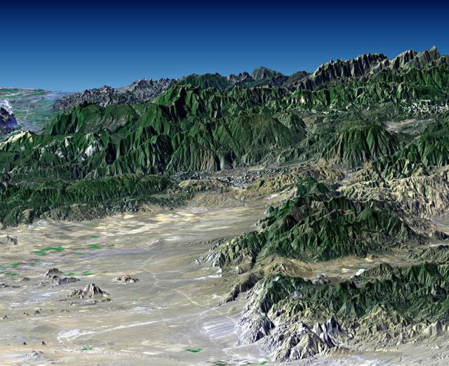
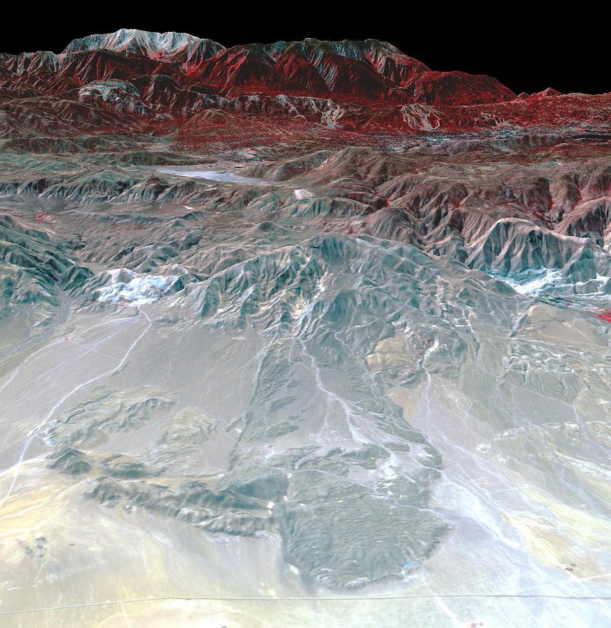
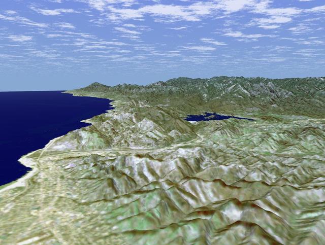
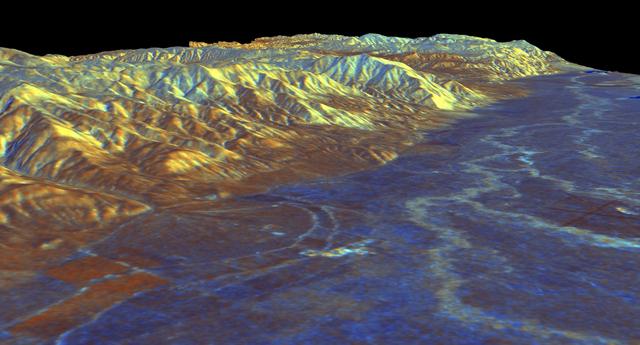
![The diversity of landforms that make up the state of California is evident in this new [sic] rendition of the 3-D topography of the state.](https://images-assets.nasa.gov/image/PIA03333/PIA03333~medium.jpg)
The diversity of landforms that make up the state of California is evident in this new [sic] rendition of the 3-D topography of the state.
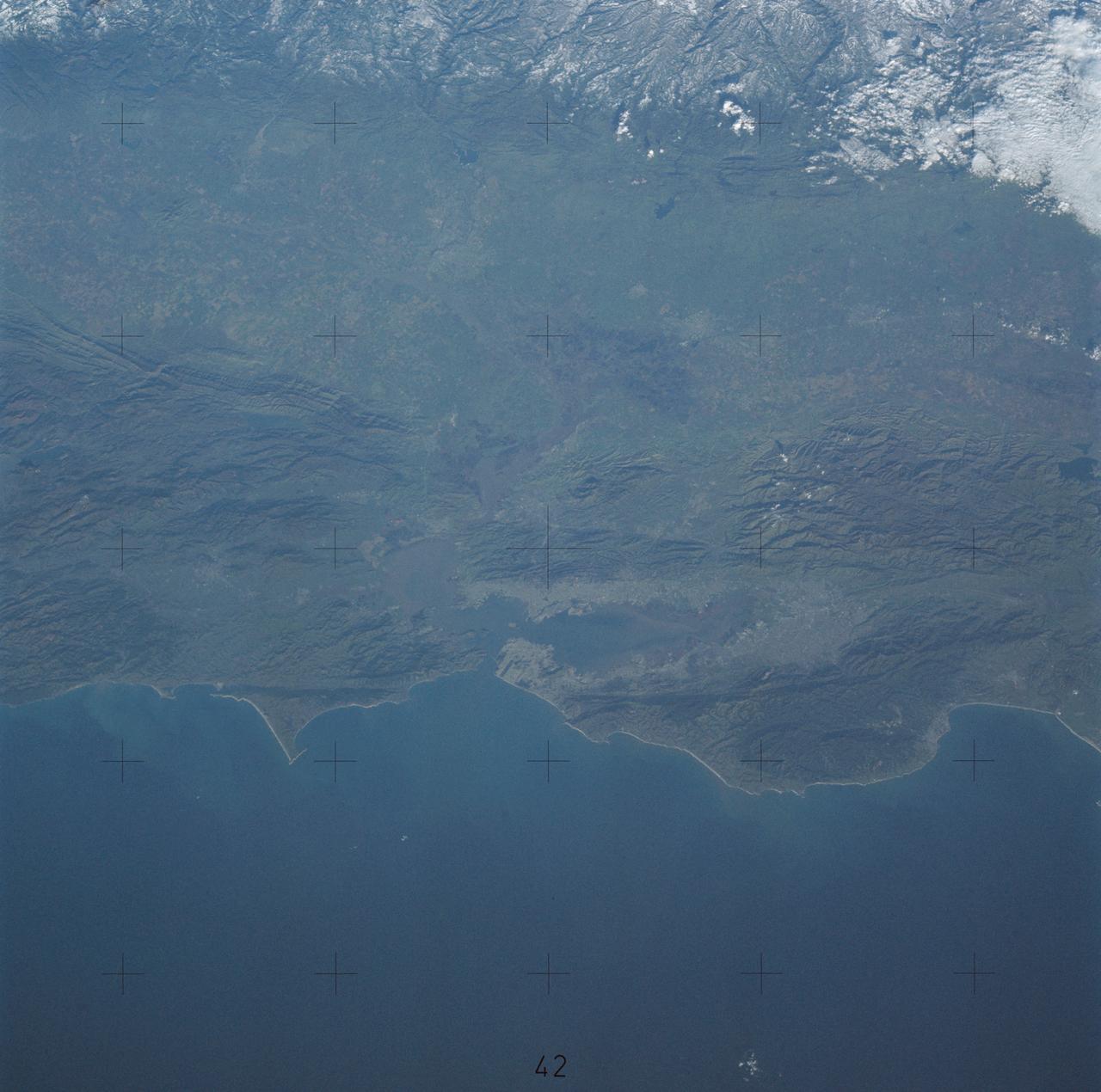
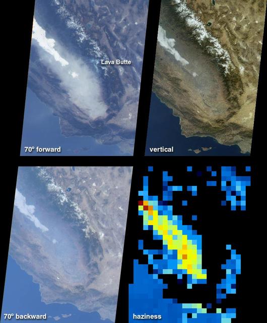
Southern California dramatic topography plays acritical role in its climate, hydrology, ecology, agriculture, and habitability.
![The diversity of landforms that make up the state of California is evident in this new [sic] rendition of the 3-D topography of the state.](https://images-assets.nasa.gov/image/PIA03347/PIA03347~medium.jpg)
The diversity of landforms that make up the state of California is evident in this new [sic] rendition of the 3-D topography of the state.
Wheeler Ridge and vicinity, California, is a site of major tectonic activity, both historically and over recent geologic time.
STS062-153-226 (4-18 March 1994) --- Though it did not reproduce well, this photo gives scientific information to aid in studying all types of earth's processes. It documents ocean features in the sunglint in the Gulf of California, off the Isla Cerralvo, souther Baja, California. Biological oils collect on the surface and shows current patterns, eddies and ship wakes. The small bright spot on the edge of the eddy is a ship dumping oily water from its bilges. The line in the brighter area is a light wind gust roughening the surface.
The Blackhawk landslide, Lucerne Valley, California, is a lobe of marble breccia, 10 to 30 m thick, 3 km wide, and nearly 8 km long. Geologic evidence shows that the rockslide came down the gently inclined slope as a nearly monolithic sheet moving more than 100 km per hour. The accepted hypothesis is that the slide was lubricated by a layer of compressed air. At least two earlier similar but smaller rockslides have occurred in the area. The south-looking perspective view image was acquired on September 22, 2014, and is located at 34.4 degrees north, 116.7 degrees west. http://photojournal.jpl.nasa.gov/catalog/PIA21008
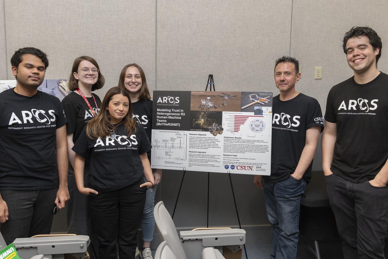
Six students from the California State University, Northridge, Autonomy Research Center for science, technology, engineering, entrepreneurship, arts, humanities, and mathematics spoke about their Trust in Autonomy technology. The students from left are Aniket Christi, Julia Spencer, Dana Bellinger, Zulma Lopez Rodriguez, front, Jordan Jannone, and Samuel Mercado. The group answered questions about their technology May 23 at the Air Force Test Pilot School auditorium on Edwards Air Force Base, California.
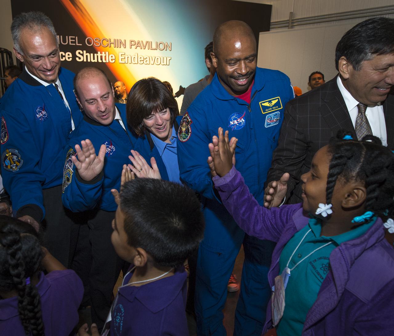
NASA Astronauts, from left, Danny Olivas, Garrett Reisman, Barbara Morgan, and, NASA Associate Administrator for Education and Astronaut, Leland Melvin give high fives to school children as they enter the California Science center's Samuel Oschin Space Shuttle Endeavour Display Pavilion, Tuesday, Oct. 30, 2012, in Los Angeles. Endeavour, built as a replacement for space shuttle Challenger, completed 25 missions, spent 299 days in orbit, and orbited Earth 4,671 times while traveling 122,883,151 miles. Photo Credit: (NASA/Bill Ingalls)
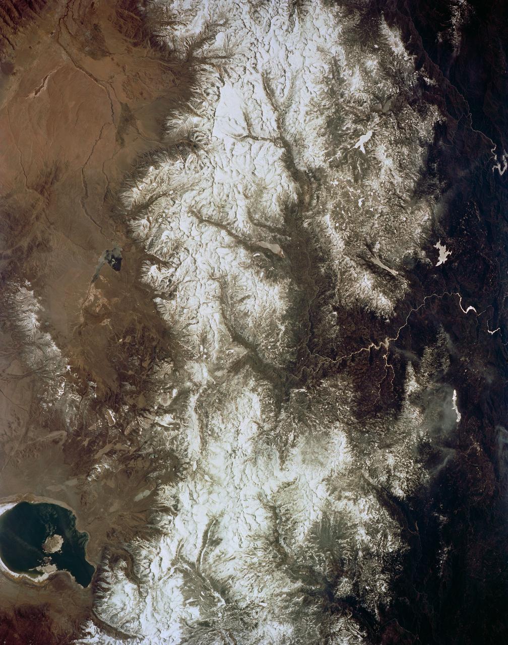
STS059-154-160 (9-20 April 1994) --- Orient with Mono Lake, California at the lower right; then the view is westward across the Sierra Nevada into the San Joaquin River drainage. A tiny network of ski trails can be seen on the Mono Lake side of the Sierras, on a line between Mono Lake and the snow-free San Joaquin headwaters. The ski trails mark Mammoth Mountain, where SRL investigators are studying microwave measurements of the water content of snowpacks. Linhof camera.
This image from NASA Terra spacecraft shows Shasta Lake in northern California, which has an area of 12,000 ha, making it the state largest reservoir. Impacts of the continuing drought in the western US is evident in the two ASTER images acquired 9 years apart. The images were acquired September 9, 2005 and September 2, 2014. They cover an area of 27.6 x 40.4 km, and are located at 40.6 degrees north, 122.4 degrees west. http://photojournal.jpl.nasa.gov/catalog/PIA19492
This image is of Ventura, California, one of this state oldest cities, and Lake Casitas, California. NASA Shuttle Radar Topography Mission SRTM acquired this data on February 16, 2000.

iss073e0272502 (June 4, 2025) --- The Gulf of California splits the Mexican states of Baja California (top) and Sonora in this photograph from the International Space Station as it orbited 260 miles above the Pacific Ocean.

Vocalist James Ingram sings "I Believe I Can Fly" from underneath the space shuttle Endeavour during the grand opening ceremony for the California Science center's Samuel Oschin Space Shuttle Endeavour Display Pavilion, Tuesday, Oct. 30, 2012, in Los Angeles. Endeavour, built as a replacement for space shuttle Challenger, completed 25 missions, spent 299 days in orbit, and orbited Earth 4,671 times while traveling 122,883,151 miles. Photo Credit: (NASA/Bill Ingalls)
SL4-138-3843 (1 Jan. 1974) --- A part of northern California centered near San Francisco Bay photographed at 3 p.m. Jan. 2, 1974, from the Skylab space station in Earth orbit. This near vertical view encompasses the coastline from Monterey Bay (right) to about 50 miles north of Point Reyes (left) and includes, from bottom to top, San Francisco Bay (center), Sacramento Valley (left center), San Joaquin Valley (right center), and the snow-covered Sierra Nevada. Afternoon shadows sharply delineate a valley which parallels San Francisco Bay, crosses Point Reyes, and lies between the Bay and the Pacific coastline. This valley marks the location of the San Andreas Fault, a major break in the Earth's crust. Forces acting on the crust are causing the land west (bottom) of the fault line to move north relative to land on the east side. The Skylab 4 astronauts photographed major fault zones in South America, New Zealand, Japan and Africa for use in the study of worldwide tectonic system. Agricultural areas in the Sacramento and San Joaquin Valleys are indicated by the tan areas which are easily discerned in contrast to the green-gray background. Photo credit: NASA

This anaglyph, from NASA Shuttle Radar Topography Mission, shows Wheeler Ridge and vicinity, California, a site of major tectonic activity. 3D glasses are necessary to view this image.
On May 30, 2013, NASA Terra spacecraft acquired this image of the largest solar plant of its kind in the world started producing power in southern California Mojave Desert near the Nevada border.
This image is a false-color composite of the Mammoth Mountain area in the Sierra Nevada Mountains, California. The image is centered at 37.6 degrees north latitude and 119.0 degrees west longitude.
The effects of California severe multiyear drought are seen in this pair of images acquired by NASA Terra spacecraft of the area northeast of Madera, in the Sierra Nevada Moutains foothills between Yosemite National Park and the San Joaquin Valley
Southern California Santa Anas are dry, north-easterly winds having speeds in excess of 25 knots 46 kilometers/hour. Santa Ana conditions are commonly associated with gusts of more than twice this level.
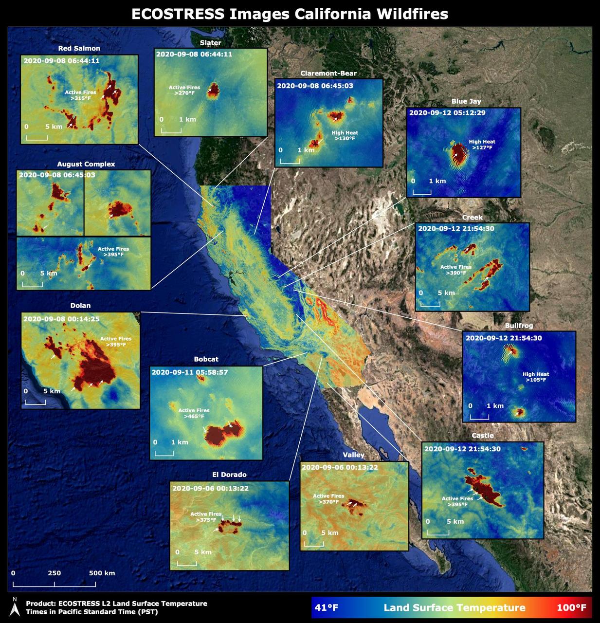
Throughout the month of September 2020, NASA's ECOsystem Spaceborne Thermal Radiometer Experiment on Space Station (ECOSTRESS) imaged multiple wildfires across the state of California. The image above shows the ECOSTRESS land surface temperature of California. Multiple insets highlight a fraction of the multiple fires that have impacted California, with effects seen throughout the U.S. and beyond. The dark red spots show areas of high heat, with arrows pointing out the active fires. The contiguous California image was stitched together from multiple evening (10 p.m.-6 a.m. PDT) ECOSTRESS images from Sept 6 to 12, 2020, to generate a cloud-free statewide map. NASA's Jet Propulsion Laboratory in Southern California built and manages the ECOSTRESS mission for the Earth Science Division in the Science Mission Directorate at NASA Headquarters in Washington. ECOSTRESS is an Earth Venture Instrument mission; the program is managed by NASA's Earth System Science Pathfinder program at NASA's Langley Research Center in Hampton, Virginia. Future studies could use ECOSTRESS data products in a similar fashion as LST was used to assess the fires pictured above. https://photojournal.jpl.nasa.gov/catalog/PIA23721

iss073e0865795 (Oct. 1, 2025) --- The Gulf of California, also known as the Sea of Cortez, separates mainland Mexico from the Baja California Peninsula in this photograph from the International Space Station as it orbited 261 miles above California. Geologically, it is Earth’s youngest sea, formed around 5 million years ago due to tectonic activity. In 2005, the Gulf was designated a UNESCO World Heritage Site in recognition of its unique oceanographic processes and extraordinary biodiversity.
STS059-L09-162 (9-20 April 1994) --- Orient with the snow-covered mountains (Sierra Nevada of California) in the upper right corner. Then Owens Valley runs along the top of the photograph to Owens Lake playa at top center. The upper end of Death Valley extends from right to left in the foreground, with the drainage running down to a playa at Stovepipe Wells in the left foreground. Geologists are studying microwave signatures of the different playa surfaces, and the coatings on alluvial fans that extend from mountain masses, to try to sort out the history of different climates in this formerly wet but now hyperarid region.
STS059-86-059 (9-20 April 1994) --- This oblique handheld Hasselblad 70mm photo shows Death Valley, near California's border with Nevada. The valley -- the central feature of Death Valley National Monument -- extends north to south for some 140 miles (225 kilometers). Hemmed in to the east by the Amargosa Range and to the west by the Panamints, its width varies from 5 to 15 miles (8 to 24 kilometers). Using Spaceborne Imaging Radar (SIR-C) and X-band Synthetic Aperture Radar (X-SAR) onboard the Space Shuttle Endeavour, the crew was able to record a great deal of data on this and other sites, as part of NASA's Mission to Planet Earth.
The Salton Sea in south California was created in 1905 when spring flooding on the Colorado River breached a canal. For 18 months the entire volume of the river rushed into the Salton Trough, creating a lake 32 km wide and 72 km long. In the 1950s, resorts sprang up along the shores. However, shrinking of the lake and increased salinity led to the abandonment of the resorts. The two images show the shrinking lake on May 31, 1984 (Landsat) and June 14, 2015 (ASTER). The images cover an area of 37.5 x 27 km, and are located at 33.2 degrees north, 115.7 degrees west. http://photojournal.jpl.nasa.gov/catalog/PIA19786
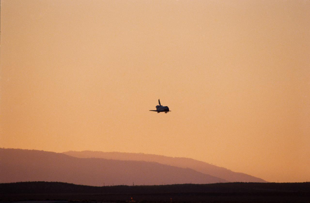
STS033-S-014 (27 Nov 1989) --- The Space Shuttle Discovery is silhouetted against late afternoon California skies as it approaches the runway for landing at Edwards Air Force Base in southern California. A five-member crew aboard was about to complete the DOD-devoted STS-33 mission. The landing occurred at 16:31:02 p.m. (PST), Nov. 27, 1989. Onboard Discovery for the mission were Astronauts Frederick D. Gregory, John E. Blaha, Kathryn C. Thornton, F. Story Musgrave and Manley L. Carter.

iss071e262729 (June 29, 2024) -- A sheet of clouds moves in over Baja California and the Gulf of California as the International Space Station soared 262 miles above.
This is a three-dimensional perspective view of Owens Valley, near the town of Bishop, California that was created by combining two spaceborne radar images using a technique known as interferometry.
This illustration features images of southern California and southwestern Nevada acquired by NASA Terra satellite on January 3, 2001 Terra orbit 5569.
51G-S-224 (24 June 1985) --- Discovery, with its seven-member 51-G crew aboard, touches down on a dry lakebed at Edwards Air Force Base in California. Landing was noted at 6:11:53 a.m. (PDT), June 24, 1985.
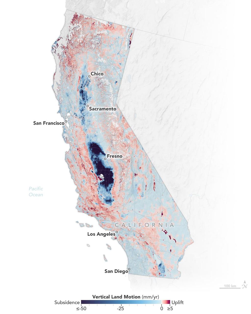
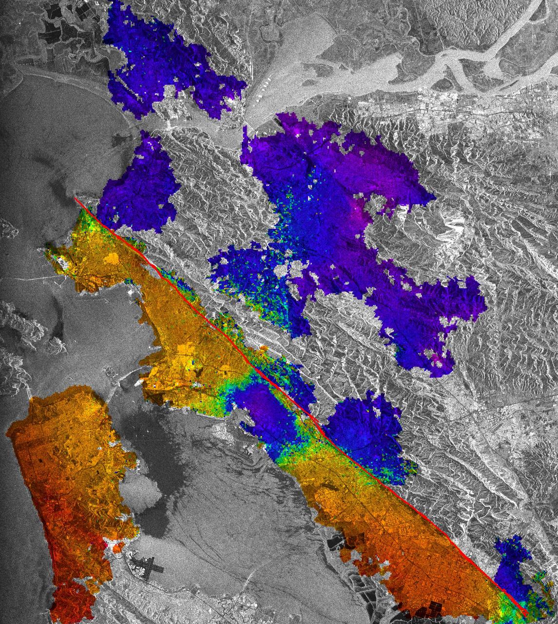
Researchers from NASA's Jet Propulsion Laboratory in Southern California and the National Oceanic and Atmospheric Administration (NOAA) analyzed vertical land motion – also known as uplift and subsidence – along the California coast between 2015 and 2023. They detailed where land beneath major coastal cities, including parts of San Francisco, Los Angeles, and San Diego, is sinking (indicated in blue in this visualization of the data). Locations of uplift (shown in red) were also observed. Causes for the motion include human-driven activities such as groundwater withdrawal and wastewater injection as well as natural dynamics like tectonic activity. Understanding these local elevation changes can help communities adapt to rising sea levels in their area. The researchers pinpointed hot spots – including cities, beaches, and aquifers – at greater exposure to rising seas in coming decades. Sea level rise can exacerbate issues like nuisance flooding and saltwater intrusion. To gather the data, the researchers employed a remote sensing technique called interferometric synthetic aperture radar (InSAR), which combines two or more 3D observations of the same region to reveal surface motion down to fractions of inches. They used the radars on the ESA (European Space Agency) Sentinel-1 satellites, as well as motion velocity data from ground-based receiving stations in the Global Navigation Satellite System. https://photojournal.jpl.nasa.gov/catalog/PIA25530
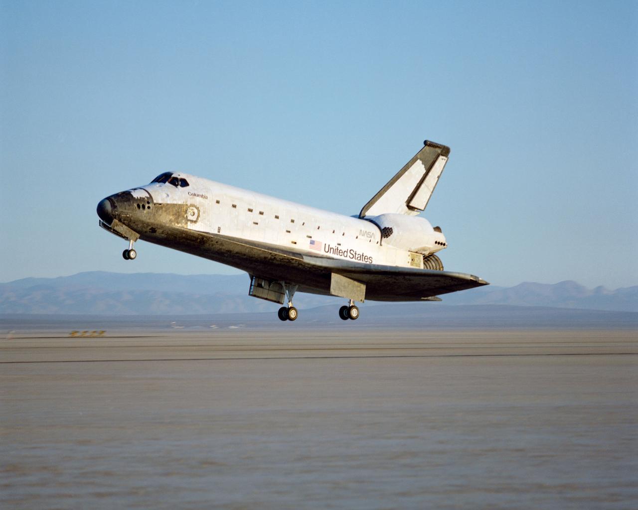
STS-28 Columbia, Orbiter Vehicle (OV) 102, approaches Runway 17 dry lake bed at Edwards Air Force Base (EAFB) California and is photographed just moments before main landing gear (MLG) touchdown. In the distance, are peaks of Southern California mountain range.