
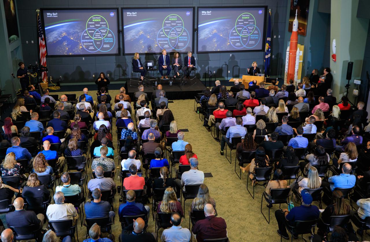
Robert Lightfoot, NASA Associate Adminstrator, delivers closing remarks at an Exploration Forum showcasing NASA's human exploration path to Mars in the James E. Webb Auditorium at NASA Headquarters on Tuesday, April 29, 2014. Photo Credit: (NASA/Joel Kowsky)

Randy Lillard, Program Executive for Technology Demonstration Missions of NASA's Space Technology Mission DIrectorate, speaks during an Exploration Forum showcasing NASA's human exploration path to Mars in the James E. Webb Auditorium at NASA Headquarters on Tuesday, April 29, 2014. Photo Credit: (NASA/Joel Kowsky)

David Miller, NASA Chief Technologist, participate in a panel discussion during an Exploration Forum showcasing NASA's human exploration path to Mars in the James E. Webb Auditorium at NASA Headquarters on Tuesday, April 29, 2014. Photo Credit: (NASA/Joel Kowsky)

NASA Administrator Charles Bolden speaks during an Exploration Forum showcasing NASA's human exploration path to Mars in the James E. Webb Auditorium at NASA Headquarters on Tuesday, April 29, 2014. Photo Credit: (NASA/Joel Kowsky)

NASA Administrator Charles Bolden speaks during an Exploration Forum showcasing NASA's human exploration path to Mars in the James E. Webb Auditorium at NASA Headquarters on Tuesday, April 29, 2014. Photo Credit: (NASA/Joel Kowsky)

Robert Lightfoot, NASA Associate Adminstrator, delivers closing remarks at an Exploration Forum showcasing NASA's human exploration path to Mars in the James E. Webb Auditorium at NASA Headquarters on Tuesday, April 29, 2014. Photo Credit: (NASA/Joel Kowsky)
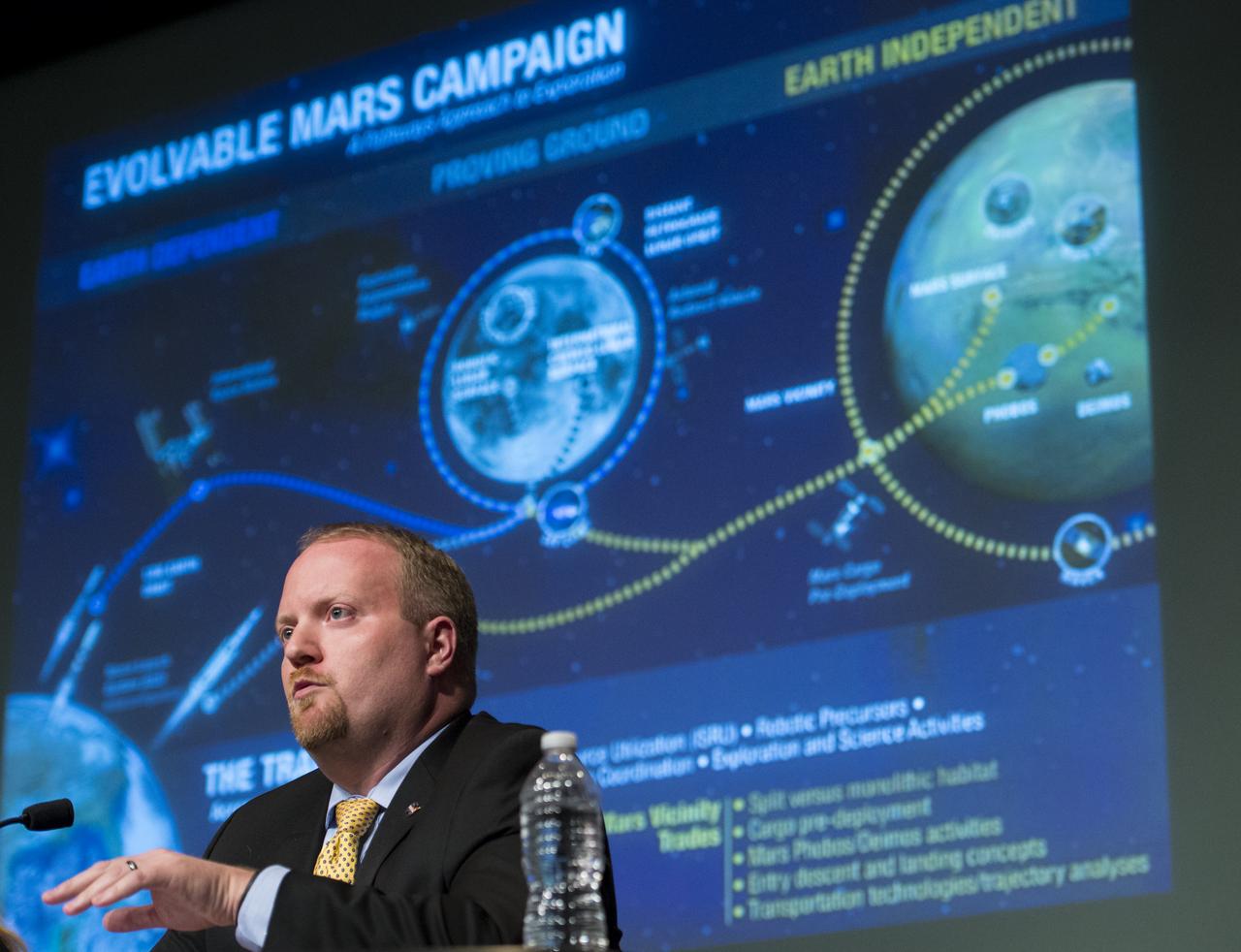
Jason Crusan, Director of NASA's Advanced Exploration Systems Division, speaks during an Exploration Forum showcasing NASA's human exploration path to Mars in the James E. Webb Auditorium at NASA Headquarters on Tuesday, April 29, 2014. Photo Credit: (NASA/Joel Kowsky)
John Grunsfeld, NASA Associate Administrator for the Science Mission Directorate, speaks during an Exploration Forum showcasing NASA's human exploration path to Mars in the James E. Webb Auditorium at NASA Headquarters on Tuesday, April 29, 2014. Photo Credit: (NASA/Joel Kowsky)

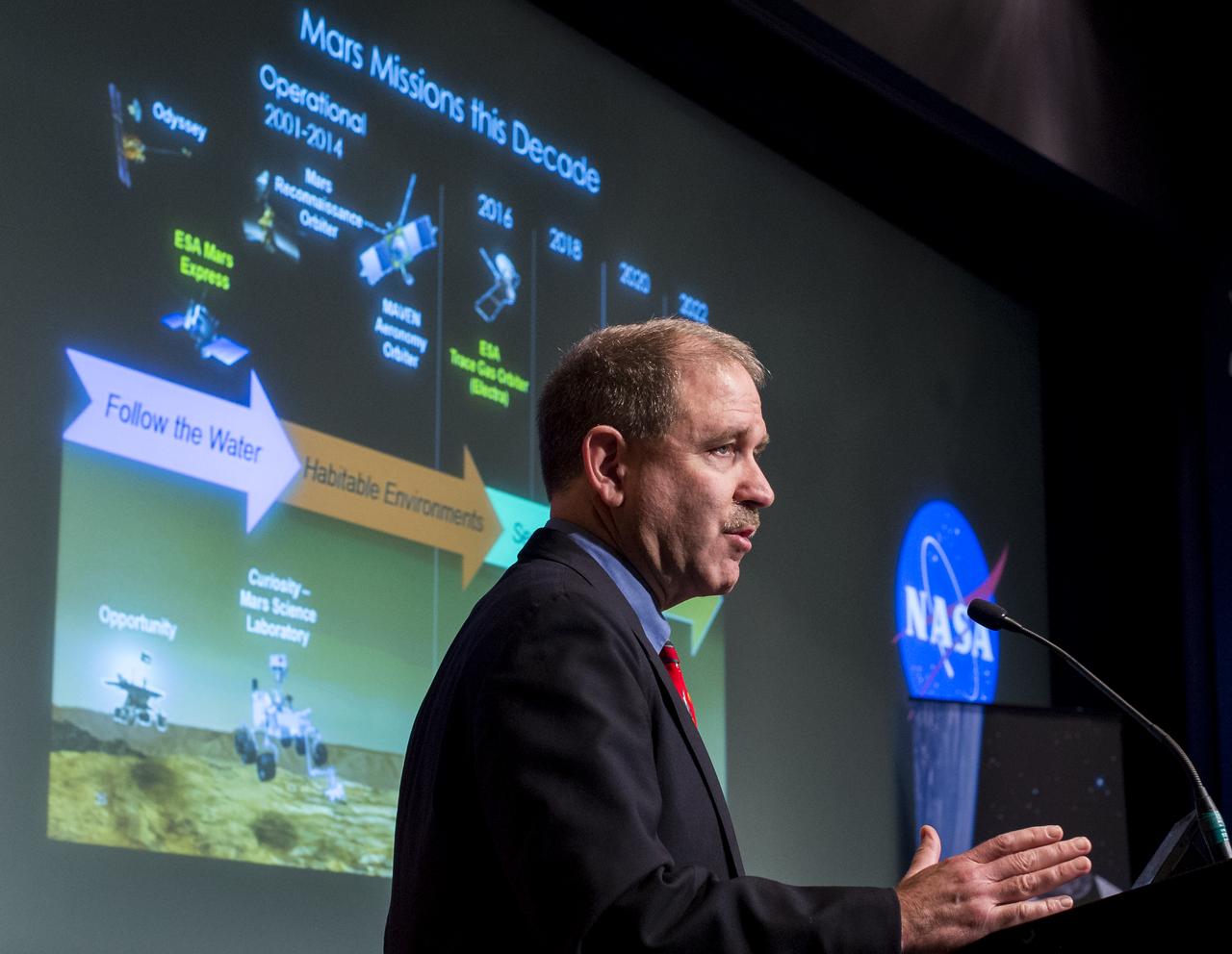
William Gerstenmaier, NASA Associate Administrator for Human Exploration and Operations, speaks during an Exploration Forum showcasing NASA's human exploration path to Mars in the James E. Webb Auditorium at NASA Headquarters on Tuesday, April 29, 2014. Photo Credit: (NASA/Joel Kowsky)

Sam Scimemi, Director of NASA's International Space Station Division, speaks during an Exploration Forum showcasing NASA's human exploration path to Mars in the James E. Webb Auditorium at NASA Headquarters on Tuesday, April 29, 2014. Photo Credit: (NASA/Joel Kowsky)
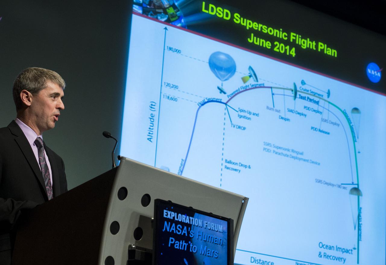
Randy Lillard, Program Executive for Technology Demonstration Missions of NASA's Space Technology Mission DIrectorate, speaks about the upcoming Low-Density Supersonic Decelerator demonstration during an Exploration Forum showcasing NASA's human exploration path to Mars in the James E. Webb Auditorium at NASA Headquarters on Tuesday, April 29, 2014. Photo Credit: (NASA/Joel Kowsky)
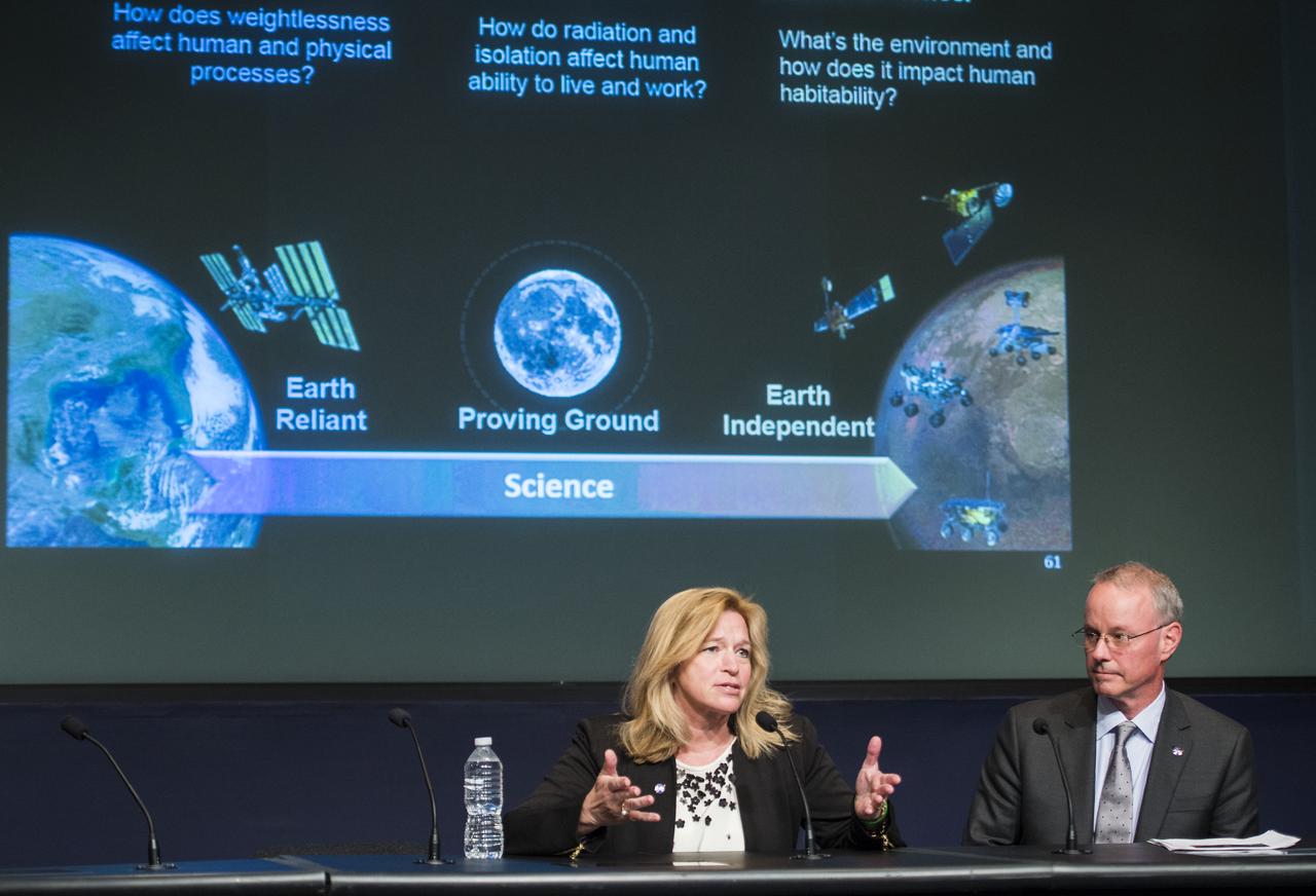
Ellen Stofan, NASA Chief Scientist, left, and David Miller, NASA Chief Technologist, right, participate in a panel discussion during an Exploration Forum showcasing NASA's human exploration path to Mars in the James E. Webb Auditorium at NASA Headquarters on Tuesday, April 29, 2014. Photo Credit: (NASA/Joel Kowsky)
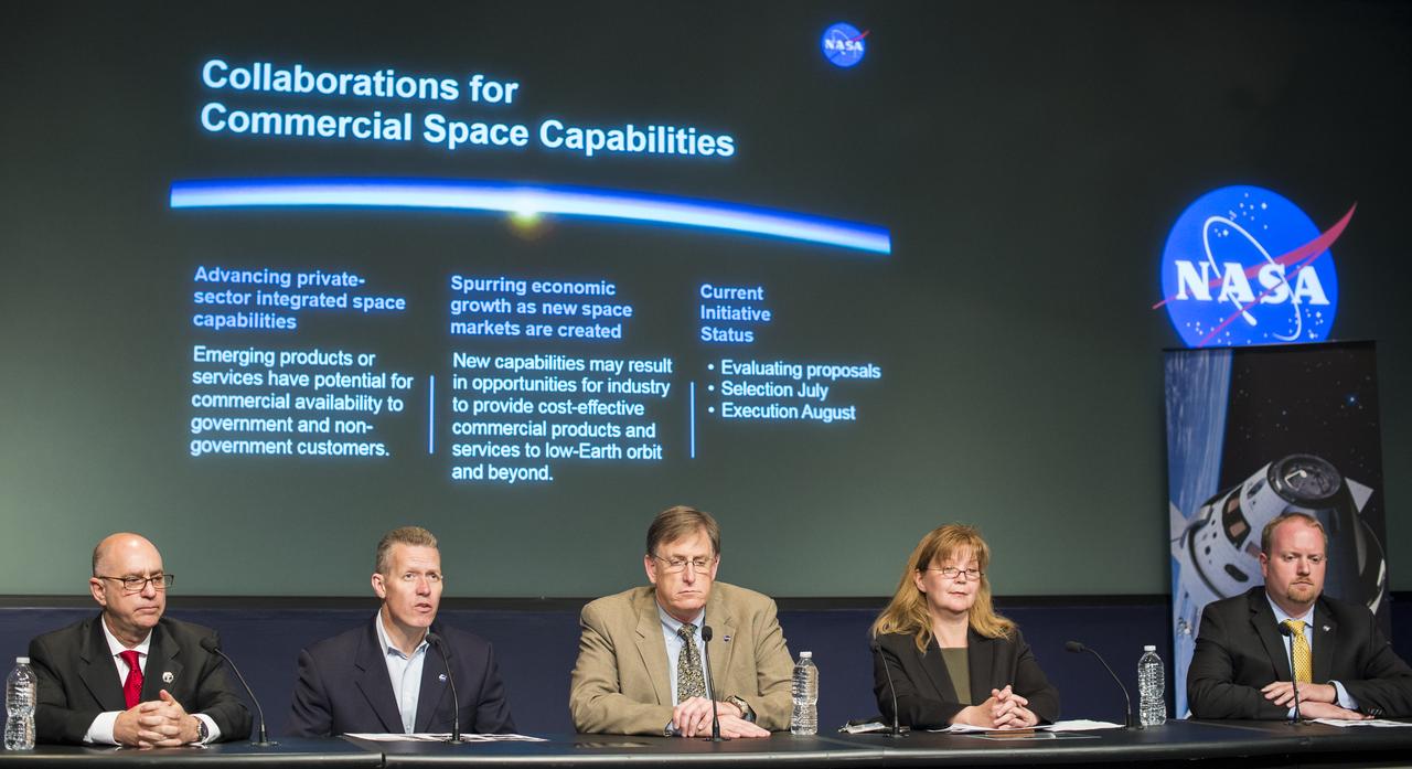
Sam Scimemi, Director of NASA's International Space Station Division, left, Phil McAlister, Director of NASA's Commercial Spaceflight Division, second from left, Dan Dumbacher, Deputy Associate Administrator of NASA's Exploration Systems Development, center, Michele Gates, Senior Technical Advisor of NASA's Human Exploration and Operations Mission Directorate, second from right, and Jason Crusan, Director of NASA's Advanced Exploration Systems Division, right, sit on a panel during an Exploration Forum showcasing NASA's human exploration path to Mars in the James E. Webb Auditorium at NASA Headquarters on Tuesday, April 29, 2014. Photo Credit: (NASA/Joel Kowsky)
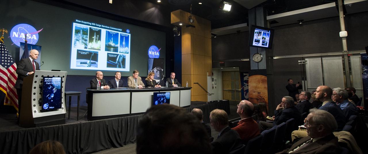
Sam Scimemi, Director of NASA's International Space Station Division, second from left, Phil McAlister, Director of NASA's Commercial Spaceflight Division, third from left, Dan Dumbacher, Deputy Associate Administrator of NASA's Exploration Systems Development, center, Michele Gates, Senior Technical Advisor of NASA's Human Exploration and Operations Mission Directorate, second from right, and Jason Crusan, Director of NASA's Advanced Exploration Systems Division, right, sit on a panel during an Exploration Forum showcasing NASA's human exploration path to Mars in the James E. Webb Auditorium at NASA Headquarters on Tuesday, April 29, 2014. Photo Credit: (NASA/Joel Kowsky)
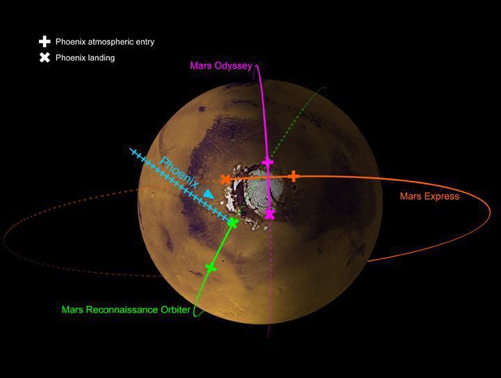
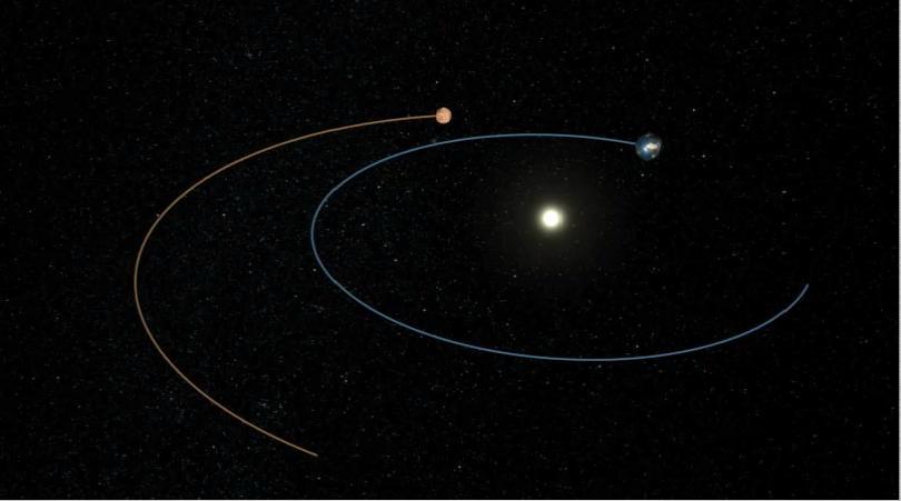
This image shows the paths of three spacecraft currently in orbit around Mars, as well as the path by which NASA Phoenix Mars Lander will approach and land on the planet.
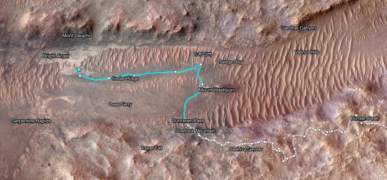
Superimposed on an image taken by the HiRISE camera aboard NASA's Mars Reconnaissance Orbiter, this map shows the path taken by the agency's Perseverance Mars rover between Jan. 31, 2024, and June 11, shortly after it arrived at a geologic area of interest the science team calls "Bright Angel." The route where the rover paralleled the Neretva Vallis river channel is depicted in white. The portion of the route where the rover was inside the river channel is depicted in pale blue. The dots along the white line signify locations where the rover stopped after completing a traverse. The University of Arizona, in Tucson, operates HiRISE, which was built by BAE Systems, in Boulder, Colorado. JPL manages the Mars Reconnaissance Orbiter Project for NASA's Science Mission Directorate, Washington. A key objective for Perseverance's mission on Mars is astrobiology, including the search for signs of ancient microbial life. The rover will characterize the planet's geology and past climate, pave the way for human exploration of the Red Planet, and be the first mission to collect and cache Martian rock and regolith (broken rock and dust). Subsequent NASA missions, in cooperation with ESA (European Space Agency), would send spacecraft to Mars to collect these sealed samples from the surface and return them to Earth for in-depth analysis. https://photojournal.jpl.nasa.gov/catalog/PIA26334
NASA's Ingenuity Mars Helicopter's fourth flight path is superimposed here atop terrain imaged by the HiRISE camera aboard the agency's Mars Reconnaissance Orbiter. https://photojournal.jpl.nasa.gov/catalog/PIA24629
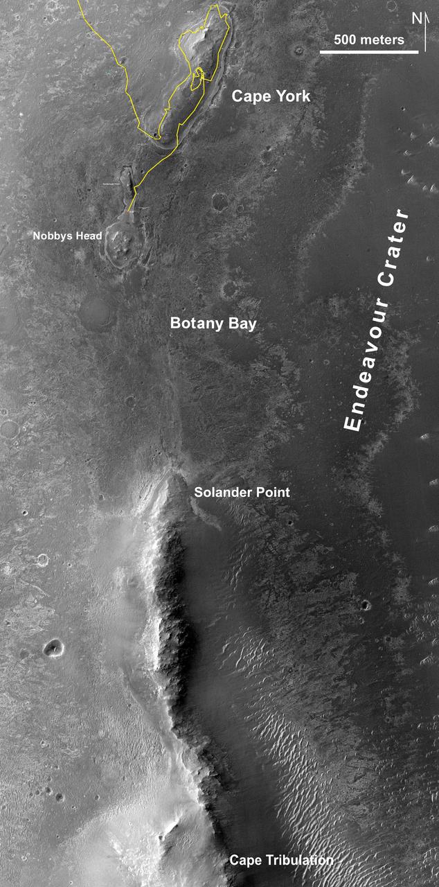
This map of a portion of the western rim of Endeavour Crater on Mars shows the path of NASA Mars Exploration Rover Opportunity as the rover is driving from the Cape York segment of the rim to its next destination, the Solander Point segment.
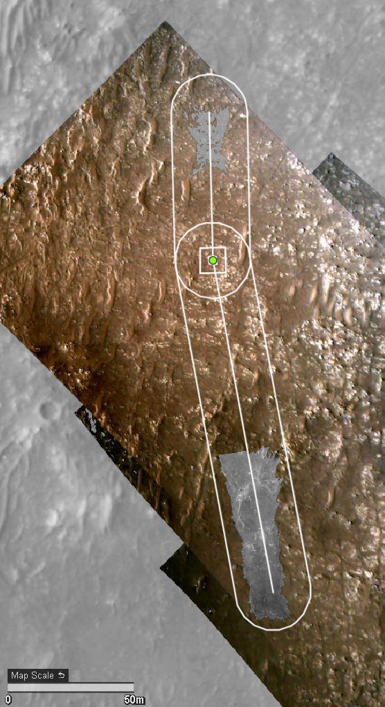
A section of NASA Mars Science Laboratory Gale Crater landing site is shown, with a representative path from the landing location toward the layered mound to the south.
This image taken from orbit shows the path driven by NASA Mars Exploration Rover Opportunity in the weeks around the rover arrival at the rim of Endeavour crater.
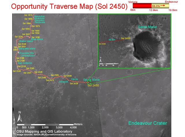
This map shows the path that NASA Mars Exploration Rover Opportunity followed from the 1,813th Martian day, or sol, to Sol 2450 Dec. 15, 2010 when Opportunity approached a crater informally named Santa Maria.
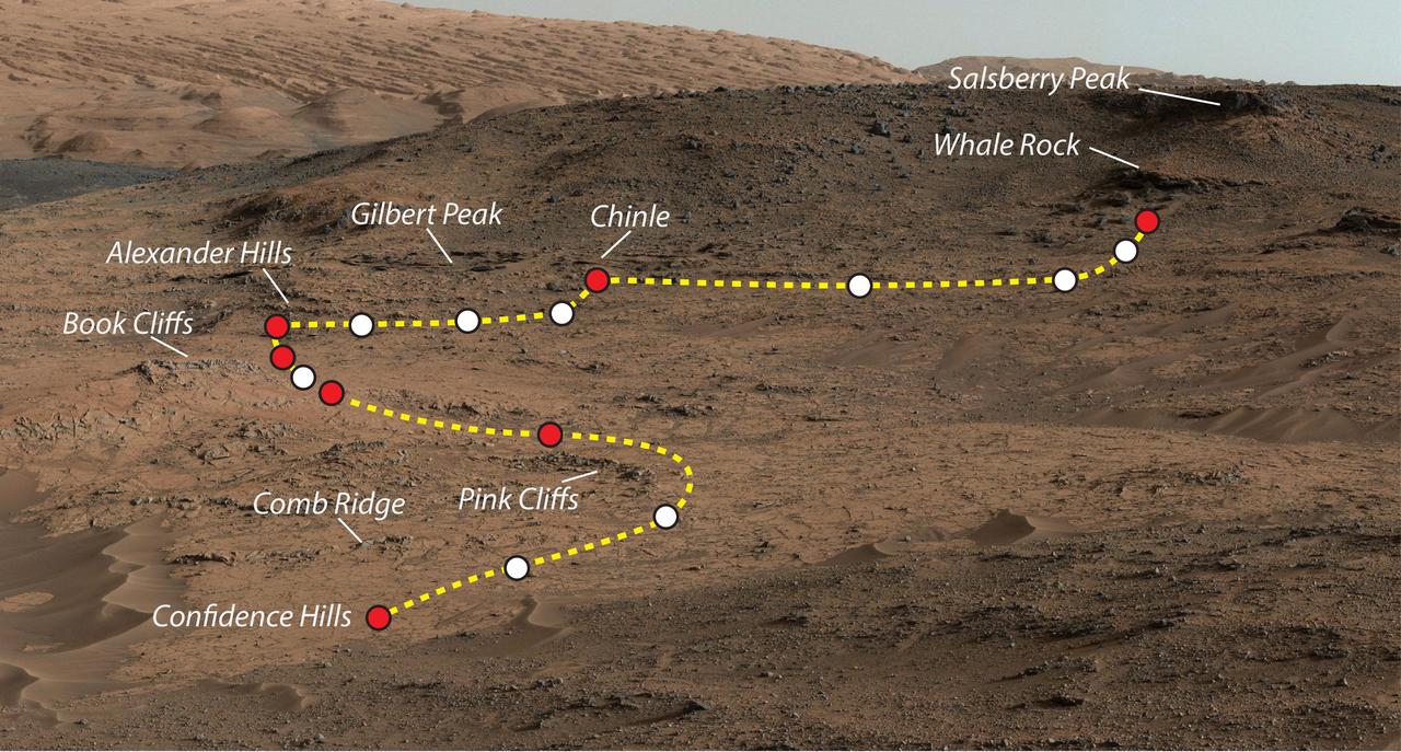
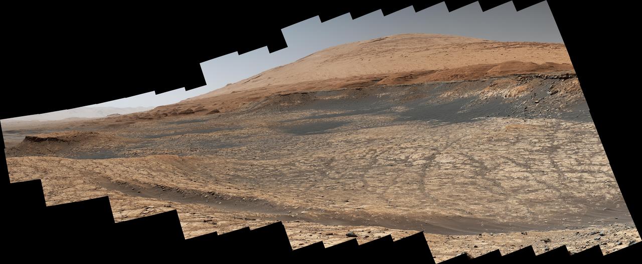
This view shows the path and some key places in a survey of the Pahrump Hills outcrop by NASA Curiosity Mars rover in autumn of 2014. The outcrop is at the base of Mount Sharp within Gale Crater.
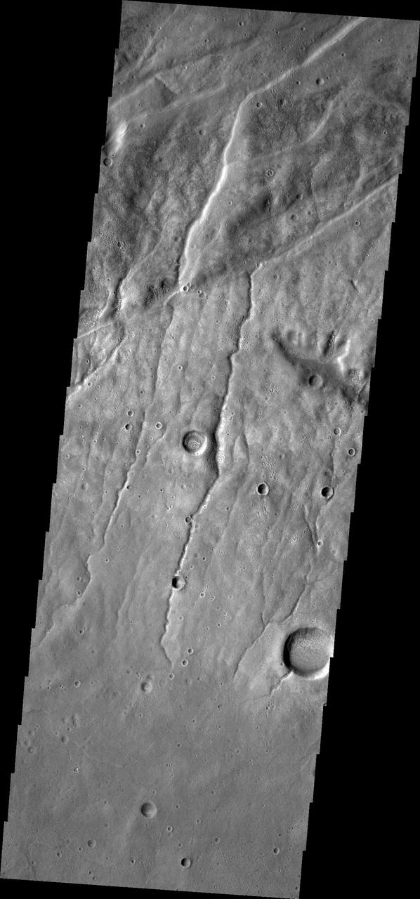
This image from NASA 2001 Mars Odyssey spacecraft of the Claritas Fossae region illustrates how fractures affect other features. In this instance, the fractures control the path of several channels from upper right towards lower left.
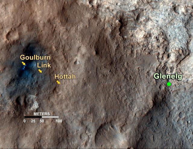
This map shows the path on Mars of NASA Curiosity rover toward Glenelg, an area where three terrains of scientific interest converge. Arrows mark what appears to be an ancient Martian streambed.
This artist animation shows the route NASA Phoenix Mars Lander took to get from Earth to Mars.
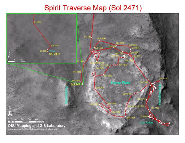
This map shows the path that NASA Mars Exploration Rover Spirit followed from the 743rd Martian day Feb. 4, 2009, or sol, to Sol 2471 Dec. 15, 2010. Spirit has been at a sand-trap location called Troy since April 2009.
This image from NASA Mars Odyssey spacecraft shows the southeastern rim of Gale Crater. The large ridge at the bottom of image is the top of the rim. Image shows a channel dissecting the rim; two dune fields occur along the path of the channel too.
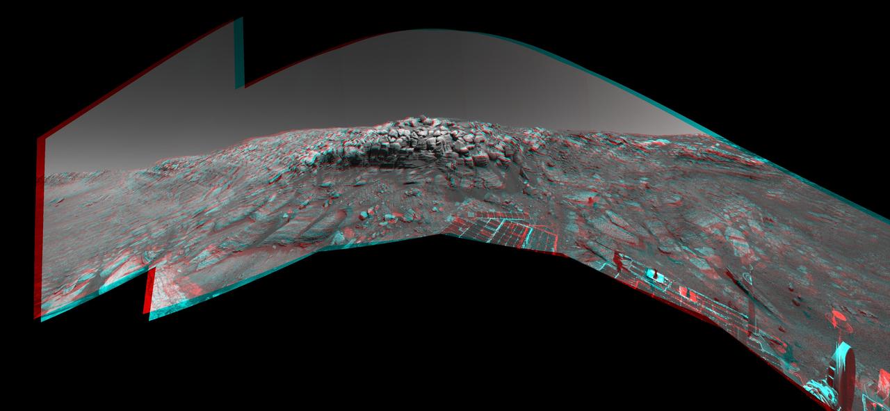
As NASA Mars Exploration Rover Opportunity was making its way back toward its original entry path into Endurance Crater, scientists and engineers spotted what they hoped might be a shortcut for climbing out of the crater. 3D glasses are necessary.
This 3-D view from behind NASA Mars Exploration Rover Opportunity shows the path the rover has traveled since rolling 1 meter 3 feet away from its empty lander on the seventh martian day, or sol, of its mission. 3D glasses are necessary.
This mosaic shows part of the path NASA's Perseverance Mars rover took through a portion of a boulder field dubbed "Snowdrift Peak." It was generated using images taken by one of the rover's navigation cameras on July 28, 2023, the 866th day, or sol, of the mission. With the help of its self-driving autonomous navigation system, AutoNav, Perseverance traversed the boulder field much more quickly than previous rovers could have. A key objective for Perseverance's mission on Mars is astrobiology, including the search for signs of ancient microbial life. The rover will characterize the planet's geology and past climate, pave the way for human exploration of the Red Planet, and be the first mission to collect and cache Martian rock and regolith (broken rock and dust). Subsequent NASA missions, in cooperation with ESA (European Space Agency), would send spacecraft to Mars to collect these sealed samples from the surface and return them to Earth for in-depth analysis. The Mars 2020 Perseverance mission is part of NASA's Moon to Mars exploration approach, which includes Artemis missions to the Moon that will help prepare for human exploration of the Red Planet. https://photojournal.jpl.nasa.gov/catalog/PIA26072

The red line on this map shows where NASA Mars Rover Opportunity has driven from the place where it landed in January 2004, inside Eagle Crater, at the upper left end of the track, to where it reached on Nov. 30, 2010.
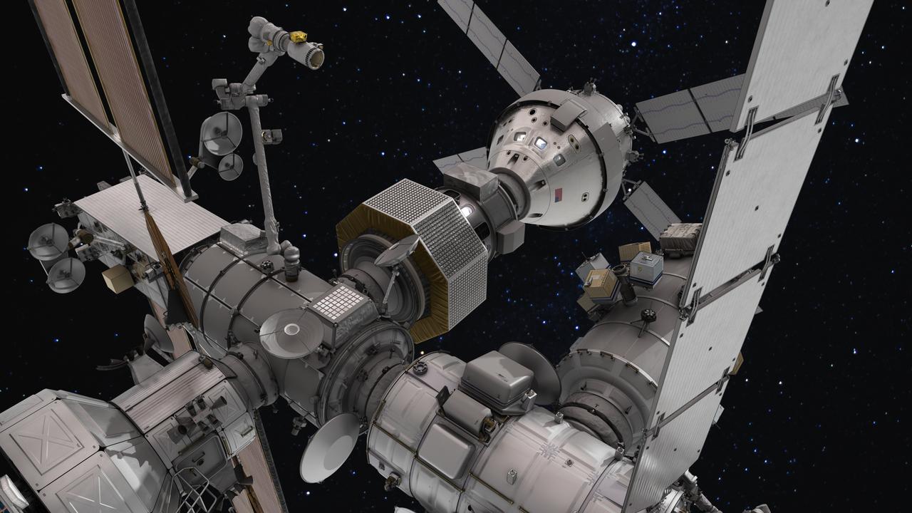
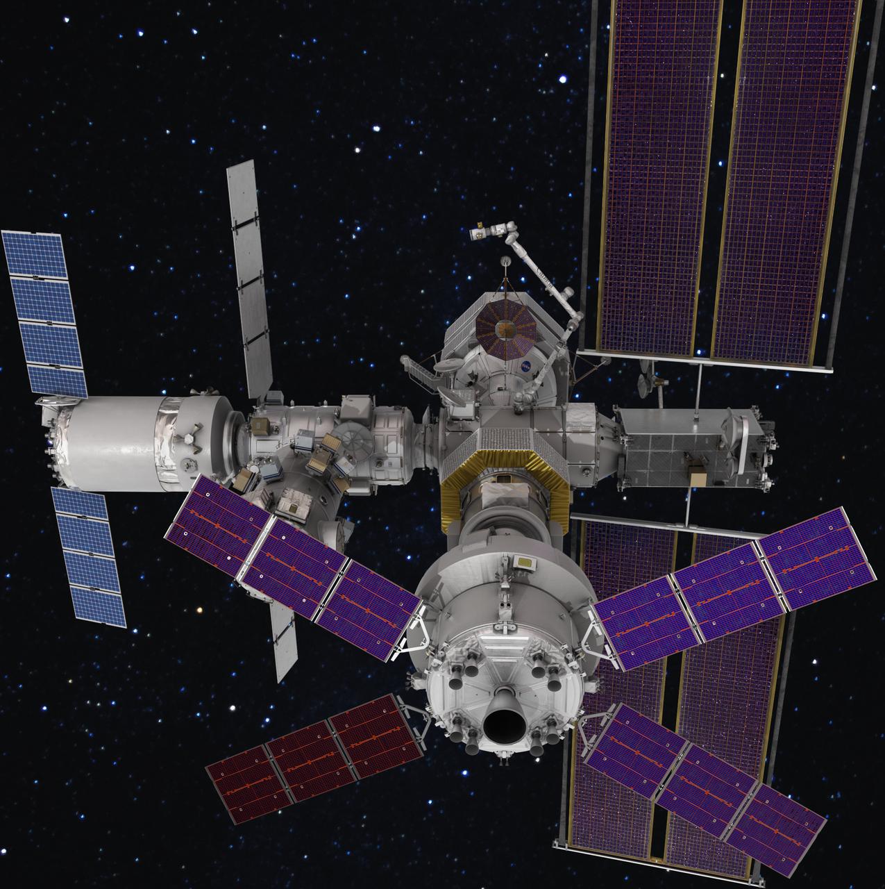
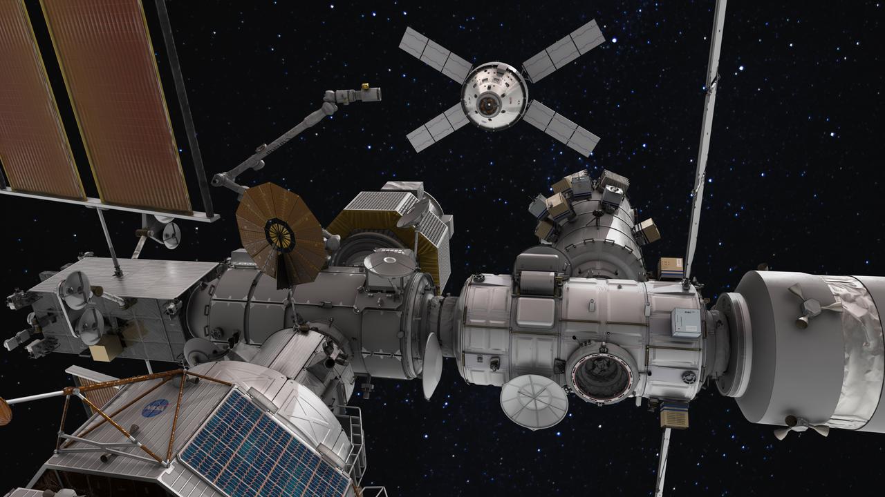
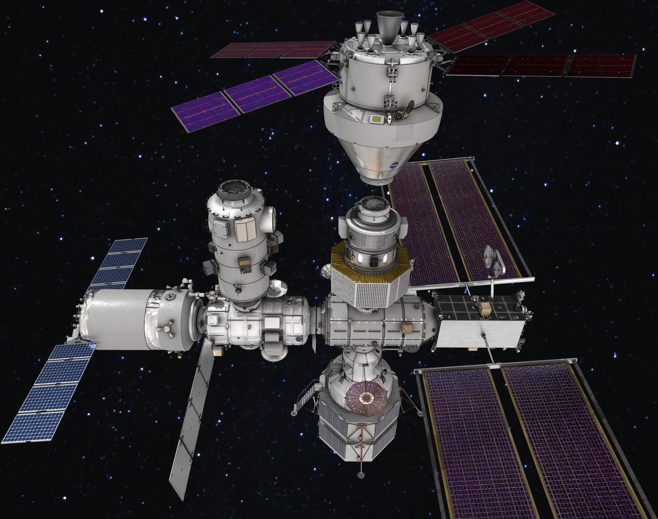
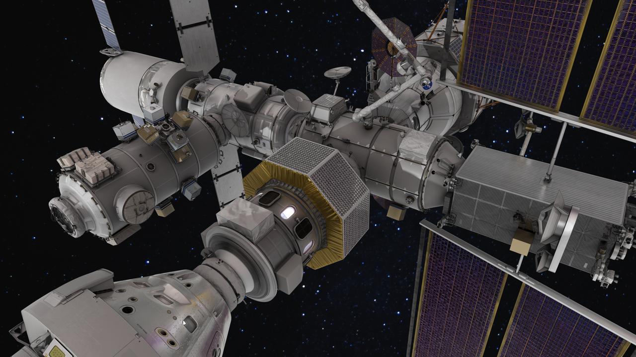
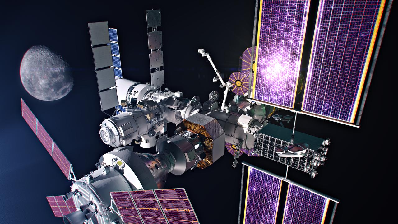
The Gateway space station will be humanity's first space station in lunar orbit as a vital component of the Artemis missions to return humans to the Moon for scientific discovery and chart a path for humans to Mars.
The Gateway space station will be humanity's first space station in lunar orbit as a vital component of the Artemis missions to return humans to the Moon for scientific discovery and chart a path for humans to Mars.
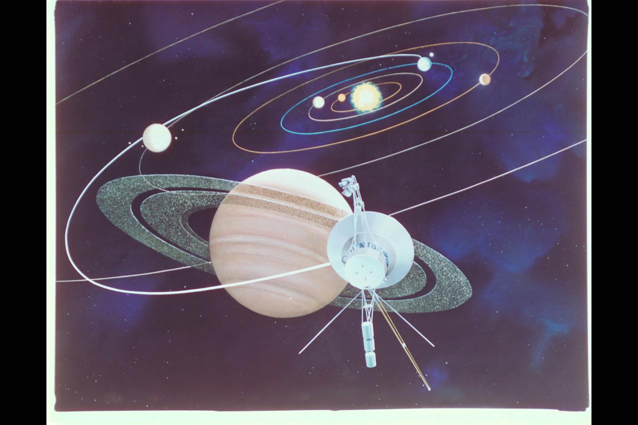
Artist: unknown (JPL) Saturn Voyager Mission Artwork depicts the spacecraft's path on it's journey to Saturn as it passed above the orbits of Mercury, Venus, Earth, Mars and around Jupiter.
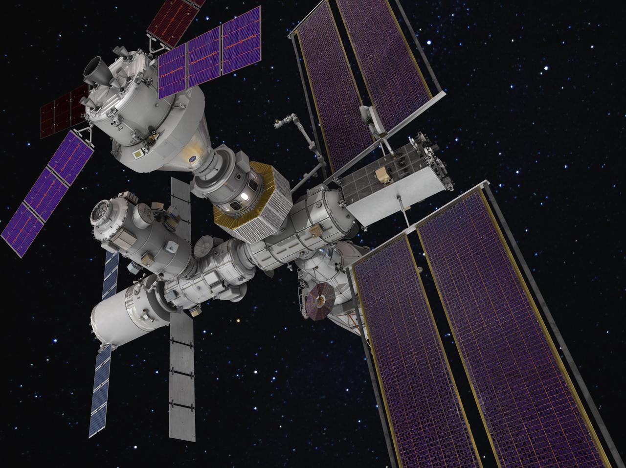
The Gateway space station will be humanity's first space station in lunar orbit as a vital component of the Artemis missions to return humans to the Moon for scientific discovery and chart a path for humans to Mars.
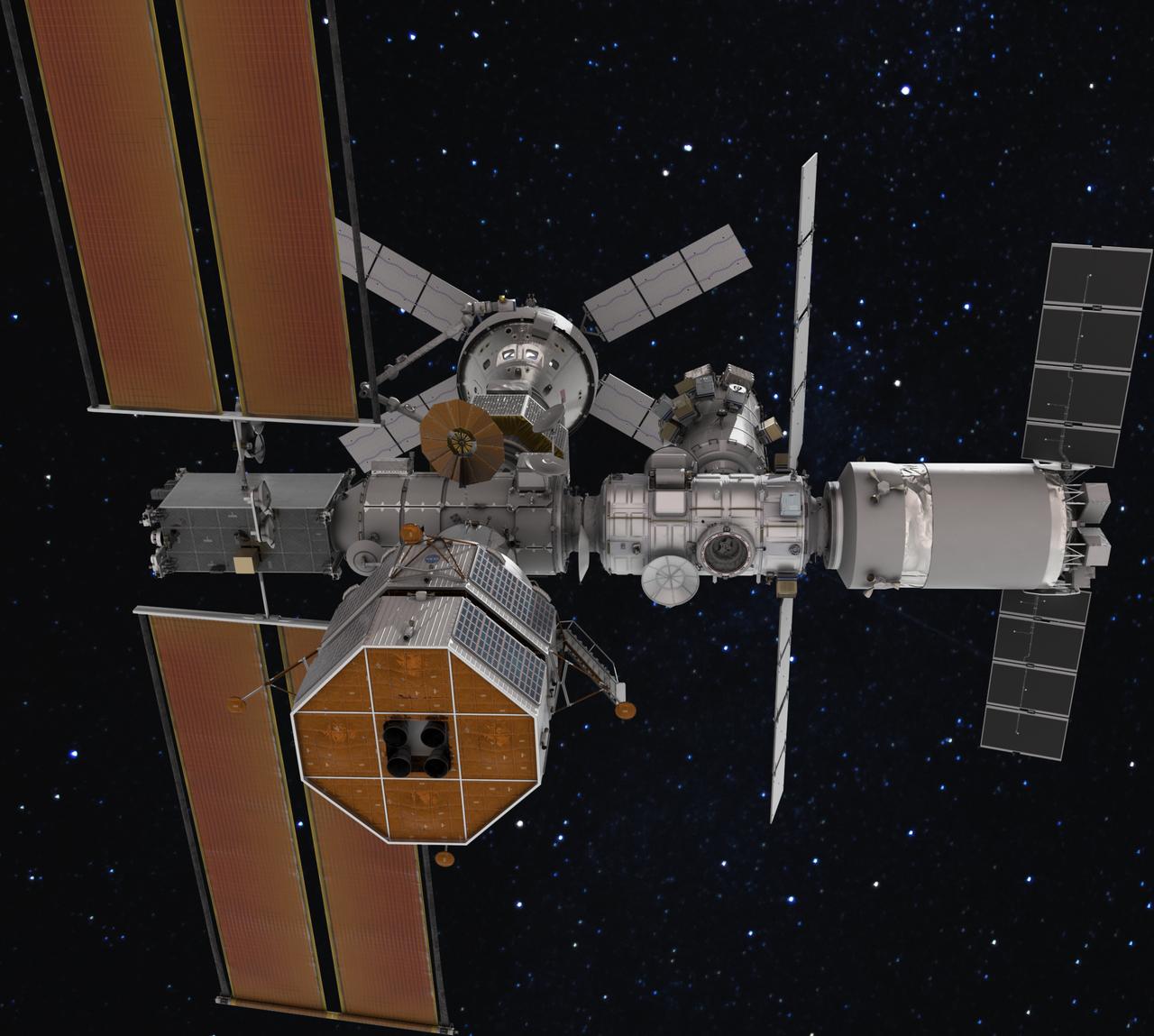
The Gateway space station will be humanity's first space station in lunar orbit as a vital component of the Artemis missions to return humans to the Moon for scientific discovery and chart a path for humans to Mars.
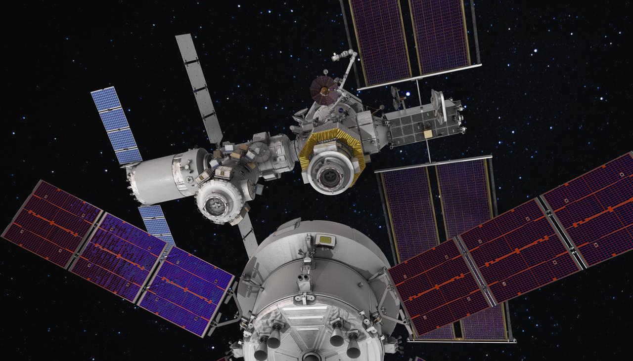
The Gateway space station will be humanity's first space station in lunar orbit as a vital component of the Artemis missions to return humans to the Moon for scientific discovery and chart a path for humans to Mars.
The Gateway space station will be humanity's first space station in lunar orbit as a vital component of the Artemis missions to return humans to the Moon for scientific discovery and chart a path for humans to Mars.
The Gateway space station will be humanity's first space station in lunar orbit as a vital component of the Artemis missions to return humans to the Moon for scientific discovery and chart a path for humans to Mars.
The Gateway space station will be humanity's first space station in lunar orbit as a vital component of the Artemis missions to return humans to the Moon for scientific discovery and chart a path for humans to Mars.
The Gateway space station will be humanity's first space station in lunar orbit as a vital component of the Artemis missions to return humans to the Moon for scientific discovery and chart a path for humans to Mars.
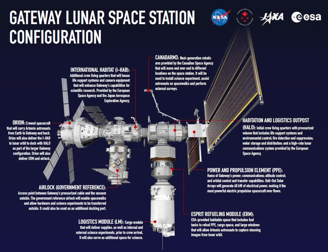
This infographic shows each element of Gateway, humanity's first space station in lunar orbit as a vital component of the Artemis missions to return to the Moon for scientific discovery and chart the path for the first human missions to Mars.
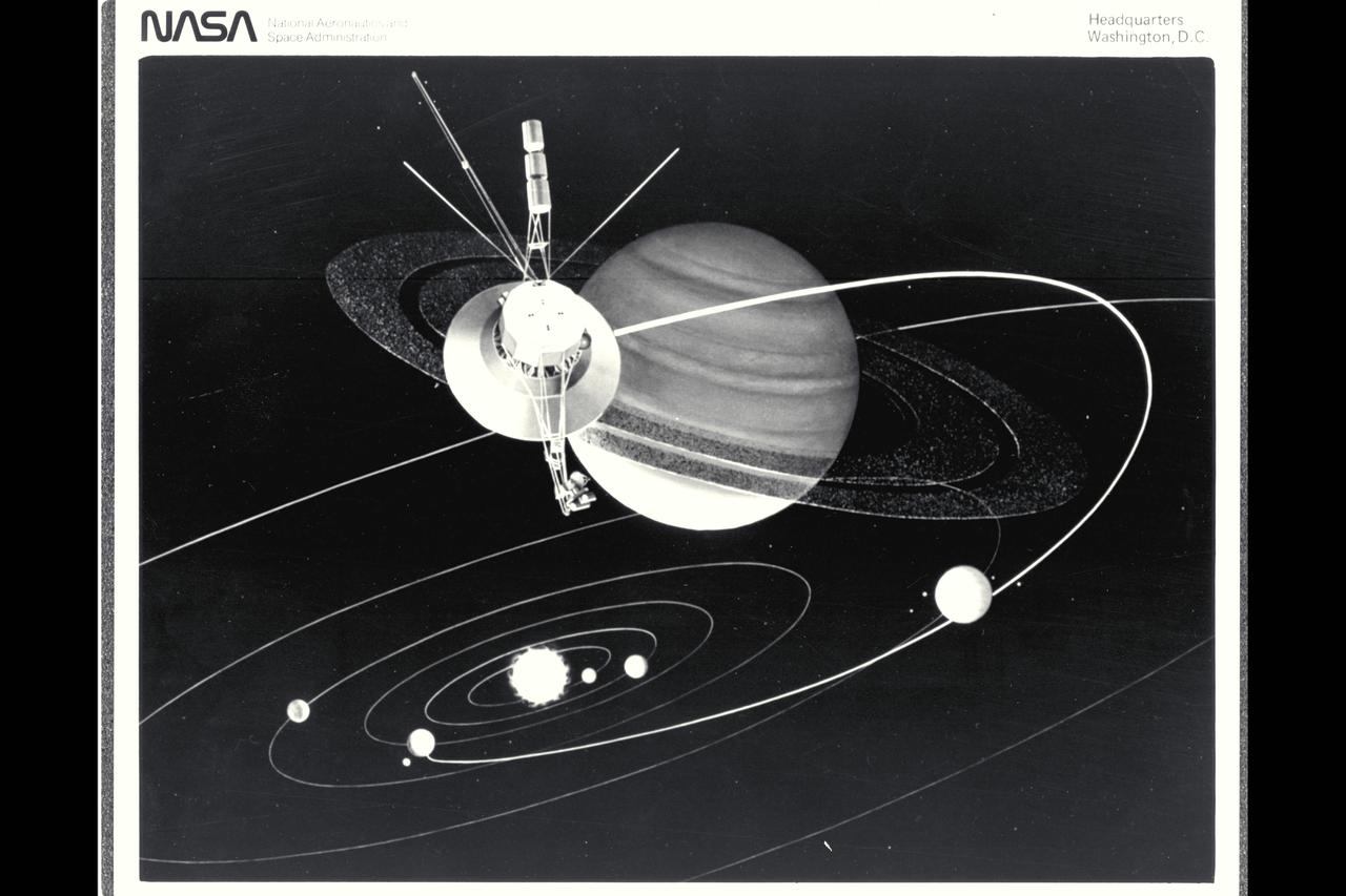
Artist: unknown (JPL) Saturn Voyager Mission Artwork depicts the spacecraft's path on it's journey to Saturn as it passed above the orbits of Mercury, Venus, Earth, Mars and around Jupiter.

Michael Gazarik, NASA Associate Administrator for Space Technology gives a short presentation on NASA's human exploration path to Mars during a panel discussion moderated by PBS NewsHour's Miles O'Brien at the Humans to Mars Summit on April 22, 2014 at George Washington University in Washington, DC. Photo Credit: (NASA/Joel Kowsky)

NASA Administrator Charles Bolden answers questions from the audience after giving the opening keynote address at the Humans to Mars Summit on April 22, 2014 at George Washington University in Washington, DC. Administrator Bolden spoke of NASA's path to the human exploration of Mars during his remarks. Photo Credit: (NASA/Joel Kowsky)

Matt Smith, flight director for the second Mars 2020 mission trajectory correction maneuver (TCM-2), studying the screens at NASA's Jet Propulsion Laboratory in Southern California. TCMs are a series of planned adjustments to put the rover on the correct path to land on Mars. https://photojournal.jpl.nasa.gov/catalog/PIA24193
Artemis will light our way to Mars. The new Artemis identity draws bold inspiration from the Apollo program and forges its own path, showing how it will pursue lunar exploration like never before and pave the way to Mars.

NASA Administrator Charles Bolden delivers the opening keynote address at the Humans to Mars Summit on April 22, 2014 at George Washington University in Washington, DC. Administrator Bolden spoke of NASA's path to the human exploration of Mars during his remarks. Photo Credit: (NASA/Joel Kowsky)

NASA Administrator Charles Bolden answers questions from the audience after giving the opening keynote address at the Humans to Mars Summit on April 22, 2014 at George Washington University in Washington, DC. Administrator Bolden spoke of NASA's path to the human exploration of Mars during his remarks. Photo Credit: (NASA/Joel Kowsky)

NASA Administrator Charles Bolden delivers the opening keynote address at the Humans to Mars Summit on April 22, 2014 at George Washington University in Washington, DC. Administrator Bolden spoke of NASA's path to the human exploration of Mars during his remarks. Photo Credit: (NASA/Joel Kowsky)
This image from the Mars Orbiter Camera aboard NASA's Mars Global Surveyor spacecraft shows an overview of "Victoria Crater" and a portion of the area NASA's Mars Exploration Rover Opportunity has covered to reach the enormous depression. Images such as this one from the Mars Orbiter Camera on NASA's Mars Global Surveyor are helping scientists and engineers decide the best path for NASA's Mars Exploration Rover Opportunity as it approaches "Victoria Crater." http://photojournal.jpl.nasa.gov/catalog/PIA08777
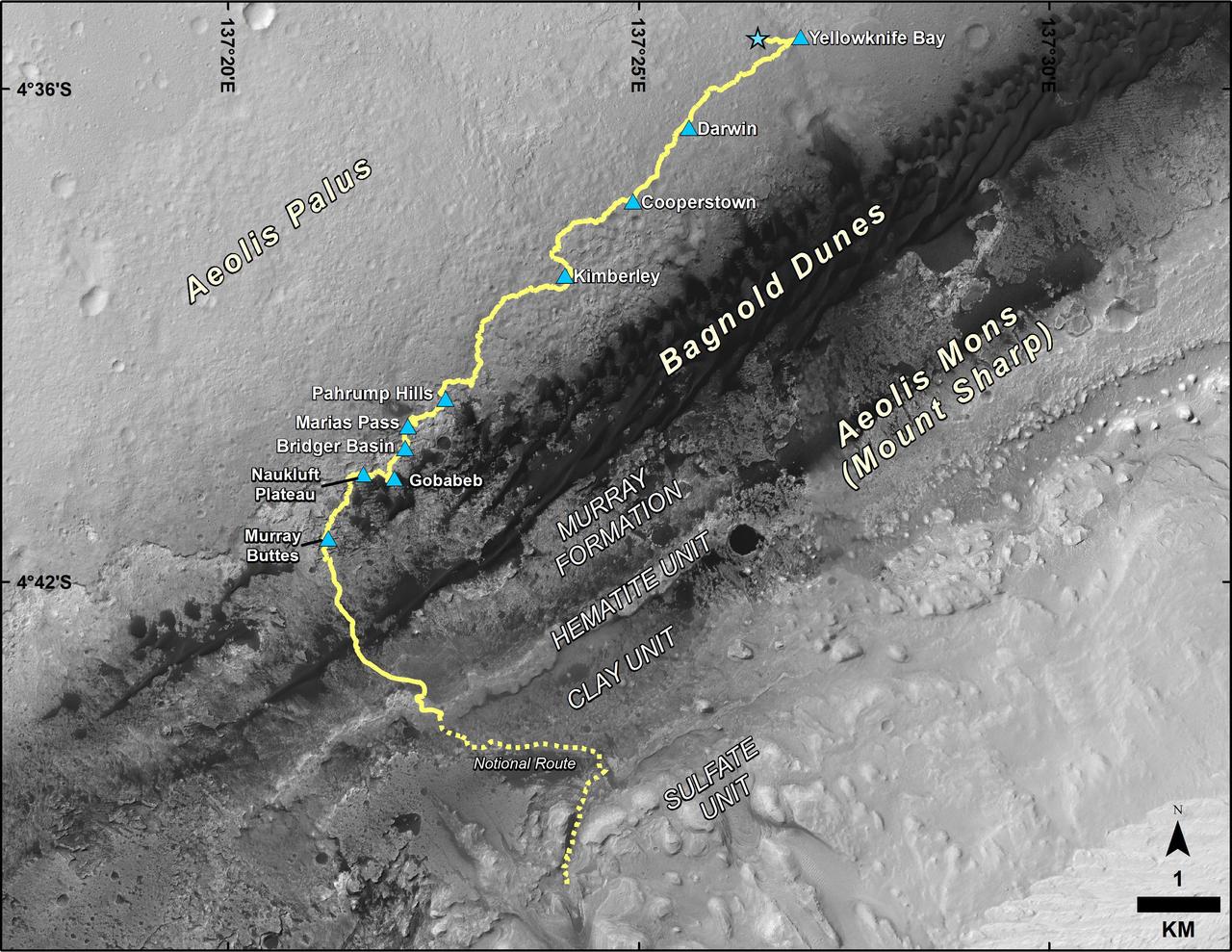
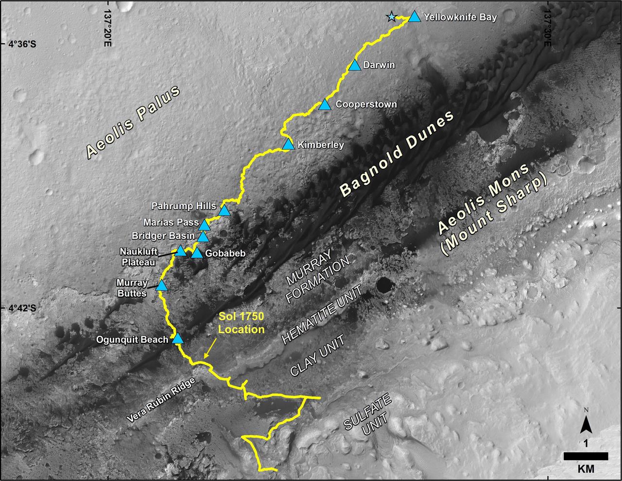
This map shows the route driven by NASA's Curiosity Mars rover from the location where it landed in August 2012 to its location in September 2016 at "Murray Buttes," and the path planned for reaching destinations at "Hematite Unit" and "Clay Unit" on lower Mount Sharp. Blue triangles mark waypoints investigated by Curiosity during the rover's two-year prime mission and first two-year extended mission. The Hematite Unit and Clay Unit are key destinations for the second two-year extension, through September 2018. The base image for the map is from the High Resolution Imaging Science Experiment (HiRISE) camera on NASA's Mars Reconnaissance Orbiter. North is up. Bagnold Dunes form a band of dark, wind-blown material at the foot of Mount Sharp. http://photojournal.jpl.nasa.gov/catalog/PIA20846

Inside the Launch Control Center at Kennedy Space Center on Sept. 29, 2020, engineer Danny Zaatari, with Exploration Ground Systems, works on software for the launch of Artemis I. Engineers at the Florida spaceport are staying focused on the “Path to the Pad.” Artemis I is the first in a series of increasingly complex missions that will enable human exploration to the Moon and Mars.

Farah Alibay, a systems engineer working on the Mars 2020 rover at NASA’s Jet Propulsion Laboratory, speaks about her path to working at NASA during an interactive STEM discussion with students attending the 70th International Astronautical Congress, Wednesday, Oct. 23, 2019, at NASA Headquarters in Washington. Photo Credit: (NASA/Joel Kowsky)

Inside the Launch Control Center at Kennedy Space Center on Sept. 29, 2020, engineer Danny Zaatari, with Exploration Ground Systems, works on software for the launch of Artemis I. Engineers at the Florida spaceport are staying focused on the “Path to the Pad.” Artemis I is the first in a series of increasingly complex missions that will enable human exploration to the Moon and Mars.

Inside the Launch Control Center at Kennedy Space Center on Sept. 29, 2020, engineer Danny Zaatari, with Exploration Ground Systems, works on software for the launch of Artemis I. Engineers at the Florida spaceport are staying focused on the “Path to the Pad.” Artemis I is the first in a series of increasingly complex missions that will enable human exploration to the Moon and Mars.
Inside the Launch Control Center at Kennedy Space Center on Sept. 29, 2020, engineer Danny Zaatari, with Exploration Ground Systems, works on software for the launch of Artemis I. Engineers at the Florida spaceport are staying focused on the “Path to the Pad.” Artemis I is the first in a series of increasingly complex missions that will enable human exploration to the Moon and Mars.
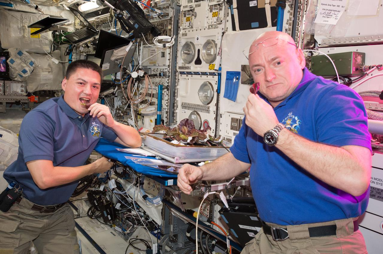
ISS044E045825 (08/11/2015) --- NASA astronauts Scott Kelly and Kjell Lindgren on the International Space Station are getting their taste buds ready for the first taste of food that's grown, harvested and eaten in space, a critical step on the path to Mars. The crew took their first bites on Aug. 10, 2015.
Inside the Launch Control Center at Kennedy Space Center on Sept. 29, 2020, engineer Danny Zaatari, with Exploration Ground Systems, works on software for the launch of Artemis I. Engineers at the Florida spaceport are staying focused on the “Path to the Pad.” Artemis I is the first in a series of increasingly complex missions that will enable human exploration to the Moon and Mars.

Farah Alibay, a systems engineer working on the Mars 2020 rover at NASA’s Jet Propulsion Laboratory, speaks about her path to working at NASA during an interactive STEM discussion with students attending the 70th International Astronautical Congress, Wednesday, Oct. 23, 2019, at NASA Headquarters in Washington. Photo Credit: (NASA/Joel Kowsky)
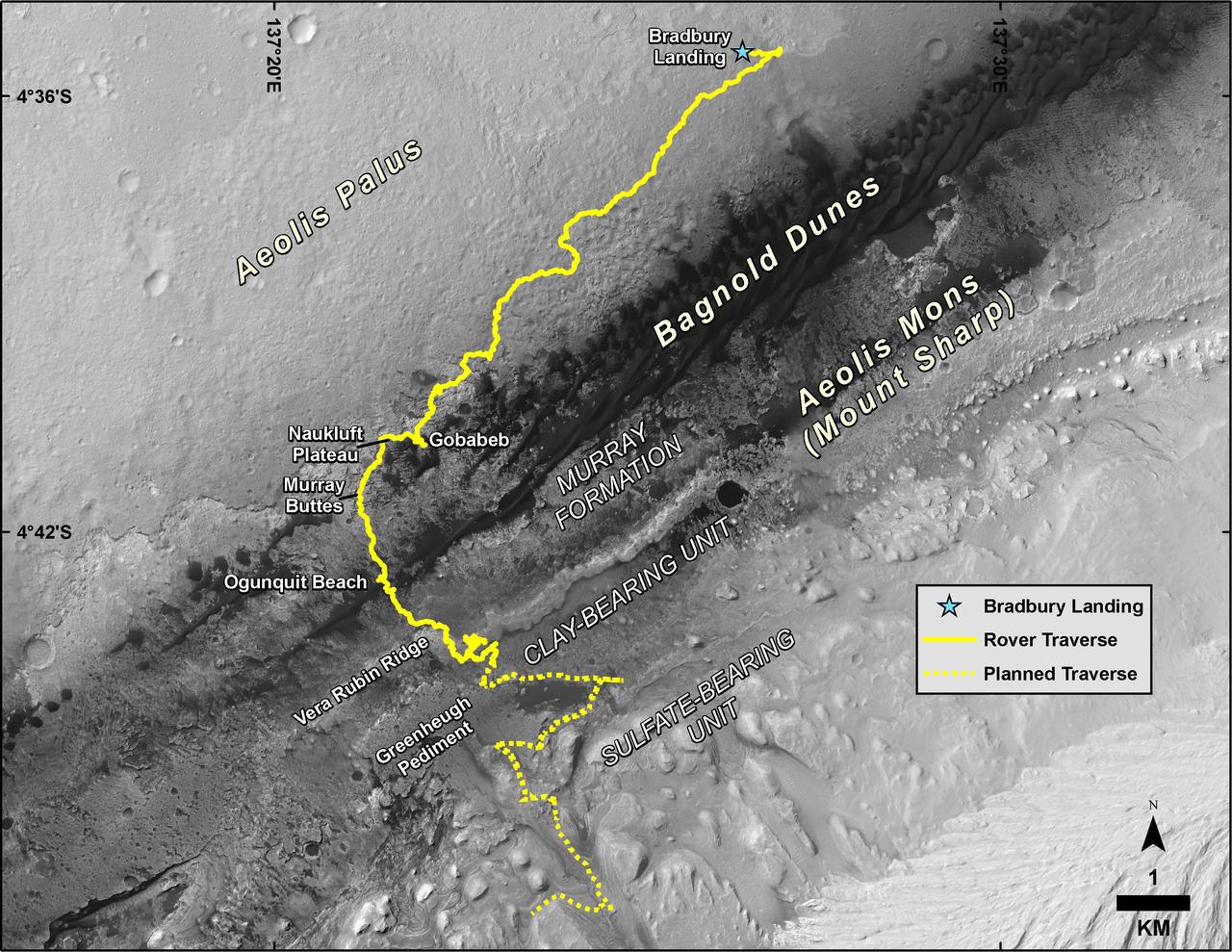
This map shows the route driven by NASA's Curiosity Mars rover, from the location where it landed in August 2012 to its location in July 2017, and its planned path to additional geological layers of lower Mount Sharp. The blue star near top center marks "Bradbury Landing," the site where Curiosity arrived on Mars on Aug. 5, 2012, PDT (Aug. 6, EDT and Universal Time). Blue triangles mark waypoints investigated by Curiosity on the floor of Gale Crater and, starting with "Pahrump Hills," on Mount Sharp. The Sol 1750 label identifies the rover's location on July 9, 2017, the 1,750th Martian day, or sol, since the landing. In July 2017, the mission is examining "Vera Rubin Ridge" from the downhill side of the ridge. Spectrometry observations from NASA's Mars Reconnaissance Orbiter have detected hematite, an iron-oxide mineral, in the ridge. Curiosity's planned route continues to the top of the ridge and then to geological units where clay minerals and sulfate minerals have been detected from orbit. The base image for the map is from the High Resolution Imaging Science Experiment (HiRISE) camera on the Mars Reconnaissance Orbiter. North is up. "Bagnold Dunes" form a band of dark, wind-blown material at the foot of Mount Sharp. https://photojournal.jpl.nasa.gov/catalog/PIA21720
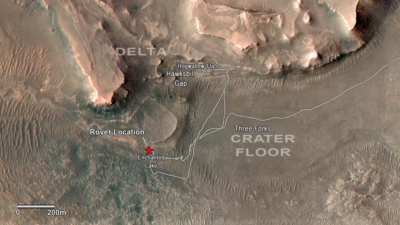
NASA's Perseverance rover has been investigating rocks at the front of the delta in Mars' Jezero Crater along the path indicated in this annotated image taken by the agency's Mars Reconnaissance Orbiter (MRO). The red star indicates the location of the rover in September 2022. Perseverance touched down at "Octavia E. Butler Landing" on the floor of Jezero Crater on Feb. 18, 2021. It reached the delta in April 2022. The delta is a fan-shaped feature where, billions of years ago, a river flowed into a lake and deposited rocks and sediments. Scientists consider the delta one of the best places on Mars to search for potential signs of ancient microbial life. The annotations show the names of some of the key features Perseverance visited, such as "Enchanted Lake" and "Hogwallow Flats." Sample tubes already filled with rock are currently stored in the rover's Sampling and Caching System. Perseverance will deposit select samples in designated locations. MRO took this overhead image with its High Resolution Imaging Science Experiment (HiRISE) camera. A key objective for Perseverance's mission on Mars is astrobiology, including the search for signs of ancient microbial life. The rover will characterize the planet's geology and past climate, pave the way for human exploration of the Red Planet, and be the first mission to collect and cache Martian rock and regolith (broken rock and dust). Subsequent NASA missions, in cooperation with ESA (European Space Agency), would send spacecraft to Mars to collect these sealed samples from the surface and return them to Earth for in-depth analysis. The Mars 2020 Perseverance mission is part of NASA's Moon to Mars exploration approach, which includes Artemis missions to the Moon that will help prepare for human exploration of the Red Planet. https://photojournal.jpl.nasa.gov/catalog/PIA24923
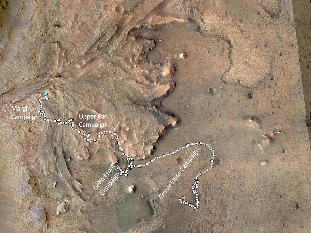
The path taken by NASA's Perseverance Mars rover during the first 1,000 sols (Martian days) of its mission at Jezero Crater is annotated on this overhead view taken by the HiRISE camera aboard the agency's Mars Reconnaissance Orbiter. White circles signify locations on the surface where the rover stopped after completing a traverse. The pale blue circle at upper left indicates the rover's position as of Dec. 12, 2023. The white text indicates the areas of the four rover science campaigns, from initial campaign to current: Crater Floor, Delta Front, Upper Fan, and Margin. Figure A, showing the same general area, is annotated to indicate the route and the two locations where the rover used its PIXL instrument to analyze abrasion patches "Ouzel Falls" and "Bills Bay" and its drill to core corresponding rock samples, "Otis Peak" and "Lefroy Bay." The University of Arizona, in Tucson, operates HiRISE, which was built by Ball Aerospace & Technologies Corp., in Boulder, Colorado. JPL manages the Mars Reconnaissance Orbiter Project for NASA's Science Mission Directorate, Washington. A key objective for Perseverance's mission on Mars is astrobiology, including the search for signs of ancient microbial life. The rover will characterize the planet's geology and past climate, pave the way for human exploration of the Red Planet, and be the first mission to collect and cache Martian rock and regolith (broken rock and dust). Subsequent NASA missions, in cooperation with ESA (European Space Agency), would send spacecraft to Mars to collect these sealed samples from the surface and return them to Earth for in-depth analysis. The Mars 2020 Perseverance mission is part of NASA's Moon to Mars exploration approach, which includes Artemis missions to the Moon that will help prepare for human exploration of the Red Planet. https://photojournal.jpl.nasa.gov/catalog/PIA26231

Attitude Control Systems lead Chris Pong donned a dinosaur-themed mask for his participation in the Mars 2020 mission's second trajectory correction maneuver at NASA's Jet Propulsion Laboratory in Southern California. The navigation team successfully sent commands to the spacecraft to adjust its flight path during its long cruise to Mars. https://photojournal.jpl.nasa.gov/catalog/PIA24191
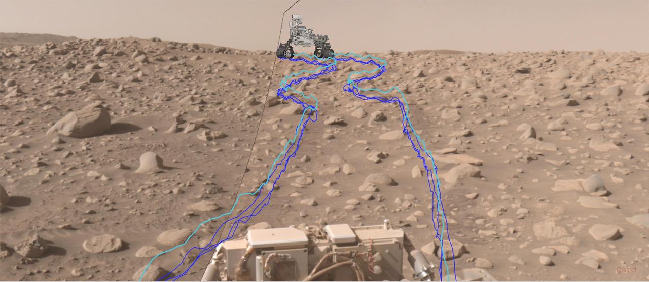
This annotated composite image shows the path NASA's Perseverance Mars rover took through a dense section of boulders. It was acquired on June 29, 2023, the 838th day, or sol, of the mission, by one of the rover's navigation cameras and was annotated using the Robot Sequencing and Visualization Program. The pale blue line indicates the course of the center of the rover's front wheel hubs, while the darker blue lines show the paths taken by the bottom of the rover's six wheels. With the help of its self-driving autonomous navigation system, AutoNav, Perseverance traversed the boulder field much more quickly than previous rovers could have. A key objective for Perseverance's mission on Mars is astrobiology, including the search for signs of ancient microbial life. The rover will characterize the planet's geology and past climate, pave the way for human exploration of the Red Planet, and be the first mission to collect and cache Martian rock and regolith (broken rock and dust). Subsequent NASA missions, in cooperation with ESA (European Space Agency), would send spacecraft to Mars to collect these sealed samples from the surface and return them to Earth for in-depth analysis. The Mars 2020 Perseverance mission is part of NASA's Moon to Mars exploration approach, which includes Artemis missions to the Moon that will help prepare for human exploration of the Red Planet. https://photojournal.jpl.nasa.gov/catalog/PIA26071
This animation, constructed using stereo imaging data from the High Resolution Imaging Science Experiment (HiRISE) camera on NASA's Mars Reconnaissance Orbiter, provides an airborne perspective of the Mars 2020 landing site and its exploration area at Jezero Crater. Mars 2020 is expected to land to the southeast of an ancient river delta, a fan-shaped feature inside the northeast rim of Jezero Crater that provides solid evidence of a river and lake system active in and around the crater billions of years ago. The solid white line on the surface indicates a path the rover could take during its prime mission. Animation available at https://photojournal.jpl.nasa.gov/catalog/PIA22905
Stitched together from 116 images, this view captured by NASA's Curiosity Mars rover shows the path it will take in the summer of 2020 as it drives to the "sulfate-bearing unit," the next layer it will be investigating on the 3-mile-tall (5-kilometer-tall) Mount Sharp. Curiosity has to drive around a large sand patch in order to reach a place where it can ascend to the sulfate-rich region. The upper part of the mountain looms at the top image. The images were taken by the rover's Mast Camera, or Mastcam, on Jan. 10, 2020, the 2,641st Martian day, or sol, of the mission. The panorama has been white-balanced so that the colors of the rock materials resemble how they would appear under daytime lighting conditions on Earth. https://photojournal.jpl.nasa.gov/catalog/PIA23973
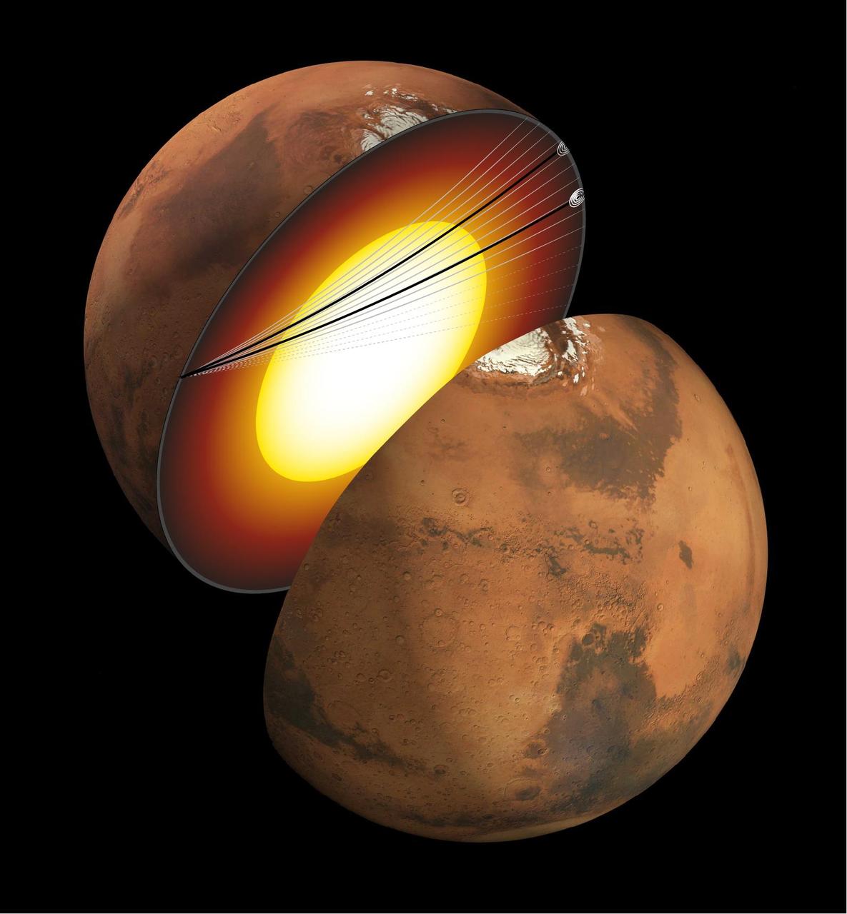
This artist's concept shows a cutaway of Mars along with the paths of seismic waves from two separate quakes in 2021. These seismic waves, detected by NASA's InSight mission, were the first ever identified to enter another planet's core. InSight's seismometer allowed scientists to study these waves and gain an unprecedented look at the Martian core. The quakes were detailed in a paper published April 24, 2023, in the Proceedings of the National Academies of Sciences. Occurring on Aug. 25 and Sept. 18, 2021, the two temblors were the first identified by the InSight team to have originated on the opposite side of the planet from the lander – so-called farside quakes. The distance proved crucial: The farther a quake happens from InSight, the deeper into the planet its seismic waves can travel before being detected. https://photojournal.jpl.nasa.gov/catalog/PIA25827

This computer animation shows a replay of telemetry from NASA's Perseverance Mars rover as it carried out its first drive using AutoNav, it's auto-navigation feature, which allows it to avoid rocks and other hazards without input from engineers back on Earth. The rover's progress here has been sped up by 50 times. The entire drive was roughly 102 feet (31 meters) and took 45 minutes. The terrain is created from height maps, which is how the rover navigates surrounding terrain. The map is created incrementally from stereo imagery taken from the rover's navigation cameras. Auto-navigation software uses a height map to evaluate possible drive paths for safety. The paths are represented by arcs emanating from the front of the rover. Different-colored arcs denote different results of the hazard evaluation. Blue arcs represent arcs that failed due to "wheel drop," where the terrain could allow for a wheel to fall more than a certain height. Pink arcs fail the belly-pan clearance check, where the terrain is at risk of high-centering the rover. Yellow arcs fail by driving onto unknown terrain. Gray arcs are safe. The white arc is the actual path selected by auto-navigation. A key objective for Perseverance's mission on Mars is astrobiology, including the search for signs of ancient microbial life. The rover will characterize the planet's geology and past climate, pave the way for human exploration of the Red Planet, and be the first mission to collect and cache Martian rock and regolith (broken rock and dust). Subsequent NASA missions, in cooperation with ESA (European Space Agency), would send spacecraft to Mars to collect these sealed samples from the surface and return them to Earth for in-depth analysis. The Mars 2020 Perseverance mission is part of NASA's Moon to Mars exploration approach, which includes Artemis missions to the Moon that will help prepare for human exploration of the Red Planet. Animation available at https://photojournal.jpl.nasa.gov/catalog/PIA24723
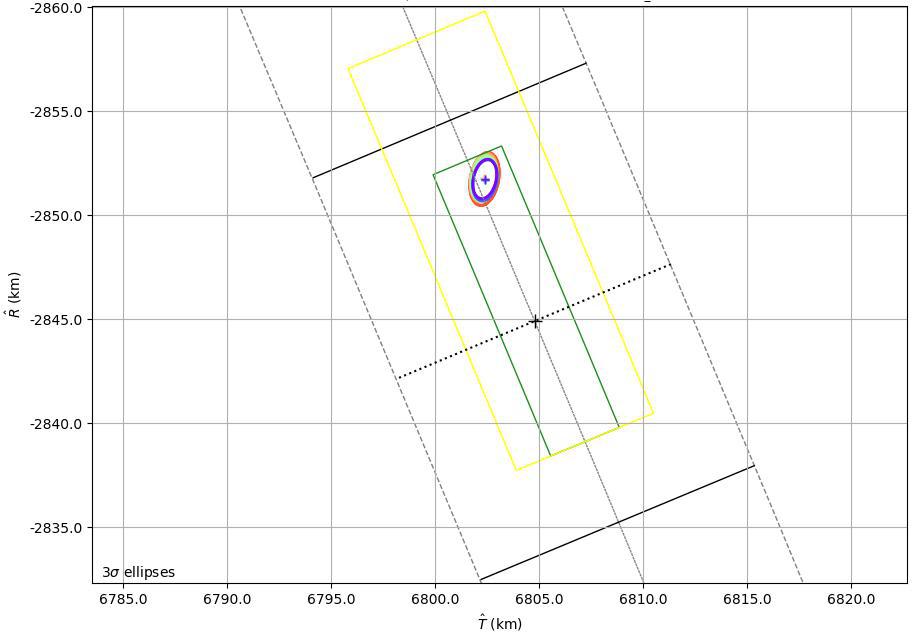
This graphic shows the B-Plane for NASA's Mars 2020 Perseverance rover mission as of February 15, 2021. A B-Plane is a key performance metric that navigators for interplanetary missions use to determine the accuracy of their spacecraft's trajectory. The entry target on the lower right of the image (black cross) depicts the point where mission navigators are targeting the Mars 2020 spacecraft to enter the Red Planet's atmosphere. Higher up, the red, orange, green, and blue ovals depict the estimated "entry uncertainty ellipse" for the spacecraft as determined by previous navigation solutions. The inner-most ring (purple) depicts the most recent trajectory path. https://photojournal.jpl.nasa.gov/catalog/PIA24296
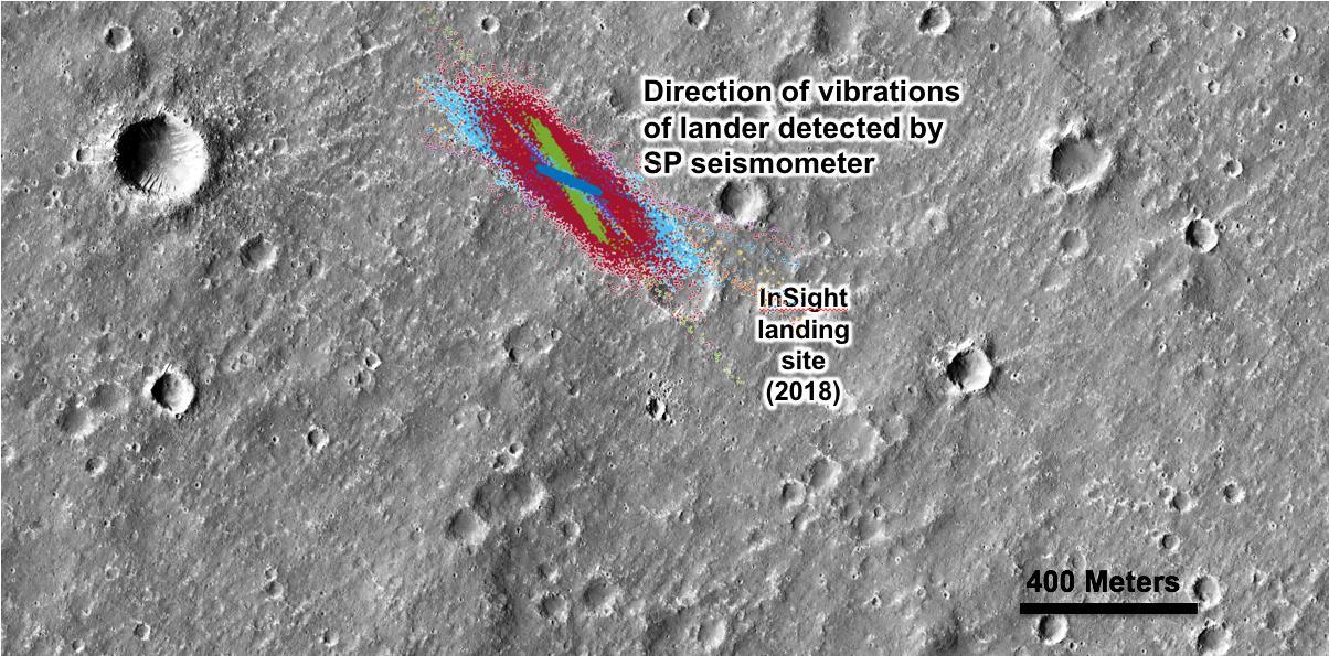
An annotated image of the surface of Mars, taken by the HiRISE camera on NASA's Mars Reconnaissance Orbiter (MRO) on May 30, 2014. The contrast has been enhanced in this image to better show the region where InSight landed on Nov. 26, 2018. The labels show the approximate position of NASA's InSight lander in Elysium Planitia. Overlaid on top are the direction of the vibrations detected by InSight's science instruments. The diagonal lines, faintly seen moving from upper left corner to the lower right corner of the image, show the paths of dust devils on the Martian surface. The vibrations recorded by InSight line up with the direction of the dust devil motion. https://photojournal.jpl.nasa.gov/catalog/PIA22927
Alluvial fans are piles of debris dumped by rivers when they emerge from the mountains and enter a mostly dry valley as seen by NASA Mars Reconnaissance Orbiter. A bajada (such as this example named after the famous American filmmaker) consists of a series of coalescing alluvial fans along a mountain front. On the surface of this bajada, one can see many sinuous ridges. These ridges mark the path that streams of water took as they flowed into this crater. The sinuosity of the ridges tells us something about the speed of the water flow. Fast moving flows tend to be straighter than slow-moving. Observations like this help us build a picture of how rivers behaved on ancient Mars. http://photojournal.jpl.nasa.gov/catalog/PIA19366
This artist's concept depicts the long, looping path NASA's Europa Clipper spacecraft will take to reach the Jupiter system. Covering a distance of about 1.8 billion miles (2.9 billion kilometers), the path swings past Mars, then Earth, using the two planets' gravity as a slingshot to add speed to the spacecraft's journey to Jupiter. Once in orbit at Jupiter, the spacecraft will conduct dozens of close flybys of the gas giant's icy moon Europa. Europa Clipper's three main science objectives are to determine the thickness of the moon's icy shell and its interactions with the ocean below, to investigate its composition, and to characterize its geology. The mission's detailed exploration of Europa will help scientists better understand the astrobiological potential for habitable worlds beyond our planet. https://photojournal.jpl.nasa.gov/catalog/PIA26432
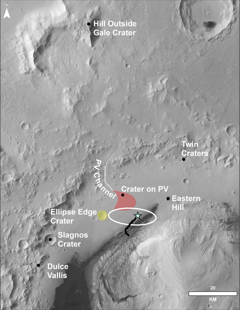
This image of the northwestern portion of Mars' Gale Crater and terrain north of it, from the European Space Agency's Mars Express orbiter, provides a locator map for some features visible in an October 2017 panorama from NASA's Curiosity Mars rover (see PIA22210, Fig. 1). A blue star marks the rover's landing site, on the floor of Gale Crater near the base of Mount Sharp. That layered mountain occupies the middle of the crater. The black line indicates the path of the rover's traverse from its August 2012 landing to about the location on lower Mount Sharp, where the panorama was acquired. North is toward the top. At lower right is a 20-kilometer (12.4-mile) scale bar. The base-map image was taken by the High Resolution Stereo Camera on Mars Express. https://photojournal.jpl.nasa.gov/catalog/PIA22208
This image shows a small landslide in Iani Chaos. Landslides are common on Mars where there are steep slopes, including this area where there are numerous mounds and hills. What is unusual about this landslide is that it carved a path downslope as it moved, similar to a snow plow pushing away snow as it moves forward. This image is part of a stereo pair so that scientists will examine the landslide in 3D to understand its formation mechanism. https://photojournal.jpl.nasa.gov/catalog/PIA23232

NASA senior leaders participate in a town hall discussion on Nov. 29, 2022, at the agency’s Kennedy Space Center in Florida. From left are Kennedy Space Center Director Janet Petro, NASA Deputy Administrator Pam Melroy; Kurt Vogel, director of NASA Space Architectures; Cathy Koerner, deputy associate administrator, Exploration Systems Development; and NASA Associate Administrator Bob Cabana. Discussion centered around NASA’s Moon to Mars objectives, Kennedy’s role in deep space exploration, and the path forward in the coming months and years.
The Gateway space station will be humanity's first space station around the Moon as a vital component of the Artemis missions to return humans to the lunar surface for scientific discovery and chart the path for the first human missions to Mars. Astronauts on Gateway will be the first humans to call deep space home during missions where they will use Gateway to conduct science and prepare for lunar surface missions.

Engineers with Exploration Ground Systems at NASA’s Kennedy Space Center in Florida work on software for the launch of Artemis I. Reggie Martin (standing) and Danny Zaatari stay focused on the “Path to the Pad” inside the Launch Control Center on Sept 29, 2020. Artemis I is the first in a series of increasingly complex missions that will enable human exploration to the Moon and Mars.

Engineers with Exploration Ground Systems at NASA’s Kennedy Space Center in Florida work on software for the launch of Artemis I. Danny Zaatari (foreground) and Reggie Martin stay focused on the “Path to the Pad” inside the Launch Control Center on Sept 29, 2020. Artemis I is the first in a series of increasingly complex missions that will enable human exploration to the Moon and Mars.
NASA senior leaders participate in a town hall discussion on Nov. 29, 2022, at the agency’s Kennedy Space Center in Florida. From left are Kennedy Center Director Janet Petro; NASA Deputy Administrator Pam Melroy; Kurt Vogel, director of NASA Space Architectures; Cathy Koerner, deputy associate administrator, Exploration Systems Development; and NASA Associate Administrator Bob Cabana. Discussion centered around NASA’s Moon to Mars objectives, Kennedy’s role in deep space exploration, and the path forward in the coming months and years.
Engineers with Exploration Ground Systems at NASA’s Kennedy Space Center in Florida work on software for the launch of Artemis I. Reggie Martin (standing) and Danny Zaatari stay focused on the “Path to the Pad” inside the Launch Control Center on Sept 29, 2020. Artemis I is the first in a series of increasingly complex missions that will enable human exploration to the Moon and Mars.
Kennedy Space Center employees attend a town hall discussion on Nov. 29, 2022, at the space center in Florida. Panelists included Janet Petro, director of the space center; NASA Deputy Administrator Pam Melroy; NASA Associate Administrator Bob Cabana; Kurt Vogel, director of NASA Space Architectures; and Cathy Koerner, deputy associate administrator, Exploration Systems Development. Discussion centered around NASA’s Moon to Mars objectives, Kennedy’s role in deep space exploration, and the path forward in the coming months and years.
Engineers with Exploration Ground Systems at NASA’s Kennedy Space Center in Florida work on software for the launch of Artemis I. Reggie Martin, left, and Danny Zaatari stay focused on the “Path to the Pad” inside the Launch Control Center on Sept 29, 2020. Artemis I is the first in a series of increasingly complex missions that will enable human exploration to the Moon and Mars.

Janet Petro, director of NASA’s Kennedy Space Center, participates in a town hall discussion on Nov. 29, 0202, at the space center in Florida. NASA senior leadership also participating were NASA Deputy Administrator Pam Melroy; Kurt Vogel, director of NASA Space Architectures; Cathy Koerner, deputy associate administrator, Exploration Systems Development; and NASA Associate Administrator Bob Cabana. Discussion centered around NASA’s Moon to Mars objectives, Kennedy’s role in deep space exploration, and the path forward in the coming months and years.
Engineers with Exploration Ground Systems at NASA’s Kennedy Space Center in Florida work on software for the launch of Artemis I. Reggie Martin (standing) and Danny Zaatari stay focused on the “Path to the Pad” inside the Launch Control Center on Sept 29, 2020. Artemis I is the first in a series of increasingly complex missions that will enable human exploration to the Moon and Mars.
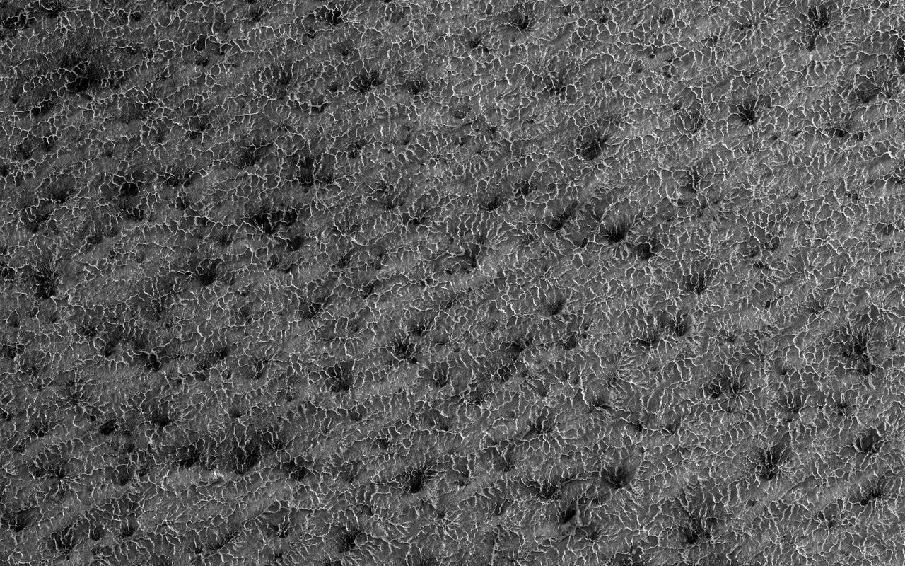
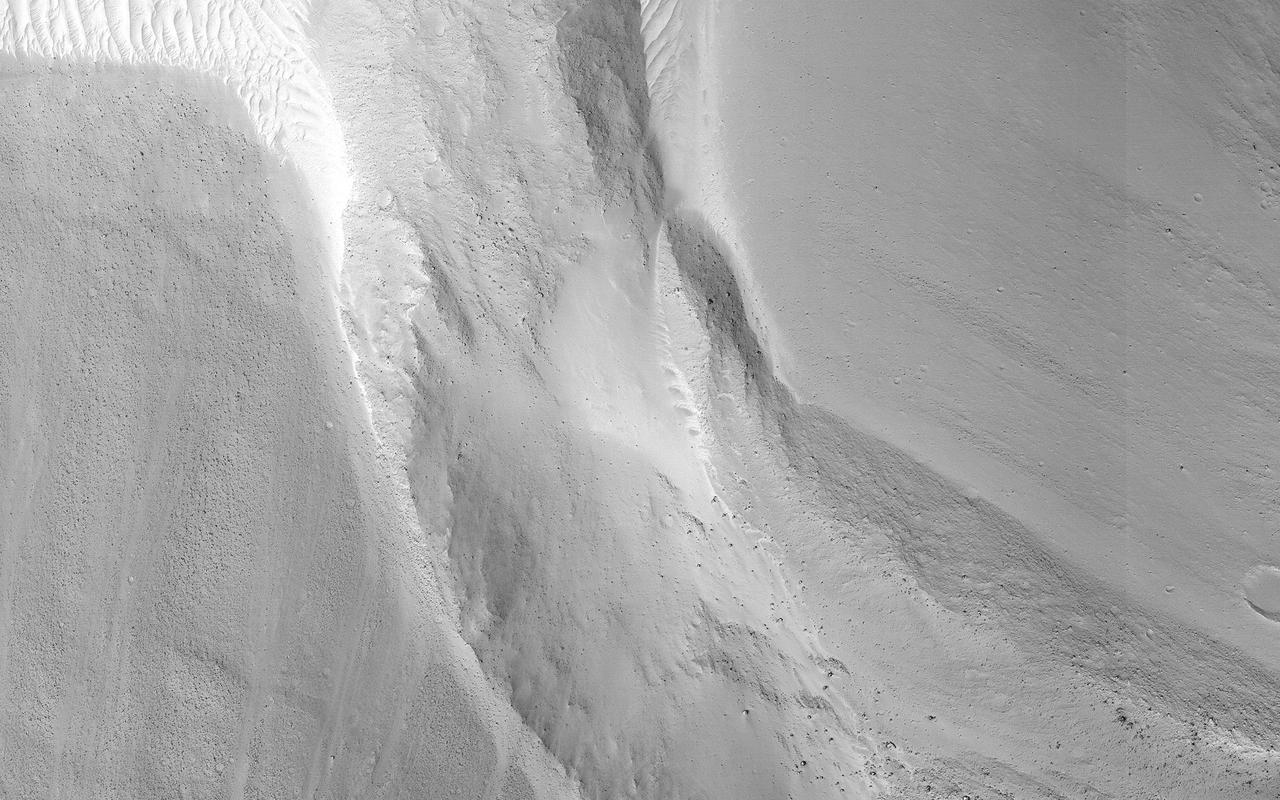
Some seasonal ice on Mars is transparent so that the sunlight penetrates to the bottom of the ice. Heat from this sunlight can turn the ice directly into a gas in a process called sublimation and this gas can scour channels in the loose dirt under the ice. Channels formed by sublimation of a layer of seasonal dry ice are so dense in this area that they look like lace. Gas flow erodes channels as it escapes to the surface of the overlying seasonal ice layer seeking the path of least resistance. http://photojournal.jpl.nasa.gov/catalog/PIA14451
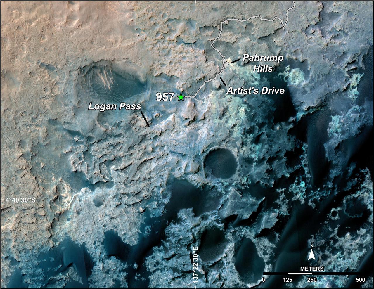
A green star marks the location of NASA's Curiosity Mars rover after a drive on the mission's 957th Martian day, or sol, (April 16, 2015). The map covers an area about 1.25 miles (2 kilometers) wide. Curiosity landed on Mars in August 2012. The drive on Sol 957 brought the mission's total driving distance past the 10-kilometer mark (6.214 miles). The rover is passing through a series of shallow valleys on a path from the "Pahrump Hills" outcrop, which it investigated for six months, toward its next science destination, called "Logan Pass." The rover's traverse line enters this map at the location Curiosity reached in mid-July 2014. The base map uses imagery from the High Resolution Imaging Science Experiment (HiRISE) camera on NASA's Mars Reconnaissance Orbiter. http://photojournal.jpl.nasa.gov/catalog/PIA19390
This illustration depicts a possible area through which the Mars 2020 Perseverance rover could traverse across Jezero Crater as it investigates several ancient environments that may have once been habitable. The route begins at the cliffs defining the base of a delta produced by a river as it flowed into a lake that once filled the crater. The path then traverses up and across the delta toward possible ancient shoreline deposits, and then climbs the 2,000-foot-high (610-meter-high) crater rim to explore the surrounding plains. About half of this traverse could be completed in Perseverance's prime mission (one Mars year, or two Earth years). For reference, the prominent crater near the center of the image is about 0.6 miles (1 kilometer) across. This mosaic is composed of multiple precisely aligned images from the Context Camera on the Mars Reconnaissance Orbiter and has a resolution of 20 meet (6 meters) per pixel. https://photojournal.jpl.nasa.gov/catalog/PIA24310
This map shows the route driven by NASA's Curiosity Mars rover, from the location where it landed in August 2012 to its location in August 2019, and its planned path to additional geological layers of lower "Mount Sharp." The blue star near top center marks "Bradbury Landing," the site where Curiosity arrived on Mars on Aug. 5, 2012, PDT (Aug. 6, EDT and Universal Time). Curiosity landed on Aeolis Palus, the plains surrounding Aeolis Mons (Mount Sharp) in Gale Crater. The base image for the map is from the High Resolution Imaging Science Experiment (HiRISE) camera on the Mars Reconnaissance Orbiter. North is up. "Bagnold Dunes" form a band of dark, wind-blown material at the foot of Mount Sharp. The scale bar at lower right represents one kilometer (0.62 mile). https://photojournal.jpl.nasa.gov/catalog/PIA23412
This annotated mosaic depicts a possible route the Mars 2020 Perseverance rover could take across Jezero Crater as it investigates several ancient environments that may have once been habitable. The route begins at the cliffs defining the base of a delta produced by a river as it flowed into a lake that once filled the crater. The path then traverses up and across the delta toward possible ancient shoreline deposits, and then climbs the 2,000-foot-high (610-meter-high) crater rim to explore the surrounding plains. About half of this traverse could be completed in Perseverance's prime mission (one Mars year, or two Earth years). For reference, the prominent crater near the center of the image is about 0.6 miles (1 kilometer) across. This mosaic is composed of multiple precisely aligned images from the Context Camera on the Mars Reconnaissance Orbiter and has a resolution of 20 meet (6 meters) per pixel. https://photojournal.jpl.nasa.gov/catalog/PIA24379
All this week, the THEMIS Image of the Day is following on the real Mars the path taken by fictional astronaut Mark Watney, stranded on the Red Planet in the book and movie, The Martian. Today's image shows a small portion of Acidalia Planitia, a largely flat plain that is part of Mars' vast northern lowlands. Scientists are debating the likelihood that the northern plains once contained a large ocean or other bodies of water, probably ice-covered. In the story, Acidalia Planitia is the landing site for a human expedition to Mars. After a dust storm damages the crew habitat and apparently kills Watney, the remaining crew abandon the expedition and leave for Earth. Watney however is still alive, and to save himself he must journey nearly 4,000 kilometers (2,500 miles) east to Schiaparelli Crater, where a rescue rocket awaits. Orbit Number: 27733 Latitude: 31.218 Longitude: 332.195 Instrument: VIS Captured: 2008-03-15 20:24 http://photojournal.jpl.nasa.gov/catalog/PIA19796
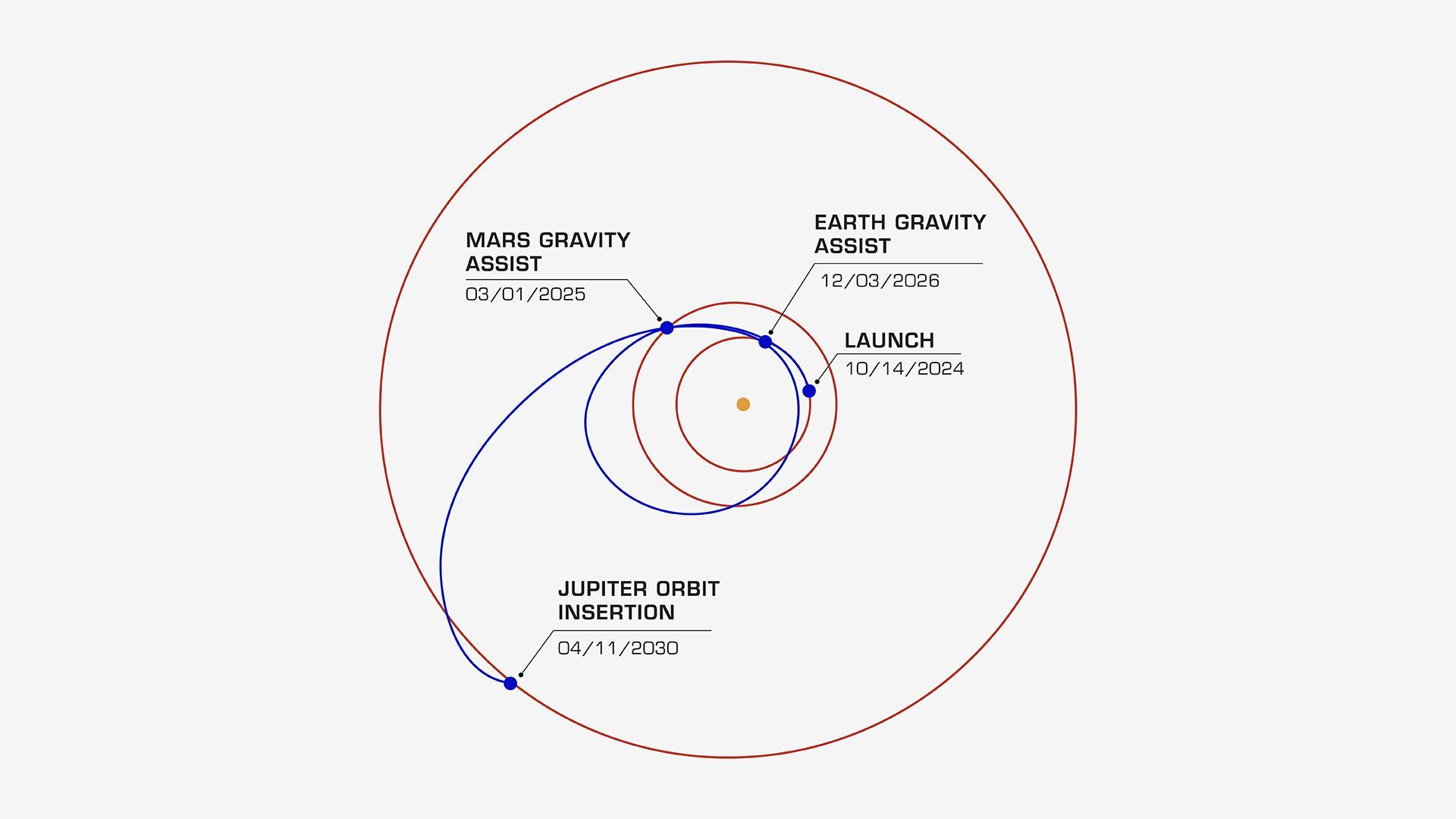
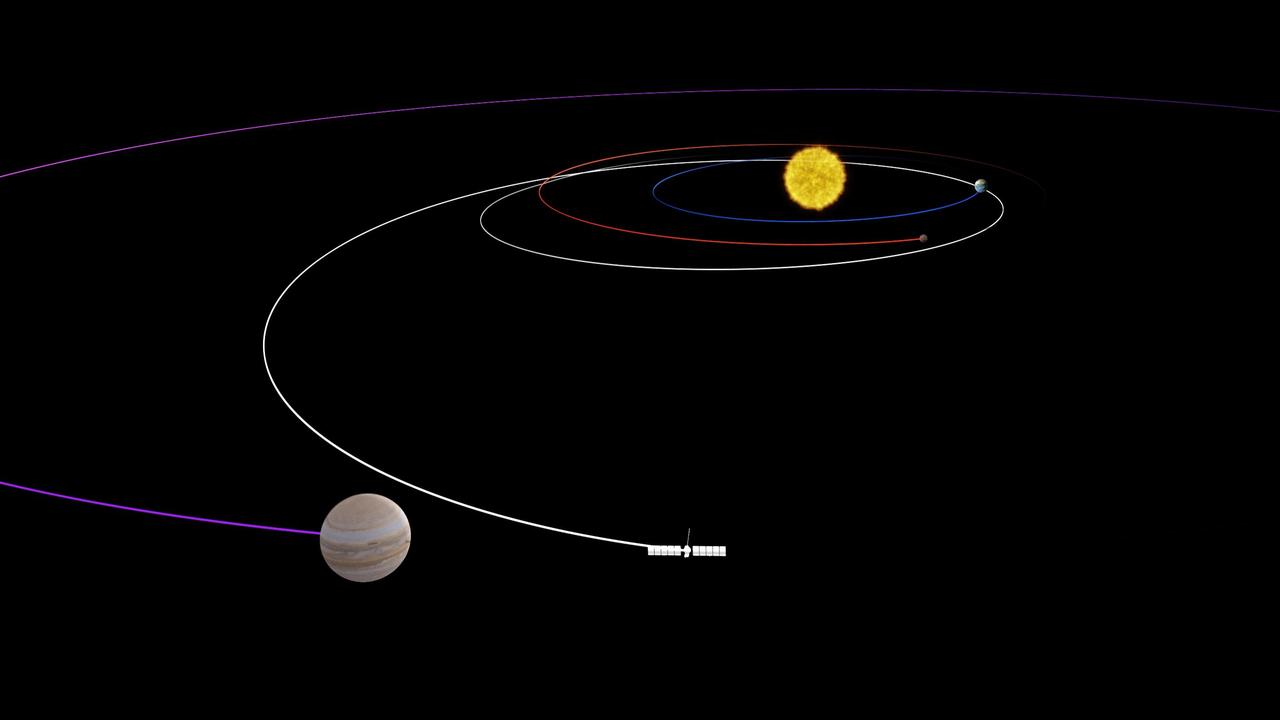
On its journey to the Jupiter system, NASA's Europa Clipper will take a path that swings past Mars, then Earth, using the gravity of each planet as a slingshot to boost the spacecraft's speed. All told, the journey will take about 5½ years, covering a distance of about 1.8 billion miles (2.9 billion kilometers). In this diagram, the orbits of Jupiter, Mars, and Earth are shown as concentric rings. Europa Clipper's launch period begins on Oct. 10, 2024. If the spacecraft launches on a later date, the timing of its Mars and Earth gravity assist maneuvers will shift. For all liftoff dates within the launch period, however, the spacecraft is scheduled to begin orbiting Jupiter on April 11, 2030. Then it will begin its investigation of the gas giant's icy moon Europa. Europa Clipper's three main science objectives are to determine the thickness of the moon's icy shell and its interactions with the ocean below, to investigate its composition, and to characterize its geology. The mission's detailed exploration of Europa will help scientists better understand the astrobiological potential for habitable worlds beyond our planet. Managed by Caltech in Pasadena, California, NASA's Jet Propulsion Laboratory leads the development of the Europa Clipper mission in partnership with APL for NASA's Science Mission Directorate in Washington. APL designed the main spacecraft body in collaboration with JPL and NASA's Goddard Space Flight Center in Greenbelt, Maryland, NASA's Marshall Space Flight Center in Huntsville, Alabama, and Langley Research Center in Hampton, Virginia. The Planetary Missions Program Office at Marshall executes program management of the Europa Clipper mission. NASA's Launch Services Program, based at Kennedy, manages the launch service for the Europa Clipper spacecraft, which will launch on a SpaceX Falcon Heavy rocket from Launch Complex 39A at Kennedy. https://photojournal.jpl.nasa.gov/catalog/PIA26435
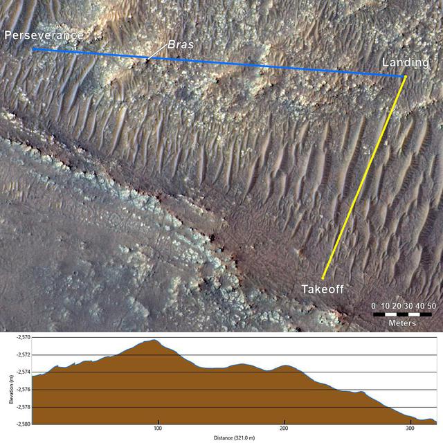
This annotated image from NASA's Mars Reconnaissance Orbiter (MRO), and the topographic map below it, provide a look at the altitude of surface features standing between the agency's Perseverance Mars rover and Ingenuity helicopter at the conclusion of the rotorcraft's 17th flight at Mars on Dec. 5, 2021. In the image of the surface – taken by MRO's High Resolution Science Experiment (HiRISE) camera – Ingenuity's flight path is depicted in yellow. Perseverance's location is indicated in the upper left, with the blue line delineating its line of sight to the helicopter's landing spot. The location of the tallest point on Mars' surface between rover and helicopter during its final descent is the hill near the center of image that the Perseverance science team has nicknamed "Bras," after a city in France. The topographic map below the orbital image provides the elevation of surface features along the blue line, or Perseverance's line of sight to helicopter. The height measurements to the left of the map are derived by comparing local elevations to the areoid (a model for an equipotential surface of Mars, analogous to "sea level" on Earth). The Ingenuity team believes the 13-foot (4-meter) height difference between the Perseverance rover and the top of Bras contributed to the loss of communications when the helicopter descended toward the surface at the end of its flight. The image's background terrain was generated using data collected by the HiRISE camera aboard NASA's Mars Reconnaissance Orbiter. https://photojournal.jpl.nasa.gov/catalog/PIA24980
This video shows NASA's Perseverance Mars rover using its auto-navigation, or AutoNav, technology to drive 548 feet (167 meters) on Sept. 12, 2021, the 200th Martian day, or sol, of the mission. AutoNav allows the rover to autonomously re-plan its route around rocks or other obstacles on its way to a pre-established destination. The video was taken by the rover's navigation cameras; they are capable of color, but black-and-white images are better for navigation. The video has been sped up by roughly 200 times with roughly 30 seconds between frames. In total, the rover drove 574 feet (175 meters). The first 26 feet (8 meters) were based on commands sent up earlier by rover drivers, allowing Perseverance to build a 3D map of the terrain under and around it. This map allows the AutoNav function to assess the safety of available paths at the rover's location; engineers call this "crawling on to the map." Once AutoNav takes over, the rover autonomously chooses a path to reach the intended destination, continually imaging around itself to maintain a 98-foot-by-98-foot (30-meter-by-30-meter) map centered on the rover. A key objective for Perseverance's mission on Mars is astrobiology, including the search for signs of ancient microbial life. The rover will characterize the planet's geology and past climate, pave the way for human exploration of the Red Planet, and be the first mission to collect and cache Martian rock and regolith (broken rock and dust). Subsequent NASA missions, in cooperation with ESA (European Space Agency), would send spacecraft to Mars to collect these sealed samples from the surface and return them to Earth for in-depth analysis. The Mars 2020 Perseverance mission is part of NASA's Moon to Mars exploration approach, which includes Artemis missions to the Moon that will help prepare for human exploration of the Red Planet. Movie available at https://photojournal.jpl.nasa.gov/catalog/PIA24934

Kim Stratton, at left, with Caterpillar, talks to students during a Women in STEM breakfast inside the Debus Conference Center at the Kennedy Space Center Visitor Complex in Florida. STEM is science, technology, engineering and math. The special event gave students competing in NASA's 8th Annual Robotic Mining Competition the chance to learn from female NASA scientists, engineers and professionals about their careers and the paths they took to working at Kennedy. The Robotic Mining Competition is a NASA Human Exploration and Operations Mission Directorate project designed to encourage students in STEM fields. The project provides a competitive environment to foster innovative ideas and solutions that could be used on NASA's Journey to Mars.

Kennedy Space Center Deputy Director Janet Petro speaks to students during a Women in STEM mentoring breakfast inside the Debus Conference Center at the Kennedy Space Center Visitor Complex in Florida. STEM is science, technology, engineering and math. The special event gave students competing in NASA's 8th Annual Robotic Mining Competition the chance to learn from female NASA scientists, engineers and professionals about their careers and the paths they took to working at Kennedy. The Robotic Mining Competition is a NASA Human Exploration and Operations Mission Directorate project designed to encourage students in STEM fields. The project provides a competitive environment to foster innovative ideas and solutions that could be used on NASA's Journey to Mars.

NASA Associate Administrator Bob Cabana participates in a town hall discussion on Nov. 29, 2022, at the agency’s Kennedy Space Center in Florida. NASA senior leaders also participating were NASA Deputy Administrator Pam Melroy; Kurt Vogel, director of NASA Space Architectures; Cathy Koerner, deputy associate administrator, Exploration Systems Development; and Janet Petro, director of Kennedy Space Center. Discussion centered around NASA’s Moon to Mars objectives, Kennedy’s role in deep space exploration, and the path forward in the coming months and years.

Kennedy Space Center Deputy Director Janet Petro speaks to students during a Women in STEM mentoring breakfast inside the Debus Conference Center at the Kennedy Space Center Visitor Complex in Florida. STEM is science, technology, engineering and math. The special event gave students competing in NASA's 8th Annual Robotic Mining Competition the chance to learn from female NASA scientists, engineers and professionals about their careers and the paths they took to working at Kennedy. The Robotic Mining Competition is a NASA Human Exploration and Operations Mission Directorate project designed to encourage students in STEM fields. The project provides a competitive environment to foster innovative ideas and solutions that could be used on NASA's Journey to Mars.

Gioia Massa, at left, a NASA payload scientist, talks to students during a Women in STEM breakfast inside the Debus Conference Center at the Kennedy Space Center Visitor Complex in Florida. STEM is science, technology, engineering and math. The special event gave students competing in NASA's 8th Annual Robotic Mining Competition the chance to learn from female NASA scientists, engineers and professionals about their careers and the paths they took to working at Kennedy. The Robotic Mining Competition is a NASA Human Exploration and Operations Mission Directorate project designed to encourage students in STEM fields. The project provides a competitive environment to foster innovative ideas and solutions that could be used on NASA's Journey to Mars.
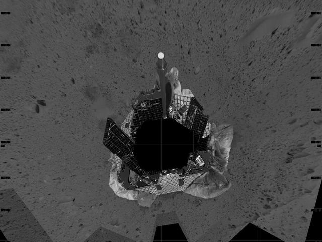
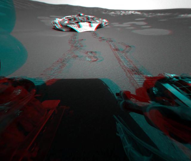
This mosaic image taken by the navigation camera on the Mars Exploration Rover Spirit represents an overhead view of the rover as it prepares to roll off the lander and onto the martian surface. The yellow arrow illustrates the direction the rover may take to roll safely off the lander. The rover was originally positioned to roll straight forward off the lander (south side of image). However, an airbag is blocking its path. To take this northeastern route, the rover must back up and perform what is likened to a 3-point turn in a cramped parking lot. http://photojournal.jpl.nasa.gov/catalog/PIA05044