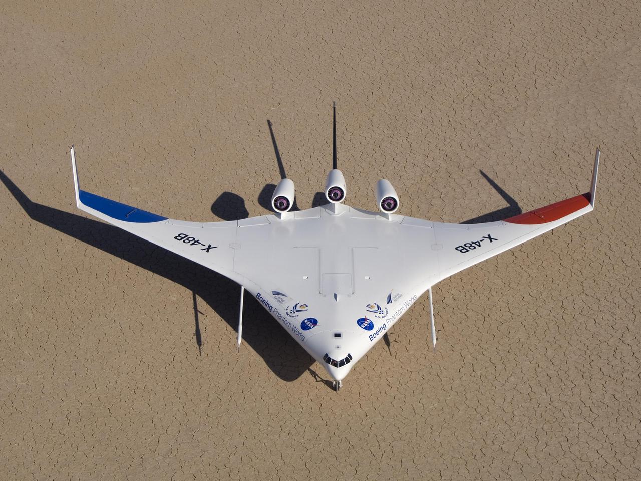
Boeing's colorful X-48B Blended Wing Body technology demonstrator showed off its unique triangular lines while parked on Rogers Dry Lake adjacent to NASA Dryden.
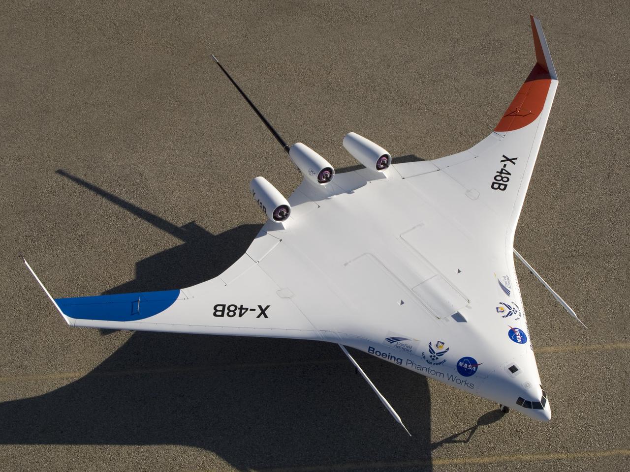
With its spin parachute tail stinger extending aft, Boeing's sub-scale X-48B BWB technology demonstrator showed off its clean semi-triangular shape.
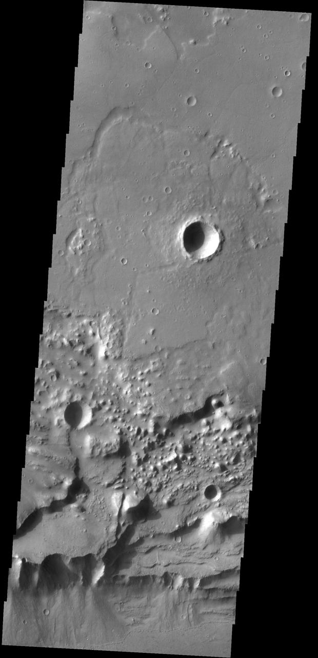
Triangular shaped deposits at cliff edges are termed alluvial fans. Alluvial fans typically form in arid regions were water flow is limited, so deposits of material are not washed away as seen by NASA 2001 Mars Odyssey spacecraft.
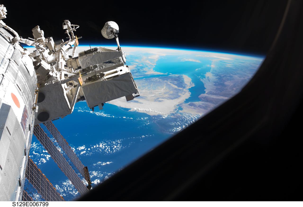
S129-E-006799 (19 Nov. 2009) --- A portion of the Kibo laboratory of the International Space Station, backdropped by the triangular Sinai Peninsula, is photographed by an STS-129 crew member while Space Shuttle Atlantis remains docked with the station.
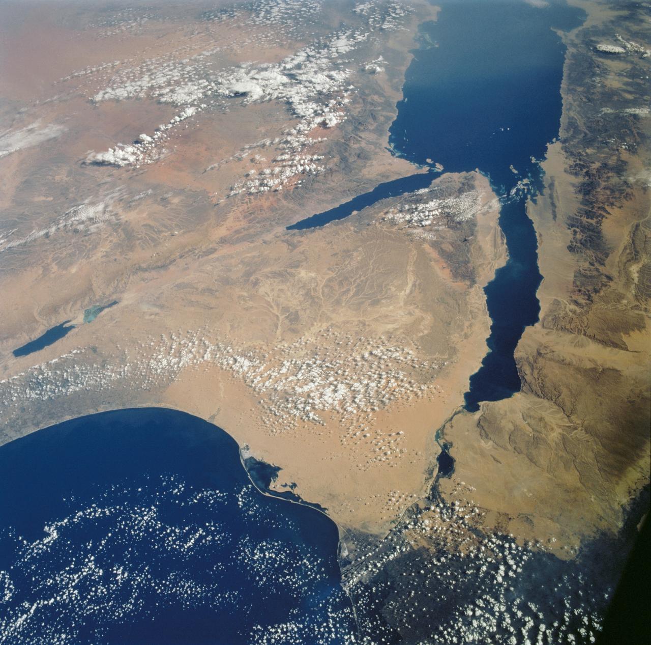
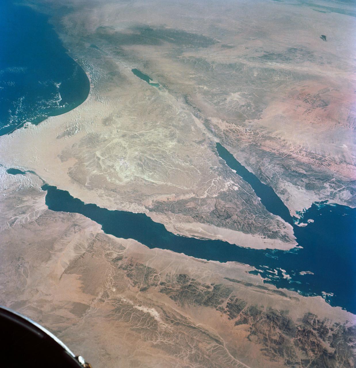
STS112-702-002 (7-18 October 2002) --- Egypt's triangular Sinai Peninsula lies in the center of this view, photographed from the Space Shuttle Atlantis, with the dark greens of the Nile delta lower right. In this southwesterly view, the Red Sea, with its characteristic parallel coastlines, stretches toward the top. At the bottom of the image, the Suez Canal appears as an irregular line joining the Red Sea to the Mediterranean Sea (lower left). The Dead Sea in central Israel, with its light blue salt ponds at the south end, appears on the left margin.

iss072e445148 (Dec. 28, 2024) --- City lights illuminate this triangular area comprising the cities of Abha, Khamis Mushait, and Ahad Rafidah, with a total metropolitan population of about 2.5 million residents in southwestern Saudi Arabia. The International Space Station was orbiting 256 miles above the Arabian Peninsula at approximately 11:28 p.m. local time.

iss073e0509720 (Aug. 18, 2025) --- Great Bend, Kansas, primarily an agricultural town and located at the point where the Arkansas River course shifts, is pictured from the International Space Station as it orbited 261 miles above the Sunflower State. The triangular Great Bend Municipal Airport, once used as a base for the B-29 Superfortress during WWII and now used for general aviation, can also be seen.
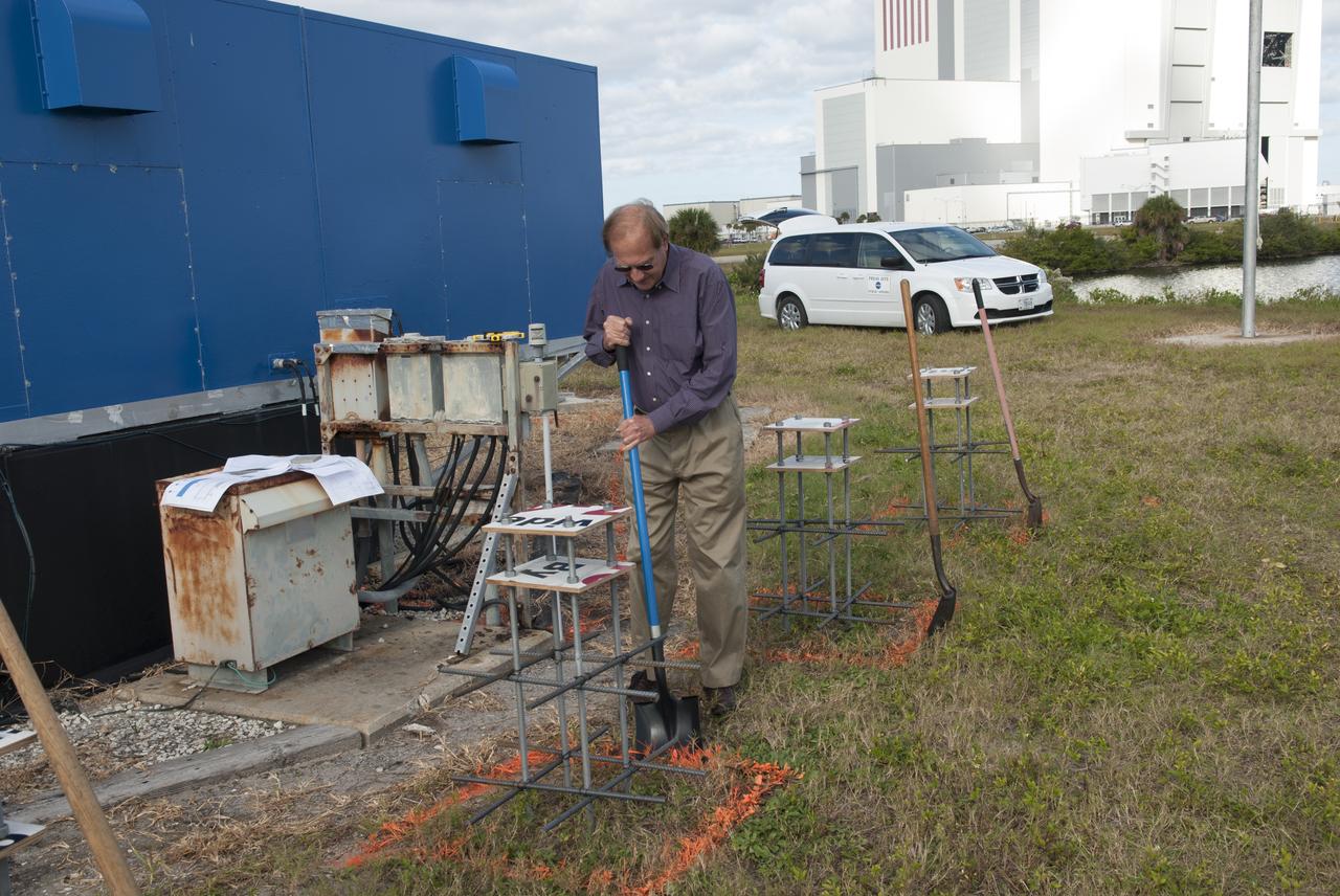
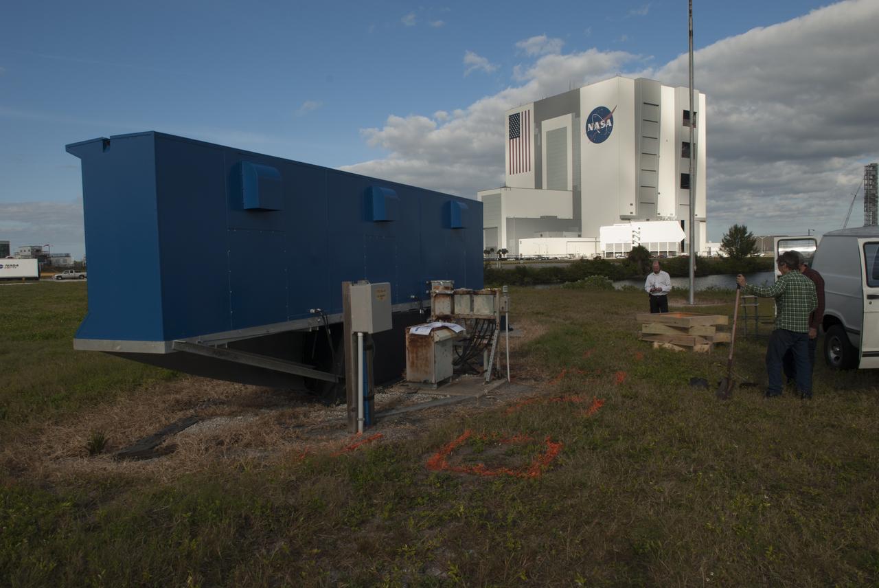
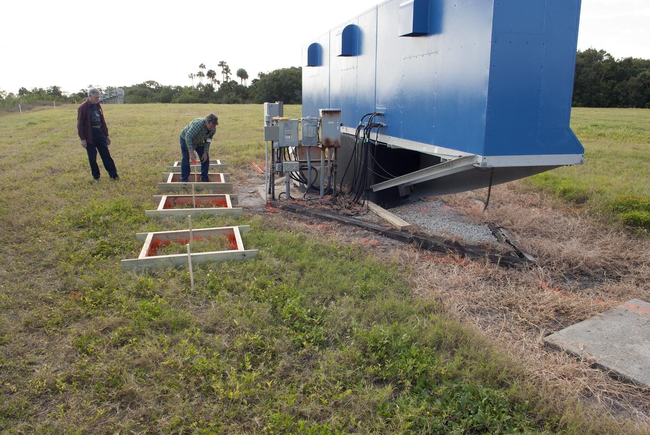
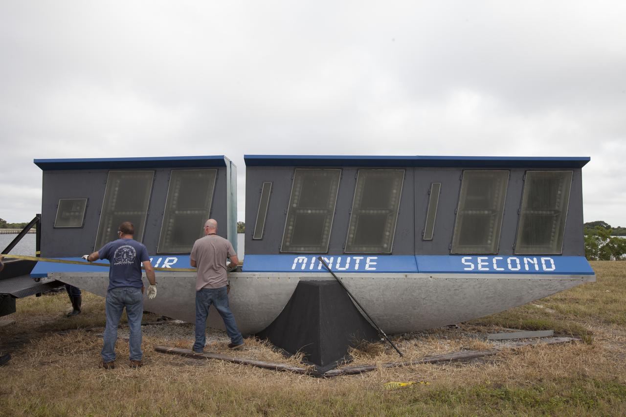
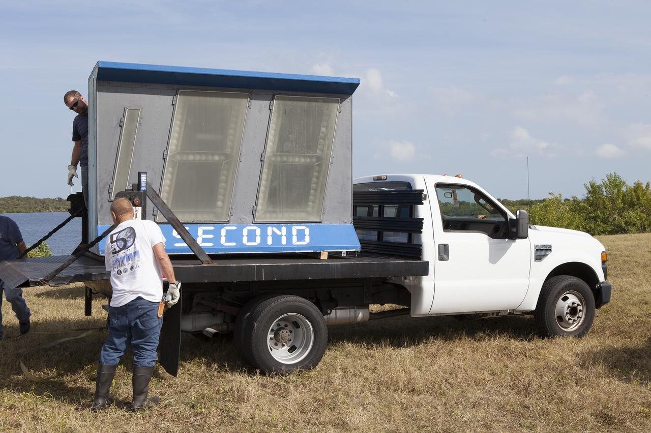
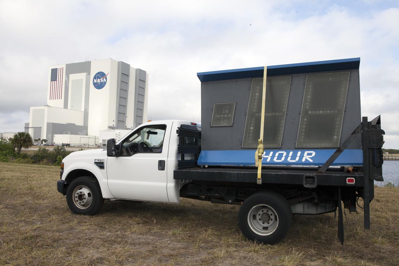
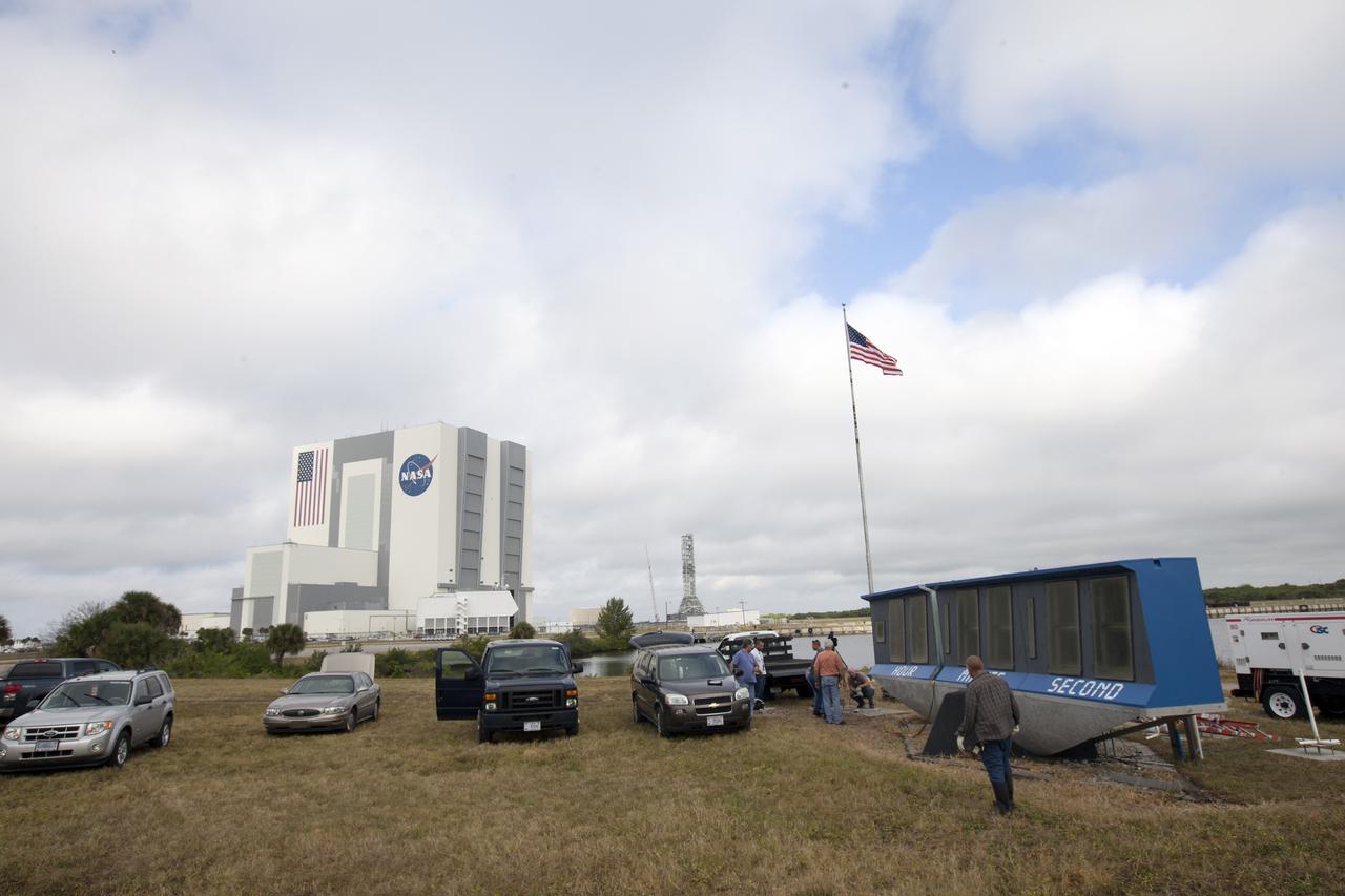
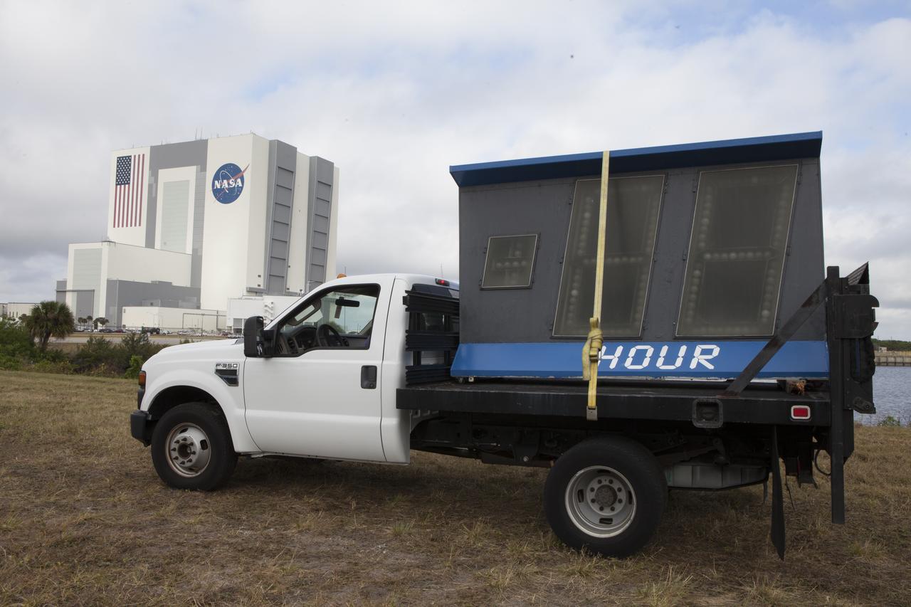
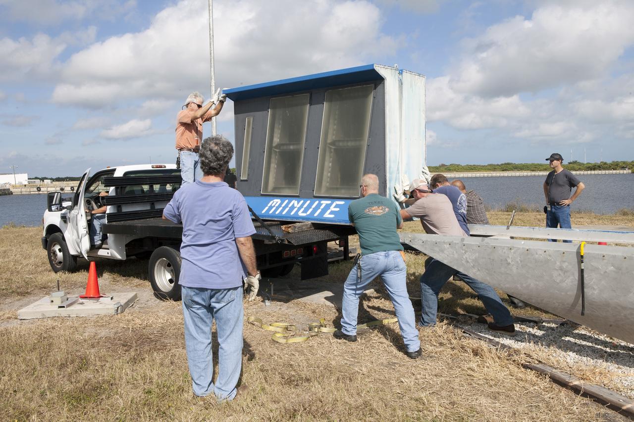
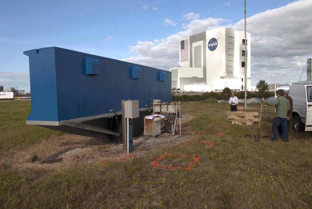
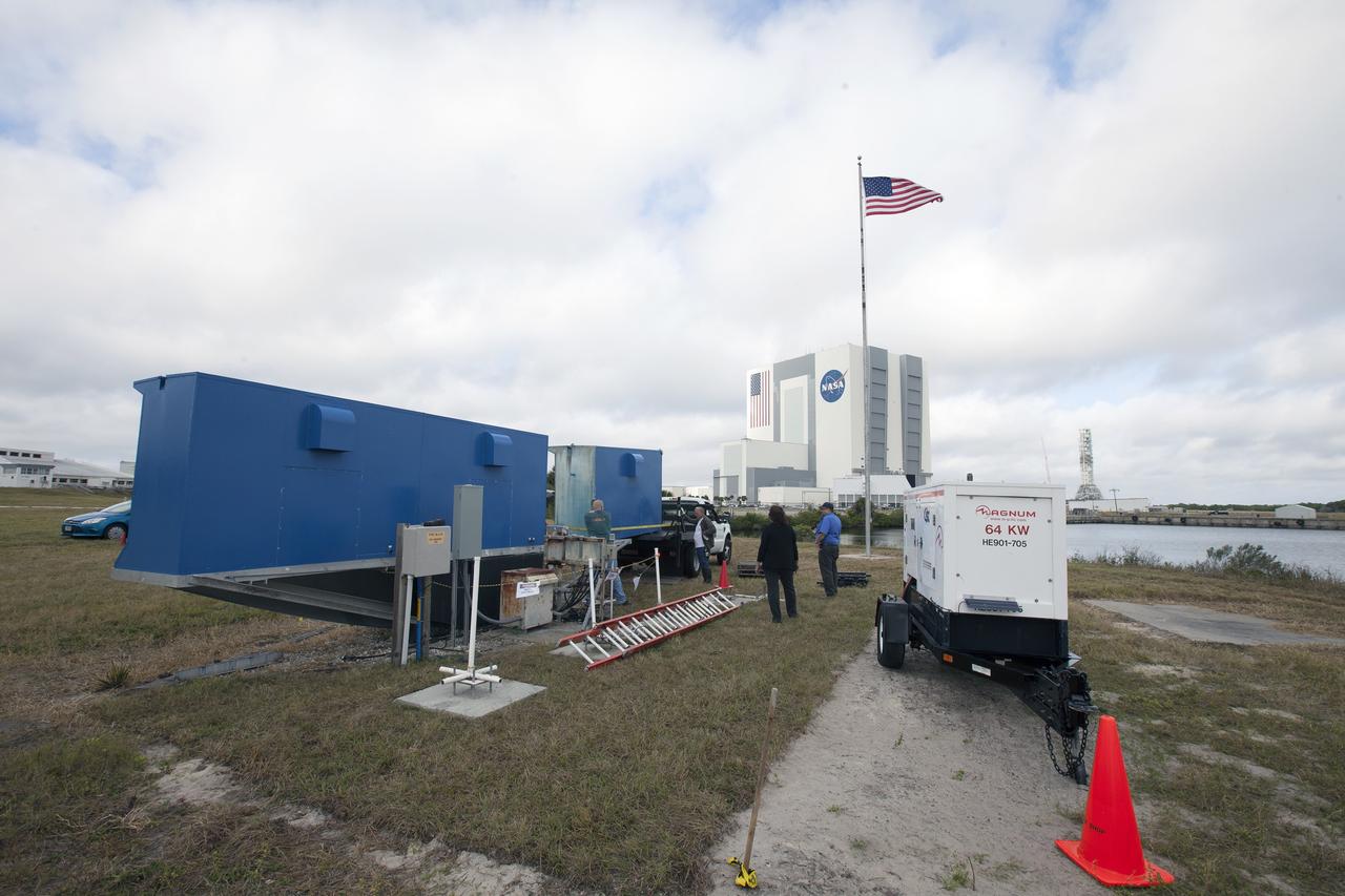
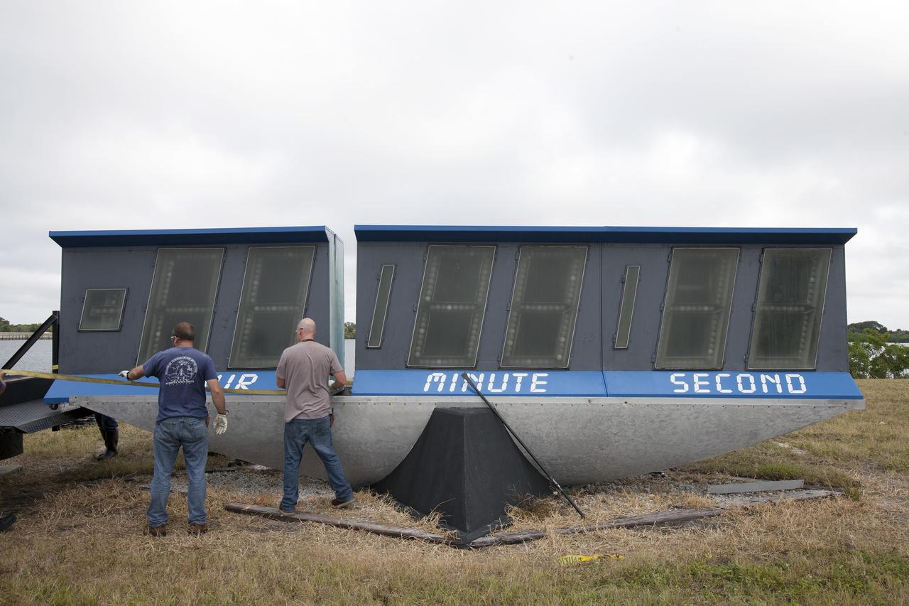
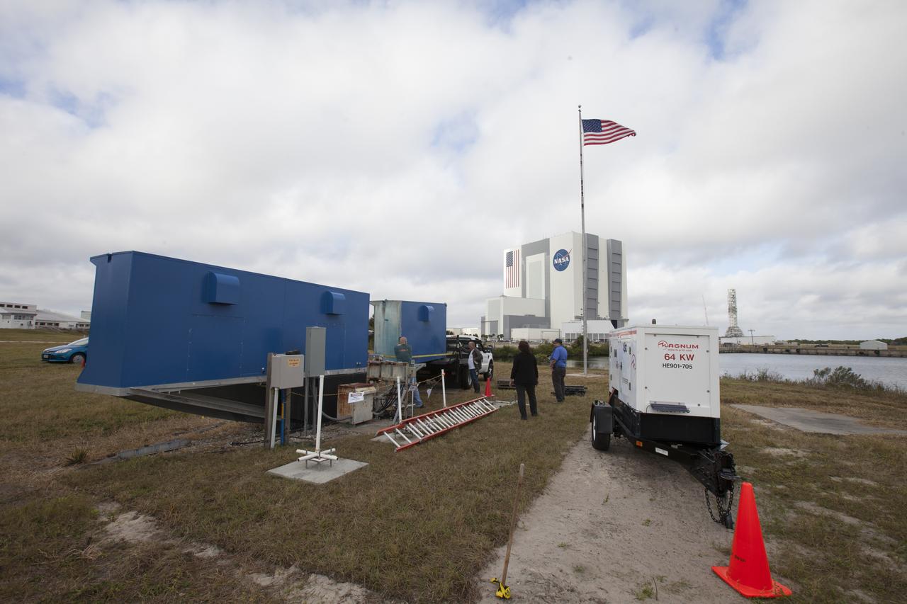
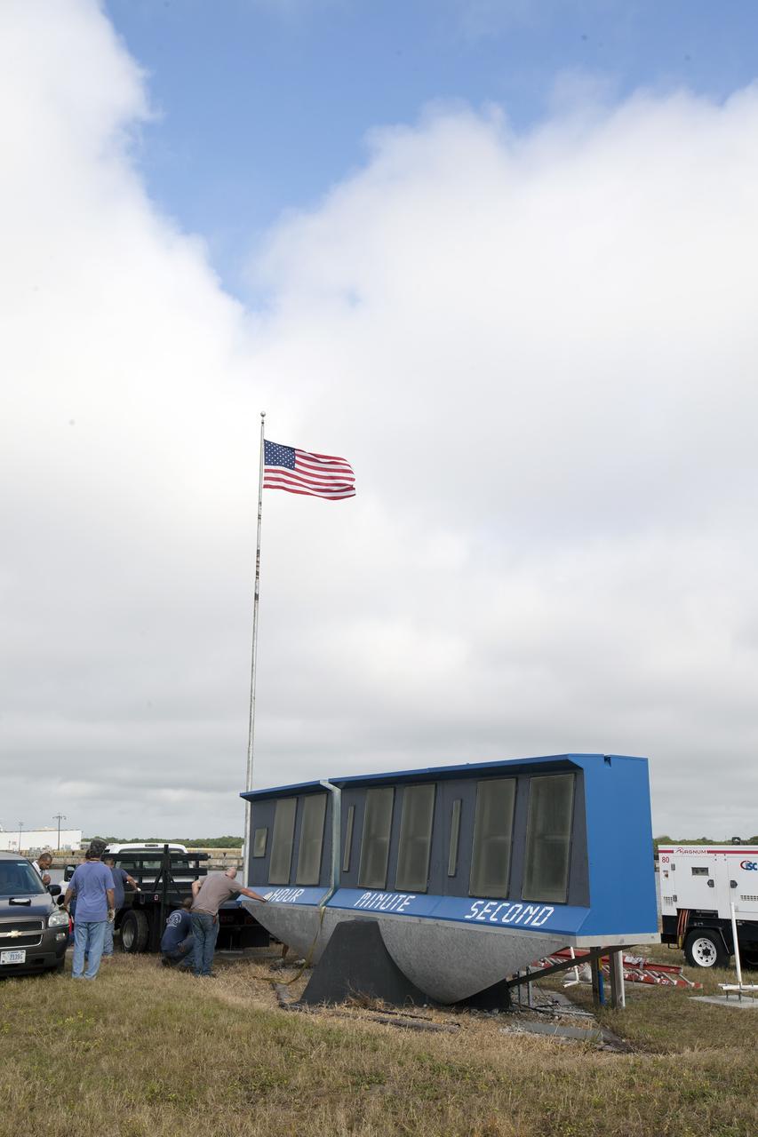
At NASA's Kennedy Space Center in Florida, Public Affairs Officer George Diller digs in behind the current countdown clock during the groundbreaking ceremony for the new countdown clock. The old timepiece was designed by Kennedy engineers and built by Kennedy technicians in 1969. Not including the triangular concrete and aluminum base, the famous landmark is nearly 6 feet 70 inches high, 26 feet 315 inches wide and 3 feet deep. The new display will be similar in size, with the screen being nearly 26 feet wide by 7 feet high.
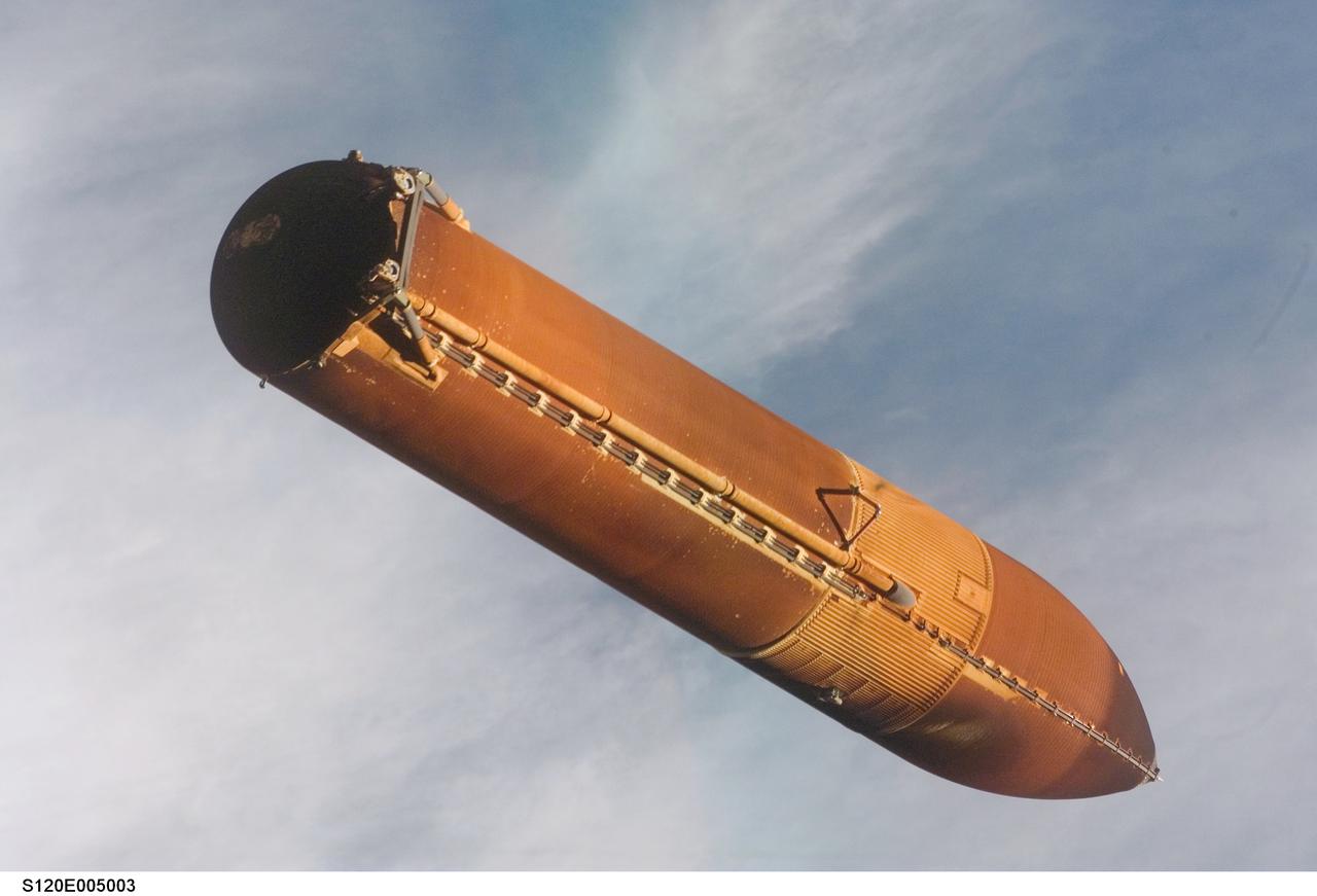
S120-E-005003 (23 Oct. 2007) --- External Tank 120 falls away from Space Shuttle Discovery as the crew onboard documents the tank's condition using a hand-held digital camera. The detailed images of the tank are reviewed by imagery experts in Mission Control. This image shows a small divot of foam loss near the triangular shaped bipod attach fitting. The divot posed no threat of damage to Discovery.
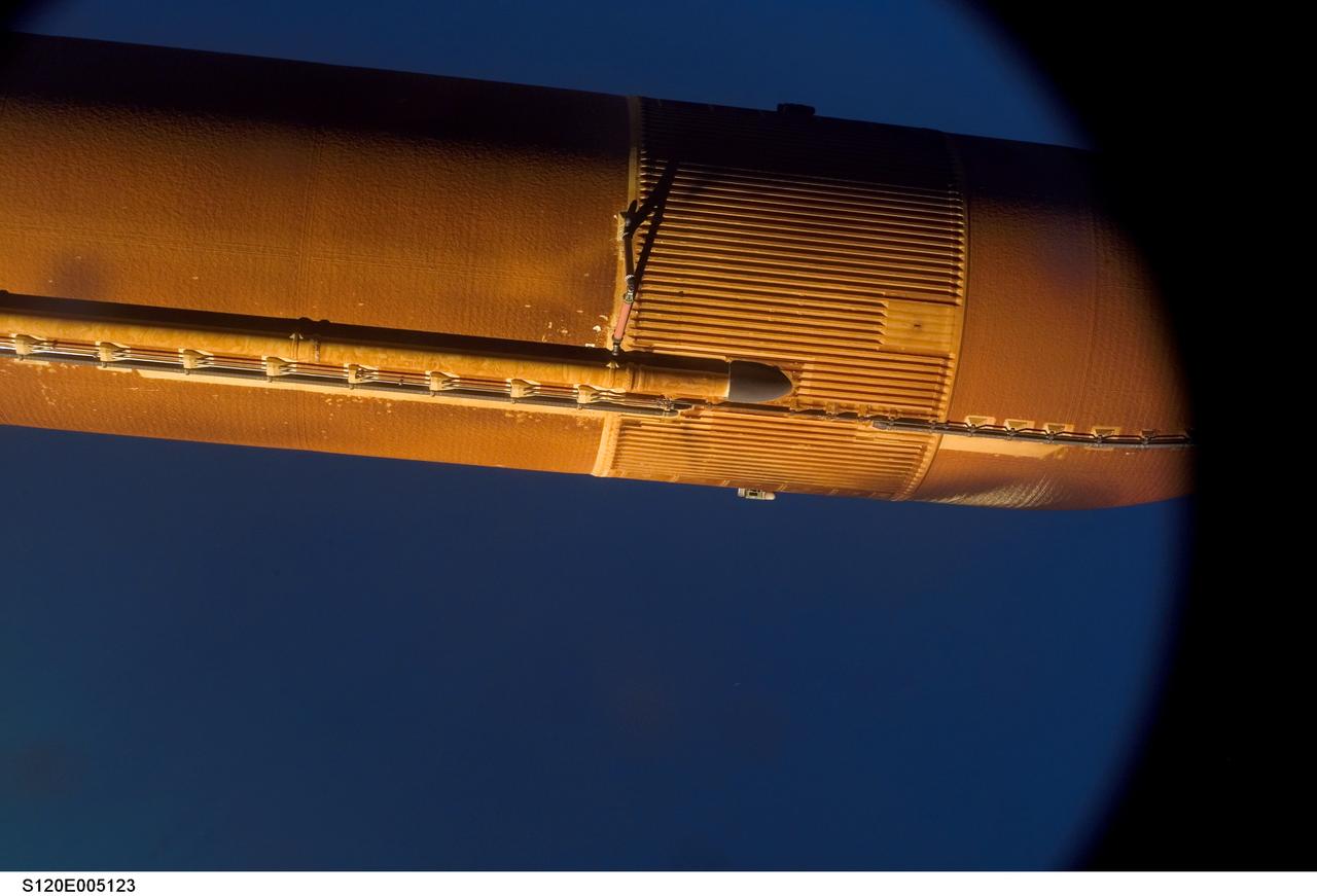
S120-E-005123 (23 Oct. 2007) --- External Tank 120 falls away from Space Shuttle Discovery as a digital camera automatically captures detailed images of the tank for analysis by imagery experts in Mission Control. This image shows little foam loss from the tank except for one small divot near the triangular shaped bipod attach fitting. The divot posed no threat of damage to Discovery.
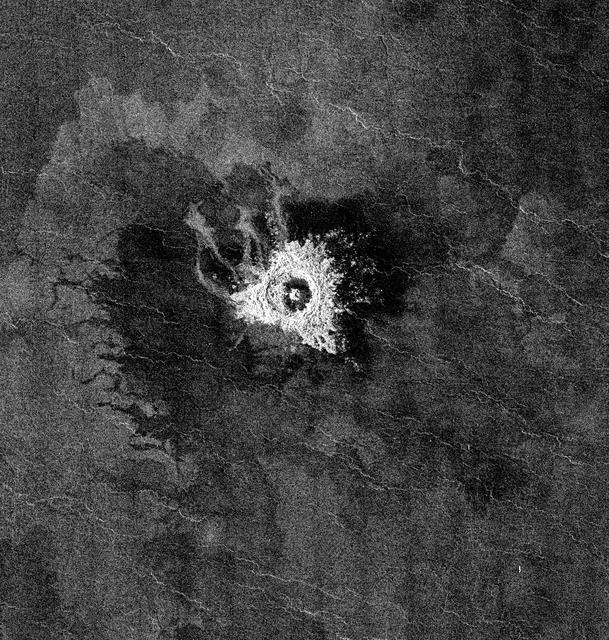
This full-resolution image from NASA Magellan spacecraft shows Jeanne crater, a 19.5 kilometer (12 mile) diameter impact crater. Jeanne crater is located at 40.0 degrees north latitude and 331.4 degrees longitude. The distinctive triangular shape of the ejecta indicates that the impacting body probably hit obliquely, traveling from southwest to northeast. The crater is surrounded by dark material of two types. The dark area on the southwest side of the crater is covered by smooth (radar-dark) lava flows which have a strongly digitate contact with surrounding brighter flows. The very dark area on the northeast side of the crater is probably covered by smooth material such as fine-grained sediment. This dark halo is asymmetric, mimicking the asymmetric shape of the ejecta blanket. The dark halo may have been caused by an atmospheric shock or pressure wave produced by the incoming body. Jeanne crater also displays several outflow lobes on the northwest side. These flow-like features may have formed by fine-grained ejecta transported by a hot, turbulent flow created by the arrival of the impacting object. Alternatively, they may have formed by flow of impact melt. http://photojournal.jpl.nasa.gov/catalog/PIA00472
At NASA's Kennedy Space Center in Florida, Kennedy TV senior systems engineer Ronald Gonser, left, Jeff Pratt and Frank Morse with Abacus Technology prep the area behind the current countdown clock for the groundbreaking ceremony for the new countdown clock. The old timepiece was designed by Kennedy engineers and built by Kennedy technicians in 1969. Not including the triangular concrete and aluminum base, the famous landmark is nearly 6 feet 70 inches high, 26 feet 315 inches wide and 3 feet deep. The new display will be similar in size, with the screen being nearly 26 feet wide by 7 feet high.
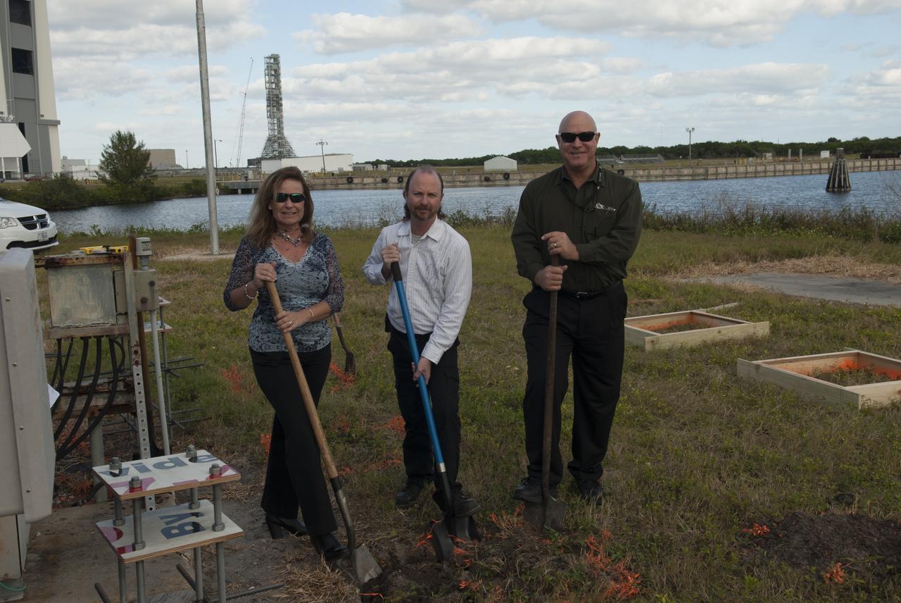
At NASA's Kennedy Space Center in Florida, Project Manager Sonja Hernandez, Kennedy TV senior systems engineer Ronald Gonser and Kennedy/IMCS senior manager Jeff Van Pelt dig in behind the current countdown clock during the groundbreaking ceremony for the new countdown clock. The old timepiece was designed by Kennedy engineers and built by Kennedy technicians in 1969. Not including the triangular concrete and aluminum base, the famous landmark is nearly 6 feet 70 inches high, 26 feet 315 inches wide and 3 feet deep. The new display will be similar in size, with the screen being nearly 26 feet wide by 7 feet high.
CAPE CANAVERAL, Fla. -- At NASA's Kennedy Space Center in Florida, Jeff Pratt and Frank Morse with Abacus Technology prep the area behind the current countdown clock for the groundbreaking ceremony for the new countdown clock. The old timepiece was designed by Kennedy engineers and built by Kennedy technicians in 1969. Not including the triangular concrete and aluminum base, the famous landmark is nearly 6 feet 70 inches high, 26 feet 315 inches wide and 3 feet deep. The new display will be similar in size, with the screen being nearly 26 feet wide by 7 feet high. For more information on the countdown clock, go to http://go.nasa.gov/10Zku10. Photo credit: NASA/Jim Grossmann
CAPE CANAVERAL, Fla. -- At NASA's Kennedy Space Center in Florida, Public Affairs Officer George Diller digs in behind the current countdown clock during the groundbreaking ceremony for the new countdown clock. The old timepiece was designed by Kennedy engineers and built by Kennedy technicians in 1969. Not including the triangular concrete and aluminum base, the famous landmark is nearly 6 feet 70 inches high, 26 feet 315 inches wide and 3 feet deep. The new display will be similar in size, with the screen being nearly 26 feet wide by 7 feet high. For more information on the countdown clock, go to http://go.nasa.gov/10Zku10. Photo credit: NASA/Jim Grossmann

STS100-713-064 (19 April-1 May 2001) --- This southerly-looking view, captured with a 70mm camera onboard the Space Shuttle Endeavour, shows the triangular-shaped island of Sicily. With only very limited coastal plains the island's topography consists of rugged hills and low mountains. Snow-capped Mt. Etna, one of the world's most instrumented volcanoes, is visible near the northeast point of the island. Two other distinctive features in this image are the lighter-colored zone of suspended sediment in the water along the southern coast and, in the distance, the smaller islands of Malta.
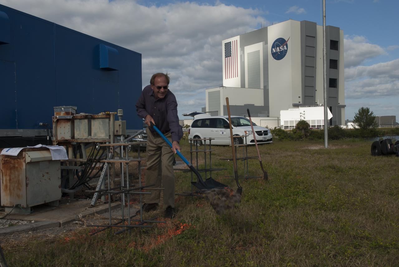
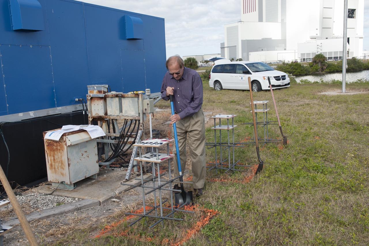
At NASA's Kennedy Space Center in Florida, Public Affairs Officer George Diller shovels the first scoop of soil behind the current countdown clock during the groundbreaking ceremony for the new countdown clock. The old timepiece was designed by Kennedy engineers and built by Kennedy technicians in 1969. Not including the triangular concrete and aluminum base, the famous landmark is nearly 6 feet 70 inches high, 26 feet 315 inches wide and 3 feet deep. The new display will be similar in size, with the screen being nearly 26 feet wide by 7 feet high.

At NASA's Kennedy Space Center in Florida, Jeff Pratt and Frank Morse with Abacus Technology prep the area behind the current countdown clock for the groundbreaking ceremony for the new countdown clock. The old timepiece was designed by Kennedy engineers and built by Kennedy technicians in 1969. Not including the triangular concrete and aluminum base, the famous landmark is nearly 6 feet 70 inches high, 26 feet 315 inches wide and 3 feet deep. The new display will be similar in size, with the screen being nearly 26 feet wide by 7 feet high.
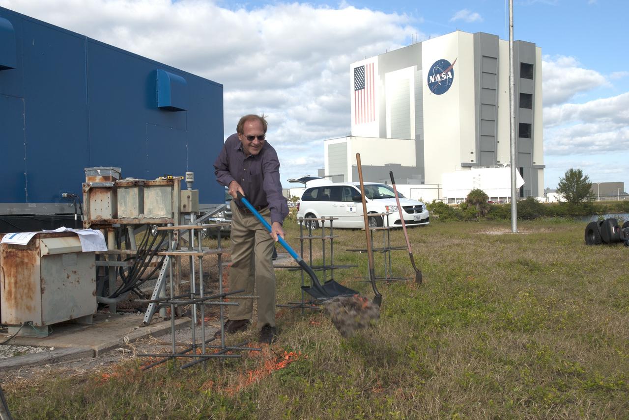
CAPE CANAVERAL, Fla. -- At NASA's Kennedy Space Center in Florida, Public Affairs Officer George Diller shovels the first scoop of soil behind the current countdown clock during the groundbreaking ceremony for the new countdown clock. The old timepiece was designed by Kennedy engineers and built by Kennedy technicians in 1969. Not including the triangular concrete and aluminum base, the famous landmark is nearly 6 feet 70 inches high, 26 feet 315 inches wide and 3 feet deep. The new display will be similar in size, with the screen being nearly 26 feet wide by 7 feet high. For more information on the countdown clock, go to http://go.nasa.gov/10Zku10. Photo credit: NASA/Jim Grossmann

An artist’s concept of NASA’s Advanced Composite Solar Sail System spacecraft in orbit as seen from directly above the spacecraft looking down at Earth below.
This image of NASA's Perseverance Mars rover at the rim of Belva Crater was taken by the agency's Ingenuity Mars Helicopter during the rotorcraft's 51st flight on April 22, 2023, the 772nd Martian day, or sol, of the rover's mission. At the time the image was taken, the helicopter was at an altitude of about 40 feet (12 meters). The rover is in the upper left of the image, parked at a light-toned rocky outcrop the science team is calling "Echo Creek." Perseverance's tracks can be seen extending from its location to the upper-right side of image. The helicopter's shadow can be seen on the rocky hill in the foreground, just to the right and below the image's center. The hill, designated "Mount Julian" by the science team, is a planned future stop for the rover. A small triangular piece of debris from the rover's entry, descent, and landing system can be seen at the lower center of image. https://photojournal.jpl.nasa.gov/catalog/PIA25884
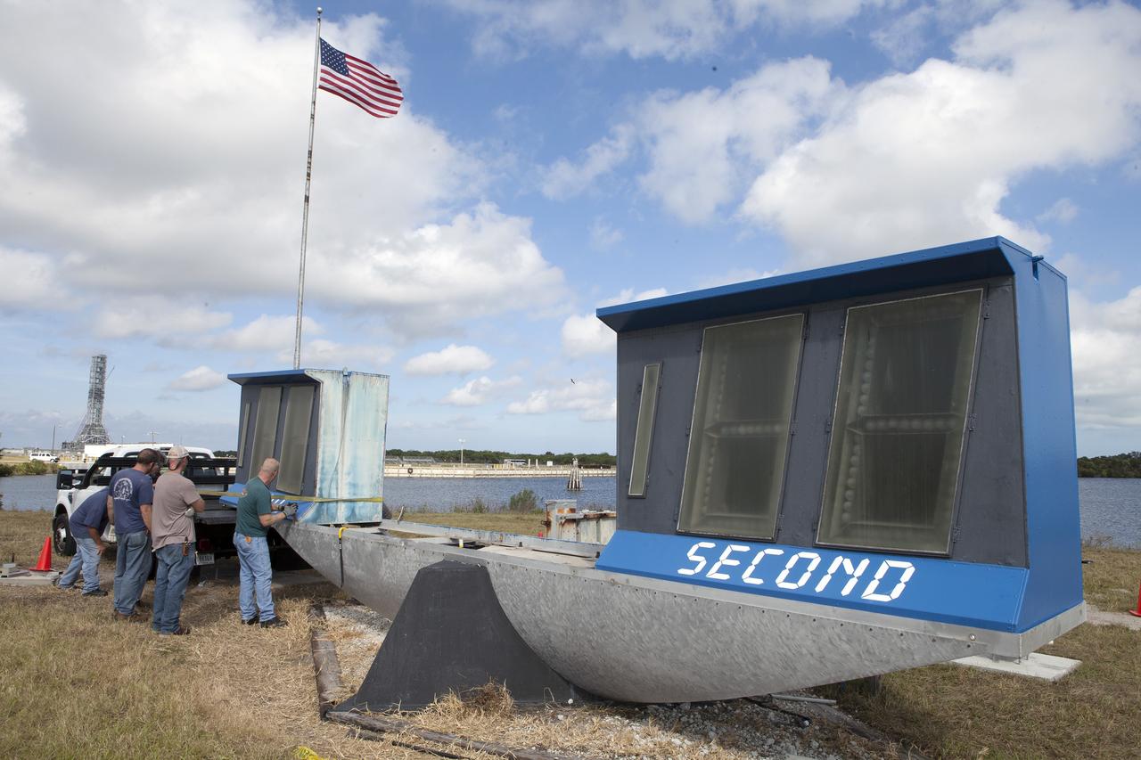
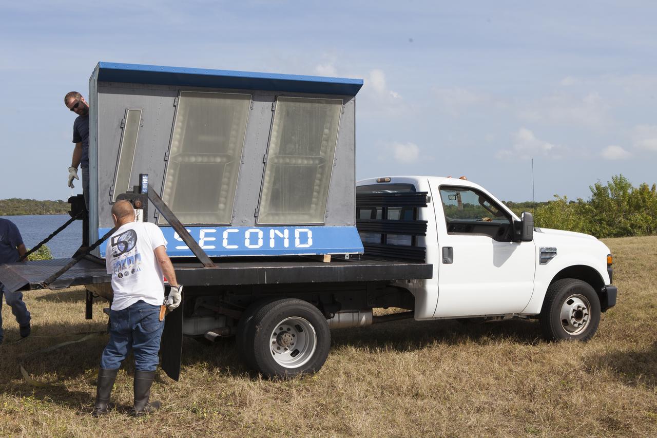
At NASA's Kennedy Space Center in Florida, the historic countdown clock at the spaceport's Press Site is disassembled for removal. Kennedy has requested to acquire the countdown clock from the agency’s Artifact Working Group at NASA Headquarters for likely display at the Kennedy Space Center Visitor Complex. A new modern multimedia display soon will be installed, similar to the screens seen at sporting venues, is in the works. The new screen will be nearly 26 feet wide by 7 feet high. The old timepiece was designed by Kennedy engineers and built by Kennedy technicians in 1969. Not including the triangular concrete and aluminum base, the famous landmark is nearly six feet high, 26 feet wide and 3 feet deep. The new display will be similar in size, with the screen being nearly 26 feet wide by seven feet high.
CAPE CANAVERAL, Fla. – At NASA's Kennedy Space Center in Florida, the historic countdown clock at the spaceport's Press Site is disassembled for removal. Kennedy has requested to acquire the countdown clock from the agency’s Artifact Working Group at NASA Headquarters for likely display at the Kennedy Space Center Visitor Complex. A new modern multimedia display soon will be installed, similar to the screens seen at sporting venues, is in the works. The new screen will be nearly 26 feet wide by 7 feet high. The old timepiece was designed by Kennedy engineers and built by Kennedy technicians in 1969. Not including the triangular concrete and aluminum base, the famous landmark is nearly six feet high, 26 feet wide and 3 feet deep. The new display will be similar in size, with the screen being nearly 26 feet wide by seven feet high. For more information on the countdown clock, go to http://go.nasa.gov/10Zku10. Photo credit: NASA/Frankie Martin

At NASA's Kennedy Space Center in Florida, the historic countdown clock at the spaceport's Press Site is disassembled for removal. Kennedy has requested to acquire the countdown clock from the agency’s Artifact Working Group at NASA Headquarters for likely display at the Kennedy Space Center Visitor Complex. A new modern multimedia display soon will be installed, similar to the screens seen at sporting venues, is in the works. The new screen will be nearly 26 feet wide by 7 feet high. The old timepiece was designed by Kennedy engineers and built by Kennedy technicians in 1969. Not including the triangular concrete and aluminum base, the famous landmark is nearly six feet high, 26 feet wide and 3 feet deep. The new display will be similar in size, with the screen being nearly 26 feet wide by seven feet high.
S66-54893 (14 Sept. 1966) --- Near East area as seen from the orbiting Gemini-11 spacecraft during its 26th revolution of Earth. The United Arab Republic (Egypt) is in foreground. Triangular-shaped area is the Sinai Peninsula. Saudi Arabia is at upper right. The Mediterranean Sea is at upper left. The Gulf of Suez separates Egypt from the Sinai Peninsula. The Red Sea is at bottom right. The Gulf of Aqaba is the body of water in right center of photograph separating the Sinai Peninsula and the Arabian Peninsula. The Dead Sea, Sea of Galilee, Jordan and Israel are in top center of picture. Iraq is at top right edge of photograph. Taken with a J. A. Maurer 70mm camera, using Eastman Kodak, Ektachrome, MS (S.O. 368) color film. Photo credit: NASA
At NASA's Kennedy Space Center in Florida, the historic countdown clock at the spaceport's Press Site is disassembled for removal. Kennedy has requested to acquire the countdown clock from the agency’s Artifact Working Group at NASA Headquarters for likely display at the Kennedy Space Center Visitor Complex. A new modern multimedia display soon will be installed, similar to the screens seen at sporting venues, is in the works. The new screen will be nearly 26 feet wide by 7 feet high. The old timepiece was designed by Kennedy engineers and built by Kennedy technicians in 1969. Not including the triangular concrete and aluminum base, the famous landmark is nearly six feet high, 26 feet wide and 3 feet deep. The new display will be similar in size, with the screen being nearly 26 feet wide by seven feet high.
At NASA's Kennedy Space Center in Florida, the historic countdown clock at the spaceport's Press Site is disassembled for removal. Kennedy has requested to acquire the countdown clock from the agency’s Artifact Working Group at NASA Headquarters for likely display at the Kennedy Space Center Visitor Complex. A new modern multimedia display soon will be installed, similar to the screens seen at sporting venues, is in the works. The new screen will be nearly 26 feet wide by 7 feet high. The old timepiece was designed by Kennedy engineers and built by Kennedy technicians in 1969. Not including the triangular concrete and aluminum base, the famous landmark is nearly six feet high, 26 feet wide and 3 feet deep. The new display will be similar in size, with the screen being nearly 26 feet wide by seven feet high.
STS080-745-004 (19 Nov.-7 Dec. 1996) --- A view to the west showing Asia in the foreground and Africa in the background, as photographed by the space shuttle Columbia crewmembers. The Mediterranean Sea is to the upper right and the Red Sea to the lower left (holding photograph with NASA numbers on left). Sinai Peninsula is between the two with the Gulf of Suez above and the Gulf of Aqaba below. The Suez Canal connects the Gulf of Suez with the Mediterranean Sea. The triangular shaped dark area beyond is the Nile River Delta. The thin green fertile valley of the Nile crosses the photograph from a point at Cairo (near dark triangle area) past the great bend at Luxor with Thebes and the Valley of the Kings, and on the left into the Nubian Desert with the Aswan High Dam at the very left edge of the photograph. To the horizon is the Western Desert of Egypt and Libya. The foreground is the northwest portion of Saudi Arabia, an area known as the Hejaz with the southern portions of Israel and Jordan to the lower right.
CAPE CANAVERAL, Fla. – At NASA's Kennedy Space Center in Florida, the historic countdown clock at the spaceport's Press Site is disassembled for removal. Kennedy has requested to acquire the countdown clock from the agency’s Artifact Working Group at NASA Headquarters for likely display at the Kennedy Space Center Visitor Complex. A new modern multimedia display soon will be installed, similar to the screens seen at sporting venues, is in the works. The new screen will be nearly 26 feet wide by 7 feet high. The old timepiece was designed by Kennedy engineers and built by Kennedy technicians in 1969. Not including the triangular concrete and aluminum base, the famous landmark is nearly six feet high, 26 feet wide and 3 feet deep. The new display will be similar in size, with the screen being nearly 26 feet wide by seven feet high. For more information on the countdown clock, go to http://go.nasa.gov/10Zku10. Photo credit: NASA/Frankie Martin

At NASA's Kennedy Space Center in Florida, the historic countdown clock at the spaceport's Press Site is disassembled for removal. Kennedy has requested to acquire the countdown clock from the agency’s Artifact Working Group at NASA Headquarters for likely display at the Kennedy Space Center Visitor Complex. A new modern multimedia display soon will be installed, similar to the screens seen at sporting venues, is in the works. The new screen will be nearly 26 feet wide by 7 feet high. The old timepiece was designed by Kennedy engineers and built by Kennedy technicians in 1969. Not including the triangular concrete and aluminum base, the famous landmark is nearly six feet high, 26 feet wide and 3 feet deep. The new display will be similar in size, with the screen being nearly 26 feet wide by seven feet high.
CAPE CANAVERAL, Fla. – At NASA's Kennedy Space Center in Florida, the historic countdown clock at the spaceport's Press Site is disassembled for removal. Kennedy has requested to acquire the countdown clock from the agency’s Artifact Working Group at NASA Headquarters for likely display at the Kennedy Space Center Visitor Complex. A new modern multimedia display soon will be installed, similar to the screens seen at sporting venues, is in the works. The new screen will be nearly 26 feet wide by 7 feet high. The old timepiece was designed by Kennedy engineers and built by Kennedy technicians in 1969. Not including the triangular concrete and aluminum base, the famous landmark is nearly six feet high, 26 feet wide and 3 feet deep. The new display will be similar in size, with the screen being nearly 26 feet wide by seven feet high. For more information on the countdown clock, go to http://go.nasa.gov/10Zku10. Photo credit: NASA/Frankie Martin

CAPE CANAVERAL, Fla. -- At NASA's Kennedy Space Center in Florida, Project Manager Sonja Hernandez, Kennedy TV senior systems engineer Ronald Gonser and Kennedy/IMCS senior manager Jeff Van Pelt dig in behind the current countdown clock during the groundbreaking ceremony for the new countdown clock. The old timepiece was designed by Kennedy engineers and built by Kennedy technicians in 1969. Not including the triangular concrete and aluminum base, the famous landmark is nearly 6 feet 70 inches high, 26 feet 315 inches wide and 3 feet deep. The new display will be similar in size, with the screen being nearly 26 feet wide by 7 feet high. For more information on the countdown clock, go to http://go.nasa.gov/10Zku10. Photo credit: NASA/Jim Grossmann
CAPE CANAVERAL, Fla. – At NASA's Kennedy Space Center in Florida, the historic countdown clock at the spaceport's Press Site is disassembled for removal. Kennedy has requested to acquire the countdown clock from the agency’s Artifact Working Group at NASA Headquarters for likely display at the Kennedy Space Center Visitor Complex. A new modern multimedia display soon will be installed, similar to the screens seen at sporting venues, is in the works. The new screen will be nearly 26 feet wide by 7 feet high. The old timepiece was designed by Kennedy engineers and built by Kennedy technicians in 1969. Not including the triangular concrete and aluminum base, the famous landmark is nearly six feet high, 26 feet wide and 3 feet deep. The new display will be similar in size, with the screen being nearly 26 feet wide by seven feet high. For more information on the countdown clock, go to http://go.nasa.gov/10Zku10. Photo credit: NASA/Frankie Martin
At NASA's Kennedy Space Center in Florida, the historic countdown clock at the spaceport's Press Site is disassembled for removal. Kennedy has requested to acquire the countdown clock from the agency’s Artifact Working Group at NASA Headquarters for likely display at the Kennedy Space Center Visitor Complex. A new modern multimedia display soon will be installed, similar to the screens seen at sporting venues, is in the works. The new screen will be nearly 26 feet wide by 7 feet high. The old timepiece was designed by Kennedy engineers and built by Kennedy technicians in 1969. Not including the triangular concrete and aluminum base, the famous landmark is nearly six feet high, 26 feet wide and 3 feet deep. The new display will be similar in size, with the screen being nearly 26 feet wide by seven feet high.
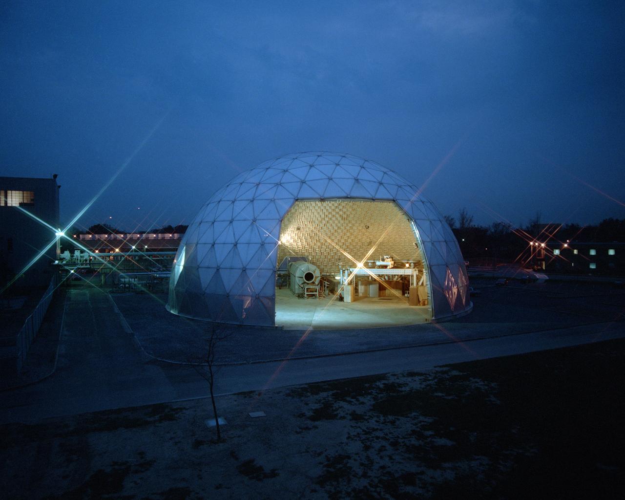
Modern jet engines are loud, but they used to be much louder. NASA’s Glenn Research Center has been at the forefront of the nation’s efforts to reduce aircraft engine noise for over 70 years. During this time, the center has built an array of test facilities to carry out this work, culminating in the Aero-Acoustic Propulsion Laboratory (AAPL), a world-class noise-reduction research facility. The AAPL, referred to as “the dome,” contains multiple test rigs enclosed in a large, echo-free chamber. The unique 130-foot diameter and 65-foot-high hemispherical structure stands out on Glenn’s campus. Its triangular sections make it appear like a golf ball rising from the ground. The interior is covered in spiky, fiberglass sound-dampening wedges and an overhead array of microphones that capture engine noise data.
CAPE CANAVERAL, Fla. – At NASA's Kennedy Space Center in Florida, the historic countdown clock at the spaceport's Press Site is disassembled for removal. Kennedy has requested to acquire the countdown clock from the agency’s Artifact Working Group at NASA Headquarters for likely display at the Kennedy Space Center Visitor Complex. A new modern multimedia display soon will be installed, similar to the screens seen at sporting venues, is in the works. The new screen will be nearly 26 feet wide by 7 feet high. The old timepiece was designed by Kennedy engineers and built by Kennedy technicians in 1969. Not including the triangular concrete and aluminum base, the famous landmark is nearly six feet high, 26 feet wide and 3 feet deep. The new display will be similar in size, with the screen being nearly 26 feet wide by seven feet high. For more information on the countdown clock, go to http://go.nasa.gov/10Zku10. Photo credit: NASA/Frankie Martin
CAPE CANAVERAL, Fla. -- At NASA's Kennedy Space Center in Florida, Kennedy TV senior systems engineer Ronald Gonser, left, Jeff Pratt and Frank Morse with Abacus Technology prep the area behind the current countdown clock for the groundbreaking ceremony for the new countdown clock. The old timepiece was designed by Kennedy engineers and built by Kennedy technicians in 1969. Not including the triangular concrete and aluminum base, the famous landmark is nearly 6 feet 70 inches high, 26 feet 315 inches wide and 3 feet deep. The new display will be similar in size, with the screen being nearly 26 feet wide by 7 feet high. For more information on the countdown clock, go to http://go.nasa.gov/10Zku10. Photo credit: NASA/Jim Grossmann
CAPE CANAVERAL, Fla. – At NASA's Kennedy Space Center in Florida, the historic countdown clock at the spaceport's Press Site is disassembled for removal. Kennedy has requested to acquire the countdown clock from the agency’s Artifact Working Group at NASA Headquarters for likely display at the Kennedy Space Center Visitor Complex. A new modern multimedia display soon will be installed, similar to the screens seen at sporting venues, is in the works. The new screen will be nearly 26 feet wide by 7 feet high. The old timepiece was designed by Kennedy engineers and built by Kennedy technicians in 1969. Not including the triangular concrete and aluminum base, the famous landmark is nearly six feet high, 26 feet wide and 3 feet deep. The new display will be similar in size, with the screen being nearly 26 feet wide by seven feet high. For more information on the countdown clock, go to http://go.nasa.gov/10Zku10. Photo credit: NASA/Frankie Martin
CAPE CANAVERAL, Fla. – At NASA's Kennedy Space Center in Florida, the historic countdown clock at the spaceport's Press Site is disassembled for removal. Kennedy has requested to acquire the countdown clock from the agency’s Artifact Working Group at NASA Headquarters for likely display at the Kennedy Space Center Visitor Complex. A new modern multimedia display soon will be installed, similar to the screens seen at sporting venues, is in the works. The new screen will be nearly 26 feet wide by 7 feet high. The old timepiece was designed by Kennedy engineers and built by Kennedy technicians in 1969. Not including the triangular concrete and aluminum base, the famous landmark is nearly six feet high, 26 feet wide and 3 feet deep. The new display will be similar in size, with the screen being nearly 26 feet wide by seven feet high. For more information on the countdown clock, go to http://go.nasa.gov/10Zku10. Photo credit: NASA/Frankie Martin
At NASA's Kennedy Space Center in Florida, the historic countdown clock at the spaceport's Press Site is disassembled for removal. Kennedy has requested to acquire the countdown clock from the agency’s Artifact Working Group at NASA Headquarters for likely display at the Kennedy Space Center Visitor Complex. A new modern multimedia display soon will be installed, similar to the screens seen at sporting venues, is in the works. The new screen will be nearly 26 feet wide by 7 feet high. The old timepiece was designed by Kennedy engineers and built by Kennedy technicians in 1969. Not including the triangular concrete and aluminum base, the famous landmark is nearly six feet high, 26 feet wide and 3 feet deep. The new display will be similar in size, with the screen being nearly 26 feet wide by seven feet high.
CAPE CANAVERAL, Fla. – At NASA's Kennedy Space Center in Florida, the historic countdown clock at the spaceport's Press Site is disassembled for removal. Kennedy has requested to acquire the countdown clock from the agency’s Artifact Working Group at NASA Headquarters for likely display at the Kennedy Space Center Visitor Complex. A new modern multimedia display soon will be installed, similar to the screens seen at sporting venues, is in the works. The new screen will be nearly 26 feet wide by 7 feet high. The old timepiece was designed by Kennedy engineers and built by Kennedy technicians in 1969. Not including the triangular concrete and aluminum base, the famous landmark is nearly six feet high, 26 feet wide and 3 feet deep. The new display will be similar in size, with the screen being nearly 26 feet wide by seven feet high. For more information on the countdown clock, go to http://go.nasa.gov/10Zku10. Photo credit: NASA/Frankie Martin

This composite image of the Jovian moon Io was generated using data collected by the JunoCam imager aboard NASA's Juno spacecraft during four separate flybys. The resolution of the images gets progressively better as the distance between spacecraft and moon decreases with each flyby. The image of the moon on the far left has a resolution 44 miles (71 kilometers) per pixel. It was taken on April 9, 2022, during Juno's 41st orbit of Jupiter (perijove 41, or PJ41), when the spacecraft flew past Io at a distance of about 66,000 miles (106,000 kilometers). Note the gray, roughly triangular patch at the terminator near the moon's center. Citizen scientist Björn Jónsson created this image using data from JunoCam. The center-left image was acquired on July 5, 2022, during Juno's 43rd orbit of Jupiter (PJ43) at a distance of 53,000 miles (86,000 kilometers). The resolution in this image has improved to 36 miles (58 kilometers) per pixel. In this view, more detail of the gray patch is seen (from a different perspective). Citizen scientist Jason Perry created this image using data from JunoCam. By the time the center-right image of Io was taken on Dec. 14, 2022, (PJ47), the distance between spacecraft and moon had decreased to 40,000 miles (64,000 kilometers), which increased the resolution to 27 miles (43 kilometers) per pixel. Here, the gray triangle appears as three distinct volcanoes with the central vents visible as dark spots in their centers. Characteristics of other nearby volcanoes also begin to stand out. Citizen scientist Mike Ravine created this image using data from JunoCam. The far-right image, taken during Juno's 49th flyby (PJ49) on March 1, 2023, shows that the spacecraft again approached the moon from a changed perspective, allowing different territory on Io's surface to be viewed. The triplet of volcanoes that make up the gray triangular patch are visible near the top of the image, and more detail of the volcanic terrain can be made out. The altitude at the time of closest approach was about 32,000 miles (51,500 kilometers), allowing resolution to increase to 22 miles (35 kilometers) per pixel. Citizen scientist Kevin M. Gill created this image using data from JunoCam. https://photojournal.jpl.nasa.gov/catalog/PIA25887
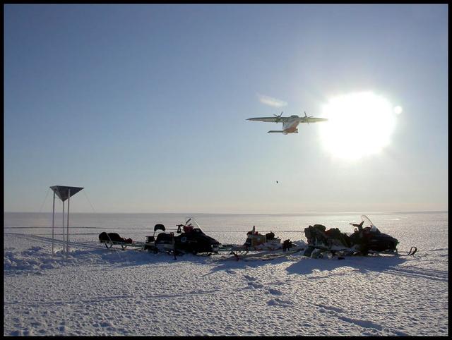
An airplane drops essential support on the Austfonna Ice Cap in Svalbard (Norwegian Arctic). The triangular structure is a corner reflector used as ground reference for airborne radar surveys. To learn about the contributions of glaciers to sea level rise, visit: <a href="http://www.nasa.gov/topics/earth/features/glacier-sea-rise.html" rel="nofollow">www.nasa.gov/topics/earth/features/glacier-sea-rise.html</a> Credit: Andrea Taurisano, Norwegian Polar Institute <b><a href="http://www.nasa.gov/audience/formedia/features/MP_Photo_Guidelines.html" rel="nofollow">NASA image use policy.</a></b> <b><a href="http://www.nasa.gov/centers/goddard/home/index.html" rel="nofollow">NASA Goddard Space Flight Center</a></b> enables NASA’s mission through four scientific endeavors: Earth Science, Heliophysics, Solar System Exploration, and Astrophysics. Goddard plays a leading role in NASA’s accomplishments by contributing compelling scientific knowledge to advance the Agency’s mission. <b>Follow us on <a href="http://twitter.com/NASA_GoddardPix" rel="nofollow">Twitter</a></b> <b>Like us on <a href="http://www.facebook.com/pages/Greenbelt-MD/NASA-Goddard/395013845897?ref=tsd" rel="nofollow">Facebook</a></b> <b>Find us on <a href="http://instagram.com/nasagoddard?vm=grid" rel="nofollow">Instagram</a></b>

S89-20077 (17 July 1989) --- The triangular shape of the STS-34 crew patch represents forward motion and the entering into new frontiers of science, engineering and technology. The Galileo spacecraft overlaying the orbiter symbolizes the joining together of both manned and unmanned space programs in order to maximize the capabilities of each. The crew members, who designed the patch, use a sunrise stretching across Earth's horizon to depict expansion of our knowledge of the solar system and other worlds, leading to a better understanding of our own planet. In the distance, Jupiter, a unique world with many unknowns, awaits the arrival of Galileo to help unlock its secrets. Meanwhile, the space shuttle remains in Earth orbit, continuing to explore the near-Earth environment. The NASA insignia design for space shuttle flights is reserved for use by the astronauts and for other official use as the NASA Administrator may authorize. Public availability has been approved only in the forms of illustrations by the various news media. When and if there is any change in this policy, which is not anticipated, the change will be publicly announced. Photo credit: NASA
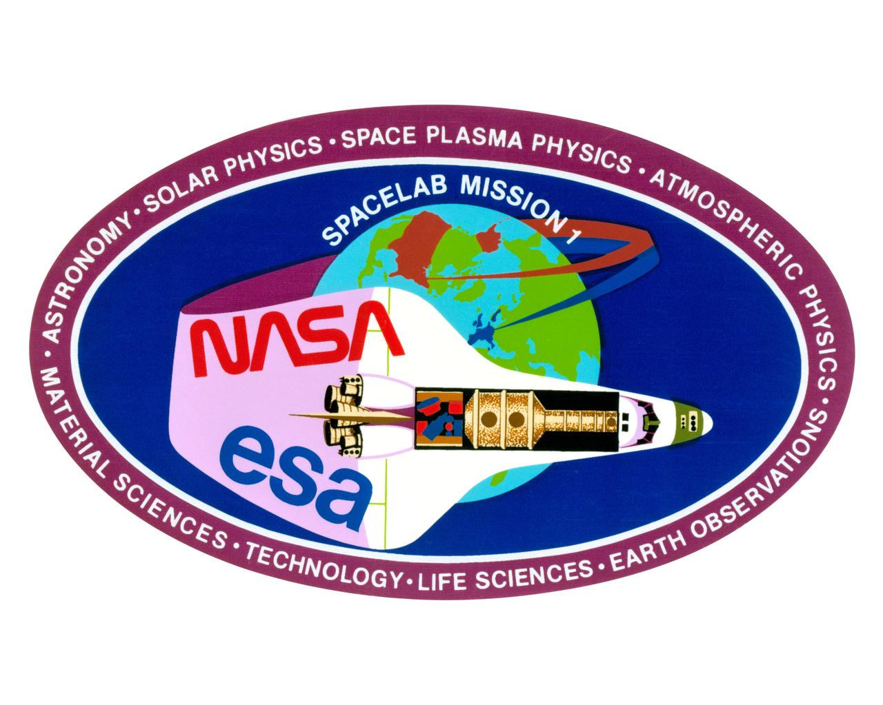
S82-31408 (May 1983) --- The Spacelab 2 emblem is a symbolic representation of the scientific objectives of the mission. The emblem is in the shape of a triangular shield with convexly curved edges. Across the top of a black out border are the words ?SPACELAB 2?. Within the black border is a sky blue border carryhing the words: ?ASTRONOMY?, ON TOP? ?PHYSICS?, on the left; and ?BIOLOGY?, on the right. Within the blue border is a schematic view of the sun, the earth, and the orbiter with Spacelab 2. The sun appears in the upper right background as a white disc surrounded by six concentric rings ranging grom bright yellow near the disc through yellow-red to a dark red out ring. A sector of the earth with blue ocean and a black portion of North America is in the upper left corner. The black and white Orbiter is seen from directly overhead in the foreground, the right side illuminated by the sun, the left side in shadow. Although the payload bay doors are not open, the Spacelab 2 payload is seen as if the doors were open. In black on white are seen the three pallets, and the separately mounted cosmic ray experiment at the aft end of the bay.

STS099-749-089 (11-22 February 2000) ---As evidenced by this 70mm frame from the Space Shuttle Endeavour, the Alaska Peninsula and Aleutian Islands form a long arc that intervenes between the Bering Sea and the northern Pacific Ocean. This view is of the snowy south coast of the peninsula, from Chignik Bay and Cape Kumliun (on the triangular peninsula) northeastward to Chiginagak Bay and David Island. Port Heiden is the darker area of little ice on the north coast. Within the rim of the Aniakchak volcanic crater (4,450 feet at highest point) the frozen waters of Surprise Lake are visible. The North American and Pacific tectonic plates are converging in this region at a rate of about 5 centimeters a year. The Pacific plate descends beneath North America, producing a deep trench along the south coast; the Aleutian Trench reaches depths greater than 25,000 ft. In such regions (subduction zones) volcanoes form on the overriding plate -- the North American plate in this instance; Aniakchak is one of the many young volcanoes in this arc.

STS048-S-001 (July 1991) --- Designed by the astronaut crew members, the patch represents the space shuttle orbiter Discovery in orbit about Earth after deploying the Upper Atmospheric Research Satellite (UARS) depicted in block letter style. The stars are those in the northern hemisphere as seen in the fall and winter when UARS will begin its study of Earth's atmosphere. The color bands on Earth's horizon, extending up to the UARS spacecraft, depict the study of Earth's atmosphere. The triangular shape represents the relationship among the three atmospheric processes that determine upper atmospheric structure and behavior: chemistry, dynamics and energy. In the words of the crew members, "This continuous process brings life to our planet and makes our planet unique in the solar system." The NASA insignia design for space shuttle flights is reserved for use by the astronauts and for other official use as the NASA Administrator may authorize. Public availability has been approved only in the form of illustrations by the various news media. When and if there is any change in this policy, which is not anticipated, it will be publicly announced. Photo credit: NASA

ISS036-S-001 (January 2012) --- The dynamic design of the Expedition 36 patch portrays the International Space Station?s (ISS) iconic solar arrays. The slanted angles denote a kinetic energy leading from the Earth in the lower right to the upper left tip of the triangular shape of the patch, representing the infinite scientific research, education, and long-duration spaceflight capabilities the ISS provides with each mission, as well as our goal for future exploration beyond the Space Station. The numbers 3 and 6 harmoniously intertwine to form expedition number 36 and its gray coloration signifies the unity and neutrality among all of the international partners of the ISS. The blue and gold color scheme of the patch represents the subtle way the central gold orbit wraps around the number 36 to form a trident at its lower right tip. The trident also symbolizes the sea, air, and land, all of which make up the Earth from where the trident originates in the design. The NASA insignia design for shuttle and space station flights is reserved for use by the astronauts and for other official use as the NASA Administrator may authorize. Public availability has been approved only in the form of illustrations by the various news media. When and if there is any change in this policy, which is not anticipated, it will be publicly announced. Photo credit: NASA

This is the astronaut designed mission insignia for the STS-96 space flight, the second Space Shuttle Mission dedicated to the assembly of the International Space Station (ISS). The crew member designed patch highlights the major themes of the Station program: Earth-directed research, the advancement of human space exploration, and international cooperation. The Space Shuttle Discovery is depicted shortly after reaching orbit as the crew prepares for the first docking with the new station. At this early stage in its construction, the ISS consisted of two modules; The Russian Zarya and the U.S. Unity, shown orbiting the Earth. The triangular shape represents building on the knowledge and experience of earlier missions, while the three vertical bars point toward future human endeavors in space. The five pointed star is symbolic of the five space agencies participating in the development of the ISS: NASA, the Russian Space Agency, the European Space Agency, the National Space Development Agency of Japan, and the Canadian Space Agency. The blend of red, white, and blue is a tribute to the nationalities of the STS-96 crew members who are from the United States, Russia, and Canada.
This image from NASA Terra spacecraft shows Mount Erebus, the world southernmost historically active volcano, overlooking the McMurdo research station on Ross Island. The 3794-m-high Erebus is the largest of three major volcanoes forming the crudely triangular Ross Island. An elliptical 500 x 600 m wide, 110-m-deep crater truncates the summit and contains an active lava lake within a 250-m-wide, 100-m-deep inner crater. The glacier-covered volcano was erupting when first sighted by Captain James Ross in 1841. Continuous lava-lake activity with minor explosions, punctuated by occasional larger strombolian explosions that eject bombs onto the crater rim, has been documented since 1972, but has probably been occurring for much of the volcano's recent history. The image was acquired December 31, 2013, covers an area of 63 x 73 km, and is located at 77.5 degrees south, 167.1 degrees east. http://photojournal.jpl.nasa.gov/catalog/PIA20239

ISS015-E-05977 (1 May 2007) --- Den Helder, Netherlands is featured in this image photographed by an Expedition 15 crewmember on the International Space Station. The city and harbor of Den Helder in the northern Netherlands has been the home port of the Dutch Royal Navy for over 175 years. Its favorable location provides access to the North Sea, and has made it an important commercial shipping port in addition to its strategic role. Bright red agricultural fields to the south of Den Helder indicate another noteworthy aspect of the region--commercial farming of tulips and hyacinth. This image is an oblique view--the camera is oriented at an angle relative to "straight down"--of the Den Helder region taken from the space station, which was located to the southeast, near Dulmen, Germany (approximately 225 kilometers away in terms of ground distance) when the image was acquired. In addition to the manmade structures of the Den Helder urban area (reddish gray to gray street grids) and dockyards to the east of the city, several striking geomorphic features are visible. The extensive gray mudflats, with their prominent branching pattern (top right), indicate that this image was acquired at low tide, and suggest the general low elevation of the region. Parallel wave patterns along the mudflats and in the Marsdiep strait are formed as water interacts with the sea bottom between Den Helder and Texel Island during tidal flow. Some ship wakes are also visible. According to scientists, the bright white-gray triangular region at the southern tip of Texel Island (bottom center) is a dune field, consisting mainly of eolian (windborne) sands deposited during the last Ice Age. Subsequent sea level rise and shoreline processes have mobilized and re-deposited these sands into their current configuration -- including a new dune field island to the southwest of Texel (bottom center).
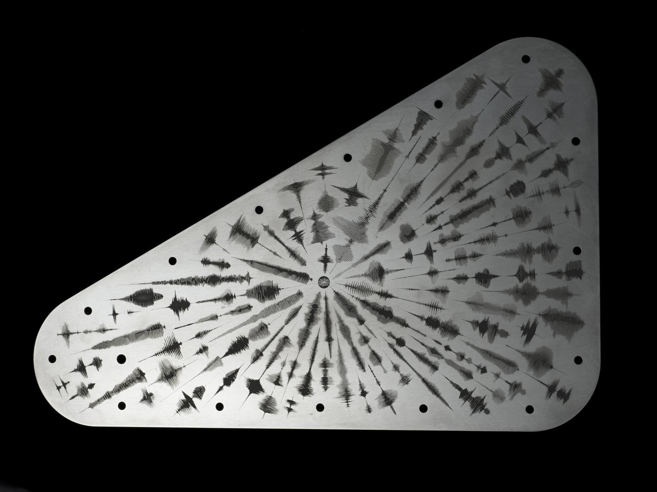
NASA's Europa Clipper spacecraft will carry a special message when it launches in October 2024 and heads toward Jupiter's moon Europa. The moon shows strong evidence of an ocean under its icy crust, with more than twice the amount of water of all of Earth's oceans combined. A triangular metal plate, seen here, will honor that connection to Earth. The plate is made of tantalum metal and is about 7 by 11 inches (18 by 28 centimeters). It is engraved on both sides and seals an opening in the electronics vault, which houses the spacecraft's sensitive electronics. The art on this side of the plate features waveforms that are visual representations of the sound waves formed by the word "water" in 103 languages. The waveforms radiate out from a symbol representing the American Sign Language sign for "water." In the spirit of the Voyager spacecraft's Golden Record, which carries sounds and images to convey the richness and diversity of life on Earth, the layered message on Europa Clipper aims to spark the imagination and offer a unifying vision. Europa Clipper, set to launch from Kennedy Space Center in Florida, will arrive at the Jupiter system in 2030 and conduct about 50 flybys of the moon Europa. The mission's main science goal is to determine whether there are places below Europa, that could support life. The mission's three main science objectives are to determine the thickness of the moon's icy shell and its surface interactions with the ocean below, to investigate its composition, and to characterize its geology. The mission's detailed exploration of Europa will help scientists better understand the astrobiological potential for habitable worlds beyond our planet. https://photojournal.jpl.nasa.gov/catalog/PIA26063
This is an image of the area of Kliuchevskoi volcano, Kamchatka, Russia, which began to erupt on September 30, 1994. Kliuchevskoi is the blue triangular peak in the center of the image, towards the left edge of the bright red area that delineates bare snow cover. The image was acquired by the Spaceborne Imaging Radar-C/X-band Synthetic Aperture Radar (SIR-C/X-SAR) aboard the space shuttle Endeavour on its 88th orbit on October 5, 1994. The image shows an area approximately 75 kilometers by 100 kilometers (46 miles by 62 miles) that is centered at 56.07 degrees north latitude and 160.84 degrees east longitude. North is toward the bottom of the image. The radar illumination is from the top of the image. The Kamchatka volcanoes are among the most active volcanoes in the world. The volcanic zone sits above a tectonic plate boundary, where the Pacific plate is sinking beneath the northeast edge of the Eurasian plate. The Endeavour crew obtained dramatic video and photographic images of this region during the eruption, which will assist scientists in analyzing the dynamics of the recent activity. The colors in this image were obtained using the following radar channels: red represents the L-band (horizontally transmitted and received); green represents the L-band (horizontally transmitted and vertically received); blue represents the C-band (horizontally transmitted and vertically received). In addition to Kliuchevskoi, two other active volcanoes are visible in the image. Bezymianny, the circular crater above and to the right of Kliuchevskoi, contains a slowly growing lava dome. Tolbachik is the large volcano with a dark summit crater near the upper right edge of the red snow covered area. The Kamchatka River runs from right to left across the bottom of the image. The current eruption of Kliuchevskoi included massive ejections of gas, vapor and ash, which reached altitudes of 15,000 meters (50,000 feet). Melting snow mixed with volcanic ash triggered mud flows on the flanks of the volcano. Paths of these flows can be seen as thin lines in various shades of blue and green on the north flank in the center of the image. http://photojournal.jpl.nasa.gov/catalog/PIA01765
The bright landing platform left behind by NASA's Mars Exploration Rover Opportunity in 2004 is visible inside Eagle Crater, at upper right in this April 8, 2017, observation by NASA's Mars Reconnaissance Orbiter. Mars Reconnaissance Orbiter arrived at Mars in March 2006, more than two years after Opportunity's landing on Jan. 25, 2004, Universal Time (Jan. 24, PDT). This is the first image of Eagle Crater from the orbiter's High Resolution Imaging Science Experiment (HiRISE) camera, which has optics that include the most powerful telescope ever sent to Mars. Eagle Crater is about 72 feet (22 meters) in diameter, at 1.95 degrees south latitude, 354.47 degrees east longitude, in the Meridiani Planum region of Mars. The airbag-cushioned lander, with Opportunity folded-up inside, first hit Martian ground near the crater, then bounced and rolled right into the crater. The lander structure was four triangles, folded into a tetrahedron until after the airbags deflated. The triangular petals then opened, exposing the rover. A week later, the rover drove off (see PIA05214), and the landing platform's job was done. The spacecraft's backshell and parachute, jettisoned during final descent, are visible near the lower left corner of this scene. The blue tint of the backshell is an effect of exaggerated color, because HiRISE combines color information from red, blue-green and infrared portions of the spectrum, rather than three different visible-light colors, so its color images are not true color. Opportunity examined Eagle Crater for more than half of the rover's originally planned three-month mission, before driving east and south to larger craters. At Eagle, it found headline-making evidence that water once flowed over the surface and soaked the subsurface of the area. By the time this orbital image of the landing site was taken, about 13 years after the rover departed Eagle, Opportunity had driven more than 27 miles (44 kilometers) and was actively exploring the rim of Endeavour Crater, which is about 1,000 times as wide as Eagle. https://photojournal.jpl.nasa.gov/catalog/PIA21494

STS96-S-001 (February 1999) --- Designed by the crew members, this is the mission insignia for the STS-96 spaceflight, the second space shuttle mission dedicated to the assembly of the International Space Station (ISS). The crew patch highlights the major themes of the Station Program: Earth-directed research, the advancement of human space exploration, and international cooperation. The space shuttle Discovery is depicted shortly after reaching orbit as the crew prepares to carry out the first docking with the new space station. At this early stage in its construction, ISS consists of two modules: Zarya and Unity, shown orbiting Earth. The triangular shape of the patch represents building on the knowledge and experience of earlier missions, while the three vertical bars of the astronaut emblem point toward future human endeavors in space. The five-pointed star that tops the astronaut emblem in this depiction is symbolic of the five space agencies participating in the development of ISS: National Aeronautics and Space Administration (NASA), the Russian Space Agency (RSA), the European Space Agency (ESA), the National Space Development Agency of Japan (NASDA), and the Canadian Space Agency (CSA). The blend of red, white, and blue is a tribute to the nationalities of the crew members who are from the United States, Canada, and Russia. The NASA insignia design for space shuttle flights is reserved for use by the astronauts and for other official use as the NASA Administrator may authorize. Public availability has been approved only in the forms of illustrations by the various news media. When and if there is any change in this policy, which is not anticipated, the change will be publicly announced. Photo credit: NASA
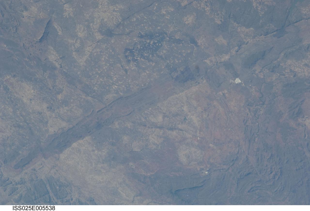
ISS025-E-005538 (30 Sept. 2010) --- The Great Dyke of Zimbabwe, Africa is featured in this image photographed by an Expedition 25 crew member on the International Space Station. The Great Dyke of Zimbabwe is a prominent geological feature that extends for over 550 kilometers, varying from 3-12 kilometers in width across the center of the country northeast – southwest; the southern end of the Dyke is illustrated in this view. The Dyke (or Dike in American English) is a layered mafic intrusion of igneous, metal-bearing rock that has been dated using uranium-lead isotopes to approximately 2.5 billion years in age, according to scientists. It intrudes even older rocks of the African craton, or core of oldest rocks forming the continent; in cross section, the Great Dyke looks somewhat triangular or keel-shaped suggesting to geologists that it rose along deep faults associated with extension of the African crust. Layered mafic intrusions are usually associated with economically important metals such as chromium, nickel, copper, platinum, titanium, iron, vanadium and tin. Chromium, in the form of the mineral chromite and platinum are particularly abundant in the Great Dyke and actively mined. Younger faults have offset sections of the Dyke along its length – two of the most obvious faults in the image are indicated, with arrows showing the relative directions of offset relative to the main trend of the intrusion. While the Great Dyke and its metal ores are products of geologic processes operating in the deep past, more recent events have also left their mark on the landscape as illustrated by two large fire burn scars which are visible at top center.

This is a space radar image of the area around the Unzen volcano, on the west coast of Kyushu Island in southwestern Japan. Unzen, which appears in this image as a large triangular peak with a white flank near the center of the peninsula, has been continuously active since a series of powerful eruptions began in 1991. The image was acquired by the Spaceborne Imaging Radar-C/X-band Synthetic Aperture Radar (SIR-C/X-SAR) aboard the space shuttle Endeavour on its 93rd orbit on April 15, 1994. The image shows an area 41.5 kilometers by 32.8 kilometers (25.7 miles by 20.3 miles) that is centered at 32.75 degrees north latitude and 130.15 degrees east longitude. North is toward the upper left of the image. The radar illumination is from the top of the image. The colors in this image were obtained using the following radar channels: red represents the L-band (vertically transmitted and received); green represents the average of L-band and C-band (vertically transmitted and received); blue represents the C-band (vertically transmitted and received). Unzen is one of 15 "Decade" volcanoes identified by the scientific community as posing significant potential threats to large local populations. The city of Shimabara sits along the coast at the foot of Unzen on its east and northeast sides. At the summit of Unzen a dome of thick lava has been growing continuously since 1991. Collapses of the sides of this dome have generated deadly avalanches of hot gas and rock known as pyroclastic flows. Volcanologists can use radar image data to monitor the growth of lava domes, to better understand and predict potentially hazardous collapses. http://photojournal.jpl.nasa.gov/catalog/PIA00504

This artist’s concept shows the Advanced Composite Solar Sail System spacecraft sailing in space using the energy of the Sun.
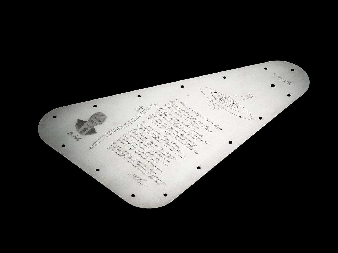
NASA's Europa Clipper spacecraft will carry a special message when it launches in October 2024 and heads toward Jupiter's moon Europa. The moon shows strong evidence of an ocean under its icy crust, with more than twice the amount of water of all of Earth's oceans combined. A triangular metal plate, seen here, will honor that connection to Earth. The plate is made of tantalum metal and is about 7 by 11 inches (18 by 28 centimeters). Engraved on both sides, it seals an opening in the electronics vault, which houses the spacecraft's sensitive electronics. The side shown here features U.S. Poet Laureate Ada Limón's handwritten "In Praise of Mystery: A Poem for Europa," and will be affixed with a silicon microchip stenciled with more than 2.6 million names submitted by the public. The microchip will be placed at the center of the illustration of a bottle amid the Jovian system – a reference to NASA's "Message in a Bottle" campaign, which invited the public to send their names with the spacecraft. The artwork includes the Drake Equation, which was formulated by astronomer Frank Drake in 1961 to estimate the possibility of finding advanced civilizations beyond Earth. Also featured is a reference to the radio frequencies considered plausible for interstellar communication, symbolizing how humanity uses this radio band to listen for messages from the cosmos. These particular frequencies match the radio waves emitted in space by the components of water and are known by astronomers as the "water hole." On the plate, they are depicted as radio emission lines. The plate includes a portrait of one of the founders of planetary science, Ron Greeley, whose early efforts to develop a Europa mission two decades ago laid the foundation for Europa Clipper. In the spirit of the Voyager spacecraft's Golden Record, which carries sounds and images to convey the richness and diversity of life on Earth, the layered message on Europa Clipper aims to spark the imagination and offer a unifying vision. Europa Clipper, set to launch from Kennedy Space Center in Florida, will arrive at the Jupiter system in 2030 and conduct about 50 flybys of the moon Europa. The mission's main science goal is to determine whether there are places below Europa, that could support life. The mission's three main science objectives are to determine the thickness of the moon's icy shell and its surface interactions with the ocean below, to investigate its composition, and to characterize its geology. The mission's detailed exploration of Europa will help scientists better understand the astrobiological potential for habitable worlds beyond our planet. https://photojournal.jpl.nasa.gov/catalog/PIA26062
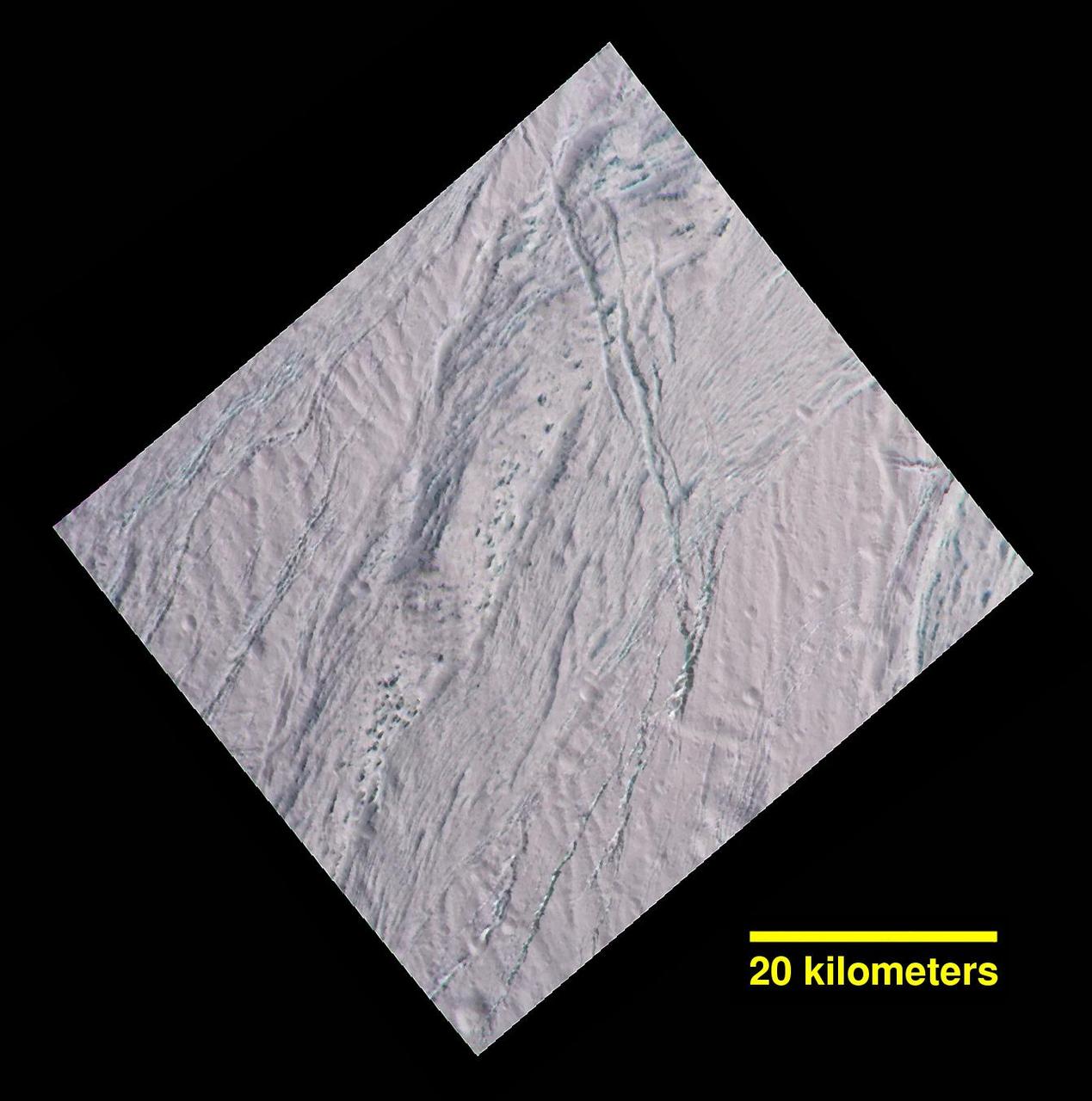
During its final close flyby of Saturn's moon Enceladus, NASA's Cassini spacecraft revisited a landscape, and a mystery, that it had originally glimpsed more than 10 years earlier. In views of this terrain captured during a 2005 flyby (see PIA06188), imaging scientists noticed small dark spots of an uncertain nature. Observing the same features in this false-color view, at higher resolution than before, provides some new insights. The spots are evidently large, relatively dark protrusions of solid "bedrock" ice and ice blocks scattered on and around the prominent ridge that runs across the scene from north to south (from top center toward lower left). The ice blocks range in size from dozens to hundreds of feet (tens to hundreds of meters). The false-color view uses an ultraviolet filter centered at 338 nanometers for blue, a green filter centered at 568 nanometers for green and a near-infrared filter centered at 930 nanometers for red -- thus covering a wider spectrum region than the human eye. As in earlier Cassini views of Enceladus using the same combination of color filters (see PIA06254), green-hued features represent coarse-grained or solid ice. Exposures of these kinds of ices are also found on the walls of cracks and troughs in this scene and elsewhere on Enceladus. To an observer on the surface, the prominent north-south trending ridge might look superficially like icy flatirons (tilted, triangular outcroppings of rock), but probably more shallowly dipping than terrestrial examples. The exposed line of ice blocks along its ridge crest might make it look a bit like a hogback (a narrow ridge with steep sides, often with vertical rocky outcrops along the top). On Enceladus, with no wind to scour loose particulate ice or "snow" off of them, the solid blocks are probably cleared by some combination of downslope movement of particulates, and perhaps sublimation. This image has a spatial scale of about 220 feet (67 meters) per pixel at its center, which is nearly twice the resolution of the earlier view (PIA06188). This terrain is on the moon's Saturn-facing side, a few degrees south of the equator. The view has been rotated so that north on Enceladus is up. The view was obtained by the Cassini spacecraft narrow-angle camera on Dec. 19, 2015. http://photojournal.jpl.nasa.gov/catalog/PIA20017
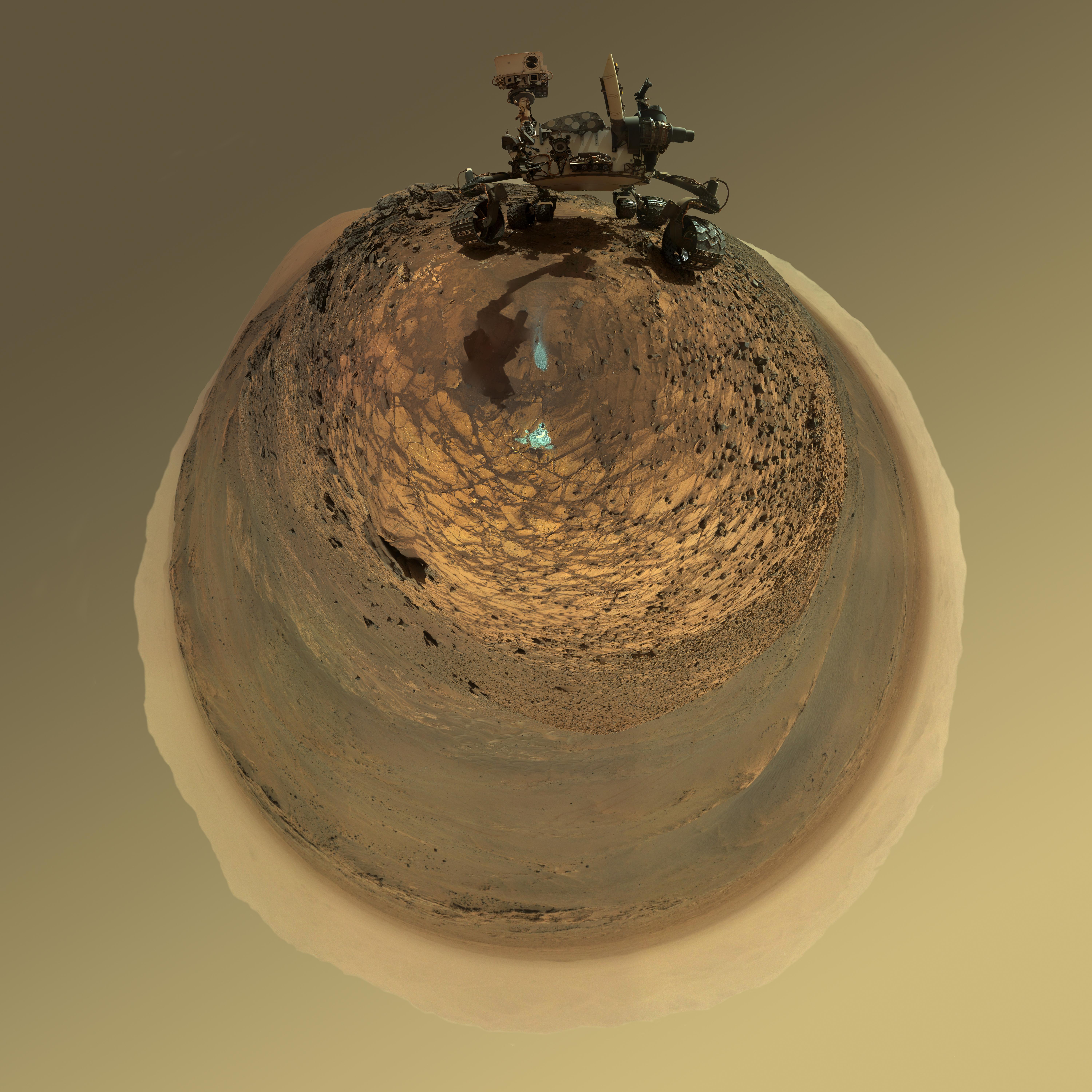
This version of a self-portrait of NASA's Curiosity Mars rover at a drilling site called "Buckskin" on lower Mount Sharp is presented as a stereographic projection, which shows the horizon as a circle. It is a mosaic assembled from the same set of 92 component raw images used for the flatter-horizon version at PIA19807. The component images were taken by Curiosity's Mars Hand Lens Imager (MAHLI) on Aug. 5, 2015, during the 1,065th Martian day, or sol, of the rover's work on Mars. Curiosity drilled the hole at Buckskin during Sol 1060 (July 30, 2015). Two patches of pale, powdered rock material pulled from inside Buckskin are visible in this scene, in front of the rover. The patch closer to the rover is where the sample-handling mechanism on Curiosity's robotic arm dumped collected material that did not pass through a sieve in the mechanism. Sieved sample material was delivered to laboratory instruments inside the rover. The patch farther in front of the rover, roughly triangular in shape, shows where fresh tailings spread downhill from the drilling process. The drilled hole, 0.63 inch (1.6 centimeters) in diameter, is at the upper point of the tailings. The rover is facing northeast, looking out over the plains from the crest of a 20-foot (6-meter) hill that it climbed to reach the "Marias Pass" area. The upper levels of Mount Sharp are visible behind the rover, while Gale Crater's northern rim dominates most of the rest of the horizon.the horizon on the left and right of the mosaic. MAHLI is mounted at the end of the rover's robotic arm. For this self-portrait, the rover team positioned the camera lower in relation to the rover body than for any previous full self-portrait of Curiosity. The assembled mosaic does not include the rover's arm beyond a portion of the upper arm held nearly vertical from the shoulder joint. Shadows from the rest of the arm and the turret of tools at the end of the arm are visible on the ground. With the wrist motions and turret rotations used in pointing the camera for the component images, the arm was positioned out of the shot in the frames or portions of frames used in this mosaic. MAHLI was built by Malin Space Science Systems, San Diego. NASA's Jet Propulsion Laboratory, a division of the California Institute of Technology in Pasadena, manages the Mars Science Laboratory Project for the NASA Science Mission Directorate, Washington. JPL designed and built the project's Curiosity rover. http://photojournal.jpl.nasa.gov/catalog/PIA19806
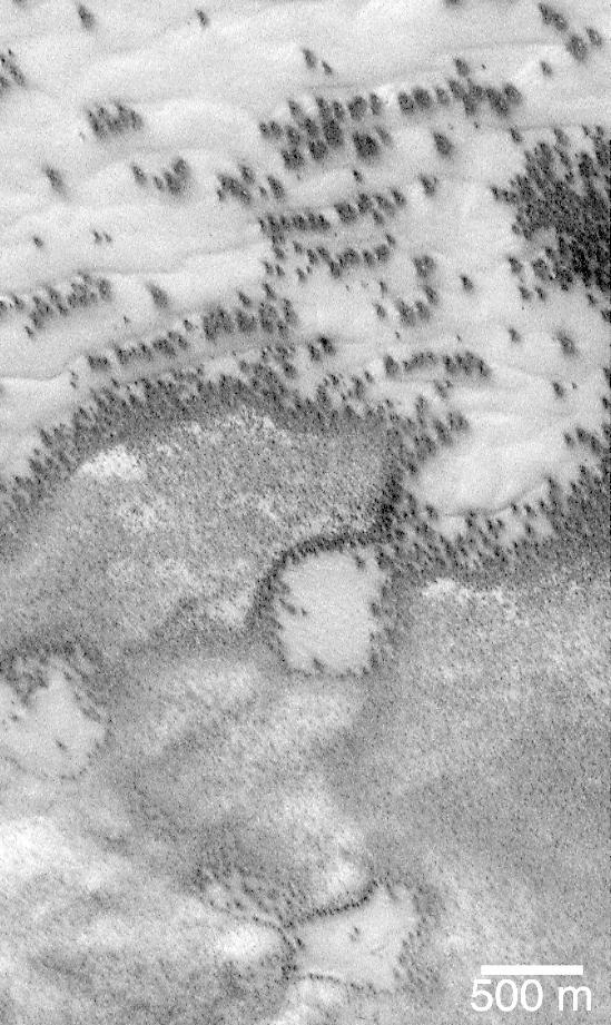
"They look like bushes!" That's what almost everyone says when they see the dark features found in pictures taken of sand dunes in the polar regions as they are beginning to defrost after a long, cold winter. It is hard to escape the fact that, at first glance, these images acquired by the Mars Global Surveyor (MGS) Mars Orbiter Camera (MOC) over both polar regions during the spring and summer seasons, do indeed resemble aerial photographs of sand dune fields on Earth -- complete with vegetation growing on and around them! Of course, this is not what the features are, as we describe below and in related picture captions. Still, don't they look like vegetation to you? Shown here are two views of the same MGS MOC image. On the left is the full scene, on the right is an expanded view of a portion of the scene on the left. The bright, smooth surfaces that are dotted with occasional, nearly triangular dark spots are sand dunes covered by winter frost. The MGS MOC has been used over the past several months (April-August 1999) to monitor dark spots as they form and evolve on polar dune surfaces. The dark spots typically appear first along the lower margins of a dune -- similar to the position of bushes and tufts of grass that occur in and among some sand dunes on Earth. Because the martian air pressure is very low -- 100 times lower than at Sea Level on Earth -- ice on Mars does not melt and become liquid when it warms up. Instead, ice sublimes -- that is, it changes directly from solid to gas, just as "dry ice" does on Earth. As polar dunes emerge from the months-long winter night, and first become exposed to sunlight, the bright winter frost and snow begins to sublime. This process is not uniform everywhere on a dune, but begins in small spots and then over several months it spreads until the entire dune is spotted like a leopard. The early stages of the defrosting process -- as in the picture shown here -- give the impression that something is "growing" on the dunes. The sand underneath the frost is dark, just like basalt beach sand in Hawaii. Once it is exposed to sunlight, the dark sand probably absorbs sunlight and helps speed the defrosting of each sand dune. This picture was taken by MGS MOC on July 21, 1999. The dunes are located in the south polar region and are expected to be completely defrosted by November or December 1999. North is approximately up, and sunlight illuminates the scene from the upper left. The 500 meter scale bar equals 547 yards; the 300 meter scale is also 328 yards. http://photojournal.jpl.nasa.gov/catalog/PIA02300
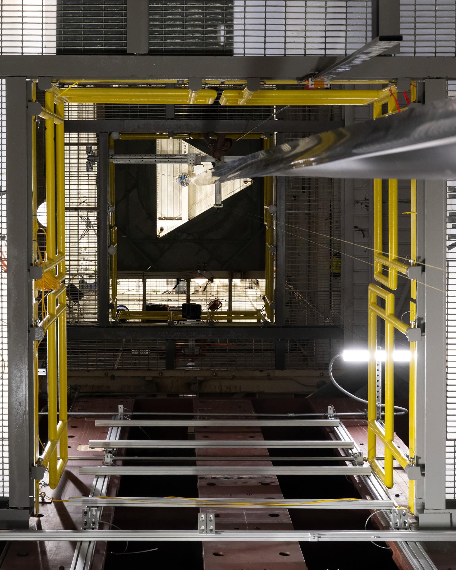
Full-Scale Test Campaign of Gravity Offloading and Analysis of Long Imperfection-Sensitive Elements (GOALIE) TRAC boom in B1293B Thor Tower, Test of Load Case C, Off-axis Compression

Full-Scale Test Campaign of Gravity Offloading and Analysis of Long Imperfection-Sensitive Elements (GOALIE) TRAC boom in B1293B Thor Tower, Test of Load Case C, Off-axis Compression
STS059-S-026 (11 April 1994) --- This is an image of Death Valley, California, centered at 36.629 degrees north latitude, 117.069 degrees west longitude. The image shows Furnace Creek alluvial fan and Furnace Creek Ranch at the far right, and the sand dunes near Stove Pipe Wells at the center. The dark fork-shaped feature between Furnace Creek fan and the dunes is a smooth flood-plain which encloses Cottonball Basin. The SIR-C/X-SAR supersite is an area of extensive field investigations and has been visited by both Space Radar Lab astronaut crews. Elevations in the Valley range from 70 meters below sea level, the lowest in the United States, to more than 3300 meters above sea level. Scientists are using SIR-C/X-SAR data from Death Valley to help answer a number of different questions about the Earth's geology. One question concerns how alluvial fans are formed and change through time under the influence of climatic changes and earthquakes. Alluvial fans are gravel deposits that wash down from the mountains over time. They are visible in the image as circular, fan-shaped bright areas extending into the darker valley floor from the mountains. Information about the alluvial fans help scientists study Earth's ancient climate. Scientists know the fans are bulit up through climatic and tectonic processes and they will use the SIR-C/X-SAR data to understand the nature and rates of weathering processes on the fans, soil formation, and the transport of sand and dust by the wind. SIR-C/X-SAR's sensitivity to centimeter-scale (or inch-scale) roughness provides detailed maps of surface texture. Such information can be used to study the occurrence and movement of dust storms and sand dunes. the goal of these studies is to gain a better understanding of the record of past climatic changes and the effects of those changes on a sensitive environment. This may lead to a better ability to predict future response of the land to different potential global cimate-change scenarios. Death Valley is also one of the primary calibration sites for SIR-C/X-SAR. The bright dots near the center of the image are corner reflectors that have been set-up to calibrate the radar as the Shuttle passes overhead. Thirty triangular-shaped reflectors (they look like aluminum pyramids) have been deployed by the calibration team from JPL over a 40 kilometer by 40 kilometer area in and around Death Valley. The calibration team will also deploy transponders (electronic reflectors) and recievers to measure the radar signals from SIR-C/X-SAR on the ground. Spaceborne Imaging Radar-C and X-Synthetic Aperture Radar (SIR-C/X-SAR) is part of NASA's Mission to Planet Earth (MTPE). The radars illuminate Earth with microwaves allowing detailed observations at any time, regardless of weather or sunlight conditions. SIR-C/X-SAR uses three microwave wavelengths: L-Band (24 cm), C-Band (6 cm), and X-Band (3 cm). The multi-frequency data will be used by the international scientific community to better understand the global environment and how it is changing. The SIR-C/X-SAR data, complemented by aircraft and ground studies, will give scientists clearer insights into those environmental changes which are caused by nature and those changes which are induced by human activity. SIR-C was develpoed by NASA's Jet Propulsion Laboratory (JPL). X-SAR was developed by the Dornire and Alenia Spazio Companies for the German Space Agency, Deutsche Agentur fuer Raumfahrtangelegenheiten (DARA), and the Italian Space Agency, Agenzia Spaziale Italiana (ASI). JPL Photo ID: P-43883
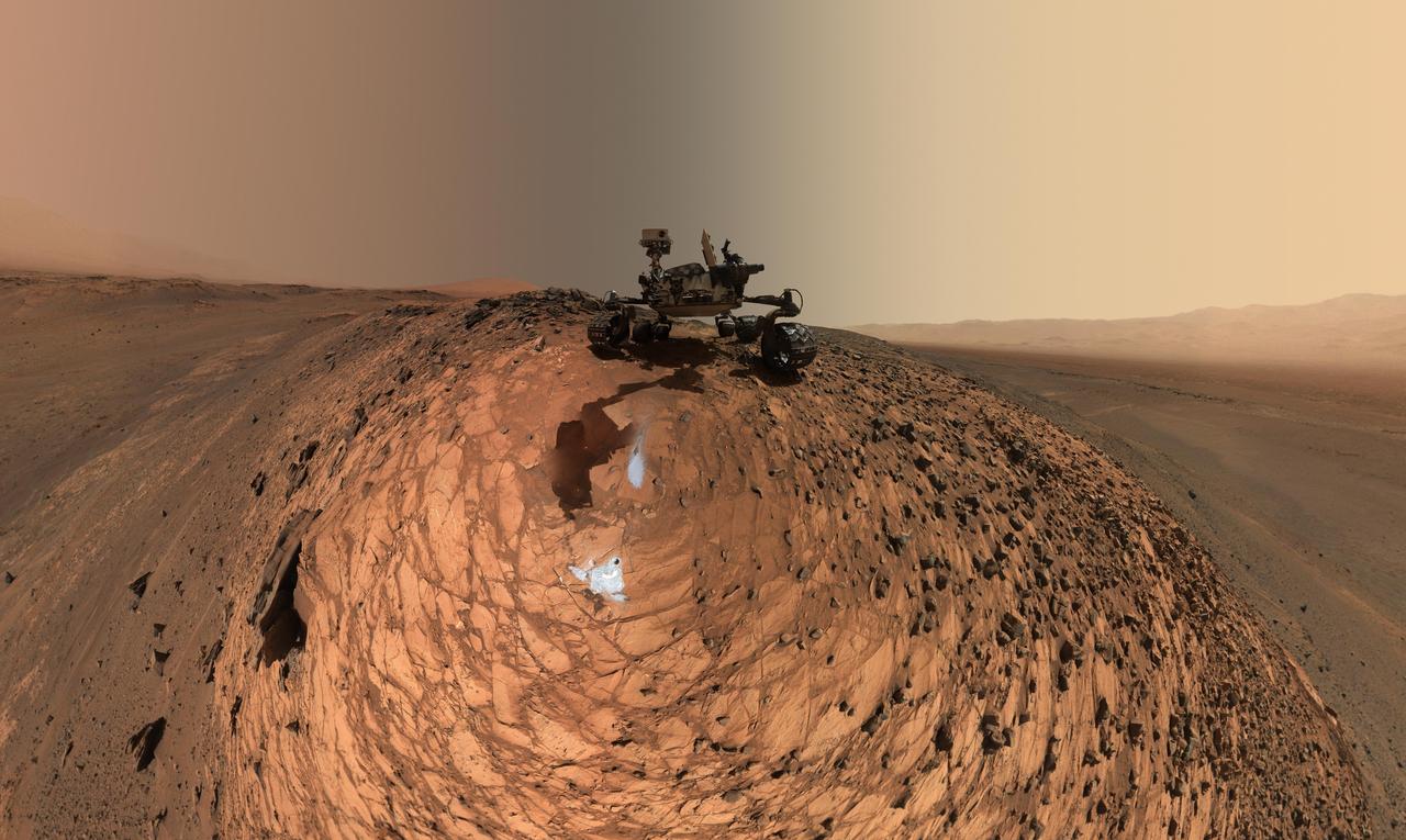
This low-angle self-portrait of NASA's Curiosity Mars rover shows the vehicle above the "Buckskin" rock target, where the mission collected its seventh drilled sample. The site is in the "Marias Pass" area of lower Mount Sharp. The scene combines dozens of images taken by Curiosity's Mars Hand Lens Imager (MAHLI) on Aug. 5, 2015, during the 1,065th Martian day, or sol, of the rover's work on Mars. The 92 component images are among MAHLI Sol 1065 raw images at http://mars.nasa.gov/msl/multimedia/raw/?s=1065&camera=MAHLI. For scale, the rover's wheels are 20 inches (50 centimeters) in diameter and about 16 inches (40 centimeters) wide. Curiosity drilled the hole at Buckskin during Sol 1060 (July 30, 2015). Two patches of pale, powdered rock material pulled from Buckskin are visible in this scene, in front of the rover. The patch closer to the rover is where the sample-handling mechanism on Curiosity's robotic arm dumped collected material that did not pass through a sieve in the mechanism. Sieved sample material was delivered to laboratory instruments inside the rover. The patch farther in front of the rover, roughly triangular in shape, shows where fresh tailings spread downhill from the drilling process. The drilled hole, 0.63 inch (1.6 centimeters) in diameter, is at the upper point of the tailings. The rover is facing northeast, looking out over the plains from the crest of a 20-foot (6-meter) hill that it climbed to reach the Marias Pass area. The upper levels of Mount Sharp are visible behind the rover, while Gale Crater's northern rim dominates the horizon on the left and right of the mosaic. A portion of this selfie cropped tighter around the rover is at PIA19808. Another version of the wide view, presented in a projection that shows the horizon as a circle, is at PIA19806. MAHLI is mounted at the end of the rover's robotic arm. For this self-portrait, the rover team positioned the camera lower in relation to the rover body than for any previous full self-portrait of Curiosity. This yielded a view that includes the rover's "belly," as in a partial self-portrait (PIA16137) taken about five weeks after Curiosity's August 2012 landing inside Mars' Gale Crater. Before sending Curiosity the arm-positioning commands for this Buckskin belly panorama, the team previewed the low-angle sequence of camera pointings on a test rover in California. A mosaic from that test is at PIA19810. This selfie at Buckskin does not include the rover's robotic arm beyond a portion of the upper arm held nearly vertical from the shoulder joint. Shadows from the rest of the arm and the turret of tools at the end of the arm are visible on the ground. With the wrist motions and turret rotations used in pointing the camera for the component images, the arm was positioned out of the shot in the frames or portions of frames used in this mosaic. This process was used previously in acquiring and assembling Curiosity self-portraits taken at sample-collection sites "Rocknest" (PIA16468), "John Klein" (PIA16937), "Windjana" (PIA18390) and "Mojave" (PIA19142). MAHLI was built by Malin Space Science Systems, San Diego. NASA's Jet Propulsion Laboratory, a division of the California Institute of Technology in Pasadena, manages the Mars Science Laboratory Project for the NASA Science Mission Directorate, Washington. JPL designed and built the project's Curiosity rover. http://photojournal.jpl.nasa.gov/catalog/PIA19807
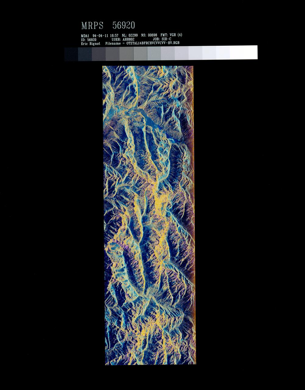
STS059-S-072 (13 April 1994) --- This image is a false-color composite of Oetztal, Austria located in the Central Alps, centered at 46.8 degrees north latitude, and 10.70 degrees east longitude, at the border between Switzerland (top), Italy (left) and Austria (right and bottom). The area shown is 50 kilometers (30 miles) south of Innsbruck, Austria. This image was acquired by the Spaceborne Imaging Radar-C and X-Band Synthetic Aperture Radar (SIR-C/X-SAR) aboard the Space Shuttle Endeavour on its 14th orbit. Oetztal is a SIR-C/X-SAR hydrology supersite. Approximately one quarter of this image is covered by glaciers, the largest of which, Gepatschferner, is visible as a triangular yellow patch in the center of the scene. The summits of the main peaks reach elevations between 3,500 and 3,768 meters (11,500 and 12,362 feet) above sea level. The tongues of the glaciers are descending from elevated plateaus down into narrow valleys which were formed during the last ice age. This color image was produced in C-Band using multi-polarization information (Red=CHV, Green=CVV, Blue=CVV/CHV). The blue areas are lakes (Gepatsch Dam at center right; Lake Muta at top right) and glacier ice. The yellow areas are slopes facing the radar and areas of dry snow. Purple corresponds to slopes facing away from the radar. Yellow in the valley bottom corresponds to tree covered areas. There is 30 to 50 centimeters (12 to 20 inches) of dry, fresh snow on the glaciers, and about 10 centimeters (4 inches) in the valley at the city of Vent, Austria (center). At these data were taken, the weather was cold, with snow and thick fog. The entire area would appear white to an optical sensor because it is all covered under a winter snowpack. Researchers are interested in Oetztal because knowing how glaciers shrink and grow over time is an important indication of climatic change. SIR-C/X-SAR is part of NASA's Mission to Planet Earth (MTPE). SIR-C/X-SAR radars illuminate Earth with microwaves allowing detailed observations at any time, regardless of weather or sunlight conditions. SIR-C/X-SAR uses three microwave wavelengths: L-Band (24 cm), C-Band (6 cm), and X-Band (3 cm). The multi-frequency data will be used by the international scientific community to better understand the global environment and how it is changing. The SIR-C/X-SAR data, complemented by aircraft and ground studies, will give scientists clearer insights into those environmental changes which are caused by nature and those changes which are induced by human activity. SIR-C was developed by NASA's Jet Propulsion Laboratory (JPL). X-SAR was developed by the Dornire and Alenia Spazio Companies for the German Space Agency, Deutsche Agentur fuer Raumfahrtangelegenheiten (DARA), and the Italian Space Agency, Agenzia Spaziale Italiana (ASI). JPL Photo ID: P-43890
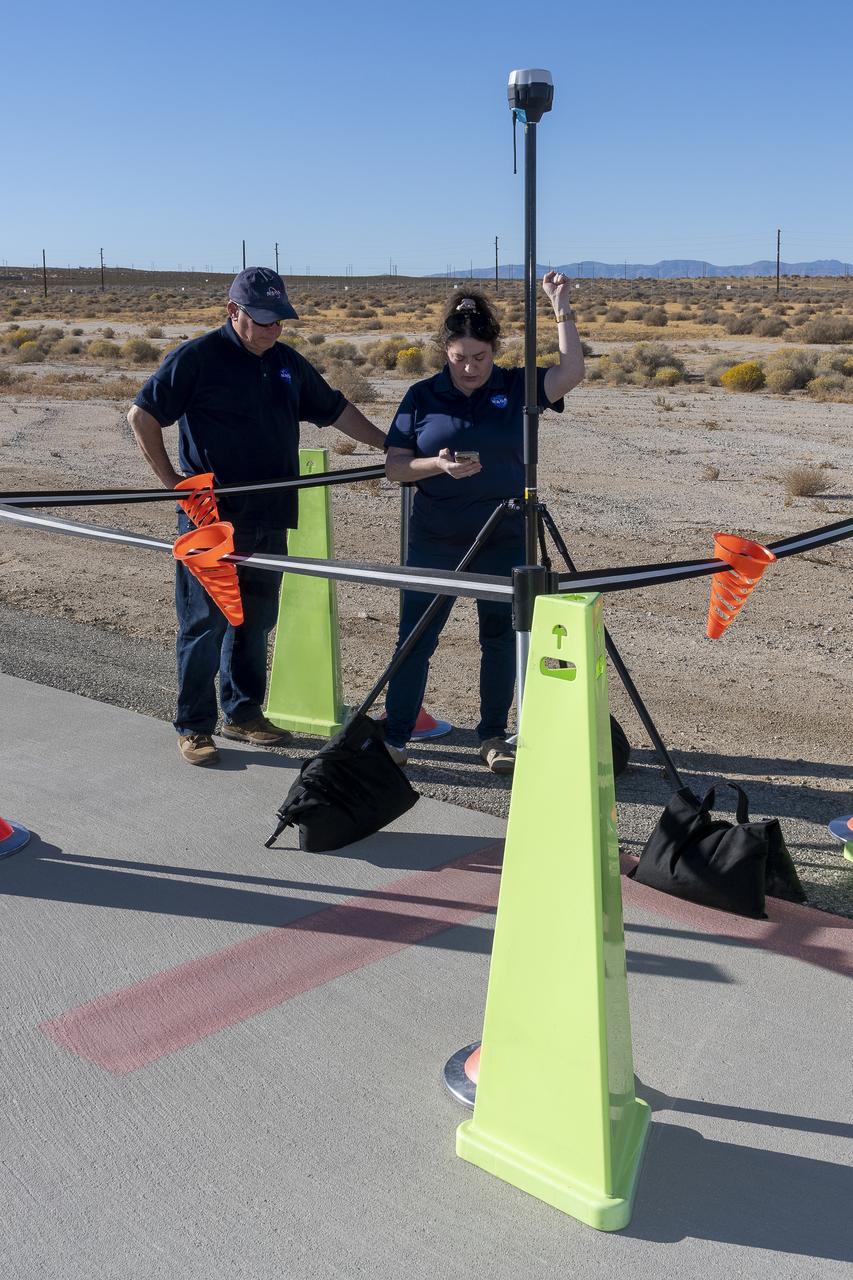
NASA Pathways intern Saré Culbertson, right, works with NASA operations engineer Jack Hayes at NASA’s Armstrong Flight Research Center in Edwards, California, on Nov. 7, 2024. They are verifying GPS and global navigation satellite system coordinates using Emlid Reach RS2+ receiver equipment, which supports surveying, mapping, and navigation in preparation for future air taxi test flight research.