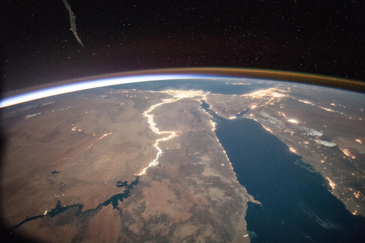
ISS044E022791 (07/27/2015) --- The Nile river in Africa sparkles in this night observation taken by NASA astronaut Scott Kelly on July 27, 2015.
ISS044E022706 07/27/2015) --- NASA astronaut Scott Kelly on the International Space Station tweeted this image out July 25, 2015 with the greeting "Good Morning".
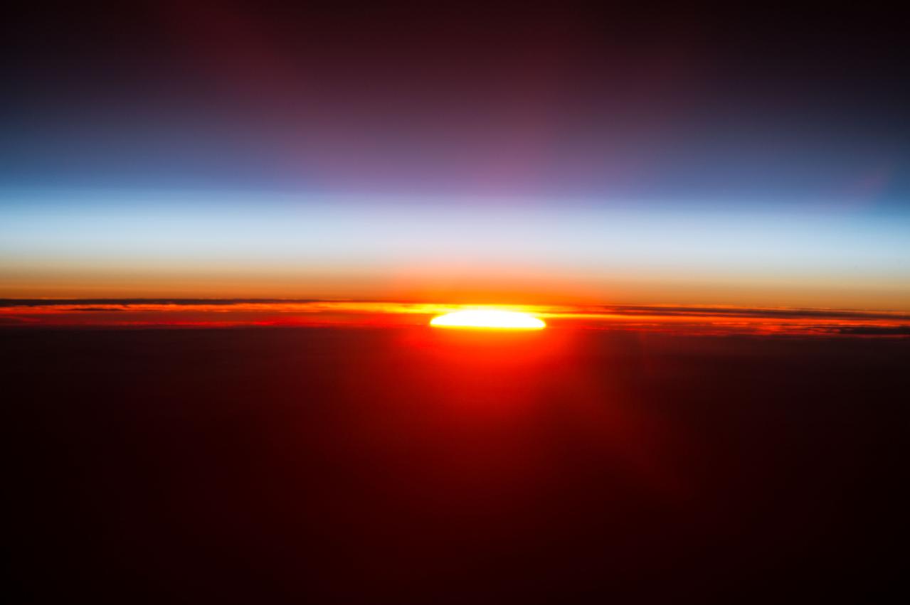
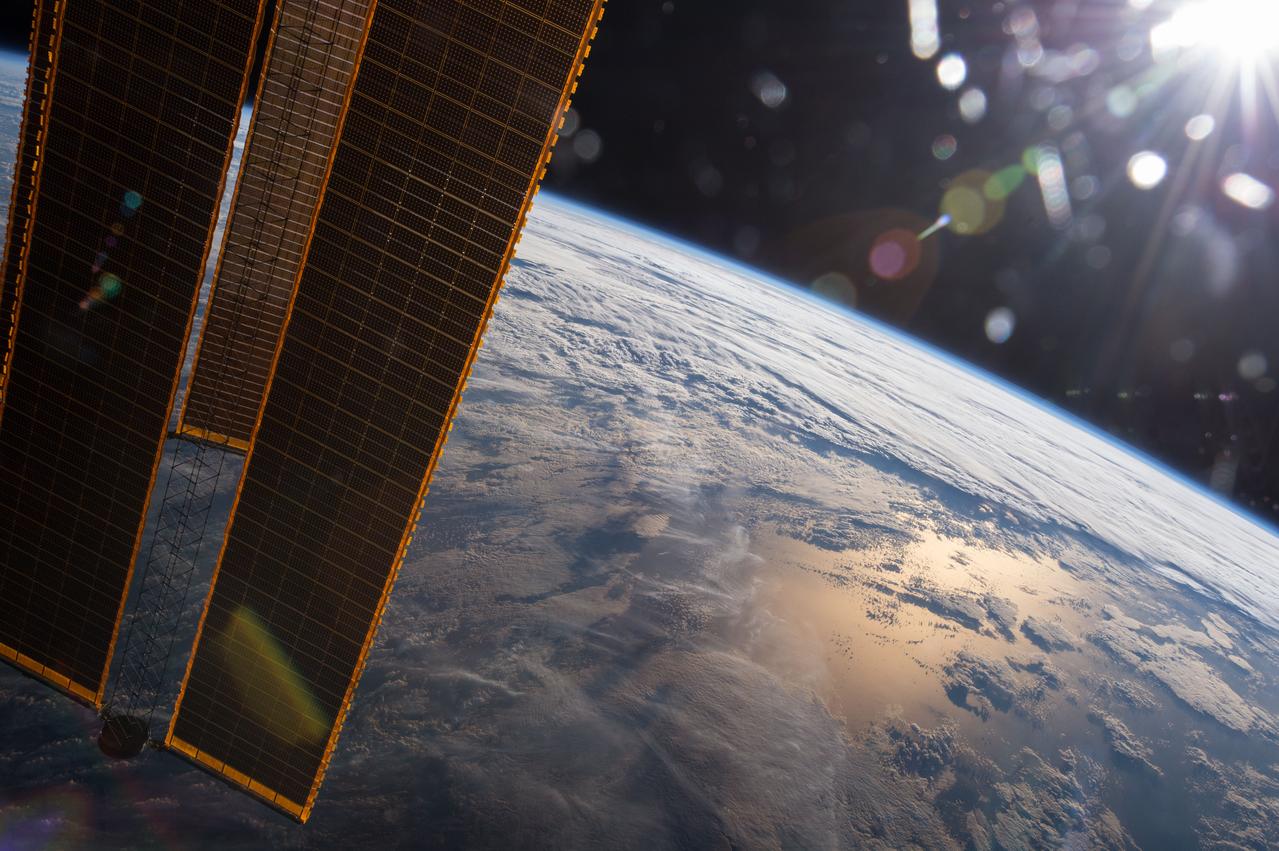
ISS044E025484 (07/30/2015) --- NASA astronaut Scott Kelly of Expedition 44 aboard the International Space Station on July 30, 2015 captured this sunrise while in his "year in space" .
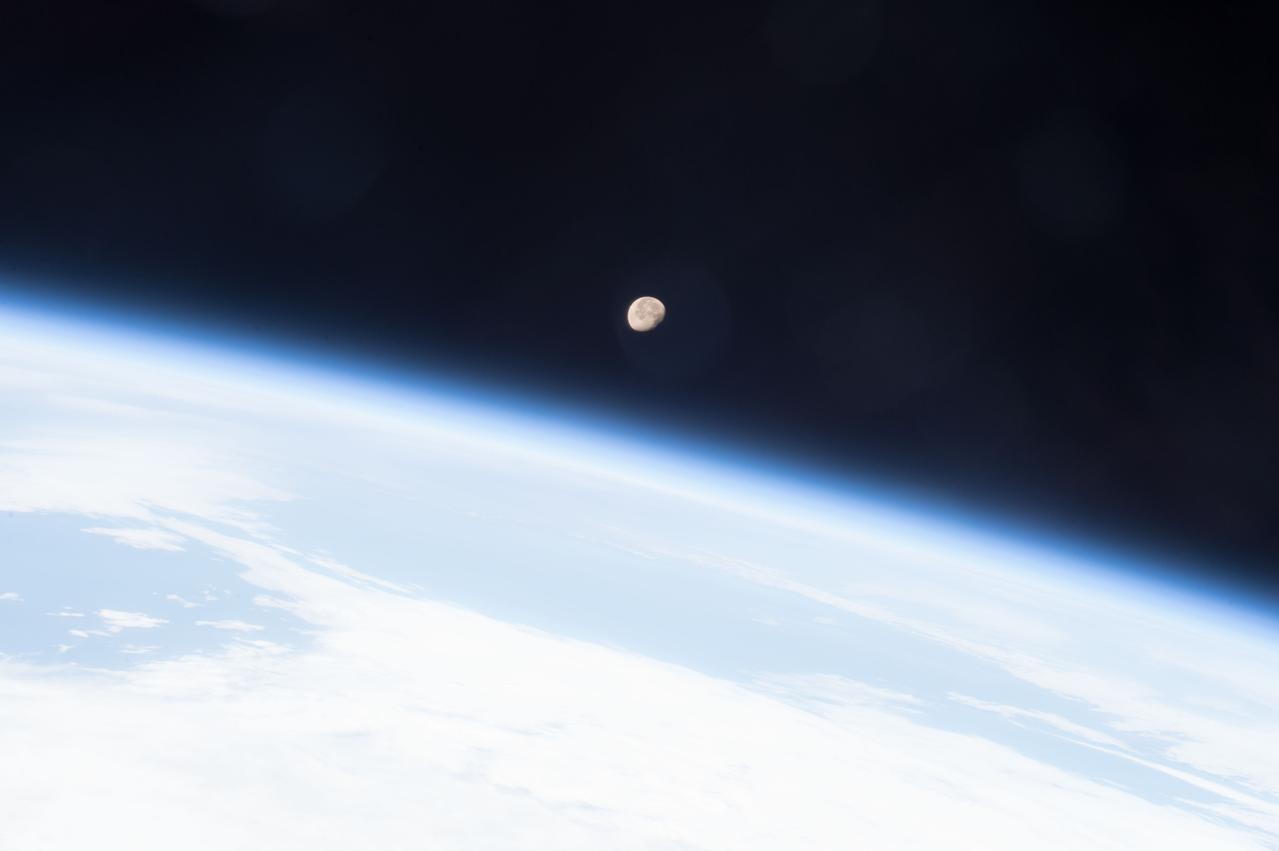
ISS043E200058 (05/07/2015) --- The Moon shines brightly on planet Earth's horizon in this image snapped from the International Space Station May 7, 2015 by the crew of Expedition 43 led by Commander Terry Virts, NASA astronaut.
ISS043E091794 (04/07/2015) --- Astronauts and cosmonauts aboard the International Space Station are regular witness to the beauty of our planet Earth from their high vantage point. This image was taken on Apr 7, 2015 by the crew of Expedition 43.
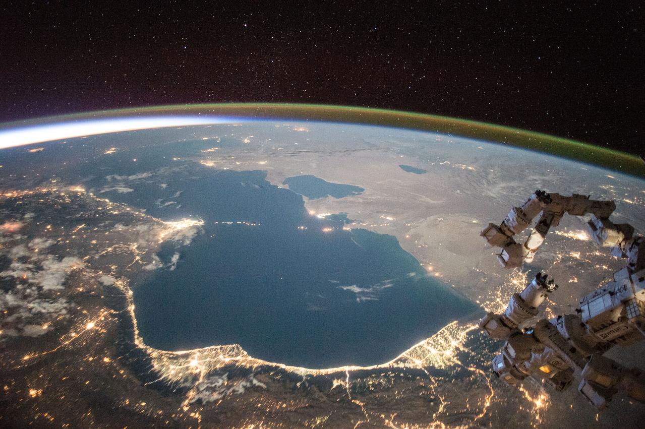
ISS044E022804 (07/26/2015) --- NASA astronaut Scott Kelly captured this earth observation of the Caspian sea on July 27, 2015 while onboard the International Space Station.
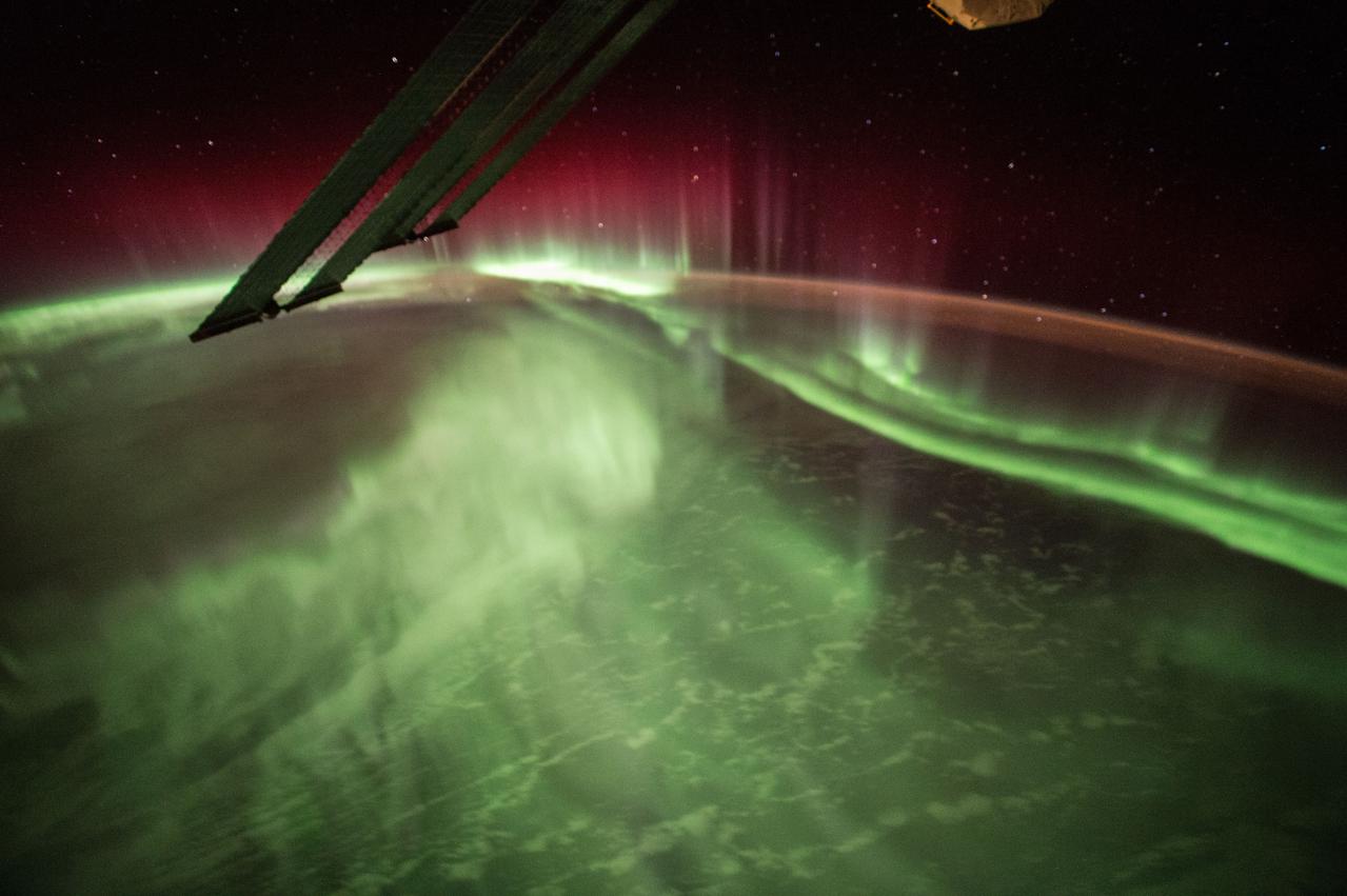
ISS044E012986 (07/13/2015) --- This Night Earth Observation of an Aurora Borealis was captured by NASA astronaut Scott Kelly of Expedition 44 on the International Space Station.

ISS044E022479 (07/27/2015) --- Earth Observation of New York City and surrounding area taken by Expedition 44 crew member NASA Astronaut Scott Kelly.
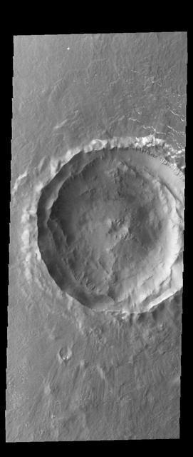
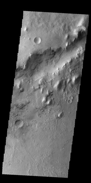
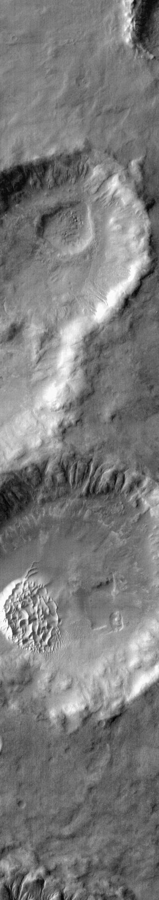
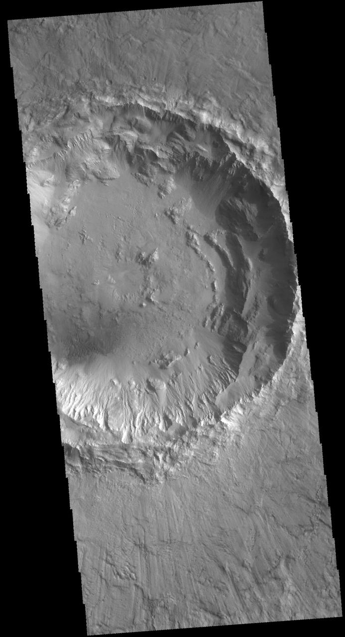
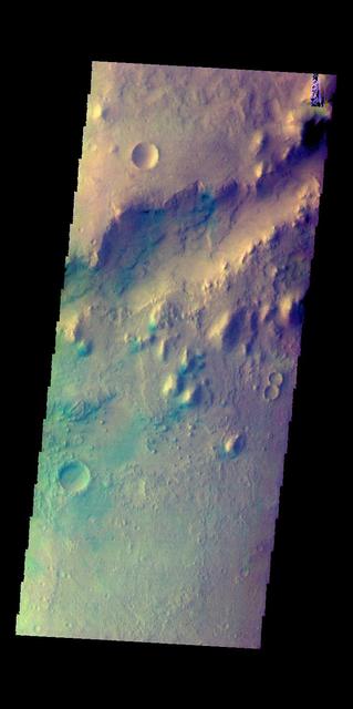
This image captured by NASA 2001 Mars Odyssey spacecraft shows an example of a central peak crater. This unnamed crater is located on the floor of Newton Crater in Terra Sirenum. Orbit Number: 57962 Latitude: -42.1211 Longitude: 201.814 Instrument: VIS Captured: 2015-01-07 07:47 photojournal.jpl.nasa.gov/catalog/PIA19200
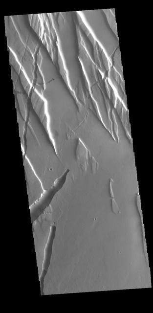
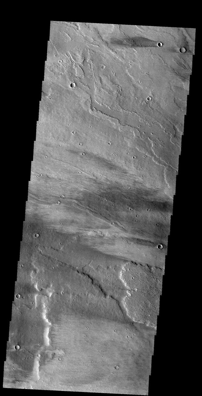
Today's VIS image shows part of Rzvius Valles, located on the northern flank of Alba Mons. Orbit Number: 60281 Latitude: 46.16 Longitude: 252.006 Instrument: VIS Captured: 2015-07-17 07:09 http://photojournal.jpl.nasa.gov/catalog/PIA19761
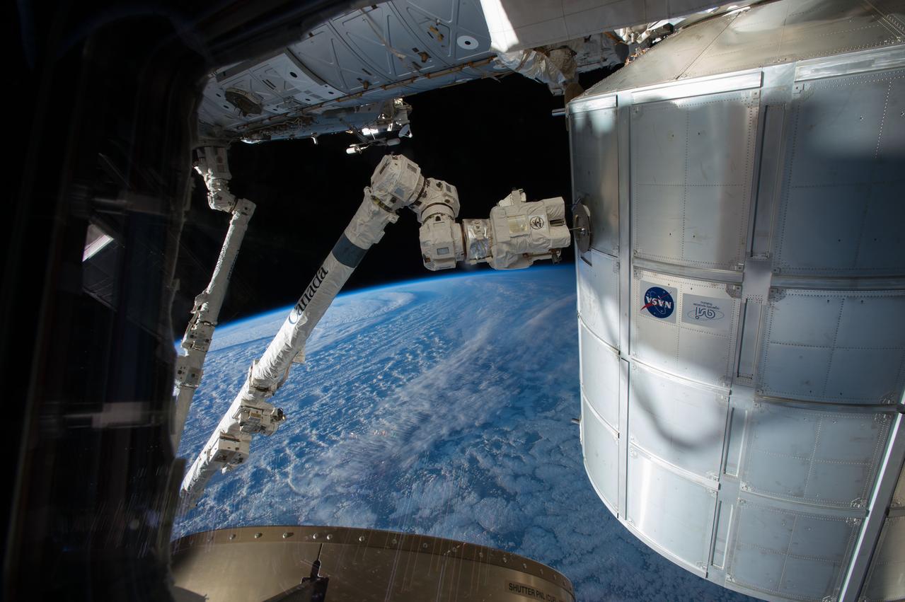
ISS043E091810 (04/07/2015) --- The International Space Stations robotic arm, Canadarm2, is poised and ready to capture SpaceX’s Dragon spacecraft following a training session on Apr. 7, 2015. Dragon’s upcoming flight will be SpaceX’s sixth resupply flight to the station and will carry more than two tons of supplies and equipment for the Expedition 43 crew.
ISS044E044204 (08/07/2015) --- NASA astronaut Scott Kelly, on board the International Space Station, took this interesting picture of the Himalayas on Aug 7, 2015 and sent it out as a twitter with these comments: " #Himalayas in #EarthArt form look a bit like funnel cake. #YearInSpace".
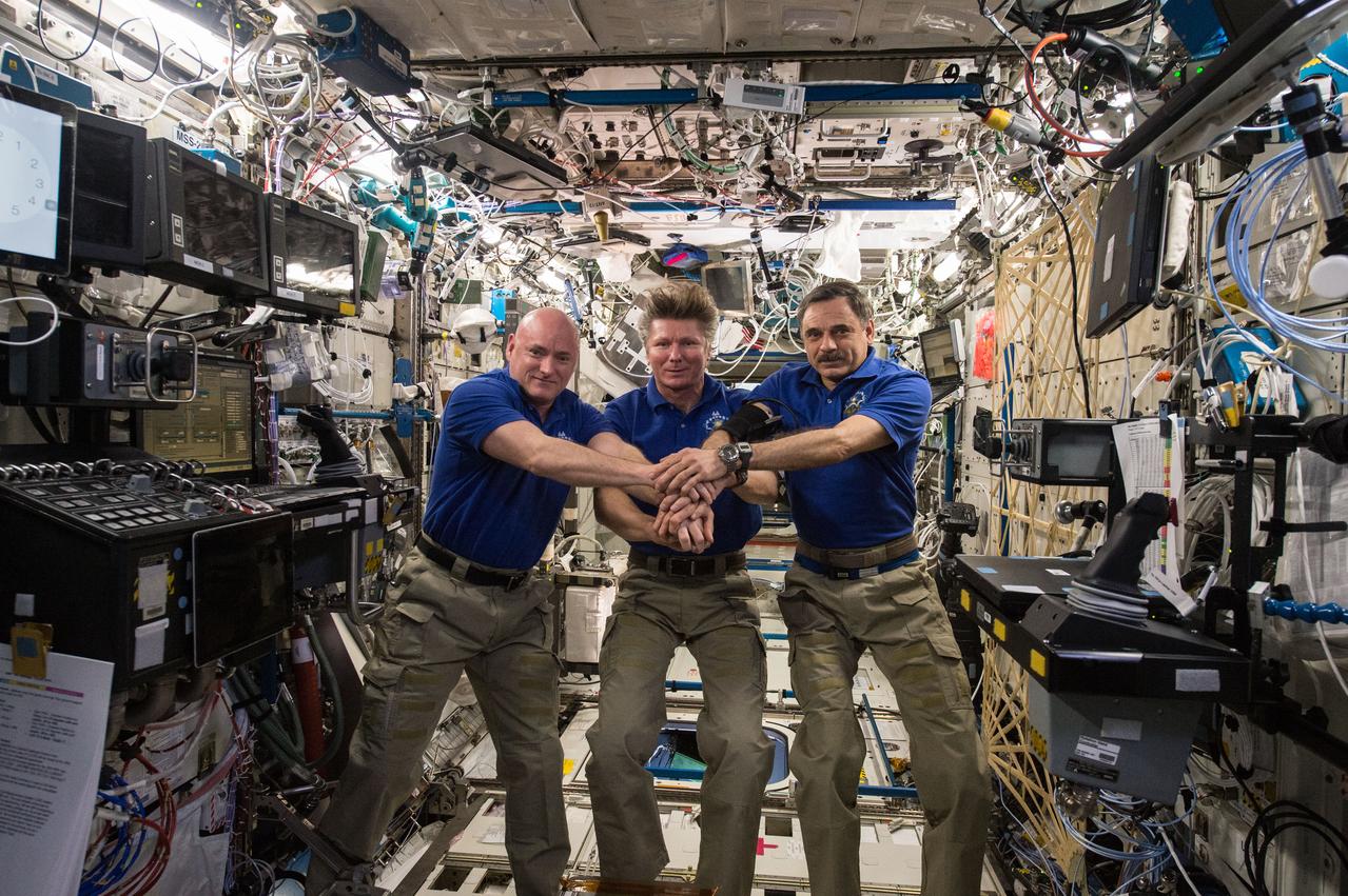
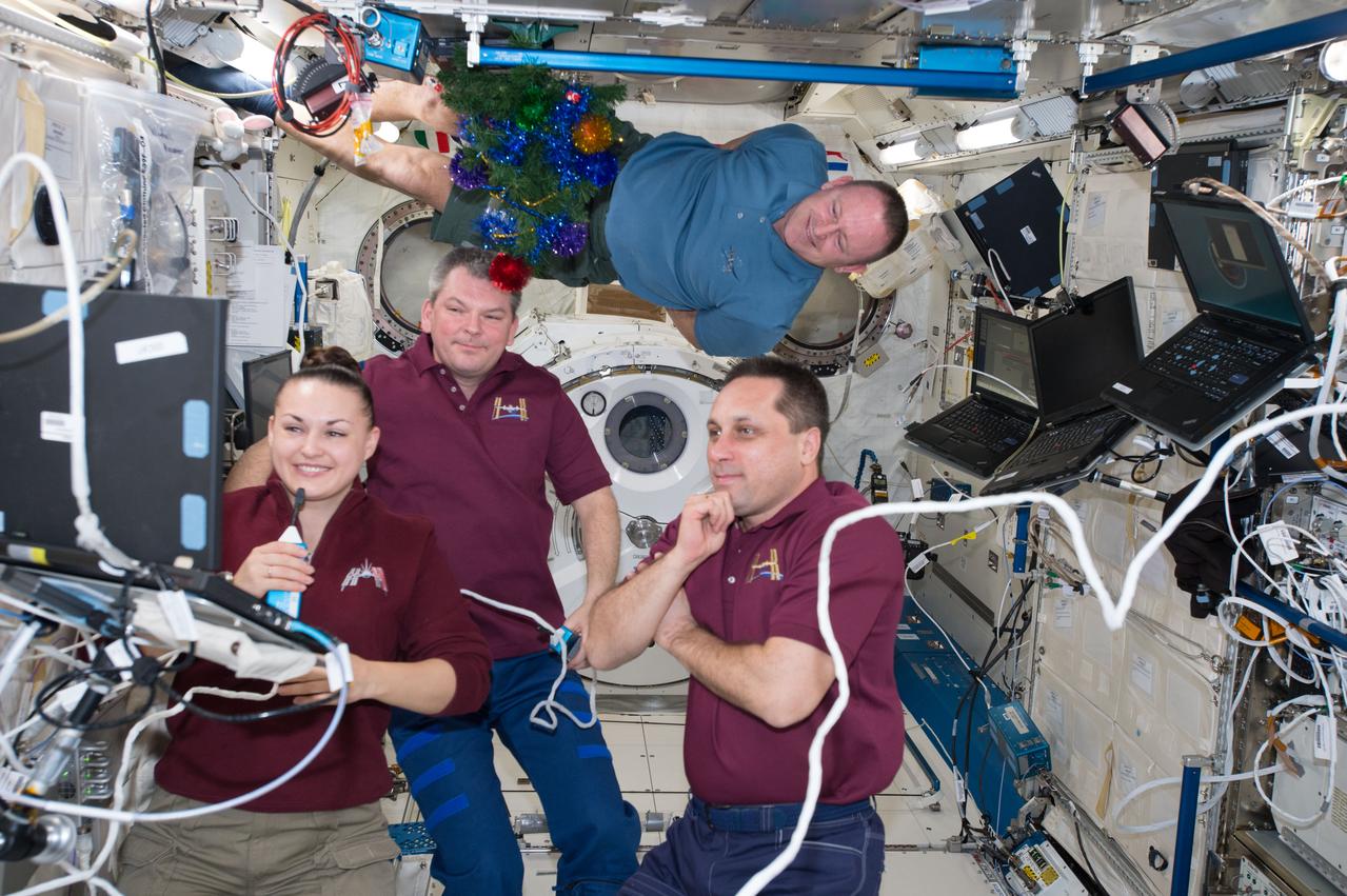
ISS044E013678 (07/15/2015) --- On July 15, 2015 aboard the International Space Station, Expedition 44 crew memebrs Scott Kelly of NASA (left), Expedition Commander and Russian cosmonaut Gennady Padalka (middle), and Russian cosmonaut Mikhail Kornienko (right) commemorated the 40th anniversary of the joint Apollo-Soyuz mission.

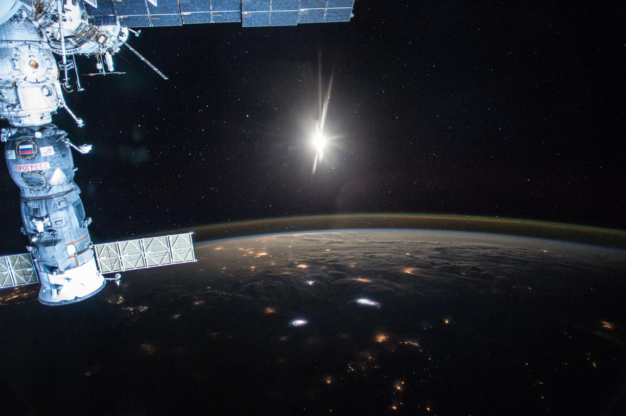
ISS044E022682 (07/27/2015) --- Night Earth observation of Japan taken by Expedition 44 crewmember Scott Kelly, with a Soyuz Spacecraft connected to the Mini Research Module 1 (MRM1), and a Progress Spacecraft visible.
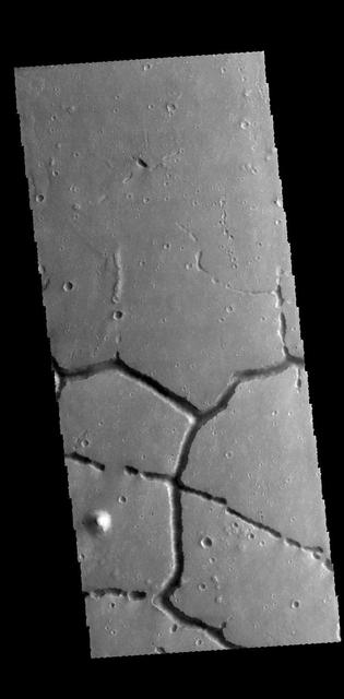
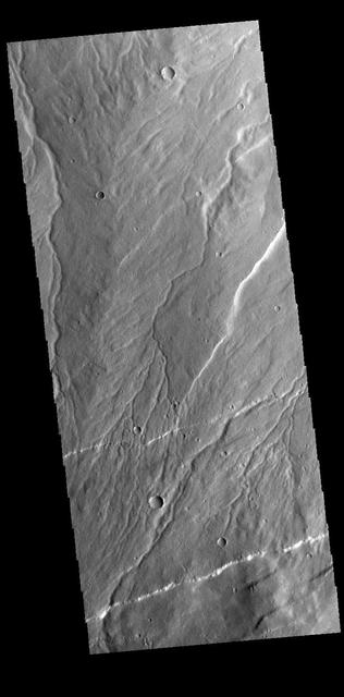
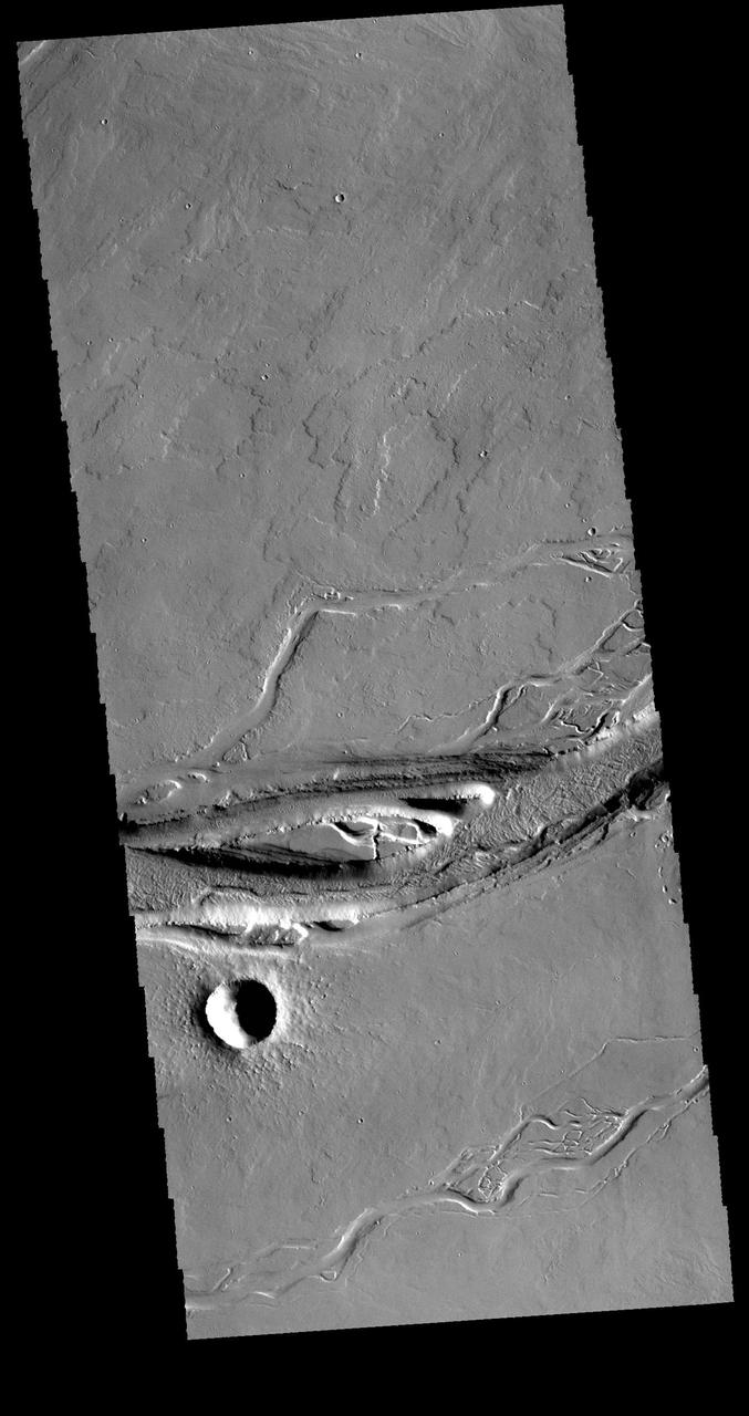
The intersecting linear depressions in this VIS image are part of Hephaestus Fossae. Orbit Number: 60373 Latitude: 21.9161 Longitude: 122.075 Instrument: VIS Captured: 2015-07-24 20:50 http://photojournal.jpl.nasa.gov/catalog/PIA19765
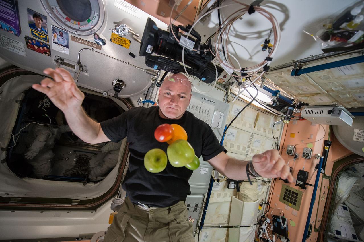
ISS044E007995 (07/05/2015) ---NASA astronaut Scott Kelly in the Unity (Node 1) module enjoying some fresh fruit and vegetables brought up to the International Space Station by the recent Russian Progress 60 spacecraft.
This relatively young crater is located on the northern plains of Arcadia Planitia. Orbit Number: 60388 Latitude: 61.6777 Longitude: 228.91 Instrument: VIS Captured: 2015-07-26 03:01 http://photojournal.jpl.nasa.gov/catalog/PIA19766
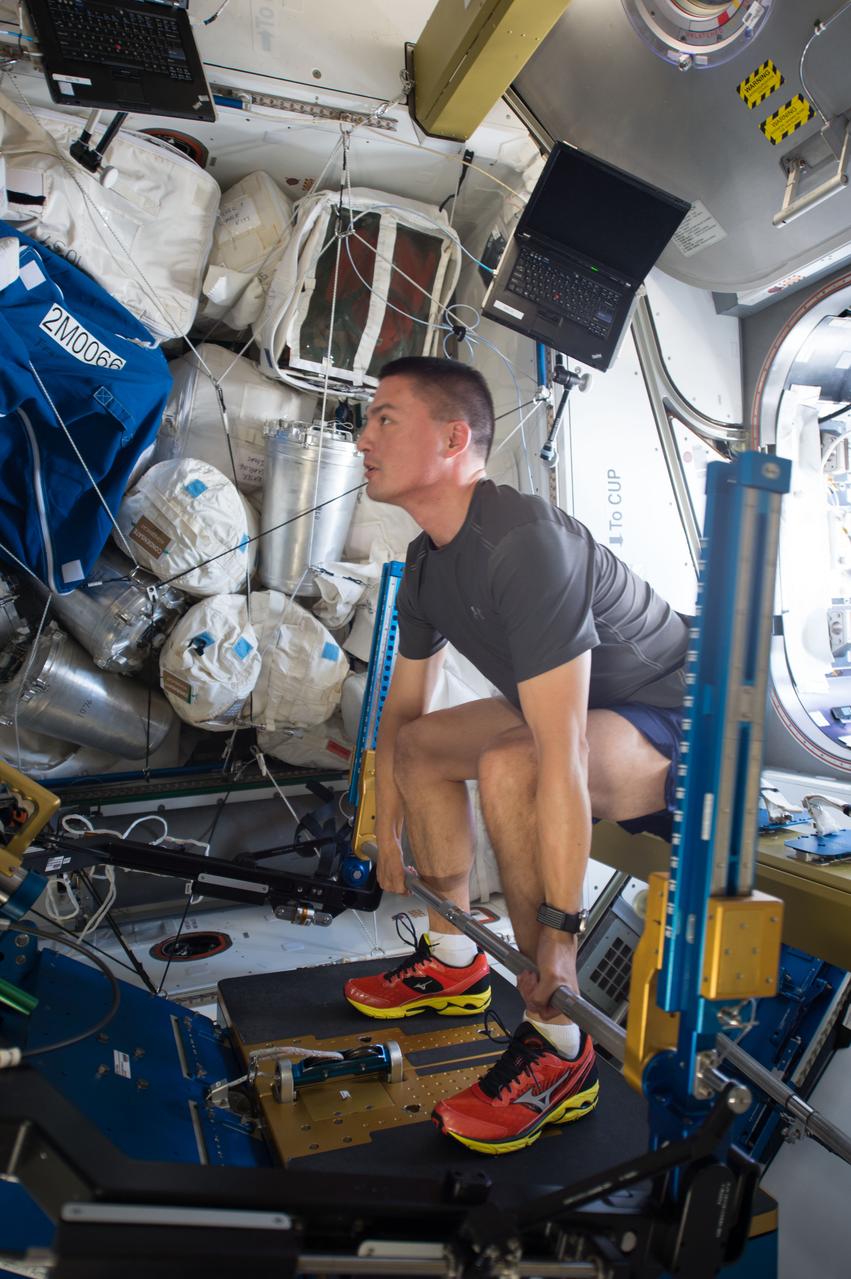
ISS044E024392 (07/28/2015) --- Newly arrived NASA astronaut Kjell Lindgren exercises on the International Space Station using the Advanced Resistive Exercise Device to help mitigate the potentially adverse effects of long duration stays in microgravity.

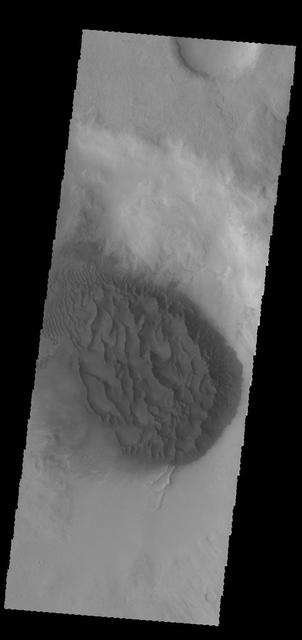
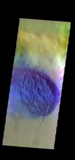
This infrared image captured by NASA 2001 Mars Odyssey spacecraft shows dunes in an unnamed crater in Noachis Terra. Latitude: -49.5174 Longitude: 33.942 Instrument: IR Captured: 2015-01-27 07:56
The linear depression in today's VIS image is part of Nili Fossae. Orbit Number: 60318 Latitude: 24.7944 Longitude: 80.7404 Instrument: VIS Captured: 2015-07-20 08:53 http://photojournal.jpl.nasa.gov/catalog/PIA19763
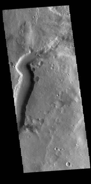
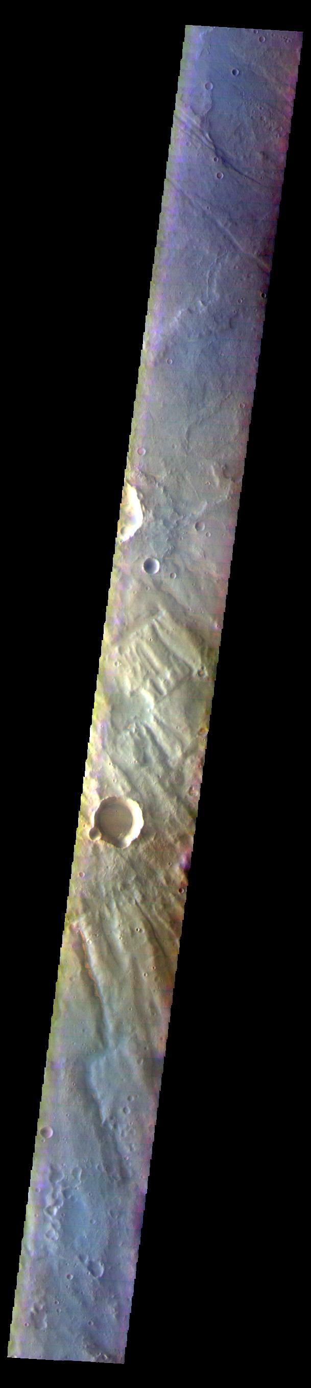
Today's VIS image shows the start of Mamers Valles. Orbit Number: 60364 Latitude: 31.4345 Longitude: 20.3221 Instrument: VIS Captured: 2015-07-24 03:06 http://photojournal.jpl.nasa.gov/catalog/PIA19764
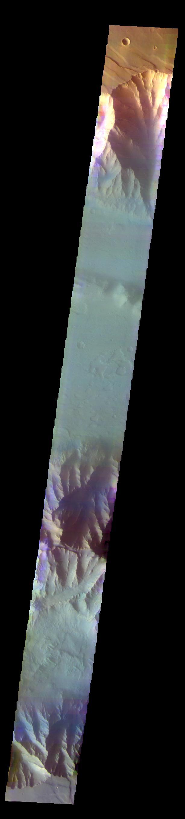
The THEMIS VIS camera contains 5 filters. The data from different filters can be combined in multiple ways to create a false color image. These false color images may reveal subtle variations of the surface not easily identified in a single band image. Today's VIS image shows part of Ophir Chasma. Orbit Number: 60112 Latitude: -4.48512 Longitude: 288.129 Instrument: VIS Captured: 2015-07-03 07:57 https://photojournal.jpl.nasa.gov/catalog/PIA22677
The THEMIS camera contains 5 filters. The data from different filters can be combined in multiple ways to create a false color image. These false color images may reveal subtle variations of the surface not easily identified in a single band image. This image from NASA 2001 Mars Odyssey spacecraft shows an unnamed crater located on the floor of Newton Crater. Orbit Number: 57962 Latitude: -42.1218 Longitude: 201.814 Instrument: VIS Captured: 2015-01-07 07:47 https://photojournal.jpl.nasa.gov/catalog/PIA21539

Doreen Zudell takes over as the Editor of the Lewis News, Center Newsletter
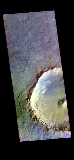
This image captured by NASA 2001 Mars Odyssey spacecraft shows gullies on the inner rim of an unnamed crater in Noachis Terra. Orbit Number: 58205 Latitude: -50.2033 Longitude: 34.0703 Instrument: VIS Captured: 2015-01-27 07:56 http://photojournal.jpl.nasa.gov/catalog/PIA19256
This image captured by NASA 2001 Mars Odyssey spacecraft shows a small portion of the lava flows that comprise Daedalia Planum. These flows originated at Arsia Mons. Orbit Number: 58691 Latitude: -24.3187 Longitude: 237.76 Instrument: VIS Captured: 2015-03-08 07:47 http://photojournal.jpl.nasa.gov/catalog/PIA19451
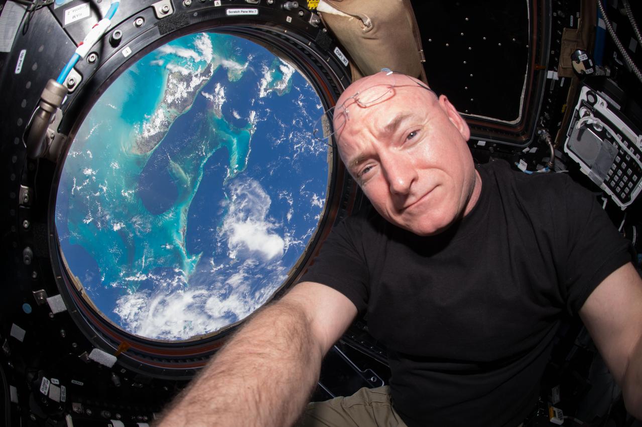
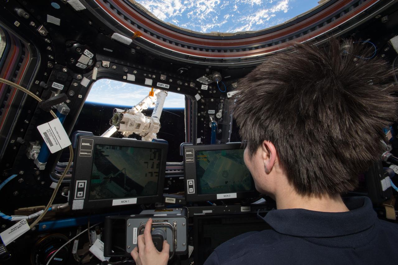
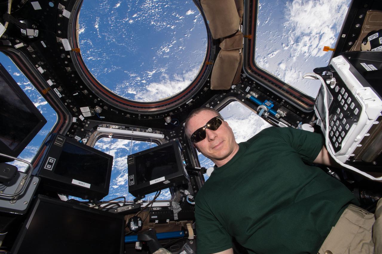
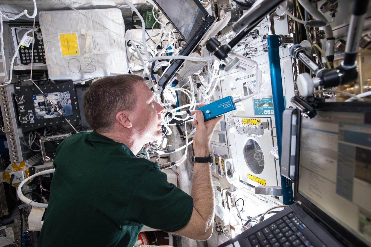
ISS044E011632 (07/12/2015) --- Expedition 44 flight engineer and NASA astronaut Scott Kelly seen inside the Cupola, a special module which provides a 360-degree viewing of the Earth and the International Space Station. Kelly is one of two crew members spending an entire year in space.
This image captured by NASA 2001 Mars Odyssey spacecraft shows a large sand sheet with surface dune forms on the floor of an unnamed crater in Noachis Terra. Orbit Number: 58336 Latitude: -48.6161 Longitude: 34.0534 Instrument: VIS Captured: 2015-02-07 02:22 http://photojournal.jpl.nasa.gov/catalog/PIA19275
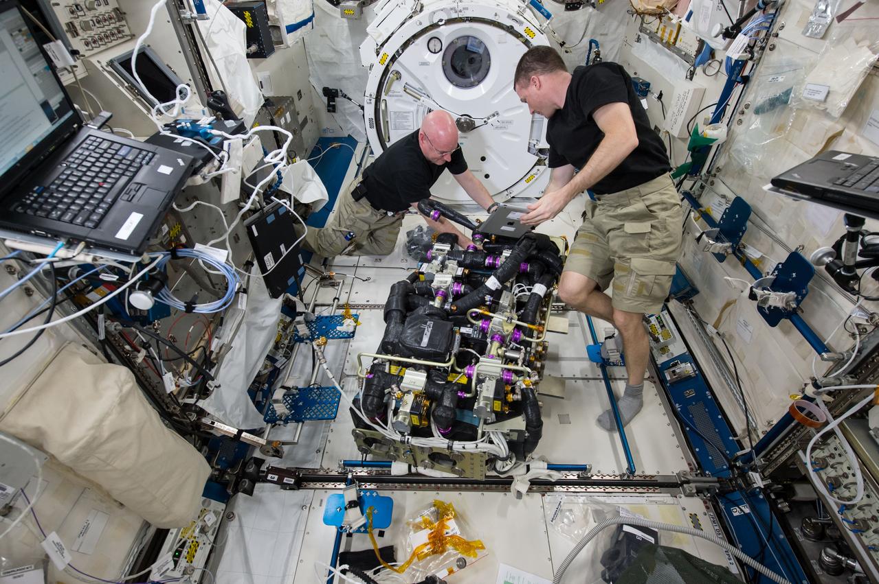
ISS043E181459 (05/07/2015) – NASA astronauts Scott Kelly (left) and Terry Virts (right) work on a Carbon Dioxide Removal Assembly (CDRA) inside the station’s Japanese Experiment Module. The CDRA system works to remove carbon dioxide from the cabin air, allowing for an environmentally safe crew cabin.
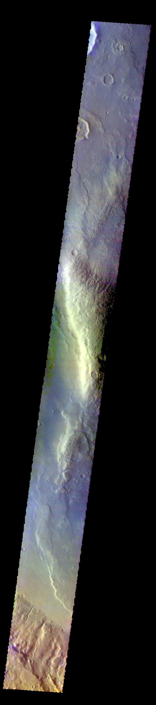
The graben and collapse features in this image are part of Ceraunius Fossae, which is located south of Alba Mons. Orbit Number: 60406 Latitude: 27.0278 Longitude: 249.29 Instrument: VIS Captured: 2015-07-27 14:05 http://photojournal.jpl.nasa.gov/catalog/PIA19767
This image from NASA 2001 Mars Odyssey spacecraft shows warm dunes are brighter than their surroundings in this infrared image of an unnamed crater in Noachis Terra. Latitude: -49.5174 Longitude: 33.942 Instrument: IR Captured: 2015-01-27 07:56 http://photojournal.jpl.nasa.gov/catalog/PIA19252
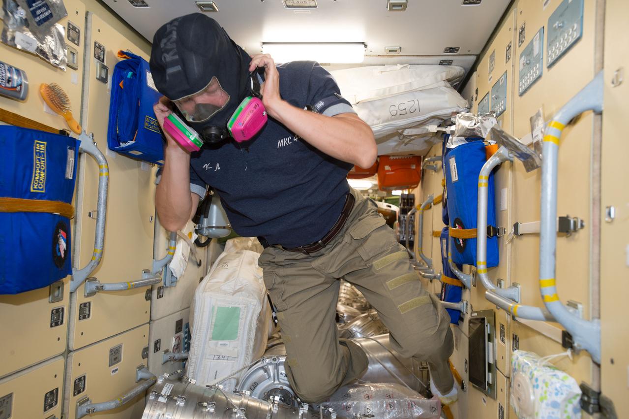
ISS044E025035 (07/29/2015) --- NASA astronaut Kjell Lindgren wears protective breathing apparatus that would be used in the unlikely event of a fire or hazardous chemical leak inside the pressurized air volume of the International Space Station. Familiarization of safety and emergency equipment is standard practice for all newly arrived crew members.
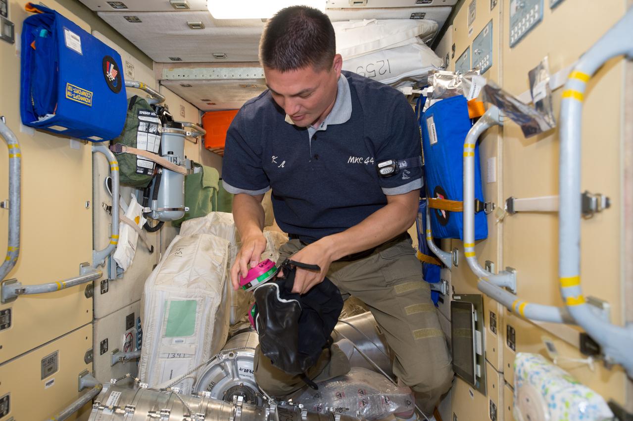
ISS044E025035 (07/29/2015) --- NASA astronaut Kjell Lindgren prepares to don protective breathing apparatus that would be used in the unlikely event of a fire or hazardous chemical leak inside the pressurized air volume of the International Space Station. Familiarization of safety and emergency equipment is standard practice for all newly arrived crew members.
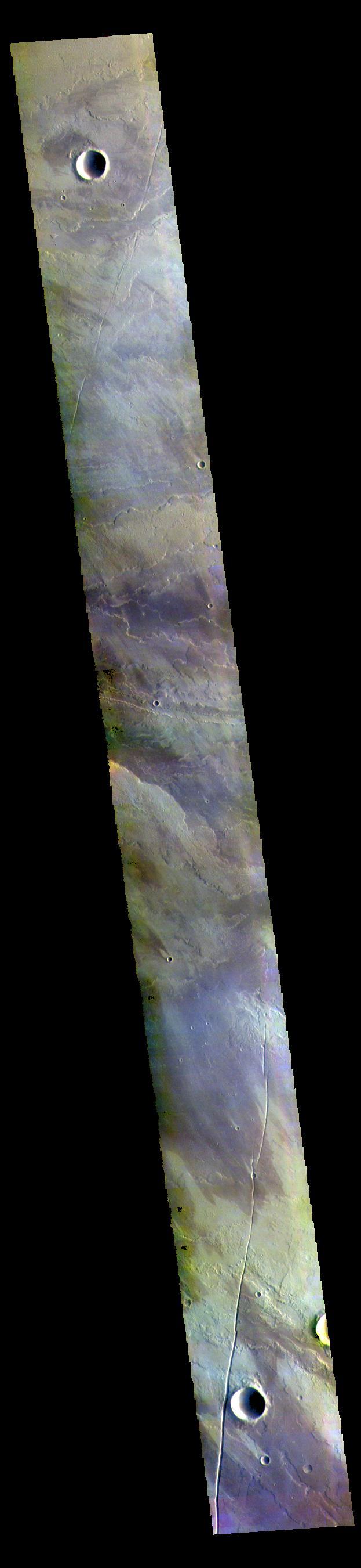
Today's VIS image of an unnamed crater in Terra Sirenum shows crater ejecta. Orbit Number: 60139 Latitude: -38.4241 Longitude: 224.216 Instrument: VIS Captured: 2015-07-05 13:30 http://photojournal.jpl.nasa.gov/catalog/PIA19760
ISS043E091840 (04/07/2015) --- ESA (European Space Agency) astronaut Samantha Cristoforetti in the International Space Station’s Cupola module guides the Canadarm2 robotic arm (visible through window) remotely on Apr. 7, 2015. She and her Expedition 43 crewmates will use this to grapple the SpaceX Dragon CRS-6 spacecraft upon its arrival. Dragon has over 2 tons of equipment, supplies, and science experiments on board for transfer to the station.
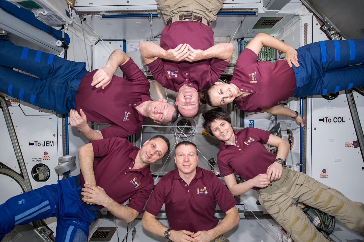
ISS042E306480 (03/07/2015) --- A meeting of the minds aboard the International Space Station on Mar. 7, 2015 with members of Expedition 42; astronauts US, Barry Wilmore (Commander) Top, Upside down, to the right cosmonaut Elena Serova, & ESA European Space Agency Samantha Cristoforetti. Bottom center US astronaut Terry Virts, top left cosmonauts Alexander Samokutyaev and Anton Shkaplerov.
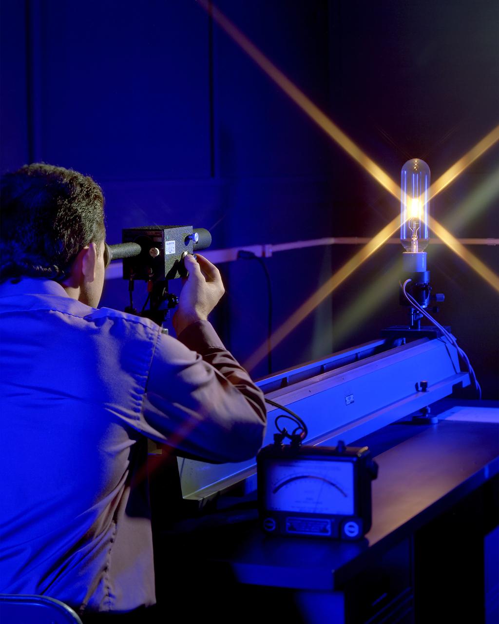
Pictured is a method for testing high temperature measurements by comparing the color spectrum of light at various power settings with an Optical Pyrometer. The devices are calibrated at NIST. The power through the bulb is varied and monitored by the meter on the table. The scanning device that the technician is looking though is adjusted till the color scheme viewed within in the device matches the color of the emanating from the bulb at the particular power setting. Using a relationship table provided, the technicians can then identify the temperature. The light source pictured is used to calibrate the device that the technician looks through. The technician would then go to a source of heat such as an oven and by aligning the color given off by the unit under test (UUT), he would use the reference table to determine the source’s heat output.
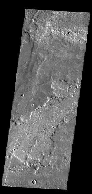
This VIS image shows a portion of Olympica Fossae. In this image several lava channels are visible, and it appears that lava has flowed in the larger depressions. The streamlined feature in the central part of the image also indicates that volcanic processes were active in this region. Orbit Number: 61654 Latitude: 24.8964 Longitude: 246.128 Instrument: VIS Captured: 2015-11-07 08:34. http://photojournal.jpl.nasa.gov/catalog/PIA20222
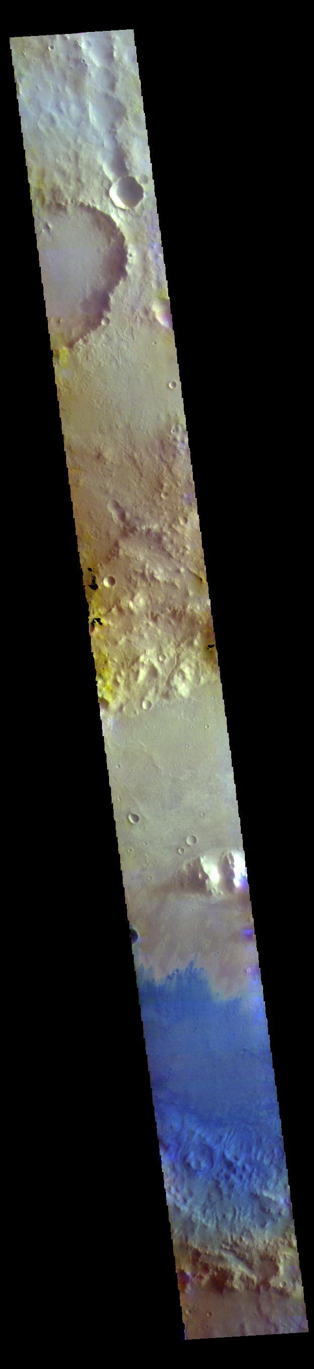
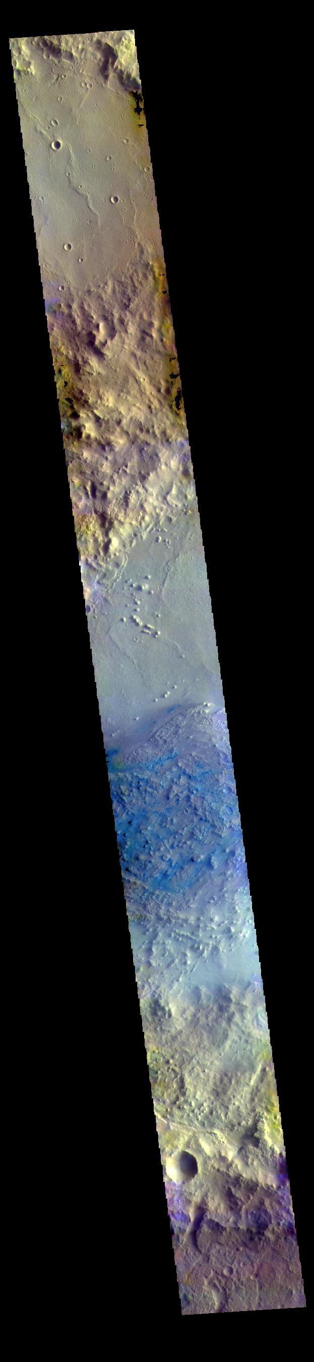
The THEMIS VIS camera contains 5 filters. The data from different filters can be combined in multiple ways to create a false color image. These false color images may reveal subtle variations of the surface not easily identified in a single band image. Today's false color images shows part of the plains and craters of Terra Sirenum. Orbit Number: 59298 Latitude: -48.8967 Longitude: 184.212 Instrument: VIS Captured: 2015-04-27 07:56 https://photojournal.jpl.nasa.gov/catalog/PIA21670
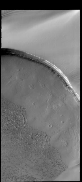
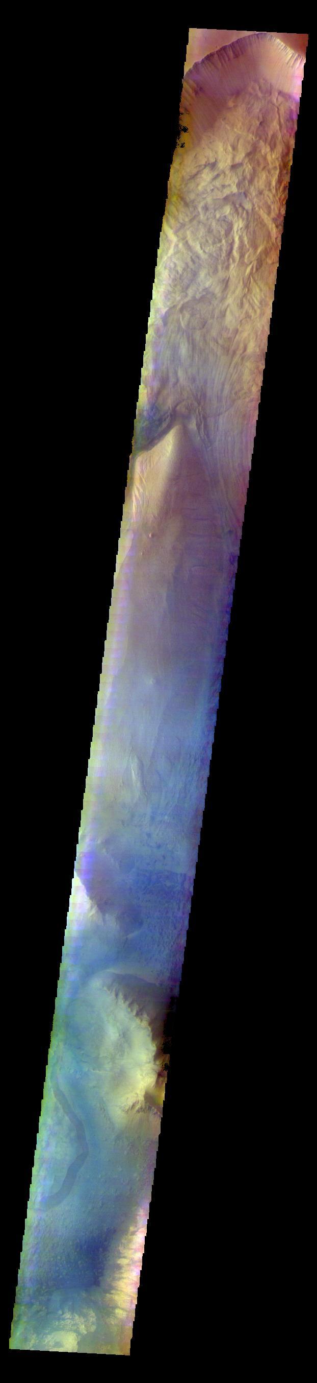
Tenuis Cavus is a region within the north polar cap where the underlying surface is visible. Ice comprises the top part of this image captured by NASA 2001 Mars Odyssey spacecraft. Orbit Number: 61283 Latitude: 84.7719 Longitude: 2.80914 Instrument: VIS Captured: 2015-10-07 19:42 http://photojournal.jpl.nasa.gov/catalog/PIA20112
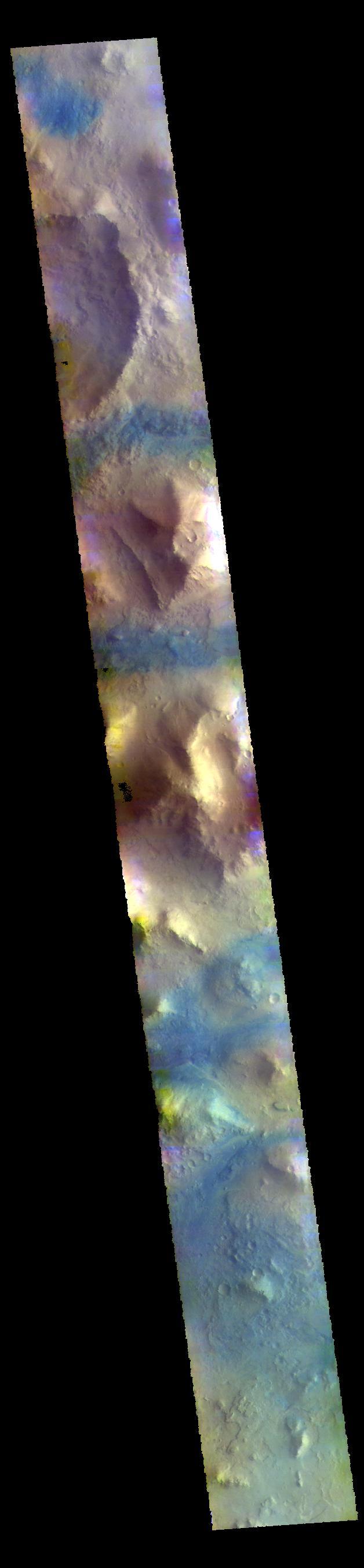
The THEMIS VIS camera contains 5 filters. The data from different filters can be combined in multiple ways to create a false color image. These false color images may reveal subtle variations of the surface not easily identified in a single band image. Today's VIS image is located on the margin between Thaumasia Planum and Coracis Fossae. Orbit Number: 60137 Latitude: -29.3915 Longitude: 283.341 Instrument: VIS Captured: 2015-07-05 09:29 https://photojournal.jpl.nasa.gov/catalog/PIA22678
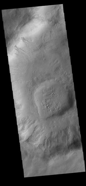
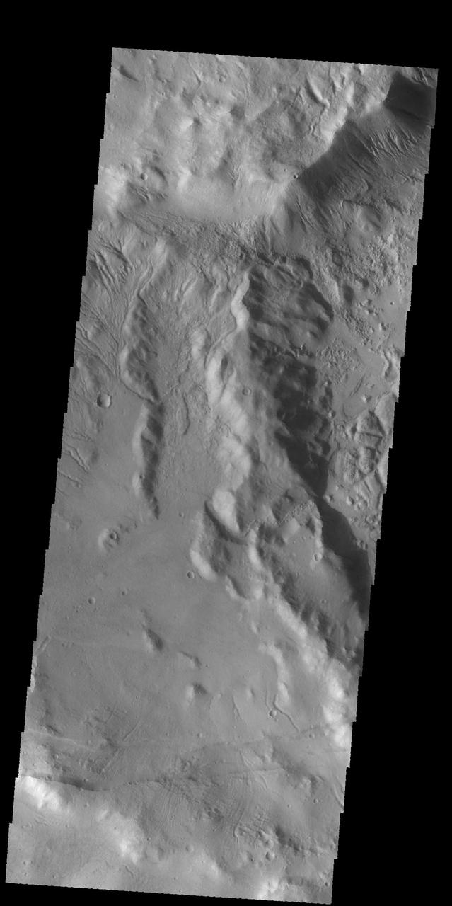
The THEMIS VIS camera contains 5 filters. The data from different filters can be combined in multiple ways to create a false color image. These false color images may reveal subtle variations of the surface not easily identified in a single band image. Today's false color images shows part of the large ridge on the floor of Newton Crater in Terra Sirenum. Orbit Number: 59416 Latitude: -41.0768 Longitude: 200.911 Instrument: VIS Captured: 2015-05-07 00:38 https://photojournal.jpl.nasa.gov/catalog/PIA21672
Today's VIS image from NASA's 2001 Mars Odyssey is of an unnamed crater in Chryse Planitia. There are several concentric ridges visible on the right side of this image. These features formed at the time of impact and are part of the rim structure of this crater. Numerous gullies dissect the rim and a small dune field is located on the floor of the crater. Orbit Number: 61676 Latitude: 36.5047 Longitude: 329.655 Instrument: VIS Captured: 2015-11-09 04:07 http://photojournal.jpl.nasa.gov/catalog/PIA20233
ISS042E101418 (01/07/2015) --- Expedition 42 Commander Barry Wilmore of NASA and Flight Engineers Elena Serova, Alexander Samoukutyaev and Anton Shkaplerov of Roscosmos are seen here gathered inside the Japanese Kibo module of the International Space Station working with equipment. Astronauts and Cosmonauts work a variety of science experiments and orbital maintenance while on their tour of duty aboard the ISS.
This image captured by NASA 2001 Mars Odyssey spacecraft shows windstreaks on the lava flows of Daedalia Planum. The tail behind the crater indicates winds blew from east to west. Orbit Number: 59116 Latitude: -12.3936 Longitude: 219.568 Instrument: VIS Captured: 2015-04-12 07:37 http://photojournal.jpl.nasa.gov/catalog/PIA19498
ISS043E091837 (04/07/2015) --- NASA astronaut Terry Virts, Commander of Expedition 43 aboard the International Space Station, dons eye protection from the sun while working in Cupola, the station’s 360 degree viewing platform. The Cupola contains the primary control station for the station’s robotic arm, Canadarm2, which the crew use to capture visiting spacecraft like SpaceX’s Dragon and Orbital ATK’s Cygnus. The specialized windows also provide one of the best vantage points on station for Earth study and photography.
This VIS image shows a small part of the extensive volcanic plains located east of Olympus Mons. The THEMIS VIS camera contains 5 filters. The data from different filters can be combined in multiple ways to create a false color image. These false color images may reveal subtle variations of the surface not easily identified in a single band image. Orbit Number: 60918 Latitude: 20.5787 Longitude: 239.913 Instrument: VIS Captured: 2015-09-07 17:55 https://photojournal.jpl.nasa.gov/catalog/PIA23051
The THEMIS VIS camera contains 5 filters. The data from different filters can be combined in multiple ways to create a false color image. These false color images may reveal subtle variations of the surface not easily identified in a single band image. Today's false color image shows a sand sheet with surface dune forms in an unnamed crater in Noachis Terra. Orbit Number: 58336 Latitude: -48.6161 Longitude: 34.0534 Instrument: VIS Captured: 2015-02-07 02:22 http://photojournal.jpl.nasa.gov/catalog/PIA19734
The subtle paired fractues at the bottom of this image from NASA 2001 Mars Odyssey spacecraft are part of Sirenum Fossae, though it is hundreds of km away from yesterday image location. Numerous gullies at the top of the image are located on the intersection of two crater rims. Orbit Number: 58618 Latitude: -38.9581 Longitude: 181.314 Instrument: VIS Captured: 2015-03-02 07:36 http://photojournal.jpl.nasa.gov/catalog/PIA19441
This image shows a small section of Nili Fossae. The darker blue tones are usually indications of basaltic sands. The THEMIS VIS camera contains 5 filters. The data from different filters can be combined in multiple ways to create a false color image. These false color images may reveal subtle variations of the surface not easily identified in a single band image. Orbit Number: 60318 Latitude: 24.7981 Longitude: 80.7408 Instrument: VIS Captured: 2015-07-20 08:53 https://photojournal.jpl.nasa.gov/catalog/PIA22706
This false color image shows part of the floor of Marth Crater. Dark blue tones typically indicate basaltic sands. Wind action is blowing the sand and dust to the southern side of the crater floor. Marth Crater is located in Arabia Terra. The THEMIS VIS camera contains 5 filters. The data from different filters can be combined in multiple ways to create a false color image. These false color images may reveal subtle variations of the surface not easily identified in a single band image. Orbit Number: 60914 Latitude: 13.5027 Longitude: 356.362 Instrument: VIS Captured: 2015-09-07 09:58 https://photojournal.jpl.nasa.gov/catalog/PIA23040
ISS043E091755 (04/07/2015) --- Expedition 43 Commander Terry Virts is seen here working inside of the Columbus laboratory on the Blood Pressure Regulation (BP Reg) experiment. Astronauts returning from long-duration space flights risk experiencing dizziness or fainting when they stand immediately after returning to Earth. This has an important health risk as it reduces the potential for astronauts to safely escape from an emergency situation. BP Reg will help researchers develop appropriate countermeasures so that astronauts returning from long-duration space flights will have very low risk of experiencing dizziness or fainting when they return to Earth.
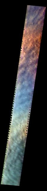
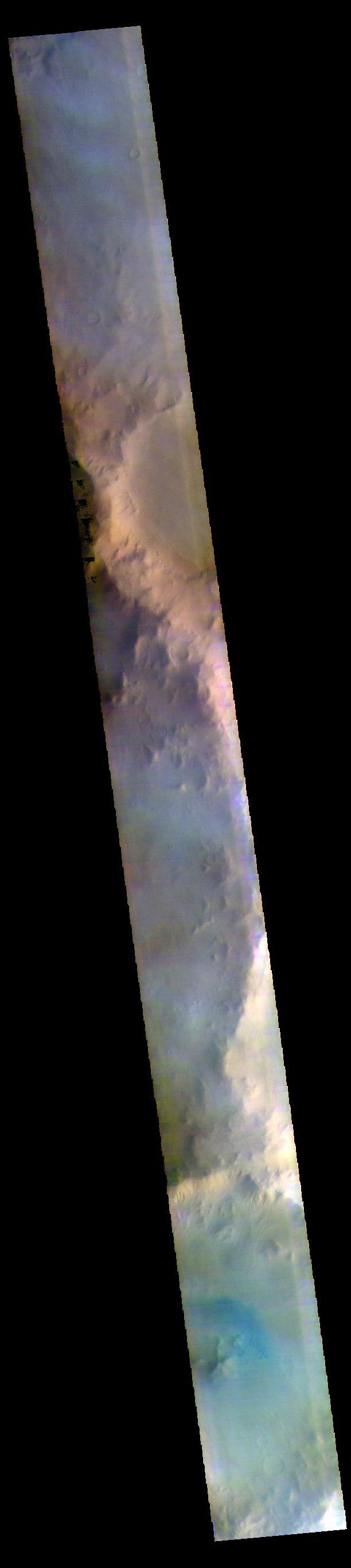
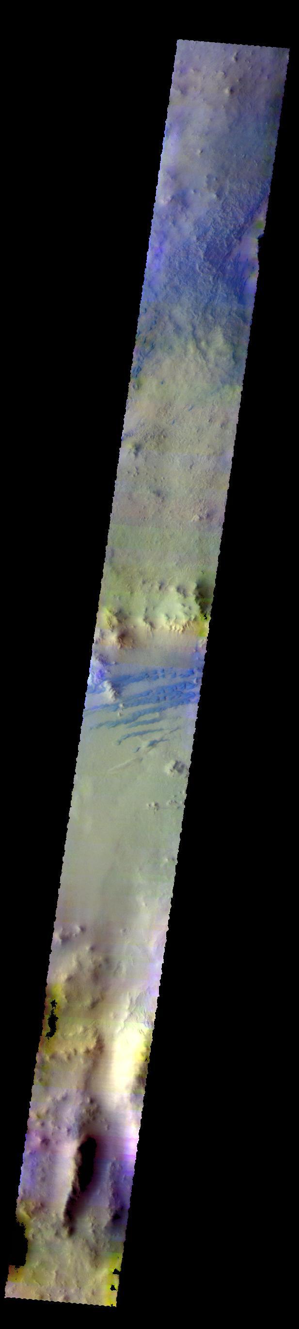
The THEMIS VIS camera contains 5 filters. The data from different filters can be combined in multiple ways to create a false color image. These false color images may reveal subtle variations of the surface not easily identified in a single band image. This VIS image shows the cloud tops of a large storm over Utopia Planitia. The clouds are composed mainly of dust and completely hide the surface. Orbit Number: 60143 Latitude: 56.7602 Longitude: 95.2069 Instrument: VIS Captured: 2015-07-05 22:51 https://photojournal.jpl.nasa.gov/catalog/PIA22679
ISS043E091740 (04/07/2015) --- Expedition 43 Commander Terry Virts is seen here working inside of the Columbus laboratory on the Blood Pressure Regulation (BP Reg) experiment. Astronauts returning from long-duration space flights risk experiencing dizziness or fainting when they stand immediately after returning to Earth. This has an important health risk as it reduces the potential for astronauts to safely escape from an emergency situation. BP Reg will help researchers develop appropriate countermeasures so that astronauts returning from long-duration space flights will have very low risk of experiencing dizziness or fainting when they return to Earth.
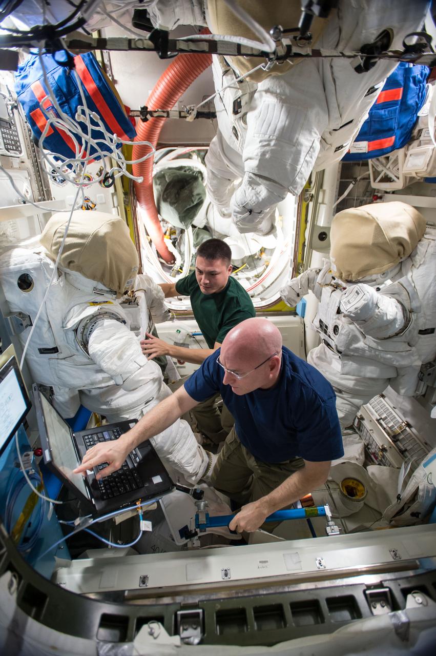
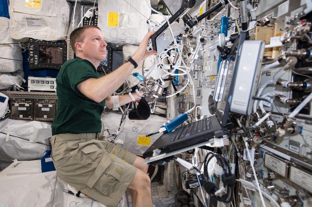
ISS045E050652 (10/07/2015) --- US astronauts Scott Kelly (bottom)and Kjell Lindgren (top) are counting down to a pair of spacewalks, now targeted for Oct. 28 and Nov. 6. The duo serviced their spacesuits replacing lithium batteries, checking their gloves and verifying power to video cameras. On the first spacewalk, the spacewalkers will lubricate the tip of the robotic arm Canadarm2, route power cables and place a thermal shroud over the Alpha Magnetic Spectrometer. During the second spacewalk, Kelly and Lindgren will refill coolant reservoirs and configure the port truss cooling system back to its original configuration after repair work completed back in 2012.
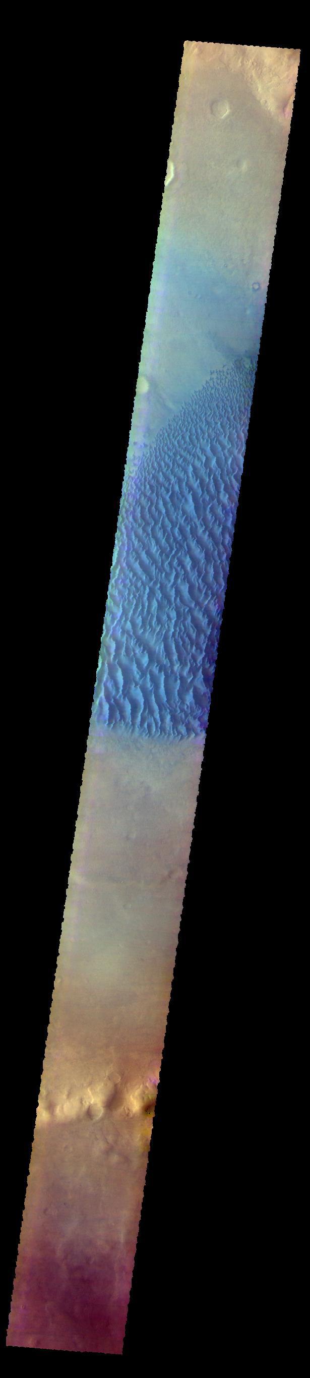
The THEMIS VIS camera contains 5 filters. The data from different filters can be combined in multiple ways to create a false color image. These false color images may reveal subtle variations of the surface not easily identified in a single band image. Today's false color image shows the floor of Proctor Crater, including the large dune field. Basaltic sands are typically blue in false color images. Proctor Crater is located in Noachis Terra. Orbit Number: 59946 Latitude: -47.9086 Longitude: 30.1317 Instrument: VIS Captured: 2015-06-19 16:07 https://photojournal.jpl.nasa.gov/catalog/PIA22670
The THEMIS VIS camera contains 5 filters. The data from different filters can be combined in multiple ways to create a false color image. These false color images may reveal subtle variations of the surface not easily identified in a single band image. Today's false color image shows part of Coprates Chasma. The pale blueish regions over the low elevations of the chasma may be an atmospheric haze. Orbit Number: 58764 Latitude: -12.2698 Longitude: 293.692 Instrument: VIS Captured: 2015-03-14 07:58 http://photojournal.jpl.nasa.gov/catalog/PIA20242
The THEMIS VIS camera contains 5 filters. The data from different filters can be combined in multiple ways to create a false color image. These false color images may reveal subtle variations of the surface not easily identified in a single band image. Today's false color image shows part of the floor of Galle Crater. Dark dunes are visible in the center of the image. The dark blue color typically indicates basaltic sand. Orbit Number: 58800 Latitude: -51.5789 Longitude: 328.788 Instrument: VIS Captured: 2015-03-17 07:20 http://photojournal.jpl.nasa.gov/catalog/PIA20243
This VIS image shows part of Terra Sabaea, including plains, craters, and mesas. The dark blue tones often indicate locations of basaltic sands. The THEMIS VIS camera contains 5 filters. The data from different filters can be combined in multiple ways to create a false color image. These false color images may reveal subtle variations of the surface not easily identified in a single band image. Orbit Number: 60437 Latitude: 29.7491 Longitude: 74.5651 Instrument: VIS Captured: 2015-07-30 03:21 https://photojournal.jpl.nasa.gov/catalog/PIA22707
Today's image shows part of the floor of Pasteur Crater. The deposit in the southwest part of the floor is a fill deposit that is undergoing erosion. Small sand dunes are found within the eroding material. Pasteur Crater is located between Arabia Terra and Terra Sabaea. The THEMIS VIS camera contains 5 filters. The data from different filters can be combined in multiple ways to create a false color image. These false color images may reveal subtle variations of the surface not easily identified in a single band image. Orbit Number: 60913 Latitude: 19.5741 Longitude: 24.3467 Instrument: VIS Captured: 2015-09-07 08:02 https://photojournal.jpl.nasa.gov/catalog/PIA23039

A Black Brant IX suborbital sounding rocket is launched at 7:07 p.m., Wednesday October 7, 2015. (NASA Photo/A. Stancil) A Black Brant IX suborbital rocket was launched from NASA's Wallops Flight Facility. The launch occurred at 7:07 p.m. The primary purpose of the flight was to test the performance of the second-stage Black Brant motor. Preliminary indications are that the motor performed as planned. Preliminary data analysis of the technology experiments (vapor tracer deployments) on the payload is in progress. <b><a href="http://www.nasa.gov/audience/formedia/features/MP_Photo_Guidelines.html" rel="nofollow">NASA image use policy.</a></b> <b><a href="http://www.nasa.gov/centers/goddard/home/index.html" rel="nofollow">NASA Goddard Space Flight Center</a></b> enables NASA’s mission through four scientific endeavors: Earth Science, Heliophysics, Solar System Exploration, and Astrophysics. Goddard plays a leading role in NASA’s accomplishments by contributing compelling scientific knowledge to advance the Agency’s mission. <b>Follow us on <a href="http://twitter.com/NASAGoddardPix" rel="nofollow">Twitter</a></b> <b>Like us on <a href="http://www.facebook.com/pages/Greenbelt-MD/NASA-Goddard/395013845897?ref=tsd" rel="nofollow">Facebook</a></b> <b>Find us on <a href="http://instagrid.me/nasagoddard/?vm=grid" rel="nofollow">Instagram</a></b>
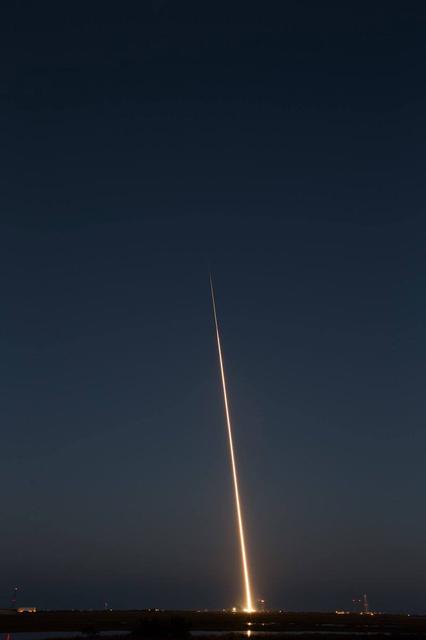
A Black Brant IX suborbital sounding rocket is launched at 7:07 p.m., Wednesday October 7, 2015. (NASA Photo/T. Zaperach) A Black Brant IX suborbital rocket was launched from NASA's Wallops Flight Facility. The launch occurred at 7:07 p.m. The primary purpose of the flight was to test the performance of the second-stage Black Brant motor. Preliminary indications are that the motor performed as planned. Preliminary data analysis of the technology experiments (vapor tracer deployments) on the payload is in progress. <b><a href="http://www.nasa.gov/audience/formedia/features/MP_Photo_Guidelines.html" rel="nofollow">NASA image use policy.</a></b> <b><a href="http://www.nasa.gov/centers/goddard/home/index.html" rel="nofollow">NASA Goddard Space Flight Center</a></b> enables NASA’s mission through four scientific endeavors: Earth Science, Heliophysics, Solar System Exploration, and Astrophysics. Goddard plays a leading role in NASA’s accomplishments by contributing compelling scientific knowledge to advance the Agency’s mission. <b>Follow us on <a href="http://twitter.com/NASAGoddardPix" rel="nofollow">Twitter</a></b> <b>Like us on <a href="http://www.facebook.com/pages/Greenbelt-MD/NASA-Goddard/395013845897?ref=tsd" rel="nofollow">Facebook</a></b> <b>Find us on <a href="http://instagrid.me/nasagoddard/?vm=grid" rel="nofollow">Instagram</a></b>
A Black Brant IX suborbital sounding rocket is launched at 7:07 p.m., Wednesday October 7, 2015. (NASA Photo/A. Stancil) A Black Brant IX suborbital rocket was launched from NASA's Wallops Flight Facility. The launch occurred at 7:07 p.m. The primary purpose of the flight was to test the performance of the second-stage Black Brant motor. Preliminary indications are that the motor performed as planned. Preliminary data analysis of the technology experiments (vapor tracer deployments) on the payload is in progress. <b><a href="http://www.nasa.gov/audience/formedia/features/MP_Photo_Guidelines.html" rel="nofollow">NASA image use policy.</a></b> <b><a href="http://www.nasa.gov/centers/goddard/home/index.html" rel="nofollow">NASA Goddard Space Flight Center</a></b> enables NASA’s mission through four scientific endeavors: Earth Science, Heliophysics, Solar System Exploration, and Astrophysics. Goddard plays a leading role in NASA’s accomplishments by contributing compelling scientific knowledge to advance the Agency’s mission. <b>Follow us on <a href="http://twitter.com/NASAGoddardPix" rel="nofollow">Twitter</a></b> <b>Like us on <a href="http://www.facebook.com/pages/Greenbelt-MD/NASA-Goddard/395013845897?ref=tsd" rel="nofollow">Facebook</a></b> <b>Find us on <a href="http://instagrid.me/nasagoddard/?vm=grid" rel="nofollow">Instagram</a></b>
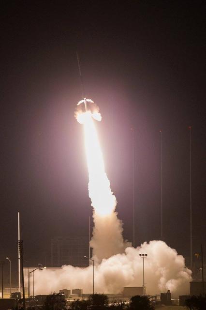
A vapor cloud is seen after launch of a Black Brant IX suborbital sounding rocket, launched at 7:07 p.m., Wednesday October 7, 2015. (NASA Photo/J. Adkins) A Black Brant IX suborbital rocket was launched from NASA's Wallops Flight Facility. The launch occurred at 7:07 p.m. The primary purpose of the flight was to test the performance of the second-stage Black Brant motor. Preliminary indications are that the motor performed as planned. Preliminary data analysis of the technology experiments (vapor tracer deployments) on the payload is in progress. <b><a href="http://www.nasa.gov/audience/formedia/features/MP_Photo_Guidelines.html" rel="nofollow">NASA image use policy.</a></b> <b><a href="http://www.nasa.gov/centers/goddard/home/index.html" rel="nofollow">NASA Goddard Space Flight Center</a></b> enables NASA’s mission through four scientific endeavors: Earth Science, Heliophysics, Solar System Exploration, and Astrophysics. Goddard plays a leading role in NASA’s accomplishments by contributing compelling scientific knowledge to advance the Agency’s mission. <b>Follow us on <a href="http://twitter.com/NASAGoddardPix" rel="nofollow">Twitter</a></b> <b>Like us on <a href="http://www.facebook.com/pages/Greenbelt-MD/NASA-Goddard/395013845897?ref=tsd" rel="nofollow">Facebook</a></b> <b>Find us on <a href="http://instagrid.me/nasagoddard/?vm=grid" rel="nofollow">Instagram</a></b>
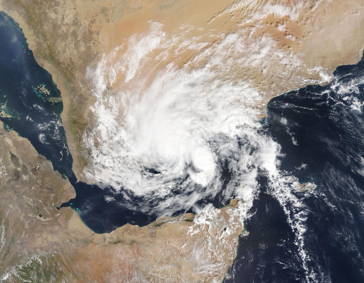
On Nov. 3, 2015 at 07:20 UTC (2:20 a.m. EDT) the MODIS instrument aboard NASA's Aqua satellite captured this image of Tropical Cyclone Chapala over Yemen. Credit: NASA Goddard MODIS Rapid Response Team <b><a href="http://www.nasa.gov/audience/formedia/features/MP_Photo_Guidelines.html" rel="nofollow">NASA image use policy.</a></b> <b><a href="http://www.nasa.gov/centers/goddard/home/index.html" rel="nofollow">NASA Goddard Space Flight Center</a></b> enables NASA’s mission through four scientific endeavors: Earth Science, Heliophysics, Solar System Exploration, and Astrophysics. Goddard plays a leading role in NASA’s accomplishments by contributing compelling scientific knowledge to advance the Agency’s mission. <b>Follow us on <a href="http://twitter.com/NASAGoddardPix" rel="nofollow">Twitter</a></b> <b>Like us on <a href="http://www.facebook.com/pages/Greenbelt-MD/NASA-Goddard/395013845897?ref=tsd" rel="nofollow">Facebook</a></b> <b>Find us on <a href="http://instagrid.me/nasagoddard/?vm=grid" rel="nofollow">Instagram</a></b>
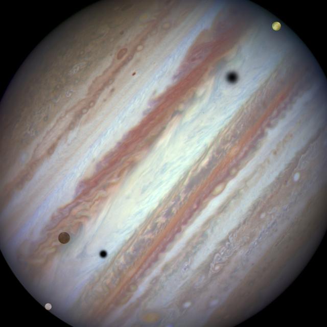
Three moons and their shadows parade across Jupiter near the end of the event at 07:10 UT on January 24, 2015. Europa has entered the frame at lower left. Slower-moving Callisto is above and to the right of Europa. Fastest-moving Io is approaching the eastern limb of the planet. Europa's shadow is toward the left side of the image and Callisto's shadow to the right. (The moons' orbital velocities are proportionally slower with increasing distance from the planet.) Credit: NASA, ESA, and the Hubble Heritage Team (STScI/AURA) More info: Firing off a string of snapshots like a sports photographer at a NASCAR race, NASA's Hubble Space Telescope captured a rare look at three of Jupiter's largest moons zipping across the banded face of the gas-giant planet: Europa, Callisto, and Io. Jupiter's four largest moons can commonly be seen transiting the face of the giant planet and casting shadows onto its cloud tops. However, seeing three moons transiting the face of Jupiter at the same time is rare, occurring only once or twice a decade. Missing from the sequence, taken on January 24, 2015, is the moon Ganymede that was too far from Jupiter in angular separation to be part of the conjunction. <b><a href="http://www.nasa.gov/audience/formedia/features/MP_Photo_Guidelines.html" rel="nofollow">NASA image use policy.</a></b> <b><a href="http://www.nasa.gov/centers/goddard/home/index.html" rel="nofollow">NASA Goddard Space Flight Center</a></b> enables NASA’s mission through four scientific endeavors: Earth Science, Heliophysics, Solar System Exploration, and Astrophysics. Goddard plays a leading role in NASA’s accomplishments by contributing compelling scientific knowledge to advance the Agency’s mission. <b>Follow us on <a href="http://twitter.com/NASAGoddardPix" rel="nofollow">Twitter</a></b> <b>Like us on <a href="http://www.facebook.com/pages/Greenbelt-MD/NASA-Goddard/395013845897?ref=tsd" rel="nofollow">Facebook</a></b> <b>Find us on <a href="http://instagram.com/nasagoddard?vm=grid" rel="nofollow">Instagram</a></b>