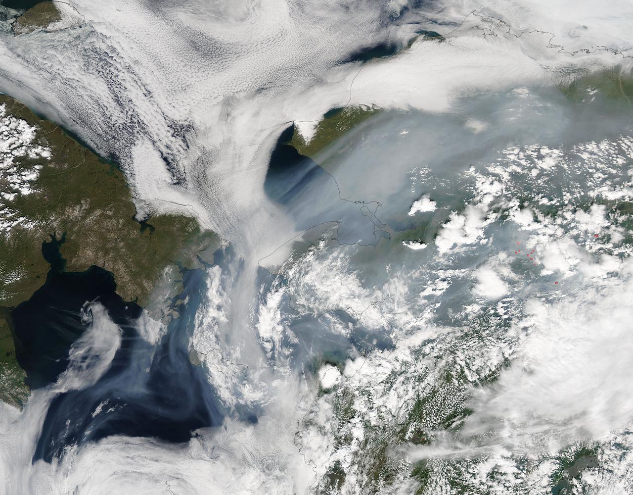
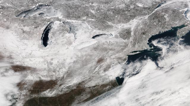
Fires have raged throughout Alaska in 2015. The Moderate Resolution Imaging Spectroradiometer (MODIS) on NASA’s Aqua satellite acquired this image on July 14, 2015. Actively burning areas, detected by the thermal bands on MODIS, are outlined in red. According to the most recent update (July 16, 2015) from the Alaska Interagency Coordination Center, about 304 fires were actively burning when MODIS imaged the area. To date, fires have charred a total of 4,854,924 acres in Alaska. The worst fire season in Alaska's history was in 2004. At this point in time, 2015 is a month ahead of the totals in 2004 putting it on track surpass the fire totals in 2004. The amount of acreage burned in Alaska during June 2015 shattered the previous acreage record set in June 2004 by more than 700,000 acres delivering a sobering piece of news for Alaskan residents. Credit: NASA/GSFC/Jeff Schmaltz/MODIS Land Rapid Response Team <b><a href="http://www.nasa.gov/audience/formedia/features/MP_Photo_Guidelines.html" rel="nofollow">NASA image use policy.</a></b> <b><a href="http://www.nasa.gov/centers/goddard/home/index.html" rel="nofollow">NASA Goddard Space Flight Center</a></b> enables NASA’s mission through four scientific endeavors: Earth Science, Heliophysics, Solar System Exploration, and Astrophysics. Goddard plays a leading role in NASA’s accomplishments by contributing compelling scientific knowledge to advance the Agency’s mission. <b>Follow us on <a href="http://twitter.com/NASAGoddardPix" rel="nofollow">Twitter</a></b> <b>Like us on <a href="http://www.facebook.com/pages/Greenbelt-MD/NASA-Goddard/395013845897?ref=tsd" rel="nofollow">Facebook</a></b> <b>Find us on <a href="http://instagrid.me/nasagoddard/?vm=grid" rel="nofollow">Instagram</a></b>

CAPE CANAVERAL, Fla. – First Lady of the State of Florida Ann Scott speaks to students, parents and guests inside the Astronaut Encounter Theater at NASA’s Kennedy Space Center in Florida during the 2015 Celebrate Literacy Week Florida PSA Awards program. The event, hosted by the Florida Department of Education, announced the winning entries from elementary, middle and high school students that best encouraged literacy and its connection to space careers. Photo credit: NASA/Ben Smegelsky

CAPE CANAVERAL, Fla. – Students, parents and guests attend the 2015 Celebrate Literacy Week Florida PSA Awards program inside the Astronaut Encounter Theater at NASA’s Kennedy Space Center in Florida. The event, hosted by the Florida Department of Education, announced the winners from elementary, middle, and high school students that best encouraged literacy and its connection to space careers. Photo credit: NASA/Ben Smegelsky
CAPE CANAVERAL, Fla. – Former NASA astronaut Wendy Lawrence speaks to students, parents and guests inside the Astronaut Encounter Theater at NASA’s Kennedy Space Center in Florida during the 2015 Celebrate Literacy Week Florida PSA Awards program. The event, hosted by the Florida Department of Education, announced the winners from elementary, middle school and high school students that best encouraged literacy and its connection to space careers. Photo credit: NASA/Ben Smegelsky

Within the penumbra, the eclipse is partial (left), but within the umbra, the Moon completely covers the Sun (right). <b><a href="http://www.nasa.gov/audience/formedia/features/MP_Photo_Guidelines.html" rel="nofollow">NASA image use policy.</a></b> <b><a href="http://www.nasa.gov/centers/goddard/home/index.html" rel="nofollow">NASA Goddard Space Flight Center</a></b> enables NASA’s mission through four scientific endeavors: Earth Science, Heliophysics, Solar System Exploration, and Astrophysics. Goddard plays a leading role in NASA’s accomplishments by contributing compelling scientific knowledge to advance the Agency’s mission. <b>Follow us on <a href="http://twitter.com/NASAGoddardPix" rel="nofollow">Twitter</a></b> <b>Like us on <a href="http://www.facebook.com/pages/Greenbelt-MD/NASA-Goddard/395013845897?ref=tsd" rel="nofollow">Facebook</a></b> <b>Find us on <a href="http://instagrid.me/nasagoddard/?vm=grid" rel="nofollow">Instagram</a></b>
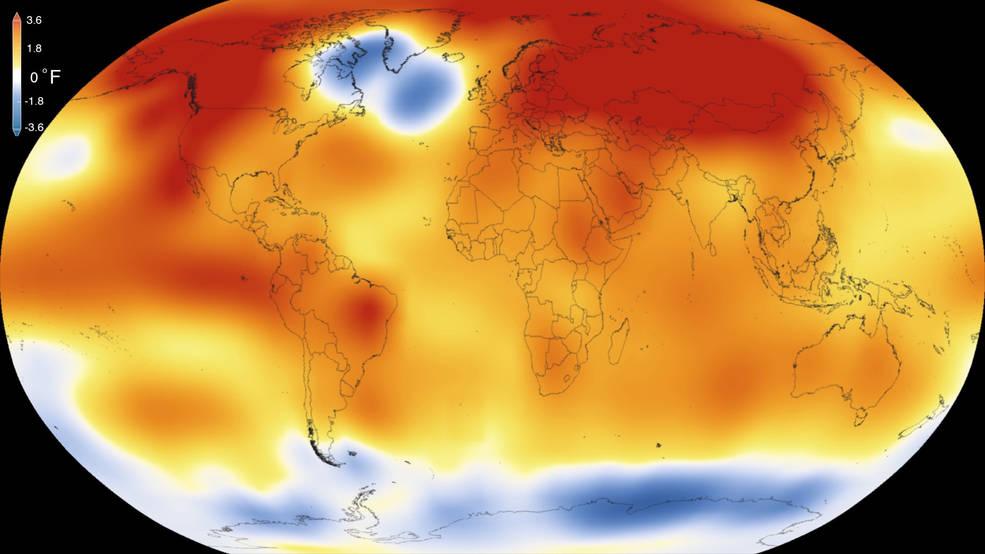
2015 was the warmest year since modern record-keeping began in 1880, according to a new analysis by NASA’s Goddard Institute for Space Studies. The record-breaking year continues a long-term warming trend — 15 of the 16 warmest years on record have now occurred since 2001. Credits: Scientific Visualization Studio/Goddard Space Flight Center Details: Earth’s 2015 surface temperatures were the warmest since modern record keeping began in 1880, according to independent analyses by NASA and the National Oceanic and Atmospheric Administration (NOAA). Globally-averaged temperatures in 2015 shattered the previous mark set in 2014 by 0.23 degrees Fahrenheit (0.13 Celsius). Only once before, in 1998, has the new record been greater than the old record by this much. The 2015 temperatures continue a long-term warming trend, according to analyses by scientists at NASA’s Goddard Institute for Space Studies (GISS) in New York (GISTEMP). NOAA scientists agreed with the finding that 2015 was the warmest year on record based on separate, independent analyses of the data. Because weather station locations and measurements change over time, there is some uncertainty in the individual values in the GISTEMP index. Taking this into account, NASA analysis estimates 2015 was the warmest year with 94 percent certainty. Read more: <a href="http://www.nasa.gov/press-release/nasa-noaa-analyses-reveal-record-shattering-global-warm-temperatures-in-2015" rel="nofollow">www.nasa.gov/press-release/nasa-noaa-analyses-reveal-reco...</a> <b><a href="http://www.nasa.gov/audience/formedia/features/MP_Photo_Guidelines.html" rel="nofollow">NASA image use policy.</a></b> <b><a href="http://www.nasa.gov/centers/goddard/home/index.html" rel="nofollow">NASA Goddard Space Flight Center</a></b> enables NASA’s mission through four scientific endeavors: Earth Science, Heliophysics, Solar System Exploration, and Astrophysics. Goddard plays a leading role in NASA’s accomplishments by contributing compelling scientific knowledge to advance the Agency’s mission. <b>Follow us on <a href="http://twitter.com/NASAGoddardPix" rel="nofollow">Twitter</a></b> <b>Like us on <a href="http://www.facebook.com/pages/Greenbelt-MD/NASA-Goddard/395013845897?ref=tsd" rel="nofollow">Facebook</a></b> <b>Find us on <a href="http://instagrid.me/nasagoddard/?vm=grid" rel="nofollow">Instagram</a></b>

This visualization shows the Moon's phase and libration at hourly intervals throughout 2015, as viewed from the northern hemisphere. Each frame represents one hour. Lunar Reconnaissance Orbiter (LRO) has been in orbit around the Moon since the summer of 2009. Its laser altimeter (LOLA) and camera (LROC) are recording the rugged, airless lunar terrain in exceptional detail, making it possible to visualize the Moon with unprecedented fidelity. This is especially evident in the long shadows cast near the terminator, or day-night line. The pummeled, craggy landscape thrown into high relief at the terminator would be impossible to recreate in the computer without global terrain maps like those from LRO. To download, learn more about this visualization, or to see what the Moon will look like at any hour in 2015, visit <a href="http://svs.gsfc.nasa.gov/goto?4236" rel="nofollow">svs.gsfc.nasa.gov/goto?4236</a> <b><a href="http://www.nasa.gov/audience/formedia/features/MP_Photo_Guidelines.html" rel="nofollow">NASA image use policy.</a></b> <b><a href="http://www.nasa.gov/centers/goddard/home/index.html" rel="nofollow">NASA Goddard Space Flight Center</a></b> enables NASA’s mission through four scientific endeavors: Earth Science, Heliophysics, Solar System Exploration, and Astrophysics. Goddard plays a leading role in NASA’s accomplishments by contributing compelling scientific knowledge to advance the Agency’s mission. <b>Follow us on <a href="http://twitter.com/NASAGoddardPix" rel="nofollow">Twitter</a></b> <b>Like us on <a href="http://www.facebook.com/pages/Greenbelt-MD/NASA-Goddard/395013845897?ref=tsd" rel="nofollow">Facebook</a></b> <b>Find us on <a href="http://instagram.com/nasagoddard?vm=grid" rel="nofollow">Instagram</a></b>
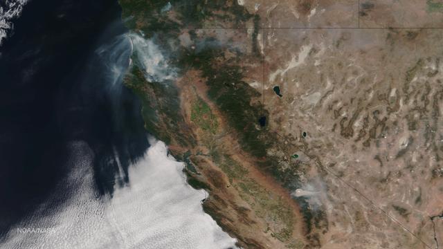
Very hot, dry and unstable conditions in California and across the Pacific Northwest add to the challenges facing firefighters as they battle blazes around the region. Cal Fire is urging Californians to be extremely cautious, especially for the next few days, as the current conditions increase the dangers authorities face. This image was taken by NASA-NOAA's Suomi NPP satellite's VIIRS instrument around 2145 UTC (5:45 p.m. EDT) on August 17, 2015. Northern California is seeing smoke from the River Complex, Route Complex, South Complex, Fork Complex and Mad River Complex fires combine over a large area of the Shasta-Trinity National Forest west of Redding, California, while the Rough Fire in Fresno County is spreading toward the Black Rock Reservoir, causing evacuations and road closures. Fires across the Pacific Northwest aren't limited to California. Please see the Suomi NPP VIIRS composites in NOAA View to see the growth and extent of fires over the past weeks. Credit: NASA/NOAA via <b><a href="www.nnvl.noaa.gov/" rel="nofollow"> NOAA Environmental Visualization Laboratory</a></b>
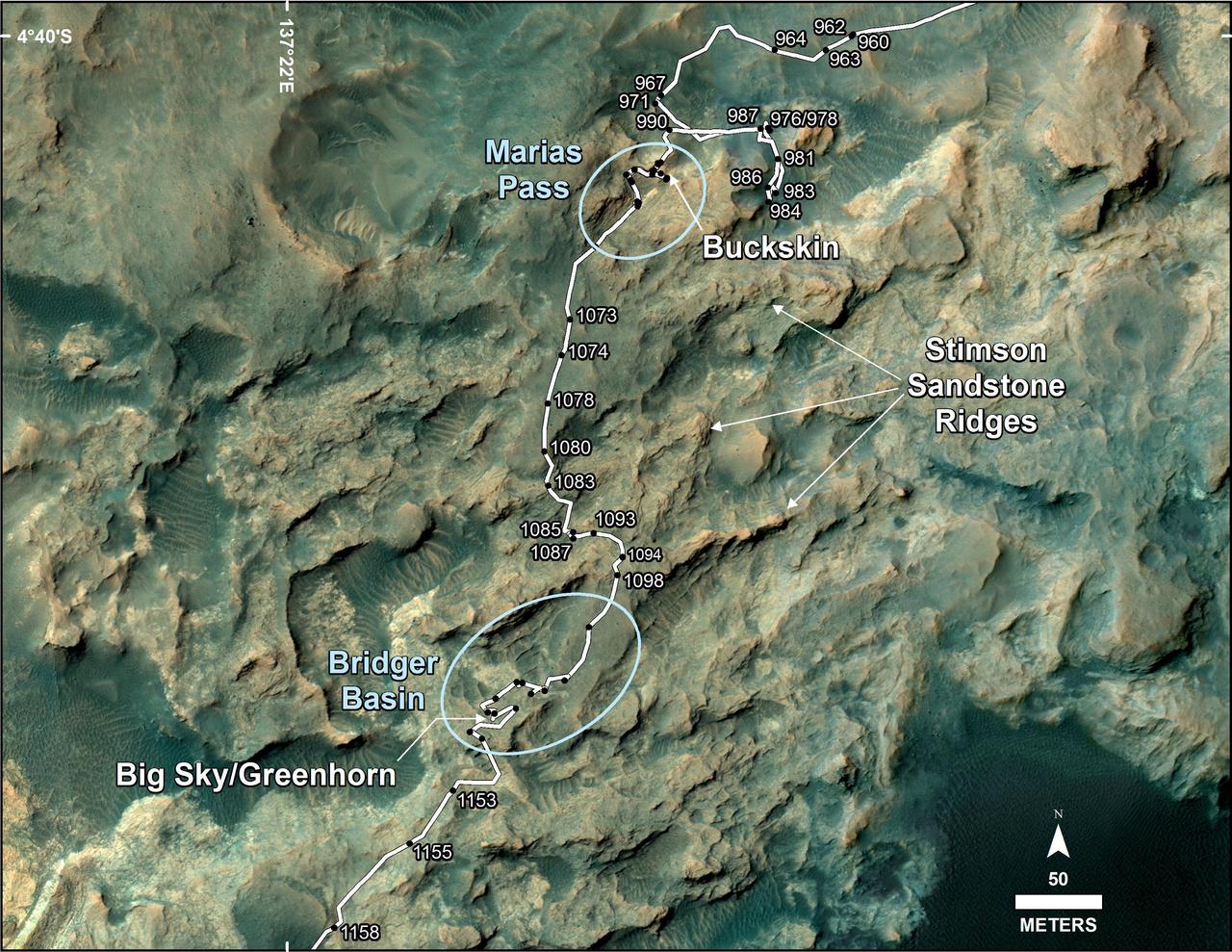
This map shows the route on lower Mount Sharp that NASA Curiosity followed between April 19, 2015, and Nov. 5, 2015.

CAPE CANAVERAL, Fla. – First Lady of the State of Florida Ann Scott greets students inside the Astronaut Encounter Theater at NASA’s Kennedy Space Center in Florida during the 2015 Celebrate Literacy Week Florida PSA Awards program. The event, hosted by the Florida Department of Education, announced the winning entries from elementary, middle and high school students that best encouraged literacy and its connection to space careers. Photo credit: NASA/Ben Smegelsky
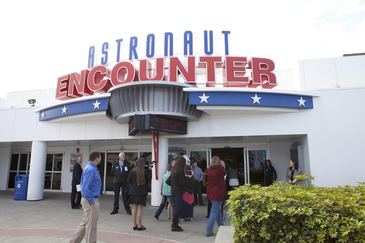
CAPE CANAVERAL, Fla. – Students and guests enter the Astronaut Encounter Theater at NASA's Kennedy Space Center Visitor Complex in Florida for the 2015 Celebrate Literacy Week Florida PSA Awards program. The event, hosted by the Florida Department of Education, announced the winning entries from elementary, middle and high school students that best encouraged literacy and its connection to space careers. Photo credit: NASA/Ben Smegelsky

CAPE CANAVERAL, Fla. – First Lady of the State of Florida Ann Scott greets students inside the Astronaut Encounter Theater at NASA’s Kennedy Space Center in Florida during the 2015 Celebrate Literacy Week Florida PSA Awards program. The event, hosted by the Florida Department of Education, announced the winning entries from elementary, middle and high school students that best encouraged literacy and its connection to space careers. Photo credit: NASA/Ben Smegelsky
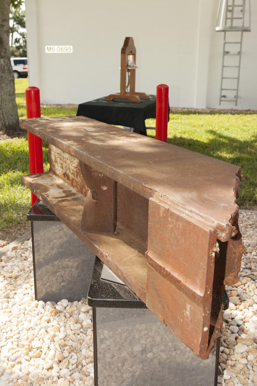
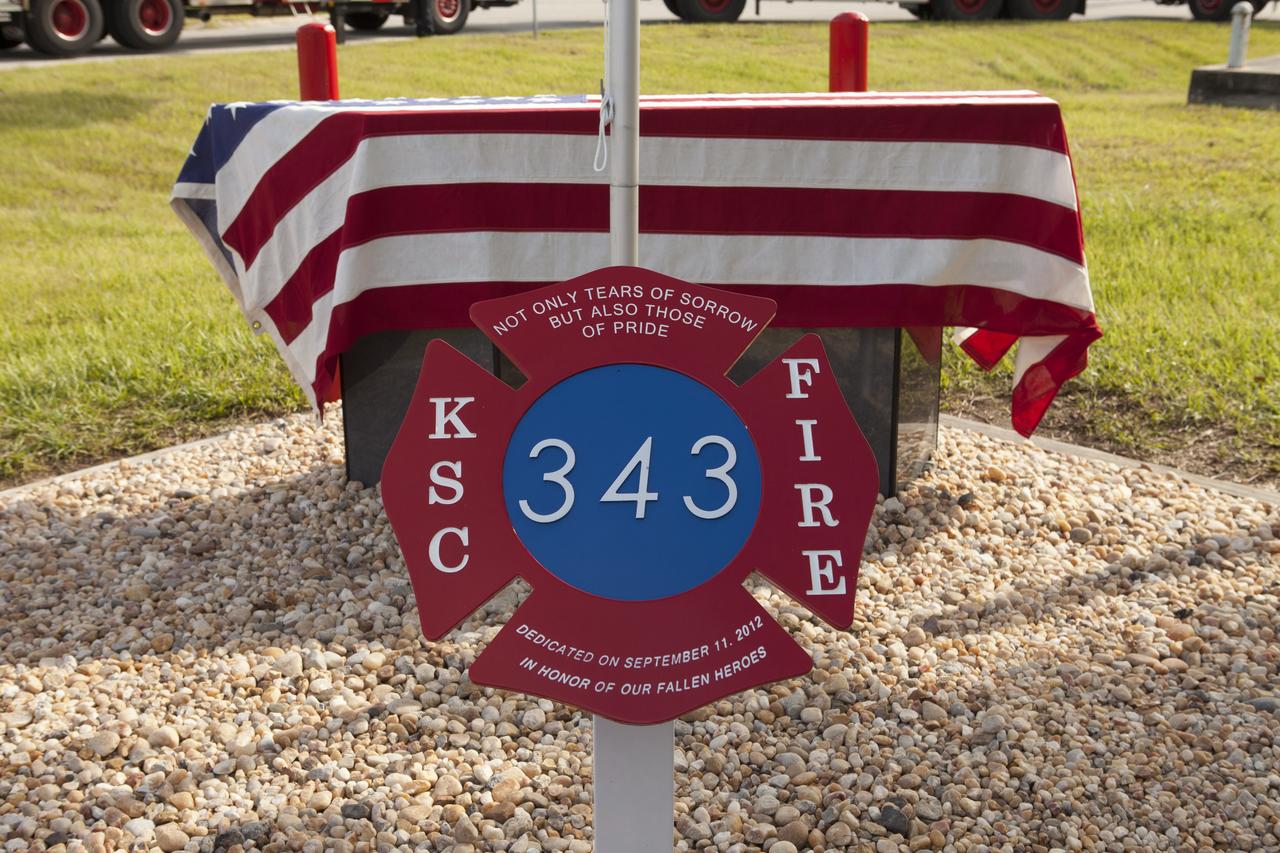
A memorial to the 343 first responder victims of the Sept. 11, 2001, terror attacks stands at Fire Station 1 at NASA's Kennedy Space Center during its dedication on Sept. 11, 2015. A section of steel I-beam from the World Trade Center in New York forms the centerpiece of the monument.
A memorial to the 343 first responder victims of the Sept. 11, 2001, terror attacks stands at Fire Station 1 at NASA's Kennedy Space Center during its dedication on Sept. 11, 2015. A section of steel I-beam from the World Trade Center in New York forms the centerpiece of the monument.
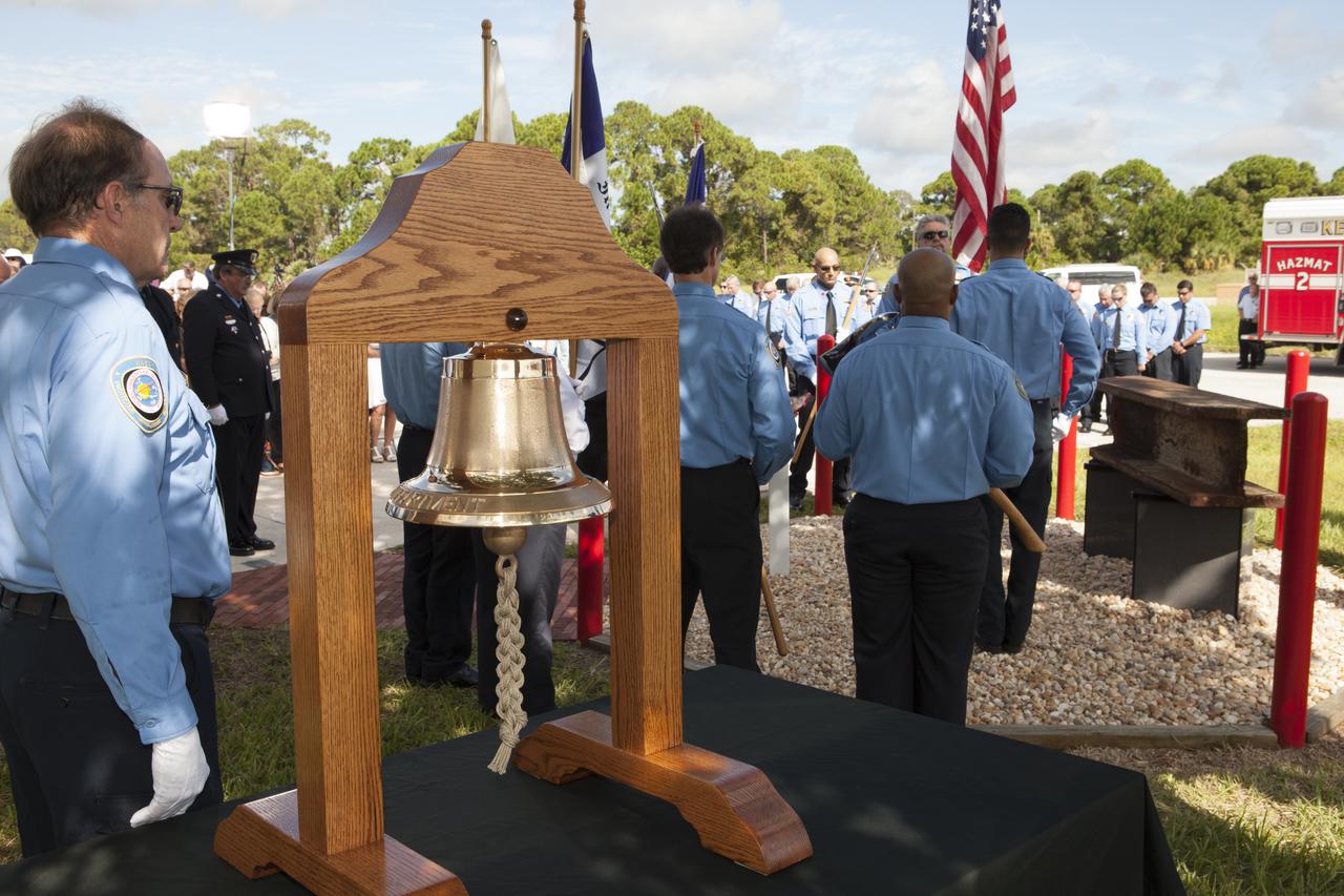
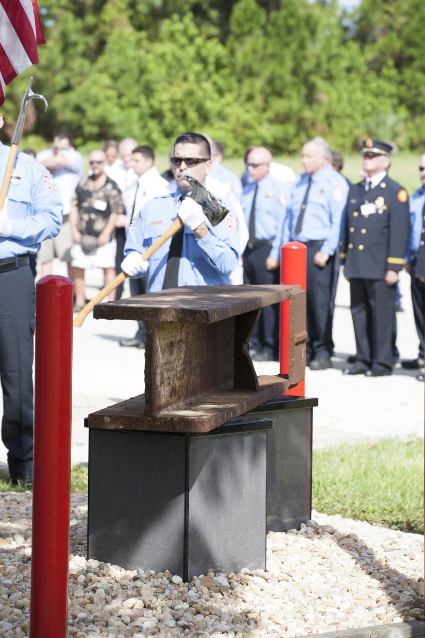
Firefighters stand at attention as a memorial to the 343 first responder victims of the Sept. 11, 2001, terror attacks is dedicated at Fire Station 1 at NASA's Kennedy Space Center on Sept. 11, 2015. A section of steel I-beam from the World Trade Center in New York forms the centerpiece of the monument.
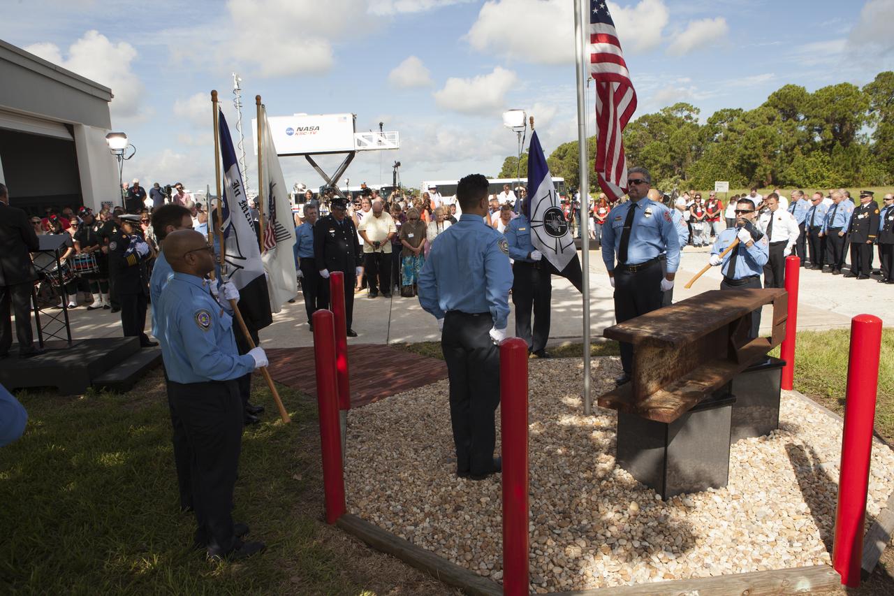
Firefighters stand at attention as a memorial to the 343 first responder victims of the Sept. 11, 2001, terror attacks is dedicated at Fire Station 1 at NASA's Kennedy Space Center on Sept. 11, 2015. A section of steel I-beam from the World Trade Center in New York forms the centerpiece of the monument.
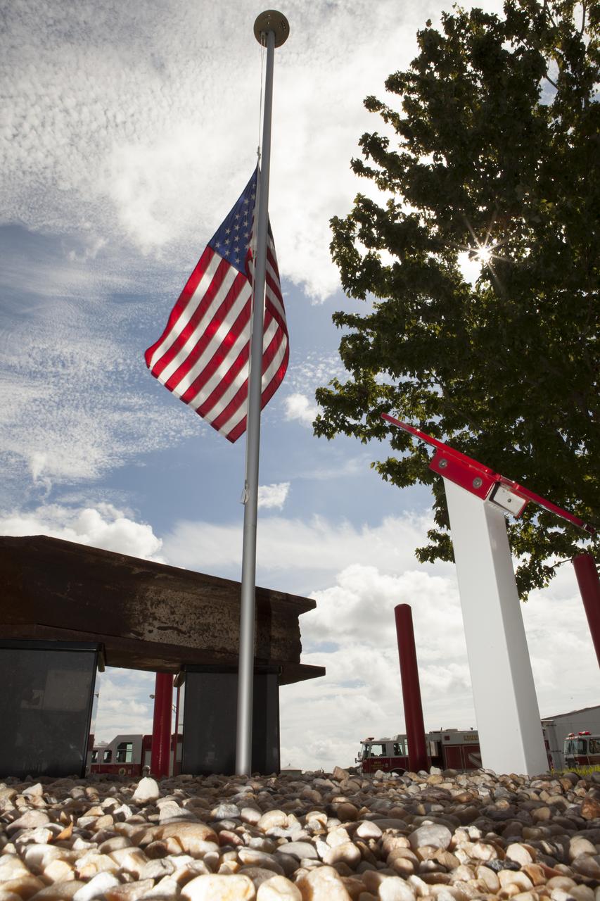
A memorial to the 343 first responder victims of the Sept. 11, 2001, terror attacks stands at Fire Station 1 at NASA's Kennedy Space Center during its dedication on Sept. 11, 2015. A section of steel I-beam from the World Trade Center in New York forms the centerpiece of the monument.
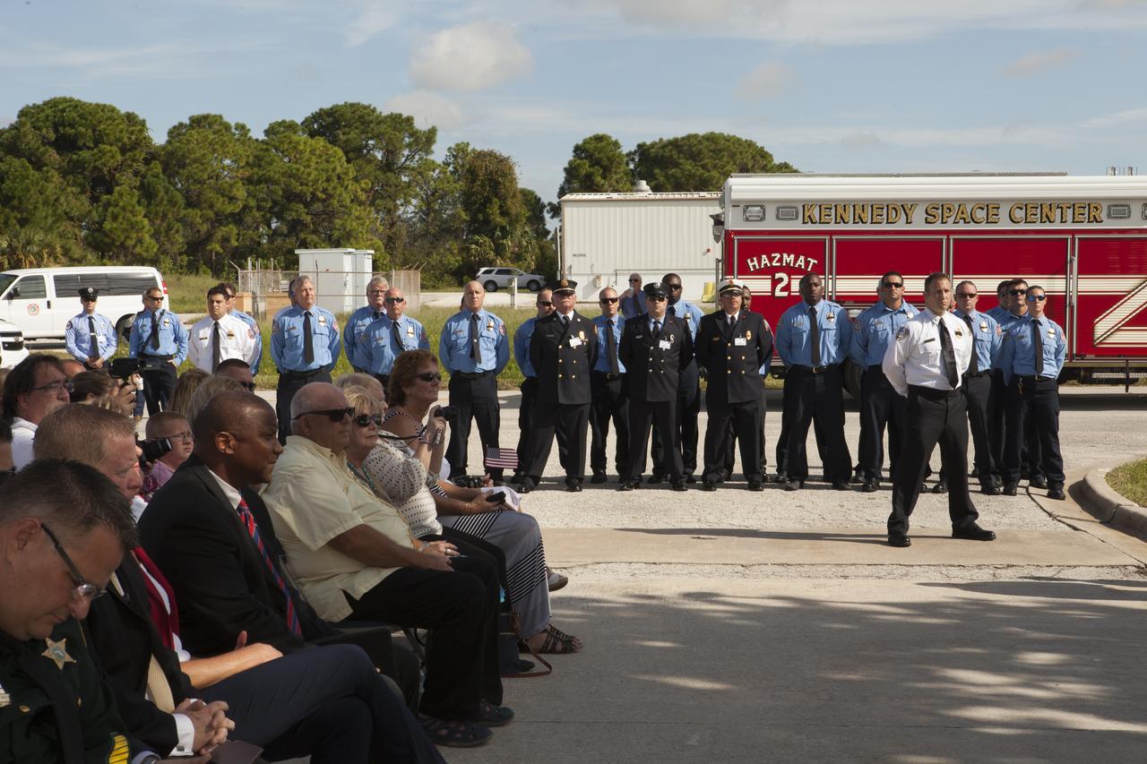
Officials and firefighters at NASA's Kennedy Space Center observe the dedication service for a memorial to the 343 first responder victims of the Sept. 11, 2001, terror attacks at Fire Station 1 at Kennedy on Sept. 11, 2015. The ceremony dedicated a monument that includes a section of steel I-beam from the World Trade Center in New York.
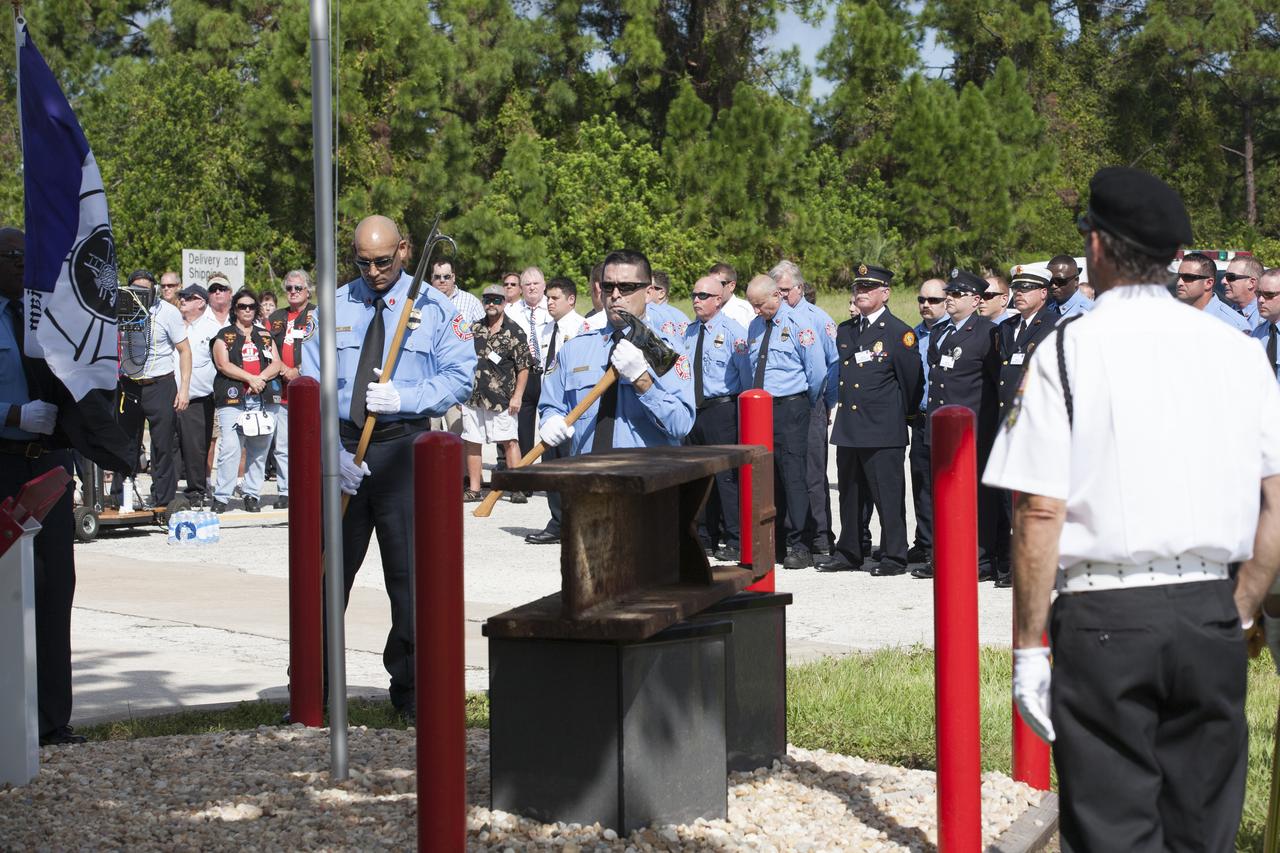
Firefighters stand at attention as a memorial to the 343 first responder victims of the Sept. 11, 2001, terror attacks is dedicated at Fire Station 1 at NASA's Kennedy Space Center on Sept. 11, 2015. A section of steel I-beam from the World Trade Center in New York forms the centerpiece of the monument.
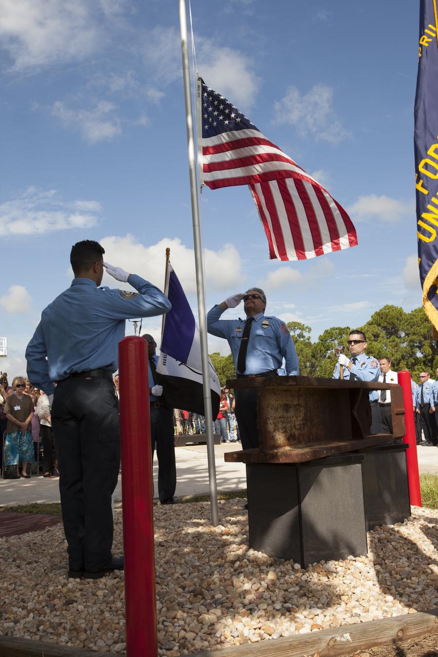
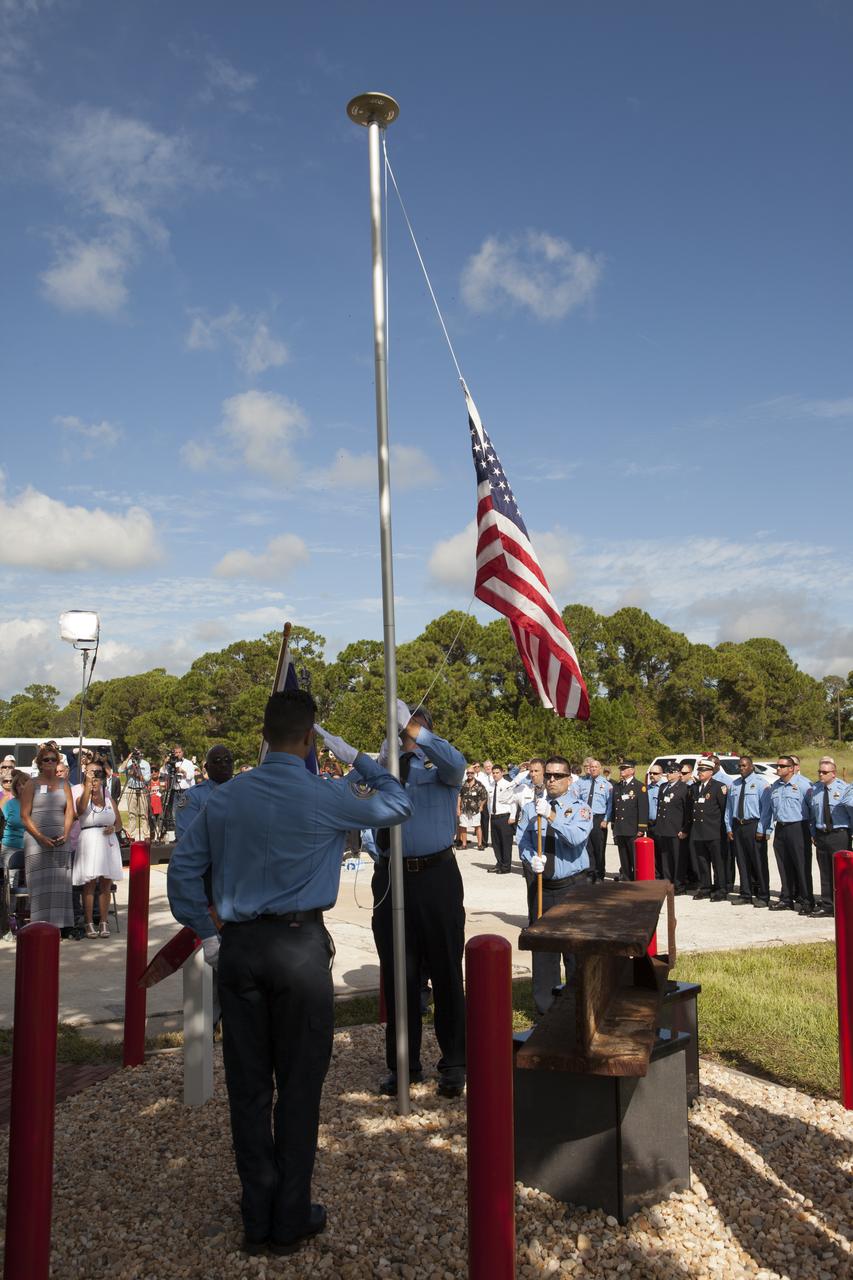
A memorial to the 343 first responder victims of the Sept. 11, 2001, terror attacks stands at Fire Station 1 at NASA's Kennedy Space Center prior to its dedication on Sept. 11, 2015. Beneath the American flag is a section of steel I-beam from the World Trade Center in New York that forms the centerpiece of the monument.
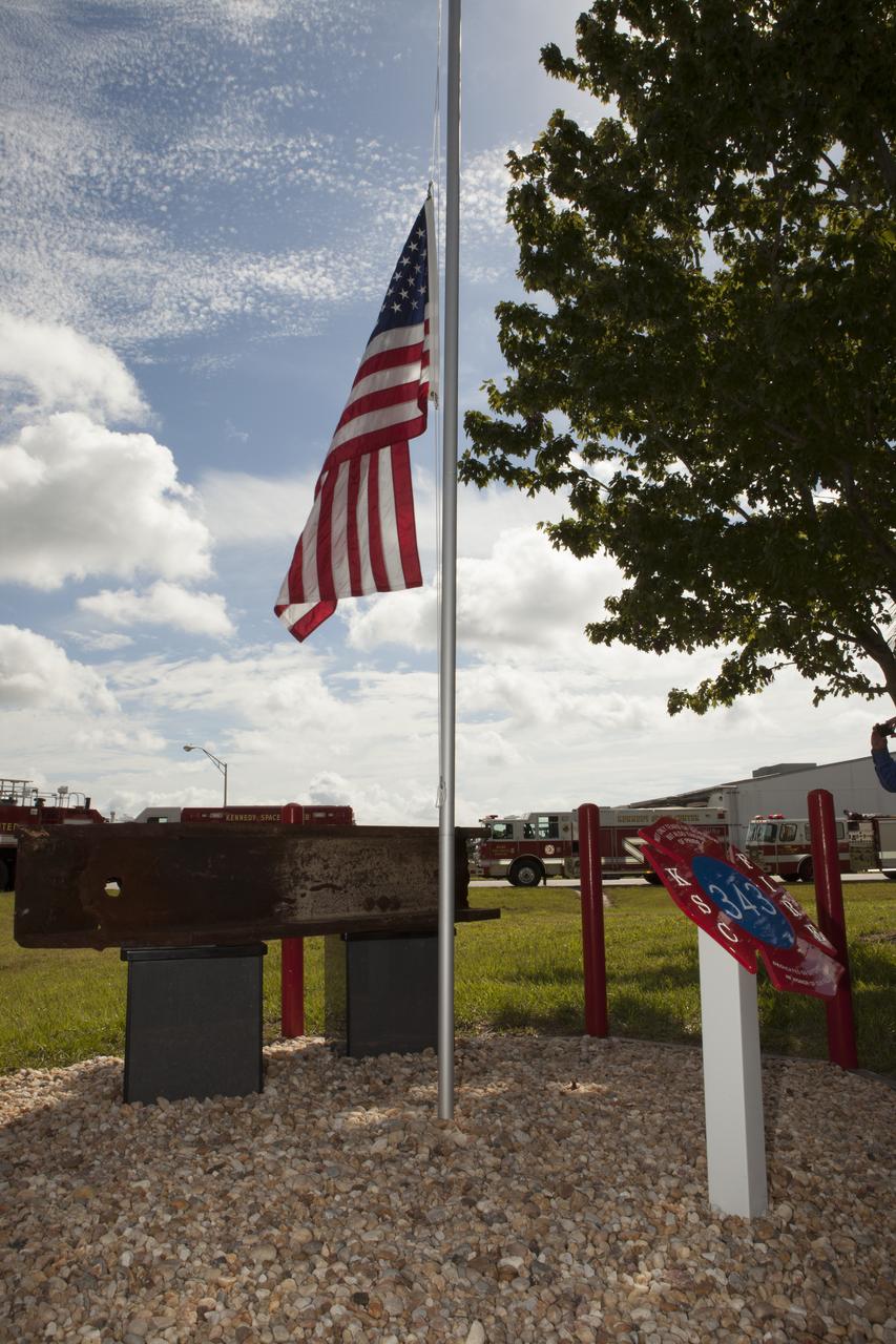
A memorial to the 343 first responder victims of the Sept. 11, 2001, terror attacks stands at Fire Station 1 at NASA's Kennedy Space Center during its dedication on Sept. 11, 2015. A section of steel I-beam from the World Trade Center in New York forms the centerpiece of the monument.
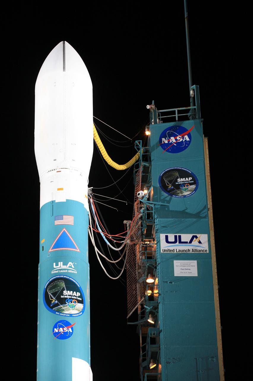
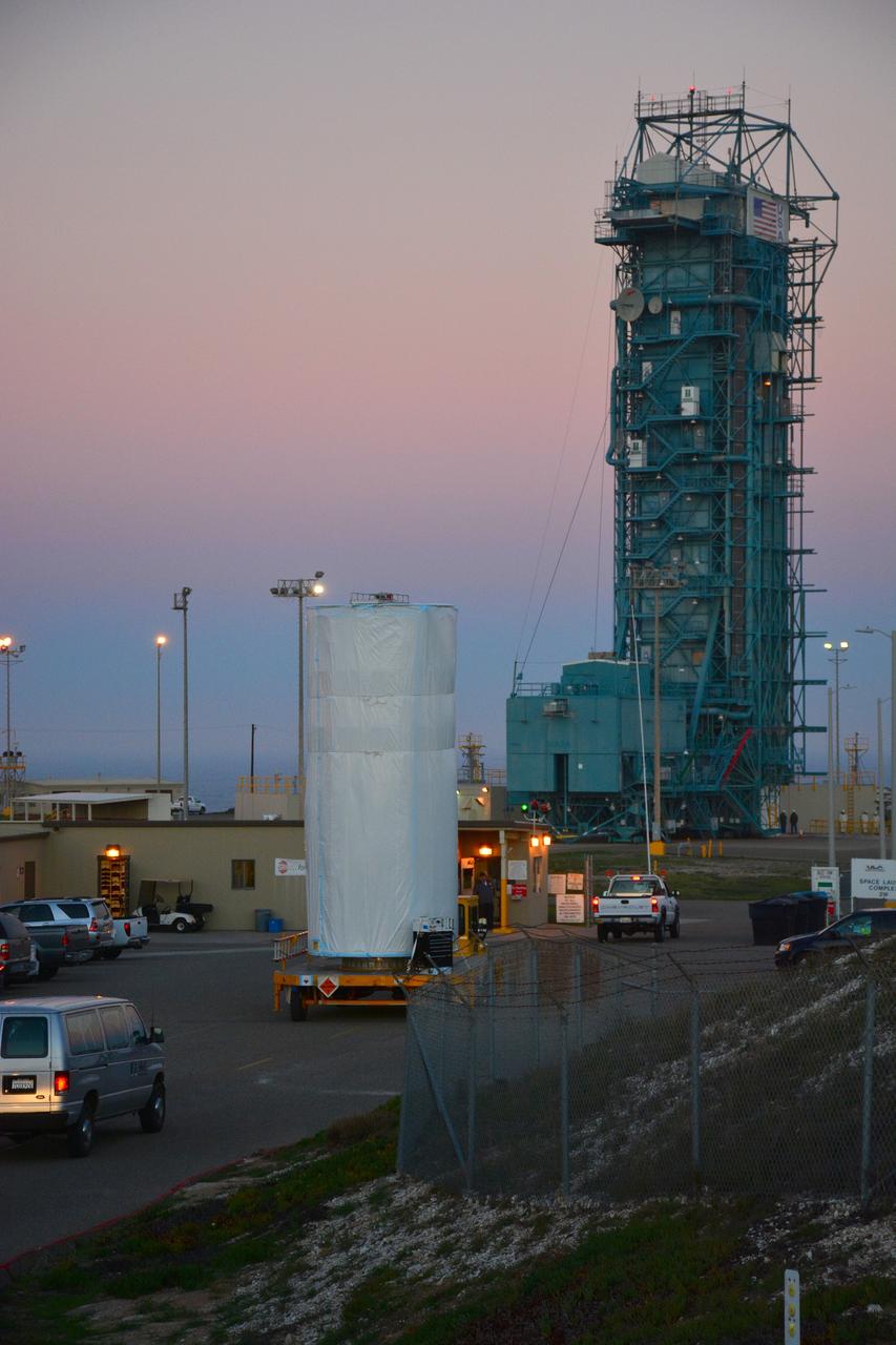
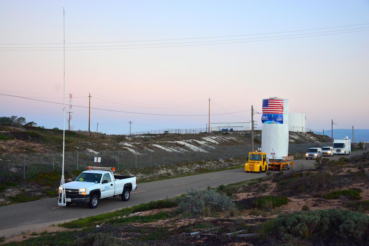
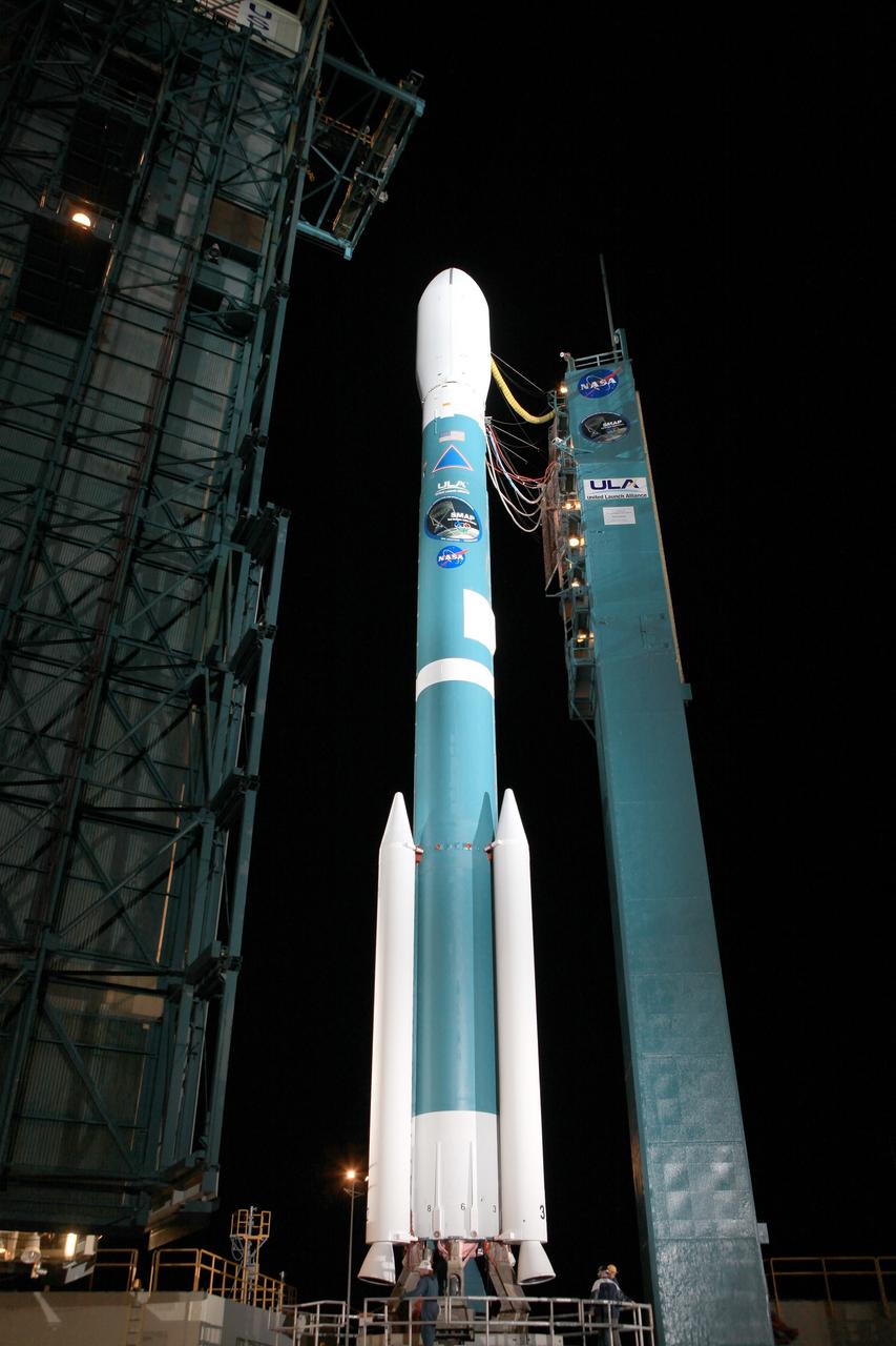
VANDENBERG AIR FORCE BASE, Calif. – Technicians prepare to lift NASA's Soil Moisture Active Passive, or SMAP, spacecraft in preparation to move it toward the Delta II payload attach structure in the Astrotech payload processing facility on Vandenberg Air Force Base in California. The structure will secure the spacecraft to the rocket's second stage. SMAP will launch on a Delta II 7320 configuration vehicle featuring a United Launch Alliance first stage booster powered by an Aerojet Rocketdyne RS-27A main engine and three Alliant Techsystems, or ATK, strap-on solid rocket motors. Once on station in Earth orbit, SMAP will provide global measurements of soil moisture and its freeze_thaw state. These measurements will be used to enhance understanding of processes that link the water, energy and carbon cycles, and to extend the capabilities of weather and climate prediction models. SMAP data also will be used to quantify net carbon flux in boreal landscapes and to develop improved flood prediction and drought monitoring capabilities. Launch from Space Launch Complex 2 is targeted for Jan. 29, 2015. To learn more about SMAP, visit http:__www.nasa.gov_smap. Photo credit: NASA_Chris Wiant, U.S. Air Force Photo Squadron
Freezing rain is in the forecast from Texas to the mid-Mississippi Valley and into the Carolinas with temperatures 20-40 degrees below normal across parts of the central and southern U.S. on Friday, extending February's icy grip on the eastern half of the U.S. This image from the Suomi NPP satellite's VIIRS instrument shows the snow cover left by February's series of east coast storms, taken around 1830Z on February 27, 2015. Credit: NASA/NOAA/NPP/VIIRS Via: <b><a href="http://www.earthobservatory.nasa.gov/" rel="nofollow"> NASA Earth Observatory</a></b>
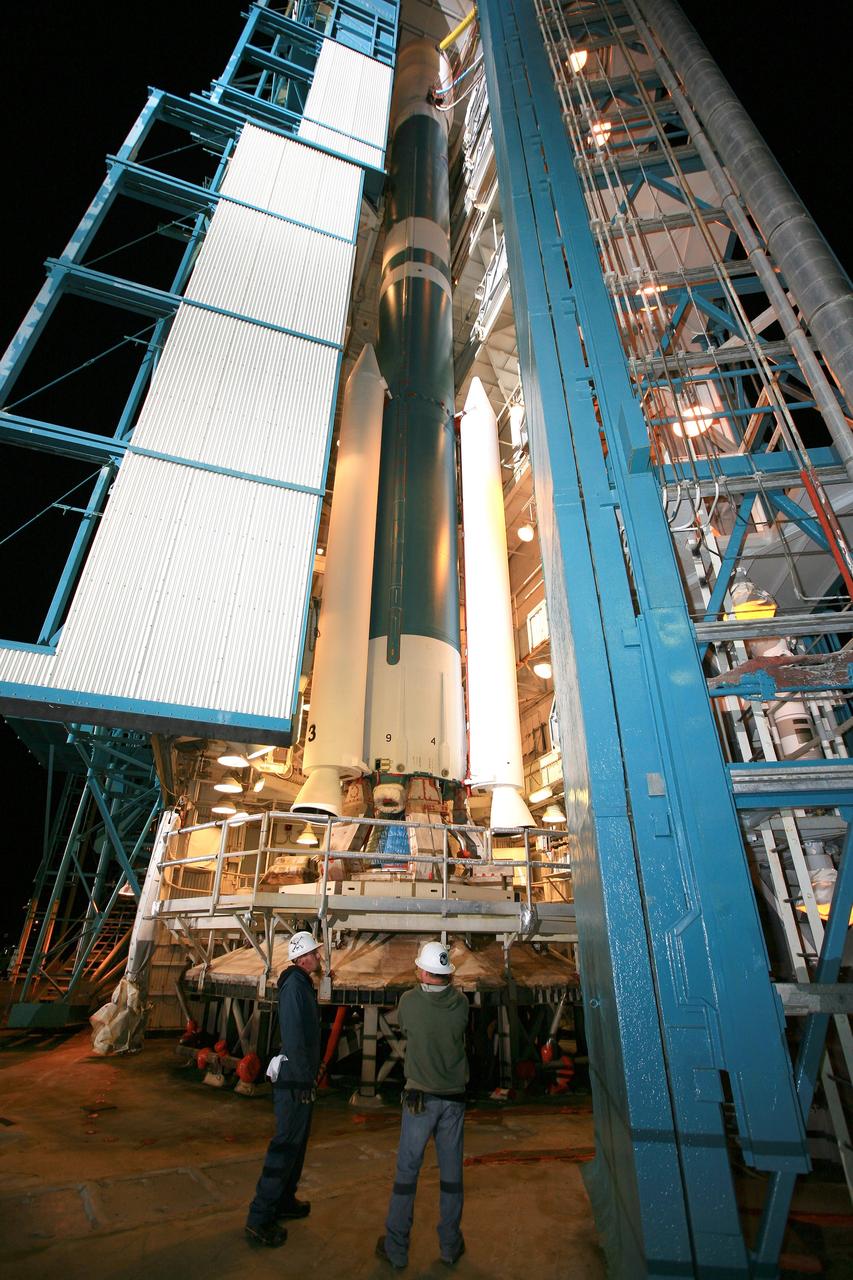
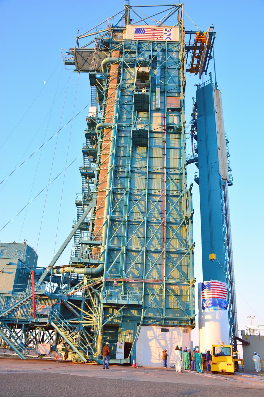
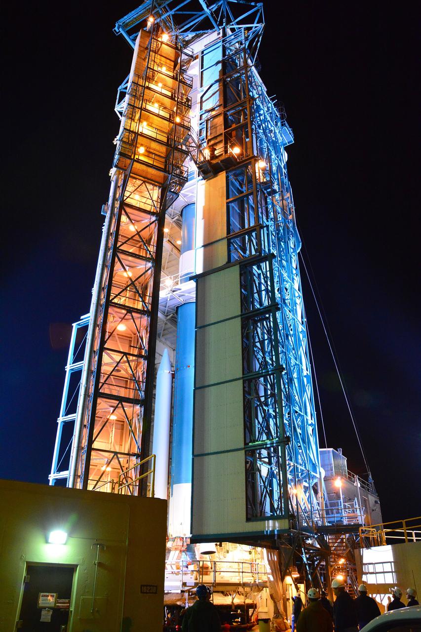
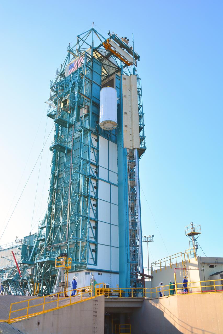
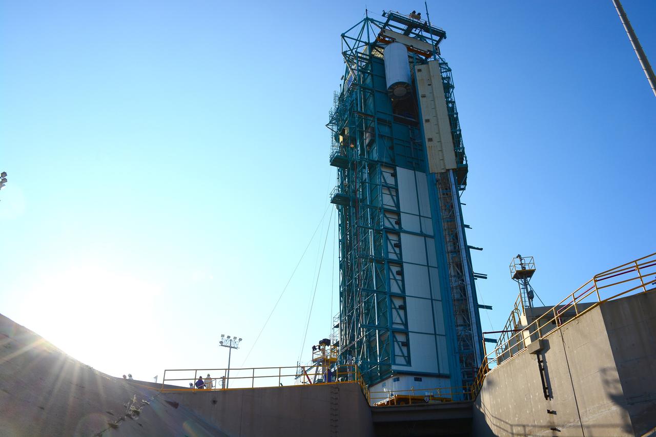
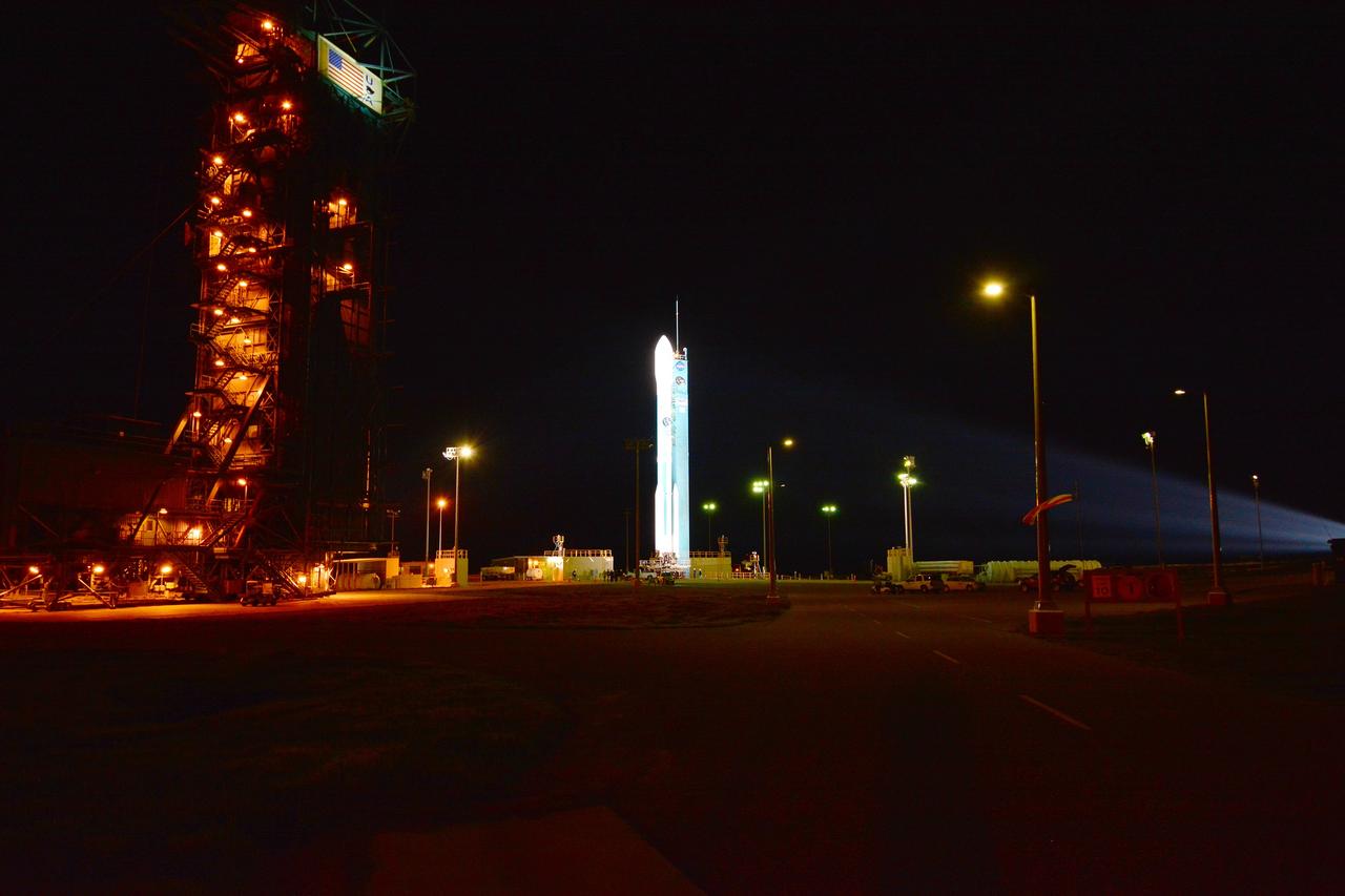
VANDENBERG AIR FORCE BASE, Calif. – The launch gantry is rolled back to reveal the United Launch Alliance Delta II rocket with the Soil Moisture Active Passive, or SMAP, satellite aboard, at the Space Launch Complex 2 at Vandenberg Air Force Base, California. SMAP is a remote sensing mission designed to measure and map the Earth's soil moisture distribution and freeze/thaw stat with unprecedented accuracy, resolution and coverage. SMAP will provide global measurements of soil moisture and its freeze/thaw state. These measurements will be used to enhance understanding of processes that link the water, energy and carbon cycles, and to extend the capabilities of weather and climate prediction models. SMAP data also will be used to quantify net carbon flux in boreal landscapes and to develop improved flood prediction and drought monitoring capabilities. Launch is scheduled for Jan. 29, 2015. To learn more about SMAP, visit http://smap.jpl.nasa.gov Photo credit: NASA/Kim Shiflett
VANDENBERG AIR FORCE BASE, Calif. – The launch gantry is rolled back to reveal the United Launch Alliance Delta II rocket with the Soil Moisture Active Passive, or SMAP, satellite aboard, at the Space Launch Complex 2 at Vandenberg Air Force Base, California. SMAP is a remote sensing mission designed to measure and map the Earth's soil moisture distribution and freeze/thaw stat with unprecedented accuracy, resolution and coverage. SMAP will provide global measurements of soil moisture and its freeze/thaw state. These measurements will be used to enhance understanding of processes that link the water, energy and carbon cycles, and to extend the capabilities of weather and climate prediction models. SMAP data also will be used to quantify net carbon flux in boreal landscapes and to develop improved flood prediction and drought monitoring capabilities. Launch is scheduled for Jan. 29, 2015. To learn more about SMAP, visit http://smap.jpl.nasa.gov Photo credit: NASA/Kim Shiflett
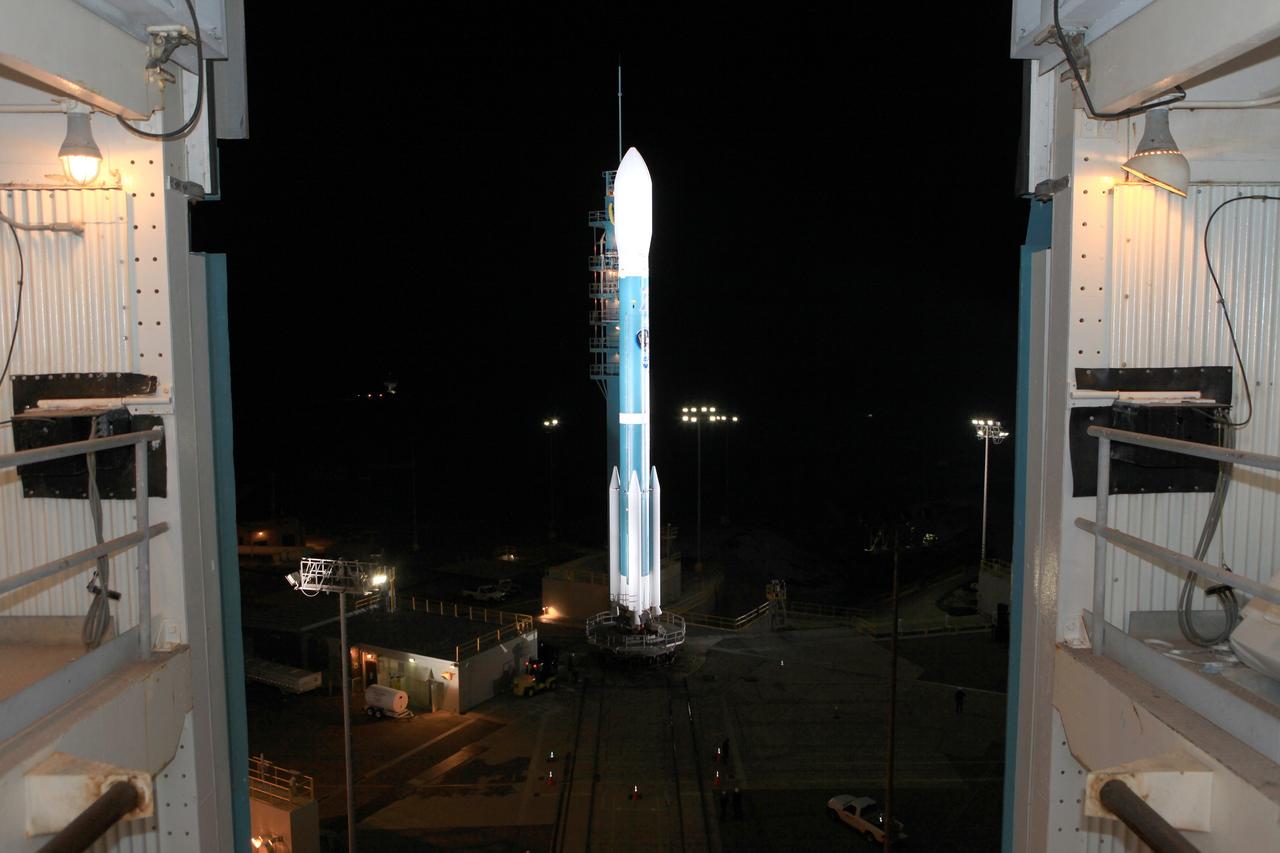
VANDENBERG AIR FORCE BASE, Calif. – The launch gantry is rolled back to reveal the United Launch Alliance Delta II rocket with the Soil Moisture Active Passive, or SMAP, satellite aboard, at the Space Launch Complex 2 at Vandenberg Air Force Base, California. SMAP is a remote sensing mission designed to measure and map the Earth's soil moisture distribution and freeze/thaw stat with unprecedented accuracy, resolution and coverage. SMAP will provide global measurements of soil moisture and its freeze/thaw state. These measurements will be used to enhance understanding of processes that link the water, energy and carbon cycles, and to extend the capabilities of weather and climate prediction models. SMAP data also will be used to quantify net carbon flux in boreal landscapes and to develop improved flood prediction and drought monitoring capabilities. Launch is scheduled for Jan. 29, 2015. To learn more about SMAP, visit http://smap.jpl.nasa.gov Photo credit: NASA/Kim Shiflett
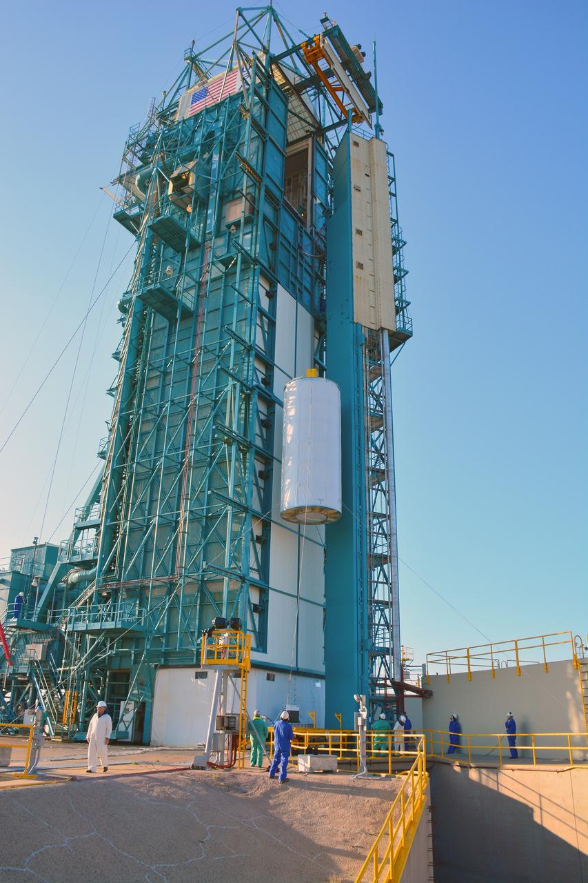
VANDENBERG AIR FORCE BASE, Calif. – At Vandenberg Air Force Base in California, NASA's Soil Moisture Active Passive mission, or SMAP, satellite is mated to its Delta II rocket at Space Launch Complex 2. SMAP will provide global measurements of soil moisture and its freeze/thaw state. These measurements will be used to enhance understanding of processes that link the water, energy and carbon cycles, and to extend the capabilities of weather and climate prediction models. SMAP data also will be used to quantify net carbon flux in boreal landscapes and to develop improved flood prediction and drought monitoring capabilities. Launch is scheduled for Jan. 29, 2015. To learn more about SMAP, visit http://smap.jpl.nasa.gov Photo credit: NASA/Randy Beaudoin
VANDENBERG AIR FORCE BASE, Calif. – The launch gantry is rolled back to reveal the United Launch Alliance Delta II rocket with the Soil Moisture Active Passive, or SMAP, satellite aboard, at the Space Launch Complex 2 at Vandenberg Air Force Base, California. SMAP is a remote sensing mission designed to measure and map the Earth's soil moisture distribution and freeze/thaw stat with unprecedented accuracy, resolution and coverage. SMAP will provide global measurements of soil moisture and its freeze/thaw state. These measurements will be used to enhance understanding of processes that link the water, energy and carbon cycles, and to extend the capabilities of weather and climate prediction models. SMAP data also will be used to quantify net carbon flux in boreal landscapes and to develop improved flood prediction and drought monitoring capabilities. Launch is scheduled for Jan. 29, 2015. To learn more about SMAP, visit http://smap.jpl.nasa.gov Photo credit: NASA/Kim Shiflett
VANDENBERG AIR FORCE BASE, Calif. – At Vandenberg Air Force Base in California, NASA's Soil Moisture Active Passive mission, or SMAP, satellite is lifted at Space Launch Complex 2 for mating to its Delta II rocket. SMAP will provide global measurements of soil moisture and its freeze/thaw state. These measurements will be used to enhance understanding of processes that link the water, energy and carbon cycles, and to extend the capabilities of weather and climate prediction models. SMAP data also will be used to quantify net carbon flux in boreal landscapes and to develop improved flood prediction and drought monitoring capabilities. Launch is scheduled for Jan. 29, 2015. To learn more about SMAP, visit http://smap.jpl.nasa.gov Photo credit: NASA/Randy Beaudoin
VANDENBERG AIR FORCE BASE, Calif. – At Vandenberg Air Force Base in California, NASA's Soil Moisture Active Passive mission, or SMAP, satellite is prepared for lifting at Space Launch Complex 2 for mating to its Delta II rocket. SMAP will provide global measurements of soil moisture and its freeze/thaw state. These measurements will be used to enhance understanding of processes that link the water, energy and carbon cycles, and to extend the capabilities of weather and climate prediction models. SMAP data also will be used to quantify net carbon flux in boreal landscapes and to develop improved flood prediction and drought monitoring capabilities. Launch is scheduled for Jan. 29, 2015. To learn more about SMAP, visit http://smap.jpl.nasa.gov Photo credit: NASA/Randy Beaudoin
VANDENBERG AIR FORCE BASE, Calif. – At Vandenberg Air Force Base in California, NASA's Soil Moisture Active Passive mission, or SMAP, satellite is lifted at Space Launch Complex 2 for mating to its Delta II rocket. SMAP will provide global measurements of soil moisture and its freeze/thaw state. These measurements will be used to enhance understanding of processes that link the water, energy and carbon cycles, and to extend the capabilities of weather and climate prediction models. SMAP data also will be used to quantify net carbon flux in boreal landscapes and to develop improved flood prediction and drought monitoring capabilities. Launch is scheduled for Jan. 29, 2015. To learn more about SMAP, visit http://smap.jpl.nasa.gov Photo credit: NASA/Randy Beaudoin
VANDENBERG AIR FORCE BASE, Calif. – The launch gantry is rolled back to reveal the United Launch Alliance Delta II rocket with the Soil Moisture Active Passive, or SMAP, satellite aboard, at Space Launch Complex 2 on Vandenberg Air Force Base in California. SMAP is a remote sensing mission designed to measure and map the Earth's soil moisture distribution and freeze/thaw stat with unprecedented accuracy, resolution and coverage. SMAP will provide global measurements of soil moisture and its freeze/thaw state. These measurements will be used to enhance understanding of processes that link the water, energy and carbon cycles, and to extend the capabilities of weather and climate prediction models. SMAP data also will be used to quantify net carbon flux in boreal landscapes and to develop improved flood prediction and drought monitoring capabilities. Launch is scheduled for Jan. 29, 2015. To learn more about SMAP, visit http://www.nasa.gov/smap. Photo credit: NASA/Randy Beaudoin
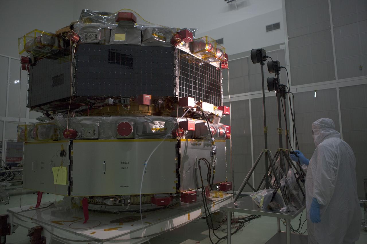
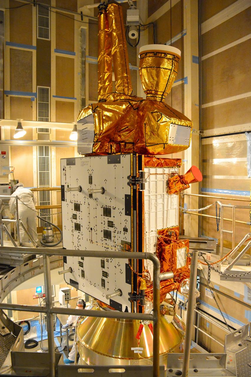
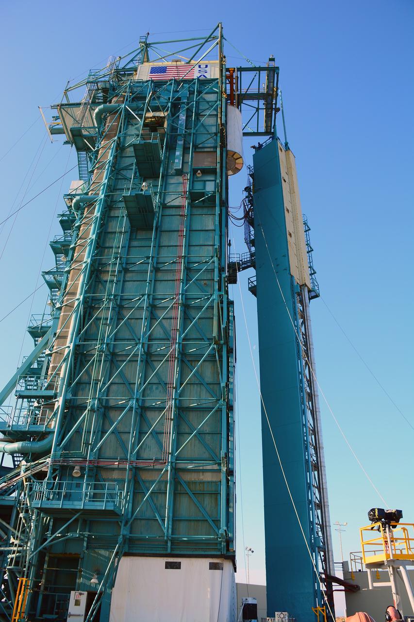
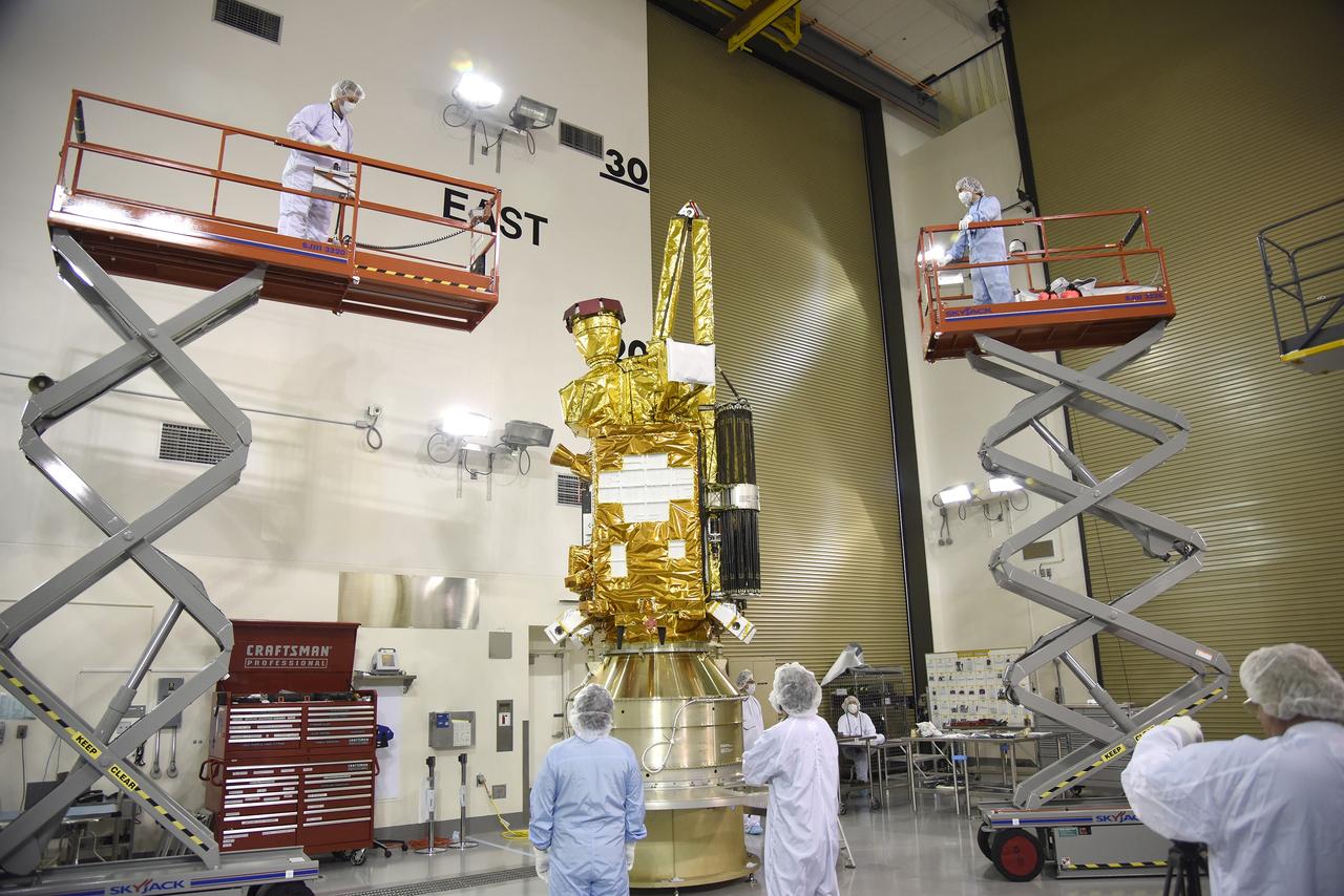
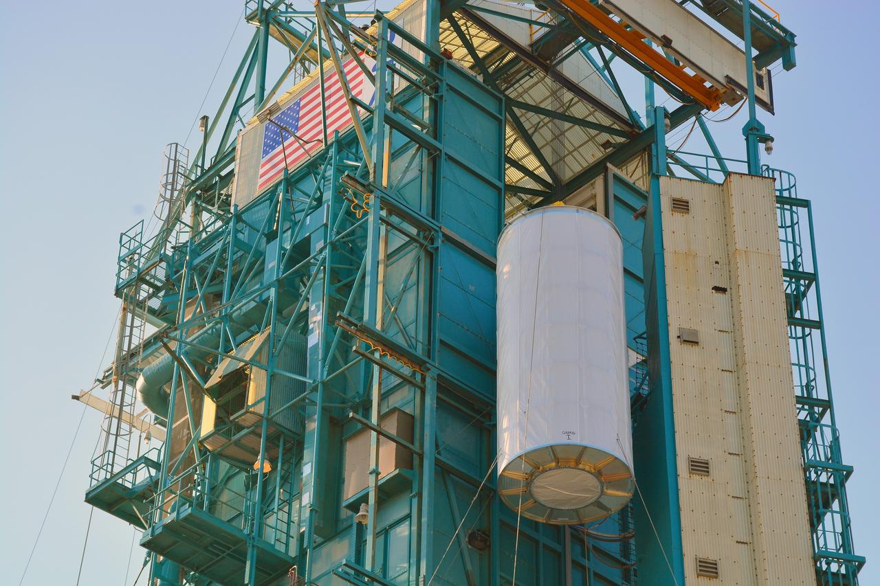
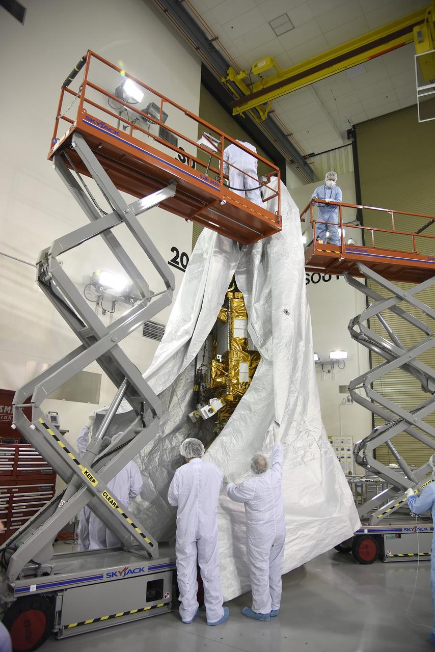
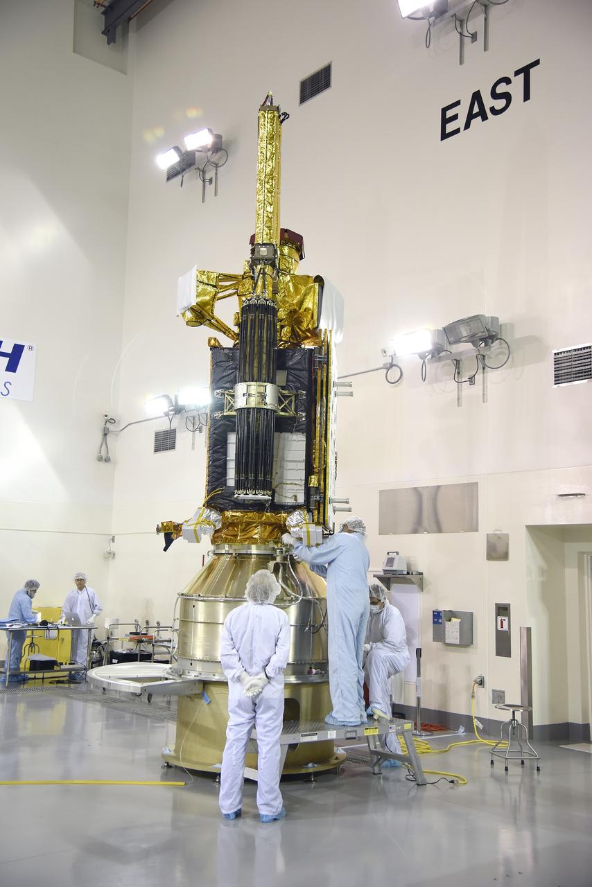
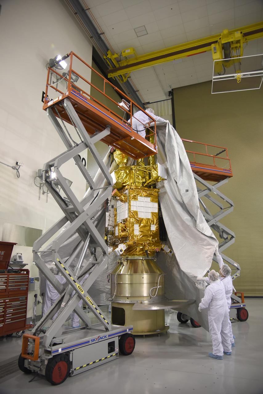
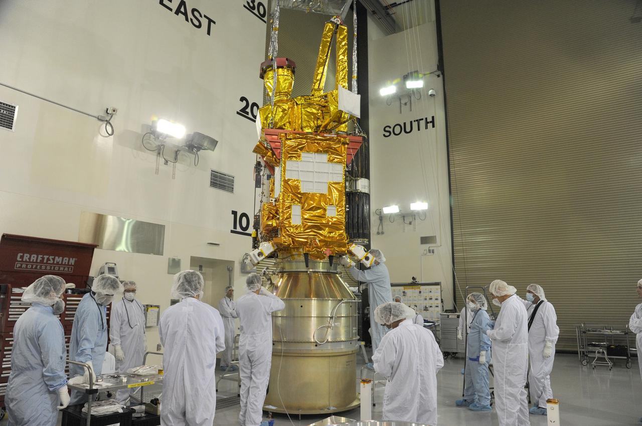
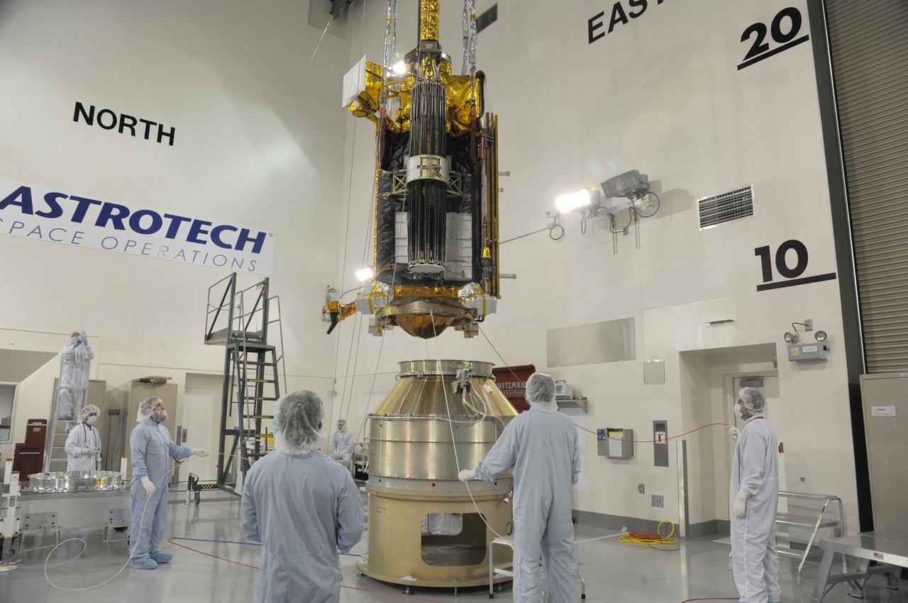
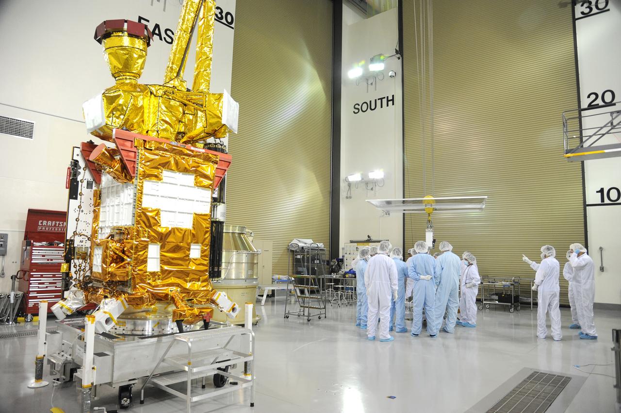
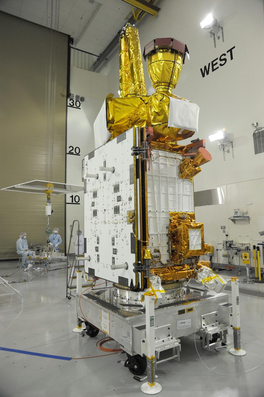
CAPE CANAVERAL, Fla. – A solar array illumination test is performed on the upper stack of the Magnetospheric Multiscale spacecraft, or MMS, in the Astrotech payload processing facility in Titusville, Florida, near Kennedy Space Center. Illumination testing of the lower instrumentation payload stack was completed in December. MMS is a Solar Terrestrial Probes mission comprising four identically instrumented spacecraft that will use Earth’s magnetosphere as a laboratory to study the microphysics of three fundamental plasma processes: magnetic reconnection, energetic particle acceleration and turbulence. Launch aboard a United Launch Alliance Atlas V rocket from Space Launch Complex 41 on Cape Canaveral Air Force Station is targeted for March 12, 2015. To learn more about MMS, visit http://www.nasa.gov/mms. Photo credit: NASA/Kim Shiflett
VANDENBERG AIR FORCE BASE, Calif. – At Vandenberg Air Force Base in California, NASA's Soil Moisture Active Passive mission, or SMAP, satellite is mated to its Delta II rocket at Space Launch Complex 2. SMAP will provide global measurements of soil moisture and its freeze/thaw state. These measurements will be used to enhance understanding of processes that link the water, energy and carbon cycles, and to extend the capabilities of weather and climate prediction models. SMAP data also will be used to quantify net carbon flux in boreal landscapes and to develop improved flood prediction and drought monitoring capabilities. Launch is scheduled for Jan. 29, 2015. To learn more about SMAP, visit http://smap.jpl.nasa.gov Photo credit: NASA/Randy Beaudoin
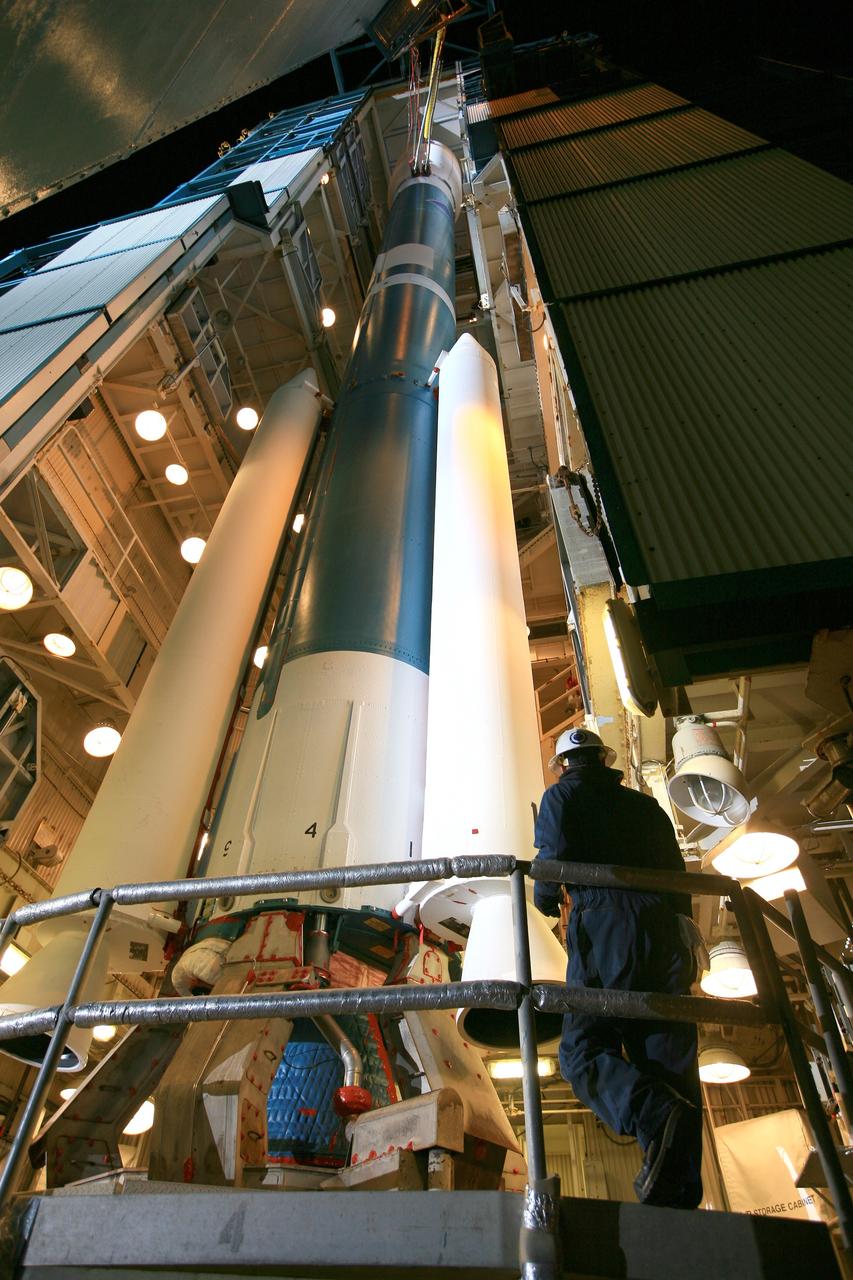
VANDENBERG AIR FORCE BASE, Calif. – Inside the Astrotech payload processing facility at Vandenberg Air Force Base in California, engineers and technicians inspect NASA's Soil Moisture Active Passive mission, or SMAP, satellite. SMAP will provide global measurements of soil moisture and its freeze/thaw state. These measurements will be used to enhance understanding of processes that link the water, energy and carbon cycles, and to extend the capabilities of weather and climate prediction models. SMAP data also will be used to quantify net carbon flux in boreal landscapes and to develop improved flood prediction and drought monitoring capabilities. Launch is scheduled for Jan. 29, 2015. To learn more about SMAP, visit http://smap.jpl.nasa.gov Photo credit: Jeremy Moore, USAF Photo Squadron
VANDENBERG AIR FORCE BASE, Calif. – At Vandenberg Air Force Base in California, NASA's Soil Moisture Active Passive mission, or SMAP, satellite is prepared for lifting at Space Launch Complex 2 for mating to its Delta II rocket. SMAP will provide global measurements of soil moisture and its freeze/thaw state. These measurements will be used to enhance understanding of processes that link the water, energy and carbon cycles, and to extend the capabilities of weather and climate prediction models. SMAP data also will be used to quantify net carbon flux in boreal landscapes and to develop improved flood prediction and drought monitoring capabilities. Launch is scheduled for Jan. 29, 2015. To learn more about SMAP, visit http://smap.jpl.nasa.gov Photo credit: NASA/Randy Beaudoin
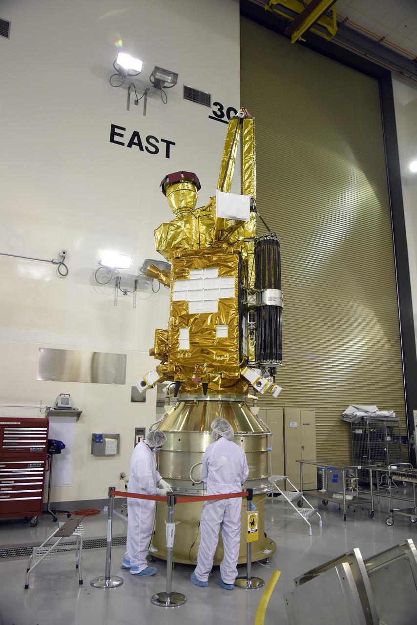
VANDENBERG AIR FORCE BASE, Calif. – Inside the Astrotech payload processing facility at Vandenberg Air Force Base in California, engineers and technicians inspect NASA's Soil Moisture Active Passive mission, or SMAP, satellite. SMAP will provide global measurements of soil moisture and its freeze/thaw state. These measurements will be used to enhance understanding of processes that link the water, energy and carbon cycles, and to extend the capabilities of weather and climate prediction models. SMAP data also will be used to quantify net carbon flux in boreal landscapes and to develop improved flood prediction and drought monitoring capabilities. Launch is scheduled for Jan. 29, 2015. To learn more about SMAP, visit http://smap.jpl.nasa.gov Photo credit: Jeremy Moore, USAF Photo Squadron
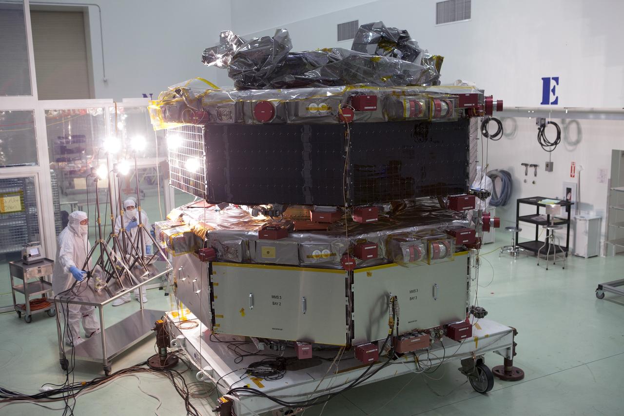
CAPE CANAVERAL, Fla. – A solar array illumination test is performed on the upper stack of the Magnetospheric Multiscale spacecraft, or MMS, in the Astrotech payload processing facility in Titusville, Florida, near Kennedy Space Center. Illumination testing of the lower instrumentation payload stack was completed in December. MMS is a Solar Terrestrial Probes mission comprising four identically instrumented spacecraft that will use Earth’s magnetosphere as a laboratory to study the microphysics of three fundamental plasma processes: magnetic reconnection, energetic particle acceleration and turbulence. Launch aboard a United Launch Alliance Atlas V rocket from Space Launch Complex 41 on Cape Canaveral Air Force Station is targeted for March 12, 2015. To learn more about MMS, visit http://www.nasa.gov/mms. Photo credit: NASA/Kim Shiflett
VANDENBERG AIR FORCE BASE, Calif. – At Vandenberg Air Force Base in California, NASA's Soil Moisture Active Passive mission, or SMAP, satellite is transported to Space Launch Complex 2 where it will be mated to a Delta II rocket. SMAP will provide global measurements of soil moisture and its freeze/thaw state. These measurements will be used to enhance understanding of processes that link the water, energy and carbon cycles, and to extend the capabilities of weather and climate prediction models. SMAP data also will be used to quantify net carbon flux in boreal landscapes and to develop improved flood prediction and drought monitoring capabilities. Launch is scheduled for Jan. 29, 2015. To learn more about SMAP, visit http://smap.jpl.nasa.gov Photo credit: NASA/Randy Beaudoin
VANDENBERG AIR FORCE BASE, Calif. – At Vandenberg Air Force Base in California, NASA's Soil Moisture Active Passive mission, or SMAP, satellite is lifted at Space Launch Complex 2 for mating to its Delta II rocket. SMAP will provide global measurements of soil moisture and its freeze/thaw state. These measurements will be used to enhance understanding of processes that link the water, energy and carbon cycles, and to extend the capabilities of weather and climate prediction models. SMAP data also will be used to quantify net carbon flux in boreal landscapes and to develop improved flood prediction and drought monitoring capabilities. Launch is scheduled for Jan. 29, 2015. To learn more about SMAP, visit http://smap.jpl.nasa.gov Photo credit: NASA/Randy Beaudoin
VANDENBERG AIR FORCE BASE, Calif. – The launch gantry is rolled back to reveal the United Launch Alliance Delta II rocket with the Soil Moisture Active Passive, or SMAP, satellite aboard, at Space Launch Complex 2 on Vandenberg Air Force Base in California. SMAP is a remote sensing mission designed to measure and map the Earth's soil moisture distribution and freeze/thaw stat with unprecedented accuracy, resolution and coverage. SMAP will provide global measurements of soil moisture and its freeze/thaw state. These measurements will be used to enhance understanding of processes that link the water, energy and carbon cycles, and to extend the capabilities of weather and climate prediction models. SMAP data also will be used to quantify net carbon flux in boreal landscapes and to develop improved flood prediction and drought monitoring capabilities. Launch is scheduled for Jan. 29, 2015. To learn more about SMAP, visit http://www.nasa.gov/smap. Photo credit: NASA/Randy Beaudoin
VANDENBERG AIR FORCE BASE, Calif. – At Vandenberg Air Force Base in California, NASA's Soil Moisture Active Passive mission, or SMAP, satellite is transported to Space Launch Complex 2 where it will be mated to a Delta II rocket. SMAP will provide global measurements of soil moisture and its freeze/thaw state. These measurements will be used to enhance understanding of processes that link the water, energy and carbon cycles, and to extend the capabilities of weather and climate prediction models. SMAP data also will be used to quantify net carbon flux in boreal landscapes and to develop improved flood prediction and drought monitoring capabilities. Launch is scheduled for Jan. 29, 2015. To learn more about SMAP, visit http://smap.jpl.nasa.gov Photo credit: NASA/Randy Beaudoin
VANDENBERG AIR FORCE BASE, Calif. – At Vandenberg Air Force Base in California, NASA's Soil Moisture Active Passive mission, or SMAP, satellite is lifted at Space Launch Complex 2 for mating to its Delta II rocket. SMAP will provide global measurements of soil moisture and its freeze/thaw state. These measurements will be used to enhance understanding of processes that link the water, energy and carbon cycles, and to extend the capabilities of weather and climate prediction models. SMAP data also will be used to quantify net carbon flux in boreal landscapes and to develop improved flood prediction and drought monitoring capabilities. Launch is scheduled for Jan. 29, 2015. To learn more about SMAP, visit http://smap.jpl.nasa.gov Photo credit: NASA/Randy Beaudoin
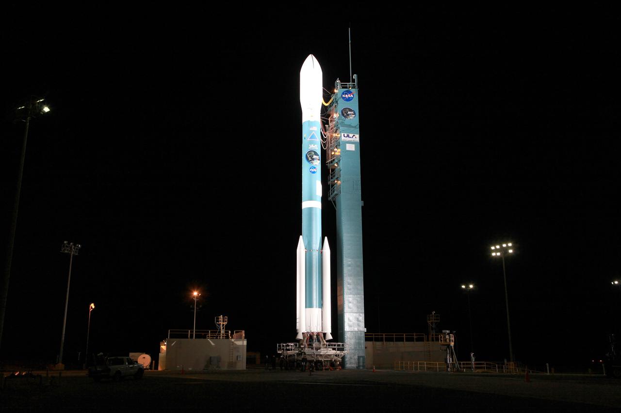
VANDENBERG AIR FORCE BASE, Calif. – The launch gantry is rolled back to reveal the United Launch Alliance Delta II rocket with the Soil Moisture Active Passive, or SMAP, satellite aboard, at the Space Launch Complex 2 at Vandenberg Air Force Base, California. SMAP is a remote sensing mission designed to measure and map the Earth's soil moisture distribution and freeze/thaw stat with unprecedented accuracy, resolution and coverage. SMAP will provide global measurements of soil moisture and its freeze/thaw state. These measurements will be used to enhance understanding of processes that link the water, energy and carbon cycles, and to extend the capabilities of weather and climate prediction models. SMAP data also will be used to quantify net carbon flux in boreal landscapes and to develop improved flood prediction and drought monitoring capabilities. Launch is scheduled for Jan. 29, 2015. To learn more about SMAP, visit http://smap.jpl.nasa.gov Photo credit: NASA/Kim Shiflett
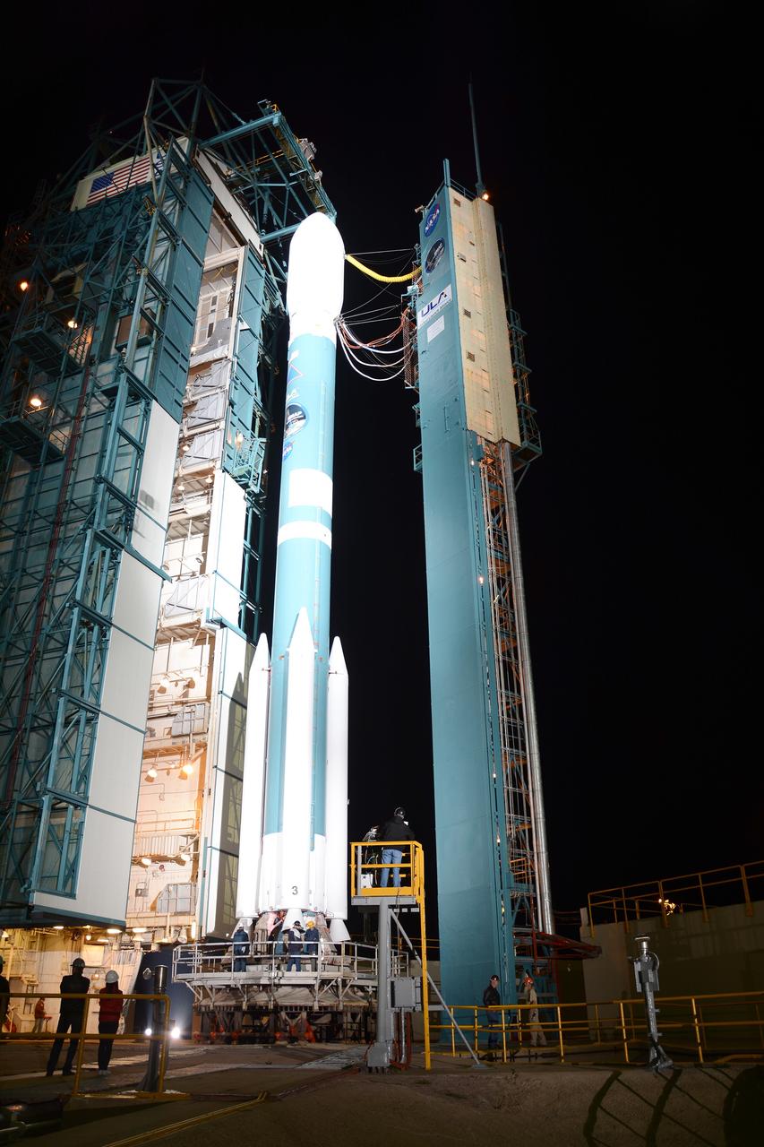
VANDENBERG AIR FORCE BASE, Calif. – The launch gantry is rolled back to reveal the United Launch Alliance Delta II rocket with the Soil Moisture Active Passive, or SMAP, satellite aboard, at Space Launch Complex 2 on Vandenberg Air Force Base in California. SMAP is a remote sensing mission designed to measure and map the Earth's soil moisture distribution and freeze/thaw stat with unprecedented accuracy, resolution and coverage. SMAP will provide global measurements of soil moisture and its freeze/thaw state. These measurements will be used to enhance understanding of processes that link the water, energy and carbon cycles, and to extend the capabilities of weather and climate prediction models. SMAP data also will be used to quantify net carbon flux in boreal landscapes and to develop improved flood prediction and drought monitoring capabilities. Launch is scheduled for Jan. 29, 2015. To learn more about SMAP, visit http://www.nasa.gov/smap. Photo credit: NASA/Randy Beaudoin
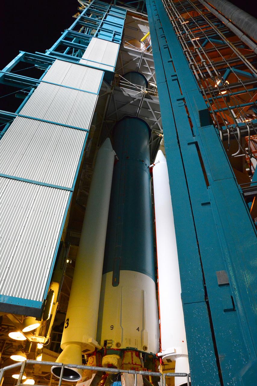
VANDENBERG AIR FORCE BASE, Calif. – The launch gantry is rolled back to reveal the United Launch Alliance Delta II rocket with the Soil Moisture Active Passive, or SMAP, satellite aboard, at Space Launch Complex 2 on Vandenberg Air Force Base in California. SMAP is a remote sensing mission designed to measure and map the Earth's soil moisture distribution and freeze/thaw stat with unprecedented accuracy, resolution and coverage. SMAP will provide global measurements of soil moisture and its freeze/thaw state. These measurements will be used to enhance understanding of processes that link the water, energy and carbon cycles, and to extend the capabilities of weather and climate prediction models. SMAP data also will be used to quantify net carbon flux in boreal landscapes and to develop improved flood prediction and drought monitoring capabilities. Launch is scheduled for Jan. 29, 2015. To learn more about SMAP, visit http://www.nasa.gov/smap. Photo credit: NASA/Randy Beaudoin
VANDENBERG AIR FORCE BASE, Calif. – The launch gantry is rolled back to reveal the United Launch Alliance Delta II rocket with the Soil Moisture Active Passive, or SMAP, satellite aboard, at the Space Launch Complex 2 at Vandenberg Air Force Base, California. SMAP is a remote sensing mission designed to measure and map the Earth's soil moisture distribution and freeze/thaw stat with unprecedented accuracy, resolution and coverage. SMAP will provide global measurements of soil moisture and its freeze/thaw state. These measurements will be used to enhance understanding of processes that link the water, energy and carbon cycles, and to extend the capabilities of weather and climate prediction models. SMAP data also will be used to quantify net carbon flux in boreal landscapes and to develop improved flood prediction and drought monitoring capabilities. Launch is scheduled for Jan. 29, 2015. To learn more about SMAP, visit http://smap.jpl.nasa.gov Photo credit: NASA/Kim Shiflett

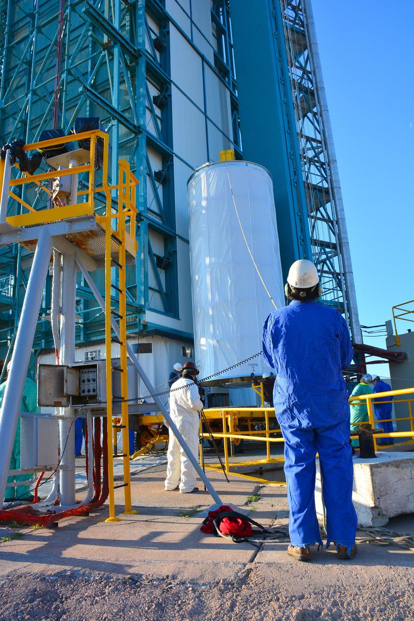
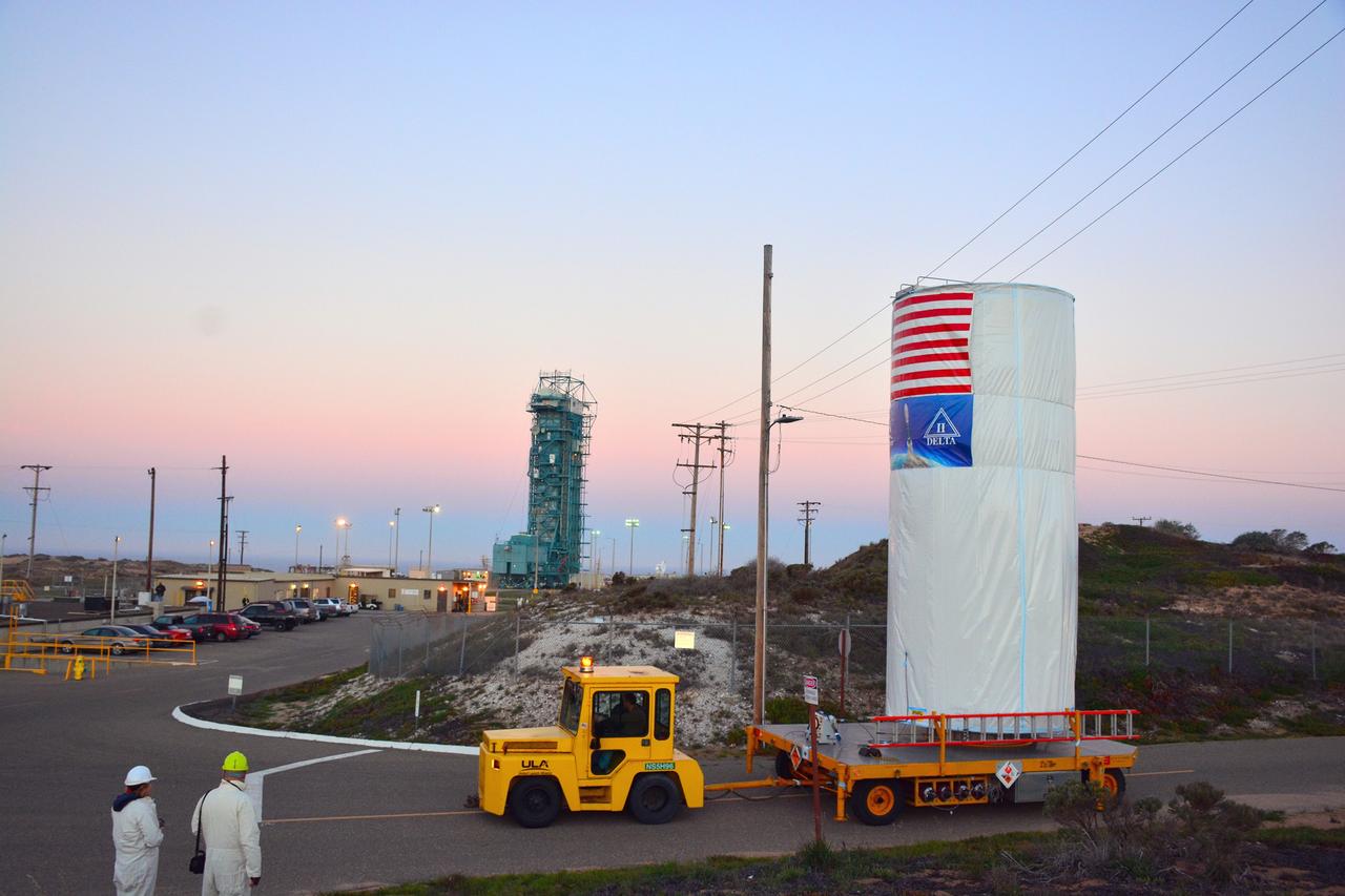
VANDENBERG AIR FORCE BASE, Calif. – The sun sets over the Pacific Ocean as seen from Vandenberg Air Force Base in California where NASA's Soil Moisture Active Passive mission, or SMAP, satellite is being prepared for liftoff from Space Launch Complex 2. SMAP will provide global measurements of soil moisture and its freeze/thaw state. These measurements will be used to enhance understanding of processes that link the water, energy and carbon cycles, and to extend the capabilities of weather and climate prediction models. SMAP data also will be used to quantify net carbon flux in boreal landscapes and to develop improved flood prediction and drought monitoring capabilities. Launch is scheduled for Jan. 29, 2015. To learn more about SMAP, visit http://smap.jpl.nasa.gov Photo credit: NASA/Randy Beaudoin
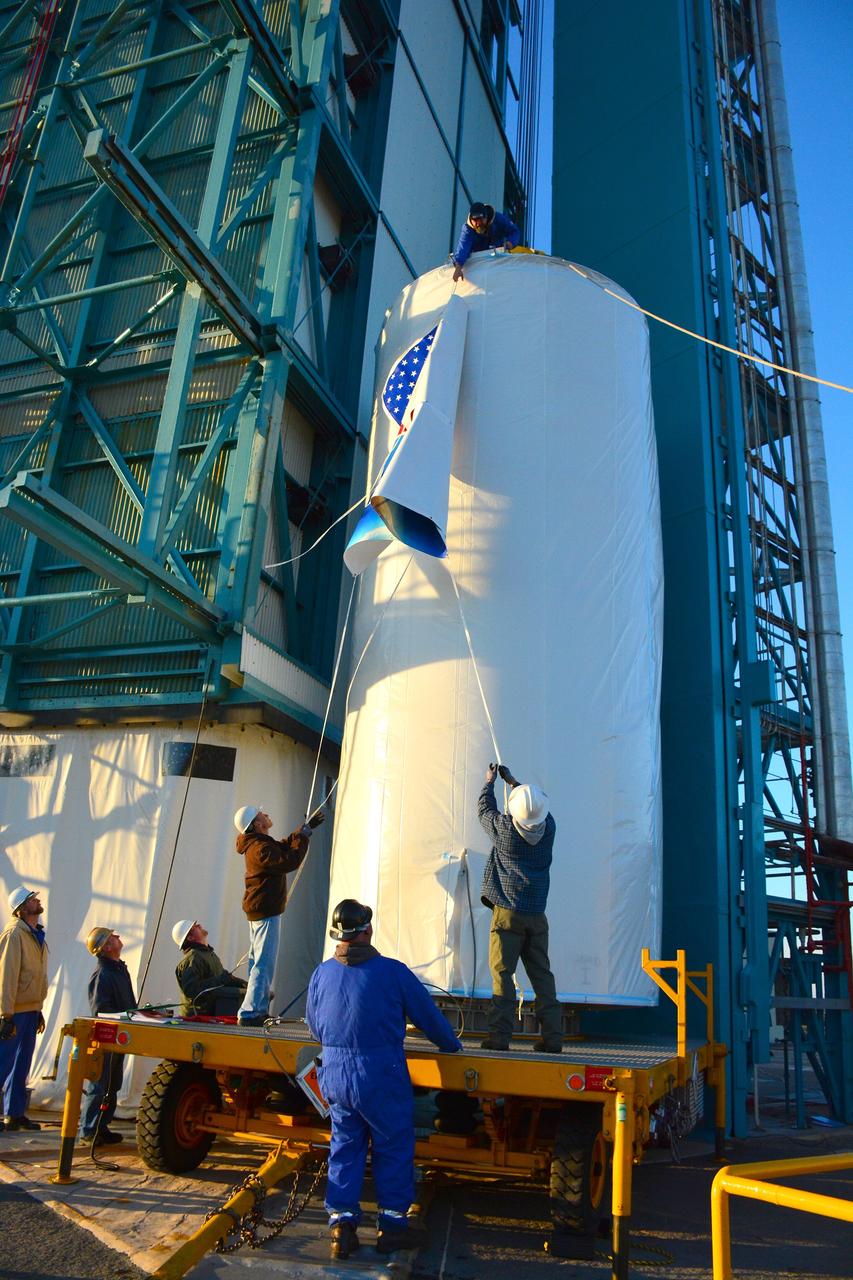
VANDENBERG AIR FORCE BASE, Calif. – Inside the Astrotech payload processing facility at Vandenberg Air Force Base in California, engineers and technicians place a protective cover over NASA's Soil Moisture Active Passive mission, or SMAP, satellite prior the spacecraft being transported to the launch pad. SMAP will provide global measurements of soil moisture and its freeze/thaw state. These measurements will be used to enhance understanding of processes that link the water, energy and carbon cycles, and to extend the capabilities of weather and climate prediction models. SMAP data also will be used to quantify net carbon flux in boreal landscapes and to develop improved flood prediction and drought monitoring capabilities. Launch is scheduled for Jan. 29, 2015. To learn more about SMAP, visit http://smap.jpl.nasa.gov Photo credit: Jeremy Moore, USAF Photo Squadron
VANDENBERG AIR FORCE BASE, Calif. – The launch gantry is rolled back to reveal the United Launch Alliance Delta II rocket with the Soil Moisture Active Passive, or SMAP, satellite aboard, at Space Launch Complex 2 on Vandenberg Air Force Base in California. SMAP is a remote sensing mission designed to measure and map the Earth's soil moisture distribution and freeze/thaw stat with unprecedented accuracy, resolution and coverage. SMAP will provide global measurements of soil moisture and its freeze/thaw state. These measurements will be used to enhance understanding of processes that link the water, energy and carbon cycles, and to extend the capabilities of weather and climate prediction models. SMAP data also will be used to quantify net carbon flux in boreal landscapes and to develop improved flood prediction and drought monitoring capabilities. Launch is scheduled for Jan. 29, 2015. To learn more about SMAP, visit http://www.nasa.gov/smap. Photo credit: NASA/Randy Beaudoin
VANDENBERG AIR FORCE BASE, Calif. – At Vandenberg Air Force Base in California, NASA's Soil Moisture Active Passive mission, or SMAP, satellite is mated to its Delta II rocket at Space Launch Complex 2. SMAP will provide global measurements of soil moisture and its freeze/thaw state. These measurements will be used to enhance understanding of processes that link the water, energy and carbon cycles, and to extend the capabilities of weather and climate prediction models. SMAP data also will be used to quantify net carbon flux in boreal landscapes and to develop improved flood prediction and drought monitoring capabilities. Launch is scheduled for Jan. 29, 2015. To learn more about SMAP, visit http://smap.jpl.nasa.gov Photo credit: NASA/Randy Beaudoin
VANDENBERG AIR FORCE BASE, Calif. – At Vandenberg Air Force Base in California, NASA's Soil Moisture Active Passive mission, or SMAP, satellite is transported to Space Launch Complex 2 where it will be mated to a Delta II rocket. SMAP will provide global measurements of soil moisture and its freeze/thaw state. These measurements will be used to enhance understanding of processes that link the water, energy and carbon cycles, and to extend the capabilities of weather and climate prediction models. SMAP data also will be used to quantify net carbon flux in boreal landscapes and to develop improved flood prediction and drought monitoring capabilities. Launch is scheduled for Jan. 29, 2015. To learn more about SMAP, visit http://smap.jpl.nasa.gov Photo credit: NASA/Randy Beaudoin
VANDENBERG AIR FORCE BASE, Calif. – At Vandenberg Air Force Base in California, NASA's Soil Moisture Active Passive mission, or SMAP, satellite is lifted at Space Launch Complex 2 for mating to its Delta II rocket. SMAP will provide global measurements of soil moisture and its freeze/thaw state. These measurements will be used to enhance understanding of processes that link the water, energy and carbon cycles, and to extend the capabilities of weather and climate prediction models. SMAP data also will be used to quantify net carbon flux in boreal landscapes and to develop improved flood prediction and drought monitoring capabilities. Launch is scheduled for Jan. 29, 2015. To learn more about SMAP, visit http://smap.jpl.nasa.gov Photo credit: NASA/Randy Beaudoin
VANDENBERG AIR FORCE BASE, Calif. – Inside the Astrotech payload processing facility at Vandenberg Air Force Base in California, engineers and technicians place a protective cover over NASA's Soil Moisture Active Passive mission, or SMAP, satellite prior the spacecraft being transported to the launch pad. SMAP will provide global measurements of soil moisture and its freeze/thaw state. These measurements will be used to enhance understanding of processes that link the water, energy and carbon cycles, and to extend the capabilities of weather and climate prediction models. SMAP data also will be used to quantify net carbon flux in boreal landscapes and to develop improved flood prediction and drought monitoring capabilities. Launch is scheduled for Jan. 29, 2015. To learn more about SMAP, visit http://smap.jpl.nasa.gov Photo credit: Jeremy Moore, USAF Photo Squadron
VANDENBERG AIR FORCE BASE, Calif. – Inside the Astrotech payload processing facility at Vandenberg Air Force Base in California, engineers and technicians inspect NASA's Soil Moisture Active Passive mission, or SMAP, satellite. SMAP will provide global measurements of soil moisture and its freeze/thaw state. These measurements will be used to enhance understanding of processes that link the water, energy and carbon cycles, and to extend the capabilities of weather and climate prediction models. SMAP data also will be used to quantify net carbon flux in boreal landscapes and to develop improved flood prediction and drought monitoring capabilities. Launch is scheduled for Jan. 29, 2015. To learn more about SMAP, visit http://smap.jpl.nasa.gov Photo credit: Jeremy Moore, USAF Photo Squadron
VANDENBERG AIR FORCE BASE, Calif. – The sun sets behind Space Launch Complex 2 at Vandenberg Air Force Base in California where NASA's Soil Moisture Active Passive mission, or SMAP, satellite is being prepared for liftoff. SMAP will provide global measurements of soil moisture and its freeze/thaw state. These measurements will be used to enhance understanding of processes that link the water, energy and carbon cycles, and to extend the capabilities of weather and climate prediction models. SMAP data also will be used to quantify net carbon flux in boreal landscapes and to develop improved flood prediction and drought monitoring capabilities. Launch is scheduled for Jan. 29, 2015. To learn more about SMAP, visit http://smap.jpl.nasa.gov Photo credit: NASA/Randy Beaudoin
VANDENBERG AIR FORCE BASE, Calif. – At Vandenberg Air Force Base in California, NASA's Soil Moisture Active Passive mission, or SMAP, satellite is prepared for lifting at Space Launch Complex 2 for mating to its Delta II rocket. SMAP will provide global measurements of soil moisture and its freeze/thaw state. These measurements will be used to enhance understanding of processes that link the water, energy and carbon cycles, and to extend the capabilities of weather and climate prediction models. SMAP data also will be used to quantify net carbon flux in boreal landscapes and to develop improved flood prediction and drought monitoring capabilities. Launch is scheduled for Jan. 29, 2015. To learn more about SMAP, visit http://smap.jpl.nasa.gov Photo credit: NASA/Randy Beaudoin
VANDENBERG AIR FORCE BASE, Calif. – At Vandenberg Air Force Base in California, NASA's Soil Moisture Active Passive mission, or SMAP, satellite is lifted at Space Launch Complex 2 for mating to its Delta II rocket. SMAP will provide global measurements of soil moisture and its freeze/thaw state. These measurements will be used to enhance understanding of processes that link the water, energy and carbon cycles, and to extend the capabilities of weather and climate prediction models. SMAP data also will be used to quantify net carbon flux in boreal landscapes and to develop improved flood prediction and drought monitoring capabilities. Launch is scheduled for Jan. 29, 2015. To learn more about SMAP, visit http://smap.jpl.nasa.gov Photo credit: NASA/Randy Beaudoin
VANDENBERG AIR FORCE BASE, Calif. – Inside the Astrotech payload processing facility at Vandenberg Air Force Base in California, engineers and technicians place a protective cover over NASA's Soil Moisture Active Passive mission, or SMAP, satellite prior the spacecraft being transported to the launch pad. SMAP will provide global measurements of soil moisture and its freeze/thaw state. These measurements will be used to enhance understanding of processes that link the water, energy and carbon cycles, and to extend the capabilities of weather and climate prediction models. SMAP data also will be used to quantify net carbon flux in boreal landscapes and to develop improved flood prediction and drought monitoring capabilities. Launch is scheduled for Jan. 29, 2015. To learn more about SMAP, visit http://smap.jpl.nasa.gov Photo credit: Jeremy Moore, USAF Photo Squadron
VANDENBERG AIR FORCE BASE, Calif. – The launch gantry is rolled back to reveal the United Launch Alliance Delta II rocket with the Soil Moisture Active Passive, or SMAP, satellite aboard, at the Space Launch Complex 2 at Vandenberg Air Force Base, California. SMAP is a remote sensing mission designed to measure and map the Earth's soil moisture distribution and freeze/thaw stat with unprecedented accuracy, resolution and coverage. SMAP will provide global measurements of soil moisture and its freeze/thaw state. These measurements will be used to enhance understanding of processes that link the water, energy and carbon cycles, and to extend the capabilities of weather and climate prediction models. SMAP data also will be used to quantify net carbon flux in boreal landscapes and to develop improved flood prediction and drought monitoring capabilities. Launch is scheduled for Jan. 29, 2015. To learn more about SMAP, visit http://smap.jpl.nasa.gov Photo credit: NASA/Kim Shiflett
VANDENBERG AIR FORCE BASE, Calif. – The launch gantry is rolled back to reveal the United Launch Alliance Delta II rocket with the Soil Moisture Active Passive, or SMAP, satellite aboard, at Space Launch Complex 2 on Vandenberg Air Force Base in California. SMAP is a remote sensing mission designed to measure and map the Earth's soil moisture distribution and freeze/thaw stat with unprecedented accuracy, resolution and coverage. SMAP will provide global measurements of soil moisture and its freeze/thaw state. These measurements will be used to enhance understanding of processes that link the water, energy and carbon cycles, and to extend the capabilities of weather and climate prediction models. SMAP data also will be used to quantify net carbon flux in boreal landscapes and to develop improved flood prediction and drought monitoring capabilities. Launch is scheduled for Jan. 29, 2015. To learn more about SMAP, visit http://www.nasa.gov/smap. Photo credit: NASA/Randy Beaudoin
VANDENBERG AIR FORCE BASE, Calif. – At Vandenberg Air Force Base in California, NASA's Soil Moisture Active Passive mission, or SMAP, satellite is transported to Space Launch Complex 2 where it will be mated to a Delta II rocket. SMAP will provide global measurements of soil moisture and its freeze/thaw state. These measurements will be used to enhance understanding of processes that link the water, energy and carbon cycles, and to extend the capabilities of weather and climate prediction models. SMAP data also will be used to quantify net carbon flux in boreal landscapes and to develop improved flood prediction and drought monitoring capabilities. Launch is scheduled for Jan. 29, 2015. To learn more about SMAP, visit http://smap.jpl.nasa.gov Photo credit: NASA/Randy Beaudoin
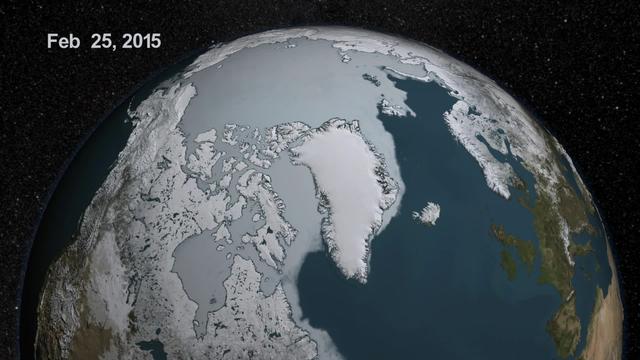
As the sun sets over the Arctic, the end of this year’s melt season is quickly approaching and the sea ice cover has already shrunk to the fourth lowest in the satellite record. With possibly some days of melting left, the sea ice extent could still drop to the second or third lowest on record. Arctic sea ice, which regulates the planet’s temperature by bouncing solar energy back to space, has been on a steep decline for the last two decades. This animation shows the evolution of Arctic sea ice in 2015, from its annual maximum wintertime extent, reached on February 25, to September 6. Credit: NASA Scientific Visualization Studio DOWNLOAD THIS VIDEO HERE: <a href="https://svs.gsfc.nasa.gov/cgi-bin/details.cgi?aid=11999" rel="nofollow">svs.gsfc.nasa.gov/cgi-bin/details.cgi?aid=11999</a> <b><a href="http://www.nasa.gov/audience/formedia/features/MP_Photo_Guidelines.html" rel="nofollow">NASA image use policy.</a></b> <b><a href="http://www.nasa.gov/centers/goddard/home/index.html" rel="nofollow">NASA Goddard Space Flight Center</a></b> enables NASA’s mission through four scientific endeavors: Earth Science, Heliophysics, Solar System Exploration, and Astrophysics. Goddard plays a leading role in NASA’s accomplishments by contributing compelling scientific knowledge to advance the Agency’s mission. <b>Follow us on <a href="http://twitter.com/NASAGoddardPix" rel="nofollow">Twitter</a></b> <b>Like us on <a href="http://www.facebook.com/pages/Greenbelt-MD/NASA-Goddard/395013845897?ref=tsd" rel="nofollow">Facebook</a></b> <b>Find us on <a href="http://instagrid.me/nasagoddard/?vm=grid" rel="nofollow">Instagram</a></b>
Firefighters place the American flag at half-staff during dedication services for a memorial to the 343 first responder victims of the Sept. 11, 2001, terror attacks at Fire Station 1 at NASA's Kennedy Space Center on Sept. 11, 2015. A section of steel I-beam from the World Trade Center in New York forms the centerpiece of the monument.

The Brevard Police and Fire Pipe and Drum corps open the dedication service for a memorial to the 343 first responder victims of the Sept. 11, 2001, terror attacks at Fire Station 1 at NASA's Kennedy Space Center on Sept. 11, 2015. The ceremony dedicated a monument that includes a section of steel I-beam from the World Trade Center in New York.
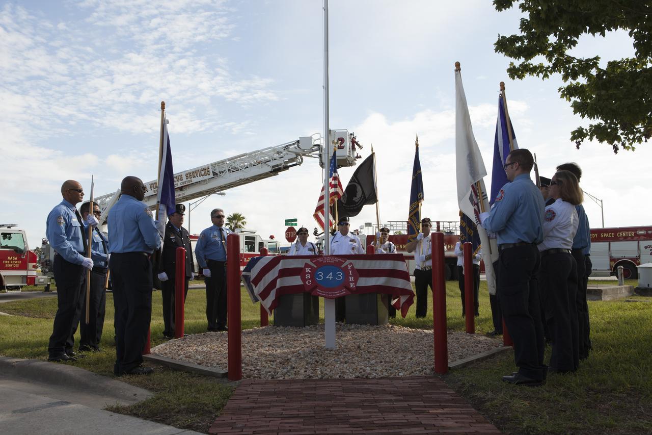
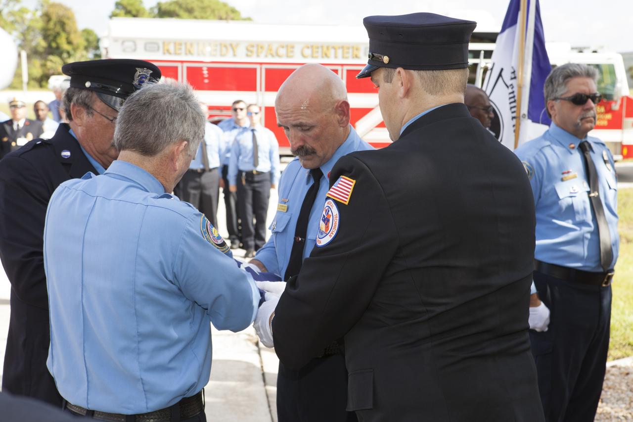
The honor guard for the Fire Department at NASA's Kennedy Space Center conducts the dedication service for a memorial to the 343 first responder victims of the Sept. 11, 2001, terror attacks at Fire Station 1 at Kennedy on Sept. 11, 2015. The ceremony dedicated a monument that includes a section of steel I-beam from the World Trade Center in New York.

An honor guard folds an American flag during the dedication service for a memorial to the 343 first responder victims of the Sept. 11, 2001, terror attacks at Fire Station 1 at NASA's Kennedy Space Center on Sept. 11, 2015. The ceremony dedicated a monument that includes a section of steel I-beam from the World Trade Center in New York.
An honor guard prepares to fold an American flag during the dedication service for a memorial to the 343 first responder victims of the Sept. 11, 2001, terror attacks at Fire Station 1 at NASA's Kennedy Space Center on Sept. 11, 2015. The ceremony dedicated a monument that includes a section of steel I-beam from the World Trade Center in New York.
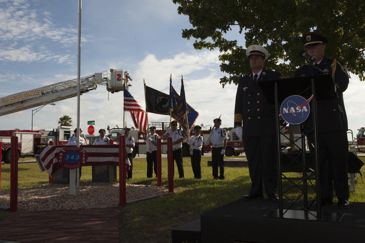
Rick Anderson, fire chief at NASA's Kennedy Space Center, on podium, left, and Lt. James Dumont lead the dedication service for a memorial to the343 first responder victims of the Sept. 11, 2001, terror attacks at Kennedy's Fire Station 1 on Sept. 11, 2015. The ceremony dedicated a monument that includes a section of steel I-beam from the World Trade Center in New York.
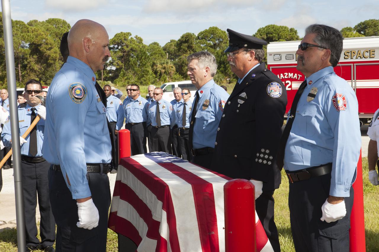
Rick Anderson, fire chief at NASA's Kennedy Space Center, on podium, left, and Brevard County Sheriff Wayne Ivey take part in the dedication service for a memorial to the 343 first responder victims of the Sept. 11, 2001, terror attacks at Kennedy's Fire Station 1 on Sept. 11, 2015. The ceremony dedicated a monument that includes a section of steel I-beam from the World Trade Center in New York.
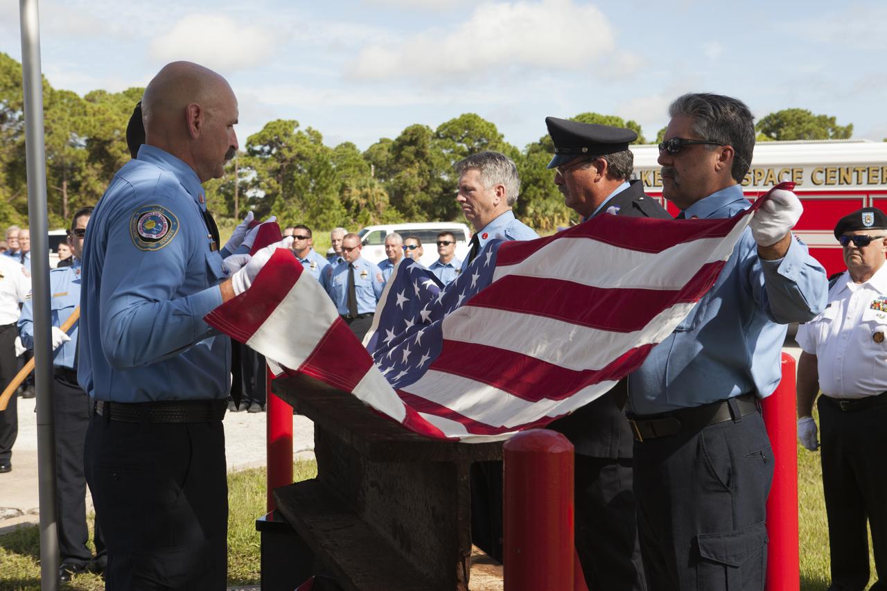
An honor guard folds an American flag during the dedication service for a memorial to the 343 first responder victims of the Sept. 11, 2001, terror attacks at Fire Station 1 at NASA's Kennedy Space Center on Sept. 11, 2015. The ceremony dedicated a monument that includes a section of steel I-beam from the World Trade Center in New York.
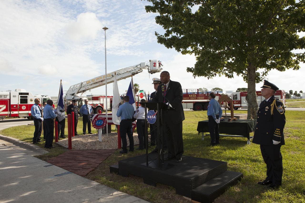
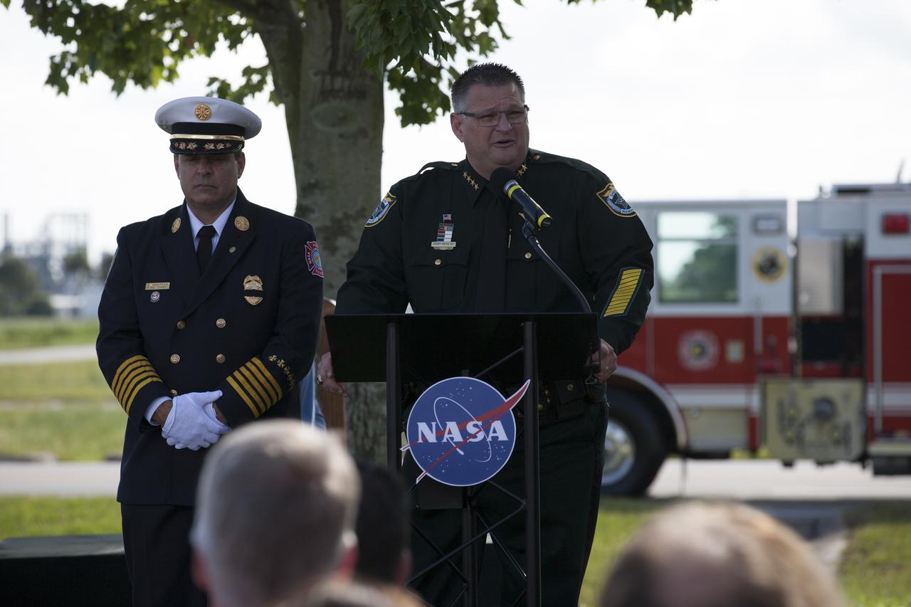
Kelvin Manning, associate director of NASA's Kennedy Space Center, speaks during the dedication service for a memorial to the 343 first responder victims of the Sept. 11, 2001, terror attacks at Fire Station 1 at Kennedy on Sept. 11, 2015. The ceremony dedicated a monument that includes a section of steel I-beam from the World Trade Center in New York.
An honor guard folds an American flag during the dedication service for a memorial to the 343 first responder victims of the Sept. 11, 2001, terror attacks at Fire Station 1 at NASA's Kennedy Space Center on Sept. 11, 2015. The ceremony dedicated a monument that includes a section of steel I-beam from the World Trade Center in New York.
Firefighters place the American flag at half-staff during dedication services for a memorial to the 343 first responder victims of the Sept. 11, 2001, terror attacks at Fire Station 1 at NASA's Kennedy Space Center on Sept. 11, 2015. A section of steel I-beam from the World Trade Center in New York forms the centerpiece of the monument.

The Brevard Police and Fire Pipe and Drum corps perform during the dedication service for a memorial to the 343 first responder victims of the Sept. 11, 2001, terror attacks at Fire Station 1 at NASA's Kennedy Space Center on Sept. 11, 2015. The ceremony dedicated a monument that includes a section of steel I-beam from the World Trade Center in New York.
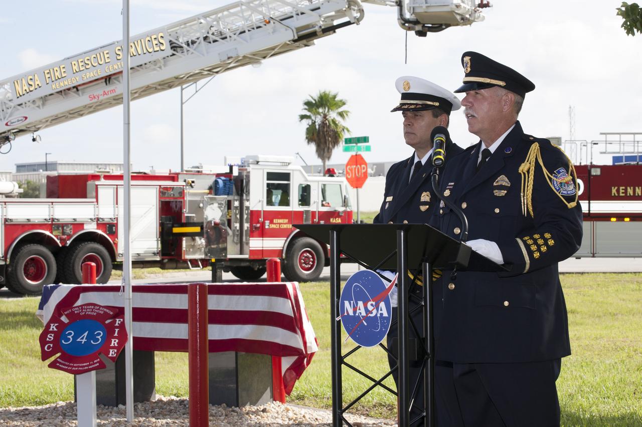
Rick Anderson, fire chief at NASA's Kennedy Space Center, on podium, left, and Lt. James Dumont lead the dedication service for a memorial to the 343 first responder victims of the Sept. 11, 2001, terror attacks at Kennedy's Fire Station 1 on Sept. 11, 2015. The ceremony dedicated a monument that includes a section of steel I-beam from the World Trade Center in New York.

An honor guard folds an American flag during the dedication service for a memorial to the 343 first responder victims of the Sept. 11, 2001, terror attacks at Fire Station 1 at NASA's Kennedy Space Center on Sept. 11, 2015. The ceremony dedicated a monument that includes a section of steel I-beam from the World Trade Center in New York.
VANDENBERG AIR FORCE BASE, Calif. – The sun sets over the West Cost prior to the launch gantry being rolled back to reveal the United Launch Alliance Delta II rocket with the Soil Moisture Active Passive, or SMAP, satellite aboard, at the Space Launch Complex 2 at Vandenberg Air Force Base, California. SMAP is a remote sensing mission designed to measure and map the Earth's soil moisture distribution and freeze/thaw stat with unprecedented accuracy, resolution and coverage. SMAP will provide global measurements of soil moisture and its freeze/thaw state. These measurements will be used to enhance understanding of processes that link the water, energy and carbon cycles, and to extend the capabilities of weather and climate prediction models. SMAP data also will be used to quantify net carbon flux in boreal landscapes and to develop improved flood prediction and drought monitoring capabilities. Launch is scheduled for Jan. 29, 2015. To learn more about SMAP, visit http://smap.jpl.nasa.gov Photo credit: NASA/Randy Beaudoin
VANDENBERG AIR FORCE BASE, Calif. – The sun sets over the West Cost prior to the launch gantry being rolled back to reveal the United Launch Alliance Delta II rocket with the Soil Moisture Active Passive, or SMAP, satellite aboard, at the Space Launch Complex 2 at Vandenberg Air Force Base, California. SMAP is a remote sensing mission designed to measure and map the Earth's soil moisture distribution and freeze/thaw stat with unprecedented accuracy, resolution and coverage. SMAP will provide global measurements of soil moisture and its freeze/thaw state. These measurements will be used to enhance understanding of processes that link the water, energy and carbon cycles, and to extend the capabilities of weather and climate prediction models. SMAP data also will be used to quantify net carbon flux in boreal landscapes and to develop improved flood prediction and drought monitoring capabilities. Launch is scheduled for Jan. 29, 2015. To learn more about SMAP, visit http://smap.jpl.nasa.gov Photo credit: NASA/Randy Beaudoin
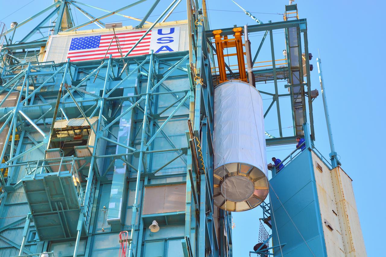
VANDENBERG AIR FORCE BASE, Calif. – Technicians connect NASA's Soil Moisture Active Passive, or SMAP, spacecraft to the Delta II payload attach structure in the Astrotech payload processing facility on Vandenberg Air Force Base in California. The structure will secure the spacecraft to the rocket's second stage. SMAP will launch on a Delta II 7320 configuration vehicle featuring a United Launch Alliance first stage booster powered by an Aerojet Rocketdyne RS-27A main engine and three Alliant Techsystems, or ATK, strap-on solid rocket motors. Once on station in Earth orbit, SMAP will provide global measurements of soil moisture and its freeze/thaw state. These measurements will be used to enhance understanding of processes that link the water, energy and carbon cycles, and to extend the capabilities of weather and climate prediction models. SMAP data also will be used to quantify net carbon flux in boreal landscapes and to develop improved flood prediction and drought monitoring capabilities. Launch from Space Launch Complex 2 is targeted for Jan. 29, 2015. To learn more about SMAP, visit http://www.nasa.gov/smap. Photo credit: NASA/Chris Wiant, U.S. Air Force Photo Squadron
VANDENBERG AIR FORCE BASE, Calif. – NASA's Soil Moisture Active Passive, or SMAP, spacecraft is lowered onto the Delta II payload attach structure in the Astrotech payload processing facility on Vandenberg Air Force Base in California. The structure will secure the spacecraft to the rocket's second stage. SMAP will launch on a Delta II 7320 configuration vehicle featuring a United Launch Alliance first stage booster powered by an Aerojet Rocketdyne RS-27A main engine and three Alliant Techsystems, or ATK, strap-on solid rocket motors. Once on station in Earth orbit, SMAP will provide global measurements of soil moisture and its freeze/thaw state. These measurements will be used to enhance understanding of processes that link the water, energy and carbon cycles, and to extend the capabilities of weather and climate prediction models. SMAP data also will be used to quantify net carbon flux in boreal landscapes and to develop improved flood prediction and drought monitoring capabilities. Launch from Space Launch Complex 2 is targeted for Jan. 29, 2015. To learn more about SMAP, visit http://www.nasa.gov/smap. Photo credit: NASA/Chris Wiant, U.S. Air Force Photo Squadron

VANDENBERG AIR FORCE BASE, Calif. – Technicians connect NASA's Soil Moisture Active Passive, or SMAP, spacecraft to the Delta II payload attach structure in the Astrotech payload processing facility on Vandenberg Air Force Base in California. The structure will secure the spacecraft to the rocket's second stage. SMAP will launch on a Delta II 7320 configuration vehicle featuring a United Launch Alliance first stage booster powered by an Aerojet Rocketdyne RS-27A main engine and three Alliant Techsystems, or ATK, strap-on solid rocket motors. Once on station in Earth orbit, SMAP will provide global measurements of soil moisture and its freeze/thaw state. These measurements will be used to enhance understanding of processes that link the water, energy and carbon cycles, and to extend the capabilities of weather and climate prediction models. SMAP data also will be used to quantify net carbon flux in boreal landscapes and to develop improved flood prediction and drought monitoring capabilities. Launch from Space Launch Complex 2 is targeted for Jan. 29, 2015. To learn more about SMAP, visit http://www.nasa.gov/smap. Photo credit: NASA/Chris Wiant, U.S. Air Force Photo Squadron
VANDENBERG AIR FORCE BASE, Calif. – Preparations are underway to attach NASA's Soil Moisture Active Passive, or SMAP, spacecraft to the Delta II payload attach structure in the Astrotech payload processing facility on Vandenberg Air Force Base in California. The structure will secure the spacecraft to the rocket's second stage. SMAP will launch on a Delta II 7320 configuration vehicle featuring a United Launch Alliance first stage booster powered by an Aerojet Rocketdyne RS-27A main engine and three Alliant Techsystems, or ATK, strap-on solid rocket motors. Once on station in Earth orbit, SMAP will provide global measurements of soil moisture and its freeze/thaw state. These measurements will be used to enhance understanding of processes that link the water, energy and carbon cycles, and to extend the capabilities of weather and climate prediction models. SMAP data also will be used to quantify net carbon flux in boreal landscapes and to develop improved flood prediction and drought monitoring capabilities. Launch from Space Launch Complex 2 is targeted for Jan. 29, 2015. To learn more about SMAP, visit http://www.nasa.gov/smap. Photo credit: NASA/Chris Wiant, U.S. Air Force Photo Squadron
VANDENBERG AIR FORCE BASE, Calif. – Preparations are underway to attach NASA's Soil Moisture Active Passive, or SMAP, spacecraft to the Delta II payload attach structure in the Astrotech payload processing facility on Vandenberg Air Force Base in California. The structure will secure the spacecraft to the rocket's second stage. SMAP will launch on a Delta II 7320 configuration vehicle featuring a United Launch Alliance first stage booster powered by an Aerojet Rocketdyne RS-27A main engine and three Alliant Techsystems, or ATK, strap-on solid rocket motors. Once on station in Earth orbit, SMAP will provide global measurements of soil moisture and its freeze/thaw state. These measurements will be used to enhance understanding of processes that link the water, energy and carbon cycles, and to extend the capabilities of weather and climate prediction models. SMAP data also will be used to quantify net carbon flux in boreal landscapes and to develop improved flood prediction and drought monitoring capabilities. Launch from Space Launch Complex 2 is targeted for Jan. 29, 2015. To learn more about SMAP, visit http://www.nasa.gov/smap. Photo credit: NASA/Chris Wiant, U.S. Air Force Photo Squadron
VANDENBERG AIR FORCE BASE, Calif. – The sun sets over the West Cost prior to the launch gantry being rolled back to reveal the United Launch Alliance Delta II rocket with the Soil Moisture Active Passive, or SMAP, satellite aboard, at the Space Launch Complex 2 at Vandenberg Air Force Base, California. SMAP is a remote sensing mission designed to measure and map the Earth's soil moisture distribution and freeze/thaw stat with unprecedented accuracy, resolution and coverage. SMAP will provide global measurements of soil moisture and its freeze/thaw state. These measurements will be used to enhance understanding of processes that link the water, energy and carbon cycles, and to extend the capabilities of weather and climate prediction models. SMAP data also will be used to quantify net carbon flux in boreal landscapes and to develop improved flood prediction and drought monitoring capabilities. Launch is scheduled for Jan. 29, 2015. To learn more about SMAP, visit http://smap.jpl.nasa.gov Photo credit: NASA/Randy Beaudoin
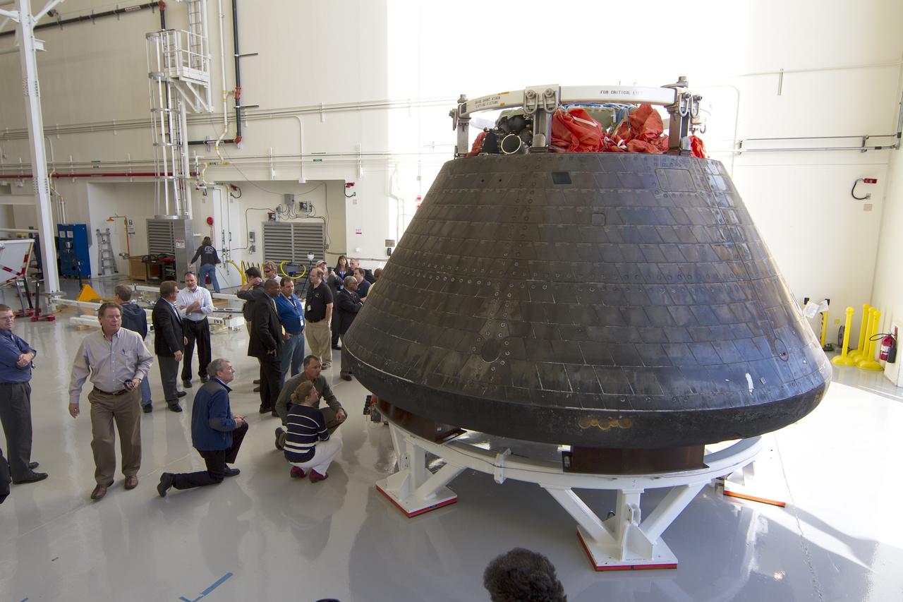
CAPE CANAVERAL, Fla. -- NASA Administrator Charlie Bolden, standing near Orion, looked over the agency's spacecraft this morning for the first time since it returned to Kennedy Space Center following the successful Orion flight test on Dec. 5. Bearing the marks of a spacecraft that has returned to Earth through a searing plunge into the atmosphere, Orion is perched on a pedestal inside the Launch Abort System Facility at Kennedy where it is going through post-mission processing. Although the spacecraft Bolden looked over did not fly with a crew aboard during the flight test, Orion is designed to carry astronauts into deep space in the future setting NASA and the nation firmly on the journey to Mars. Photo credit: NASA/Cory Huston

The sun emitted a mid-level solar flare, peaking at 11:24 p.m. EST on Jan. 12, 2015. NASA’s Solar Dynamics Observatory, which watches the sun constantly, captured an image of the event. Solar flares are powerful bursts of radiation. Harmful radiation from a flare cannot pass through Earth's atmosphere to physically affect humans on the ground, however -- when intense enough -- they can disturb the atmosphere in the layer where GPS and communications signals travel. This flare is classified as an M5.6-class flare. M-class flares are a tenth the size of the most intense flares, the X-class flares. The number provides more information about its strength. An M2 is twice as intense as an M1, an M3 is three times as intense, etc. Credit: NASA/Goddard/SDO <b><a href="http://www.nasa.gov/audience/formedia/features/MP_Photo_Guidelines.html" rel="nofollow">NASA image use policy.</a></b> <b><a href="http://www.nasa.gov/centers/goddard/home/index.html" rel="nofollow">NASA Goddard Space Flight Center</a></b> enables NASA’s mission through four scientific endeavors: Earth Science, Heliophysics, Solar System Exploration, and Astrophysics. Goddard plays a leading role in NASA’s accomplishments by contributing compelling scientific knowledge to advance the Agency’s mission. <b>Follow us on <a href="http://twitter.com/NASAGoddardPix" rel="nofollow">Twitter</a></b> <b>Like us on <a href="http://www.facebook.com/pages/Greenbelt-MD/NASA-Goddard/395013845897?ref=tsd" rel="nofollow">Facebook</a></b> <b>Find us on <a href="http://instagram.com/nasagoddard?vm=grid" rel="nofollow">Instagram</a></b>
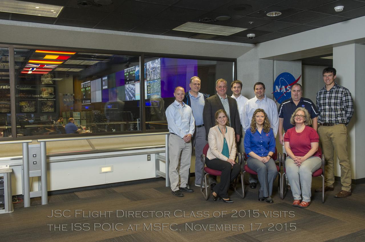
JSC FLIGHT DIRECTOR CLASS OF 2015 VISITS THE INTERNATIONAL SPACE STATION PAYLOAD OPERATION INTEGRATION CENTER AT MSFC, NOVEMBER 17, 2015
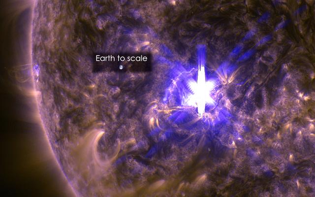
The sun emitted a significant solar flare, peaking at 12:22 p.m. EDT on March 11, 2015. NASA’s Solar Dynamics Observatory, which watches the sun constantly, captured an image of the event. Solar flares are powerful bursts of radiation. Harmful radiation from a flare cannot pass through Earth's atmosphere to physically affect humans on the ground, however -- when intense enough -- they can disturb the atmosphere in the layer where GPS and communications signals travel. This flare is classified as an X2.2-class flare. X-class denotes the most intense flares, while the number provides more information about its strength. An X2 is twice as intense as an X1, an X3 is three times as intense, etc. This image was captured by NASA's Solar Dynamics Observatory and shows a blend of light from the 171 and 131 Ångström wavelengths. The Earth is shown to scale. Credit: NASA/Goddard/SDO <b><a href="http://www.nasa.gov/audience/formedia/features/MP_Photo_Guidelines.html" rel="nofollow">NASA image use policy.</a></b> <b><a href="http://www.nasa.gov/centers/goddard/home/index.html" rel="nofollow">NASA Goddard Space Flight Center</a></b> enables NASA’s mission through four scientific endeavors: Earth Science, Heliophysics, Solar System Exploration, and Astrophysics. Goddard plays a leading role in NASA’s accomplishments by contributing compelling scientific knowledge to advance the Agency’s mission. <b>Follow us on <a href="http://twitter.com/NASAGoddardPix" rel="nofollow">Twitter</a></b> <b>Like us on <a href="http://www.facebook.com/pages/Greenbelt-MD/NASA-Goddard/395013845897?ref=tsd" rel="nofollow">Facebook</a></b> <b>Find us on <a href="http://instagram.com/nasagoddard?vm=grid" rel="nofollow">Instagram</a></b>

CAPE CANAVERAL, Fla. - At NASA's Kennedy Space Center in Florida, STS-131 Mission Specialist Clayton Anderson takes his instructor, Battalion Chief David Seymour, for a ride in an M-113 armored personnel carrier during driving practice. An M-113 is kept at the foot of the launch pad in case an emergency egress from the vicinity of the pad is needed. The crew members of space shuttle Discovery's STS-131 mission are at Kennedy for training related to their launch dress rehearsal, the Terminal Countdown Demonstration Test. The seven-member crew will deliver the multi-purpose logistics module Leonardo, filled with resupply stowage platforms and racks, to the International Space Station aboard Discovery. Targeted for launch on April 5, STS-131 will be the 33rd shuttle mission to the station and the 131st shuttle mission overall. For information on the STS-131 mission and crew, visit http:__www.nasa.gov_mission_pages_shuttle_shuttlemissions_sts131_index.html. Photo credit: NASA_Kim Shiflett
VANDENBERG AFB, Calif. – Technicians begin processing NASA's IRIS spacecraft at Vandenberg where the spacecraft will be readied for launch aboard an Orbital Sciences Pegasus XL rocket. IRIS is short for Interface Region Imaging Spectrograph and the spacecraft's mission will improve our understanding of how heat and energy move through the deepest levels of the sun’s atmosphere, thereby increasing our ability to forecast space weather. Photo credit: VAFB_Tony Vauelin
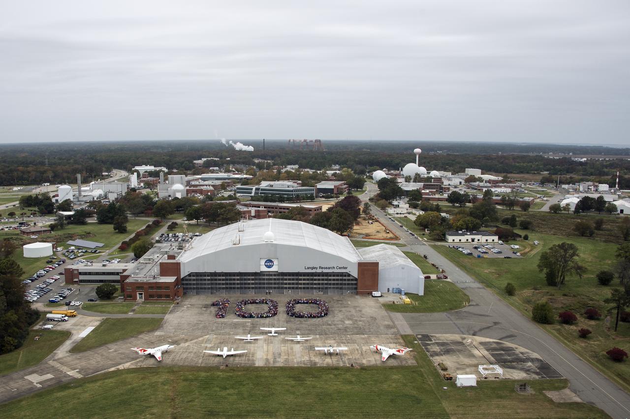
Aerial photos of NASA Langley employees gathered on the back ramp in the shape of 100.

Aerial photos of NASA Langley employees gathered on the back ramp in the shape of 100.

Aerial photos of NASA Langley employees gathered on the back ramp in the shape of 100.
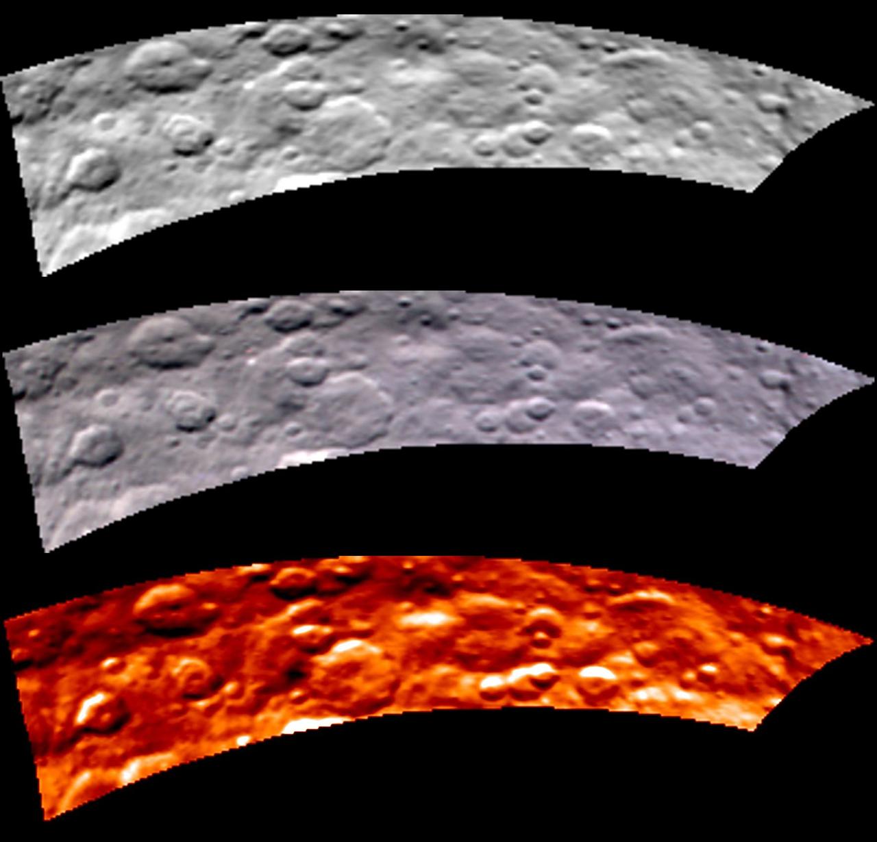
Images from Dawn's visible and infrared mapping spectrometer (VIR) show a portion of Ceres' cratered northern hemisphere, taken on May 16, 2015. From top to bottom, the views include a black-and-white image, a true-color view and a temperature image. The true-color view contains reddish dots that are image artifacts, which are not part of Ceres' surface. These images were taken at a distance of 4,500 miles (7,300 kilometers) from Ceres. They have a resolution of 1.1 miles (1.8 kilometers) per pixel. The temperature image is derived from data in the infrared light range. The lightest areas are the hottest and the darkest are the coolest. http://photojournal.jpl.nasa.gov/catalog/PIA19571

NASA data and expertise are providing valuable information for the ongoing response to the April 25, 2015, magnitude 7.8 Gorkha earthquake in Nepal.
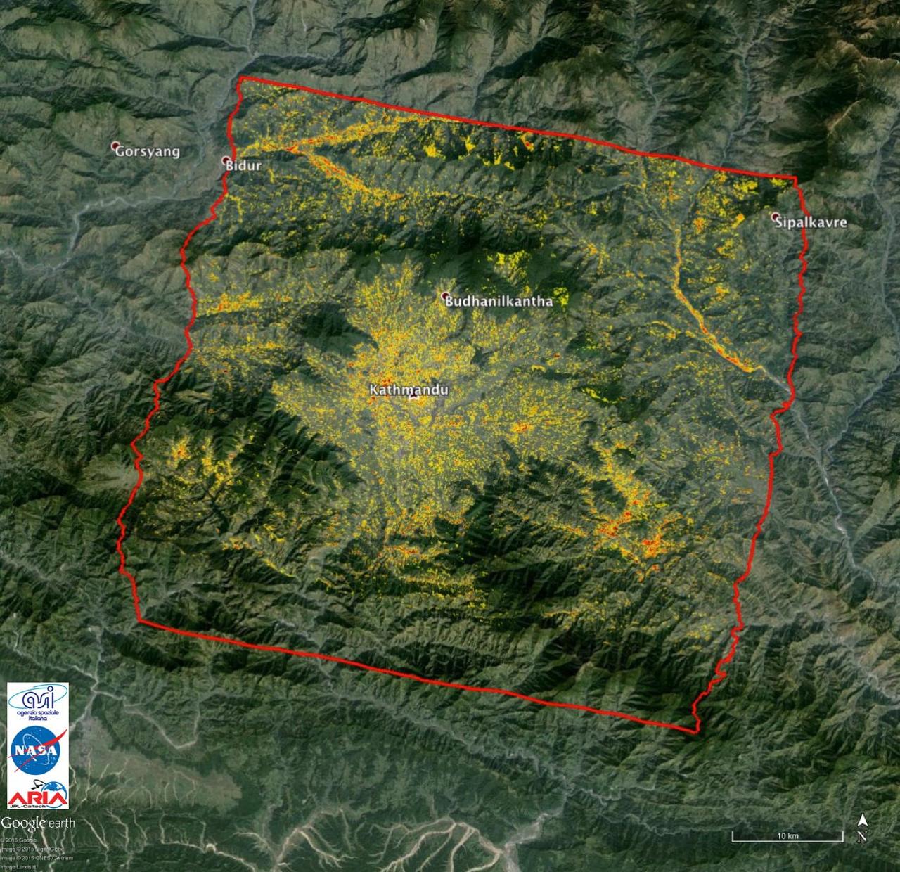
NASA data and expertise are providing valuable information for the ongoing response to the April 25, 2015, magnitude 7.8 Gorkha earthquake in Nepal.
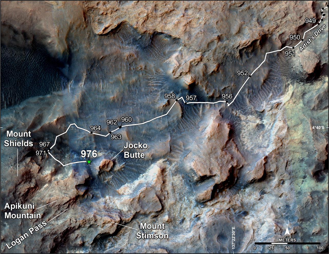
This map shows the route on lower Mount Sharp that NASA's Curiosity followed in April and early May 2015, in the context of the surrounding terrain. Numbers along the route identify the sol, or Martian day, on which it completed the drive reaching that point, as counted since its 2012 landing. The map covers an area about one-third of a mile (half a kilometer) across. North is up. The base image is from the High Resolution Science Experiment (HiRISE) camera on NASA's Mars Reconnaissance Orbiter. Curiosity departed the "Pahrump Hills" outcrop -- mostly off the upper right corner of the map -- through "Artist's Drive" valley. The Sol 949 drive was completed on April 7, 2015. A HiRISE image actually showing Curiosity at that spot is at PIA19392. At that time, the rover's next planned science destination was "Logan Pass," an area where two geological units meet. At the Sol 951 location, Curiosity's Mast Camera (Mastcam) took component images for a sweeping panorama to the south and southwest, at PIA19397 and http://mars.nasa.gov/msl/multimedia/deepzoom/PIA19397. At the Sol 956 location, the Mastcam took component images for a westward panorama, at PIA19398 and http://mars.nasa.gov/msl/multimedia/deepzoom/PIA19398. From views such as these, Curiosity's science team selected an additional site for close inspection, at the base of a rise called "Mount Shields." The rover arrived there with the Sol 967 drive, completed on April 26, 2015. After the observations and measurements made by Curiosity's instruments at the base of Mount Shields, the rover resumed its approach to Logan Pass, on a route passing west of "Jocko Butte." The Sol 976 drive was completed on May 5, 2015. http://photojournal.jpl.nasa.gov/catalog/PIA19399

National Librarians Week