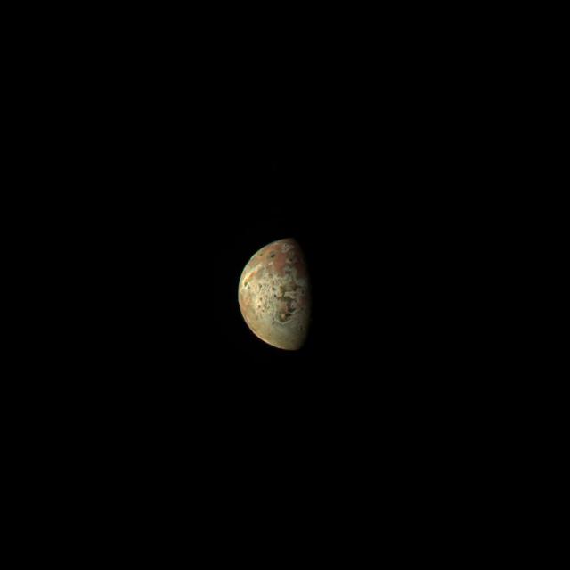
This image of the Jovian moon Io was generated using data collected by the JunoCam imager aboard NASA's Juno spacecraft during a flyby of the moon on March 1, 2023. At the time of closest approach, Juno was about 32,000 miles (51,500 kilometers) away from Io. The image's resolution is about 22 miles (35 kilometers) per pixel. Citizen scientist Kevin M. Gill created this image using data from JunoCam. https://photojournal.jpl.nasa.gov/catalog/PIA25885
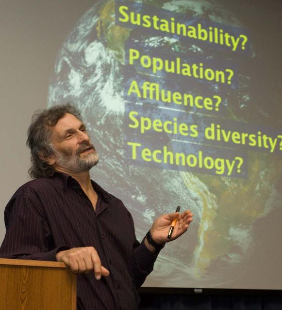
Director's Colloquium; Dr Jonathan Trent, Physical Scientist with NASA Ames Bioengineering Branch presents 'OMEGA and the Future of Aviation Fuels) Abstract: Offshore Membrane Enclosures for Growing Algae (OMEGA) is an innovative approach to growing oil-producing, freshwater algea in off shore enclosures, using municipal wastewater that is currently dumped into the ocean at a rate of >35 billion gals/day.
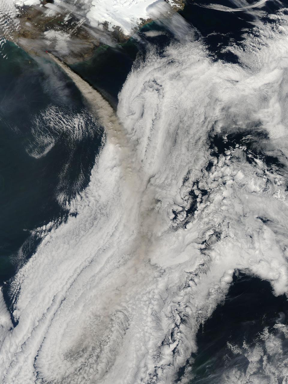
NASA image acquired May 8, 2010 at 13 :35 UTC Ash plume from Eyjafjallajokull Volcano, Iceland Satellite: Aqua NASA/GSFC/Jeff Schmaltz/MODIS Land Rapid Response Team <b><a href="http://www.nasa.gov/centers/goddard/home/index.html" rel="nofollow">NASA Goddard Space Flight Center</a></b> is home to the nation's largest organization of combined scientists, engineers and technologists that build spacecraft, instruments and new technology to study the Earth, the sun, our solar system, and the universe.
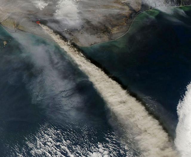
NASA image acquired May 8, 2010 at 13 :35 UTC Ash plume from Eyjafjallajokull Volcano, Iceland Satellite: Aqua NASA/GSFC/Jeff Schmaltz/MODIS Land Rapid Response Team <b><a href="http://www.nasa.gov/centers/goddard/home/index.html" rel="nofollow">NASA Goddard Space Flight Center</a></b> is home to the nation's largest organization of combined scientists, engineers and technologists that build spacecraft, instruments and new technology to study the Earth, the sun, our solar system, and the universe.

Director's Colloquium; Dr Jonathan Trent, Physical Scientist with NASA Ames Bioengineering Branch presents 'OMEGA and the Future of Aviation Fuels) Abstract: Offshore Membrane Enclosures for Growing Algae (OMEGA) is an innovative approach to growing oil-producing, freshwater algea in off shore enclosures, using municipal wastewater that is currently dumped into the ocean at a rate of >35 billion gals/day.
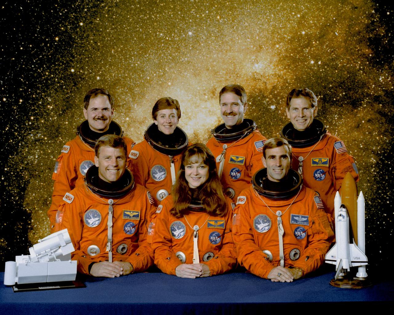
STS067-S-002 (December 1994) --- Five NASA astronauts and two payload specialists from the private sector have been named to fly aboard the Space Shuttle Endeavour for the STS-67/ASTRO-2 mission, scheduled for March 1995. In front are astronauts (left to right) Stephen S. Oswald, mission commander; Tamara E. Jernigan, payload commander; and William G. Gregory, pilot. In the back are (left to right) Ronald A. Parise, payload specialist; astronauts Wendy B. Lawrence, and John M. Grunsfeld, both mission specialists; and Samuel T. Durrance, payload specialist. Dr. Durrance is a research scientist in the Department of Physics and Astronomy at Johns Hopkins University, Baltimore, Maryland. Dr. Parise is a senior scientist in the Space Observatories Department, Computer Sciences Corporation, Silver Spring, Maryland. Both payload specialist's flew aboard the Space Shuttle Columbia for the STS-35/ASTRO-1 mission in December 1990.
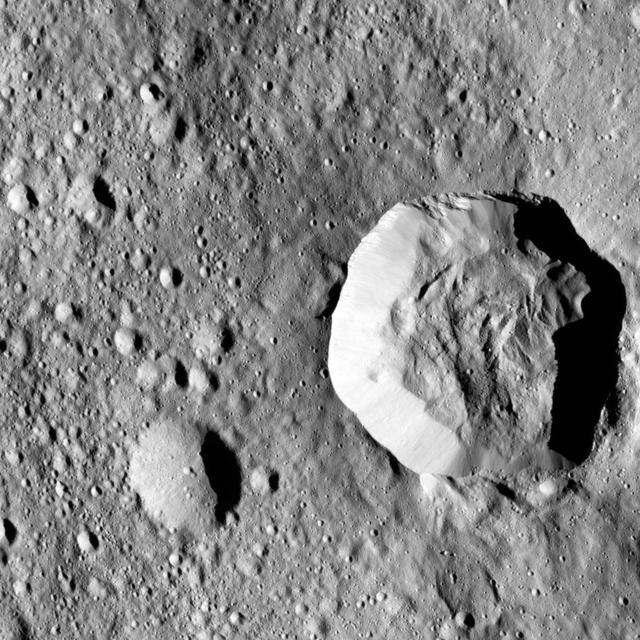
Scientists created this stereo view, called an anaglyph, with two images of the same part of Ceres's surface taken by Dawn on different orbits and from different viewing angles. The images were artificially colored and combined so that when viewed through glasses with a red filter on the left and blue on the right, they provide a 3-D view. The images used in this anaglyph were obtained by NASA's Dawn spacecraft from an altitude of about 22 miles (35 kilometers). The center of this image is located at about 18.9 degrees north latitude and 239.4 degrees east longitude. https://photojournal.jpl.nasa.gov/catalog/PIA22864
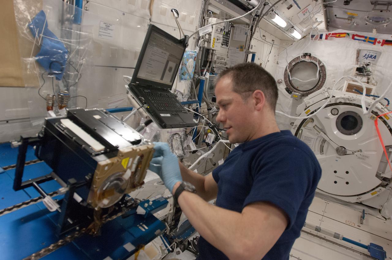
ISS035e006147 (19 March 2013) --- NASA astronaut Tom Marshburn, Expedition 35 flight engineer, works on the Marangoni Inside core cleaning in the Kibo Japanese Experiment Module onboard the Earth-orbiting International Space Station. Marangoni convection is the flow driven by the presence of a surface tension gradient which can be produced by temperature difference at a liquid/gas interface. The convection in liquid bridge of silicone oil is generated by heating the one disc higher than the other. Scientists are observing flow patterns of how fluids move to learn more about how heat is transferred in microgravity.
NASA New Horizons scientists believe that the informally named feature Wright Mons, located south of Sputnik Planum on Pluto, and another, Piccard Mons, could have been formed by the cryovolcanic eruption of ices from beneath Pluto surface. Sputnik Planum on Pluto, is an unusual feature that's about 100 miles (160 kilometers) wide and 13,000 feet (4 kilometers) high. It displays a summit depression (visible in the center of the image) that's approximately 35 miles (56 kilometers) across, with a distinctive hummocky texture on its sides. The rim of the summit depression also shows concentric fracturing. http://photojournal.jpl.nasa.gov/catalog/PIA20155
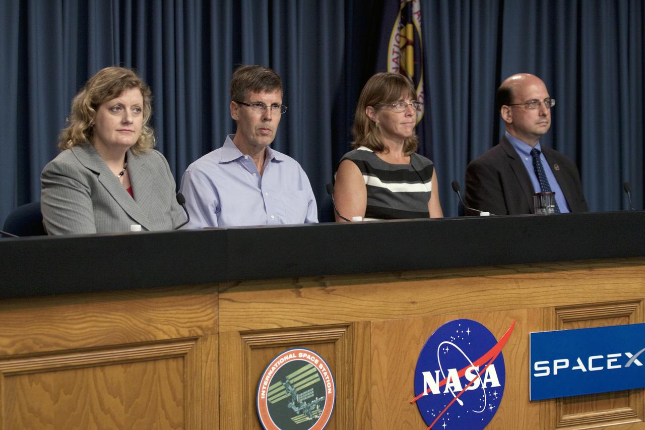
CAPE CANAVERAL, Fla. -- Scientists participate in a space station and mission science briefing in NASA Kennedy Space Center's Press Site auditorium in Florida. From left are Julie Robinson, program scientist for International Space Station at NASA's Johnson Space Center, Timothy Yeatman, interim chief scientist at the Center for the Advancement of Science in Space, Sheila Nielsen-Preiss, cell biologist at Montana State University, and Scott Smith, NASA nutritionist at NASA's Johnson Space Center. The briefing provided media with an overview of the experiments and payloads scheduled for launch on NASA's first Commercial Resupply Services, or CRS-1, mission to the International Space Station. Space Exploration Technologies Corp., or SpaceX, built both the mission's Falcon 9 rocket and Dragon capsule. Launch is scheduled for 8:35 p.m. EDT on Oct. 7 from Space Launch Complex 40 on Cape Canaveral Air Force Station. SpaceX CRS-1 is an important step toward making America’s microgravity research program self-sufficient by providing a way to deliver and return significant amounts of cargo, including science experiments, to and from the orbiting laboratory. NASA has contracted for 12 commercial resupply flights from SpaceX and eight from the Orbital Sciences Corp. For more information, visit http://www.nasa.gov/mission_pages/station/living/launch/index.html. Photo credit: NASA/Kim Shiflett
NASA's Cassini spacecraft zoomed by Saturn's icy moon Enceladus on Oct. 14, 2015, capturing this stunning image of the moon's north pole. A companion view from the wide-angle camera (PIA20010) shows a zoomed out view of the same region for context. Scientists expected the north polar region of Enceladus to be heavily cratered, based on low-resolution images from the Voyager mission, but high-resolution Cassini images show a landscape of stark contrasts. Thin cracks cross over the pole -- the northernmost extent of a global system of such fractures. Before this Cassini flyby, scientists did not know if the fractures extended so far north on Enceladus. North on Enceladus is up. The image was taken in visible green light with the Cassini spacecraft narrow-angle camera. The view was acquired at a distance of approximately 4,000 miles (6,000 kilometers) from Enceladus and at a Sun-Enceladus-spacecraft, or phase, angle of 9 degrees. Image scale is 115 feet (35 meters) per pixel. http://photojournal.jpl.nasa.gov/catalog/PIA19660
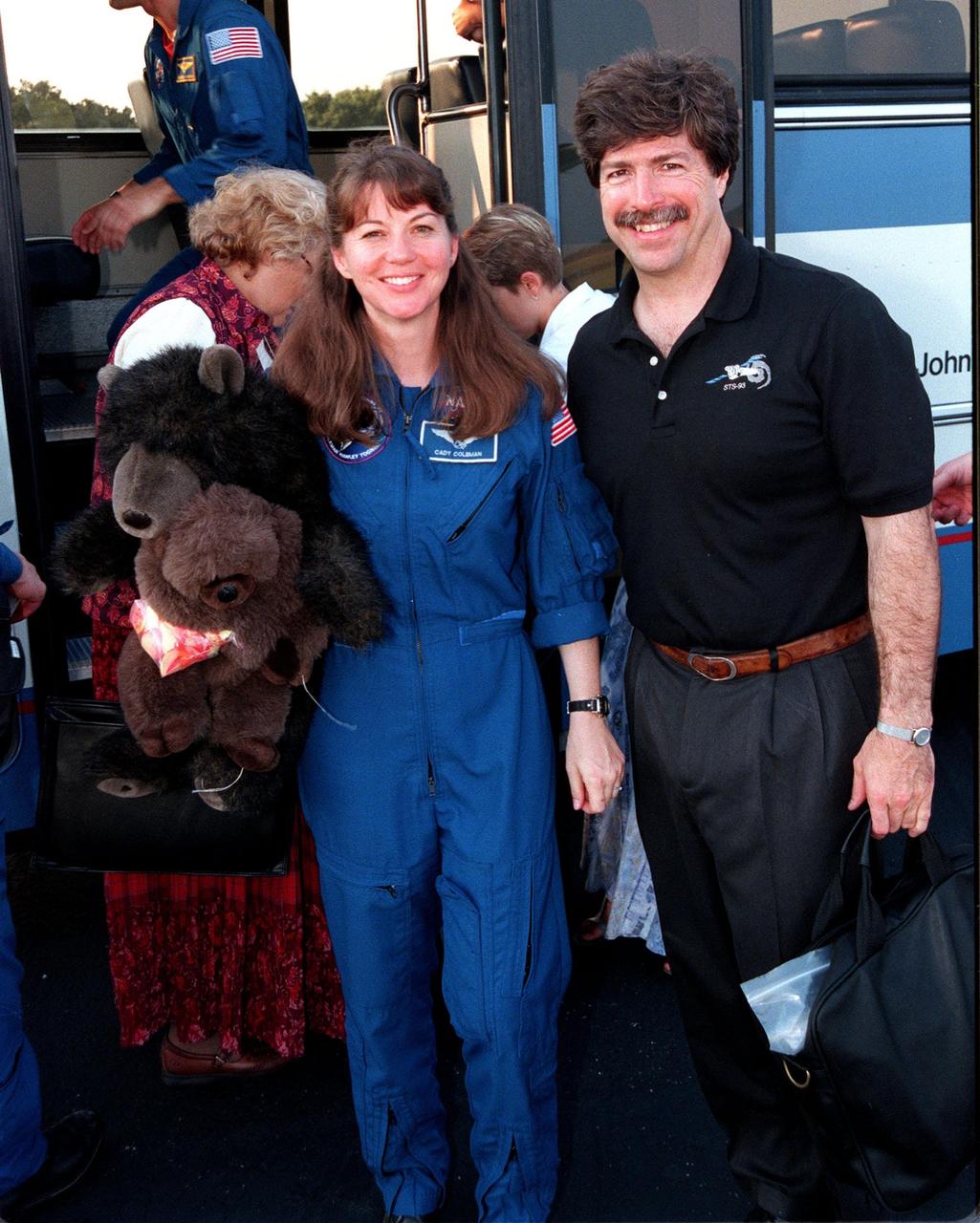
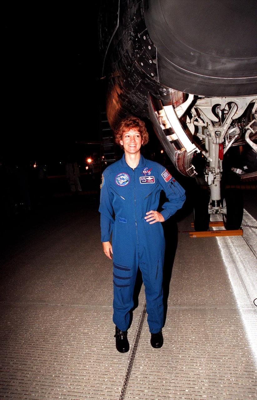
At the Skid Strip at the Cape Canaveral Air Station, Mission Specialist Catherine G. Coleman (Ph.D.) and her husband, Josh Simpson, prepare to board an aircraft for their return flight to Houston following the completion of the STS-93 Space Shuttle mission. Landing occurred on runway 33 at KSC's Shuttle Landing Facility on July 27 with main gear touchdown at 11:20:35 p.m. EDT. The mission's primary objective was to deploy the Chandra X-ray Observatory, which will allow scientists from around the world to study some of the most distant, powerful and dynamic objects in the universe. This was the 95th flight in the Space Shuttle program and the 26th for Columbia. The landing was the 19th consecutive Shuttle landing in Florida and the 12th night landing in Shuttle program history. On this mission, Eileen Collins became the first woman to serve as a Shuttle commander
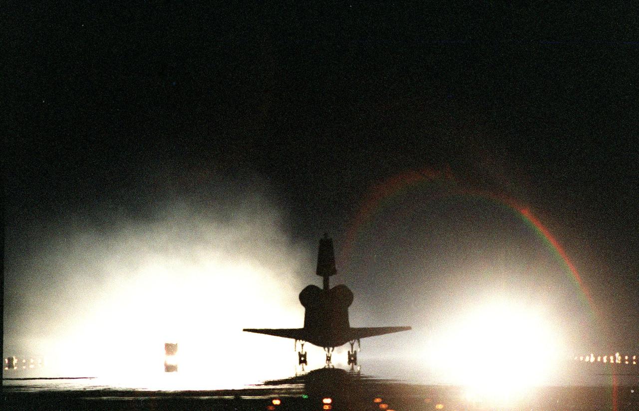
KENNEDY SPACE CENTER, Fla. -- The Space Shuttle orbiter Columbia touches down on runway 33 at the Shuttle Landing Facility after a successful mission of nearly five days and 1.8 million miles. Main gear touchdown was at 11:20:35 p.m. EDT on July 27. Aboard are the STS-93 crew members: Commander Eileen M. Collins, Pilot Jeffrey S. Ashby, and Mission Specialists Steven A. Hawley (Ph.D.), Catherine G. Coleman (Ph.D.) and Michel Tognini of France, with the Centre National d'Etudes Spatiales (CNES). The mission's primary objective was to deploy the Chandra X-ray Observatory, which will allow scientists from around the world to study some of the most distant, powerful and dynamic objects in the universe. This was the 95th flight in the Space Shuttle program and the 26th for Columbia. The landing was the 19th consecutive Shuttle landing in Florida and the 12th night landing in Shuttle program history
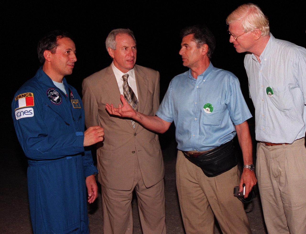
At the Shuttle Landing Facility (from left to right), STS-93 Mission Specialist Michel Tognini of France, representing the Centre National d'Etudes Spatiales (CNES), and NASA Administrator Daniel Goldin talk with Jacques Ratie, Astronaut Director, CNES, and Serge Plattard, International Relations, CNES. Landing occurred on runway 33 with main gear touchdown at 11:20:35 p.m. EDT on July 27. The mission's primary objective was to deploy the Chandra X-ray Observatory, which will allow scientists from around the world to study some of the most distant, powerful and dynamic objects in the universe. This was the 95th flight in the Space Shuttle program and the 26th for Columbia. The landing was the 19th consecutive Shuttle landing in Florida and the 12th night landing in Shuttle program history. On this mission, Eileen Collins became the first woman to serve as a Shuttle commander

At the Skid Strip at the Cape Canaveral Air Station, Mission Specialist Michel Tognini of France, representing the Centre National d'Etudes Spatiales (CNES), and his daughter Tatinana prepare to board an aircraft for their return flight to Houston following the completion of the STS-93 Space Shuttle mission. Landing occurred on runway 33 at KSC's Shuttle Landing Facility on July 27 with main gear touchdown at 11:20:35 p.m. EDT. The mission's primary objective was to deploy the Chandra X-ray Observatory, which will allow scientists from around the world to study some of the most distant, powerful and dynamic objects in the universe. This was the 95th flight in the Space Shuttle program and the 26th for Columbia. The landing was the 19th consecutive Shuttle landing in Florida and the 12th night landing in Shuttle program history. On this mission, Eileen Collins became the first woman to serve as a Shuttle commander

KENNEDY SPACE CENTER, FLA. -- At the Shuttle Landing Facility, NASA Administrator Daniel Goldin (foreground) talks with STS-93 Commander Eileen Collins beside the Space Shuttle orbiter Columbia following the successful completion of her mission. Marshall Space Flight Center Director Arthur G. Stephenson (far left) looks on. Landing occurred on runway 33 with main gear touchdown at 11:20:35 p.m. EDT on July 27. The mission's primary objective was to deploy the Chandra X-ray Observatory, which will allow scientists from around the world to study some of the most distant, powerful and dynamic objects in the universe. This was the 95th flight in the Space Shuttle program and the 26th for Columbia. The landing was the 19th consecutive Shuttle landing in Florida and the 12th night landing in Shuttle program history. On this mission, Collins became the first woman to serve as a Shuttle commander
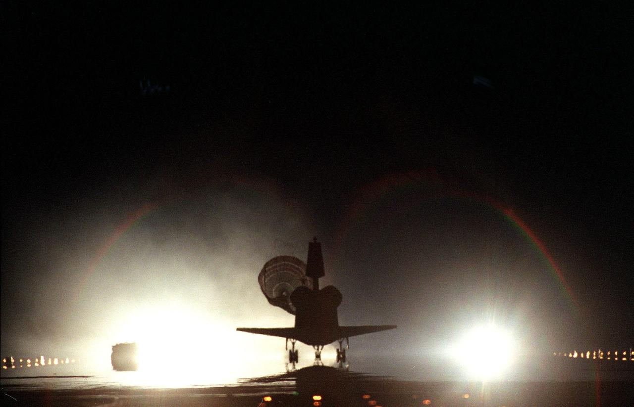
KENNEDY SPACE CENTER, Fla. -- The Space Shuttle orbiter Columbia, with its drag chute deployed, touches down on runway 33 at the Shuttle Landing Facility after a successful mission of nearly five days and 1.8 million miles. Main gear touchdown was at 11:20:35 p.m. EDT on July 27. Aboard are the STS-93 crew members: Commander Eileen M. Collins, Pilot Jeffrey S. Ashby, and Mission Specialists Steven A. Hawley (Ph.D.), Catherine G. Coleman (Ph.D.) and Michel Tognini of France, with the Centre National d'Etudes Spatiales (CNES). The mission's primary objective was to deploy the Chandra X-ray Observatory, which will allow scientists from around the world to study some of the most distant, powerful and dynamic objects in the universe. This was the 95th flight in the Space Shuttle program and the 26th for Columbia. The landing was the 19th consecutive Shuttle landing in Florida and the 12th night landing in Shuttle program history
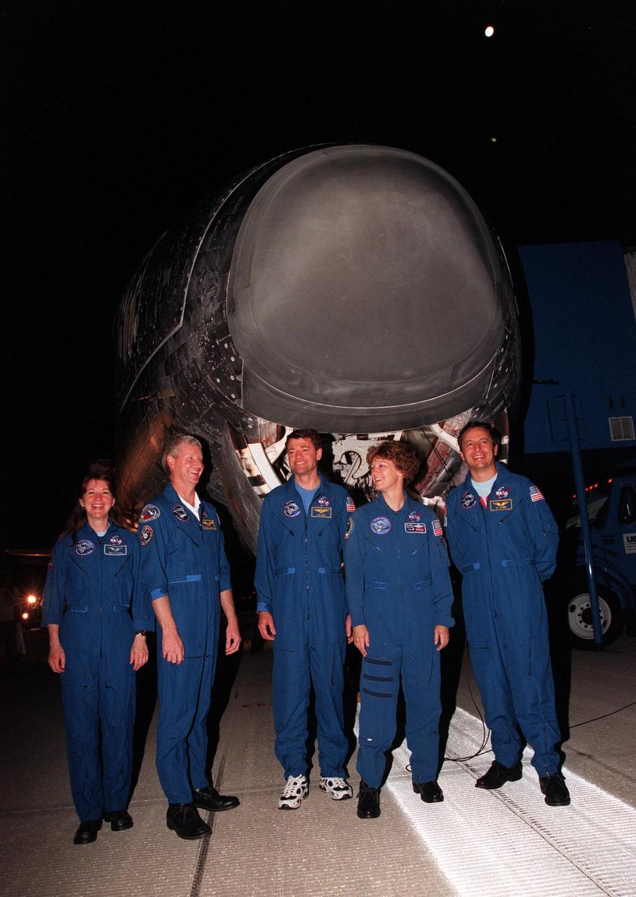
KENNEDY SPACE CENTER, FLA. -- The STS-93 crew pose in front of the Space Shuttle orbiter Columbia following their landing on runway 33 at the Shuttle Landing Facility. Main gear touchdown occurred at 11:20:35 p.m. EDT on July 27. From left to right, they are Mission Specialists Catherine G. Coleman (Ph.D.) and Steven A. Hawley (Ph.D.), Pilot Jeffrey S. Ashby, Commander Eileen Collins, and Mission Specialist Michel Tognini of France, with the Centre National d'Etudes Spatiales (CNES). The mission's primary objective was to deploy the Chandra X-ray Observatory, which will allow scientists from around the world to study some of the most distant, powerful and dynamic objects in the universe. This was the 95th flight in the Space Shuttle program and the 26th for Columbia. The landing was the 19th consecutive Shuttle landing in Florida and the 12th night landing in Shuttle program history. On this mission, Collins became the first woman to serve as a Shuttle commander

At the Skid Strip at the Cape Canaveral Air Station, Commander Eileen Collins and her daughter, Bridget Youngs, prepare to board an aircraft for their return flight to Houston following the completion of the STS-93 Space Shuttle mission. Landing occurred on runway 33 at KSC's Shuttle Landing Facility on July 27 with main gear touchdown at 11:20:35 p.m. EDT. The mission's primary objective was to deploy the Chandra X-ray Observatory, which will allow scientists from around the world to study some of the most distant, powerful and dynamic objects in the universe. This was the 95th flight in the Space Shuttle program and the 26th for Columbia. The landing was the 19th consecutive Shuttle landing in Florida and the 12th night landing in Shuttle program history. On this mission, Collins became the first woman to serve as a Shuttle commander

At the Skid Strip at the Cape Canaveral Air Station, Commander Eileen Collins and her daughter Bridget Youngs prepare to board an aircraft for their return flight to Houston following the completion of the STS-93 Space Shuttle mission. Landing occurred on runway 33 at KSC's Shuttle Landing Facility with main gear touchdown at 11:20:35 p.m. EDT on July 27. The mission's primary objective was to deploy the Chandra X-ray Observatory, which will allow scientists from around the world to study some of the most distant, powerful and dynamic objects in the universe. This was the 95th flight in the Space Shuttle program and the 26th for Columbia. The landing was the 19th consecutive Shuttle landing in Florida and the 12th night landing in Shuttle program history. On this mission, Collins became the first woman to serve as a Shuttle commander
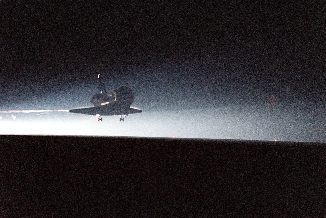
KENNEDY SPACE CENTER, Fla. -- The Space Shuttle orbiter Columbia swoops out of the darkness onto runway 33 at the Shuttle Landing Facility after a successful mission of nearly five days and 1.8 million miles. Main gear touchdown was at 11:20:35 p.m. EDT on July 27. Aboard are the STS-93 crew members: Commander Eileen M. Collins, Pilot Jeffrey S. Ashby, and Mission Specialists Steven A. Hawley (Ph.D.), Catherine G. Coleman (Ph.D.) and Michel Tognini of France, with the Centre National d'Etudes Spatiales (CNES). The mission's primary objective was to deploy the Chandra X-ray Observatory, which will allow scientists from around the world to study some of the most distant, powerful and dynamic objects in the universe. This was the 95th flight in the Space Shuttle program and the 26th for Columbia. The landing was the 19th consecutive Shuttle landing in Florida and the 12th night landing in Shuttle program history

This composite image of the Jovian moon Io was generated using data collected by the JunoCam imager aboard NASA's Juno spacecraft during four separate flybys. The resolution of the images gets progressively better as the distance between spacecraft and moon decreases with each flyby. The image of the moon on the far left has a resolution 44 miles (71 kilometers) per pixel. It was taken on April 9, 2022, during Juno's 41st orbit of Jupiter (perijove 41, or PJ41), when the spacecraft flew past Io at a distance of about 66,000 miles (106,000 kilometers). Note the gray, roughly triangular patch at the terminator near the moon's center. Citizen scientist Björn Jónsson created this image using data from JunoCam. The center-left image was acquired on July 5, 2022, during Juno's 43rd orbit of Jupiter (PJ43) at a distance of 53,000 miles (86,000 kilometers). The resolution in this image has improved to 36 miles (58 kilometers) per pixel. In this view, more detail of the gray patch is seen (from a different perspective). Citizen scientist Jason Perry created this image using data from JunoCam. By the time the center-right image of Io was taken on Dec. 14, 2022, (PJ47), the distance between spacecraft and moon had decreased to 40,000 miles (64,000 kilometers), which increased the resolution to 27 miles (43 kilometers) per pixel. Here, the gray triangle appears as three distinct volcanoes with the central vents visible as dark spots in their centers. Characteristics of other nearby volcanoes also begin to stand out. Citizen scientist Mike Ravine created this image using data from JunoCam. The far-right image, taken during Juno's 49th flyby (PJ49) on March 1, 2023, shows that the spacecraft again approached the moon from a changed perspective, allowing different territory on Io's surface to be viewed. The triplet of volcanoes that make up the gray triangular patch are visible near the top of the image, and more detail of the volcanic terrain can be made out. The altitude at the time of closest approach was about 32,000 miles (51,500 kilometers), allowing resolution to increase to 22 miles (35 kilometers) per pixel. Citizen scientist Kevin M. Gill created this image using data from JunoCam. https://photojournal.jpl.nasa.gov/catalog/PIA25887
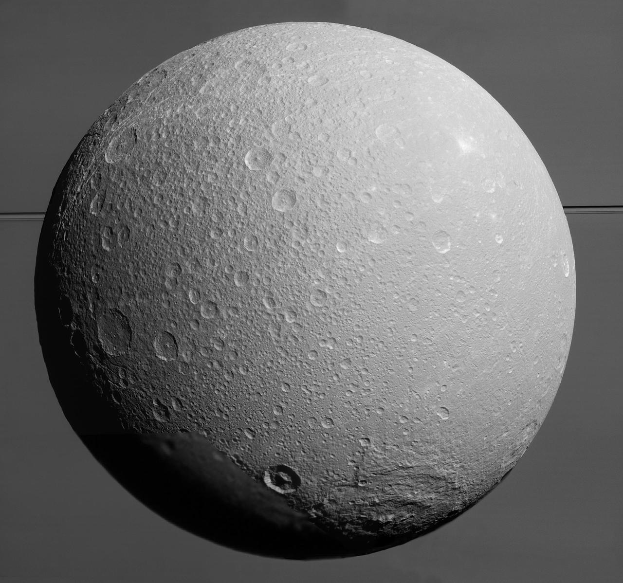
Saturn's rings are so expansive that they often sneak into Cassini's pictures of other bodies. Here, they appear with the planet in a picture taken during a close flyby of Dione. The flyby of Dione (698 miles or 1123 kilometers across) during which this image was taken was the last close encounter with this moon during Cassini's mission. The main goal of the flyby was to use the spacecraft as a probe to measure Dione's gravity field. However, scientists also managed to take some very close images of the surface. All of the data will be helpful to understand the interior structure and geological history of this distant, icy world. This view is centered on terrain at 7 degrees south latitude, 122 degrees west longitude. The image was taken in visible light with the Cassini spacecraft narrow-angle camera on Aug. 17, 2015. The view was obtained at a distance of approximately 48,000 miles (77,000 kilometers) from Dione and at a Sun-Dione-spacecraft, or phase angle of 35 degrees. Image scale is 1,520 feet (464 meters) per pixel. http://photojournal.jpl.nasa.gov/catalog/PIA18344
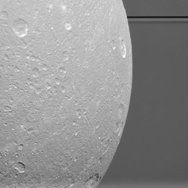
This view from NASA Cassini spacecraft looks toward Saturn icy moon Dione, with giant Saturn and its rings in the background, just prior to the mission final close approach to the moon on August 17, 2015. At lower right is the large, multi-ringed impact basin named Evander, which is about 220 miles (350 kilometers) wide. The canyons of Padua Chasma, features that form part of Dione's bright, wispy terrain, reach into the darkness at left. Imaging scientists combined nine visible light (clear spectral filter) images to create this mosaic view: eight from the narrow-angle camera and one from the wide-angle camera, which fills in an area at lower left. The scene is an orthographic projection centered on terrain at 0.2 degrees north latitude, 179 degrees west longitude on Dione. An orthographic view is most like the view seen by a distant observer looking through a telescope. North on Dione is up. The view was acquired at distances ranging from approximately 106,000 miles (170,000 kilometers) to 39,000 miles (63,000 kilometers) from Dione and at a sun-Dione-spacecraft, or phase, angle of 35 degrees. Image scale is about 1,500 feet (450 meters) per pixel. http://photojournal.jpl.nasa.gov/catalog/PIA19650
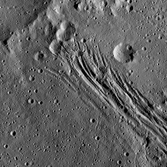
This image, taken by NASA's Dawn spacecraft, shows a series of linear features, which are depressions that located within the large Yalode Crater on Ceres. The widest of the linear features is approximately 0.9 miles (1.5 kilometers) in width. Scientists think these features formed when extensional stresses pulled the surface of Ceres apart. In the upper part of the image, the linear features cut through several impact craters, indicating that the fractures are younger than those particular craters. The linear features are not the youngest things visible in this view, however. There are also small impact craters imprinted upon them, meaning those craters must have appeared more recently. Yalode is 160 miles (260 kilometers) in diameter. Dawn took this image on June 15, 2016, from its low-altitude mapping orbit, at a distance of about 240 miles (385 kilometers) above the surface. The image resolution is 120 feet (35 meters) per pixel. http://photojournal.jpl.nasa.gov/catalog/PIA20959
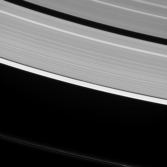
Saturn's moon Daphnis raises waves wherever it goes. In fact, such waves are one way that scientists search for undiscovered moons in the ring gaps. But they can tell researchers a lot of other things, as well. The waves that Daphnis (5 miles or 8 kilometers across) raises on the edges of the Keeler Gap can also be used to deduce the moon's mass and even some of its orbital behavior. Since the moon moves in and out of the ring-plane, and closer to and farther from the rings' edges as it orbits, the waves it makes change over time. Cassini has been observing these changes during its extended study of the Saturn system to help understand this interaction. This view looks toward the sunlit side of the rings from about 35 degrees above the ring plane. The image was taken in visible light with the Cassini spacecraft narrow-angle camera on Oct. 10, 2016. Daphnis has been brightened by a factor of two in this image to increase its visibility. The view was obtained at a distance of approximately 810,000 miles (1.3 million kilometers) from Daphnis and at a Sun-Daphnis-spacecraft, or phase, angle of 96 degrees. Image scale is 5 miles (8 kilometers) per pixel. http://photojournal.jpl.nasa.gov/catalog/PIA20511
KENNEDY SPACE CENTER, FLA. -- STS-93 Commander Eileen Collins poses in front of the Space Shuttle orbiter Columbia following her textbook landing on runway 33 at the Shuttle Landing Facility. Main gear touchdown occurred at 11:20:35 p.m. EDT on July 27. On this mission, Collins became the first woman to serve as a Shuttle commander. Also on board were her fellow STS-93 crew members: Pilot Jeffrey S. Ashby and Mission Specialists Steven A. Hawley (Ph.D.), Catherine G. Coleman (Ph.D.) and Michel Tognini of France, with the Centre National d'Etudes Spatiales (CNES). The mission's primary objective was to deploy the Chandra X-ray Observatory, which will allow scientists from around the world to study some of the most distant, powerful and dynamic objects in the universe. This was the 95th flight in the Space Shuttle program and the 26th for Columbia. The landing was the 19th consecutive Shuttle landing in Florida and the 12th night landing in Shuttle program history

Saturn's graceful lanes of orbiting ice -- its iconic rings -- wind their way around the planet to pass beyond the horizon in this view from NASA's Cassini spacecraft. And diminutive Pandora, scarcely larger than a pixel here, can be seen orbiting just beyond the F ring in this image. Also in this image is the gap between Saturn's cloud tops and its innermost D ring through which Cassini would pass 22 times before ending its mission in spectacular fashion in Sept. 15, 2017. Scientists scoured images of this region, particularly those taken at the high phase (spacecraft-ring-Sun) angles, looking for material that might pose a hazard to the spacecraft. This view looks toward the sunlit side of the rings from about 19 degrees above the ringplane. The image was taken in green light with the Cassini spacecraft wide-angle camera on Aug. 12, 2017. Pandora was brightened by a factor of 2 to increase its visibility. The view was obtained at a distance to Saturn of approximately 581,000 miles (935,000 kilometers) from Saturn. Image scale is 35 miles (56 kilometers) per pixel. The distance to Pandora was 691,000 miles (1.1 million kilometers) for a scale of 41 miles (66 kilometers) per pixel. The Cassini spacecraft ended its mission on Sept. 15, 2017. https://photojournal.jpl.nasa.gov/catalog/PIA21352
Ceres surface shows evidence for different types of flows that indicate the presence of ice in the regolith. One type of flow encircles the large impact crater at right in this image taken by NASA Dawn spacecraft. One type of flow encircles the large impact crater at right in this image. Scientists see features in this flow that indicate a low degree of internal friction within its material, meaning it was able to flow easily and far from its source. This could be due to the incorporation of a significant amount of liquid water or water vapor into the ejecta blanket. This flow also shows a large ridge along its edge (seen most clearly just to the left of the large crater). These features are commonly associated with flows on Mars called "fluidized ejecta blankets." This feature is located southwest of Kerwan crater at 40 degrees south latitude, 109 degrees east longitude. This is in the vicinity of the latitudes where Dawn's gamma ray and neutron spectrometer (GRaND) instrument sensed the presence of ice in the first meter of Ceres' regolith. The image was taken on August, 7, 2016 from an altitude of about 240 miles (390 kilometers) above Ceres. The image resolution is about 120 feet (35 meters) per pixel. https://photojournal.jpl.nasa.gov/catalog/PIA21404
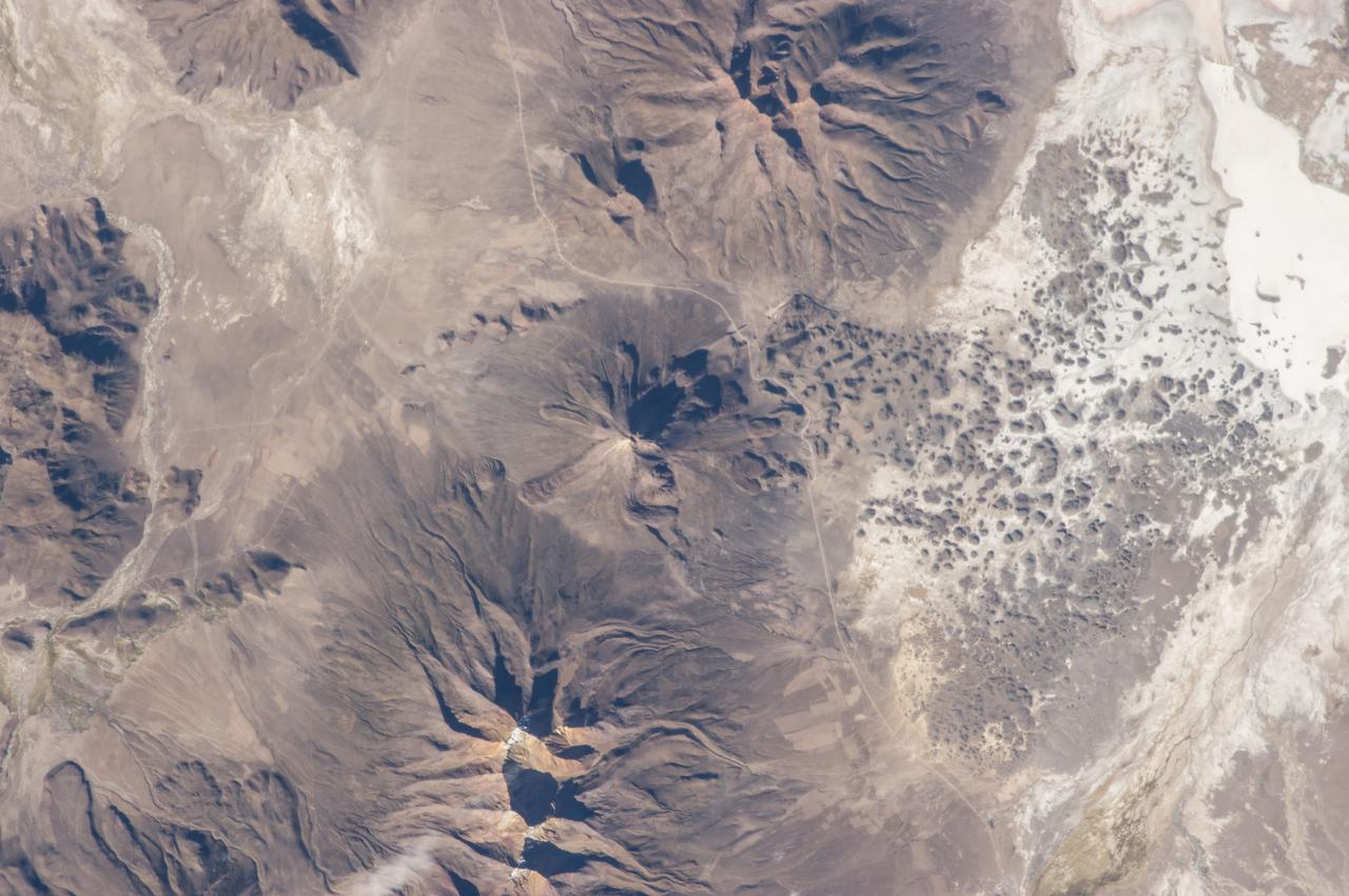
ISS035-E-18006 (8 April 2013) --- One of the Expedition 35 crew members aboard the Earth-orbiting International Space Station photographed this image of Tata Sabaya Volcano, located in the Altiplano region of Bolivia. The volcano rises to a summit elevation of 5430 meters above sea level. While its current form is that of a “youthful” stratovolcano, the regional geological evidence indicates an older, eventful history, according to scientists. The scientists say that prior to approximately 12,000 years ago (during the late Pleistocene Epoch), a large debris avalanche was formed by collapse of the ancestral Tata Sabaya volcano. Debris from the avalanche swept into the nearby Salar de Coipasa –at that time filled with a lake larger than today – significantly changing its northwestern coastline. Timing of the event is obtained from tufa deposits formed on debris islands during a high stand of the Coipasa lake – illustrating the geological principle of cross-cutting relationships, in that the debris avalanche had to have occurred before the tufa deposits were formed in the lake. The Tata Sabaya stratovolcano is located at image center. Several young lava flows are visible on the northwestern and western flanks of the volcano. Peaks visible to the northeast and southwest appear to be volcanoes as well, but unlike Tata Sabaya there is no record of recent activity from either of them (according to the Smithsonian National Museum of Natural History’s Global Volcanism Program). As the Altiplano became more arid and the Coipasa Lake shrank, much of the hummocky terrain of the debris avalanche became exposed over an area of more than 300 square kilometers. The hummocky terrain is clearly visible at image right. White salt deposits of the salar surround many of the individual hummocks, making them “islands” once again.
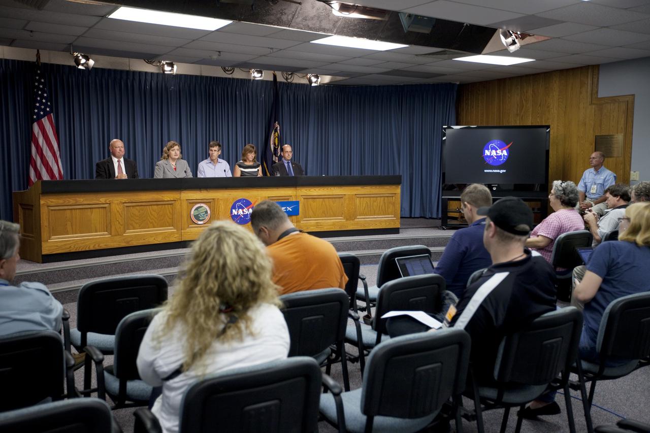
CAPE CANAVERAL, Fla. -- News and social media representatives participate in a space station and mission science briefing in NASA Kennedy Space Center's Press Site auditorium in Florida. On the dais from left are Michael Curie, NASA Public Affairs, Julie Robinson, program scientist for International Space Station at NASA's Johnson Space Center, Timothy Yeatman, interim chief scientist at the Center for the Advancement of Science in Space, Sheila Nielsen-Preiss, cell biologist at Montana State University, and Scott Smith, NASA nutritionist at NASA's Johnson Space Center. The briefing provided media with an overview of the experiments and payloads scheduled for launch on NASA's first Commercial Resupply Services, or CRS-1, mission to the International Space Station. Space Exploration Technologies Corp., or SpaceX, built both the mission's Falcon 9 rocket and Dragon capsule. Launch is scheduled for 8:35 p.m. EDT on Oct. 7 from Space Launch Complex 40 on Cape Canaveral Air Force Station. SpaceX CRS-1 is an important step toward making America’s microgravity research program self-sufficient by providing a way to deliver and return significant amounts of cargo, including science experiments, to and from the orbiting laboratory. NASA has contracted for 12 commercial resupply flights from SpaceX and eight from the Orbital Sciences Corp. For more information, visit http://www.nasa.gov/mission_pages/station/living/launch/index.html. Photo credit: NASA/Kim Shiflett
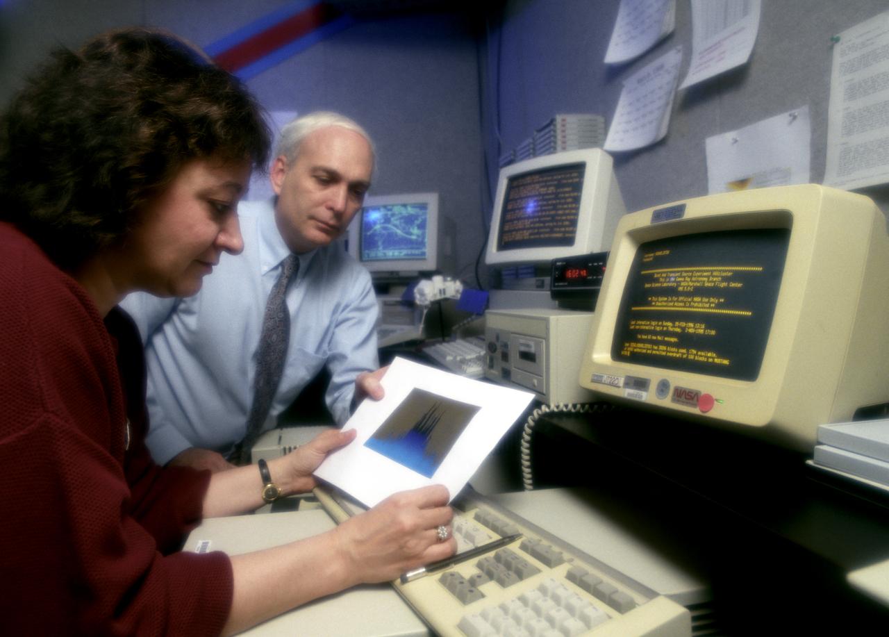
In this photograph, Dr. Gerald Fishman of the Marshall Space Flight Center (MSFC), a principal investigator of the Compton Gamma-Ray Observatory's (GRO's) instrument, the Burst and Transient Source Experiment (BATSE), and Dr. Chryssa Kouveliotou of Universities Space Research Associates review data from the BATSE. For nearly 9 years, GRO's Burst and Transient Source Experiment (BATSE), designed and built by the Marshall Space Flight Center, kept a blinking watch on the universe to alert scientist to the invisible, mysterious gamma-ray bursts. By studying gamma-rays from objects like black holes, pulsars, quasars, neutron stars, and other exotic objects, scientists could discover clues to the birth, evolution, and death of stars, galaxies, and the universe. The gamma-ray instrument was one of four major science instruments aboard the Compton. It consisted of eight detectors, or modules, located at each corner of the rectangular satellite to simultaneously scan the entire universe for bursts of gamma-rays ranging in duration from fractions of a second to minutes. Because gamma-rays are so powerful, they pass through conventional telescope mirrors. Instead of a mirror, the heart of each BATSE module was a large, flat, transparent crystal that generated a tiny flash of light when struck by a gamma-ray. With an impressive list of discoveries and diverse accomplishments, BATSE could claim to have rewritten astronomy textbooks. Launched aboard the Space Shuttle Orbiter Atlantis during the STS-35 mission in April 1991, the GRO reentered the Earth's atmosphere and ended its successful 9-year mission in June 2000.

This photograph shows the Compton Gamma-Ray Observatory being released from the Remote Manipulator System (RMS) arm aboard the Space Shuttle Atlantis during the STS-35 mission in April 1991. The GRO reentered the Earth's atmosphere and ended its successful mission in June 2000. For nearly 9 years, GRO's Burst and Transient Source Experiment (BATSE), designed and built by the Marshall Space Flight Center, kept an unblinking watch on the universe to alert scientist to the invisible, mysterious gamma-ray bursts that had puzzled them for decades. By studying gamma-rays from objects like black holes, pulsars, quasars, neutron stars, and other exotic objects, scientists could discover clues to the birth, evolution, and death of star, galaxies, and the universe. The gamma-ray instrument was one of four major science instruments aboard the Compton. It consisted of eight detectors, or modules, located at each corner of the rectangular satellite to simultaneously scan the entire universe for bursts of gamma-rays ranging in duration from fractions of a second to minutes. In January 1999, the instrument, via the Internet, cued a computer-controlled telescope at Las Alamos National Laboratory in Los Alamos, New Mexico, within 20 seconds of registering a burst. With this capability, the gamma-ray experiment came to serve as a gamma-ray burst alert for the Hubble Space Telescope, the Chandra X-Ray Observatory, and major gound-based observatories around the world. Thirty-seven universities, observatories, and NASA centers in 19 states, and 11 more institutions in Europe and Russia, participated in BATSE's science program.
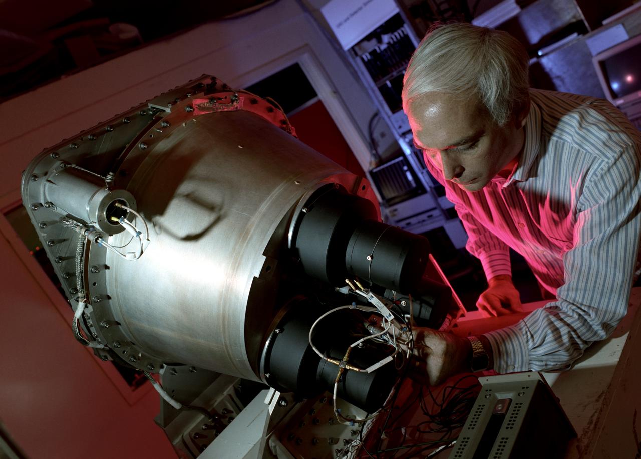
In this photograph, Dr. Gerald Fishman of the Marshall Space Flight Center (MSFC), a principal investigator of the Compton Gamma-Ray Observatory's (GRO's) instrument, the Burst and Transient Source Experiment (BATSE), works on the BATSE detector module. For nearly 9 years, GRO's BATSE, designed and built by MSFC, kept an unblinking watch on the universe to alert scientist to the invisible, mysterious gamma-ray bursts. By studying gamma-rays from objects like black holes, pulsars, quasars, neutron stars, and other exotic objects, scientists could discover clues to the birth, evolution, and death of star, galaxies, and the universe. The gamma-ray instrument was one of four major science instruments aboard the Compton. It consisted of eight detectors, or modules, located at each corner of the rectangular satellite to simultaneously scan the entire universe for bursts of gamma-rays ranging in duration from fractions of a second to minutes. Because gamma-rays are so powerful, they pass through conventional telescope mirrors. Instead of a mirror, the heart of each BATSE module was a large, flat, transparent crystal that generated a tiny flash of light when struck by a gamma-ray. With an impressive list of discoveries and diverse accomplishments, BATSE could claim to have rewritten astronomy textbooks. Launched aboard the Space Shuttle Orbiter Atlantis during the STS-35 mission in April 1991, the GRO reentered the Earth's atmosphere and ended its successful 9-year mission in June 2000.
Climate researchers from the National Center for Atmospheric Research (NCAR) and several universities install and perform functional checkouts of a variety of sensitive atmospheric instruments on NASA's DC-8 airborne laboratory prior to beginning the ARCTAS mission.
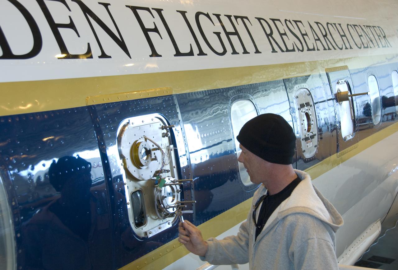
Climate researchers from the National Center for Atmospheric Research (NCAR) and several universities install and perform functional checkouts of a variety of sensitive atmospheric instruments on NASA's DC-8 airborne laboratory prior to beginning the ARCTAS mission.
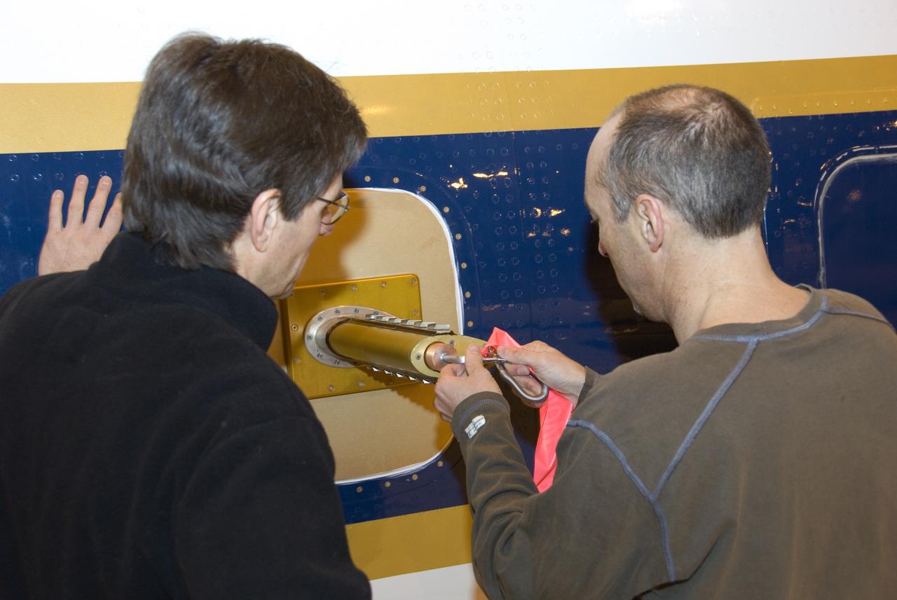
Climate researchers from the National Center for Atmospheric Research (NCAR) and several universities install and perform functional checkouts of a variety of sensitive atmospheric instruments on NASA's DC-8 airborne laboratory prior to beginning the ARCTAS mission.
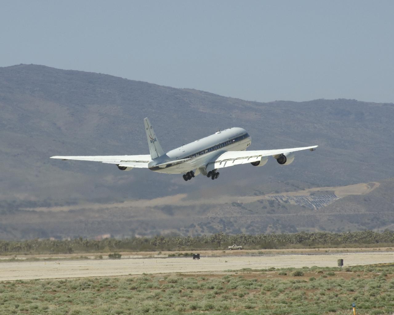
NASA's DC-8 flying laboratory lifts off the runway at Air Force Plant 42 in Palmdale, Calif., on its first flight in the ARCTAS atmospheric science mission.

Climate researchers from the National Center for Atmospheric Research (NCAR) and several universities install and perform functional checkouts of a variety of sensitive atmospheric instruments on NASA's DC-8 airborne laboratory prior to beginning the ARCTAS mission.

Climate researchers from the National Center for Atmospheric Research (NCAR) and several universities install and perform functional checkouts of a variety of sensitive atmospheric instruments on NASA's DC-8 airborne laboratory prior to beginning the ARCTAS mission.
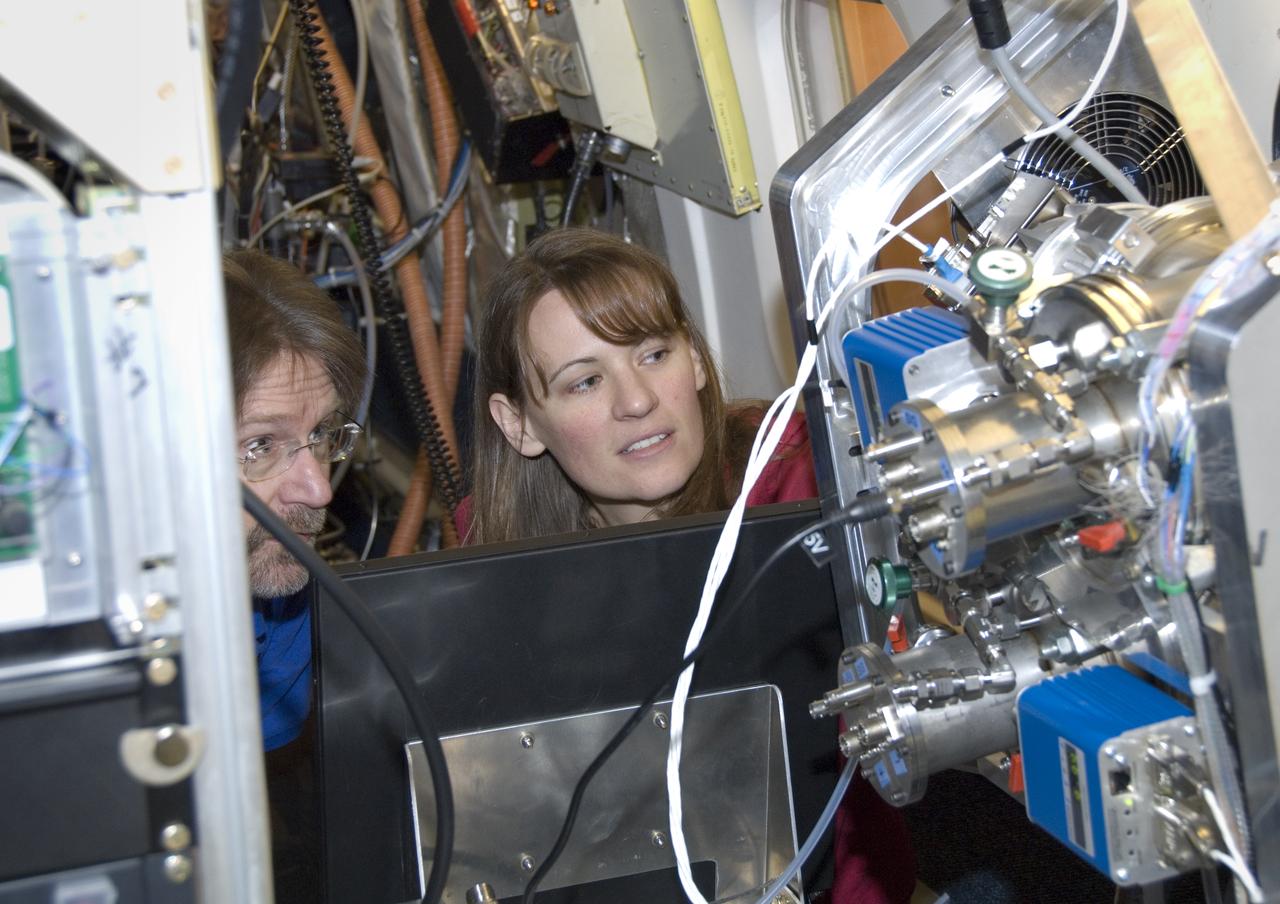
Climate researchers from the National Center for Atmospheric Research (NCAR) and several universities install and perform functional checkouts of a variety of sensitive atmospheric instruments on NASA's DC-8 airborne laboratory prior to beginning the ARCTAS mission.
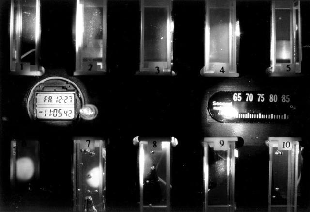
Close-up view of the Binary Colloidal Alloy Test during an experiment run aboard the Russian Mir space station. BCAT is part of an extensive series of experiments plarned to investigate the fundamental properties of colloids so that scientists can make colloids more useful for technological applications. Some of the colloids studied in BCAT are made of two different sized particles (binary colloidal alloys) that are very tiny, uniform plastic spheres. Under the proper conditions, these colloids can arrange themselves in a pattern to form crystals, which may have many unique properties that may form the basis of new classes of light switches, displays, and optical devices that can fuel the evolution of the next generation of computer and communication technologies. This Slow Growth hardware consisted of a 35-mm camera aimed toward a module which contained 10 separate colloid samples. To begin the experiment, one of the astronauts would mix the samples to disperse the colloidal particles. Then the hardware operated autonomously, taking photos of the colloidal samples over a 90-day period. The investigation proved that gravity plays a central role in the formation and stability of these types of colloidal crystal structures. The investigation also helped identify the optimum conditions for the formation of colloidal crystals, which will be used for optimizing future microgravity experiments in the study of colloidal physics. Dr. David Weitz of the University of Pennsylvania and Dr. Peter Pusey of the University of Edinburgh, United Kingdom, are the principal investigators.
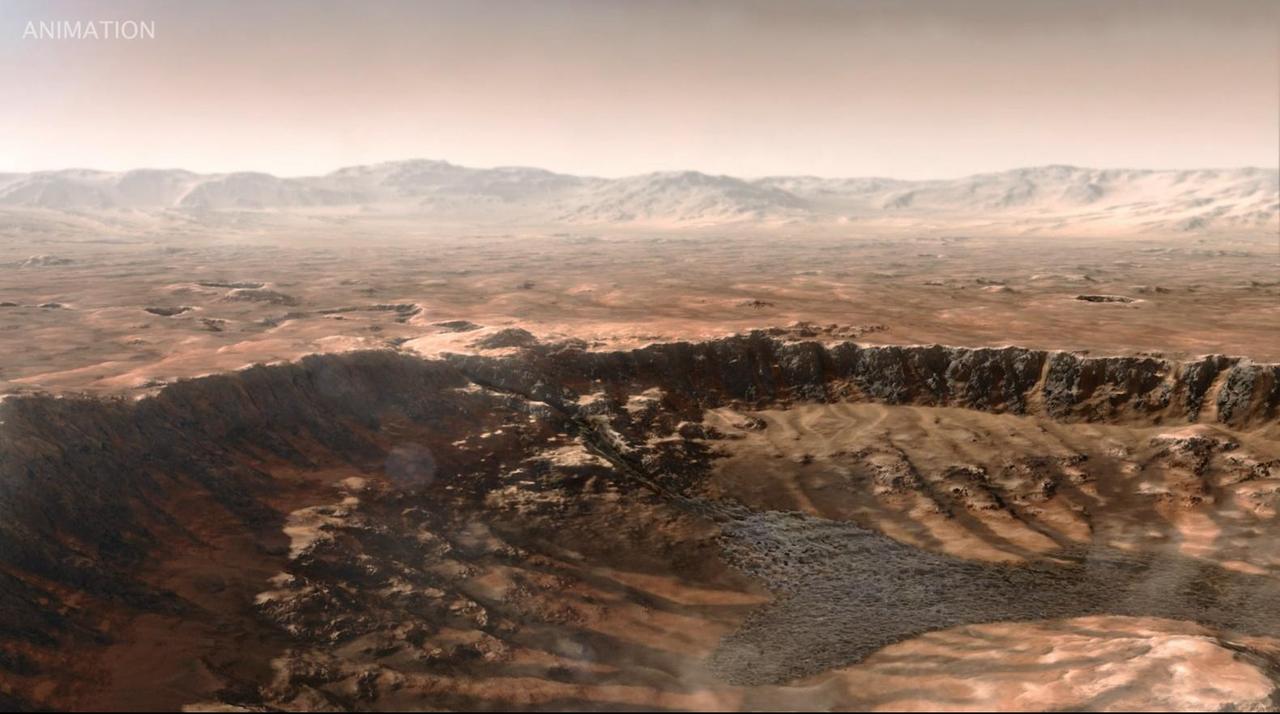
This animated artist's concept depicts a scene of water breaking through the rim of Mars' Jezero Crater, which NASA's Perseverance rover is now exploring. Water entered the crater billions of years ago, depositing sediments that built up into a delta. Since the spacecraft's landing in February 2021, Perseverance's exploration of the crater floor and the delta have led to scientists developing a detailed timeline for the crater's formation. They now know there were three major periods after water began flooding through the crater rim. First, those waters brought fine-grained sand and mud (seen by Perseverance at "Hogwallow Flats") that is known for preserving fossilized life in comparable environments on Earth. Second, the crater's lake grew as wide as 22 miles (35 kilometers) in diameter and as deep as 100 feet (30 meters) – deep enough to lay down several sedimentary layers (like those seen at "Pinestand"). Finally, high-energy rivers brought in boulders that were rounded as they tumbled through water, as seen at "Castell Henllys." A key objective for Perseverance's mission on Mars is astrobiology, including the search for signs of ancient microbial life. The rover will characterize the planet's geology and past climate, pave the way for human exploration of the Red Planet, and be the first mission to collect and cache Martian rock and regolith (broken rock and dust). Subsequent NASA missions, in cooperation with ESA (European Space Agency), would send spacecraft to Mars to collect these sealed samples from the surface and return them to Earth for in-depth analysis. The Mars 2020 Perseverance mission is part of NASA's Moon to Mars exploration approach, which includes Artemis missions to the Moon that will help prepare for human exploration of the Red Planet. Animation available at https://photojournal.jpl.nasa.gov/catalog/PIA26207
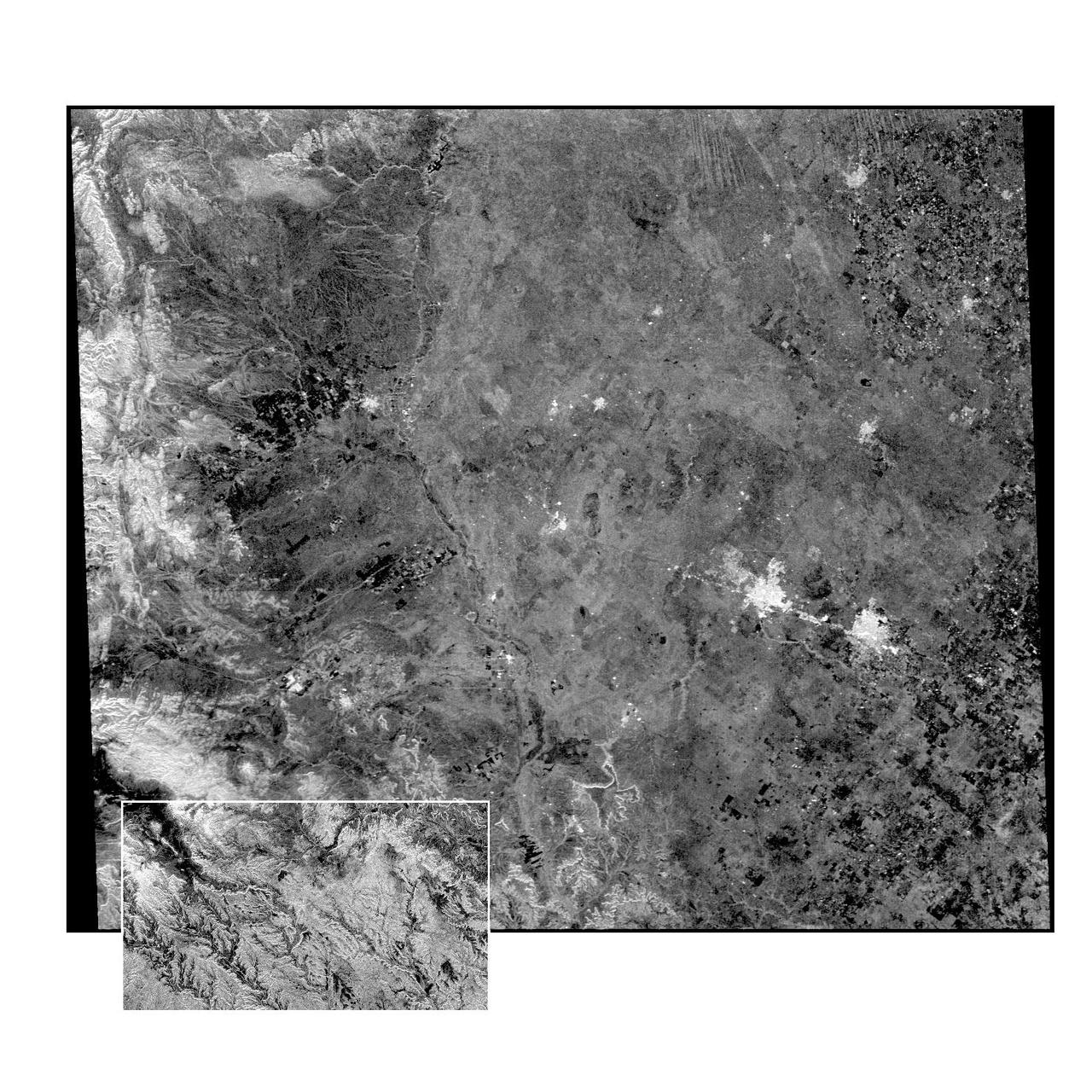
This radar image of the Midland/Odessa region of West Texas, demonstrates an experimental technique, called ScanSAR, that allows scientists to rapidly image large areas of the Earth's surface. The large image covers an area 245 kilometers by 225 kilometers (152 miles by 139 miles). It was obtained by the Spaceborne Imaging Radar-C/X-Band Synthetic Aperture Radar (SIR-C/X-SAR) flying aboard the space shuttle Endeavour on October 5, 1994. The smaller inset image is a standard SIR-C image showing a portion of the same area, 100 kilometers by 57 kilometers (62 miles by 35 miles) and was taken during the first flight of SIR-C on April 14, 1994. The bright spots on the right side of the image are the cities of Odessa (left) and Midland (right), Texas. The Pecos River runs from the top center to the bottom center of the image. Along the left side of the image are, from top to bottom, parts of the Guadalupe, Davis and Santiago Mountains. North is toward the upper right. Unlike conventional radar imaging, in which a radar continuously illuminates a single ground swath as the space shuttle passes over the terrain, a Scansar radar illuminates several adjacent ground swaths almost simultaneously, by "scanning" the radar beam across a large area in a rapid sequence. The adjacent swaths, typically about 50 km (31 miles) wide, are then merged during ground processing to produce a single large scene. Illumination for this L-band scene is from the top of the image. The beams were scanned from the top of the scene to the bottom, as the shuttle flew from left to right. This scene was acquired in about 30 seconds. A normal SIR-C image is acquired in about 13 seconds. The ScanSAR mode will likely be used on future radar sensors to construct regional and possibly global radar images and topographic maps. The ScanSAR processor is being designed for 1996 implementation at NASA's Alaska SAR Facility, located at the University of Alaska Fairbanks, and will produce digital images from the forthcoming Canadian RADARSAT satellite. http://photojournal.jpl.nasa.gov/catalog/PIA01787

Droughts in the U.S. Southwest and Central Plains at the end of this century could be drier and longer compared to drought conditions seen in those regions in the last 1,000 years, according to a new NASA study. The study, published Feb 12 in the journal Science Advances, is based on projections from several climate models, including one sponsored by NASA. The research found the risk of severe droughts in those regions would increase if human-produced greenhouse gas emissions continue to increase. "Natural droughts like the 1930s Dust Bowl and the current drought in the Southwest have historically lasted maybe a decade or a little less," said Ben Cook, climate scientist at NASA's Goddard Institute for Space Studies and the Lamont-Doherty Earth Observatory at Columbia University in New York City, and lead author of the study. "What these results are saying is we're going to get a drought similar to those events, but it is probably going to last at least 30 to 35 years." Read more:http://bit.ly/nasa-megadroughts Credit: NASA’s Goddard Space Flight Center <b><a href="http://www.nasa.gov/audience/formedia/features/MP_Photo_Guidelines.html" rel="nofollow">NASA image use policy.</a></b> <b><a href="http://www.nasa.gov/centers/goddard/home/index.html" rel="nofollow">NASA Goddard Space Flight Center</a></b> enables NASA’s mission through four scientific endeavors: Earth Science, Heliophysics, Solar System Exploration, and Astrophysics. Goddard plays a leading role in NASA’s accomplishments by contributing compelling scientific knowledge to advance the Agency’s mission. <b>Follow us on <a href="http://twitter.com/NASAGoddardPix" rel="nofollow">Twitter</a></b> <b>Like us on <a href="http://www.facebook.com/pages/Greenbelt-MD/NASA-Goddard/395013845897?ref=tsd" rel="nofollow">Facebook</a></b> <b>Find us on <a href="http://instagram.com/nasagoddard?vm=grid" rel="nofollow">Instagram</a></b>
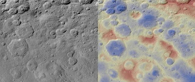
These images show a subtle feature on Ceres called Kwanzaa Tholus. Kwanzaa, meaning "first fruits" in Swahili, is an African-American festival based on ancient African harvest celebrations, and takes place from December 26 to January 1. A tholus is a type of small mountain. Kwanzaa Tholus measures about 22 by 12 miles (35 by 19 kilometers) and is elevated about 2 miles (3 km) above its surroundings. Because the mountain does not rise sharply above the ground, it is difficult to see in the mosaic on the left, although a small crescent-shaped shadow stands out. The image on the right, which is an elevation map of the area, shows where Kwanzaa Tholus is more prominently. The rounded shape of Kwanzaa Tholus is typical of tholi (plural of tholus) in general, but is different than other examples found on Ceres (like Dalien Tholus) and Mars. This region is particularly rich in this type of feature: The current Ceres map shows six named tholi and montes (slightly bigger mountains) in the region (centered around 32 degrees north, 327 degrees east) and several others including Ahuna Mons farther south. Scientists say Kwanzaa Tholus may have once been as prominent as Ahuna Mons, the tallest and most noticeable mountain on Ceres. Ahuna Mons is likely a cryovolcano, a volcano formed by the gradual accumulation of thick, slowly flowing icy materials. Because ice https://www.nasa.gov/feature/goddard/2016/ceres-cryo-volcano/is not strong enough to preserve an elevated structure for extended periods, cryovolcanoes on Ceres are expected to gradually collapse over tens of millions of years. This means Kwanzaa Tholus and other tholi in that area could be degraded mountains, which also formed from cryovolcanic activity. The mosaic on the left combines images taken by NASA's Dawn spacecraft in its high-altitude mapping orbit (HAMO) at about 915 miles (1,470 kilometers) above the surface. The spatial resolution is 450 feet (140 meters) per pixel. https://photojournal.jpl.nasa.gov/catalog/PIA21916
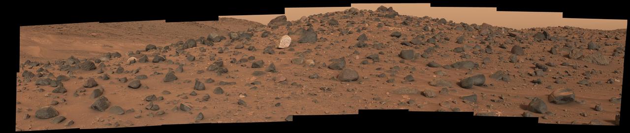
Composed of 18 images, this natural-color mosaic shows a boulder field on "Mount Washburn" (named after a mountain in Wyoming) in Mars' Jezero Crater. The Perseverance science team nicknamed the light-toned boulder with dark speckles near the center of the mosaic "Atoko Point" (after a feature in the eastern Grand Canyon). The images were acquired by NASA's Perseverance Mars rover on May 27, 2024, the 1,162nd Martian day, or sol, of the mission. Analysis by the rover's SuperCam and Mastcam-Z instruments indicate Atoko Point is composed of the mineral pyroxene, similar to some boulders the rover has encountered elsewhere in Jezero Crater. In terms of the size, shape, and arrangement of its mineral grains and crystals – and potentially its chemical composition – Atoko Point is different from any of the rocks the rover has encountered before. Some Perseverance scientists speculate the minerals that make up Atoko Point were produced in a subsurface body of magma that is possibly exposed now on the crater rim. Others on the team wonder if the boulder, which stands about 18 inches (45 centimeters) wide and 14 inches (35 centimeters) tall, had been created far beyond the walls of Jezero and transported there by swift Martian waters eons ago. Arizona State University leads the operations of the Mastcam-Z instrument, working in collaboration with Malin Space Science Systems in San Diego, on the design, fabrication, testing, and operation of the cameras, and in collaboration with the Niels Bohr Institute of the University of Copenhagen on the design, fabrication, and testing of the calibration targets. A key objective for Perseverance's mission on Mars is astrobiology, including the search for signs of ancient microbial life. The rover will characterize the planet's geology and past climate, pave the way for human exploration of the Red Planet, and be the first mission to collect and cache Martian rock and regolith (broken rock and dust). Subsequent NASA missions, in cooperation with ESA (European Space Agency), would send spacecraft to Mars to collect these sealed samples from the surface and return them to Earth for in-depth analysis. The Mars 2020 Perseverance mission is part of NASA's Moon to Mars exploration approach, which includes Artemis missions to the Moon that will help prepare for human exploration of the Red Planet. https://photojournal.jpl.nasa.gov/catalog/PIA26333
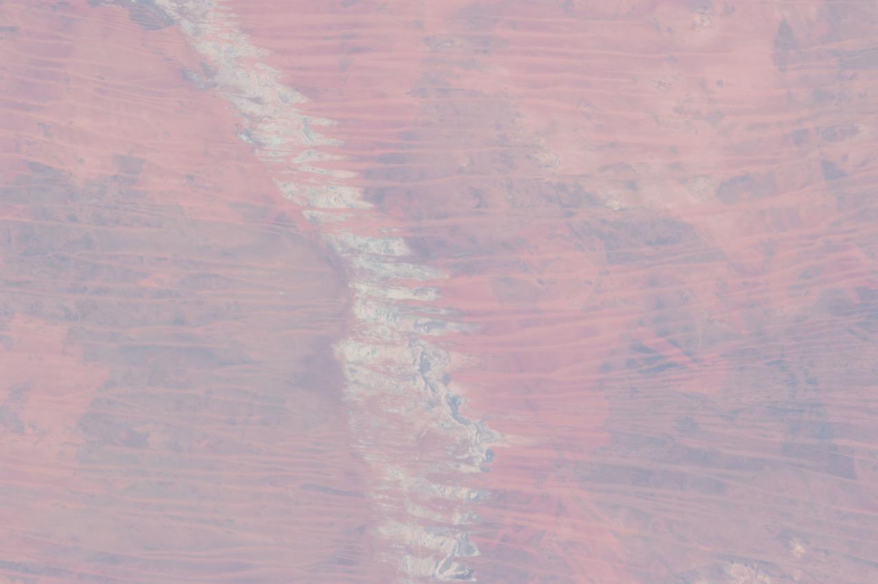
ISS035-E-009454 (25 March 2013 ) --- One of the Expedition 35 crew members aboard the Earth-orbiting International Space Station used a 400 millimeter lens to photograph this view of the Great Sandy Desert, northwestern Australia on March 25. It bears evidence that much of Australia is arid. In northwest Australia the Great Sandy Desert holds great geological interest as a zone of active sand dune movement; strings of narrow lakes that represent very ancient rivers are also present. While a variety of dune forms can be seen in the region, this photograph features numerous linear dunes (approximately 25 meters high) separated in a roughly regular fashion (0.5?1.5 kilometers), and aligned closely to the winds that generated them?that is, winds blowing from east to west. Where linear dunes converge, dune confluences point downwind. One of the main visual impressions flying over such tropical dune fields ? both from an airplane or from the orbital station outpost?apart from the dune patterns are fire scars where thin vegetation has been burned off the dunes. The result is dunes that appear red from the underlying sand (image top left and top right), and darker areas where the vegetation remains (image lower left and lower right). The white feature visible down the center of the image is Lake Auld, the white color being the result of a cemented combination of fine clayey sediment and salts from evaporation of flood waters that occasionally fill the lake. Wider views of the area show that this lake is part of what is now known to have been a major, ancient river system in northwest Australia, draining northwest to the Indian Ocean. Such sinuous lakes are also known in Australia as ?river lakes.? Scientists point out that the river system is remarkably well preserved considering that the rivers were probably active in the Paleocene Epoch more than 55 million years ago. Australia then lay much further south in a wetter climatic zone. Today?s desert climate results in almost all rivers in the Great Sandy Desert being dry. Linear dunes can be seen entering Lake Auld on the east side. During flooding events, the sand of the dune noses is dispersed, becoming incorporated into the lake floor sediments together with muds and salts. During the long intervening dry periods, sand can blow across the lake floor to build thinner, smaller dunes visible as linear accumulations on the west side of the lake.