Edwards, Calif. – ED13-0266-013- Sierra Nevada Corporation, or SNC, team members prepare for 60 mph tow tests of the company's Dream Chaser flight vehicle on taxi and runways at NASA's Dryden Flight Research Center at Edwards Air Force Base in California. Ground testing at 10, 20, 40 and 60 miles per hour is helping the company validate the performance of the spacecraft's braking and landing systems prior to captive-carry and free-flight tests scheduled for later this year. SNC is continuing the development of its Dream Chaser spacecraft under the agency's Commercial Crew Development Round 2, or CCDev2, and Commercial Crew Integrated Capability, or CCiCap, phases, which are intended to lead to the availability of commercial human spaceflight services for government and commercial customers. To learn more about CCP and its industry partners, visit www.nasa.gov/commercialcrew. Image credit: NASA/Ken Ulbrich
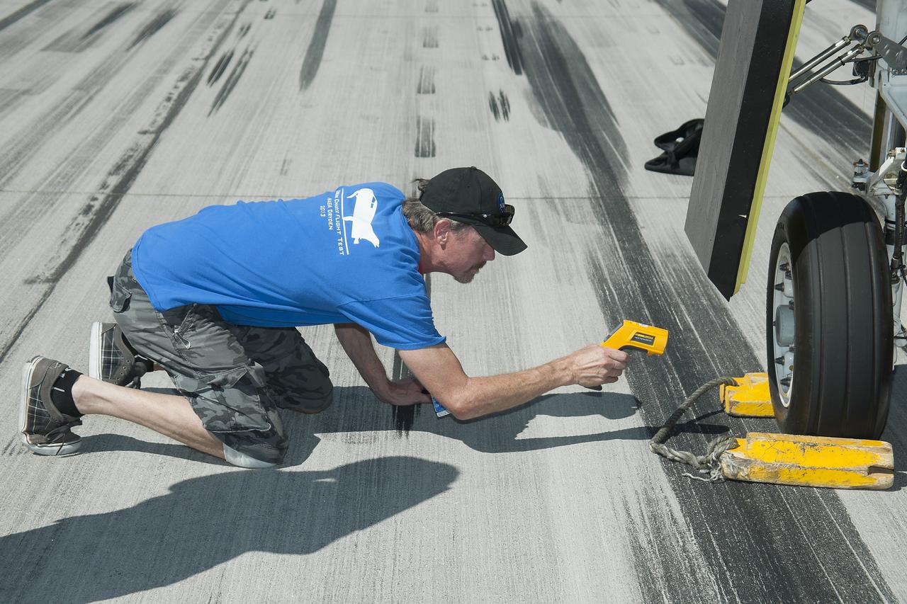
Edwards, Calif. – ED13-0266-060- A Sierra Nevada Corporation, or SNC, team member checks the company's Dream Chaser flight vehicle systems following a 60 mph tow test on taxi and runways at NASA's Dryden Flight Research Center at Edwards Air Force Base in California. Ground testing at 10, 20, 40 and 60 miles per hour is helping the company validate the performance of the spacecraft's braking and landing systems prior to captive-carry and free-flight tests scheduled for later this year. SNC is continuing the development of its Dream Chaser spacecraft under the agency's Commercial Crew Development Round 2, or CCDev2, and Commercial Crew Integrated Capability, or CCiCap, phases, which are intended to lead to the availability of commercial human spaceflight services for government and commercial customers. To learn more about CCP and its industry partners, visit www.nasa.gov/commercialcrew. Image credit: NASA/Ken Ulbrich
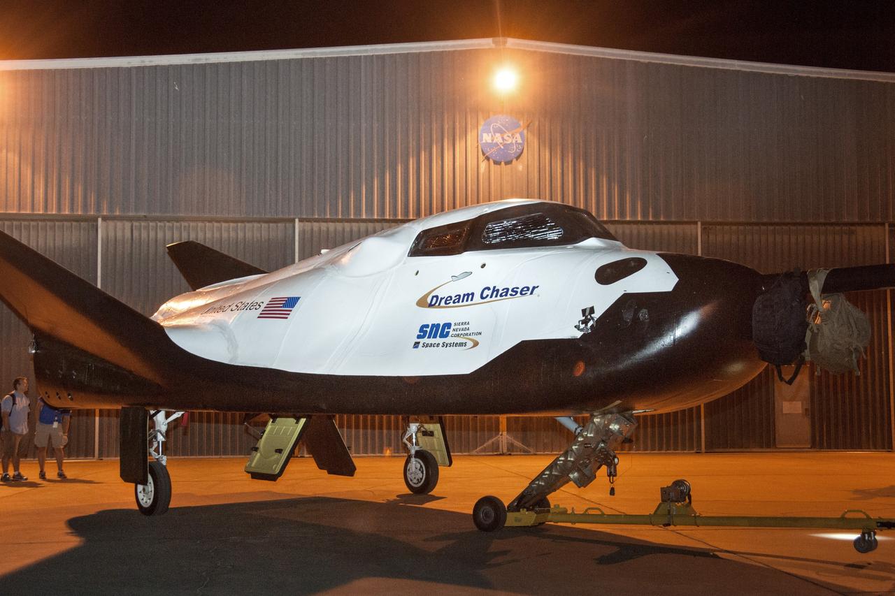
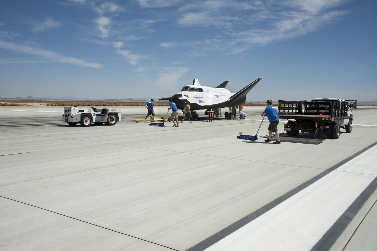
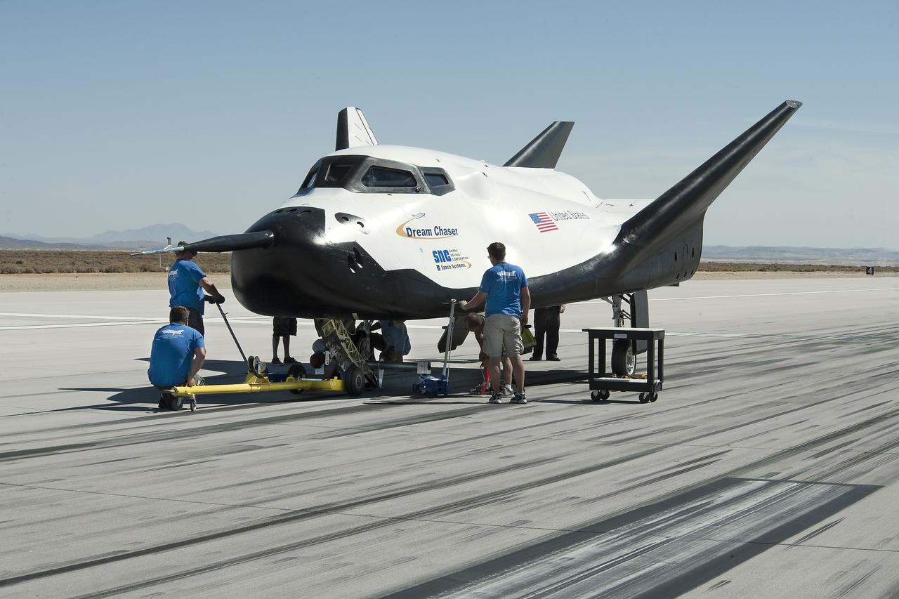
Edwards, Calif. – ED13-0266-007- The Sierra Nevada Corporation, or SNC, Dream Chaser flight vehicle is prepared for 60 mph tow tests on taxi and runways at NASA's Dryden Flight Research Center at Edwards Air Force Base in California. Ground testing at 10, 20, 40 and 60 miles per hour is helping the company validate the performance of the spacecraft's braking and landing systems prior to captive-carry and free-flight tests scheduled for later this year. SNC is continuing the development of its Dream Chaser spacecraft under the agency's Commercial Crew Development Round 2, or CCDev2, and Commercial Crew Integrated Capability, or CCiCap, phases, which are intended to lead to the availability of commercial human spaceflight services for government and commercial customers. To learn more about CCP and its industry partners, visit www.nasa.gov/commercialcrew. Image credit: NASA/Ken Ulbrich
Edwards, Calif. – ED13-0266-010- The Sierra Nevada Corporation, or SNC, Dream Chaser flight vehicle is prepared for 60 mph tow tests on taxi and runways at NASA's Dryden Flight Research Center at Edwards Air Force Base in California. Ground testing at 10, 20, 40 and 60 miles per hour is helping the company validate the performance of the spacecraft's braking and landing systems prior to captive-carry and free-flight tests scheduled for later this year. SNC is continuing the development of its Dream Chaser spacecraft under the agency's Commercial Crew Development Round 2, or CCDev2, and Commercial Crew Integrated Capability, or CCiCap, phases, which are intended to lead to the availability of commercial human spaceflight services for government and commercial customers. To learn more about CCP and its industry partners, visit www.nasa.gov/commercialcrew. Image credit: NASA/Ken Ulbrich
Edwards, Calif. – ED13-0266-016- Sierra Nevada Corporation, or SNC, team members prepare for 60 mph tow tests of the company's Dream Chaser flight vehicle on taxi and runways at NASA's Dryden Flight Research Center at Edwards Air Force Base in California. Ground testing at 10, 20, 40 and 60 miles per hour is helping the company validate the performance of the spacecraft's braking and landing systems prior to captive-carry and free-flight tests scheduled for later this year. SNC is continuing the development of its Dream Chaser spacecraft under the agency's Commercial Crew Development Round 2, or CCDev2, and Commercial Crew Integrated Capability, or CCiCap, phases, which are intended to lead to the availability of commercial human spaceflight services for government and commercial customers. To learn more about CCP and its industry partners, visit www.nasa.gov/commercialcrew. Image credit: NASA/Ken Ulbrich
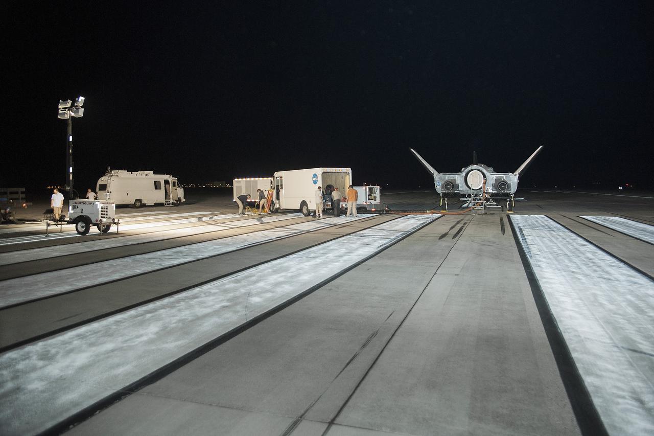
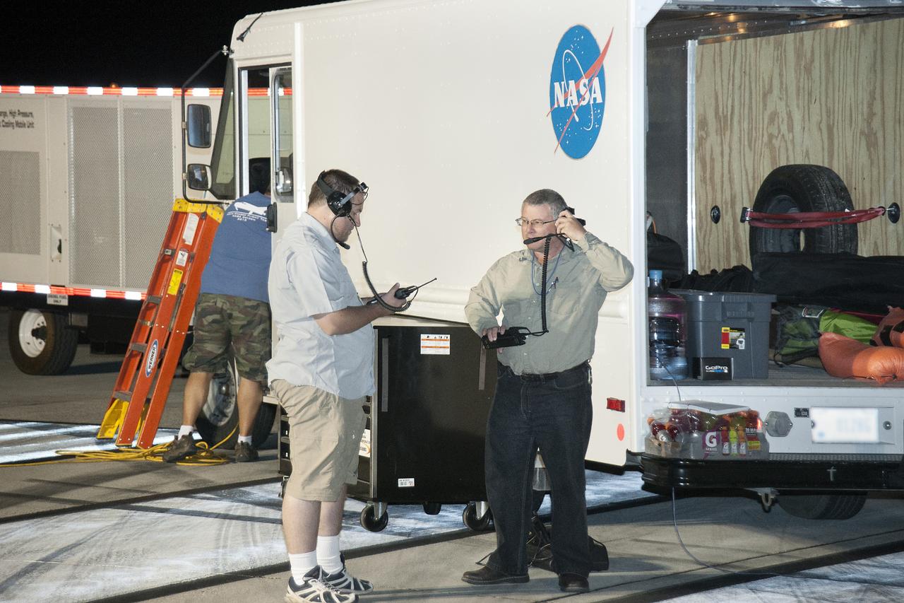
Edwards, Calif. – ED13-0266-056- Sierra Nevada Corporation, or SNC, team members monitor the company's Dream Chaser flight vehicle systems during 60 mph tow testing on taxi and runways at NASA's Dryden Flight Research Center at Edwards Air Force Base in California. Ground testing at 10, 20, 40 and 60 miles per hour is helping the company validate the performance of the spacecraft's braking and landing systems prior to captive-carry and free-flight tests scheduled for later this year. SNC is continuing the development of its Dream Chaser spacecraft under the agency's Commercial Crew Development Round 2, or CCDev2, and Commercial Crew Integrated Capability, or CCiCap, phases, which are intended to lead to the availability of commercial human spaceflight services for government and commercial customers. To learn more about CCP and its industry partners, visit www.nasa.gov/commercialcrew. Image credit: NASA/Ken Ulbrich

Edwards, Calif. – ED13-0266-074- Sierra Nevada Corporation's, or SNC's, Dream Chaser flight vehicle sports a pair of fuzzy dice during 60 mph tow tests at NASA's Dryden Flight Research Center in California. Ground testing at 10, 20, 40 and 60 miles per hour is helping the company validate the performance of the spacecraft's braking and landing systems prior to captive-carry and free-flight tests scheduled for later this year. SNC is continuing the development of its Dream Chaser spacecraft under the agency's Commercial Crew Development Round 2, or CCDev2, and Commercial Crew Integrated Capability, or CCiCap, phases, which are intended to lead to the availability of commercial human spaceflight services for government and commercial customers. To learn more about CCP and its industry partners, visit www.nasa.gov/commercialcrew. Image credit: NASA/Ken Ulbrich
Edwards, Calif. – ED13-0266-069- Sierra Nevada Corporation, or SNC, team members check the company's Dream Chaser flight vehicle systems following a 60 mph tow test on taxi and runways at NASA's Dryden Flight Research Center at Edwards Air Force Base in California. Ground testing at 10, 20, 40 and 60 miles per hour is helping the company validate the performance of the spacecraft's braking and landing systems prior to captive-carry and free-flight tests scheduled for later this year. SNC is continuing the development of its Dream Chaser spacecraft under the agency's Commercial Crew Development Round 2, or CCDev2, and Commercial Crew Integrated Capability, or CCiCap, phases, which are intended to lead to the availability of commercial human spaceflight services for government and commercial customers. To learn more about CCP and its industry partners, visit www.nasa.gov/commercialcrew. Image credit: NASA/Ken Ulbrich
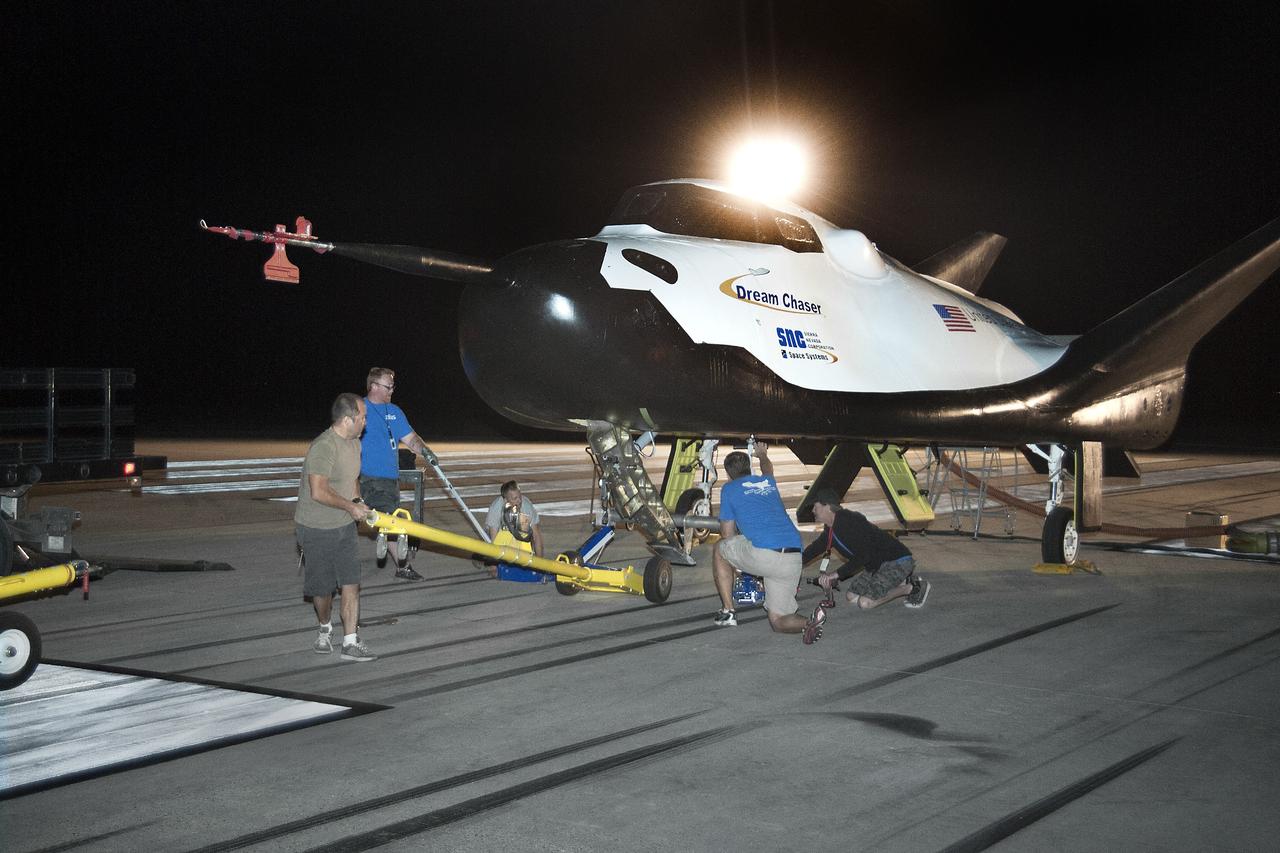
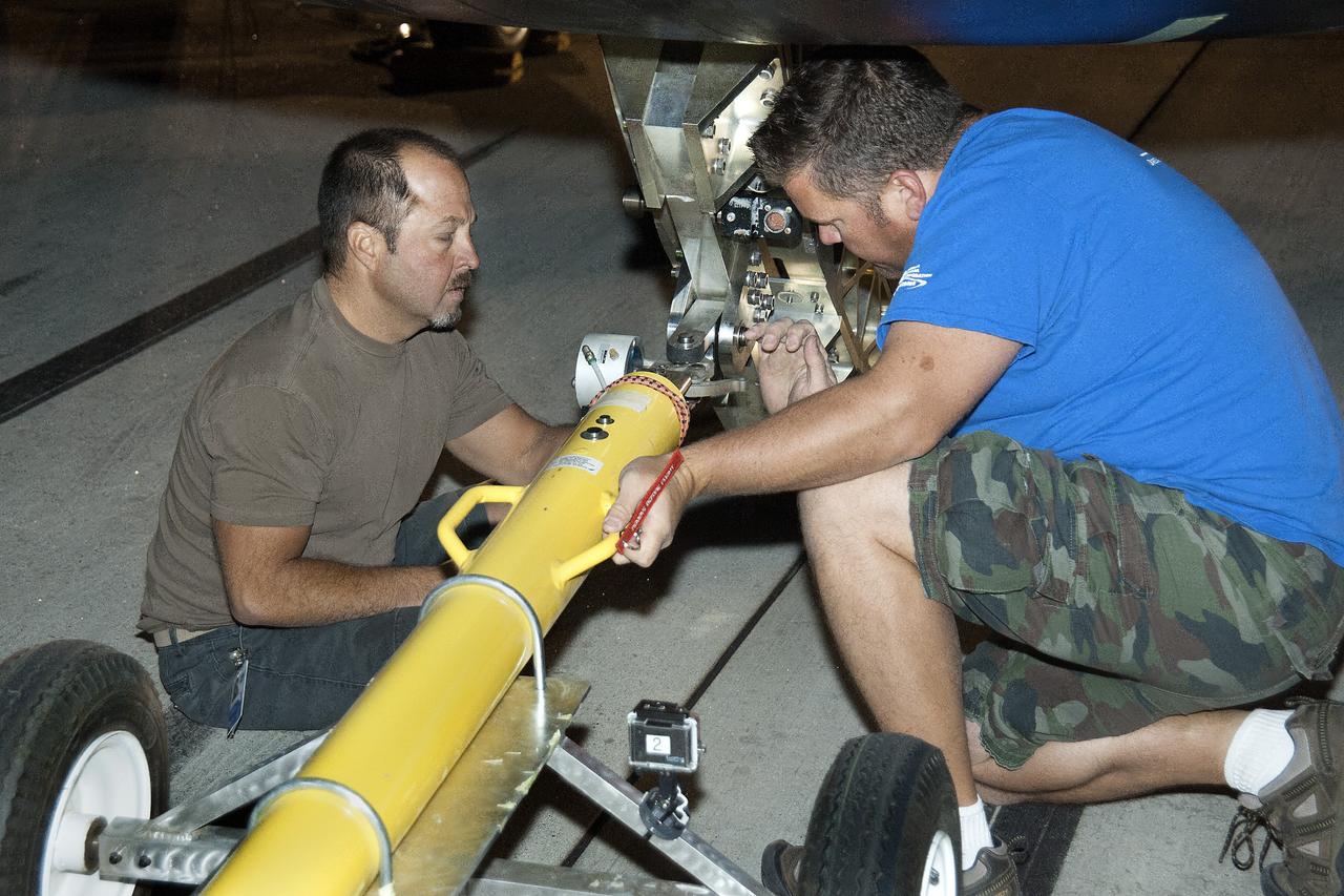
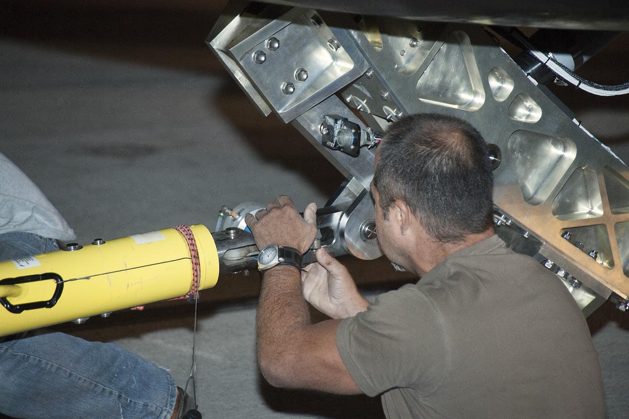
Edwards, Calif. – ED13-0266-012- Technicians prepare for 60 mph tow tests of Sierra Nevada Corporation's, or SNC's, Dream Chaser flight vehicle on taxi and runways at NASA's Dryden Flight Research Center at Edwards Air Force Base in California. Ground testing at 10, 20, 40 and 60 miles per hour is helping the company validate the performance of the spacecraft's braking and landing systems prior to captive-carry and free-flight tests scheduled for later this year. SNC is continuing the development of its Dream Chaser spacecraft under the agency's Commercial Crew Development Round 2, or CCDev2, and Commercial Crew Integrated Capability, or CCiCap, phases, which are intended to lead to the availability of commercial human spaceflight services for government and commercial customers. To learn more about CCP and its industry partners, visit www.nasa.gov/commercialcrew. Image credit: NASA/Ken Ulbrich
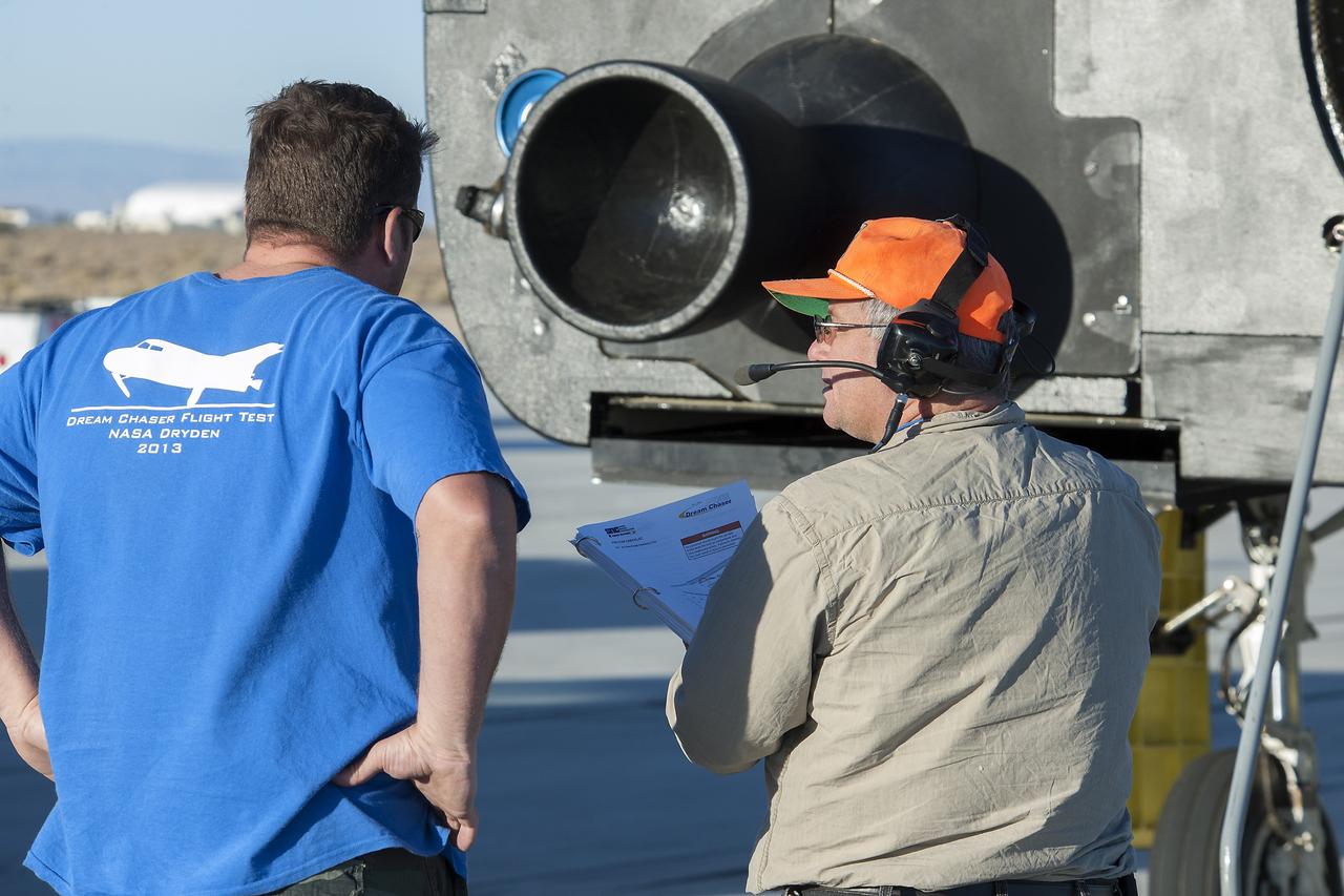
Edwards, Calif. – ED13-0266-021- A Sierra Nevada Corporation, or SNC, team member prepares for 60 mph tow tests of the company's Dream Chaser flight vehicle on taxi and runways at NASA's Dryden Flight Research Center at Edwards Air Force Base in California. Ground testing at 10, 20, 40 and 60 miles per hour is helping the company validate the performance of the spacecraft's braking and landing systems prior to captive-carry and free-flight tests scheduled for later this year. SNC is continuing the development of its Dream Chaser spacecraft under the agency's Commercial Crew Development Round 2, or CCDev2, and Commercial Crew Integrated Capability, or CCiCap, phases, which are intended to lead to the availability of commercial human spaceflight services for government and commercial customers. To learn more about CCP and its industry partners, visit www.nasa.gov/commercialcrew. Image credit: NASA/Ken Ulbrich
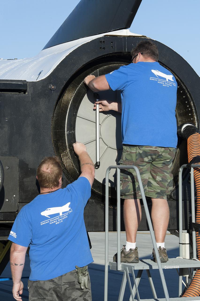
Edwards, Calif. – ED13-0266-046- Sierra Nevada Corporation, or SNC, team members prepare for 60 mph tow tests of the company's Dream Chaser flight vehicle on taxi and runways at NASA's Dryden Flight Research Center at Edwards Air Force Base in California. Ground testing at 10, 20, 40 and 60 miles per hour is helping the company validate the performance of the spacecraft's braking and landing systems prior to captive-carry and free-flight tests scheduled for later this year. SNC is continuing the development of its Dream Chaser spacecraft under the agency's Commercial Crew Development Round 2, or CCDev2, and Commercial Crew Integrated Capability, or CCiCap, phases, which are intended to lead to the availability of commercial human spaceflight services for government and commercial customers. To learn more about CCP and its industry partners, visit www.nasa.gov/commercialcrew. Image credit: NASA/Ken Ulbrich

Edwards, Calif. – ED13-0266-070- Sierra Nevada Corporation, or SNC, team members check the company's Dream Chaser flight vehicle systems following a 60 mph tow test on taxi and runways at NASA's Dryden Flight Research Center at Edwards Air Force Base in California. Ground testing at 10, 20, 40 and 60 miles per hour is helping the company validate the performance of the spacecraft's braking and landing systems prior to captive-carry and free-flight tests scheduled for later this year. SNC is continuing the development of its Dream Chaser spacecraft under the agency's Commercial Crew Development Round 2, or CCDev2, and Commercial Crew Integrated Capability, or CCiCap, phases, which are intended to lead to the availability of commercial human spaceflight services for government and commercial customers. To learn more about CCP and its industry partners, visit www.nasa.gov/commercialcrew. Image credit: NASA/Ken Ulbrich
Edwards, Calif. – ED13-0266-045- Sierra Nevada Corporation, or SNC, team members prepare for 60 mph tow tests of the company's Dream Chaser flight vehicle on taxi and runways at NASA's Dryden Flight Research Center at Edwards Air Force Base in California. Ground testing at 10, 20, 40 and 60 miles per hour is helping the company validate the performance of the spacecraft's braking and landing systems prior to captive-carry and free-flight tests scheduled for later this year. SNC is continuing the development of its Dream Chaser spacecraft under the agency's Commercial Crew Development Round 2, or CCDev2, and Commercial Crew Integrated Capability, or CCiCap, phases, which are intended to lead to the availability of commercial human spaceflight services for government and commercial customers. To learn more about CCP and its industry partners, visit www.nasa.gov/commercialcrew. Image credit: NASA/Ken Ulbrich
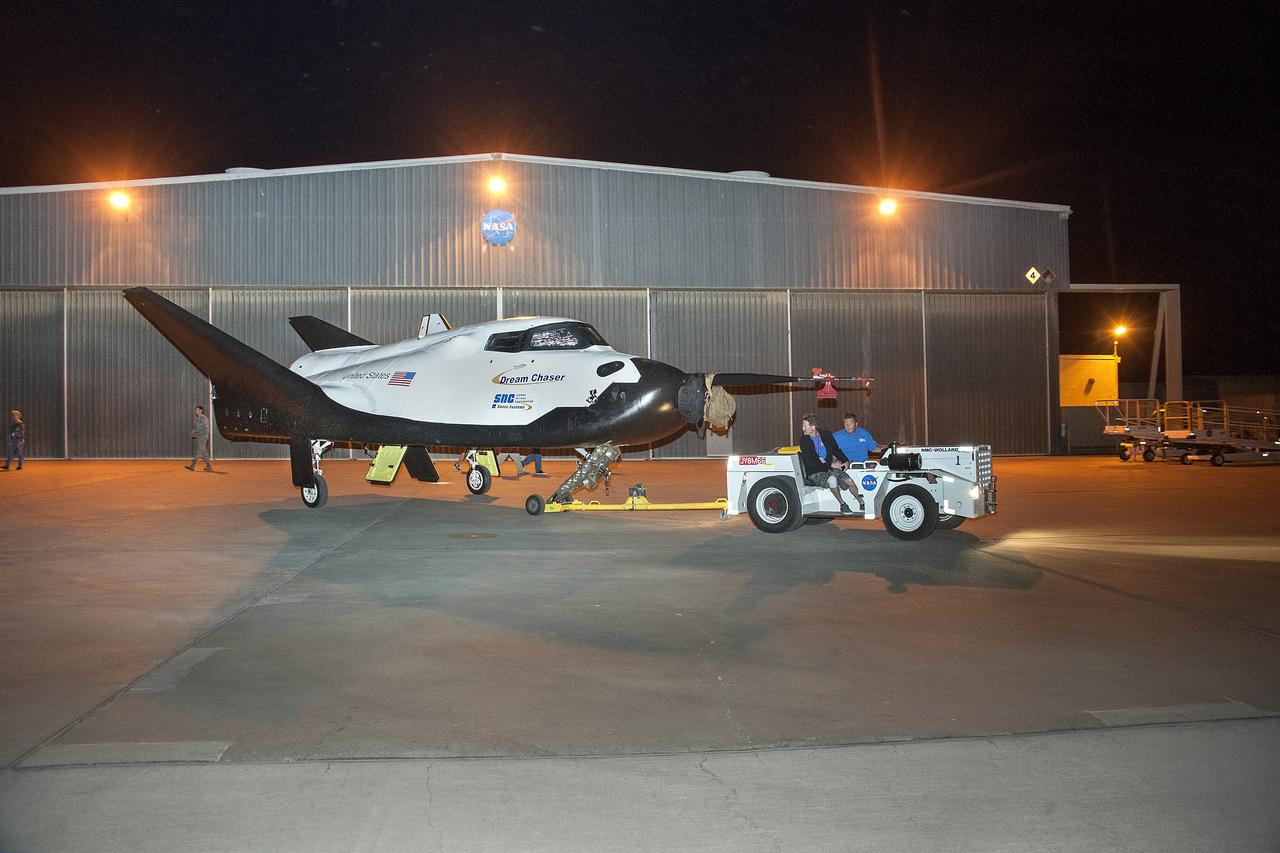
Edwards, Calif. – ED13-0266-008- The Sierra Nevada Corporation, or SNC, Dream Chaser flight vehicle is prepared for 60 mph tow tests on taxi and runways at NASA's Dryden Flight Research Center at Edwards Air Force Base in California. Ground testing at 10, 20, 40 and 60 miles per hour is helping the company validate the performance of the spacecraft's braking and landing systems prior to captive-carry and free-flight tests scheduled for later this year. SNC is continuing the development of its Dream Chaser spacecraft under the agency's Commercial Crew Development Round 2, or CCDev2, and Commercial Crew Integrated Capability, or CCiCap, phases, which are intended to lead to the availability of commercial human spaceflight services for government and commercial customers. To learn more about CCP and its industry partners, visit www.nasa.gov/commercialcrew. Image credit: NASA/Ken Ulbrich
Edwards, Calif. – ED13-0266-054- Sierra Nevada Corporation, or SNC, team members check the company's Dream Chaser flight vehicle systems following a 60 mph tow test on taxi and runways at NASA's Dryden Flight Research Center at Edwards Air Force Base in California. Ground testing at 10, 20, 40 and 60 miles per hour is helping the company validate the performance of the spacecraft's braking and landing systems prior to captive-carry and free-flight tests scheduled for later this year. SNC is continuing the development of its Dream Chaser spacecraft under the agency's Commercial Crew Development Round 2, or CCDev2, and Commercial Crew Integrated Capability, or CCiCap, phases, which are intended to lead to the availability of commercial human spaceflight services for government and commercial customers. To learn more about CCP and its industry partners, visit www.nasa.gov/commercialcrew. Image credit: NASA/Ken Ulbrich
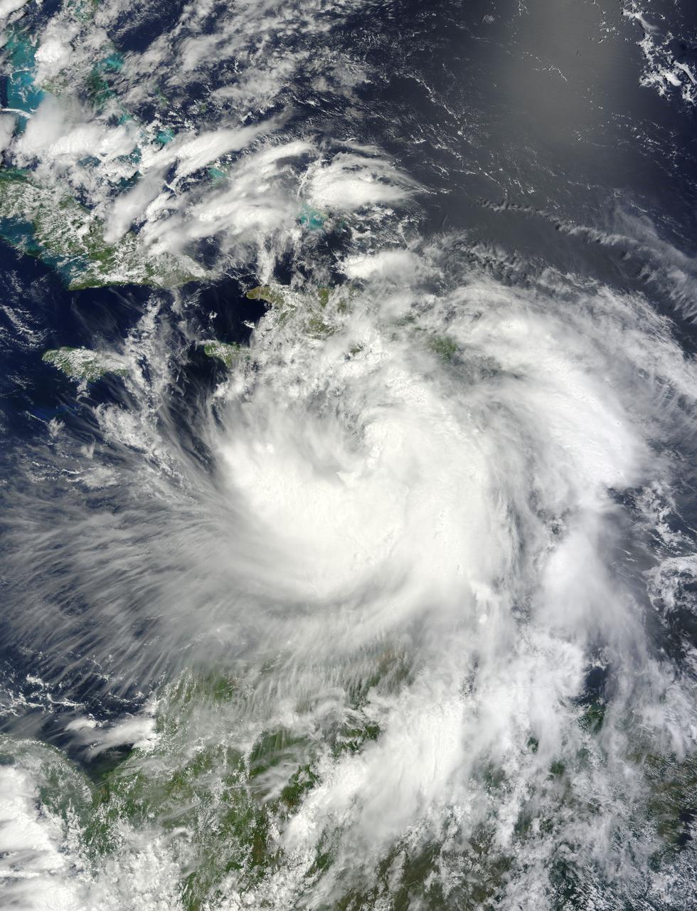
ISS011-E-08483 (11 June 2005) --- From 225 miles above Earth, the crew members aboard the International Space Station captured early tropical activity of the 2005 season, using an Electronic Still Camera. At the time of this photo (17:27:32 GMT, June 11, 2005), tropical storm Arlene was about two hours away from making landfall near Gulf Shores, AL with 60 mph winds. This frame and ISS011-E-08482 together encompass the entire body of the disorganized storm. View is from the southeast over the central Bahamas.
ISS011-E-08482 (11 June 2005) --- From 225 miles above Earth, the crew members aboard the International Space Station captured early tropical activity of the 2005 season, using an Electronic Still Camera. At the time of this photo (17:27:29 GMT, June 11, 2005), tropical storm Arlene was about two hours away from making landfall near Gulf Shores, AL with 60 mph winds. This frame and ISS011-E-08483 together encompass the entire body of the disorganized storm. View is from the southeast over the central Bahamas.

NASA's ECOsystem Spaceborne Thermal Radiometer Experiment on Space Station (ECOSTRESS) has imaged a temperature profile of an area surrounding a fire-induced tornado in Loyalton, California. A 20,000-acre wildfire early on Saturday, Aug. 15, 2020, had been the source of the tornado. Fire tornados are rare occurrences and happen due to the most unfavorable weather conditions: harsh winds and a surge in heat from a fire. They have the potential to be highly dangerous, leading to many areas to issue a weather alert to their residents to stay cautious and find places of shelter. In this map, there is a concentrated area of high temperature, which is likely where the fire-induced tornado had taken place. Also present in the image are very cold clouds, possibly representing the pyrocumulonimbus cloud that usually forms above a fire tornado. The National Weather Service (NWS) also suggested outflow winds in excess of 60 mph, which points to the event to be an EF1 or EF2 tornado. https://photojournal.jpl.nasa.gov/catalog/PIA23215
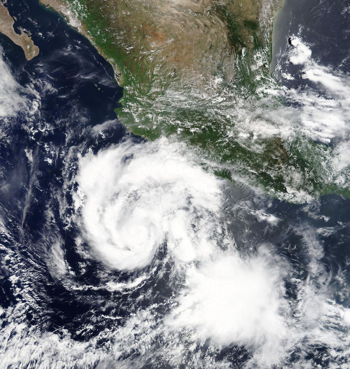
Hilary is a small but strengthening hurricane, with hurricane-force winds extending outward up to 10 miles (20 km) from the center. Tropical-storm-force winds extending outward up to 60 miles (95 km). Hilary began when Tropical Depression 9E formed on July 21. By July 22 at 11 p.m. EDT, the depression strengthened into a tropical storm and was re-named Hilary. At 5 a.m. EDT on Monday, July 24, 2017, Hilary rapidly intensified into a hurricane. NASA's Moderate Resolution Imaging Spectroradiometer, or MODIS, instrument aboard NASA’s Terra satellite captured a true color image of Hurricane Hilary on July 24 at 11 a.m. EDT. The image revealed a better organized tropical cyclone. The National Hurricane Center (NHC) noted "Satellite images indicate that Hilary has a small central core of convection, with both the visible and infrared channels suggesting that an eye is trying to form. Microwave data also show an incomplete eyewall." At 11 a.m. EDT (1500 UTC), the center of Hurricane Hilary was located near 14.1 degrees north latitude and 104.2 degrees west longitude. That's about 340 miles (545 km) south of Manzanillo, Mexico. Hilary is moving toward the west-northwest near 8 mph (13 kph), and the National Hurricane Center said this general motion with some increase in forward speed is expected over the next 48 hours. Maximum sustained winds have increased to near 80 mph (130 kph) with higher gusts. The estimated minimum central pressure is 989 millibars. The National Hurricane Center expects Hilary to become a major hurricane on Tuesday, July 25. For updated forecasts, visit: <a href="http://www.nhc.noaa.gov" rel="nofollow">www.nhc.noaa.gov</a>.
NASA's Terra satellite passed over Tropical Storm Isaac on Aug. 24 at 15:20 UTC (11:20 a.m. EDT) as it continued moving through the eastern Caribbean Sea. The MODIS instrument onboard Aqua captured this visible image. At 2 p.m. EDT on Aug. 24, Isaac's maximum sustained winds were near 60 mph (95 kmh). The National Hurricane Center noted that Isaac could strengthen later before reaching the coast of Hispaniola tonight, Aug. 24. Hispaniola is an island that contains the Dominican Republic and Haiti. Isaac is located about 135 miles (215 km) south-southeast of Port au Prince, Haiti, near latitude 16.8 north and longitude 71.4 west. Isaac is now moving toward the northwest near 14 mph (22 kmh). Isaac is expected to reach hurricane status over the weekend of Aug. 25-26 and NASA satellites will continue providing valuable temperature, rainfall, visible and infrared data. Text Credit: Rob Gutro NASA's Goddard Space Flight Center, Greenbelt, Md. <b>To read more go to: <a href="http://www.nasa.gov/mission_pages/hurricanes/archives/2012/h2012_Isaac.html" rel="nofollow">www.nasa.gov/mission_pages/hurricanes/archives/2012/h2012...</a></b> Credit: NASA Goddard MODIS Rapid Response Team <b><a href="http://www.nasa.gov/audience/formedia/features/MP_Photo_Guidelines.html" rel="nofollow">NASA image use policy.</a></b> <b><a href="http://www.nasa.gov/centers/goddard/home/index.html" rel="nofollow">NASA Goddard Space Flight Center</a></b> enables NASA’s mission through four scientific endeavors: Earth Science, Heliophysics, Solar System Exploration, and Astrophysics. Goddard plays a leading role in NASA’s accomplishments by contributing compelling scientific knowledge to advance the Agency’s mission. <b>Follow us on <a href="http://twitter.com/NASA_GoddardPix" rel="nofollow">Twitter</a></b> <b>Like us on <a href="http://www.facebook.com/pages/Greenbelt-MD/NASA-Goddard/395013845897?ref=tsd" rel="nofollow">Facebook</a></b> <b>Find us on <a href="http://instagrid.me/nasagoddard/?vm=grid" rel="nofollow">Instagram</a></b>
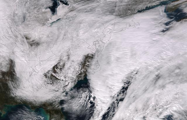
This image was taken by the Suomi NPP satellite's VIIRS instrument at 1825Z on January 26, 2015. A low pressure system currently forming off the mid-Atlantic coast will rapidly strengthen into a major nor'easter today and affect parts of the Northeast U.S. through early Wednesday. This system will be responsible for heavy to intense snowfall and strong winds, with blizzard conditions expected from eastern New Jersey to eastern Massachusetts where Blizzard Warnings are in effect. Accumulations will likely exceed one foot from eastern New Jersey through eastern Maine by late Tuesday. The heaviest snow accumulations, perhaps exceeding two feet, are forecast across portions of Connecticut, Rhode Island and Massachusetts, including the Boston area. Currently, New York City is forecast to receive 18-24 inches of snow, and Boston is forecast to receive 24-36 inches of snow. Wind gusts of 45 to 60 mph will be common from eastern New Jersey to eastern Massachusetts, leading to widespread blizzard conditions. Wind gusts up to 70 mph are possible in far eastern Massachusetts, including Cape Cod and Nantucket. Credit: NASA/NOAA/NPP/VIIRS Via: NASA/NOAA via <b><a href="www.nnvl.noaa.gov/" rel="nofollow"> NOAA Environmental Visualization Laboratory</a></b> <b><a href="http://www.nasa.gov/audience/formedia/features/MP_Photo_Guidelines.html" rel="nofollow">NASA image use policy.</a></b> <b><a href="http://www.nasa.gov/centers/goddard/home/index.html" rel="nofollow">NASA Goddard Space Flight Center</a></b> enables NASA’s mission through four scientific endeavors: Earth Science, Heliophysics, Solar System Exploration, and Astrophysics. Goddard plays a leading role in NASA’s accomplishments by contributing compelling scientific knowledge to advance the Agency’s mission. <b>Follow us on <a href="http://twitter.com/NASAGoddardPix" rel="nofollow">Twitter</a></b> <b>Like us on <a href="http://www.facebook.com/pages/Greenbelt-MD/NASA-Goddard/395013845897?ref=tsd" rel="nofollow">Facebook</a></b> <b>Find us on <a href="http://instagram.com/nasagoddard?vm=grid" rel="nofollow">Instagram</a></b>
NASA's Aqua satellite captured a picture of Tropical Storm Linfa in the South China Sea on July 7 when it was between southern Taiwan and the northern Philippines. Aqua passed over Linfa on July 7 at 05:25 UTC (1:25 a.m. EDT) and the Moderate Resolution Imaging Spectroradiometer or MODIS instrument captured a visible image of the storm. Bands of thunderstorms wrapping into the center of circulation from the south, draped over western Luzon. The MODIS image showed the tight concentration of thunderstorms around Linfa's center were located over the South China Sea. Fragmented bands of thunderstorms north of the center were brushing over Southern Taiwan while clouds from another band of fragmented thunderstorms stretched northwest through the Taiwan Strait. On July 7 at 1500 UTC (11 a.m. EDT), Tropical Storm Linfa's maximum sustained winds had increased to 50 knots (57.5 mph/92.6 kph), up from 45 knots (51.7 mph/83.3 kph) six hours before. Linfa strengthened in the warm waters of the South China Sea now that its center has moved away from the northern Philippines and was no longer over land. Linfa was centered near 21.0 North latitude and 118.8 East longitude, about 277 nautical miles (319 miles/513.3 km) east-southeast of Hong Kong, China. Linfa has tracked northward at 3 knots (3.5 mph/5.5 kph). China's National Meteorological Centre has (CNMC) issued a yellow category warning of typhoon at 6:00 a.m. July 7, Beijing Time. CNMC noted that Linfa is the tenth typhoon this year and at that time it was centered about 430 km (267.2 miles) southeast of border between Fujian and Guangdong For updated warnings and watches from the China Meteorological Service, visit: <a href="http://www.cma.gov.cn/en/WeatherWarnings/" rel="nofollow">www.cma.gov.cn/en/WeatherWarnings/</a>. Linfa is moving north between Luzon and Taiwan. The Joint Typhoon Warning Center expects Linfa to strengthen to 60 knots (69 mph/111 kph) by mid-day on July 9, before weakening and then making landfall in mainland China. Credit: NASA/GSFC/Jeff Schmaltz/MODIS Land Rapid Response Team <b><a href="http://www.nasa.gov/audience/formedia/features/MP_Photo_Guidelines.html" rel="nofollow">NASA image use policy.</a></b> <b><a href="http://www.nasa.gov/centers/goddard/home/index.html" rel="nofollow">NASA Goddard Space Flight Center</a></b> enables NASA’s mission through four scientific endeavors: Earth Science, Heliophysics, Solar System Exploration, and Astrophysics. Goddard plays a leading role in NASA’s accomplishments by contributing compelling scientific knowledge to advance the Agency’s mission. <b>Follow us on <a href="http://twitter.com/NASAGoddardPix" rel="nofollow">Twitter</a></b> <b>Like us on <a href="http://www.facebook.com/pages/Greenbelt-MD/NASA-Goddard/395013845897?ref=tsd" rel="nofollow">Facebook</a></b> <b>Find us on <a href="http://instagrid.me/nasagoddard/?vm=grid" rel="nofollow">Instagram</a></b>
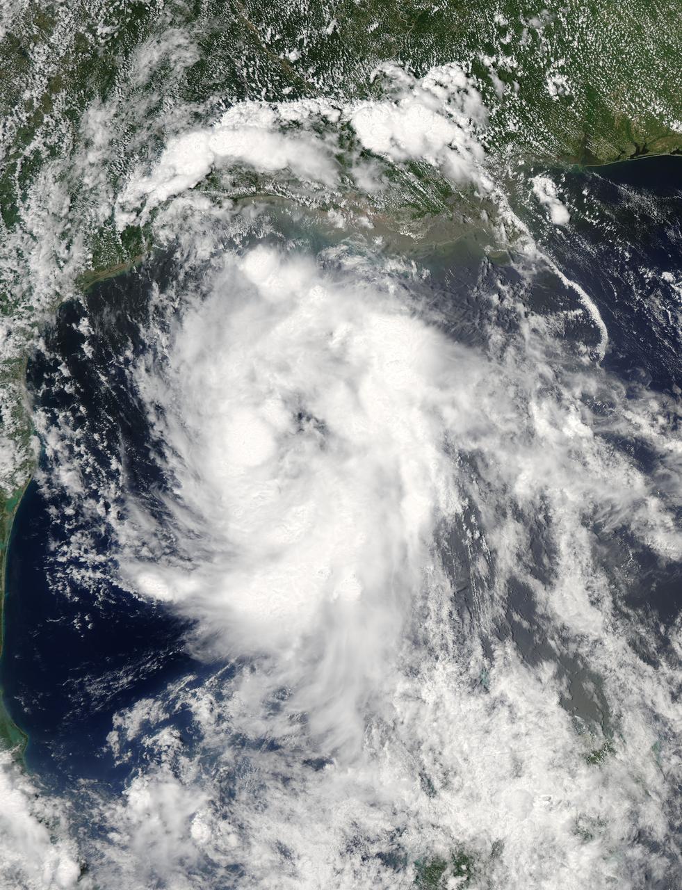
On June 15 at 19:15 UTC (3:15 p.m. EDT) the MODIS instrument aboard NASA's Aqua satellite captured a visible image of Tropical Storm Bill approaching Texas and Louisiana. Powerful thunderstorms circled the center in fragmented bands. At 11 a.m. CDT on June 16, a Tropical Storm Warning was in effect from Baffin Bay to High Island Texas as Bill was making landfall. The National Hurricane Center noted that Bill is expected to produce total rain accumulations of 4 to 8 inches over eastern Texas and eastern Oklahoma and 2 to 4 inches over western Arkansas and southern Missouri, with possible isolated maximum amounts of 12 inches in eastern Texas. In eastern Texas and far western Louisiana today and tonight, isolated tornadoes are also possible, as with any landfalling tropical storm. Tropical storm conditions are expected to continue into the evening in the warning area. Along the coasts, the combination of a storm surge and the tide will cause normally dry areas near the coast to be flooded by rising waters. The water could reach the following heights above ground if the peak surge occurs at the time of high tide. The NHC noted that the Upper Texas coast could experience 2 to 4 feet, and the western Louisiana coast between 1 to 2 feet. At 10 a.m. CDT (1500 UTC), the center of Tropical Storm Bill was located near latitude 28.2 North, longitude 96.4 West. Bill was moving toward the northwest near 10 mph (17 kph) and that general motion is expected to continue today. The latest minimum central pressure reported by an Air Force Reserve Hurricane Hunter aircraft was 997 millibars. Reports from an Air Force Reserve reconnaissance aircraft indicate that maximum sustained winds remain near 60 mph (95 kph) with higher gusts. Unlike Carlos, Bill is not a compact storm. Tropical-storm-force winds extend outward up to 150 miles (240 km) from the center. Between 9 and 10 a.m. CDT, an automated observing station at Port O'Connor also reported a sustained wind of 44 mph (70 kph) and a gust to 53 mph (85 kph). For updated forecasts, watches and warnings, visit the National Hurricane Center webpage at <a href="http://www.nhc.noaa.gov" rel="nofollow">www.nhc.noaa.gov</a>. For local forecasts and advisories, visit: <a href="http://www.weather.gov" rel="nofollow">www.weather.gov</a>. Bill is forecast to continue moving inland and is expected to be a tropical depression by Wednesday, June 17, west of Dallas. The remnants of Bill are forecast to move into the Midwest later in the week. Credit: NASA/GSFC/Jeff Schmaltz/MODIS Land Rapid Response Team <b><a href="http://www.nasa.gov/audience/formedia/features/MP_Photo_Guidelines.html" rel="nofollow">NASA image use policy.</a></b> <b><a href="http://www.nasa.gov/centers/goddard/home/index.html" rel="nofollow">NASA Goddard Space Flight Center</a></b> enables NASA’s mission through four scientific endeavors: Earth Science, Heliophysics, Solar System Exploration, and Astrophysics. Goddard plays a leading role in NASA’s accomplishments by contributing compelling scientific knowledge to advance the Agency’s mission. <b>Follow us on <a href="http://twitter.com/NASAGoddardPix" rel="nofollow">Twitter</a></b> <b>Like us on <a href="http://www.facebook.com/pages/Greenbelt-MD/NASA-Goddard/395013845897?ref=tsd" rel="nofollow">Facebook</a></b> <b>Find us on <a href="http://instagrid.me/nasagoddard/?vm=grid" rel="nofollow">Instagram</a></b>
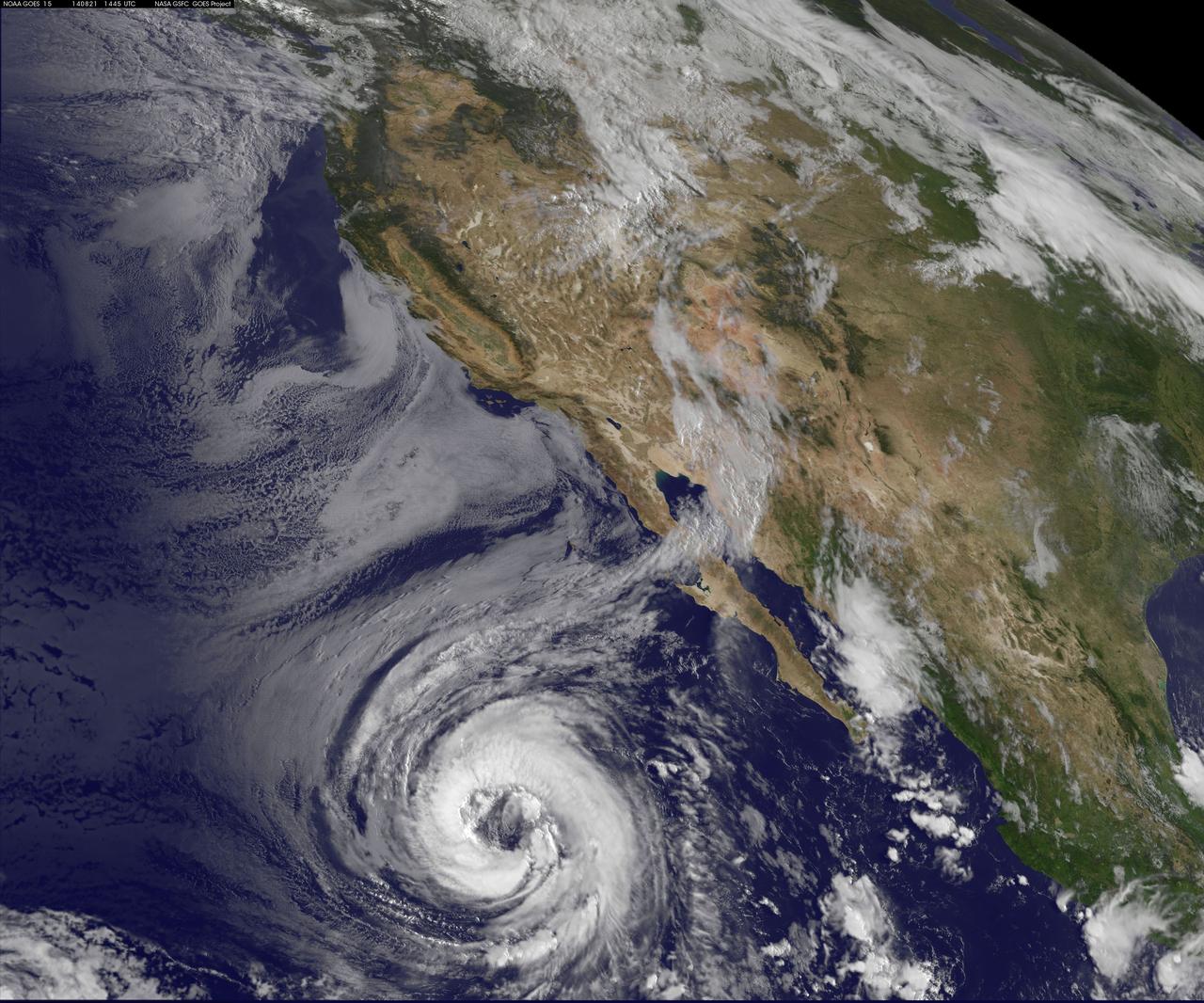
NOAA's GOES-West satellite watched as Tropical Storm Lowell strengthened into a large hurricane during the morning of August 21 and opened its eye. Hurricane force winds extend outward up to 60 miles (95 km) from the center, while tropical storm force winds extend outward up to 185 miles (295 km). The storm stretches over a greater distance. Lowell became the seventh hurricane of the Eastern Pacific Ocean season today, August 21 at 11 a.m. EDT (1500 UTC). Maximum sustained winds had increased to 75 mph (120 kph) making Lowell a Category One hurricane on the Saffir-Simpson Wind Scale. Little change in intensity is forecast by the National Hurricane Center (NHC) today, and NHC forecasters expect a slow weakening trend later today through August 22. It was centered near latitude 20.0 north and longitude 122.1 west, about 810 miles (1,300 km) west-southwest of the southern tip of Baja California, Mexico. It is moving to the northwest near 3 mph (4 kph) and is expected to move faster in that direction over the next two days. The NHC said that Lowell should begin to slowly weaken by August 22 as it moves over progressively cooler waters and into a drier and more stable air mass. Since Lowell is such a large cyclone, it will likely take longer than average to spin down. The GOES-West image of Lowell was created at the NASA/NOAA GOES Project, located at NASA's Goddard Space Flight Center in Greenbelt, Maryland. Rob Gutro NASA's Goddard Space Flight Center <b><a href="http://goes.gsfc.nasa.gov/" rel="nofollow">Credit: NOAA/NASA GOES Project</a></b> <b><a href="http://www.nasa.gov/audience/formedia/features/MP_Photo_Guidelines.html" rel="nofollow">NASA image use policy.</a></b> <b><a href="http://www.nasa.gov/centers/goddard/home/index.html" rel="nofollow">NASA Goddard Space Flight Center</a></b> enables NASA’s mission through four scientific endeavors: Earth Science, Heliophysics, Solar System Exploration, and Astrophysics. Goddard plays a leading role in NASA’s accomplishments by contributing compelling scientific knowledge to advance the Agency’s mission. <b>Follow us on <a href="http://twitter.com/NASAGoddardPix" rel="nofollow">Twitter</a></b> <b>Like us on <a href="http://www.facebook.com/pages/Greenbelt-MD/NASA-Goddard/395013845897?ref=tsd" rel="nofollow">Facebook</a></b> <b>Find us on <a href="http://instagram.com/nasagoddard?vm=grid" rel="nofollow">Instagram</a></b>

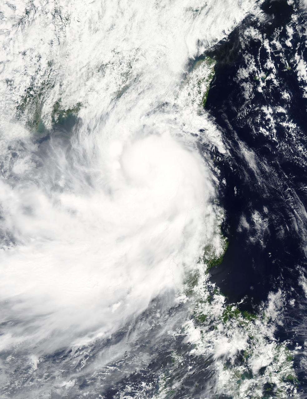
Over the weekend of Oct. 5 and 6, Typhoon Phanfone's center made landfall just south of Tokyo and passed over the city before exiting back into the Northwestern Pacific Ocean. NASA's Aqua satellite captured a picture of the typhoon as Tokyo braced for its large eye. On its way to mainland Japan, Phanfone struck Kadena Air Base on the island of Okinawa. According to the website for U.S. Air Force Kadena Air Base (<a href="http://www.kadena.af.mil" rel="nofollow">www.kadena.af.mil</a>), "One Airman is confirmed deceased and two more are missing after they were washed out to sea from the northwest coast of Okinawa at about 3:45 p.m. Oct. 5. An Airman that was found by the Japanese Coast Guard and pulled from the sea was later pronounced dead at a local hospital. HH-60s from Kadena Air Base and Japanese Coast Guard are continuing to search for the remaining two Airmen. Rough seas are complicating rescue efforts." Typhoon Phanfone's large eye made landfall near the city of Hamamatsu on Oct. 5 around 8 a.m. local time and then tracked north before turning eastward into the Pacific Ocean north of Tokyo. The MODIS instrument known as the Moderate Resolution Imaging Spectroradiometer captures amazing pictures from its orbit aboard NASA's Aqua satellite. MODIS snapped a picture of Typhoon Phanfone approaching Japan on Oct. 5 at 12:55 a.m. EDT. At that time, the Typhoon had already passed north of Okinawa, and was just south of the large island of Kyushu. The MODIS image revealed a large eye with powerful bands of thunderstorms spiraling into the center. On Oct. 6 by 0900 UTC (5 a.m. EDT), Phanfone had weakened from a typhoon to a tropical storm back over open waters of the Northwestern Pacific Ocean. Maximum sustained winds were near 60 knots (69.0 mph/111.1 kph). Phanfone was located near 38.0 north longitude and 145.0 east latitude. That's about 201 nautical miles (271 miles/372 km) south-southeast of Misawa Air Base, Japan. Phanfone was moving to the northeast at 40 knots (46 mph/74 kph). Forecasters at the Joint Typhoon Warning Center (JTWC) using animated multispectral satellite imagery noted that Phanfone is being affected by strong wind shear. The wind shear has stretched the tropical storm out, and pushed the bulk of thunderstorms northeast of the center. In addition, Phanfone has transitioned into an extra-tropical storm, which means that its core transitioned from warm to cold. JTWC called for Phanfone to continue accelerating northeastward and weaken as an extra-tropical cyclone over water. <b><a href="http://www.nasa.gov/audience/formedia/features/MP_Photo_Guidelines.html" rel="nofollow">NASA image use policy.</a></b> <b><a href="http://www.nasa.gov/centers/goddard/home/index.html" rel="nofollow">NASA Goddard Space Flight Center</a></b> enables NASA’s mission through four scientific endeavors: Earth Science, Heliophysics, Solar System Exploration, and Astrophysics. Goddard plays a leading role in NASA’s accomplishments by contributing compelling scientific knowledge to advance the Agency’s mission. <b>Follow us on <a href="http://twitter.com/NASAGoddardPix" rel="nofollow">Twitter</a></b> <b>Like us on <a href="http://www.facebook.com/pages/Greenbelt-MD/NASA-Goddard/395013845897?ref=tsd" rel="nofollow">Facebook</a></b> <b>Find us on <a href="http://instagram.com/nasagoddard?vm=grid" rel="nofollow">Instagram</a></b>
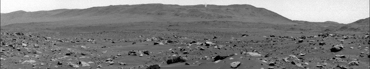
The lower portion of a Martian dust devil was captured by one of the Navcams on NASA's Perseverance rover on Aug. 30, 2023, the 899th Martian day, or sol, of the mission. The video, which has been enhanced in order to show maximal detail, was sped up 20 times and composed of 21 frames taken four seconds apart. Using data from the imagery, mission scientists determined that the dust devil was about 2.5 miles (4 kilometers) away, at a location nicknamed "Thorofare Ridge," and moving east to west at a clip of about 12 mph (19 kph). They calculated its width to be about 200 feet (60 meters). While only the bottom 387 feet (118 meters) of the swirling vortex are visible in the camera frame, scientists used the dust devil's shadow to estimate its full height at about 1.2 miles (2 kilometers). A key objective for Perseverance's mission on Mars is astrobiology, including the search for signs of ancient microbial life. The rover will characterize the planet's geology and past climate, pave the way for human exploration of the Red Planet, and be the first mission to collect and cache Martian rock and regolith (broken rock and dust). Subsequent NASA missions, in cooperation with ESA (European Space Agency), would send spacecraft to Mars to collect these sealed samples from the surface and return them to Earth for in-depth analysis. The Mars 2020 Perseverance mission is part of NASA's Moon to Mars exploration approach, which includes Artemis missions to the Moon that will help prepare for human exploration of the Red Planet. Animation available at https://photojournal.jpl.nasa.gov/catalog/PIA26074

As it sped away from Venus, NASA's Mariner 10 spacecraft captured this seemingly peaceful view of a planet the size of Earth, wrapped in a dense, global cloud layer. But, contrary to its serene appearance, the clouded globe of Venus is a world of intense heat, crushing atmospheric pressure and clouds of corrosive acid. This newly processed image revisits the original data with modern image processing software. A contrast-enhanced version of this view, also provided here, makes features in the planet's thick cloud cover visible in greater detail. The clouds seen here are located about 40 miles (60 kilometers) above the planet's surface, at altitudes where Earth-like atmospheric pressures and temperatures exist. They are comprised of sulfuric acid particles, as opposed to water droplets or ice crystals, as on Earth. These cloud particles are mostly white in appearance; however, patches of red-tinted clouds also can be seen. This is due to the presence of a mysterious material that absorbs light at blue and ultraviolet wavelengths. Many chemicals have been suggested for this mystery component, from sulfur compounds to even biological materials, but a consensus has yet to be reached among researchers. The clouds of Venus whip around the planet at nearly over 200 miles per hour (100 meters per second), circling the globe in about four and a half days. That these hurricane-force winds cover nearly the entire planet is another unexplained mystery, especially given that the solid planet itself rotates at a very slow 4 mph (less than 2 meters per second) — much slower than Earth's rotation rate of about 1,000 mph (450 meters per second). The winds and clouds also blow to the west, not to the east as on the Earth. This is because the planet itself rotates to the west, backward compared to Earth and most of the other planets. As the clouds travel westward, they also typically progress toward the poles; this can be seen in the Mariner 10 view as a curved spiral pattern at mid latitudes. Near the equator, instead of long streaks, areas of more clumpy, discrete clouds can be seen, indicating enhanced upwelling and cloud formation in the equatorial region, spurred on by the enhanced power of sunlight there. This view is a false color composite created by combining images taken using orange and ultraviolet spectral filters on the spacecraft's imaging camera. These were used for the red and blue channels of the color image, respectively, with the green channel synthesized by combining the other two images. Flying past Venus en route to the first-ever flyby of Mercury, Mariner 10 became the first spacecraft to use a gravity assist to change its flight path in order to reach another planet. The images used to create this view were acquired by Mariner 10 on Feb. 7 and 8, 1974, a couple of days after the spacecraft's closest approach to Venus on Feb. 5. Despite their many differences, comparisons between Earth and Venus are valuable for helping to understand their distinct climate histories. Nearly 50 years after this view was obtained, many fundamental questions about Venus remain unanswered. Did Venus have oceans long ago? How has its atmosphere evolved over time, and when did its runaway greenhouse effect begin? How does Venus lose its heat? How volcanically and tectonically active has Venus been over the last billion years? This image was processed from archived Mariner 10 data by JPL engineer Kevin M. Gill. The Mariner 10 mission was managed by NASA's Jet Propulsion Laboratory. https://photojournal.jpl.nasa.gov/catalog/PIA23791
Dream Chaser departs in front of HL-10 at NASA Armstrong where it underwent testing and preparation for successful approach and landing flight. The spacecraft returned to SNC facility in Colorado.
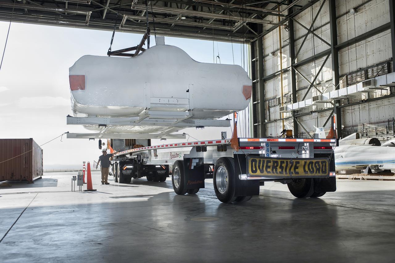
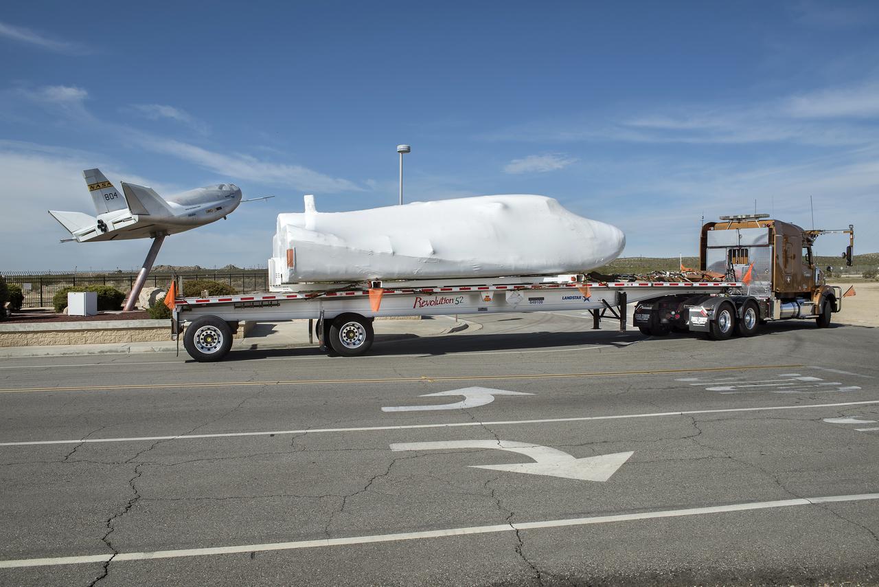
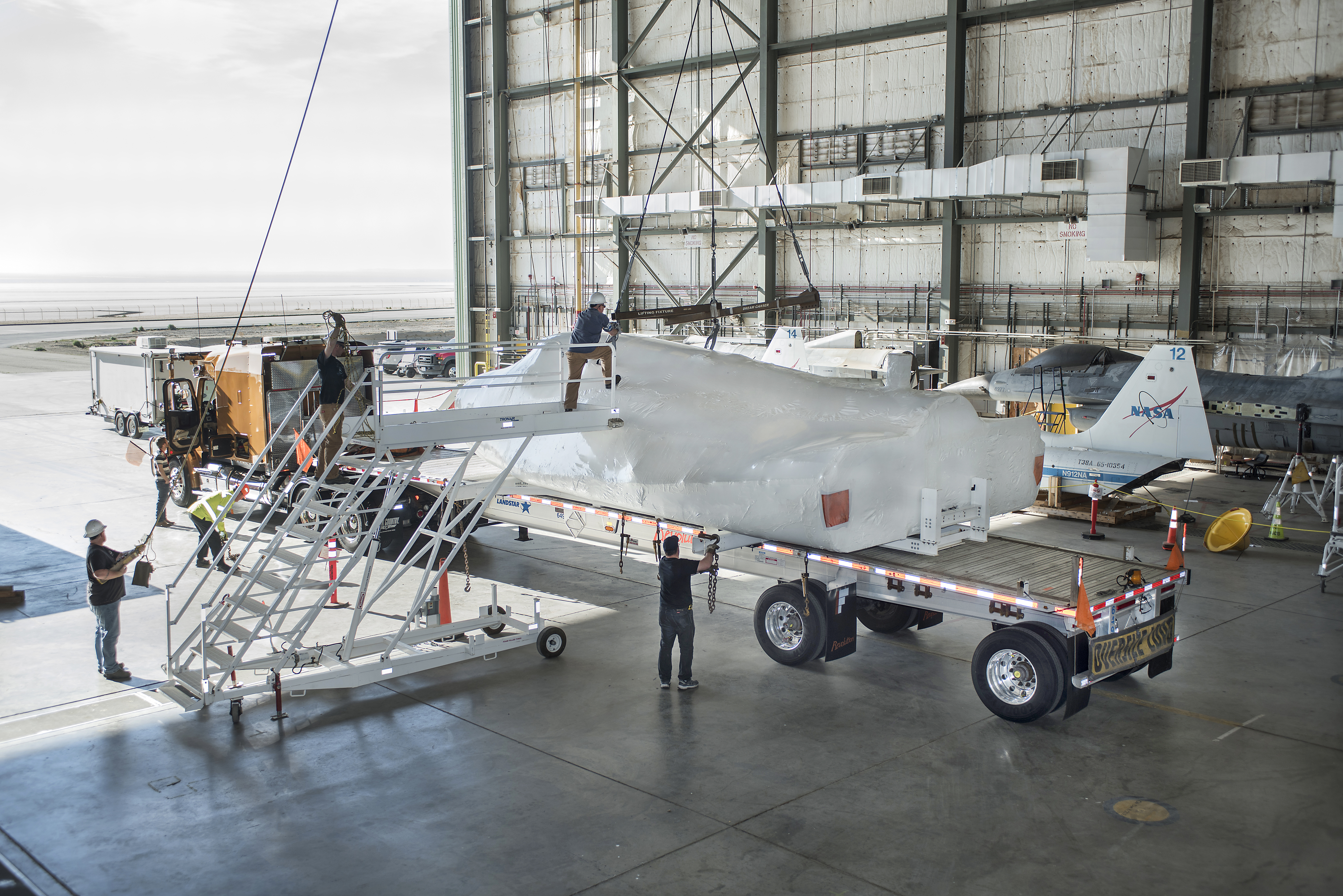
SNC Dream Chaser is lifted on to a truck in NASA Armstrong’s historic space shuttle hangar where the spacecraft stayed as it was being prepared for testing and flights. Dream Chaser is in Colorado at a SNC facility.
SNC Dream Chaser is in NASA Armstrong, previously known as space shuttle, hangar being loaded on truck for its departure from the center heading to SNC in Colorado.