
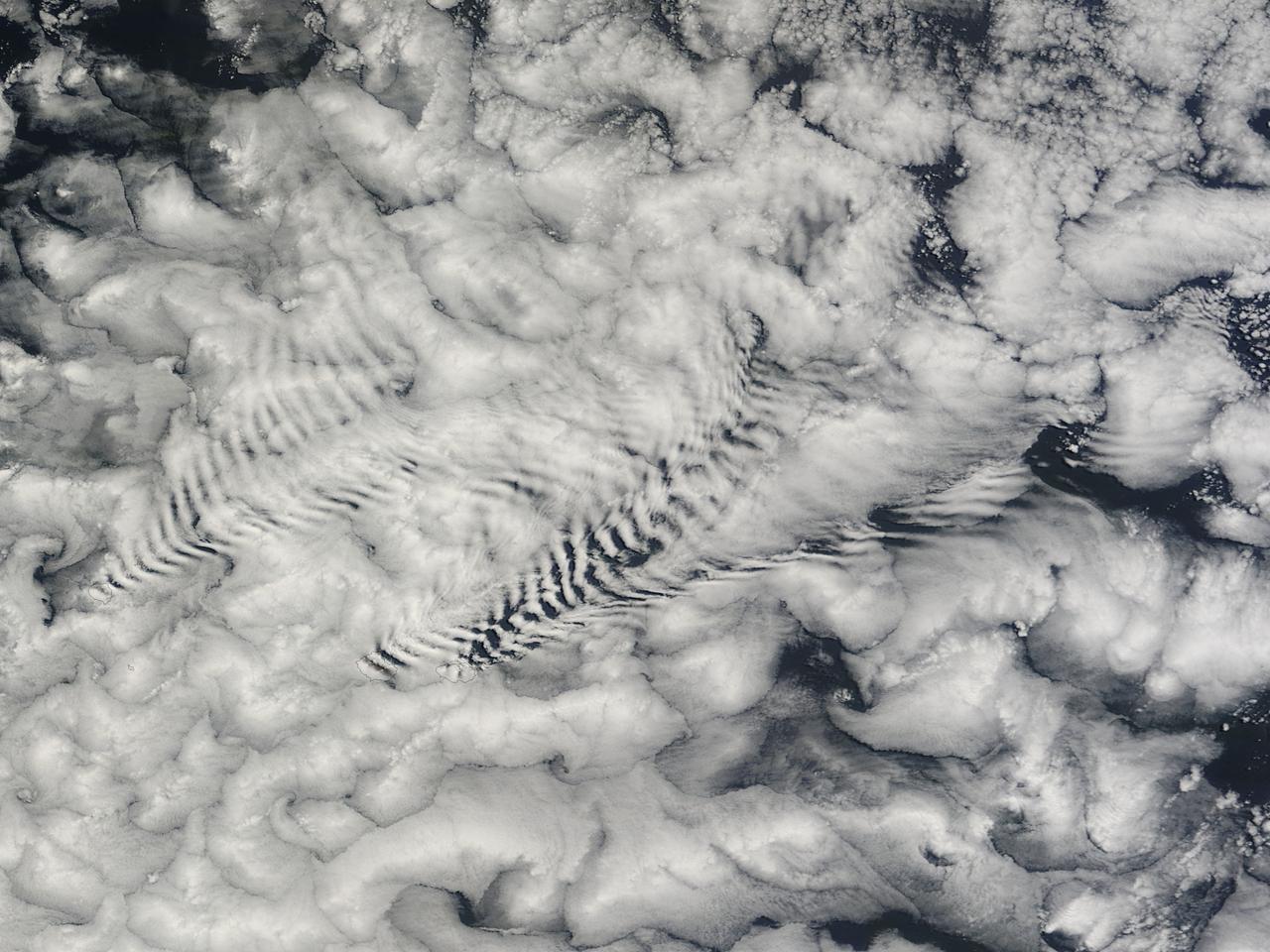
Like a ship carving its way through the sea, the South Georgia and South Sandwich Islands parted the clouds. The Moderate Resolution Imaging Spectroradiometer (MODIS) on NASA’s Terra satellite acquired this natural-color image on February 2, 2017. The ripples in the clouds are known as gravity waves. NASA image by Jeff Schmaltz, LANCE/EOSDIS Rapid Response #nasagoddard
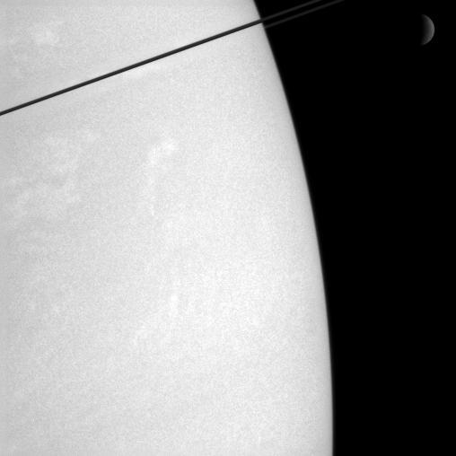
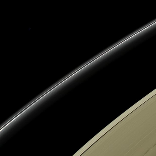
Whiffs of cloud dance in Saturn atmosphere, while the dim crescent of Rhea 1,528 kilometers, or 949 miles across hangs in the distance. The dark ringplane cuts a diagonal across the top left corner of this view

Flight engineer and photographer William Wynne (pictured) worked with photographer Arthur Laufman to execute a photo concept devised by Laufman. Wynne printed two copies of the F-61 aircraft in flight. The prints were made to the correct size that allowed them to be cut out and taped to the lenses of his goggles to simulate a reflection. The photo of Wynne was then taken with an out of focus background to simulate clouds.
AS09-23-3561 (3-13 March 1969) --- Near vertical view of the Lubbock area in west Texas as photographed from the Apollo 9 spacecraft during its Earth-orbital mission. Conspicuous patterns of farmland surround the city and extend eastward (up) to the Caprock Escarpment. The Double Mountain fork of the Brazos River drains east (toward upper center); Leeland is at lower center; Brownfield at lower right. The sharp edge of a cloud disk cuts across the upper right corner.
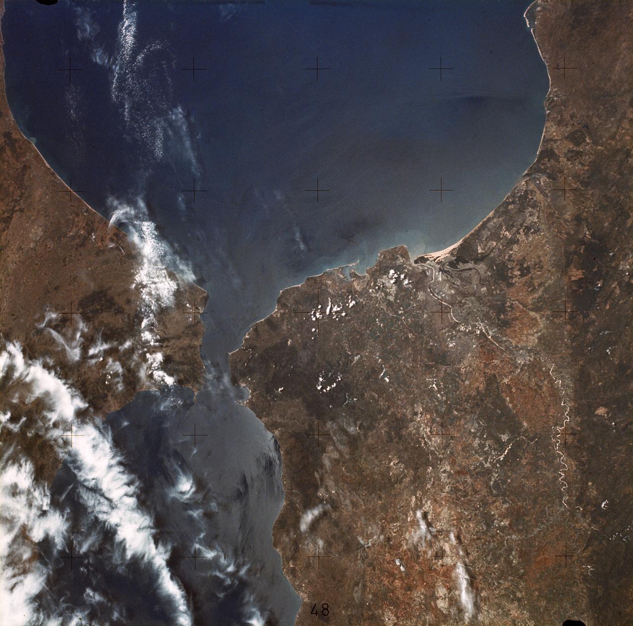
SL2-05-370 (22 June 1973) --- Gateway to the Atlantic, since ancient times the Strait of Gibraltar (36.5N, 4.5W) is also the border between Africa and Europe. In Spain to the north, the dark area near the coast is the delta of the Guadalquivir River and the city of Seville. The small spike of land on the north side of the strait is the actual Rock of Gibraltar. On the African side, a cloud front cutting across from the coast is blowing into Europe from Morocco and Algeria. Photo credit: NASA
NASA's Curiosity Mars rover used its left Mast Camera, or Mastcam, to capture these drifting noctilucent, or twilight, clouds on Jan. 17, 2025, the 4,426th Martian day, or sol, of the mission. The left Mastcam has a stuck color filter wheel, which is why part of the imagery appears cut off in three corners. The original recording taken by Curiosity was 16 minutes; this video has been speeded up by about 480 times (and it loops four times). The clouds at the top of the frame, including the falling white plumes, are made of carbon dioxide ice. The plumes are an estimated 37 to 50 miles (60 to 80 kilometers) above the Martian surface; they could fall as low as 31 miles (50 kilometers) above the surface before they would evaporate due to rising temperatures. In the lower half of the frame at the beginning of the video, a different set of very faint clouds is visible. These are water-ice clouds are hovering at roughly 31 miles (50 kilometers) in altitude. The brightness has been stretched to make certain colors more visible in this enhanced-color imagery. This is the fourth Mars year that twilight clouds have been observed by Curiosity; previous observations were made in 2019, 2021, and 2023. Animation available at https://photojournal.jpl.nasa.gov/catalog/PIA26519
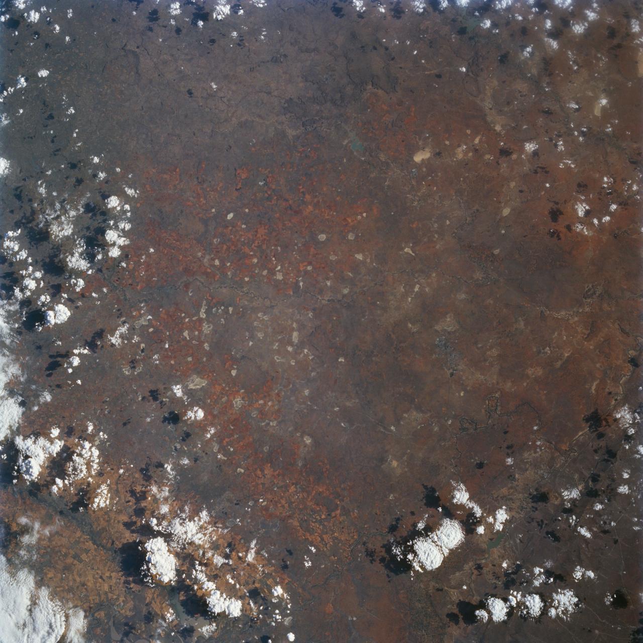
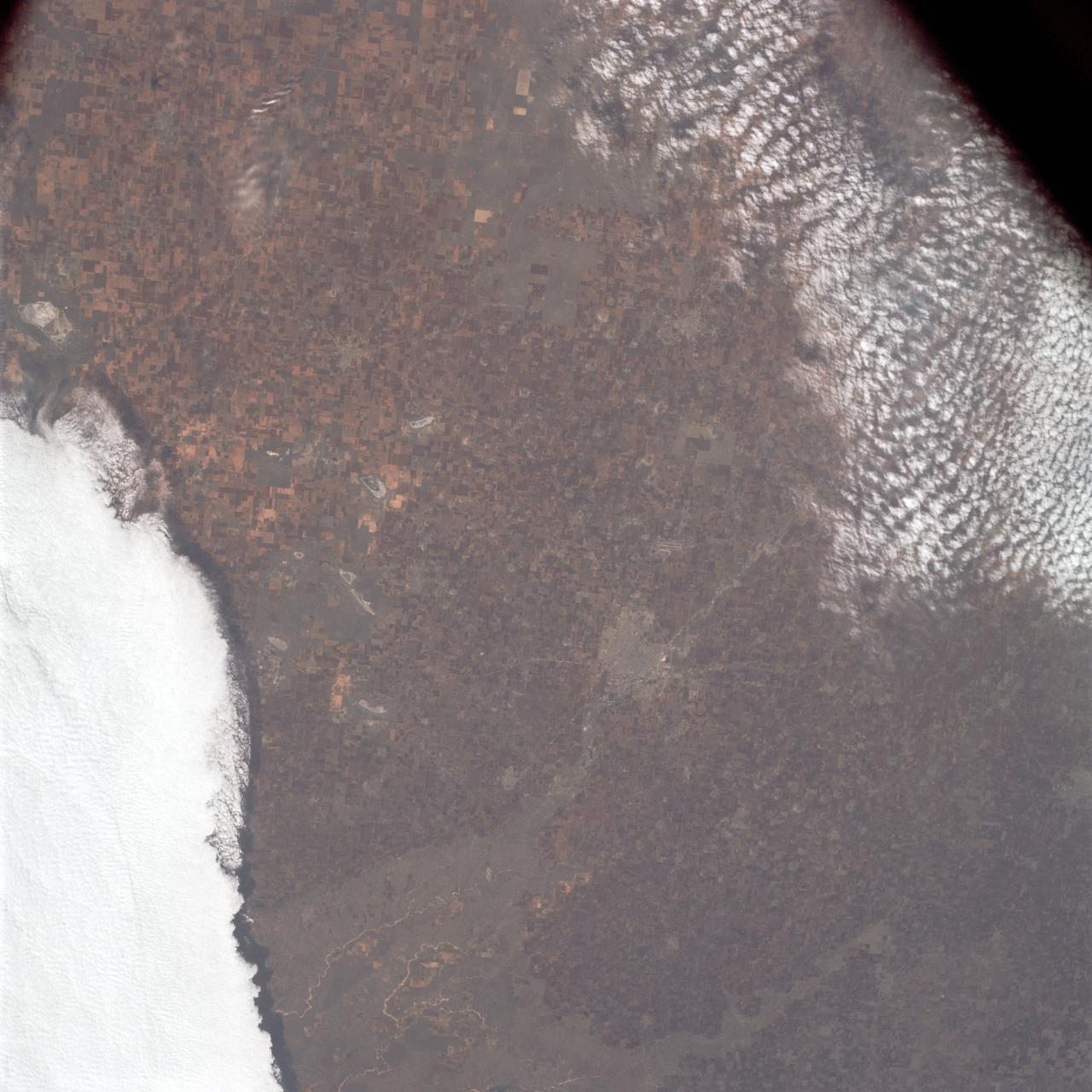
STS072-727-059 (11-20 Jan. 1996) --- Plains of the Orange Free State, South Africa are featured in this 70mm frame exposed from the Space Shuttle Endeavour. If the photograph is oriented with the largest clouds at the top edge, so that the cloud shadows fall to the upper right of each cloud, then north is to the top. The Vaal River flows along the top and through the upper left of the photograph; the reservoir of the Bloemhofdam on the Sand River can be seen between clouds at the upper right of the photograph. Kimberley can be seen as a gray smudge southeast of a contorted set of bends in the Vaal river (upper left center). With high magnification four dark dots, large open-pit mine shafts, can be seen within the gray smudge of the city. Kimberley, the capital of Northern Cape Province, was founded in 1878 after the discovery of diamonds in 1969 - 71, and reached by railway in 1885. Diamond mining and gem cutting remain prominent in the economy. The reddish soil and scattered salt pans (playa lakes) across the plateau suggest the semi-arid climate, suitable for cattle ranching. Reservoirs on most streams now provide water for the towns as well as irrigation for agriculture.
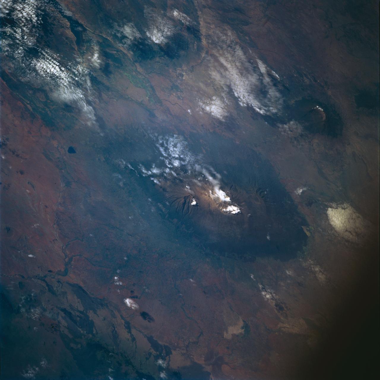
STS072-722-004 (11-20 Jan. 1996) --- Mount Kilimanjaro in Tanzania is featured in this 70mm frame exposed from the Earth-orbiting Space Shuttle Endeavour. Orient with the clouds trailing to the left; then the view is southwest from Kenya past Kilimanjaro to Mount Meru, in Tanzania. Mount Kilimanjaro is about three degrees south of the Equator, but at nearly 6,000 meters has a permanent snowfield. The mountain displays a classic zonation of vegetation types from seasonally dry savannah on the plains at 1,000 meters, to the cloud forest near the top. The mountain is being managed experimentally as an international biosphere reserve. A buffer zone of "traditional" agriculture and pastoral land use is designated around the closed-canopy forest reserve. Specialists familiar with this area say management is partially successful so far, but cleared areas of the forest can be seen on this photograph as light green "nibbles" or "cookie cuts" extending into the dark forest region.
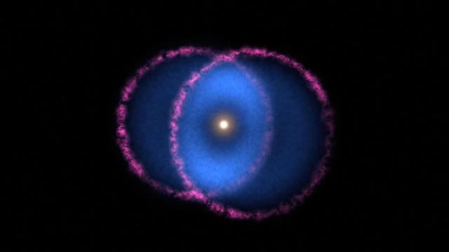
The Blue Ring Nebula is thought to be the product of two stars merging into one. The collision of the bodies ejected a cloud of hot debris into space. A disk of gas orbiting the larger star cut the cloud in half, creating two cones that are moving away from the star in opposite directions. The base of one cone is moving almost directly toward Earth, while the other is moving almost directly away. Magenta represents optical light from the shockwave at the front of the expanding debris cones, outlining the two cone bases at their widest points. Blue represents far-ultraviolet light (not visible to the human eye) and comes from gas behind the shockwave. As the gas expands and cools, it forms hydrogen molecules that interact with the interstellar medium and emit only far-ultraviolet light. These emissions are visible only where the cones overlap (as seen from Earth), forming the blue ring around the central star. Movie available at https://photojournal.jpl.nasa.gov/catalog/PIA23868
KENNEDY SPACE CENTER, FLA. - Under evening cloud-filled skies, Space Shuttle Discovery remains on the pad two days after the Shuttle’s launch on Return to Flight mission STS-114 was scrubbed. The July 13 mission was scrubbed when a low-level fuel cut-off sensor for the liquid hydrogen tank inside the External Tank failed a routine prelaunch check during the countdown July 13, causing mission managers to scrub Discovery's first launch attempt. The sensor protects the Shuttle's main engines by triggering their shutdown in the event fuel runs unexpectedly low. The sensor is one of four inside the liquid hydrogen section of the External Tank (ET).
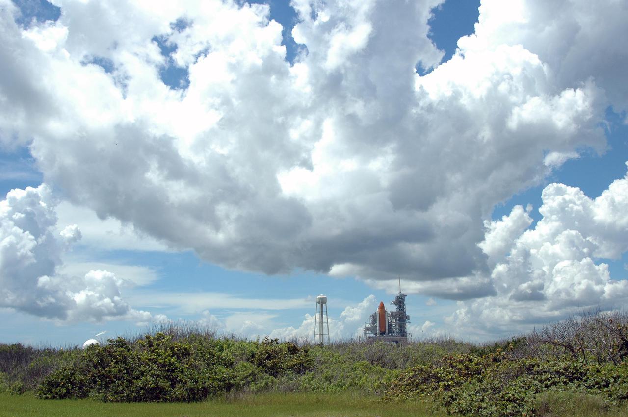
KENNEDY SPACE CENTER, FLA. - Under evening cloud-filled skies, Space Shuttle Discovery remains on the pad two days after the Shuttle’s launch on Return to Flight mission STS-114 was scrubbed. The July 13 mission was scrubbed when a low-level fuel cut-off sensor for the liquid hydrogen tank inside the External Tank failed a routine prelaunch check during the countdown July 13, causing mission managers to scrub Discovery's first launch attempt. The sensor protects the Shuttle's main engines by triggering their shutdown in the event fuel runs unexpectedly low. The sensor is one of four inside the liquid hydrogen section of the External Tank (ET).
SL3-34-336 (July-September 1973) --- A vertical view of a portion of northern California near the Pacific coast as photographed from Earth orbit by one of the six lenses of the Itek-furnished S190-A Multispectral Photographic Facility Experiment in the Multiple Docking Adapter of the Skylab space station. A cloud deck covers the Pacific Ocean. Most of Cape Mendocino is clear of clouds and extends into the Pacific as the westernmost part of California. The sinuous pattern of the Bel River (in center) flows northward into the ocean and is characteristic of the rivers that drain the coastal ranges. This area is immediately southeast of Eureka. During Skylab 3 extensive forest fires occurred near Briceland and the smoke rising from the fires is clearly visible next to the cloud bank. Redwood and fir forests are sources of lumber in this region; and a variety of clear cut (timbering) patterns appear as light against the dark forest. The patterns appear to be related to the topography. Analysis of this photograph will aid Dr. P.G. Langley, Earth Satellite Corporation, in developing methods for forest inventory using space photography. Federal agencies participating with NASA on the EREP project are the Departments of Agriculture, Commerce, Interior, the Environmental Protection Agency and the Corps of Engineers. All EREP photography is available to the public through the Department of Interior?s Earth Resources Observations Systems Data Center, Sioux Falls, South Dakota, 57198. Photo credit: NASA
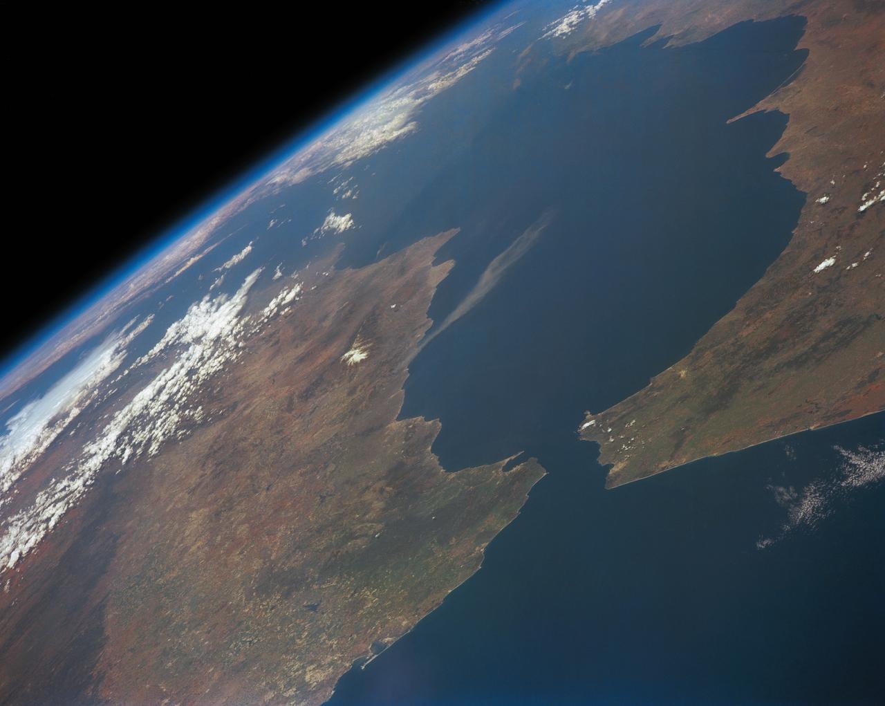
STS039-151-193 (28 April-6 May 1991) --- The Strait of Gibraltar, the only outlet for the Mediterranean Sea, was photographed with a large format handheld camera by the STS-39 crew members. Scientists site evidence in Shuttle photography that the Mediterranean Sea dried up a number of times between 5 million and 20 million years ago. Sea levels, they say, dropped slightly, cutting off the Mediterranean (top right) from the Atlantic Ocean (bottom). In southern Spain, the dark area near the coast is the delta of the Guadalquivir River with the city of Seville. The Sierra Nevada range still has some snow. A small field fire near the Spanish coast has generated a conspicuous smoke plume. The small spike of land on the north side of the Strait is the Rock of Gibraltar, an outpost of the British empire. The larger spike of land on the north coast of Africa marks the border between Morocco (center foreground) and Algeria (right). The sharp line cutting across them Mediterranean (top right) marks the edge of a dust cloud blowing from Africa into Europe. Photo credit: NASA
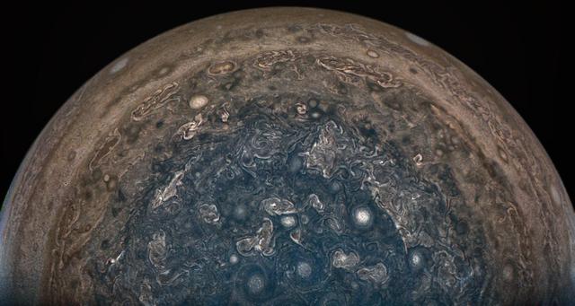
NASA's Juno spacecraft soared directly over Jupiter's south pole when JunoCam acquired this image on February 2, 2017 at 6:06 a.m. PT (9:06 a.m. ET), from an altitude of about 62,800 miles (101,000 kilometers) above the cloud tops. From this unique vantage point we see the terminator (where day meets night) cutting across the Jovian south polar region's restless, marbled atmosphere with the south pole itself approximately in the center of that border. The terminator is offset a bit because it's summer in Jupiter's southern hemisphere. However, the tilt of Jupiter's spin axis is only 3 degrees, much less than Earth's 23.5-degree tilt. This image was processed by citizen scientist John Landino. This enhanced color version highlights the bright high clouds and numerous meandering oval storms. Away from the polar region, the seeming chaos of Jupiter's polar region gives way to the more familiar color banding that Jupiter is known for. http://photojournal.jpl.nasa.gov/catalog/PIA21382
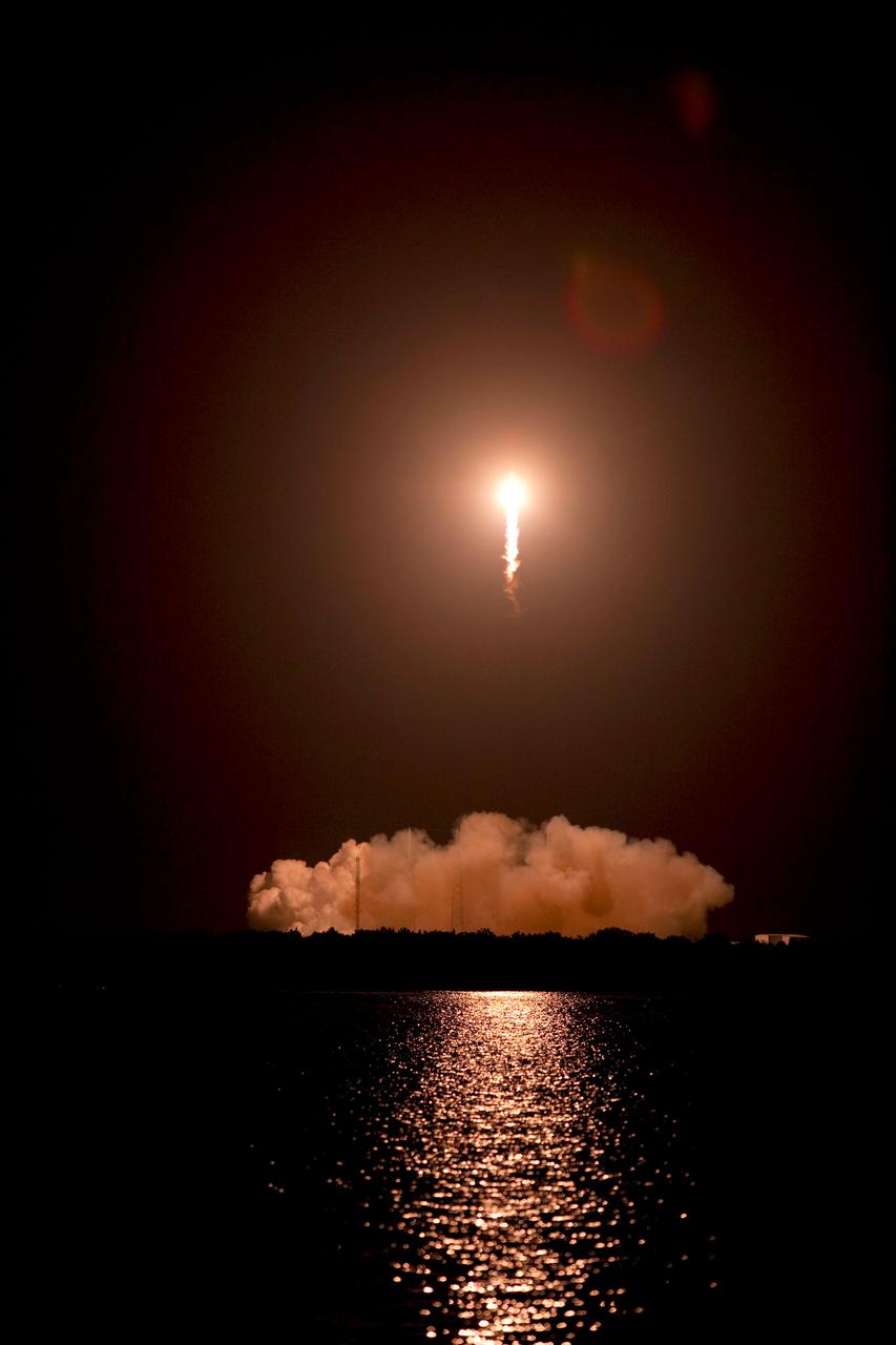
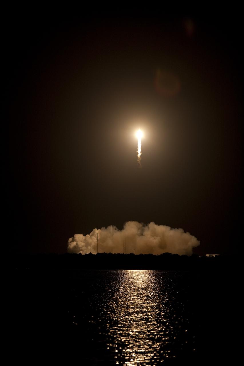
CAPE CANAVERAL, Fla. -- A Falcon 9 rocket cuts its way through the clouds over Space Launch Complex 40 on Cape Canaveral Air Force Station in Florida carrying a Dragon capsule to orbit. Launch was at 8:35 p.m. EDT. Space Exploration Technologies Corp., or SpaceX, built both the rocket and capsule for NASA's first Commercial Resupply Services, or CRS-1, mission to the International Space Station. SpaceX CRS-1 is an important step toward making America’s microgravity research program self-sufficient by providing a way to deliver and return significant amounts of cargo, including science experiments, to and from the orbiting laboratory. NASA has contracted for 12 commercial resupply flights from SpaceX and eight from the Orbital Sciences Corp. For more information, visit http://www.nasa.gov/mission_pages/station/living/launch/index.html. Photo credit: NASA/Glenn Benson
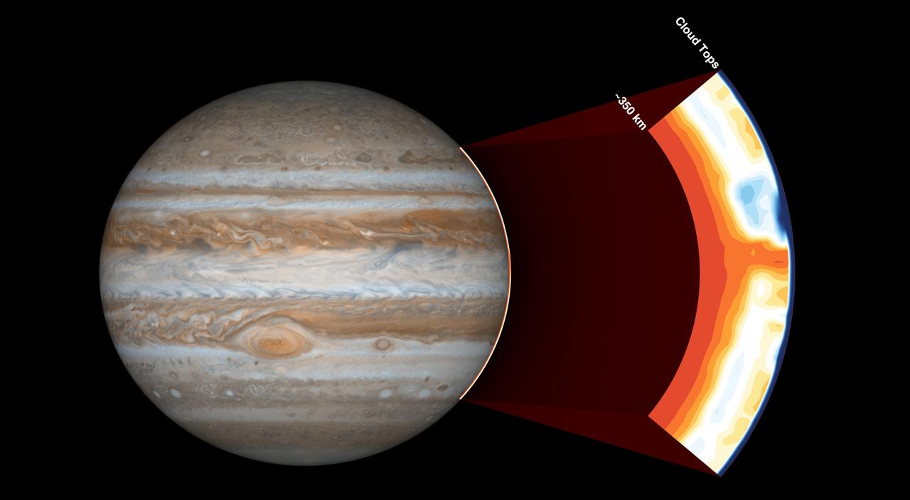
NASA's Juno spacecraft carries an instrument called the Microwave Radiometer, which examines Jupiter's atmosphere beneath the planet's cloud tops. This image shows the instrument's view of the outer part of Jupiter's atmosphere. Before Juno began using this instrument, scientists expected the atmosphere to be uniform at depths greater than 60 miles (100 kilometers). But with the Microwave Radiometer, scientists have discovered that the atmosphere has variations down to at least 220 miles (350 kilometers), as deep as the instrument can see. In the cut-out image to the right, orange signifies high ammonia abundance and blue signifies low ammonia abundance. Jupiter appears to have a band around its equator high in ammonia abundance, with a column shown in orange. This is contrary to scientists' expectations that ammonia would be uniformly mixed. https://photojournal.jpl.nasa.gov/catalog/PIA21642
CAPE CANAVERAL, Fla. -- A Falcon 9 rocket cuts its way through the clouds over Space Launch Complex 40 on Cape Canaveral Air Force Station in Florida carrying a Dragon capsule to orbit. Launch was at 8:35 p.m. EDT. Space Exploration Technologies Corp., or SpaceX, built both the rocket and capsule for NASA's first Commercial Resupply Services, or CRS-1, mission to the International Space Station. SpaceX CRS-1 is an important step toward making America’s microgravity research program self-sufficient by providing a way to deliver and return significant amounts of cargo, including science experiments, to and from the orbiting laboratory. NASA has contracted for 12 commercial resupply flights from SpaceX and eight from the Orbital Sciences Corp. For more information, visit http://www.nasa.gov/mission_pages/station/living/launch/index.html. Photo credit: NASA/Glenn Benson
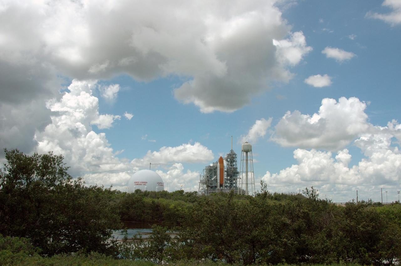
KENNEDY SPACE CENTER, FLA. - Storm clouds roll across the sky above and beyond Space Shuttle Discovery on Launch Pad 39B. The Shuttle remains on the pad the day after the Shuttle’s launch on Return to Flight mission STS-114 was scrubbed. The July 13 mission was scrubbed when a low-level fuel cut-off sensor for the liquid hydrogen tank inside the External Tank failed a routine prelaunch check during the countdown July 13, causing mission managers to scrub Discovery's first launch attempt. The sensor protects the Shuttle's main engines by triggering their shutdown in the event fuel runs unexpectedly low. The sensor is one of four inside the liquid hydrogen section of the External Tank (ET).
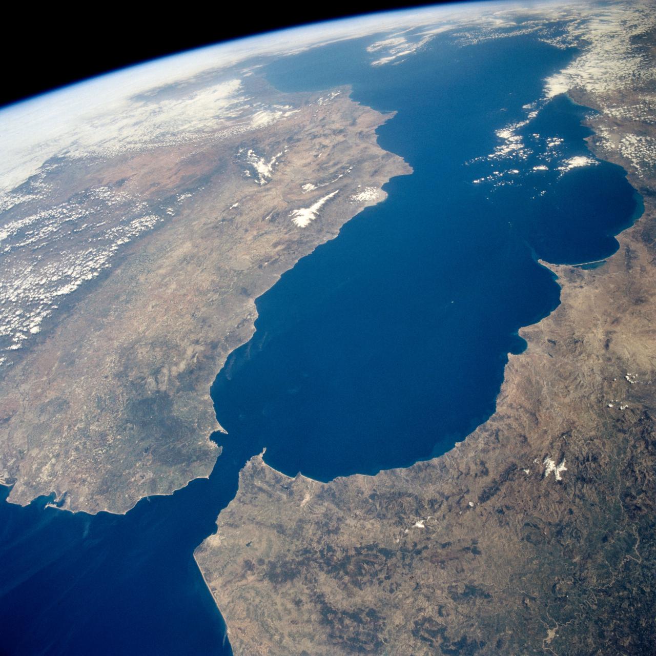
STS059-238-074 (9-20 April 1994) --- The Atlantic Ocean, Straits of Gibraltar, and Alboran Sea (the westernmost portion of the Mediterranean Sea) separate Spain on the left from Morocco on the right. Algeciras Harbor is the prominent notch cut out of the eastern end of the north shore of the Strait; the Rock of Gibraltar is the tiny arrowhead that separates the notch from the Alboran Sea. The Sierra Nevada, farther away down the Spanish coast, lives up to its name in this April scene. The difference in elevation between the Sierra Morena and the Guadalquivir River valley is highlighted nicely by cumulus clouds. Tangier, Morocco can be seen as a light-toned spot on the southern shore of the Strait, near the entrance to the Atlantic Ocean. Hasselblad photograph.
STS043-151-159 (2-11 August 1991) --- This photograph looks westward over the high plateau of the southern Peruvian Andes west and north of Lake Titicaca (not in field of view). Lima, Peru lies under the clouds just north of the clear coastal area. Because the high Andes have been uplifted 10,000 to 13,000 feet during the past 20 million years, the rivers which cut down to the Pacific Ocean have gorges almost that deep, such as the Rio Ocona at the bottom of the photograph. The eastern slopes of the Andes are heavily forested, forming the headwaters of the Amazon system. Smoke from burning in the Amazon basin fills river valleys on the right side of the photograph. A Linhof camera was used to take this view.
STS057-73-075 (21 June-1 July 1993) --- Eastern Mediterranean from an unusually high vantage point over the Nile River, this north-looking view shows not only the eastern Mediterranean but also the entire landmass of Asia Minor, with the Black Sea dimly visible at the horizon. Many of the Greek islands can be seen in the Aegean Sea (top left), off the coast of Asia Minor. Cyprus is visible under atmospheric dust in the northeast corner of the Mediterranean. The dust cloud covers the east end of the Mediterranean, its western edge demarcated by a line that cuts the center of the Nile Delta. This dust cloud originated far to the west, in Algeria, and moved northeast over Sicily, southern Italy, and Greece. Part of the cloud then moved on over the Black Sea, but another part swerved southward back towards Egypt. A gyre of clouds in the southeast corner of the Mediterranean indicates a complementary counterclockwise (cyclonic) circulation of air. The Euphrates River appears as a thin green line (upper right) in the yellow Syrian Desert just south of the blue-green mountains of Turkey. The Dead Sea (lower right) lies in a rift valley which extends north into Turkey and south thousands of miles down the Gulf of Aqaba, the Red Sea, and on through East Africa. The straight international boundary between Israel and Egypt (where the coastline angles) is particularly clear in this view, marked by the thicker vegetation on the Israeli side of the border. The green delta of the Nile River appears in the foreground, with the great conurbation of Cairo seen as a gray area at the apex of the triangle. Most of Egypt's 52 million inhabitants live in the delta. On the east side of the delta, the Suez Canal is visible. On the western corner of the delta lies the ancient city of Alexandria, beside the orange and white salt pans. The World War II battlesite El Alamein lies on the coast.
There are special places on Earth that sometimes write their personal signature in the clouds. The Crozet Islands are one such place, thanks to the tall volcanic peaks that grace the islands. When air flows around these tall peaks, it gets pushed around the islands as well as up and over the peak. The net effect of the flowing air flowing around the solid, tall peaks is much like the solid bow of a ship cutting through standing water. In each case v-shaped waves are formed behind the motion. In liquid, this is called a wake; in the atmosphere, when clouds are present or created, they are known as ship-wave-shaped clouds. The Moderate Resolution Imaging Spectroradiometer (MODIS) aboard NASA’s Terra satellite captured this true-color image as it passed over the Crozet Islands on November 26, 2014. Three distinct waves are seen behind the three largest islands. From west to east these are Pig Island, Possession Island and East Island. Credit: NASA/GSFC/Jeff Schmaltz/MODIS Land Rapid Response Team <b><a href="http://www.nasa.gov/audience/formedia/features/MP_Photo_Guidelines.html" rel="nofollow">NASA image use policy.</a></b> <b><a href="http://www.nasa.gov/centers/goddard/home/index.html" rel="nofollow">NASA Goddard Space Flight Center</a></b> enables NASA’s mission through four scientific endeavors: Earth Science, Heliophysics, Solar System Exploration, and Astrophysics. Goddard plays a leading role in NASA’s accomplishments by contributing compelling scientific knowledge to advance the Agency’s mission. <b>Follow us on <a href="http://twitter.com/NASAGoddardPix" rel="nofollow">Twitter</a></b> <b>Like us on <a href="http://www.facebook.com/pages/Greenbelt-MD/NASA-Goddard/395013845897?ref=tsd" rel="nofollow">Facebook</a></b> <b>Find us on <a href="http://instagram.com/nasagoddard?vm=grid" rel="nofollow">Instagram</a></b>
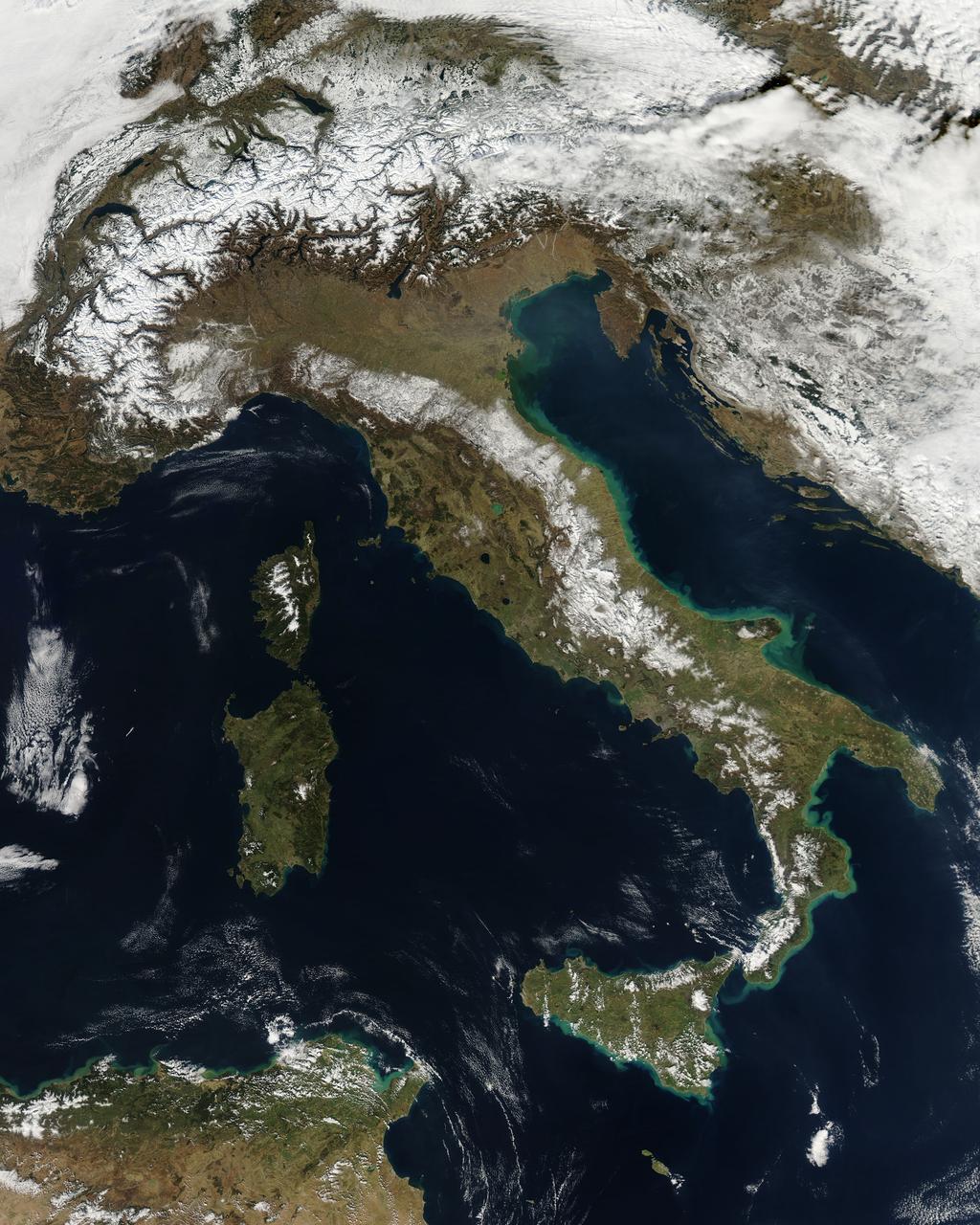
NASA image acquired February 24, 2012 By late February, 2012, the great European cold wave had begun to loosen its frigid grip, but significant snow still remained in the region. The Moderate Resolution Imaging Spectroradiometer (MODIS) aboard the Aqua satellite captured this true-color image of snow in Italy on February 24 at 12:35 UTC (1:30 p.m. local time). In the north of the image, bright white clouds blanket the region in a broad arc. Snow, which tends to be generally less bright that clouds, covers the Alps in the north of Italy. The Apennine Mountains, which form the backbone of the Italian peninsula, also carry a blanket of snow. Although clouds and snow can, at times, be distinguished visually in a true-color image, sometimes they can appear very similar. When it is important to clearly define snow from cloud, false color images are often helpful. Rome, which can be seen as a gray smudge on the southwestern coast of the peninsula, recorded highs of a spring-like 50°F the day this image was captured, but earlier in the month the temperatures dove as low as 26°F on February 5. During that cold snap a rare intense snowfall blanketed Rome, causing the closure of the Colosseum, the Roman Forum and the Palatine Hill due to concerns of the risk of icy footing for tourists, and roads became impassible. Further north, temperatures plummeted to −21 °C (−6 °F) on 7 February. On February 11, news media reported over 2 meters (6.5 feet) of snow had fallen in Urbino, a walled town situated on a high sloping hillside on the eastern side of the Apennine Mountains. That same snowfall cut access to many remote towns in the Apennines, blocking roads and trapping some people in the homes. Credit: NASA/GSFC/Jeff Schmaltz/MODIS Land Rapid Response Team <b><a href="http://www.nasa.gov/centers/goddard/home/index.html" rel="nofollow">NASA Goddard Space Flight Center</a></b> enables NASA’s mission through four scientific endeavors: Earth Science, Heliophysics, Solar System Exploration, and Astrophysics. Goddard plays a leading role in NASA’s accomplishments by contributing compelling scientific knowledge to advance the Agency’s mission. <b>Follow us on <a href="http://twitter.com/NASA_GoddardPix" rel="nofollow">Twitter</a></b> <b>Like us on <a href="http://www.facebook.com/pages/Greenbelt-MD/NASA-Goddard/395013845897?ref=tsd" rel="nofollow">Facebook</a></b> <b>Find us on <a href="http://instagrid.me/nasagoddard/?vm=grid" rel="nofollow">Instagram</a></b>

This enhanced color Jupiter image, taken by the JunoCam imager on NASA's Juno spacecraft, showcases several interesting features on the apparent edge (limb) of the planet. Prior to Juno's fifth flyby over Jupiter's mysterious cloud tops, members of the public voted on which targets JunoCam should image. This picture captures not only a fascinating variety of textures in Jupiter's atmosphere, it also features three specific points of interest: "String of Pearls," "Between the Pearls," and "An Interesting Band Point." Also visible is what's known as the STB Spectre, a feature in Jupiter's South Temperate Belt where multiple atmospheric conditions appear to collide. JunoCam images of Jupiter sometimes appear to have an odd shape. This is because the Juno spacecraft is so close to Jupiter that it cannot capture the entire illuminated area in one image -- the sides get cut off. Juno acquired this image on March 27, 2017, at 2:12 a.m. PDT (5:12 a.m. EDT), as the spacecraft performed a close flyby of Jupiter. When the image was taken, the spacecraft was about 12,400 miles (20,000 kilometers) from the planet. https://photojournal.jpl.nasa.gov/catalog/PIA21389. - Enhanced image by Björn Jónsson (CC-NC-SA) based on images provided courtesy of NASA/JPL-Caltech/SwRI/MSSS
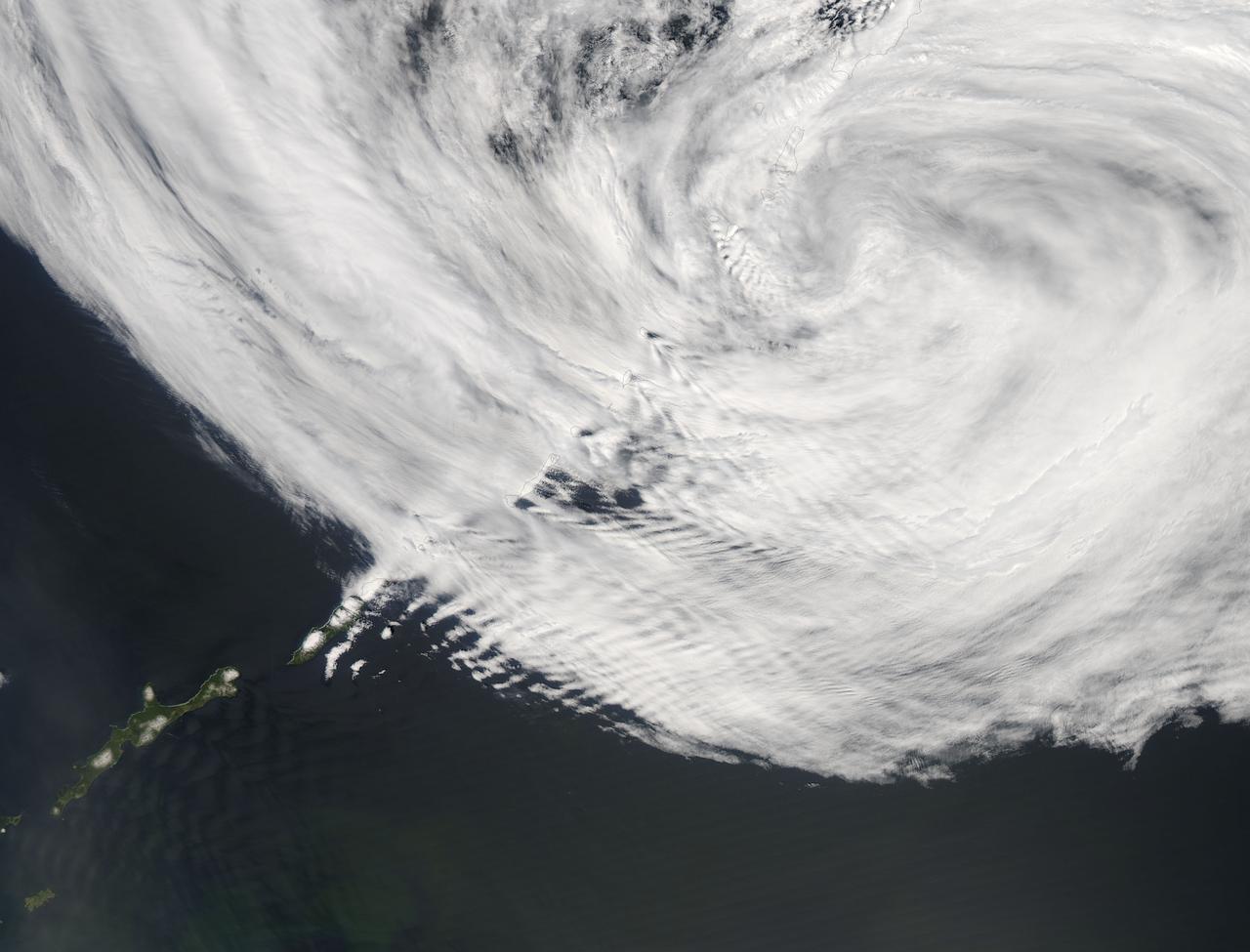
The Kuril Islands are a string of volcanically-formed islands that stretch between Russia and Japan, separating the North Pacific Ocean from the Sea of Okhotsk. Subject to the cold, moist breezes from the North Atlantic, and the frigid air from Siberia, the climate is severe, with frequent storms, and ever-present winds, which often reach hurricane strength. Cloudy, windy conditions are common. On June 1, 2015 the Moderate Resolution Imaging Spectroradiometer (MODIS) aboard NASA’s Aqua satellite captured this true-color image as it passed over the Kuril Islands. Clouds curl into the center of a storm system, bringing strong winds to the region. As the winds scrape over the tall volcanic peaks of the Kuril Islands, they become turbulent air behind the islands. The turbulence disturbs the cloudbank, etching its passage into a striking pattern that can be seen from space. This particular pattern is called “ship-waved-shaped wave clouds”, because the pattern can be likened to that formed behind a ship cutting through a smooth ocean. On the windward side of the Kuril Islands, the cloud bank is generally smooth, with streaks that are lined up parallel to the movement of the wind, blowing from the west and towards the east. Behind the tall volcanic peaks of the islands, V’s fan out on the leeward side, illustrating the flow of the turbulent air. Image Credit: Jeff Schmaltz, MODIS Land Rapid Response Team, NASA GSFC <b><a href="http://www.nasa.gov/audience/formedia/features/MP_Photo_Guidelines.html" rel="nofollow">NASA image use policy.</a></b> <b><a href="http://www.nasa.gov/centers/goddard/home/index.html" rel="nofollow">NASA Goddard Space Flight Center</a></b> enables NASA’s mission through four scientific endeavors: Earth Science, Heliophysics, Solar System Exploration, and Astrophysics. Goddard plays a leading role in NASA’s accomplishments by contributing compelling scientific knowledge to advance the Agency’s mission. <b>Follow us on <a href="http://twitter.com/NASAGoddardPix" rel="nofollow">Twitter</a></b> <b>Like us on <a href="http://www.facebook.com/pages/Greenbelt-MD/NASA-Goddard/395013845897?ref=tsd" rel="nofollow">Facebook</a></b> <b>Find us on <a href="http://instagrid.me/nasagoddard/?vm=grid" rel="nofollow">Instagram</a></b>
![Some of the most breathtaking views in the Universe are created by nebulae — hot, glowing clouds of gas. This new NASA/ESA Hubble Space Telescope image shows the centre of the Lagoon Nebula, an object with a deceptively tranquil name. The region is filled with intense winds from hot stars, churning funnels of gas, and energetic star formation, all embedded within an intricate haze of gas and pitch-dark dust. Nebulae are often named based on their key characteristics — particularly beautiful examples include the Ring Nebula (heic1310), the Horsehead Nebula (heic1307) and the Butterfly Nebula (heic0910). This new NASA/ESA Hubble Space Telescope image shows the centre of the Lagoon Nebula, otherwise known as Messier 8, in the constellation of Sagittarius (The Archer). The inspiration for this nebula’s name may not be immediately obvious — this is because the image captures only the very heart of the nebula. The Lagoon Nebula’s name becomes much clearer in a wider field view (opo0417i) when the broad, lagoon-shaped dust lane that crosses the glowing gas of the nebula can be made out. Another clear difference between this new image and others is that this image combines both infrared and optical light rather than being purely optical(heic1015). Infrared light cuts through thick, obscuring patches of dust and gas, revealing the more intricate structures underneath and producing a completely different landscape [1]. However, even in visible light, the tranquil name remains misleading as the region is packed full of violent phenomena. The bright star embedded in dark clouds at the centre of this image is known as Herschel 36. This star is responsible for sculpting the surrounding cloud, stripping away material and influencing its shape. Herschel 36 is the main source of ionising radiation [2] for this part of the Lagoon Nebula. This central part of the Lagoon Nebula contains two main structures of gas and dust connected by wispy twisters, visible in the middle third of this image (opo9638). These features are quite similar to their namesakes on Earth — they are thought to be wrapped up into their funnel-like shapes by temperature differences between the hot surface and cold interior of the clouds. The nebula is also actively forming new stars, and energetic winds from these newborns may contribute to creating the twisters. This image combines images taken using optical and infrared light gathered by Hubble’s Wide Field Planetary Camera 2. Credit: NASA, ESA, J. Trauger (Jet Propulson Laboratory) <b><a href="http://www.nasa.gov/audience/formedia/features/MP_Photo_Guidelines.html" rel="nofollow">NASA image use policy.</a></b> <b><a href="http://www.nasa.gov/centers/goddard/home/index.html" rel="nofollow">NASA Goddard Space Flight Center</a></b> enables NASA’s mission through four scientific endeavors: Earth Science, Heliophysics, Solar System Exploration, and Astrophysics. Goddard plays a leading role in NASA’s accomplishments by contributing compelling scientific knowledge to advance the Agency’s mission. <b>Follow us on <a href="http://twitter.com/NASAGoddardPix" rel="nofollow">Twitter</a></b> <b>Like us on <a href="http://www.facebook.com/pages/Greenbelt-MD/NASA-Goddard/395013845897?ref=tsd" rel="nofollow">Facebook</a></b> <b>Find us on <a href="http://instagrid.me/nasagoddard/?vm=grid" rel="nofollow">Instagram</a></b>](https://images-assets.nasa.gov/image/GSFC_20171208_Archive_e000671/GSFC_20171208_Archive_e000671~small.jpg)
Some of the most breathtaking views in the Universe are created by nebulae — hot, glowing clouds of gas. This new NASA/ESA Hubble Space Telescope image shows the centre of the Lagoon Nebula, an object with a deceptively tranquil name. The region is filled with intense winds from hot stars, churning funnels of gas, and energetic star formation, all embedded within an intricate haze of gas and pitch-dark dust. Nebulae are often named based on their key characteristics — particularly beautiful examples include the Ring Nebula (heic1310), the Horsehead Nebula (heic1307) and the Butterfly Nebula (heic0910). This new NASA/ESA Hubble Space Telescope image shows the centre of the Lagoon Nebula, otherwise known as Messier 8, in the constellation of Sagittarius (The Archer). The inspiration for this nebula’s name may not be immediately obvious — this is because the image captures only the very heart of the nebula. The Lagoon Nebula’s name becomes much clearer in a wider field view (opo0417i) when the broad, lagoon-shaped dust lane that crosses the glowing gas of the nebula can be made out. Another clear difference between this new image and others is that this image combines both infrared and optical light rather than being purely optical(heic1015). Infrared light cuts through thick, obscuring patches of dust and gas, revealing the more intricate structures underneath and producing a completely different landscape [1]. However, even in visible light, the tranquil name remains misleading as the region is packed full of violent phenomena. The bright star embedded in dark clouds at the centre of this image is known as Herschel 36. This star is responsible for sculpting the surrounding cloud, stripping away material and influencing its shape. Herschel 36 is the main source of ionising radiation [2] for this part of the Lagoon Nebula. This central part of the Lagoon Nebula contains two main structures of gas and dust connected by wispy twisters, visible in the middle third of this image (opo9638). These features are quite similar to their namesakes on Earth — they are thought to be wrapped up into their funnel-like shapes by temperature differences between the hot surface and cold interior of the clouds. The nebula is also actively forming new stars, and energetic winds from these newborns may contribute to creating the twisters. This image combines images taken using optical and infrared light gathered by Hubble’s Wide Field Planetary Camera 2. Credit: NASA, ESA, J. Trauger (Jet Propulson Laboratory) <b><a href="http://www.nasa.gov/audience/formedia/features/MP_Photo_Guidelines.html" rel="nofollow">NASA image use policy.</a></b> <b><a href="http://www.nasa.gov/centers/goddard/home/index.html" rel="nofollow">NASA Goddard Space Flight Center</a></b> enables NASA’s mission through four scientific endeavors: Earth Science, Heliophysics, Solar System Exploration, and Astrophysics. Goddard plays a leading role in NASA’s accomplishments by contributing compelling scientific knowledge to advance the Agency’s mission. <b>Follow us on <a href="http://twitter.com/NASAGoddardPix" rel="nofollow">Twitter</a></b> <b>Like us on <a href="http://www.facebook.com/pages/Greenbelt-MD/NASA-Goddard/395013845897?ref=tsd" rel="nofollow">Facebook</a></b> <b>Find us on <a href="http://instagrid.me/nasagoddard/?vm=grid" rel="nofollow">Instagram</a></b>
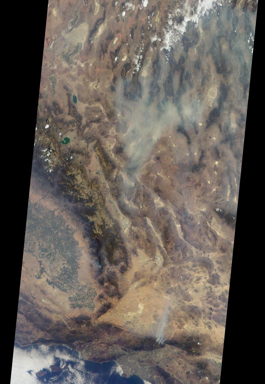
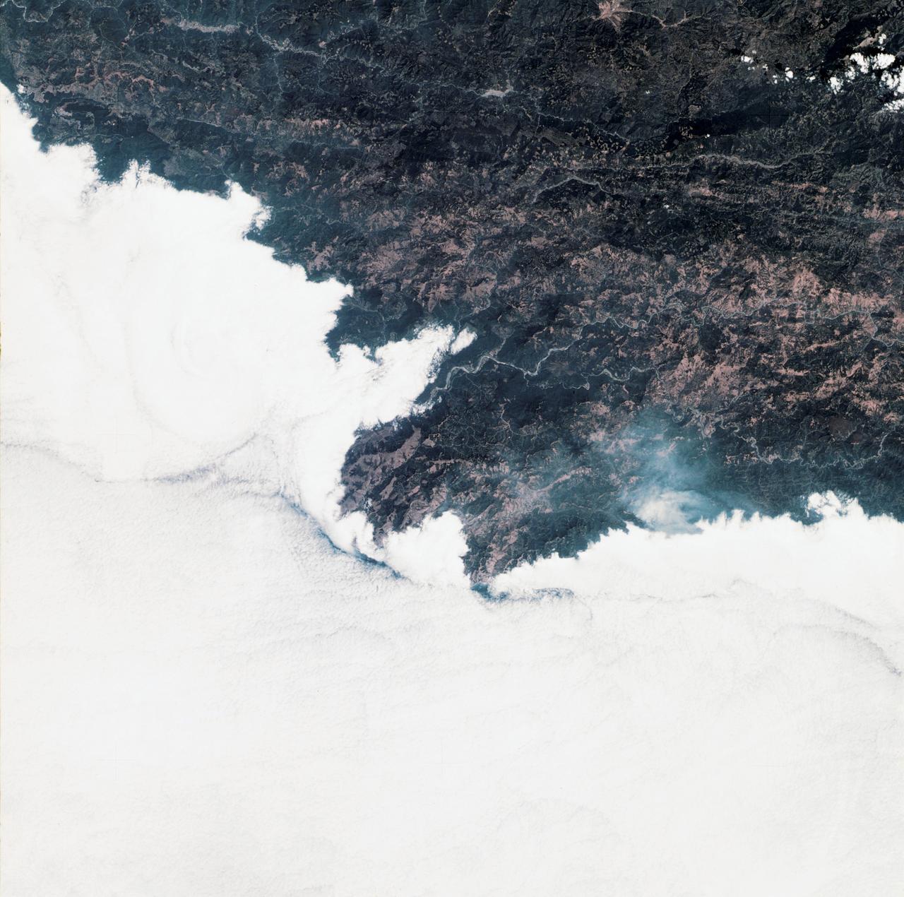
On Aug. 16, 2016, at around 10:30 a.m., a brush fire ignited in the Cajon Pass east of Los Angeles, just to the west of Interstate 15. Within a matter of hours, extreme temperatures, high winds and low humidity allowed the fire to spread rapidly, burning through brush left tinder-dry by years of drought. Firefighters quickly responded, ordering the evacuation of about 83,000 people in and around the Cajon Pass, Wrightwood, Lytle Creek, Oak Hills and surrounding areas. An as-yet uncounted number of homes and structures have burned, and Interstate 15 remains closed to downed power lines and barrier damage. By Aug. 17, the fire had expanded to more than 30,000 acres and remains zero percent contained as some 1,300 firefighters continue to battle to save homes and evacuate residents. The Multi-angle Imaging SpectroRadiometer (MISR) instrument aboard NASA's Terra satellite passed over the region on Aug. 17 around 11:50 a.m. PDT and captured this natural-color image from MISR's 70-degree forward-viewing camera, which covers an areas about 257 miles (414 kilometers) wide. The oblique view angle makes the smoke more apparent than it would be in a more conventional vertical view. The Los Angeles metropolitan area is the large gray area on the coast in the center of the image. Three plumes from the Blue Cut Fire are clearly visible in the mountains to the north. This oblique view also shows an enormous cloud of smoke spreading northeastward over a significant portion of eastern California and Nevada. This smoke probably originated from the fire as it consumed almost 20,000 acres on the evening of the 16th and traveled north overnight. Also visible from this oblique view is considerable haziness filling California's Central Valley, to the northwest of the Blue Cut Fire. This haziness is most likely due to smoke from several other fires burning in California, including the Soberanes Fire near Monterey, the Clayton Fire that has destroyed 175 structures north of San Francisco, the Chimney Fire and the Cedar Fire, which is visible in the image in the southern Sierra Nevada. The total number of acres burned in California this year has tripled in just the past week. The 3D stereo anaglyph is made by combining data from MISR's 60-degree and 70-degree forward-viewing cameras. You will need red-blue glasses to view the 3D effect (ensure the red lens is over your left eye). In order to enable stereo viewing, the image has been rotated so north is to the left. These data were acquired during Terra orbit 88648. http://photojournal.jpl.nasa.gov/catalog/PIA20888
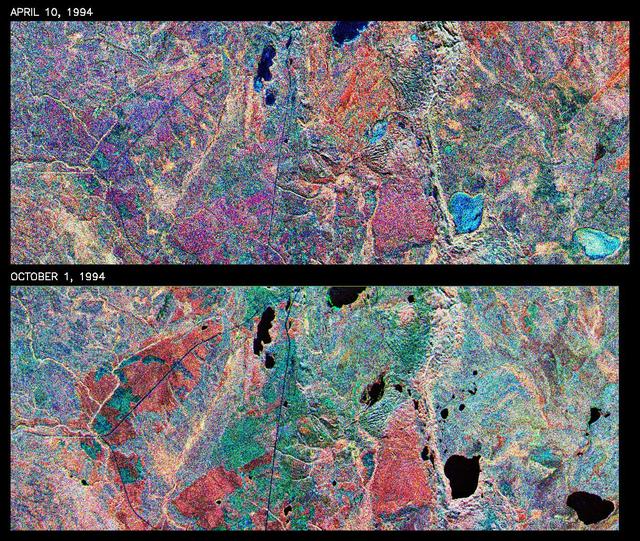
This is a comparison of images over Prince Albert, produced by NASA Spaceborne Imaging Radar-C and X-band Synthetic Aperture Radar aboard the space shuttle Endeavour on its 20th orbit on April 10, 1994. The area is centered at 53.91 degrees north latitude and 104.69 degrees west longitude and is located 40 kilometers (25 miles) north and 30 kilometers (18.5 miles) east of the town of Prince Albert in the Saskatchewan province of Canada. The image covers the area east of Candle Lake, between the gravel highway of 120 and west of highway 106. The area imaged is near the southern limit of the boreal forest. The boreal forest of North America is a continuous vegetation belt at high latitudes stretching across the continent from the Atlantic shoreline of central Labrador and then westward across Canada to the interior mountains and central coastal plains of Alaska. The forest is also part of a larger northern hemisphere circumpolar boreal forest belt. Coniferous trees dominate the entire forest but deciduous trees are also present. During the month of April, the forest experiences seasonal changes from a frozen condition to a thawed condition. The trees are completely frozen over the winter season and the forest floor is covered by snow. As the average temperature rises in the spring, the trees are thawed and the snow melts. This transition has an impact on the rate of moisture evaporation and release of carbon dioxide into the atmosphere. In late September and early October, the boreal forest experiences a relatively different seasonal change. At this time, the leaves on deciduous trees start changing color and dropping off. The soil and trees are quite often moist due to frequent rainfall and cloud cover. The evaporation of moisture and carbon dioxide into the atmosphere also diminishes at this time. SIR-C/X-SAR is sensitive to the moisture of soil and vegetation and can sense this freeze-thaw cycle and the summer-fall seasonal transition over forested areas in particular. Optical sensors, by contrast, are blind to these regions, which are perpetually obscured by thick cloud cover. These changes were detected by comparing the April and October color composite images of L-band data in red, C-band data in green and X-band (vertically received and transmitted) in blue. The changes in intensity of each color over lakes, various forest stands and clear cuts in the two images is striking. Lakes such as Lake Heiberg, Crabtree Lake and Williams Lake, in the right middle part of the image, are frozen in April (appearing in bright blue) and melted (appearing in black) in October. The higher intensity of blue over lakes in April is due to low penetration of the X-band (vertically received and transmitted) and the radar's high sensitivity to surface features. Forest stands also exhibit major changes between the two images. The red areas in the October image are old jack pine canopies that cause higher return at L-band because of their moist condition in late summer compared to their partially frozen condition in April (in purple). Similarly, in the areas near the middle of the image, where black spruce and mixed aspen and jack pine trees dominate, the contrast between blue in October and red and green in April is an indication that the top of the canopy (needles and branches) were frozen in April and moist in October. The changes due to deforestation by logging companies or natural fires can also be detected by comparing the images. For example, the small blue area near the intersection of Harding Road and Highway 120 is the result of logging which occurred after the April data was acquired. The surface area of clear cut is approximately 4 hectares, which is calculated from the high-resolution capability of the radar images and verified by scientists participating in field work during the mission. http://photojournal.jpl.nasa.gov/catalog/PIA01732

NASA image release April 27, 2012 The NASA/ESA Hubble Space Telescope has been at the cutting edge of research into what happens to stars like our sun at the ends of their lives. One stage that stars pass through as they run out of nuclear fuel is called the preplanetary or protoplanetary nebula stage. This Hubble image of the Egg Nebula shows one of the best views to date of this brief but dramatic phase in a star’s life. The preplanetary nebula phase is a short period in the cycle of stellar evolution, and has nothing to do with planets. Over a few thousand years, the hot remains of the aging star in the center of the nebula heat it up, excite the gas, and make it glow as a subsequent planetary nebula. The short lifespan of preplanetary nebulae means there are relatively few of them in existence at any one time. Moreover, they are very dim, requiring powerful telescopes to be seen. This combination of rarity and faintness means they were only discovered comparatively recently. The Egg Nebula, the first to be discovered, was first spotted less than 40 years ago, and many aspects of this class of object remain shrouded in mystery. At the center of this image, and hidden in a thick cloud of dust, is the nebula’s central star. While we can’t see the star directly, four searchlight beams of light coming from it shine out through the nebula. It is thought that ring-shaped holes in the thick cocoon of dust, carved by jets coming from the star, let the beams of light emerge through the otherwise opaque cloud. The precise mechanism by which stellar jets produce these holes is not known for certain, but one possible explanation is that a binary star system, rather than a single star, exists at the center of the nebula. The onion-like layered structure of the more diffuse cloud surrounding the central cocoon is caused by periodic bursts of material being ejected from the dying star. The bursts typically occur every few hundred years. The distance to the Egg Nebula is only known very approximately, the best guess placing it at around 3,000 light-years from Earth. This in turn means that astronomers do not have any accurate figures for the size of the nebula (it may be larger and further away, or smaller but nearer). This image is produced from exposures in visible and infrared light from Hubble’s Wide Field Camera 3. Credit: ESA/Hubble, NASA <b><a href="http://www.nasa.gov/audience/formedia/features/MP_Photo_Guidelines.html" rel="nofollow">NASA image use policy.</a></b> <b><a href="http://www.nasa.gov/centers/goddard/home/index.html" rel="nofollow">NASA Goddard Space Flight Center</a></b> enables NASA’s mission through four scientific endeavors: Earth Science, Heliophysics, Solar System Exploration, and Astrophysics. Goddard plays a leading role in NASA’s accomplishments by contributing compelling scientific knowledge to advance the Agency’s mission. <b>Follow us on <a href="http://twitter.com/NASAGoddardPix" rel="nofollow">Twitter</a></b> <b>Like us on <a href="http://www.facebook.com/pages/Greenbelt-MD/NASA-Goddard/395013845897?ref=tsd" rel="nofollow">Facebook</a></b> <b>Find us on <a href="http://instagrid.me/nasagoddard/?vm=grid" rel="nofollow">Instagram</a></b>
This view from NASA's Cassini spacecraft features a blue planet, imaged by Cassini for the first time. Uranus is a pale blue in this natural color image because its visible atmosphere contains methane gas and few aerosols or clouds. Methane on Uranus -- and its sapphire-colored sibling, Neptune -- absorbs red wavelengths of incoming sunlight, but allows blue wavelengths to escape back into space, resulting in the predominantly bluish color seen here. Cassini imaging scientists combined red, green and blue spectral filter images to create a final image that represents what human eyes might see from the vantage point of the spacecraft. Uranus has been brightened by a factor of 4.5 to make it more easily visible. The outer portion of Saturn's A ring, seen at bottom right, has been brightened by a factor of two. The bright ring cutting across the image center is Saturn's narrow F ring. Uranus was approximately 28.6 astronomical units from Cassini and Saturn when this view was obtained. An astronomical unit is the average distance from Earth to the sun, equal to 93,000,000 miles (150,000,000 kilometers). This view was acquired by the Cassini narrow-angle camera at a distance of approximately 614,300 miles (988,600 kilometers) from Saturn on April 11, 2014. Image scale at Uranus is approximately 16,000 miles (25,700 kilometers) per pixel. Image scale at Saturn's rings is approximately 4 miles (6 kilometers) per pixel. In the image, the disk of Uranus is just barely resolved. The solar phase angle at Uranus, seen from Cassini, is 11.9 degrees. http://photojournal.jpl.nasa.gov/catalog/PIA17178