51F-32-024 (29 July - 6 August 1985) --- Italy's “boot heel" surrounded by waters of the Ionian Sea/Golfo di Taranto and the Adriatic Sea is very clearly visible in this scene made with a handheld 70mm camera. Spacelab 2's versatile instrument pointing system (IPS) protrudes from the cargo bay.
iss073e0254866 (June 5, 2025) --- The sun's glint beams off the Adriatic Sea contrasting with the "boot" of Italy in this photograph from the International Space Station as it orbited 261 miles above Southern Europe. In the right foreground, is the Soyuz MS-27 crew ship docked to the orbital outpost's Prichal module.
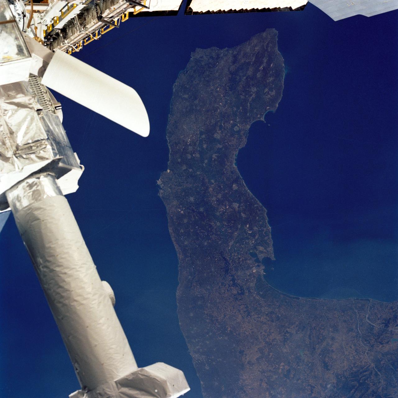
This image from NASA KidSat spans the region of Venetia from the city of Venice, Italy, on the coast of the Adriatic Sea north to the snow-capped Alps. Venice appears in the lower left part of the image, and the Alps appear in the lower right.
Earth observation taken during night pass by an Expedition 37 crew member on board the International Space Station (ISS). Folder lists this as CEO Venice. Per Twitter Message this is Adriatic Sea.
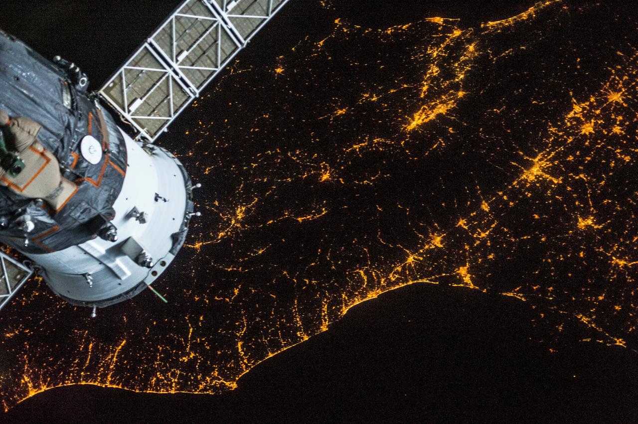
ISS036-E-028696 (3 Aug. 2013) --- One of the Expedition 36 crew members aboard the International Space Station photographed this nighttime image of northern parts of Italy showing both the Mediterranean Sea (top) and Adriatic Sea coasts on Aug. 3, 2013. A Russian Soyuz vehicle, docked to the orbital outpost, is in upper left.

ISS019-E-005501 (9 April 2009) --- Split Region in Croatia is featured in this image photographed by an Expedition 19 crewmember on the International Space Station. One the world?s most rugged coastlines are located in Croatia along the Adriatic Sea. This view features the Dalmatian coastline of Croatia around the city of Split. Much of the region can be characterized by northwest-southeast oriented linear islands and embayments of the Adriatic Sea. This distinctive coastal geomorphology is the result of faulting caused by tectonic activity in the region and sea level rise. Split has a long history - the Roman Emperor Diocletian retired to Spalatum (the present-day Split) in 305, and his palace constitutes the core of the city today. The city is a popular resort destination for its historic sites, Mediterranean climate, and ready access to the Adriatic islands (such as Brac to the south). Other large cities in the region include Kastela and Trogir; together with Split, these form an almost continuous urban area bordering the coast (visible as pink regions). A thin zone marking a water boundary is visible in this image between Split and the island of Brac. It may represent a local plankton bloom, or a line of convergence between water masses creating rougher water. A unique combination of geography -- including dramatic topography that channels local winds, the complicated coastline, input of fresh water from rivers, and ample nutrients and surface oils -- makes for interesting mesoscale surface dynamics throughout the Adriatic Sea. Over the years, astronauts have taken images of the Split region using sunglint and changes in water color to highlight features like eddies, water boundaries and mixing zones between fresh waters flowing into the saltier (denser) waters of the Adriatic, and wind-driven surface currents. Split is an important transit center connecting islands in the Adriatic Sea to the Italian peninsula, and an important regional manufacturing center of goods such as solar cells, plastics, and paper products. The city was heavily industrialized during the post World War II period as a member state of Yugoslavia. By the 1980s, the marine environment bordered by Split, Kastela, and Trogir (known as Kastela Bay) had been identified as one of the most polluted areas of the Adriatic from both sewage and industrial wastes. Concerted efforts by the Croatian government and international partners to improve waste handling and treatment infrastructure over the past 10 years seem to have been successful ? both marine species and water polo players have returned to the area.
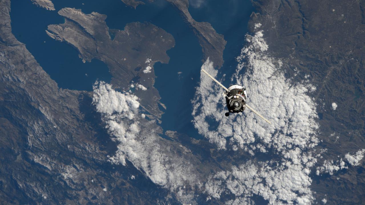
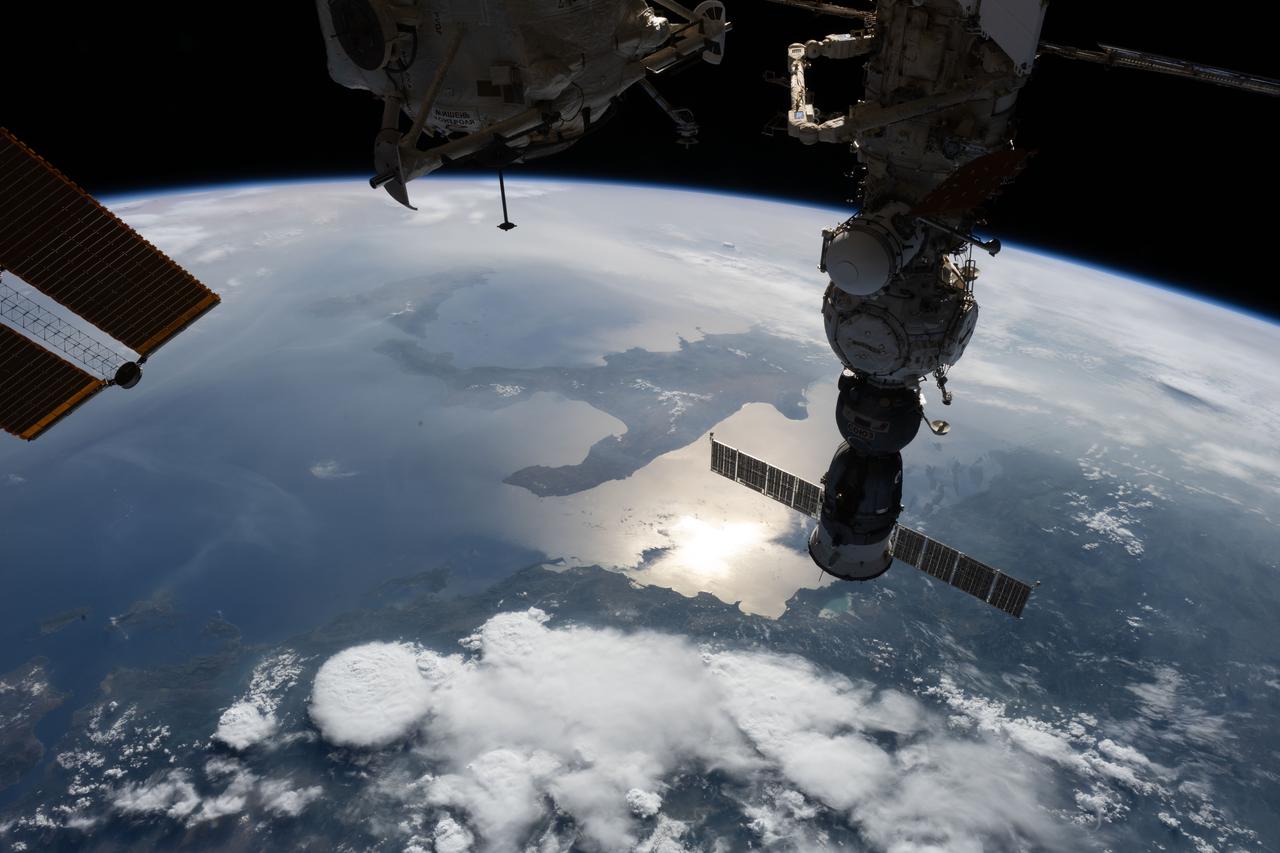
iss070e129495 (March 25, 2024) --- The Soyuz MS-25 crew ship carrying NASA astronaut Tracy C. Dyson, Roscosmos cosmonaut Oleg Novitskiy, and Belarus spaceflight participant Marina Vasilevskaya approaches the International Space Station 262 miles above the Croatian coast on the Adriatic Sea.
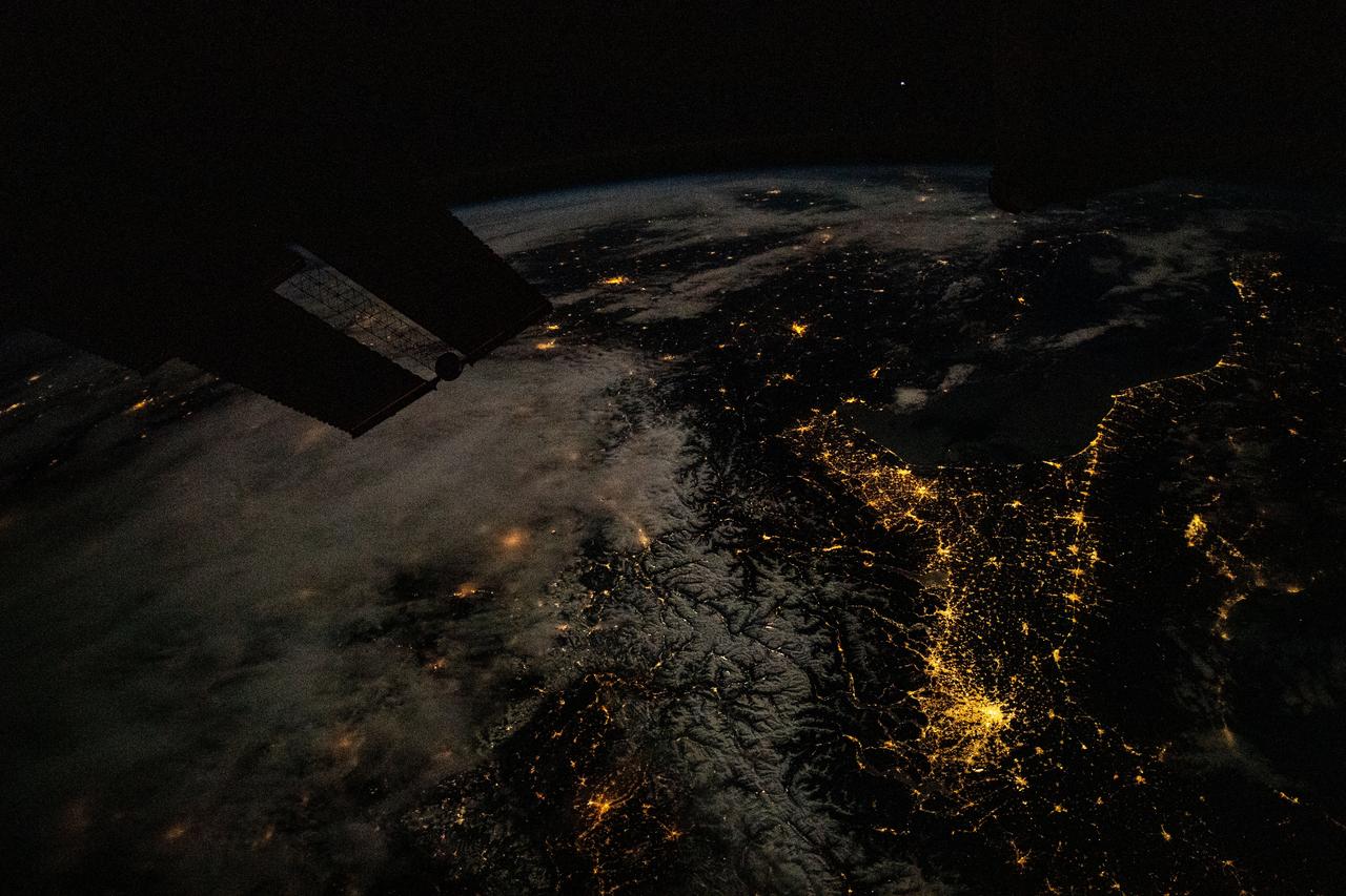
iss070e030942 (Nov. 26, 2023) --- This nighttime view of southern Europe looks northwest to southeast from Milan, Italy (bottom right), and across the Adriatic Sea to Split, Croatia. The International Space Station was orbiting 263 miles above eastern France at the time of this photograph.
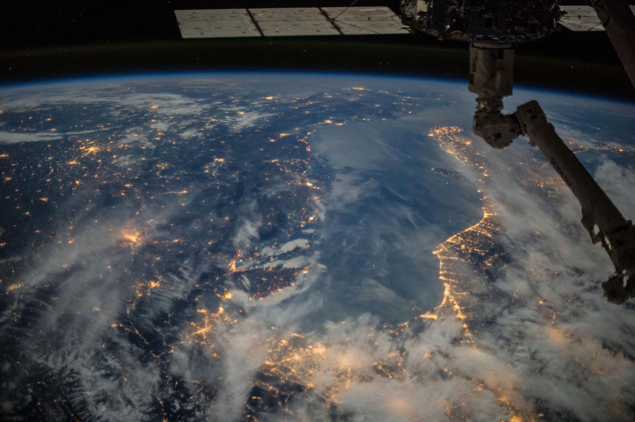
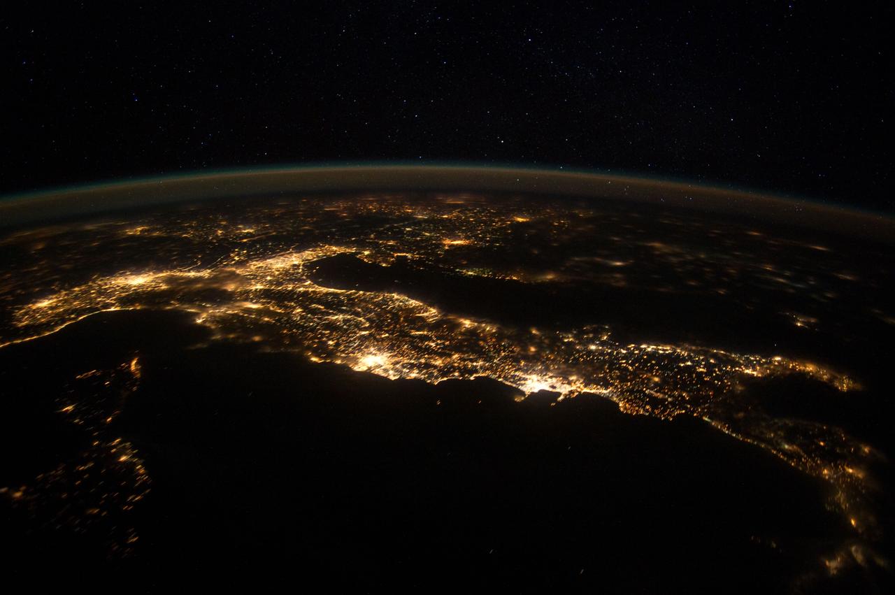
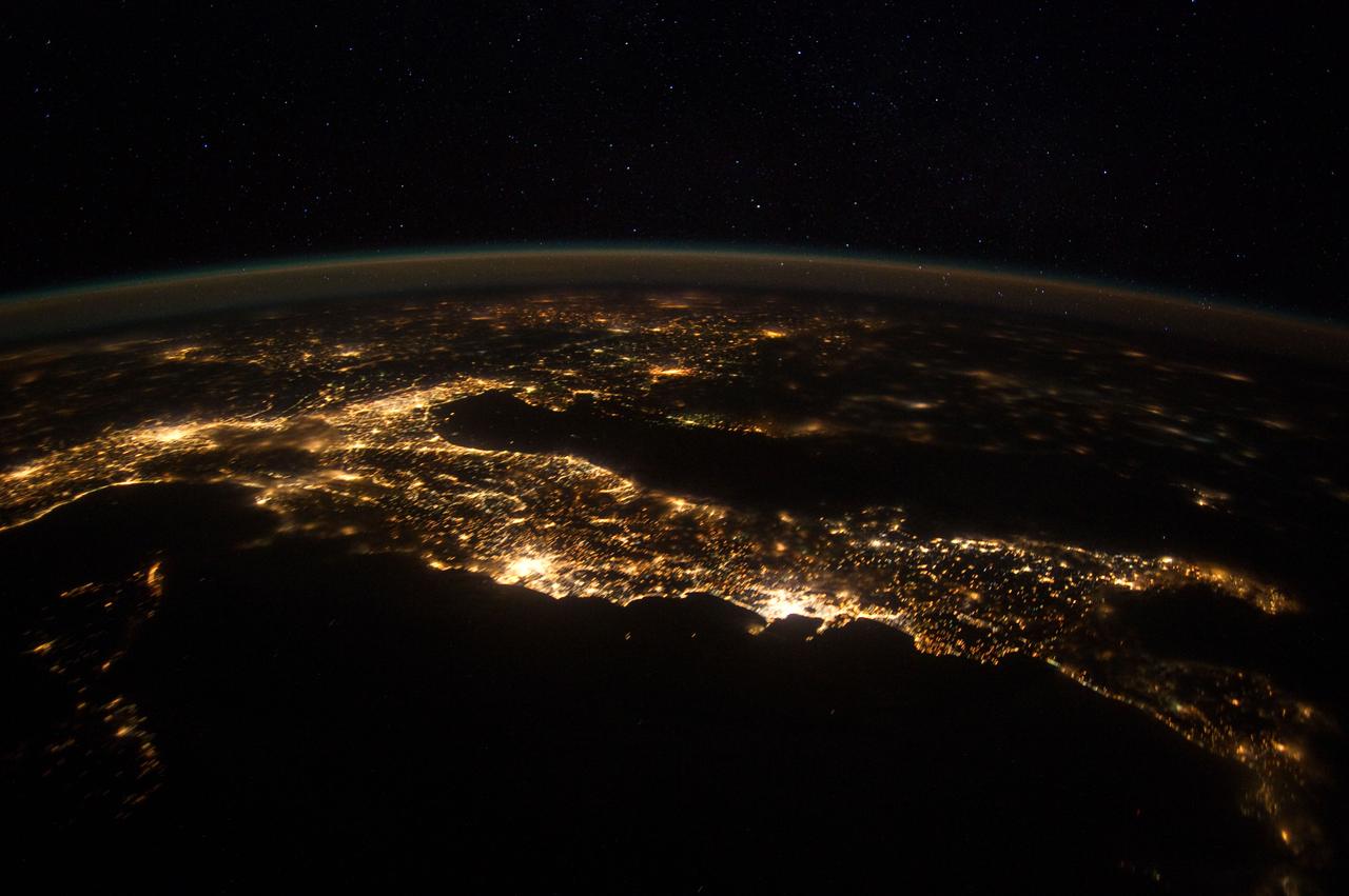
iss072e904970 (March 22, 2025) --- The boot of Italy well-defined by the nation's city lights stands in contrast to the Tyrrhenian Sea (left) and the Adriatic Sea (right) with the Balkans at far right underneath an atmospheric glow blanketing Earth's horizon. The International Space Station was orbiting 262 miles above southern Europe at 10:57 p.m. local time when this photograph was taken.
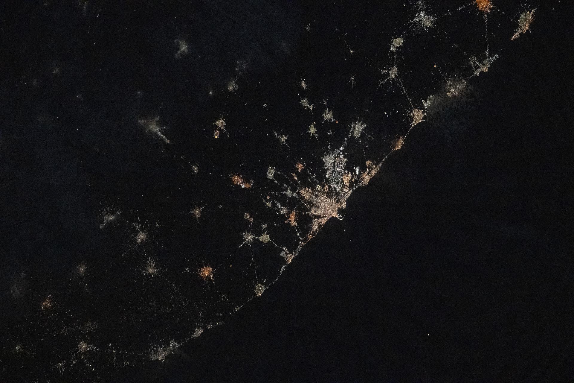
iss073e1047143 (Nov. 2, 2025) --- The city lights of Bari, Italy, and its surrounding suburbs dot the nation's Adriatic Sea coast in this photograph taken from the International Space Station at approximately 10:13 p.m. local time as it orbited 260 miles above the Mediterranean Sea. Founded around 2,700 years ago, Bari is known for its olive groves, vineyards, spectacular caves, and rugged coastal cliffs.
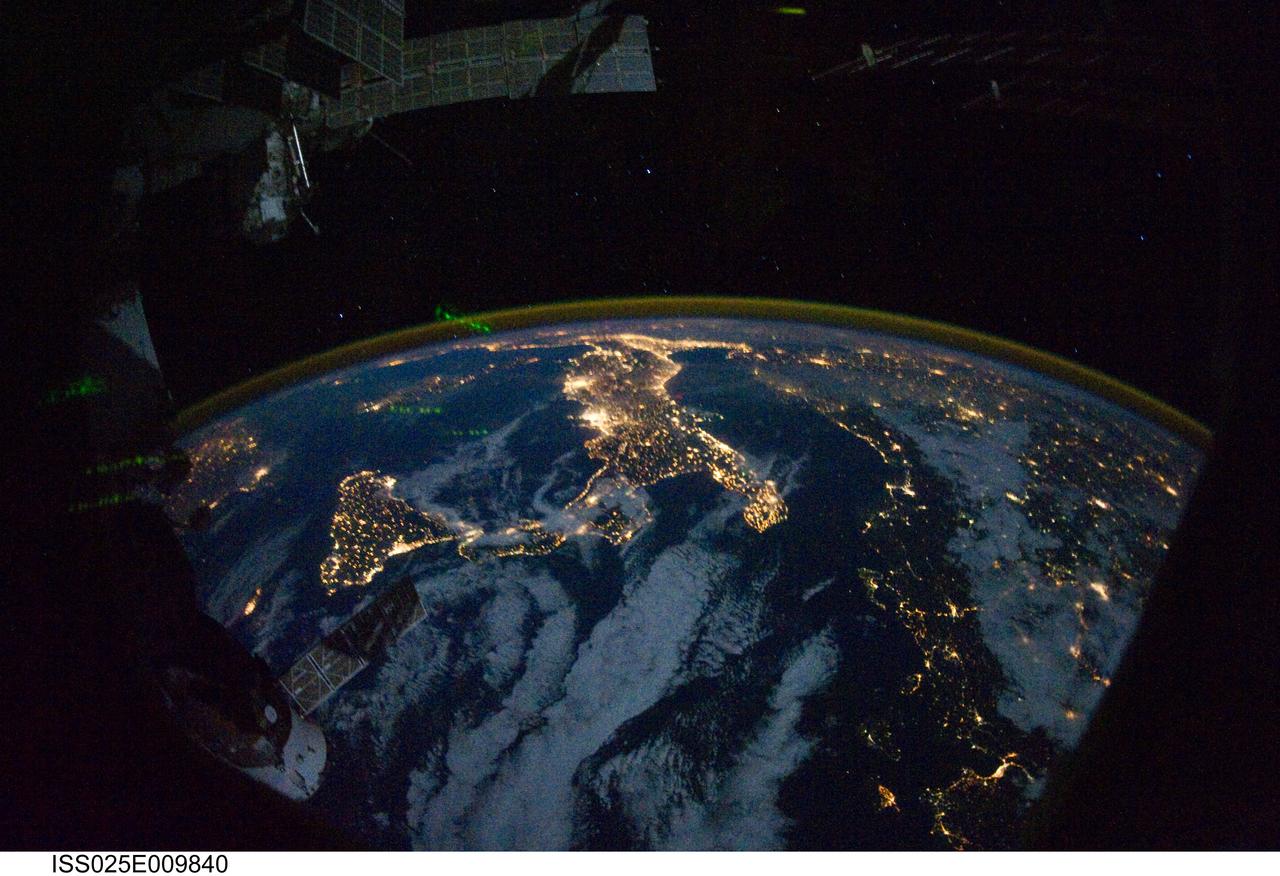
ISS025-E-009840 (28 Oct. 2010) --- Parts of Europe and Africa are very easily recognizable in this night time image shot by one of the Expedition 25 crew members aboard the International Space Station flying 220 miles above Earth on Oct. 28. The view "looks" northward over Sicily and the "boot" of Italy, with the Mediterranean Sea representing most of the visible water in the view and the Adriatic Sea to the right of center. Tunisia is partially visible at left. Part of a docked Russian spacecraft and other components of the ISS are in the foreground.
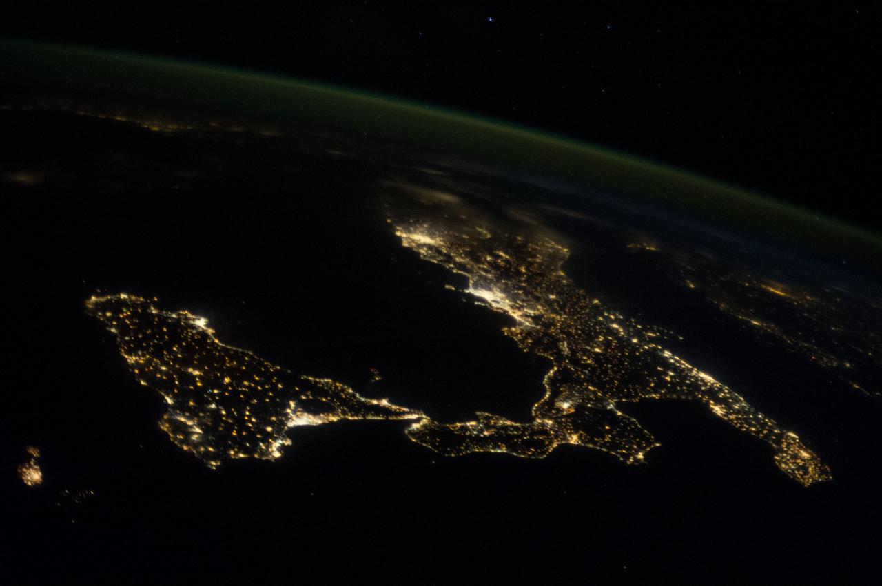
ISS040-E-016629 (22 June 2014) --- One of the Expedition 40 crew members aboard the Earth-orbiting International Space Station recorded this panorama of part of Europe on June 22, 2014. Italy's long coastlines (of the Adriatic and Tyrrhenian Seas) all the way down to the "Boot" dominate the scene. Parts of the Mediterranean and Ionian Seas are also visible.
ISS036-E-027014 (31 July 2013) --- One of the Expedition 36 crew members aboard the Earth-orbiting International Space Station, as it was passing over Eastern Europe on July 31, 2013, took this night picture looking toward the Mediterranean Sea, which almost blends into the horizon. Also visible are the Aegean Sea, Adriatic Sea and Mediterranean Sea. Parts of the following countries are among those visible as well: Greece, Italy, Sicily, Bulgaria, Serbia, Croatia and Albania. The high oblique 50mm lens shot includes a number of stars in the late July sky. A solar array panel is visible in the darkness on the right side of the frame.
ISS030-E-074777 (25 Jan. 2012 ) --- This nighttime panorama of much of Europe was photographed by one of the Expedition 30 crew members aboard the International Space Station flying approximately 240 miles above the Tyrrhenian Sea on Jan. 25, 2012. Most of the country of Italy is visible running horizontally across the center of the frame, with the night lights of Rome and Naples being visible to the left and right of center, respectively. Sardinia, and Corsica are in the lower left quadrant of the photo. The Adriatic Sea is on the other side of Italy, and beyond it to the east and north can be seen parts of several other European nations.

ISS030-E-074752 (25 Jan. 2012 ) --- This nighttime panorama of much of Europe was photographed by one of the Expedition 30 crew members aboard the International Space Station flying approximately 240 miles above the Tyrrhenian Sea on Jan. 25, 2012. Most of the country of Italy is visible running horizontally across the center of the frame, with the night lights of Rome and Naples being visible to the center and right center, respectively. Sardinia, and Corsica are in the lower left quadrant of the photo, and Sicily is at lower right corner. The Adriatic Sea is on the other side of Italy, and beyond it to the east and north can be seen parts of several other European nations.
ISS030-E-074783 (25 Jan. 2012 ) --- This nighttime panorama of much of Europe was photographed by one of the Expedition 30 crew members aboard the International Space Station flying approximately 240 miles above the Tyrrhenian Sea on Jan. 25, 2012. Most of the country of Italy is visible running horizontally across the center of the frame, with the night lights of Rome and Naples being visible to the left and right of center, respectively. Sardinia, and Corsica are in the lower left quadrant of the photo. The Adriatic Sea is on the other side of Italy, and beyond it to the east and north can be seen parts of several other European nations.
ISS032-E-020159 (18 Aug. 2012 ) --- This oblique, nighttime panorama of much of Europe was photographed by one of the Expedition 32 crew members aboard the International Space Station flying approximately 240 miles above the Mediterranean Sea on Aug. 18, 2012. The country of Italy is visible running diagonally southward from the horizon across the center of the frame, with the night lights of Rome and Naples being visible on the coast near the center. Sardinia and Corsica are just above left center of the photo, and Sicily is at lower left. The Adriatic Sea is on the other side of Italy, and beyond it to the east and north can be seen parts of several other European nations.

ISS036-E-025994 (29 July 2013) --- One of the Expedition 36 crew members aboard the International Space Station photographed this oblique, north-looking nighttime image of parts of Italy on July 29, 2013. Rome is well lighted and clearly visible on the Mediterranean coast in the lower left quadrant. Much of the Adriatic Sea coast is visible on the right side of the frame
ISS036-E-026000 (29 July 2013) --- One of the Expedition 36 crew members aboard the International Space Station photographed this oblique, north-looking nighttime image of parts of Italy on July 29, 2013. Rome is well lighted and cleary visible on the Mediteranean coast in the lower left quadrant. Much of the Adriatic Sea coast is visible on the right side of the frame.
ISS037-E-018864 (23 Oct. 2013) --- This night image of most of Italy and all of Sicily was photographed by one of the Expedition 37 crew members aboard the International Space Station flying approximately 240 miles above Earth on Oct. 23, 2013. The night lights of Rome and Naples are visible near the center of the frame. Many other major cities are also visible by their lights. The Adriatic Sea is on the east (right) side of Italy.
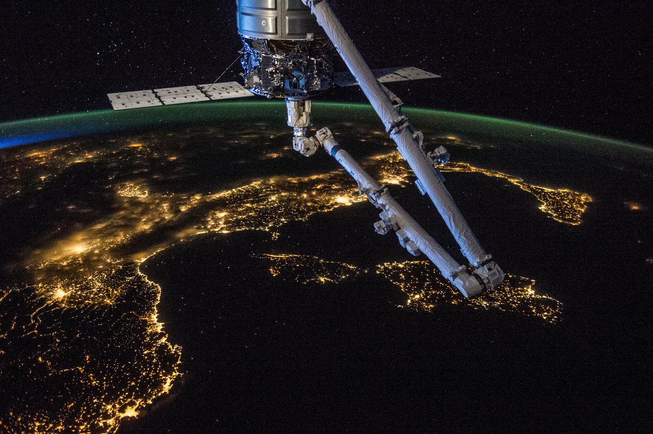
ISS040-E-081344 (26 July 2014) --- Orbital Sciences' Cygnus cargo carrier craft, in the grasp of the International Space Station's robot arm, is prominent in the foreground of this nighttime photo, taken by one of the Expedition 40 crew members aboard the orbital outpost, flying at an altitude of 225 nautical miles. Many European countries can be seen in the photo. Nearly all of Italy, from Turin (bottom left) to the island of Sicily (right center), is visible, as are the islands of Corsica and Sardinia in the Mediterranean in the center foreground. Looking across Italy over the Adriatic Sea, city lights in several other countries are visible. The 1/6 shutter speed allows for a large number of stars to be visible above the horizon.
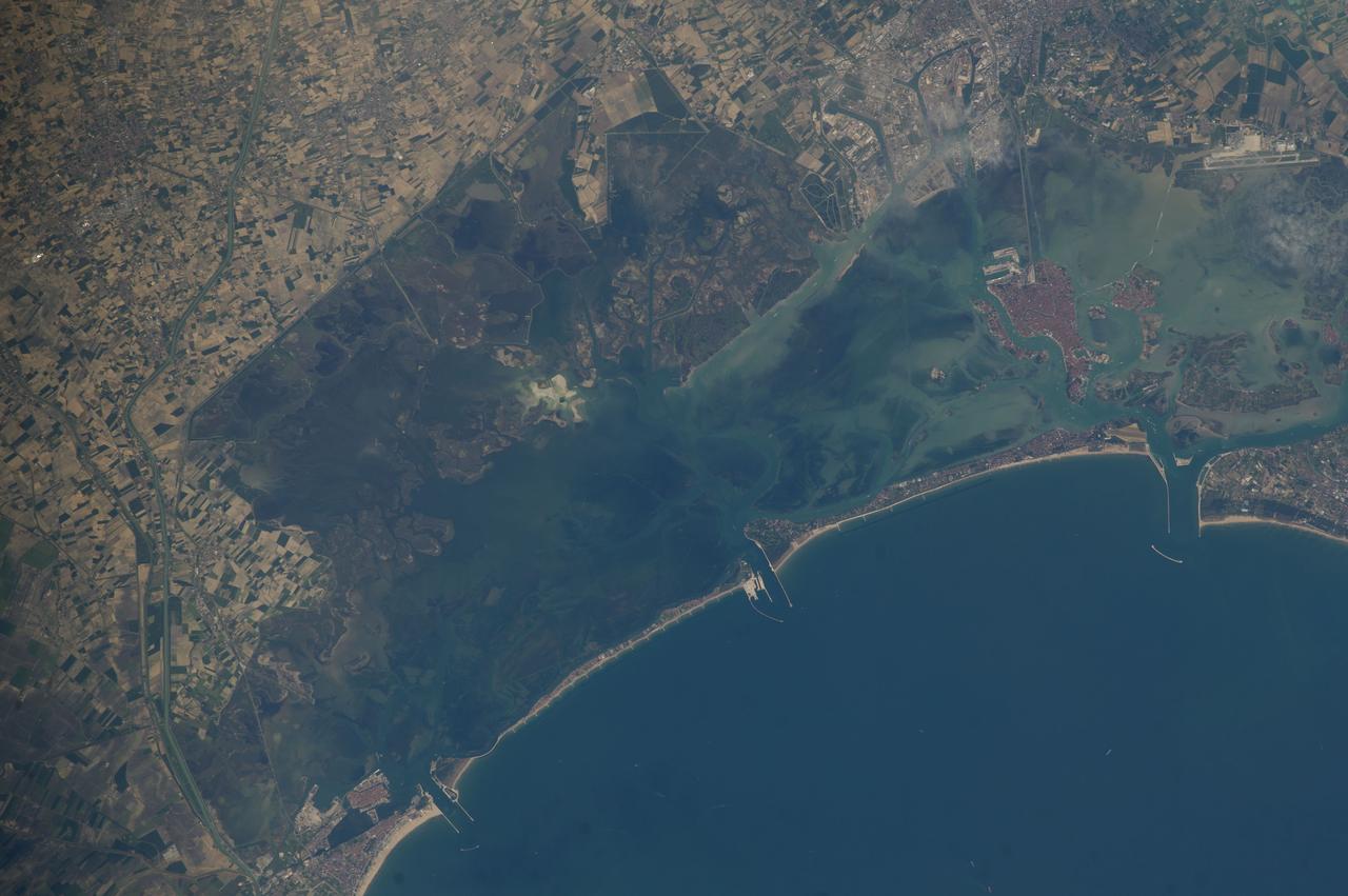
ISS039-E-019482 (9 May 2014) --- One of the Expedition 39 crew members aboard the Earth-orbiting International Space Station used a 400mm lens to take this photograph of Venice Lagoon, Italy on May 9, 2014. A narrow barrier island protects the Lagoon of Venice from storm waves in the northern Adriatic Sea, and breakwaters protect inlets to the lagoon. Red tiles of the roofs of the edifices on the island of Venice contrast with the grays of the mainland sister city of Mestre. The cities are joined by a prominent causeway. Another causeway joins the island to the airport (top right). Small bright agricultural fields of well drained soils (top left) contrast with the darker vegetation of back bay swamps where fishing is a popular pastime. Dense urban populations on its shores and heavy use by craft of all kinds result in turbid water in the northern half of the lagoon.
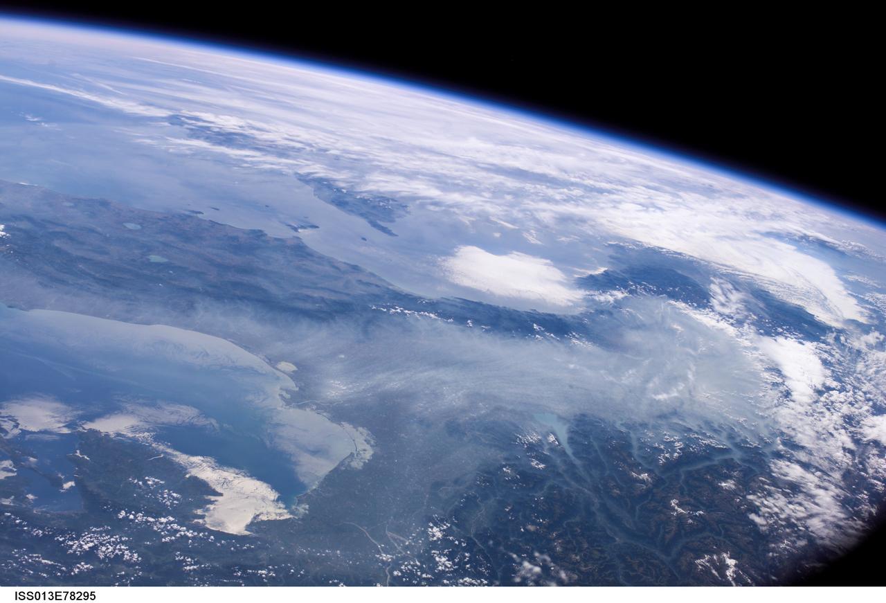
ISS013-E-78295 (6 Sept. 2006) --- Haze in the Po River Valley of Italy is featured in this image photographed by an Expedition 13 crewmember onboard the International Space Station. The valley is visible across the horizontal center of the frame, with the floor obscured by what NASA scientists refer to as frequent atmospheric haze, a mixture of industrial pollutants, dust and smoke. The visual texture of such haze is perceptibly different from that of bright white clouds which stretch across the top of the scene and cover part of the Alps. The Po River Valley is Italy's industrial heartland and one of the most industrialized regions on Earth, according to scientists. Northern Italy is in the foreground of this southwesterly view. The partially cloud-covered Alps are at lower right; the Adriatic Sea at lower left. Corsica is under partial cloud cover at center; and Sardinia, almost totally obscured, is to its south. The island of Elba is visible just to the west of Italy. By contrast with haze accumulation along the axis of the valley, the Alps and the Apennines are clearly visible, and Lake Garda can be seen in the foothills of the Alps. Other visible geographic features are the lagoon at Venice north of the Po River delta, and three small lakes north of Rome. The winds on the day this image was taken are mainly from the north, as shown by the flow lines in the haze near Venice. The haze typically flows south down the Adriatic Sea. Visibility in the Mediterranean basin is often reduced by hazes such as these, deriving from different sources in industrialized Europe.
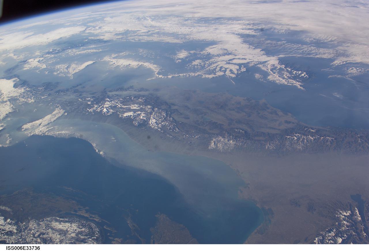
ISS006-E-33736 (25 February 2003) --- The boot of Italy crosses the image in this southwest-looking view taken by an Expedition Six crewmember onboard the International Space Station (ISS). The spine of Italy is highlighted with snow and the largely cloud-covered Mediterranean Sea is at the top. The Adriatic Sea transverses most of the bottom of the image and Sicily appears top left beyond the toe of the boot. The heel lies out of the left side of the image. Corsica and Sardinia appear right of center partly under cloud. The floor of the Po River valley, lower right, is obscured by haze. Experience gained from similar haze events, in which atmospheric pressure, humidity and visibility and atmospheric chemistry were known, suggests that the haze as industrial smog. Industrial haze from the urban region of the central and upper Po valley accumulates to visible concentrations under conditions of high atmospheric pressure and the surrounding mountains prevent easy dispersal. This view illustrates the markedly different color and texture of cloud versus industrial aerosol haze.
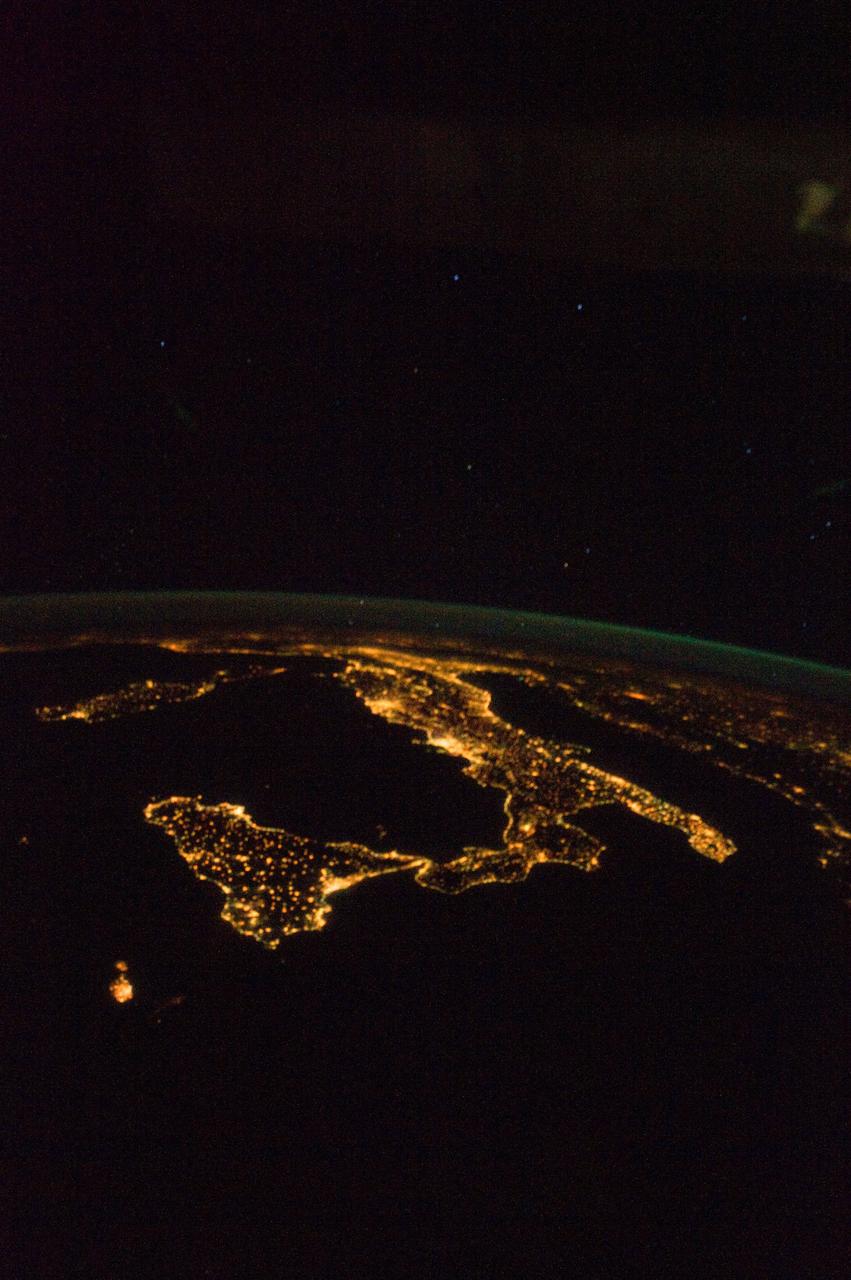
ISS028-E-008604 (11 June 2011) --- A night view of the southern Italian Peninsula is featured in this image photographed by an Expedition 28 crew member on the International Space Station. The Earth’s surface at night is covered with a delicate tracery of lights, particularly in regions – such as Europe – that have a long history of urban development. Large urban areas are recognizable from orbit due to extensive electric lighting and distinct street patterns; with smaller urban areas spread across the land surface and coastlines, the outlines of continental landmasses are easily discernable at night. This photograph highlights the night time appearance of the southern Italian Peninsula; the toe and heel of Italy’s “boot” are clearly defined by the lights of large cities such as Naples, Bari, and Brindisi as well as numerous smaller urban areas. The bordering Adriatic, Tyrrhenian, and Ionian Seas appear as dark regions to the east, west, and south of the boot. The city lights of Palermo and Catania on the island of Sicily are visible at image bottom center. The space station was located over an area of Romania close to the capital city of Bucharest – approximately 945 kilometers to the northeast—at the time this image was taken. Part of a docked Russian spacecraft solar panel array is visible in the foreground at left. The distance between the image subject area and the position of the photographer, as well as the viewing angle looking outwards from the space station, contributes to the distorted appearance of the Italian Peninsula and Sicily in the image.

ISS026-E-028829 (22 Feb. 2011) --- Milan, Italy metropolitan area is featured in this night time view photographed by an Expedition 26 crew member on the International Space Station. The metropolitan area of Milan (or Milano) illuminates the Italian region of Lombardy, in a pattern evocative of a patchwork quilt, in this photograph. The city of Milan proper forms a dense cluster of lights at center left; brilliant white lights indicate the historic center of the city where the Duomo di Milano (Milan Cathedral) is located. Large dark regions to the south of Milan contain mostly agricultural fields. To the north, numerous smaller cities are interspersed with agricultural fields giving way to forested areas as one approaches the Italian Alps (not shown). Low patchy clouds diffuse the city lights, producing isolated regions in the image that appear blurred. The Milan urban area is located within the Po Valley, a large plain bordered by the Adriatic Sea to the south and the Italian Alps to the north. Milan has the largest metropolitan area in Italy, and the fifth largest in the European Union.
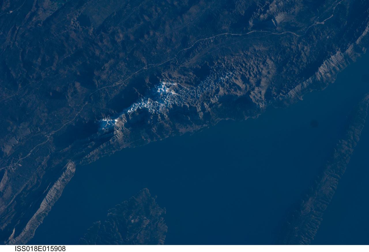
ISS018-E-015908 (29 Dec. 2008) --- The Biokovo Range in Croatia is featured in this image photographed by an Expedition 18 crewmember on the International Space Station. The Biokovo Range in Croatia is part of the Dinaric Alps extending northwest-southeast along the coastline of the Adriatic Sea. The Range itself is the location of a national park; the nearby city of Makarska, located between the mountains and the sea, is a popular tourist destination. The highest peak in the Biokovo Range, Sveti Jure (1762 meters above sea level), is reachable by road or hiking. The Range is comprised mainly of Mesozoic age carbonate rocks ? primarily limestone, a sedimentary rock type rich in calcium carbonate ? deposited in relatively warm, shallow waters. Later tectonic processes uplifted and exposed the carbonate rocks to erosion ? leading to a distinctive geological surface known as karst topography. Karst topography originates due to the chemical erosion of carbonate rocks by acids formed in surface and subsurface water; as the rock is dissolved, underground networks of drainages and caves form. As more underground void space develops through time, the overlaying rock and soil collapses to form a variety of landforms including sinkholes, blind valleys, and towers. In the Biokovo Range, much of the karst surface has a pitted appearance, made easily visible by early morning light in this astronaut photograph. The pitted appearance is produced by numerous circular or semi-circular collapse valleys known locally as vrtace. While this image captures Sveti Jure covered with snow, there are no glaciers or ice fields in the Biokovo Range.
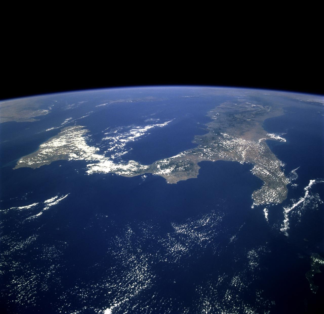
STS078-751-012 (20 June-7 July 1996) --- The international crew of the Life and Microgravity Spacelab (LMS-1) mission onboard the Space Shuttle Columbia photographed this oblique view of the "toe" of Italy and the island of Sicily. Southern Italy is known as the Mezzogiorno because of the intensity of sunshine there at midday (Mezzogiorno is the Italian term for "midday" or "noon"). Mezzogiorno is a mainland subregion consisting of the modern southern Italian regions of Abruzzi, Molise, Campania, Puglia, Basilicata, and Calabria and an insular subregion composed of Sicily and Sardinia. Southern Italy is dominated by the Apennine Range, seen in the photo on the west side, and up to one-half of the land is too steep for any form of cultivation. Coastal plains are generally narrow and poorly drained and are limited to the environs of the cities of Naples and Salerno, Foggia, and Taranto. Chief crops in this region include wheat, olives, grapes, peaches, apricots, pears, and various vegetables. Iron, steel, machine tools, agricultural machinery, and petrochemicals are produced in the industrial triangle of Bari, Brindisi, and Taranto; industries around Naples are more diversified and produce textiles and various consumer goods, iron, steel, Olivetti office machinery, Pirelli cables, Alfa Romeo automobiles, and ships. The Adriatic Sea on the east separates it from the Balkans, and the Mediterranean Sea on the south separates it from North Africa. Three major tectonic plates, converging from the south, the west, and the northeast, create geologically unstable conditions throughout southern Italy and Sicily. The most famous of southern Italy's four active volcanoes is Mount Vesuvius, whose eruption in AD 79 destroyed Pompeii. Sicily's Mount Etna and Stromboli, on an island north of Sicily, were active during this Space Shuttle mission.

ISS014-E-17346 (15 March 2007) --- Venice, Italy is featured in this image photographed by an Expedition 14 crewmember on the International Space Station. A space-based perspective of the City of Venice provides a quick assessment of the different development and land uses in the region; the major islands in the lagoon surrounding Venice--Laguna Veneta--appear different from one another. The island of Venice itself, a dense urban landscape, appears almost uniformly covered with red tiled roofs. By contrast, port facilities, and the train station at the west end of the island, appear in shades of gray. The islands of Giudecca and Murano (famous for glassware) are almost as densely built up, but the whole walled island of San Michele, used as a cemetery since Napoleon's occupation, is covered with trees and tombs. Lido di Venezia, which separates the lagoon from the Adriatic Sea, has wide, vegetated spaces. The green spaces of nearby islands east of Venice are often used by picnickers getting away from Venice. Though Venice has a declining population of fewer than 70,000, a mass of 12 million visitors invade the city every year. Many arrive from the mainland via the bridge at the train station. Many arrive by boat, whose wakes can be seen as white flashes in many parts of the image. A prominent visual feature of the Venice metropolitan area is the S-bend of the Grand Canal. The famous Rialto Bridge is big enough to appear as a white break in the canal in this view. St. Mark's church and square, and the Doge's Palace are also visible at the east end of the canal.