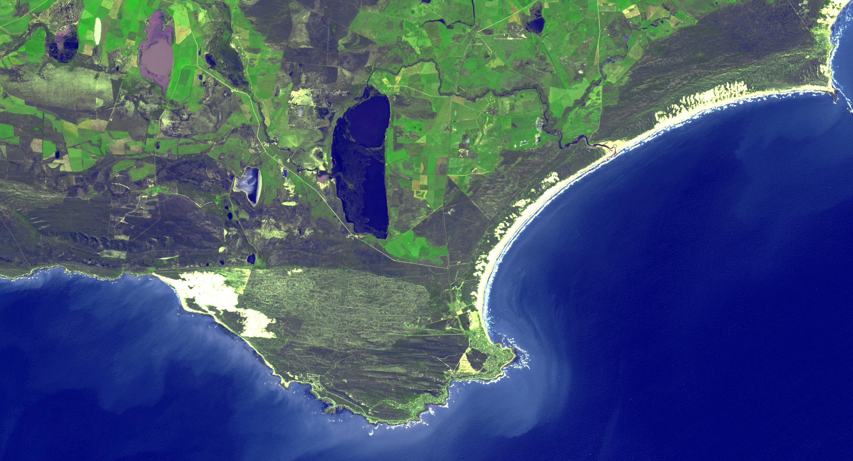
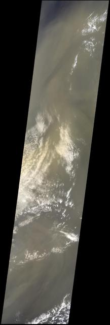
The southernmost tip of Africa is marked by the Cape Agulhas lighthouse. The warm Atlantic Agulhas current meets the cold water Indian Ocean Benguela current, creating treacherous seas that have claimed many ships over the last 450 years. The image covers an area of 22.5 by 41.1 kilometers, was acquired September 27, 2006, and is located at 34.8 degrees south, 20 degrees east. http://photojournal.jpl.nasa.gov/catalog/PIA21014
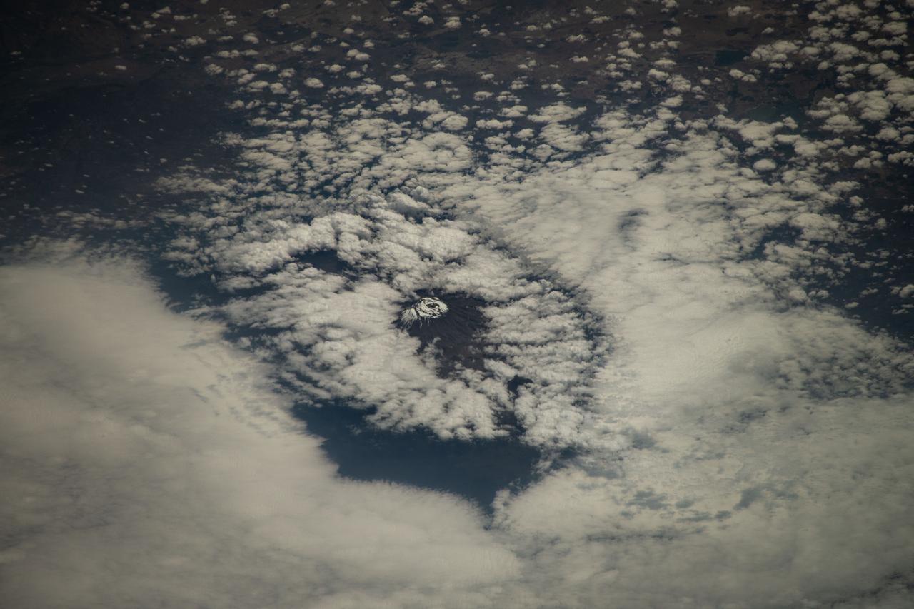
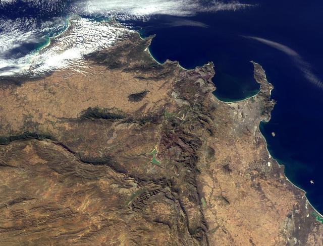
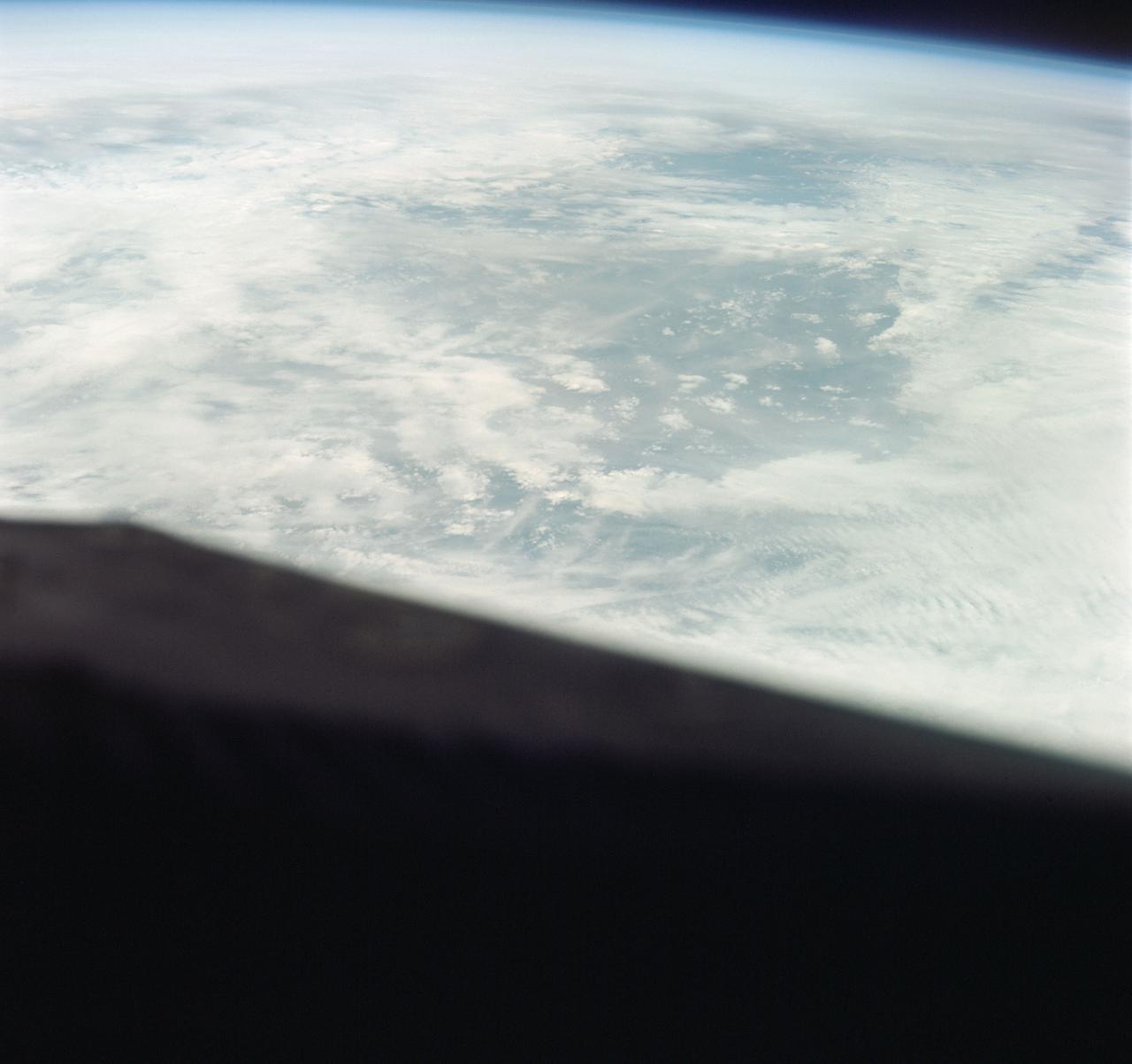
iss071e378517 (July 21, 2024) --- Mount Kilimanjaro, surrounded by clouds and the highest mountian in Africa, is pictured from the International Space Station as it orbited 261 miles above the Indian Ocean off the coast of Tanzania.
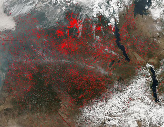
The Suomi NPP satellite's Visible Infrared Imaging Radiometer Suite (VIIRS) instrument captured a look at huge numbers of fires burning and the resulting smoke in central Africa on June 27, 2017. Actively burning areas, detected by VIIRS are outlined in red. The fires obscure most of the landscape in central Africa. June heralds the end of the crop season in this part of the world, and these fires may be intentional agricultural fires set by people to rid the area of left over crops and get it ready for the next season. So too some of these may also be lightning strike fires or they may be accidental fires which may have gotten out of control. The Suomi NPP satellite is a joint mission between NASA and NOAA. NASA image courtesy Jeff Schmaltz, MODIS Rapid Response Team <b><a href="http://www.nasa.gov/audience/formedia/features/MP_Photo_Guidelines.html" rel="nofollow">NASA image use policy.</a></b> <b><a href="http://www.nasa.gov/centers/goddard/home/index.html" rel="nofollow">NASA Goddard Space Flight Center</a></b> enables NASA’s mission through four scientific endeavors: Earth Science, Heliophysics, Solar System Exploration, and Astrophysics. Goddard plays a leading role in NASA’s accomplishments by contributing compelling scientific knowledge to advance the Agency’s mission. <b>Follow us on <a href="http://twitter.com/NASAGoddardPix" rel="nofollow">Twitter</a></b> <b>Like us on <a href="http://www.facebook.com/pages/Greenbelt-MD/NASA-Goddard/395013845897?ref=tsd" rel="nofollow">Facebook</a></b> <b>Find us on <a href="http://instagrid.me/nasagoddard/?vm=grid" rel="nofollow">Instagram</a></b>

Africa is front and center in this image of Earth taken by a NASA camera on the Deep Space Climate Observatory (DSCOVR) satellite. The image, taken July 6 from a vantage point one million miles from Earth, was one of the first taken by NASA’s Earth Polychromatic Imaging Camera (EPIC). Central Europe is toward the top of the image with the Sahara Desert to the south, showing the Nile River flowing to the Mediterranean Sea through Egypt. The photographic-quality color image was generated by combining three separate images of the entire Earth taken a few minutes apart. The camera takes a series of 10 images using different narrowband filters -- from ultraviolet to near infrared -- to produce a variety of science products. The red, green and blue channel images are used in these Earth images. The DSCOVR mission is a partnership between NASA, the National Oceanic and Atmospheric Administration (NOAA) and the U.S. Air Force, with the primary objective to maintain the nation’s real-time solar wind monitoring capabilities, which are critical to the accuracy and lead time of space weather alerts and forecasts from NOAA. DSCOVR was launched in February to its planned orbit at the first Lagrange point or L1, about one million miles from Earth toward the sun. It’s from that unique vantage point that the EPIC instrument is acquiring images of the entire sunlit face of Earth. Data from EPIC will be used to measure ozone and aerosol levels in Earth’s atmosphere, cloud height, vegetation properties and a variety of other features. Image Credit: NASA
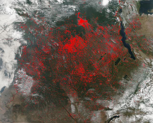
NASA’s Suomi NPP satellite detected thousands of fires burning in central Africa on July 11, 2016. The fires are represented by the multitudes of red dots. Most of the fires burn in grass or cropland. The location, widespread nature, and number of fires suggest that these fires were deliberately set to manage land. Places where traditional plots of open land is not available because the vegetation in the area is dense are the places where "slash and burn" agriculture is practiced most often. These regions include parts of Africa, northern South America, and Southeast Asia, where an abundance of grasslands and rainforests are found. Although most parts of the world outlaw this type of agriculture due to the fact that the smoke from these (or any) fires is a health hazard, the method of agriculture continues because it is the easiest and lowest cost solution to clearing fields for next year's crops. The Suomi NPP satellite is a joint mission between NASA, NOAA and the U.S. Department of Defense. NASA image courtesy Jeff Schmaltz, MODIS Rapid Response Team.

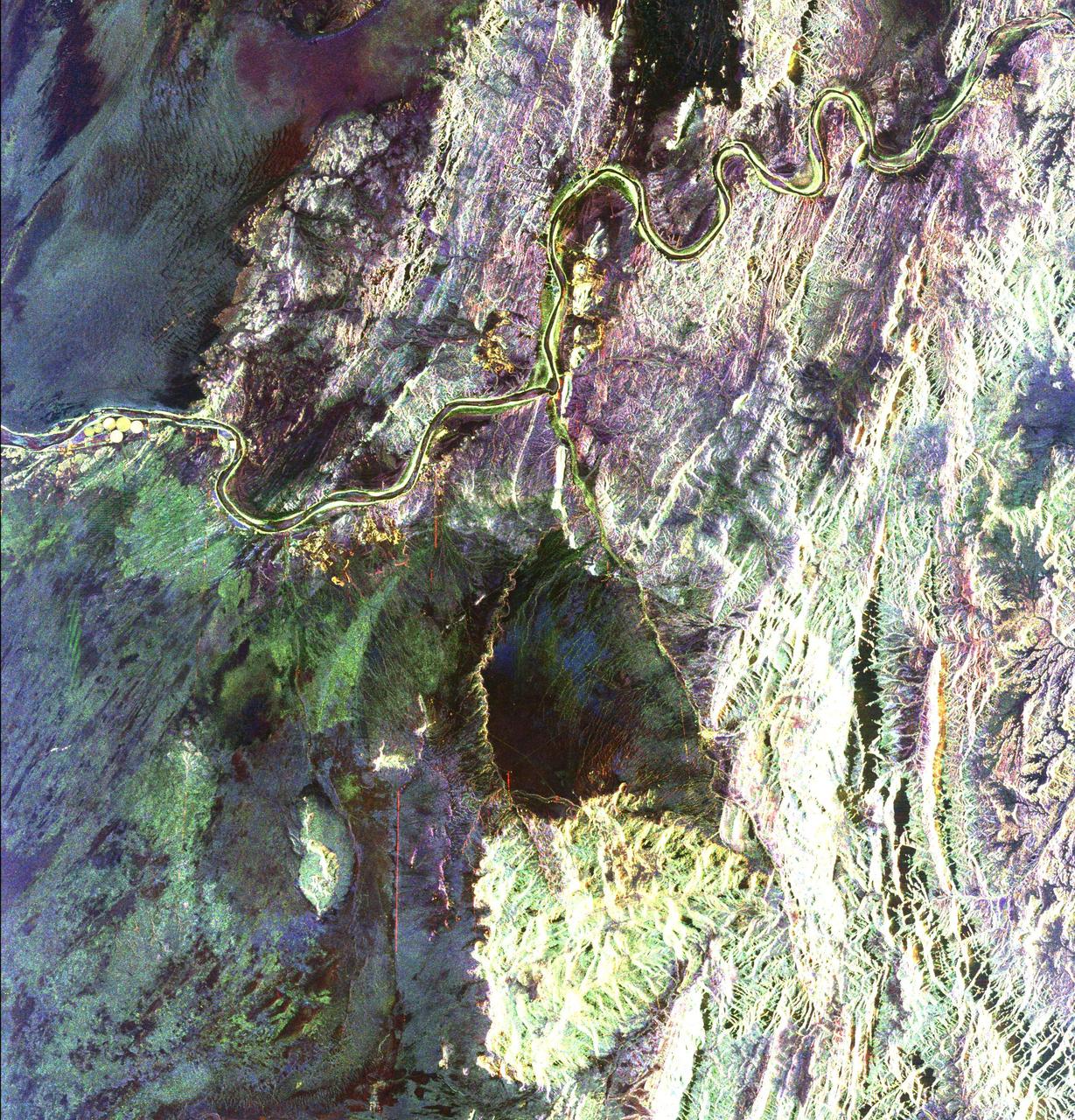
This is an image of equatorial Africa, centered on the equator at longitude 15degrees east. This image is a mosaic of almost 4,000 separate images obtained in 1996 by the L-band imaging radar onboard the Japanese Earth Resources Satellite. Using radar to penetrate the persistent clouds prevalent in tropical forests, the Japanese Earth Resources Satellite was able for the first time to image at high resolution this continental scale region during single flooding seasons. The area shown covers about 7.4 million square kilometers (2.8 million square miles) of land surface, spans more than 5,000 kilometers(3,100 miles) east and west and some 2,000 kilometers (1,240 miles) north and south. North is up in this image. At the full resolution of the mosaic (100 meters or 330 feet), this image is more than 500 megabytes in size, and was processed from imagery totaling more than 60 gigabytes. Central Africa was imaged twice in 1996, once between January and March, which is the major low-flood season in the Congo Basin, and once between October and November, which is the major high-flood season in the Congo Basin. The red color corresponds to the data from the low-flood season, the green to the high-flood season, and the blue to the "texture" of the low-flood data. The forests appear green as a result, the flooded and palm forests, as well as urban areas, appear yellow, the ocean and lakes appear black, and savanna areas appear blue, black or green, depending on the savanna type, surface topography and other factors. The areas of the image that are black and white were mapped only between January and March 1996. In these areas, the black areas are savanna or open water, the gray are forests, and the white areas are flooded forests or urban areas. The Congo River dominates the middle of the image, where the nearby forests that are periodically flooded by the Congo and its tributaries stand out as yellow. The Nile River flows north from Lake Victoria in the middle right of the color portion of the mosaic. http://photojournal.jpl.nasa.gov/catalog/PIA01348
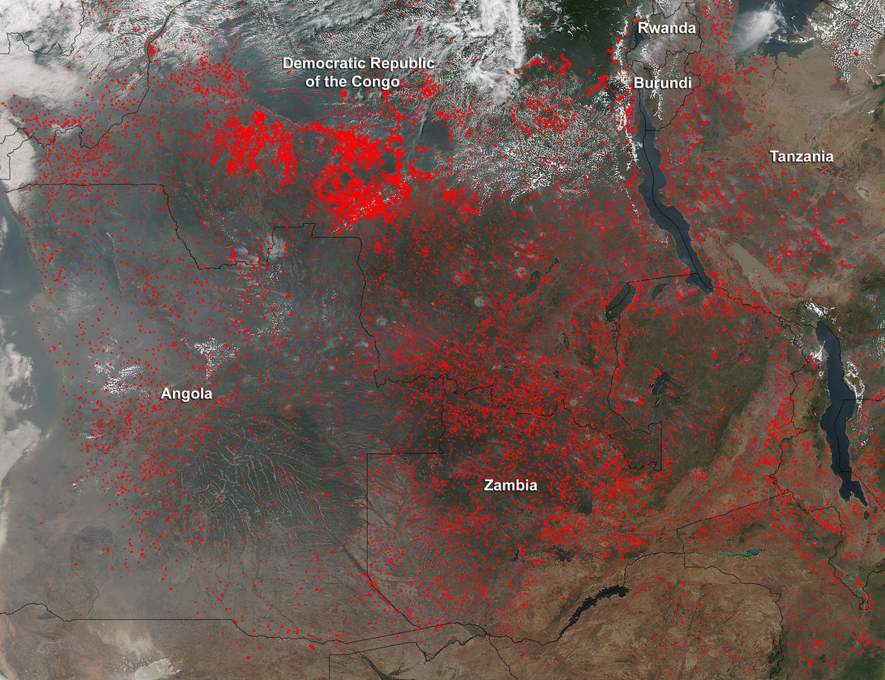
Widespread agricultural burning continues throughout central Africa. Smoke and fires in several countries were seen by the Suomi NPP satellite. Most of the fires were burning in the southern region of the Democratic Republic of the Congo, Tanzania, Zambia and Angola. NASA-NOAA's Suomi NPP satellite's Visible Infrared Imaging Radiometer Suite (VIIRS) instrument captured a look at multiple fires and smoke on August 1 at 7:55 a.m. EDT (11:55 UTC). Actively burning areas, detected by VIIRS are outlined in red. Credit: NASA/Jeff Schmaltz/NASA Goddard Rapid Response Team <b><a href="http://www.nasa.gov/audience/formedia/features/MP_Photo_Guidelines.html" rel="nofollow">NASA image use policy.</a></b> <b><a href="http://www.nasa.gov/centers/goddard/home/index.html" rel="nofollow">NASA Goddard Space Flight Center</a></b> enables NASA’s mission through four scientific endeavors: Earth Science, Heliophysics, Solar System Exploration, and Astrophysics. Goddard plays a leading role in NASA’s accomplishments by contributing compelling scientific knowledge to advance the Agency’s mission. <b>Follow us on <a href="http://twitter.com/NASAGoddardPix" rel="nofollow">Twitter</a></b> <b>Like us on <a href="http://www.facebook.com/pages/Greenbelt-MD/NASA-Goddard/395013845897?ref=tsd" rel="nofollow">Facebook</a></b> <b>Find us on <a href="http://instagrid.me/nasagoddard/?vm=grid" rel="nofollow">Instagram</a></b>
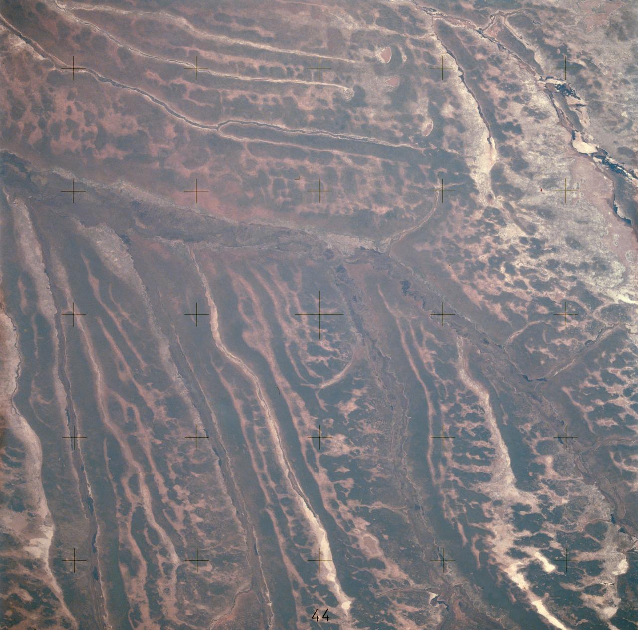
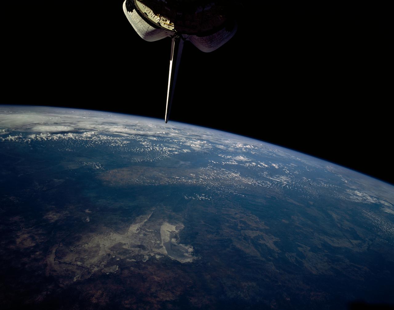
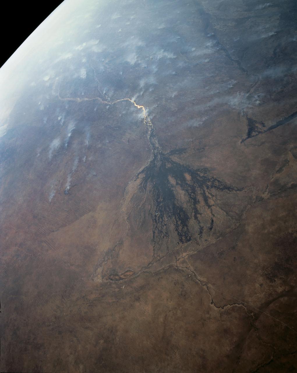
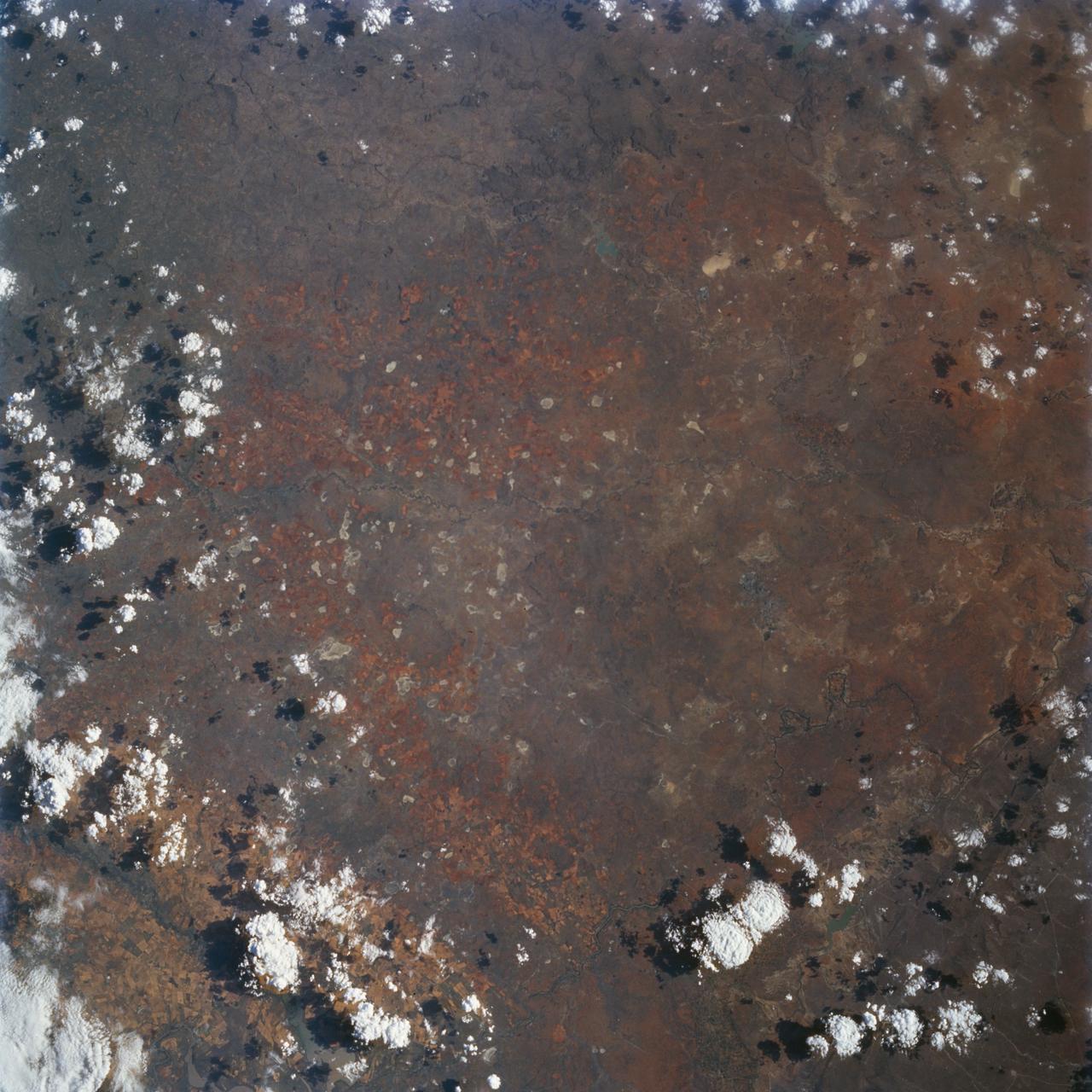
AST-14-890 (18 July 1975) --- An oblique view of unique drainage patterns in southwestern Africa in the Rio Cuando area of Angola and South-West Africa, as photographed from the Apollo spacecraft in Earth orbit during the joint U.S.-USSR Apollo-Soyuz Test Project mission. The picture was taken at an altitude of 223 kilometers (138 statute miles) with a 70mm Hasselblad camera using high-definition Ektachrome aerial SO-242 type film.
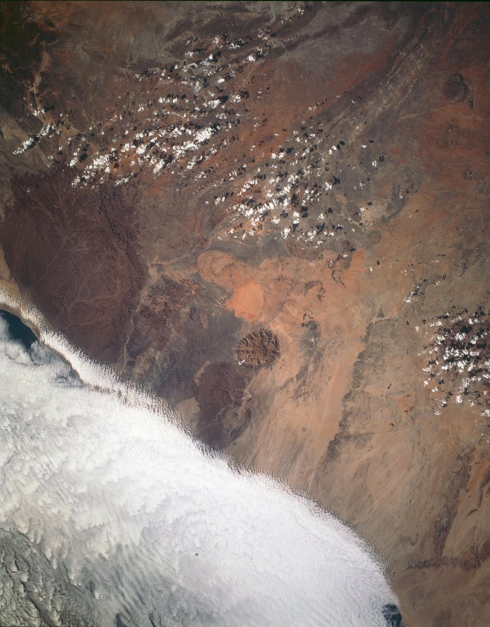
STS054-151-009 (13-19 Jan 1993) --- This large format camera's view shows the circular volcanic structure of the Brandberg mountain, which at 2630 meters (8,550 feet) is the highest point in the new nation of Namibia. The Brandberg is a major feature in the very arid Namib Desert on Africa's southwest coast. Coastal fog brings some moisture to the driest parts of the desert.
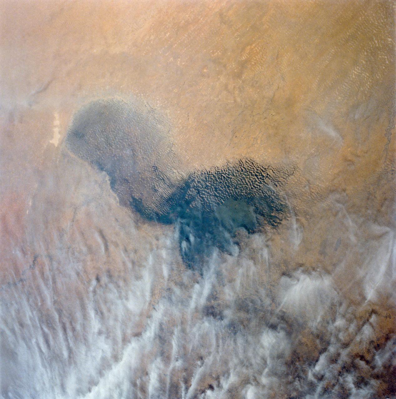
Africa's Lake Chad where the borders of Chad, Niger, Nigeria and Cameroon merge (13.0N, 14.0E) has been undergoing change for the past 25 to 30 years when it was first noticed that the lake is drying up. Since then, astronauts have been photographing it on a regular basis to record the diminishing lake bed. This lake was once the aproximate size of Lake Erie but is now only about half that size and is still receeding.
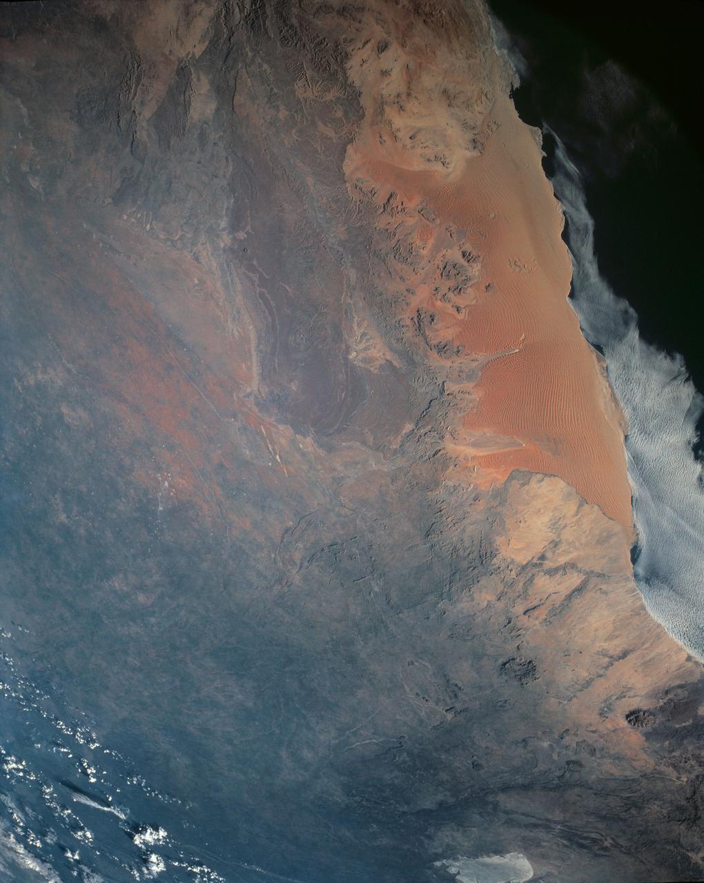
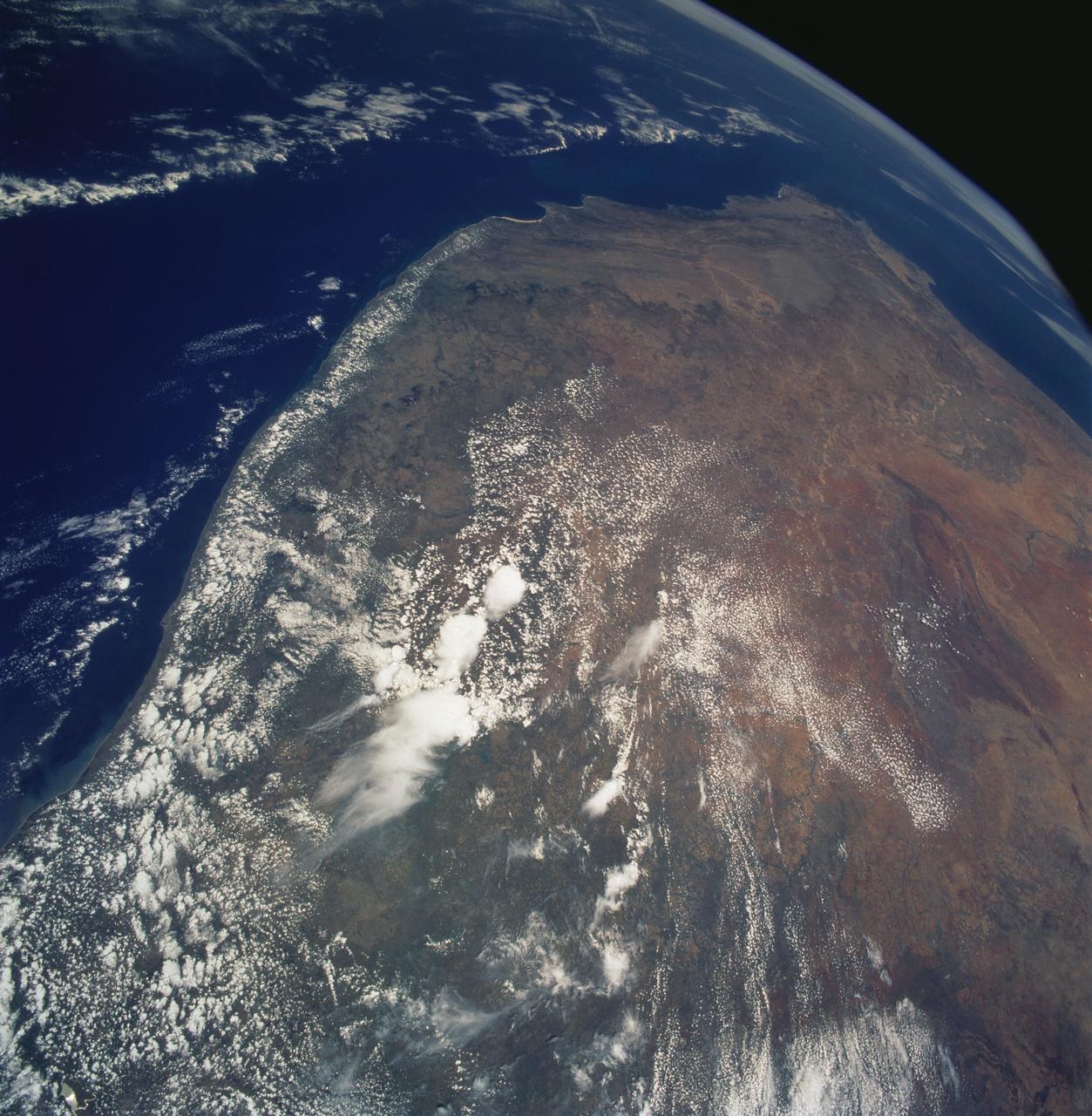
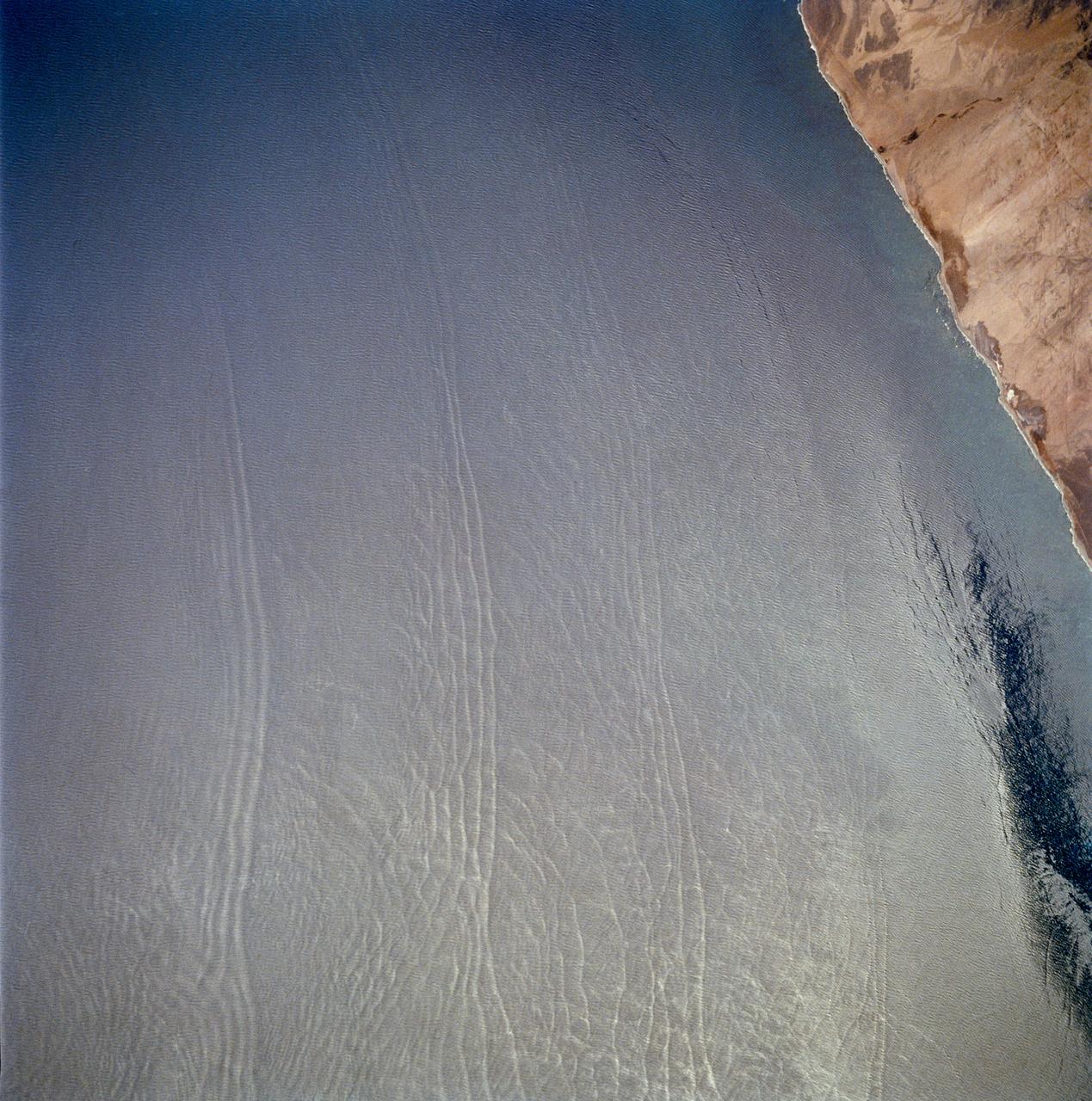
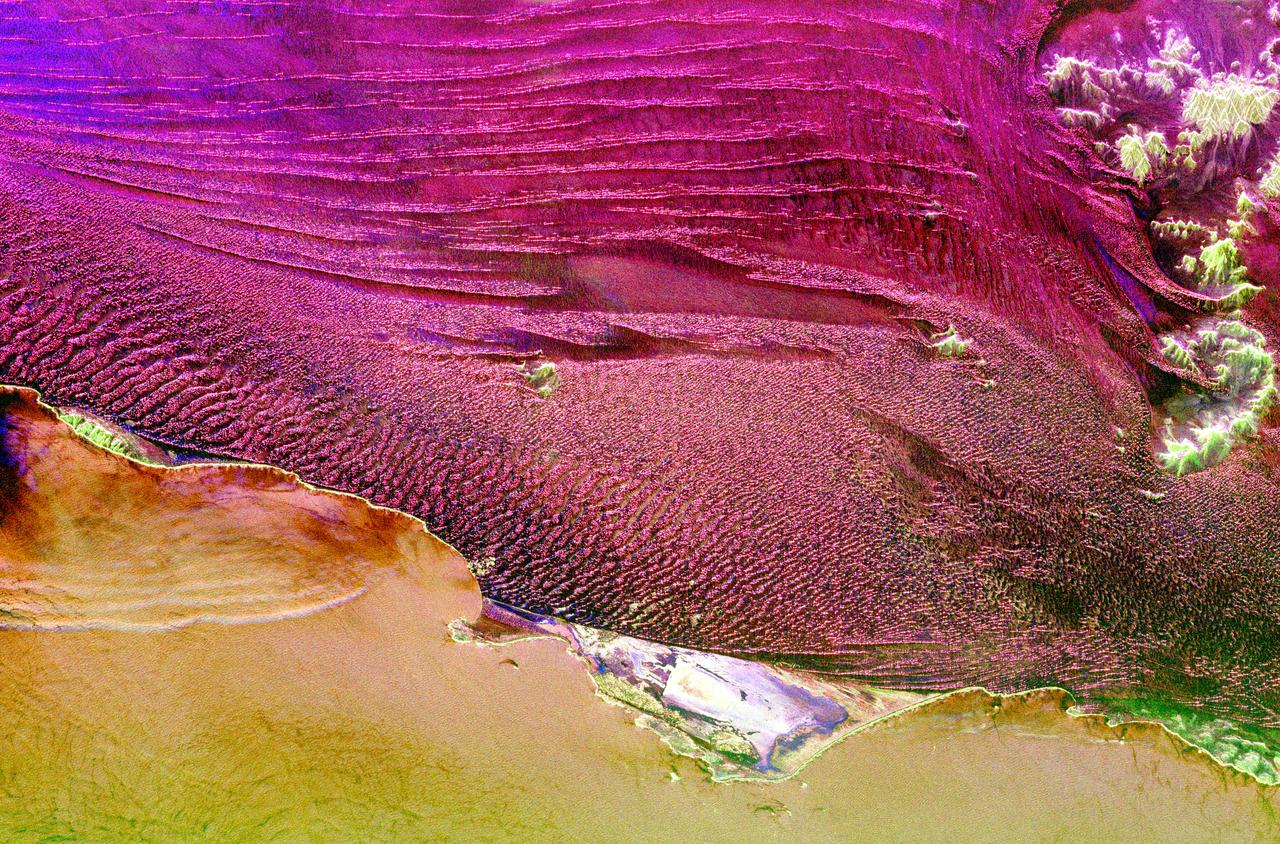
One of the driest regions on Earth, the Namib Desert, Namibia, Africa (23.0N, 15.0E) lies adjacent to the Atlantic coast but the upwelling oceanic water causes a very stable rainless atmosphere. The few local inland rivers do not reach the sea but instead, appear as long indentations where they penetrate the dune fields and end as small dry lakes. The vast dune fields are the result of sands deposited over millions of years by the stream flow.
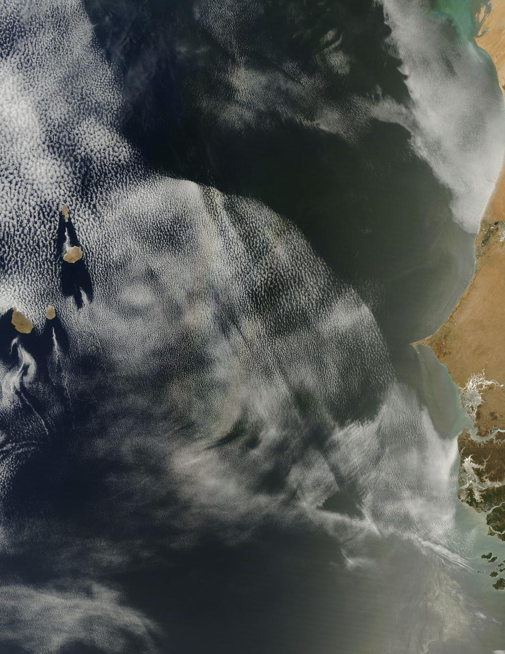
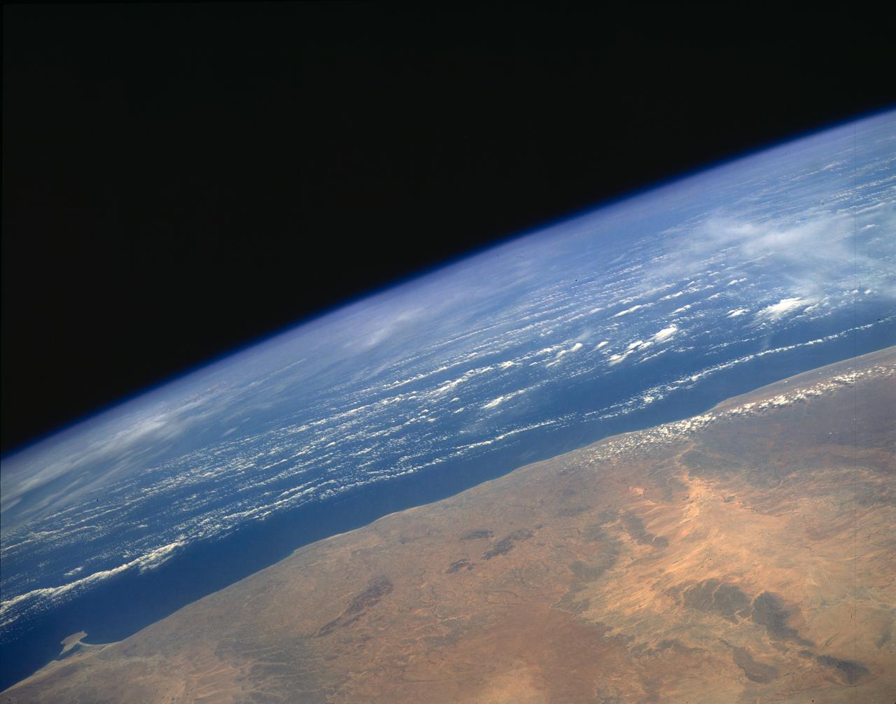
![On June 26, 2016, the Moderate Resolution Imaging Spectroradiometer (MODIS) on NASA’s Terra satellite acquired this natural-color image of cloud gravity waves off the coast of Angola and Namibia. “I [regularly] look at this area on Worldview because you quite often have these gravity waves,” said Bastiaan Van Diedenhoven, a researcher for Columbia University and NASA's Goddard Institute for Space Studies interested in cloud formations. “On this day, there was so much going on—so many different waves from different directions—that they really started interfering.” A distinctive criss-cross pattern formed in unbroken stretches hundreds of kilometers long. Similar to a boat’s wake, which forms as the water is pushed upward by the boat and pulled downward again by gravity, these clouds are formed by the rise and fall of colliding air columns. Off of west Africa, dry air coming off the Namib desert—after being cooled by the night—moves out under the balmy, moist air over the ocean and bumps it upwards. As the humid air rises to a higher altitude, the moisture condenses into droplets, forming clouds. Gravity rolls these newly formed clouds into a wave-like shape. When moist air goes up, it cools, and then gravity pushes it down again. As it plummets toward the earth, the moist air is pushed up again by the dry air. Repeated again and again, this process creates gravity waves. Clouds occur at the upward wave motions, while they evaporate at the downward motions. Such waves will often propagate in the morning and early afternoon, said Van Diedenhoven. During the course of the day, the clouds move out to sea and stretch out, as the dry air flowing off the land pushes the moist ocean air westward. NASA Earth Observatory image by Jesse Allen, using data from the Land Atmosphere Near real-time Capability for EOS (LANCE). via @NASAEarth <a href="http://go.nasa.gov/29Btxcy" rel="nofollow">go.nasa.gov/29Btxcy</a> <b><a href="http://go.nasa.gov/29BtHR6" rel="nofollow">NASA image use policy.</a></b> <b><a href="http://go.nasa.gov/29BtDku" rel="nofollow">NASA Goddard Space Flight Center</a></b> enables NASA’s mission through four scientific endeavors: Earth Science, Heliophysics, Solar System Exploration, and Astrophysics. Goddard plays a leading role in NASA’s accomplishments by contributing compelling scientific knowledge to advance the Agency’s mission. <b>Follow us on <a href="http://go.nasa.gov/29BtVrn" rel="nofollow">Twitter</a></b> <b>Like us on <a href="http://go.nasa.gov/29BtygK" rel="nofollow">Facebook</a></b> <b>Find us on <a href="http://go.nasa.gov/29Bu0vu" rel="nofollow">Instagram</a></b>](https://images-assets.nasa.gov/image/GSFC_20171208_Archive_e000269/GSFC_20171208_Archive_e000269~medium.jpg)
On June 26, 2016, the Moderate Resolution Imaging Spectroradiometer (MODIS) on NASA’s Terra satellite acquired this natural-color image of cloud gravity waves off the coast of Angola and Namibia. “I [regularly] look at this area on Worldview because you quite often have these gravity waves,” said Bastiaan Van Diedenhoven, a researcher for Columbia University and NASA's Goddard Institute for Space Studies interested in cloud formations. “On this day, there was so much going on—so many different waves from different directions—that they really started interfering.” A distinctive criss-cross pattern formed in unbroken stretches hundreds of kilometers long. Similar to a boat’s wake, which forms as the water is pushed upward by the boat and pulled downward again by gravity, these clouds are formed by the rise and fall of colliding air columns. Off of west Africa, dry air coming off the Namib desert—after being cooled by the night—moves out under the balmy, moist air over the ocean and bumps it upwards. As the humid air rises to a higher altitude, the moisture condenses into droplets, forming clouds. Gravity rolls these newly formed clouds into a wave-like shape. When moist air goes up, it cools, and then gravity pushes it down again. As it plummets toward the earth, the moist air is pushed up again by the dry air. Repeated again and again, this process creates gravity waves. Clouds occur at the upward wave motions, while they evaporate at the downward motions. Such waves will often propagate in the morning and early afternoon, said Van Diedenhoven. During the course of the day, the clouds move out to sea and stretch out, as the dry air flowing off the land pushes the moist ocean air westward. NASA Earth Observatory image by Jesse Allen, using data from the Land Atmosphere Near real-time Capability for EOS (LANCE). via @NASAEarth <a href="http://go.nasa.gov/29Btxcy" rel="nofollow">go.nasa.gov/29Btxcy</a> <b><a href="http://go.nasa.gov/29BtHR6" rel="nofollow">NASA image use policy.</a></b> <b><a href="http://go.nasa.gov/29BtDku" rel="nofollow">NASA Goddard Space Flight Center</a></b> enables NASA’s mission through four scientific endeavors: Earth Science, Heliophysics, Solar System Exploration, and Astrophysics. Goddard plays a leading role in NASA’s accomplishments by contributing compelling scientific knowledge to advance the Agency’s mission. <b>Follow us on <a href="http://go.nasa.gov/29BtVrn" rel="nofollow">Twitter</a></b> <b>Like us on <a href="http://go.nasa.gov/29BtygK" rel="nofollow">Facebook</a></b> <b>Find us on <a href="http://go.nasa.gov/29Bu0vu" rel="nofollow">Instagram</a></b>
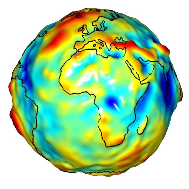
This visualization of a gravity model was created with data from NASA’s Gravity Recovery and Climate Experiment and shows variations in the gravity field across Africa and Europe.

STS058-77-083 (18 Oct-1 Nov 1993) --- In this scene of the south coast of Africa, Cape Agulhas, the southernmost point on the continent, appears as the leftmost cape. Viewed with the Earth's limb top left, clouds at bottom, the view direction is west and north top right. The Cape of Good Hope, with Cape Town nearby, is the thin spike beyond. The great bay in the foreground is Algoa Bay with the city of Port Elizabeth. This was the first time European voyagers are known to have rounded the Cape of Good Hope in their quest to reach India by sea. The entire fold mountain belt of southern Africa is visible: these mountains appear as green (forested) wavy structures stretching west form the foreground, to the Cape of Good Hope, and then northwards some distance. One theory about their origin is that the Falkland Plateau, now an undersea extension of South America, was jostled up against Africa more than 150 million years ago, in times before the Atlantic Ocean existed, before Africa and South America drifted apart from one another. The jostling caused the evolution of the fold mountain belt.
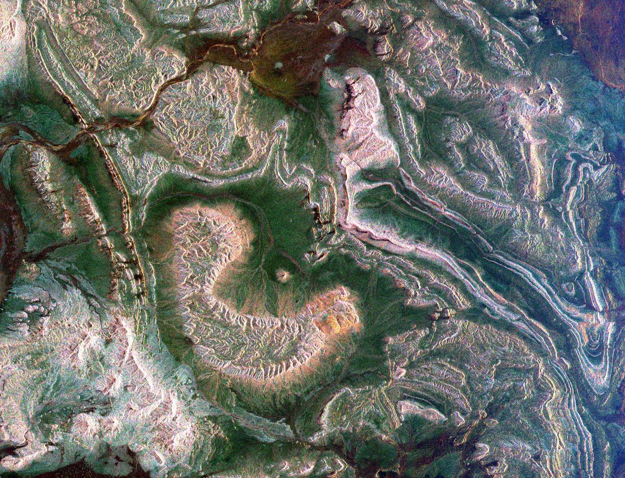
This radar image covers a portion of the Richtersveld National Park and Orange River top of image in the Northern Cape Province of the Republic of South Africa.
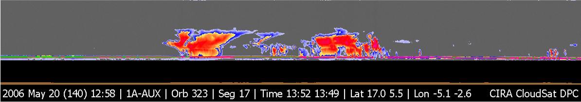
NASA CloudSat image of a horizontal cross-section of tropical clouds and thunderstorms over east Africa.
On April 23, 2013 NASA’s Terra satellite passed off the coast of West Africa, allowing the Moderate Resolution Imaging Spectroradiometer (MODIS) flying aboard to capture a curious phenomenon over the cloud deck below. The rainbow-like discoloration that can be seen streaking across the bank of marine cumulus clouds near the center of this image is known as a “glory”. A glory is caused by the scattering of sunlight by a cloud made of water droplets that are all roughly the same size, and is only produced when the light is just right. In order for a glory to be viewed, the observer’s anti-solar point must fall on the cloud deck below. In this case the observer is the Terra satellite, and the anti-solar point is where the sun is directly behind you – 180° from the MODIS line of sight. Water and ice particles in the cloud bend the light, breaking it into all its wavelengths, and the result is colorful flare, which may contain all of the colors of the rainbow. Credit: NASA/GSFC/Jeff Schmaltz/MODIS Land Rapid Response Team <b><a href="http://www.nasa.gov/audience/formedia/features/MP_Photo_Guidelines.html" rel="nofollow">NASA image use policy.</a></b> <b><a href="http://www.nasa.gov/centers/goddard/home/index.html" rel="nofollow">NASA Goddard Space Flight Center</a></b> enables NASA’s mission through four scientific endeavors: Earth Science, Heliophysics, Solar System Exploration, and Astrophysics. Goddard plays a leading role in NASA’s accomplishments by contributing compelling scientific knowledge to advance the Agency’s mission. <b>Follow us on <a href="http://twitter.com/NASA_GoddardPix" rel="nofollow">Twitter</a></b> <b>Like us on <a href="http://www.facebook.com/pages/Greenbelt-MD/NASA-Goddard/395013845897?ref=tsd" rel="nofollow">Facebook</a></b> <b>Find us on <a href="http://instagram.com/nasagoddard?vm=grid" rel="nofollow">Instagram</a></b>
STS061-106-091 (December 1993) --- The entire southern tip of Africa is shown in this high altitude 50mm photograph. The center of the photograph is at approximately 28.0 degrees south and 24.0 degrees east Cape Columbine is at the upper right with Durban at the lower center. The Orange River is at the upper center of the frame. Cape Agulas is the southernmost part of the African continent and is visible toward the upper right corner with the great bays of South Africa trending toward the bottom right. Continuing clockwise along the coast, Durban projects out into the Indian Ocean. The oceanic clouds on the right side of the photograph probably depict a current boundary. The Drakensberg Range on the east, the great Karoo Range to the south and the Karas Mountains on the west surround the drier central plateau. The southern Kalahari Desert is at the upper left of the photograph.
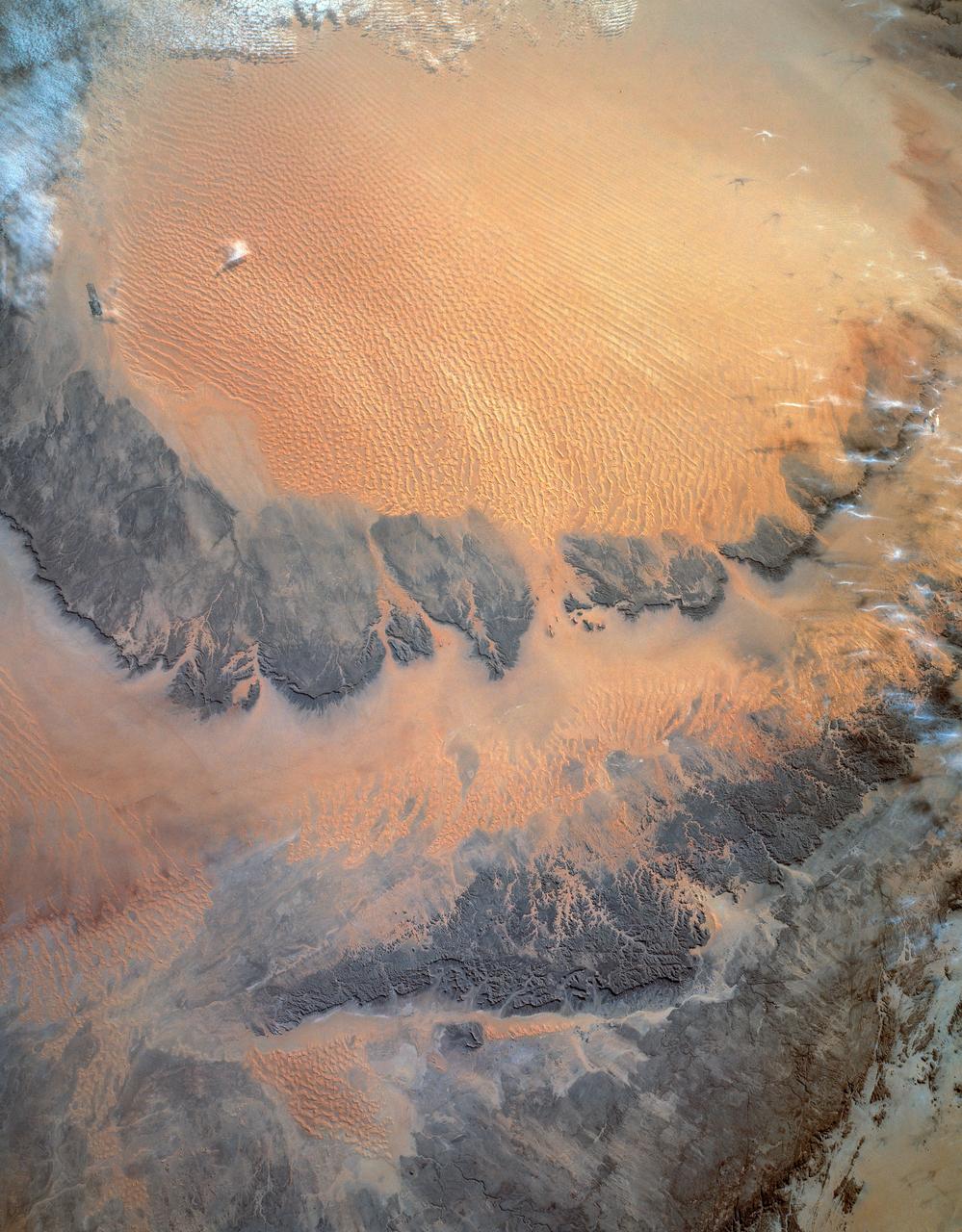
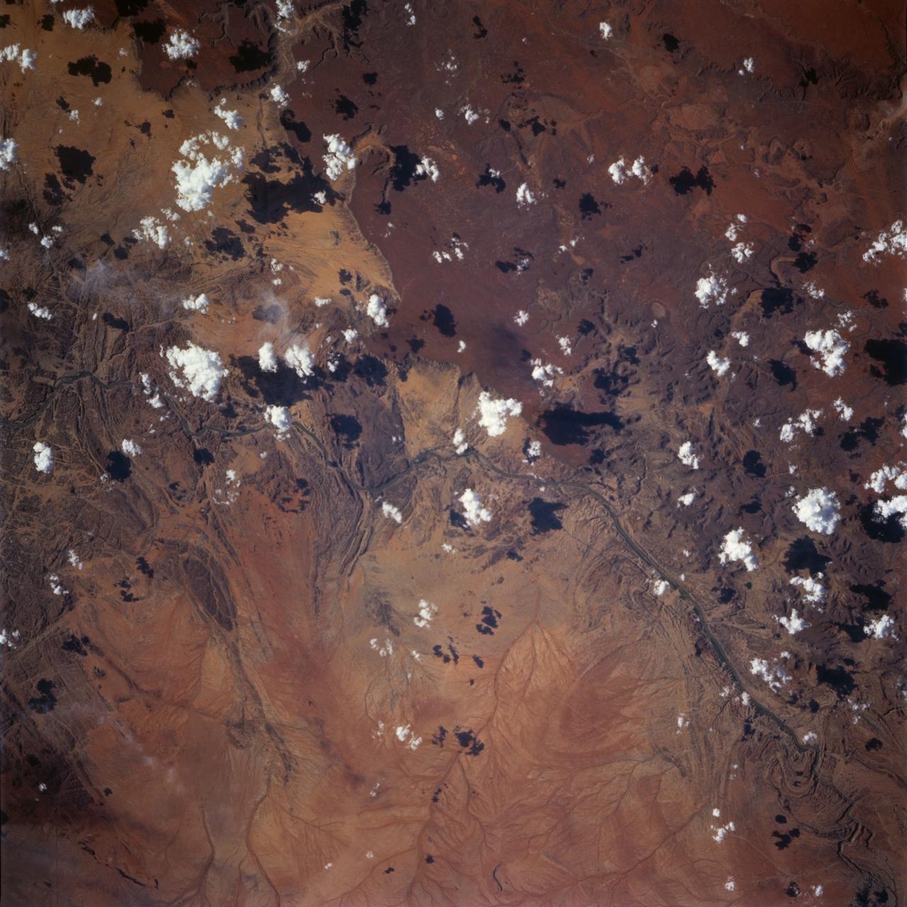
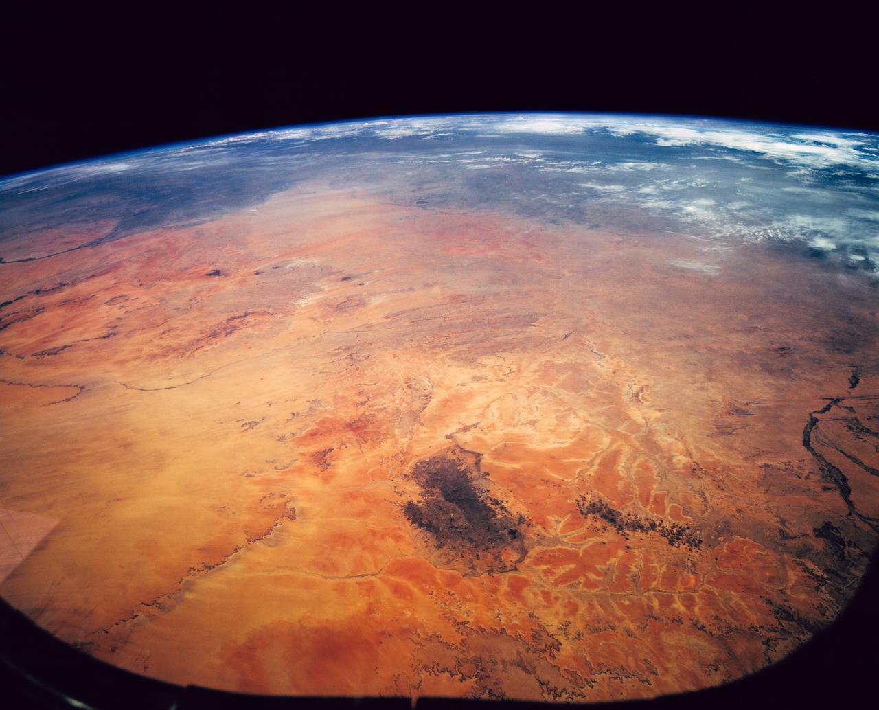
STS054-152-189 (13-19 Jan. 1993) --- This near-vertical color photograph shows the very diverse landscape that is part of the great Sahara Desert of north Africa. Specifically, the vast expanse of sand dunes, located in the extreme southwestern corner of Libya, is known as the Murzuk Sand Sea. Close inspection of this photograph shows the agricultural village of Murzuk as evidenced by the numerous center pivot irrigation patterns at the edge of the Murzuk Sand Sea. The very rugged, dissected terrain to the west of this sand sea is the eastern tip of the Tassili N'ajjer Mountains and the Tadrart Plateau that are in neighboring Algeria. Several smaller areas of sand dunes are interspersed between the major areas of rock outcrops. The photograph was taken with a Linhof camera.
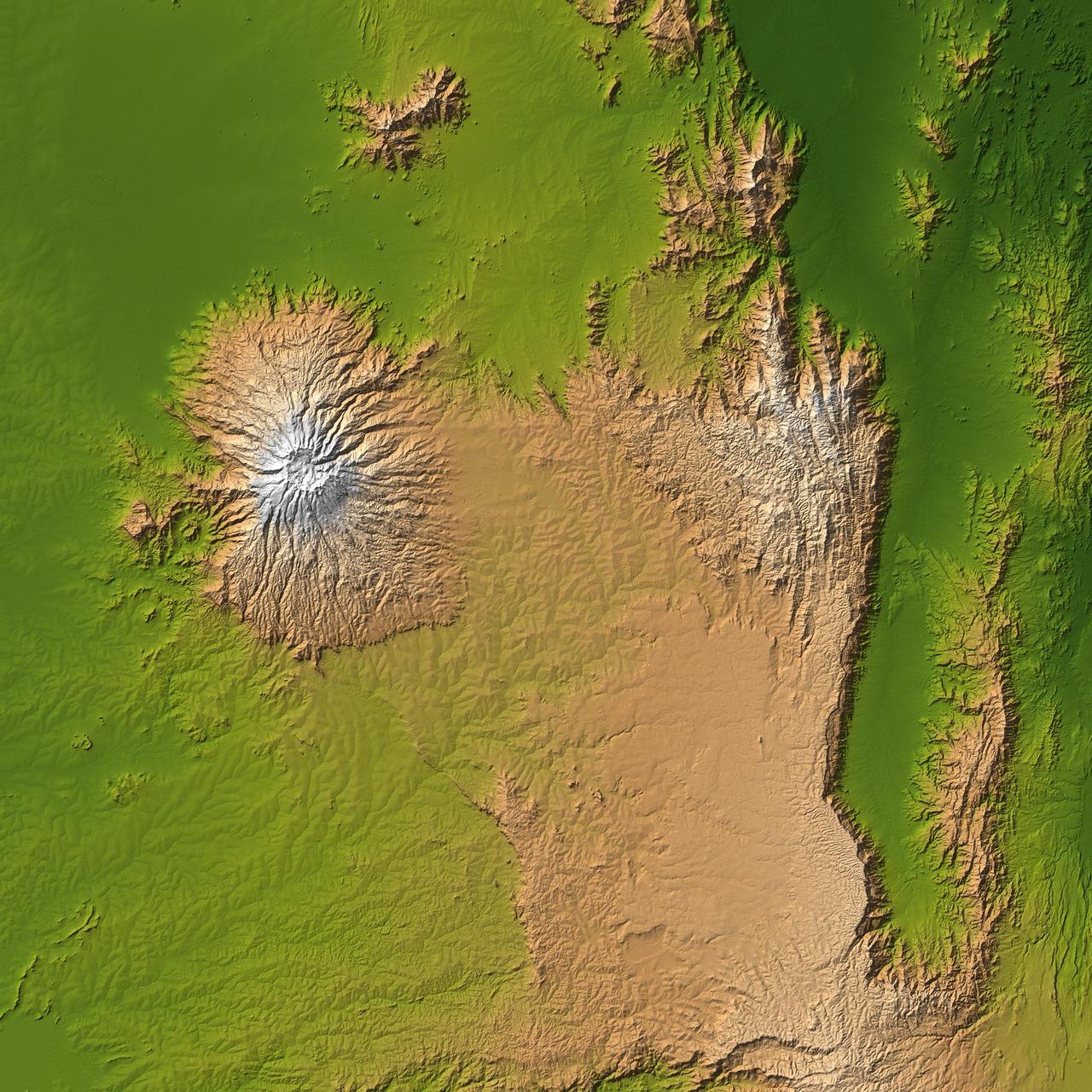
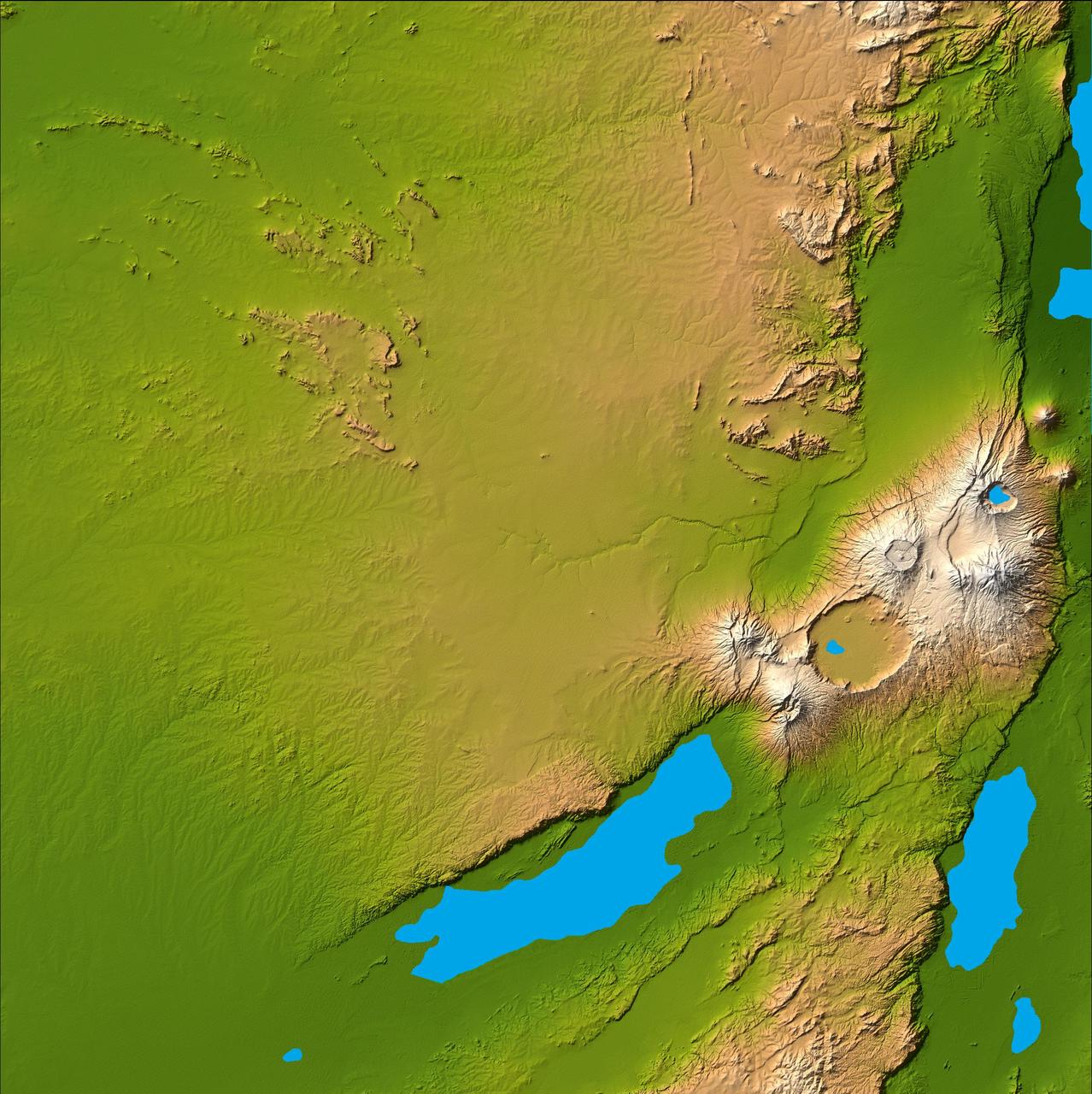
The striking contrast of geologic structures in Africa is shown in this shaded relief image of Mt. Elgon on the left and a section of the Great Rift Valley on the right.
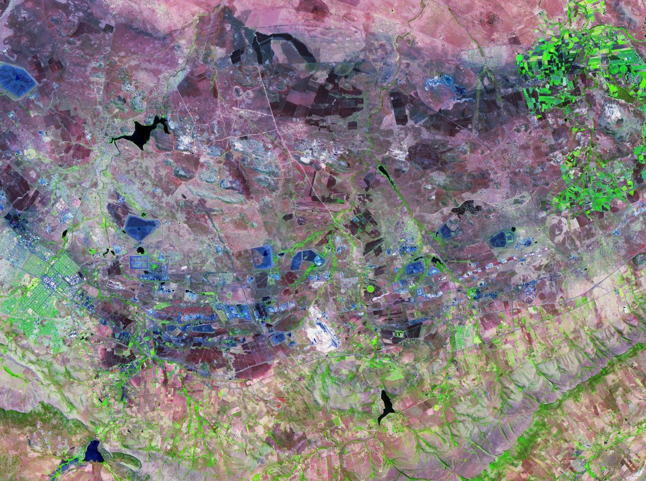
These views from NASA Terra satellite highlight a number of the land use, vegetation, and geological features found Johannesburg, Gauteng Province, South Africa.
This radar image shows a close up view of a portion of the Richtersveld National Park and Orange River top of image in the Northern Cape Province of the Republic of South Africa.

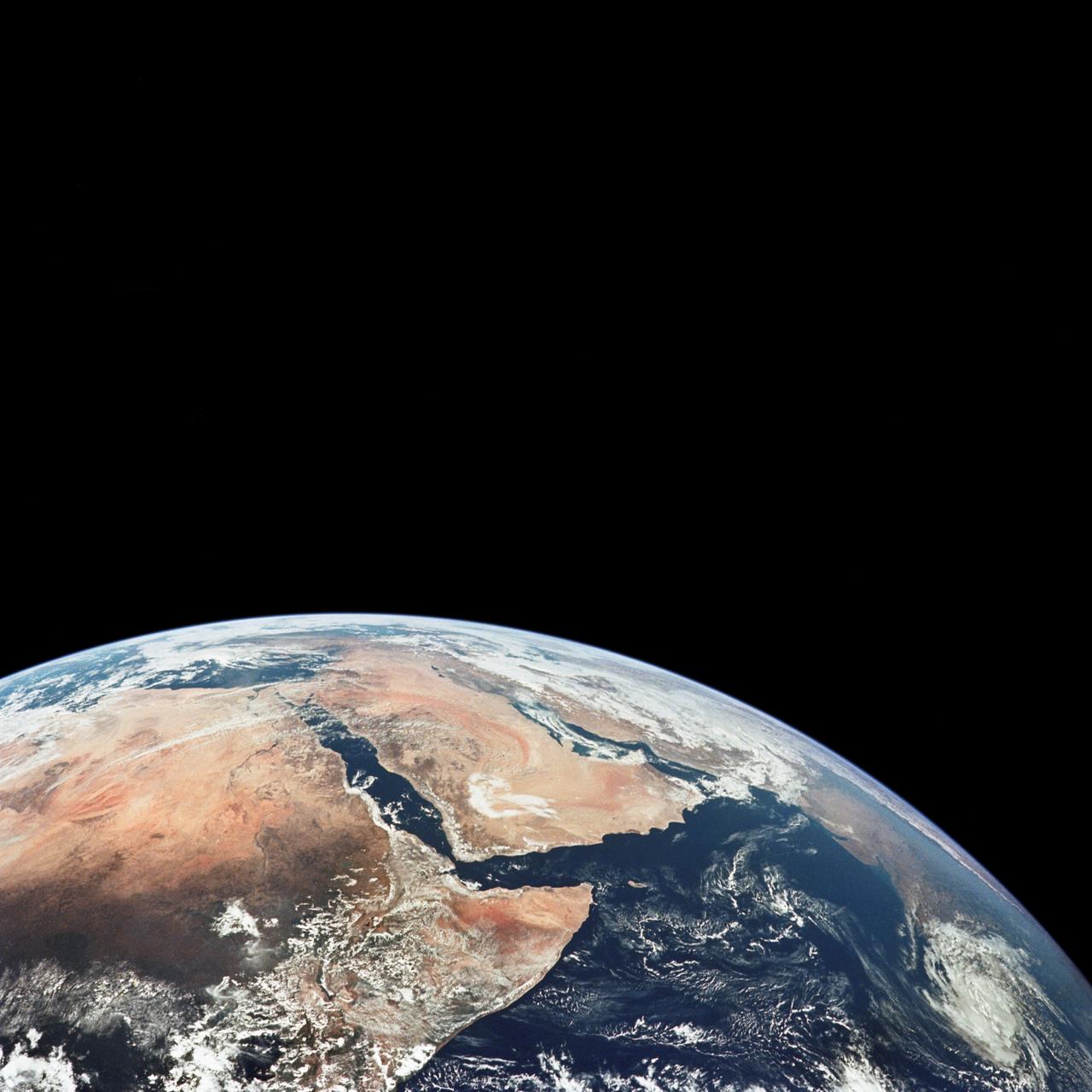
This image of northeast Africa and the Arabian Peninsula was taken from an altitude of about 500,000 kilometers 300,000 miles by NASA’s Galileo spacecraft on December 9, 1992, as it left Earth en route to Jupiter. http://photojournal.jpl.nasa.gov/catalog/PIA00127
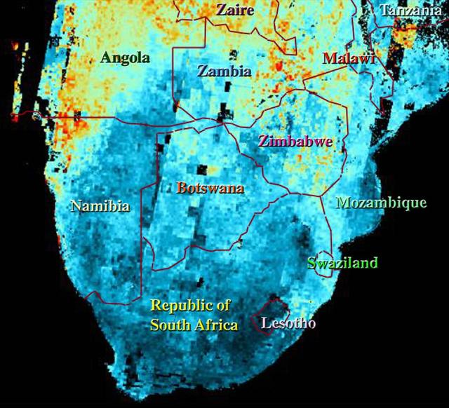
This map shows the abundance of airborne particulates, or aerosols, over Southern Africa during the period August 14-September 29, 2000, when NASA Terra satellite flew over the area.
The Bushveld Igneous Complex BIC is a large layered igneous intrusion within the earth crust, exposed at the edge of the Transvaal Basin in South Africa. Numerous mines, tailings piles, and leach ponds are shown in blue.
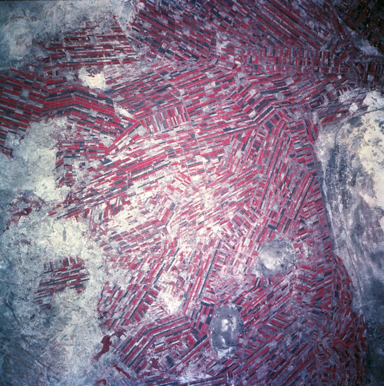
Agricultural patterns are distinctly visible in this near-vertical false color infrared photography taken in November 1994. The area depicted on the photograph is south of Khartoum between the White and Blue Nile Rivers. By far the most important irrigation project in sub-Saharan Africa, both large and small scale agricultural enterprises have been developed using water transported from the perennial Nile Rivers. Hundreds of small rectangular fields and water-filled canals can be seen in this photograph.

This color image of the Earth was obtained by NASA Galileo spacecraft in Dec. 1990, when the spacecraft was about 1.5 million miles from the Earth. Africa stretches from the center to the top of the picture with the Arabian Peninsula off to its right. http://photojournal.jpl.nasa.gov/catalog/PIA00076

iss071e580719 (Aug. 30, 2024) -- The coastline of South Africa, with Cape Town and the False Bay situated at the top right of the image, is pictured from the International Space Station as it orbited 265 miles above.
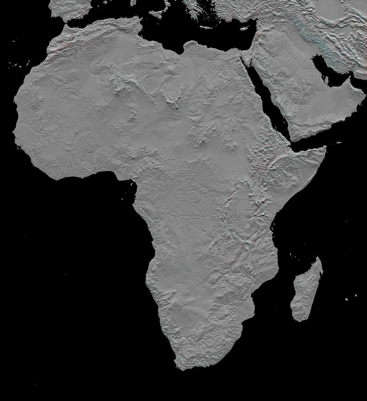
This stereoscopic shaded relief image from NASA Shuttle Radar Topography Mission shows Africa topography. Also shown are Madagascar, the Arabian Peninsula, and other adjacent regions. 3D glasses are necessary to view this image.
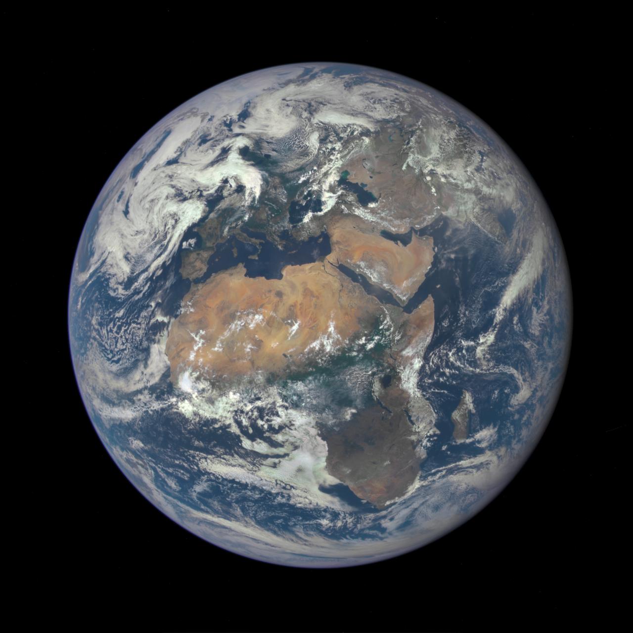
Africa is front and center in this image of Earth taken by a NASA camera on the Deep Space Climate Observatory (DSCOVR) satellite. The image, taken July 6 from a vantage point one million miles from Earth, was one of the first taken by NASA’s Earth Polychromatic Imaging Camera (EPIC). Central Europe is toward the top of the image with the Sahara Desert to the south, showing the Nile River flowing to the Mediterranean Sea through Egypt. The photographic-quality color image was generated by combining three separate images of the entire Earth taken a few minutes apart. The camera takes a series of 10 images using different narrowband filters -- from ultraviolet to near infrared -- to produce a variety of science products. The red, green and blue channel images are used in these Earth images. The DSCOVR mission is a partnership between NASA, the National Oceanic and Atmospheric Administration (NOAA) and the U.S. Air Force, with the primary objective to maintain the nation’s real-time solar wind monitoring capabilities, which are critical to the accuracy and lead time of space weather alerts and forecasts from NOAA. DSCOVR was launched in February to its planned orbit at the first Lagrange point or L1, about one million miles from Earth toward the sun. It’s from that unique vantage point that the EPIC instrument is acquiring images of the entire sunlit face of Earth. Data from EPIC will be used to measure ozone and aerosol levels in Earth’s atmosphere, cloud height, vegetation properties and a variety of other features. Image Credit: NASA <b><a href="http://www.nasa.gov/audience/formedia/features/MP_Photo_Guidelines.html" rel="nofollow">NASA image use policy.</a></b> <b><a href="http://www.nasa.gov/centers/goddard/home/index.html" rel="nofollow">NASA Goddard Space Flight Center</a></b> enables NASA’s mission through four scientific endeavors: Earth Science, Heliophysics, Solar System Exploration, and Astrophysics. Goddard plays a leading role in NASA’s accomplishments by contributing compelling scientific knowledge to advance the Agency’s mission. <b>Follow us on <a href="http://twitter.com/NASAGoddardPix" rel="nofollow">Twitter</a></b> <b>Like us on <a href="http://www.facebook.com/pages/Greenbelt-MD/NASA-Goddard/395013845897?ref=tsd" rel="nofollow">Facebook</a></b> <b>Find us on <a href="http://instagrid.me/nasagoddard/?vm=grid" rel="nofollow">Instagram</a></b>

AS04-01-410 (9 Nov. 1967) --- Coastal Brazil, Atlantic Ocean, West Africa, Sahara, Antarctica, looking west, as photographed from the Apollo 4 (Spacecraft 017/Saturn 501) unmanned, Earth-orbital space mission. This picture was taken when the Spacecraft 017 and Saturn S-IVB (third) stage were orbiting Earth at an altitude of 9,745 nautical miles.
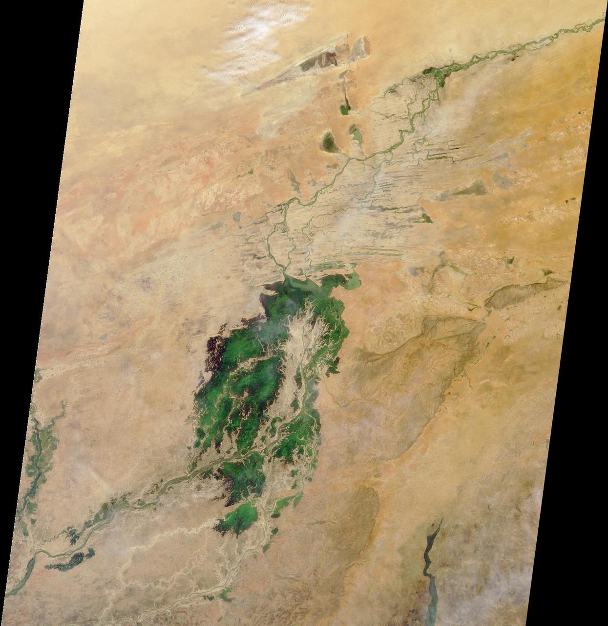
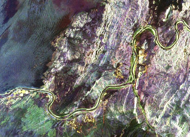
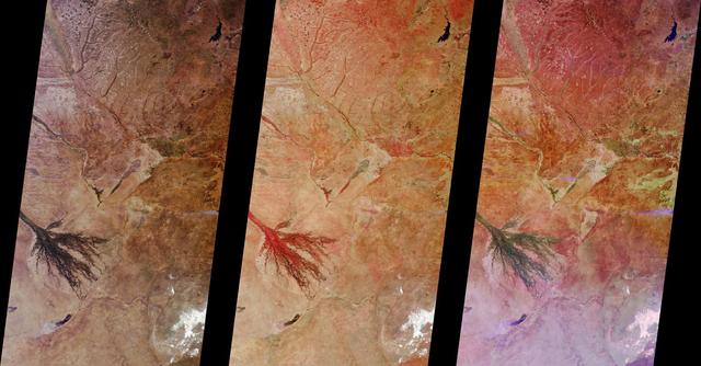
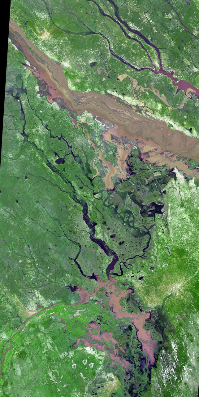
The third largest river in Africa, the Niger, forms an inland delta in central Mali. This image is from NASA Terra satellite is MISR Mystery Image Quiz #3.
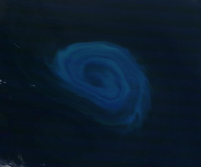
NASA image acquired December 26, 2011 Off the coast of South Africa, near where the South Atlantic meets the Southern Indian Ocean, a massive summer phytoplankton bloom colored the waters with a swirl of turquoise, green and white in late December 2011. Although this circular bloom has the appearance of a precious antique gaming marble, it is actually the result of millions of tiny plant-like organisms (phytoplankton) which are growing where nutrient-rich waters mix together. Each spring and summer, lengthening sunshine comes to the southern oceans, providing light to spur the growth of these microscopic plants. The lengthening light also melts sea ice, which can release additional nutrients into the sea. Blooms such as this one become a banquet for krill, fish and other marine species which survive in these cool waters. The Moderate Resolution Imaging Spectroradiometer (MODIS) aboard NASA’s Terra satellite captured this true-color image on December 26, 2011 as it passed over the region. Credit: NASA/GSFC/Jeff Schmaltz/MODIS Land Rapid Response Team <b><a href="http://www.nasa.gov/audience/formedia/features/MP_Photo_Guidelines.html" rel="nofollow">NASA image use policy.</a></b> <b><a href="http://www.nasa.gov/centers/goddard/home/index.html" rel="nofollow">NASA Goddard Space Flight Center</a></b> enables NASA’s mission through four scientific endeavors: Earth Science, Heliophysics, Solar System Exploration, and Astrophysics. Goddard plays a leading role in NASA’s accomplishments by contributing compelling scientific knowledge to advance the Agency’s mission. <b>Follow us on <a href="http://twitter.com/NASA_GoddardPix" rel="nofollow">Twitter</a></b> <b>Like us on <a href="http://www.facebook.com/pages/Greenbelt-MD/NASA-Goddard/395013845897?ref=tsd" rel="nofollow">Facebook</a></b> <b>Find us on <a href="http://instagrid.me/nasagoddard/?vm=grid" rel="nofollow">Instagram</a></b>
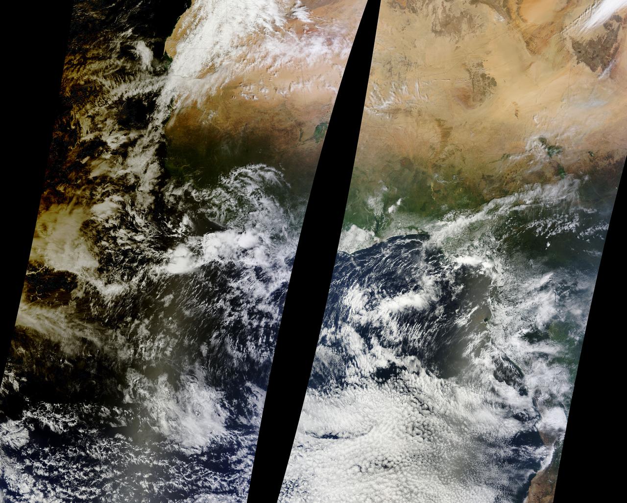
Solar eclipse over western Africa (afternoon overpass) at 14:45 UTC. Satellite: Aqua A rare “hybrid” solar eclipse occurred on 03 November 2013, which began over the western Atlantic Ocean as an annular eclipse and transitioned into a full total solar eclipse for observers along the narrow path of totality in the far eastern Atlantic and over parts of Africa. The Lunar Umbra (or solar eclipse shadow) could be seen tracking rapidly southeastward across the Atlantic Ocean. Credit: NASA/GSFC/Jeff Schmaltz/MODIS Land Rapid Response Team <b><a href="http://www.nasa.gov/audience/formedia/features/MP_Photo_Guidelines.html" rel="nofollow">NASA image use policy.</a></b> <b><a href="http://www.nasa.gov/centers/goddard/home/index.html" rel="nofollow">NASA Goddard Space Flight Center</a></b> enables NASA’s mission through four scientific endeavors: Earth Science, Heliophysics, Solar System Exploration, and Astrophysics. Goddard plays a leading role in NASA’s accomplishments by contributing compelling scientific knowledge to advance the Agency’s mission. <b>Follow us on <a href="http://twitter.com/NASA_GoddardPix" rel="nofollow">Twitter</a></b> <b>Like us on <a href="http://www.facebook.com/pages/Greenbelt-MD/NASA-Goddard/395013845897?ref=tsd" rel="nofollow">Facebook</a></b> <b>Find us on <a href="http://instagram.com/nasagoddard?vm=grid" rel="nofollow">Instagram</a></b>
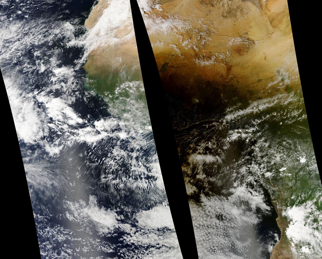
Solar eclipse over western Africa (morning overpass) at 11:45 UTC. Satellite: Terra A rare “hybrid” solar eclipse occurred on 03 November 2013, which began over the western Atlantic Ocean as an annular eclipse and transitioned into a full total solar eclipse for observers along the narrow path of totality in the far eastern Atlantic and over parts of Africa. The Lunar Umbra (or solar eclipse shadow) could be seen tracking rapidly southeastward across the Atlantic Ocean. Credit: NASA/GSFC/Jeff Schmaltz/MODIS Land Rapid Response Team <b><a href="http://www.nasa.gov/audience/formedia/features/MP_Photo_Guidelines.html" rel="nofollow">NASA image use policy.</a></b> <b><a href="http://www.nasa.gov/centers/goddard/home/index.html" rel="nofollow">NASA Goddard Space Flight Center</a></b> enables NASA’s mission through four scientific endeavors: Earth Science, Heliophysics, Solar System Exploration, and Astrophysics. Goddard plays a leading role in NASA’s accomplishments by contributing compelling scientific knowledge to advance the Agency’s mission. <b>Follow us on <a href="http://twitter.com/NASA_GoddardPix" rel="nofollow">Twitter</a></b> <b>Like us on <a href="http://www.facebook.com/pages/Greenbelt-MD/NASA-Goddard/395013845897?ref=tsd" rel="nofollow">Facebook</a></b> <b>Find us on <a href="http://instagram.com/nasagoddard?vm=grid" rel="nofollow">Instagram</a></b>

AS04-01-580 (9 Nov. 1967) --- Earth as viewed from 10,000 miles. In 1969, the Apollo 4 (Spacecraft 017/Saturn 501) unmanned test flight made a great ellipse around Earth as a test of the translunar motors and of the high speed entry required of a manned flight returning from the moon. A 70mm camera was programmed to look out a window toward Earth, and take a series of photographs from "high apogee". Coastal Brazil, Atlantic Ocean, West Africa, Antarctica, looking west. This photograph was made when the Apollo 4 spacecraft, still attached to the S-IVB (third) stage, was orbiting Earth at an altitude of 9,544 miles.
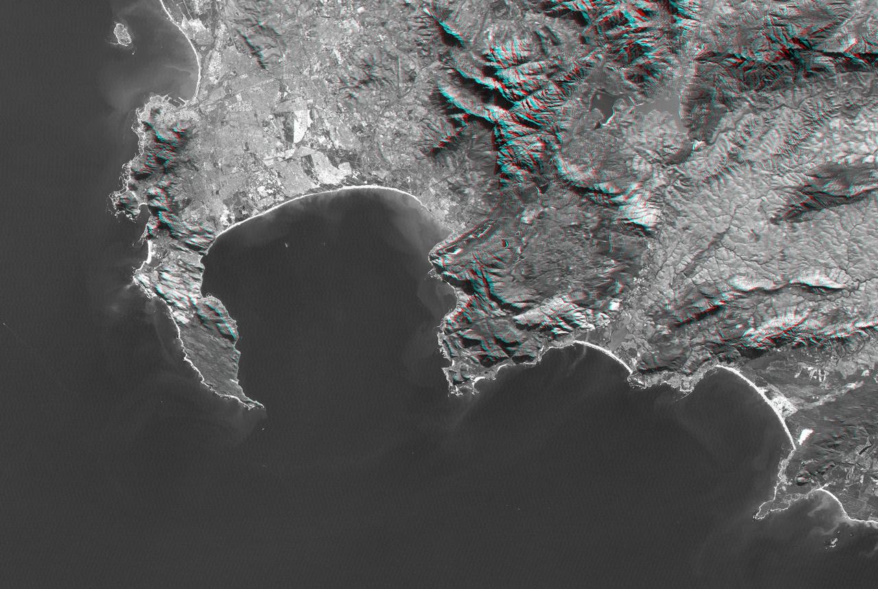
Cape Town and the Cape of Good Hope, South Africa, appear on the left west of this anaglyph from NASA Shuttle Radar Topography Mission. 3D glasses are necessary to view this image.
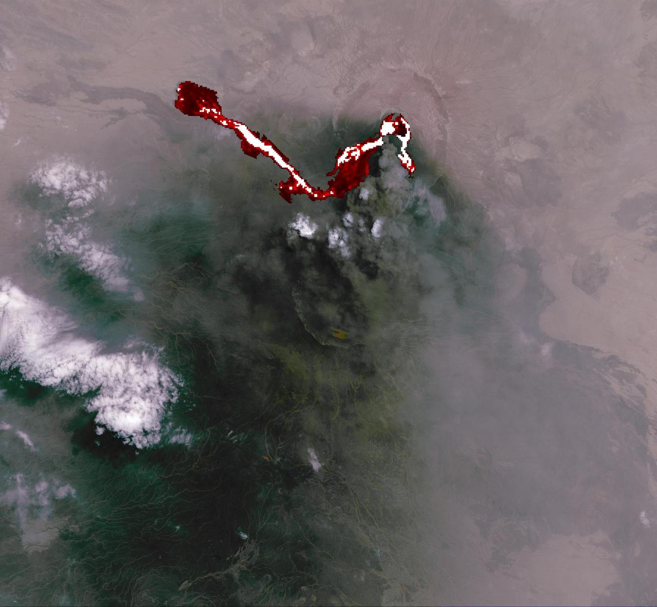
This image of Africa Nabro volcano in Eritrea was acquired by NASA Terra spacecraft on July 6, 2011. Ash plumes sent into the stratosphere disrupted air traffic in Sudan, Djibouti, Ethiopia and Sudan.
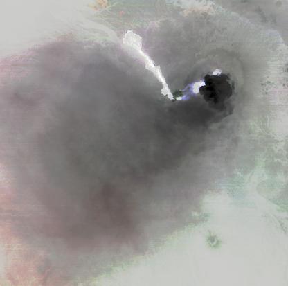
Nabro volcano, Eritrea, in the Horn of Africa, began erupting June 12, 2011, the first-ever recorded eruption of this stratovolcano. This image was acquired by NASA Terra spacecraft on June 19, 2011.
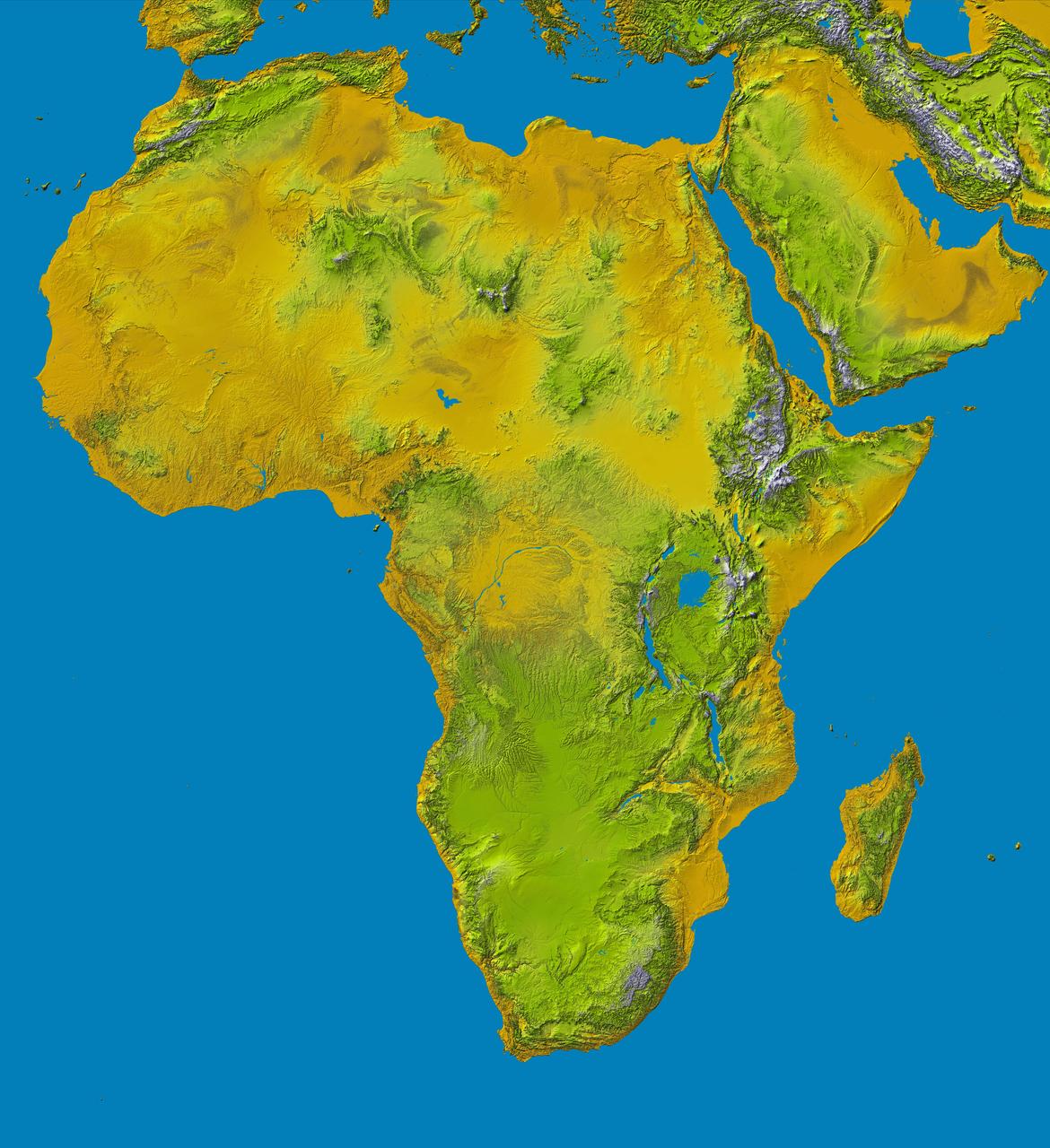
Elevation data at the highest possible resolution from NASA SRTM mission in February 2000 are being released for the first time for most of the African continent. This color shaded relief image shows the extent of SRTM digital elevation data for Africa.
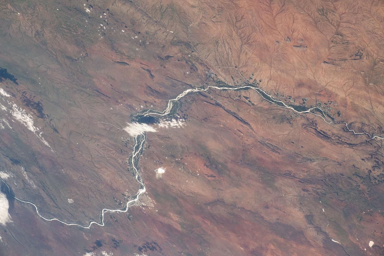
iss072e862232 (March 28, 2025) --- This portion of the Orange River, South Africa's longest river, east of Namibia's southern border and beaming under the sun's glint is pictured from the International Space Station as it orbited 264 miles above.
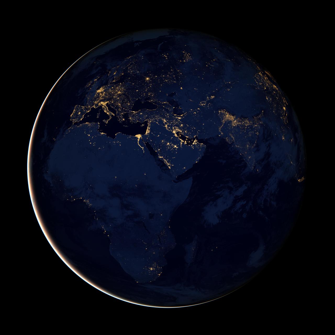
NASA image acquired April 18 - October 23, 2012 This new image of Europe, Africa, and the Middle East at night is a composite assembled from data acquired by the Suomi NPP satellite in April and October 2012. The new data was mapped over existing Blue Marble imagery of Earth to provide a realistic view of the planet. The nighttime view was made possible by the new satellite’s “day-night band” of the Visible Infrared Imaging Radiometer Suite. VIIRS detects light in a range of wavelengths from green to near-infrared and uses filtering techniques to observe dim signals such as gas flares, auroras, wildfires, city lights, and reflected moonlight. In this case, auroras, fires, and other stray light have been removed to emphasize the city lights. “Night time imagery provides an intuitively graspable view of our planet,” says William Stefanov, senior remote sensing scientist for the International Space Station program office. “They provide a fairly straightforward means to map urban versus rural areas, and to show where the major population centers are and where they are not.” Named for satellite meteorology pioneer Verner Suomi, NPP flies over any given point on Earth's surface twice each day at roughly 1:30 a.m. and p.m. The polar-orbiting satellite flies 824 kilometers (512 miles) above the surface, sending its data once per orbit to a ground station in Svalbard, Norway, and continuously to local direct broadcast users distributed around the world. The mission is managed by NASA with operational support from NOAA and its Joint Polar Satellite System, which manages the satellite's ground system. NASA Earth Observatory image by Robert Simmon, using Suomi NPP VIIRS data provided courtesy of Chris Elvidge (NOAA National Geophysical Data Center). Suomi NPP is the result of a partnership between NASA, NOAA, and the Department of Defense. Caption by Mike Carlowicz. Instrument: Suomi NPP - VIIRS Credit: <b><a href="http://www.earthobservatory.nasa.gov/" rel="nofollow"> NASA Earth Observatory</a></b> <b>Click here to view all of the <a href="http://earthobservatory.nasa.gov/Features/NightLights/" rel="nofollow"> Earth at Night 2012 images </a></b> <b>Click here to <a href="http://earthobservatory.nasa.gov/NaturalHazards/view.php?id=79793" rel="nofollow"> read more </a> about this image </b> <b><a href="http://www.nasa.gov/audience/formedia/features/MP_Photo_Guidelines.html" rel="nofollow">NASA image use policy.</a></b> <b><a href="http://www.nasa.gov/centers/goddard/home/index.html" rel="nofollow">NASA Goddard Space Flight Center</a></b> enables NASA’s mission through four scientific endeavors: Earth Science, Heliophysics, Solar System Exploration, and Astrophysics. Goddard plays a leading role in NASA’s accomplishments by contributing compelling scientific knowledge to advance the Agency’s mission. <b>Follow us on <a href="http://twitter.com/NASA_GoddardPix" rel="nofollow">Twitter</a></b> <b>Like us on <a href="http://www.facebook.com/pages/Greenbelt-MD/NASA-Goddard/395013845897?ref=tsd" rel="nofollow">Facebook</a></b> <b>Find us on <a href="http://instagram.com/nasagoddard?vm=grid" rel="nofollow">Instagram</a></b>
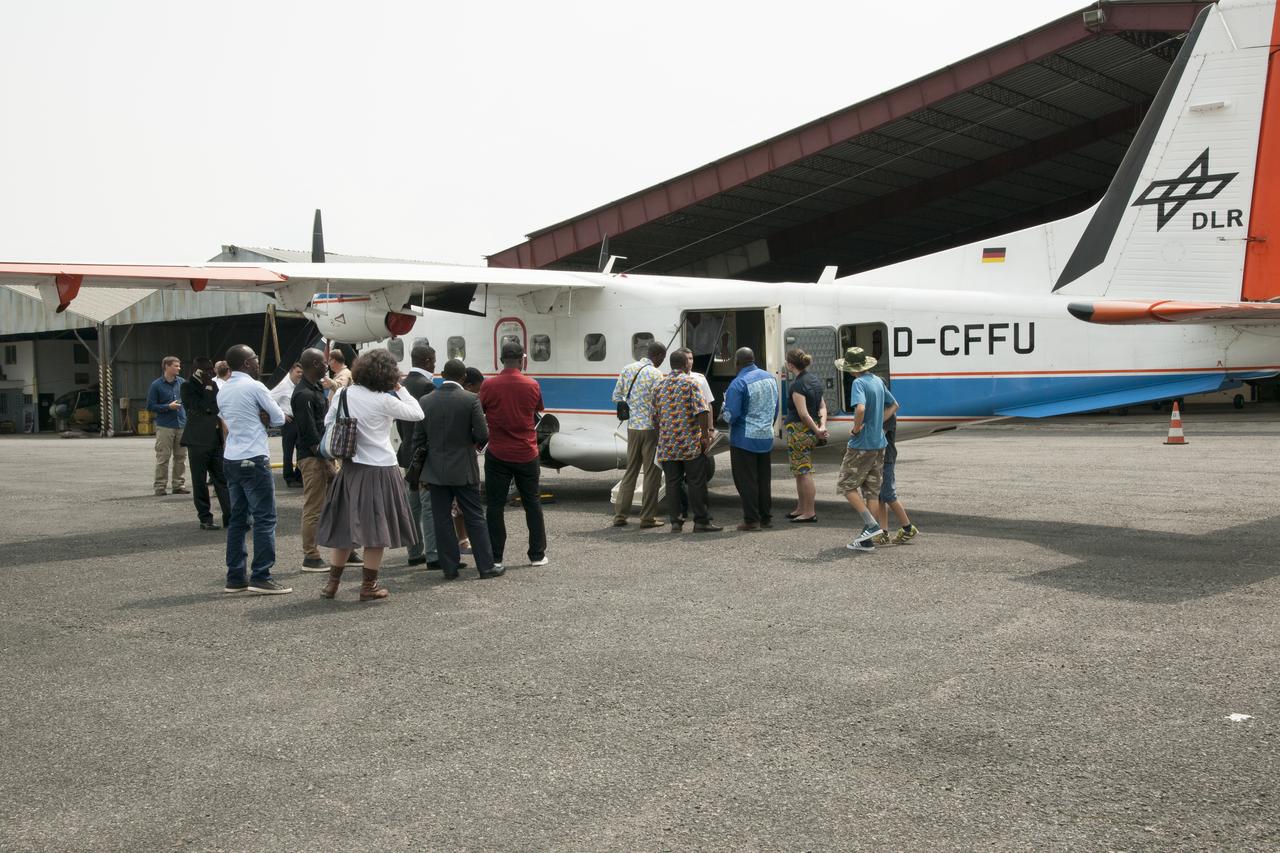
During an education outreach event in Gabon, Africa, students and educators, look at the German Aerospace Center Dornier DO-228 twin-engine turboprop aircraft.
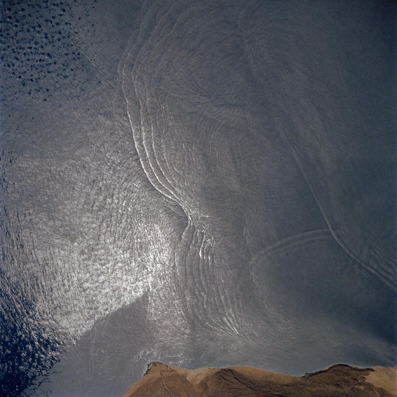
The arculate fronts of these apparently converging internal waves off the northeast coast of Somalia (11.5N, 51.5E) probably were produced by interaction with two parallel submarine canyons off the Horn of Africa. Internal waves are packets of tidally generated waves traveling within the ocean at varying depths and are not detectable by any surface disturbance.
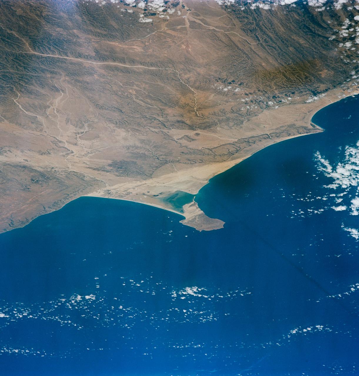
S65-63130 (16 Dec. 1965) --- Ras Hafum, coast of Somali Republic, northeast Africa, as seen from the Gemini-6 spacecraft during its 13th revolution of Earth. Photo credit: NASA or National Aeronautics and Space Administration
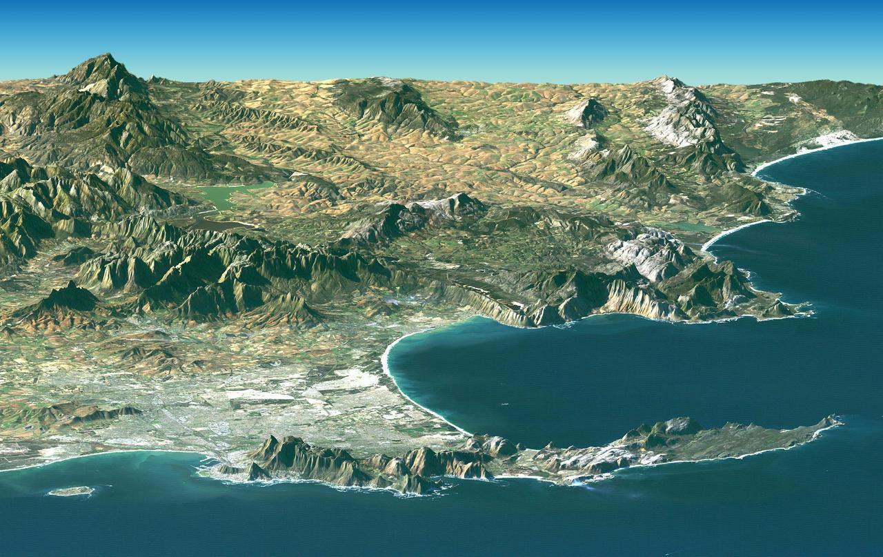
Cape Town and the Cape of Good Hope, South Africa, appear in the foreground of this perspective view generated from a Landsat satellite image and elevation data from NASA Space Shuttle Endeavour.
This image of Western Cape, South Africa was acquired by the Multi-angle Imaging SpectroRadiometer MISR instrument aboard NASA Terra spacecraft. This image is from the MISR Mystery Image Quiz #25.
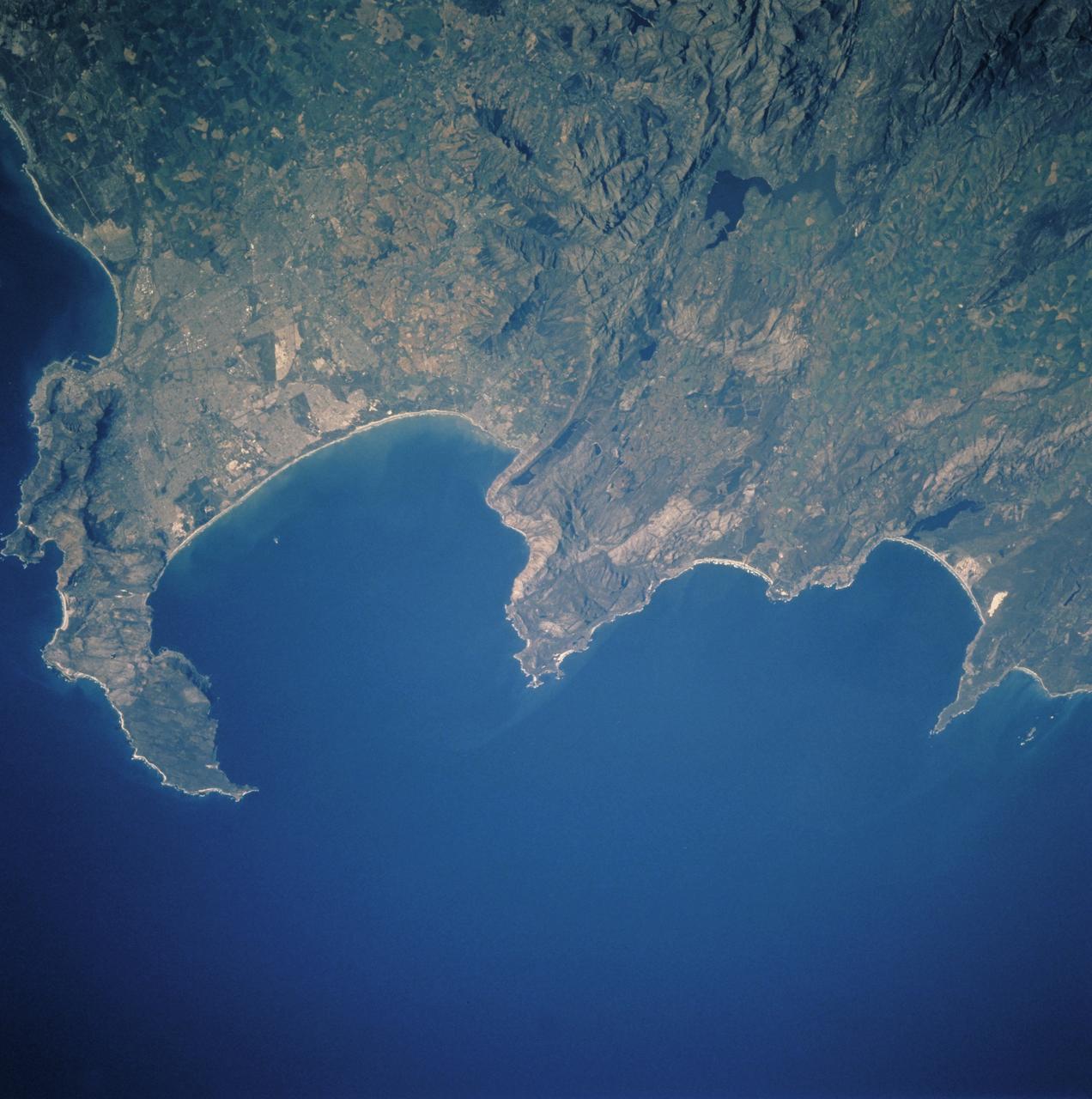
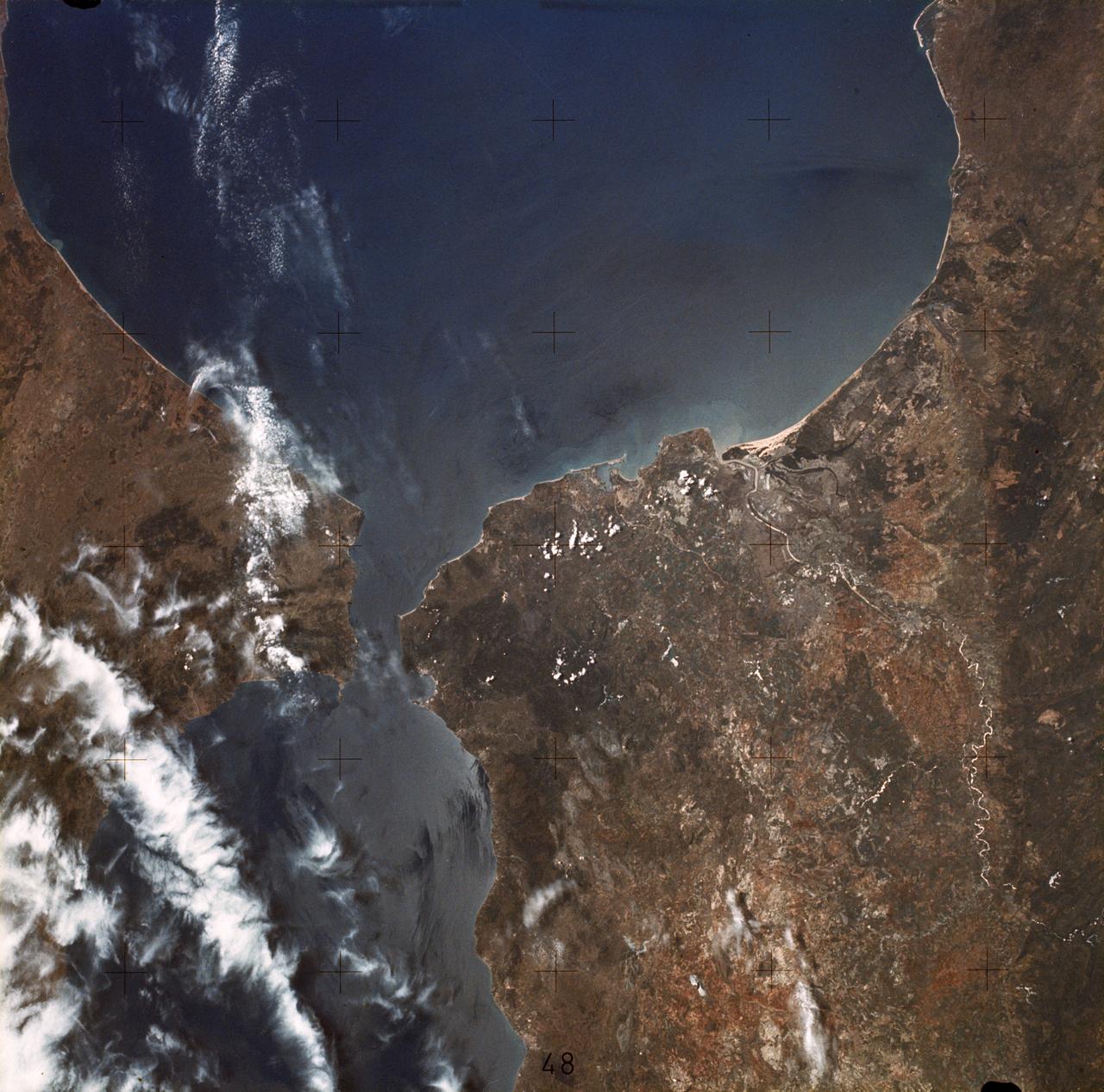
STS106-713-057 (19 September 2000) --- One of the STS-106 crew members on board the Space Shuttle Atlantis used a handheld 70mm camera to photograph this image of Cape Town and the Karroo Ranges in South Africa. Cape Town occupies the north end of the Cape of Good Hope peninsula and extends to the shore of False Bay. The city is home to about 2.7 million people. Tourism and viticulture contribute importantly to the local economy, and the city is a service center for government and industry -- particularly mining. The great folded mountain ranges of South Africa were formed during the assembly of the ancient super continent of Gondwana. Broad N-trending folds of the Cedarburg range, South Africa formed first, according to geologists, about 230 million years ago, and the W-trending Karroo ranges formed a little later.
STS072-738-036 (11-20 Jan. 1996) --- The astronauts used a 70mm handheld camera to expose this frame of the west-flowing Orange River, which constitutes the international boundary between Namibia and the Republic of South Africa. The railroad and highway connecting the two countries is seen as a ribbon crossing the corner of the view. The broad color difference between strong browns/reds in the northern half of the view and lighter yellows in the southern corresponds to two land surfaces. The darker is a higher, flat land surface developed on horizontal Nama Sandstone’s, with rock surfaces widely coated with a dark manganese stain, typical of desert regions. This region is known as Namaqualand and borders the Namib Desert. Where rivers have cut down into this surface, the lighter underlying rock and soil colors show up.
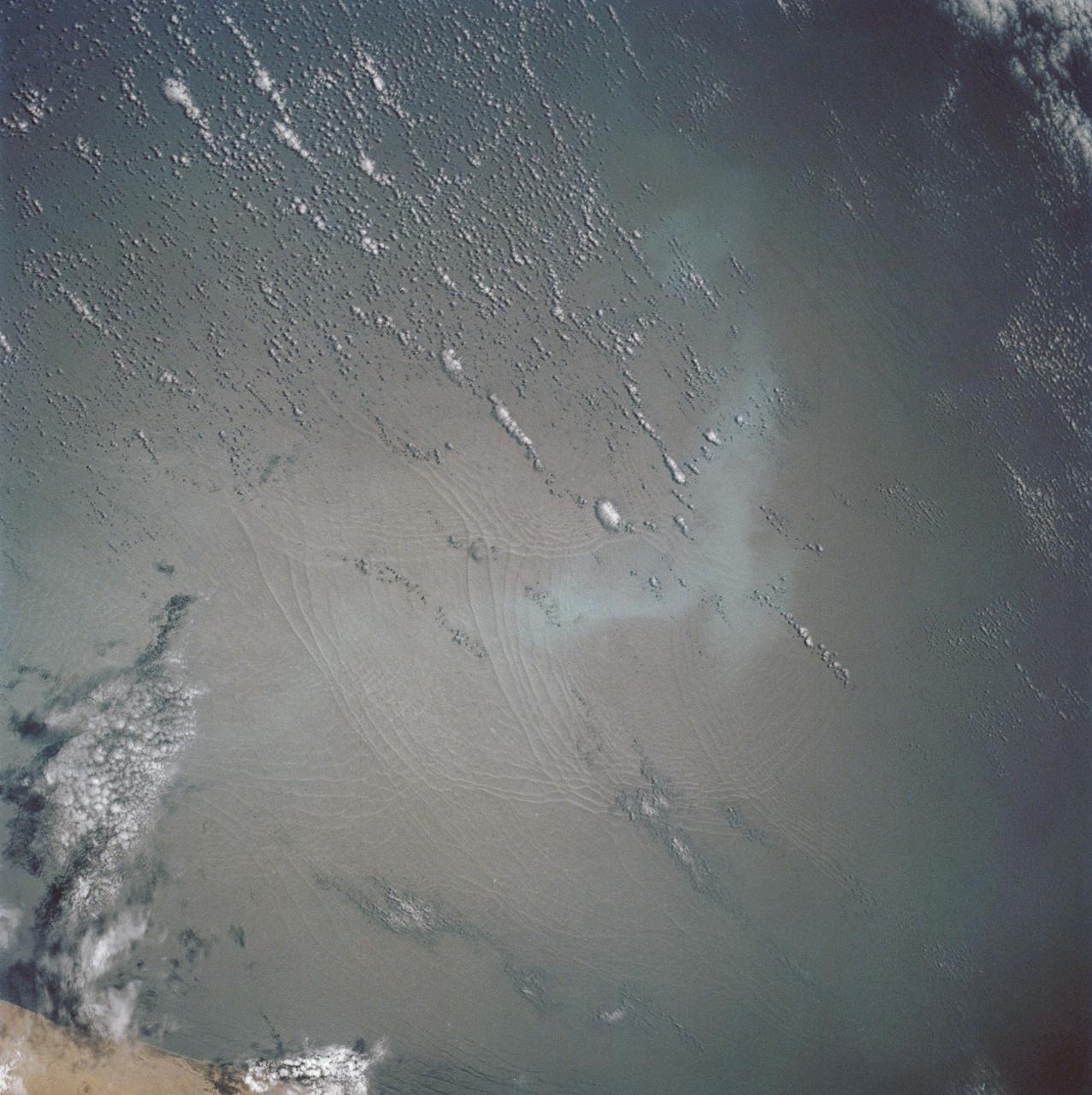
These open ocean Internal Waves were seen off the Namibia Coast, Africa (19.5S, 11.5E). The periodic and regularly spaced sets of incoming internal appear to be diffracting against the coastline and recombining to form a network of interference patterns. They seem to coincide with tidal periods about 12 hours apart and wave length (distance from crest to crest) varies between 1.5 and 5.0 miles and the crest lengths stretch beyond the image.
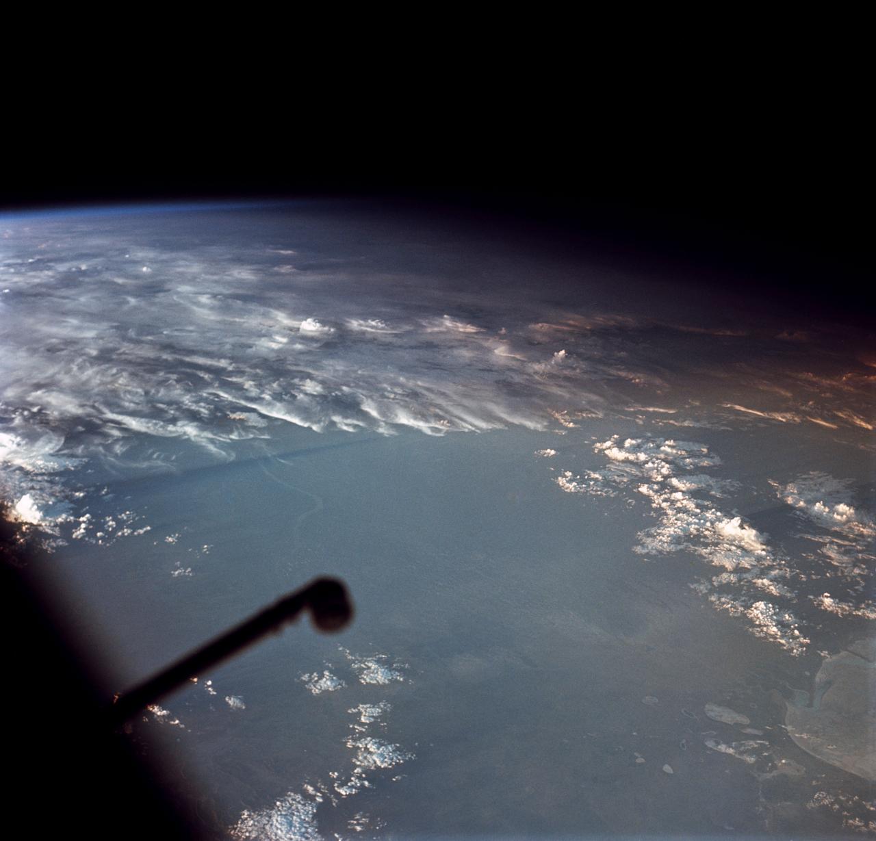
Oblique Earth Observation taken by the Apollo 9 crew. View is of southwest Africa near Cape Fria. Film magazine was E,film type was SO-368 Ektachrome with 0.460 - 0.710 micrometers film / filter transmittance response and haze filter,80mm lens. Latitude was 21.15 S by Longitude 12.40 E, Overlap was 80%, Altitude miles were 163 and cloud cover was 40%.
These open ocean Internal Waves were seen off the Namibia Coast, Africa (23.0S, 14.0E). The periodic and regularly spaced sets of internal waves most likely coincide with tidal periods about 12 hours apart. The wave length (distance from crest to crest) varies between 1.5 and 5.0 miles and the crest lengths stretch across and beyond the distance of the photo. The waves are intersecting the Namibia coastline at about a 30 degree angle.
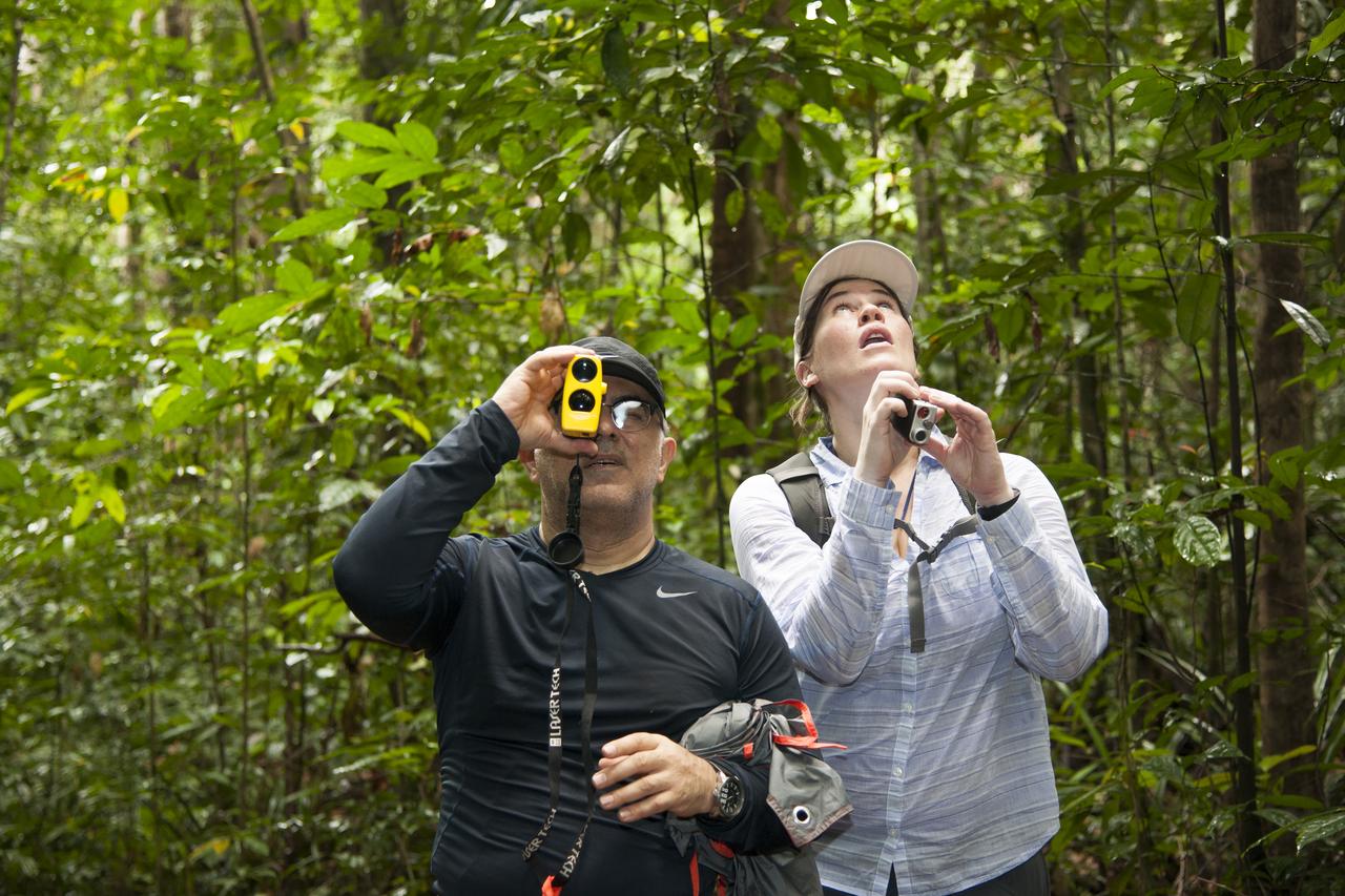
AfriSAR team members Sassan Saatchi (left) from NASA’s Jet Propulsion Laboratory and Laura Duncanson from NASA’s Goddard Space Flight Center take measurements of trees in the rainforest in the Mondah National Park, Gabon, Africa.
In Gabon, Africa, the Mondah National Park is one of the field research sites for NASA’s AfriSAR campaign. Gabon is a Central African country slightly smaller than the state of Colorado that features the world’s second largest rainforest. In addition to environmental measurements, the flights were used for calibrating satellites for current and upcoming missions.

The NASA Langley Research Center-based B-200 in Gabon, Africa, was visited by three representatives of the Gabon Ministry of the Numerical Economy (the three women seen in the middle). In the photo from left are Bryan Blair, Rick Yasky, the three Gabon representatives, Alan Barringer and Lola Fatoyinbo.

Armstrong Pilots David Fedors and Stu Broce are at the controls of the C-20A in March 2016 as it flies a synthetic aperture radar over areas of interest in the AfriSAR mission based in Gabon, Africa. The international campaign included measurements of flora in the country’s rainforests, wetlands, mangrove forests and savanna.
STS054-151-015 (13-19 Jan 1993) --- The Makgadikgadi Salt Pan is one of the largest features in Botswana visible from space. Any water that spills out of the Okavango Swamplands flows down to the Makgadikgadi where it evaporates. An ancient beach line can be seen as a smooth line around the west (left) side of the Pan. Orapa diamond mine can be detected due south of the pan as a small rectangle. The large geological feature known as the Great Dike of Zimbabwe can be seen far right. This large panorama shows clouds in southern Angola, Zambia and Zimbabwe in the distance.
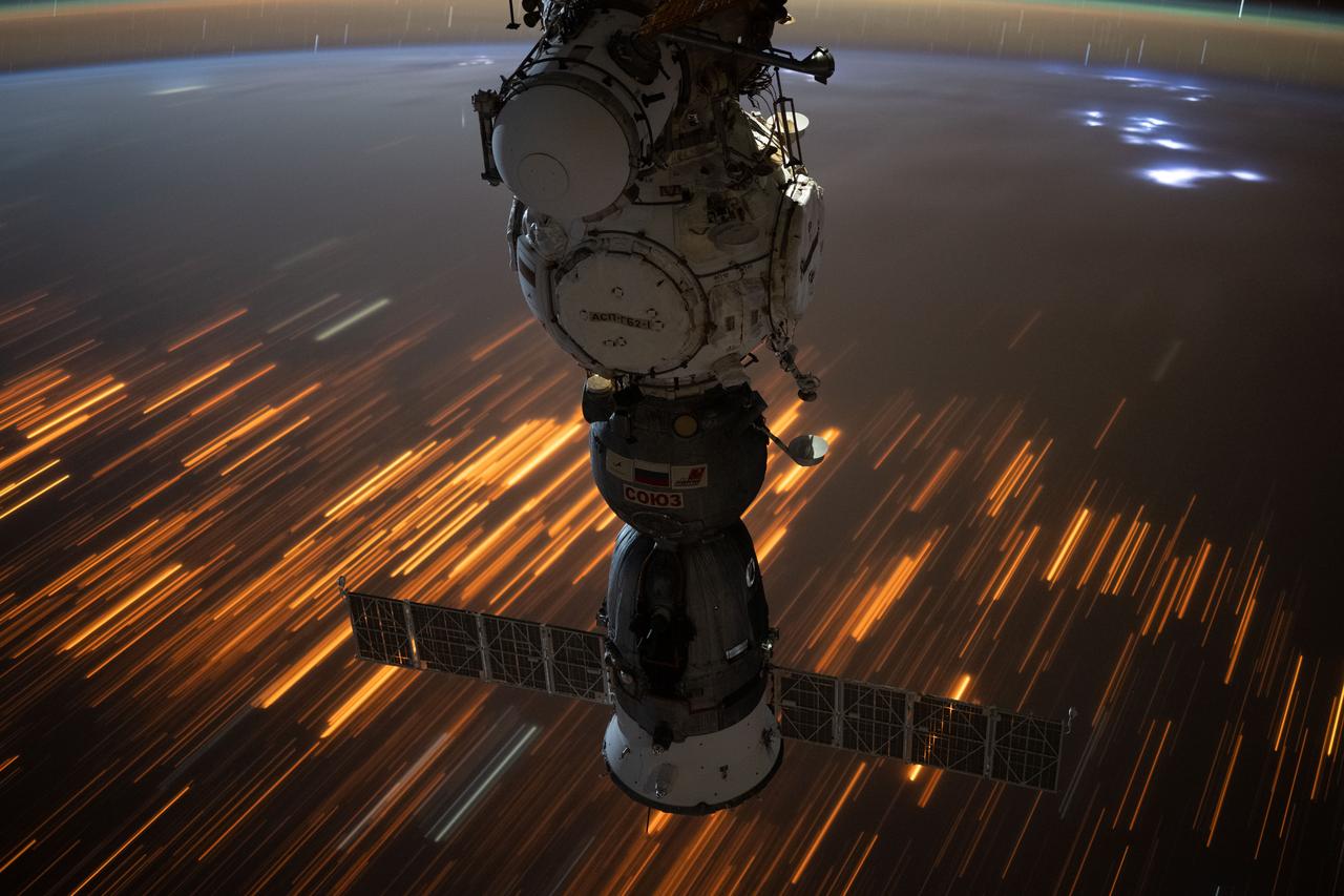
iss073e0422445 (July 29, 2025) --- The city lights of Sub-Saharan Africa streak below the International Space Station as it orbited 260 miles above the Tanzania-Zambia border in this long-duration photograph. At top right, lightning storms illuminate the cloud tops with the Soyuz MS-27 spacecraft docked to the Prichal module in the foreground.
In this panoramic view of the Okavango Swamp, Botswana, (19.0S, 22.0E), the Okavango River, seen in sunglint, flows into a topographic trough to form an inland delta. Water, trapped in the meandering delta distributaries is evaporated or transpired by vegetation. In Angola to the north, the many fires of the seasonal burning of savannah vegetation for land clearing, in preparation for agriculture, has filled the atmosphere with haze and smoke.
STS054-152-001 (13-19 Jan 1993) --- View southeastward across the northern, arid coastal plain of Somalia from Dhul Hafun (Hafun Peninsula) on the extreme left to Ras (Cape) Illig on the extreme right. There are no good harbors, no permanent streams, and few people in this 200-mile-wide expanse of dry coastal Plain. The cloud line offshore marks the limit of offshore breeze, and provides a partial explanation of the lack of rain in this region.
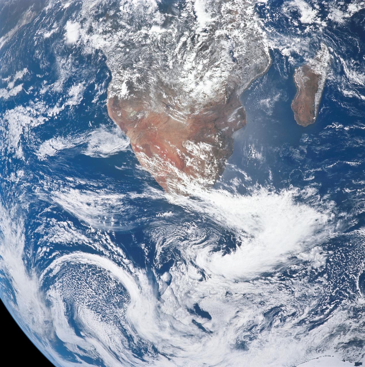
AS17-148-22717 (7 Dec. 1972) --- This view of a portion of Earth was taken from the Apollo 17 spacecraft following trans-lunar insertion during the final lunar landing mission in NASA's Apollo Program. The visible land mass is the southern two-thirds of the African continent, with Madagascar at right. A portion of Antarctica is visible at bottom frame. Onboard the Apollo 17 spacecraft were astronauts Eugene A. Cernan, commander; Ronald E. Evans, command module pilot; and Harrison H. Schmitt, lunar module pilot. While astronauts Cernan and Schmitt descended in the Lunar Module (LM) "Challenger" to explore the Hadley-Apennine region of the moon, astronaut Evans remained with the Command and Service Modules (CSM) "America" in lunar orbit.
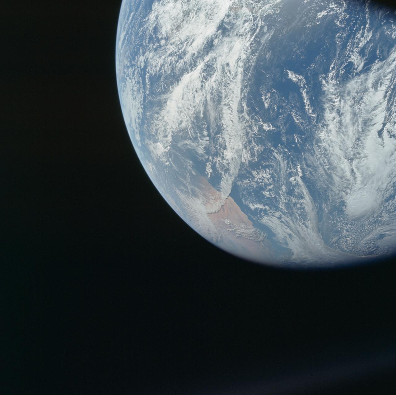
AS08-16-2588 (21-27 Dec. 1968) --- Both sides of the Atlantic Ocean are visible in this view from Apollo 8 spacecraft. (Hold picture with Earth at bottom left). The large, most prominent land mass is the bulge of West Africa. The portion of Africa near the equator is dark and cloudy, but the more northerly portions are clear, showing the prominent cape at Dakar and the Senegal River in Senegal; Cap Blanc; the Adrar Plateau in Mauretania; the wide expanse of desert in Algeria and Spanish Sahara; and the far edge, the Atlas and Anti-Atlas Mountains in Morocco. Clouds cover the eastern coast of South America, southward from Surinam and Guyana to near the city of Salvador, Brazil. The view was photographed following trans-lunar insertion.

Provincial Minister for Finance and Economic Opportunities of the Western Cape Government, Mireille Wenger, provides remarks during a meeting with the Premier of the Western Cape Government, Alan Winde, right, NASA representatives, and a delegation from South Africa, to discuss the path forward for development of an antenna for the Lunar Exploration Ground Sites (LEGS) mission in Matjiesfontein, South Africa, and other opportunities, Tuesday, June 13, 2023, at the Mary W. Jackson NASA Headquarters building in Washington. Photo Credit: (NASA/Aubrey Gemignani)

Premier of the Western Cape Government, Alan Winde, provides remarks during a meeting with NASA Deputy Associate Administrator for Space Communications and Navigation, Badri Younes, right, other NASA representatives, and a delegation from South Africa, to discuss the path forward for development of an antenna for the Lunar Exploration Ground Sites (LEGS) mission in Matjiesfontein, South Africa, and other opportunities, Tuesday, June 13, 2023, at the Mary W. Jackson NASA Headquarters building in Washington. Photo Credit: (NASA/Aubrey Gemignani)

NASA SCaN Development Manager, Bill Marinelli provides remarks during a meeting with NASA Deputy Associate Administrator for Space Communications and Navigation, Badri Younes, the Premier of the Western Cape Government, Alan Winde, and a delegation from South Africa, to discuss the path forward for development of an antenna for the Lunar Exploration Ground Sites (LEGS) mission in Matjiesfontein, South Africa, and other opportunities, Tuesday, June 13, 2023, at the Mary W. Jackson NASA Headquarters building in Washington. Photo Credit: (NASA/Aubrey Gemignani)

NASA Deputy Associate Administrator for Space Communications and Navigation, Badri Younes, right, speaks with the Premier of the Western Cape Government, Alan Winde, during a meeting with NASA representatives and a delegation from South Africa, to discuss the path forward for development of an antenna for the Lunar Exploration Ground Sites (LEGS) mission in Matjiesfontein, South Africa, and other opportunities, Tuesday, June 13, 2023, at the Mary W. Jackson NASA Headquarters building in Washington. Photo Credit: (NASA/Aubrey Gemignani)

NASA Deputy Associate Administrator for Space Communications and Navigation, Badri Younes, provides remarks during a meeting with the Premier of the Western Cape Government, Alan Winde, NASA representatives, and a delegation from South Africa, to discuss the path forward for development of an antenna for the Lunar Exploration Ground Sites (LEGS) mission in Matjiesfontein, South Africa, and other opportunities, Tuesday, June 13, 2023, at the Mary W. Jackson NASA Headquarters building in Washington. Photo Credit: (NASA/Aubrey Gemignani)

Members of the AfriSAR team standing by the C-20A in Gabon, Africa, which is usually based at NASA Armstrong Flight Research Center in California include, from left, John McGrath, Carlos Meza, Stu Broce, Samuel Choi, David Fedors, Naiara Pinto, Mark Scherer, Marc Simard, Vincent Moreno, Chuck Irving and Kean Tham.
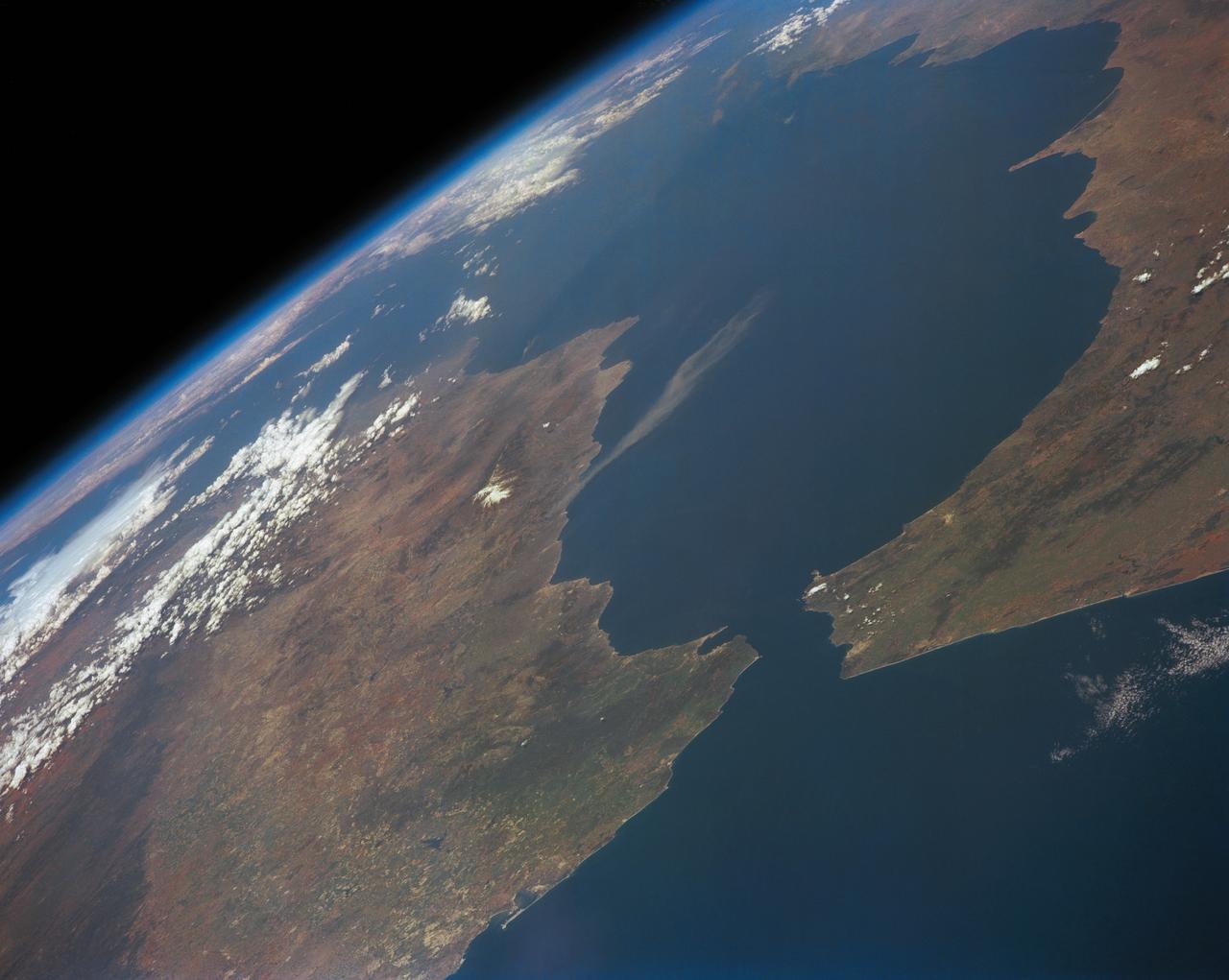
SL2-05-370 (22 June 1973) --- Gateway to the Atlantic, since ancient times the Strait of Gibraltar (36.5N, 4.5W) is also the border between Africa and Europe. In Spain to the north, the dark area near the coast is the delta of the Guadalquivir River and the city of Seville. The small spike of land on the north side of the strait is the actual Rock of Gibraltar. On the African side, a cloud front cutting across from the coast is blowing into Europe from Morocco and Algeria. Photo credit: NASA
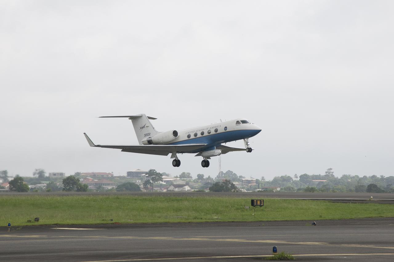
NASA’s C-20A takes off from Libreville International Airport in Gabon, Africa, in support of the AfriSAR  campaign in March 2016. Gabon is a Central African country slightly smaller than the state of Colorado that features the world’s second largest rainforest. In addition to environmental measurements, the flights were used for calibrating satellites for current and upcoming missions.
This spaceborne radar image shows how the Atlas Mountains in northwestern Africa dominate the geography of Morocco.
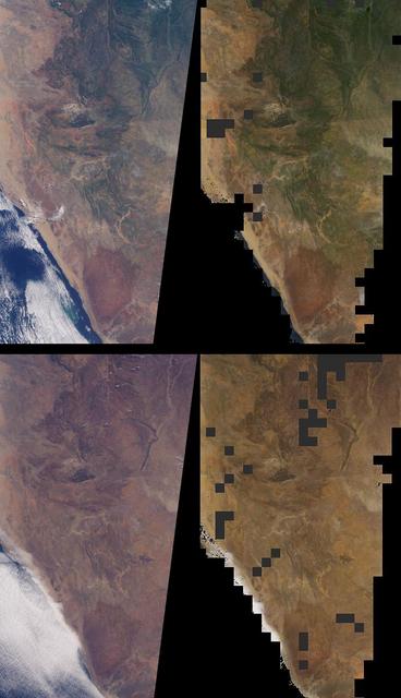
Brightness variations in the terrain along a portion of southwestern Africa are displayed in these views from NASA Terra spacecraft.
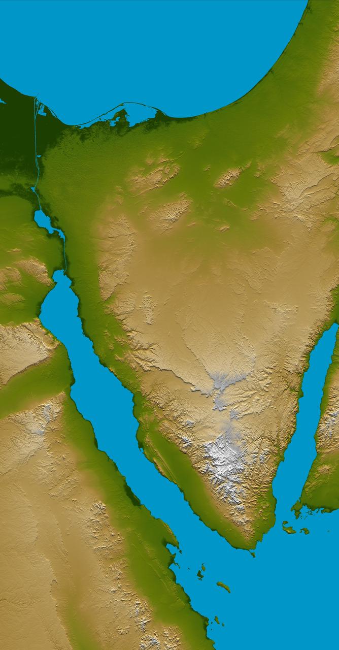
The Sinai Peninsula, located between Africa and Asia, is a result of those two continents pulling apart from each other.
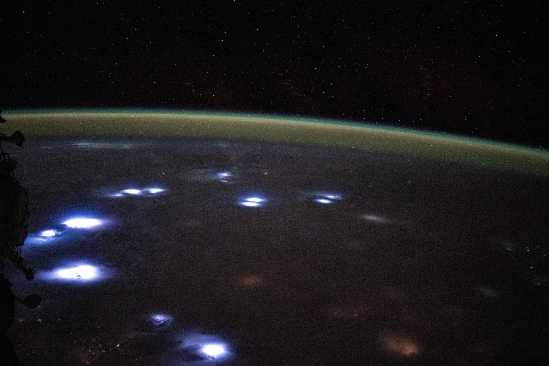
iss073e0816985 (Sept. 27, 2025) --- Bright lightning storms illuminate the cloudy landscape of western Africa in this image captured from the International Space Station. A soft yellow-green atmospheric glow, created by atoms and molecules releasing energy absorbed from solar radiation earlier in the day, blankets Earth’s horizon. The orbital outpost was soaring 260 miles above the Atlantic coast of Ghana at approximately 11:04 p.m. local time when this photograph was taken.

AS04-01-200 (9 Nov. 1967) --- Coastal Brazil, Atlantic Ocean, West Africa, Sahara, looking northwest, as photographed from the unmanned Apollo 4 (Spacecraft 017/Saturn 501) earth-orbital space mission. This picture was taken when the Spacecraft 017 and the Saturn IVB stage were orbiting Earth at an altitude of 9,060 nautical miles.
S65-18750 (23 March 1965) --- Astronaut John W. Young took this picture over eastern Africa during the Gemini-Titan 3 three-orbit mission on March 23, 1965. The altitude of the Gemini spacecraft "Molly Brown" was 90 miles. Young used a hand-held modified 70mm Hasselblad camera with color film. The lens setting was 250th of a second at f/11.

Head of Department, Western Cape Government Economic Development and Tourism, Velile Dube, provides remarks during a meeting with NASA Deputy Associate Administrator for Space Communications and Navigation, Badri Younes, Premier of the Western Cape Government, Alan Winde, other NASA representatives, and a delegation from South Africa, to discuss the path forward for development of an antenna for the Lunar Exploration Ground Sites (LEGS) mission in Matjiesfontein, South Africa, and other opportunities, Tuesday, June 13, 2023, at the Mary W. Jackson NASA Headquarters building in Washington. Photo Credit: (NASA/Aubrey Gemignani)

NASA International Program Specialist, Office of International and Interagency Relations, Greg Mann, provide remarks during a meeting with NASA Associate Administrator for the Space Operations Mission Directorate, Ken Bowersox, NASA Deputy Associate Administrator for Space Communications and Navigation, Badri Younes, he Premier of the Western Cape Government, Alan Winde, and a delegation from South Africa, to discuss the path forward for development of an antenna for the Lunar Exploration Ground Sites (LEGS) mission in Matjiesfontein, South Africa, and other opportunities, Tuesday, June 13, 2023, at the Mary W. Jackson NASA Headquarters building in Washington. Photo Credit: (NASA/Aubrey Gemignani)

From left to right, the Premier of the Western Cape Government, Alan Winde, NASA Deputy Associate Administrator for Space Communications and Navigation, Badri Younes, and Director-General of the Western Cape Government, Dr. Harry Malila, are seen during a meeting with NASA representatives and a delegation from South Africa, to discuss the path forward for development of an antenna for the Lunar Exploration Ground Sites (LEGS) mission in Matjiesfontein, South Africa, and other opportunities, Tuesday, June 13, 2023, at the Mary W. Jackson NASA Headquarters building in Washington. Photo Credit: (NASA/Aubrey Gemignani)

NASA SCaN Development Manager, Bill Marinelli provides remarks during a meeting with the Associate Administrator for the Space Operations Mission Directorate, Ken Bowersox, NASA Deputy Associate Administrator for Space Communications and Navigation, Badri Younes, the Premier of the Western Cape Government, Alan Winde, and a delegation from South Africa, to discuss the path forward for development of an antenna for the Lunar Exploration Ground Sites (LEGS) mission in Matjiesfontein, South Africa, and other opportunities, Tuesday, June 13, 2023, at the Mary W. Jackson NASA Headquarters building in Washington. Photo Credit: (NASA/Aubrey Gemignani)
STS039-151-193 (28 April-6 May 1991) --- The Strait of Gibraltar, the only outlet for the Mediterranean Sea, was photographed with a large format handheld camera by the STS-39 crew members. Scientists site evidence in Shuttle photography that the Mediterranean Sea dried up a number of times between 5 million and 20 million years ago. Sea levels, they say, dropped slightly, cutting off the Mediterranean (top right) from the Atlantic Ocean (bottom). In southern Spain, the dark area near the coast is the delta of the Guadalquivir River with the city of Seville. The Sierra Nevada range still has some snow. A small field fire near the Spanish coast has generated a conspicuous smoke plume. The small spike of land on the north side of the Strait is the Rock of Gibraltar, an outpost of the British empire. The larger spike of land on the north coast of Africa marks the border between Morocco (center foreground) and Algeria (right). The sharp line cutting across them Mediterranean (top right) marks the edge of a dust cloud blowing from Africa into Europe. Photo credit: NASA
STS062-151-182Z (4-18 March 1994) --- This east-looking view shows most of the east-west extent of the country of Sudan. The foreground shows a vegetation-less and almost uninhabited region of northwest Sudan. The rich earth colors are ancient soils (browner and redder tones), a concentrated mass of what may be volcanic cinder cones (dark brown dots - center) and dune and younger river sediments (yellows). The photo would have been difficult to locate had it not been for two recognizable features in the background: a visually well-known inselberg ("island mountain" -- top center) on a large west-bank tributary of the White Nile; and the confluence of the Blue and White Nile's, with the great cotton developments of the Gezira Scheme between them (top left). The Red Sea coast is almost obscured by a dust cloud but can be discerned running across the top of the picture. The clouds at top may be developing over the coastal ranges of Saudi Arabia beyond the Red Sea.
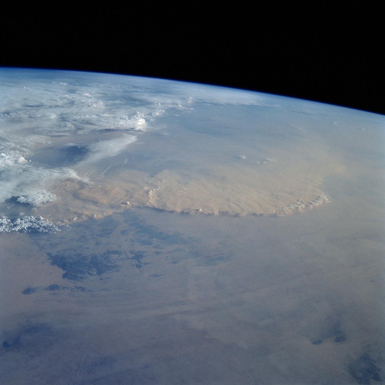
STS049-92-071 (13 May 1992) --- The STS-49 crew aboard the Earth-orbiting Space Shuttle Endeavour captured this Saharan dust storm on the Algeria-Niger border. The south-looking, late-afternoon view shows one of the best examples in the Shuttle photo data base of a dust storm. A series of gust fronts, caused by dissipating thunderstorms have picked up dust along the outflow boundaries. Small cumulus clouds have formed over the most vigorously ascending parts of the dust front, enhancing the visual effect of the front. The storm is moving roughly north-northwest, at right angles to the most typical path for dust storms in this part of the Sahara (shown by lines of sand on the desert surface in the foreground). Storms such as this can move out into the Atlantic, bringing dust even as far as the Americas on some occasions. A crewmember used a 70mm handheld Hasselblad camera with a 100mm lens to record the frame.
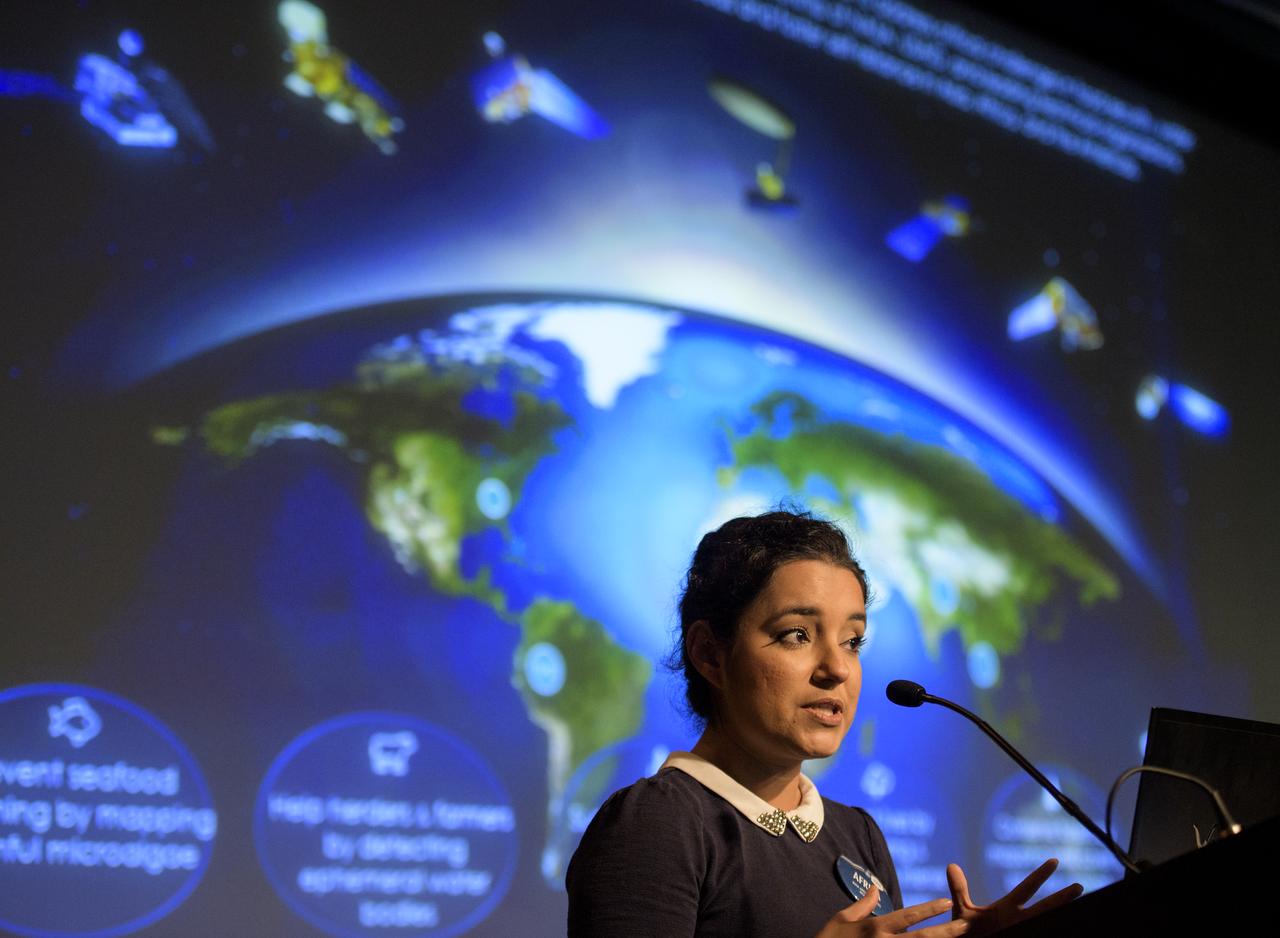
Africa Flores, Land Cover and Land Use Change Theme Lead for SERVIR, speaks during the 2018 Annual Earth Science Applications Showcase, Wednesday, Aug. 1, 2018 at NASA Headquarters in Washington. Every summer students and young professionals from NASA’s Applied Sciences’ DEVELOP National Program come to NASA Headquarters and present their research projects. DEVELOP is a training and development program where students work on Earth science research projects, mentored by science advisers from NASA and partner agencies, and extend research results to local communities. Photo Credit: (NASA/Joel Kowsky)
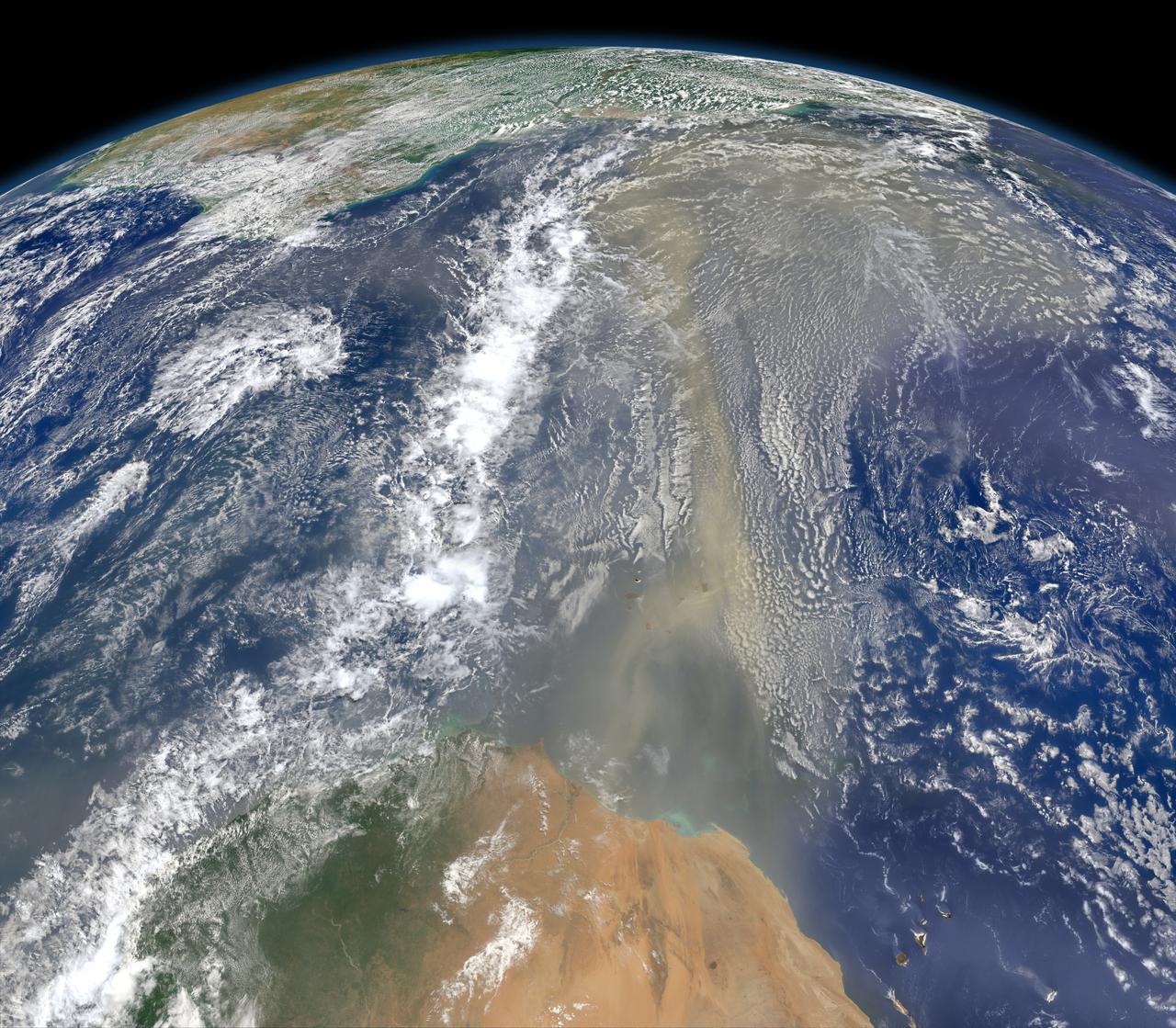
A piece of Africa—actually lots of them—began to arrive in the Americas in June 2014. On June 23, a lengthy river of dust from western Africa began to push across the Atlantic Ocean on easterly winds. A week later, the influx of dust was affecting air quality as far away as the southeastern United States. This composite image, made with data from the Visible Infrared Imaging Radiometer Suite (VIIRS) on Suomi NPP, shows dust heading west toward South America and the Gulf of Mexico on June 25, 2014. The dust flowed roughly parallel to a line of clouds in the intertropical convergence zone, an area near the equator where the trade winds come together and rain and clouds are common. In imagery captured by the Moderate Resolution Imaging Spectroradiometer (MODIS), the dust appeared to be streaming from Mauritania, Senegal, and Western Sahara, though some of it may have originated in countries farther to the east. Saharan dust has a range of impacts on ecosystems downwind. Each year, dust events like the one pictured here deliver about 40 million tons of dust from the Sahara to the Amazon River Basin. The minerals in the dust replenish nutrients in rainforest soils, which are continually depleted by drenching, tropical rains. Research focused on peat soils in the Everglades show that African dust has been arriving regularly in South Florida for thousands of years as well. In some instances, the impacts are harmful. Infusion of Saharan dust, for instance, can have a negative impact on air quality in the Americas. And scientists have linked African dust to outbreaks of certain types of toxic algal blooms in the Gulf of Mexico and southern Florida. Read more: <a href="http://1.usa.gov/1snkzmS" rel="nofollow">1.usa.gov/1snkzmS</a> NASA images by Norman Kuring, NASA’s Ocean Color web. Caption by Adam Voiland. Credit: <b><a href="http://www.earthobservatory.nasa.gov/" rel="nofollow"> NASA Earth Observatory</a></b> <b><a href="http://www.nasa.gov/audience/formedia/features/MP_Photo_Guidelines.html" rel="nofollow">NASA image use policy.</a></b> <b><a href="http://www.nasa.gov/centers/goddard/home/index.html" rel="nofollow">NASA Goddard Space Flight Center</a></b> enables NASA’s mission through four scientific endeavors: Earth Science, Heliophysics, Solar System Exploration, and Astrophysics. Goddard plays a leading role in NASA’s accomplishments by contributing compelling scientific knowledge to advance the Agency’s mission. <b>Follow us on <a href="http://twitter.com/NASAGoddardPix" rel="nofollow">Twitter</a></b> <b>Like us on <a href="http://www.facebook.com/pages/Greenbelt-MD/NASA-Goddard/395013845897?ref=tsd" rel="nofollow">Facebook</a></b> <b>Find us on <a href="http://instagram.com/nasagoddard?vm=grid" rel="nofollow">Instagram</a></b>
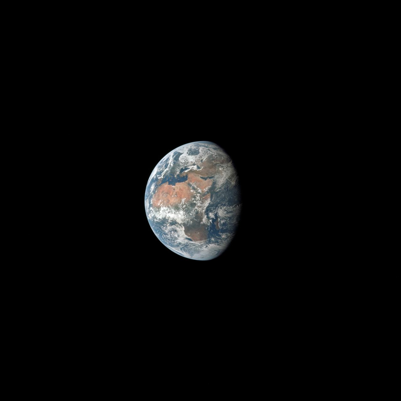
AS11-36-5355 (17 July 1969) --- Most of Africa and portions of Europe and Asia can be seen in this spectacular photograph taken from the Apollo 11 spacecraft during its trans-lunar coast toward the moon. Apollo 11, with astronauts Neil A. Armstrong, commander; Michael Collins, command module pilot; and Edwin E. Aldrin Jr., lunar module pilot, onboard was already 98,000 nautical miles from Earth when this picture was made. While astronauts Armstrong and Aldrin descended in the Lunar Module (LM) "Eagle" to explore the Sea of Tranquility region of the moon, astronaut Collins remained with the Command and Service Modules (CSM) "Columbia" in lunar orbit.
This image, captured by NASA Terra satellite on July 20, 2005, shows the dust cloud just off the west coast of Africa near Mauritania and Senegal.
Three striking and important areas of Tanzania in eastern Africa are shown in this color-coded shaded relief image from NASA Shuttle Radar Topography Mission.
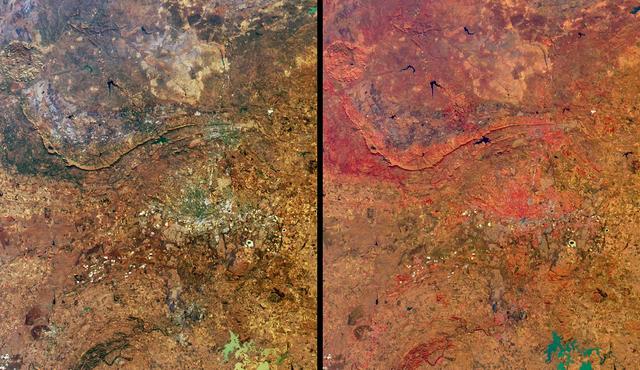
These images from NASA Terra satellite images are of northeastern South Africa, near Kruger National Park, were acquired on September 7, 2000.
These images from NASA Terra satellite images of Zambia and Botswana, Africa were acquired on August 25, 2000 during Terra orbit 3655.
This spaceborne radar image shows part of the vast Namib Sand Sea on the west coast of southern Africa, just northeast of the city of Luderitz, Namibia.
The area known as the Afar Triangle is located at the northern end of the East Africa Rift, where it approaches the southeastern end of the Red Sea and the southwestern end of the Gulf of Aden.
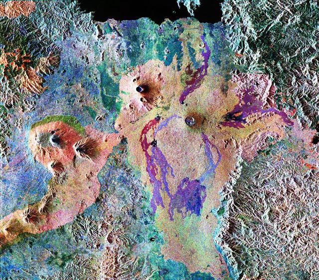
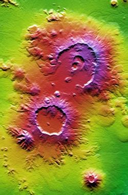
This is a false-color composite of Central Africa, showing the Virunga volcano chain along the borders of Rwanda, Zaire and Uganda. This area is home to the endangered mountain gorillas.
NASA Terra spacecraft flew over South Africa and Zimbabwe where week-long torrential rains swelled the Limpopo River in Jan. 2013.
STS072-727-059 (11-20 Jan. 1996) --- Plains of the Orange Free State, South Africa are featured in this 70mm frame exposed from the Space Shuttle Endeavour. If the photograph is oriented with the largest clouds at the top edge, so that the cloud shadows fall to the upper right of each cloud, then north is to the top. The Vaal River flows along the top and through the upper left of the photograph; the reservoir of the Bloemhofdam on the Sand River can be seen between clouds at the upper right of the photograph. Kimberley can be seen as a gray smudge southeast of a contorted set of bends in the Vaal river (upper left center). With high magnification four dark dots, large open-pit mine shafts, can be seen within the gray smudge of the city. Kimberley, the capital of Northern Cape Province, was founded in 1878 after the discovery of diamonds in 1969 - 71, and reached by railway in 1885. Diamond mining and gem cutting remain prominent in the economy. The reddish soil and scattered salt pans (playa lakes) across the plateau suggest the semi-arid climate, suitable for cattle ranching. Reservoirs on most streams now provide water for the towns as well as irrigation for agriculture.
AS17-148-22718 (7-19 Dec. 1972) --- This excellent view of Saudi Arabia and the north eastern portion of the African continent was photographed by the Apollo 17 astronauts with a hand-held camera on their trans-lunar coast toward man's last lunar visit. Egypt, Sudan, Ethiopia are some of the African nations are visible. Iran, Iraq, Jordan are not so clearly visible because of cloud cover and their particular location in the picture. India is dimly visible at right of frame. The Red Sea is seen entirely in this one single frame, a rare occurrence in Apollo photography or any photography taken from manned spacecraft. The Gulf of Suez, the Dead Sea, Gulf of Aden, Persian Gulf and Gulf of Oman are also visible. This frame is one of 169 frames on film magazine NN carried aboard Apollo 17, all of which are SO368 (color) film. A 250mm lens on a 70mm Hasselblad camera recorded the image, one of 92 taken during the trans-lunar coast. Note AS17-148-22727 (also magazine NN) for an excellent full Earth picture showing the entire African continent.

NASA Associate Administrator for the Space Operations Mission Directorate, Ken Bowersox, and NASA Deputy Associate Administrator for Space Communications and Navigation, Badri Younes, meet with the Premier of the Western Cape Government, Alan Winde, and a delegation from South Africa, to discuss the path forward for development of an antenna for the Lunar Exploration Ground Sites (LEGS) mission in Matjiesfontein, South Africa, and other opportunities, Tuesday, June 13, 2023, at the Mary W. Jackson NASA Headquarters building in Washington. Photo Credit: (NASA/Aubrey Gemignani)
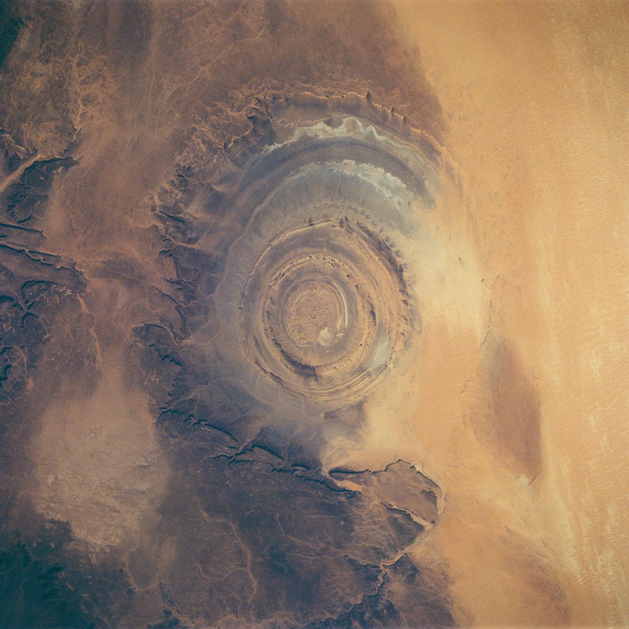
STS058-88-017 (18 Oct-1 Nov 1993) --- The eye-catching "bullseye" of the Richat Structure adds interest to the barren Gres de Chinguetti Plateau in central Mauretania, northwest Africa. It represents domally uplifted, layered (sedimentary) rocks that have been eroded by water and wind into the present shape. Desert sands have invaded the feature from the south. The origin of the structure is unknown. It is not an impact structure, because field work showed that strata are undisturbed and flat-lying in the middle of the feature, and no shock-altered rock could be found. There is no evidence for a salt dome or shale diapir, nor is there any geophysical evidence for an underlying dome of dense igneous rock having about the same density as the sedimentary layers.
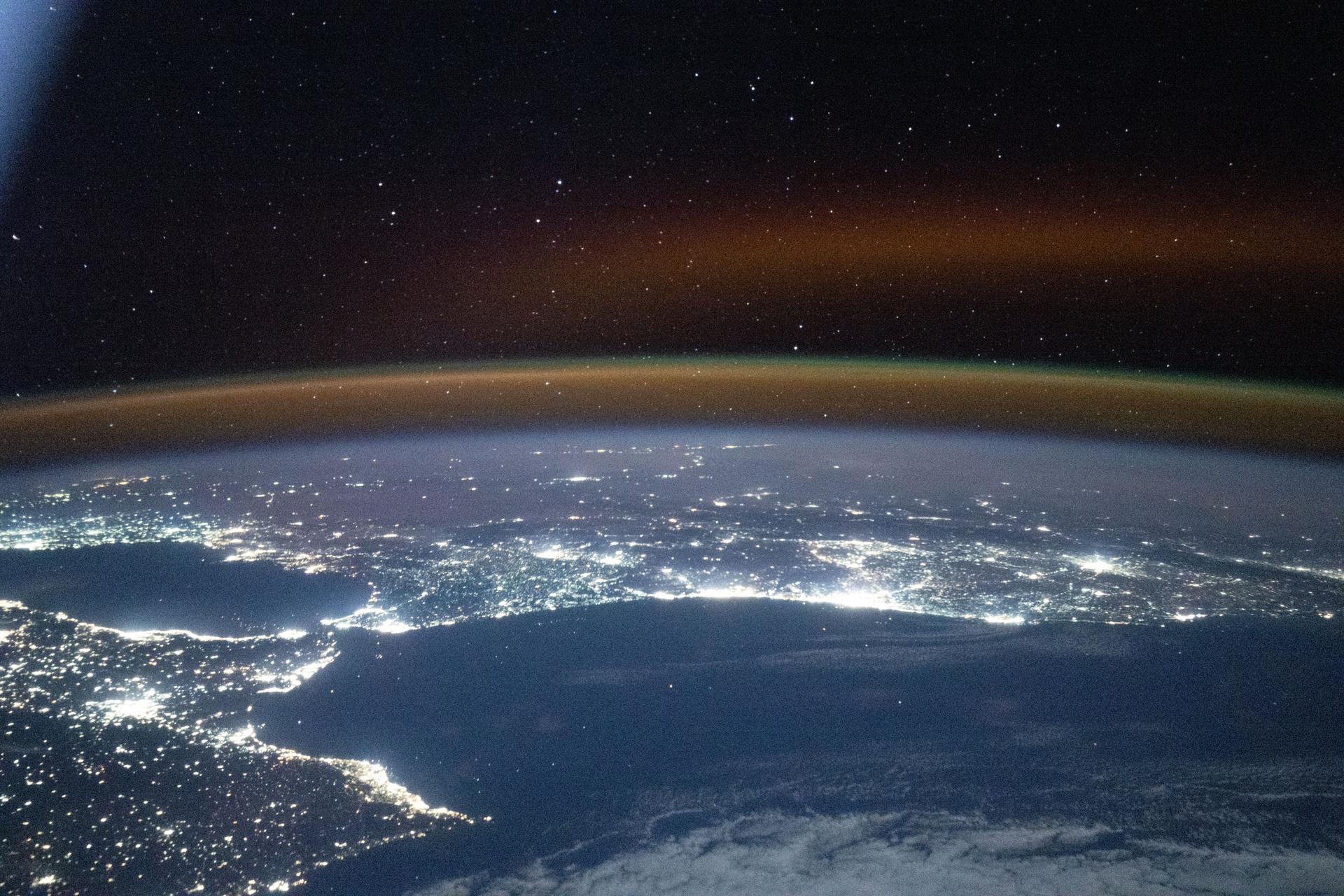
iss073e1198911 (Nov. 28, 2025) --- A red-yellow airglow blankets Earth's horizon as the city lights of southwestern Europe and North Africa sparkle in contrast to the Atlantic Ocean and the Mediterranean Sea that separates the two continents. The International Space Station was orbiting 262 miles above the Atlantic at approximately 7:47 p.m. local time when this photograph was taken.
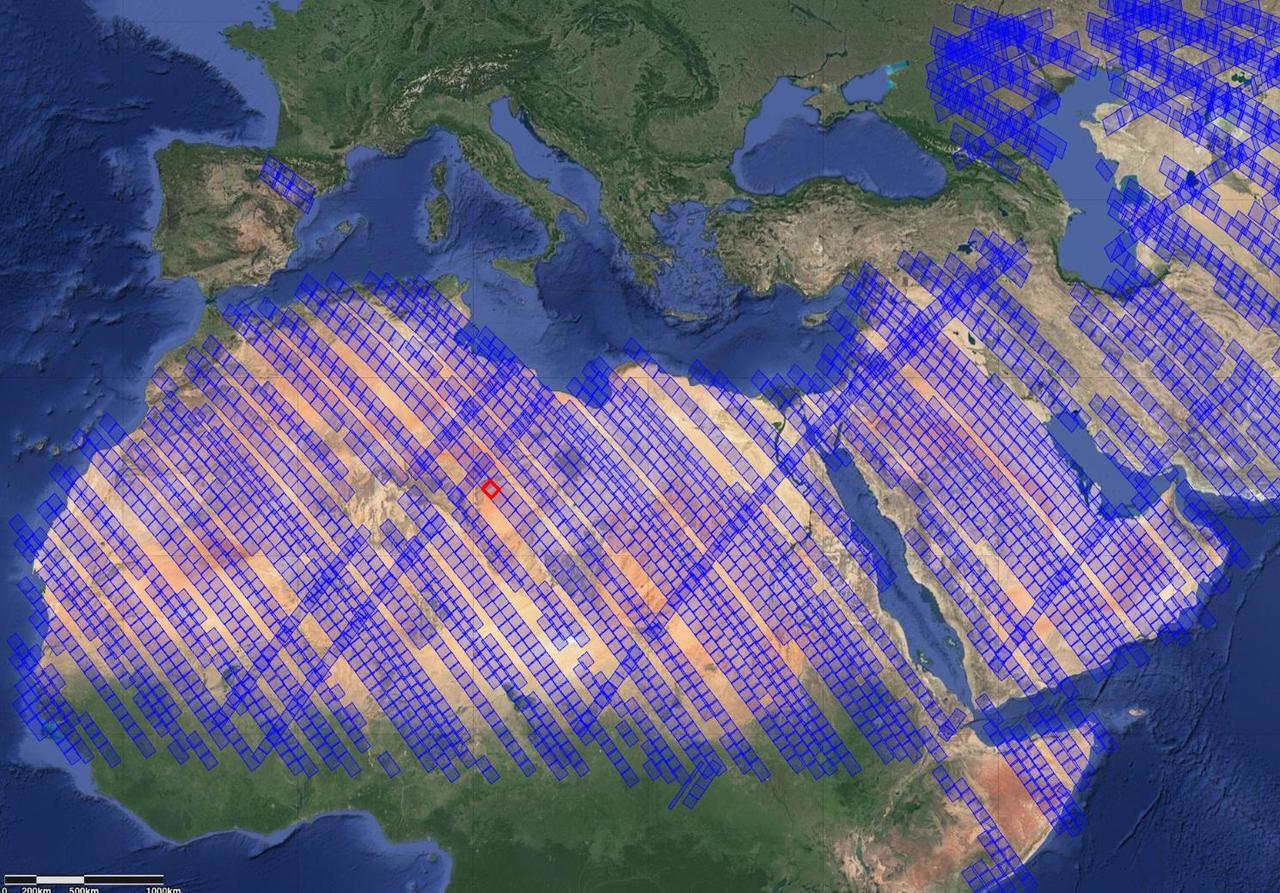
This image shows locations in parts of North Africa, Europe, the Middle East, and Central Asia observed by NASA's Earth Surface Mineral Dust Source Investigation (EMIT). Each blue box is a "scene" the instrument, which is aboard the International Space Station, has captured. The red box indicates where the instrument recently gathered data on three minerals in a location in southwest Libya, in the Sahara Desert. Installed on the space station in July 2022, EMIT orbits Earth about once every 90 minutes to map the world's mineral-dust sources, gathering information about surface composition as the instrument completes about 16 orbits per day. Over the course of its 12-month mission, EMIT will collect measurements of 10 important surface minerals – kaolinite, hematite, goethite, illite, vermiculite, calcite, dolomite, montmorillonite, chlorite, and gypsum – in arid regions between 50-degree south and north latitudes in Africa, Asia, North and South America, and Australia. The data EMIT collects will help scientists better understand the role of airborne dust particles in heating and cooling Earth's atmosphere on global and regional scales. https://photojournal.jpl.nasa.gov/catalog/PIA25429