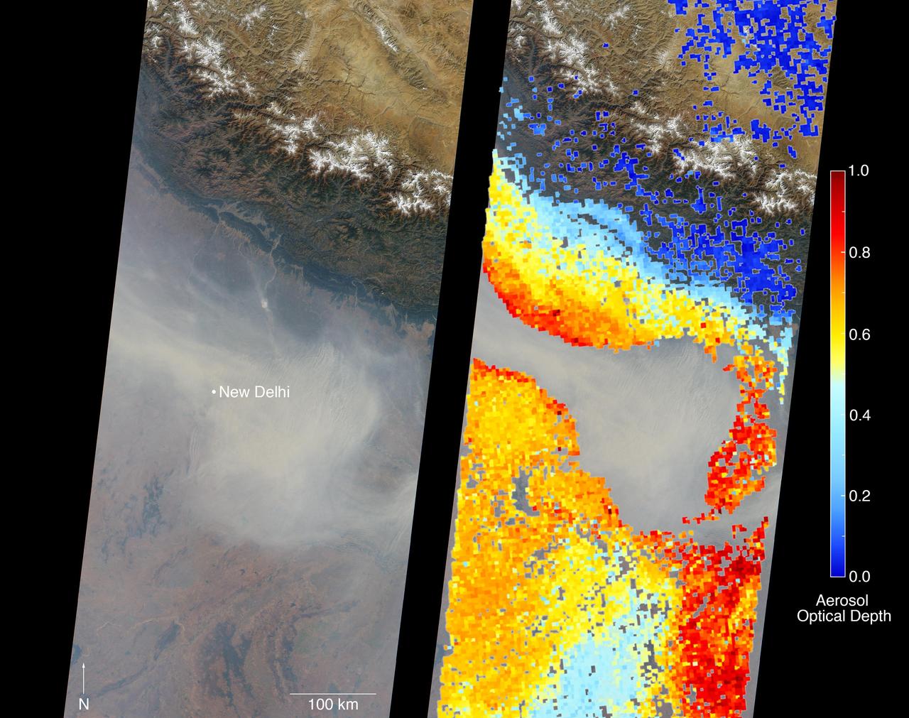
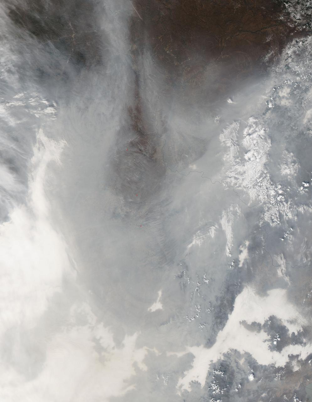
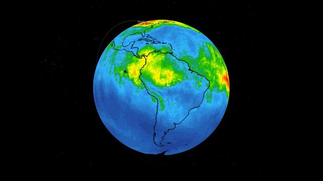
New Delhi, India's capital city, is currently suffering though a period of particularly poor air quality. In early November 2016, monitors at various locations in the area posted air quality index measurements as high as the 900s (the most severe ranking, "hazardous," is any air quality index measurement over 300). Thousands of schools have been closed, and a survey by the Associate Chambers of Commerce and Industry of India reports that 10 percent of the city's workers called in sick due to air-pollution-related health issues. According to several published news reports, the extreme air pollution may be due to a combination of nearby agricultural burning after harvest, urban construction and solid-waste burning, as well as remnants of firecracker smoke and additional car emissions after the celebration of Diwali, the Hindu festival of lights, on October 30. The Multi-angle Imaging SpectroRadiometer (MISR) instrument aboard NASA's Terra satellite passed over the region on Saturday, Nov. 5, 2016, at around 11:05 a.m. local time. At left is an image acquired from MISR's vertical viewing camera. The Himalayas stretch across the northern portion of the image. This towering mountain range tends to concentrate pollution in the region immediately to the south, including New Delhi, by preventing pollutants from blowing northwards. New Delhi, whose location is indicated on the image, is under a patch of especially thick haze. At 6:00 a.m. local time on that date, the U.S. Mission India NowCast Air Quality Index for New Delhi was reported at 751, more than twice the threshold for hazardous air quality. At right, a map of aerosol optical depth is superimposed on the image. Optical depth is a quantitative measure of the abundance of aerosols (tiny particles in the atmosphere). Optical depths for the area around New Delhi have not been calculated because the haze is so thick that the algorithm has classified the area as a cloud. In the region immediately surrounding the thick haze, optical depths approach 1.0. An optical depth of 1.0 means that only about 37 percent of direct sunlight reaches the surface due to interactions with particles in the atmosphere. These data were acquired during Terra orbit 89805. Other MISR data are available through the NASA Langley Research Center; for more information, go to https://eosweb.larc.nasa.gov/project/misr/misr_table. MISR was built and is managed by NASA's Jet Propulsion Laboratory, Pasadena, California, for NASA's Science Mission Directorate, Washington, D.C. The Terra spacecraft is managed by NASA's Goddard Space Flight Center, Greenbelt, Maryland. The MISR data were obtained from the NASA Langley Research Center Atmospheric Science Data Center, Hampton, Virginia. JPL is a division of the California Institute of Technology in Pasadena. http://photojournal.jpl.nasa.gov/catalog/PIA21100
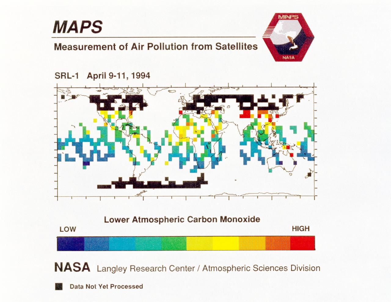
STS059-S-040 (12 April 1994) --- STS-59's MAPS (Measurement of Air Pollution from Satellites) experiment is sending real-time data that provides the most comprehensive view of carbon monoxide concentrations on Earth ever recorded. This computer image shows a summary of "quick look" data obtained by the MAPS instrument during its first days of operations as part of the Space Shuttle Endeavour's SRL-1 payload. This data will be processed using more sophisticated techniques following the flight. The color red indicates areas with the highest levels of carbon monoxide. These Northern Hemisphere springtime carbon monoxide values are generally significantly higher than the values found in the Southern Hemisphere. This is in direct contrast to the data obtained by the MAPS experiment during November 1981 and October 1984, i.e. during Northern Hemisphere fall. The astronauts aboard Endeavour have seen fires in most of the areas showing higher carbon monoxide values (China, Eastern Australia, and equatorial Africa). The relationship between the observed fires and the higher carbon monoxide values will be investigated following SRL-1 by combining the MAPS data with meteorological data, surface imagery, and Space Shuttle hand-held photographs. By the end of SRL-1, MAPS will have acquired data over most of the globe between 57 degrees north and 57 degrees south latitudes. The entire data set will be carefully analyzed using sophisticated post-flight data processing techniques. The data will then be applied in a variety of scientific studies concerning chemistry and transport processes in the atmosphere. The MAPS experiment measures the carbon monoxide in the lower atmosphere. This gas is produced both as a result of natural processes and as a result of human activities. The primary human resources of carbon monoxide are automobiles and industry and the burning of plant materials. The primary natural source is the interaction of sunlight with naturally occurring ozone and water vapor. The strength of all of these sources changes seasonally.
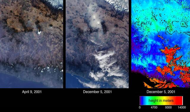
Mexico City has one of the world most serious air pollution problems. These images from NASA Terra satellite were captured on April 9 and December 5, 2001.
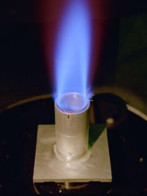
The Ring Flame Stabilizer has been developed in conjunction with Lewis Research Center. This device can lower pollutant emissions (which contribute to smog and air pollution) from natural-gas appliances such as furnaces and water heaters by 90 percent while improving energy efficiency by 2 percent.

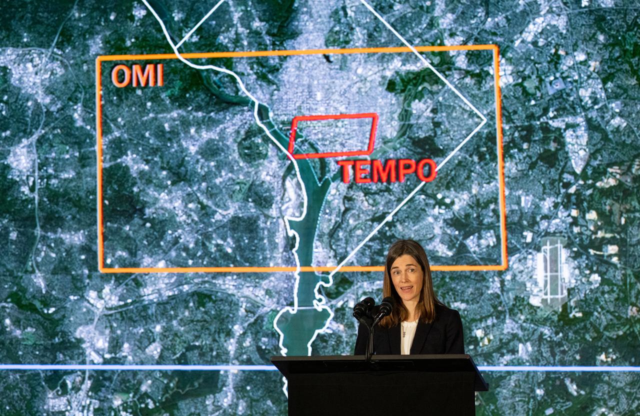
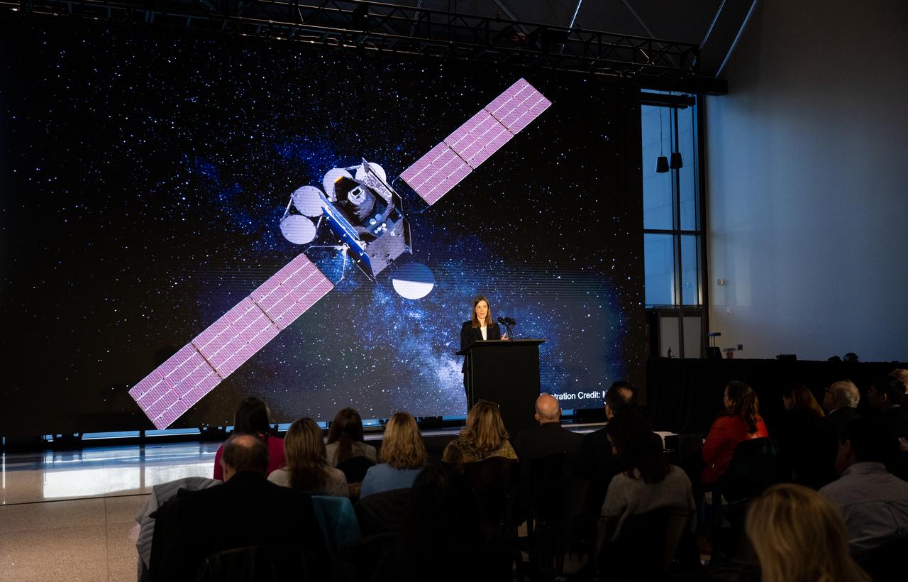
Christopher Browne, director of the Smithsonian’s National Air and Space Museum delivers remarks during a briefing on NASA’s TEMPO (Tropospheric Emissions: Monitoring of Pollution) instrument, Tuesday, March 14, 2023 at the Smithsonian’s National Air and Space Museum in Washington. NASA’s TEMPO instrument, the first Earth Venture Instrument mission, will measure air pollution across North America from Mexico City to the Canadian oil sands and from the Atlantic to the Pacific hourly and at a high spatial resolution. A partnership between NASA and the Center for Astrophysics | Harvard & Smithsonian, TEMPO will launch on a commercial satellite to geostationary orbit as early as April. Photo Credit: (NASA/Joel Kowsky)
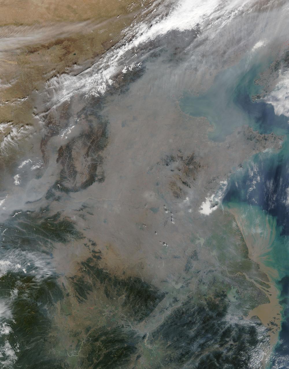
On October 17, 2015, the Moderate Resolution Imaging Spectroradiometer (MODIS) aboard NASA’s Terra satellite captured this true-color image of a thick haze hanging over eastern China. In the north, the large city of Beijing is completely obscured from view, as is much of the landscape. The haze thins slightly over the Bohai Sea. Further south, sediment pours into the East China Sea near the city of Shanghai. Heavy haze is common in this region, and tends to worsen in October through January, when cold, heavy air traps pollutants near the surface of the Earth. It is likely that this scene was caused by such a temperature inversion. Normally, air is warmest near the surface of the Earth. But sometimes a mass of warm air will move the cooler air, so the atmosphere actually warms with the altitude. Cool air does not have energy to rise through the warm air, vertical circulation slows and air becomes trapped near the surface. Any pollution that is emitted into the cooler air will also get trapped, increasing low-level air pollution and haze. Credit: NASA/GSFC/Jeff Schmaltz/MODIS Land Rapid Response Team
The equipment bays and wing pods of NASA's high-altitude ER-2 will carry 15 specialized instruments to study how the vertical convection of air pollution and natural emissions affect climate change.
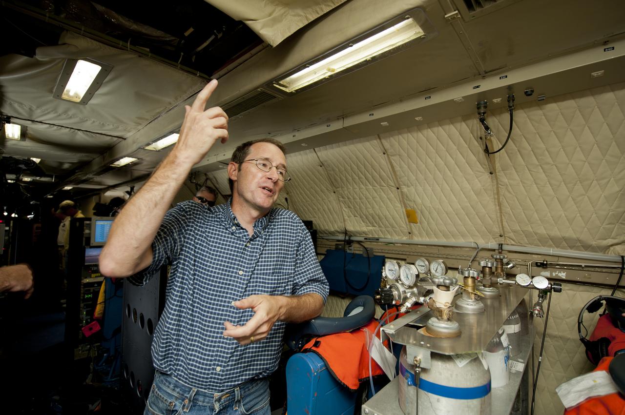
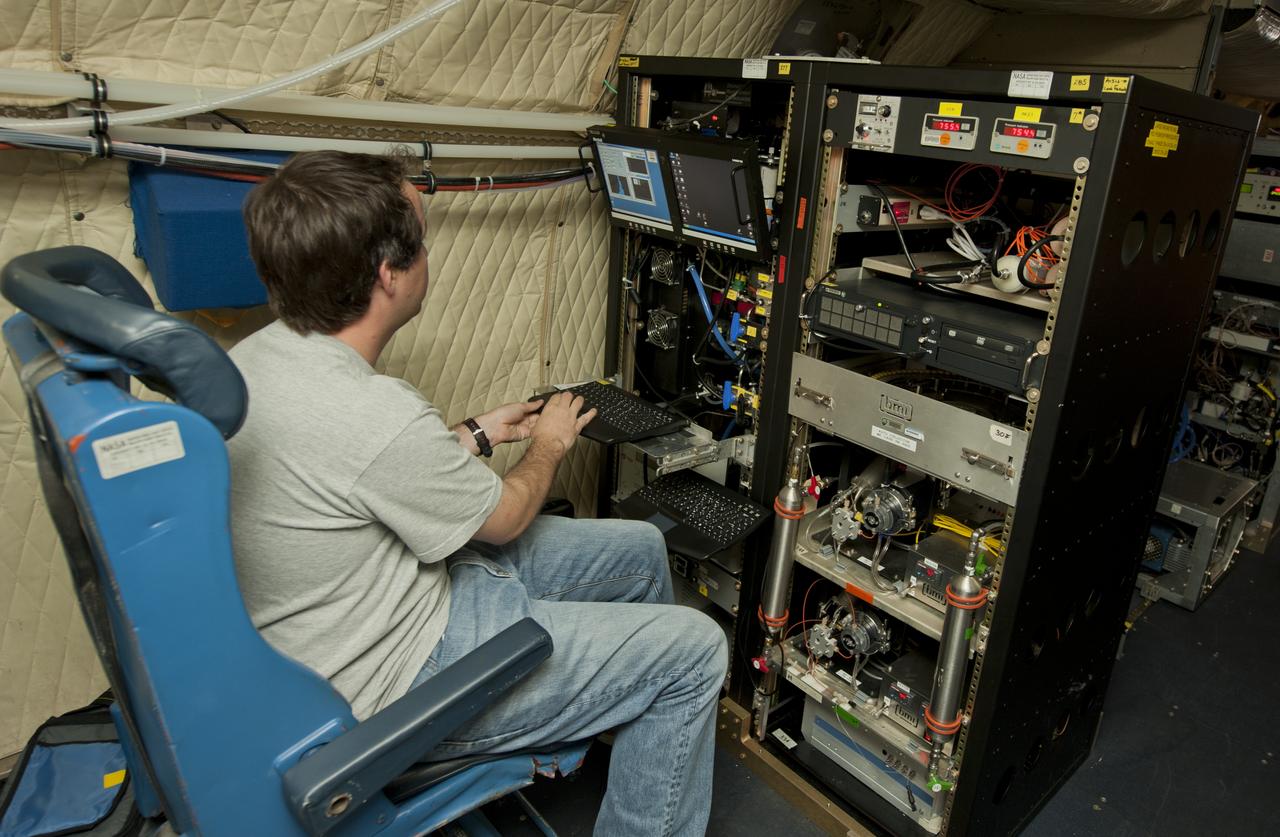
Scientists and technicians ready an instrument rack for mounting in NASA's DC-8 flying laboratory in preparation for a complex mission to study how air pollution and natural emissions affect climate change
A number of atmospheric probes are installed along the fuselage of NASA's DC-8 in preparation for the SEAC4RS study to learn more about how air pollution and natural emissions affect climate change.
Karen St. Germain, director of the Earth Science Division of NASA’s Science Mission Directorate, answers a question during a briefing on NASA’s TEMPO (Tropospheric Emissions: Monitoring of Pollution) instrument, Tuesday, March 14, 2023 at the Smithsonian’s National Air and Space Museum in Washington. NASA’s TEMPO instrument, the first Earth Venture Instrument mission, will measure air pollution across North America from Mexico City to the Canadian oil sands and from the Atlantic to the Pacific hourly and at a high spatial resolution. A partnership between NASA and the Center for Astrophysics | Harvard & Smithsonian, TEMPO will launch on a commercial satellite to geostationary orbit as early as April. Photo Credit: (NASA/Joel Kowsky)

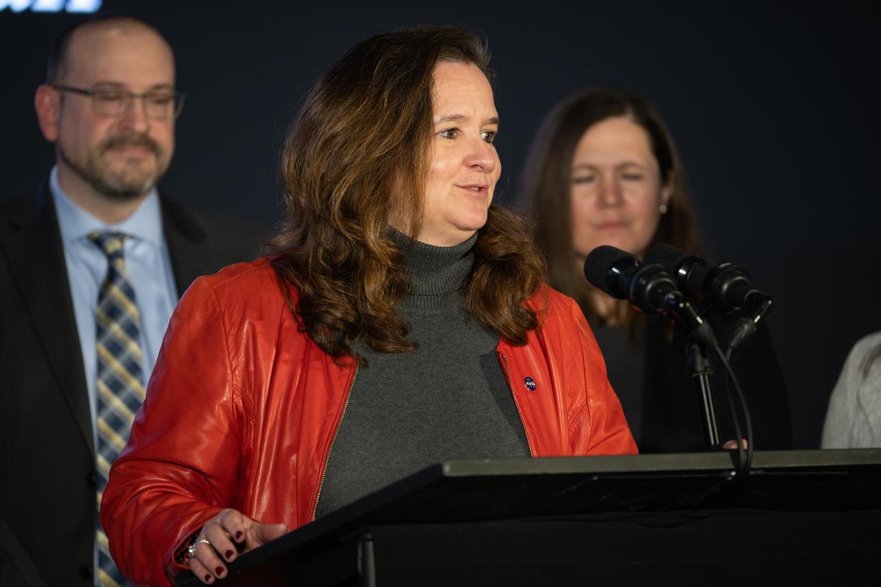
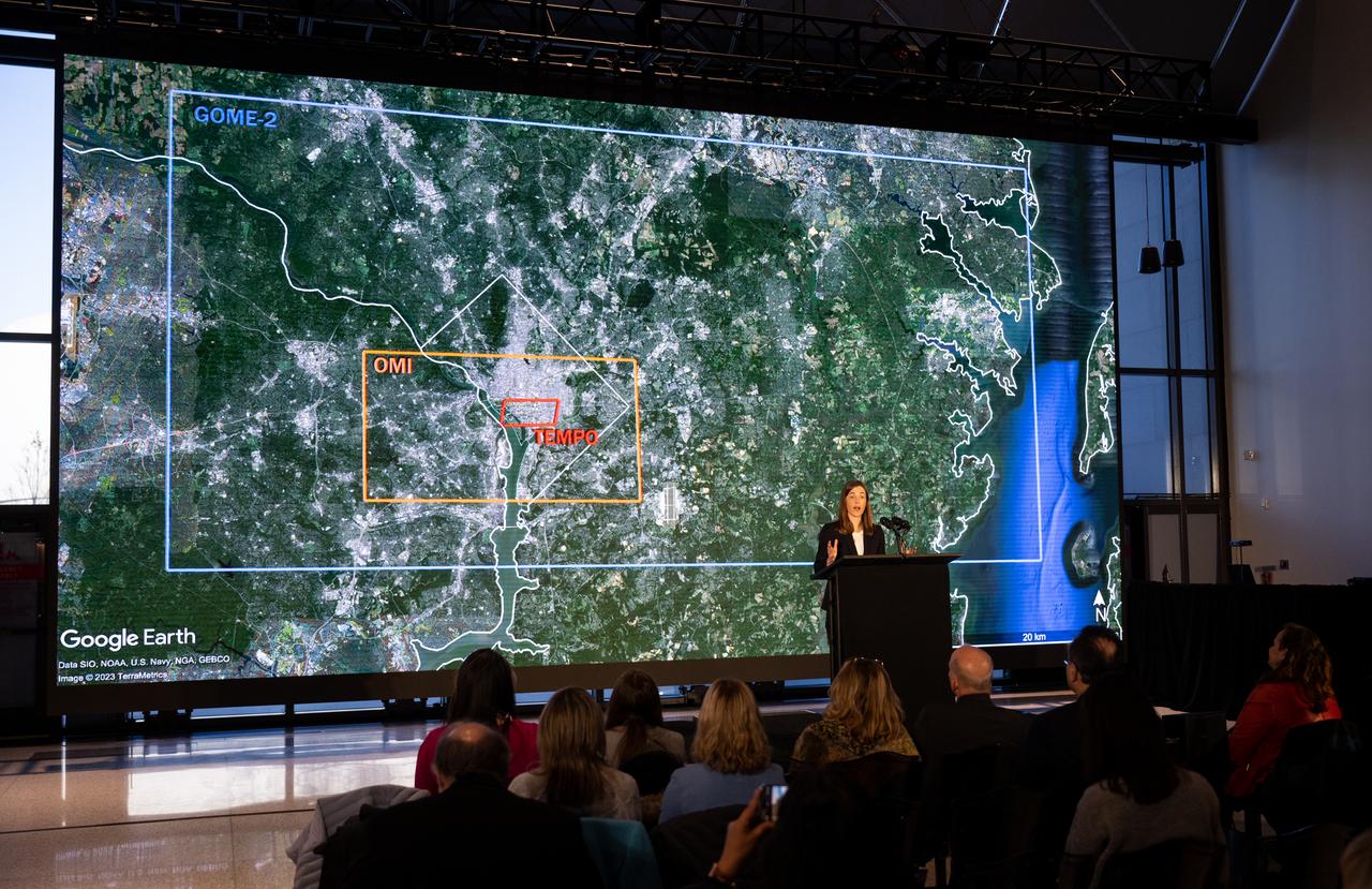
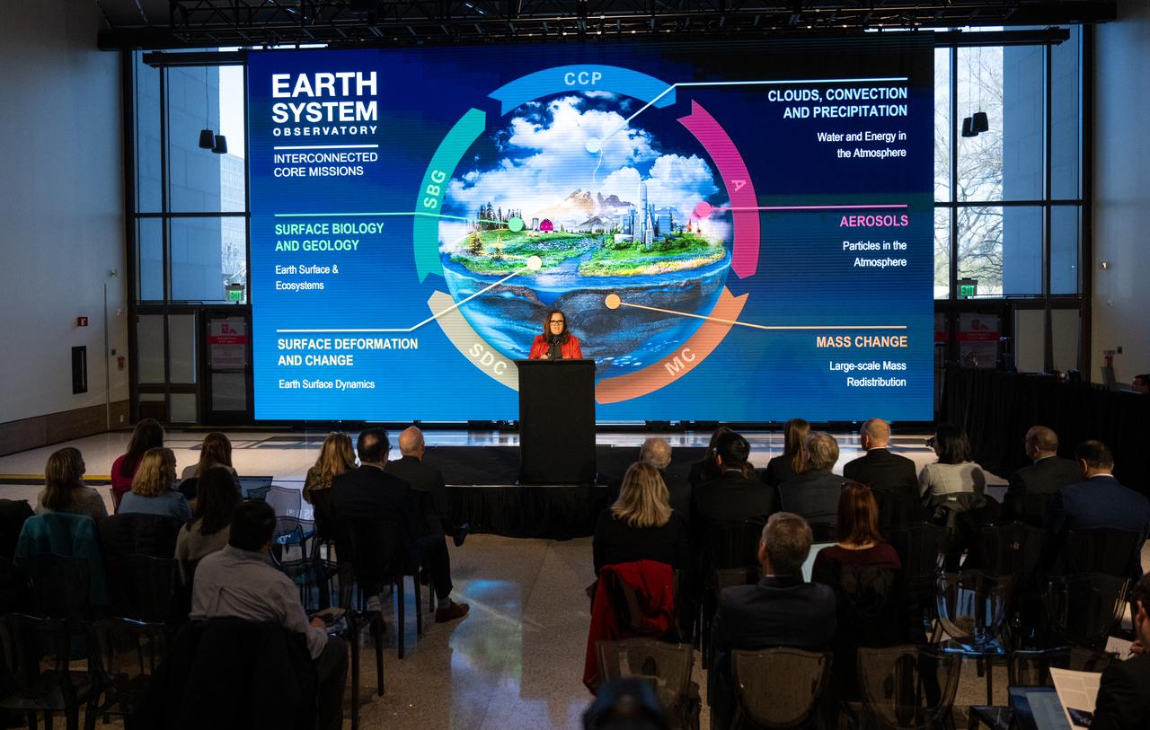
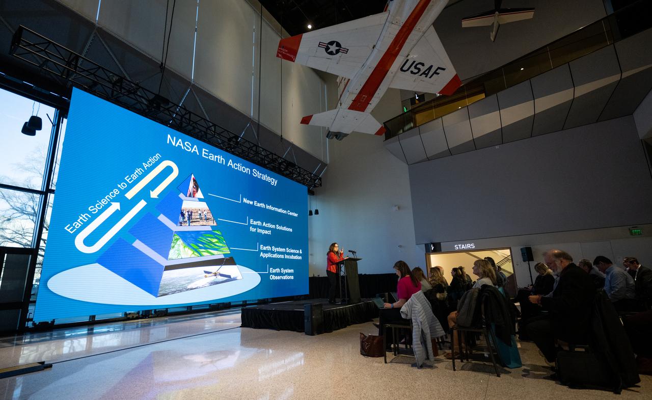
Ellen Stofan, under secretary for Science and Research at the Smithsonian Institution, speaks during a briefing on NASA’s TEMPO (Tropospheric Emissions: Monitoring of Pollution) instrument, Tuesday, March 14, 2023 at the Smithsonian’s National Air and Space Museum in Washington. NASA’s TEMPO instrument, the first Earth Venture Instrument mission, will measure air pollution across North America from Mexico City to the Canadian oil sands and from the Atlantic to the Pacific hourly and at a high spatial resolution. A partnership between NASA and the Center for Astrophysics | Harvard & Smithsonian, TEMPO will launch on a commercial satellite to geostationary orbit as early as April. Photo Credit: (NASA/Joel Kowsky)

Karen St. Germain, director of the Earth Science Division of NASA’s Science Mission Directorate, speaks during a briefing on NASA’s TEMPO (Tropospheric Emissions: Monitoring of Pollution) instrument, Tuesday, March 14, 2023 at the Smithsonian’s National Air and Space Museum in Washington. NASA’s TEMPO instrument, the first Earth Venture Instrument mission, will measure air pollution across North America from Mexico City to the Canadian oil sands and from the Atlantic to the Pacific hourly and at a high spatial resolution. A partnership between NASA and the Center for Astrophysics | Harvard & Smithsonian, TEMPO will launch on a commercial satellite to geostationary orbit as early as April. Photo Credit: (NASA/Joel Kowsky)
Caroline Nowlan, atmospheric physicist at the Center for Astrophysics | Harvard & Smithsonian, speaks during a briefing on NASA’s TEMPO (Tropospheric Emissions: Monitoring of Pollution) instrument, Tuesday, March 14, 2023 at the Smithsonian’s National Air and Space Museum in Washington. NASA’s TEMPO instrument, the first Earth Venture Instrument mission, will measure air pollution across North America from Mexico City to the Canadian oil sands and from the Atlantic to the Pacific hourly and at a high spatial resolution. A partnership between NASA and the Center for Astrophysics | Harvard & Smithsonian, TEMPO will launch on a commercial satellite to geostationary orbit as early as April. Photo Credit: (NASA/Joel Kowsky)

Erika Wright, education specialist at the Center for Astrophysics | Harvard & Smithsonian, speaks during a briefing on NASA’s TEMPO (Tropospheric Emissions: Monitoring of Pollution) instrument, Tuesday, March 14, 2023 at the Smithsonian’s National Air and Space Museum in Washington. NASA’s TEMPO instrument, the first Earth Venture Instrument mission, will measure air pollution across North America from Mexico City to the Canadian oil sands and from the Atlantic to the Pacific hourly and at a high spatial resolution. A partnership between NASA and the Center for Astrophysics | Harvard & Smithsonian, TEMPO will launch on a commercial satellite to geostationary orbit as early as April. Photo Credit: (NASA/Joel Kowsky)

Karen St. Germain, director of the Earth Science Division of NASA’s Science Mission Directorate, speaks during a briefing on NASA’s TEMPO (Tropospheric Emissions: Monitoring of Pollution) instrument, Tuesday, March 14, 2023 at the Smithsonian’s National Air and Space Museum in Washington. NASA’s TEMPO instrument, the first Earth Venture Instrument mission, will measure air pollution across North America from Mexico City to the Canadian oil sands and from the Atlantic to the Pacific hourly and at a high spatial resolution. A partnership between NASA and the Center for Astrophysics | Harvard & Smithsonian, TEMPO will launch on a commercial satellite to geostationary orbit as early as April. Photo Credit: (NASA/Joel Kowsky)

Caroline Nowlan, atmospheric physicist at the Center for Astrophysics | Harvard & Smithsonian, speaks during a briefing on NASA’s TEMPO (Tropospheric Emissions: Monitoring of Pollution) instrument, Tuesday, March 14, 2023 at the Smithsonian’s National Air and Space Museum in Washington. NASA’s TEMPO instrument, the first Earth Venture Instrument mission, will measure air pollution across North America from Mexico City to the Canadian oil sands and from the Atlantic to the Pacific hourly and at a high spatial resolution. A partnership between NASA and the Center for Astrophysics | Harvard & Smithsonian, TEMPO will launch on a commercial satellite to geostationary orbit as early as April. Photo Credit: (NASA/Joel Kowsky)

Barry Lefer, tropospheric composition program manager in the Earth Science Division of NASA’s Science Mission Directorate, speaks during a briefing on NASA’s TEMPO (Tropospheric Emissions: Monitoring of Pollution) instrument, Tuesday, March 14, 2023 at the Smithsonian’s National Air and Space Museum in Washington. NASA’s TEMPO instrument, the first Earth Venture Instrument mission, will measure air pollution across North America from Mexico City to the Canadian oil sands and from the Atlantic to the Pacific hourly and at a high spatial resolution. A partnership between NASA and the Center for Astrophysics | Harvard & Smithsonian, TEMPO will launch on a commercial satellite to geostationary orbit as early as April. Photo Credit: (NASA/Joel Kowsky)
Karen St. Germain, director of the Earth Science Division of NASA’s Science Mission Directorate, speaks during a briefing on NASA’s TEMPO (Tropospheric Emissions: Monitoring of Pollution) instrument, Tuesday, March 14, 2023 at the Smithsonian’s National Air and Space Museum in Washington. NASA’s TEMPO instrument, the first Earth Venture Instrument mission, will measure air pollution across North America from Mexico City to the Canadian oil sands and from the Atlantic to the Pacific hourly and at a high spatial resolution. A partnership between NASA and the Center for Astrophysics | Harvard & Smithsonian, TEMPO will launch on a commercial satellite to geostationary orbit as early as April. Photo Credit: (NASA/Joel Kowsky)

Barry Lefer, tropospheric composition program manager in the Earth Science Division of NASA’s Science Mission Directorate, speaks during a briefing on NASA’s TEMPO (Tropospheric Emissions: Monitoring of Pollution) instrument, Tuesday, March 14, 2023 at the Smithsonian’s National Air and Space Museum in Washington. NASA’s TEMPO instrument, the first Earth Venture Instrument mission, will measure air pollution across North America from Mexico City to the Canadian oil sands and from the Atlantic to the Pacific hourly and at a high spatial resolution. A partnership between NASA and the Center for Astrophysics | Harvard & Smithsonian, TEMPO will launch on a commercial satellite to geostationary orbit as early as April. Photo Credit: (NASA/Joel Kowsky)

Barry Lefer, tropospheric composition program manager in the Earth Science Division of NASA’s Science Mission Directorate, speaks during a briefing on NASA’s TEMPO (Tropospheric Emissions: Monitoring of Pollution) instrument, Tuesday, March 14, 2023 at the Smithsonian’s National Air and Space Museum in Washington. NASA’s TEMPO instrument, the first Earth Venture Instrument mission, will measure air pollution across North America from Mexico City to the Canadian oil sands and from the Atlantic to the Pacific hourly and at a high spatial resolution. A partnership between NASA and the Center for Astrophysics | Harvard & Smithsonian, TEMPO will launch on a commercial satellite to geostationary orbit as early as April. Photo Credit: (NASA/Joel Kowsky)
Karen St. Germain, director of the Earth Science Division of NASA’s Science Mission Directorate, speaks during a briefing on NASA’s TEMPO (Tropospheric Emissions: Monitoring of Pollution) instrument, Tuesday, March 14, 2023 at the Smithsonian’s National Air and Space Museum in Washington. NASA’s TEMPO instrument, the first Earth Venture Instrument mission, will measure air pollution across North America from Mexico City to the Canadian oil sands and from the Atlantic to the Pacific hourly and at a high spatial resolution. A partnership between NASA and the Center for Astrophysics | Harvard & Smithsonian, TEMPO will launch on a commercial satellite to geostationary orbit as early as April. Photo Credit: (NASA/Joel Kowsky)

Ellen Stofan, under secretary for Science and Research at the Smithsonian Institution, speaks during a briefing on NASA’s TEMPO (Tropospheric Emissions: Monitoring of Pollution) instrument, Tuesday, March 14, 2023 at the Smithsonian’s National Air and Space Museum in Washington. NASA’s TEMPO instrument, the first Earth Venture Instrument mission, will measure air pollution across North America from Mexico City to the Canadian oil sands and from the Atlantic to the Pacific hourly and at a high spatial resolution. A partnership between NASA and the Center for Astrophysics | Harvard & Smithsonian, TEMPO will launch on a commercial satellite to geostationary orbit as early as April. Photo Credit: (NASA/Joel Kowsky)
Caroline Nowlan, atmospheric physicist at the Center for Astrophysics | Harvard & Smithsonian, speaks during a briefing on NASA’s TEMPO (Tropospheric Emissions: Monitoring of Pollution) instrument, Tuesday, March 14, 2023 at the Smithsonian’s National Air and Space Museum in Washington. NASA’s TEMPO instrument, the first Earth Venture Instrument mission, will measure air pollution across North America from Mexico City to the Canadian oil sands and from the Atlantic to the Pacific hourly and at a high spatial resolution. A partnership between NASA and the Center for Astrophysics | Harvard & Smithsonian, TEMPO will launch on a commercial satellite to geostationary orbit as early as April. Photo Credit: (NASA/Joel Kowsky)
Caroline Nowlan, atmospheric physicist at the Center for Astrophysics | Harvard & Smithsonian, speaks during a briefing on NASA’s TEMPO (Tropospheric Emissions: Monitoring of Pollution) instrument, Tuesday, March 14, 2023 at the Smithsonian’s National Air and Space Museum in Washington. NASA’s TEMPO instrument, the first Earth Venture Instrument mission, will measure air pollution across North America from Mexico City to the Canadian oil sands and from the Atlantic to the Pacific hourly and at a high spatial resolution. A partnership between NASA and the Center for Astrophysics | Harvard & Smithsonian, TEMPO will launch on a commercial satellite to geostationary orbit as early as April. Photo Credit: (NASA/Joel Kowsky)
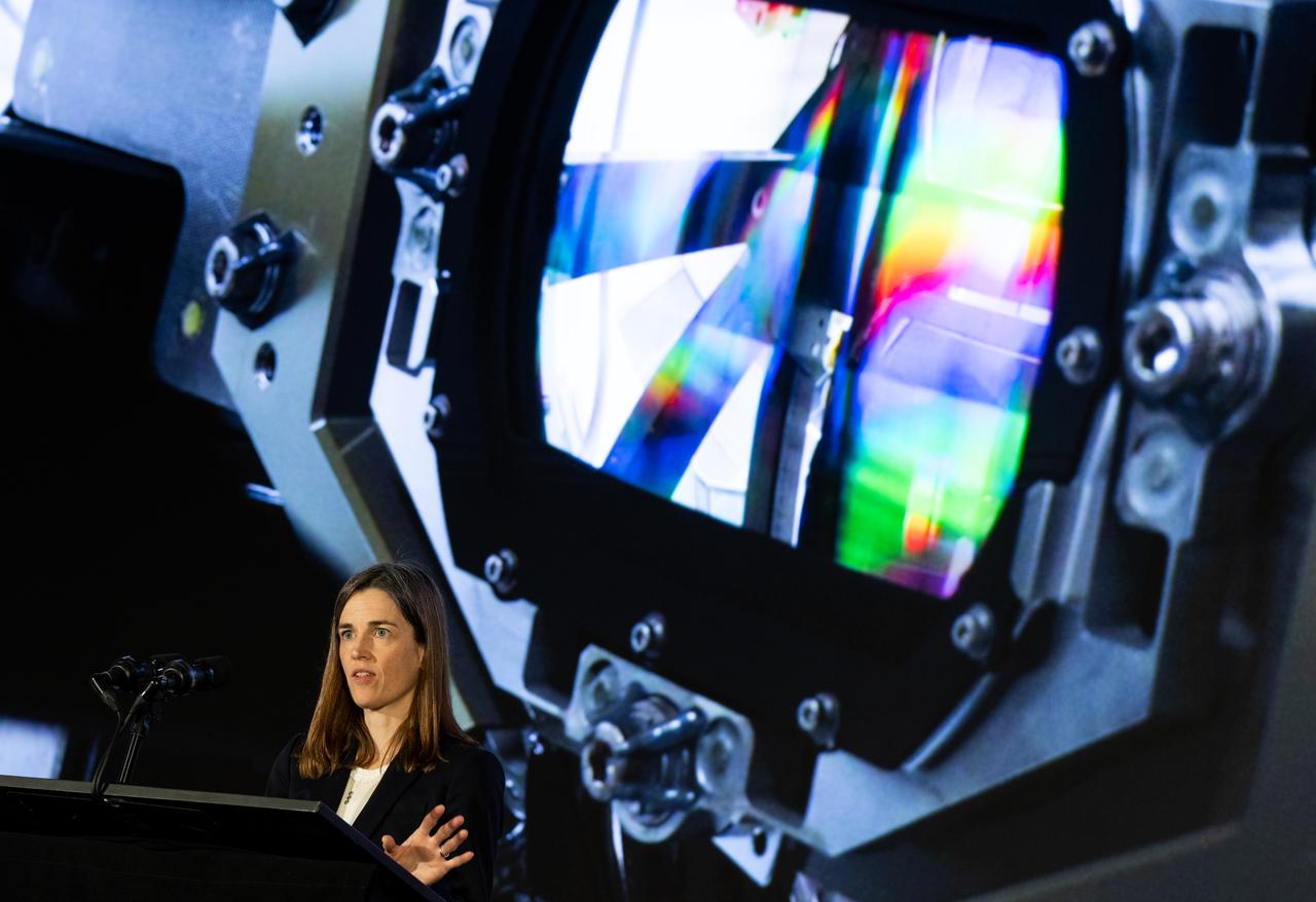
Caroline Nowlan, atmospheric physicist at the Center for Astrophysics | Harvard & Smithsonian, speaks during a briefing on NASA’s TEMPO (Tropospheric Emissions: Monitoring of Pollution) instrument, Tuesday, March 14, 2023 at the Smithsonian’s National Air and Space Museum in Washington. NASA’s TEMPO instrument, the first Earth Venture Instrument mission, will measure air pollution across North America from Mexico City to the Canadian oil sands and from the Atlantic to the Pacific hourly and at a high spatial resolution. A partnership between NASA and the Center for Astrophysics | Harvard & Smithsonian, TEMPO will launch on a commercial satellite to geostationary orbit as early as April. Photo Credit: (NASA/Joel Kowsky)

Caroline Nowlan, atmospheric physicist at the Center for Astrophysics | Harvard & Smithsonian, answers a question during a briefing on NASA’s TEMPO (Tropospheric Emissions: Monitoring of Pollution) instrument, Tuesday, March 14, 2023 at the Smithsonian’s National Air and Space Museum in Washington. NASA’s TEMPO instrument, the first Earth Venture Instrument mission, will measure air pollution across North America from Mexico City to the Canadian oil sands and from the Atlantic to the Pacific hourly and at a high spatial resolution. A partnership between NASA and the Center for Astrophysics | Harvard & Smithsonian, TEMPO will launch on a commercial satellite to geostationary orbit as early as April. Photo Credit: (NASA/Joel Kowsky)

NASA Public Affairs Officer Karen Fox moderates a briefing on NASA’s TEMPO (Tropospheric Emissions: Monitoring of Pollution) instrument, Tuesday, March 14, 2023 at the Smithsonian’s National Air and Space Museum in Washington. NASA’s TEMPO instrument, the first Earth Venture Instrument mission, will measure air pollution across North America from Mexico City to the Canadian oil sands and from the Atlantic to the Pacific hourly and at a high spatial resolution. A partnership between NASA and the Center for Astrophysics | Harvard & Smithsonian, TEMPO will launch on a commercial satellite to geostationary orbit as early as April. Photo Credit: (NASA/Joel Kowsky)
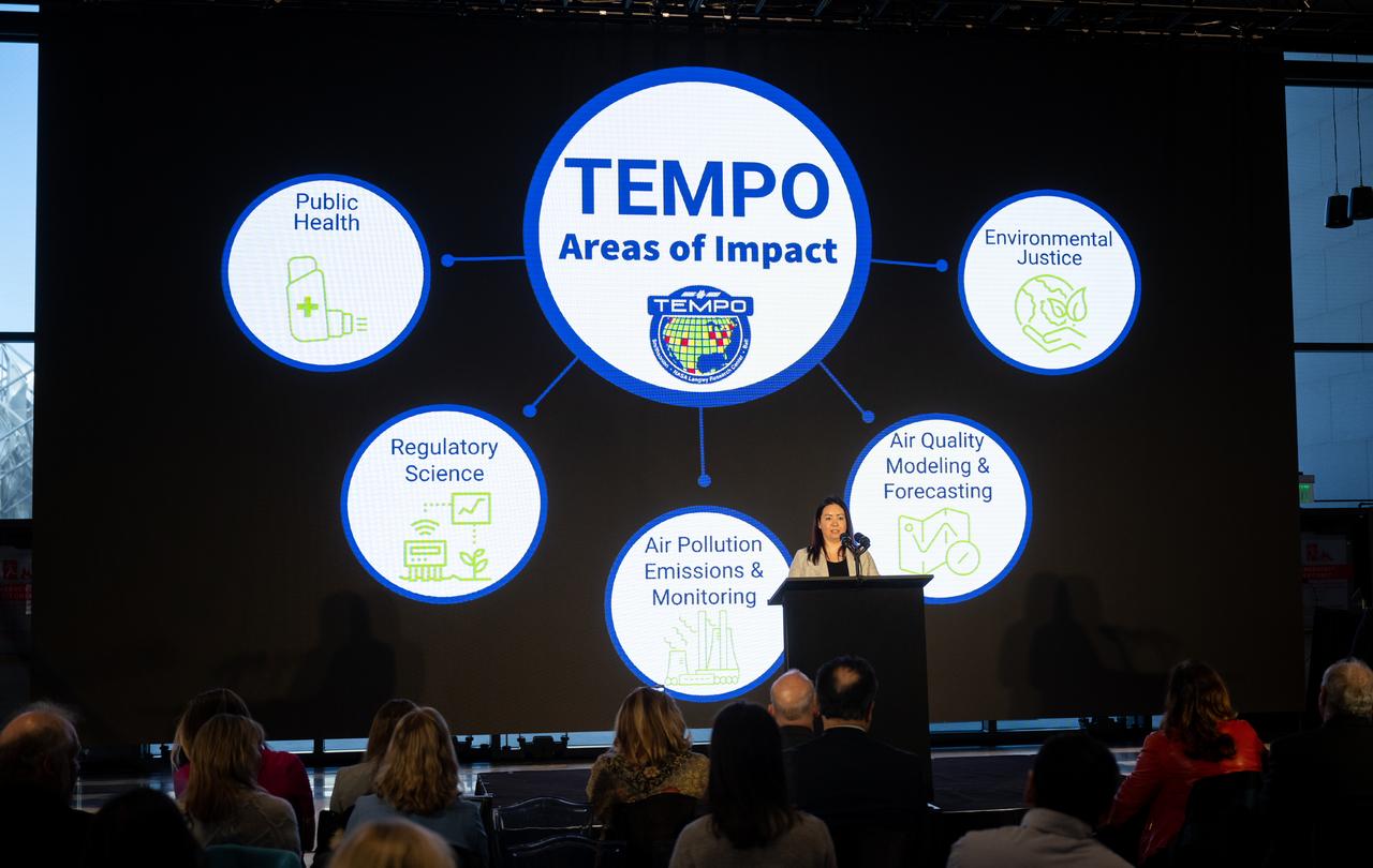
Laura Judd, associate program manager for the Applied Sciences Health and Air Quality Applications in the Applied Sciences Program of NASA’s Earth Science Division, speaks during a briefing on NASA’s TEMPO (Tropospheric Emissions: Monitoring of Pollution) instrument, Tuesday, March 14, 2023 at the Smithsonian’s National Air and Space Museum in Washington. NASA’s TEMPO instrument, the first Earth Venture Instrument mission, will measure air pollution across North America from Mexico City to the Canadian oil sands and from the Atlantic to the Pacific hourly and at a high spatial resolution. A partnership between NASA and the Center for Astrophysics | Harvard & Smithsonian, TEMPO will launch on a commercial satellite to geostationary orbit as early as April. Photo Credit: (NASA/Joel Kowsky)

Laura Judd, associate program manager for the Applied Sciences Health and Air Quality Applications in the Applied Sciences Program of NASA’s Earth Science Division, speaks during a briefing on NASA’s TEMPO (Tropospheric Emissions: Monitoring of Pollution) instrument, Tuesday, March 14, 2023 at the Smithsonian’s National Air and Space Museum in Washington. NASA’s TEMPO instrument, the first Earth Venture Instrument mission, will measure air pollution across North America from Mexico City to the Canadian oil sands and from the Atlantic to the Pacific hourly and at a high spatial resolution. A partnership between NASA and the Center for Astrophysics | Harvard & Smithsonian, TEMPO will launch on a commercial satellite to geostationary orbit as early as April. Photo Credit: (NASA/Joel Kowsky)
STS082-723-071 (11-21 Feb. 1997) --- The island of Hispaniola appears left center in this wide-angle view, photographed with a 70mm handheld camera from the Earth-orbiting Space Shuttle Discovery. The prominent cape is Cap-a-Foux, the northwest point of Haiti. The cloud is broken by the mountainous spine of the island. Smoke from bush fires appears in the valleys between the ridges. The coppery tinge of light reflected off the sea surface indicates pollution in the air -- probably industrial pollutants from North America which are typically fed around from the Atlantic seaboard into the Caribbean from the east.
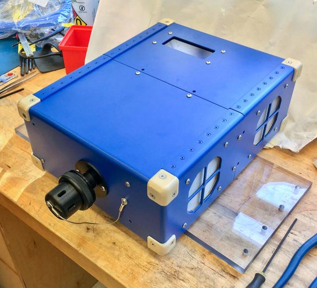
jsc2020e004941 (2/7/2020) --- A preflight view of the Airborne Particulate Monitor (APM) engineering unit. APM technology has applications in environmental monitoring and air pollution studies on Earth. Its combination of two instruments into one box offers a wider range of particle size measurement than other commercially available instruments.
This frame from a movie was produced with data from NASA Aqua spacecraft showing the spread of carbon monoxide pollution across North America from fires in the Western U.S., including the Beaver Creek Fire in Idaho and the Rim Fire in California.
JPL-led study shows bromine explosion on March 13, 2008 across the western Northwest Territories in Canada looking toward the Mackenzie Mountains at the horizon, which prevented the bromine from crossing over into Alaska.
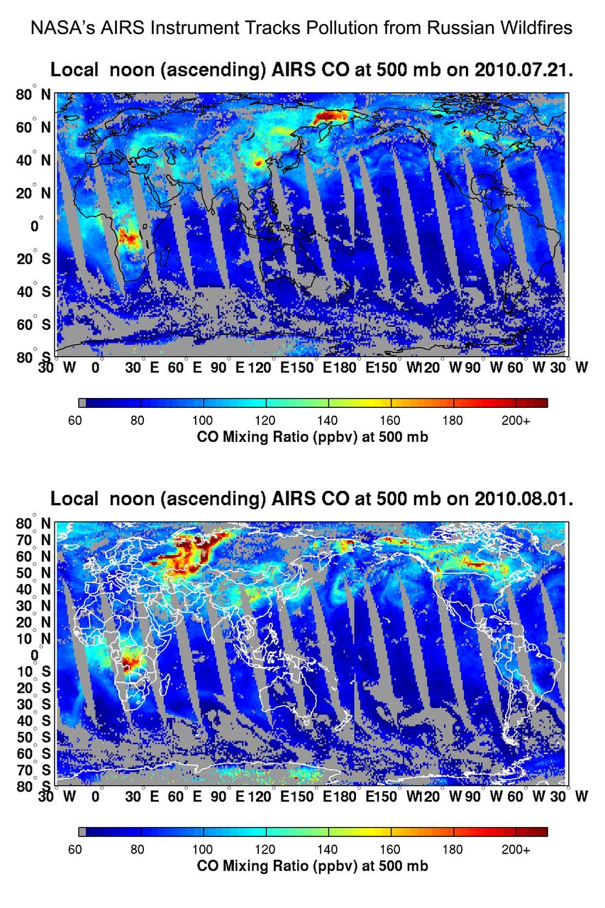
NASA Aqua spacecraft tracked the concentration and transport of carbon monoxide from Russian fires in 2010, during which time some 558 fires were burning.
STS073-723-054 (21 October 1995) --- Central Turkey dominates this north-looking panorama, with the long fingered island of Cyprus lower left, surrounded by the deep blue waters of the Mediterranean Sea. Turkey's capital, Ankara, lies just north of the white bed of a dry lake in the center of the view. The city is supplied with water from the neighboring blue lake. The coast of Syria and Lebanon appear bottom right. Man-made lakes on the upper Euphrates River in eastern Turkey appear extreme right. According to scientists studying the STS-73 photo collection, the striking difference in visibility to north and south of Turkey suggests a pollution event over the Black Sea. Air pollution from East European industry flows down into the Black Sea basin, especially at the west end (haze top left) as shown in this view (compare clearer air top right).
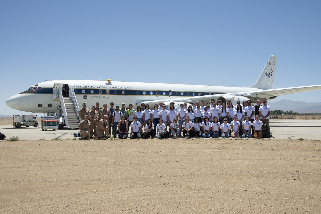
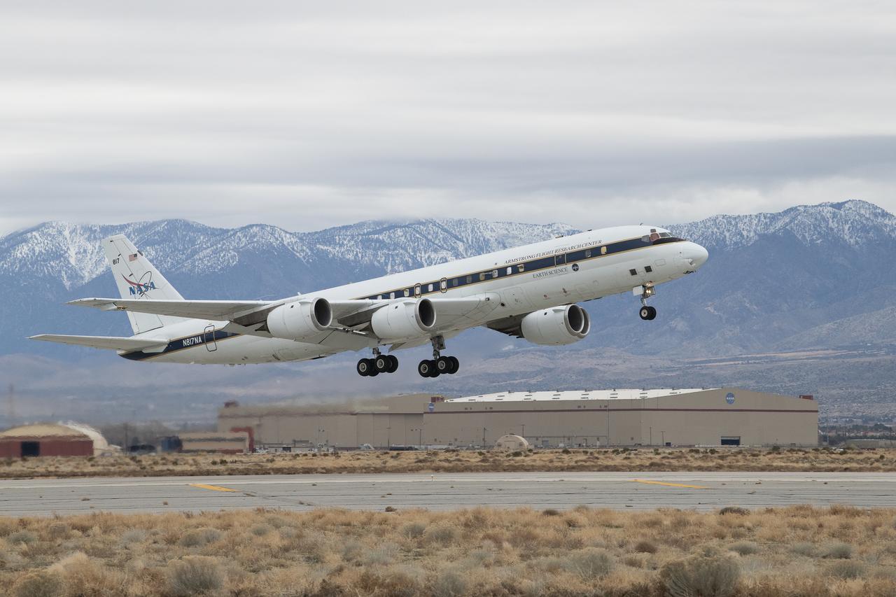
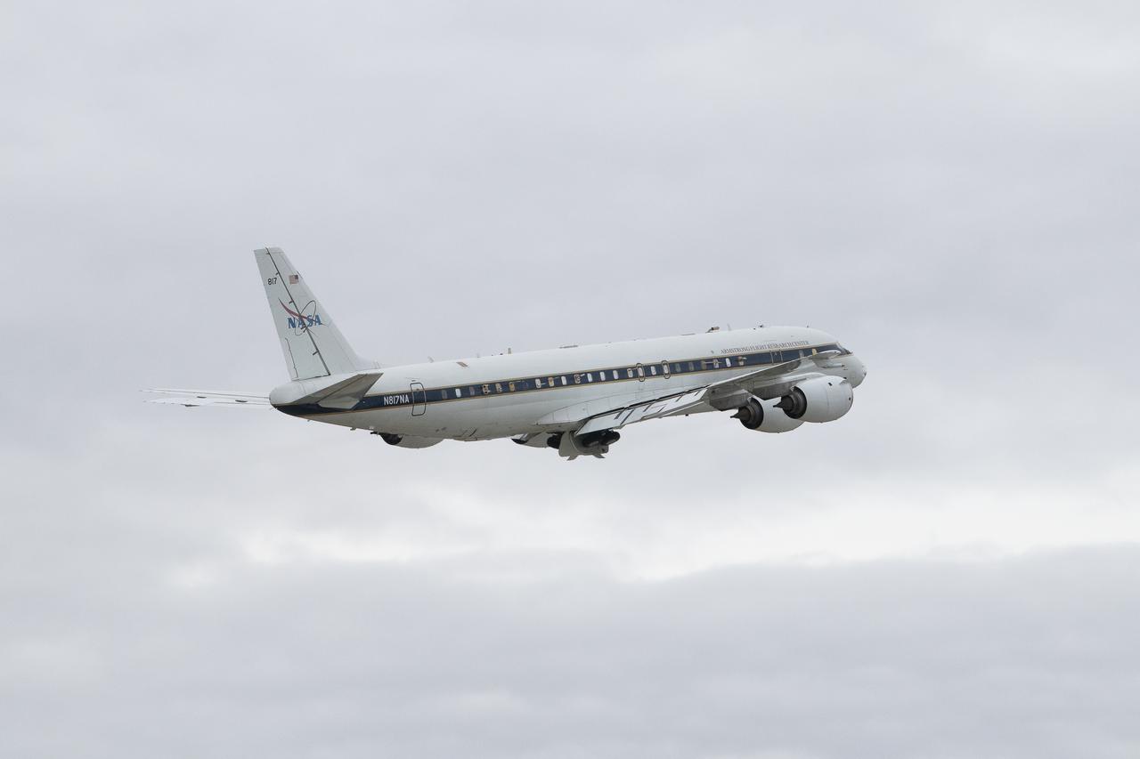
NASA Armstrong’s Student Airborne Research Program celebrates 15 years of success in 2023. An eight-week summer internship program, SARP offers upper-level undergraduate students the opportunity to acquire hands-on research experience as part of a scientific campaign using NASA Airborne Science Program flying science laboratories—aircraft outfitted specifically for research projects. Students onboard NASA’s DC-8 aircraft, the largest flying science laboratory in the world, help scientists from NOAA, the National Oceanic and Atmospheric Administration with a science project investigating air quality and non-vehicular pollution sources called AEROMMA, which measures Atmospheric Emissions and Reactions Observed from Megacities to Marine Areas. In 2023, NASA also introduced a sister program, SARP East to complement the West Coast program.
NASA Armstrong’s Student Airborne Research Program celebrates 15 years of success in 2023. An eight-week summer internship program, SARP offers upper-level undergraduate students the opportunity to acquire hands-on research experience as part of a scientific campaign using NASA Airborne Science Program flying science laboratories—aircraft outfitted specifically for research projects. Students onboard NASA’s DC-8 aircraft, the largest flying science laboratory in the world, help scientists from NOAA, the National Oceanic and Atmospheric Administration with a science project investigating air quality and non-vehicular pollution sources called AEROMMA, which measures Atmospheric Emissions and Reactions Observed from Megacities to Marine Areas. In 2023, NASA also introduced a sister program, SARP East to complement the West Coast program.
NASA Armstrong’s Student Airborne Research Program celebrates 15 years of success in 2023. An eight-week summer internship program, SARP offers upper-level undergraduate students the opportunity to acquire hands-on research experience as part of a scientific campaign using NASA Airborne Science Program flying science laboratories—aircraft outfitted specifically for research projects. Students onboard NASA’s DC-8 aircraft, the largest flying science laboratory in the world, help scientists from NOAA, the National Oceanic and Atmospheric Administration with a science project investigating air quality and non-vehicular pollution sources called AEROMMA, which measures Atmospheric Emissions and Reactions Observed from Megacities to Marine Areas. In 2023, NASA also introduced a sister program, SARP East to complement the West Coast program.
NASA Armstrong’s Student Airborne Research Program celebrates 15 years of success in 2023. An eight-week summer internship program, SARP offers upper-level undergraduate students the opportunity to acquire hands-on research experience as part of a scientific campaign using NASA Airborne Science Program flying science laboratories—aircraft outfitted specifically for research projects. Students onboard NASA’s DC-8 aircraft, the largest flying science laboratory in the world, help scientists from NOAA, the National Oceanic and Atmospheric Administration with a science project investigating air quality and non-vehicular pollution sources called AEROMMA, which measures Atmospheric Emissions and Reactions Observed from Megacities to Marine Areas. In 2023, NASA also introduced a sister program, SARP East to complement the West Coast program.
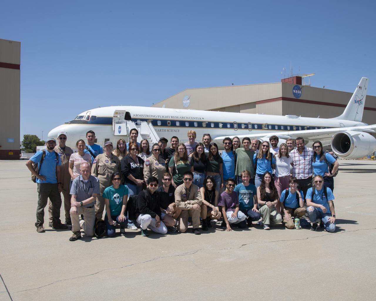
NASA Armstrong’s Student Airborne Research Program celebrates 15 years of success in 2023. An eight-week summer internship program, SARP offers upper-level undergraduate students the opportunity to acquire hands-on research experience as part of a scientific campaign using NASA Airborne Science Program flying science laboratories—aircraft outfitted specifically for research projects. Students onboard NASA’s DC-8 aircraft, the largest flying science laboratory in the world, help scientists from NOAA, the National Oceanic and Atmospheric Administration with a science project investigating air quality and non-vehicular pollution sources called AEROMMA, which measures Atmospheric Emissions and Reactions Observed from Megacities to Marine Areas. In 2023, NASA also introduced a sister program, SARP East to complement the West Coast program.
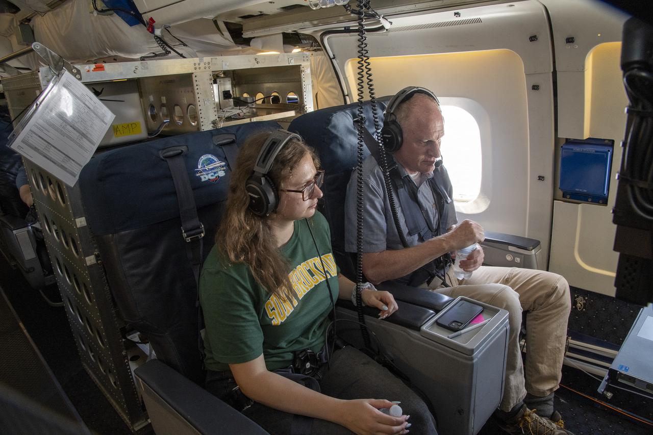
NASA Armstrong’s Student Airborne Research Program celebrates 15 years of success in 2023. An eight-week summer internship program, SARP offers upper-level undergraduate students the opportunity to acquire hands-on research experience as part of a scientific campaign using NASA Airborne Science Program flying science laboratories—aircraft outfitted specifically for research projects. Students onboard NASA’s DC-8 aircraft, the largest flying science laboratory in the world, help scientists from NOAA, the National Oceanic and Atmospheric Administration with a science project investigating air quality and non-vehicular pollution sources called AEROMMA, which measures Atmospheric Emissions and Reactions Observed from Megacities to Marine Areas. In 2023, NASA also introduced a sister program, SARP East to complement the West Coast program.

NASA Armstrong’s Student Airborne Research Program celebrates 15 years of success in 2023. An eight-week summer internship program, SARP offers upper-level undergraduate students the opportunity to acquire hands-on research experience as part of a scientific campaign using NASA Airborne Science Program flying science laboratories—aircraft outfitted specifically for research projects. Students onboard NASA’s DC-8 aircraft, the largest flying science laboratory in the world, help scientists from NOAA, the National Oceanic and Atmospheric Administration with a science project investigating air quality and non-vehicular pollution sources called AEROMMA, which measures Atmospheric Emissions and Reactions Observed from Megacities to Marine Areas. In 2023, NASA also introduced a sister program, SARP East to complement the West Coast program.
NASA Armstrong’s Student Airborne Research Program celebrates 15 years of success in 2023. An eight-week summer internship program, SARP offers upper-level undergraduate students the opportunity to acquire hands-on research experience as part of a scientific campaign using NASA Airborne Science Program flying science laboratories—aircraft outfitted specifically for research projects. Students onboard NASA’s DC-8 aircraft, the largest flying science laboratory in the world, help scientists from NOAA, the National Oceanic and Atmospheric Administration with a science project investigating air quality and non-vehicular pollution sources called AEROMMA, which measures Atmospheric Emissions and Reactions Observed from Megacities to Marine Areas. In 2023, NASA also introduced a sister program, SARP East to complement the West Coast program.
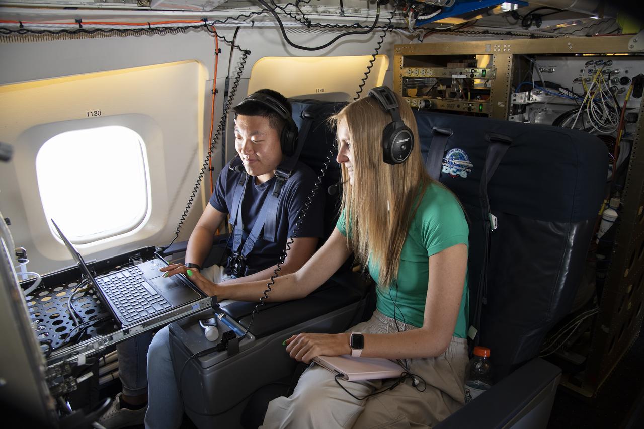
A group of university students and mentors flew aboard NASA Armstrong Flight Research Center’s DC-8 aircraft to study air quality as part of NASA’s Student Airborne Research Program (SARP). Based at NASA’s Armstrong Building 703 in Palmdale, California, the DC-8 flew over the Central Valley to measure pollution and monitor air quality on Tuesday, June 21, 2022.
Chinese authorities shut down much of Harbin – a city of more than 10 million people – as unusually high levels of pollution shrouded the city and the surrounding region in mid-October, 2013. Measurements taken on October 20, 2013 scored the air quality index in the city at 500, the highest possible reading. Levels above 300 are considered hazardous to human health. The Moderate Resolution Imaging Spectroradiometer (MODIS) on NASA’s Aqua satellite acquired this true-color image of northeastern China on October 21. The brightest areas are fog, which is tinged with gray or yellow due to the air pollution. Other cloud-free areas have a pall of gray and brown smog that blots out the city and surrounding towns. Harbin lies under the Y-shaped patch of fog and smog in the south-central section of the image, completely obscured from view. Some neighborhoods experienced concentrations of fine particulate matter (PM 2.5) as high as 1,000 micrograms per cubic meter. For comparison the U.S. Environmental Protection Agency’s air quality standards state that PM 2.5 should remain below 35 micrograms per cubic meter. It is extremely rare for particulate levels to reach such high levels in the absence of a dust storm or forest fire. Chinese authorities grounded airplanes, shuttered thousands of schools and closed major roads in response to the surge in pollution. A few days after pollution levels started to rise, Harbin hospitals reported a 30 percent increase in admissions related to respiratory problems, and several Harbin pharmacies were sold out of pollution facemasks, according to media reports. Cold weather and lack of wind helped fuel the pollution outbreak, but human factors also played an important role. Wheat and corn farmers in the region light fires in the fall to burn off debris following the harvest. Also, city officials turned on Harbin’s city-wide, coal-powered heating system just prior to the pollution outbreak, according to China’s state-run Xinhua News Agency. Credit: NASA/GSFC/Jeff Schmaltz/MODIS Land Rapid Response Team <b><a href="http://www.nasa.gov/audience/formedia/features/MP_Photo_Guidelines.html" rel="nofollow">NASA image use policy.</a></b> <b><a href="http://www.nasa.gov/centers/goddard/home/index.html" rel="nofollow">NASA Goddard Space Flight Center</a></b> enables NASA’s mission through four scientific endeavors: Earth Science, Heliophysics, Solar System Exploration, and Astrophysics. Goddard plays a leading role in NASA’s accomplishments by contributing compelling scientific knowledge to advance the Agency’s mission. <b>Follow us on <a href="http://twitter.com/NASA_GoddardPix" rel="nofollow">Twitter</a></b> <b>Like us on <a href="http://www.facebook.com/pages/Greenbelt-MD/NASA-Goddard/395013845897?ref=tsd" rel="nofollow">Facebook</a></b> <b>Find us on <a href="http://instagram.com/nasagoddard?vm=grid" rel="nofollow">Instagram</a></b>
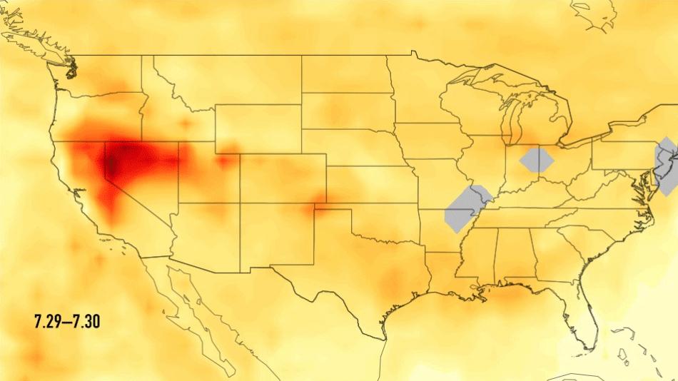
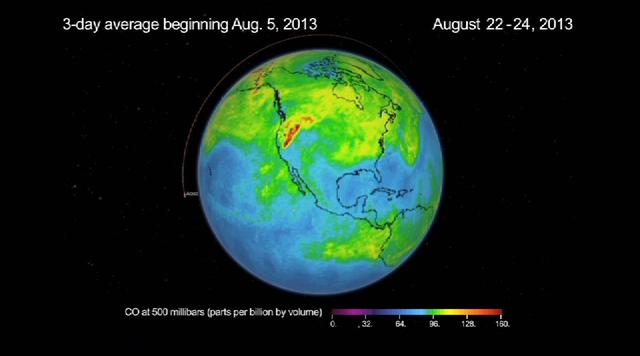
This single frame from a series of images shows carbon monoxide (in orange/red) from California's massive wildfires drifting east across the U.S. between July 30 and August 7, 2018. It was produced using data from the Atmospheric Infrared Sounder (AIRS) on NASA's Aqua satellite. AIRS measures concentrations of carbon monoxide that have been lofted high into the atmosphere. These images show the carbon monoxide at a 500 hPa pressure level, or an altitude of approximately 18,000 feet (5,500 meters). As the time series progresses, we see that this carbon monoxide is drifting east with one branch moving toward Texas and the other forking to the northeast. The high end of the scale is set to 200 parts per billion by volume (ppbv); however, local values can be significantly higher. Carbon monoxide is a pollutant that can persist in the atmosphere for about one month and can be transported large distances. It plays a role in both air pollution and climate change. An animation and single frames are available at https://photojournal.jpl.nasa.gov/catalog/PIA22492
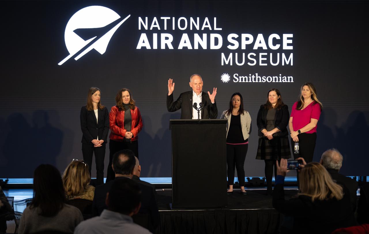
Barry Lefer, tropospheric composition program manager in the Earth Science Division of NASA’s Science Mission Directorate, at podium, answers a question during a briefing on NASA’s TEMPO (Tropospheric Emissions: Monitoring of Pollution) instrument along with Caroline Nowlan, atmospheric physicist at the Center for Astrophysics | Harvard & Smithsonian, left, Karen St. Germain, director of the Earth Science Division of NASA’s Science Mission Directorate, second from left, Laura Judd, associate program manager for the Applied Sciences Health and Air Quality Applications in the Applied Sciences Program of NASA’s Earth Science Division, third from right, Erika Wright, education specialist at the Center for Astrophysics | Harvard & Smithsonian, second from right, and Karen Fox, NASA Public Affairs Officer, right, Tuesday, March 14, 2023 at the Smithsonian’s National Air and Space Museum in Washington. NASA’s TEMPO instrument, the first Earth Venture Instrument mission, will measure air pollution across North America from Mexico City to the Canadian oil sands and from the Atlantic to the Pacific hourly and at a high spatial resolution. A partnership between NASA and the Center for Astrophysics | Harvard & Smithsonian, TEMPO will launch on a commercial satellite to geostationary orbit as early as April. Photo Credit: (NASA/Joel Kowsky)
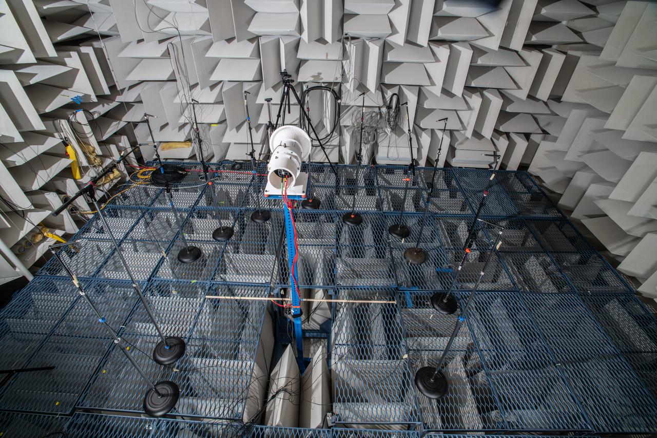
The Quiet Electric Engine V1 (QUEEN V1) experiment that was performed in the NASA GRC Acoustical Testing Laboratory (ATL). Equipment is installed in the anechoic chamber and in the adjacent control room. In response to the pervasive health and environmental problems associated with aviation noise and air pollution, NASA’s Quiet Electric Engine (QUEEN) team is working to increase the peace and quiet in the world by researching ways to make engines for large single-aisle aircraft safer, cleaner, and quieter.

The Quiet Electric Engine V1 (QUEEN V1) experiment that was performed in the NASA GRC Acoustical Testing Laboratory (ATL). Equipment is installed in the anechoic chamber and in the adjacent control room. In response to the pervasive health and environmental problems associated with aviation noise and air pollution, NASA’s Quiet Electric Engine (QUEEN) team is working to increase the peace and quiet in the world by researching ways to make engines for large single-aisle aircraft safer, cleaner, and quieter.
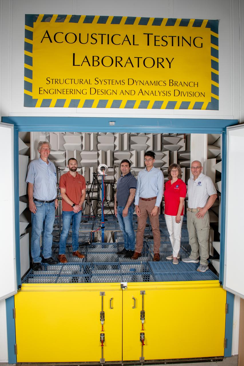
The Quiet Electric Engine V1 (QUEEN V1) experiment that was performed in the NASA GRC Acoustical Testing Laboratory (ATL). Equipment is installed in the anechoic chamber and in the adjacent control room. In response to the pervasive health and environmental problems associated with aviation noise and air pollution, NASA’s Quiet Electric Engine (QUEEN) team is working to increase the peace and quiet in the world by researching ways to make engines for large single-aisle aircraft safer, cleaner, and quieter.
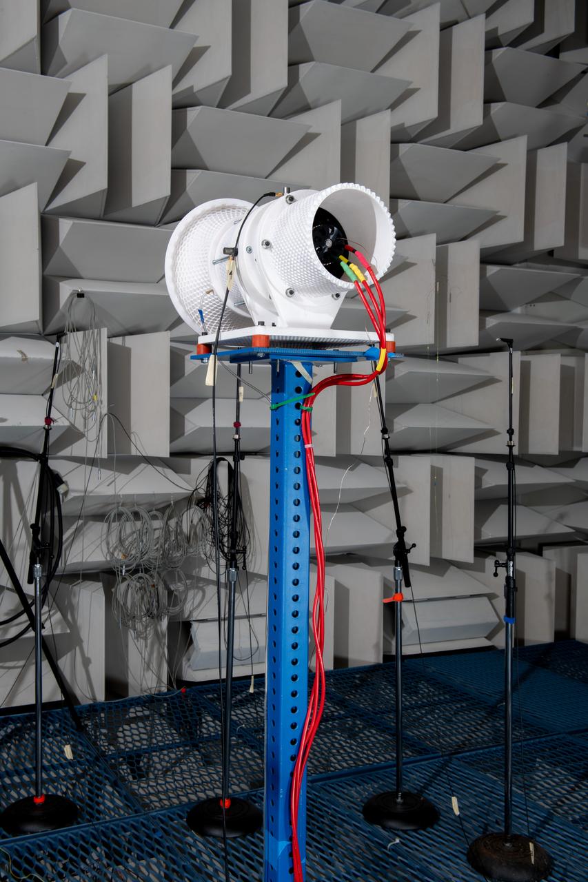
The Quiet Electric Engine V1 (QUEEN V1) experiment that was performed in the NASA GRC Acoustical Testing Laboratory (ATL). Equipment is installed in the anechoic chamber and in the adjacent control room. In response to the pervasive health and environmental problems associated with aviation noise and air pollution, NASA’s Quiet Electric Engine (QUEEN) team is working to increase the peace and quiet in the world by researching ways to make engines for large single-aisle aircraft safer, cleaner, and quieter.
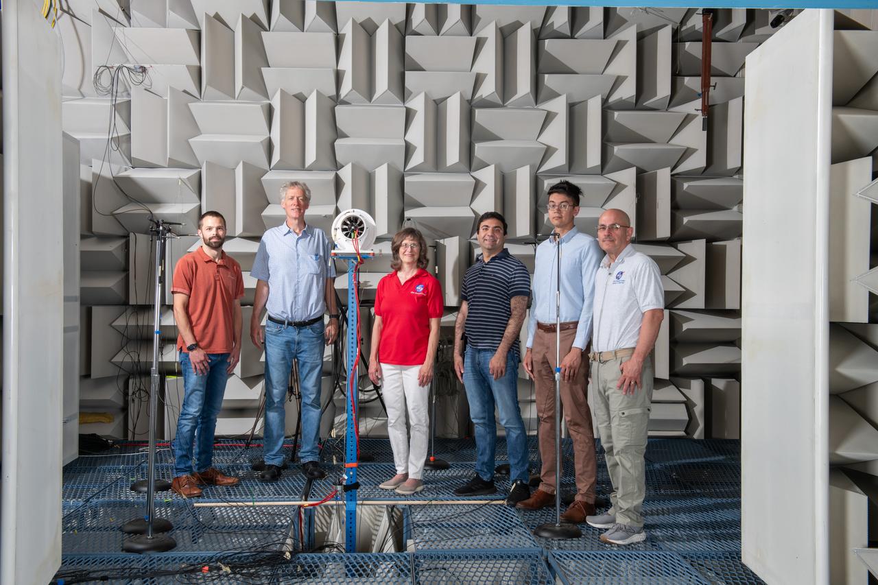
The Quiet Electric Engine V1 (QUEEN V1) experiment that was performed in the NASA GRC Acoustical Testing Laboratory (ATL). Equipment is installed in the anechoic chamber and in the adjacent control room. In response to the pervasive health and environmental problems associated with aviation noise and air pollution, NASA’s Quiet Electric Engine (QUEEN) team is working to increase the peace and quiet in the world by researching ways to make engines for large single-aisle aircraft safer, cleaner, and quieter.
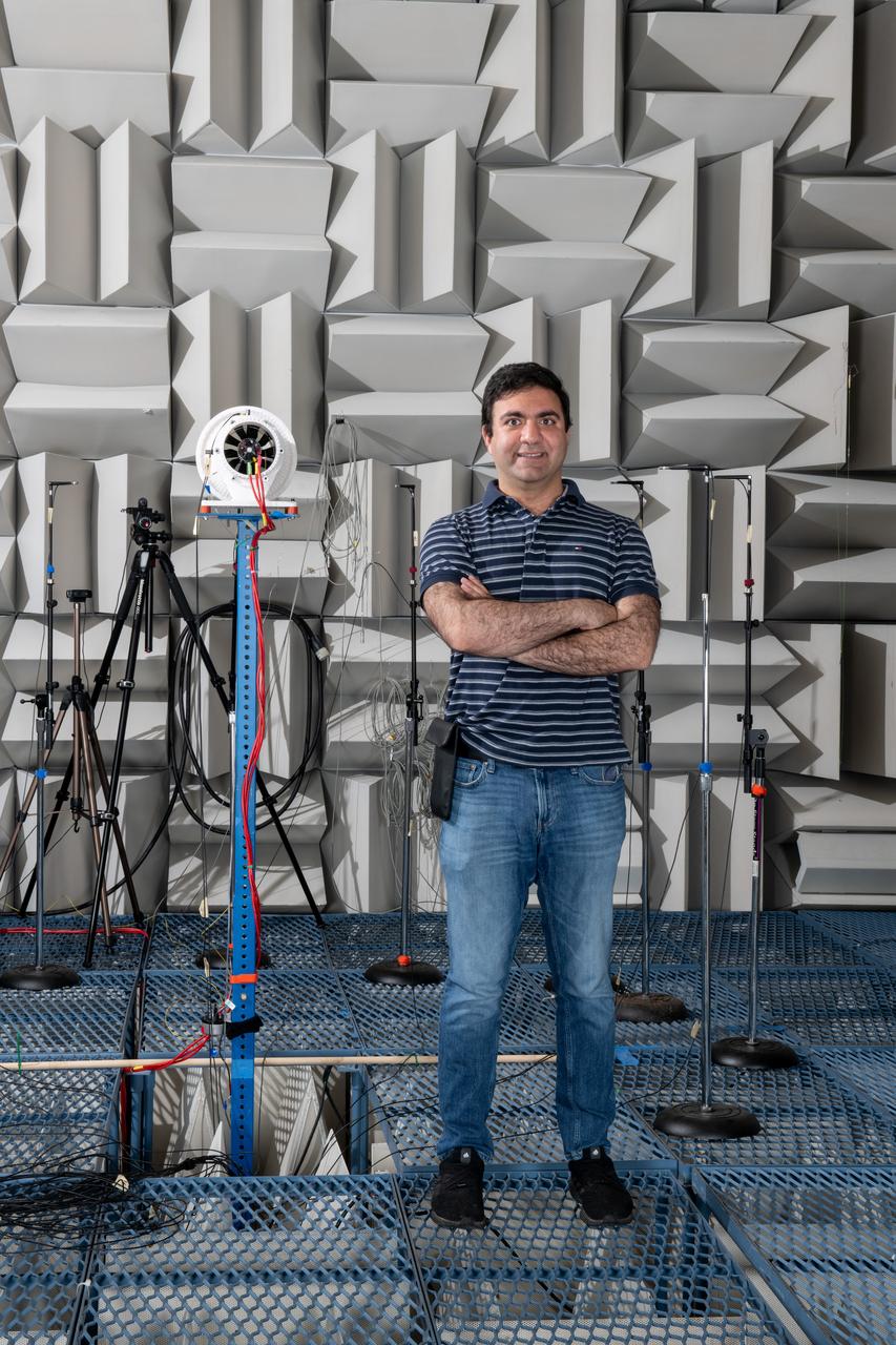
The Quiet Electric Engine V1 (QUEEN V1) experiment that was performed in the NASA GRC Acoustical Testing Laboratory (ATL). Equipment is installed in the anechoic chamber and in the adjacent control room. In response to the pervasive health and environmental problems associated with aviation noise and air pollution, NASA’s Quiet Electric Engine (QUEEN) team is working to increase the peace and quiet in the world by researching ways to make engines for large single-aisle aircraft safer, cleaner, and quieter. Posing with the experiment is aerospace engineer, Jonathan M. Goodman.
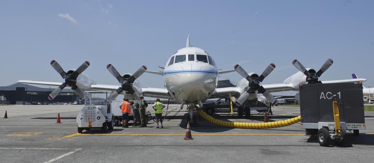
A 117-foot P-3B NASA research aircraft is seen on the tarmac at Baltimore/Washington International Thurgood Marshall Airport, Tuesday, June 28, 2011, in Baltimore, Md. The aircraft is part of a month-long field campaign designed to improve satellite measurements of air pollution. The name of the experiment -- Deriving Information on Surface conditions from Column and Vertically Resolved Observations Relevant to Air Quality (DISCOVER -- AQ) -- is a mouthful, but its purpose is simple. Come July, the aircraft will be flying spirals over six ground stations in Maryland. Photo Credit: (NASA/Paul E. Alers)
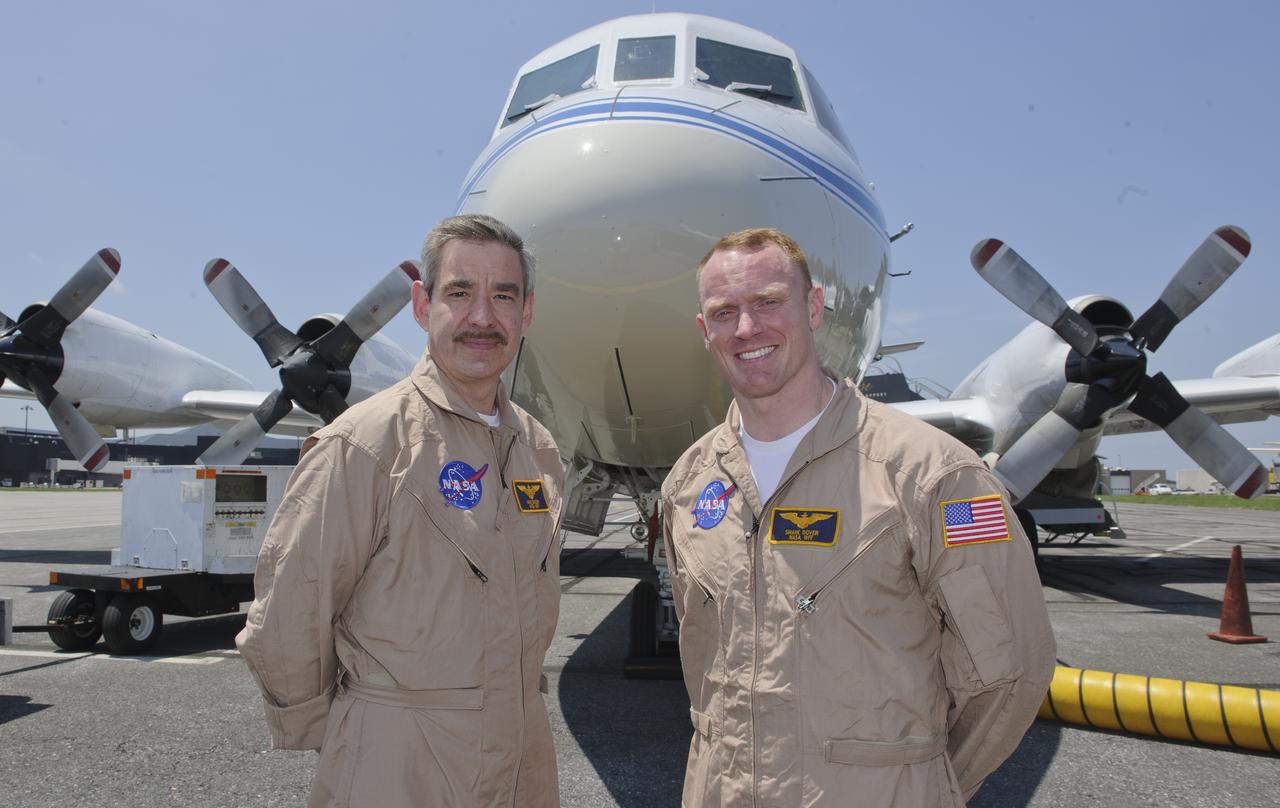
WFF Pilots Mike Singer, left, and Shane Dover stand in front of the 117-foot P-3B NASA research aircraft on the tarmac at Baltimore/Washington International Thurgood Marshall Airport, Tuesday, June 28, 2011, in Baltimore, Md. The aircraft is part of a month-long field campaign designed to improve satellite measurements of air pollution. The name of the experiment -- Deriving Information on Surface conditions from Column and Vertically Resolved Observations Relevant to Air Quality (DISCOVER -- AQ) -- is a mouthful, but its purpose is simple. Come July, the aircraft will be flying spirals over six ground stations in Maryland. Photo Credit: (NASA/Paul E. Alers)
James Crawford, principal investigator and scientist based at NASA’s Langley Research Center in Hampton, Va., talks about the DISCOVER-AQ project on board the P-3B NASA research aircraft at Baltimore/Washington International Thurgood Marshall Airport, Tuesday, June 28, 2011, in Baltimore, Md. The aircraft is part of a month-long field campaign designed to improve satellite measurements of air pollution. The name of the experiment -- Deriving Information on Surface conditions from Column and Vertically Resolved Observations Relevant to Air Quality (DISCOVER -- AQ) -- is a mouthful, but its purpose is simple. Come July, the aircraft will be flying spirals over six ground stations in Maryland. Photo Credit: (NASA/Paul E. Alers)
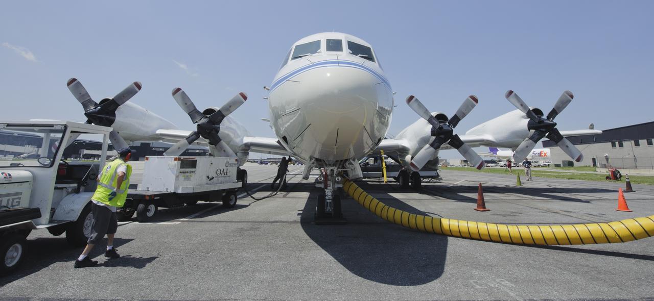
A 117-foot P-3B NASA research aircraft is seen on the tarmac at Baltimore/Washington International Thurgood Marshall Airport, Tuesday, June 28, 2011, in Baltimore, Md. The aircraft is part of a month-long field campaign designed to improve satellite measurements of air pollution. The name of the experiment -- Deriving Information on Surface conditions from Column and Vertically Resolved Observations Relevant to Air Quality (DISCOVER -- AQ) -- is a mouthful, but its purpose is simple. Come July, the aircraft will be flying spirals over six ground stations in Maryland. Photo Credit: (NASA/Paul E. Alers)
An unidentified researcher works aboard the P-3B NASA research aircraft at Baltimore/Washington International Thurgood Marshall Airport, Tuesday, June 28, 2011, in Baltimore, Md. The aircraft is part of a month-long field campaign designed to improve satellite measurements of air pollution. The name of the experiment -- Deriving Information on Surface conditions from Column and Vertically Resolved Observations Relevant to Air Quality (DISCOVER -- AQ) -- is a mouthful, but its purpose is simple. Come July, the aircraft will be flying spirals over six ground stations in Maryland. Photo Credit: (NASA/Paul E. Alers)

A 117-foot P-3B NASA research aircraft is seen on the tarmac at Baltimore/Washington International Thurgood Marshall Airport, Tuesday, June 28, 2011, in Baltimore, Md. The aircraft is part of a month-long field campaign designed to improve satellite measurements of air pollution. The name of the experiment -- Deriving Information on Surface conditions from Column and Vertically Resolved Observations Relevant to Air Quality (DISCOVER -- AQ) -- is a mouthful, but its purpose is simple. Come July, the aircraft will be flying spirals over six ground stations in Maryland. Photo Credit: (NASA/Paul E. Alers)
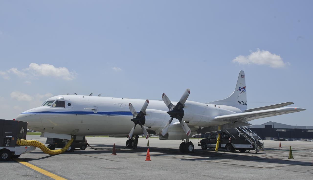
A 117-foot P-3B NASA research aircraft is seen on the tarmac at Baltimore/Washington International Thurgood Marshall Airport, Tuesday, June 28, 2011, in Baltimore, Md. The aircraft is part of a month-long field campaign designed to improve satellite measurements of air pollution. The name of the experiment -- Deriving Information on Surface conditions from Column and Vertically Resolved Observations Relevant to Air Quality (DISCOVER -- AQ) -- is a mouthful, but its purpose is simple. Come July, the aircraft will be flying spirals over six ground stations in Maryland. Photo Credit: (NASA/Paul E. Alers)

Pilots Shane Dover, left, and Mike Singer are seen on the flight deck of the P-3B NASA research aircraft at Baltimore/Washington International Thurgood Marshall Airport, Tuesday, June 28, 2011, in Baltimore, Md. The aircraft is part of a month-long field campaign designed to improve satellite measurements of air pollution. The name of the experiment -- Deriving Information on Surface conditions from Column and Vertically Resolved Observations Relevant to Air Quality (DISCOVER -- AQ) -- is a mouthful, but its purpose is simple. Come July, the aircraft will be flying spirals over six ground stations in Maryland. Photo Credit: (NASA/Paul E. Alers)
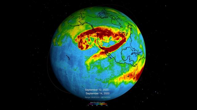
This time series shows carbon monoxide associated with fires from the Amazon region in Brazil from Aug. 8-22, 2019. The images show carbon monoxide at an hPA — a common unit of measurement for atmospheric pressure — of 500, or approximately 18,000 feet (5,500 meters) altitude, made with data collected from the Atmospheric Infrared Sounder (AIRS) on NASA's Aqua satellite. Each "day" in the series is made by averaging three day's-worth of measurements, a technique used to eliminate data gaps. As the series progresses, the carbon monoxide plume blooms in the northwest Amazon region then drifts south and east in a more concentrated plume toward Sao Paulo. Green indicates concentrations of carbon monoxide at approximately 100 parts per billion by volume (ppbv), yellow at approximately 120 ppbv, and dark red at approximately 160 ppbv. It must be noted that local values can be significantly higher. Carbon monoxide is a pollutant that can be transported large distances and persist in the atmosphere for about one month. It plays a role in both air pollution and climate change. Movie available at https://photojournal.jpl.nasa.gov/catalog/PIA23356

This cross section of the Earth's atmosphere at sunset and earth limb (24.5S, 43.5E) displays an unusual layering believed to be caused by temperature inversions which effectively concentrate smoke, dust and aerosols into narrow layers. the top of the stratosphere can be seen as the top of the white layer thought to contain volcanic debris. The purple layer is the troposphere containing smoke from landclearing biomass burning.
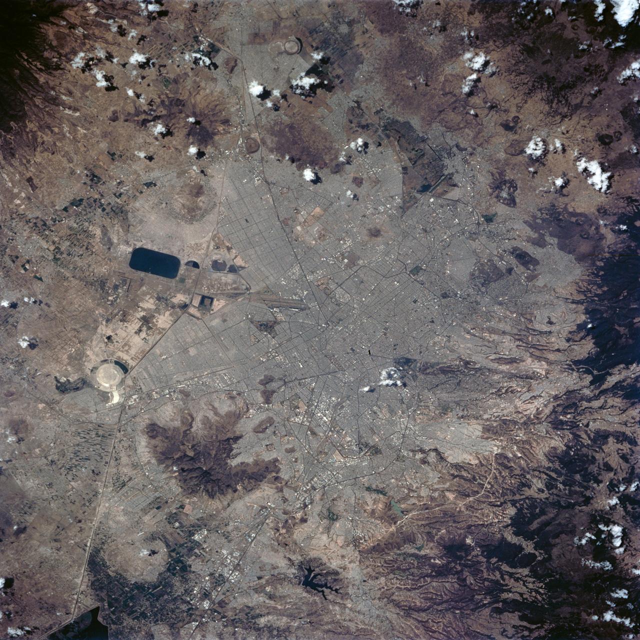
STS062-84-028 (4-18 March 1994) --- According to NASA scientists this image is the clearest photo of Mexico City taken from United States manned spacecraft. North is to the upper right. Mexico City sits in a basin surrounded by large volcanoes. The restricted atmospheric circulation in the basin, coupled with the inevitable air emissions produced by a city of 20 million people has created a critical air pollution problem for the city. In most photographs of the region, Mexico City is obscured by haze. Scientists feel the clear atmosphere in this photograph may be due, in part, to the stringent air emission restrictions now in place. The clarity of the photograph allows many key cultural features to be identified, including all of the major boulevards, the horse track (western part of the city), the university (south of the city), and the museum areas. Large, man-made ponds east of the city also stand out.
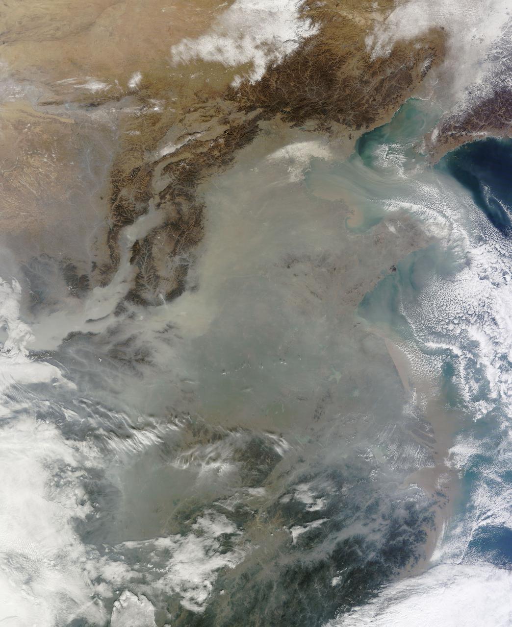
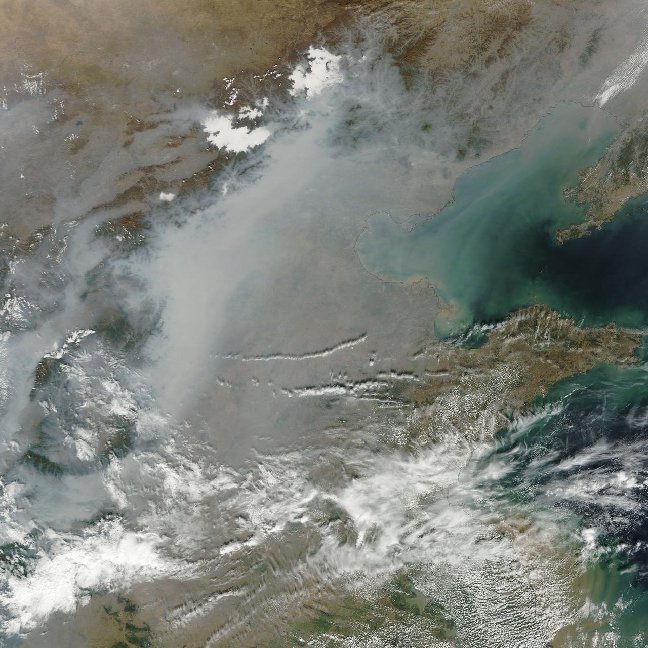
The skies over northern China were shrouded with a thick haze in late December, 2013. The Moderate Resolution Imaging Spectroradiometer (MODIS) aboard the Terra satellite captured this true-color image on December 23. The dense, gray haze obscures almost all the land and much of the coastal waters from view south and east of the Taihang Mountains. Clearer air covers the region north of the mountains, although fingers of haze roll through most river valleys. The cities of Beijing and Hebei, both west of the Bohai Sea are complete enshrouded. By December 24 the smog levels in some area exceeded World Health Organization-recommended levels by 30 times, according to Bloomberg News. The concentration of PM2.5, which are fine air particulates, were reported at 421 micrograms per cubic meter at 2 p.m. near Tiananmen Square in Beijing, while levels were 795 in Xi’an and 740 in Zhengzhou. The World Health Organization (WHO) recommends 24-hour exposure to PM2.5 concentrations no higher than 25 micrograms per cubic meter. While not the sole cause of haze and pollution, the use of coal as a very cheap energy source adds to the problem, particularly north of the Huai River. Prior to 1980, the government policy provided free coal for fuel boilers for all people living north of the Huai River. The widespread use of coal allows people in the north to stay warm in winter, but they have paid a price in air quality. According to Michael Greenstone, a Professor of Environmental Economics at Massachusetts Institute of Technology (MIT), whose research team published a paper on sustained exposure to air pollution on life expectancy in the region, air pollution, as measured by total suspended particulates, was about 55% higher north of the Huai River than south of it, for a difference of around 184 micrograms of particulate matter per cubic meter. The research, published in Proceedings of the National Academy of Sciences in July, 2013, also noted life expectancies were about 5.5 years lower in the north, owing to an increased incidence of cardiorespiratory mortality. Air pollution is an on-going issue for the government of China, and Beijing’s Five-Year Clean Air Action Plan aims to reduce overall particle density by over 25 percent on the PM2.5 scale by 2017, and also takes aim at shutting down all coal-burning plants. Credit: NASA/GSFC/Jeff Schmaltz/MODIS Land Rapid Response Team <b><a href="http://www.nasa.gov/audience/formedia/features/MP_Photo_Guidelines.html" rel="nofollow">NASA image use policy.</a></b> <b><a href="http://www.nasa.gov/centers/goddard/home/index.html" rel="nofollow">NASA Goddard Space Flight Center</a></b> enables NASA’s mission through four scientific endeavors: Earth Science, Heliophysics, Solar System Exploration, and Astrophysics. Goddard plays a leading role in NASA’s accomplishments by contributing compelling scientific knowledge to advance the Agency’s mission. <b>Follow us on <a href="http://twitter.com/NASA_GoddardPix" rel="nofollow">Twitter</a></b> <b>Like us on <a href="http://www.facebook.com/pages/Greenbelt-MD/NASA-Goddard/395013845897?ref=tsd" rel="nofollow">Facebook</a></b> <b>Find us on <a href="http://instagram.com/nasagoddard?vm=grid" rel="nofollow">Instagram</a></b>
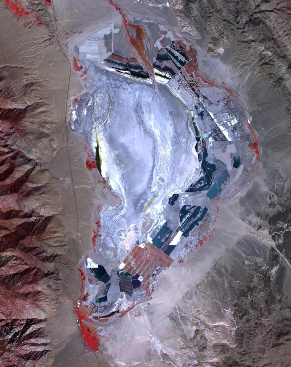
Prior to 1913, Owens Lake in eastern California had water up to a depth of 15 m, and covered an area of 280 km2. With the construction of the Los Angeles Aqueduct, all of the water from the Owens River was diverted to Los Angeles, and the lake dessicated, leading to dust storms that caused the worst air pollution in the state. Starting in 2002, various mitigation efforts were undertaken, including re-vegetation, flooding to create shallow ponds, and surface saturation to rehydrate the top layers. The ASTER image was acquired on September 29, 2020. It covers an area of 25.6 by 32.3 km, and is located at 36.4 degrees north, 117.9 degrees west. https://photojournal.jpl.nasa.gov/catalog/PIA24733
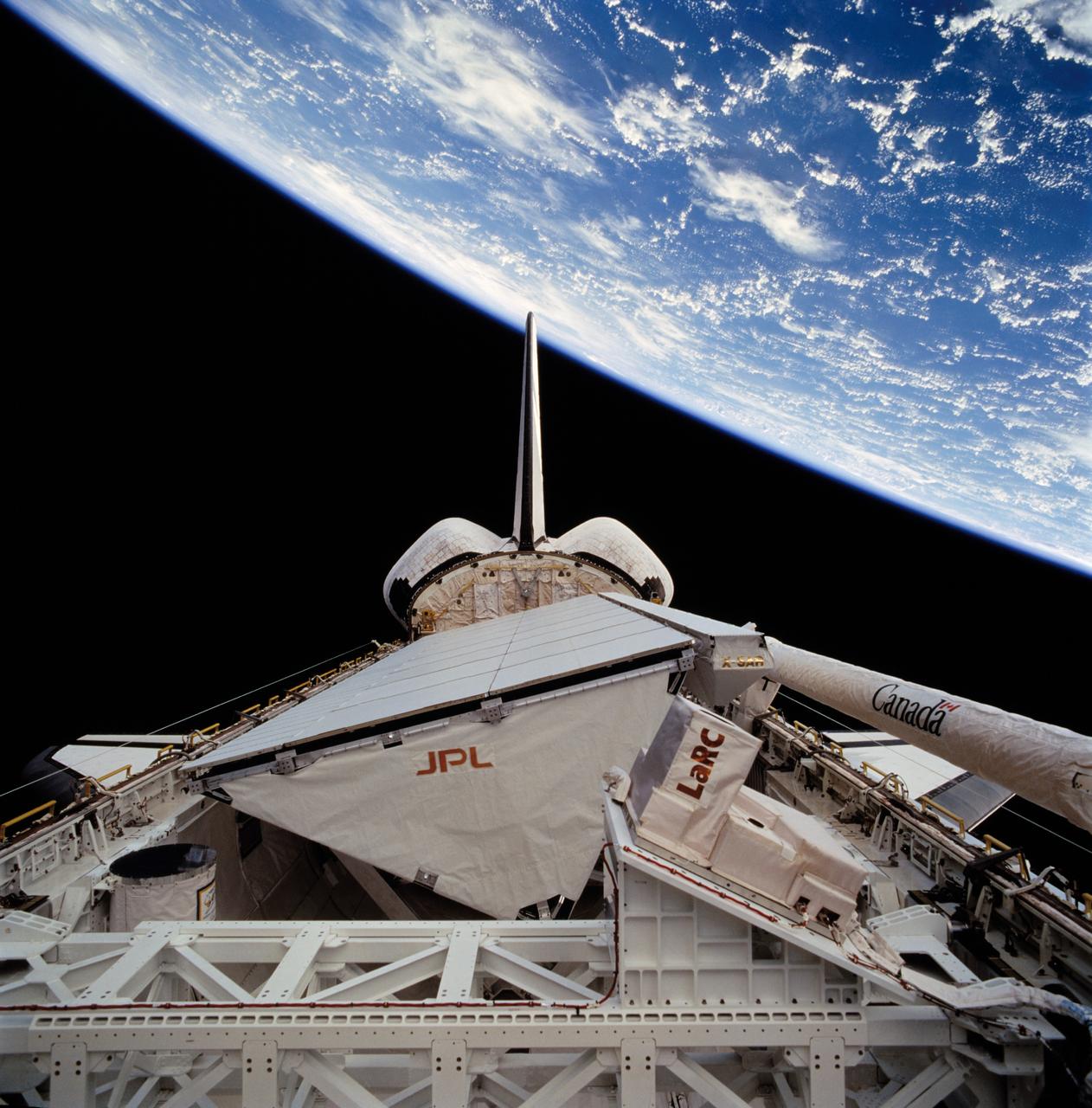
STS068-272-075 (30 September-11 October 1994) --- The darkness of space forms the backdrop for this scene of the Space Shuttle Endeavour's cargo bay, 115 nautical miles above a cloud covered Indian Ocean. The Space Radar Laboratory (SRL-2) Multipurpose Experiment Support Structure (MPESS) is seen at bottom frame. Also partially seen are other experiments including other components of the primary payload. They are the antenna for the Spaceborne Imaging Radar (SIR-C), the X-band Synthetic Aperture Radar (X-SAR), the device for Measurement of Air Pollution from Satellites (MAPS) and some Getaway Special (GAS) canisters.
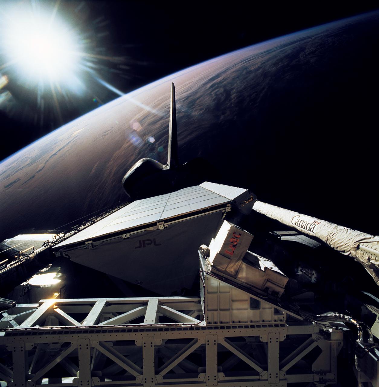
STS068-267-079 (30 September-11 October 1994) --- The rear windows of the Space Shuttle Endeavour reflect sunlight in this view of part of the cargo bay, 115 nautical miles above the Earth. The Space Radar Laboratory (SRL-2) Multipurpose Experiment Support Structure (MPESS) is seen at bottom frame. Also partially seen are other experiments including other components of the primary payload. They are the antenna for the Spaceborne Imaging Radar (SIR-C), the X-band Synthetic Aperture Radar (X-SAR), the device for Measurement of Air Pollution from Satellites (MAPS) and some Getaway Special (GAS) canisters.

ISS011-E-12401 (10 July 2005) --- Gulf of Finland is featured in this image photographed by an Expedition 11 crew member on the international space station. This strongly oblique view shows the Gulf of Finland and Lake Ladoga in the sunglint of late afternoon. The image was taken from the station when the position of the craft lay north of the Caspian Sea, approximately 2,500 kilometers to the southeast on the Russia–Kazakhstan border. The Neva River appears in sunglint, connecting Lake Ladoga to the gulf. Although not visible, St. Petersburg—the home town of Sergei Krikalev, space station commander when this picture was taken—lies on the Neva River delta. In this view taken with a powerful 400 millimeter lens, sunglint even reveals the causeways to Kotlin Island in the gulf—including some of the details of their construction. Oblique views reveal marked layers of gray haze generated by air pollution, a common sight over Western Europe. Pollution also renders the bright glint areas a copper color.
NASA's Atmospheric Infrared Sounder (AIRS), which is aboard the Aqua satellite, captured carbon monoxide plumes coming from California wildfires last week. There were 28 major wildfires burning across the state as of Sept. 14. This includes the August Complex Fire, which started on Aug. 17 and has since burned over 471,000 acres, making it the largest fire on record in California. The animation shows three-day averages of carbon monoxide concentrations around 3 miles (5 kilometers) up in the atmosphere between Sept. 6 and 14. The red and orange areas indicate regions with extremely high carbon monoxide concentrations of greater than 350 parts per billion by volume (ppbv). The more normal, background concentrations of carbon monoxide show up as yellow and green, with amounts between 30 and 50 ppbv. A pollutant that can travel large distances, carbon monoxide can persist in the atmosphere for about a month. At the high altitude mapped in these images, the gas has little effect on the air we breathe; however, strong winds can carry it downward to where it can significantly impact air quality. Carbon monoxide plays a role in both air pollution and climate change. The intense heat from the wildfires lofted the carbon monoxide high into the atmosphere, enabling detection by the AIRS instrument. The jet stream then blew the carbon monoxide plume eastward across the U.S. and over the Atlantic Ocean. Movie available at https://photojournal.jpl.nasa.gov/catalog/PIA23789
JPL-led study shows bromine explosion on March 13, 2008 across the Alaskan North Slope looking south toward the Brooks Range at the horizon, which blocked the bromine from going further south into the Alaskan interior.
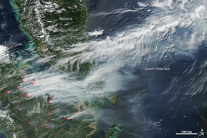
On June 19, 2013, NASA’s Aqua satellite captured a striking image of smoke billowing from illegal wildfires on the Indonesian island of Sumatra. The smoke blew east toward southern Malaysia and Singapore, and news media reported that thick clouds of haze had descended on Singapore, pushing pollution levels to record levels. Singapore’s primary measure of pollution, the Pollutant Standards Index (PSI)—a uniform measure of key pollutants similar to the Air Quality Index (AQI) used by the U.S. Environmental Protection Agency—spiked to 371 on the afternoon of June 20, 2013, the highest level ever recorded. The previous record occurred in 1997, when the index hit 226. Health experts consider any level above 300 to be “hazardous” to human health. Levels above 200 are considered “very unhealthy.” The image above was captured by the Moderate Resolution Imaging Spectroradiometer (MODIS), an instrument that observes the entire surface of Earth’s every 1 to 2 days. The image was captured during the afternoon at 6:30 UTC (2:30 p.m. local time). Though local laws prohibit it, farmers in Sumatra often burn forests during the dry season to prepare soil for new crops. The BBC reported that Singapore’s Prime Minister Lee Hsien Loong warned that the haze could “easily last for several weeks and quite possibly longer until the dry season ends in Sumatra.” NASA image by Jeff Schmaltz, LANCE/EOSDIS Rapid Response. Caption by Adam Voiland. Credit: <b><a href="http://www.earthobservatory.nasa.gov/" rel="nofollow"> NASA Earth Observatory</a></b> Instrument: Aqua - MODIS <b><a href="http://www.nasa.gov/audience/formedia/features/MP_Photo_Guidelines.html" rel="nofollow">NASA image use policy.</a></b> <b><a href="http://www.nasa.gov/centers/goddard/home/index.html" rel="nofollow">NASA Goddard Space Flight Center</a></b> enables NASA’s mission through four scientific endeavors: Earth Science, Heliophysics, Solar System Exploration, and Astrophysics. Goddard plays a leading role in NASA’s accomplishments by contributing compelling scientific knowledge to advance the Agency’s mission. <b>Follow us on <a href="http://twitter.com/NASA_GoddardPix" rel="nofollow">Twitter</a></b> <b>Like us on <a href="http://www.facebook.com/pages/Greenbelt-MD/NASA-Goddard/395013845897?ref=tsd" rel="nofollow">Facebook</a></b> <b>Find us on <a href="http://instagram.com/nasagoddard?vm=grid" rel="nofollow">Instagram</a></b>
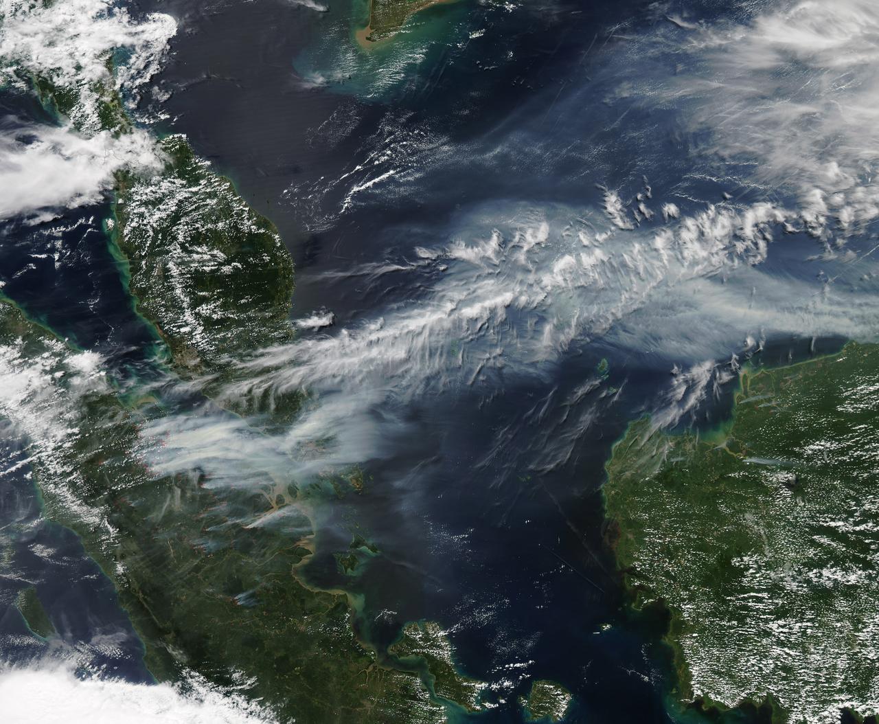
On June 19, 2013, NASA’s Aqua satellite captured a striking image of smoke billowing from illegal wildfires on the Indonesian island of Sumatra. The smoke blew east toward southern Malaysia and Singapore, and news media reported that thick clouds of haze had descended on Singapore, pushing pollution levels to record levels. Singapore’s primary measure of pollution, the Pollutant Standards Index (PSI)—a uniform measure of key pollutants similar to the Air Quality Index (AQI) used by the U.S. Environmental Protection Agency—spiked to 371 on the afternoon of June 20, 2013, the highest level ever recorded. The previous record occurred in 1997, when the index hit 226. Health experts consider any level above 300 to be “hazardous” to human health. Levels above 200 are considered “very unhealthy.” The image above was captured by the Moderate Resolution Imaging Spectroradiometer (MODIS), an instrument that observes the entire surface of Earth’s every 1 to 2 days. The image was captured during the afternoon at 6:30 UTC (2:30 p.m. local time). Though local laws prohibit it, farmers in Sumatra often burn forests during the dry season to prepare soil for new crops. The BBC reported that Singapore’s Prime Minister Lee Hsien Loong warned that the haze could “easily last for several weeks and quite possibly longer until the dry season ends in Sumatra.” NASA image by Jeff Schmaltz, LANCE/EOSDIS Rapid Response. Caption by Adam Voiland. Credit: <b><a href="http://www.earthobservatory.nasa.gov/" rel="nofollow"> NASA Earth Observatory</a></b> Instrument: Aqua - MODIS <b><a href="http://www.nasa.gov/audience/formedia/features/MP_Photo_Guidelines.html" rel="nofollow">NASA image use policy.</a></b> <b><a href="http://www.nasa.gov/centers/goddard/home/index.html" rel="nofollow">NASA Goddard Space Flight Center</a></b> enables NASA’s mission through four scientific endeavors: Earth Science, Heliophysics, Solar System Exploration, and Astrophysics. Goddard plays a leading role in NASA’s accomplishments by contributing compelling scientific knowledge to advance the Agency’s mission. <b>Follow us on <a href="http://twitter.com/NASA_GoddardPix" rel="nofollow">Twitter</a></b> <b>Like us on <a href="http://www.facebook.com/pages/Greenbelt-MD/NASA-Goddard/395013845897?ref=tsd" rel="nofollow">Facebook</a></b> <b>Find us on <a href="http://instagram.com/nasagoddard?vm=grid" rel="nofollow">Instagram</a></b>
The National Aeronautics and Space Administration (NASA) Lewis Research Center’s Convair F-106B Delta Dart equipped with air sampling equipment in the mid-1970s. NASA Lewis created and managed the Global Air Sampling Program (GASP) in 1972 in partnership with several airline companies. NASA researchers used the airliners’ Boeing 747 aircraft to gather air samples to determine the amount of pollution present in the stratosphere. Private companies developed the air sampling equipment for the GASP program, and Lewis created a particle collector. The collector was flight tested on NASA Lewis’ F-106B in the summer of 1973. The sampling equipment was automatically operated once the proper altitude was achieved. The sampling instruments collected dust particles in the air so their chemical composition could be analyzed. The equipment analyzed one second’s worth of data at a time. The researchers also monitored carbon monoxide, monozide, ozone, and water vapor. The 747 flights began in December 1974 and soon included four airlines flying routes all over the globe. The F-106B augmented the airline data with sampling of its own, seen here. It gathered samples throughout this period from locations such as New Mexico, Texas, Michigan, and Ohio. In July 1977 the F-106B flew eight GASP flights in nine days over Alaska to supplement the earlier data gathered by the airlines.
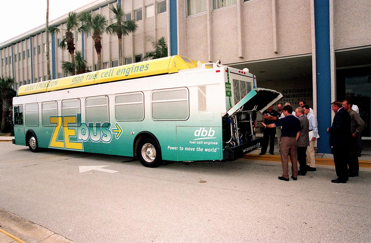
KSC workers, with Center Director Roy Bridges (at right next to bus), head for the open door of the Zero Emissions (ZE) transit bus and a ride around the center. Provided by dbb fuel cell engines inc. of Vancouver, Canada, the ZE bus was brought to KSC as part of the Center's Alternative Fuel Initiatives Program. The bus uses a Proton Exchange Membrane fuel cell in which hydrogen and oxygen, from atmospheric air, react to produce electricity that powers an electric motor drive system. The by-product "exhaust" from the fuel cell is water vapor, thus zero harmful emissions. A typical diesel-powered bus emits more than a ton of harmful pollutants from its exhaust every year. Available to employees for viewing and a ride, the ZE bus is also being used on tour routes at the KSC Visitor Complex Oct. 26-27
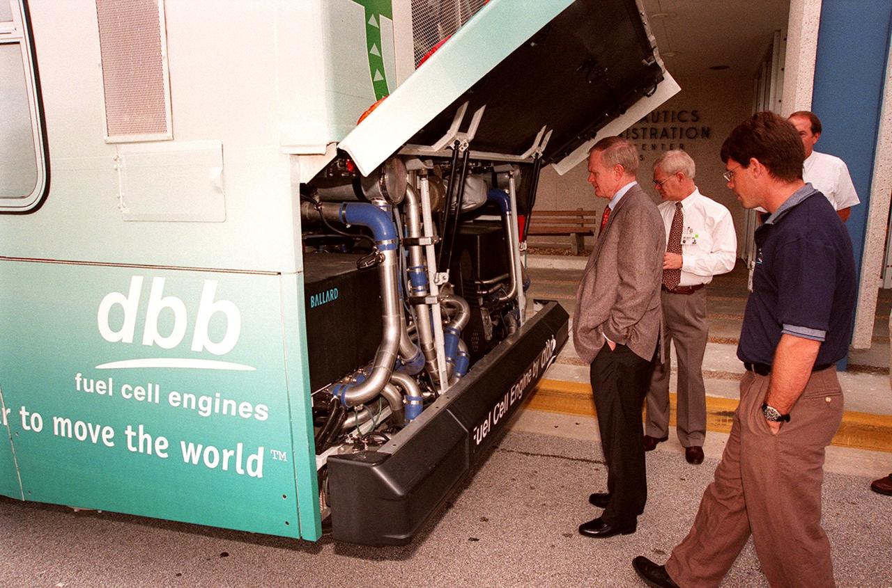
In front of the Headquarters Building at KSC, Center Director Roy Bridges (left) looks at the hydrogen-oxygen driven engine powering a Zero Emissions (ZE) transit bus. Provided by dbb fuel cell engines inc. of Vancouver, Canada, the ZE bus was brought to KSC as part of the Center's Alternative Fuel Initiatives Program. The bus uses a Proton Exchange Membrane fuel cell in which hydrogen and oxygen, from atmospheric air, react to produce electricity that powers an electric motor drive system. The by-product "exhaust" from the fuel cell is water vapor, thus zero harmful emissions. A typical diesel-powered bus emits more than a ton of harmful pollutants from its exhaust every year. Available for viewing by employees, the ZE bus is also being used on tour routes at the KSC Visitor Complex Oct. 26-27
On view in front of the Headquarters Building, the Zero Emissions (ZE) transit bus attracts an interested group of employees, including Center Director Roy Bridges (second from left in foreground). Provided by dbb fuel cell engines inc. of Vancouver, Canada, the ZE bus was brought to KSC as part of the Center's Alternative Fuel Initiatives Program. The bus uses a Proton Exchange Membrane fuel cell in which hydrogen and oxygen, from atmospheric air, react to produce electricity that powers an electric motor drive system. The by-product "exhaust" from the fuel cell is water vapor, thus zero harmful emissions. A typical diesel-powered bus emits more than a ton of harmful pollutants from its exhaust every year. Available for viewing by employees, the ZE bus is also being used on tour routes at the KSC Visitor Complex Oct. 26-27
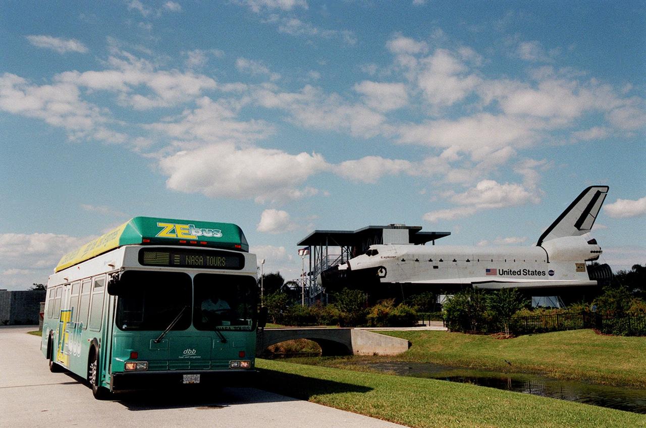
The Zero Emissions (ZE) transit bus passes a mock-up orbiter named Explorer on a trek through the KSC Visitor Complex. Provided by dbb fuel cell engines inc. of Vancouver, Canada, the ZE bus was brought to KSC as part of the Center's Alternative Fuel Initiatives Program. The bus uses a Proton Exchange Membrane fuel cell in which hydrogen and oxygen, from atmospheric air, react to produce electricity that powers an electric motor drive system. The by-product "exhaust" from the fuel cell is water vapor, thus zero harmful emissions. A typical diesel-powered bus emits more than a ton of harmful pollutants from its exhaust every year. The ZE bus is being used on tour routes at the KSC Visitor Complex for two days to introduce the public to the concept
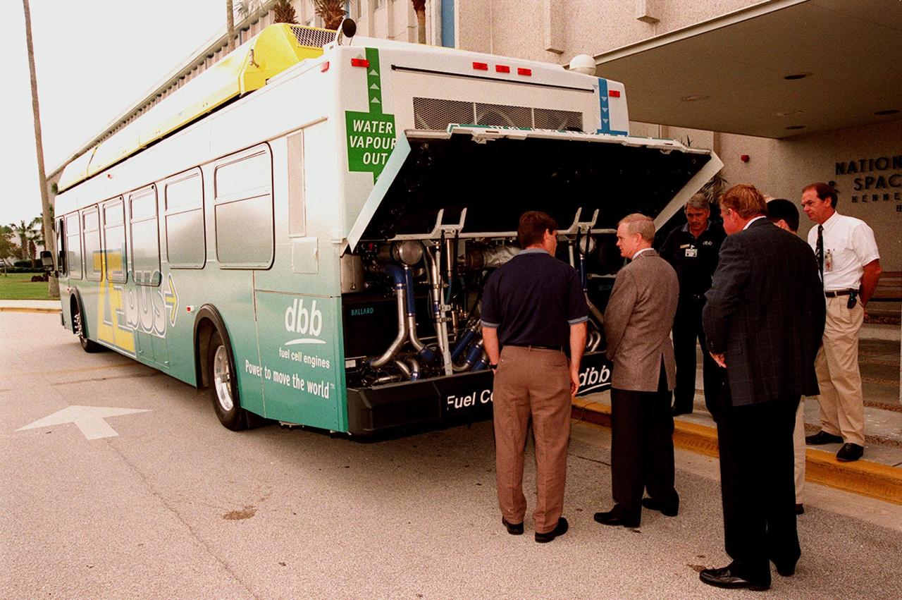
KSC employees, along with Center Director Roy Bridges (second from left), view the hydrogen-oxygen driven engine powering a Zero Emissions (ZE) transit bus. Provided by dbb fuel cell engines inc. of Vancouver, Canada, the ZE bus was brought to KSC as part of the Center's Alternative Fuel Initiatives Program. The bus uses a Proton Exchange Membrane fuel cell in which hydrogen and oxygen, from atmospheric air, react to produce electricity that powers an electric motor drive system. The by-product "exhaust" from the fuel cell is water vapor, thus zero harmful emissions. A typical diesel-powered bus emits more than a ton of harmful pollutants from its exhaust every year. Available for viewing by employees, the ZE bus is also being used on tour routes at the KSC Visitor Complex Oct. 26-27
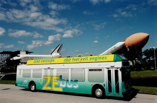
The Zero Emissions (ZE) transit bus tours the KSC Visitor Complex for a test ride. In the background are a mock-up orbiter named Explorer (left) and a stack of solid rocket boosters and external tank (right), typically used on Shuttle launches. Provided by dbb fuel cell engines inc. of Vancouver, Canada, the ZE bus was brought to KSC as part of the Center's Alternative Fuel Initiatives Program. The bus uses a Proton Exchange Membrane fuel cell in which hydrogen and oxygen, from atmospheric air, react to produce electricity that powers an electric motor drive system. The by-product "exhaust" from the fuel cell is water vapor, thus zero harmful emissions. A typical diesel-powered bus emits more than a ton of harmful pollutants from its exhaust every year. The ZE bus is being used on tour routes at the KSC Visitor Complex for two days to introduce the public to the concept

The takeoff set the stage for a two-day Helios endurance flight in the stratosphere planned for mid-July. The Helios wing, spanning 247 feet and weighing about 2,400 pounds, is giving NASA and industry engineers confidence that remotely piloted aircraft will be able to stay aloft for weeks at a time, providing environmental monitoring capabilities and telecommunications relay services Helios is an all-electric airplane. In addition to being non-polluting, Helios can fly above storms, and use the power of the sun to stay aloft during daylight. Key to the success of this type of aircraft is the ability to fly in darkness, using fuel cells when sunlight cannot furnish energy. Helios flew over the Navy's Pacific Missile Range Facility where favorable sun exposure and test ranges closed to other air traffic benefited the NASA research effort. In 2003 the aircraft was lost to a crash.
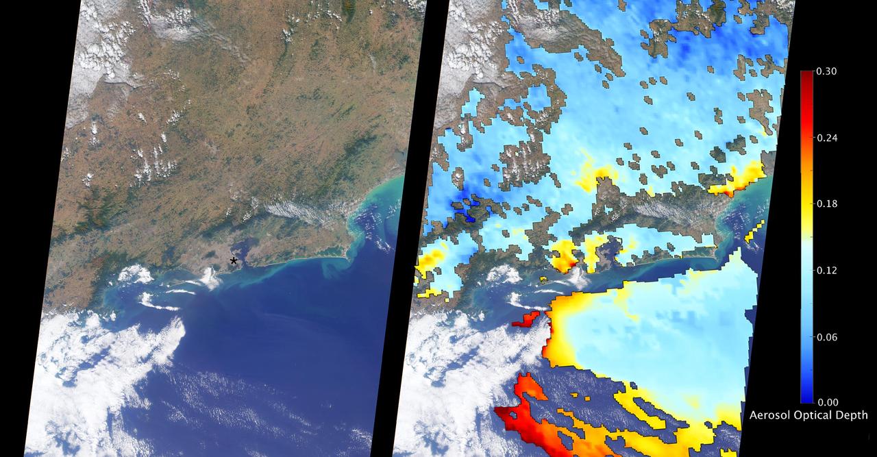
The Multi-angle Imaging SpectroRadiometer (MISR) instrument aboard NASA's Terra satellite passed directly over Rio de Janeiro, Brazil, on Aug. 2, 2016, just prior to the opening of the Summer Olympic Games. On the left is an image from MISR's nadir (downward-looking) camera; the width of the image is 235 miles (378 kilometers), and Rio de Janeiro is visible as the large gray area on the coast in the center. The black asterisk marks the location of the Maracanã Stadium in downtown, where the opening ceremonies were held. In the weeks leading up to the Aug. 5 opening ceremonies in Rio de Janeiro, there have been reports of elevated levels of particulate matter in the region. Particulate matter refers to tiny airborne droplets or pieces of soot and dust that can end up in the lungs, comprising an all-too-common problem for many cities around the world. MISR data are routinely used to estimate the amount of air pollution via measurements of aerosol optical depth, which is a measure of how much incoming light from the sun is blocked by particles in the atmosphere. On the right, a map of aerosol optical depth is superimposed on the image. Individual squares making up this map measure 2.7 miles (4.4 kilometers) on a side, and holes in the map occur where an aerosol amount could not be determined, such as where clouds are present. Optical depth over Rio is slightly elevated compared to its surroundings, most likely due to the presence of air pollution, with values from 0.15-0.25. For reference, an optical depth of 0.2 corresponds to light haze. The product shown here is a prototype of a new version of the MISR aerosol product to be publicly released in the near future, and increases the spatial resolution of the aerosol information by a factor of 16 compared to the currently available product, making it possible to observe the fine details of optical depth over urban areas. These data were captured during Terra orbit 88426. http://photojournal.jpl.nasa.gov/catalog/PIA20885
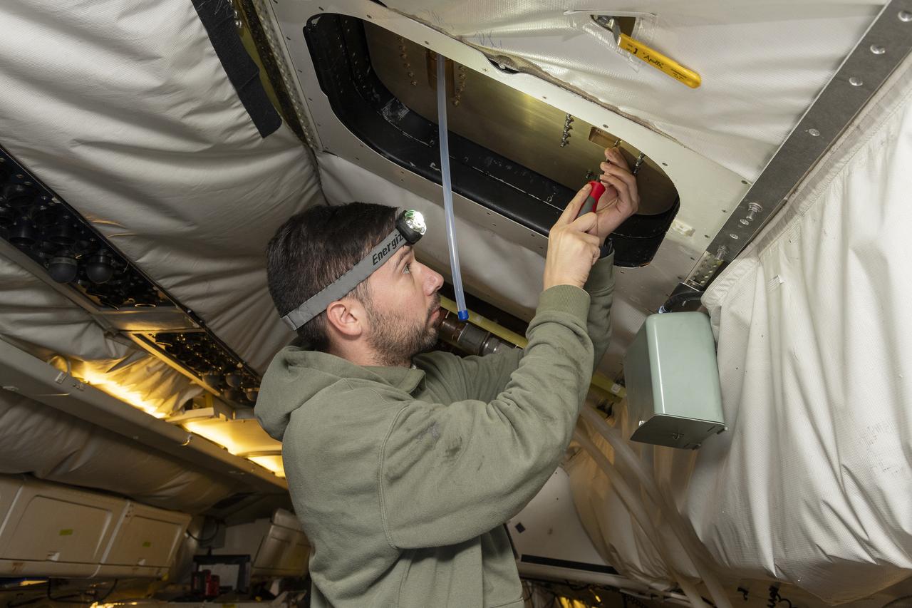
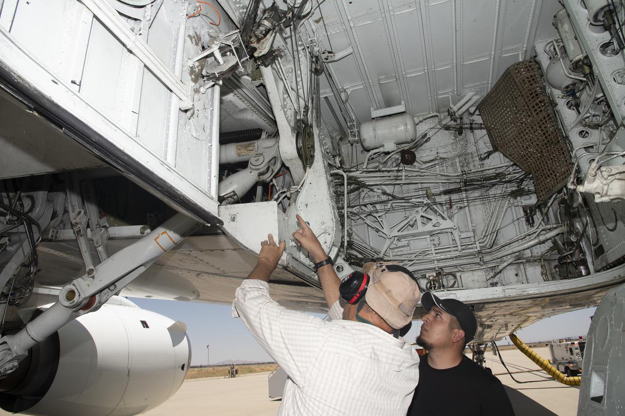
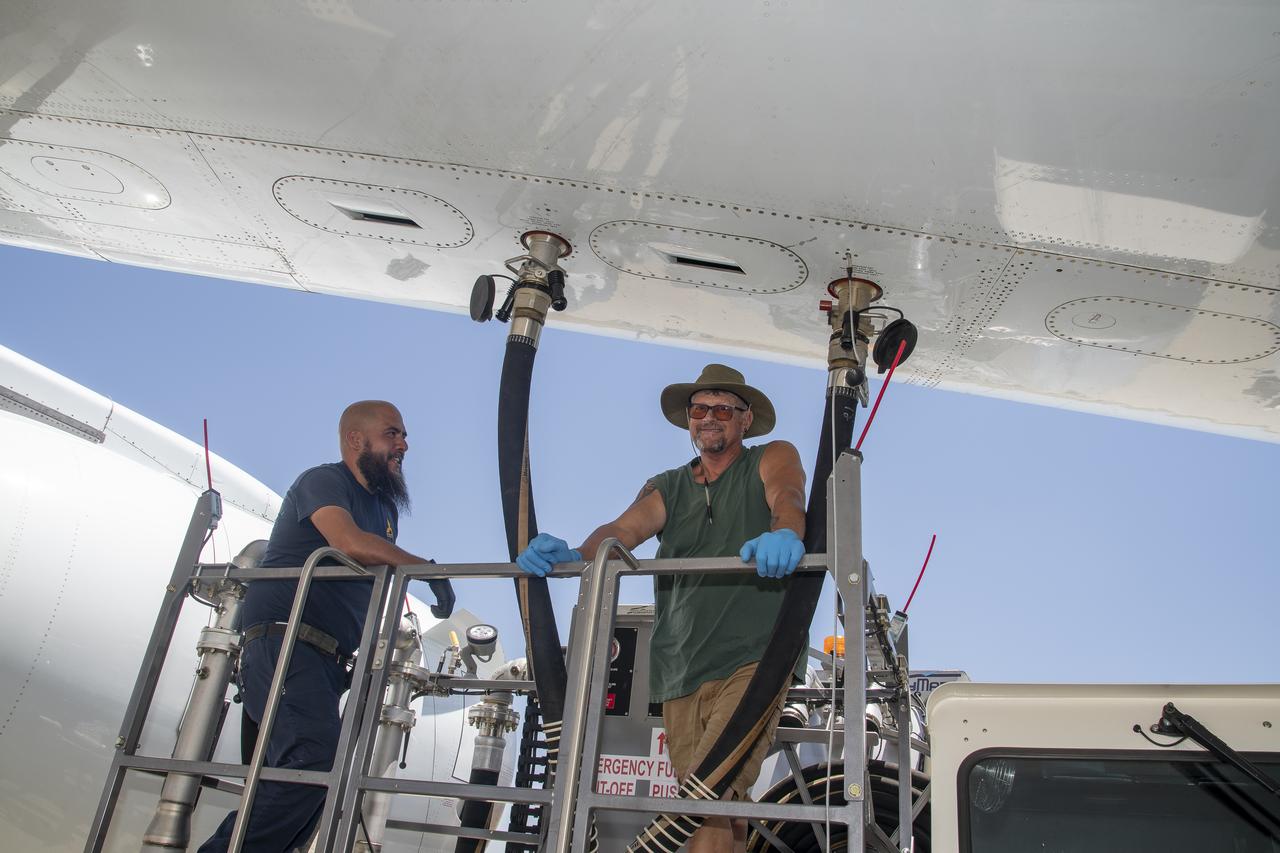
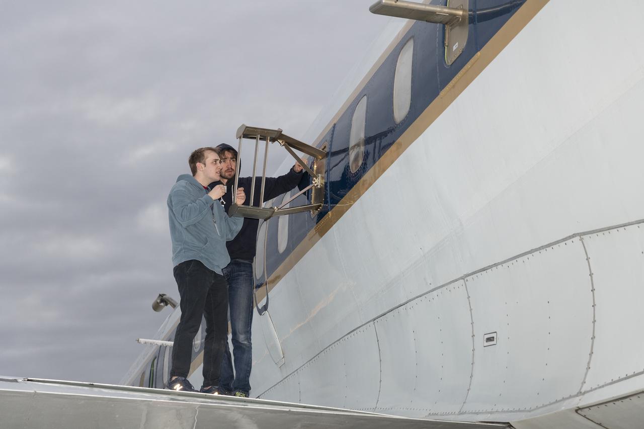
Isac Mata, engineering technician at NASA’s Armstrong Flight Research Center, attends to the interior of the DC-8 aircraft at Building 703 in Palmdale, CA. The DC-8 aircraft is prepared for its last mission, ASIA-AQ (Airborne and Satellite Investigation of Asian Air Quality), that will collect detailed air quality data over several locations in Asia to improve the understanding of local air quality in collaboration with local scientists, air quality agencies, and government partners
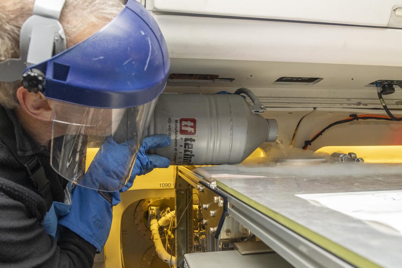
Alan Hills fills liquid nitrogen in the Trace Organic Gas Analyzer (TOGA) instrument onboard the DC-8 aircraft at Building 703 in Palmdale, CA. This instrument measures volatile organic compounds (VOCs) in the atmosphere. The DC-8 aircraft is prepared for its last mission, ASIA-AQ (Airborne and Satellite Investigation of Asian Air Quality), that will collect detailed air quality data over several locations in Asia to improve the understanding of local air quality in collaboration with local scientists, air quality agencies, and government partners
DC-8 aircraft conducts test flights at Building 703 in Palmdale, CA. The DC-8 aircraft is prepared for its last mission, ASIA-AQ (Airborne and Satellite Investigation of Asian Air Quality), that will collect detailed air quality data over several locations in Asia to improve the understanding of local air quality in collaboration with local scientists, air quality agencies, and government partners
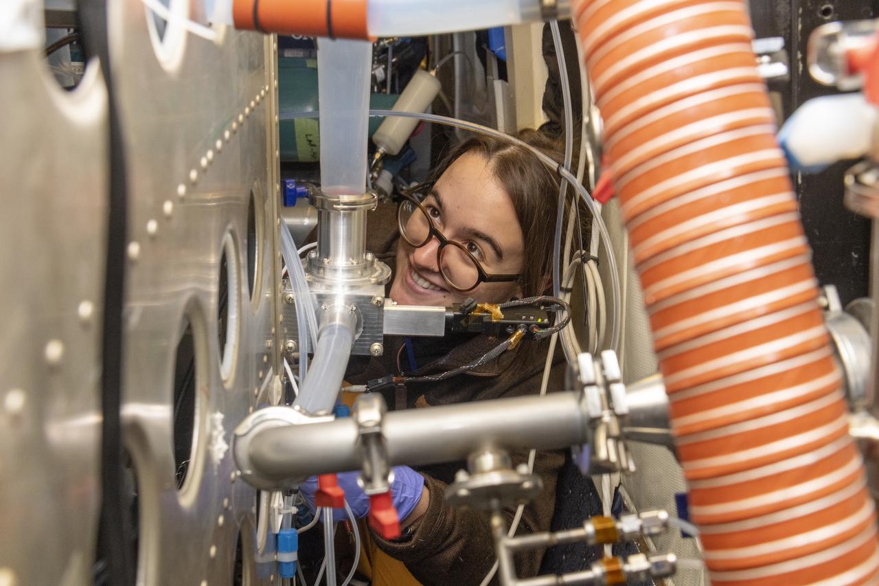
Kat Ball, Chemical Engineering Ph.D candidate at Caltech, attends to the Chemical Ionization Mass Spectrometer (CIMS) rack onboard the DC-8 aircraft at Building 703 in Palmdale, CA. The DC-8 aircraft is prepared for its last mission, ASIA-AQ (Airborne and Satellite Investigation of Asian Air Quality), that will collect detailed air quality data over several locations in Asia to improve the understanding of local air quality in collaboration with local scientists, air quality agencies, and government partners
DC-8 aircraft conducts test flights at Building 703 in Palmdale, CA. The DC-8 aircraft is prepared for its last mission, ASIA-AQ (Airborne and Satellite Investigation of Asian Air Quality), that will collect detailed air quality data over several locations in Asia to improve the understanding of local air quality in collaboration with local scientists, air quality agencies, and government partners
Scientists Ryan Boyd (left) and Vladislav Sevostianov (right) attend to the Optical Payload for Lasercomm Science (OPALS) instrument on the exterior the DC-8 aircraft at Building 703 in Palmdale, CA. The DC-8 aircraft is prepared for its last mission, ASIA-AQ (Airborne and Satellite Investigation of Asian Air Quality), that will collect detailed air quality data over several locations in Asia to improve the understanding of local air quality in collaboration with local scientists, air quality agencies, and government partners
Kirsten Boogaard, Deputy Project Manager for the DC-8 aircraft, leads and manages project planning, integration and resources for airborne science missions since 2020
A thick layer of haze blanketed the North China Plain on October 9, 2014, when the Moderate Resolution Imaging Spectroradiometer (MODIS) on NASA’s Terra satellite acquired this natural-color image at 2:50 Coordinated Universal Time (10:50 a.m. local time). The haze obscured many features usually visible in MODIS imagery of the area, including China’s largest city, Beijing. On the day this image was acquired, measurements from ground-based sensors at the U.S. Consulate in Beijing reported PM2.5 measurements of 334 micrograms per cubic meter of air. Fine, airborne particulate matter (PM) that is smaller than 2.5 microns (about one thirtieth the width of a human hair) is considered dangerous because it is small enough to enter the passages of the human lungs. Most PM2.5 aerosol particles come from the burning of fossil fuels and biomass (wood fires and agricultural burning). The World Health Organization considers PM2.5 to be safe when it is below 25. Haze in this region tends to worsen in the fall and winter, when cold, heavy air traps pollutants near the surface. In this case, the haze was likely trapped by a temperature inversion. Normally, air is warmest near the surface of the Earth. Occasionally, a mass of warm air will move over cooler air so that the atmosphere actually warms with altitude. Since the cool air does not have the energy to rise through the warm air, vertical circulation slows and air becomes trapped near the surface. Any pollutant that enters the air gets trapped as well, and haze builds up over time. Daily satellite images of the North China Plain show that visible haze began to accumulate on October 7, 2014. NASA image courtesy Jeff Schmaltz, LANCE MODIS Rapid Response. Caption by Adam Voiland. Read more: <a href="http://earthobservatory.nasa.gov/NaturalHazards/view.php?id=84530&eocn=home&eoci=nh" rel="nofollow">earthobservatory.nasa.gov/NaturalHazards/view.php?id=8453...</a> Credit: <b><a href="http://www.earthobservatory.nasa.gov/" rel="nofollow"> NASA Earth Observatory</a></b> <b><a href="http://www.nasa.gov/audience/formedia/features/MP_Photo_Guidelines.html" rel="nofollow">NASA image use policy.</a></b> <b><a href="http://www.nasa.gov/centers/goddard/home/index.html" rel="nofollow">NASA Goddard Space Flight Center</a></b> enables NASA’s mission through four scientific endeavors: Earth Science, Heliophysics, Solar System Exploration, and Astrophysics. Goddard plays a leading role in NASA’s accomplishments by contributing compelling scientific knowledge to advance the Agency’s mission. <b>Follow us on <a href="http://twitter.com/NASAGoddardPix" rel="nofollow">Twitter</a></b> <b>Like us on <a href="http://www.facebook.com/pages/Greenbelt-MD/NASA-Goddard/395013845897?ref=tsd" rel="nofollow">Facebook</a></b> <b>Find us on <a href="http://instagram.com/nasagoddard?vm=grid" rel="nofollow">Instagram</a></b>
ISS010-E-13807 (18 January 2005) --- Shenyang, China is featured in this image photographed by an Expedition 10 crewmember on the International Space Station (ISS). The city of Shenyang is China’s sixth largest city with a population of over 4 million residents in the urban core. The city is the major industrial, commercial, and cultural center of northeast China (the region historically known as Manchuria). Its geographic location on the floodplains of the Hun and Liao Rivers ensured an early agrarian economy that was later replaced by industrialization and natural resource extraction. Shenyang was first settled as a Mongol trading center in the 10th century, and served as the capitol of the Manchu government from the 17th through 20th centuries. Currently the city serves as the capital of Liaoning Province. Snow cover provides a clear contrast between urbanized (dark grey, center of image) and rural regions (white to light grey). The major portion of the local economy is devoted to industries such as metal smelting, coal mining, and petrochemical processing. Several southeast-trending plumes from industrial facilities are visible in the image. According to NASA scientists studying the Expedition 10 imagery, the high density of industrial land use in the Shenyang metropolitan area has lead to significant air, water, and soil pollution in the region. Recently, several initiatives to reduce pollution levels and establish environmentally-sound development guidelines have begun with support from local government and the United Nations.
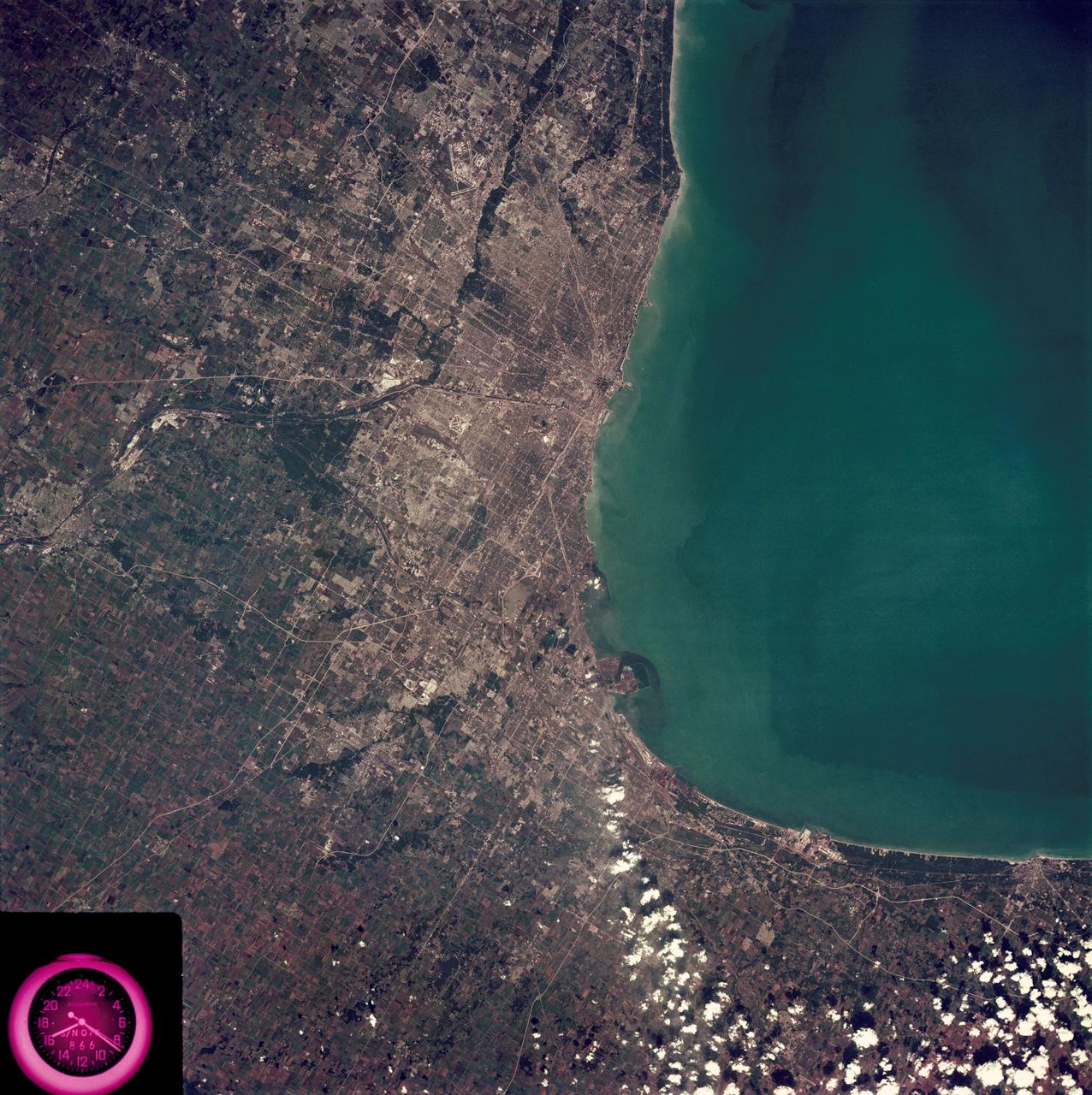
SL3-88-222 (18 Sept. 1973) --- The metropolitan area of Chicago is encompassed in this Skylab 3 Earth Resources Experiments Package (EREP) S190-B photograph taken on Sept. 18, 1973 from the Skylab space station cluster in Earth orbit. The surrounding major cities of Aurora and Joliet, Illinois; Hammond, Gary and East Chicago, Indiana, are easily delineated. The photograph reveals the following: (1) Cultural differentiation of commercial, industrial and residential areas for use in population and social studies in micro-macro community planning and in cultural pattern studies in the improvement of urban areas. (Aurora is one of 27 census cities of interest to Robert Alexander, a principal investigator. Alexander is with the U.S. Geological Survey). (2) The transportation network with major corridors and their interchanges, primary and feeder streets for use in network analysis and in the development of models for population movement and land use projection. (3) The agricultural lands for land use identification on crop inventory analysis; airports for use in delineation of service and infringement of major man-made features that affect ecosystem balance (support to environmental impact studies). (4) Air and water plumes for use in case studies, natural and man-made differentiation of pollution sources, in support of model development and in ecosystem research studies on the effects of pollution. (5) Recreational centers for use in relating recreational centers to population centers, establishing possible demands and in development of possible future recreational centers to support the demand. All EREP photography is available to the public through the Department of Interior?s Earth Resources Observations Systems Data Center, Sioux Falls, South Dakota, 57198. Photo credit: NASA

Norwegian explorer Roald Amundsen became the first man to reach the South Pole in December 1911. More than 100 years later, an international team of scientists that includes a NASA researcher has proven that air pollution from industrial activities arrived to the planet’s southern pole long before any human. Using data from 16 ice cores collected from widely spaced locations around the Antarctic continent, including the South Pole, a group led by Joe McConnell of the Desert Research Institute (DRI) in Reno, Nevada, created the most accurate and precise reconstruction to date of lead pollution over Earth’s southernmost continent. The new record, described in an article published today in the online edition of the Nature Publishing Group’s journal Scientific Reports, spans a 410-year period from 1600 to 2010. More here: <a href="http://1.usa.gov/1oB4p9U" rel="nofollow">1.usa.gov/1oB4p9U</a> <b><a href="http://www.nasa.gov/audience/formedia/features/MP_Photo_Guidelines.html" rel="nofollow">NASA image use policy.</a></b> <b><a href="http://www.nasa.gov/centers/goddard/home/index.html" rel="nofollow">NASA Goddard Space Flight Center</a></b> enables NASA’s mission through four scientific endeavors: Earth Science, Heliophysics, Solar System Exploration, and Astrophysics. Goddard plays a leading role in NASA’s accomplishments by contributing compelling scientific knowledge to advance the Agency’s mission. <b>Follow us on <a href="http://twitter.com/NASAGoddardPix" rel="nofollow">Twitter</a></b> <b>Like us on <a href="http://www.facebook.com/pages/Greenbelt-MD/NASA-Goddard/395013845897?ref=tsd" rel="nofollow">Facebook</a></b> <b>Find us on <a href="http://instagrid.me/nasagoddard/?vm=grid" rel="nofollow">Instagram</a></b>

ISS012-E-21250 (2 March 2006) --- Dust and smog in northeast China are featured in this image photographed by an Expedition 12 crewmember on the International Space Station. Much of the land surface is obscured in this oblique image of the North China Plain and parts of Inner Mongolia. In the center of the view a mass of gray smog—mainly industrial pollution and smoke from domestic burning—obscures Beijing and surrounding cities. Numerous plumes with their source points appear within the mass. Beijing suffers some of the worst air pollution in the world from these chronic sources, and the characteristic colors and textures of the smog can be easily seen through windows of the International Space Station. The coastline of Bo Hai Bay, 300 kilometers east of Beijing, is visible at left. The light brown material in Bo Hai Bay is sediment from the Yellow and other rivers. Separated from the smog mass by a band of puffy, white cumulus clouds is a light brown plume of dust. The line of white cloud has developed along the escarpment that separates the heavily populated North China Plain – location of the largest population agglomeration on Earth – and the sparsely populated semi-desert plains of Inner Mongolia. Observers saw a number of dust events in most Northern Hemisphere deserts in the spring of 2006, and the Gobi and the Takla Makan deserts of western China were no exception. Dust plumes originating in these deserts typically extend eastward hundreds of kilometers, regularly depositing dust on Beijing, the Korean peninsula and Japan. Some plumes even extend over the Pacific Ocean. In extreme cases, visible masses of Gobi-derived dust have reached North America.
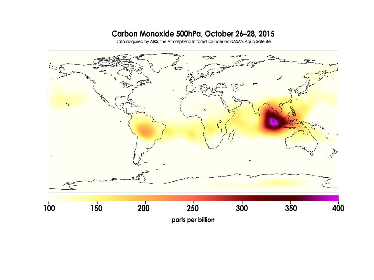
Widespread forest fires across Indonesia have burned tens of thousands of acres over three months, causing high levels of pollution, loss of life, and billions of dollars to the Indonesian government. It is estimated that more than 43 million people have been inhaling toxic fumes, and large parts of Indonesia have been placed in a state of emergency. Most of the fires are believed to have been set to clear farmland during the dry season, but a long term drought enhanced by El Niño conditions have contributed to the fires remaining unchecked due to lack of rain. These images made with data acquired by AIRS, the Atmospheric Infrared Sounder on NASA's Aqua Satellite, show the global concentration of carbon monoxide at the 500hPa pressure level, or approximately 18,000 feet (5,500 meters) altitude. The data are an average of measurements taken over three days, from October 14 through 16, and October 26 through 28, and the high concentration and large extent of the fires over Indonesia are quite apparent. While the scale for this image extends to 400 parts per billion, local values of carbon monoxide can be significantly higher. http://photojournal.jpl.nasa.gov/catalog/PIA20042
ISS014-E-07738 (10 Nov. 2006) --- This image featuring a southeast-looking view of the Long Island Sound and New Jersey coast, with the lower Hudson River and New York Bay in the area of brightest sunglint was photographed by an Expedition 14 crewmember on the International Space Station. On the far right a gray haze can be seen streaming out to sea offshore of New Jersey, where it becomes harder to see. In fact haze covers most of the visible area offshore, partly obscuring the sea surface. By contrast, clouds look quite different from haze according to scientists. Clouds usually have sharp margins and are pure white, as clouds at the bottom show. Industrial haze is grayer and more diffuse, and is typical of the air over the Northeast. Flow lines show that winds are transporting the haze in clockwise fashion--i.e. bending south--which in turn signifies that a high pressure system was operating on that day, centered roughly over the coast. High pressure systems are notorious for promoting smog events because they bring clear skies, and sunlight promotes smog formation. Highs also concentrate polluted surface layers near the ground.
This STS-68 patch was designed by artist Sean Collins. Exploration of Earth from space is the focus of the design of the insignia, the second flight of the Space Radar Laboratory (SRL-2). SRL-2 was part of NASA's Mission to Planet Earth (MTPE) project. The world's land masses and oceans dominate the center field, with the Space Shuttle Endeavour circling the globe. The SRL-2 letters span the width and breadth of planet Earth, symbolizing worldwide coverage of the two prime experiments of STS-68: The Shuttle Imaging Radar-C and X-Band Synthetic Aperture Radar (SIR-C/X-SAR) instruments; and the Measurement of Air Pollution from Satellites (MAPS) sensor. The red, blue, and black colors of the insignia represent the three operating wavelengths of SIR-C/X-SAR, and the gold band surrounding the globe symbolizes the atmospheric envelope examined by MAPS. The flags of international partners Germany and Italy are shown opposite Endeavour. The relationship of the Orbiter to Earth highlights the usefulness of human space flights in understanding Earth's environment, and the monitoring of its changing surface and atmosphere. In the words of the crew members, the soaring Orbiter also typifies the excellence of the NASA team in exploring our own world, using the tools which the Space Program developed to explore the other planets in the solar system.
STS059-S-001 (November 1993) --- Designed by the crew members, the STS-59 insignia is dominated by Earth, reflecting the focus of the first Space Radar Laboratory (SRL-1) mission upon our planet's surface and atmosphere. The golden symbol of the astronaut corps emblem sweeps over Earth's surface from the space shuttle Endeavour, representing the operation of the SIR-C/Synthetic Aperture Radar (X-SAR) and the Measurement of Air Pollution from Space (MAPS) sensors. The astronaut emblem also signals the importance of the human element in space exploration and in the study of our planet. Using the unique vantage point of space, Endeavour and its crew -- along with scientists from around the world -- will study Earth and its environment. The starfield visible below Earth represents the many talents and skills of the international (SRL-1) team in working to make this "Mission to Planet Earth" (MTPE) a scientific and operational success. The NASA insignia design for space shuttle flights is reserved for use by the astronauts and for other official use as the NASA Administrator may authorize. Public availability has been approved only in the forms of illustrations by the various news media. When and if there is any change in this policy, which is not anticipated, the change will be publicly announced. Photo credit: NASA
STS087-330-009 (19 November – 5 December 1997) --- Astronauts Takao Doi (left) and Steven W. Lindsey check out the Enclosed Laminar Flames (ELF) experiment on the mid-deck of the Earth-orbiting Space Shuttle Columbia. ELF has been designed to examine the effect of different air flow velocities on the stability of laminar (non-turbulent) flames. Enclosed laminar flames are commonly found in combustion systems such as power plant and gas turbine combustors, and jet engine afterburners. It is hoped that results of this investigation may help to optimize the performance of industrial combustors, including pollutant emissions and heat transfer. The microgravity environment of space makes a perfect setting for a laboratory involving combustion, an activity that creates convection in normal gravity. In microgravity, scientists can study subtle processes ordinarily masked by the effects of gravity. Doi is an international mission specialist representing Japan's National Space Development Agency (NASDA) and Lindsey is the pilot. Both are alumni of NASA's 1995 class of Astronaut Candidates (ASCAN).
The Atmospheric Infrared Sounder (AIRS) instrument aboard NASA's Aqua satellite detected volcanic sulfur dioxide (SO₂) plumes emanating from Hawaii's Mauna Loa volcano, which started erupting late Sunday, Nov. 27, 2022, at 11:30 p.m. Hawaiian Standard Time (9:30 a.m. UTC, Nov. 28). The AIRS images shown here were taken from seven overpasses, capturing the SO₂ volcanic plumes and its pathways since the eruption. Starting from the upper left frame — captured at 2:41 a.m. HST (12:41 UTC) on Nov. 28, around three hours after the eruption began — a red patch that represents an SO₂ plume can be seen east of the volcano, which is shown as a blue triangle, then moving east and diffusing through subsequent frames. By 71 hours after the eruption, the eastern part of the plume is over the southeastern United States. SO₂ can be harmful to the human respiratory system when inhaled. In the atmosphere, it can also lead to the formation of other gaseous sulfur oxides (SOₓ). These substances can react with other chemicals to form particulate-matter pollution, which can cause breathing problems, contribute to acid rain, and reduce sky visibility. AIRS measures the amount of radiation reaching the instrument from the top of the atmosphere at more than 2,000 different wavelengths. Brightness temperature (BT) is a measure of the amount of radiation, and the images show the difference between BT observed at two different wavelengths. One of the wavelengths is sensitive to atmospheric SO₂, and the other is not, so the difference between the two measurements can give a reliable signal of volcanic SO₂ plumes. A fully automated volcanic plume detection rapid response system that uses AIRS data has been developed at the Jet Propulsion Laboratory in Southern California. This tool is available at the AIRS Rapid Response website, where detections of the most recent volcanic SO₂, dust, and clouds, in visible and infrared images, are updated in near real-time when a volcanic event anywhere on Earth triggers the system. AIRS historical detections of volcanic SO₂ and dust are archived on the site at https://airs.jpl.nasa.gov/volcanic_plumes/. AIRS, in conjunction with the Advanced Microwave Sounding Unit (AMSU), senses emitted infrared and microwave radiation from Earth to provide a three-dimensional look at the planet's weather and climate. Working in tandem, the two instruments make simultaneous observations down to Earth's surface. With more than 2,000 channels sensing different regions of the atmosphere, the system creates a global map of atmospheric temperature and humidity, cloud amounts and heights, greenhouse gas concentrations, and many other atmospheric phenomena. Launched into Earth orbit in 2002 aboard NASA's Aqua spacecraft, the AIRS and AMSU instruments are managed by JPL, under contract to NASA. JPL is a division of Caltech. https://photojournal.jpl.nasa.gov/catalog/PIA25562