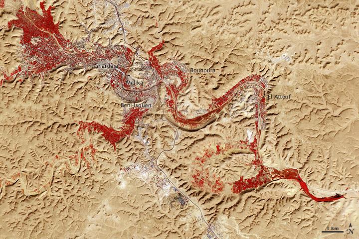
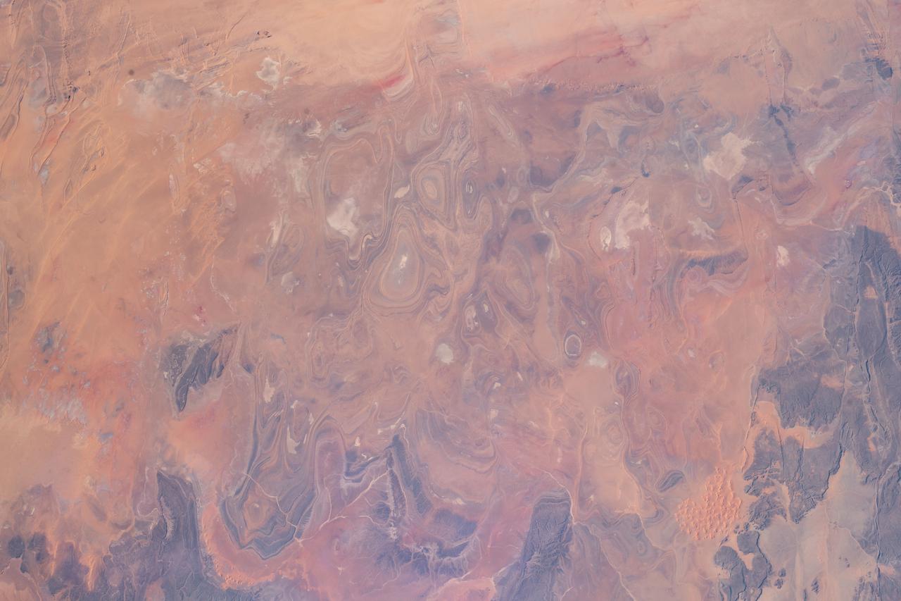
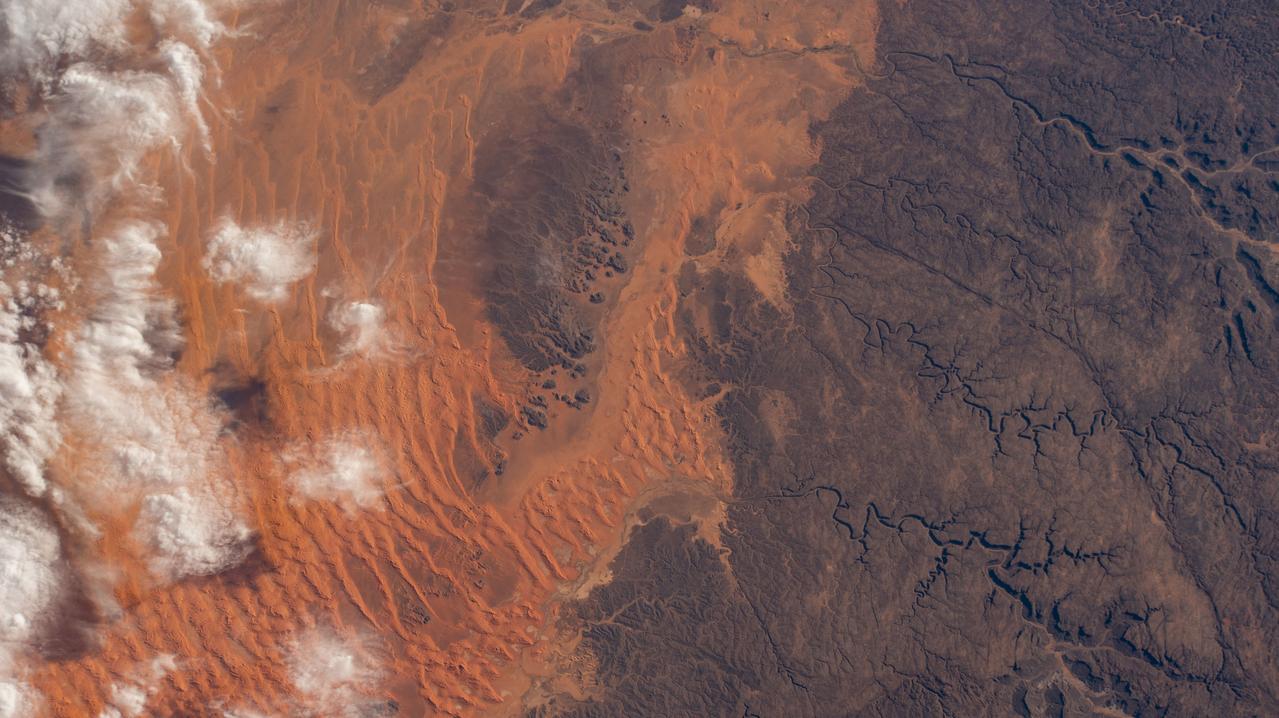
NASA image acquired Feb. 9, 2011 Less than 5 percent of Algeria’s land surface is suitable for growing crops, and most precipitation falls on the Atlas Mountains along the coast. Inland, dust-laden winds blow over rocky plains and sand seas. However, in north central Algeria—off the tip of Grand Erg Occidental and about 450 kilometers (280 miles) south of Algiers—lies a serpentine stretch of vegetation. It is the M’zab Valley, filled with palm groves and dotted with centuries-old settlements. The Advanced Spaceborne Thermal Emission and Reflection Radiometer (ASTER) on NASA’s Terra satellite captured this image of M’zab Valley on February 9, 2011. ASTER combines infrared, red, and green wavelengths of light. Bare rock ranges in color from beige to peach. Buildings and paved surfaces appear gray. Vegetation is red, and brighter shades of red indicate more robust vegetation. This oasis results from water that is otherwise in short supply in the Sahara Desert, thanks to the valley’s approximately 3,000 wells. Chemical analysis of Algerian aquifers, as well studies of topography in Algeria and Tunisia, suggest this region experienced a cooler climate in the late Pleistocene, and potentially heavy monsoon rains earlier in the Holocene. The M’zab region shows evidence of meandering rivers and pinnate drainage patterns. The vegetation lining M’zab Valley highlights this old river valley’s contours. Cool summer temperatures and monsoon rains had long since retreated from the region by eleventh century, but this valley nevertheless supported the establishment of multiple fortified settlements, or ksours. Between 1012 A.D. and 1350 A.D., locals established the ksours of El-Atteuf, Bounoura, Melika, Ghardaïa, and Beni-Isguen. Collectively these cities are now a United Nations Educational, Scientific, and Cultural Organization (UNESCO) World Heritage site. NASA Earth Observatory image by Robert Simmon and Jesse Allen, using data from the GSFC/METI/ERSDAC/JAROS, and U.S./Japan ASTER Science Team. Caption by Michon Scott. Instrument: Terra - ASTER <b>To download the full high res file go <a href="http://earthobservatory.nasa.gov/IOTD/view.php?id=51296" rel="nofollow"> here</a></b>
S65-63830 (5 Dec. 1965) --- Algeria, south-southeast of the Colomb Bechar area, as seen from the National Aeronautics and Space Administration's Gemini-7 spacecraft. Sand dunes are 200 to 300 feet high in the Grand Erg Occidental area. The Quod Sacura River can be seen in the upper left corner. The white spot in the middle of the picture is the Sebcha el Malah salt beds. It should be noted that the area had just experienced very heavy rains (first in many years) and the stream and salt flat are inundated. This photograph was taken with a modified 70mm Hasselblad camera, with Eastman Kodak, Ektachrome MS (S.O. 217) color film. Photo credit: NASA
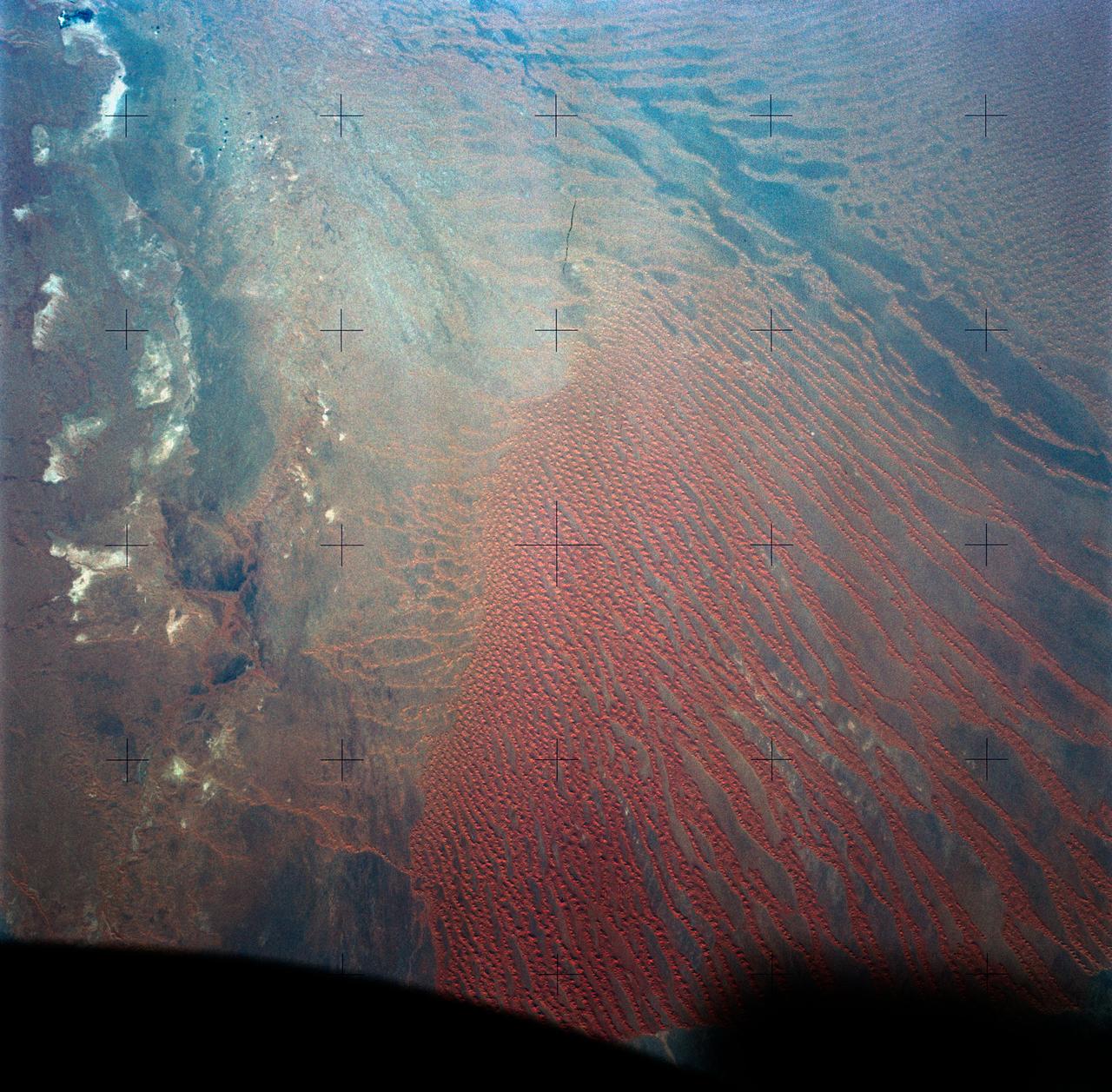
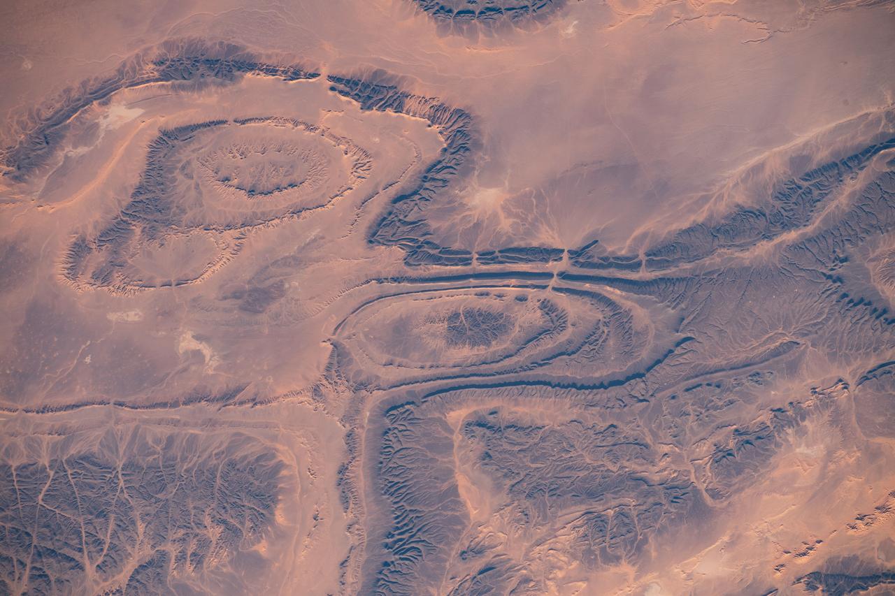
The impermanent waterways shown here from NASA EarthKAM are part of Oued Irharrhar, which appear to be carrying sulfur yellow and iron red deposits. The city of Amguid is located on these waterways, and all lie in the Mouydir Mountains in Algeria.
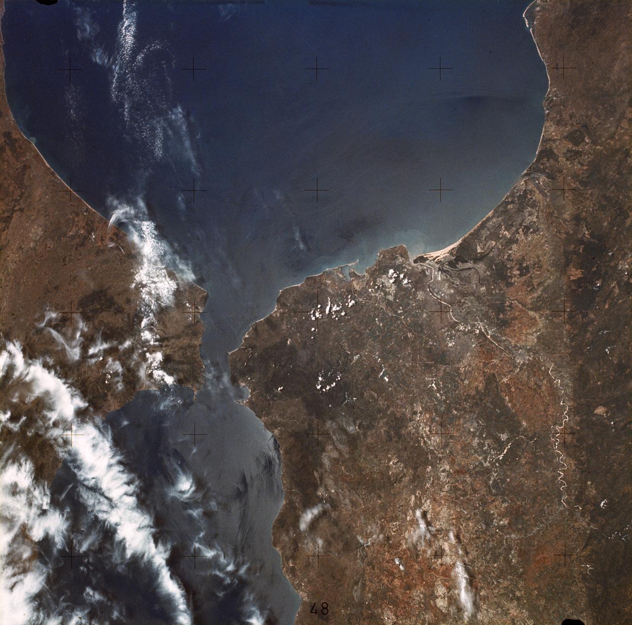
Located 600 km south of Algiers, Algeria in the heart of the Sahara Desert, the five ksour fortified villages of the MZab Valley form an extraordinarily homogenous ensemble in this image captured by NASA Terra spacecraft.
iss072e068304 (Oct. 13, 2024) --- The town and commune of In Ghar, with a population of over 11,000 in Algeria's portion of the Sahara Desert, is pictured from the International Space Station as it orbited 259 miles above the African nation.
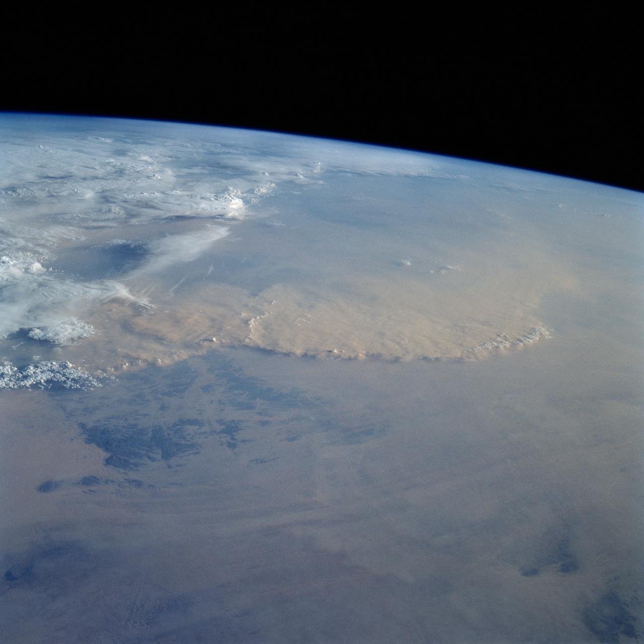
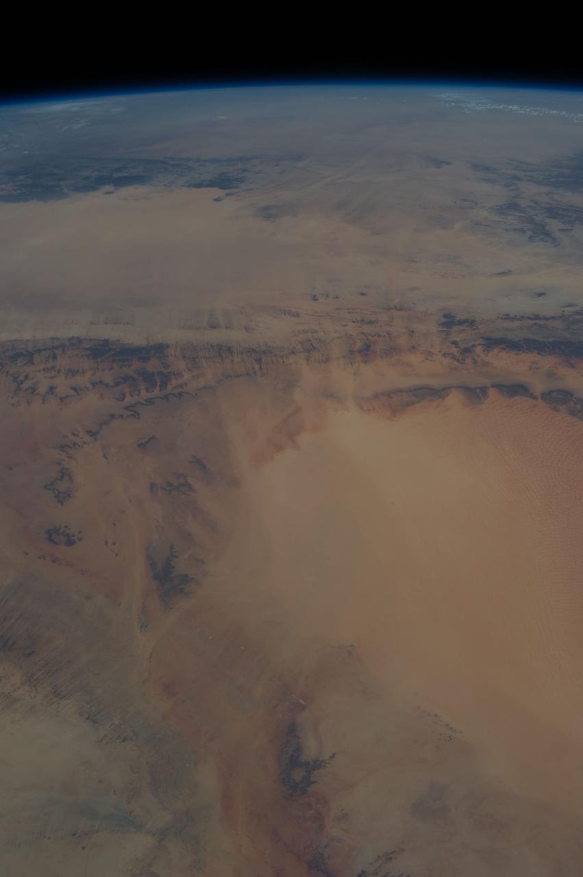
STS049-92-071 (13 May 1992) --- The STS-49 crew aboard the Earth-orbiting Space Shuttle Endeavour captured this Saharan dust storm on the Algeria-Niger border. The south-looking, late-afternoon view shows one of the best examples in the Shuttle photo data base of a dust storm. A series of gust fronts, caused by dissipating thunderstorms have picked up dust along the outflow boundaries. Small cumulus clouds have formed over the most vigorously ascending parts of the dust front, enhancing the visual effect of the front. The storm is moving roughly north-northwest, at right angles to the most typical path for dust storms in this part of the Sahara (shown by lines of sand on the desert surface in the foreground). Storms such as this can move out into the Atlantic, bringing dust even as far as the Americas on some occasions. A crewmember used a 70mm handheld Hasselblad camera with a 100mm lens to record the frame.
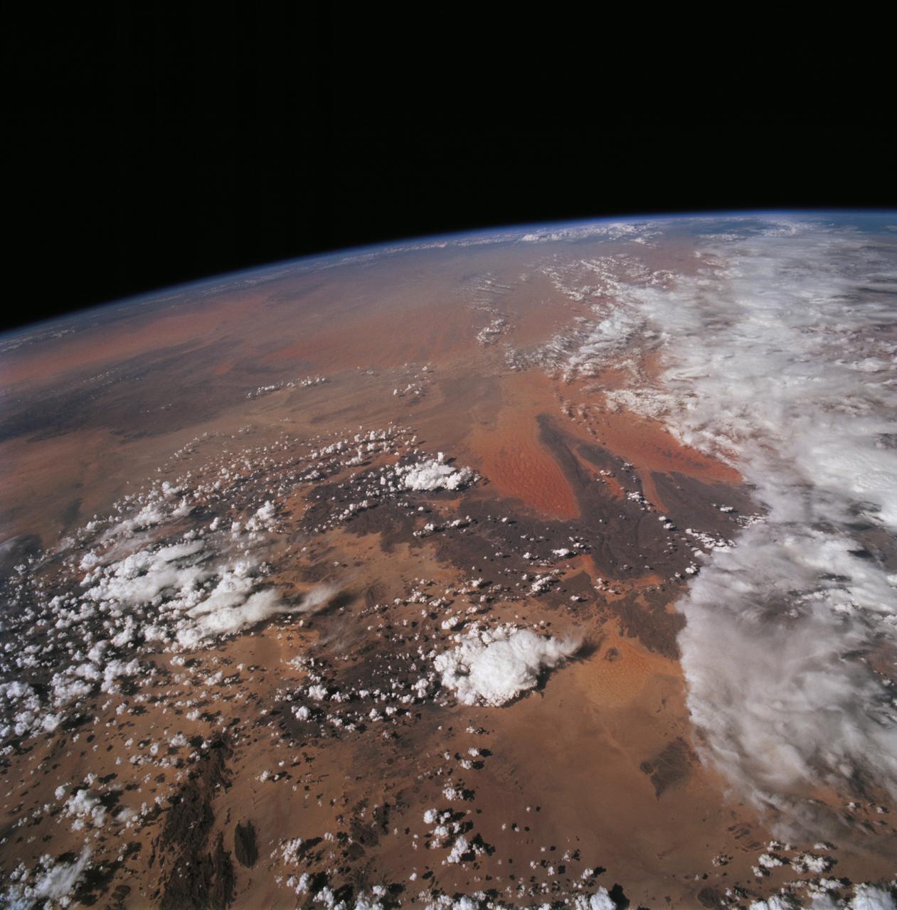
STS068-228-081 (30 September-11 October 1994) --- This northwest-looking view shows central Algeria with an unusual amount of cloud cover, responsible for one of the infrequent bouts of rain in the Sahara Desert. The lope-shaped, red sand dunes mass in the center of the view is one of the most prominent features in the Sahara as seen from the Space Shuttle Endeavour. It is known as the Tifernine Dunes. The Atlas Mountains (top) are only apparent in this view because of the clouds, which cap their summits.
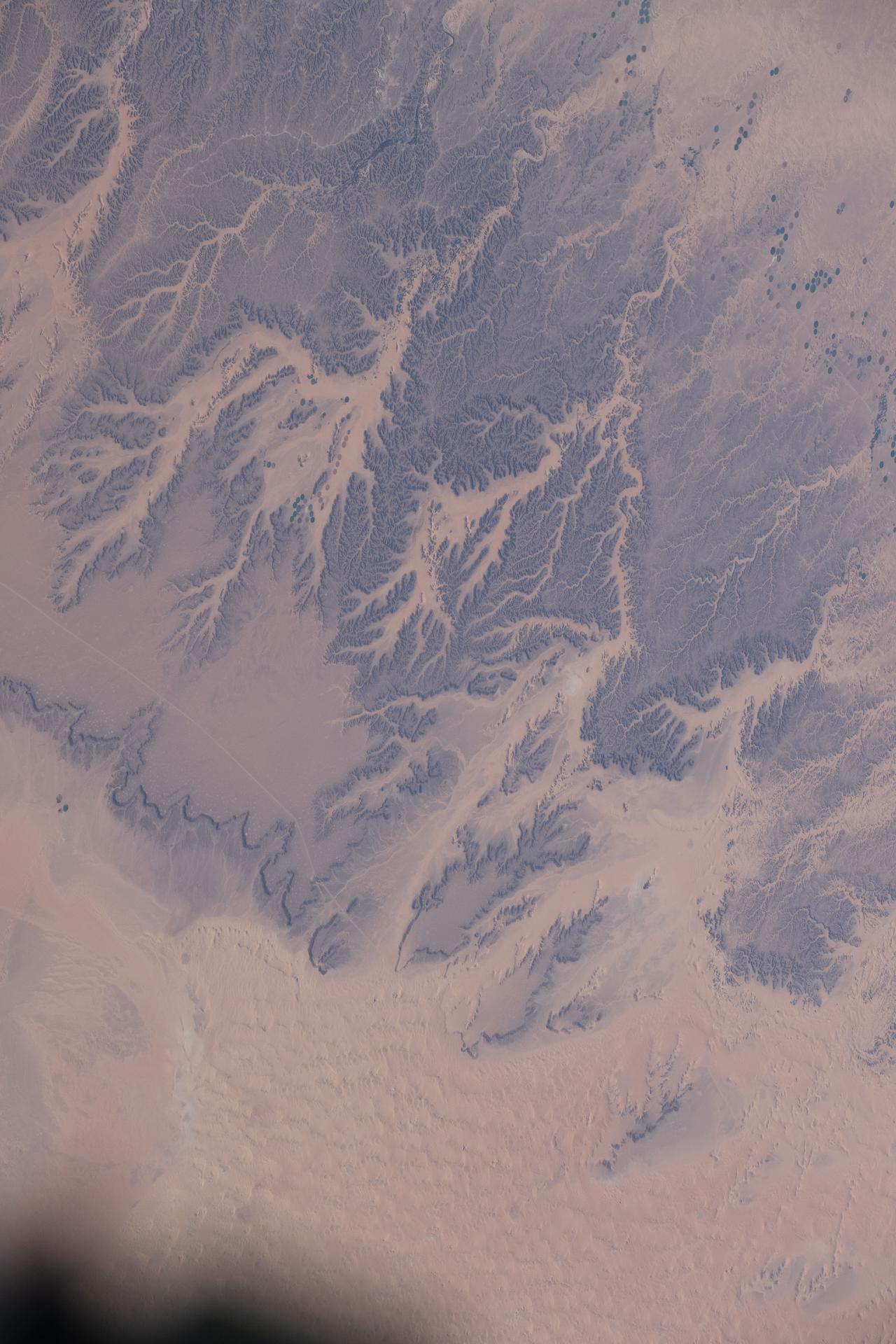
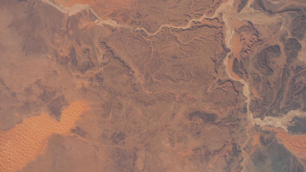
iss074e0320309 (Feb. 21, 2026) --- Wadis, dry riverbeds or channels that carry water only during the rainy season, are pictured in the northern Sahara Desert region of Algeria. The International Space Station was orbiting 260 miles above the North African nation when this photograph was taken. Credit: NASA/Jessica Meir
S66-45749 (18 July 1966) --- Straits of Gibraltar, Mediterranean Sea, Spain in background, Algeria and Morocco in foreground as seen from Gemini-10 spacecraft. Photo credit: NASA
iss074e0491560 (April 19, 2026) --- Annaba, Algeria, located on the coast of the Mediterranean Sea and home to a metropolitan population of about 1 million, is pictured from the International Space Station as it orbited 262 miles above the North African nation. Annaba traces its origins to a Phoenician settlement about 3,200 years ago and features Roman, Byzantine, Moorish, and European architectural influences accumulated over the ensuing centuries. Credit: NASA/Chris Williams
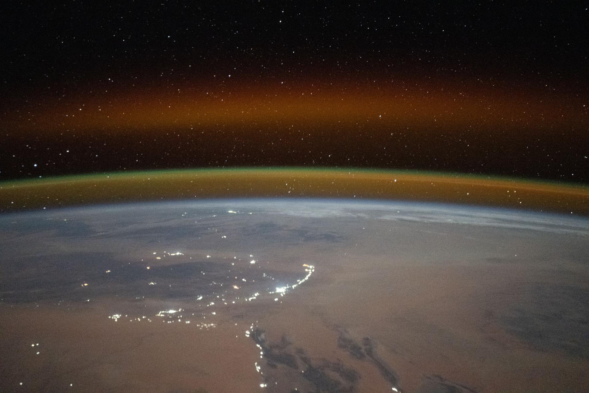
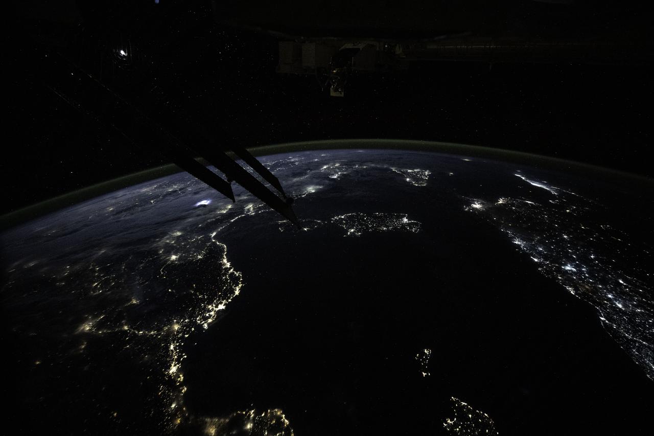
iss073e1198938 (Nov. 28, 2025) --- A yellow-red airglow blankets Earth's horizon as village lights dot the Saharan landscape of Algeria in this photograph taken at approximately 8:50 p.m. local time from the International Space Station as it orbited 261 miles above north Africa.
S66-46062 (18-21 July 1966) --- Area of the Spanish Sahara--Mauritania--Algeria--Morocco, looking north into Hamada Du Dra, as seen from the Gemini-10 spacecraft. Taken with a J.A. Maurer 70mm camera, using Eastman Kodak, Ektachrome, MS (S.O. 217) color film. Photo credit: NASA
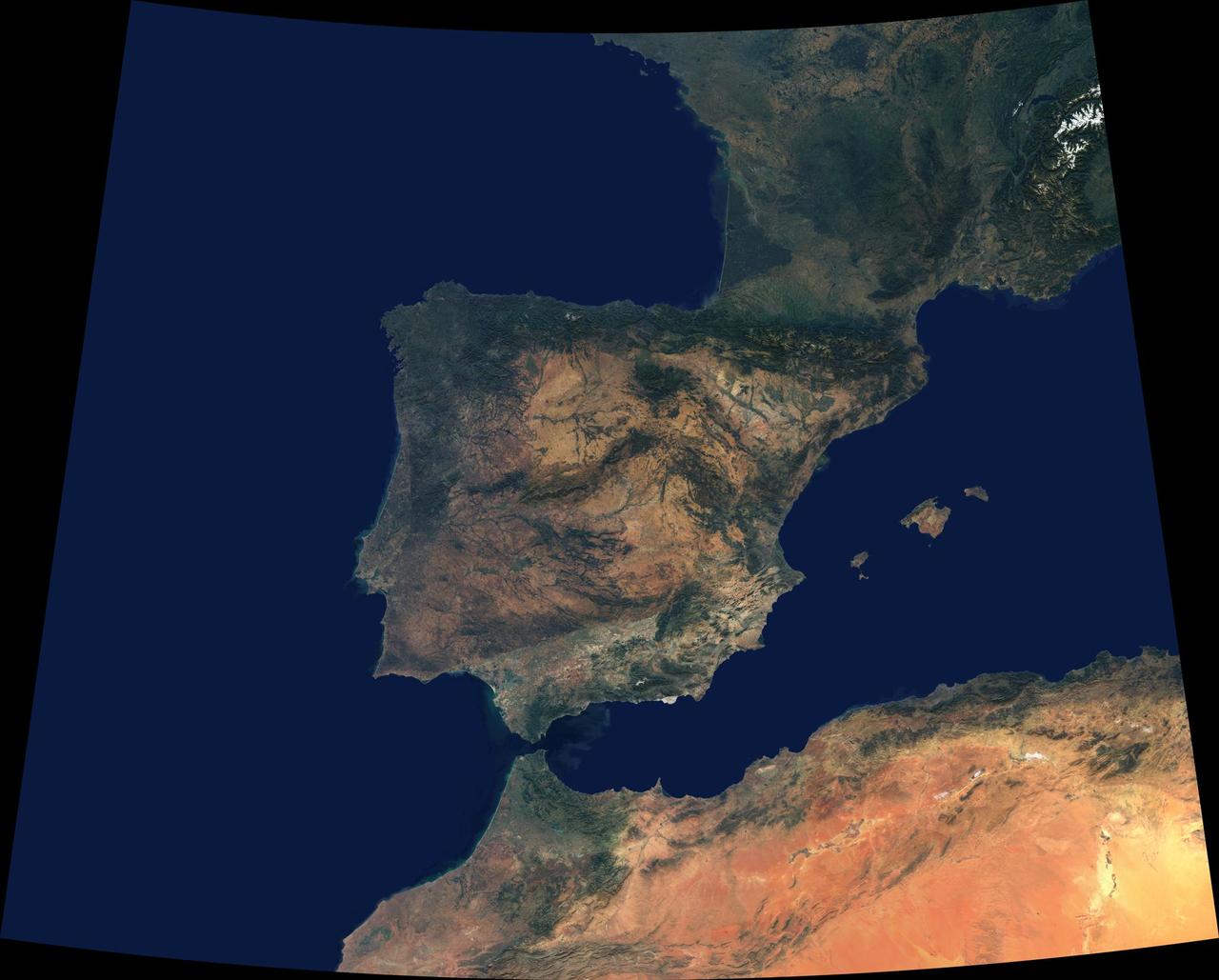
Data from a portion of the imagery acquired by NASA Terra spacecraft during 2000-2002 were combined to create this cloud-free natural-color mosaic of southwestern Europe and northwestern Morocco and Algeria.
SL4-138-3820 (31 Dec. 1973) --- An north-looking oblique view of chains of star sand dunes in eastern Algeria as seen from the Skylab space station in Earth orbit. This picture was taken by one of the Skylab 4 crewmen with a hand-held 70mm Hasselblad camera. The low sun angle of about 25 degrees above horizontal enhances the detail in this picture. The coordinates of the center of the photograph are approximately 29.5 degrees north latitude and 5.0 degrees east longitude in the Grand Erg Oriental. The field of view at the base of the photograph is approximately 200 kilometers (125 miles). The individual dunes are roughly star-shaped rather than simple crescents which are common in dune fields. In this region the stars are aligned along ridges. The causes of these and a wide variety of other dune forms are little understood. Descriptions and photographs from Skylab 4 will be used by the U.S. Geological Survey in their world-wide study of dunes. Photo credit: NASA
iss070e090117 (Feb. 8, 2024) --- Sand dunes in the Sahara Desert are pictured in the African nation of Algeria as the International Space Station orbited 260 miles above.
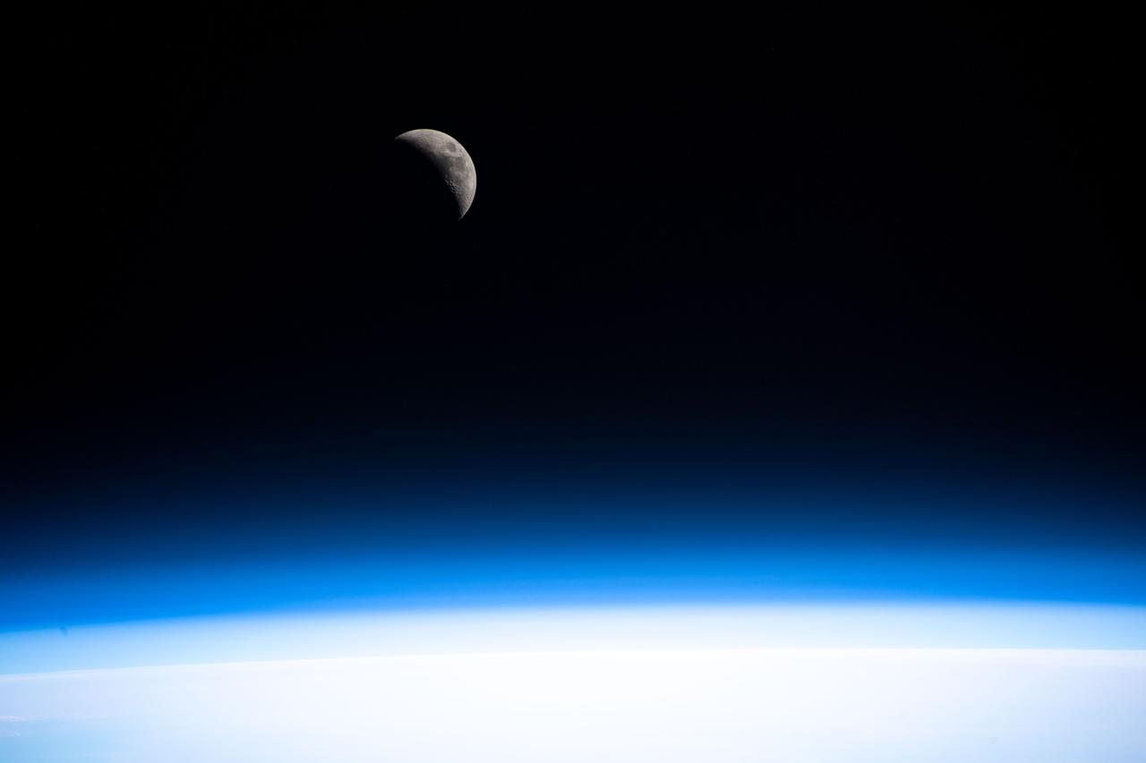
iss061e112503 (Jan. 1, 2020) --- A waxing crescent Moon is pictured as the International Space Station orbited 260 miles above the north African country of Algeria.
iss060e014846 (July 26, 2019) --- A portion of the Sahara desert in Algeria is pictured as the International Space Station orbited 260 miles above north Africa.
iss061e063421 (Nov. 29, 2019) --- The Ougerta Range of mountains in Algeria is pictured as the International Space Station orbited 258 miles above the African nation.
iss060e014847 (July 26, 2019) --- A portion of the Sahara desert in Algeria is pictured as the International Space Station orbited 260 miles above north Africa.
ISS040-E-081008 (25 July 2014) --- One of the Expedition 40 crew members aboard the International Space Station, flying 225 nautical miles above Earth, photographed this image of the Tifernine dunes and the Tassili Najjer Mountains in Algeria. The area is about 800 miles south, southeast of Algiers, the capital of Algeria. The dunes are in excess of 1,000 feet in height.

STS002-13-210 (12-14 Nov. 1981) --- Photograph of Algeria's Tifernine dunes taken with a hand-held camera through the ceiling windows of the space shuttle Columbia during STS-2. The area is about 800 miles south, southeast of Algiers, the capital of Algeria. The dunes are in excess of 1,000 feet in height and are trapped in an enclosure in the Tassili Najjer Mountains. Photo credit: NASA
Earth observation taken during day pass by an Expedition 36 crew member on board the International Space Station (ISS). Per Twitter message: Looking southwest over northern Africa. Libya, Algeria, Niger.
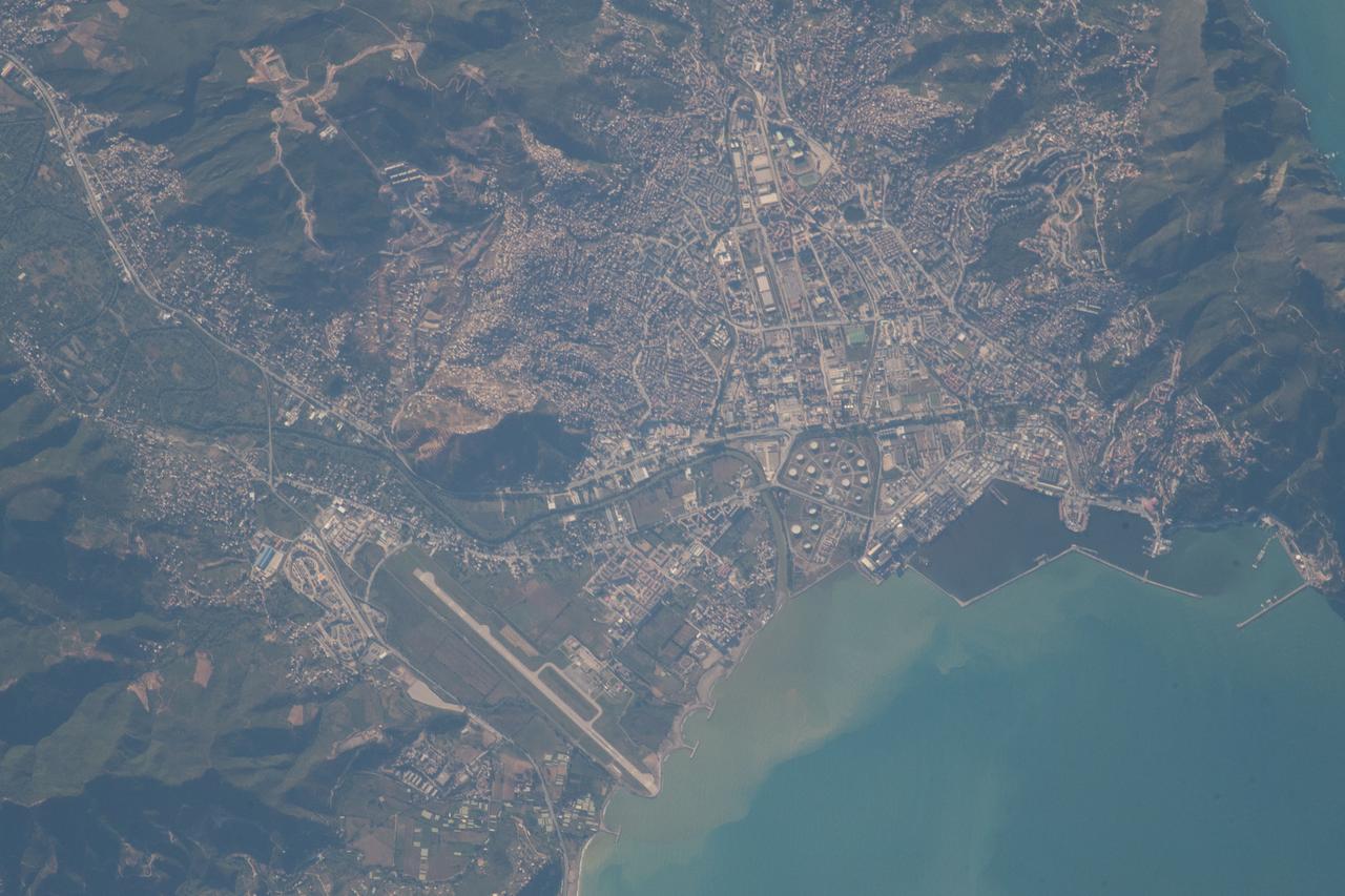
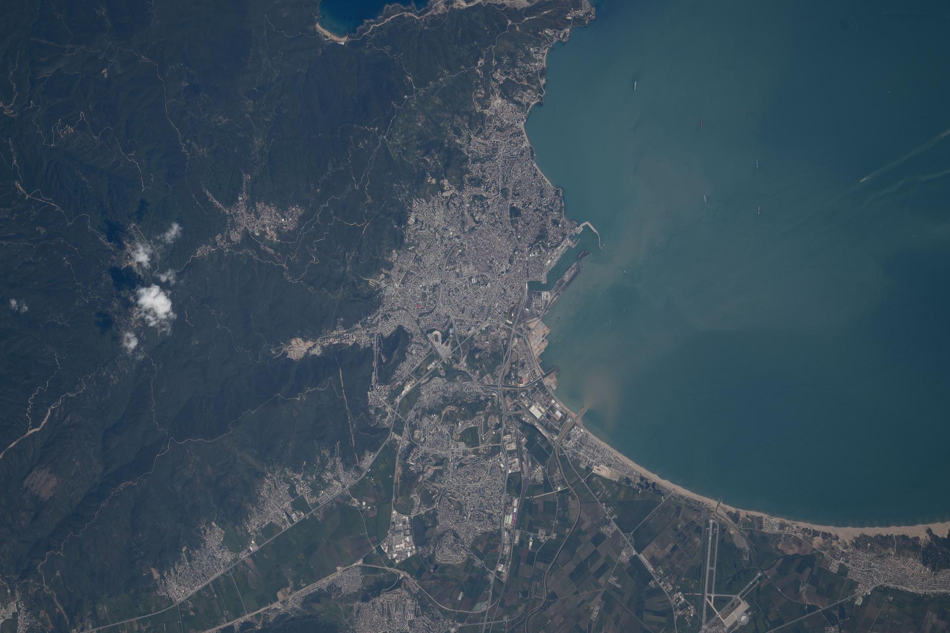
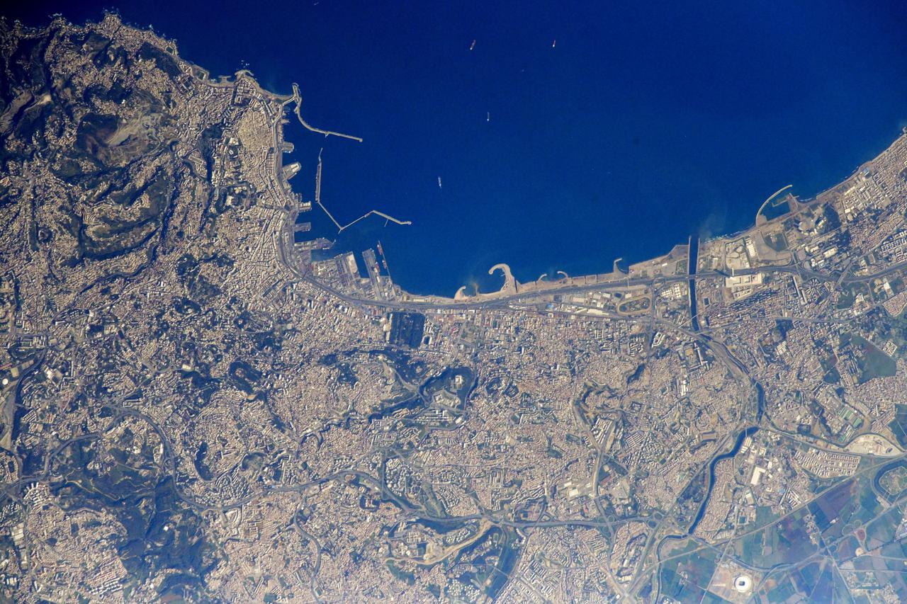
iss056e014254 (June 16, 2018) --- The Mediterranean port city of Béjaïa and its airport in the African country of Algeria are pictured from the International Space Station by an Expedition 56 crew member.
iss066e137375 (Feb. 7, 2022) --- A portion of the Sahara Desert in Algeria, with sand dunes, rocky platforms and sandstone plateaus, is pictured from the International Space Station as it orbited 259 miles above the African nation.
iss067e014093 (April 15, 2022) --- The western portion of Algeria, near the border with Morocco, is pictured from the International Space Station as it orbited 258 miles above the African nation.
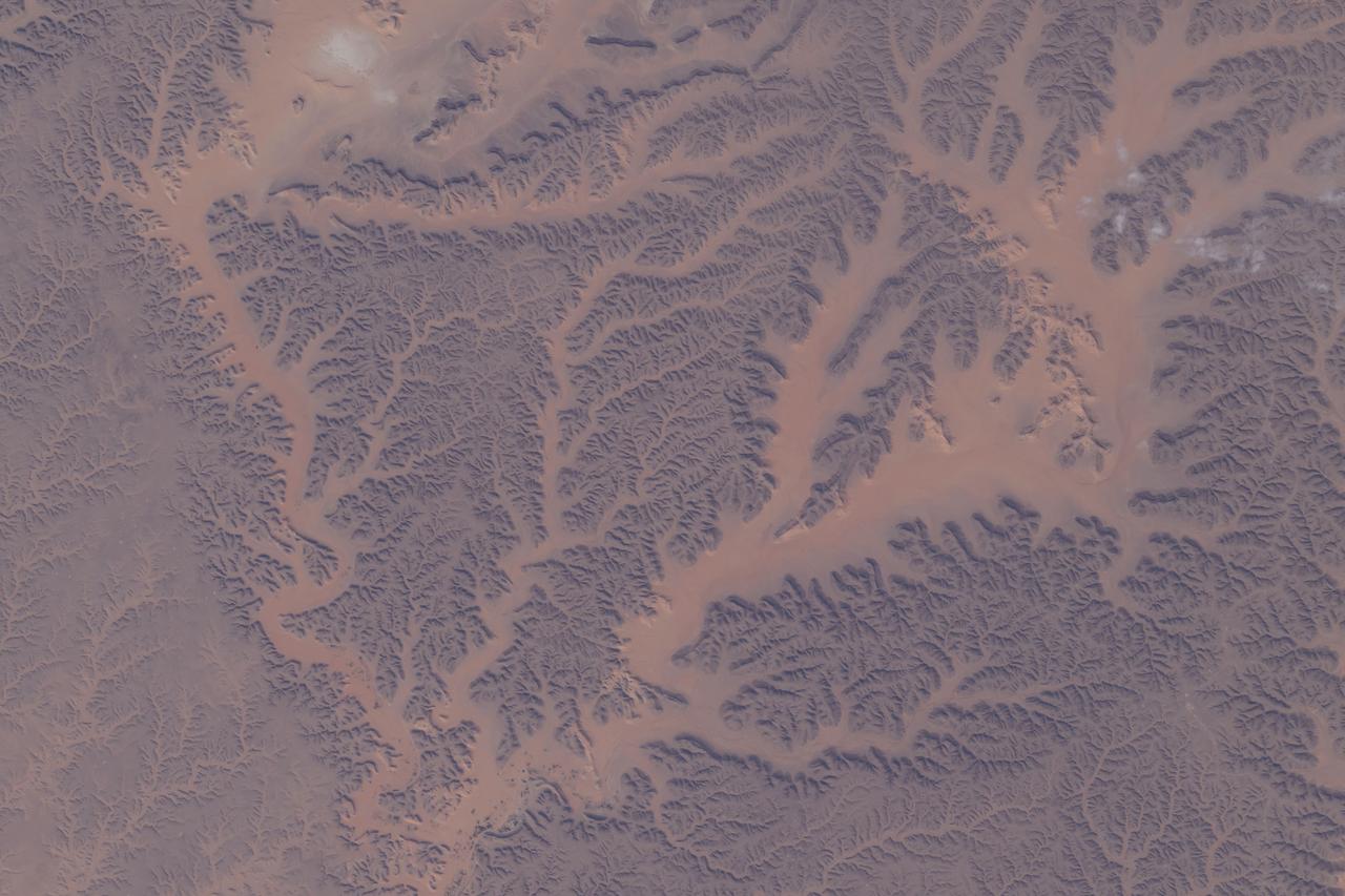
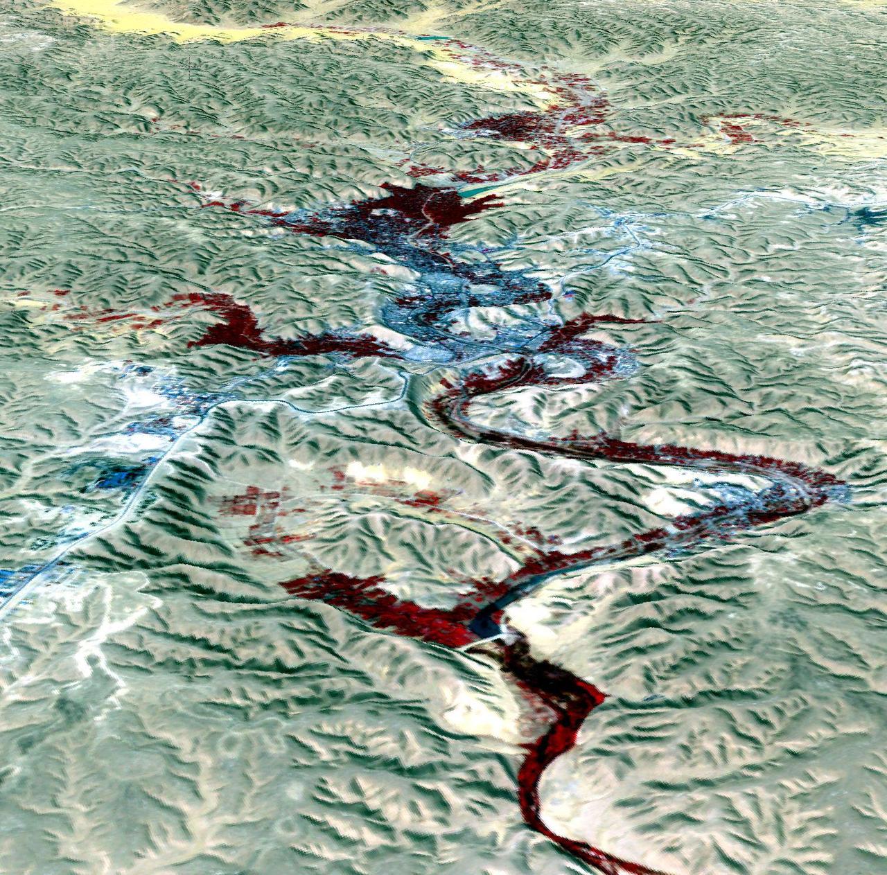
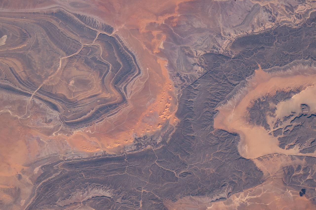
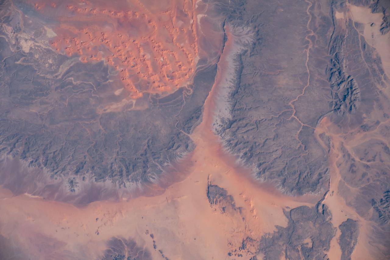
iss071e462964 (Aug. 9, 2024) --- Dry watercourses, also known as wadis, in Algeria's Ghardaia Province are pictured from the International Space Station as it orbited 262 miles above the African nation.
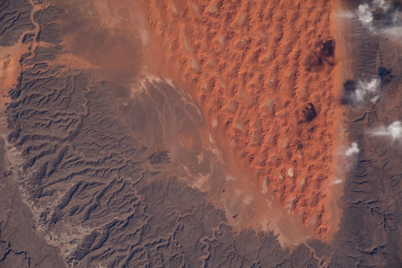
iss066e137392 (Feb. 7, 2022) --- A portion of the Sahara Desert in Algeria, with sand dunes, rocky platforms and sandstone plateaus, is pictured from the International Space Station as it orbited 259 miles above the African nation.
iss070e052305 (Jan. 3, 2024) --- Sand dunes, sandstone plateaus, and rocky platforms that comprise the Tassili N'Ajjer National Park in the southeastern portion of Algeria are pictured from the International Space Station as it orbited 261 mile above the Sahara.
iss064e038919 (Feb. 28, 2021) --- The city of Algiers on the Mediterranean coast was pictured from the International Space Station as it orbited 262 miles above the African nation of Algeria. Credit: Roscosmos
iss064e011532 (Dec. 9, 2020) --- A portion of the Sahara Desert in central western Algeria is pictured from the International Space Station as it orbited 261 miles above the African nation.

S66-09378 (1 Oct. 1966) --- Goggles which will be worn by Gemini-12 astronaut as he photographs sodium cloud ejected from French Centaure rocket launched from Hammaguir, Algeria. Photo credit: NASA
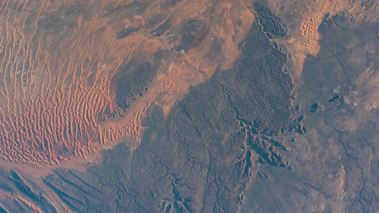
iss064e011821 (Dec. 11, 2020) --- The hot desert climate of Illizi, Algeria, and Tassili N'Ajjer National Park, is apparent in this photograph from the International Space Station as it orbited 261 miles above the African nation.
Radially symmetrical, star dunes dominate the Grand Erg Oriental of the Algerian Sahara, as depicted in this image acquired October 27, 2012 acquired by NASA Terra spacecraft.
iss071e082775 (May 16, 2024) --- The Atlas Mountain range rises on the Atlantic coast of Morocco and extends east to the North African nations of Algeria and Tunisia. The International Space Station was orbiting 258 miles above the Moroccan coast at the time of this photograph.
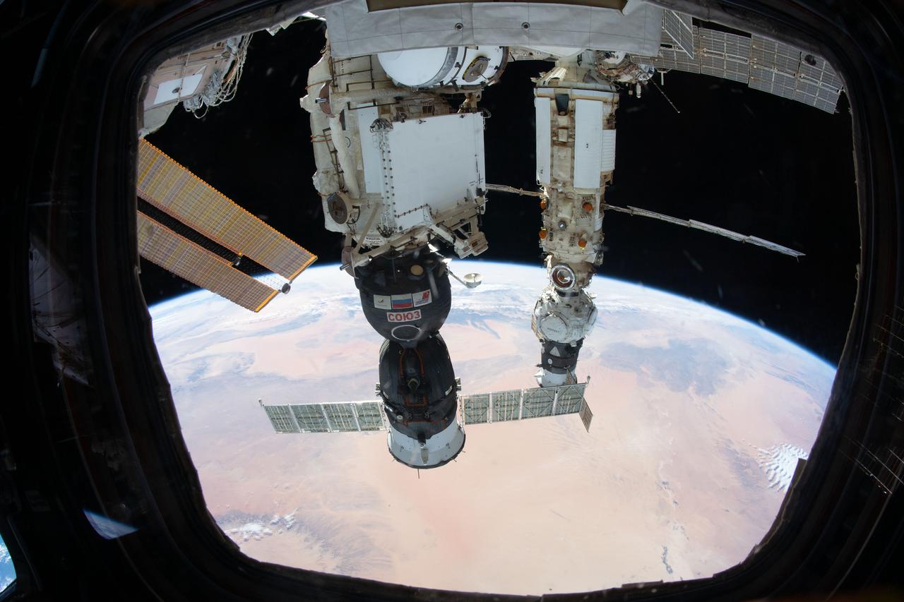
iss066e086723 (Dec. 6, 2021) --- Pictured as the International Space Station orbited 263 miles above the Algeria-Tunisia border are the Soyuz MS-19 crew ship docked to the Rassvet module and the Prichal module, still attached to the Progress delivery craft, docked to the Nauka multipurpose module.
iss059e038134 (April 30, 2019) --- Looking from northwest to southeast (bottom to top), this oblique view shows portions of Western Europe, the Atlantic Ocean, the Mediterranean Sea and North Africa. More specific regions such as Portugal, Spain, the Strait of Gibraltar, Morocco and Algeria are seen as the International Space Station orbited 257 miles above the Atlantic.
Extremely heavy rains fell at the end of February 2012 in the northern Algerian province of El Tarf, near the Tunisian border. The rainfall total was the greatest recorded in the last 30 years. This image is from NASA Terra spacecraft.

The 16th American assembly flight and 112th overall American flight to the International Space Station (ISS), launched on November 23, 2002 from Kennedy's launch pad 39A aboard the Space Shuttle Orbiter Endeavor STS-113. Mission objectives included the delivery of the Expedition Six Crew to the ISS, the return of Expedition Five crew back to Earth, and the installation and activation of the Port 1 Integrated Truss Assembly (P1). The first major component installed on the left side of the Station, the P1 truss provides an additional three External Thermal Control System radiators. Weighing in at 27,506 pounds, the P1 truss is 45 feet (13.7 meters) long, 15 feet (4.6 meters) wide, and 13 feet (4 meters) high. Three space walks, aided by the use of the Robotic Manipulator Systems of both the Shuttle and the Station, were performed in the installation of P1. In this photograph, astronaut and mission specialist Michael E. Lopez-Alegria works on the newly installed P1 truss during the mission's second scheduled session of extravehicular activity.

iss068e022435 (Nov. 15, 2022) --- NASA astronaut and Expedition 68 Flight Engineer Frank Rubio is pictured during a spacewalk tethered to the International Space Station's starboard truss structure. Behind Rubio, the last rays of an orbital sunset penetrate Earth's thin atmosphere as the space station flew 258 miles above the African nation of Algeria.
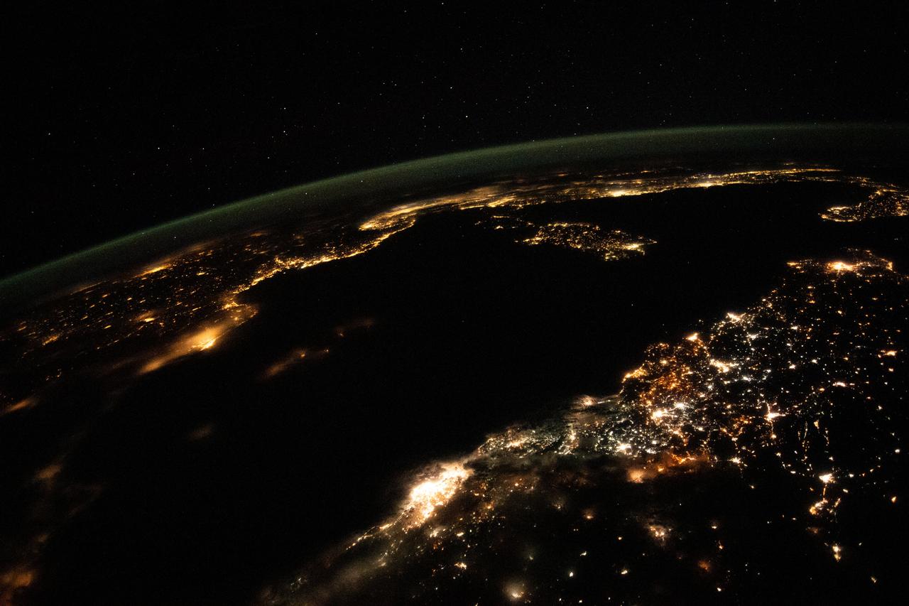
iss067e302248 (Aug. 31, 2022) --- This night time photograph from the International Space Station as it orbited 261 miles above looks across the Mediterranean Sea from north Africa to southern Europe. The city lights of Algiers, Algeria, to Tunis, Tunisia, highlight Africa's northern coast from the bottom center toward upper right. From far left, the city lights of city-state Monaco to Naples, Italy, define the shores of southern Europe. The French island of Corsica and the Italian island of Sardinia are also pictured.
iss072e000922 (Sept. 23, 2024) -- The vibrant night lights of coastal cities on the Mediterranean Sea, from Spain to Italy in Europe and Algeria to Lybia in Africa, are pictured from the International Space Station as it orbited 262 miles above Barcelona. Peeking in at the bottom of the image is Mallorca Island, next to it Minorca. The Italian islands of Corsica, Sardinia, and Sicily are also visible. Above Earth, stars glitter in the night sky.
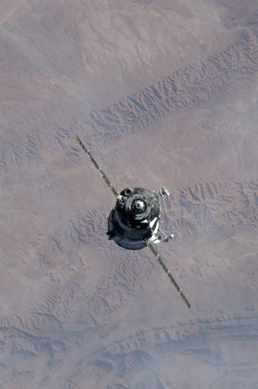
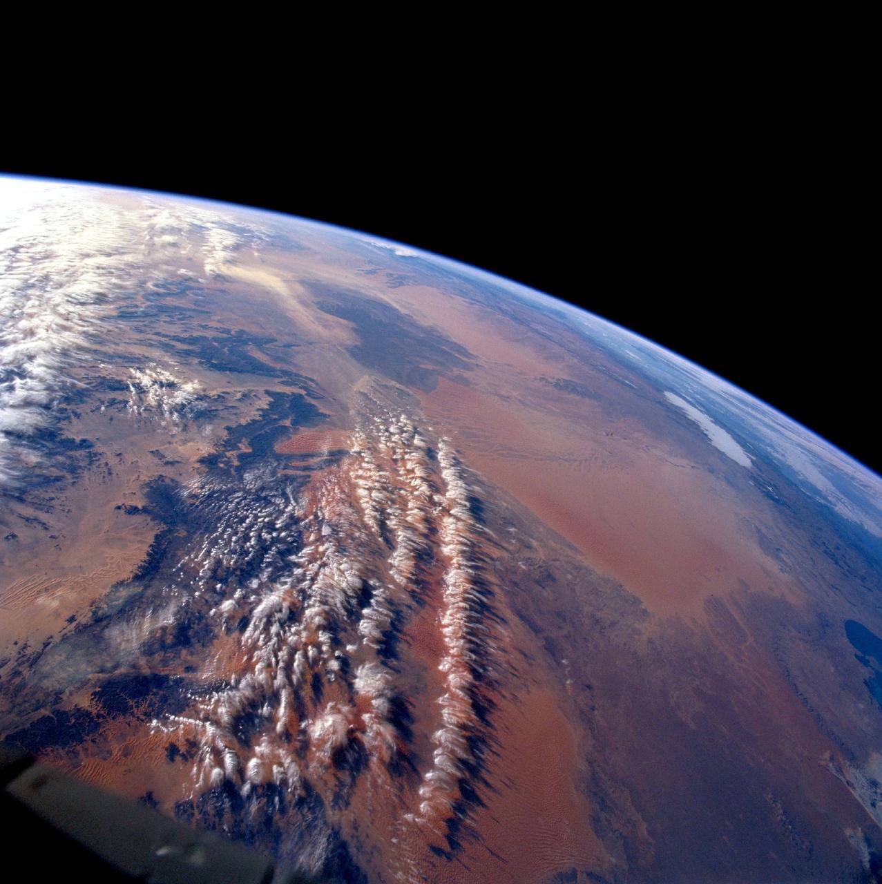
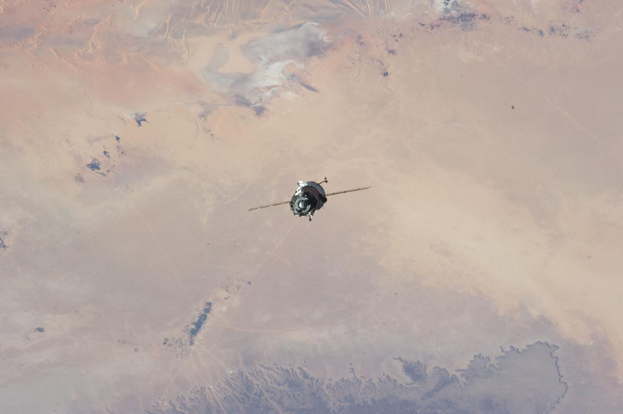
ISS034-E-010181 (21 Dec. 2012) --- As the International Space Station and Soyuz TMA-07M spacecraft were making their relative approaches on Dec. 21, one of the Expedition 34 crew members on the orbital outpost captured this photo of the Soyuz. The background is in northern Algeria, near the Atlas Mountains. Inside the arriving spacecraft were astronaut Chris Hadfield of the Canadian Space Agency, cosmonaut Roman Romanenko of Russia's Federal Space Agency and NASA astronaut Tom Marshburn.
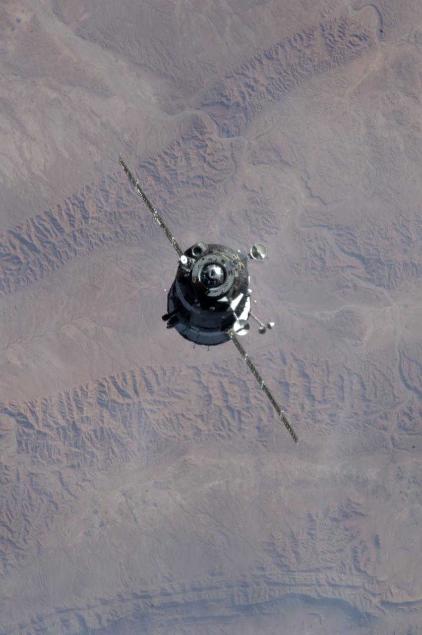
ISS034-E-010180 (21 Dec. 2012) --- As the International Space Station and Soyuz TMA-07M spacecraft were making their relative approaches on Dec. 21, one of the Expedition 34 crew members on the orbital outpost captured this photo of the Soyuz. The background is in northern Algeria, near the Atlas Mountains. Inside the arriving spacecraft were astronaut Chris Hadfield of the Canadian Space Agency, cosmonaut Roman Romanenko of Russia's Federal Space Agency and NASA astronaut Tom Marshburn.
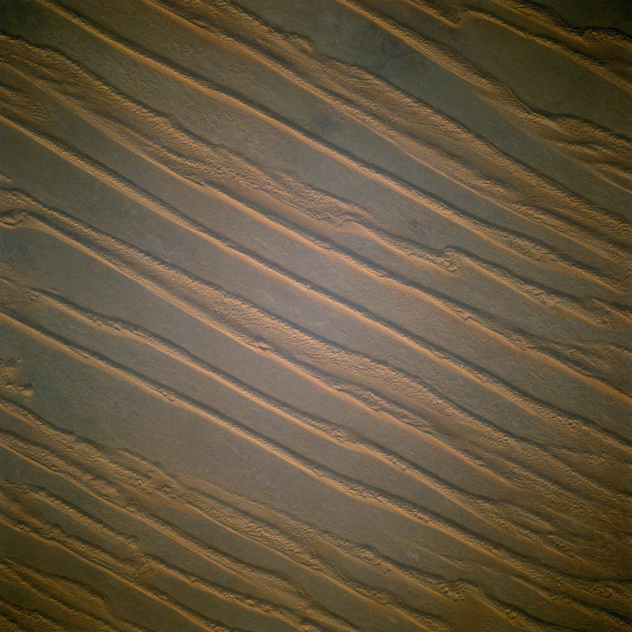
41C-31-990 (6-13 April 1984) --- Southwestern Algeria's Erg Chech shows long lines of parallel sand dunes called siefs. The Erg (sand desert) is in a remote (26.5 degrees north by 1.5 degrees west) of harsh desert, uninhabited and rarely visited. These parallel sand dunes are about 100 miles in length and 5 to 10 miles apart and are found in very few areas of the Earth. Most sand dunes are traverse dunes, or perpendicular to the general direction of the wind.
SL2-05-370 (22 June 1973) --- Gateway to the Atlantic, since ancient times the Strait of Gibraltar (36.5N, 4.5W) is also the border between Africa and Europe. In Spain to the north, the dark area near the coast is the delta of the Guadalquivir River and the city of Seville. The small spike of land on the north side of the strait is the actual Rock of Gibraltar. On the African side, a cloud front cutting across from the coast is blowing into Europe from Morocco and Algeria. Photo credit: NASA
iss069e037776 (Aug. 8, 2023) --- This nighttime photograph shows the Mediterranean Sea ringed by the coastal city lights of Morocco and Algeria on the African side and Spain on the European side. The city lights extending to the Strait of Gibraltar and the Atlantic Ocean are also prominent. The International Space Station was orbiting 261 miles above the Balearic Sea off the coast of Mallorca at the time of this photograph.

iss069e090251 (Sept. 18, 2023) --- The Soyuz MS-24 spacecraft (foreground) that carried NASA astronaut Loral O'Hara and Roscosmos cosmonauts Oleg Kononenko and Nikolai Chub to the International Space Station is pictured docked to the Rassvet module. In the rear, is the Soyuz MS-23 crew ship, docked to the Prichal docking module, that will return NASA astronaut Frank Rubio and Roscosmos cosmonauts Sergey Prokopyev and Dmitri Petelin back to Earth on Sept. 27. 258 miles below the station is the Sahara desert in the African nation of Algeria.
S65-63784 (7 Dec. 1965) --- Algeria, south of Celemb Bechar, as seen from the orbiting Gemini-7 spacecraft during its 42nd revolution of Earth. Note rain runoff on the desert floor. Astronaut Frank Borman and James A. Lovell Jr. were aboard the National Aeronautics and Space Administration?s Gemini-7 spacecraft. The photograph was taken with a modified 70mm Hasselblad camera, using Eastman Kodak, Ektachrome MS (S.O. 217) color film. Photo credit: NASA
S65-63829 (5 Dec. 1965) --- Algeria, south of the Fort Flatters area, as seen from the National Aeronautics and Space Administration?s Gemini-7 spacecraft during its 13th revolution of Earth. The orange color area is the Tifermine Sand Dunes that reach a height of 1,000 feet. The photograph was taken with a modified 70mm Hasselblad camera, with Eastman Kodak, Ektachrome MS (S.O. 217) color film. Photo credit: NASA
STS070-705-094 (13-22 JULY 1995) --- The southern half (about 70 miles in this view) of the Tifernine dunes of east-central Algeria appears on this view. The Tifernine dune-sea is one of the more dramatic features visible from the Shuttle when flying over the Sahara Desert. The dunes lie in a basin of dark-colored rocks heavily cut by winding stream courses (top right). Very occasional storms allow the streams to erode the dark rocks and transport the sediment to the basin. Westerly winds then mold the stream sediments into the complex dune shapes so well displayed here. North at bottom.
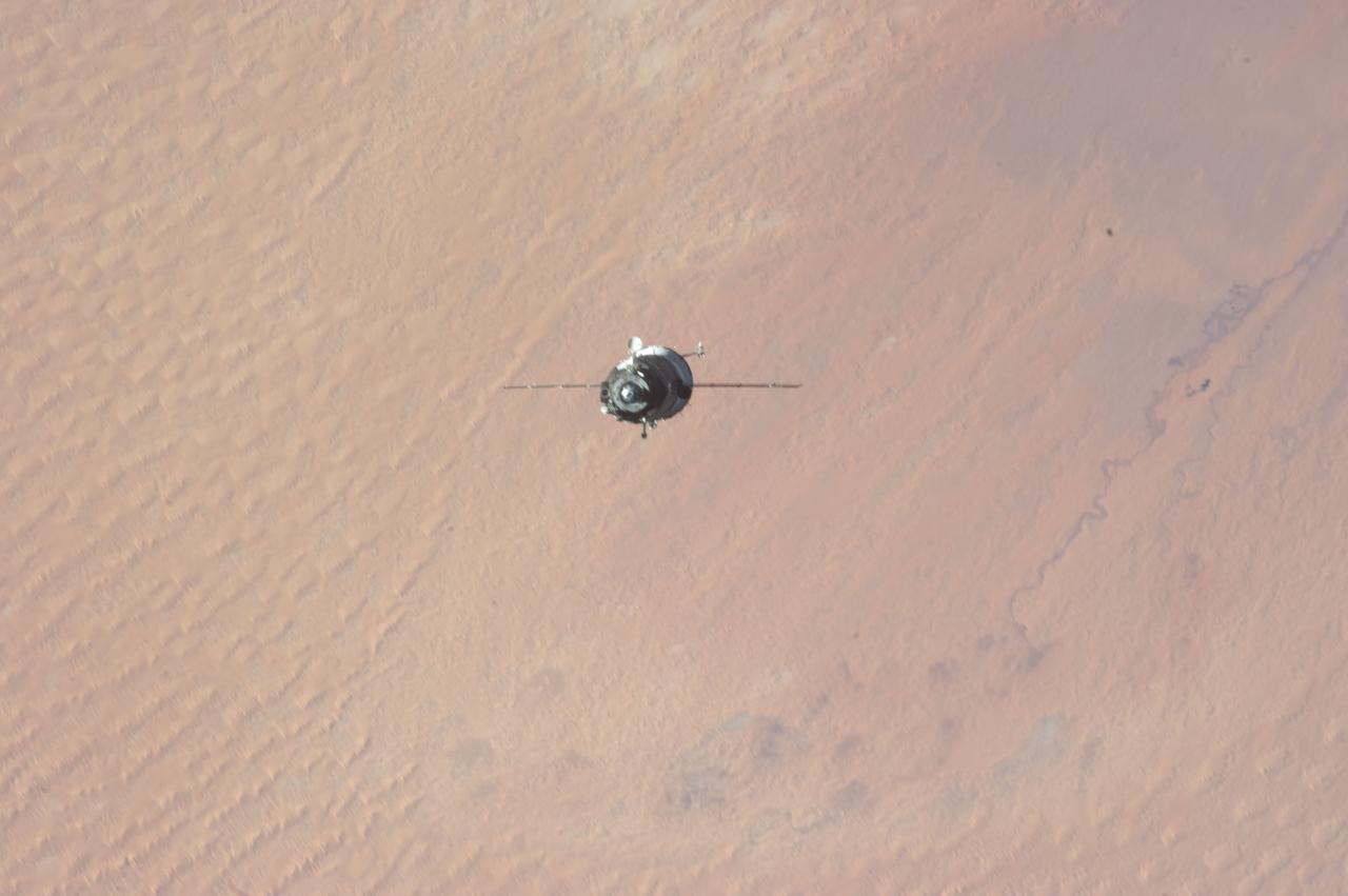
ISS034-E-009926 (21 Dec. 2012) --- As the International Space Station and Soyuz TMA-07M spacecraft were making their relative approaches on Dec. 21, one of the Expedition 34 crew members on the orbital outpost captured this photo of the Soyuz over the Sahara Desert. The image center is at 31.7 degrees north latitude and 2.0 degrees east longitude, on the south side of the Atlas Mountains and on the northern margin of a huge dune field known as Grand Erg Occidental, located in north central Algeria. Inside the arriving spacecraft were astronaut Chris Hadfield of the Canadian Space Agency, cosmonaut Roman Romanenko of Russia's Federal Space Agency and NASA astronaut Tom Marshburn.
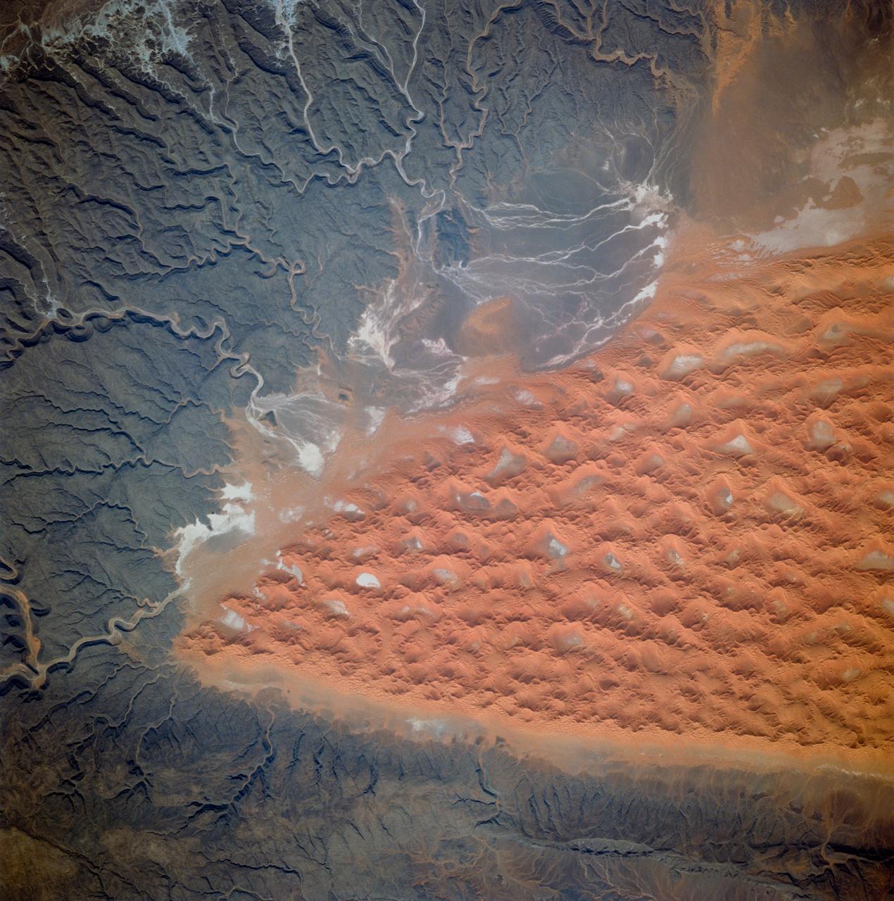
STS103-710-084 (19-27 December 1999)--- One of the astronauts aboard the Earth-orbiting Space Shuttle Discovery used a handheld 70mm camera to photograph the great sand seas which occupy northern Algeria. They are Grand Erg Oriental (Eastern Sand Sea) and Grand Erg Occidental (Western Sand Sea). Both sand seas occupy depressions that are separated by a north-south rise called Mizab. Ergs are areas of large accumulations of sand that take the form of actively shifting dunes, fossilized dunes, or extensive sand sheets.
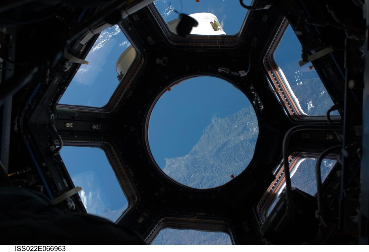
ISS022-E-066963 (17 Feb. 2010) --- This image is among the first taken through a first of its kind ?bay window? on the International Space Station, the seven-windowed Cupola. The image shows the coast of Algeria featuring (in the Cupola?s round window) an area between the cities of Dellys and Algiers. The image was recorded with a digital still camera using a 28mm lens setting. The Cupola, which a week and half ago was brought up to the orbital outpost by the STS-130 crew on the space shuttle Endeavour, will house controls for the station robotics and will be a location where crew members can operate the robotic arms and monitor other exterior activities.
ISS034-E-009924 (21 Dec. 2012) --- As the International Space Station and Soyuz TMA-07M spacecraft were making their relative approaches on Dec. 21, one of the Expedition 34 crew members on the orbital outpost captured this photo of the Soyuz backdropped by the Sahara Desert. Inside the arriving spacecraft were astronaut Chris Hadfield of the Canadian Space Agency, cosmonaut Roman Romanenko of Russia's Federal Space Agency and NASA astronaut Tom Marshburn. The image center is at 31.7 degrees north latitude and 2.0 degrees east longitude, on the south side of the Atlas Mountains and on the northern margin of a huge dune field known as Grand Erg Occidental, located in north central Algeria.
STS054-152-189 (13-19 Jan. 1993) --- This near-vertical color photograph shows the very diverse landscape that is part of the great Sahara Desert of north Africa. Specifically, the vast expanse of sand dunes, located in the extreme southwestern corner of Libya, is known as the Murzuk Sand Sea. Close inspection of this photograph shows the agricultural village of Murzuk as evidenced by the numerous center pivot irrigation patterns at the edge of the Murzuk Sand Sea. The very rugged, dissected terrain to the west of this sand sea is the eastern tip of the Tassili N'ajjer Mountains and the Tadrart Plateau that are in neighboring Algeria. Several smaller areas of sand dunes are interspersed between the major areas of rock outcrops. The photograph was taken with a Linhof camera.
AS08-16-2588 (21-27 Dec. 1968) --- Both sides of the Atlantic Ocean are visible in this view from Apollo 8 spacecraft. (Hold picture with Earth at bottom left). The large, most prominent land mass is the bulge of West Africa. The portion of Africa near the equator is dark and cloudy, but the more northerly portions are clear, showing the prominent cape at Dakar and the Senegal River in Senegal; Cap Blanc; the Adrar Plateau in Mauretania; the wide expanse of desert in Algeria and Spanish Sahara; and the far edge, the Atlas and Anti-Atlas Mountains in Morocco. Clouds cover the eastern coast of South America, southward from Surinam and Guyana to near the city of Salvador, Brazil. The view was photographed following trans-lunar insertion.
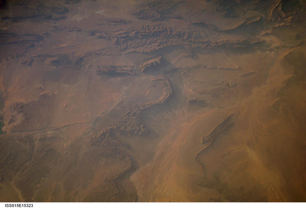
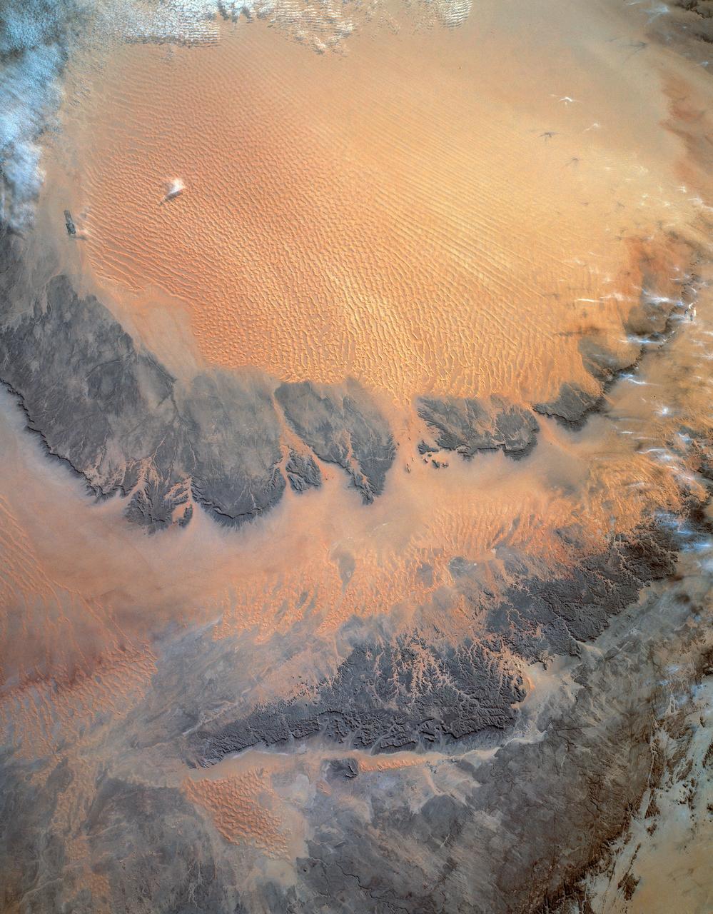
ISS015-E-15323 (27 June 2007) --- Part of Bechar Basin, Algeria is featured in this image photographed by an Expedition 15 crewmember on the International Space Station. The Bechar Basin of northwestern Algeria reaches depths of 8,000 meters, and is a producing hydrocarbon region. According to scientists, the basin was formed as Paleozoic (approximately 250-540 million years old) sedimentary layers were folded and faulted during much later collision of the continents of Africa and Europe during the Tertiary Period (approximately 2-65 million years ago). Hydrocarbon reservoirs are located within clastic (formed of variably-sized pieces of pre-existing rock) sedimentary rocks and fossilized coral reefs. Dark brown to tan folded ridges of these Paleozoic sedimentary layers extend across this view from top to bottom. Sand dunes are visible to the north, south, and west of the city of Bechar (gray-blue region to the left of the fold ridges) at center. Wadis (river channels) are dry most of the year in the arid climate of the region. Unconsolidated (loose) sands left in the channels by intermittent streams are transported by surface winds after the water is gone. This leads to the formation of individual dunes and larger dune fields (both bright tan in color) along the wadi courses, which also concentrate sands from other sources; dune fields are visible to the south of Bechar and at lower right. The oblique -- looking at an angle from the International Space Station, versus looking straight down - view of this photo accentuates cliff and dune shadows, providing a sense of the topography of the region.
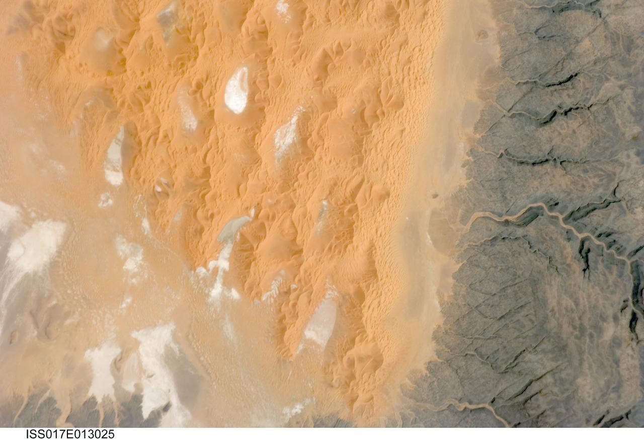
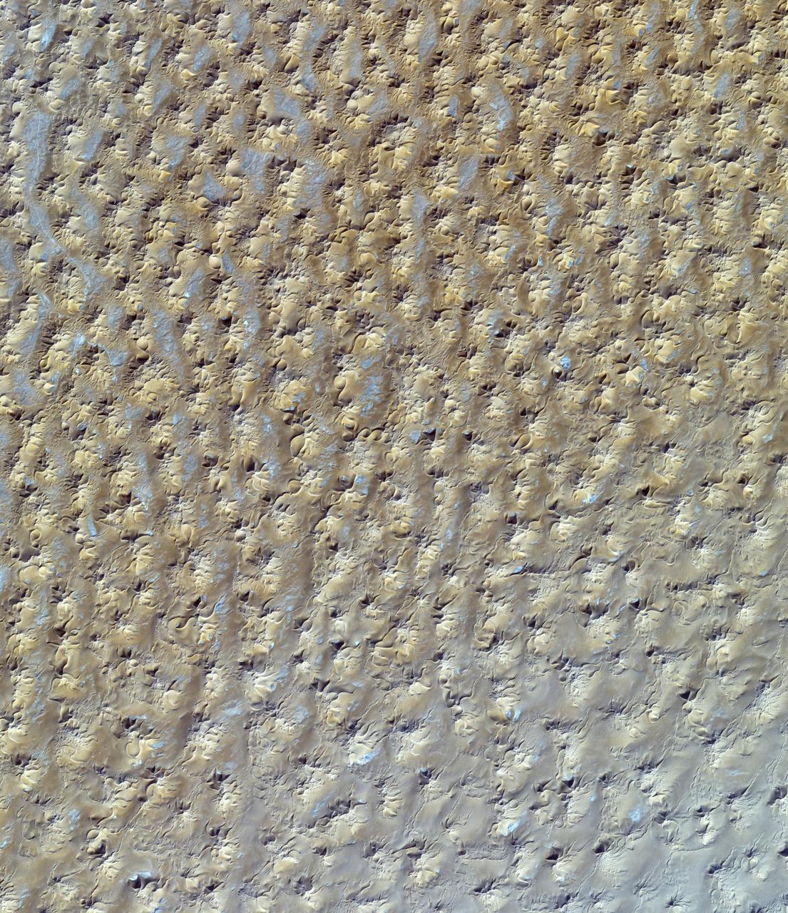
ISS017-E-013025 (12 Aug. 2008) --- The Tifernine Dune Field in Algeria is featured in this image photographed by an Expedition 17 crewmember on the International Space Station. The Tifernine Dune Field is located at the southernmost tip of the Grand Erg Oriental, a "dune sea" that occupies a large portion of the Sahara Desert in eastern Algeria. This view illustrates the interface between the yellow-orange sand dunes of the field and adjacent dark brown consolidated rocks of the Tinrhert Plateau to the south and east (right). NASA scientists point out that three distinct landform types are visible in the image, each providing information about past and present climate in the area. The oldest landform is represented by the rocks of the Tinrhert Plateau, which are characterized by a number of incised channels in the bedrock -- these formed during a wet and cool climate period, most probably by glacial meltwater streams. As the present dry and hot climate that characterizes the Sahara became established, water ceased to flow in these channels, and large amounts of drying sediment (sand, silt, and clay) were eroded and transported by predominantly northeast-southwest winds -- forming large linear dunes that roughly parallel the prevailing wind direction (center). The present climate regime is still hot and dry, but current wind directions are more variable, leading to the formation of star dunes -- recognizable by a starfish-like pattern when seem from above -- that are modifying the older large linear dunes. White to grey regions within the dune field are exposed deposits of silt and clay, together with evaporite minerals (such as halite, or common table salt) formed by evaporation of water that collected in small basins between the dunes.

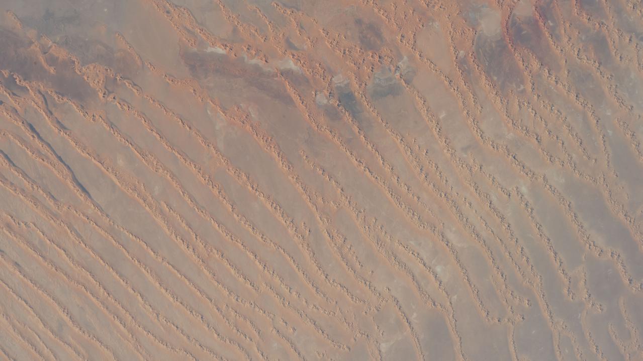
ISS013-E-75141 (2 Sept. 2006) --- Erg Oriental, Algeria is featured in this image photographed by an Expedition 13 crewmember onboard the International Space Station. One of the main interests of rainless regions like the Sahara Desert to landscape science is that the work of flowing water--mainly streams and rivers--becomes less important than the work of wind. According to scientists, over millennia, and if enough sand is available, winds can generate dunes of enormous size, arranged in regular patterns. Long, generally north-south trending linear dunes stretch across much of northeast Algeria covering a vast tract (approximately 140,000 kilometers square) of the Sahara Desert known as the Erg Oriental. Erg means dune sea in Arabic, and the term has been adopted into modern geology. Spanning this image diagonally are a series of two kilometer-wide linear dunes, comprised of red sand, from a point on the southwest margin of the erg (center point 28.9N 4.8W). The dune chains are more than 100 meters high. The "streets" between the dunes are grayer areas free of sand. Linear dune chains are usually generated roughly parallel with the dominant winds. It also seems to be true that linear dunes are built by stronger winds. This detailed view shows that smaller dunes, known as star dunes, are built on top of the linear dunes. By contrast, star dunes seem to form in weak wind regimes, with winds from different directions in each season -- resulting in characteristic "arms" snaking away from a central point. Some scientists therefore think the dunes in this image were generated in two earlier climatic phases, different from that of today. (1) During a phase when winds were stronger and dominantly from one direction (the south), major linear sand masses accumulated. (2) Later, when wind strengths declined, the star dunes formed. Modern features--known as wind streaks--on the edge of the present erg (not shown), younger than either the linear or star dunes, show that present-day sand-moving winds blow from the southwest.
In December 2016, snow fell in the Sahara for the first time since 1979. In 1984, the charitable supergroup Band Aid sang: “There won’t be snow in Africa this Christmas time.” In fact, it does snow in Africa at high elevations. Kilimanjaro has long had a cap of snow and ice, though it has been shrinking. Skiiers travel for natural and manufactured snow in the Atlas Mountains of Morocco and Algeria, as well as a few spots in South Africa and Lesotho. Nonetheless, snow on the edge of the Sahara Desert is rare. On December 19, 2016, snow fell on the Algerian town of Ain Sefra, which is sometimes referred to as the “gateway to the desert.” The town of roughly 35,000 people sits between the Atlas Mountains and the northern edge of the Sahara. The last recorded snowfall in Ain Sefra occurred in February 1979. The Enhanced Thematic Mapper Plus (ETM+) on the Landsat 7 satellite acquired this natural-color image of snow in North Africa on December 19, 2016. This scene shows an area near the border of Morocco and Algeria, south of the city of Bouarfa and southwest of Ain Sefra. Though the news has been dominated by snow in the Saharan city, a review of several years of satellite data suggests that snow is also pretty rare in this section of the Atlas range. Read more: <a href="http://go.nasa.gov/2hIH4Xe" rel="nofollow">go.nasa.gov/2hIH4Xe</a> NASA Earth Observatory image by Joshua Stevens, using Landsat data from the U.S. Geological Survey. Caption by Mike Carlowicz. b><a href="http://www.nasa.gov/audience/formedia/features/MP_Photo_Guidelines.html" rel="nofollow">NASA image use policy.</a> <b><a href="http://www.nasa.gov/centers/goddard/home/index.html" rel="nofollow">NASA Goddard Space Flight Center</a></b> enables NASA’s mission through four scientific endeavors: Earth Science, Heliophysics, Solar System Exploration, and Astrophysics. Goddard plays a leading role in NASA’s accomplishments by contributing compelling scientific knowledge to advance the Agency’s mission. <b>Follow us on <a href="http://twitter.com/NASAGoddardPix" rel="nofollow">Twitter</a></b> <b>Like us on <a href="http://www.facebook.com/pages/Greenbelt-MD/NASA-Goddard/395013845897?ref=tsd" rel="nofollow">Facebook</a></b> <b>Find us on <a href="http://instagrid.me/nasagoddard/?vm=grid" rel="nofollow">Instagram</a></b>
ISS030-E-030290 (31 Dec. 2011) --- Majorca in the Balearic Islands (Spain) is featured in this image photographed by an Expedition 30 crew member aboard the International Space Station. The Balearic Islands are an archipelago located to the southwest of Spain in the Mediterranean Sea. Catalan – the native tongue – and Spanish are the official languages. The islands are an autonomous community and province of Spain, located approximately midway between the southeastern coastline of Spain and the northern coastline of Algeria. This photograph highlights the large island of Majorca (approximately 5,400 square kilometers; also known as Mallorca in Spanish) on which the capital city of Palma is located (center). The small island of Cabrera to the southwest of Majorca (upper left) hosts the Parc Nacional de l’Arxipelag de Cabrera (site mainly in Spanish). Like the other Balearic Islands, Majorca is a popular holiday destination for the European community with tourism forming a major part of the island’s economy. The island’s physiography offers many recreational opportunities – mountainous regions are present along the northwest coastline and eastern third, while much of the central part of the island is flat. Diving is also a popular activity. The central region includes agricultural lands (tan, light brown, and green, center), forested patches and corridors (dark green, center), and urban centers (gray). In addition to Majorca, the other major islands of the archipelago include Ibiza, Formentera, and Minorca.
STS039-151-193 (28 April-6 May 1991) --- The Strait of Gibraltar, the only outlet for the Mediterranean Sea, was photographed with a large format handheld camera by the STS-39 crew members. Scientists site evidence in Shuttle photography that the Mediterranean Sea dried up a number of times between 5 million and 20 million years ago. Sea levels, they say, dropped slightly, cutting off the Mediterranean (top right) from the Atlantic Ocean (bottom). In southern Spain, the dark area near the coast is the delta of the Guadalquivir River with the city of Seville. The Sierra Nevada range still has some snow. A small field fire near the Spanish coast has generated a conspicuous smoke plume. The small spike of land on the north side of the Strait is the Rock of Gibraltar, an outpost of the British empire. The larger spike of land on the north coast of Africa marks the border between Morocco (center foreground) and Algeria (right). The sharp line cutting across them Mediterranean (top right) marks the edge of a dust cloud blowing from Africa into Europe. Photo credit: NASA
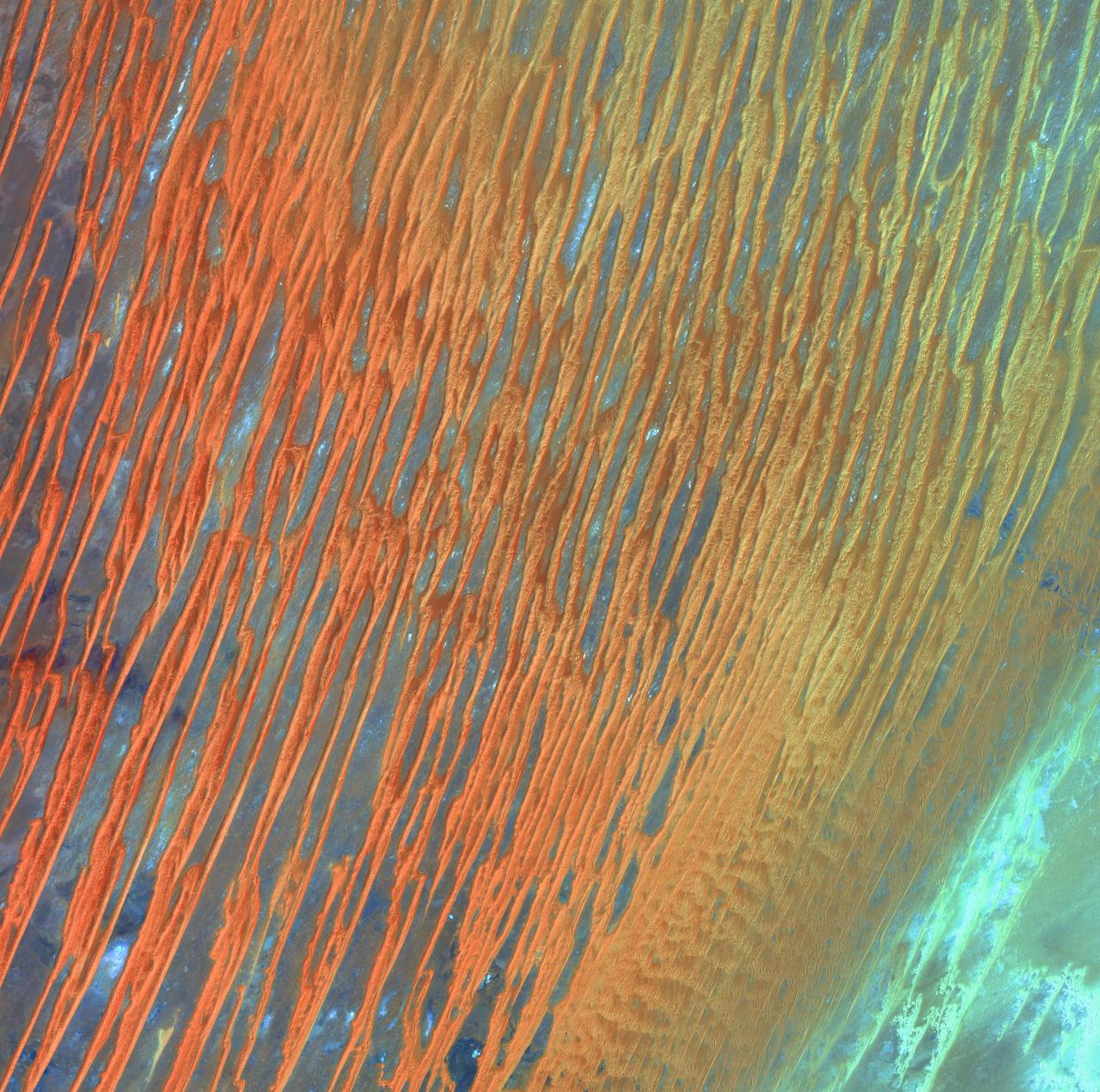
Desert Patterns - April 13th, 2003 Description: Seen through the "eyes" of a satellite sensor, ribbons of Saharan sand dunes seem to glow in sunset colors. These patterned stripes are part of Erg Chech, a desolate sand sea in southwestern Algeria, Africa, where the prevailing winds create an endlessly shifting collage of large, linear sand dunes. The term "erg" is derived from an Arabic word for a field of sand dunes. Credit: USGS/NASA/Landsat 7 To learn more about the Landsat satellite go to: <a href="http://landsat.gsfc.nasa.gov/" rel="nofollow">landsat.gsfc.nasa.gov/</a> <b><a href="http://www.nasa.gov/centers/goddard/home/index.html" rel="nofollow">NASA Goddard Space Flight Center</a></b> enables NASA’s mission through four scientific endeavors: Earth Science, Heliophysics, Solar System Exploration, and Astrophysics. Goddard plays a leading role in NASA’s accomplishments by contributing compelling scientific knowledge to advance the Agency’s mission. <b>Follow us on <a href="http://twitter.com/NASA_GoddardPix" rel="nofollow">Twitter</a></b> <b>Join us on <a href="http://www.facebook.com/pages/Greenbelt-MD/NASA-Goddard/395013845897?ref=tsd" rel="nofollow">Facebook</a></b>
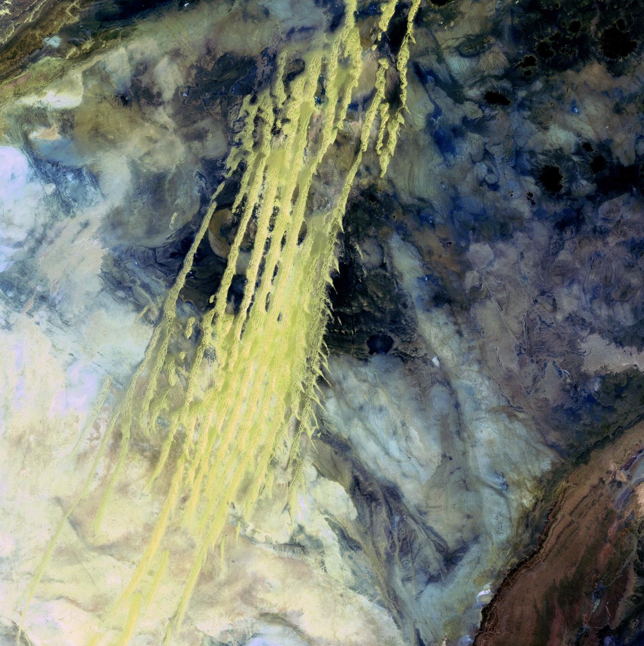
Algerian Abstract - April 8th, 1985 Description: What look like pale yellow paint streaks slashing through a mosaic of mottled colors are ridges of wind-blown sand that make up Erg Iguidi, an area of ever-shifting sand dunes extending from Algeria into Mauritania in northwestern Africa. Erg Iguidi is one of several Saharan ergs, or sand seas, where individual dunes often surpass 500 meters-nearly a third of a mile-in both width and height. Credit: USGS/NASA/Landsat 5 To learn more about the Landsat satellite go to: <a href="http://landsat.gsfc.nasa.gov/" rel="nofollow">landsat.gsfc.nasa.gov/</a> <b><a href="http://www.nasa.gov/centers/goddard/home/index.html" rel="nofollow">NASA Goddard Space Flight Center</a></b> enables NASA’s mission through four scientific endeavors: Earth Science, Heliophysics, Solar System Exploration, and Astrophysics. Goddard plays a leading role in NASA’s accomplishments by contributing compelling scientific knowledge to advance the Agency’s mission. <b>Follow us on <a href="http://twitter.com/NASA_GoddardPix" rel="nofollow">Twitter</a></b> <b>Join us on <a href="http://www.facebook.com/pages/Greenbelt-MD/NASA-Goddard/395013845897?ref=tsd" rel="nofollow">Facebook</a></b>
SL3-34-056 (July-September 1973) --- A near vertical view of an 8,000 square-mile area of the Grand Erg Oriental in east central Algeria as photographed from Earth orbit by one of the six lenses of the Itek-furnished S190-A Multispectral Photographic Facility Experiment in the Multiple Docking Adapter of the Skylab space station. The Grand Erg contains vast areas of sand dunes and sand plains. This photograph illustrates the variety of surface features that are characteristic of the Sahara Desert. The dark areas are relatively sand free, and may contain rock outcrops along which travel is considerably easier. Sand dunes are abundant in this picture, and their size, shape, location and pattern are due to the underlying topography and direction of the prevailing winds. Scientists interested in study of dune fields will be able to use this photograph for detailed analysis of the dune features, especially their characteristics adjacent to the sand-free areas. Federal agencies participating with NASA on the EREP project are the Departments of Agriculture, Commerce, Interior, the Environmental Protection Agency and the Corps of Engineers. All EREP photography is available to the public through the Department of Interior?s Earth Resources Observations Systems Data Center, Sioux Falls, South Dakota, 57198. Photo credit: NASA
STS057-73-075 (21 June-1 July 1993) --- Eastern Mediterranean from an unusually high vantage point over the Nile River, this north-looking view shows not only the eastern Mediterranean but also the entire landmass of Asia Minor, with the Black Sea dimly visible at the horizon. Many of the Greek islands can be seen in the Aegean Sea (top left), off the coast of Asia Minor. Cyprus is visible under atmospheric dust in the northeast corner of the Mediterranean. The dust cloud covers the east end of the Mediterranean, its western edge demarcated by a line that cuts the center of the Nile Delta. This dust cloud originated far to the west, in Algeria, and moved northeast over Sicily, southern Italy, and Greece. Part of the cloud then moved on over the Black Sea, but another part swerved southward back towards Egypt. A gyre of clouds in the southeast corner of the Mediterranean indicates a complementary counterclockwise (cyclonic) circulation of air. The Euphrates River appears as a thin green line (upper right) in the yellow Syrian Desert just south of the blue-green mountains of Turkey. The Dead Sea (lower right) lies in a rift valley which extends north into Turkey and south thousands of miles down the Gulf of Aqaba, the Red Sea, and on through East Africa. The straight international boundary between Israel and Egypt (where the coastline angles) is particularly clear in this view, marked by the thicker vegetation on the Israeli side of the border. The green delta of the Nile River appears in the foreground, with the great conurbation of Cairo seen as a gray area at the apex of the triangle. Most of Egypt's 52 million inhabitants live in the delta. On the east side of the delta, the Suez Canal is visible. On the western corner of the delta lies the ancient city of Alexandria, beside the orange and white salt pans. The World War II battlesite El Alamein lies on the coast.

ISS030-E-254011 (21 April 2012) --- The Ouarkziz Impact Crater is featured in this image photographed by an Expedition 30 crew member on the International Space Station. The Ouarkziz Impact Crater is located in northwestern Algeria close to the border with Morocco. According to scientists, the crater was formed by a meteor impact less than 70 million years ago during the late Cretaceous Period of the Mesozoic Era or “Age of Dinosaurs”. Originally called Tindouf, the 3.5-kilometer in diameter impact crater (center) has been heavily eroded since its formation; however its circular morphology is highlighted by exposures of older sedimentary rock layers that form roughly northwest-to-southeast-trending ridgelines to the north and south. From the vantage point of a crew member onboard the space station, the impact crater is clearly visible with a magnifying camera lens. A geologist interpreting this image to build a working geological history of the region would conclude that the Ouarkziz impact crater is younger than the sedimentary rocks, as the rock layers had to be already present for the meteor to hit them. Likewise, a stream channel is visible cutting across the center of the impact structure (center), indicating that the channel formed after the impact had occurred. This Principal of Cross-Cutting Relationships, usually attributed to the famous 19th century geologist Charles Lyell, is a basic logic tool used by geologists to build relative sequence and history of events when investigating a region.
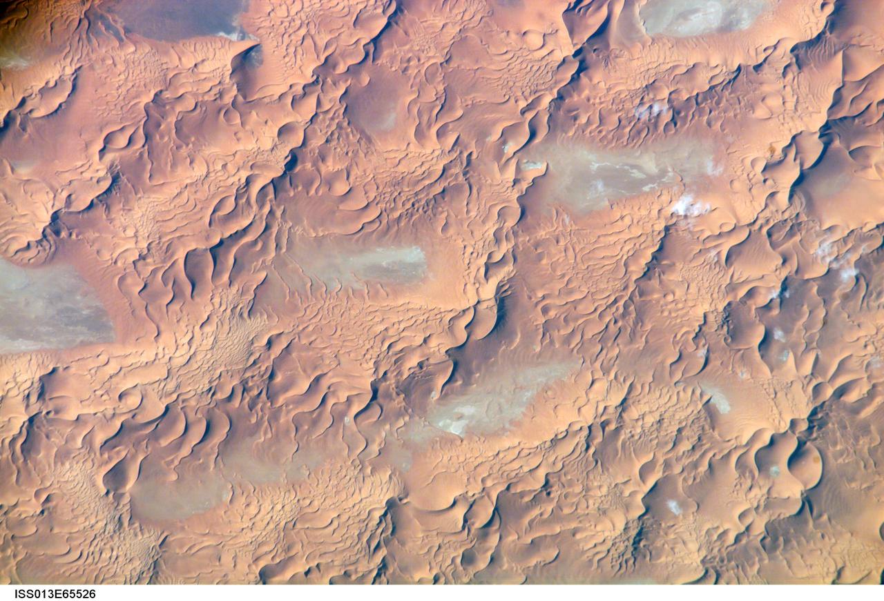
ISS013-E-65526 (8 Aug. 2006) --- Issaouane Dune Sea, Eastern Algeria is featured in this image photographed by an Expedition 13 crewmember on the International Space Station. This view from one of the smaller dune seas in the central Sahara shows the complex but regular patterns produced by winds in deserts where abundant sand is available. Geologists now know that dune seas (also called ergs) comprise at least three orders of dune size. In this image the largest and oldest appear here as chains oriented about 60 degrees apart, that is, one oriented almost north-south, the other southwest-northeast. The "streets" between the dune chains (also called mega-dunes) are swept clean of sand in places, revealing the original surface, with light colored muds and salt derived from very occasional rains. The chains have probably taken hundreds of thousands of years to accumulate, starting when the Sahara began to become significantly dry roughly 2.5 million years ago. Rivers became smaller, failed to reach the sea and deposited their sand load in the desert. Wind did the rest, blowing the sand into aerodynamic dune forms. According to scientists, chain trends coincide with two of the four major trends identified in the Great Eastern Sand Sea immediately to the north. Each trend likely implies a different formative wind direction--attesting to the climate shifts that have occurred since sand began to accumulate in the central Sahara. Smaller dunes are superimposed on the mega-dunes. Sinuous crest lines are the mesoscale (intermediate in size) forms, forming octopus-like crests, especially evident as the arms of star dunes. Whereas the mega-dunes are apparently stationary, studies based on aerial photographs in other parts of the world show that these dune crests move in the course of decades. The smallest dunes appear in patches on the eastern sides of the mega-dunes as a tracery of closely spaced crests. Small dunes move fast and reform quickly as stronger winds shift with the seasons. Sand grains are blown continuously from upwind dunes, across the dune-free flats. Small dunes form when the grains slow down and accumulate at the next large dune. The small dunes ride up and over the backs of the mega- and meso-dunes. Interestingly the crest orientation of the small dunes is different from that of the mesoscale dunes throughout the image. This is a common effect of wind direction shifting locally depending on dune height: the increased friction caused by larger dunes causes formative winds to blow to the left of the (weaker) winds that form the small dunes. The friction effect of larger dunes is to the right in the southern hemisphere, well illustrated on the coast of the Namib Desert.