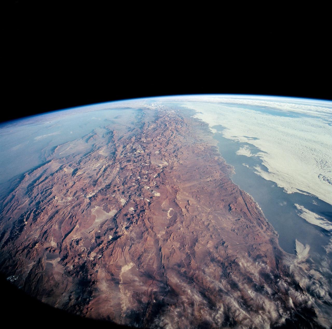
STS-65 Earth observation taken aboard Columbia, Orbiter Vehicle (OV) 102, shows Northern Chile and the Andes Mountains. This color photograph is a panoramic (southern view) that features Chile and the Andes Mountains of South America. The Atacama Desert, one of the driest regions on Earth, is clearly visible along the Chilean coast. In the near left foreground is the Salar de Arizaro. Salar Punta Negra in the center foreground appears to be partially filled with water. On the right side of the view, a coastal plateau rises from the Pacific Ocean and meets the Andes Mountains that appear as a backbone running north to south along the border of Chile and Argentina. In the distant left portion of the view can be seen the hazy Chaco Plains and Pampas.
This anaglyph, from NASA Shuttle Radar Topography Mission, in South America is dominated by the Andes Mountains, which extend all along the Pacific Coast. 3D glasses are necessary to view this image.
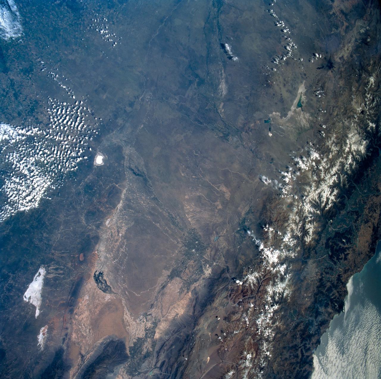
iss058e006004 (Jan. 26, 2019) --- This photograph of South America from bottom to top looks from the northeast coast of Argentina to southwest across Chile, the Andes mountains and the Pacific Ocean. The International Space Station was orbiting 259 miles above the Atlantic coast of the South American continent.
This false-color mosaic of the central part of the Andes mountains of South America 70 degrees w. longitude, 19 degrees s. latitude is made up of 42 images acquired by NASA’s Galileo spacecraft from an altitude of about 25,000 kilometers 15,000 miles. http://photojournal.jpl.nasa.gov/catalog/PIA00133
iss059e067738 (May 19, 2018) --- Snow-capped mountain tops are pictured as the International Space Station orbited 257 miles above the Andes mountain range along the western coast of South America.
ISS047e014747 (03/22/2016) --- Crewmembers of the International Space Stations Expedition 47 captured this image of southern South America. Patagonia is a sparsely populated region located at the southern end of South America, shared by Argentina and Chile. The region comprises the southern section of the Andes mountains as well as the deserts, steppes and grasslands east of this southern portion of the Andes. The Colorado and Barrancas rivers, which run from the Andes to the Atlantic, are commonly considered the northern limit of Argentine Patagonia
iss067e355983 (Sept. 11, 2022) --- The Andes Mountain range is pictured from the International Space Station as it orbited 264 miles above the coast of central Chile in South America.
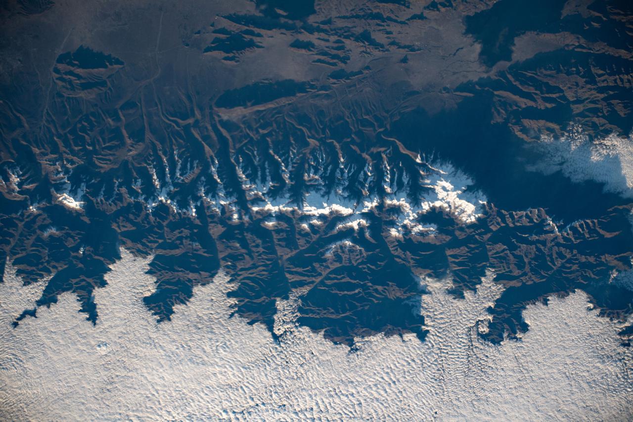
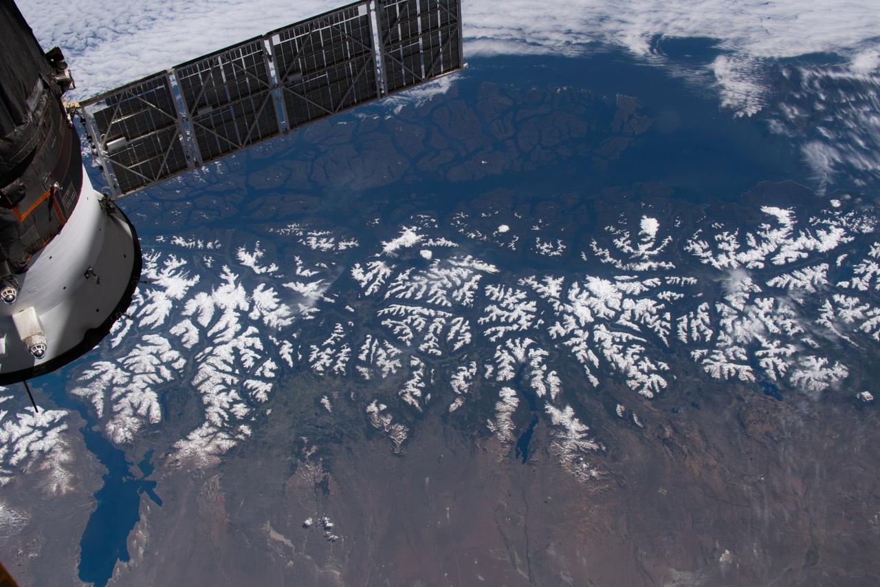
iss072e398041 (Dec. 21, 2024) --- The snow-tipped Andes mountain range and its many lakes on the southern border between Chile and Argentina are pictured from the International Space Station as it orbited 268 miles above South America.
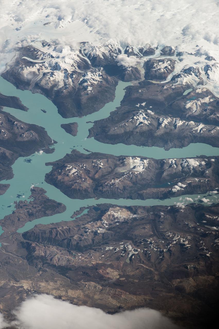
iss064e003738 (Nov. 8, 2020) --- The snow-capped peaks of the Andes Mountains in southern Chile, with General Carrera Lake at bottom left, are pictured from the International Space Station as it orbited above South America.
S66-38290 (5 June 1966) --- The north coastal area of Peru looking southeast across the Andes Mountains as seen from the National Aeronautics and Space Administration's Gemini-9A spacecraft. The body of water is the Pacific Ocean. The image was taken with a modified 70mm Hasselblad camera, using Eastman Kodak, Ektachrome MS (S.O. 217) color film. Photo credit: NASA
iss073e0384067 (July 12, 2025) --- The Andes Mountains run through Chile and Bolivia on the South American continent. The eastern slope of the Andes in Bolivia captures moisture from the Amazon basin creating more rainfall on that side of the nation and contributes to an arid climate on South America's Pacific coast. The International Space Station was orbiting 260 miles above Chile when this photograph was taken.

AS08-16-2593 (21-27 Dec. 1968) --- A striking view from the Apollo 8 spacecraft showing nearly the entire Western Hemisphere, from the mouth of the St. Lawrence River, including nearby Newfoundland, extending to Tierra del Fuego at the southern tip of South America. Central America is clearly outlined. Nearly all of South America is covered by clouds, except the high Andes Mountain chain along the west coast. A small portion of the bulge of West Africa shows along the sunset terminator.

iss063e053023 (July 22, 2020) --- Lake Titicaca, pictured from the International Space Station as it orbited off the Pacific coast of South America, is located between the nations of Peru and Bolivia in the Andes Mountains and is one of the highest navigable lakes in the world.
STS054-151-150 (13-19 Jan 1993) --- View west into sun glint off the Rio Salado, Saladillo, and Parana Rivers in Argentina. The Space Shuttle nadir is about 28 degrees north latitude and 57 degrees west longitude. The Andes Mountains are barely visible on Earth's limb. Thunderstorms along the eastern edge of the Andes are typical of this time of year (Southern Hemisphere summer), with anvils moving to the east from the core of the storm.
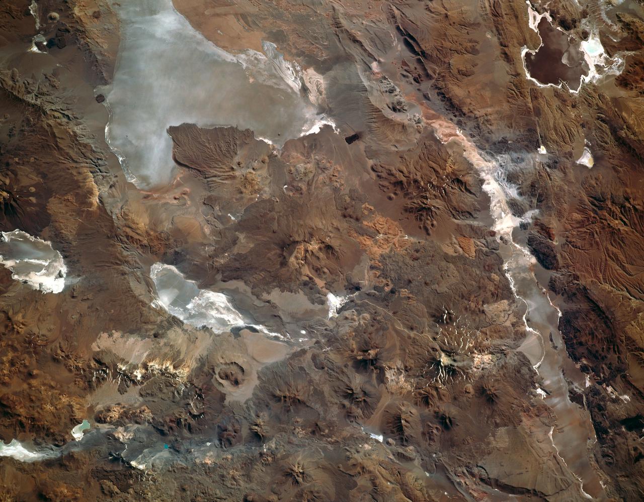
This photograph captures the exotic volcanic terrain of the Altiplano of the Central Andes. Some of the remarkable details include the west-pointing wind streaks, resulting from fine dust being transported across the Andes by high winds; paleto (old) shorelines along the margins of the salars (or dry lake beds), recording the changes in water levels on the high Altiplano; beautiful alluvial fans emptying onto some of the salars; and the hundreds of volcanic land forms which can be mapped and interpreted to help decipher the volcanic history of the region.
STS089-742-014 (22-31 Jan. 1998) --- This near-nadir picture of the central Andes, showing Santiago and other parts of Chile and Argentina, was photographed with a 70mm handheld camera from the Earth-orbiting space shuttle Endeavour. Santiago (population 4.7 million) is visible to the right of center, west of the snow-capped Andes Mountains. Mendoza, Argentina is the light spot in the upper center of the image in the eastern foothills of the Andes. Cerro Aconcagua, the highest peak in South America (22,834 feet) is due west of Mendoza. Note the sharp bend in the river valley to the junction with a straight north-trending valley. Aconcagua is the large, rounded mass with a bit of cloud just northwest of the valley junction. Bright white spots on the left of the image are salars, or dry lake beds of gypsum and/or salt. Usually dry, some contain water due to recent rains generated by the record El Nino this year. The Pacific Ocean is to the upper right. The continental shelf is very steep in this region and water depths drop (to almost 17,000 feet over a distance of about 60 miles) over the same distance inland from the coast, the Andes rise +17,000 to almost 23,000 feet. The reason for this is the very rapid plate motion between the Pacific Ocean plate and South America. According to NASA scientists, over the last 140 million years, South America has been overriding the Pacific plate resulting in the rapid rise in the Andes and the rapid subduction of the Pacific plate, along with any sediments that are shed into the ocean along the continental margin. The dark, linear mountain ranges east of the high Andes (right center) constitute the Precordillera block; rock strata there have been correlated with the Ordovician (approximately 470 million years old) rocks near El Paso, Texas. The rocks and the fossils within them are virtually identical in the two areas, which are now widely separated. This region would be considered a "remnant terrain" from the time when this portion of South America and Texas were once joined. Photo credit: NASA
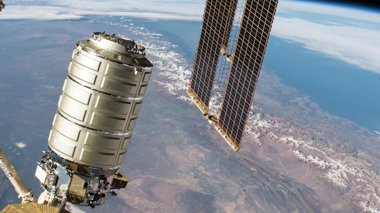
iss057e103653 (Nov. 19, 2018) --- Northrop Grumman's Cygnus space freighter with its prominent cymbal-shaped UltraFlex solar arrays is pictured in the grips of the Canadarm2 robotic arm as it is remotely maneuvered by ground controllers towards the Earth-facing port of the Unity module. Both spacecraft were orbiting 259 miles above the Andes mountains in South America.
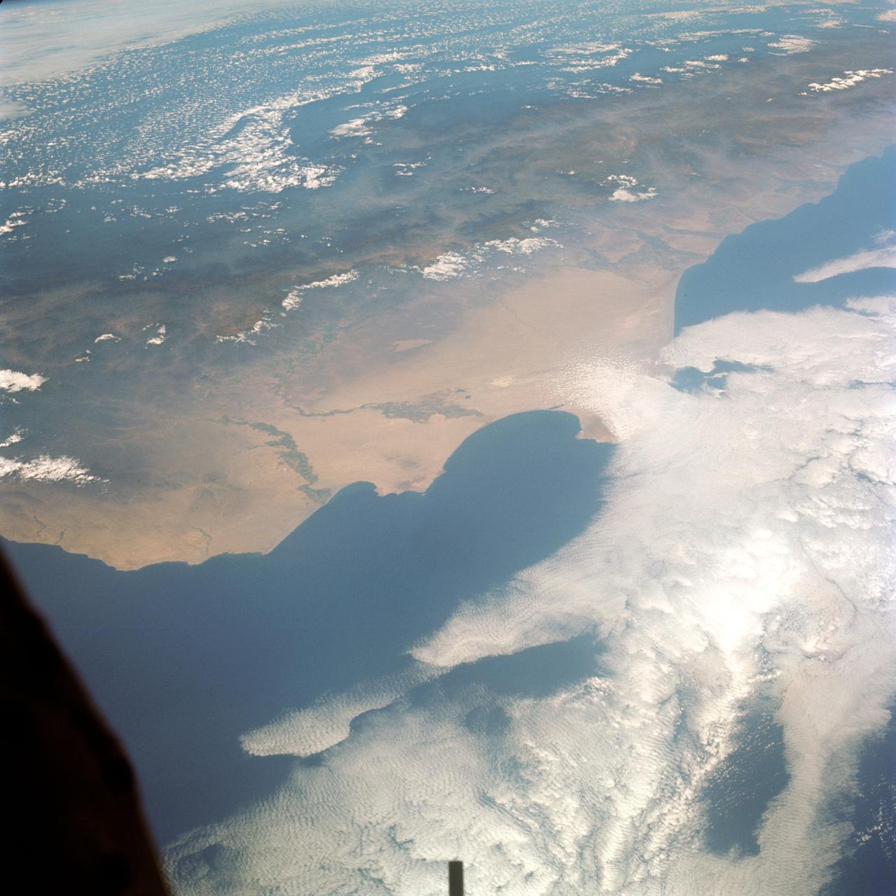
STS043-151-159 (2-11 August 1991) --- This photograph looks westward over the high plateau of the southern Peruvian Andes west and north of Lake Titicaca (not in field of view). Lima, Peru lies under the clouds just north of the clear coastal area. Because the high Andes have been uplifted 10,000 to 13,000 feet during the past 20 million years, the rivers which cut down to the Pacific Ocean have gorges almost that deep, such as the Rio Ocona at the bottom of the photograph. The eastern slopes of the Andes are heavily forested, forming the headwaters of the Amazon system. Smoke from burning in the Amazon basin fills river valleys on the right side of the photograph. A Linhof camera was used to take this view.

STS089-709-049 (22-31 Jan. 1998) --- This oblique photograph of Argentina and Chile was among several of South America photographed with a 70mm handheld camera from the Earth-orbiting space shuttle Endeavour. This part of Patagonia in Argentina and the lake district of Chile and Argentina are in southern South America between latitudes 40 degrees and 43 degrees. It is a beautiful alpine region noted for skiing and for the recent immigration of rich Americans and Europeans. On the west side of the Andes are a series of snow-capped volcanoes that are formed due to melting of sediments and portions of the Pacific Plate, which are being subducted beneath South America. East of the mountains the plains are barren and windswept, noted as having "the curse of sterility" by Charles Darwin. In the mountain regions some alpine valleys are filled by lovely lakes, such as Nahuel Huapi (in sunglint). The university town and ski resort of Bariloche, Argentina is the light area on the southeastern shore. In 1901 Robert Leroy Parker and Harry Longabaugh (aka Butch Cassidy and Sundance Kid) bought a ranch near the town of Cholila (lower left in the photo) with the proceeds of a robbery of the First National Bank of Winnemucca, Nevada. They lived there as successful ranchers until 1907, when they were reportedly forced to sell out and flee to Bolivia where their career ended at the hands of the Bolivian army. Photo credit: NASA

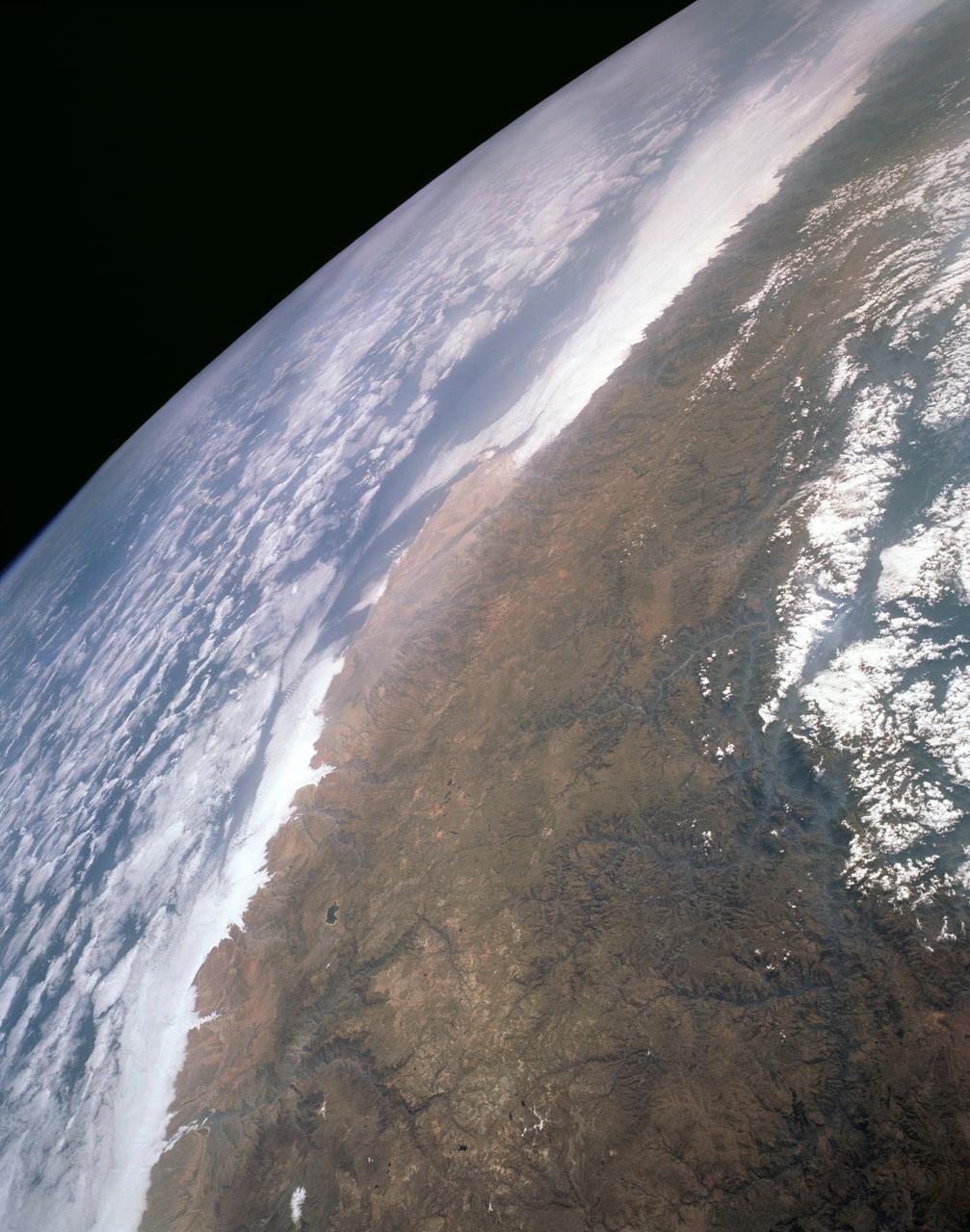
STS031-83-090 (24-29 April 1990) --- This late afternoon scene over the Andes Mountains features sun glare, heavy cloud illumination and sunglint against the Pacific Ocean. This photo was among those selected by the crew members for showing at their May 9, 1990, Post-Flight Press Conference (PFPC) at the Johnson Space Center (JSC) Public Affairs Office (PAO) Facility briefing room. Onboard the Space Shuttle Discovery for the flight, which lifted off on April 24, 1990, and landed on April 29, 1990, were astronauts Loren J. Shriver, Charles F. Bolden, Jr., Bruce McCandless II, Kathryn D. Sullivan and Steven A. Hawley. Some of the slides were not actually shown due to a shortage of time.
STS097-715-061 (10 December 2000) This view over the Central Andes Mountains in Argentina and Chile was taken on December 10, 2000 by one of the astronauts aboard the Earth-orbiting Space Shuttle Endeavour. Extending 5500 miles (8850 kilometers) along the western coast of South America from northern Colombia to Cape Horn in southern Chile, the Andes are the longest mountain range, above sea level, and the second highest range in the world. According to NASA scientists studying the STS-97 photo collection, this immense system came into existence nearly 70 million years ago. With numerous active volcanoes and a slow uplift, the building of the Andes Mountains continues today rising four inches (10 centimeters) per century, the scientists say. In this north-looking view, snow covers the higher peaks of the range, some of which rise to over 20000 feet (6100 meters) above sea level. Along the left or western portion of the view, clouds can be seen along coastal areas of Chile. In the bottom left quadrant of the scene, the blue waters of the Paloma Reservoir, a recreational lake, are visible. The folded Tontal Range (bottom center) and the Valle Fertil Range (upper right quadrant and partially cloud covered) of western Argentina can be seen. The rocks of these ranges, the scientists point out, are ancient compared to the younger volcanic peaks and ranges of the Andes. The city of San Juan, Argentina is visible on the eastern (right) base of the Tontal Range in the lower right quadrant of the view.
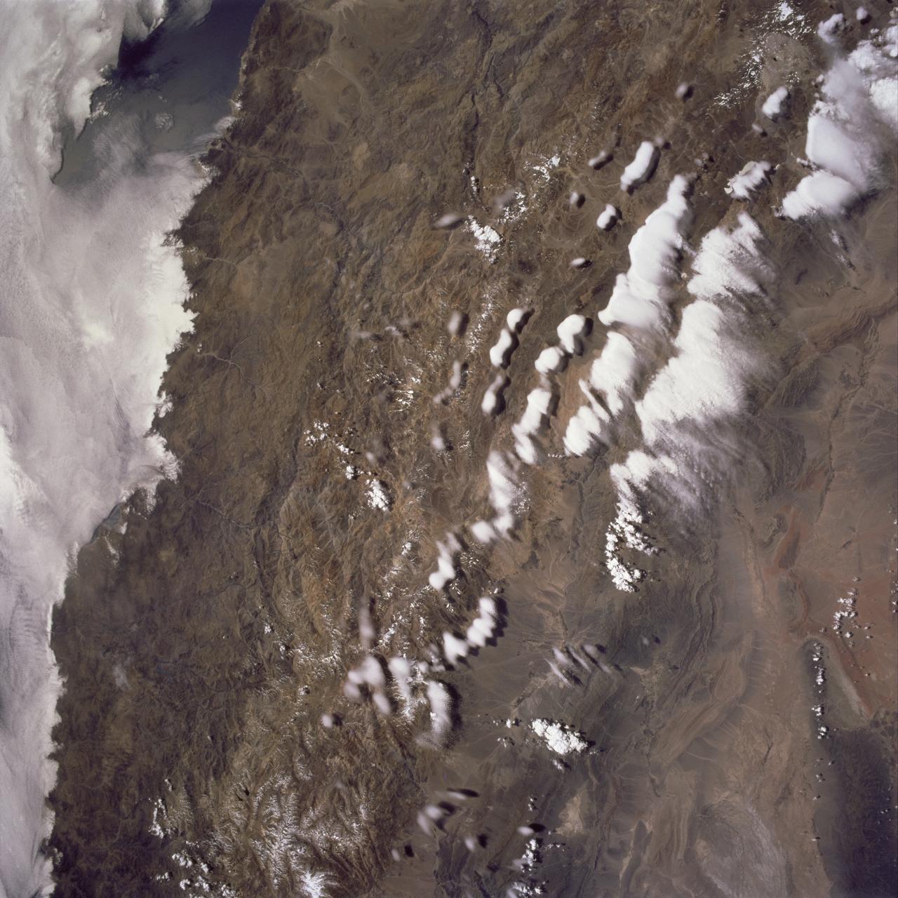
STS061-101-023 (8 Dec 1993) --- This color photograph is a spectacular, panoramic (southeastern view) shot that features the northern half of the country of Chile and the Andes Mountains of South America. The Atacama Desert, one of the driest regions on earth, is clearly visible along the northern Chilean coast. This desert extends from roughly Arica in the north to the city of Caldera in the south, a distance of six hundred miles. Some parts of this very arid region go for more than twenty years without measurable precipitation. It is an area of dramatic and abrupt elevation changes. For example, from the waters edge there is an escarpment of the coastal plateau that rises like an unbroken wall two or three thousand feet above the Pacific Ocean. From the coastal plateau, there is an even more dramatic increase in elevation -- from two thousand feet above sea level to an average elevation of thirteen thousand feet above sea level in the Bolivian Altiplano. This elevation change occurs within a one hundred to two hundred mile distance from the Pacific Ocean. The north-south trending spine of the Andes Mountains can be seen on this photograph. Several of the volcanic peaks in this mountain chain exceed 20,000 feet above sea level. Interspersed with these volcanic peaks, numerous dry lake beds (salars) can be seen as highly reflective surfaces. The largest of these salars (Salar de Uyuni) is visible at the edge of the Hubble Space Telescope (HST). Offshore, the cold Peruvian current produces low stratus clouds that can be found along this coastline at certain times of the year. This is the same type of meteorological phenomena that is found along the southern California coast and the Skeleton coast of southwestern Africa.
ISS031-E-035310 (15 May 2012) --- Sunglint and clouds off Western South America are featured in this image photographed by an Expedition 31 crew member on the International Space Station. The setting sun highlights cloud patterns above the Pacific Ocean, as well as the ocean surface itself in this impressive image. The space station was located over the Andes Mountains of central Chile at the time. The view is looking towards the Pacific Ocean and the sun setting in the west (towards lower left). Light from the setting sun reflects off the water surface towards the observer on the space station and creates a mirror-like appearance—a phenomenon known as sunglint. Bands of relatively low altitude cumulus clouds appear much like a flotilla of ships with their west-facing sides illuminated by the waning sunlight and the rest in shadow (center). Due to the low sun angle, they cast long and deep shadows over large swaths of the ocean surface. Given the short camera lens used, an individual cloud shadow may extend for miles. Light gray clouds at upper right appear to be at a higher altitude. The cloud cover is likely a remnant of a frontal system that moved inland over South America from the Pacific a day or two prior to the time the image was taken.
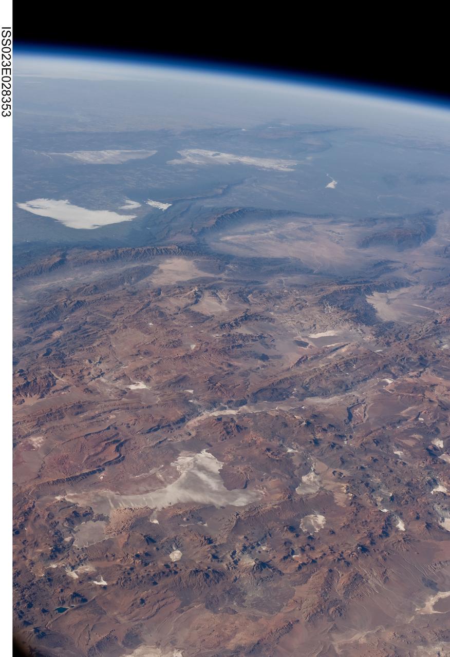
ISS023-E-028353 (26 April 2010) --- Central Andes Mountains, Salar de Arizaro, Argentina are featured in this image photographed by an Expedition 23 crew member on the International Space Station. The high plains (3,000 to greater than 5,000 meters elevation, 13,000 to 19,000 feet) of the Andes Mountains, also known as the Puna, appear in the foreground of this photograph, with a line of young volcanoes facing the much lower Atacama Desert (1,000–2,000 meters elevation). Several large dry lakes, marked by light-toned salt crusts, occupy the basins between major thrust faults in the Puna. Salar de Arizaro (foreground) is the largest of the dry lakes in this view (salar means waterless salt flat in Spanish). This panorama was taken by a station crew member looking southeast across the South American continent when the ISS was almost directly over the Atacama Desert near Chile’s Pacific coast. The Atlantic Ocean coastline (River Plate where Argentina’s capital city of Buenos Aires is located) is dimly visible at top left. A striking geological and landscape contrast is visible at center which separates two distinct geological zones, namely the Puna and the Sierras Pampeanas. The Sierras Pampeanas Mountains are lower in elevation and have few young volcanoes, in contrast to the Puna. Sharp-crested ranges are separated by wide, low valleys in this region. The Salinas Grandes—ephemeral shallow salt lakes at top left (salina means salt lake in Spanish) — occupies one of these valleys. The general color change from reds and browns in the foreground to blues and greens in the upper part of the image reflects the major climatic regions, namely the deserts of the Atacama and Puna, versus the low grassy plains of central Argentina where rainfall is sufficient to promote lush prairie grass growth—known famously as the pampas in Argentina. The Salinas Grandes mark an intermediate semiarid region. What accounts for the changes in landscape? The geology of this part of the Andes is a result of the eastward subduction of the Nazca tectonic plate underneath South America. Investigations using seismic data suggest that the Puna is underlain by a steeply dipping sector of the subducting Nazca plate. The Sierras Pampeanas zone however, is underlain by a sector of the Nazca plate that is almost horizontal, possibly due to the subduction of a submarine mountain range known as the Juan Fernandez Ridge. In the simplest terms, ridges are topographic highs that are difficult to stuff down subduction zones, with profound effects on the volcanism and structures of the upper plate.
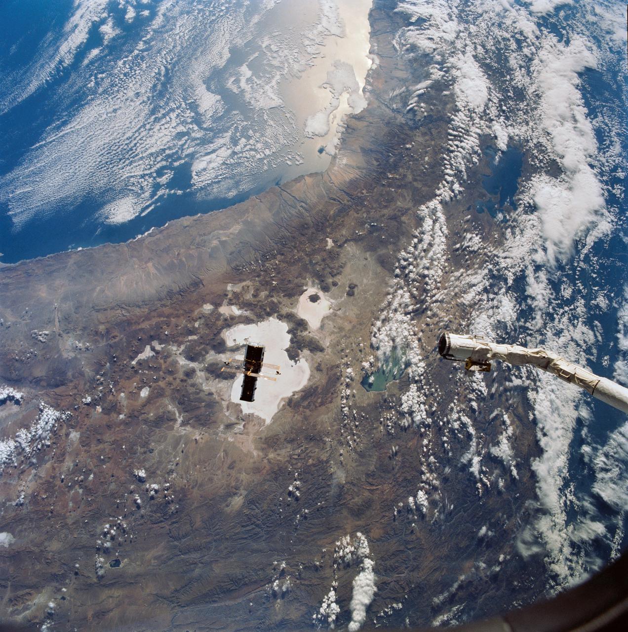
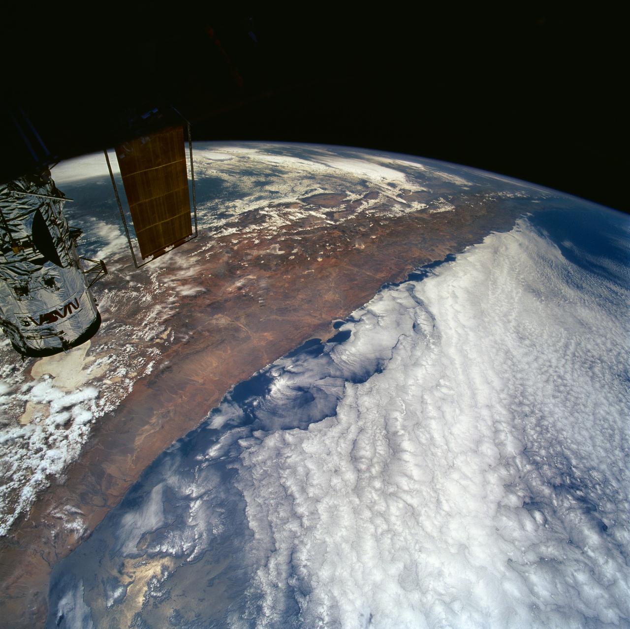
Hubble Space Telescope (HST), with its solar array (SA) wings and high gain antennae (HGA) fully extended,is released from Discovery's, Orbiter Vehicle (OV) 103's, remote manipulator system (RMS) end effector and is set free into Earth orbit by the STS-31 crew. HST drifts away from the end effector over the Andes Mountains.Parts of Bolivia, Peru, Chile, and Argentina are visible. The view covers a huge area of the western half of South America stretching from 14 degrees south latitude to 23 degrees, about 1,000 kilometers.
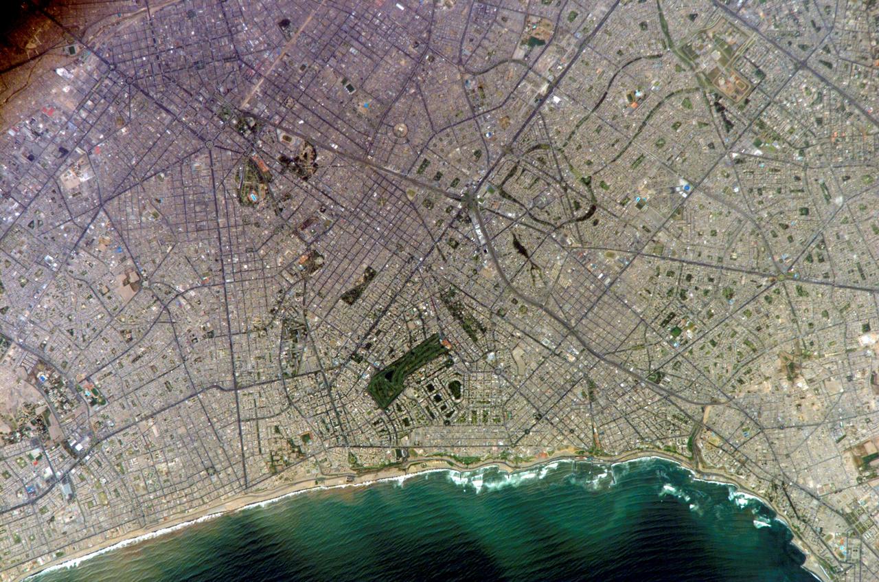
ISS010-E-20111 (15 March 2005) --- Lima, Peru is featured in this image photographed by an Expedition 10 crewmember on the International Space Station (ISS). Located on the broad alluvial fan of the Rimac River, Lima is the capital of Peru and the only mega city (7.7 million inhabitants in 2002) located on the western coastline of South America. The city was established by Francisco Pizarro in 1535 and became an important colonial port linking silver mines of the Altiplano of the high Andes to the east with the burgeoning Spanish empire. During the mid-20th century a significant relocation of people from rural mountain communities into the Lima metropolitan area led to its growth into a mega city. Problems now facing the metropolitan region include development of adequate water resources, control of pollution, and the potential effects of natural hazards such as earthquakes and landslides. This photograph depicts the wealthier San Isidro and Mira Flores quarters of Lima. This part of the metropolitan area is characterized by numerous vegetated parks, golf courses (such as the Lima Golf Course—approximately 1 kilometer long), and greenbelts interspersed with residential and commercial areas. The higher proportion of dark asphalt in the street grid of the residential and commercial areas lends a purple coloration to the left portion of the image (downtown Lima is to the north). Regions with fewer built materials and vegetation are light tan. Wave patterns are visible approaching beaches, popular tourist destinations, in the lower half of the image.
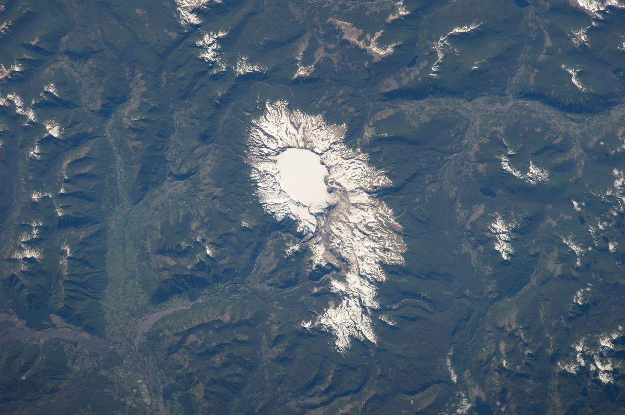
ISS038-E-012569 (6 Dec. 2013) --- Sollipulli Caldera is featured in this image photographed by an Expedition 38 crew member on the International Space Station. While active volcanoes are obvious targets of interest from the standpoint of natural hazards, there are some dormant volcanoes that nevertheless warrant concern due to their geologic history of activity. One such volcano is Sollipulli, located in central Chile near the border with Argentina in the southern Andes Mountains of South America. The volcano is located within the Parque Nacional Villarica of Chile. This photograph highlights the summit (2,282 meters above sea level) of the volcano and the bare slopes above the tree line. Lower elevations are covered with the green forests indicative of Southern Hemisphere summer. The summit of the volcano is occupied by a four-kilometer-wide caldera, currently filled with a snow-covered glacier (center). While most calderas form following violent explosive eruptions, the types of volcanic rock and deposits associated with such an event have not been found at Sollipulli. The geologic evidence does indicate explosive activity 2,900 years before present, and production of lava flows approximately 700 years before present. Together with craters and scoria cones located along the outer flanks of the caldera, scientists say this history suggests that Sollipulli could experience violent eruptions again, presenting an immediate potential hazard to such towns as Melipeuco in addition to the greater region.
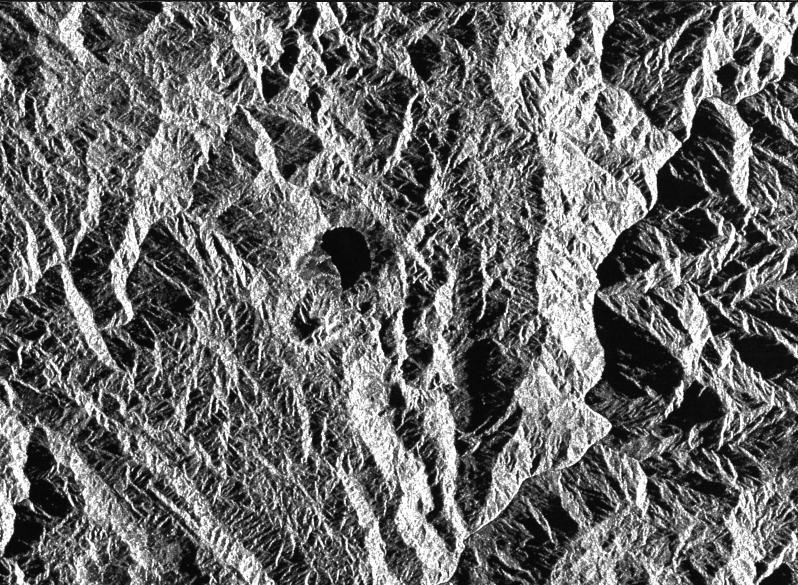
This is a radar image of a little known volcano in northern Colombia. The image was acquired on orbit 80 of space shuttle Endeavour on April 14, 1994, by NASA Spaceborne Imaging Radar C/X-Band Synthetic Aperture Radar SIR-C/X-SAR. The volcano near the center of the image is located at 5.6 degrees north latitude, 75.0 degrees west longitude, about 100 kilometers (65 miles) southeast of Medellin, Colombia. The conspicuous dark spot is a lake at the bottom of an approximately 3-kilometer-wide (1.9-mile) volcanic collapse depression or caldera. A cone-shaped peak on the bottom left (northeast rim) of the caldera appears to have been the source for a flow of material into the caldera. This is the northern-most known volcano in South America and because of its youthful appearance, should be considered dormant rather than extinct. The volcano's existence confirms a fracture zone proposed in 1985 as the northern boundary of volcanism in the Andes. The SIR-C/X-SAR image reveals another, older caldera further south in Colombia, along another proposed fracture zone. Although relatively conspicuous, these volcanoes have escaped widespread recognition because of frequent cloud cover that hinders remote sensing imaging in visible wavelengths. Four separate volcanoes in the Northern Andes nations of Colombia and Ecuador have been active during the last 10 years, killing more than 25,000 people, including scientists who were monitoring the volcanic activity. Detection and monitoring of volcanoes from space provides a safe way to investigate volcanism. The recognition of previously unknown volcanoes is important for hazard evaluations because a number of major eruptions this century have occurred at mountains that were not previously recognized as volcanoes. http://photojournal.jpl.nasa.gov/catalog/PIA01722
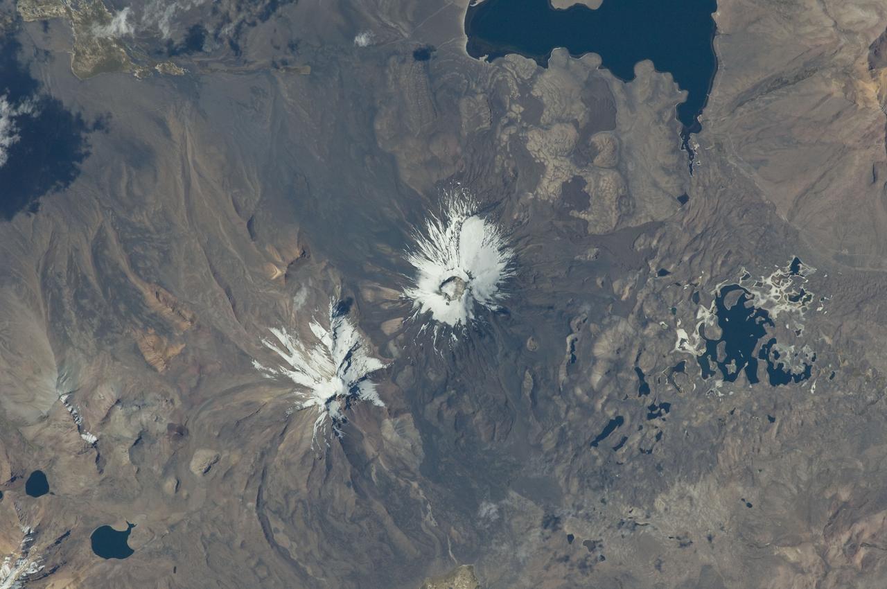
ISS029-E-020003 (7 Oct. 2011) --- Parinacota Volcano in the Chile-Bolivia border region, South America is featured in this image photographed by an Expedition 29 crew member on the International Space Station. Volcan Parinacota (?flamingo lake? in the regional Aymara language) is a potentially active stratovolcano located on the Altiplano, a high plateau situated within the Andes Mountains of west-central South America. While no direct observations of eruptive activity are recorded, surface exposure age-dating of lava flows suggests that activity occurred as recently as 290 AD approximately 300 years, according to scientists. Local Aymara stories also suggest that the volcano has erupted during the past 1,000 years. This detailed photograph highlights the symmetrical cone of Parinacota, with its well-developed summit crater (elevation 6,348 meters above sea level) at center. Dark brown to dark gray surfaces to the east and west of the summit include lava flows, pyroclastic deposits, and ash. A companion volcano, Pomerape, is located across a low saddle to the north ? scientists believe this volcano last erupted during the Pleistocene Epoch (extending from approximately 3 million to 12,000 years ago). The summits of both volcanoes are covered by white permanent snowpack and small glaciers. Together, the two volcanoes form the Nevados de Payachata volcanic area. Eruptive activity at Parinacota has directly influenced development of the local landscape beyond the emplacement of volcanic deposits ? approximately 8,000 years ago the western flank of the volcano collapsed, creating a debris avalanche that traveled 22 kilometers to the west. This debris avalanche blocked drainages, leading to the formation of Lake Chungara to the south (upper right). The uneven, hummocky surface of the debris avalanche deposit provides ample catchments for water, as evidenced by the numerous small ponds and Cotacotani Lake to the west.
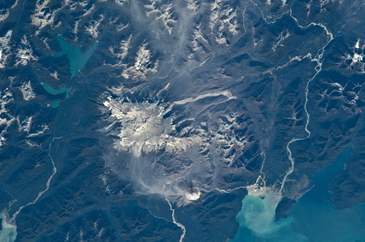
ISS018-E-035716 (24 Feb. 2009) --- Minchinmavida and Chaiten Volcanoes in Chile are featured in this image photographed by an Expedition 18 crewmember on the International Space Station. The Andes mountain chain along the western coastline of South America includes numerous active stratovolcanoes. The majority of these volcanoes are formed, and fed, by magma generated as the oceanic Nazca tectonic plate moves northeastward and plunges beneath the less dense South American continental tectonic plate (a process known as subduction). The line of Andean volcanoes marks the approximate location of the subduction zone. This astronaut photograph highlights two volcanoes located near the southern boundary of the Nazca ? South America subduction zone in southern Chile. Dominating the scene is the massive Minchinmavida stratovolcano at center. An eruption of this glaciated volcano was observed by Charles Darwin during his Galapagos Island voyage in 1834; the last recorded eruption took place the following year. The white, snow covered summit of Minchinmavida is blanketed by gray ash erupted from its much smaller but now active neighbor to the west, Volcan (volcano) Chaiten. The historically inactive Chaiten volcano, characterized by a large lava dome within a caldera (an emptied and collapsed magma chamber beneath a volcano) roared back to life unexpectedly on May 2, 2008, generating dense ash plumes and forcing the evacuation of the nearby town of Chaiten. Volcanic activity continues at Chaiten, including partial collapse of a new lava dome and generation of a pyroclastic flow several days before this photograph was taken. A steam and ash plume is visible extending to the northeast from the eruptive center of the volcano.

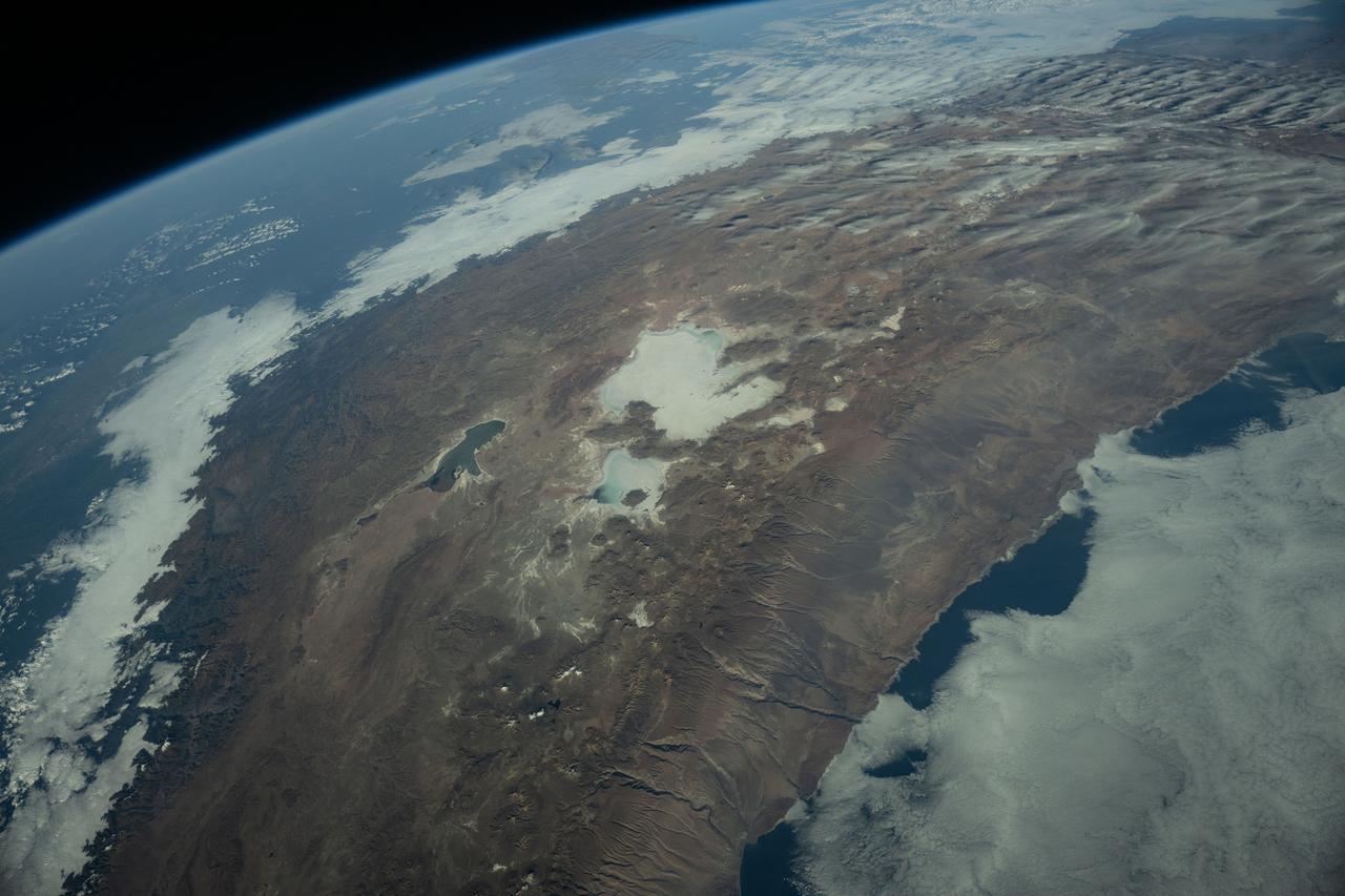
ISS012-E-06456 (3 Nov. 2005) --- Salar de Uyuni, the largest Salar (salt flat) in the world, located within the Altiplano of Bolivia, South America is featured in this image photographed by an Expedition 12 crewmember on the International Space Station. The Altiplano is a high plateau formed during uplift of the Andes Mountains. The plateau harbors fresh and saltwater lakes, together with Salars, that are surrounded by mountains with no drainage outlets--all at elevations greater than 3,659 meters (12,000 feet) above mean sea level. The Salar de Uyuni covers approximately 8,000 square kilometers (3,100 square miles), and it is a major transport route across the Bolivian Altiplano due to its flatness. This image features the northern end of the Salar and the dormant volcano Mount Tunupa (image center). This mountain is high enough to support a summit glacier, and enough rain falls on the windward slopes to provide water for small communities along the base. The dark volcanic rocks comprising Mt. Tunupa are in sharp contrast with the white, mineral-crusted surface of the Salar. The major minerals are halite--common table salt--and gypsum--a common component of drywall. Relict shorelines visible in the surface salt deposits (lower right of the image) attest to the occasional presence of small amounts of water in the Salar. Sediments in the Salar basin record fluctuations in water levels that occurred as the lake that once occupied the Salar evaporated. These sediments provide a valuable paleoclimate record for the region. The dynamic geological history of the Altiplano is recorded in isolated "islands" within the salt flat (image left); these islands are typically built from fossil coral reefs covered by Andean volcanic rocks.
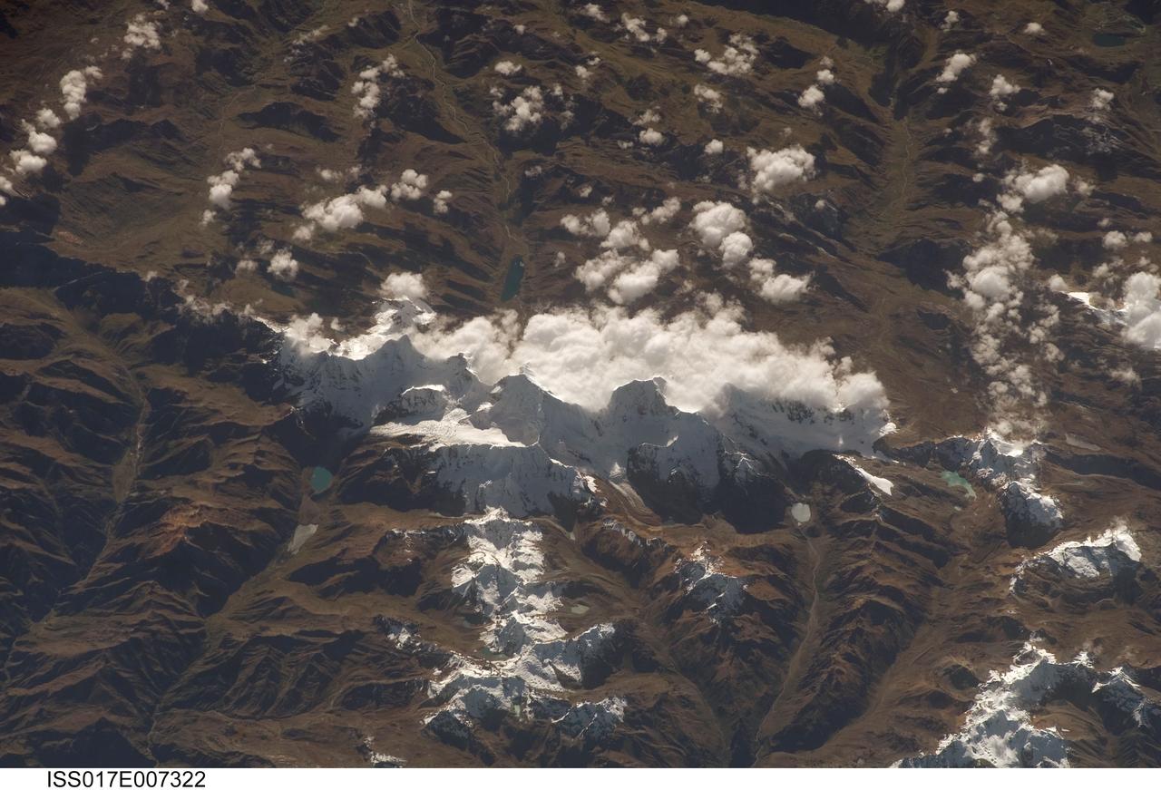
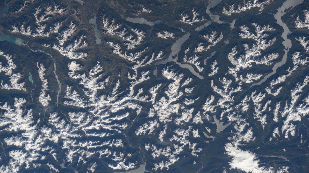
ISS017-E-007322 (17 May 2008) --- Cordillera Huayhuash in the Peruvian Andes is featured in this image photographed by an Expedition 17 crewmember on the International Space Station. This view was taken looking east as the station was flying approximately 100 kilometers off the Peruvian coast and shows Cordillera Huayhuash (pronounced Why-wash). Here clouds are banked up on the east side, snow covers all higher slopes and mountain peaks, and glaciers occupy lower slopes. This prominent but short mountain range (25 kilometers in length) boasts twenty peaks of remarkable steepness and ridge sharpness. Although only 100 kilometers from the coastline, six of the peaks reach above 6,000 meters (more than 19,500 feet), the highest of which is Nevado Yerupaja, Peru's second highest peak, variously estimated as 6,617 and 6,635 meters high. Generally considered the most spectacular peak in South America, Yerupaja is so steep that it has seldom been climbed. The best climbing approach is from the southwest, the face seen in this view. Yerupaja is locally known as El Carnicero (The Butcher) because of its blade-like ridges, features typical of mountains that have been heavily eroded by glacial ice. Other features created by the erosive effect of flowing ice are small glacial lakes, which often vary in color due to different amounts of fine mud being fed into them by meltwater from under the glaciers. According to scientists, during the ice ages the glaciers advanced many kilometers outward from the cordillera, occupying all the surrounding valley floors (all of which lie above 3,000 meters) producing the characteristic U-shaped valleys.
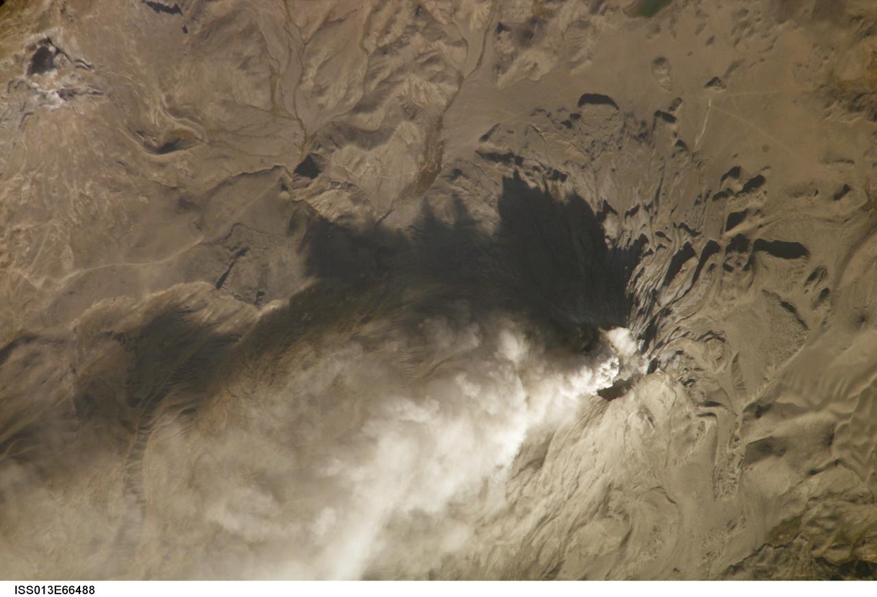
ISS013-E-66488 (14 Aug. 2006) --- Ash cloud from Ubinas Volcano, Peru is featured in this image photographed by an Expedition 13 crewmember on the International Space Station (ISS). Subduction of the Nazca tectonic plate along the western coast of South America forms the high Peruvian Andes, and also produces magma feeding a chain of historically active volcanoes along the western front of the mountains. The most active of these volcanoes in Peru is Ubinas. A typical steep-sided stratovolcano comprised primarily of layers of silica-rich lava flows, it has a summit elevation of 5,672 meters. The volcanic cone appears distinctively truncated or flat-topped in profile -- the result of a relatively small eruption that evacuated a magma reservoir near the summit. Following removal of the magma, the summit material collapsed downwards to form the current 1.4 kilometer-wide summit caldera. This oblique image (looking at an angle from the ISS) captures an ash cloud first observed on satellite imagery at 11:00 GMT on Aug. 14, 2006; this image was acquired one hour and 45 minutes later. The ash cloud resulted in the issuing of an aviation hazard warning by the Buenos Aires Volcanic Ash Advisory Center. Modern activity at Ubinas is characterized by these minor to moderate explosive eruptions of ash and larger pumice - a volcanic rock characterized by low density and high proportion of gas bubbles formed as the explosively-erupted parent lava cools during its transit through the air. These materials blanket the volcanic cone and surrounding area, giving this image an overall gray appearance. Shadowing of the western flank of Ubinas throws several lava flows into sharp relief, and highlights the steep slopes at the flow fronts -- a common characteristic of silica-rich, thick, and slow-moving lavas. NASA researchers note that the most recent major eruption of Ubinas occurred in 1969, however the historical record of activity extends back to the 16th century.
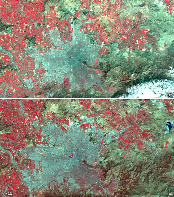
Santiago, Chile, ranks among the world's fastest growing cities. Chile is South America's fifth largest economy with strong export and tourism markets. More than a third of Chile's population lives in Santiago as of 2009. Taken on January 9, 1985, and January 30, 2010, this pair of images from the Landsat 5 satellite illustrates the city's steady growth. The images were made with infrared and visible light (Landsat bands 4, 3, and 2) so that plant-covered land is red. Bare or sparsely vegetated land is tan, and the city is dark silver. In the fifteen years that elapsed between 1985 and 2010, the city expanded away from the Andes Mountains along spoke-like lines, which are major roads. ---- NASA and the U.S. Department of the Interior through the U.S. Geological Survey (USGS) jointly manage Landsat, and the USGS preserves a 40-year archive of Landsat images that is freely available over the Internet. The next Landsat satellite, now known as the Landsat Data Continuity Mission (LDCM) and later to be called Landsat 8, is scheduled for launch in 2013. In honor of Landsat’s 40th anniversary in July 2012, the USGS released the LandsatLook viewer – a quick, simple way to go forward and backward in time, pulling images of anywhere in the world out of the Landsat archive. <b><a href="http://www.nasa.gov/audience/formedia/features/MP_Photo_Guidelines.html" rel="nofollow">NASA image use policy.</a></b> <b><a href="http://www.nasa.gov/centers/goddard/home/index.html" rel="nofollow">NASA Goddard Space Flight Center</a></b> enables NASA’s mission through four scientific endeavors: Earth Science, Heliophysics, Solar System Exploration, and Astrophysics. Goddard plays a leading role in NASA’s accomplishments by contributing compelling scientific knowledge to advance the Agency’s mission. <b>Follow us on <a href="http://twitter.com/NASA_GoddardPix" rel="nofollow">Twitter</a></b> <b>Like us on <a href="http://www.facebook.com/pages/Greenbelt-MD/NASA-Goddard/395013845897?ref=tsd" rel="nofollow">Facebook</a></b> <b>Find us on <a href="http://instagrid.me/nasagoddard/?vm=grid" rel="nofollow">Instagram</a></b>
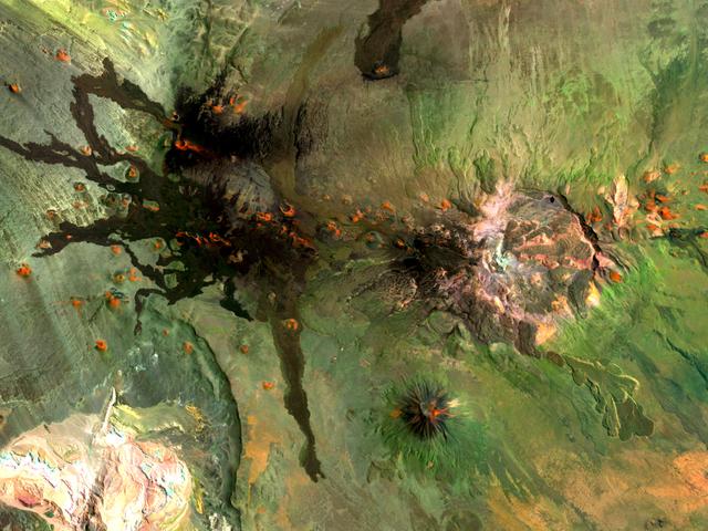
Situated in the southern Andes Mountains, the Payún volcanic field of Argentina is a complex landscape that formed over hundreds of thousands of years. Sprawling over 5,200 square kilometers (2,000 square miles), Payún is a massive shield volcano—a broad formation resembling an ancient warrior shield. This false-color image is a composite of observations acquired on February 7 and March 20, 2001 by the Enhanced Thematic Mapper Plus on the Landsat 7 satellite. It was made from a combination of visible and infrared light, where green indicates vegetation, black indicates lava flows, and orange is bare rock rich in iron oxides. Part of the back-arc volcanism of the Andes, Payún lies about 530 kilometers (330 miles) east from where the Nazca plate subducts below the South America plate. Not surprisingly, a volcanic zone extends over some 1,000 kilometers (600 miles) north-to-south in this region. According to a study published in 2010, the regional geology and chemical composition of the rocks indicate that the volcanic field likely formed within the past 300,000 years. The dominant feature of the volcanic field is Payún Matru, an elliptical caldera measuring roughly 9 by 7 kilometers (6 by 4 miles). Geologists surmise that the caldera formed after the old magma chamber emptied and the summit collapsed. Southwest of the caldera is a stratovolcano composed of alternating layers of compacted ash, hardened lava, and rocks ejected during previous eruptions. This stratovolcano, Payún, rises to 3,680 meters (12,073 feet) above sea level. (The entire volcanic field sits at 2,000 meters, or 6,600 feet.) The stratovolcano may be the most prominent feature in the volcanic field but it is by no means the only one. More than 300 eruptive features litter the shield volcano, most of them occupying an east-west line. West of Payún Matru is an area known as Los Volcanes, a mass of strombolian cones and basaltic lava flows. Image courtesy Michael P. Taylor, Landsat Data Continuity Mission Project Office, NASA Goddard Space Flight Center. Caption by Michon Scott with information from Michael Abrams, NASA Jet Propulsion Laboratory. Instrument: Landsat 7 - ETM+ To read more go to: <a href="http://1.usa.gov/UO8CbF" rel="nofollow">1.usa.gov/UO8CbF</a> Credit: <b><a href="http://www.earthobservatory.nasa.gov/" rel="nofollow"> NASA Earth Observatory</a></b> <b><a href="http://www.nasa.gov/audience/formedia/features/MP_Photo_Guidelines.html" rel="nofollow">NASA image use policy.</a></b> <b><a href="http://www.nasa.gov/centers/goddard/home/index.html" rel="nofollow">NASA Goddard Space Flight Center</a></b> enables NASA’s mission through four scientific endeavors: Earth Science, Heliophysics, Solar System Exploration, and Astrophysics. Goddard plays a leading role in NASA’s accomplishments by contributing compelling scientific knowledge to advance the Agency’s mission. <b>Follow us on <a href="http://twitter.com/NASA_GoddardPix" rel="nofollow">Twitter</a></b> <b>Like us on <a href="http://www.facebook.com/pages/Greenbelt-MD/NASA-Goddard/395013845897?ref=tsd" rel="nofollow">Facebook</a></b> <b>Find us on <a href="http://instagram.com/nasagoddard?vm=grid" rel="nofollow">Instagram</a></b>