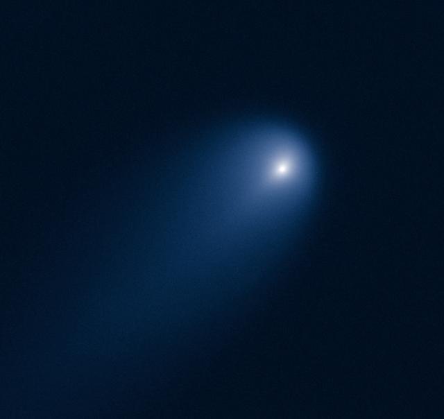
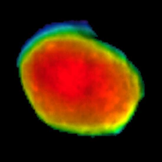
This NASA Hubble Space Telescope image of Comet (C/2012 S1) ISON was photographed on April 10, 2013, when the comet was slightly closer than Jupiter's orbit at a distance of 394 million miles from Earth. Even at that great distance the comet is already active as sunlight warms the surface and causes frozen volatiles to boil off. Astronomers used such early images to try to measure the size of the nucleus, in order to predict whether the comet would stay intact when it slingshots around the sun -- at 700,000 miles above the sun's surface -- on Nov. 28, 2013. The comet's dusty coma, or head of the comet, is approximately 3,100 miles across, or 1.2 times the width of Australia. A dust tail extends more than 57,000 miles, far beyond Hubble's field of view. This image was taken in visible light. The blue false color was added to bring out details in the comet structure. Credit: NASA/ ESA/STScI/AURA -------- More details on Comet ISON: Comet ISON began its trip from the Oort cloud region of our solar system and is now travelling toward the sun. The comet will reach its closest approach to the sun on Thanksgiving Day -- 28 Nov 2013 -- skimming just 730,000 miles above the sun's surface. If it comes around the sun without breaking up, the comet will be visible in the Northern Hemisphere with the naked eye, and from what we see now, ISON is predicted to be a particularly bright and beautiful comet. Catalogued as C/2012 S1, Comet ISON was first spotted 585 million miles away in September 2012. This is ISON's very first trip around the sun, which means it is still made of pristine matter from the earliest days of the solar system’s formation, its top layers never having been lost by a trip near the sun. Comet ISON is, like all comets, a dirty snowball made up of dust and frozen gases like water, ammonia, methane and carbon dioxide -- some of the fundamental building blocks that scientists believe led to the formation of the planets 4.5 billion years ago. NASA has been using a vast fleet of spacecraft, instruments, and space- and Earth-based telescope, in order to learn more about this time capsule from when the solar system first formed. The journey along the way for such a sun-grazing comet can be dangerous. A giant ejection of solar material from the sun could rip its tail off. Before it reaches Mars -- at some 230 million miles away from the sun -- the radiation of the sun begins to boil its water, the first step toward breaking apart. And, if it survives all this, the intense radiation and pressure as it flies near the surface of the sun could destroy it altogether. This collection of images show ISON throughout that journey, as scientists watched to see whether the comet would break up or remain intact. The comet reaches its closest approach to the sun on Thanksgiving Day -- Nov. 28, 2013 -- skimming just 730,000 miles above the sun’s surface. If it comes around the sun without breaking up, the comet will be visible in the Northern Hemisphere with the naked eye, and from what we see now, ISON is predicted to be a particularly bright and beautiful comet. ISON stands for International Scientific Optical Network, a group of observatories in ten countries who have organized to detect, monitor, and track objects in space. ISON is managed by the Keldysh Institute of Applied Mathematics, part of the Russian Academy of Sciences. <b><a href="http://www.nasa.gov/audience/formedia/features/MP_Photo_Guidelines.html" rel="nofollow">NASA image use policy.</a></b> <b><a href="http://www.nasa.gov/centers/goddard/home/index.html" rel="nofollow">NASA Goddard Space Flight Center</a></b> enables NASA’s mission through four scientific endeavors: Earth Science, Heliophysics, Solar System Exploration, and Astrophysics. Goddard plays a leading role in NASA’s accomplishments by contributing compelling scientific knowledge to advance the Agency’s mission. <b>Follow us on <a href="http://twitter.com/NASA_GoddardPix" rel="nofollow">Twitter</a></b> <b>Like us on <a href="http://www.facebook.com/pages/Greenbelt-MD/NASA-Godd</b>
On April 1, 2017, comet 41P will pass closer than it normally does to Earth, giving observers with binoculars or a telescope a special viewing opportunity. Comet hunters in the Northern Hemisphere should look for it near the constellations Draco and Ursa Major, which the Big Dipper is part of. Whether a comet will put on a good show for observers is notoriously difficult to predict, but 41P has a history of outbursts, and put on quite a display in 1973. If the comet experiences similar outbursts this time, there’s a chance it could become bright enough to see with the naked eye. The comet is expected to reach perihelion, or its closest approach to the sun, on April 12. A member of the Jupiter family of comets, 41P makes a trip around the sun every 5.4 years, coming relatively close to Earth on some of those trips. On this approach, the comet will pass our planet at a distance of about 13 million miles (0.14 astronomical units), or about 55 times the distance from Earth to the moon. This is the comet’s closest approach to Earth in more than 50 years and perhaps more than a century. Read more: <a href="https://go.nasa.gov/2nLNzes" rel="nofollow">go.nasa.gov/2nLNzes</a> Photo caption: In this image taken March 24, 2017, comet 41P/Tuttle-Giacobini-Kresák is shown moving through a field of faint galaxies in the bowl of the Big Dipper. On April 1, the comet will pass by Earth at a distance of about 13 million miles (0.14 astronomical units), or 55 times the distance from Earth to the moon; that is a much closer approach than usual for this Jupiter-family comet. Photo credit: Image copyright Chris Schur©, used with permission <b><a href="http://www.nasa.gov/audience/formedia/features/MP_Photo_Guidelines.html" rel="nofollow">NASA image use policy.</a></b> <b><a href="http://www.nasa.gov/centers/goddard/home/index.html" rel="nofollow">NASA Goddard Space Flight Center</a></b> enables NASA’s mission through four scientific endeavors: Earth Science, Heliophysics, Solar System Exploration, and Astrophysics. Goddard plays a leading role in NASA’s accomplishments by contributing compelling scientific knowledge to advance the Agency’s mission. <b>Follow us on <a href="http://twitter.com/NASAGoddardPix" rel="nofollow">Twitter</a></b> <b>Like us on <a href="http://www.facebook.com/pages/Greenbelt-MD/NASA-Goddard/395013845897?ref=tsd" rel="nofollow">Facebook</a></b> <b>Find us on <a href="http://instagrid.me/nasagoddard/?vm=grid" rel="nofollow">Instagram</a></b>
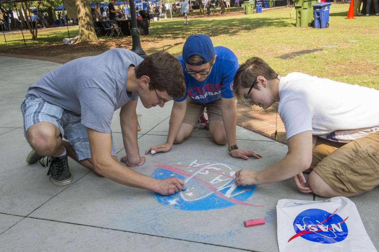
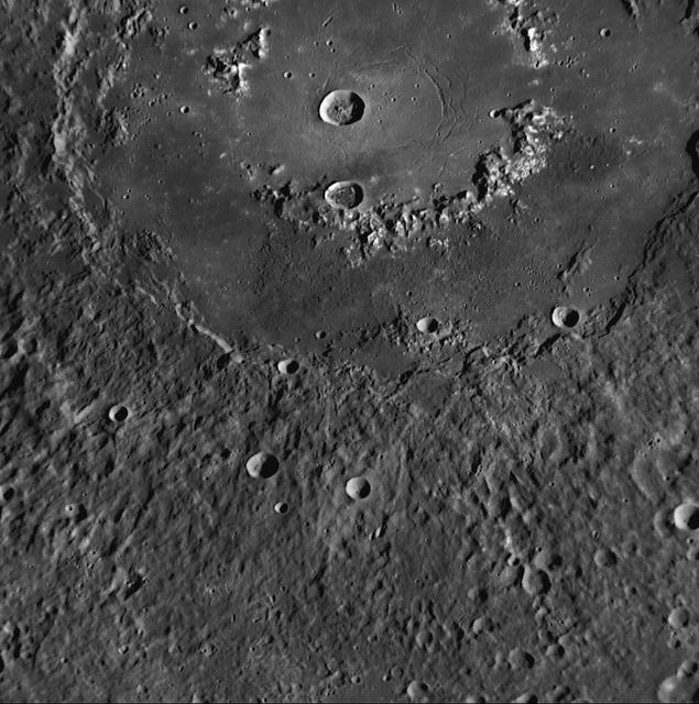
April Fool Crater
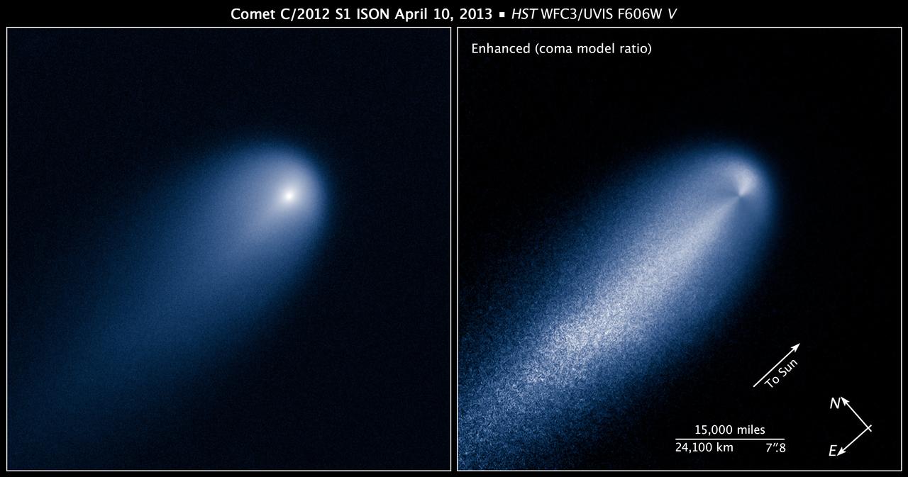
This NASA Hubble Space Telescope image of Comet (C/2012 S1) ISON was photographed on April 10, 2013, when the comet was slightly closer than Jupiter's orbit at a distance of 394 million miles from Earth. Even at that great distance the comet is already active as sunlight warms the surface and causes frozen volatiles to boil off. Astronomers used such early images to try to measure the size of the nucleus, in order to predict whether the comet would stay intact when it slingshots around the sun -- at 700,000 miles above the sun's surface -- on Nov. 28, 2013. The comet's dusty coma, or head of the comet, is approximately 3,100 miles across, or 1.2 times the width of Australia. A dust tail extends more than 57,000 miles, far beyond Hubble's field of view. This image was taken in visible light. The blue false color was added to bring out details in the comet structure. Credit: NASA/ ESA/STScI/AURA -------- More details on Comet ISON: Comet ISON began its trip from the Oort cloud region of our solar system and is now travelling toward the sun. The comet will reach its closest approach to the sun on Thanksgiving Day -- 28 Nov 2013 -- skimming just 730,000 miles above the sun's surface. If it comes around the sun without breaking up, the comet will be visible in the Northern Hemisphere with the naked eye, and from what we see now, ISON is predicted to be a particularly bright and beautiful comet. Catalogued as C/2012 S1, Comet ISON was first spotted 585 million miles away in September 2012. This is ISON's very first trip around the sun, which means it is still made of pristine matter from the earliest days of the solar system’s formation, its top layers never having been lost by a trip near the sun. Comet ISON is, like all comets, a dirty snowball made up of dust and frozen gases like water, ammonia, methane and carbon dioxide -- some of the fundamental building blocks that scientists believe led to the formation of the planets 4.5 billion years ago. NASA has been using a vast fleet of spacecraft, instruments, and space- and Earth-based telescope, in order to learn more about this time capsule from when the solar system first formed. The journey along the way for such a sun-grazing comet can be dangerous. A giant ejection of solar material from the sun could rip its tail off. Before it reaches Mars -- at some 230 million miles away from the sun -- the radiation of the sun begins to boil its water, the first step toward breaking apart. And, if it survives all this, the intense radiation and pressure as it flies near the surface of the sun could destroy it altogether. This collection of images show ISON throughout that journey, as scientists watched to see whether the comet would break up or remain intact. The comet reaches its closest approach to the sun on Thanksgiving Day -- Nov. 28, 2013 -- skimming just 730,000 miles above the sun’s surface. If it comes around the sun without breaking up, the comet will be visible in the Northern Hemisphere with the naked eye, and from what we see now, ISON is predicted to be a particularly bright and beautiful comet. ISON stands for International Scientific Optical Network, a group of observatories in ten countries who have organized to detect, monitor, and track objects in space. ISON is managed by the Keldysh Institute of Applied Mathematics, part of the Russian Academy of Sciences. <b><a href="http://www.nasa.gov/audience/formedia/features/MP_Photo_Guidelines.html" rel="nofollow">NASA image use policy.</a></b> <b><a href="http://www.nasa.gov/centers/goddard/home/index.html" rel="nofollow">NASA Goddard Space Flight Center</a></b> enables NASA’s mission through four scientific endeavors: Earth Science, Heliophysics, Solar System Exploration, and Astrophysics. Goddard plays a leading role in NASA’s accomplishments by contributing compelling scientific knowledge to advance the Agency’s mission. <b>Follow us on <a href="http://twitter.com/NASA_GoddardPix" rel="nofollow">Twitter</a></b> <b>Like us on <a href="http://www.facebook.com/pages/Greenbelt-MD/NASA-Godd</b>
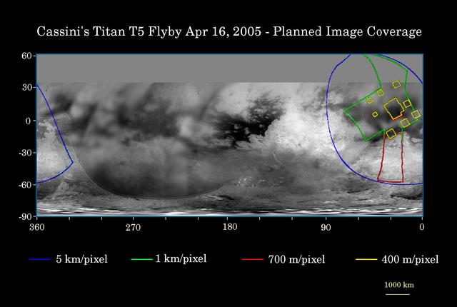
Cassini April 16 Flyby of Titan
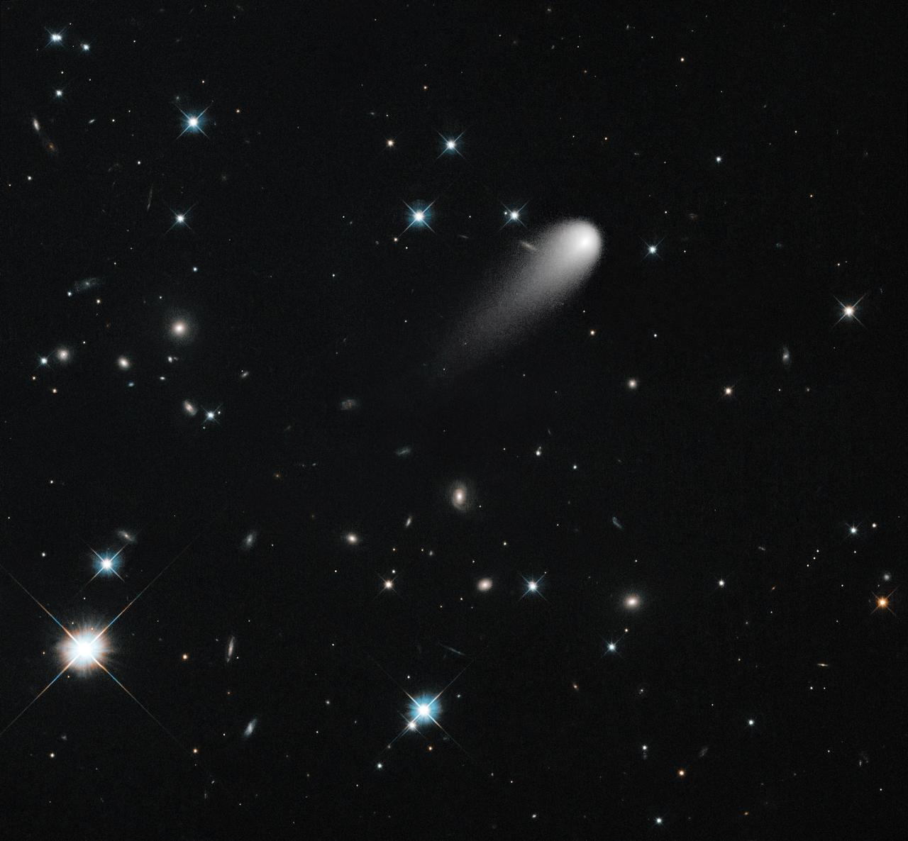
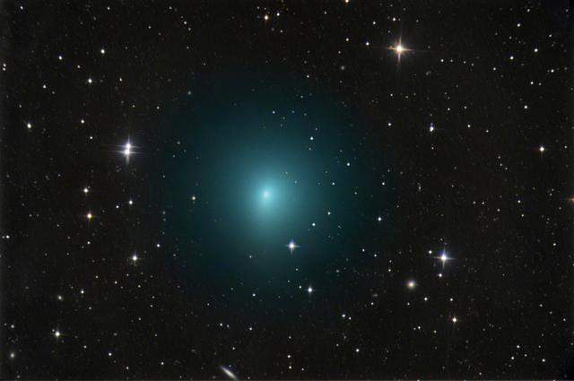
On April 30, NASA's Hubble Space Telescope observed Comet ISON again. The comet is in the upper middle, showing the long tail. Various galaxies and stars appear behind it. In this image, Hubble trained its telescope on the stars instead of following the comet. The result is that the comet appears fuzzier, but the stars and galaxies are more detailed and precise. These dimmer features don't pop out if the camera is moving, following along with ISON. To see them, you really need to dwell in one place until they emerge from the noise. Credit: NASA/ESA/STScI/AURA -------- More details on Comet ISON: Comet ISON began its trip from the Oort cloud region of our solar system and is now travelling toward the sun. The comet will reach its closest approach to the sun on Thanksgiving Day -- 28 Nov 2013 -- skimming just 730,000 miles above the sun's surface. If it comes around the sun without breaking up, the comet will be visible in the Northern Hemisphere with the naked eye, and from what we see now, ISON is predicted to be a particularly bright and beautiful comet. Catalogued as C/2012 S1, Comet ISON was first spotted 585 million miles away in September 2012. This is ISON's very first trip around the sun, which means it is still made of pristine matter from the earliest days of the solar system’s formation, its top layers never having been lost by a trip near the sun. Comet ISON is, like all comets, a dirty snowball made up of dust and frozen gases like water, ammonia, methane and carbon dioxide -- some of the fundamental building blocks that scientists believe led to the formation of the planets 4.5 billion years ago. NASA has been using a vast fleet of spacecraft, instruments, and space- and Earth-based telescope, in order to learn more about this time capsule from when the solar system first formed. The journey along the way for such a sun-grazing comet can be dangerous. A giant ejection of solar material from the sun could rip its tail off. Before it reaches Mars -- at some 230 million miles away from the sun -- the radiation of the sun begins to boil its water, the first step toward breaking apart. And, if it survives all this, the intense radiation and pressure as it flies near the surface of the sun could destroy it altogether. This collection of images show ISON throughout that journey, as scientists watched to see whether the comet would break up or remain intact. The comet reaches its closest approach to the sun on Thanksgiving Day -- Nov. 28, 2013 -- skimming just 730,000 miles above the sun’s surface. If it comes around the sun without breaking up, the comet will be visible in the Northern Hemisphere with the naked eye, and from what we see now, ISON is predicted to be a particularly bright and beautiful comet. ISON stands for International Scientific Optical Network, a group of observatories in ten countries who have organized to detect, monitor, and track objects in space. ISON is managed by the Keldysh Institute of Applied Mathematics, part of the Russian Academy of Sciences. <b><a href="http://www.nasa.gov/audience/formedia/features/MP_Photo_Guidelines.html" rel="nofollow">NASA image use policy.</a></b> <b><a href="http://www.nasa.gov/centers/goddard/home/index.html" rel="nofollow">NASA Goddard Space Flight Center</a></b> enables NASA’s mission through four scientific endeavors: Earth Science, Heliophysics, Solar System Exploration, and Astrophysics. Goddard plays a leading role in NASA’s accomplishments by contributing compelling scientific knowledge to advance the Agency’s mission. <b>Follow us on <a href="http://twitter.com/NASA_GoddardPix" rel="nofollow">Twitter</a></b> <b>Like us on <a href="http://www.facebook.com/pages/Greenbelt-MD/NASA-Goddard/395013845897?ref=tsd" rel="nofollow">Facebook</a></b> <b>Find us on <a href="http://instagram.com/nasagoddard?vm=grid" rel="nofollow">Instagram</a></b>
<b>Share YOUR pink moon and/or partial lunar eclipse images in our Flickr Group here: <a href="http://www.flickr.com/groups/pinkmoon/">www.flickr.com/groups/pinkmoon/</a> </b> TimeThursday, April 25, 2013, 21:00 UT Phase 100.0% Diameter - 1962.6 arcseconds Distance - 365185 km (28.66 Earth diameters There is a special lunar name for every full moon in a year. The April 25 full moon is known as the “Full Pink Moon” because of the grass pink – or wild ground phlox – flower, which is one of the earliest widespread flowers to bloom in the spring. This month’s full moon is also known as the Sprouting Grass moon and the Egg moon. The first lunar eclipse of 2013 occurs at the Moon's ascending node in southern Virgo about 12° east of Spica (mv = +1.05). It is visible primarily from the Eastern Hemisphere. This event will not be visible in North America, it will only be visible from Eastern Europea, Africa, Asia, and Western Australia. April’s full moon, which is set to rise tonight, is known as a pink moon. And this year it coincides with the partial lunar eclipse. This NASA animation shows elevation measurements by the Lunar Orbiter Laser Altimeter (LOLA) aboard the Lunar Reconnaissance Orbiter (LRO). Credit: NASA/Goddard Space Flight Center Scientific Visualization Studio <b><a href="http://www.nasa.gov/audience/formedia/features/MP_Photo_Guidelines.html" rel="nofollow">NASA image use policy.</a></b> <b><a href="http://www.nasa.gov/centers/goddard/home/index.html" rel="nofollow">NASA Goddard Space Flight Center</a></b> enables NASA’s mission through four scientific endeavors: Earth Science, Heliophysics, Solar System Exploration, and Astrophysics. Goddard plays a leading role in NASA’s accomplishments by contributing compelling scientific knowledge to advance the Agency’s mission. <b>Follow us on <a href="http://twitter.com/NASA_GoddardPix" rel="nofollow">Twitter</a></b> <b>Like us on <a href="http://www.facebook.com/pages/Greenbelt-MD/NASA-Goddard/395013845897?ref=tsd" rel="nofollow">Facebook</a></b> <b>Find us on <a href="http://instagram.com/nasagoddard?vm=grid" rel="nofollow">Instagram</a></b>

Portrait of April Albert in front of NASA Langley's Hawker Siddeley P-1127 on display at Air Power Park in Hampton, Virginia. Due to the COVID-19 pandemic, masks were mandated by Governor Northam in Virginia in public settings. This is for the faces of NASA project. "I am really made to feel like I am part of a family. I don’t feel like anybody is treated differently. We are all one team. To be a part of NASA, to me, is to be part of something special. There is nothing like the camaraderie of NASA. I feel like I’m where I belong.” — April Albert, Schedule Analyst, Langley Research Center
Radar Flyby of Titan - April 30, 2006
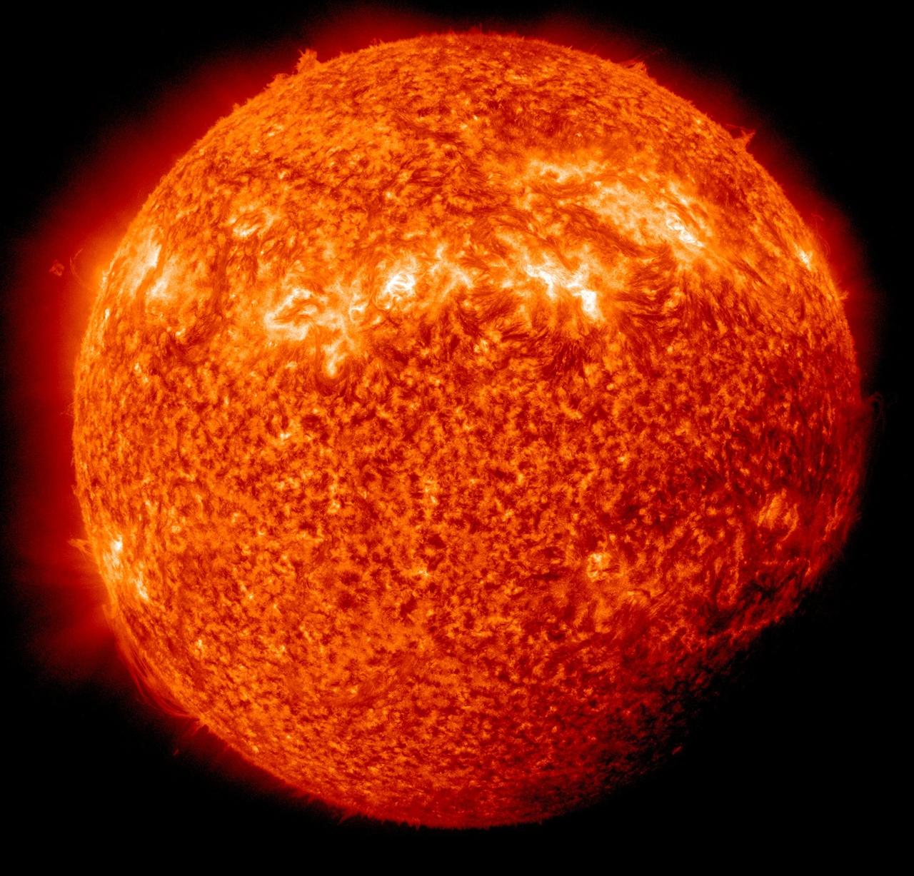
NASA image captured April 3, 2011 Twice a year, SDO enters an eclipse season where the spacecraft slips behind Earth for up to 72 minutes a day. Unlike the crisp shadow one sees on the sun during a lunar eclipse, Earth's shadow has a variegated edge due to its atmosphere, which blocks the sun light to different degrees depending on its density. Also, light from brighter spots on the sun may make it through, which is why some solar features extend low into Earth's shadow. Credit: NASA/GSFC/SDO <b><a href="http://www.nasa.gov/centers/goddard/home/index.html" rel="nofollow">NASA Goddard Space Flight Center</a></b> enables NASA’s mission through four scientific endeavors: Earth Science, Heliophysics, Solar System Exploration, and Astrophysics. Goddard plays a leading role in NASA’s accomplishments by contributing compelling scientific knowledge to advance the Agency’s mission. <b>Follow us on <a href="http://twitter.com/NASA_GoddardPix" rel="nofollow">Twitter</a></b> <b>Join us on <a href="http://www.facebook.com/pages/Greenbelt-MD/NASA-Goddard/395013845897?ref=tsd" rel="nofollow">Facebook</a></b>

NASA image captured April 2, 2011 Twice a year, SDO enters an eclipse season where the spacecraft slips behind Earth for up to 72 minutes a day. Unlike the crisp shadow one sees on the sun during a lunar eclipse, Earth's shadow has a variegated edge due to its atmosphere, which blocks the sun light to different degrees depending on its density. Also, light from brighter spots on the sun may make it through, which is why some solar features extend low into Earth's shadow. Credit: NASA/GSFC/SDO <b><a href="http://www.nasa.gov/centers/goddard/home/index.html" rel="nofollow">NASA Goddard Space Flight Center</a></b> enables NASA’s mission through four scientific endeavors: Earth Science, Heliophysics, Solar System Exploration, and Astrophysics. Goddard plays a leading role in NASA’s accomplishments by contributing compelling scientific knowledge to advance the Agency’s mission. <b>Follow us on <a href="http://twitter.com/NASA_GoddardPix" rel="nofollow">Twitter</a></b> <b>Join us on <a href="http://www.facebook.com/pages/Greenbelt-MD/NASA-Goddard/395013845897?ref=tsd" rel="nofollow">Facebook</a></b>
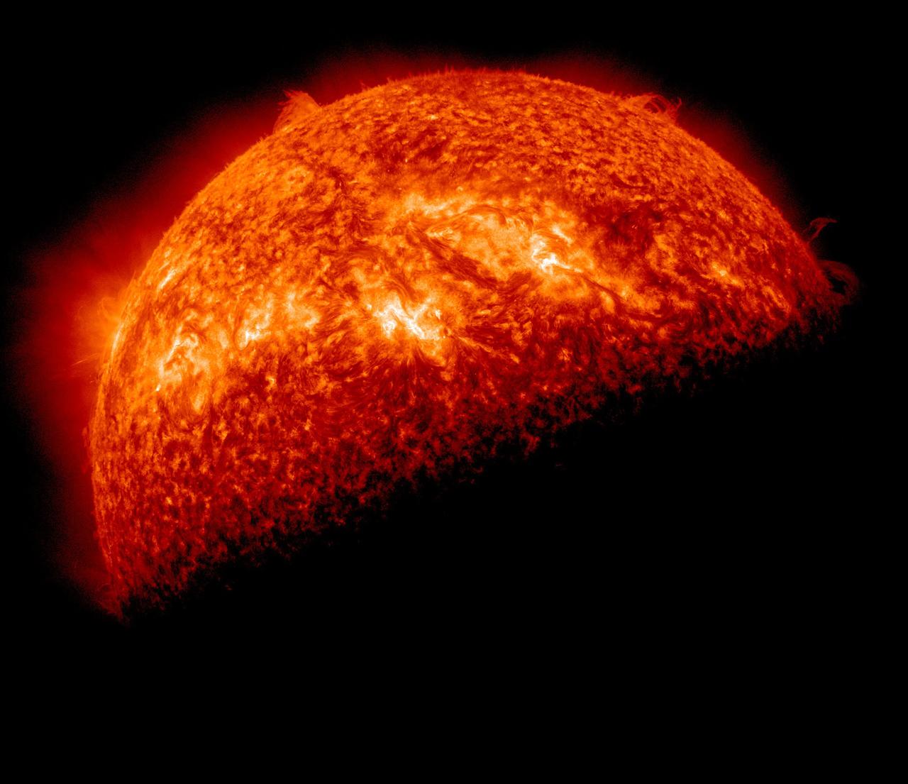
NASA image captured April 1, 2011 Twice a year, SDO enters an eclipse season where the spacecraft slips behind Earth for up to 72 minutes a day. Unlike the crisp shadow one sees on the sun during a lunar eclipse, Earth's shadow has a variegated edge due to its atmosphere, which blocks the sun light to different degrees depending on its density. Also, light from brighter spots on the sun may make it through, which is why some solar features extend low into Earth's shadow. Credit: NASA/GSFC/SDO <b><a href="http://www.nasa.gov/centers/goddard/home/index.html" rel="nofollow">NASA Goddard Space Flight Center</a></b> enables NASA’s mission through four scientific endeavors: Earth Science, Heliophysics, Solar System Exploration, and Astrophysics. Goddard plays a leading role in NASA’s accomplishments by contributing compelling scientific knowledge to advance the Agency’s mission. <b>Follow us on <a href="http://twitter.com/NASA_GoddardPix" rel="nofollow">Twitter</a></b> <b>Join us on <a href="http://www.facebook.com/pages/Greenbelt-MD/NASA-Goddard/395013845897?ref=tsd" rel="nofollow">Facebook</a></b>

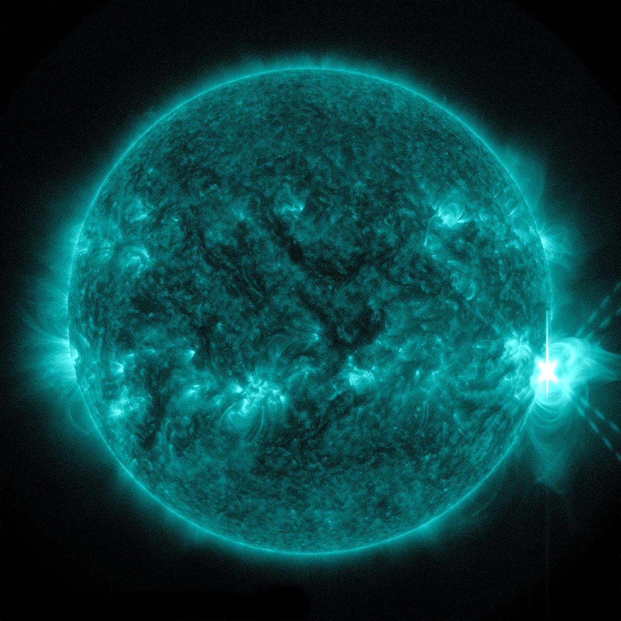
The sun emitted a trio of mid-level solar flares on April 2-3, 2017. The first peaked at 4:02 a.m. EDT on April 2, the second peaked at 4:33 p.m. EDT on April 2, and the third peaked at 10:29 a.m. EDT on April 3. NASA’s Solar Dynamics Observatory, which watches the sun constantly, captured images of the three events. Solar flares are powerful bursts of radiation. Harmful radiation from a flare cannot pass through Earth's atmosphere to physically affect humans on the ground, however — when intense enough — they can disturb the atmosphere in the layer where GPS and communications signals travel. Learn more: <a href="https://go.nasa.gov/2oQVFju" rel="nofollow">go.nasa.gov/2oQVFju</a> Caption: NASA's Solar Dynamics Observatory captured this image of a solar flare peaking at 10:29 a.m. EDT on April 3, 2017, as seen in the bright flash near the sun’s upper right edge. The image shows a subset of extreme ultraviolet light that highlights the extremely hot material in flares and which is typically colorized in teal. Credits: NASA/SDO <b><a href="http://www.nasa.gov/audience/formedia/features/MP_Photo_Guidelines.html" rel="nofollow">NASA image use policy.</a></b> <b><a href="http://www.nasa.gov/centers/goddard/home/index.html" rel="nofollow">NASA Goddard Space Flight Center</a></b> enables NASA’s mission through four scientific endeavors: Earth Science, Heliophysics, Solar System Exploration, and Astrophysics. Goddard plays a leading role in NASA’s accomplishments by contributing compelling scientific knowledge to advance the Agency’s mission. <b>Follow us on <a href="http://twitter.com/NASAGoddardPix" rel="nofollow">Twitter</a></b> <b>Like us on <a href="http://www.facebook.com/pages/Greenbelt-MD/NASA-Goddard/395013845897?ref=tsd" rel="nofollow">Facebook</a></b> <b>Find us on <a href="http://instagrid.me/nasagoddard/?vm=grid" rel="nofollow">Instagram</a></b>
The sun emitted a significant solar flare, peaking at 8:27 p.m. EDT on April 24, 2014. Images of the flare were captured by NASA's Solar Dynamics Observatory. Solar flares are powerful bursts of radiation. Harmful radiation from a flare cannot pass through Earth's atmosphere to physically affect humans on the ground, however -- when intense enough -- they can disturb the atmosphere in the layer where GPS and communications signals travel. To see how this event may impact Earth, please visit NOAA's Space Weather Prediction Center at <a href="http://spaceweather.gov" rel="nofollow">spaceweather.gov</a>, the U.S. government's official source for space weather forecasts, alerts, watches and warnings. This flare is classified as an X1.4 flare. X-class denotes the most intense flares, while the number provides more information about its strength. An X2 is twice as intense as an X1, an X3 is three times as intense, etc. Credit: NASA/Goddard/SDO Credit: NASA/SDO

2010/119 - 04/29 at 16 :48 UTC Oil slick in the Gulf of Mexico (Input Direct Broadcast data courtesy Direct Readout Lab, NASA/GSFC) Satellite: Terra NASA/GSFC/Jeff Schmaltz/MODIS Land Rapid Response Team To learn more about MODIS go to: <a href="http://rapidfire.sci.gsfc.nasa.gov/gallery/?latest" rel="nofollow">rapidfire.sci.gsfc.nasa.gov/gallery/?latest</a> <b><a href="http://www.nasa.gov/centers/goddard/home/index.html" rel="nofollow">NASA Goddard Space Flight Center</a></b> is home to the nation's largest organization of combined scientists, engineers and technologists that build spacecraft, instruments and new technology to study the Earth, the sun, our solar system, and the universe.

New Impact Crater Formed Between April 2001 and December 2003

Hubble Views Ancient Storm in the Atmosphere of Jupiter - April, 1997

Titan T28 Viewed by Cassini Radar-- April 10, 2007

Wildlife April 2013

Wildlife April 2013

April Lanotte gives remarks during the Mars celebration Saturday, June 1, 2019, in Mars, Pennsylvania. NASA is in the small town to celebrate Mars exploration and share the agency’s excitement about landing astronauts on the Moon in five years. The celebration includes a weekend of Science, Technology, Engineering, Arts and Mathematics (STEAM) activities. Photo Credit: (NASA/Bill Ingalls)
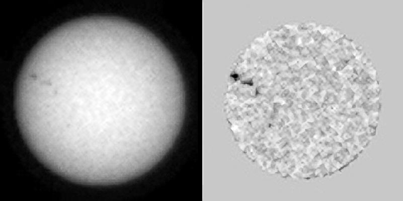
This single frame from a sequence of six images of an animation shows sunspots as viewed by NASA Curiosity Mars rover from April 4 to April 15, 2015. From Mars, the rover was in position to see the opposite side of the sun. The images were taken by the right-eye camera of Curiosity's Mast Camera (Mastcam), which has a 100-millimeter telephoto lens. The view on the left of each pair in this sequence has little processing other than calibration and putting north toward the top of each frame. The view on the right of each pair has been enhanced to make sunspots more visible. The apparent granularity throughout these enhanced images is an artifact of this processing. These sunspots seen in this sequence eventually produced two solar eruptions, one of which affected Earth. http://photojournal.jpl.nasa.gov/catalog/PIA19802
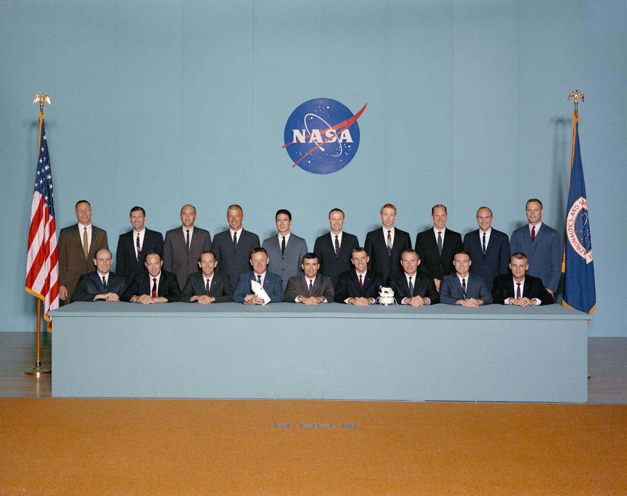
S67-30404 (May 1967) --- Portrait of astronaut group selected April 4, 1966. Seated, left to right, are Edward G. Givens Jr., Edgar D. Mitchell, Charles M. Duke Jr., Don L. Lind, Fred W. Haise Jr., Joe H. Engle, Vance D. Brand, John S. Bull and Bruce McCandless II. Standing, left to right, are John L. Swigert Jr., William R. Pogue, Ronald E. Evans, Paul J. Weitz, James B. Irwin, Gerald P. Carr, Stuart A. Roosa, Alfred M. Worden, Thomas K. Mattingly and Jack R. Lousma. Photo credit: NASA or National Aeronautics and Space Administration
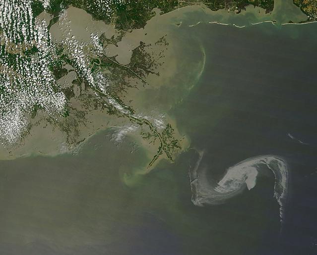
2010/119 - 04/29 at 16 :48 UTC Oil slick in the Gulf of Mexico To see a full view of this image go to: <a href="http://www.flickr.com/photos/gsfc/4563296541/">www.flickr.com/photos/gsfc/4563296541/</a> (Input Direct Broadcast data courtesy Direct Readout Lab, NASA/GSFC) Satellite: Terra NASA/GSFC/Jeff Schmaltz/MODIS Land Rapid Response Team To learn more about MODIS go to: <a href="http://rapidfire.sci.gsfc.nasa.gov/gallery/?latest" rel="nofollow">rapidfire.sci.gsfc.nasa.gov/gallery/?latest</a> <b><a href="http://www.nasa.gov/centers/goddard/home/index.html" rel="nofollow">NASA Goddard Space Flight Center</a></b> is home to the nation's largest organization of combined scientists, engineers and technologists that build spacecraft, instruments and new technology to study the Earth, the sun, our solar system, and the universe.
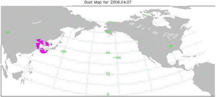
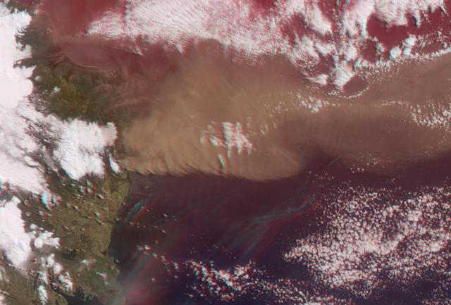
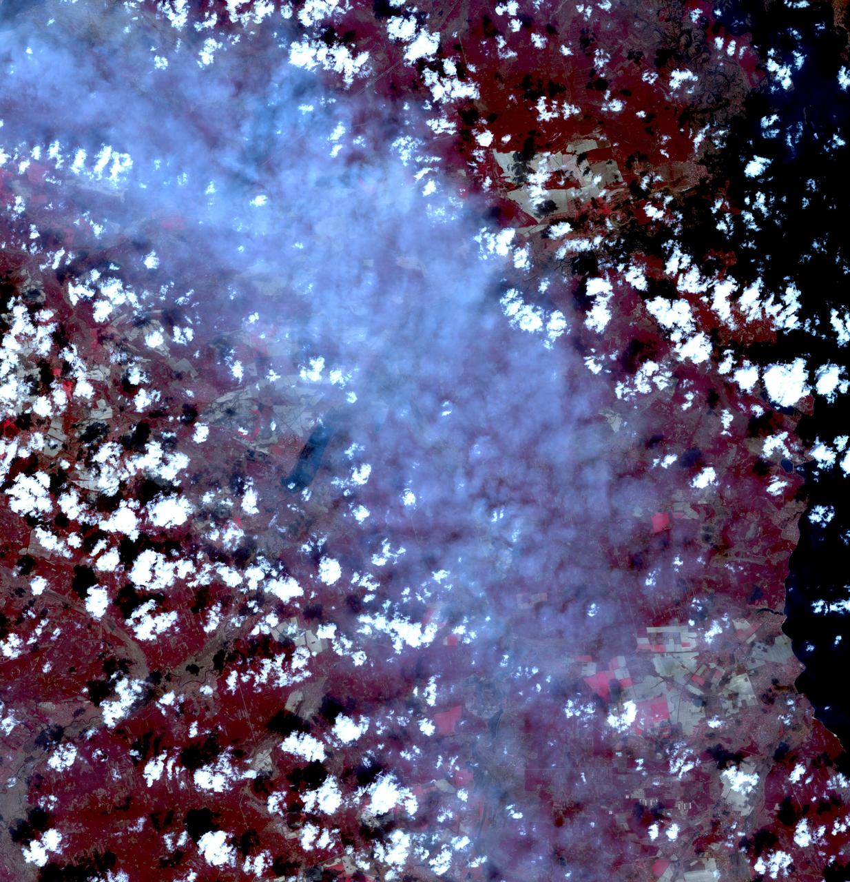
Transport of dust from China Dust Storm of April 2006, from the Atmospheric Infrared Sounder AIRS on NASA Aqua satellite.
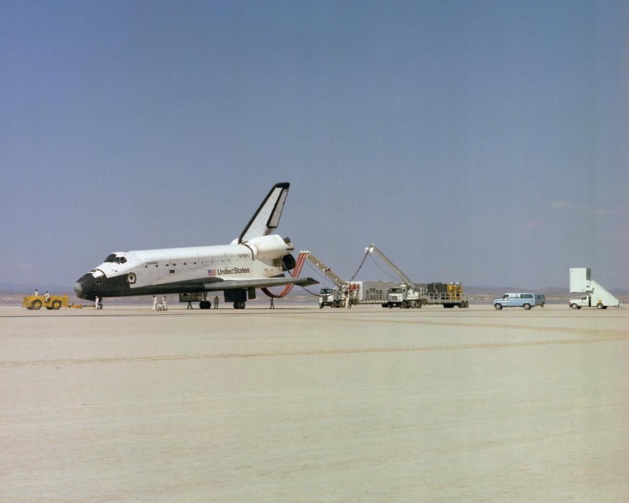
The Space Shuttle Columbia on Rogers Dry lakebed at Edwards AFB after landing to complete its first orbital mission on April 14, 1981. Technicians towed the Shuttle back to the NASA Dryden Flight Research Center for post-flight processing and preparation for a return ferry flight atop a modified 747 to Kennedy Space Center in Florida.
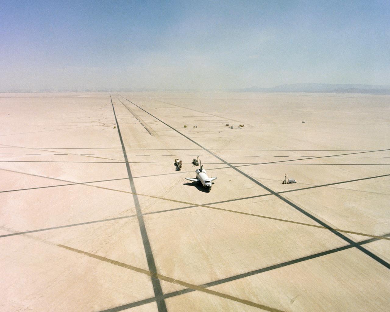
The Space Shuttle Columbia on Rogers Dry lakebed at Edwards AFB after landing to complete its first orbital mission on April 14, 1981. Technicians towed the Shuttle back to the NASA Dryden Flight Research Center for post-flight processing and preparation for a return ferry flight atop a modified 747 to Kennedy Space Center in Florida. (JSC photo # S81-31163)
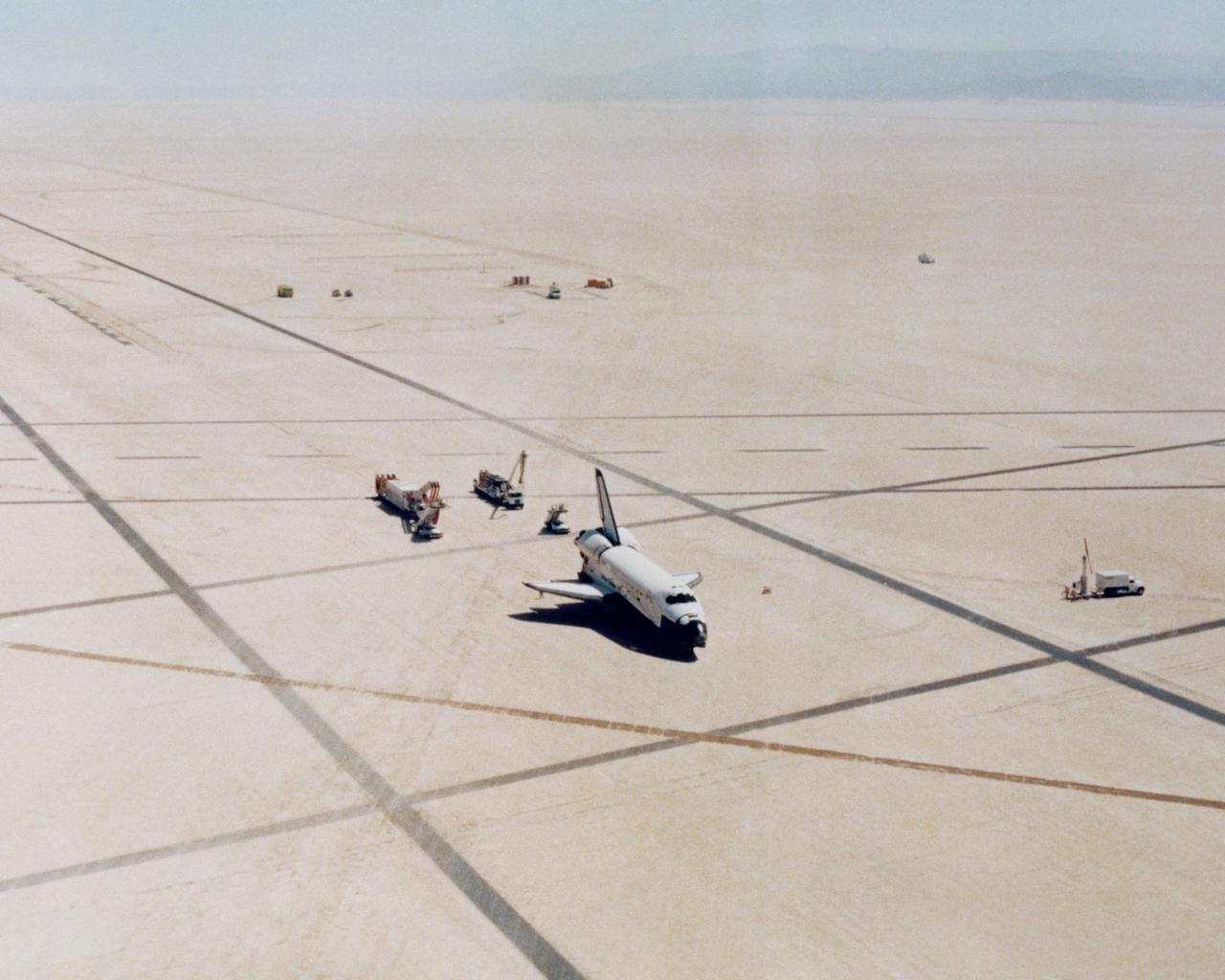
The Space Shuttle Columbia on Rogers Dry lakebed at Edwards AFB after landing to complete its first orbital mission on April 14, 1981. Technicians towed the Shuttle back to the NASA Dryden Flight Research Center for post-flight processing and preparation for a return ferry flight atop a modified 747 to Kennedy Space Center in Florida. (JSC photo # S81-30749)
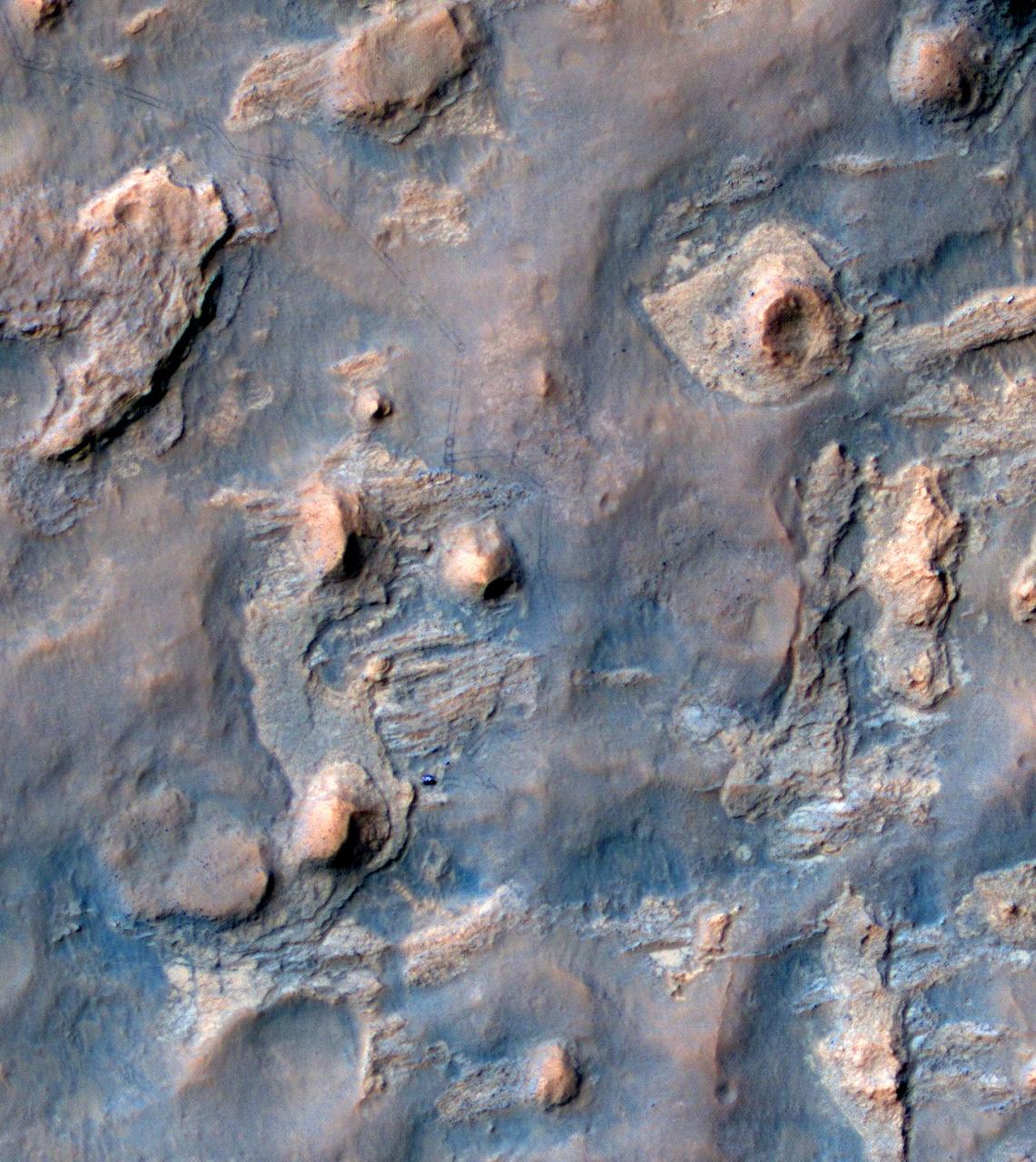
NASA Curiosity Mars rover and tracks from its driving are visible in this view from orbit, acquired on April 11, 2014, by the High Resolution Imaging Science Experiment HiRISE camera on NASA Mars Reconnaissance Orbiter.
NASA Terra satellite flew directly over Iceland on April 19, 2010 and captured this image of the Eyjafjallajökull volcano and its erupting ash plume. 3D glasses are necessary to view this image.

This image of Titan was acquired on April 30, 2006, by Cassini radar instrument in synthetic-aperture mode over the continent-sized region called Xanadu
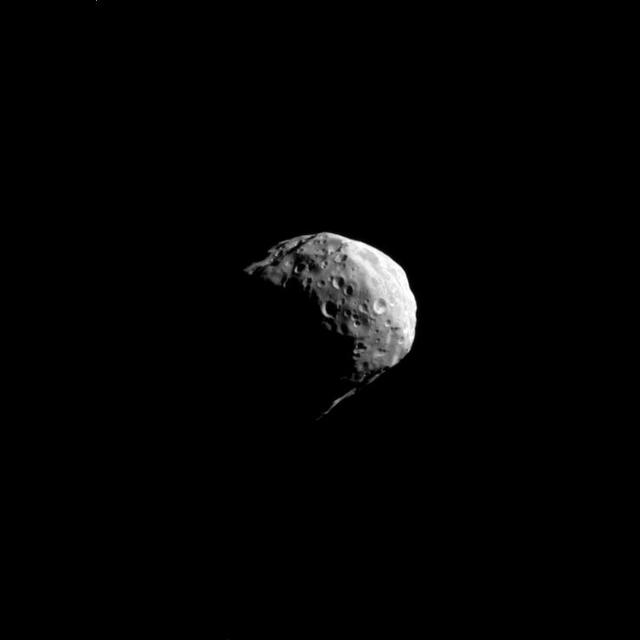
Taken on April 24, 2019, this rainbow-colored image shows the Martian moon Phobos, as viewed by NASA's 2001 Mars Odyssey orbiter using its infrared camera, Thermal Emission Imaging System (THEMIS). Each color represents a different temperature range, with the warmest in the center and coolest on the outer edge. This was the first time THEMIS was used to observe Phobos while in a full moon phase, which offers scientists a much better view for studying the composition of the Martian moon. Previous half-moon views, which can be seen here, were better for studying surface textures. https://photojournal.jpl.nasa.gov/catalog/PIA23204
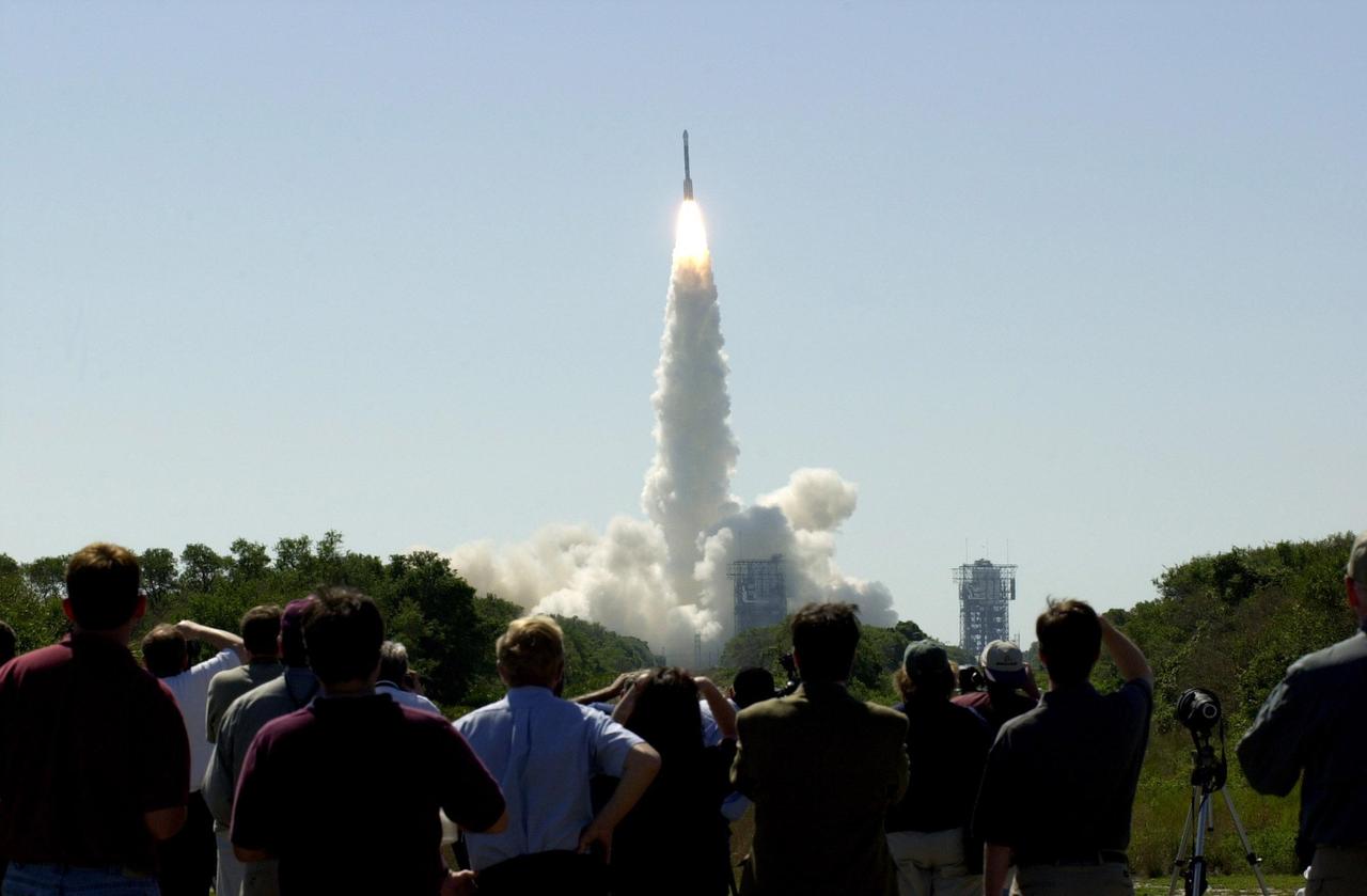
At 11:02 a.m. EDT on April 7, 2001, crowds watch a Boeing Delta II rocket lift off from Cape Canaveral Air Force Station, Florida, carrying NASA 2001 Mars Odyssey spacecraft into space on its seven-month journey to Mars.
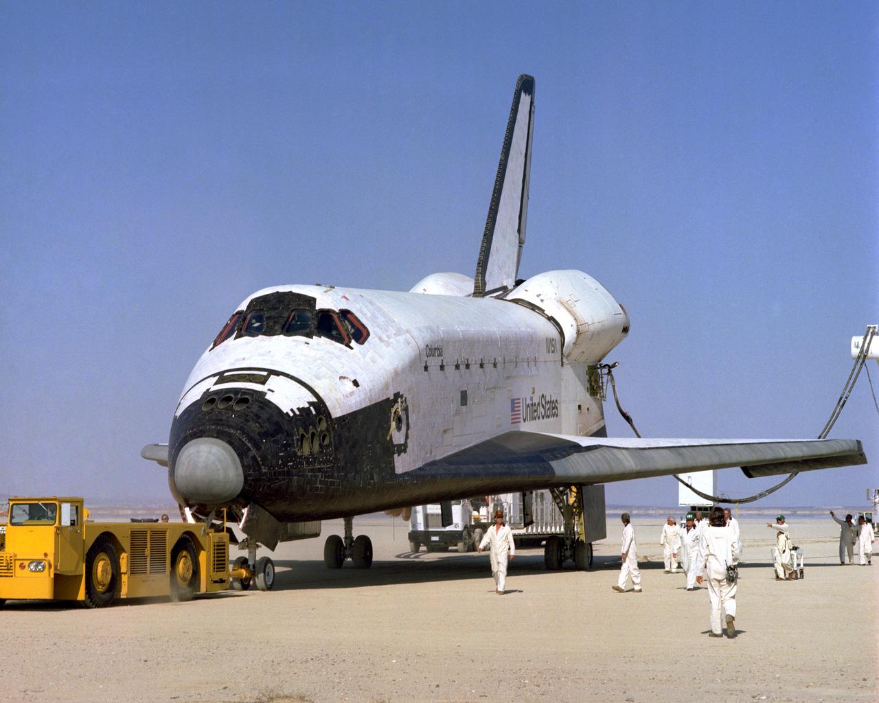
The Space Shuttle Columbia on Rogers Dry lakebed at Edwards AFB after landing to complete its first orbital mission on April 14, 1981. Technicians towed the Shuttle back to the NASA Dryden Flight Research Center for post-flight processing and preparation for a return ferry flight atop a modified 747 to Kennedy Space Center in Florida.
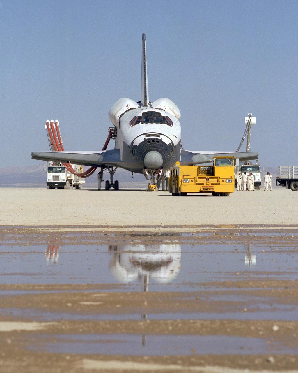
The Space Shuttle Columbia on Rogers Dry lakebed at Edwards AFB after landing to complete its first orbital mission on April 14, 1981. Technicians towed the Shuttle back to the NASA Dryden Flight Research Center for post-flight processing and preparation for a return ferry flight atop a modified 747 to Kennedy Space Center in Florida.
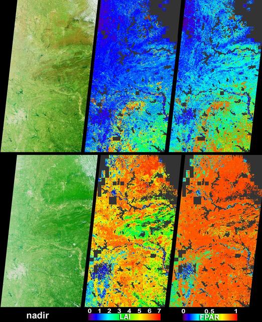
Vigorous vegetation growth in the Southern United States after heavy rains fell during April and early May, 2004, is quantified in these images and data products from NASA Terra spacecraft.

This movie shows the Martian moon Phobos as viewed in visible light by NASA's 2001 Mars Odyssey orbiter on April 24, 2019. It was put together from 19 images taken 1 second apart by Odyssey's infrared camera, Thermal Emission Imaging System (THEMIS). The apparent motion is due to progression of the camera's pointing during the observation. This was the third observation of Phobos by Mars Odyssey. While displayed here in visible-wavelength light, THEMIS also recorded thermal-infrared imagery in the same scan. The distance to Phobos from Odyssey during the observation was about 5,692 miles (9,160 kilometers). Movie available at https://photojournal.jpl.nasa.gov/catalog/PIA23207
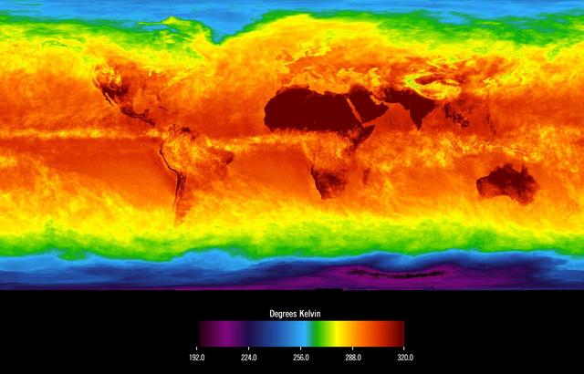
This image shows average temperatures in April, 2003, observed by AIRS at an infrared wavelength that senses either the Earth's surface or any intervening cloud. Similar to a photograph of the planet taken with the camera shutter held open for a month, stationary features are captured while those obscured by moving clouds are blurred. Many continental features stand out boldly, such as our planet's vast deserts, and India, now at the end of its long, clear dry season. Also obvious are the high, cold Tibetan plateau to the north of India, and the mountains of North America. The band of yellow encircling the planet's equator is the Intertropical Convergence Zone (ITCZ), a region of persistent thunderstorms and associated high, cold clouds. The ITCZ merges with the monsoon systems of Africa and South America. Higher latitudes are increasingly obscured by clouds, though some features like the Great Lakes, the British Isles and Korea are apparent. The highest latitudes of Europe and Eurasia are completely obscured by clouds, while Antarctica stands out cold and clear at the bottom of the image. http://photojournal.jpl.nasa.gov/catalog/PIA00427
NASA Terra satellite flew directly over Iceland on April 19, 2010, to capture this stereo anaglyph generated from the nadir and 46-degree forward-viewing cameras of the Eyjafjallajökull volcano and its erupting ash plume. 3D glasses are necessary to vie
This image was obtained by NASA Cassini radar instrument during a flyby on April 26, 2007. The radar antenna was pointing toward Titan at an altitude of 980 kilometers 609 miles during the closest approach. The radar antenna was pointing toward Titan at a 980 km altitude at the closest approach. The image has been processed with a resolution of 128 pixels/deg. https://photojournal.jpl.nasa.gov/catalog/PIA04391
NASA in the Park on June 16 in Huntsville featured more than 60 exhibits and demonstrations by NASA experts, as well as performances by Marshall musicians, educational opportunities, games and hands-on activities for all ages. MSFC Summer Interns Eben Lenfest, Nick Bonini, and April Benedict display their artistic talents on Big Spring Park sidewalk during NASA in the Park festivities.
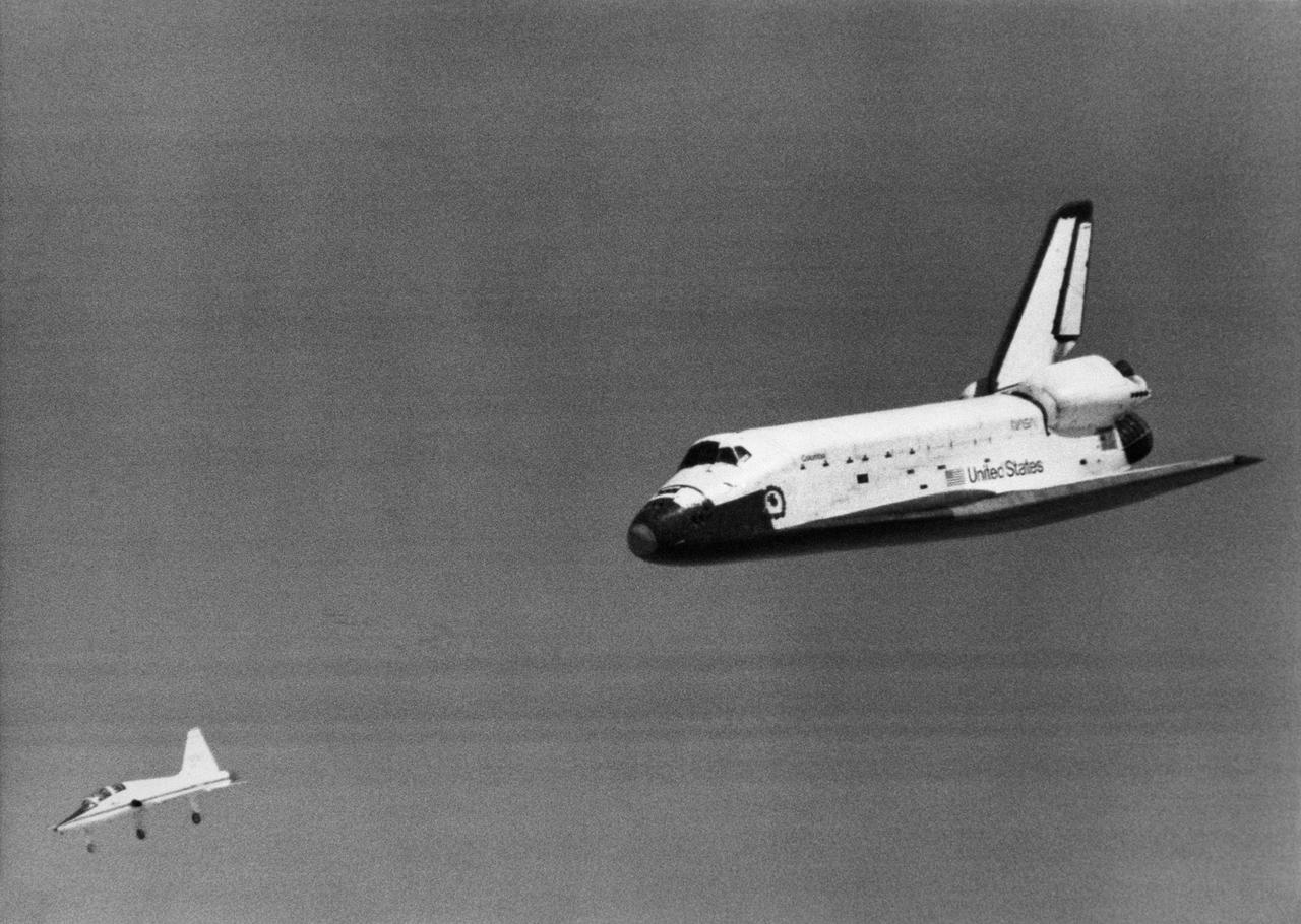
The Space Shuttle Columbia glides down over Rogers Dry Lake as it heads for a landing at Edwards Air Force Base at the conclusion of its first orbital mission on April 14, 1981.
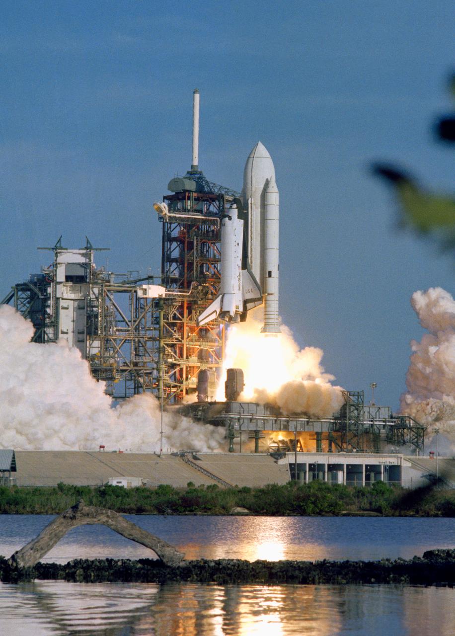
S81-30463 (12 April 1981) --- The space shuttle Columbia rises off Pad 39A a few seconds past 7 a.m. (EST) on April 12, 1981. Onboard, astronauts John W. Young, STS-1 commander, and Robert L. Crippen, pilot, head toward an Earth-orbital mission which represents the beginning of a new era in space transportation. Thousands of persons were in the area to view the historic launch. Photo credit: NASA or National Aeronautics and Space Administration
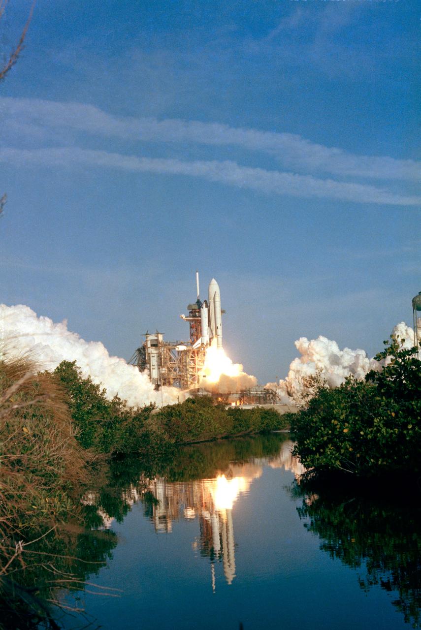
S81-30462 (12 April 1981) --- The space shuttle Columbia rises off Pad 39A a few seconds past 7 a.m. (EST) on April 12, 1981. Onboard, astronauts John W. Young, STS-1 commander, and Robert L. Crippen, pilot, head toward an Earth-orbital mission which represents the beginning of a new era in space transportation. Thousands of persons were in the area to view the historic launch. Photo credit: NASA or National Aeronautics and Space Administration
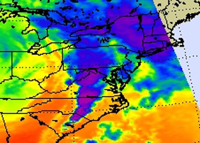
NASA Aqua satellite captured an infrared image of the storms on April 16, 2011 showing very cold, high cloud tops of the strong thunderstorms that spawned tornadoes in North Carolina and Virginia.

Markeeva Morgan, SLS avionics subsystem manager at NASA’s Marshall Space Flight Center, speaks to an audience of Marshall team members April 26 at the Overlook at Redstone. Morgan was the introductory speaker for the luncheon meeting of the Marshall Association, the center’s professional, employee service organization.
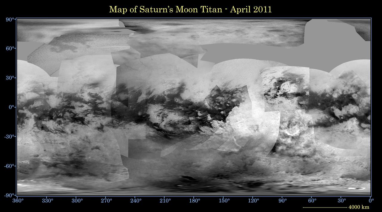
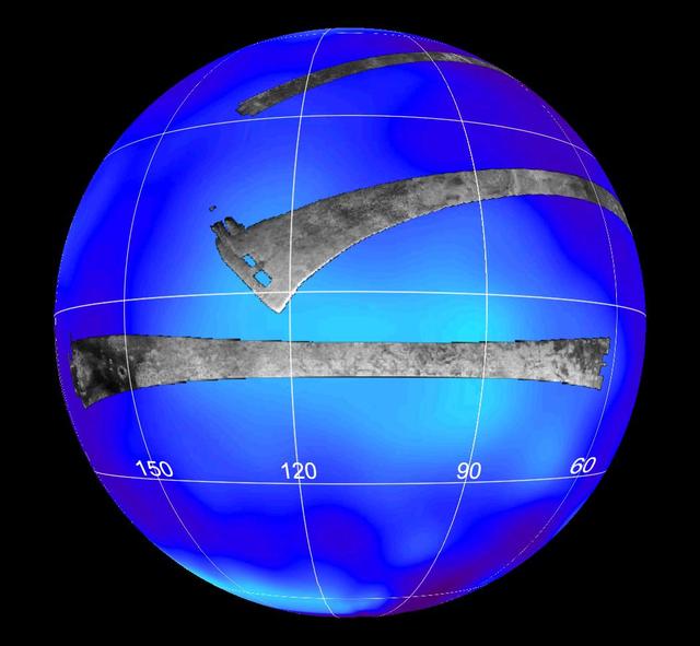
This global digital map of Saturn moon Titan was created using images taken by NASA Cassini spacecraft imaging science subsystem ISS. Because of the scattering of light by Titan dense atmosphere, no topographic shading is visible here.
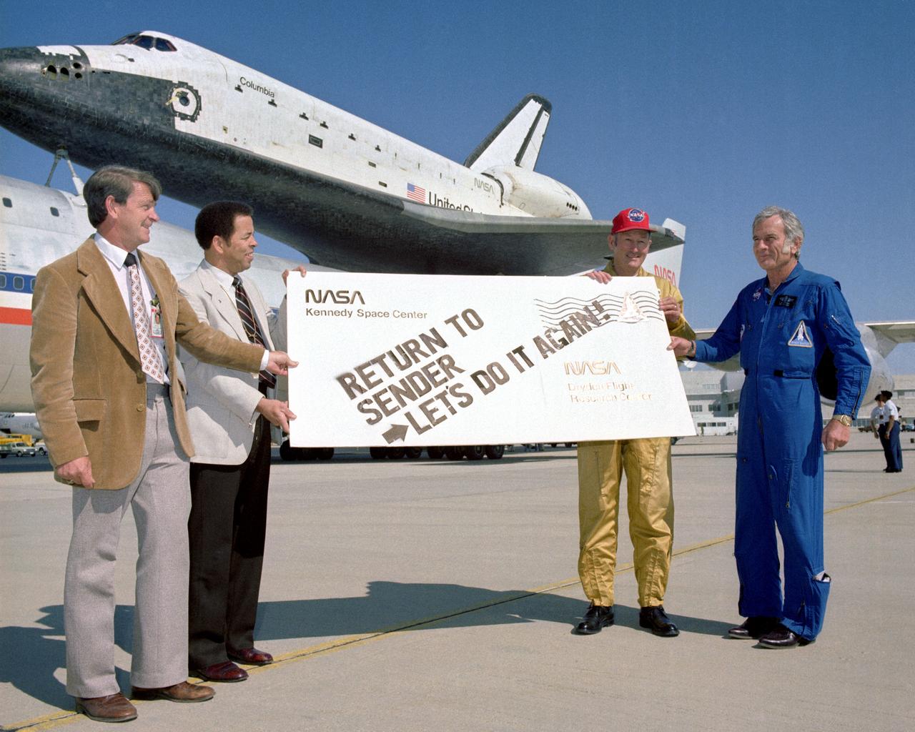
After completing it's first orbital mission with a landing at Edwards Air Force Base on April 14, 1981, Space Shuttle Columbia received a humorous sendoff before it's ferry flight atop a modified 747 back to the Kennedy Space Center in Florida. Holding the sign are, left to right: Melvin Burke, DFRC Orbital Flight Test (OFT) Program Manager; Isaac 'Ike' Gillam, DFRC Center Director; Fitzhugh 'Fitz' L. Fulton Jr., NASA DFRC 747 SCA Pilot; and Donald K. 'Deke' Slayton, JSC OFT Project Manager.

Paul Finley, mayor of the City of Madison, Alabama, chats with Jody Singer, deputy director of NASA’s Marshall Space Flight Center, following the April 26 lunch meeting of the Marshall Association, the center's professional, employee service organization. Finley, the guest speaker for the event, served as mayor of Madison from 2008-2012 and was elected to the post again in 2016.
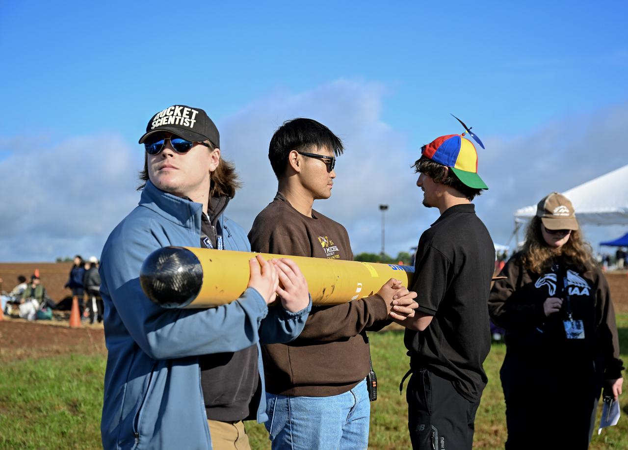
NASA MSFC 25th Anniversary of the Student Launch held on April 4, 2025 at Bragg Farms in Toney, AL.
Fires began near the Chernobyl Nuclear Power Plant in Ukraine April 4, 2020. By April 14, the fires were nearly extinguished. On April 16, new fires erupted, sending large, dark gray clouds of smoke traveling over 750 km to the southeast. The ASTER image, acquired April 18, shows part of the billowing smoke plume. The image covers an area of 59.2 by 61.4 km, and is located near 51 degrees north, 30.1 degrees east. https://photojournal.jpl.nasa.gov/catalog/PIA23911

NASA's Stratospheric Observatory for Infrared Astronomy (SOFIA) was airborne for almost two hours during its first check flight at Waco, Texas on April 26, 2007.

jsc2023e065192 (1/23/2023) --- Student researchers from Gervais, OR work on their experiment, Patulin Growth in Space, which will be included in the Nanoracks-National Center for Earth and Space Science Education-Orbiter-Student Spaceflight Experiments Program Mission 17 to ISS (Nanoracks-NCESSE-Orbiter-SSEP).
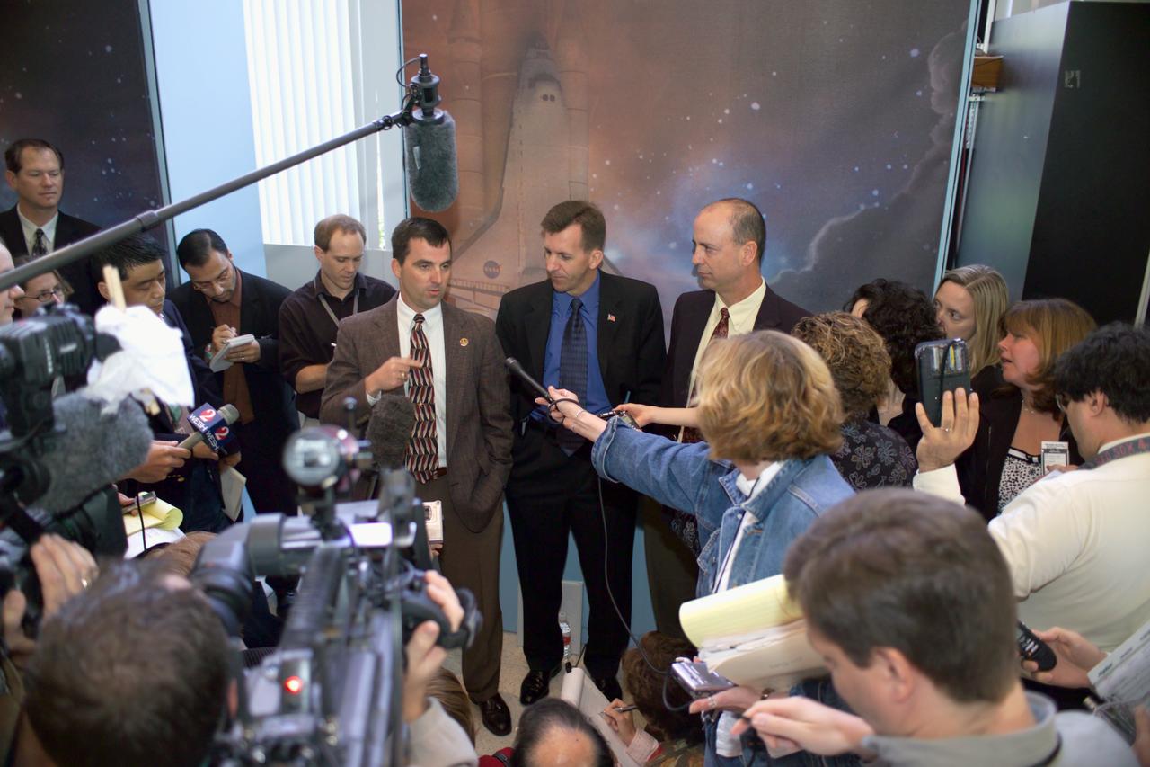
JSC2005-E-14182 (7 April 2005) --- Paul Hill (left center), STS-114 Lead Shuttle Flight Director; LeRoy Cain, Ascent/Entry Flight Director; and Mark Ferring, Lead ISS Flight Director, speak with various news media representatives following an STS-114 preflight press briefing in the Teague Auditorium at the Johnson Space Center (JSC).
Swinging by Saturn small moon Epimetheus, NASA Cassini spacecraft snapped this shot during the spacecraft April 7, 2010, flyby.
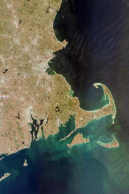
This image acquired on April 13, 2000 from NASA Terra satellite shows west side of Cape Cod Bay.

The Cassini spacecraft investigates the craters and deep valleys on Dione during a close approach in April 2007

NASA data and expertise are providing valuable information for the ongoing response to the April 25, 2015, magnitude 7.8 Gorkha earthquake in Nepal.

Relative sizes of Kepler habitable zone planets discovered as of 2013 April 18. Except for Earth, these are artists renditions.
Raditladi basin, imaged during MESSENGER first Mercury flyby and named in April 2008, is intriguing for several reasons.
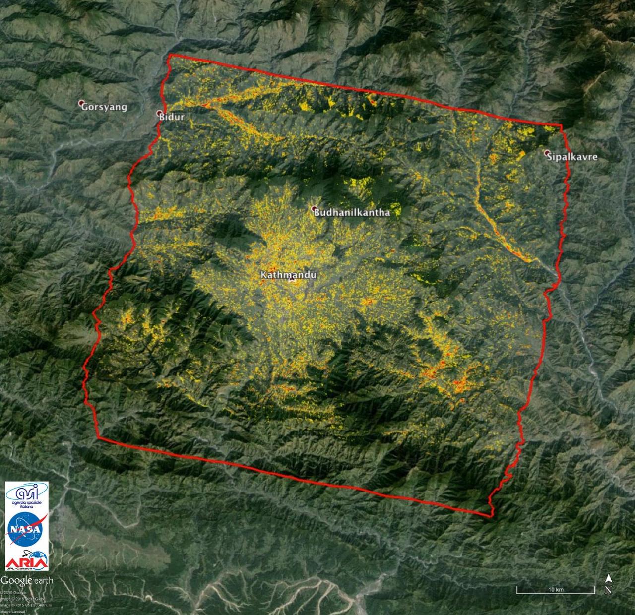
NASA data and expertise are providing valuable information for the ongoing response to the April 25, 2015, magnitude 7.8 Gorkha earthquake in Nepal.
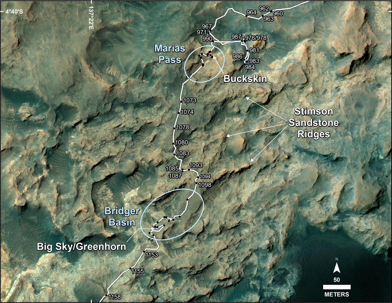
This map shows the route on lower Mount Sharp that NASA Curiosity followed between April 19, 2015, and Nov. 5, 2015.
Twelve orbits a day provide NASA Mars Global Surveyor MOC wide angle cameras a global napshot of weather patterns across the planet. Here, bluish-white water ice clouds hang above the Tharsis volcanoes.
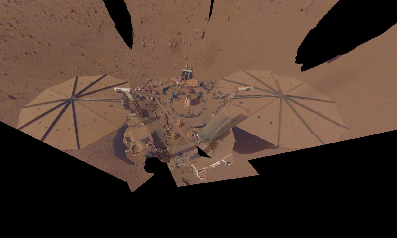
NASA's InSight Mars lander took this final selfie on April 24, 2022, the 1,211th Martian day, or sol, of the mission. The lander is covered with far more dust than it was in its first selfie, taken in December 2018, not long after landing – or in its second selfie, composed of images taken in March and April 2019. The arm needs to move several times in order to capture a full selfie. Because InSight's dusty solar panels are producing less power, the team will soon put the lander's robotic arm in its resting position (called the "retirement pose") for the last time in May of 2022. Animation available at https://photojournal.jpl.nasa.gov/catalog/PIA25287
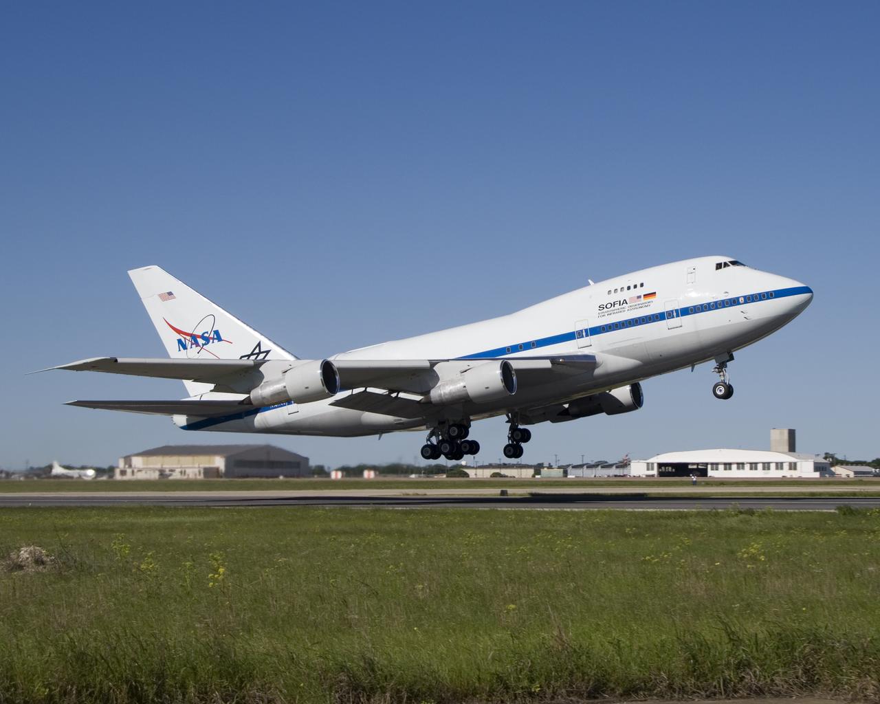
The NASA and German Aerospace Center SOFIA airborne infrared observatory took flight for the first time April 26, 2007, from its modification center in Waco, Texas.
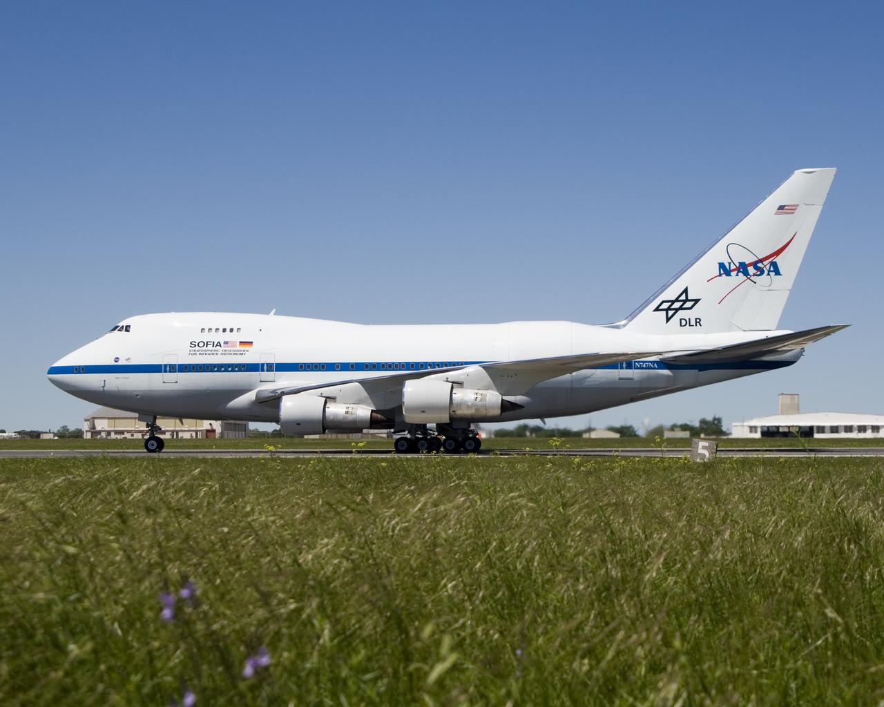
NASA's modified Boeing 747SP SOFIA airborne observatory taxis along the runway at Waco, Texas after completing its first checkout flight on April 26, 2007.
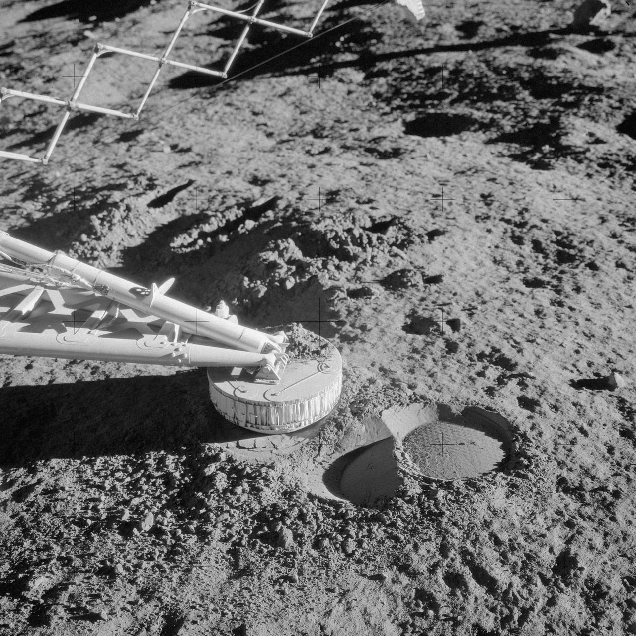
AS12-48-7110 (20 Nov. 1969) --- A close-up view of a footpad and surface sampler with scoop (arm, out of frame) on the Surveyor 3 spacecraft which was photographed by the Apollo 12 astronauts during their second extravehicular activity (EVA) on the moon. The Apollo 12 Lunar Module (LM), with astronauts Charles Conrad Jr. and Alan L. Bean aboard, touched down in the Ocean of Storms only 600 feet from Surveyor 3. The television camera and several other pieces were taken from Surveyor 3 and brought back to Earth for scientific examination. The unmanned spacecraft soft-landed on the moon on April 19, 1967. Note the imprint in the lunar soil which was caused when the Surveyor 3 bounced upon landing.
This image shows the southern high-latitudes region of Mars from March 19 through April 14, 2009, a period when regional dust storms occurred along the retreating edge of carbon-dioxide frost in the seasonal south polar cap. Compared with a full-hemisphere view (see PIA11987), this view shows more details of where the dust clouds formed and how they moved around the planet. The movie combines hundreds of images from the Mars Color Imager (MARCI) camera on NASA's Mars Reconnaissance Orbiter. In viewing the movie, it helps to understand some of the artifacts produced by the nature of MARCI images when seen in animation. MARCI acquires images in swaths from pole-to-pole during the dayside portion of each orbit. The camera can cover the entire planet in just over 12 orbits, and takes about 1 day to accumulate this coverage. The indiviual swaths are assembled into a mosaic, and that mosaic is shown here wrapped onto a sphere. The blurry portions of the mosaic, seen to be "pinwheeling" around the planet in the movie, are the portions of adjacent images viewing obliquely through the hazy atmosphsere. Portions with sharper-looking details are the central part of an image, viewing more directly downward through less atmosphere than the obliquely viewed portions. MARCI has a 180-degree field of view, and Mars fills about 78 percent of that field of view when the camera is pointed down at the planet. However, the Mars Reconnaissance Orbiter often is pointed to one side or the other off its orbital track in order to acquire targeted observations by the higher-resolution imaging systems on the spacecraft. When such rolls exceed about 20 degrees, gaps occur in the mosaic of MARCI swaths. Also, dark gaps appear when data are missing, either because of irrecoverable data drops, or because not all the data have yet been transmitted from the spacecraft. It isn't easy to see the actual dust motion in the atmosphere in these images, owing to the apparent motion of these artifacts. However, by concentrating on specific surface features (craters, prominent ice deposits, etc.) and looking for the brownish clouds of dust, it is possible to see where the storms start and how they move around the planet. In additon to tracking the storms, it is also interesting to watch how the seasonal cap shrinks from the beginning to the end of the animation. This shrinkage results from subliming of the carbon-dioxide frost from the surface as the frost absorbs southern hemisphere mid-spring sunlight. The temperature contrast between the warm sunlit ground just north of the cap's edge and the cold carbon-dioxide frost generates strong winds, enhanced by the excess carbon dioxide subliming off the cap. These winds create the conditions that lead to the dust storms. http://photojournal.jpl.nasa.gov/catalog/PIA11988
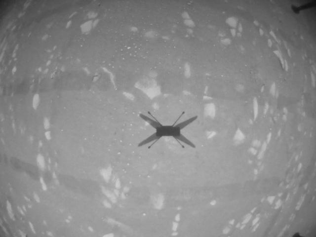
This black-and-white image was taken by the navigation camera aboard NASA's Ingenuity helicopter during its third flight, on April 25, 2021. https://photojournal.jpl.nasa.gov/catalog/PIA24623
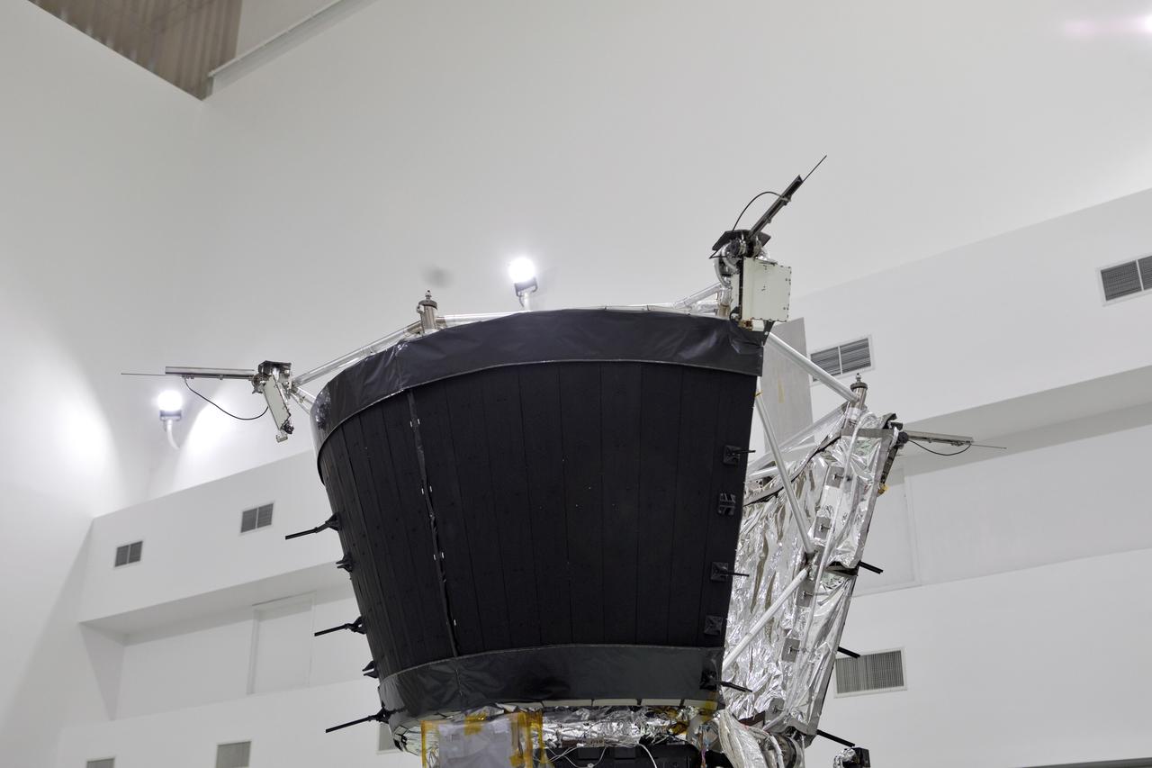
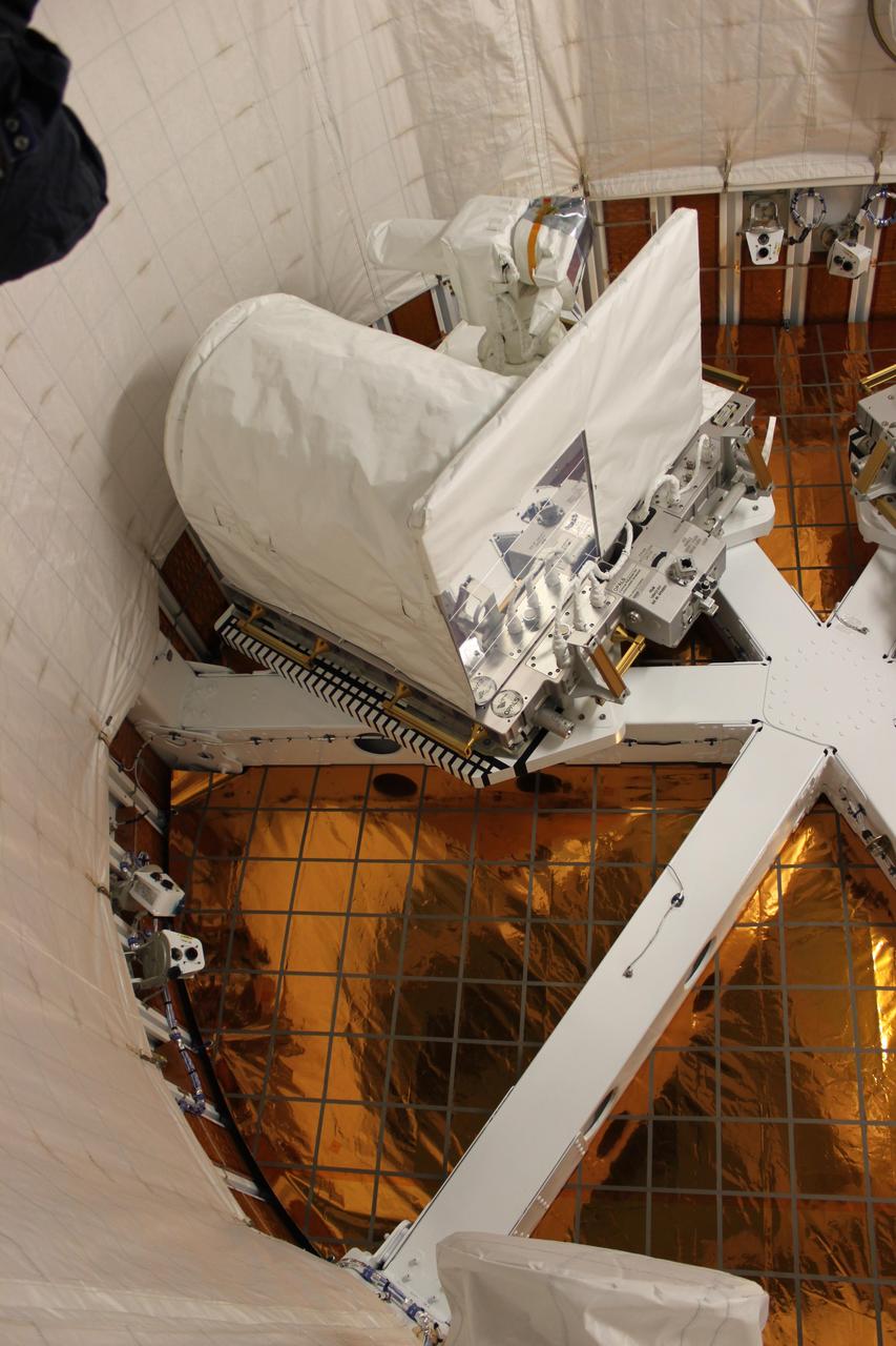
Antenna's on NASA's Parker Solar Probe are deployed for testing at the Astrotech processing facility in Titusville, Florida, near NASA's Kennedy Space Center on Thursday, April 19, 2018. The Parker Solar Probe will launch on a United Launch Alliance Delta IV Heavy rocket from Space Launch Complex 37 at Cape Canaveral Air Force Station in Florida no earlier than Aug. 4, 2018. The mission will perform the closest-ever observations of a star when it travels through the Sun's atmosphere, called the corona. The probe will rely on measurements and imaging to revolutionize our understanding of the corona and the Sun-Earth connection.

Antenna's on NASA's Parker Solar Probe are deployed for testing at the Astrotech processing facility in Titusville, Florida, near NASA's Kennedy Space Center on Thursday, April 19, 2018. The Parker Solar Probe will launch on a United Launch Alliance Delta IV Heavy rocket from Space Launch Complex 37 at Cape Canaveral Air Force Station in Florida no earlier than Aug. 4, 2018. The mission will perform the closest-ever observations of a star when it travels through the Sun's atmosphere, called the corona. The probe will rely on measurements and imaging to revolutionize our understanding of the corona and the Sun-Earth connection.
Antenna's on NASA's Parker Solar Probe are deployed for testing at the Astrotech processing facility in Titusville, Florida, near NASA's Kennedy Space Center on Thursday, April 19, 2018. The Parker Solar Probe will launch on a United Launch Alliance Delta IV Heavy rocket from Space Launch Complex 37 at Cape Canaveral Air Force Station in Florida no earlier than Aug. 4, 2018. The mission will perform the closest-ever observations of a star when it travels through the Sun's atmosphere, called the corona. The probe will rely on measurements and imaging to revolutionize our understanding of the corona and the Sun-Earth connection.

Antenna's on NASA's Parker Solar Probe are deployed for testing at the Astrotech processing facility in Titusville, Florida, near NASA's Kennedy Space Center on Thursday, April 19, 2018. The Parker Solar Probe will launch on a United Launch Alliance Delta IV Heavy rocket from Space Launch Complex 37 at Cape Canaveral Air Force Station in Florida no earlier than Aug. 4, 2018. The mission will perform the closest-ever observations of a star when it travels through the Sun's atmosphere, called the corona. The probe will rely on measurements and imaging to revolutionize our understanding of the corona and the Sun-Earth connection.
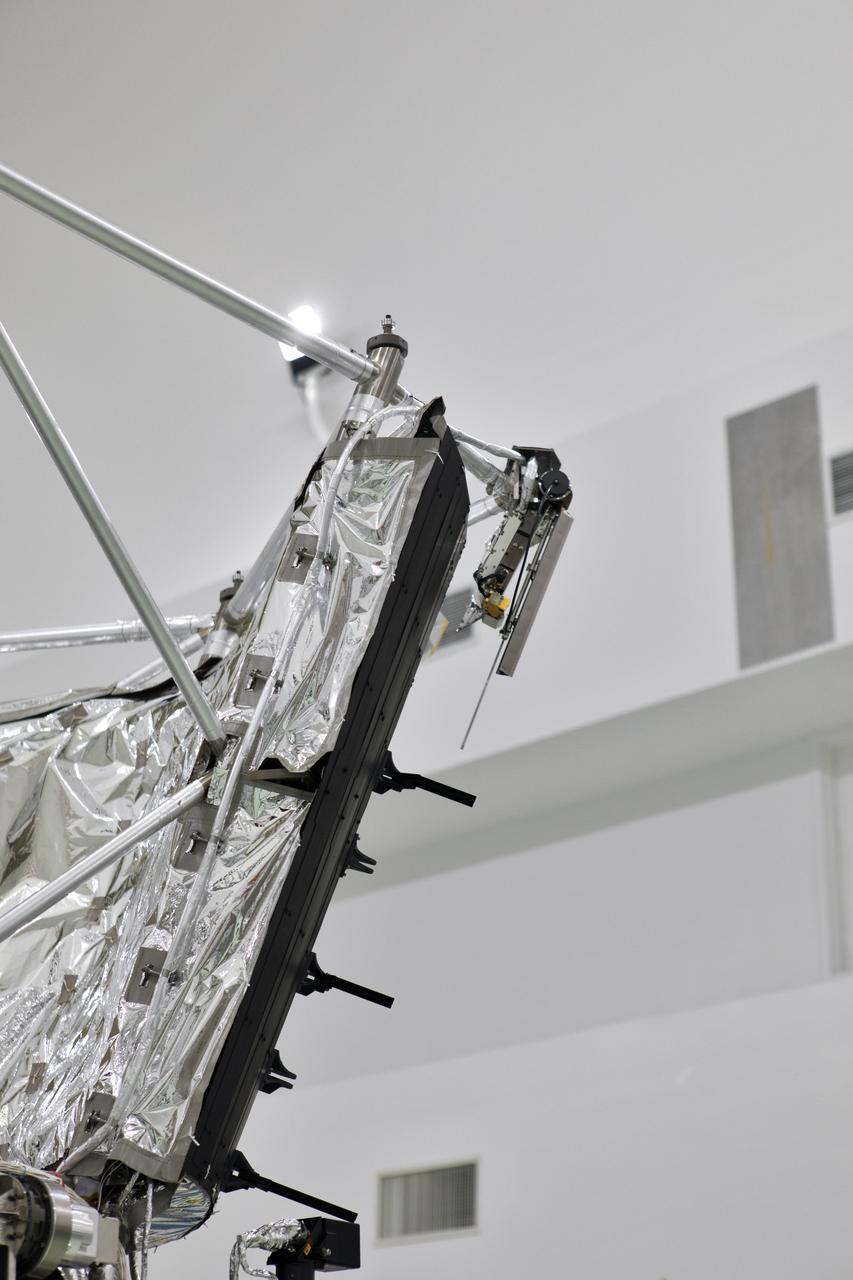
Antenna's on NASA's Parker Solar Probe are deployed for testing at the Astrotech processing facility in Titusville, Florida, near NASA's Kennedy Space Center on Thursday, April 19, 2018. The Parker Solar Probe will launch on a United Launch Alliance Delta IV Heavy rocket from Space Launch Complex 37 at Cape Canaveral Air Force Station in Florida no earlier than Aug. 4, 2018. The mission will perform the closest-ever observations of a star when it travels through the Sun's atmosphere, called the corona. The probe will rely on measurements and imaging to revolutionize our understanding of the corona and the Sun-Earth connection.
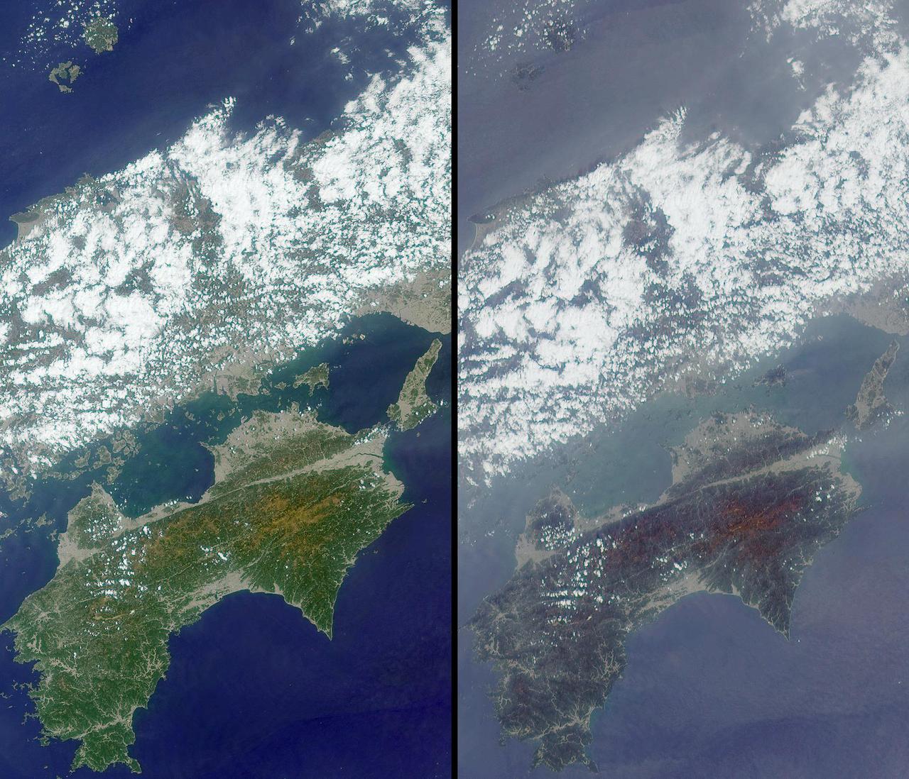
These images, centered just north of Shikoku Island in southwest Japan, were acquired by NASA Terra satellite on April 13, 2001 during Terra orbit 7015.

This image of Ceres is part of a sequence taken by NASA Dawn spacecraft on April 29, 2015, from a distance of 8,400 miles 13,600 kilometers.

Jupiter atmospheric circulation is dominated by alternating eastward and westward jets from equatorial to polar latitudes. This image was taken on April 3, 1997, by NASA Galileo spacecraft.

Jupiter atmospheric circulation is dominated by alternating eastward and westward jets from equatorial to polar latitudes. This image was taken on April 3, 1997, by NASA Galileo spacecraft.

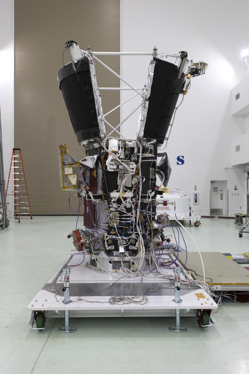
Assembly began April 1, 2010, for NASA Juno spacecraft. Workers at Lockheed Martin Space Systems in Denver, Colorado workers are readying the spacecraft propulsion module.

Jupiter atmospheric circulation is dominated by alternating eastward and westward jets from equatorial to polar latitudes. This image was taken on April 3, 1997, by NASA Galileo spacecraft.

Jupiter atmospheric circulation is dominated by alternating eastward and westward jets from equatorial to polar latitudes. This image was taken on April 3, 1997, by NASA Galileo spacecraft.

Jupiter atmospheric circulation is dominated by alternating eastward and westward jets from equatorial to polar latitudes. This image was taken on April 3, 1997, by NASA Galileo spacecraft.

Spatial distribution of snow water equivalent across the Tuolumne River Basin from April 10 to June 1, 2013 as measured by NASA Airborne Snow Observatory.

Jupiter atmospheric circulation is dominated by alternating eastward and westward jets from equatorial to polar latitudes. This image was taken on April 3, 1997, by NASA Galileo spacecraft.

This mosaic shows the features of Jupiter main visible cloud deck and the hazy cloud layer above it as seen by NASA Galileo spacecraft on April 3, 1997.

Jupiter atmospheric circulation is dominated by alternating eastward and westward jets from equatorial to polar latitudes. This image was taken on April 3, 1997, by NASA Galileo spacecraft.

Jupiter atmospheric circulation is dominated by alternating eastward and westward jets from equatorial to polar latitudes. This image was taken on April 3, 1997, by NASA Galileo spacecraft.
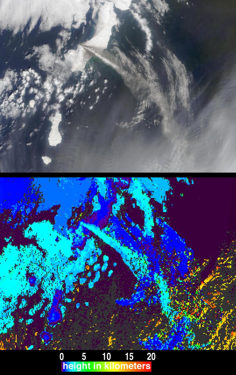
The height and motion of the ash and gas plume from the April 22, 2003, eruption of the Chikurachki volcano is portrayed in these views NASA Terra spacecraft.

Jupiter atmospheric circulation is dominated by alternating eastward and westward jets from equatorial to polar latitudes. This image was taken on April 3, 1997, by NASA Galileo spacecraft.
This April 6, 2014, image from NASA Mars Reconnaissance Orbiter shows numerous landslides in the vicinity of where an impact crater was excavated in March 2012.
This photo shows the Optical PAyload for Lasercomm Science OPALS being installed in SpaceX Dragon capsule prior to launching on April 18, 2014.

Jupiter atmospheric circulation is dominated by alternating eastward and westward jets from equatorial to polar latitudes. This image was taken on April 3, 1997, by NASA Galileo spacecraft.

Jupiter atmospheric circulation is dominated by alternating eastward and westward jets from equatorial to polar latitudes. This image was taken on April 3, 1997, by NASA Galileo spacecraft.
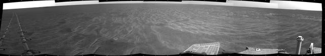
A dance-step pattern is visible in the wheel tracks near the left edge of this scene recorded by NASA Mars Exploration Rover Opportunity on Mars on April 1, 2011.
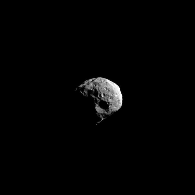
NASA Cassini spacecraft snapped this high-resolution image of Saturn small moon Epimetheus during the spacecraft non-targeted flyby on April 7, 2010.
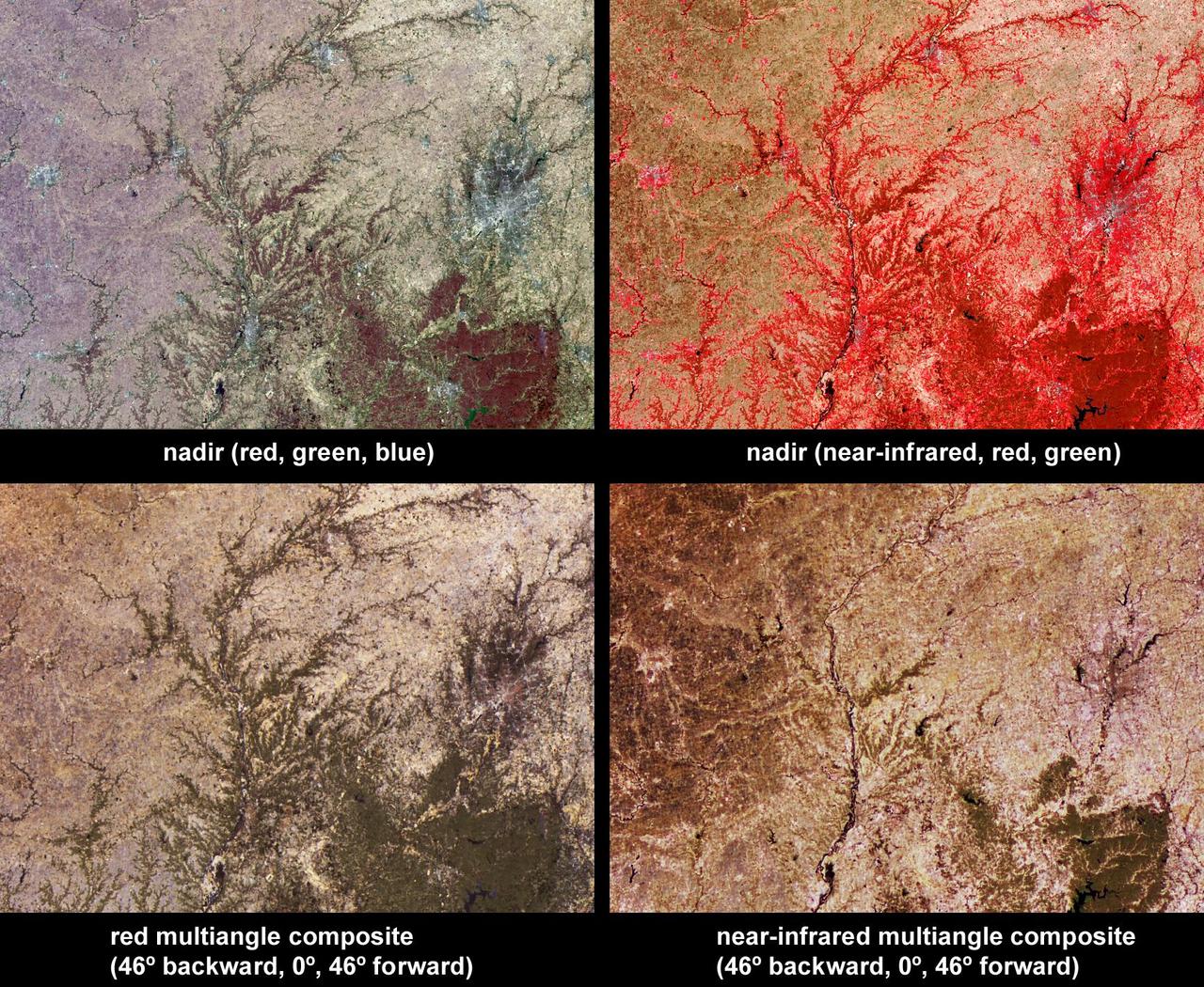
Vegetation across southeast Illinois and central Indiana is shown in this set of multispectral and multiangle images from NASA Terra spacecraft, captured on April 5, 2004.
AS12-48-7099 (20 Nov. 1969) --- This unusual view shows two National Aeronautics and Space Administration (NASA) spacecraft on the surface of the moon. In the center foreground is the unmanned Surveyor 3 spacecraft, which soft landed on the lunar surface on April 19, 1967. Just 600 feet away from the Surveyor 3 spacecraft, pictured here in the background, is the Apollo 12 Lunar Module (LM), which landed on the lunar surface on Nov. 19, 1969. This photograph was taken the following day, during the second Apollo 12 extravehicular activity (EVA) in which astronauts Charles Conrad Jr., commander, and Alan L. Bean, lunar module pilot, participated. Pictured to the right of the LM are the deployed S-Band antenna and the United States flag, which was unfurled on Nov. 19, 1969. While Conrad and Bean descended from lunar orbit in their Apollo 12 LM, astronaut Richard F. Gordon Jr., command module pilot, remained with the Command and Service Modules (CSM).
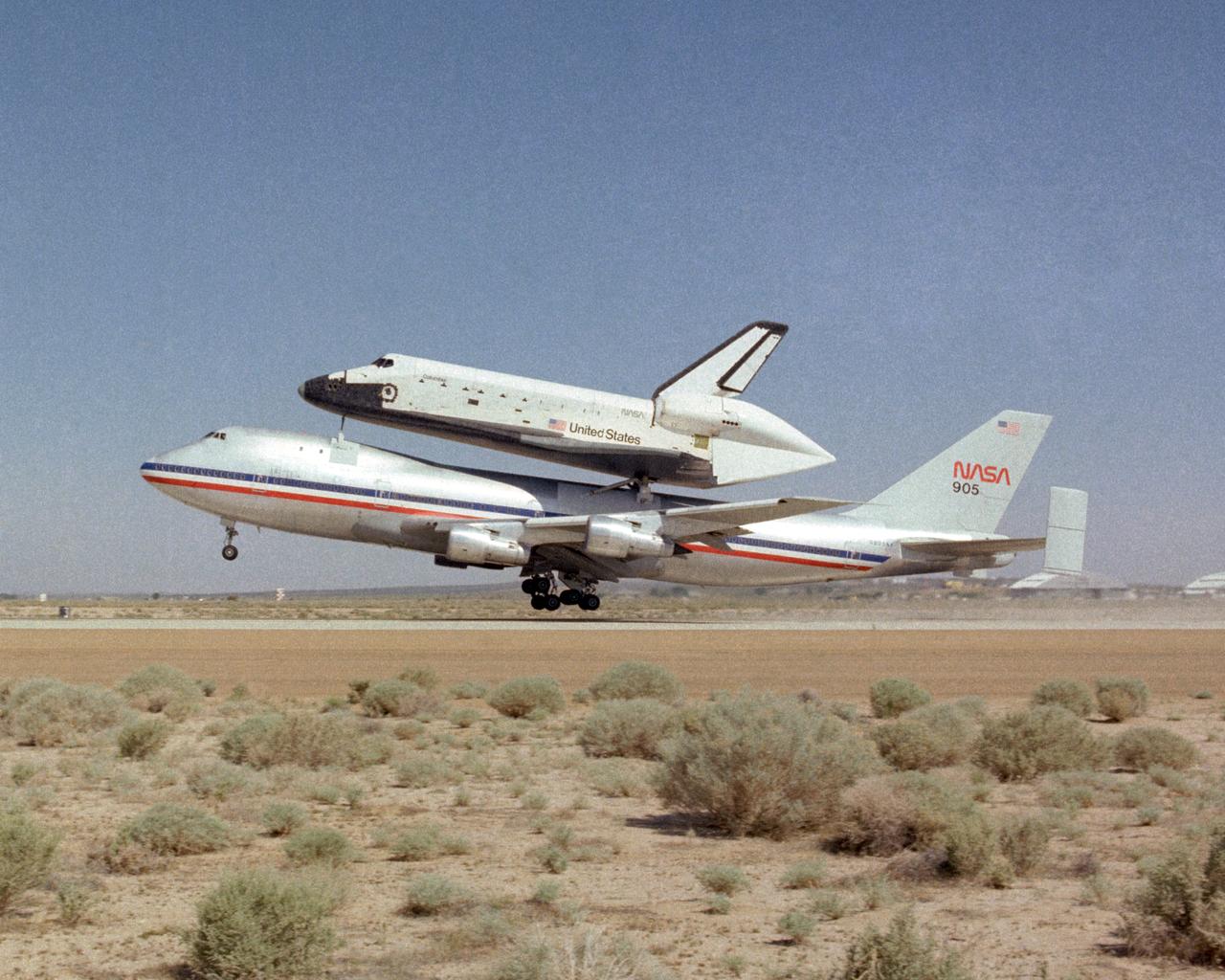
NASA's specially modified 747 with the Space Shuttle Columbia atop takes off to ferry the Shuttle back to Kennedy Space Center in Florida. Columbia had recently completed its first orbital mission with a landing at Edwards Air Force Base in California.
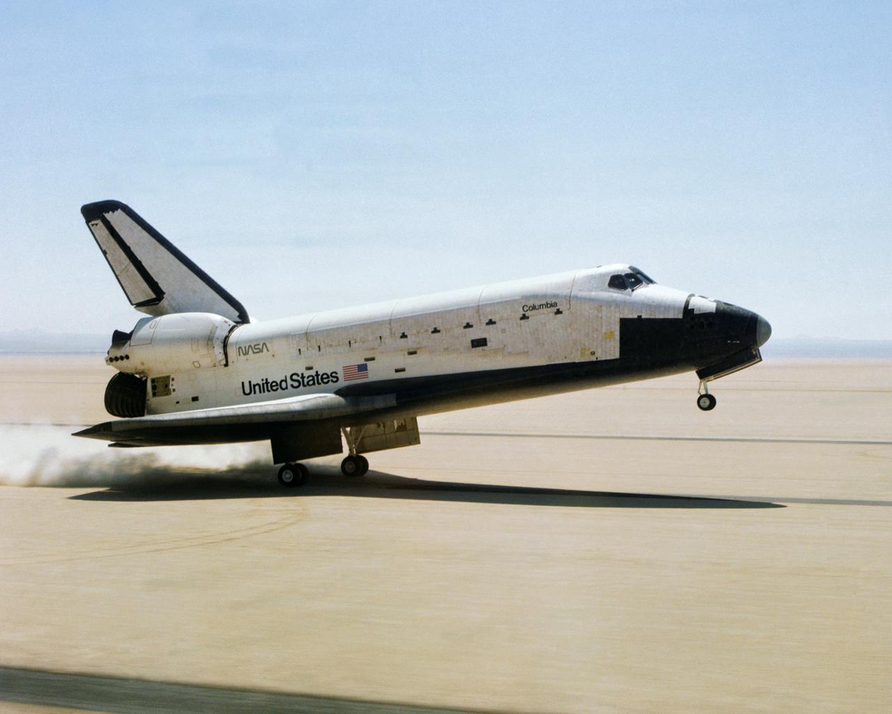
The Space Shuttle Columbia touches down on lakebed runway 23 at Edwards Air Force Base, Calif., to conclude the first orbital shuttle mission. (JSC photo # S81-30734)
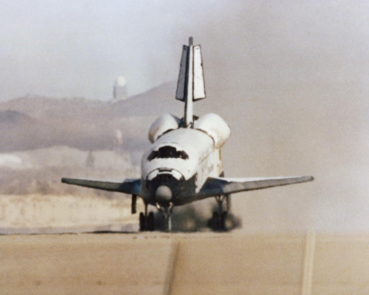
The Space Shuttle Columbia touches down on lakebed runway 23 at Edwards Air Force Base, Calif., to conclude the first orbital shuttle mission.