
Portrait of April Albert in front of NASA Langley's Hawker Siddeley P-1127 on display at Air Power Park in Hampton, Virginia. Due to the COVID-19 pandemic, masks were mandated by Governor Northam in Virginia in public settings. This is for the faces of NASA project. "I am really made to feel like I am part of a family. I don’t feel like anybody is treated differently. We are all one team. To be a part of NASA, to me, is to be part of something special. There is nothing like the camaraderie of NASA. I feel like I’m where I belong.” — April Albert, Schedule Analyst, Langley Research Center
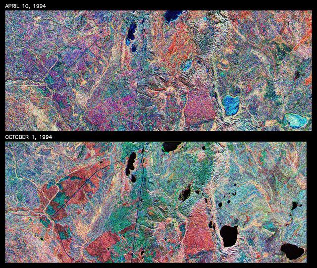
This is a comparison of images over Prince Albert, produced by NASA Spaceborne Imaging Radar-C and X-band Synthetic Aperture Radar aboard the space shuttle Endeavour on its 20th orbit on April 10, 1994. The area is centered at 53.91 degrees north latitude and 104.69 degrees west longitude and is located 40 kilometers (25 miles) north and 30 kilometers (18.5 miles) east of the town of Prince Albert in the Saskatchewan province of Canada. The image covers the area east of Candle Lake, between the gravel highway of 120 and west of highway 106. The area imaged is near the southern limit of the boreal forest. The boreal forest of North America is a continuous vegetation belt at high latitudes stretching across the continent from the Atlantic shoreline of central Labrador and then westward across Canada to the interior mountains and central coastal plains of Alaska. The forest is also part of a larger northern hemisphere circumpolar boreal forest belt. Coniferous trees dominate the entire forest but deciduous trees are also present. During the month of April, the forest experiences seasonal changes from a frozen condition to a thawed condition. The trees are completely frozen over the winter season and the forest floor is covered by snow. As the average temperature rises in the spring, the trees are thawed and the snow melts. This transition has an impact on the rate of moisture evaporation and release of carbon dioxide into the atmosphere. In late September and early October, the boreal forest experiences a relatively different seasonal change. At this time, the leaves on deciduous trees start changing color and dropping off. The soil and trees are quite often moist due to frequent rainfall and cloud cover. The evaporation of moisture and carbon dioxide into the atmosphere also diminishes at this time. SIR-C/X-SAR is sensitive to the moisture of soil and vegetation and can sense this freeze-thaw cycle and the summer-fall seasonal transition over forested areas in particular. Optical sensors, by contrast, are blind to these regions, which are perpetually obscured by thick cloud cover. These changes were detected by comparing the April and October color composite images of L-band data in red, C-band data in green and X-band (vertically received and transmitted) in blue. The changes in intensity of each color over lakes, various forest stands and clear cuts in the two images is striking. Lakes such as Lake Heiberg, Crabtree Lake and Williams Lake, in the right middle part of the image, are frozen in April (appearing in bright blue) and melted (appearing in black) in October. The higher intensity of blue over lakes in April is due to low penetration of the X-band (vertically received and transmitted) and the radar's high sensitivity to surface features. Forest stands also exhibit major changes between the two images. The red areas in the October image are old jack pine canopies that cause higher return at L-band because of their moist condition in late summer compared to their partially frozen condition in April (in purple). Similarly, in the areas near the middle of the image, where black spruce and mixed aspen and jack pine trees dominate, the contrast between blue in October and red and green in April is an indication that the top of the canopy (needles and branches) were frozen in April and moist in October. The changes due to deforestation by logging companies or natural fires can also be detected by comparing the images. For example, the small blue area near the intersection of Harding Road and Highway 120 is the result of logging which occurred after the April data was acquired. The surface area of clear cut is approximately 4 hectares, which is calculated from the high-resolution capability of the radar images and verified by scientists participating in field work during the mission. http://photojournal.jpl.nasa.gov/catalog/PIA01732

CAPE CANAVERAL, Fla. – Inside the Educator Resource Center at NASA’s Kennedy Space Center Visitor Complex in Florida, science teacher April Lanotte displays the Museum in a Box that contains activities and learning materials for K-12 students. Lanotte, who is an Albert Einstein Distinguished Educator Fellow working in NASA’s Aeronautics Research Mission Directorate, was at Kennedy to train education specialists and Kennedy Educate to Innovate program volunteers in the new series of lessons and activities. The Museum in a Box is a program designed to teach physical science through aeronautics using hands-on activities and experiments. Photo credit: NASA_Jim Grossmann

CAPE CANAVERAL, Fla. – Inside the Educator Resource Center at NASA’s Kennedy Space Center Visitor Complex in Florida, science teacher April Lanotte demonstrates one of the Museum in a Box experiments designed for K-12 students. Lanotte, who is an Albert Einstein Distinguished Educator Fellow working in NASA’s Aeronautics Research Mission Directorate, was at Kennedy to train education specialists and Kennedy Educate to Innovate program volunteers in the new series of lessons and activities. The Museum in a Box is a program designed to teach physical science through aeronautics using hands-on activities and experiments. Photo credit: NASA_Jim Grossmann

CAPE CANAVERAL, Fla. – Inside the Educator Resource Center at NASA’s Kennedy Space Center Visitor Complex in Florida, science teacher April Lanotte displays materials used for the Museum in a Box activities for K-12 students. Lanotte, who is an Albert Einstein Distinguished Educator Fellow working in NASA’s Aeronautics Research Mission Directorate, was at Kennedy to train education specialists and Kennedy Educate to Innovate program volunteers in the new series of lessons and activities. The Museum in a Box is a program designed to teach physical science through aeronautics using hands-on activities and experiments. Photo credit: NASA_Jim Grossmann
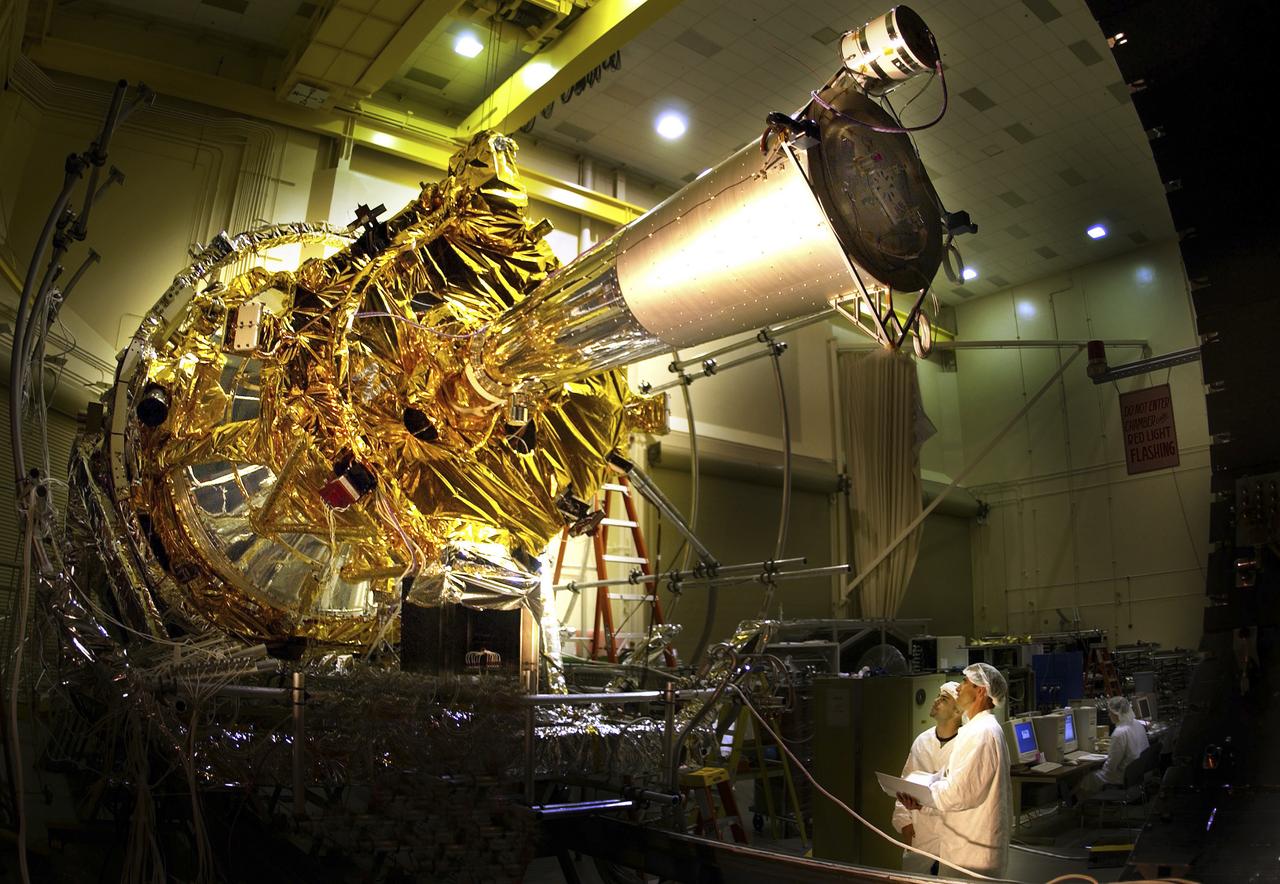
The Gravity Probe B (GP-B) is the relativity experiment developed at Stanford University to test two extraordinary predictions of Albert Einstein’s general theory of relativity. The experiment will measure, very precisely, the expected tiny changes in the direction of the spin axes of four gyroscopes contained in an Earth-orbiting satellite at a 400-mile altitude. So free are the gyroscopes from disturbance that they will provide an almost perfect space-time reference system. They will measure how space and time are very slightly warped by the presence of the Earth, and, more profoundly, how the Earth’s rotation very slightly drags space-time around with it. These effects, though small for the Earth, have far-reaching implications for the nature of matter and the structure of the Universe. In this photograph, the completed space vehicle is undergoing thermal vacuum environment testing. GP-B is among the most thoroughly researched programs ever undertaken by NASA. This is the story of a scientific quest in which physicists and engineers have collaborated closely over many years. Inspired by their quest, they have invented a whole range of technologies that are already enlivening other branches of science and engineering. Launched April 20, 2004 , the GP-B program was managed for NASA by the Marshall Space Flight Center. Development of the GP-B is the responsibility of Stanford University along with major subcontractor Lockheed Martin Corporation. (Image credit to Russ Underwood, Lockheed Martin Corporation.)

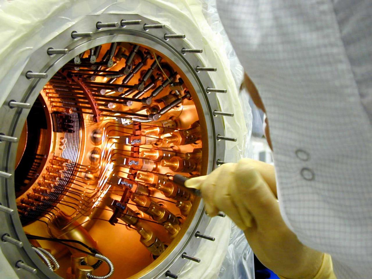
The Gravity Probe B (GP-B) is the relativity experiment developed at Stanford University to test two extraordinary predictions of Albert Einstein’s general theory of relativity. The experiment will measure, very precisely, the expected tiny changes in the direction of the spin axes of four gyroscopes contained in an Earth-orbiting satellite at a 400-mile altitude. So free are the gyroscopes from disturbance that they will provide an almost perfect space-time reference system. They will measure how space and time are very slightly warped by the presence of the Earth, and, more profoundly, how the Earth’s rotation very slightly drags space-time around with it. These effects, though small for the Earth, have far-reaching implications for the nature of matter and the structure of the Universe. In this photograph, Stanford engineer, Chris Gray, is inspecting the number 4 gyro under monochromatic light. GP-B is among the most thoroughly researched programs ever undertaken by NASA. This is the story of a scientific quest in which physicists and engineers have collaborated closely over many years. Inspired by their quest, they have invented a whole range of technologies that are already enlivening other branches of science and engineering. Launched April 20, 2004 , the GP-B program was managed for NASA by the Marshall Space Flight Center. Development of the GP-B is the responsibility of Stanford University along with major subcontractor Lockheed Martin Corporation. (Image credit to Russ Leese, Stanford University.)
In this photo, the Gravity Probe B (GP-B) space vehicle is completed during the solar array installation. The GP-B is the relativity experiment developed at Stanford University to test two extraordinary predictions of Albert Einstein’s general theory of relativity. The experiment will measure, very precisely, the expected tiny changes in the direction of the spin axes of four gyroscopes contained in an Earth-orbiting satellite at a 400-mile altitude. So free are the gyroscopes from disturbance that they will provide an almost perfect space-time reference system. They will measure how space and time are very slightly warped by the presence of the Earth, and, more profoundly, how the Earth’s rotation very slightly drags space-time around with it. These effects, though small for the Earth, have far-reaching implications for the nature of matter and the structure of the Universe. GP-B is among the most thoroughly researched programs ever undertaken by NASA. This is the story of a scientific quest in which physicists and engineers have collaborated closely over many years. Inspired by their quest, they have invented a whole range of technologies that are already enlivening other branches of science and engineering. GP-B is scheduled for launch in April 2004 and managed for NASA by the Marshall Space Flight Center. Development of the GP-B is the responsibility of Stanford University along with major subcontractor Lockheed Martin Corporation. (Image credit to Russ Underwood, Lockheed Martin Corporation).
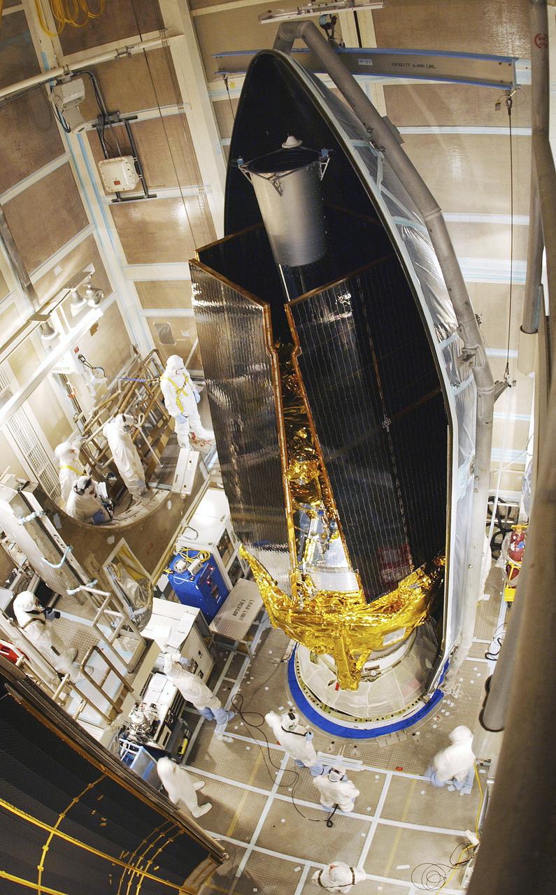
In this photo, the Gravity Probe B (GP-B) space vehicle is being encapsulated atop the Delta II launch vehicle. The GP-B is the relativity experiment developed at Stanford University to test two extraordinary predictions of Albert Einstein’s general theory of relativity. The experiment will measure, very precisely, the expected tiny changes in the direction of the spin axes of four gyroscopes contained in an Earth-orbiting satellite at a 400-mile altitude. So free are the gyroscopes from disturbance that they will provide an almost perfect space-time reference system. They will measure how space and time are very slightly warped by the presence of the Earth, and, more profoundly, how the Earth’s rotation very slightly drags space-time around with it. These effects, though small for the Earth, have far-reaching implications for the nature of matter and the structure of the Universe. GP-B is among the most thoroughly researched programs ever undertaken by NASA. This is the story of a scientific quest in which physicists and engineers have collaborated closely over many years. Inspired by their quest, they have invented a whole range of technologies that are already enlivening other branches of science and engineering. Launched April 20, 2004 , the GP-B program was managed for NASA by the Marshall Space Flight Center. Development of the GP-B is the responsibility of Stanford University along with major subcontractor Lockheed Martin Corporation. (Image credit to Russ Underwood, Lockheed Martin Corporation).
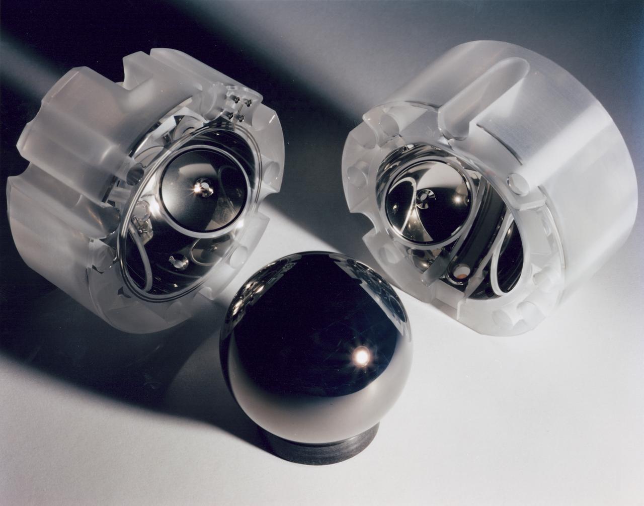
The Gravity Probe B (GP-B) is the relativity experiment developed at Stanford University to test two extraordinary predictions of Albert Einstein’s general theory of relativity. The experiment will measure, very precisely, the expected tiny changes in the direction of the spin axes of four gyroscopes contained in an Earth-orbiting satellite at a 400-mile altitude. So free are the gyroscopes from disturbance that they will provide an almost perfect space-time reference system. They will measure how space and time are very slightly warped by the presence of the Earth, and, more profoundly, how the Earth’s rotation very slightly drags space-time around with it. These effects, though small for the Earth, have far-reaching implications for the nature of matter and the structure of the Universe. This photograph is a close up of a niobium-coated gyroscope motor and its housing halves. GP-B is among the most thoroughly researched programs ever undertaken by NASA. This is the story of a scientific quest in which physicists and engineers have collaborated closely over many years. Inspired by their quest, they have invented a whole range of technologies that are already enlivening other branches of science and engineering. Launched April 20, 2004 , the GP-B program was managed for NASA by the Marshall Space Flight Center. Development of the GP-B is the responsibility of Stanford University along with major subcontractor Lockheed Martin Corporation. (Image credit to Don Harley.)
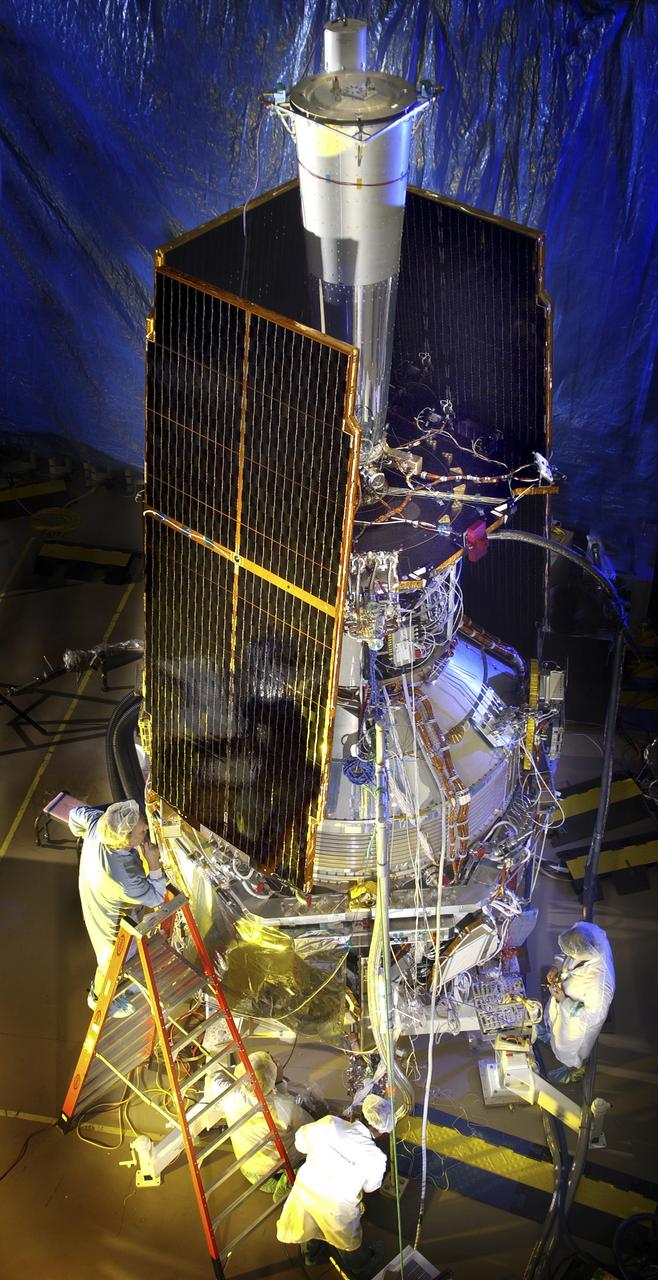
In this photo, the Gravity Probe B (GP-B) space vehicle is being assembled at the Sunnyvale, California location of the Lockheed Martin Corporation. The GP-B is the relativity experiment developed at Stanford University to test two extraordinary predictions of Albert Einstein’s general theory of relativity. The experiment will measure, very precisely, the expected tiny changes in the direction of the spin axes of four gyroscopes contained in an Earth-orbiting satellite at a 400-mile altitude. So free are the gyroscopes from disturbance that they will provide an almost perfect space-time reference system. They will measure how space and time are very slightly warped by the presence of the Earth, and, more profoundly, how the Earth’s rotation very slightly drags space-time around with it. These effects, though small for the Earth, have far-reaching implications for the nature of matter and the structure of the Universe. GP-B is among the most thoroughly researched programs ever undertaken by NASA. This is the story of a scientific quest in which physicists and engineers have collaborated closely over many years. Inspired by their quest, they have invented a whole range of technologies that are already enlivening other branches of science and engineering. Launched April 20, 2004 , the GP-B program was managed for NASA by the Marshall Space Flight Center. Development of the GP-B is the responsibility of Stanford University along with major subcontractor Lockheed Martin Corporation. (Image credit to Russ Underwood, Lockheed Martin Corporation).
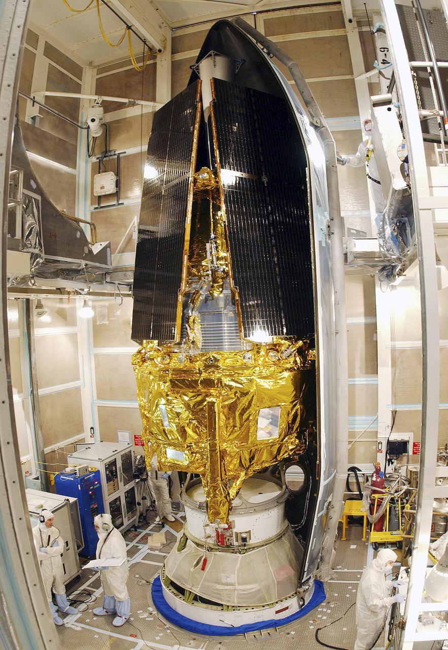
In this photo, the Gravity Probe B (GP-B) space vehicle is being encapsulated atop the Delta II launch vehicle. The GP-B is the relativity experiment developed at Stanford University to test two extraordinary predictions of Albert Einstein’s general theory of relativity. The experiment will measure, very precisely, the expected tiny changes in the direction of the spin axes of four gyroscopes contained in an Earth-orbiting satellite at a 400-mile altitude. So free are the gyroscopes from disturbance that they will provide an almost perfect space-time reference system. They will measure how space and time are very slightly warped by the presence of the Earth, and, more profoundly, how the Earth’s rotation very slightly drags space-time around with it. These effects, though small for the Earth, have far-reaching implications for the nature of matter and the structure of the Universe. GP-B is among the most thoroughly researched programs ever undertaken by NASA. This is the story of a scientific quest in which physicists and engineers have collaborated closely over many years. Inspired by their quest, they have invented a whole range of technologies that are already enlivening other branches of science and engineering. Launched April 20, 2004 , the GP-B program was managed for NASA by the Marshall Space Flight Center. Development of the GP-B is the responsibility of Stanford University along with major subcontractor Lockheed Martin Corporation. (Image credit to Russ Underwood, Lockheed Martin Corporation).

STS059-S-039 (11 April 1994) --- This is a false-color composite of Prince Albert, Canada, centered at 53.91 north latitude and 104.69 west longitude. This image was acquired by the Spaceborne Imaging Radar-C and X-Band Synthetic Aperture Radar (SIR-C/X-SAR) aboard the Space Shuttle Endeavour on its 20th orbit. The area is located 40 kilometers (25 miles) north and 30 kilometers (20 miles) east of the town of Prince Albert in the Saskatchewan province of Canada. The image covers the area east of the Candle Lake, between gravel surface Highways 120 and 106 and west of 106. The area in the middle of the image covers the entire Nipawin (Narrow Hills) provincial park. The look angle of the radar is 30 degrees and the size of the image is approximately 20 kilometers by 50 kilometers (12 by 30 miles). The image was produced by using only the L-Band. The three polarization channels HH, HV and VV are illustrated by red, green and blue respectively. The changes in the intensity of each color are related to various surface conditions such as variations in forest stands, frozen or thawed condition of the surface, disturbances (fire and deforestation), and areas of re-growth. Most of the dark areas in the image are the ice-covered lakes in the region. The dark area on the top right corner of the image is the White Gull Lake north of the intersection of Highway 120 and 913. The right middle part of the image shows Lake Ispuchaw and Lower Fishing Lake. The deforested areas are also shown by dark areas in the image. Since most of the logging practice at the Prince Albert area is around the major highways, the deforested areas can be easily detected as small geometrically shaped dark regions along the roads. At the time of the SIR-C/X-SAR overpass, a major part of the forest is either frozen or undergoing the spring thaw. The L-Band HH shows a high return in the jack pine forest. The reddish areas in the image are old jack pine forest, 12-17 meters (40-55 feet) in height and 60-75 years old. The orange-greenish areas are young jack pine trees, 3-5 meters (10-16 feet) in height and 11-16 years old. The green areas are due to the relative high intensity of the HV channel which is strongly correlated with the amount of biomass. L-Band HV channel shows the biomass variations over the entire region. Most of the green areas, when compared to the forest cover maps are identified as black spruce trees. The dark blue and dark purple colors show recently harvested or re-growth areas respectively. SIR-C/X-SAR is part of NASA's Mission to Planet Earth (MTPE). SIR-C/X-SAR radars illuminate Earth with microwaves allowing detailed observations at any time, regardless of weather or sunlight conditions. SIR-C/X-SAR uses three microwave wavelengths: L-Band (24 cm), C-Band (6 cm), and X-Band (3 cm). The multi-frequency data will be used by the international scientific community to better understand the global environment and how it is changing. The SIR-C/X-SAR data, complemented by aircraft and ground studies, will give scientists clearer insights into those environmental changes which are caused by nature and those changes which are induced by human activity. SIR-C was developed by NASA's Jet Propulsion Laboratory (JPL). X-SAR was developed by the Dornire and Alenia Spazio Companies for the German Space Agency, Deutsche Agentur fuer Raumfahrtangelegenheiten (DARA), and the Italian Space Agency, Agenzia Spaziale Italiana (ASI). JPL Photo ID: P-43886
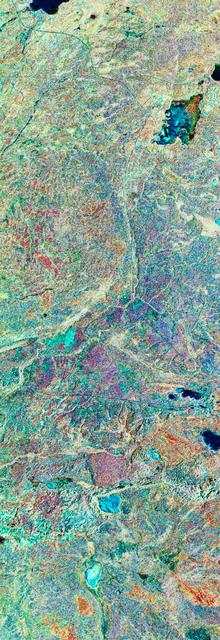
STS059-S-079 (18 April 1994) --- This is a false-color, three frequency image of Prince Albert, Canada, centered at 53.91 north latitude and 104.69 west longitude. It was produced using data from the X-Band, C-Band and L-Band radars that comprise the Spaceborne Imaging Radar-C and X-Band Synthetic Aperture Radar (SIR-C/X-SAR). SIR-C/X-SAR acquired this image on the 20th orbit of the Space Shuttle Endeavour. The area is located 40 kilometers north and 30 kilometers east of the town of Prince Albert in the Saskatchewan province of Canada. The image covers the area east of the Candle Lake, between gravel surface Highways 120 and 106 and west of 106. The area in the middle of the image covers the entire Nipawin (Narrow Hills) provincial park. The look angle of the radar is 30 degrees and the size of the image is approximately 20 by 50 kilometers. The red, green, and blue colors represent L-Band total power, C-Band total power, and XVV respectively. The changes in the intensity of each color are related to various surface conditions such as frozen or thawed forest, fire, deforestation and areas of regrowth. Most of the dark blue areas in the image are the ice covered lakes. The dark area on the top right corner of the image is the White Gull Lake north of the intersection of Highway 120 and 913. The right middle part of the image shows Lake Ispuchaw and Lower Fishing Lake. The deforested areas are shown by light blue in the image. Since most of the logging practice at the Prince Albert area is around the major highways, the deforested areas can be easily detected as small geometrically shaped dark regions along the roads. At the time these data were taken, a major part of the forest was either frozen or undergoing the spring thaw. In such conditions, due to low volume of water in the vegetation, a deeper layer of the canopy is imaged by the radar, revealing valuable information about the type of trees, the amount of vegetation biomass and the condition of the surface. As the frequency increases, the penetration depth in the canopy decreases. Over forest canopies, the X-Band radar contains information about the top of the canopy. Whereas, C-Band and L-Band radar returns show contributions from the crown and trunk areas respectively. The bright areas in the image are dense mixed aspen and old jackpine forests where the return from all three bands is high. The reddish area corresponds to more sparse old jack pine (12 to 17 meters in height and 60 to 75 years old) where the L-Band signal penetrates deeper in the canopy and dominates C-Band and X-Band returns. Comparison of the image with the forest cover map of the area indicates that the three band radar can be used to classify various stands. SIR-C/X-SAR is part of NASA's Mission to Planet Earth (MTPE). SIR-C/X-SAR radars illuminate Earth with microwaves allowing detailed observations at any time, regardless of weather or sunlight conditions. SIR-C/X-SAR uses three microwave wavelengths: L-Band (24 cm), C-Band (6 cm), and X-Band (3 cm). The multi-frequency data will be used by the international scientific community to better understand the global environment and how it is changing. The SIR-C/X-SAR data, complemented by aircraft and ground studies, will give scientists clearer insights into those environmental changes which are caused by nature and those changes which are induced by human activity. SIR-C was developed by NASA's Jet Propulsion Laboratory (JPL). X-SAR was developed by the Dornire and Alenia Spazio Companies for the German Space Agency, Deutsche Agentur fuer Raumfahrtangelegenheiten (DARA), and the Italian Space Agency, Agenzia Spaziale Italiana (ASI). JPL Photo ID: P-43929
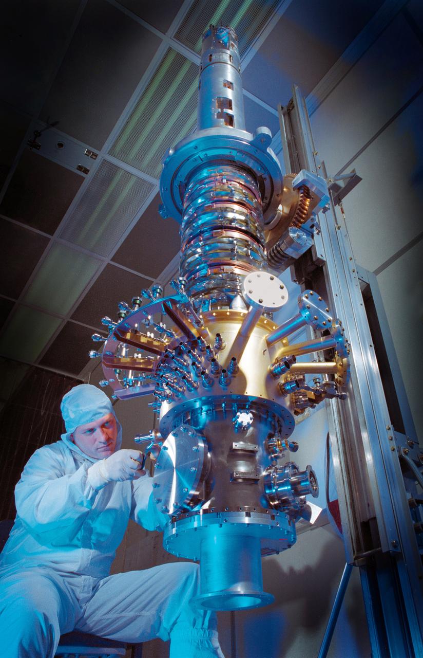
The space vehicle Gravity Probe B (GP-B) is the relativity experiment developed at Stanford University to test two extraordinary predictions of Albert Einstein’s general theory of relativity. The experiment will measure, very precisely, the expected tiny changes in the direction of the spin axes of four gyroscopes contained in an Earth-orbiting satellite at a 400-mile altitude. So free are the gyroscopes from disturbance that they will provide an almost perfect space-time reference system. They will measure how space and time are very slightly warped by the presence of the Earth, and, more profoundly, how the Earth’s rotation very slightly drags space-time around with it. These effects, though small for the Earth, have far-reaching implications for the nature of matter and the structure of the Universe. GP-B is among the most thoroughly researched programs ever undertaken by NASA. This is the story of a scientific quest in which physicists and engineers have collaborated closely over many years. Inspired by their quest, they have invented a whole range of technologies that are already enlivening other branches of science and engineering. In this photograph, engineer Gary Reynolds is inspecting the inside of the probe neck during probe thermal repairs. GP-B is scheduled for launch in April 2004 and managed for NASA by the Marshall Space Flight Center. Development of the GP-B is the responsibility of Stanford University along with major subcontractor Lockheed Martin Corporation. (Image credit to Russ Leese, Gravity Probe B, Stanford University)
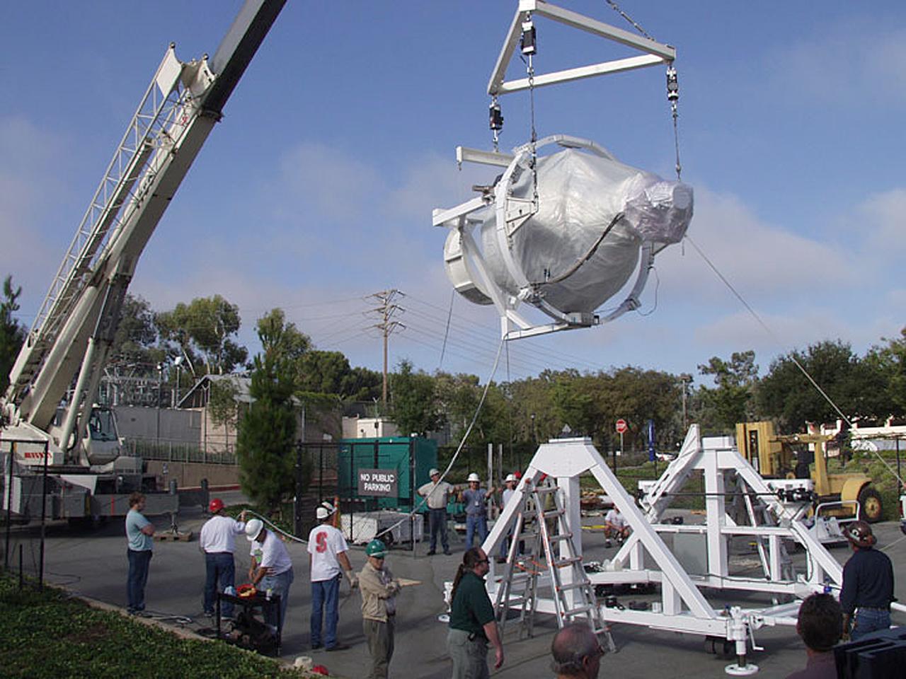
The Gravity Probe B (GP-B) payload was hoisted by crane to the transportation truck in the W.W. Hansen Experimental Physics Laboratory in Stanford, California for shipment to the launch site at Vandenburg Air Force Base. GP-B is the relativity experiment being developed at Stanford University to test two extraordinary predictions of Albert Einstein’s general theory of relativity. The experiment will measure, very precisely, the expected tiny changes in the direction of the spin axes of four gyroscopes contained in an Earth-orbiting satellite at a 400-mile altitude. So free are the gyroscopes from disturbance that they will provide an almost perfect space-time reference system. They will measure how space and time are very slightly warped by the presence of the Earth, and, more profoundly, how the Earth’s rotation very slightly drags space-time around with it. These effects, though small for the Earth, have far-reaching implications for the nature of matter and the structure of the Universe. GP-B is among the most thoroughly researched programs ever undertaken by NASA. This is the story of a scientific quest in which physicists and engineers have collaborated closely over many years. Inspired by their quest, they have invented a whole range of technologies that are already enlivening other branches of science and engineering. Launched April 20, 2004, the GP-B program was managed for NASA by the Marshall Space Flight Center. Development of the GP-B is the responsibility of Stanford University, along with major subcontractor Lockheed Martin Corporation. (Photo Credit: Stanford University)
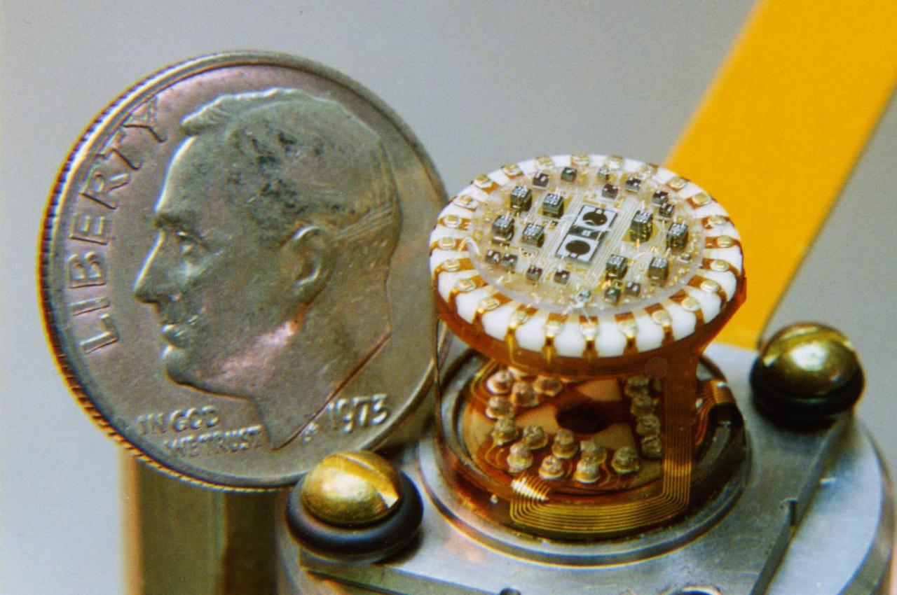
In this photo, the Gravity Probe B (GP-B) detector mount assembly is shown in comparison to the size of a dime. The assembly is used to detect exactly how much starlight is coming through different beams from the beam splitter in the telescope. The measurements from the tiny chips inside are what keeps GP-B aimed at the guide star. The GP-B is the relativity experiment developed at Stanford University to test two extraordinary predictions of Albert Einstein’s general theory of relativity. The experiment will measure, very precisely, the expected tiny changes in the direction of the spin axes of four gyroscopes contained in an Earth-orbiting satellite at a 400-mile altitude. So free are the gyroscopes from disturbance that they will provide an almost perfect space-time reference system. They will measure how space and time are very slightly warped by the presence of the Earth, and, more profoundly, how the Earth’s rotation very slightly drags space-time around with it. These effects, though small for the Earth, have far-reaching implications for the nature of matter and the structure of the Universe. GP-B is among the most thoroughly researched programs ever undertaken by NASA. This is the story of a scientific quest in which physicists and engineers have collaborated closely over many years. Inspired by their quest, they have invented a whole range of technologies that are already enlivening other branches of science and engineering. Launched April 20, 2004 , the GP-B program was managed for NASA by the Marshall Space Flight Center. Development of the GP-B is the responsibility of Stanford University along with major subcontractor Lockheed Martin Corporation. (Image credit to Paul Ehrensberger, Stanford University.)