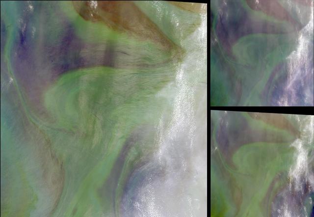
In the Arabian Sea, sunlight and nutrients has fueled a startling occurrence of colorful phytoplankton and bacterial assemblages, which is captured in these natural color images from NASA Terra spacecraft October 2, 2004.
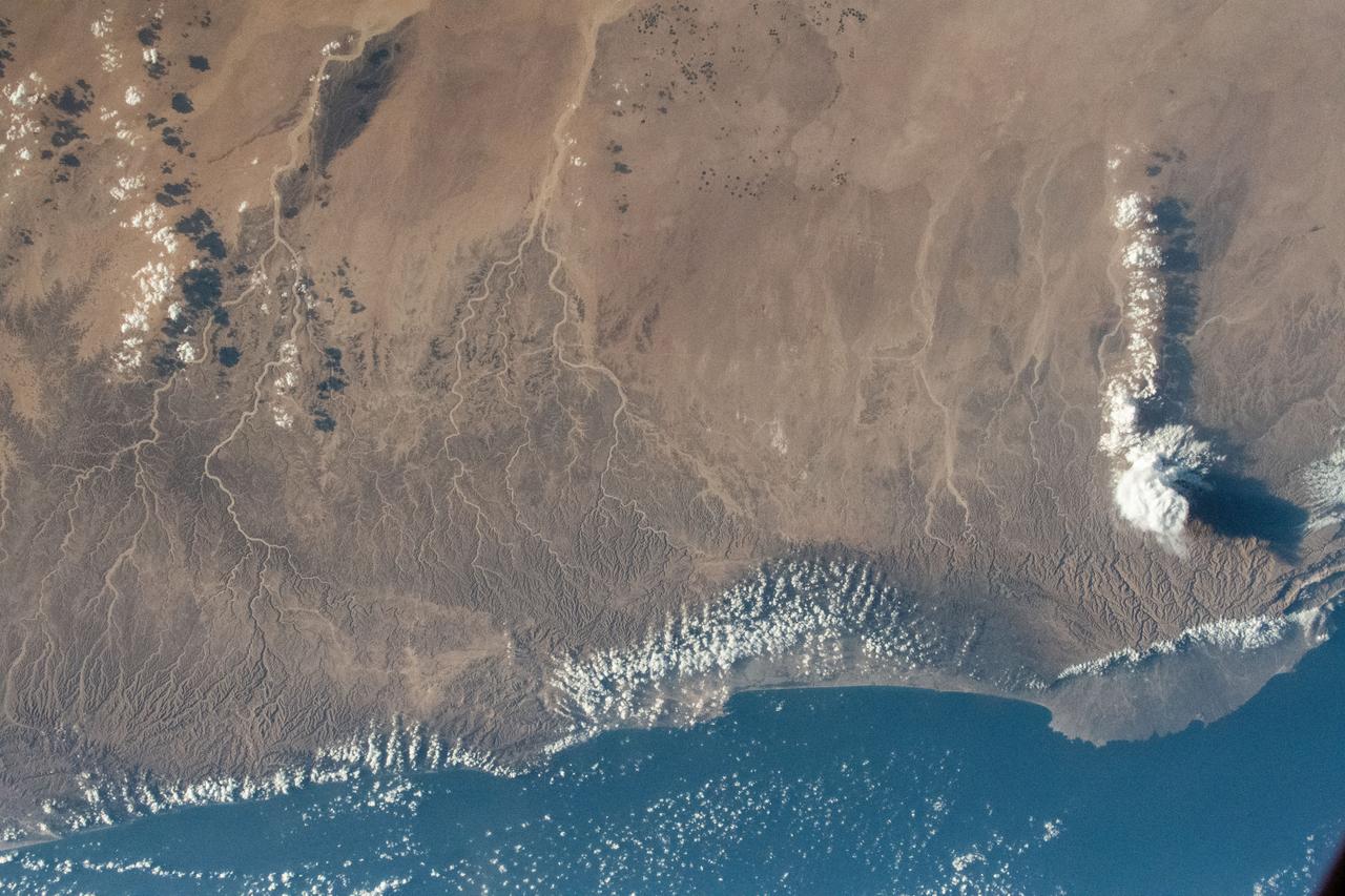
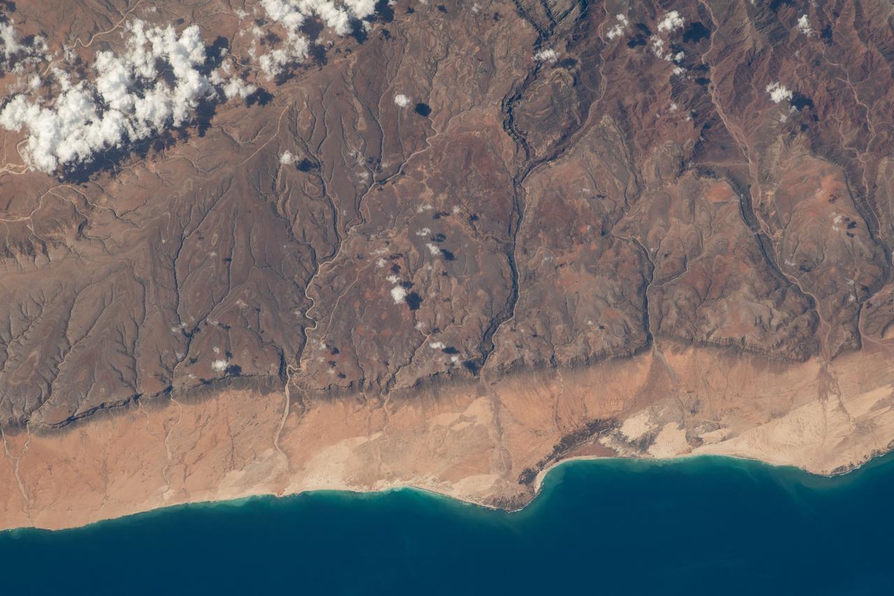
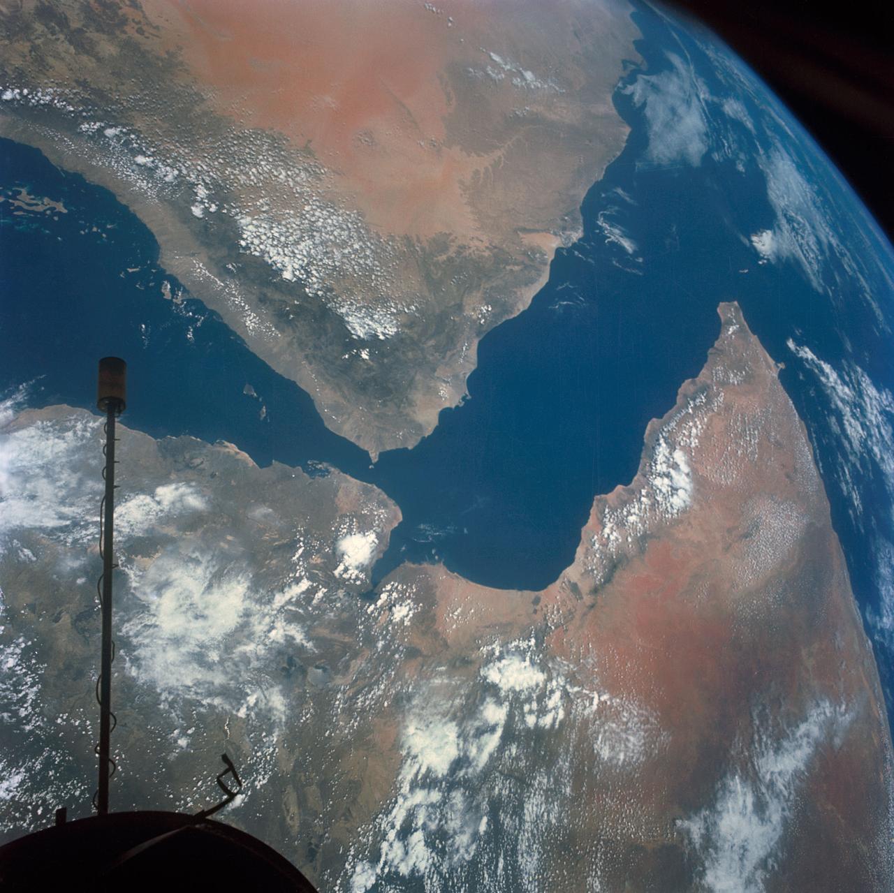
iss069e003275 (April 13, 2023) --- The middle eastern nation of Oman and its Dhofar mountains on the coast of the Arabian Sea were pictured by UAE (United Arab Emirates) astronaut and Expedition 69 Flight Engineer Sultan Alneyadi as the International Space Station orbited 257 miles above.
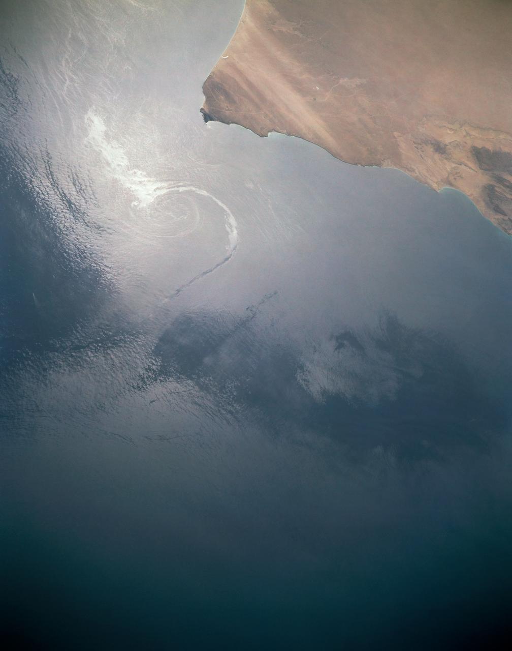
In this sunglint view of the Arabian Seacoast of Oman (19.0N, 59.0E) an oil slick is highlighted on the water's surface by sunglint lighting conditions. Nearly 50 percent of the oil transported worldwide passes through the Gulf of Oman, en route from the Persian Gulf and numerous ship wakes can be seen in this view. The oil slick, rounding the tip of Cape Ras Al Hadd, has formed a counterclockwise bright spiral indicating the local ocean currents.

In December, 2011, NASA Terra spacecraft captured this image of a new volcanic island forming in the Red Sea. This region is part of the Red Sea Rift where the African and Arabian tectonic plates are pulling apart.
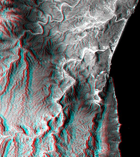
This anaglyph, from NASA Shuttle Radar Topography Mission, is of the coastal area in southernmost Oman; the Arabian Sea is on the right. 3D glasses are necessary to view this image.
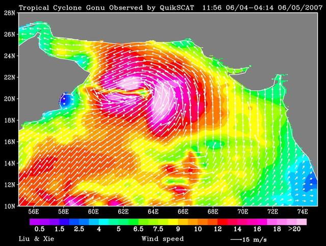
NASA QuikScat observed a rare tropical cyclone in the northern part of the Arabian Sea, threatening the petroleum shipping lanes and the Gulf States e.g. Oman that are unprepared for such an event.
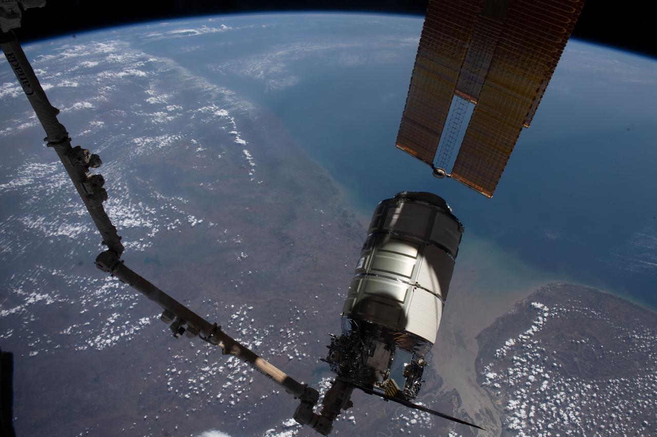
iss069e004909 (April 21, 2023) --- The Cygnus space freighter from Northrop Grumman is pictured in the grips of the Canadarm2 robotic arm as the International Space Station orbited 258 miles above the Arabian Sea coast of India.
iss069e004768 (April 20, 2023) --- The southern coast of Yemeni's island of Socotra in the Arabian Sea was pictured by NASA astronaut and Expedition 69 Flight Engineer Woody Hoburg as the International Space Station orbited 257 miles above.
iss058e005961 (Jan. 26, 2019) --- The International Space Station's Canadarm2 robotic arm and its Dextre robotic hand are seen as the orbital complex flew 252 miles above the Arabian Sea off the coast of India.
iss069e004371 (April 19, 2023) --- The Yemeni cities of Little Aden and Aden, on the coast of the Arabian Sea near the Red Sea, were pictured by Expedition 69 Flight Engineer and UAE (United Arab Emirates) astronaut Sultan Alneyadi as the International Space Station orbited 257 miles above.
This is a radar image of an offshore drilling field about 150 km 93 miles west of Bombay, India, in the Arabian Sea. The dark streaks are extensive oil slicks surrounding many of the drilling platforms, which appear as bright white spots.
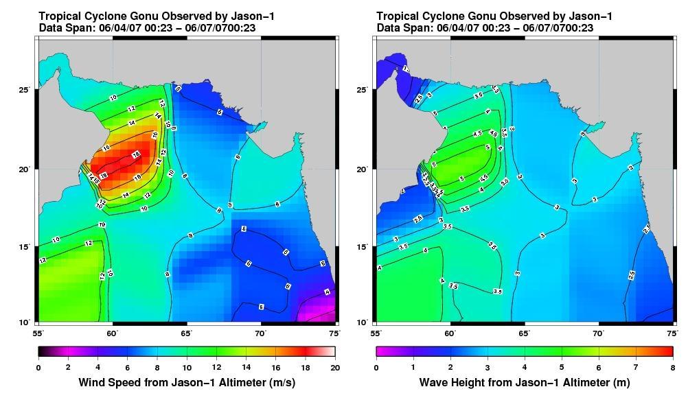
This pair of images from the radar altimeter instrument on NASA U.S./France Jason mission reveals information on wind speeds and wave heights of Tropical Cyclone Gonu, which reached Category 5 strength in the Arabian Sea prior to landfall in early June.
Earth Observation taken during a day pass by the Expedition 40 crew aboard the International Space Station (ISS). Folder lists this as: Arabian sea.
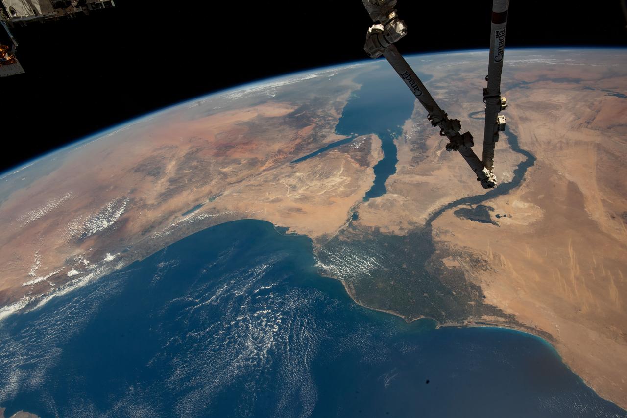
iss067e286504 (Aug. 21, 2022) --- The Canadarm2 robotic arm extends from the top right foreground, with the Nile Delta and the Red Sea, situated in the Arabian Peninsula, pictured from the International Space Station as it orbited 257 miles above the Mediterranean Sea.
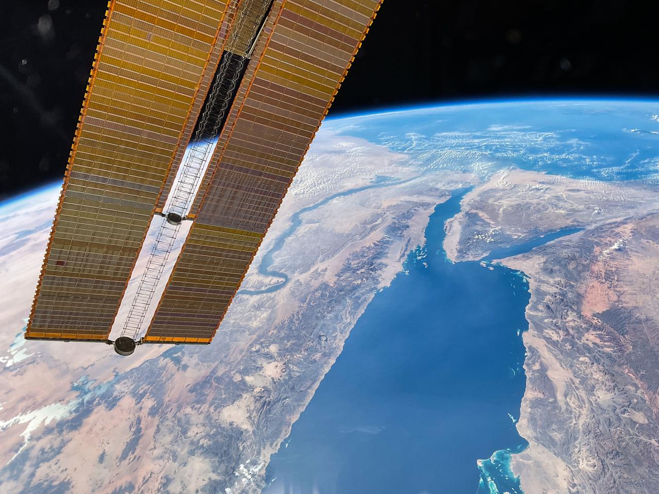
iss069e090728 (Sept. 20, 2023) --- The Nile River and the Red Sea lead to the Mediterranean Sea and are pictured from the International Space Station as it orbited 258 miles above the Arabian Peninsula. A pair of the space station's main solar arrays drapes across the left foreground.
iss068e036000 (Jan. 2, 2023) --- The city lights of Mumbai, India, on the coast of the Arabian Sea are pictured from the International Space Station as it orbited 261 miles above the Indian subcontinent.
iss070e008366 (Oct. 22, 2023) --- The International Space Station was orbiting 260 miles above the coast of Somalia on the Indian Ocean as Tropical Cyclone Tej was pictured on the Arabian Sea approaching the coast of Yemen.
iss062e104017 (March 20, 2020) --- The city lights of Mumbai to Goa (from bottom left to center right) highlight India's coast on the Arabian Sea as the International Space Station orbited 261 miles above.
iss066e128404 (Jan. 26, 2022) --- The city lights of Yanbu, a Saudi Arabian port city on the Red Sea coast, are pictured during an orbital nightime pass from the International Space Station as it orbited 260 miles above.
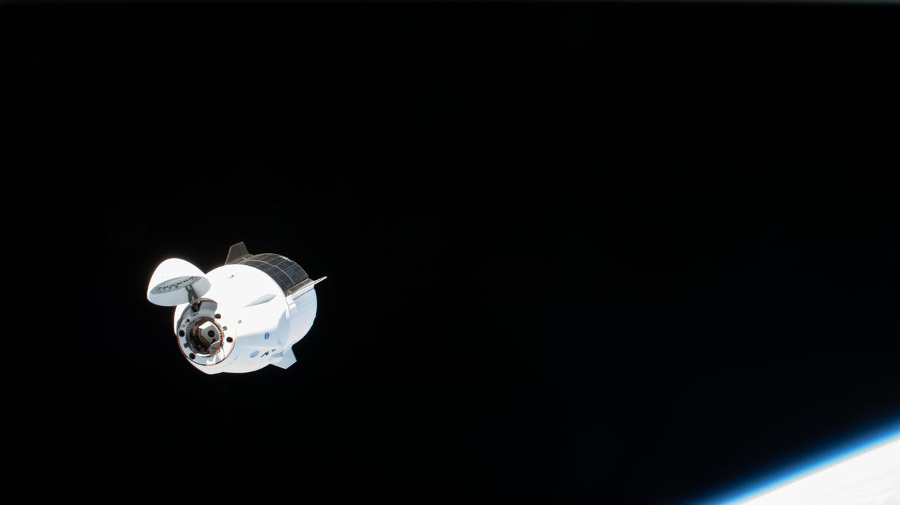
iss065e002848 (April 24, 2021) --- The SpaceX Crew Dragon Endeavour is pictured approaching the International Space Station as both spacecraft orbited 261 miles above the Arabian Sea.
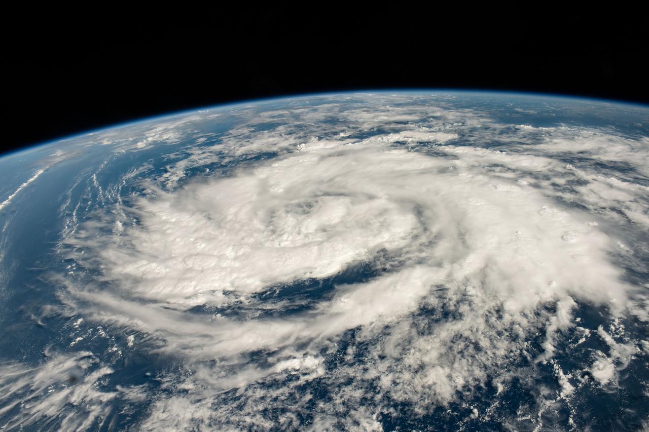
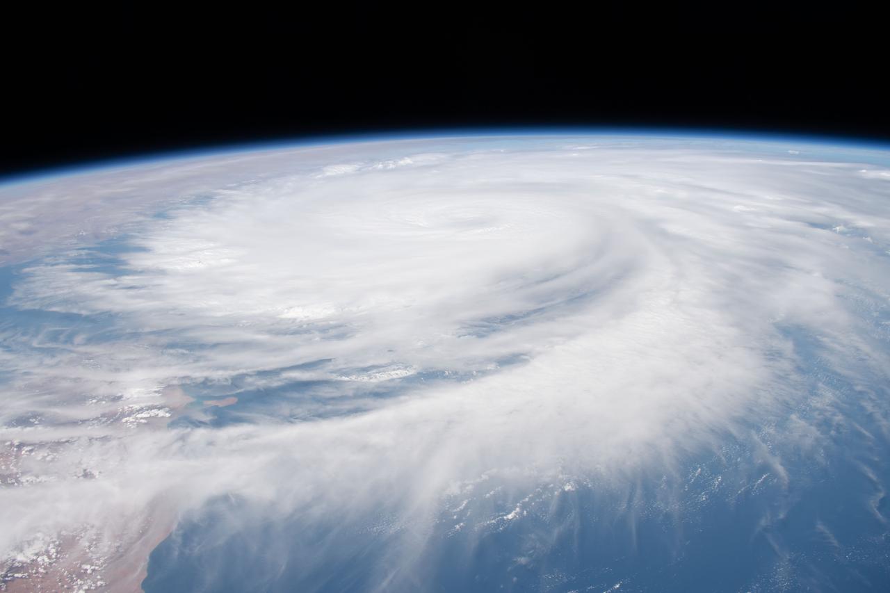
iss070e007626 (Oct. 20, 2023) --- A storm is pictured in the Arabian Sea less than 700 miles off the coast of Oman as the International Space Station orbited 260 miles above.
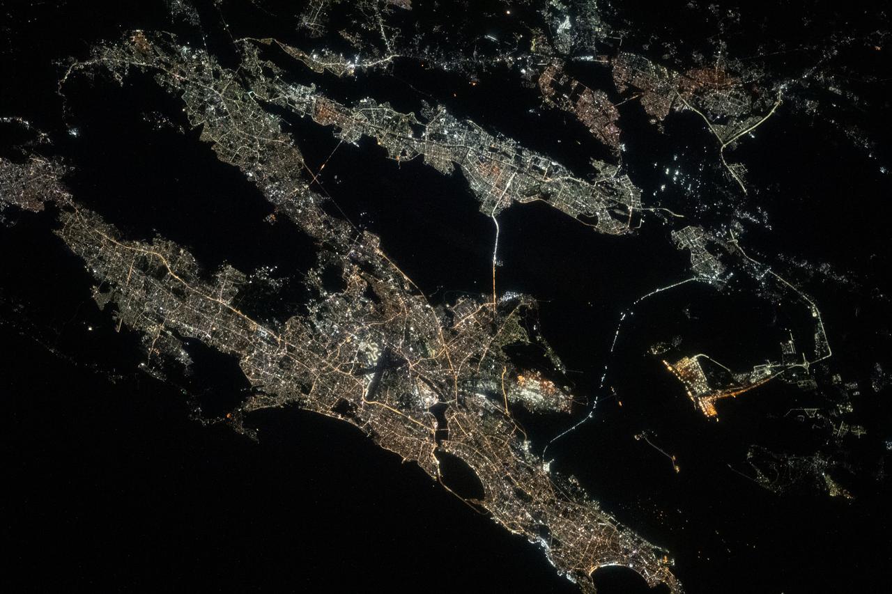
iss068e076629 (March 26, 2023) --- The night lights of the Saudi Arabian cities of Jeddah (lower left) and Mecca (upper right) contrast with the darkness of the Red Sea and the surrounding desert in this photograph from International Space Station as it orbited 258 miles above.
iss064e021873 (Jan. 9, 2021) --- The International Space Station was flying 261 miles above the Arabian Sea just off the coast of Karachi, the largest city in Pakistan with a population of about 16.1 million, when this photograph was taken during a night pass.
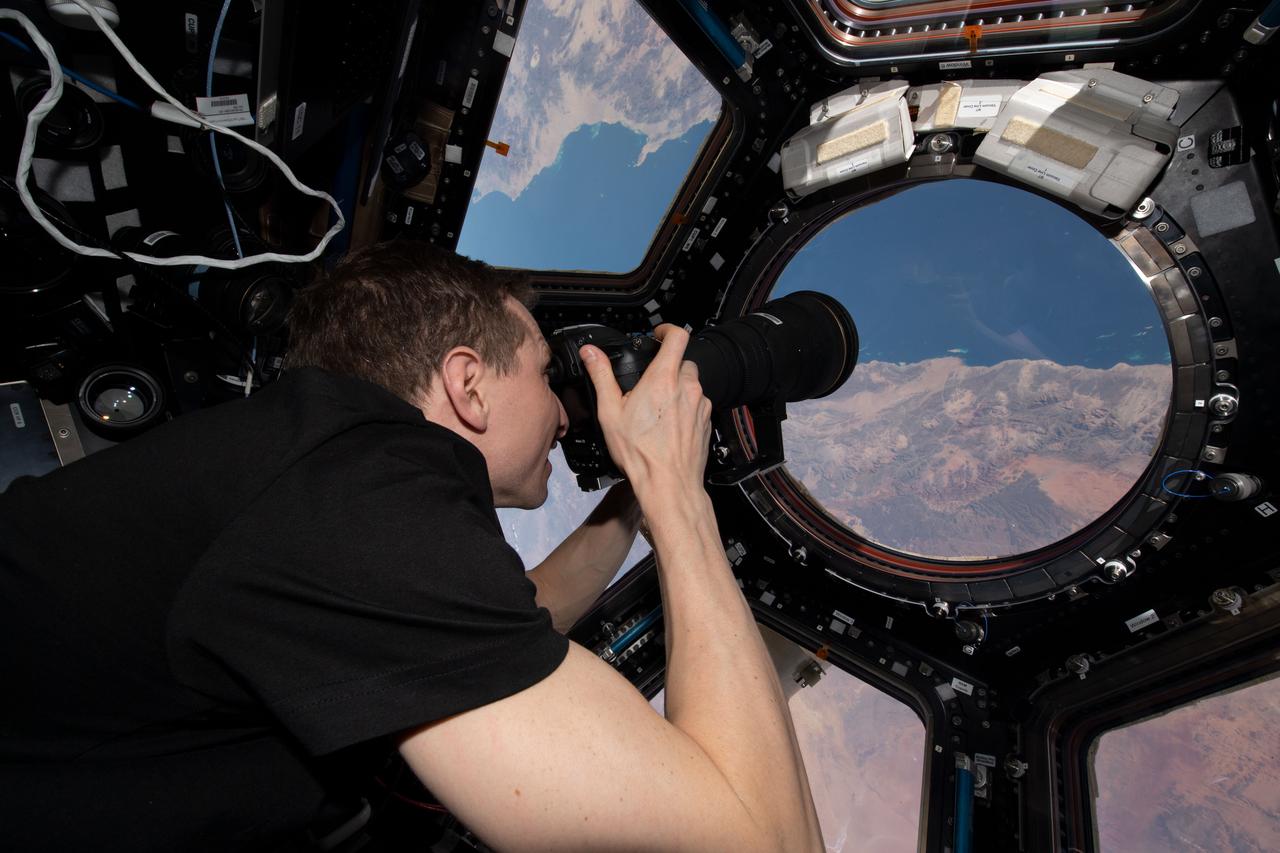
iss069e012505 (May 20, 2023) --- NASA astronaut and Expedition 69 Flight Engineer Woody Hoburg is pictured inside the seven window cupola photographing the Saudi Arabian coast on the Red Sea as the International Space Station orbited 258 miles above.
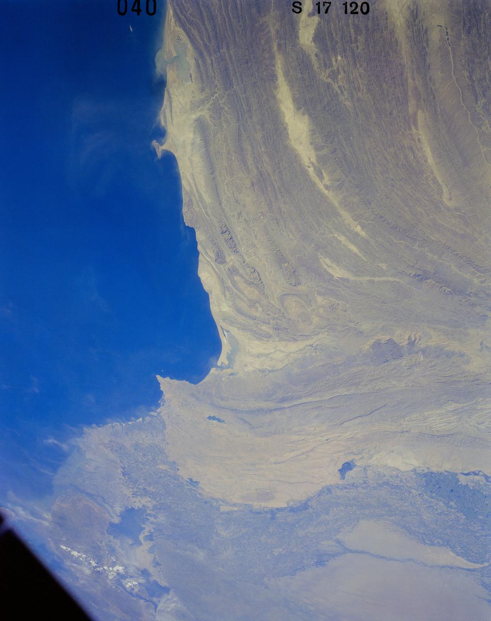
41G-120-040 (5-13 Oct. 1984) --- Pakistan, featuring the city of Karachi, the Makran mountain range, the mouth of the Indus River and the North Arabian Sea were photographed with a medium format camera aboard the space shuttle Challenger during the 41-G mission. Photo credit: NASA
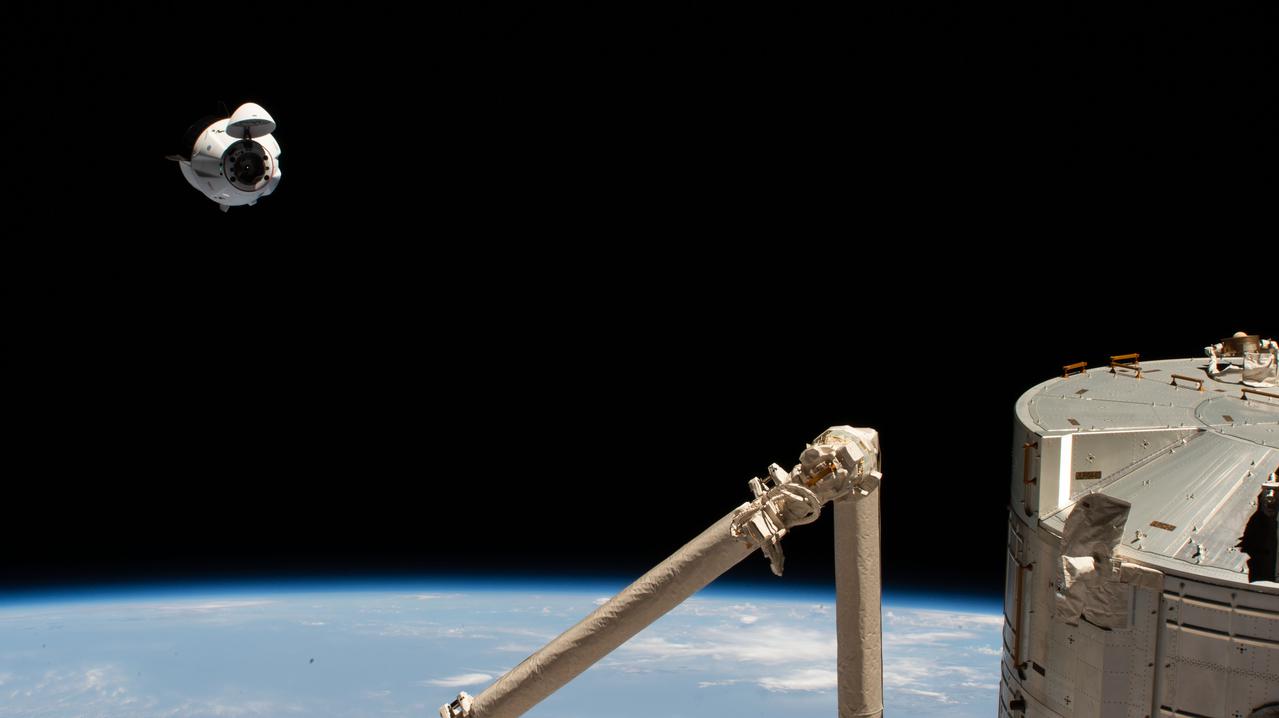
iss065e002827 (April 24, 2021) --- The SpaceX Crew Dragon Endeavour is pictured 262 miles above the Arabian Sea during its approach to the International Space Station. In the bottom right foreground, are portions of the Kibo laboratory module and the Japanese robotic arm, both from the Japan Aerospace Exploration Agency.
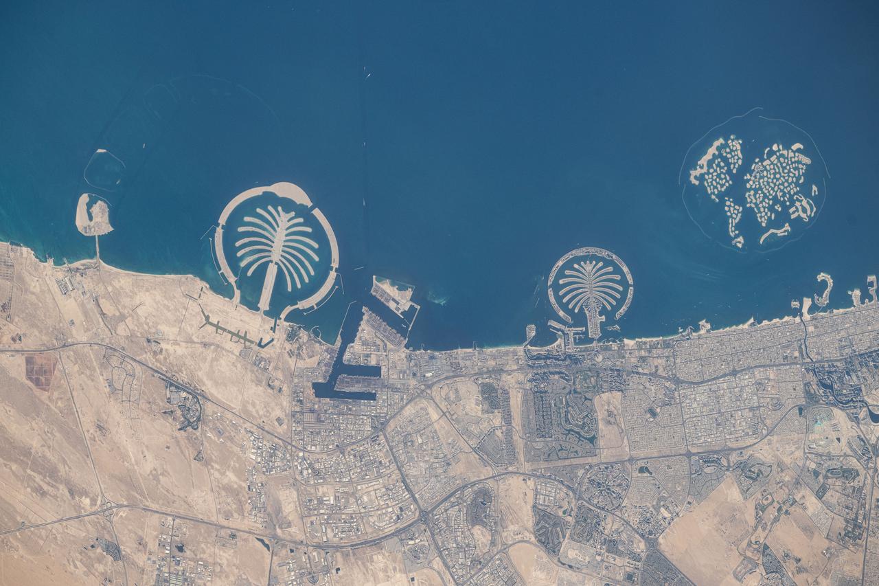
iss073e0247372 (June 10, 2025) --- Artificial islands built on the Persian Gulf coast of Dubai, United Arab Emirates, are pictured from the International Space Station as it orbited 258 miles above the Arabian Sea. Featured promoniently from left, are the man-made archipelagos of Palm Jebel Ali, Palm Jumierah, and The World islands.
STS062-86-196 (4-18 March 1994) --- This photo depicts many of the types of ocean features seen when illuminated by sunglint. These features include a shear line, bilge dump, currents and ship wakes. Winds, currents and oils effect the smoothness of the surface of the water. The oils smooth the water which reflect the sun more than the rougher surround water. This is seen in the bright curved line which is a bilge dump of oily water from a ship. The oils then start to take the form of the currents and in this case are also being blown by the surface winds. The shear line is approximately 240 miles west of Bombay, India. This shear line appears to be a result of two water masses, moving at slightly different speeds, having converged. Ship wakes, such as those in the photo, which cross a shear line, often give us an indication of the relative strenght of a a shear.
S66-38423 (6 June 1966) --- The southern tip of the Red Sea area as seen from the Gemini-9A spacecraft during its 43rd revolution of Earth. The Red Sea is at lower left. The Gulf of Aden is in the center of the picture. The land mass at bottom center is Ethiopia. Yemen is at upper center, southwestern tip of Arabian Peninsula. Somalia is the land mass in the background, center of picture. The image was taken with a modified 70mm Hasselblad camera, using Eastman Kodak, Ektachrome MS (S.O. 217) color film. Photo credit: NASA
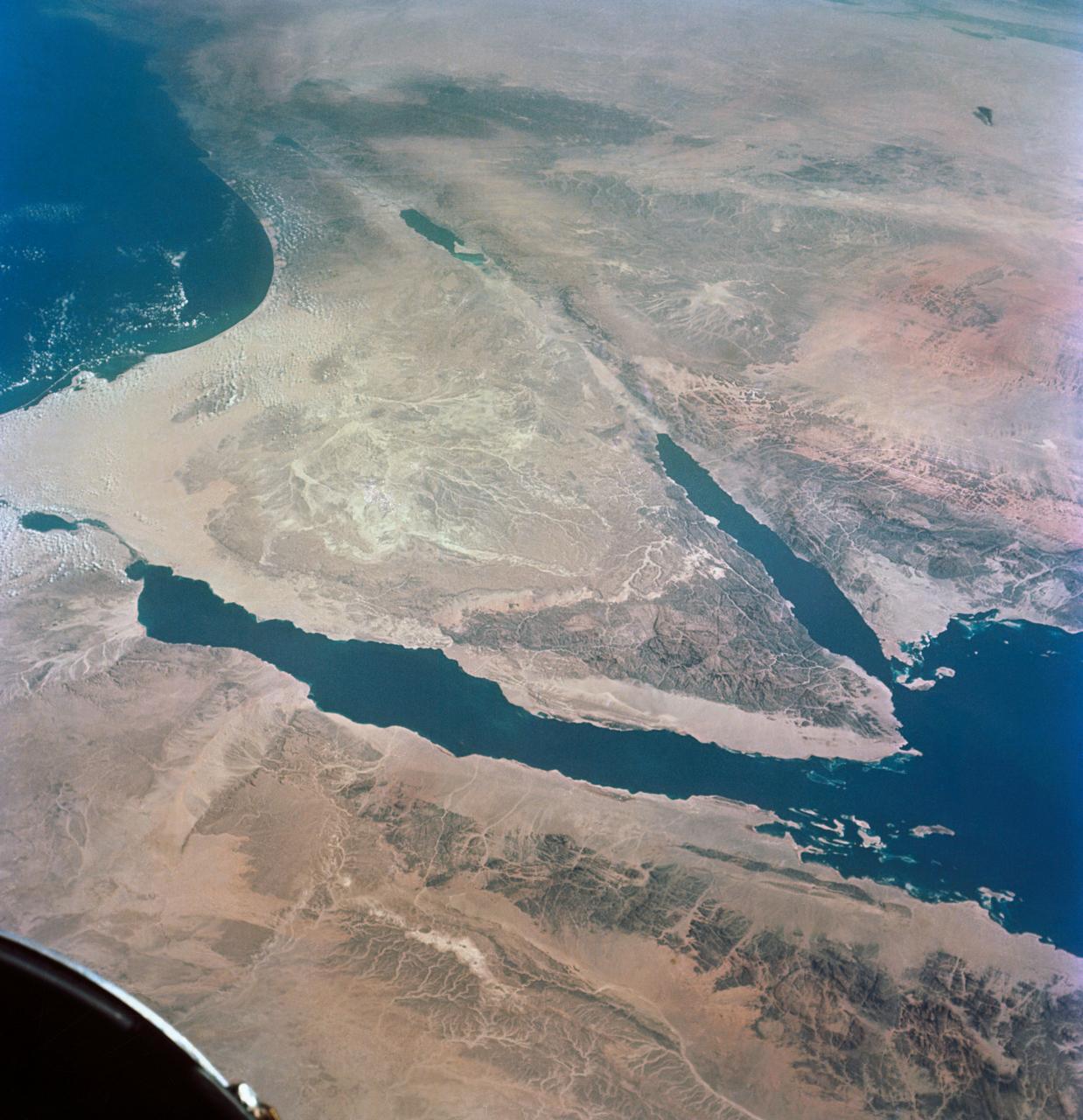
S66-54893 (14 Sept. 1966) --- Near East area as seen from the orbiting Gemini-11 spacecraft during its 26th revolution of Earth. The United Arab Republic (Egypt) is in foreground. Triangular-shaped area is the Sinai Peninsula. Saudi Arabia is at upper right. The Mediterranean Sea is at upper left. The Gulf of Suez separates Egypt from the Sinai Peninsula. The Red Sea is at bottom right. The Gulf of Aqaba is the body of water in right center of photograph separating the Sinai Peninsula and the Arabian Peninsula. The Dead Sea, Sea of Galilee, Jordan and Israel are in top center of picture. Iraq is at top right edge of photograph. Taken with a J. A. Maurer 70mm camera, using Eastman Kodak, Ektachrome, MS (S.O. 368) color film. Photo credit: NASA
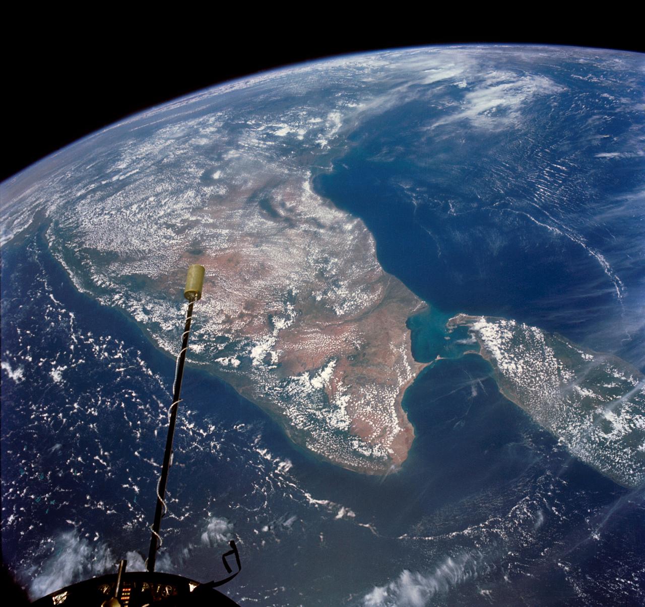
S66-54677 (14 Sept. 1966) --- India and Ceylon as seen from the orbiting Gemini-11 spacecraft at an altitude of 410 nautical miles during its 26th revolution of Earth. The Indian Ocean is at bottom of picture; at left center is Arabian Sea; and at upper right is Bay of Bengal. The Maldives Islands are near nose of spacecraft. Taken with a modified 70mm Hasselblad camera, using Eastman Kodak, Ektachrome, MS. (S.O. 368) color film. Photo credit: NASA

iss071e265124 (July 3, 2024) --- Boeing's Starliner spacecraft that launched NASA's Crew Flight Test astronauts Butch Wilmore and Suni Williams to the International Space Station is pictured docked to the Harmony module's forward port. This long-duration photograph was taken at night from the orbital complex as it soared 256 miles above the Arabian Sea off the coast of Mumbai, India.
S66-63533 (14 Nov. 1966) --- United Arab Republic (Egypt) area as seen from the Gemini-12 spacecraft during its 39th revolution of Earth, looking southeast. Nile River is in center of picture. At bottom center is the Sinai Peninsula. Arabian Peninsula is at lower left. Large body of water is Red Sea. Gulf of Aqaba is on east side of Sinai Peninsula. Gulf of Suez separates Sinai from Egyptian mainland. Photo credit: NASA

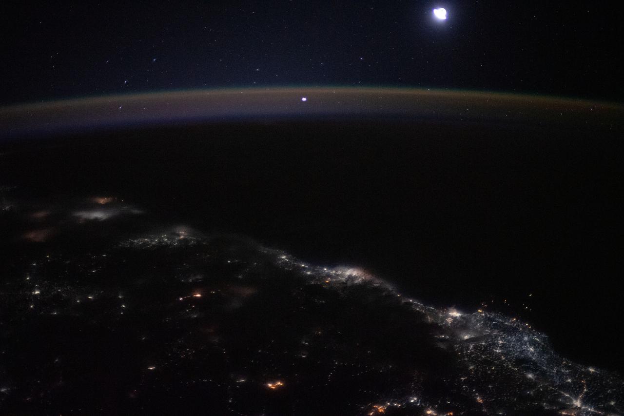
iss073e0982696 (Oct. 25, 2025) --- A reddish airglow blankets Earth beneath a star-filled sky illuminated by the Milky Way. The planet’s surface is sparsely dotted with city lights along the desert coast of the Middle East by the Arabian Sea. The International Space Station was orbiting 258 miles above Earth at approximately 11:34 p.m. local time when this photograph was taken.
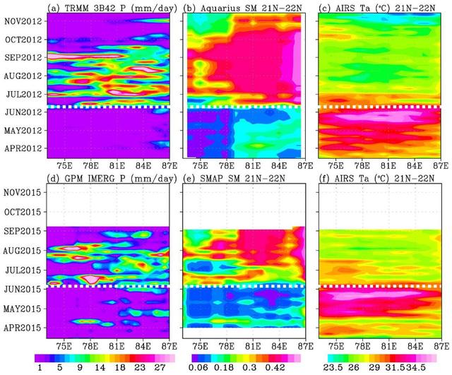
In June 2015, news organizations around the world reported on a deadly heat wave in India that killed more than 2,300 people. Prior to the arrival of the summer monsoon in India, weather conditions had been extremely hot and dry. Such conditions can lead to economic and agricultural disaster, human suffering and loss of life. NASA satellite sensors are allowing scientists to characterize pre-monsoon droughts and heat waves and postulate their scientific cause. This figure shows the longitude-time variations, averaged between 21 and 22 degrees North, across the middle of the India subcontinent from mid-April to mid-June. Longitude from the Arabian Sea to the Bay of Bengal is represented on the horizontal axis; while the vertical axis shows the timeframe. Rainfall is shown on the left, soil moisture is in the center, and surface air temperature is on the right. For both years (2012 and 2015), the summer monsoon begins in June, with sharp rises in rainfall and soil moisture, and a sharp drop in air temperature. The hottest and driest weeks occurred just before the summer monsoon onsets. Similar dry and hot periods, varying from one to a few weeks, were observed in 2013 and 2014. Soil moisture as an indication of drought as measured by NASA's Aquarius mission was first available in 2012. Rainfall data are from NASA's Tropical Rainfall Measuring Mission (TRMM), and surface air temperature is from NASA's Atmospheric Infrared Sounder (AIRS) instrument on NASA's Aqua satellite. The TRMM and Aquarius missions ended in April 2015, before the drought and heat waves. Their data were replaced by those presently available from NASA's Soil Moisture Active Passive Mission (SMAP) and Global Precipitation Mission (GPM) to show the drought and heatwave in 2015. Scientists from NASA's Jet Propulsion Laboratory, Pasadena, California, have shown that during the summer monsoon season, moisture is transported into the India Subcontinent from the Arabian Sea and out to the Bay of Bengal. The difference between moisture input from the west and output to the east is deposited as rain over land. The pre-monsoon drought and heat waves coincide with the short period when moisture is advected out to the Bay of Bengal ahead of input from the Arabian Sea. The onset of southwest monsoon winds begins in the Bay of Bengal and sucks moisture out from the subcontinent earlier than the onset in the Arabian Sea. http://photojournal.jpl.nasa.gov/catalog/PIA19939

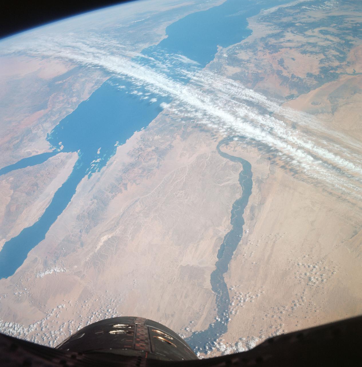
STS083-709-030 (4-8 April 1997) --- Panorama over the Nile River, Sinai Peninsula and the Red Sea. Looking past the Orbiter's tail, this view extends from central Egypt eastward to Saudi Arabia on the horizon. Two major water systems, seen in this view, the Nile River and the Red Sea are used for world commerce and transportation in this region. The Nile is flanked immediately by agriculture then beyond by desert. This emphasizes the importance of the river waters to sustain a thriving local population. The Nile River delta is north under the clouds on the upper left-hand corner of the photo. Geologically, the Red Sea is a spreading center between the Arabian and the African Plates, and will continue to widen slowly over a long period of time.
S66-54536 (14 Sept. 1966) --- Arabian Peninsula (on left) and northeast Africa (on right) as seen from the orbiting Gemini-11 spacecraft at an altitude of 340 nautical miles during its 27th revolution of Earth, looking southeast. Saudi Arabia, South Arabia, Yemen, and Aden Protectorate are at left. At bottom right is Ethiopia. French Somaliland is in center on right shore. Somali is at upper right. Body of water at bottom is Red Sea. Gulf of Aden is in center; and at top left is Indian Ocean. Taken with a modified 70mm Hasselblad camera, using Eastman Kodak, Ektachrome, MS (S.O. 368) color film. Photo credit: NASA
S66-54530 --- Libyan Desert area of Sudan, foreground, and the United Arab Republic (Egypt), at lower left, as seen from the orbiting Gemini-11 spacecraft at an altitude of 300 nautical miles during its 27th revolution of Earth. In view is the Nile River from Biba in Egypt to Khartoum in the Sudan. The Red Sea is in the background. At upper left is the Arabian Peninsula. At top right is Ethiopia. Note L-band antenna of the Agena Target Vehicle. Taken with a modified 70mm Hasselblad camera, using Eastman Kodak, Ektachrome, MS (S.O. 368) color film. Photo credit: NASA
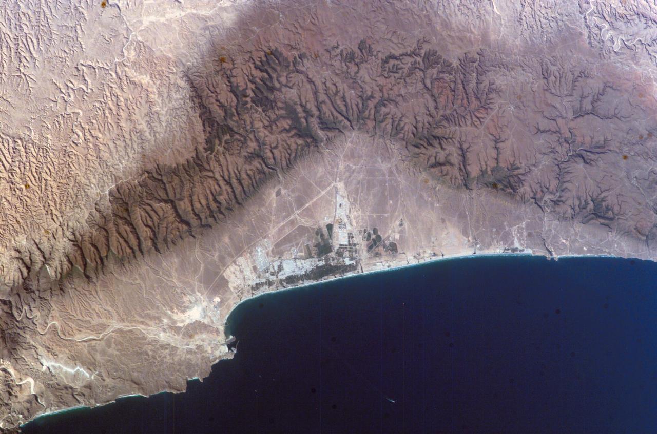
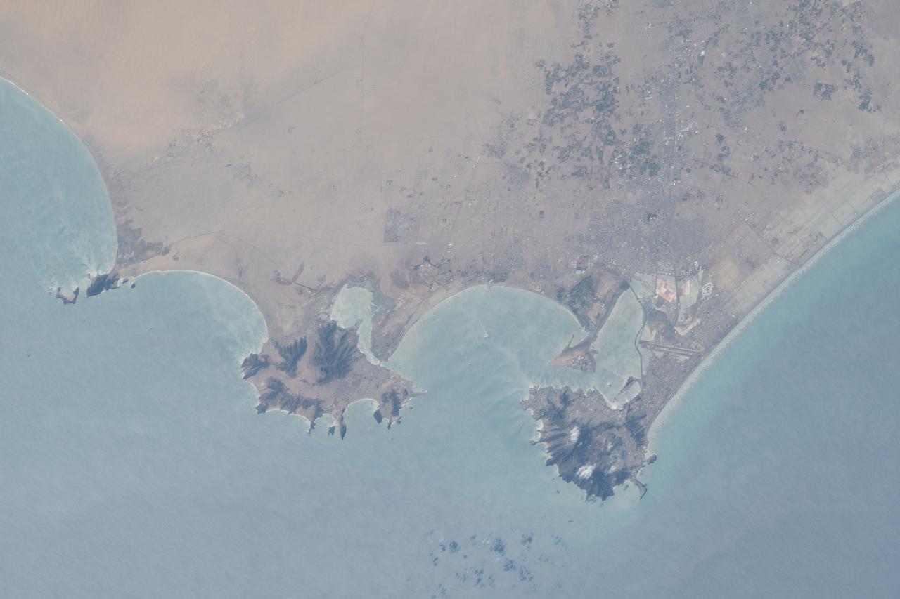
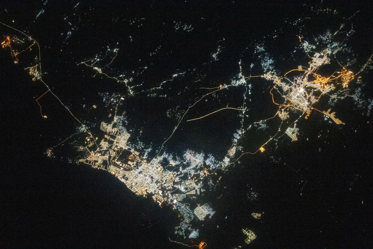
ISS010-E-07210 (16 November 2004) --- Salalah, Sultanate of Oman is featured in this image photographed by an Expedition 10 crewmember on the International Space Station (ISS). The city of Salalah is the capital of the Dhofar region of Oman and is known as the “perfume capital of Arabia”. The city is a popular destination for tourism due to the natural attractions of the al Qara Mountains (Jabal al Qara in Arabic) and abundant stands of frankincense trees lining mountain stream courses. These can be seen as green regions in the Jabal al Qara north of the city (located in the center of this image). The beaches and coastline are also major attractions for scuba diving and bird watching. Modern Oman is also represented by the Port of Salalah, located approximately 15 kilometers to the southwest of the city. The strategic location of this port has made it one of the major entry points to India, the Middle East, and Africa. The rectangular projection into the Arabian Sea visible in this photo is a large shipping container loading/unloading platform.
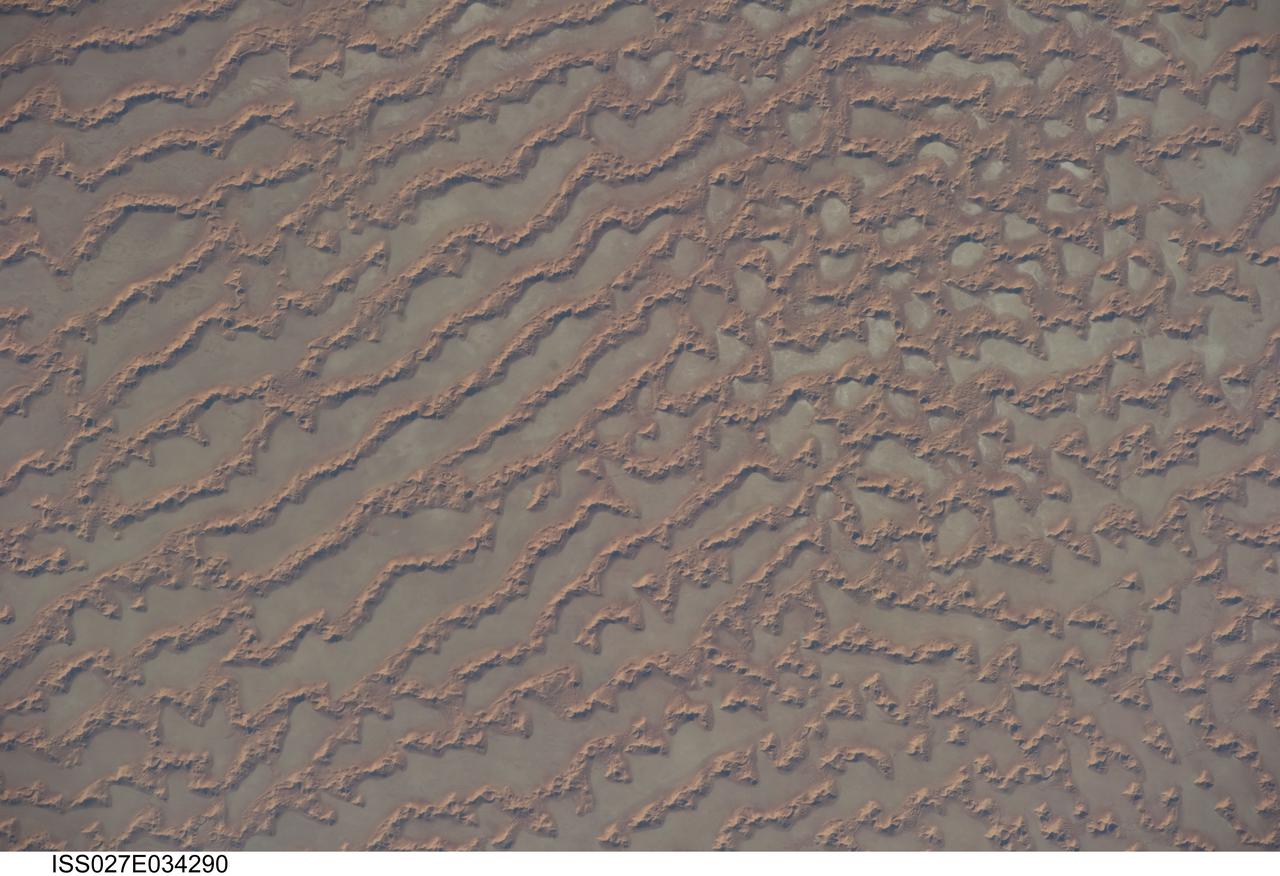
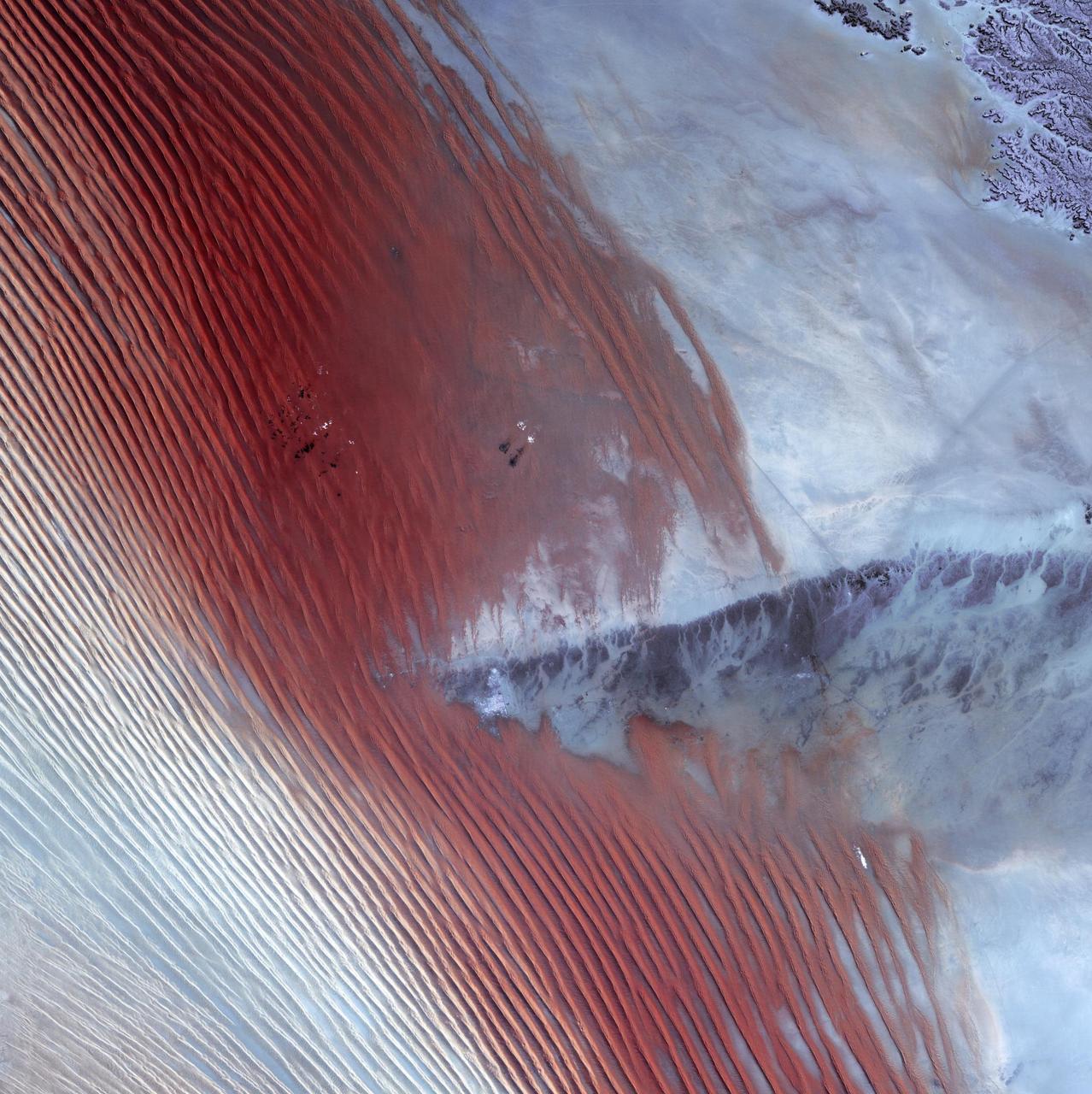
ISS027-E-034290 (16 May 2011) --- Ar Rub al Khali Sand Sea, Arabian Peninsula is featured in this image photographed by an Expedition 27 crew member on the International Space Station. The Ar Rub al Khali, also known as the “Empty Quarter”, is a large region of sand dunes and interdune flats known as a sand sea (or erg). This photograph highlights a part of the Ar Rub al Khali located close to its southeastern margin in the Sultanate of Oman. Reddish-brown, large linear sand dunes alternate with blue-gray interdune salt flats known as sabkhas at left. The major trend of the linear dunes is transverse to northwesterly trade winds that originate in Iraq (known as the Shamal winds). Formation of secondary barchan (crescent-shaped) and star dunes (dune crests in several directions originating from a single point, looking somewhat like a starfish from above) on the linear dunes is supported by southwesterly winds that occur during the monsoon season (Kharif winds). The long linear dunes begin to break up into isolated large star dunes to the northeast and east (right). This is likely a result of both wind pattern interactions and changes in the sand supply to the dunes. The Empty Quarter covers much of the south-central portion of the Arabian Peninsula, and with an area of approximately 660,000 square kilometers it is the largest continuous sand desert on Earth. The Empty Quarter is so called as the dominantly hyperarid climate and difficulty of travel through the dunes has not encouraged permanent settlement within the region. There is geological and archeological evidence to support cooler and wetter past climates in the region together with human settlement. This evidence includes exposed lakebed sediments, scattered stone tools, and the fossils of hippopotamus, water buffalo, and long-horned cattle.
ISS016-E-019394 (30 Dec. 2007) --- Al Wadj Bank, Saudi Arabia is featured in this image photographed by an Expedition 16 crewmember on the International Space Station. Saudi Arabia boasts the most coral reefs of any Middle Eastern country, as it includes coastline along both the Red Sea and Gulf of Arabia. This high resolution image depicts a portion of the Al Wadj Bank, located along the northern Red Sea coast. Despite the relatively high salinity of Red Sea water (compared to other oceans), approximately 260 species of coral are found here, according to scientists. Large tracts of the Saudi Arabian coastline are undeveloped, and reefs in these areas are in generally good ecological health. However, reefs located near large urban centers like Jeddeh have suffered degradation due to land reclamation, pollution, and increased terrigeneous sediment input. The Al Wadj Bank includes a healthy and diverse reef system, extensive seagrass beds, and perhaps the largest population of dugong -- a marine mammal similar to the North American manatee -- in the eastern Red Sea. The portion of the Bank in this image illustrates the complex form and topography of the reef system. Several emergent islands (tan) - surrounded primarily by dark green seagrass - are visible, the largest located at top left. Only the islands are above the waterline -- over the reef structures the water color ranges from light teal (shallow) to turquoise (increasing depth). The southern edge of the reef is well indicated by the deep, dark blue water of the Red Sea at image top.
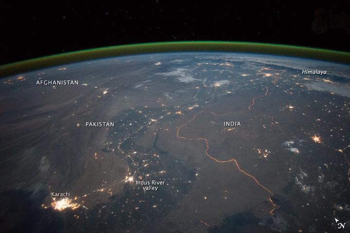
An astronaut aboard the International Space Station took this nighttime panorama while looking north across Pakistan’s Indus River valley. The port city of Karachi is the bright cluster of lights facing the Arabian Sea, which appears completely black. City lights and the dark color of dense agriculture closely track with the great curves of the Indus valley. For scale, the distance from Karachi to the foothills of the Himalaya Mountains is 1,160 kilometers (720 miles). This photograph shows one of the few places on Earth where an international boundary can be seen at night. The winding border between Pakistan and India is lit by security lights that have a distinct orange tone. Astronaut photograph ISS045-E-27869 was acquired on September 23, 2015, with a Nikon D4 digital camera using a 28 millimeter lens, and is provided by the ISS Crew Earth Observations Facility and the Earth Science and Remote Sensing Unit, Johnson Space Center. via NASA Earth Observatory Read more: <a href="http://earthobservatory.nasa.gov/IOTD/view.php?id=86725&eocn=home&eoci=iotd_title" rel="nofollow">earthobservatory.nasa.gov/IOTD/view.php?id=86725&eocn...</a>
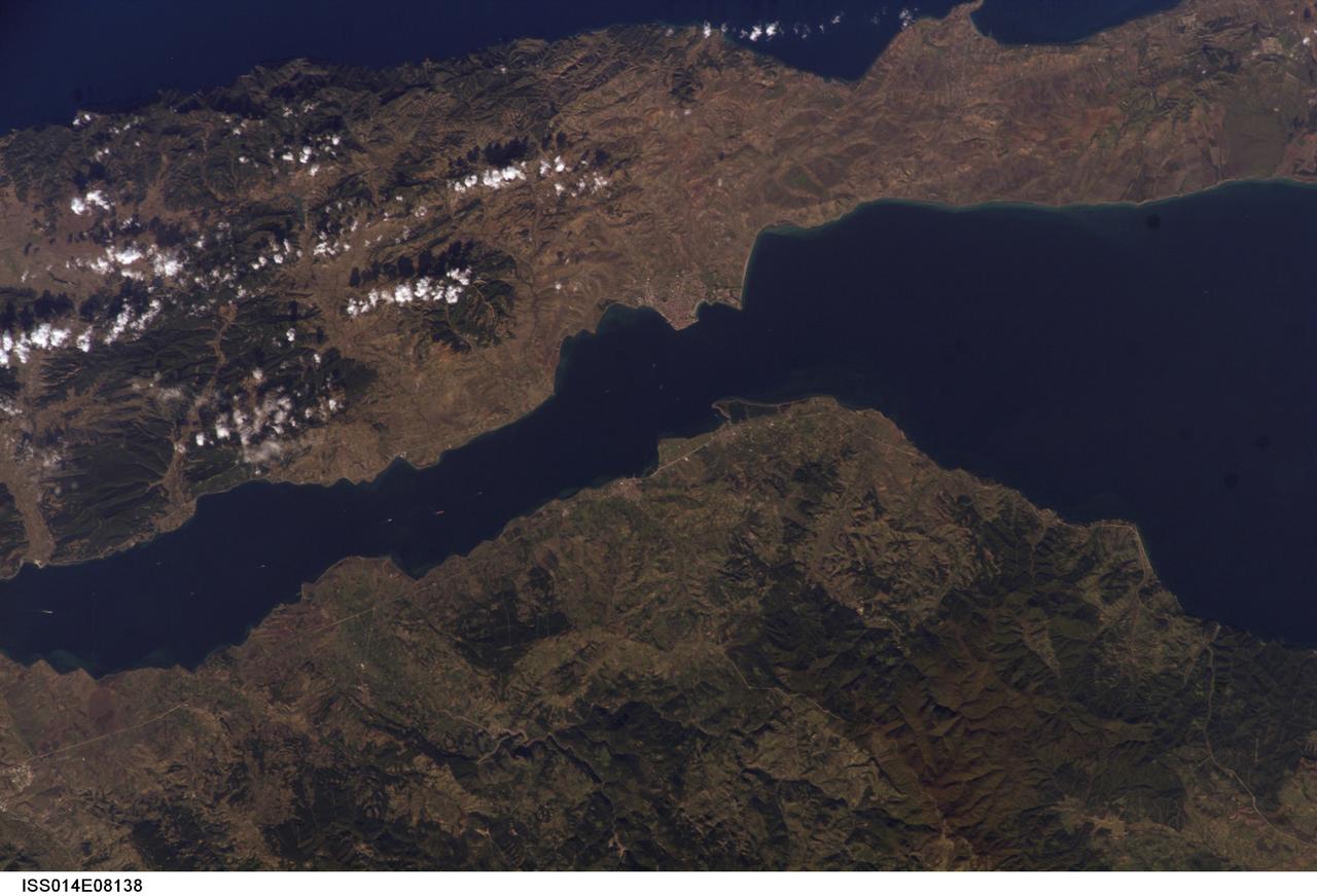
ISS014-E-08138 (9 Nov. 2006) --- Gallipoli and Dardanelles Strait, Turkey are featured in this image photographed by an Expedition 14 crewmember on the International Space Station. The city of Gallipoli (or Gelibolu in Turkish) sits at a crossroads between the Marmara and Aegean Seas, connected by the Dardanelles Strait. According to scientists, the strait is a 61 kilometer-long drowned fault valley formed during tectonic activity during the Tertiary period as the Arabian, Indian, and African plates collided with the Eurasian plate. This faulting, which formed the great mountain ranges of the Alps and Himalayas, also created the rugged terrain of western Turkey visible in the lower half of this image. Plate collision continues today, leading to frequent strike-slip (side-by-side relative motion along a fault, rather than up or down motion) earthquakes in the region as Turkey moves westward in relation to Eurasia (sometimes called escape tectonics). The urbanized area of modern Gallipoli is visible as a light gray to pink region at the entrance to the Dardanelles Strait. Water in the Strait flows in both northeast and southwest directions due to opposite surface and undercurrents. Several ships are visible in the Strait to the southwest of Gallipoli (center left).
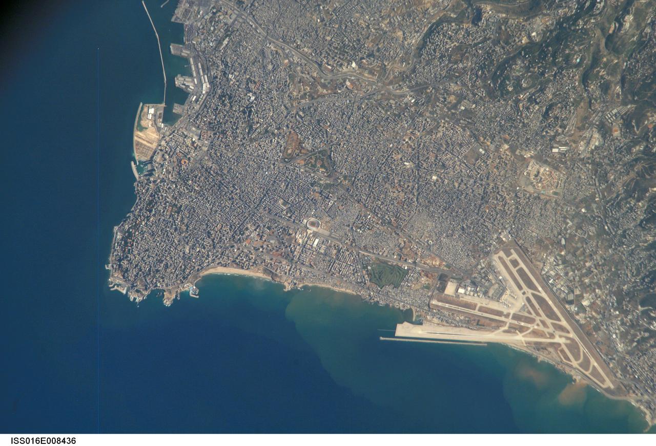
ISS016-E-008436 (26 Oct. 2007) --- Beirut Metropolitan Area, Lebanon is featured in this image photographed by an Expedition 16 crewmember on the International Space Station. The capital of Lebanon, Beirut is located along the southeastern shoreline of the Mediterranean Sea. According to geologists, the metropolitan area is built on a small peninsula composed mainly of sedimentary rock deposited over the past 100 million years or so. The growth of the city eastwards is bounded by foothills of the more mountainous interior of Lebanon (sparsely settled greenish brown region visible at upper right). While this sedimentary platform is stable, the country of Lebanon is located along a major transform fault zone, or region where the African and Arabian tectonic plates are moving laterally in relation to (and against) each other. This active tectonism creates an earthquake hazard for the country. The Roum Fault, one of the fault strands that is part of the transform boundary, is located directly to the south of the Beirut metropolitan area. Other distinctive features visible in this image include the Rafic Hariri Airport at lower right, the city sports arena at center, and several areas of green and open space (such a large golf course at center). Also visible in the image are several plumes of sediment along the coastline -- the most striking of which are located near the airport. The general lack of vegetation in the airport may promote higher degrees of soil transport by surface water runoff or wind.

AS17-148-22727 (7 Dec. 1972) --- This view of Earth was seen by the Apollo 17 crew as they traveled toward the moon on their NASA lunar landing mission. This outstanding trans-lunar coast photograph extends from the Mediterranean Sea area to the Antarctica south polar ice cap. This is the first time the Apollo trajectory made it possible to photograph the south polar ice cap. Note the heavy cloud cover in the Southern Hemisphere. Almost the entire coastline of Africa is clearly visible. The Arabian Peninsula can be seen at the northeastern edge of Africa. The large island off the coast of Africa is the Malagasy Republic. The Asian mainland is on the horizon toward the northeast. The Apollo 17 crew consisted of astronauts Eugene A. Cernan, mission commander; Ronald E. Evans, command module pilot; and Harrison H. Schmitt, lunar module pilot. While astronauts Cernan and Schmitt descended in the Lunar Module (LM) to explore the moon, astronaut Evans remained with the Command and Service Modules (CSM) in lunar orbit.
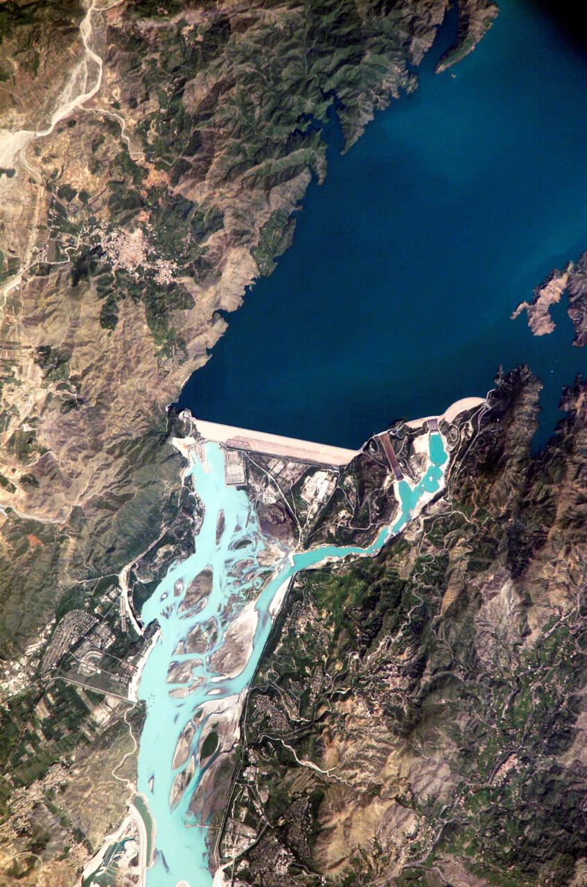
ISS005-E-12804 (6 September 2002) --- Tarbela Dam, Pakistan is featured in this image photographed by an Expedition 5 crewmember on the International Space Station (ISS). The Indus River basin extends from the Himalaya mountain ranges forming the northeastern boundary of Pakistan, to the alluvial plains of Sindh near the Arabian Sea coastline. Tarbela Dam is part of the Indus Basin Project that resulted from a water treaty signed in 1960 between India and Pakistan. This treaty guaranteed Pakistan water supplies independent of upstream control by India. Designed primarily for water storage rather than power generation, the dam was completed in 1977. Turquoise waters of the Indus River (to the south of the dam) reflect the high proportion of silt and clay suspended in waters released by the spillways (chutes on either of side of the main dam). With a volume of 142,000,000 cubic meters, the Tarbela Dam is the largest earth and rockfill dam in the world and stands 147 meters above the Indus riverbed. Its reservoir occupies an area of 37 square kilometers. While the dam has fulfilled its purpose in storing water for agricultural use in Pakistan, there have been environmental consequences to the Indus river delta, according to NASA scientists who are studying the Space Station photography. Reduction of seasonal flooding and reduced water flows to the delta have resulted in decrease of mangrove stands and abundance of some fish species.
Empty Quarter - February 1st, 20003 Description: White pinpricks of cloud cast ebony shadows on the Rub' al Khali, or Empty Quarter, near the border between Saudi Arabia and Yemen. The lines of wind-sculpted sand are characteristic of immense sand deserts, or sand seas, and the Rub' al Khali is the largest desert of this type in the world. A highland ridge is just high enough to disturb the flow of the lines. In the center of that interruption lies the Saudi Arabian town of Sharurah. Credit: USGS/NASA/Landsat 7 To learn more about the Landsat satellite go to: <a href="http://landsat.gsfc.nasa.gov/" rel="nofollow">landsat.gsfc.nasa.gov/</a> <b><a href="http://www.nasa.gov/centers/goddard/home/index.html" rel="nofollow">NASA Goddard Space Flight Center</a></b> enables NASA’s mission through four scientific endeavors: Earth Science, Heliophysics, Solar System Exploration, and Astrophysics. Goddard plays a leading role in NASA’s accomplishments by contributing compelling scientific knowledge to advance the Agency’s mission. <b>Follow us on <a href="http://twitter.com/NASA_GoddardPix" rel="nofollow">Twitter</a></b> <b>Join us on <a href="http://www.facebook.com/pages/Greenbelt-MD/NASA-Goddard/395013845897?ref=tsd" rel="nofollow">Facebook</a></b>
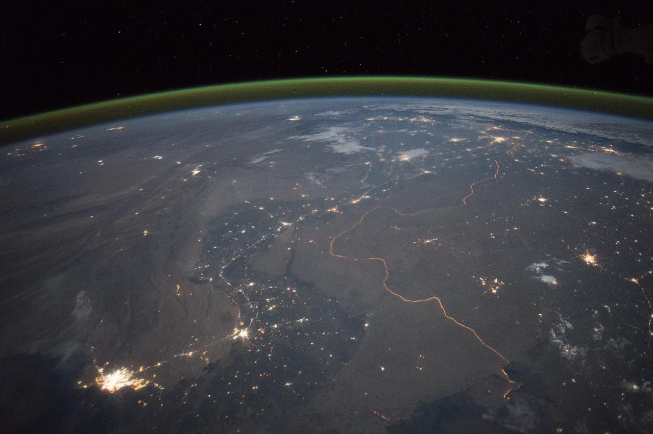
An astronaut aboard the International Space Station took this nighttime panorama while looking north across Pakistan’s Indus River valley. The port city of Karachi is the bright cluster of lights facing the Arabian Sea, which appears completely black. City lights and the dark color of dense agriculture closely track with the great curves of the Indus valley. For scale, the distance from Karachi to the foothills of the Himalaya Mountains is 1,160 kilometers (720 miles). This photograph shows one of the few places on Earth where an international boundary can be seen at night. The winding border between Pakistan and India is lit by security lights that have a distinct orange tone. Astronaut photograph ISS045-E-27869 was acquired on September 23, 2015, with a Nikon D4 digital camera using a 28 millimeter lens, and is provided by the ISS Crew Earth Observations Facility and the Earth Science and Remote Sensing Unit, Johnson Space Center. via NASA Earth Observatory Read more: <a href="http://earthobservatory.nasa.gov/IOTD/view.php?id=86725&eocn=home&eoci=iotd_title" rel="nofollow">earthobservatory.nasa.gov/IOTD/view.php?id=86725&eocn...</a>
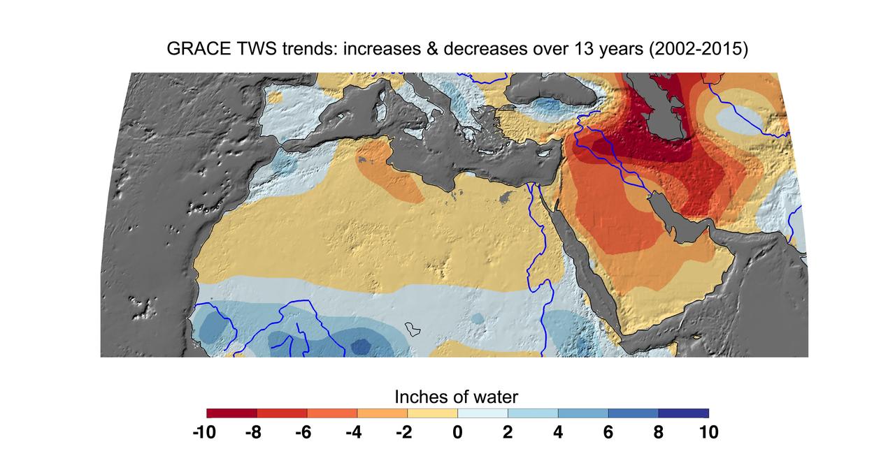
Cumulative total freshwater losses in North Africa and the Middle East from 2002 to 2015 (in inches) observed by NASA's Gravity Recovery and Climate Experiment (GRACE) mission. Total water refers to all of the snow, surface water, soil water and groundwater combined. Groundwater depletion in Turkey, Syria, Iraq and Iran, and along the Arabian Peninsula, are leading to large changes in total water storage in the region. Likewise, drought and groundwater pumping is contributing to the drying of the Caspian Sea Region. The Northwest Sahara Aquifer System, which underlies Tunisia and Libya, is also experiencing increasing water stress as shown in the map. Image updated from Voss et al., 2013. Citation of Record: Voss, K. A., J. S. Famiglietti, M. Lo, C. R. de Linage, M. Rodell and S. C. Swenson, Groundwater depletion in the Middle East from GRACE with Implications for Transboundary Water Management in the Tigris-Euphrates-Western Iran Region, Wat. Resour. Res., 49(2), 904-914, DOI: 10.1002/wrcr.20078. http://photojournal.jpl.nasa.gov/catalog/PIA20207
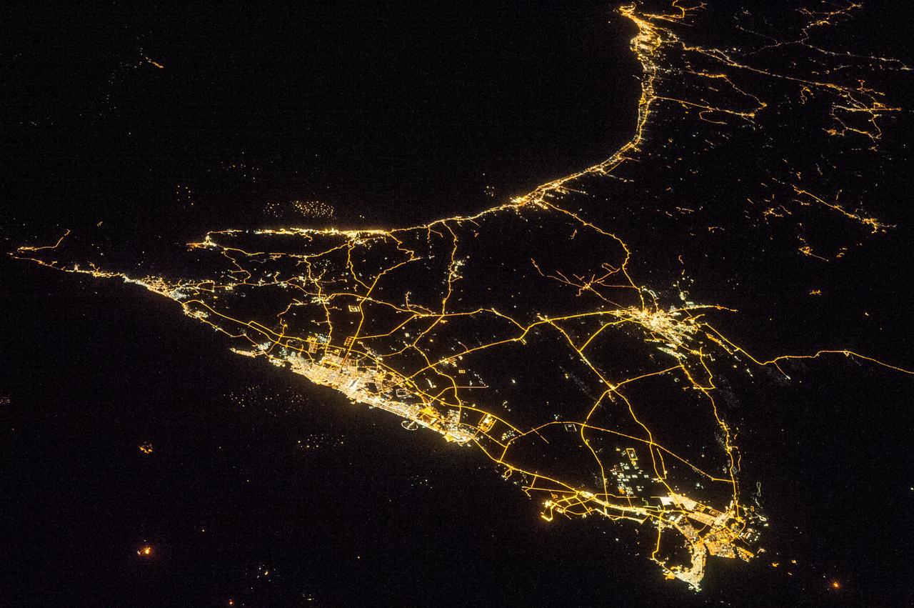
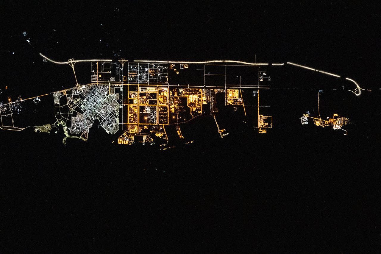
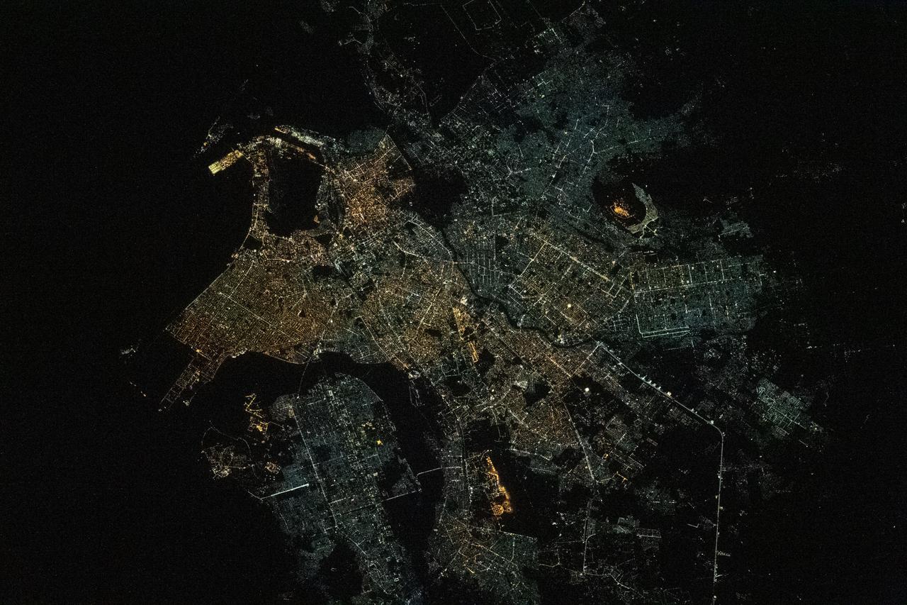
ISS038-E-016335 (11 Dec. 2013) --- A nighttime view of the United Arab Emirates is featured in this image photographed by an Expedition 38 crew member on the International Space Station. Geographers like night images of cities because you see immediately so much about the human landscape--things that are difficult or impossible to see in day images. You see where the cities are located and their shape; the brightest light clusters frequently indicate the city centers. In large field of view images, such as this photograph of the United Arab Emirates (UAE), you can also see cities' position relative to one another and their relative size. Here the largest cluster of lights is the conurbation ("joined cities") of Dubai-Sharjah-Ajman (population 3.25 million), with its smaller neighbor Dubai (population 2.1 million). These cities front onto the Persian Gulf (also known as the Arabian Gulf) where the city lights are cut off abruptly at the coastline. The bright city centers are located at the coast showing that sea trade is important (and has been important) in the growth of these cities. Smaller cities are Al Ain (population 518,000), the fourth largest city in the UAE, and Fujairah (population 152,000). Major highways join the cities in a brightly lit network, and a faint peppering of lights offshore shows the relatively young oil and gas platforms on either side of the Musandam Peninsula (left). Despite being taken at night, the spike of the Musandam Peninsula is easy to imagine at the south end of the Persian Gulf. The biggest cities in the UAE are Abu Dhabi and Dubai. Muscat, the capital city of the neighboring country of Oman, appears top center. By contrast, the almost unpopulated Musandam Peninsula shows very few lights.