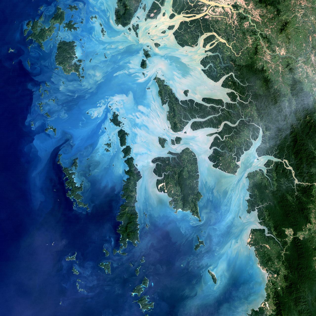
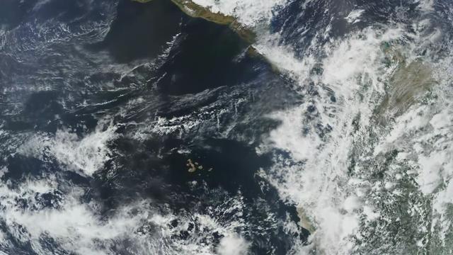
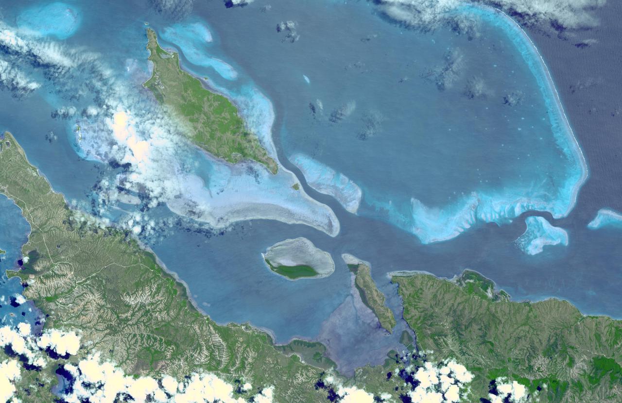
NASA image acquired December 14, 2004 In the southernmost reaches of Burma (Myanmar), along the border with Thailand, lies the Mergui Archipelago. The archipelago in the Andaman Sea is made up of more than 800 islands surrounded by extensive coral reefs. This natural color image acquired by Landsat 5 on Dec. 14, 2004, shows the middle portion of the archipelago, including Auckland and Whale Bays. Swirling patterns are visible in the near-shore waters as sediments carried by rivers slowly settle out and are deposited on the seafloor. The heavy sediment loads make the river appear nearly white. As those sediments settle out, the seawater appears deeper shades of blue. The tropical rainforests of the region appear deep green. Captain Thomas Forrest of the East India Company first described the region to Europeans after a 1782 expedition in search of potential sugar-growing lands. At that time, the islands were mainly inhabited by a nomadic fishing culture. These people, known as the Moken, still call the archipelago home and mostly live a hunter-gatherer lifestyle. As of 2006, 2,000 Moken were known to inhabit the Burmese portion of Mergui. The small population of the archipelago has helped preserve its high diversity of plants and animals. In 1997, Burma opened the region to foreign tourism and in the years since it has become a major diving destination. A valued species of pearl oyster (Pinctada maxima) are found in nearby waters. Today, overfishing is emerging as a regional problem. Landsat image created by Michael Taylor, Landsat Project Science Office. Caption by Laura Rocchio. Instrument: Landsat 5 - TM To read more go to: <a href="http://1.usa.gov/TDmjsk" rel="nofollow">1.usa.gov/TDmjsk</a> Credit: <b><a href="http://www.earthobservatory.nasa.gov/" rel="nofollow"> NASA Earth Observatory</a></b> <b><a href="http://www.nasa.gov/audience/formedia/features/MP_Photo_Guidelines.html" rel="nofollow">NASA image use policy.</a></b> <b><a href="http://www.nasa.gov/centers/goddard/home/index.html" rel="nofollow">NASA Goddard Space Flight Center</a></b> enables NASA’s mission through four scientific endeavors: Earth Science, Heliophysics, Solar System Exploration, and Astrophysics. Goddard plays a leading role in NASA’s accomplishments by contributing compelling scientific knowledge to advance the Agency’s mission. <b>Follow us on <a href="http://twitter.com/NASA_GoddardPix" rel="nofollow">Twitter</a></b> <b>Like us on <a href="http://www.facebook.com/pages/Greenbelt-MD/NASA-Goddard/395013845897?ref=tsd" rel="nofollow">Facebook</a></b> <b>Find us on <a href="http://instagram.com/nasagoddard?vm=grid" rel="nofollow">Instagram</a></b>
iss071e345427 (July 15, 2024) --- The Mayotte archipelago, a French overseas department and region, in the Mozambique Channel and in between Madagascar and Mozambique is pictured from the International Space Station as it orbited 263 miles above.
The entire Hawaiian Island Archipelago (21.5N, 158.0W) is seen in this single view. The islands are a favorite international resort and tourist attraction drawing visitors from all over the world to enjoy the tropical climate, year round beaches and lush island flora. Being volcanic in origin, the islands' offer a rugged landscape and on the big island of Hawaii, there is still an occasional volcanic eruption of lava flows and steam vents.
Tenarife Island is one of the most volcanically active of the Canary Island archipelago, Atlantic Ocean, just off the NW coast of Africa, (28.5N, 16.5W). The old central caldera, nearly filled in by successive volcanic activity culminating in two stratocones. From those two peaks, a line of smaller cinder cones extend to the point of the island. Extensive gullies dissect the west side of the island and some forests still remain on the east side.
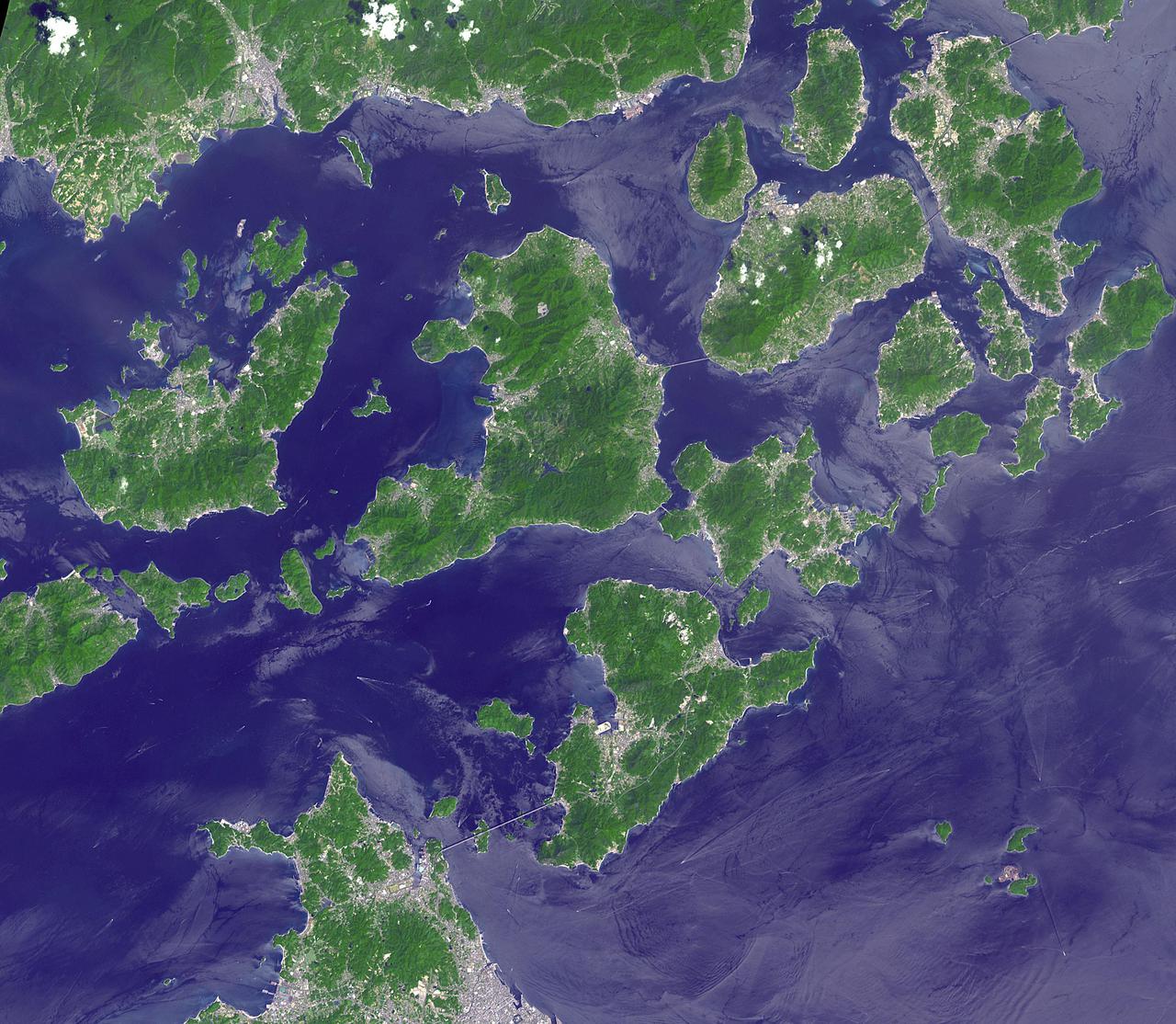
Japan's Geiyo Archipelago, in the Seito Inland Sea, was once home to pirates. From the 9th to the 16th centuries, the pirates dominated the Inland Sea and terrorized the coasts of East Asia. Until the Shimanami Kaido (Inland Wave Sea Road) was completed in 1999, the Geiyo Islands were a remote region, accessible only by boat. The ASTER image was acquired August 19, 2010, covers an area of 33.7 by 43.7 km, and is located at 34.3 degrees north, 133.1 degrees east. https://photojournal.jpl.nasa.gov/catalog/PIA25185
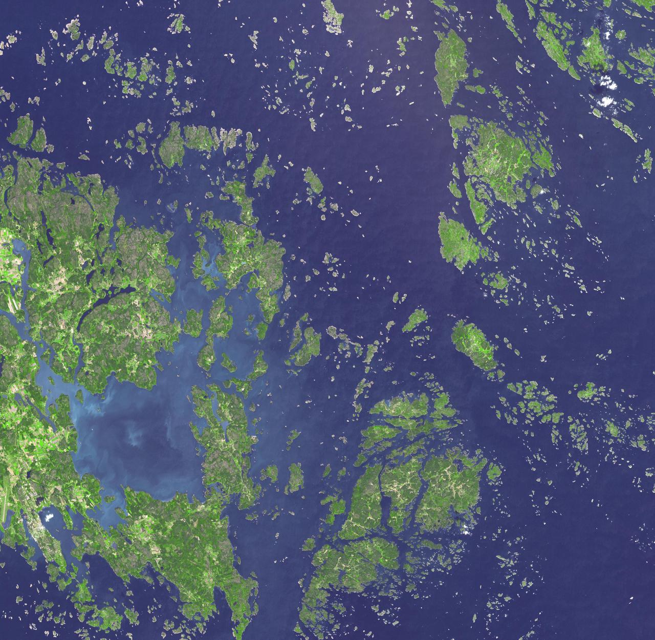
This image, acquired by NASA Terra spacecraft, is of the Aaland archipelago at the mouth of the Gulf of Bothnia which belongs to Finland, though it enjoys autonomy from Helsinki and locals speak Swedish.
iss072e715777 (Feb. 28, 2025) --- Eleuthera, an island state that is part of the Bahamas archipelago, is pictured in the Atlantic Ocean from the International Space Station as it orbited 262 miles above.
STS026-43-082 (29 Sept. - 3 Oct. 1988) --- This 70mm northerly oriented frame over the Pacific Ocean features the Hawaiian Islands chain. The islands perturb the prevailing northeasterly winds producing extensive cloud wakes in the lee of the islands. Photo experts feel that atmospheric haze in the Hawaii wake is probably a result of the continuing eruptions of Kilauea volcano on the southeast coast. From the lower right corner in a diagonal directed upward to the north are the islands of Nihau, Kauai, Oahu, Molokai, Lanai, Maui, Kahoolawe, and Hawaii. This photo was shown during the post-flight press conference on October 11, 1988 by the STS-26 astronauts, who at one time during the flight wore Hawaiian attire to pay tribute to the working staff of the Hawaii tracking station.
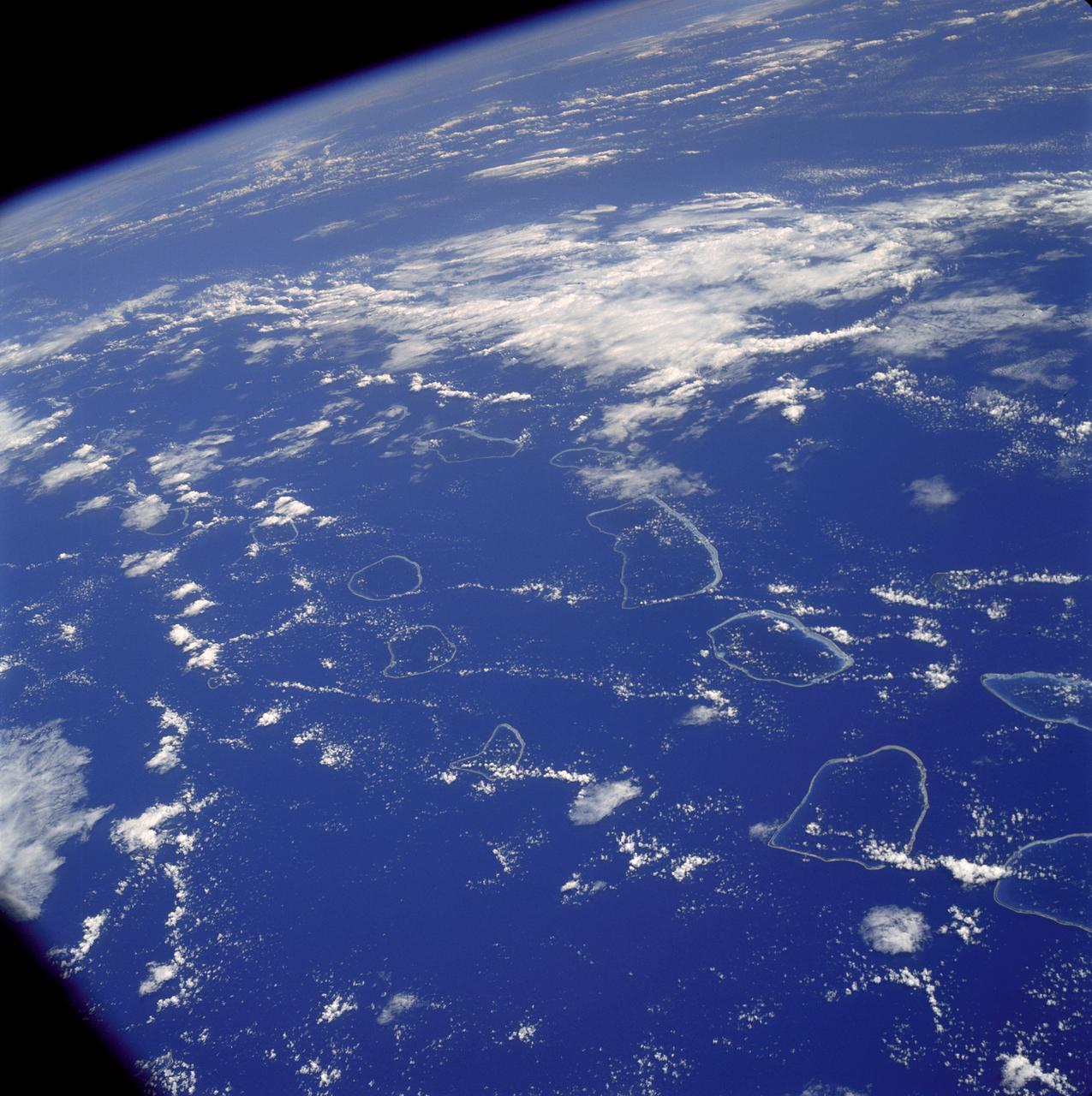
AS07-04-1590 (20 Oct. 1968) --- Tuamotu Archipelago in the South Pacific Ocean, looking southwest, as photographed from the Apollo 7 spacecraft during its 141st revolution of Earth. The photograph was taken from an altitude of 110 nautical miles, at a ground elapsed time of 224 hours and 18 minutes.
NASA Terra spacecraft acquired this image of the Republic of Seychelles, an island country with an archipelago of 115 islands in the Indian Ocean.

The pictured archipelago is the Republic of Fiji. This image from NASA Terra satellite is MISR Mystery Image Quiz #1.
This image from NASA Terra spacecraft shows the Faroe Islands, an archipelago and autonomous country within the Kingdom of Denmark, comprising 18 major islands.
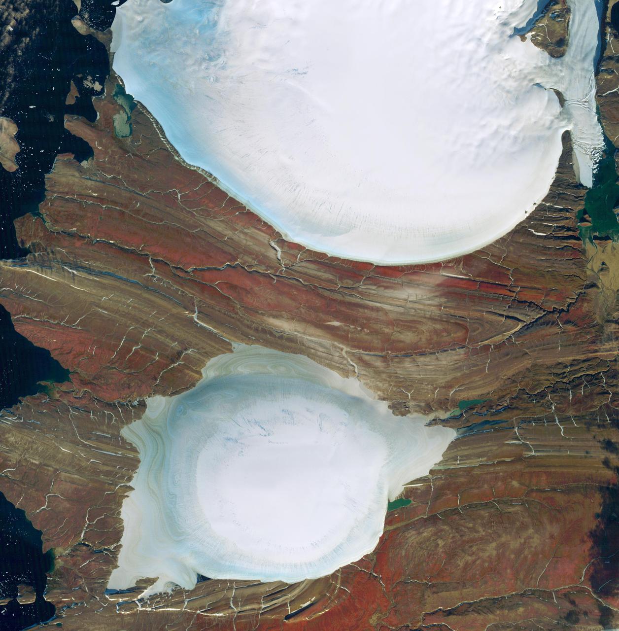
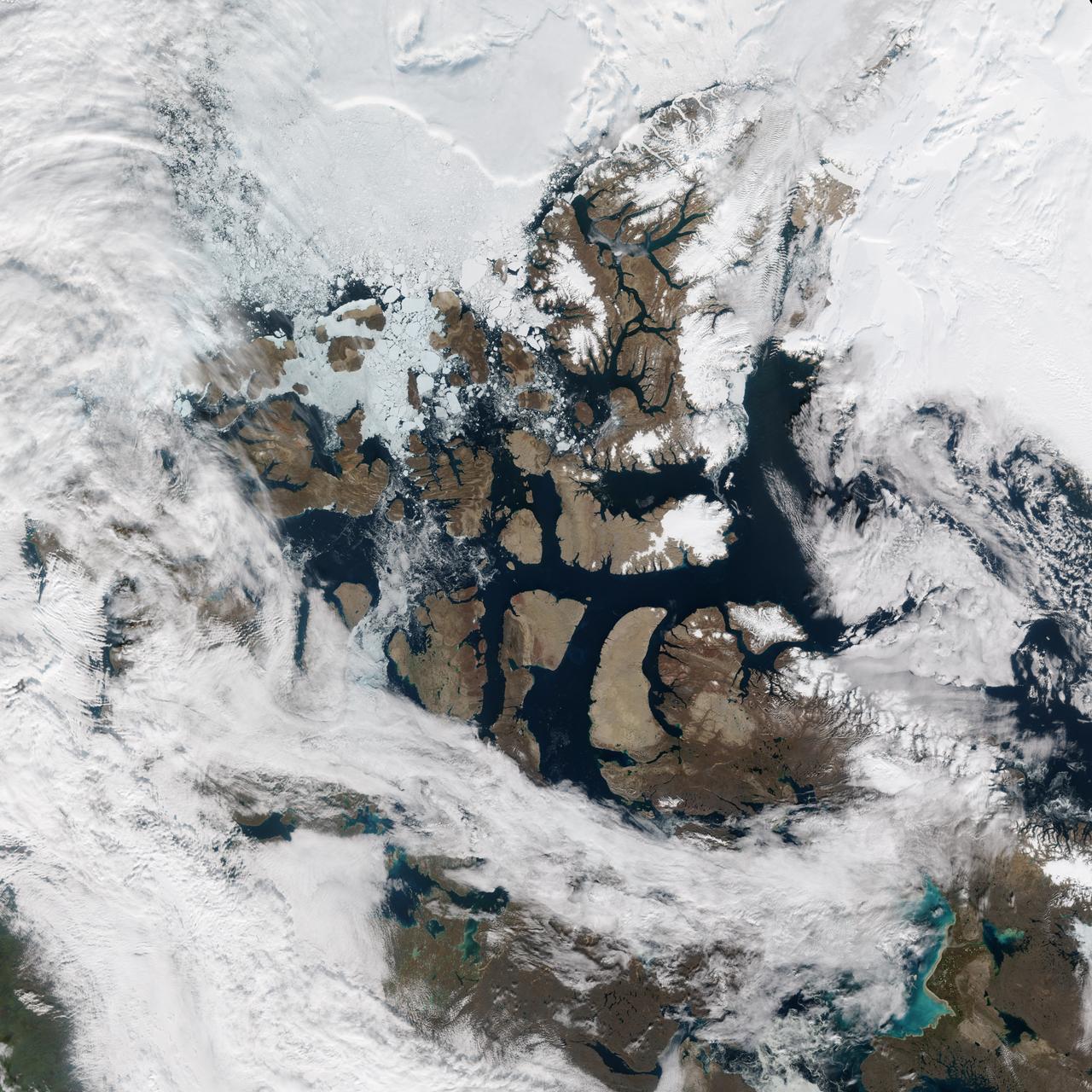
Severnaya Zemlya is an archipelago in the Russian high Arctic. It was first charted in 1930, making it the last large archipelago on Earth to be explored. It consists of four main islands: October Revolution, Bolshevik, Komsomolets, and Pioneer. All are mostly glaciated; the glaciers have a characteristic dome shape. This image of the center of October Revolution Island shows two of these glaciers. The ice-free areas between the glaciers expose folded sedimentary rocks. The image was acquired September 18, 2012, covers an area of 45.6 by 48.3 kilometers, and is located at 79.8 degrees north, 96.1 degrees east. https://photojournal.jpl.nasa.gov/catalog/PIA23018
Completed: 07-16-2009 Straddling the equator approximately 1000 kilometers to the west of the South American mainland, the Galapagos Islands lie within the heart of the equatorial current system. Rising from the sea floor, the volcanic islands of the Galapagos are set on top of a large submarine platform. The main portion of the Galapagos platform is relatively flat and less than 1000 meters in depth. The steepest slopes are found along the western and southern flanks of the platform with a gradual slope towards the east. The interactions of the Galapagos and the oceanic currents create vastly different environmental regimes which not only isolates one part of the Archipelago from the other but allows penguins to live along the equator on the western part of the Archipelago and tropical corals around the islands to the north. The islands are relatively new in geologic terms with the youngest islands in the west still exhibiting periodic eruptions from their massive volcanic craters. Please give credit for this item to: NASA/Goddard Space Flight Center, The SeaWiFS Project and GeoEye, Scientific Visualization Studio. NOTE: All SeaWiFS images and data presented on this web site are for research and educational use only. All commercial use of SeaWiFS data must be coordinated with GeoEye (http://www.geoeye.com). To download this video go to: <a href="http://svs.gsfc.nasa.gov/goto?3628" rel="nofollow">svs.gsfc.nasa.gov/goto?3628</a> <b><a href="http://www.nasa.gov/centers/goddard/home/index.html" rel="nofollow">NASA Goddard Space Flight Center</a></b> is home to the nation's largest organization of combined scientists, engineers and technologists that build spacecraft, instruments and new technology to study the Earth, the sun, our solar system, and the universe.
The Belcher Islands are an archipelago in Hudson Bay in Canada, belonging to the territory of Nunavit. The hamlet of Sanikiluaq is on the north coast of Flaherty Island. This image was acquired by NASA Terra satellite on 18 September 2006.
Longyearbyen is the administrative center of Svalbard and is located on Spitsbergen, the largest island of the Svalbard archipelago, part of the Kingdom of Norway. NASA Terra satellite captured this image on July 12, 2003.
The recently active volcano Mt. Manaro is the dominant feature in this shaded relief image of Ambae Island, part of the Vanuatu archipelago located 1400 miles northeast of Sydney, Australia.
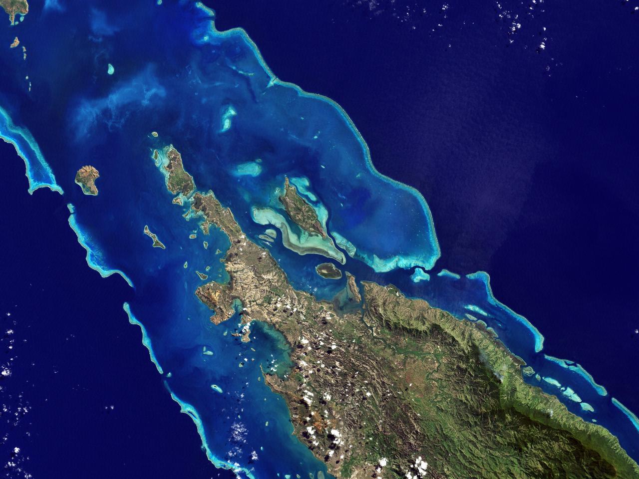
In this image, taken by NASA Terra spacecraft, six marine clusters represent the main diversity of coral reefs and associated ecosystems in the French Pacific Ocean archipelago of New Caledonia.
As the Space Shuttle Atlantis flew over the Indonesian archipelago on Saturday, Sept. 27, 1997, middle school students across the country used NASA Kidsat camera to photograph the fires and smoke that blanket the island of Sumatra.
This image from NASA Terra spacecraft is of Franz Josef Land, an archipelago in the far north of Russia. It consists of 191 islands covering an area of about 200 by 325 km, and has no native inhabitants.
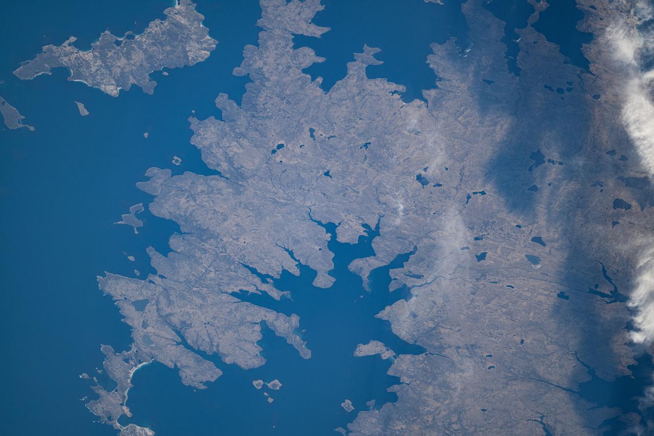
The Isles of Scilly are an archipelago of 145 islands that lies 28 km off the tip of Cornwall. Scilly is part of the Duchy of Cornwall under the stewardship of the Prince of Wales, who owns all the lands, and collects rents or leases from all 2200 residents. Tourism now accounts for 85% of the islands' income. The image was acquired July 8, 2019, covers an area of 12.8 by 13 km, and is located at 49.9 degrees north, 6.3 degrees west. https://photojournal.jpl.nasa.gov/catalog/PIA24867
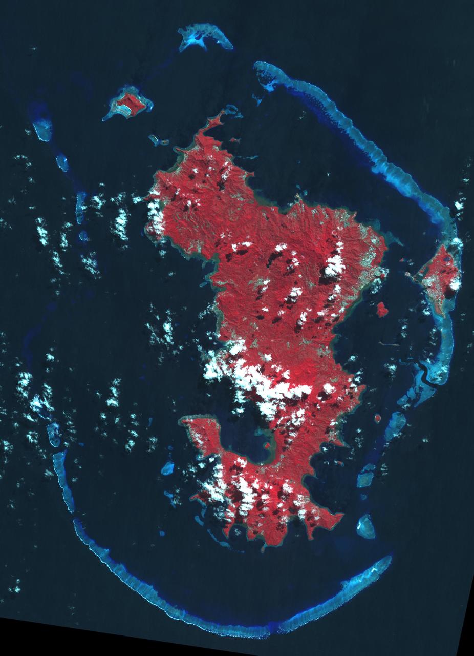
Mayotte is a volcanic island in the Comoros archipelago between the eastern coast of Africa and the northern tip of Madagascar. It is a French Overseas Territory in the Indian Ocean. On December 14, the island was hit by devastating category-4 hurricane Chido, causing widespread damage and loss of life. The image was acquired June 7, 2016, covers an area of 42 by 58.5 km, and is located at 12.8 degrees south, 45.1 degrees east. https://photojournal.jpl.nasa.gov/catalog/PIA26503
iss065e009427 (April 29, 2021) --- The Bazaruto Archipelago off the coast of Mozambique is pictured from the International Space Station as it orbited 265 miles above the African nation.
The Atlantic Ocean Road is an 8.3 kilometer road that runs through an archipelago in Eide and Averoy in More of Romsdal, Norway. It consists of eight bridges and four resting places and viewpoints. The road was originally proposed as a railway line, but that was abandoned. The road was opened in July 1989, and has been declared the world's best road trip. The image was acquired July 2, 2008, covers an area of 8.9 by 11.8 kilometers, and is located at 63 degrees north, 7.3 degrees east. https://photojournal.jpl.nasa.gov/catalog/PIA23096
Cape Horn is the southernmost point of the Tierra Del Fuego archipelago of Southern Chile, and marks the northern boundary of the Drake Passage where the Atlantic and Pacific Oceans meet. For decades after its 1616 discovery, it was a milestone for the clipper route by which sailing ships carried trade around the world (Wikipedia). Unfortunately, it was also a graveyard for sailing ships due to strong winds, large waves, strong currents, and icebergs. The 1914 opening of the Panama Canal greatly reduced the need for ships to traverse this dangerous passage. The image was acquired December 20, 2009, covers an area of 28.3 by 36.0 kilometers, and is located at 56 degrees south, 67.3 degrees west. https://photojournal.jpl.nasa.gov/catalog/PIA23118
iss071e582470 (Sept. 2, 2024) --- The Falkland Islands, also known as Islas Malvinas, are pictured from the International Space Station as it orbited 267 miles above the Argentine Sea in between the archipelago and the southern tip of Argentina.
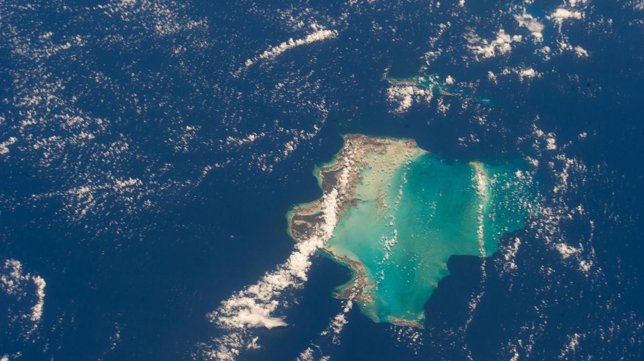
iss073e0118628 (May 26, 2025) --- The Turks and Caicos Islands, an archipelago and British Overseas Territory in the Atlantic Ocean southeast of The Bahamas, are pictured from the International Space Station as it orbited 261 miles above.
iss066e091560 (Nov. 30, 2021) --- The remote archipelago of the Falkland Islands, also known as the Islas Malvinas, off the coast of southern Argentina is pictured from the International Space Station as it orbited 270 miles above the south Atlantic.
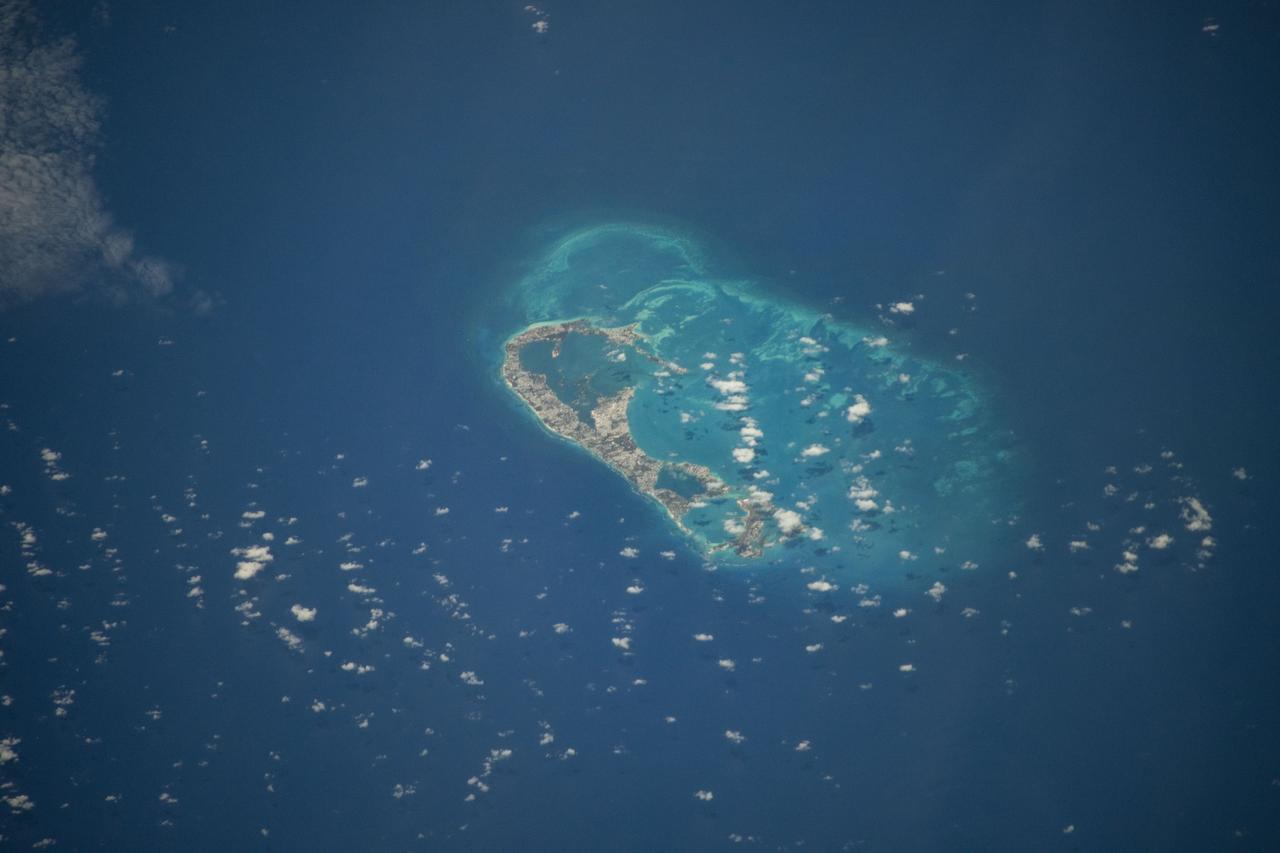
iss071e206529 (June 19, 2024) -- In the North Atlantic Ocean lies Bermuda, an archipelago of more than 180 islands and islets. As the International Space Station orbited 265 miles above, NASA astronaut Matthew Dominick captured this photo.
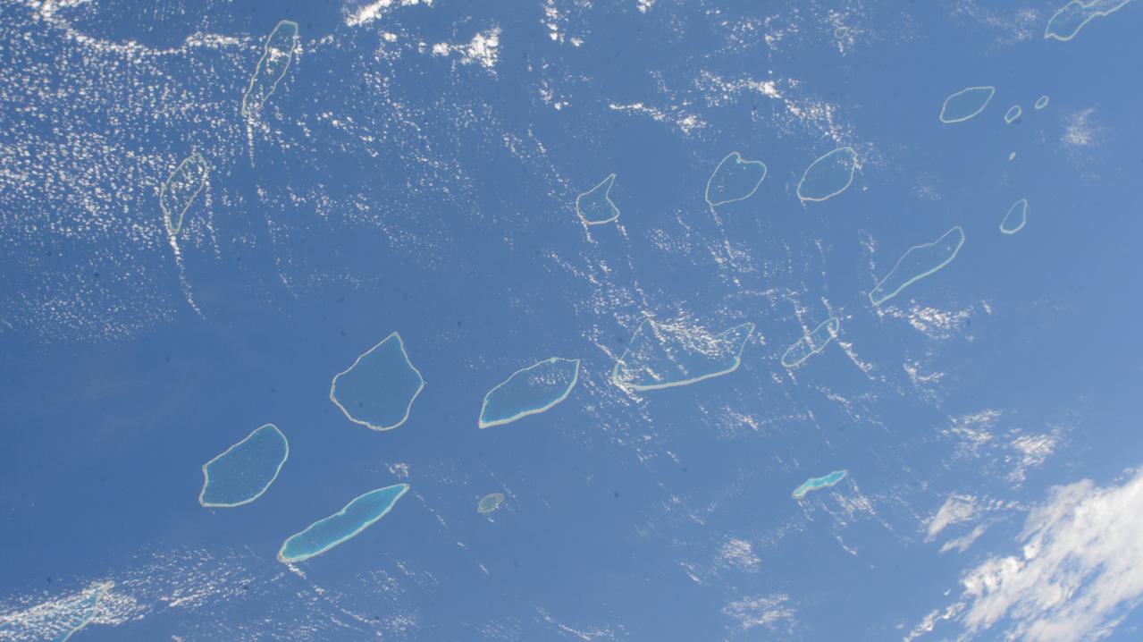
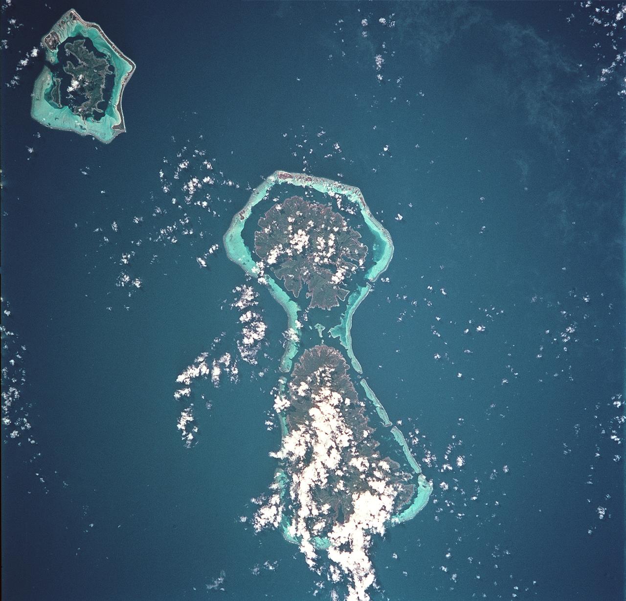
iss071e207656 (June 22, 2024) --- The Palliser Islands, atolls that are part of Fench Polynesia's Tuamotu Archipelago in the Pacific Ocean, are pictured from the International Space Station as it orbited 266 miles above.

iss070e064005 (Jan. 10, 2024) --- A portion of Mozambique's Bazaruto Archipelago, a national park ceated to protect marine wildlife, on the southern coast of the African nation is pictured from the International Space Station as it orbited 261 miles above.

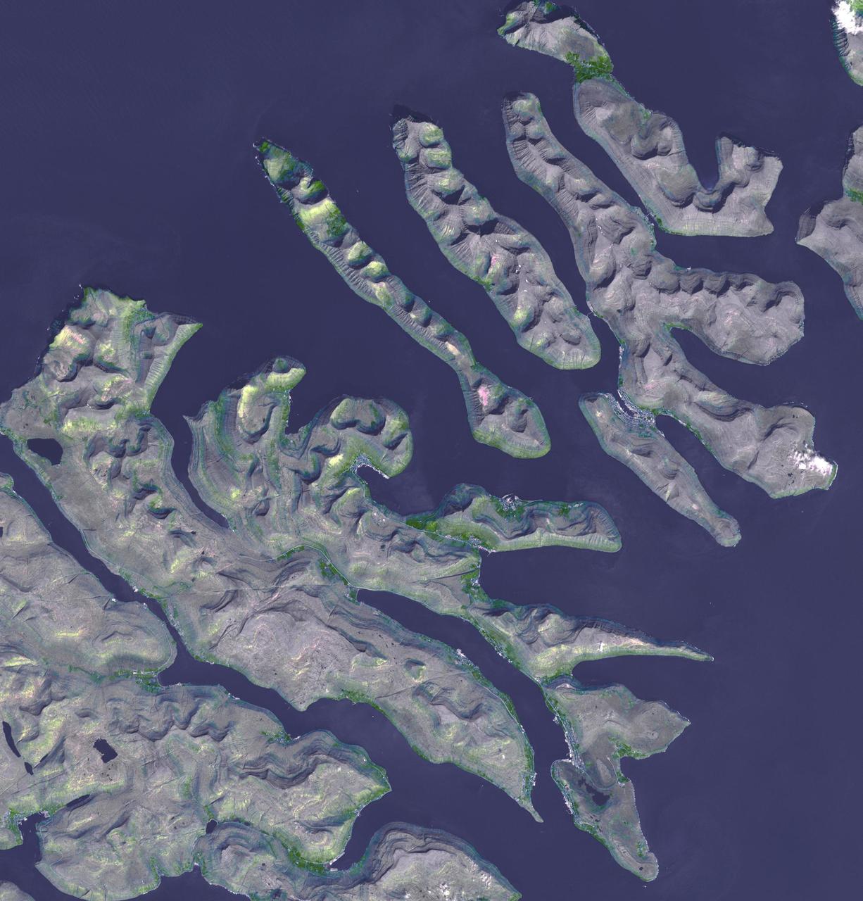
This image from NASA Terra spacecraft shows Prince Patrick Island, which is located in the Canadian Arctic Archipelago, and is the westernmost Elizabeth Island in the Northwest Territories of Canada. The island is underlain by sedimentary rocks, cut by still-active faults. The streams follow a dendritic drainage system: there are many contributing streams (analogous to the twigs of a tree), which are then joined together into the tributaries of the main river (the branches and the trunk of the tree, respectively). They develop where the river channel follows the slope of the terrain. The image covers an area of 22 by 27 km, was acquired July 2, 2011, and is located at 76.9 degrees north, 118.9 degrees west. http://photojournal.jpl.nasa.gov/catalog/PIA19222
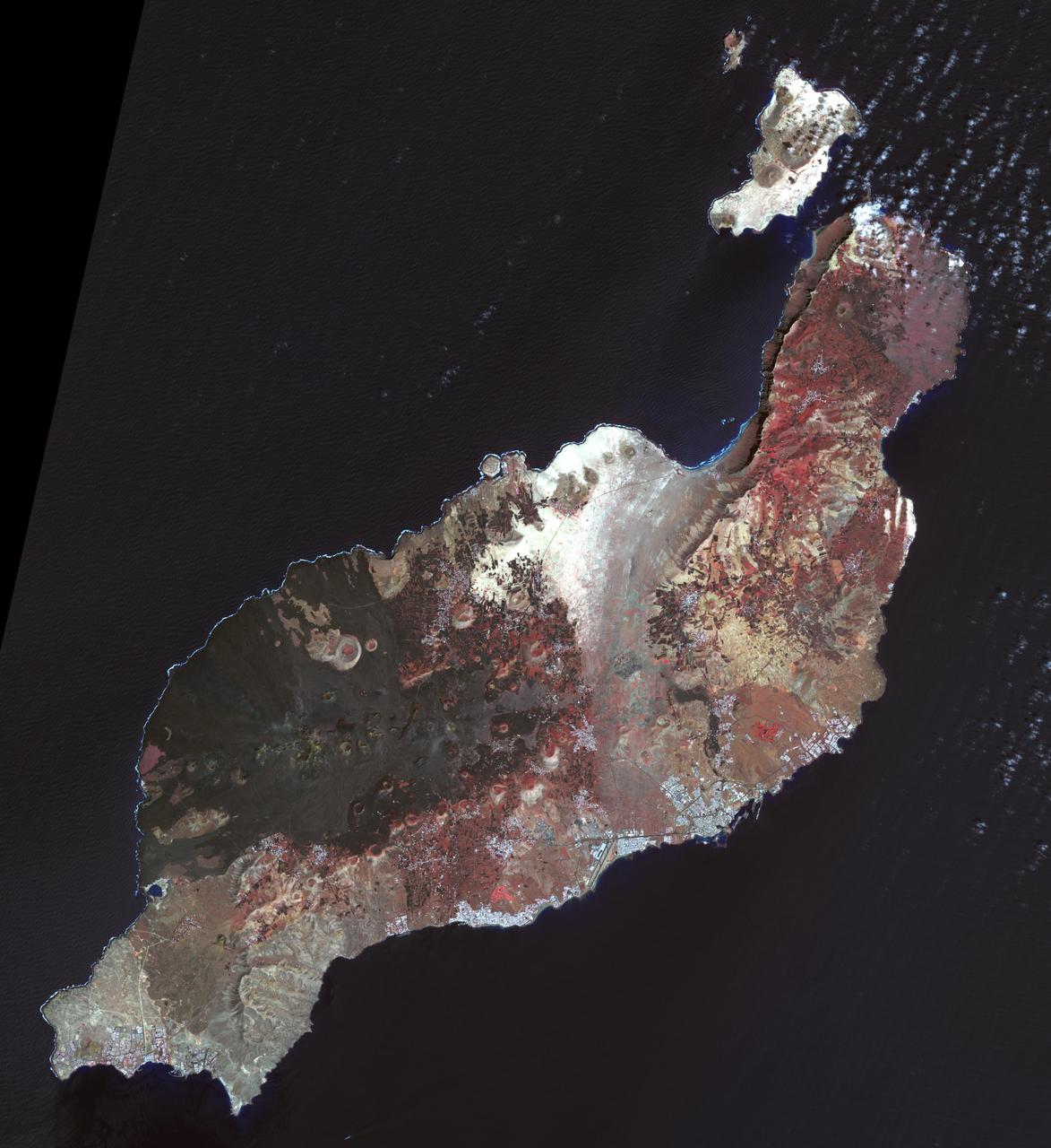
Lanzarote is the easternmost of the Canary Islands, 125 km off the coast of Africa, and is the fourth largest of the archipelago, with an area of 846 square kilometers. Like all of the Canary Islands, its volcanic origin dates to about 15 million years ago. The largest historic eruption occurred in the 1730s. The island was first recorded by Pliny the Elder, though it may have been originally settled by the Phoenicians (Wikipedia). The image was acquired 12 March 2015, covers an area of 50.5 by 55.1 km, and is located near 29 degrees north, 13.6 degrees west. http://photojournal.jpl.nasa.gov/catalog/PIA21284
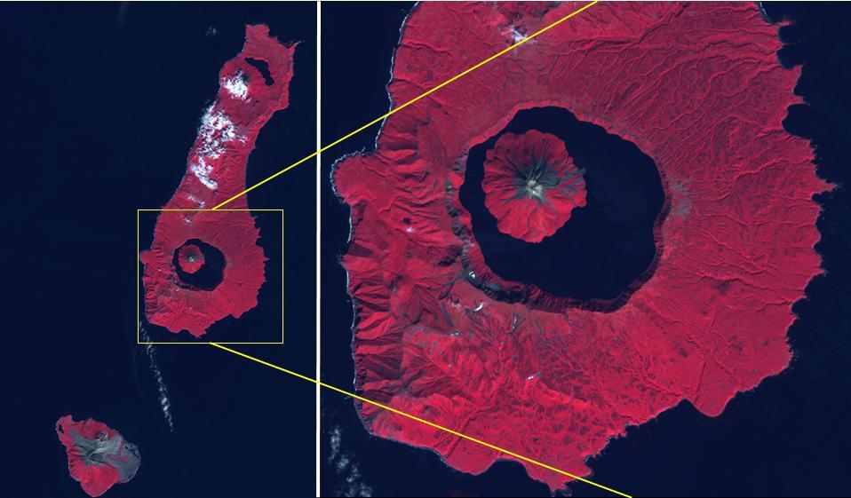
The Kuril Islands are a volcanic archipelago, stretching 1300 km from Hokkaido, Japan to Kamchatka, Russia. They are part of the Pacific Ring of Fire, the result of subduction of the Pacific Plate under the Okhotsk Plate along the Kuril Trench. At the southern end of Onekotan Island is the Tao-Rusyr Caldera stratovolcano, with its 7500 year old caldera lake. The most recent eruption was in 1952. The smaller Kharimkotan Island to the southwest last erupted in 1933. Collapse of this volcano created a horseshoe-shaped crater, and caused a tsunami that killed two people on a near-by island. The image was acquired June 4, 2012; the enlargement covers an area of 17 by 18.5 km, and is located at 49.3 degrees north, 154.7 degrees east. https://photojournal.jpl.nasa.gov/catalog/PIA24020
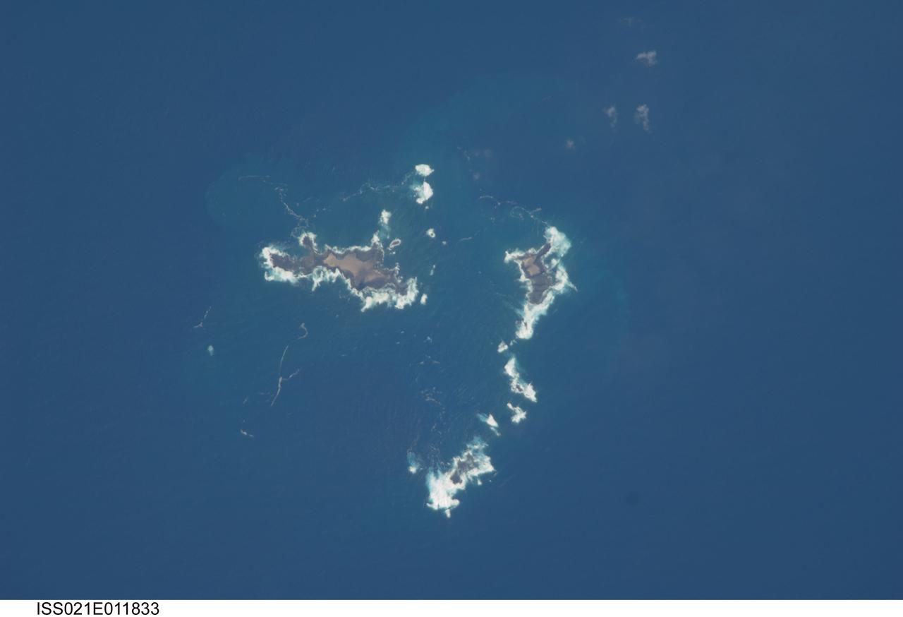
ISS021-E-011833 (22 Oct. 2009) --- The southern Savage Islands in the Atlantic Ocean are featured in this image photographed by an Expedition 21 crew member on the International Space Station. The Savage Islands, or Ilhas Selvagens in Portuguese, comprise a small archipelago in the eastern North Atlantic Ocean between the archipelago of Madeira to the north and the Canary Islands to the south. Like other island groups, the Savage Islands are thought to have been produced by volcanism related to a mantle plume or ?hot spot?. Mantle plumes are relatively fixed regions of upwelling magma that can feed volcanoes on an overlying tectonic plate. Active volcanoes form over the plume, and become dormant as they are carried away on the moving tectonic plate. Scientists believe that over geologic time, this creates a line of older extinct volcanoes, seamounts, and islands extending from the leading active volcanoes that are currently over the plume. This view illustrates the smaller and more irregularly-shaped Ilheus do Norte, Ilheu de Fora, and Selvagem Pequena. Spain and Portugal both claim sovereignty over the Savage Islands. All of the islands of the archipelago are ringed by bright white breaking waves along the fringing beaches. Coral reefs that surround the Savage Islands make it very difficult to land boats there, and there is no permanent settlement on the islands.
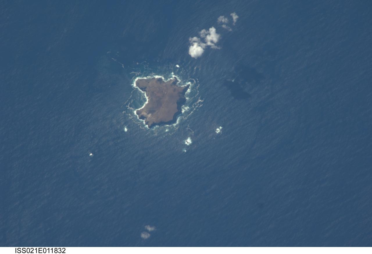
ISS021-E-011832 (22 Oct. 2009) --- The northern Savage Islands in the Atlantic Ocean are featured in this image photographed by an Expedition 21 crew member on the International Space Station. The Savage Islands, or Ilhas Selvagens in Portuguese, comprise a small archipelago in the eastern North Atlantic Ocean between the archipelago of Madeira to the north and the Canary Islands to the south. Like other island groups, the Savage Islands are thought to have been produced by volcanism related to a mantle plume or “hot spot”. Mantle plumes are relatively fixed regions of upwelling magma that can feed volcanoes on an overlying tectonic plate. Active volcanoes form over the plume, and become dormant as they are carried away on the moving tectonic plate. Scientists believe that over geologic time, this creates a line of older extinct volcanoes, seamounts, and islands extending from the leading active volcanoes that are currently over the plume. This view illustrates Selvagem Grande, the largest of the islands with an approximate area of four square kilometers. All of the islands of the archipelago are ringed by bright white breaking waves along the fringing beaches. Coral reefs that surround the Savage Islands make it very difficult to land boats there, and there is no permanent settlement on the islands.
ISS040-E-007404 (4 June 2014) --- One of the Expedition 40 crew members aboard the International Space Station on June 4, 2014, recorded this vertical image of Fangataufa Atoll, a small coral atoll on the eastern side of the Tuamotu Archipelago in French Polynesia in the South Pacific Ocean.
iss070e044474 (Dec. 22, 2023) --- Northrop Grumman's Cygnus space freighter is pictured in the grip of the Canadarm2 robotic arm shortly after it was detached from the Unity module. The orbital complex was soaring 260 miles above the island archipelago of Seychelles in the Indian Ocean at the time of this photograph.

iss071e378497 (July 21, 2024) -- The Quirimbas Islands lie in the western Indian Ocean off the coast of Mozambique. The archipelago consists of 32 islands, partially linked to the coastline by coral reefs, mangroves, and sand bars. As the International Space Station orbited 262 miles above, NASA astronaut Matthew Dominick captured this photo.
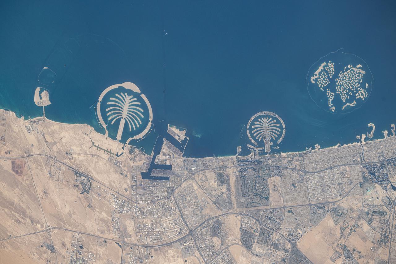
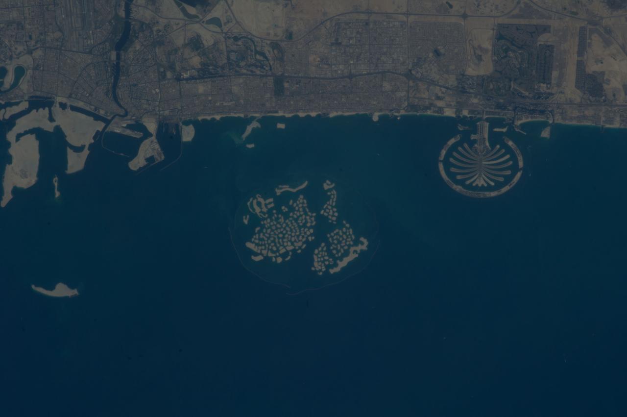
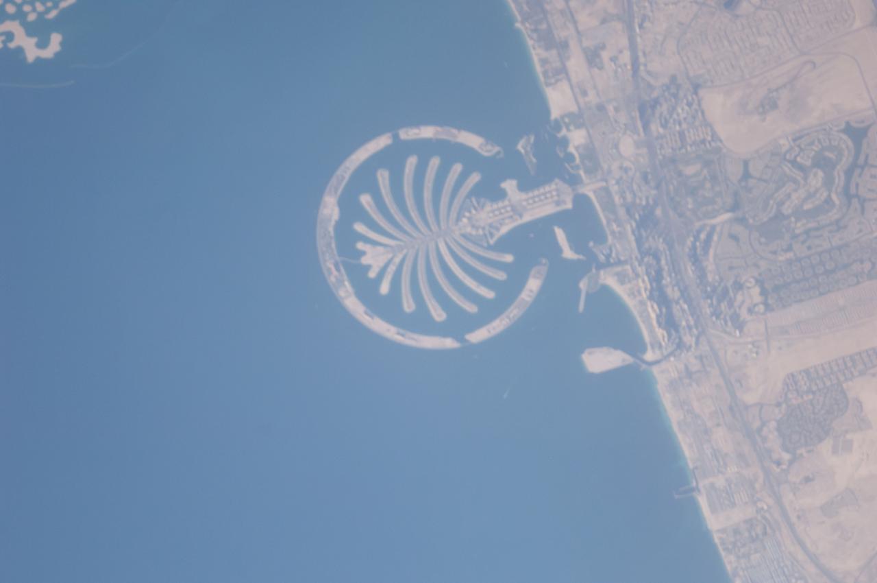
iss073e0247372 (June 10, 2025) --- Artificial islands built on the Persian Gulf coast of Dubai, United Arab Emirates, are pictured from the International Space Station as it orbited 258 miles above the Arabian Sea. Featured promoniently from left, are the man-made archipelagos of Palm Jebel Ali, Palm Jumierah, and The World islands.
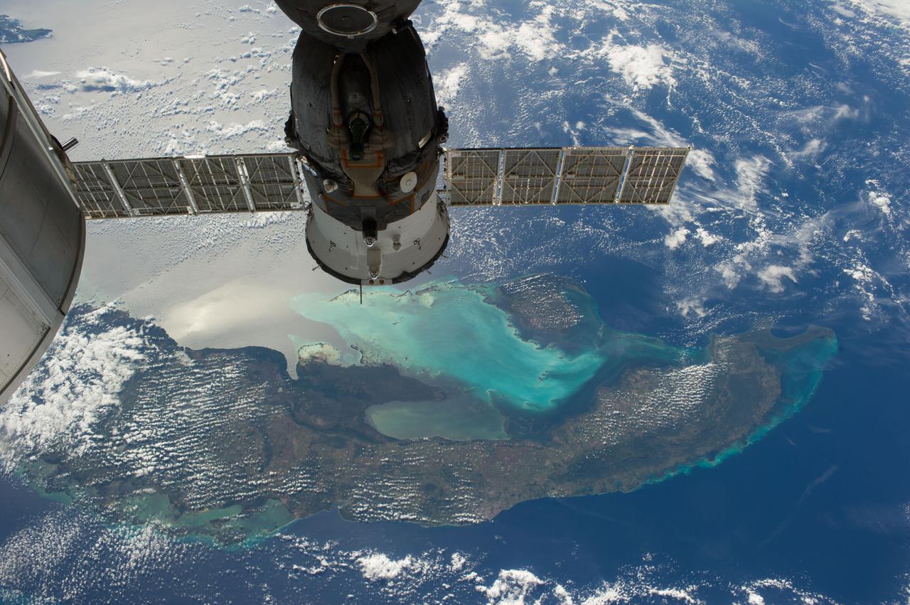
ISS038-E-021401 (24 Dec. 2013) --- The Caribbean country of Cuba is pictured in this high oblique image, photographed by one of the Expedition 38 crew members aboard the International Space Station. Andros ISland, part of the Bahamas, is Cuba is an archipelago of islands in the northern Caribbean Sea at the confluence with the Gulf of Mexico and the Atlantic Ocean. A Russian Soyuz spacecraft is docked to the station.
ISS038-E-019899 (23 Dec. 2013) --- The Caribbean country of Cuba appears at the top of this high oblique image, photographed by one of the Expedition 38 crew members aboard the International Space Station. Andros Island, part of the Bahamas, is in the bottom of the frame. Cuba is an archipelago of islands in the northern Caribbean Sea at the confluence with the Gulf of Mexico and the Atlantic Ocean. A Russian Soyuz spacecraft is docked to the station.
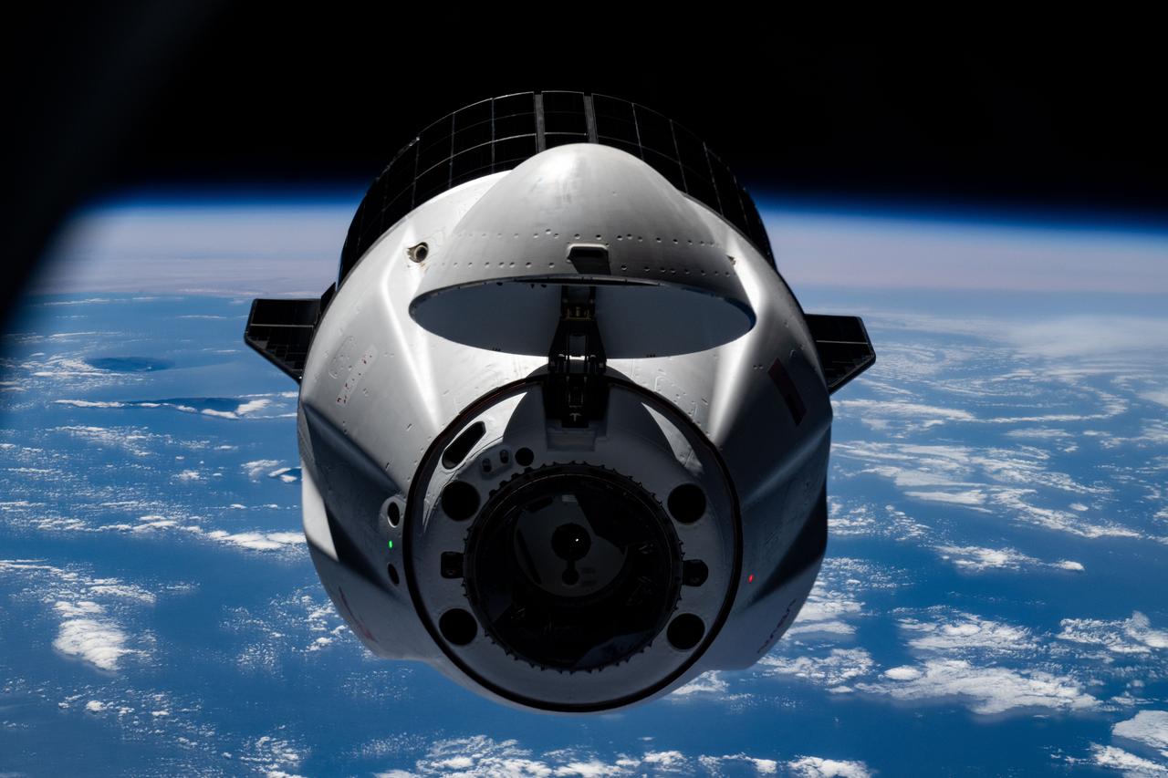
iss073e0545540 (Aug. 25, 2025) --- A SpaceX Dragon cargo spacecraft with its nosecone open and carrying over 5,000 pounds of science, supplies, and hardware for NASA's SpaceX CRS-33 mission approaches the International Space Station for an automated docking to the Harmony module's forward port. Both spacecraft were flying 261 miles above the Atlantic Ocean south of the Azores, a Portuguese archipelago, at the time of this photograph.
iss073e1047970 (Nov. 2, 2025) --- The western portion of Grand Terre, part of the French Southern and Antarctic Lands, is pictured from the International Space Station as it orbited 270 miles above the Indian Ocean. The largest island in the Kerguelen Archipelago, this UNESCO World Heritage Site is of volcanic origin, features a cold oceanic climate, and is home to king penguins, elephant seals, and albatrosses.
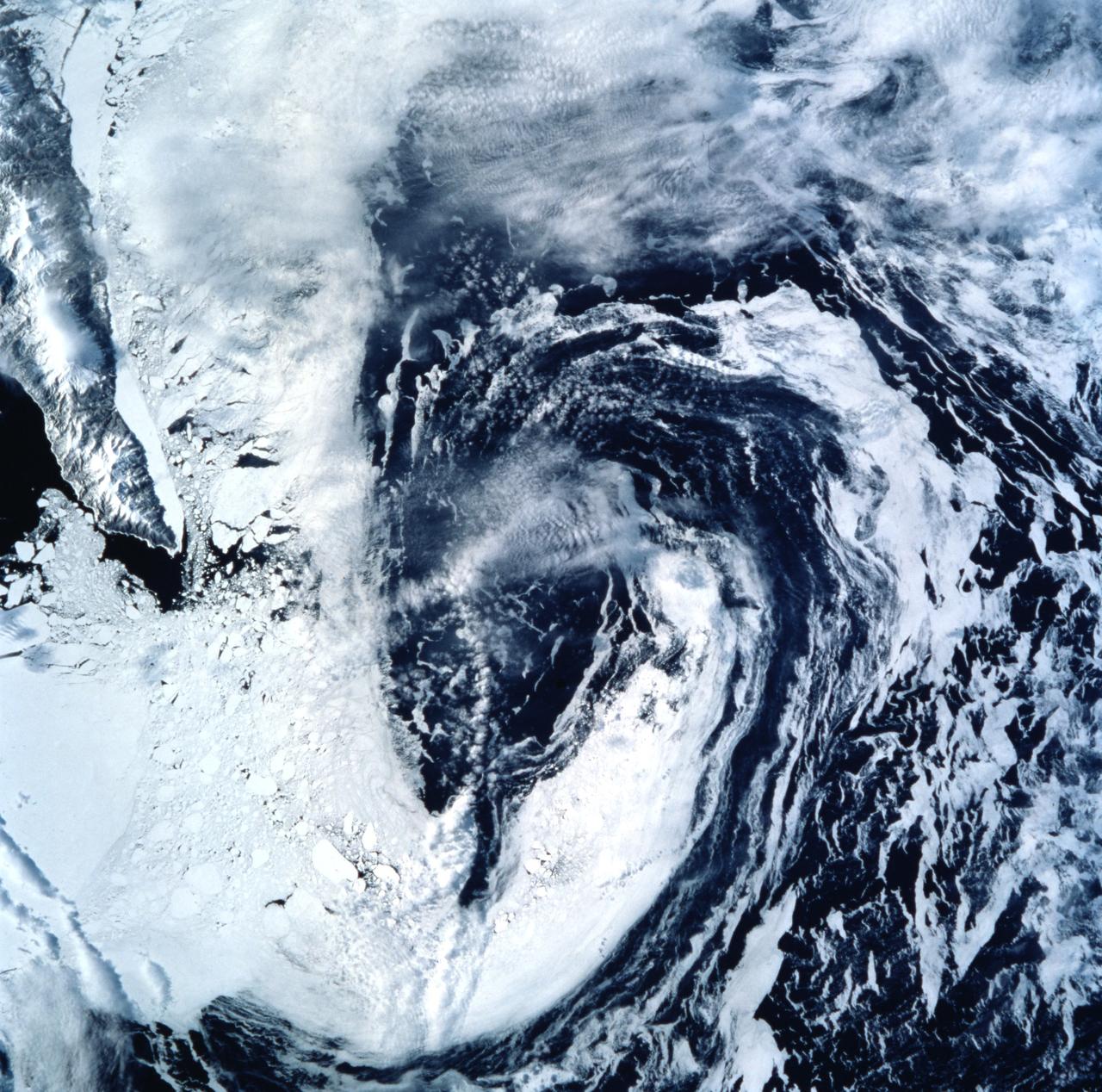
STS099-722-077 (11-22 February 2000) ---Both topography and bathymetry combine with wind and sea currents to produce a pattern of sea ice in the extreme southern Sea of Okhotsk, in this scene photographed by one of the STS-99 crew members aboard the Space Shuttle Endeavour. The rugged shoreline of north Hokkaido and the Kurile Archipelago have channeled northerly winds and surface waters into a gyre here, clearly depicted in the pattern of sea ice.
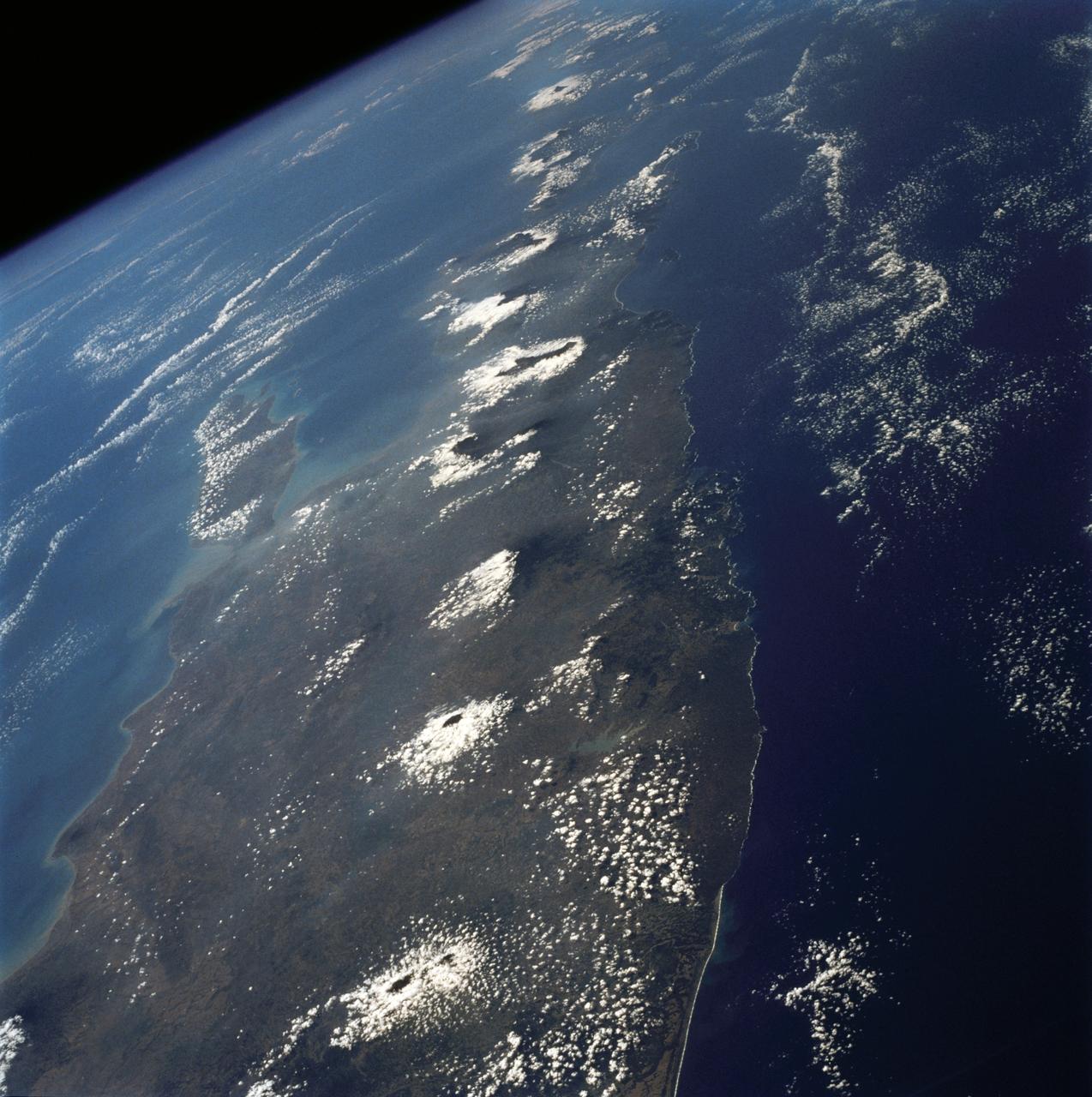
The island of Java (8.0S, 112.0E), perhaps better than any other, illustrates the volcanic origin of Pacific Island groups. Seen in this single view are at least a dozen once active volcano craters. Alignment of the craters even defines the linear fault line of Java as well as the other some 1500 islands of the Indonesian Archipelago. Deep blue water of the Indian Ocean to the south contrasts to the sediment laden waters of the Java Sea to the north.

iss074e0342635 (Feb. 22, 2026) --- A dim airglow blankets Earth’s horizon as a faint Moon sets above a dark and vast Indian Ocean in this photograph from the International Space Station, which was orbiting 264 miles above the Maldives—an Asian archipelago nation southwest of India—at approximately 12:11 a.m. local time. Credit: NASA/Chris Williams

iss074e0342246 (Feb. 22, 2026) --- A dim airglow blankets Earth’s horizon as a faint Moon sets above a dark and vast Indian Ocean. The International Space Station was orbiting 265 miles above the Seychelles—an East African archipelago nation of 115 islands—at approximately 11:08 p.m. local time when this photograph was taken. Credit: NASA/Chris Williams
ISS038-E-000232 (11 Nov. 2013) --- One of the Expedition 38 crew members aboard the International Space Station used a 180mm lens to photograph this oblique image featuring the Galapagos Islands or Islas Galapagos, distributed on either side of the Equator in the eastern Pacific Ocean. An archipelago of volcanic islands, the group?s official name is Archipielago de Colon.
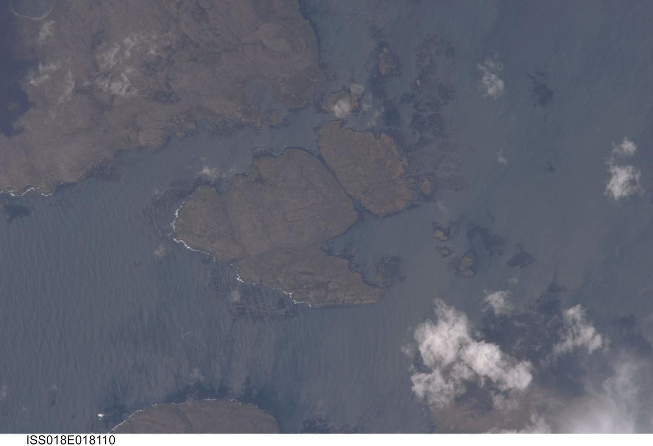
ISS018-E-018110 (6 Jan. 2009) --- Kerguelen Kelp Beds in the Southern Indian Ocean are featured in this image photographed by an Expedition 18 crewmember on the International Space Station. MacMurdo and Howe Islands are two of the 300 islands of the Kerguelen Archipelago, a remote place located in the Southern Indian Ocean that belongs to the French Southern and Antarctic Lands. The Kerguelen Archipelago is also known as the "Desolation Islands". The coastal regions of the islands support low vegetation (mainly genus Acaena), while elevations above 50 meters are rocky. There are no permanent inhabitants of the islands, but there is a permanent settlement (Port aux Francais) that hosts scientists mainly interested in biology, oceanography and earth sciences ? in addition, the settlement maintains a weather station and satellite/rocket tracking station. Latitudinal weather conditions are typical from the ?roaring forties? through the ?furious fifties? - on the day this image was taken, the mean daily temperature was 4.5 degrees Celsius with mean westerly winds of 9 meters per second. A substantial proportion of the coastlines of sub-Antarctic islands, like the Kerguelen Islands, are occupied by highly productive giant kelp beds (Macrocystis pyrifera). One of the largest marine macroalgaes, the species can grow up to 50 meters in length, forming undersea forests in hard-bottom subtidal areas. Fronds can spread out to form a canopy which can totally cover the water surface ? we interpret that the black patches surrounding coastal areas in this astronaut photograph are the offshore kelp beds. These forests serve as a habitat for marine fauna, and due to their large biomass and relatively long turnover act as an efficient sink for atmospheric carbon dioxide. The surface wave pattern traveling southeastward along the gray-blue ocean surface, and through the kelp beds, are visible due to the sunglint from the water surface. This also improves the identification of the kelp beds by creating a different water texture (and therefore a contrast) between the dark vegetation and the ocean surface. Kerguelen Archipelago hosts thousands of marine birds (penguins, albatrosses, and petrels among others) and seals (elephant and Antarctic fur species). Whales (humpback) and dolphins (killer whales and Commerson's dolphin) are very common in the area. Fishing boats also frequent the Archipelago ? including unlicensed, so-called ?pirate? fishing vessels.
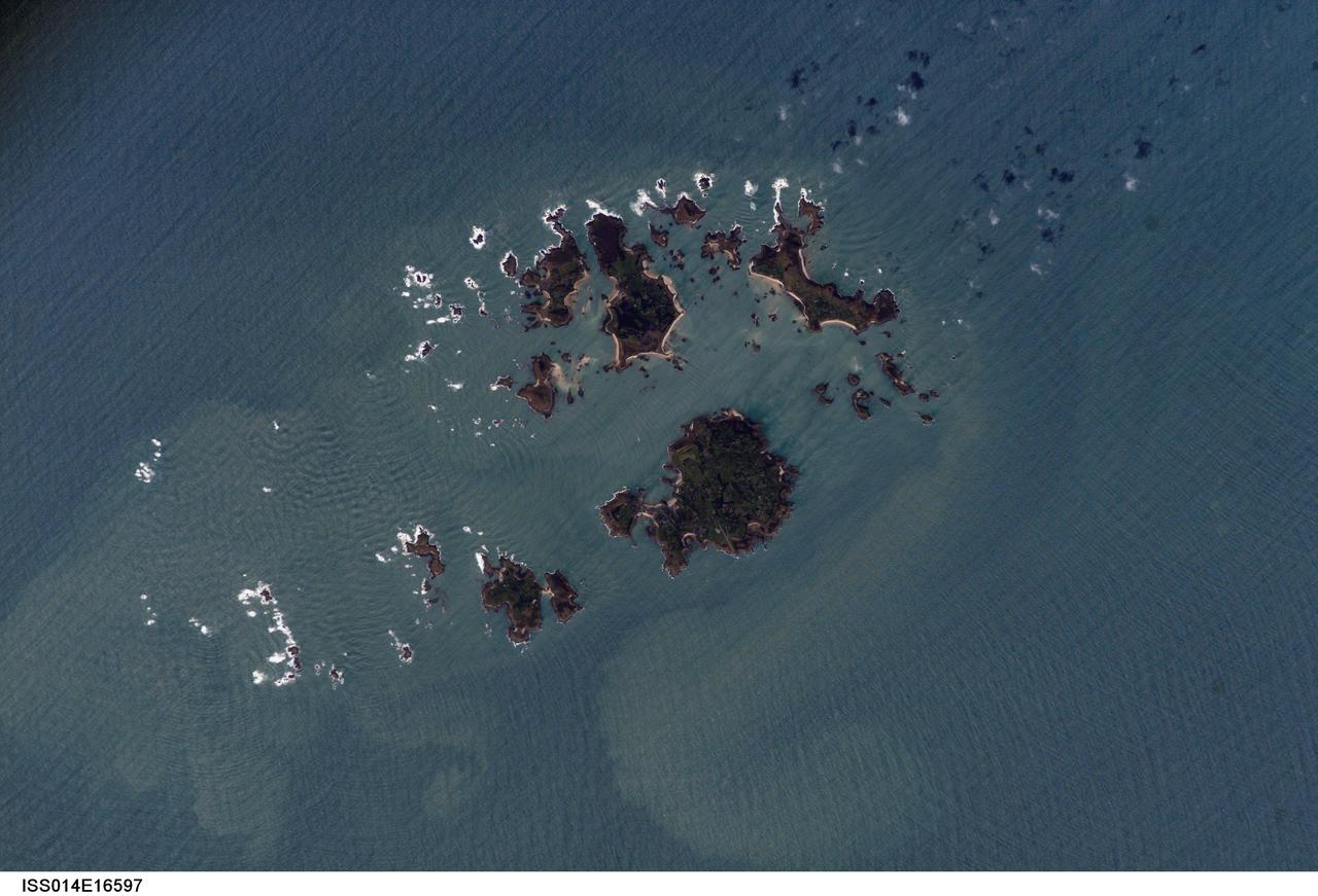
ISS014-E-16597 (10 March 2007) --- Isles of Scilly, United Kingdom is featured in this image photographed by an Expedition 14 crewmember on the International Space Station. The Isles of Scilly, an archipelago of approximately 150 islands, is located some 44 kilometers southwest of the westernmost point of England (Land's End). According to scientists, the islands are an erosional remnant of an ancient granite intrusion, and are notable because they have been inhabited for over 4000 years. Historical and geological evidence cited by NASA scientists on the Isles indicates that many of the islands were larger and/or connected in the recent past--this could be due to local subsidence, rising sea levels, or a combination of both factors. Even today, it is possible to walk between certain islands during low tides. The Isles have been designated a United Kingdom Area of Outstanding Natural Beauty due to their unique landscape, ecology, and historical significance. The potential effect of rising sea level on the Isles is a primary concern for both long-term ecosystem health and human habitability. This image illustrates the geographic configuration of the archipelago, and its effect on ocean wave patterns. Long linear swells oriented northeast-southwest and moving to the southeast (from upper left to lower right) are diffracted (bent) as they approach the coastlines and small shoals of the Isles. The wave diffraction forms complex interacting surface patterns--this is most clearly visible southwest of St. Mary's island (left). The dominant ocean wave pattern resumes to the southeast of St. Mary's, but with an additional northwest-southeast oriented pattern superimposed, possibly due to winds originating in the English channel to the east (not shown). Suspended, tan-colored sediments visible within and around the archipelago are locally derived from continuing wave erosion of the granite forming the islands and remobilization of beach sands. Bright white areas in the photograph are waves breaking on shoals.
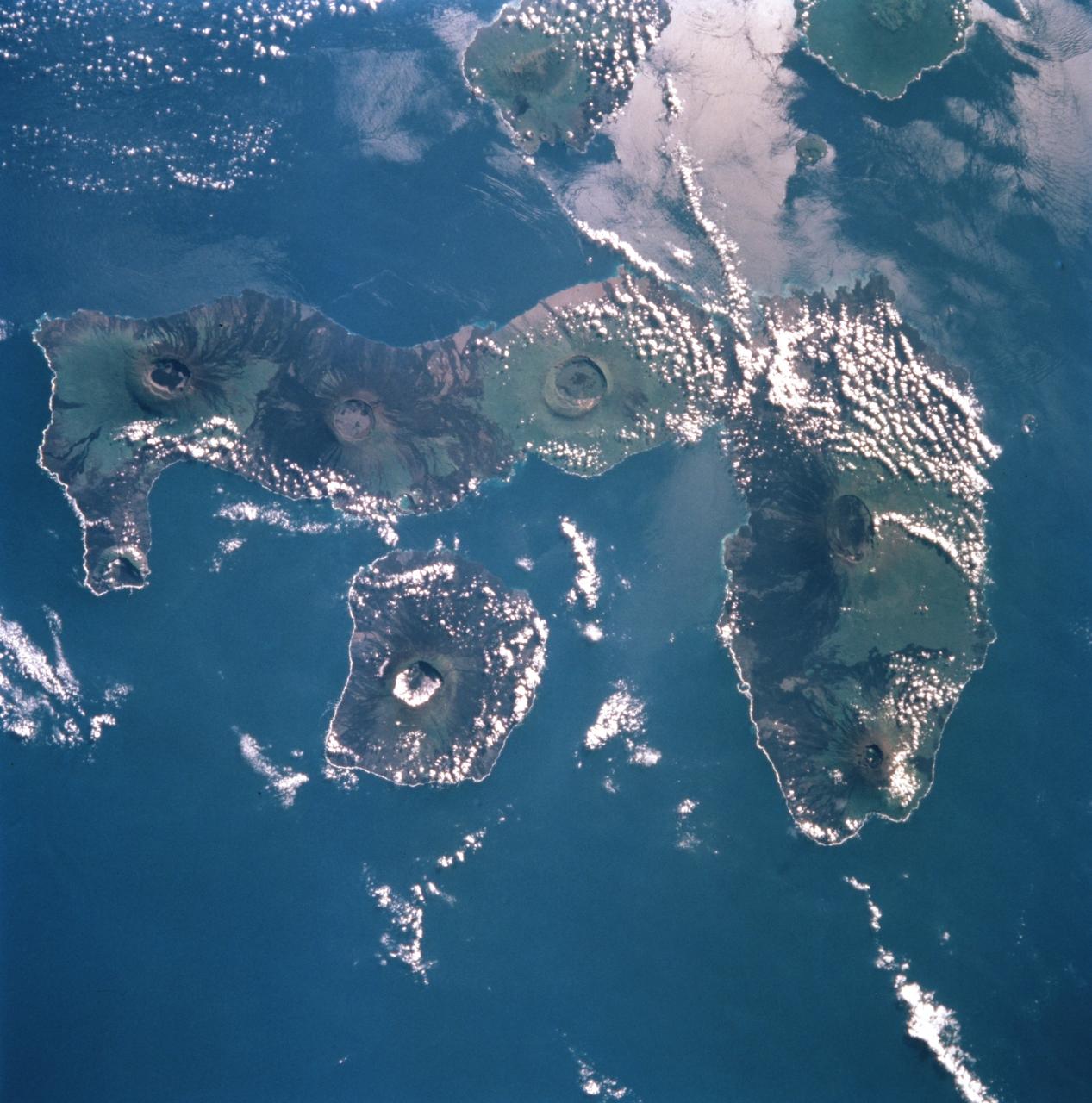
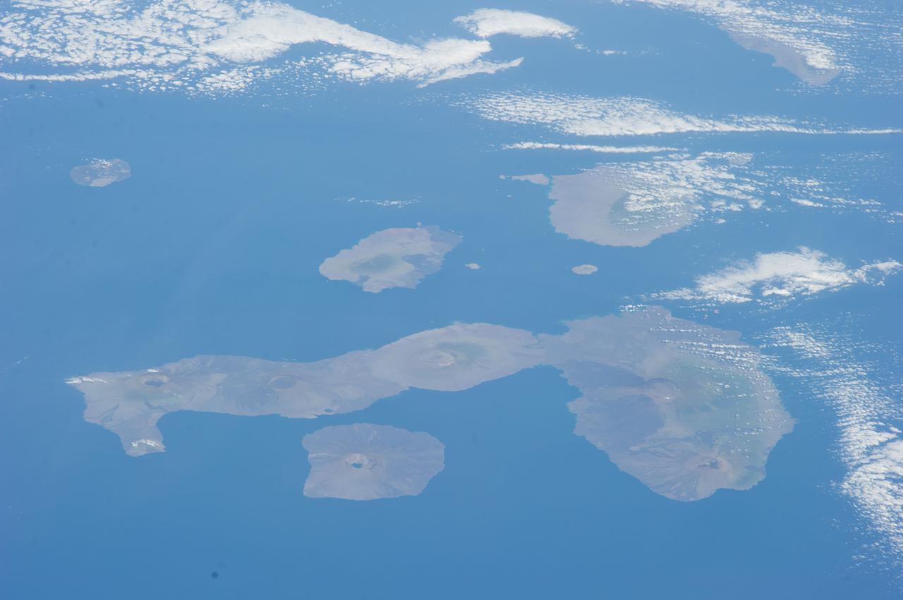
STS099-753-032 (11-22 February 2000) ---This 70mm photograph, photographed from the Space Shuttle Endeavour, centers on the two westernmost Galapagos Islands--seahorse-shaped Isla Isabela and the smaller round Isla Fernandina to its west. All of the 19 islands in the chain are volcanic in origin, and the craters of several of the shield volcanoes are visible as circular features on each of the islands. The two islands shown in this picture contain the most active volcanoes of the Galapagos. Fernandina last erupted in January-February 1995, with red-hot lava pouring into the sea. After 20 years of inactivity, Cerro Azul on Isla Isabela, last erupted in September-October 1998. Cerro Azul is the southwesternmost volcano on Isla Isabela. At 82 miles long, Isla Isabela is the largest of the islands, and comprises half of the land area of the archipelago. The islands are famous for their unique flora and fauna. Charles Darwin's observations of these species in 1835 contributed to the formation of his ideas on natural selection. Some of the most unique species include flightless cormorants, Galapagos penguins, giant land tortoises, and Galapagos finches. The range of Galapagos penguins is restricted to these western islands where upwelling enriches the ocean productivity, and the adaptation of a typically Antarctic bird family to the equator is an ecological marvel. Giant land tortoises are thought to have the oldest lifespans of any animal on Earth, but, scientists say, they have been driven near to extinction. During the most recent eruption of Cerro Azul, one tortoise was killed and many had to be relocated. The 13 species of Galapagos finches on the islands, although varied in form and lifestyle, are the descendants of an ancestor that happened to colonize this isolated archipelago. The human population of the entire archipelago is about 10,000.
ISS037-E-011470 (14 Oct. 2013) --- Man-made archipelagos near Dubai, United Arab Emirates, are featured in this image photographed by an Expedition 37 crew member on the International Space Station, flying at approximately 220 miles above Earth. The municipality of Dubai is the largest city of the Persian Gulf emirate of the same name, and has built a global reputation for large-scale developments and architectural works. Among the most visible of these developments -- particularly from the perspective of astronauts onboard the space station -- are three man-made archipelagos. The two Palm Islands -- Palm Jumeirah (right) and Palm Jebel Ali (out of frame further to the right) -- appear as stylized palm trees when viewed from above. The World Islands (center frame) evoke a rough map of the world from an air- or space-borne perspective. The Palm Jumeirah project began in 2001 and required more than 50 million cubic meters of dredged sand to raise the islands above the Persian Gulf sea level. Construction of the Palm Jumeirah islands was completed in 2006; for several years now they have been developed for residential and commercial housing and infrastructure. Creation of the World Islands was begun in 2003 and completed in 2008, using 320 million cubic meters of sand and 37 million tons of rock for the surrounding 27 kilometer-long protective breakwater.
ISS039-E-011515 (13 April 2014) --- Man-made archipelagos near Dubai, United Arab Emirates, are featured in this image photographed by an Expedition 39 crew member on the International Space Station, flying at 220 miles above Earth. The municipality of Dubai is the largest city of the Persian Gulf emirate of the same name, and has built a global reputation for large-scale developments and architectural works. Among the most visible of these developments -- particularly from the perspective of astronauts onboard the ISS -- are three man-made archipelagos. The two Palm Islands -- Palm Jumeirah to the left of center, and Palm Jebel Ali, just to the right of center, appear as stylized palm trees when viewed from above. The World Islands (near left edge) evoke a rough map of the world from an air- or space-borne perspective. The Palm Jumeirah project began in 2001 and required more than 50 million cubic meters of dredged sand to raise the islands above the Persian Gulf sea level. Construction of the Palm Jumeirah islands was completed in 2006; they are now being developed for residential and commercial housing and infrastructure. Creation of the World Islands was begun in 2003 and completed in 2008, using 320 million cubic meters of sand and 37 million tons of rock for the surrounding 27 kilometer-long protective breakwater.
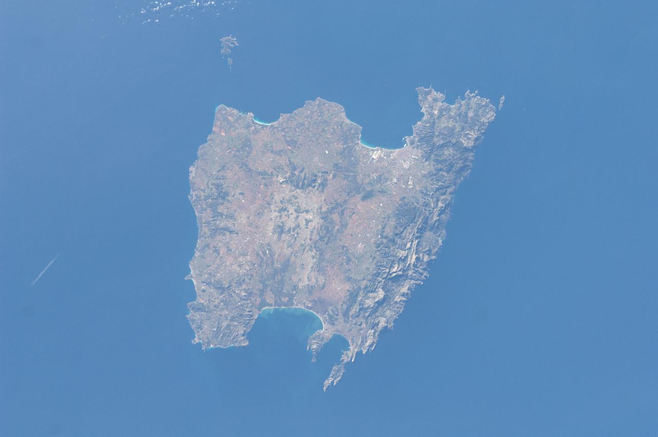
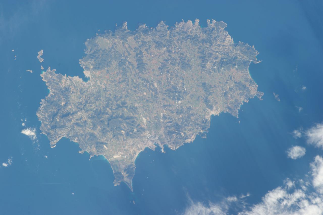
ISS030-E-030290 (31 Dec. 2011) --- Majorca in the Balearic Islands (Spain) is featured in this image photographed by an Expedition 30 crew member aboard the International Space Station. The Balearic Islands are an archipelago located to the southwest of Spain in the Mediterranean Sea. Catalan – the native tongue – and Spanish are the official languages. The islands are an autonomous community and province of Spain, located approximately midway between the southeastern coastline of Spain and the northern coastline of Algeria. This photograph highlights the large island of Majorca (approximately 5,400 square kilometers; also known as Mallorca in Spanish) on which the capital city of Palma is located (center). The small island of Cabrera to the southwest of Majorca (upper left) hosts the Parc Nacional de l’Arxipelag de Cabrera (site mainly in Spanish). Like the other Balearic Islands, Majorca is a popular holiday destination for the European community with tourism forming a major part of the island’s economy. The island’s physiography offers many recreational opportunities – mountainous regions are present along the northwest coastline and eastern third, while much of the central part of the island is flat. Diving is also a popular activity. The central region includes agricultural lands (tan, light brown, and green, center), forested patches and corridors (dark green, center), and urban centers (gray). In addition to Majorca, the other major islands of the archipelago include Ibiza, Formentera, and Minorca.
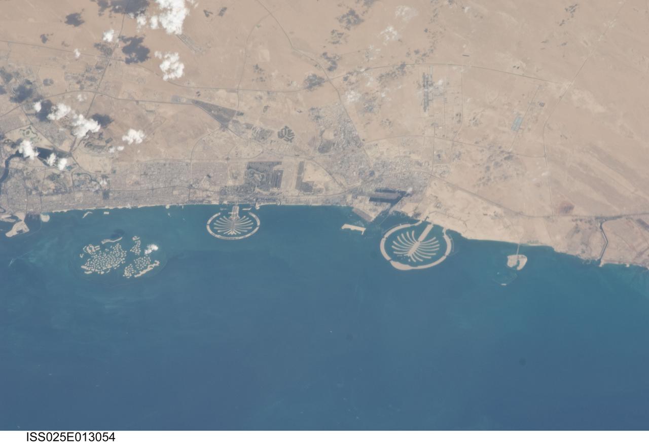
ISS025-E-013054 (7 Nov. 2010) --- Man-made archipelagos near Dubai, United Arab Emirates, are featured in this image photographed by an Expedition 25 crew member on the International Space Station, flying at 220 miles above Earth. The municipality of Dubai is the largest city of the Persian Gulf emirate of the same name, and has built a global reputation for large-scale developments and architectural works. Among the most visible of these developments -- particularly from the perspective of astronauts onboard the ISS -- are three man-made archipelagos. The two Palm Islands -- Palm Jumeirah to the left of center, and Palm Jebel Ali, just to the right of center, appear as stylized palm trees when viewed from above. The World Islands (near left edge) evoke a rough map of the world from an air- or space-borne perspective. The Palm Jumeirah project began in 2001 and required more than 50 million cubic meters of dredged sand to raise the islands above the Persian Gulf sea level. Construction of the Palm Jumeirah islands was completed in 2006; they are now being developed for residential and commercial housing and infrastructure. Creation of the World Islands was begun in 2003 and completed in 2008, using 320 million cubic meters of sand and 37 million tons of rock for the surrounding 27 kilometer-long protective breakwater.
STS006-45-097 (4-9 April 1983) --- This photograph was taken with a handheld 70mm camera aimed through the “ceiling” windows of the Earth-orbiting space shuttle Challenger during its five-day STS-6 mission. A beautiful photo shows the contrast between the islands, clouds, shallow water and deep water. Islands of the Bahamas seen are New Providence (upper left) and Eleuthera (right). Northeast Providence Channel is at the upper edge and Exuma Sound is at the lower left with the open Atlantic along the right edge. The wind, from the south, causes a long cloud to develop downwind from Eleuthera Point. Photo credit: NASA
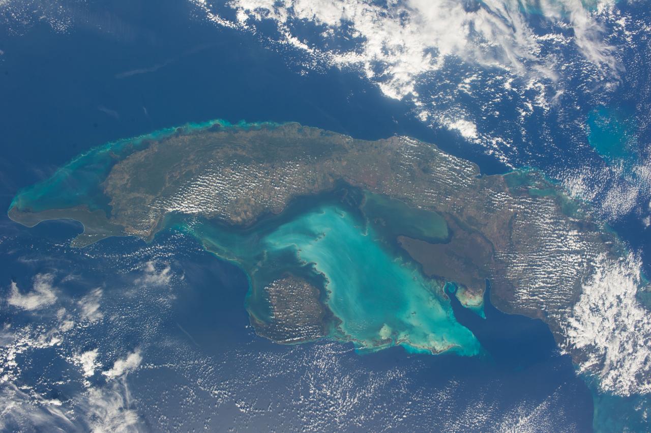
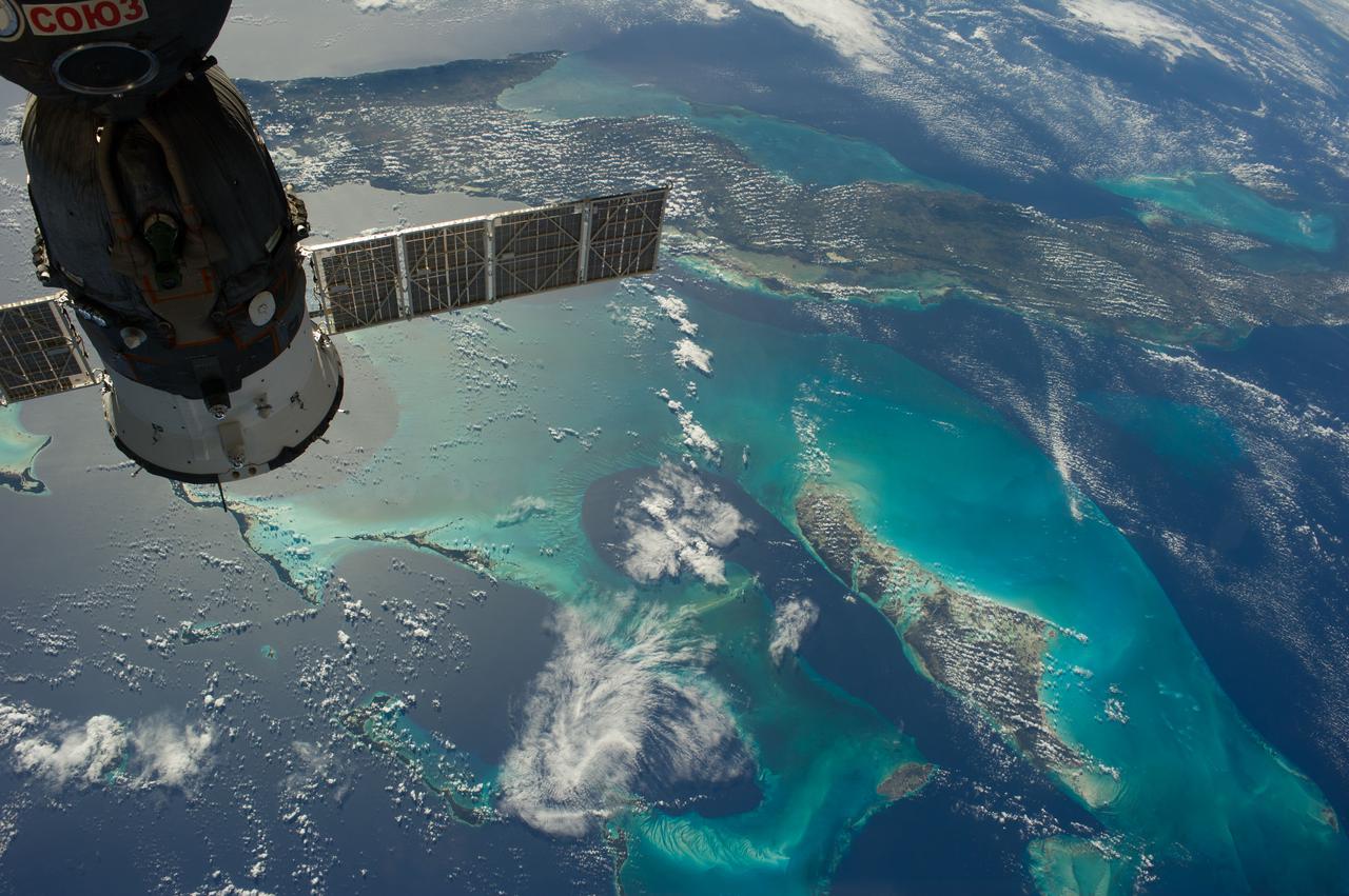
ISS038-E-021397 (24 Dec. 2013) --- The Caribbean country of Cuba is pictured in this nadir image, photographed by one of the Expedition 38 crew members aboard the International Space Station. (Note: North is at the top of the picture.) Cuba is an archipelago of islands in the northern Caribbean Sea at the confluence with the Gulf of Mexico and the Atlantic Ocean. In the southeast, the dark coastal area is home to the Sierra Maestra mountains. It is the highest mountain range on the island, with Pico Turquino reaching nearly 2000 meters. On the central southern coast of the island is the Sierra Del Escambray mountain range, including the 1160 meter-high Pico San Juan, Cuba's second highest peak.
STS093-717-066 (23-27 July 1999) --- The STS-93 astronauts aboard the Space Shuttle Columbia took this picture featuring the Society Islands. Delicate coral reefs ring the islands of Bora Bora (top), Tahaa (center) and Raiatea (bottom). The Society Islands, which also include the island of Tahiti, are one of many archipelagoes that constitute French Polynesia in the central South Pacific. When the photo was taken, the shuttle was flying over a point located at 16.2 degrees south latitude and 151.8 degrees west longitude. Data back information on the 70mm listed the time and date as 23:36:16 GMT, July 25, 1999 (Orbit 45).

ISS013-E-74843 (2 Sept. 2006) --- Rio Negro in Amazonia, Brazil is featured in this image photographed by an Expedition 13 crewmember onboard the International Space Station. The wide, multi-island zone in the Rio Negro (Black River) shown in this image is one of two, long "archipelagoes" upstream of the city of Manaus (not shown) in central Amazonia. Ninety kilometers of the total 120 kilometers length of this archipelago appear in this view. On the day the photo was taken, air temperatures over the cooler river water of the archipelago were just low enough to prevent cloud formation. Over the neighboring rainforest, temperatures were warm enough to produce small convection-related clouds, known to pilots as "popcorn" cumulus. Several zones of deforestation, represented by lighter green zones along the river banks, are also visible. Two different types of river appear in this image. Flowing east-southeast (left to right) is the multi-island, Rio Negro, 20 kilometers wide near the right of the view. Two other "black" rivers, Rio Caures and Rio Jufari, join Rio Negro downstream. The second river type is the Rio Branco (White River; right) which is the largest tributary of the Rio Negro. The difference in water color is controlled by the source regions: black-water rivers derive entirely from soils of lowland forests. Water in these rivers has the color of weak tea, which appears black in images from space. By contrast, white-water rivers like the Branco carry a load of sand and mud particles, mudding the waters. The reason for the tan color is that white-water rivers rise in mountainous country where headwater streams erode exposed rock. The Amazon itself rises in the Andes Mts., where very high erosion occurs, and it is thus the most famous white river in Amazonia. This image was taken in September, near low-water stage. Pictures taken at other times show the channels much wider during high-water season (May--July) when water levels rise several meters. It was discovered recently, from high resolution GPS measurements at Manaus, that the land surface actually rises vertically a small amount in compensation when this vast mass of water drains away each season. Although small, the vertical displacement--50-70 mm--was unexpectedly large according to the scientists who performed the study.
The Democratic Republic of Sao Tome and Principe is an island country in the Gulf of Guinea, off the western equatorial coast of central Africa. It is the second smallest African sovereign state, and consists of two archipelagos around the two main islands, about 150 km apart. About 100 years ago, this twin-island nation was the biggest producer of chocolate in the world. Now several producers are seeking to revitalize the trade. The images were acquired May 25, 2018 (Sao Tome, left), and April 5, 2020 (Principe, right); cover areas of 42 by 49.5 km, and 18.3 by 20.1 km; and are located at 0.2 degrees north, 6.6 degrees east; and 1.6 degrees north, 7.4 degrees east. https://photojournal.jpl.nasa.gov/catalog/PIA25981
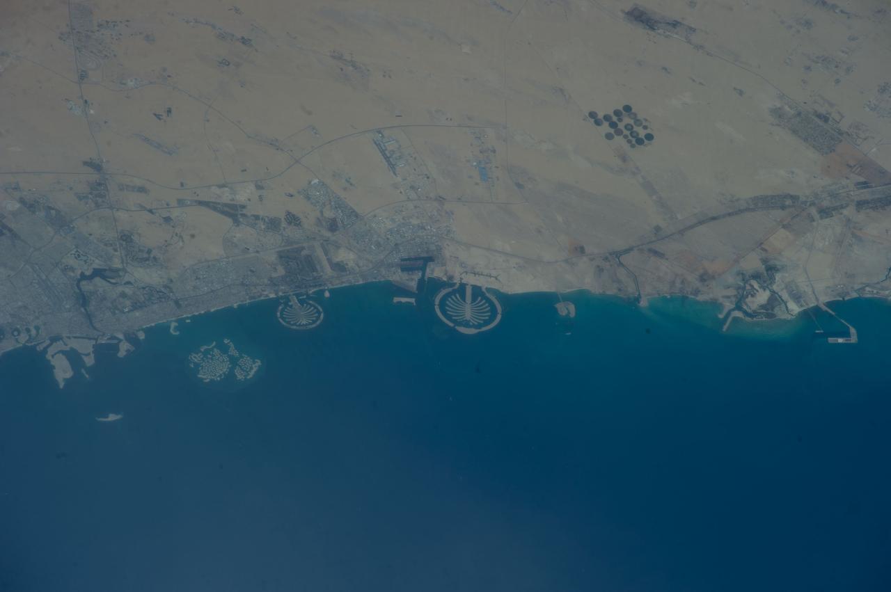
ISS040-E-125332 (4 Sept. 2014) --- Palm Jumeirah, protruding off the Persian Gulf Coast of Dubai in the United Arab Emirates, is featured in this 800mm photograph, taken by one of the Expedition 40 crew members aboard the International Space Station. The municipality of Dubai is the largest city of the Persian Gulf emirate of the same name, and has built a global reputation for large-scale developments and architectural works. Among the most visible of these developments ? particularly from the perspective of crew members onboard the space station ? are three man-made archipelagos. The two Palm Islands (Palm Jumeirah and Palm Jebel Ali, which is not in this frame) appear as stylized palm trees when viewed from above. The World Islands evoke a rough map of the world from an air- or space-borne perspective. A very small part of the World Islands is seen in upper left corner.
ISS006-E-51456 (2003) --- Marias Islands, Mexico is featured in this image photographed by an Expedition Six crewmember on the International Space Station. The view shows the land-sea interactions along a section of Mexico's west coast just south of Mazatlan and the Isla Marias archipelago. The islands are a manifestation of intersecting plate boundaries -- the East Pacific Rise spreading center that traces south from the Gulf of California, and the subduction zone that consumes the Cocos plate beneath southern Mexico. These islands are biologically important: they comprise the Islas Marias Biosphere Reserve and contain endemic species of raccoons and rabbits, and important habitat for birds and marine life. Between the islands and the mainland, swirling surface currents are highlighted by the sun glint reflecting off the ocean surface. Along the Mexican coast, water flows out from a coastal lagoon, and near shore currents carry sediment (light colored water) along the beach front.

ISS030-E-099324 (22 Feb. 2012) --- City lights of Dubai, United Arab Emirates are featured in this image photographed by an Expedition 30 crew member on the International Space Station. The City of Dubai?the largest metropolitan area within the emirate of Dubai?is a favorite subject of astronaut photography largely due to the unique island developments situated directly offshore in the Persian Gulf. These artificial archipelagos have been built such that their full design is only visible from the vantage point of an airplane ? or an orbiting spacecraft such as the International Space Station. The city presents an eye-catching appearance at night that vividly displays the urban development pattern. In this detailed nighttime image?taken with a long focal length lens and digital camera optimized for fast response and high light sensitivity?several interesting patterns can be observed. The highways and major streets are sharply defined by yellow-orange lighting, while the commercial and residential areas are resolved into a speckle pattern of individual white, blue, and yellow-orange lights. Several large and brilliantly lit areas are large hotel and mall complexes, including the Burj Khalifa Tower; at 828 meters (2,717 feet) height it is the world?s tallest building. The brilliant lighting of the city contrasts sharply with both the dark Persian Gulf to the northwest, and largely undeveloped and unlit areas to the southeast. Likewise, the clusters of lighting in the Palm Jumeira complex at bottom right correspond to the relatively small part of the archipelago that has been developed. Isolated areas of blurred city lights are due to patchy clouds.
ISS035-E-007431 (22 March 2013) --- One of the Expedition 35 crew members aboard the Earth-orbiting International Space Station used a digital camera equipped with a 400 millimeter lens to capture this image of the island of Ibiza (Eivissa in the native Catalan language), located off of the southeastern coast of Spain. Ibiza is part of the Balearic archipelago. Together with the neighboring island of Formentera (not shown), it comprises the Pine Islands of the western archipelago. The largest cities on the island, Ibiza Town, Sant Antoni de Portmany, and Santa Eularia des Riu, appear as white to pink regions near coastal bays in the image. Much of the lowland interior of the island is covered with green to light brown agricultural fields; some are still in active production for such crops as wheat, olives, and grapes but many fields are inactive and experiencing regrowth of native trees such as pine (Pinus halpensis) and savine (Juniperus phoenicea). The northern and southwestern coastlines are hilly (grey-brown regions), with the highest peak (Sa Talaia, 475 meters above sea level) located in the southwestern region. Like many of the Balearic Islands, the major industry of Ibiza is European tourism, and it is particularly well known for the nightlife of Ibiza Town and Sant Antoni de Portmany. Ships near Ibiza Town and a ship wake off the southwestern coastline are visible at image lower left. The island hosts a large variety of birds and lizards; however no large land fauna are present. The Mediterranean Sea to the southeast of the island appears dark in the image due to shadowing by clouds, just visible at the lower right corner of the image.
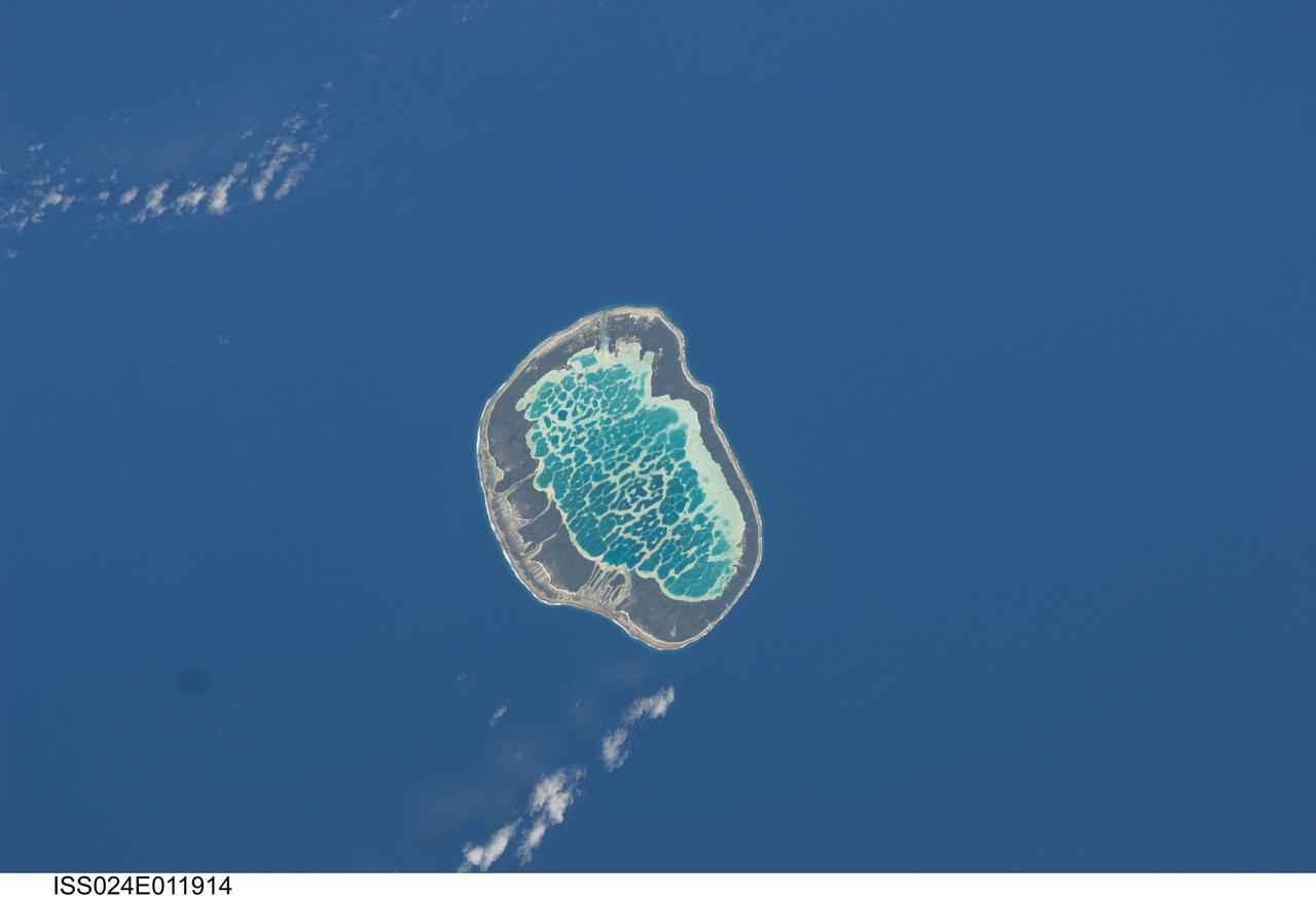
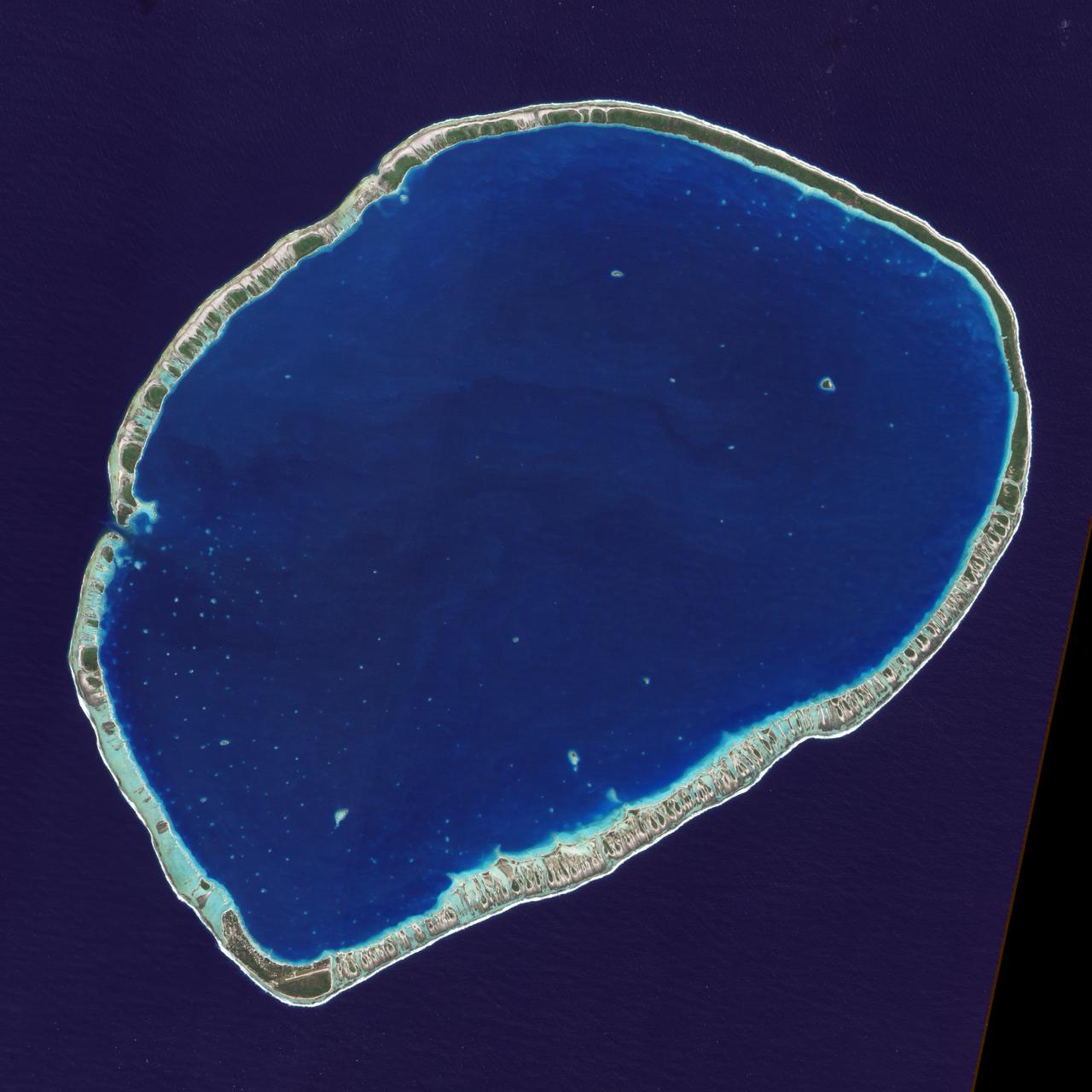
ISS024-E-011914 (13 Aug. 2010) --- Mataiva Atoll, Tuamotu Archipelago in the South Pacific Ocean is featured in this image photographed by an Expedition 24 crew member on the International Space Station. The Tuamotu Archipelago is part of French Polynesia, and forms the largest chain of atolls in the world. This photograph features Mataiva Atoll, the westernmost atoll of the Tuamotu chain. An atoll is a ring-shaped island that encloses a central lagoon. This distinctive morphology is usually associated with oceanic islands formed by volcanoes; coral reefs become established around the partially submerged volcanic cone. Over geologic time the central volcano becomes extinct, followed by erosion and subsidence beneath the sea surface, leaving the coral reefs as a ring around (or cap on) the submerged island remnant. Coral reefs exposed above the sea surface in turn experience erosion, sedimentation and soil formation, leading to the establishment of vegetation and complex ecosystems – including in many cases human habitation. Mataiva Atoll is notable in that its central lagoon includes a network of ridges (white, center) and small basins formed from eroded coral reefs. Mataiva means “nine eyes” in Tuamotuan, an allusion to nine narrow channels on the south-central portion of the island. The atoll is sparsely populated, with only a single village – Pahua – located on either side of the only pass providing constant connection between the shallow (light blue) water of the lagoon and the deeper (dark blue) adjacent Pacific Ocean. Much of the 10 kilometer-long atoll is covered with forest (greenish brown); vanilla and copra (dried coconut) are major exports from the atoll, but tourism is becoming a greater economic factor.
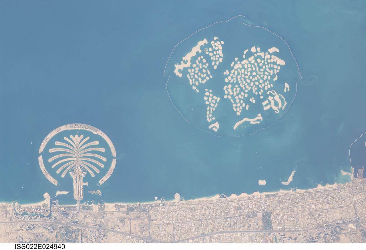
ISS022-E-024940 (13 Jan. 2010) --- Man-made archipelagos near Dubai, United Arab Emirates are featured in this image photographed by an Expedition 22 crew member on the International Space Station. The municipality of Dubai is the largest city of the Persian Gulf emirate of the same name, and has built a global reputation for large-scale developments and architectural works. Among the most visible of these developments ? particularly from the perspective of astronauts onboard the ISS ? are three man-made archipelagos. The two Palm Islands (Palm Jumeirah and Palm Jebel Ali) appear as stylized palm trees when viewed from above. The World Islands evoke a rough map of the world from an air- or space-borne perspective. Palm Jumeirah and the World Islands are highlighted in this view. Palm Jumeirah (lower left) was begun in 2001 and required more than 50 million cubic meters of dredged sand to raise the islands above the Persian Gulf sea level. Construction of the Palm Jumeirah islands was completed in 2006; they are now being developed for residential and commercial housing and infrastructure. Creation of the 300 World Islands (upper right) was begun in 2003 and completed in 2008, using 320 million cubic meters of sand and 37 million tons of rock for the surrounding 27 kilometer-long protective breakwater. Also visible at the lower edge of the image is another notable built structure ? the Burj Tower (white rectangle at lower right and inset image). The Burj Tower ? or Burj Khalifa ? stands 800 meters high, and is currently the world?s tallest structure. The photograph captures enough detail to make out the tapering outline of the building as well as its dark needle-like shadow pointing towards the northeast.
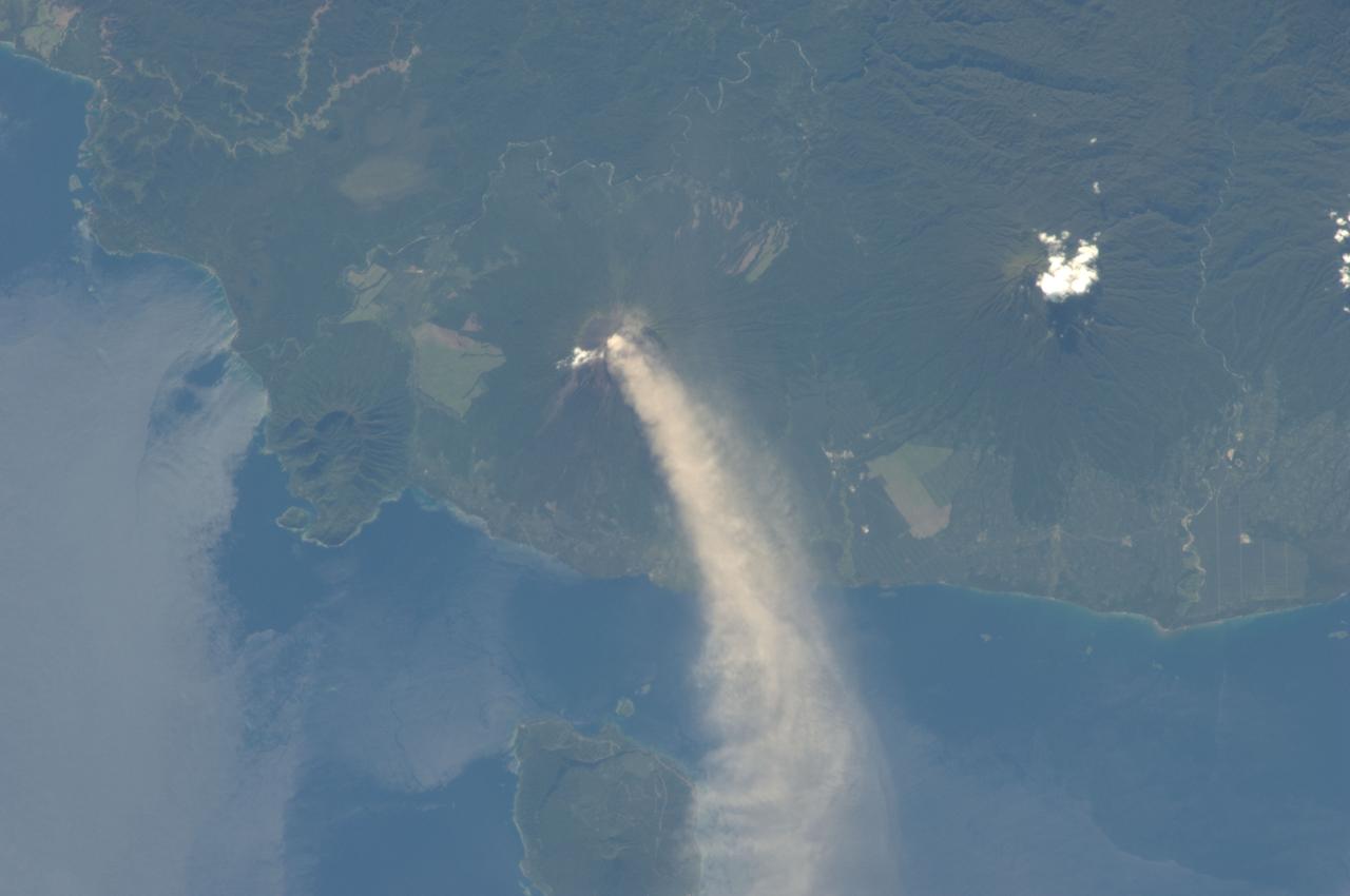
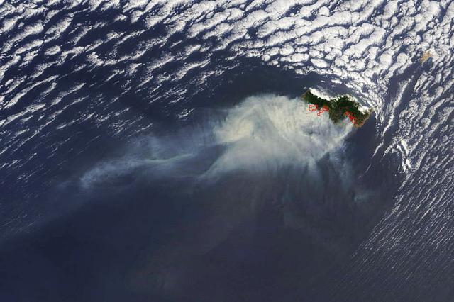
ISS034-E-005496 (30 Nov. 2012) --- An eruption at the Ulawun volcano, New Britain Island, Papua New Guinea is featured in this image photographed by an Expedition 34 crew member on the International Space Station. Numerous volcanoes contribute to the landmass of the island of New Britain, the largest in the Bismarck Archipelago of Papua New Guinea. One of the most active of these volcanoes, Ulawun, is also the highest with a summit elevation of 2,334 meters. This photograph was taken during the most recent phase of volcanic activity at Ulawun. A white steam and ash plume extends from the summit crater of the stratovolcano towards the northwest (center; note the image is oriented such that north is towards the lower left). The plume begins to broaden as it passes the southwestern coast of Lolobau Island approximately 23 kilometers downwind from its source. Ulawun volcano is also known as “the Father”, with the Bamus volcano to the southwest also known as “the South Son”. The summit of Bamus is obscured by white cumulus clouds (not of volcanic origin) in this image. While Ulawun has been active since at least 1700, the most recent eruptive activity at Bamus occurred in the late 19th century. A large region of ocean surface highlighted by sunglint – sunlight reflecting off the water surface, lending it a mirror-like appearance– is visible to the north-northeast of Ulawun (lower left).
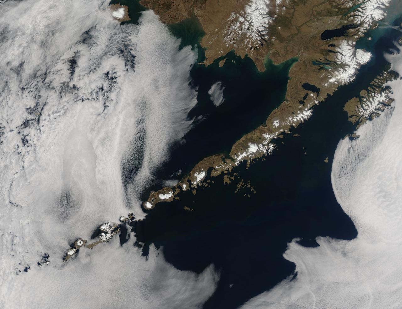
Remote, rugged and extraordinarily beautiful, Alaska’s Aleutian Islands are best known for wildlife reserves, military bases, fishing, furs and fog. The sprawling volcanic archipelago was brought into the spotlight by the Russian-supported expedition of Alexey Chirikov and Vitus Bering in 1741, and soon became controlled by the Russian-American Fur Company. In 1867 the United States purchased Alaska, including the Aleutian Islands, from Russia. By 1900 the port in Unalaska was well established as a shipping port for Alaska gold. The archipelago sweeps about 1,200 miles (1,800 km) from the tip of the Alaskan Peninsula to Attu, the most westward island. Four major island groups hold 14 large islands, about 55 smaller islands, and a large number of islets, adding up to roughly 150 islands/islets in total. This chain separates the Bering Sea (north) from the Pacific Ocean (south) and the islands are connected by the Marine Highway Ferry – at least as far as Unalaska. For the most remote islands, such as birding paradise of Attu, the western-most Aleutian Island, travel becomes trickier and relies primarily on custom charter. The Moderate Resolution Imaging Spectroradiometer (MODIS) flew over the region and captured this spectacular true-color image of the eastern Aleutian Islands on May 15, 2014. In this image, the Alaskan Peninsula protrudes from the mainland and sweeps to the southwest. The first set of islands are called the Fox Island group. Unalaska Island is part of this group and can be identified, with some imagination, as an island formed in the shape of a flying cherub, with two arms (peninsulas) outstretched towards the northeast, seemingly reaching for the round “balls” of Akutan and Akun Islands. The smallest islands in the west of the image belong to the group known as the Islands of Four Mountains. The Aleutians continue far to the west of this image. Fog surrounds the Aleutians, stretching from just off the southwestern Alaska mainland to the western Fox Islands group, then further southwest across the Pacific Ocean. It appears to give way to marine stratocumulus clouds in the west. Fog is common in the area, and can be a hazard to shipping. Credit: NASA/GSFC/Jeff Schmaltz/MODIS Land Rapid Response Team <b><a href="http://www.nasa.gov/audience/formedia/features/MP_Photo_Guidelines.html" rel="nofollow">NASA image use policy.</a></b> <b><a href="http://www.nasa.gov/centers/goddard/home/index.html" rel="nofollow">NASA Goddard Space Flight Center</a></b> enables NASA’s mission through four scientific endeavors: Earth Science, Heliophysics, Solar System Exploration, and Astrophysics. Goddard plays a leading role in NASA’s accomplishments by contributing compelling scientific knowledge to advance the Agency’s mission. <b>Follow us on <a href="http://twitter.com/NASAGoddardPix" rel="nofollow">Twitter</a></b> <b>Like us on <a href="http://www.facebook.com/pages/Greenbelt-MD/NASA-Goddard/395013845897?ref=tsd" rel="nofollow">Facebook</a></b> <b>Find us on <a href="http://instagram.com/nasagoddard?vm=grid" rel="nofollow">Instagram</a></b>
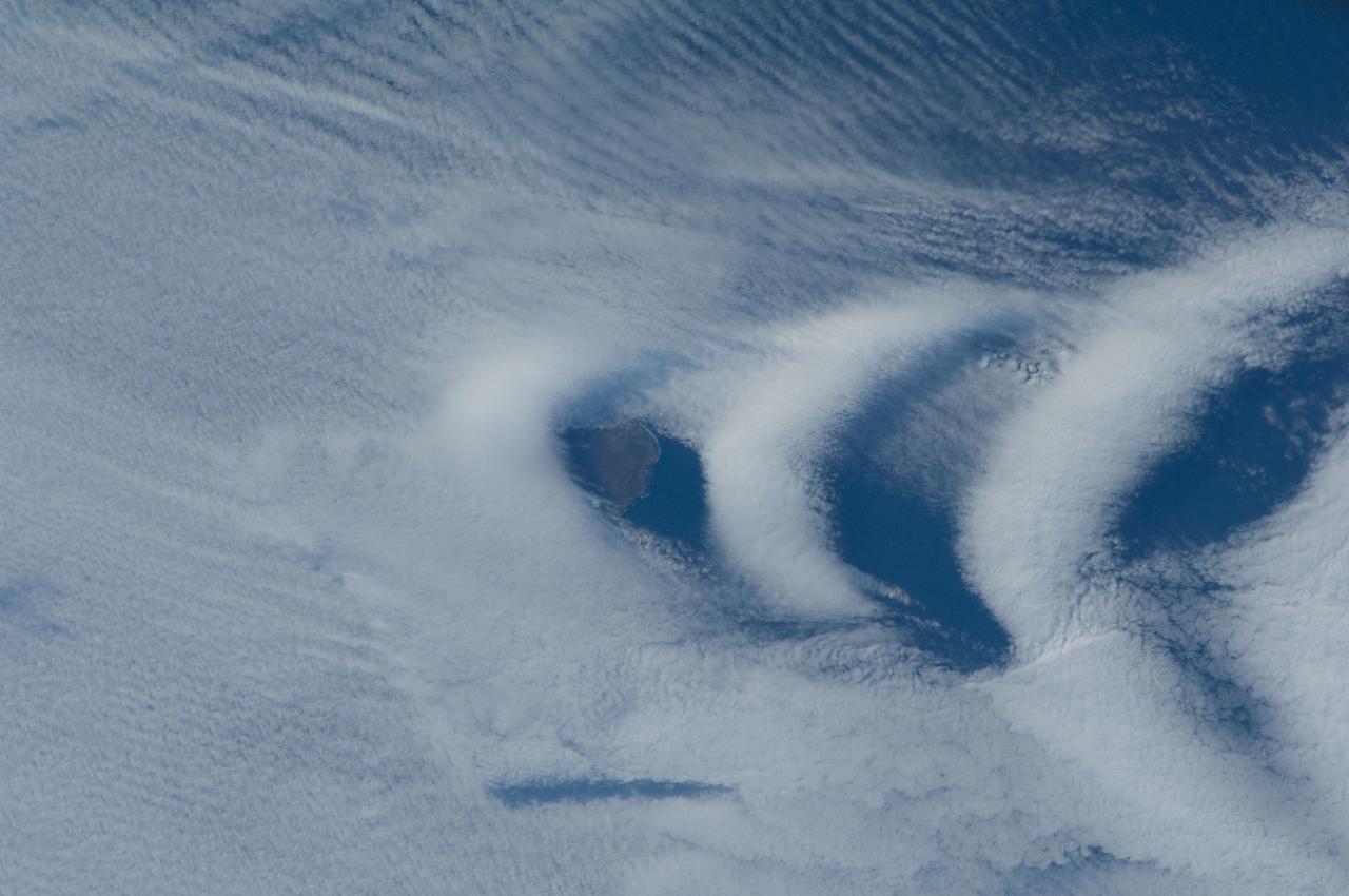
ISS030-E-193144 (25 March 2012) --- Wave clouds near Ile aux Cochons are featured in this image photographed by an Expedition 30 crew member on the International Space Station. This photograph illustrates the formation of wave clouds in the wake—or downwind side—of Ile aux Cochons (“Isle of Pigs”) located in the Southern Indian Ocean. The island is approximately located 3,000 kilometers southeast of the southern tip of the African continent and 2,300 kilometers northwest of Antarctica. The island itself, of which only a part of the eastern coastline is visible at center, is volcanic in origin with a summit elevation of 775 meters above sea level. According to scientists, the Ile aux Cochons stratovolcano is thought to have erupted within the last 12,000 years; however no historical activity has been recorded. The summit elevation is high enough for the land surface to interact with cloud layers and winds flowing past the island. Two major cloud layers are visible; a lower, more uniform layer consists of roughly parallel cloud “streets” that suggest a westerly flow pattern of air. When the air mass encounters the Ile aux Cochons, moisture-laden air rises and cools, causing more water vapor to condense into clouds. As the air mass passes over the summit of Ile aux Cochons and descends, it may encounter alternating moist and dry air layers, enabling the formation of the discontinuous chevron-shaped wave clouds in the wake of the island. While their appearance suggests that the clouds are forming in the wake of the island and moving eastwards, in fact it is the air mass that is moving, with clouds forming in regions of moist air and dissipating in dry regions. Ile aux Cochons is the westernmost of the islands that form the subantarctic Crozet Archipelago (part of the French Southern and Antarctic Lands). Accept for occasional research visits, the island is uninhabited. The island is an important breeding site for seabirds, including the world’s largest King Penguin colony.
Chausey is a group of small islands and islets off the coast of Normandy and is part of the French Channel Islands. Chausey bounced back and forth between England and France for 800 years before finally officially belonging to France in the 19th century. The archipelago comprises 365 islands at low tide (2019 image), compared to only 52 islands at high tide (2018 image). The images were acquired July 7, 2018 and September 10, 2019, cover an area of 6.7 by 10.5 km, and are located at 48.9 degrees north, 1.8 degrees west. With its 14 spectral bands from the visible to the thermal infrared wavelength region and its high spatial resolution of about 50 to 300 feet (15 to 90 meters), ASTER images Earth to map and monitor the changing surface of our planet. ASTER is one of five Earth-observing instruments launched Dec. 18, 1999, on Terra. The instrument was built by Japan's Ministry of Economy, Trade and Industry. A joint U.S./Japan science team is responsible for validation and calibration of the instrument and data products. The broad spectral coverage and high spectral resolution of ASTER provides scientists in numerous disciplines with critical information for surface mapping and monitoring of dynamic conditions and temporal change. Example applications are monitoring glacial advances and retreats; monitoring potentially active volcanoes; identifying crop stress; determining cloud morphology and physical properties; wetlands evaluation; thermal pollution monitoring; coral reef degradation; surface temperature mapping of soils and geology; and measuring surface heat balance. https://photojournal.jpl.nasa.gov/catalog/PIA25800
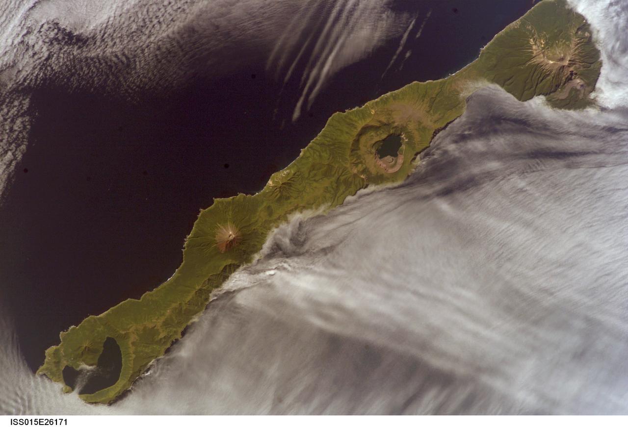
ISS015-E-26171 (1 Sept. 2007) --- Simushir Island, Kuril Archipelago, Russian Far East, is featured in this image photographed by an Expedition 15 crewmember on the International Space Station. Simushir is a deserted, 5-mile-wide volcanic island in the Kuril island chain, half way between northern Japan and the Kamchatka Peninsula of Russia. Four volcanoes - Milne, Prevo, Urataman and Zavaritski - have built cones that are high enough to rise above the altitude of green forest. The remaining remnant of Zavaritski volcano is a caldera -- a structure formed when a volcano collapses into its emptied magma chamber. A small lake fills the innermost of three nested calderas which make up Zavaritski Caldera. The larger caldera of Urataman Volcano is connected to the sea. A defunct Soviet naval base occupies the northern tip of the island next to this caldera. The islands and volcanoes of the Kuril chain are part of the Pacific Rim of Fire, marking the edge of the Pacific tectonic plate. Low stratus clouds approaching from the northwest (from the Sea of Okhotsk--top left) bank up against the northwest side of the island, making complex cloud patterns. A small finger of cloud can be seen entering the northernmost caldera (Urataman) at sea level. When this image was taken, the cloud layer had stopped at the northwest coast of the island, not flowing over even the low points of the island between the volcanoes. The cloud pattern suggests that the air mass flowed up and over the island, descending on the southeast side. This descending motion was enough--under stable atmospheric conditions--to warm up the atmosphere locally so that a cloud-free zone formed on the southeastern, lee side of the island.
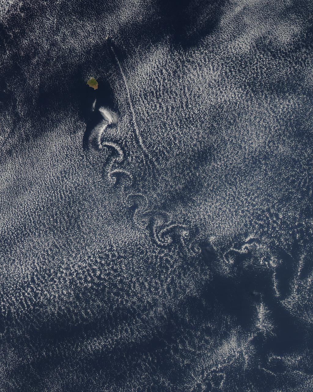
Theodore von Kármán, a Hungarian-American physicist, was the first to describe the physical processes that create long chains of spiral eddies like the one shown above. Known as von Kármán vortices the patterns can form nearly anywhere that fluid flow is disturbed by an object. Since the atmosphere behaves like a fluid, the wing of an airplane, a bridge, even an island can trigger the distinctive phenomenon. On May 22, 2013, the Moderate Resolution Imaging Spectroradiometer (MODIS) on NASA’s Terra satellite captured this natural-color image of cloud vortices behind Isla Socorro, a volcanic island located in the Pacific Ocean. The island, which is located a few hundred kilometers off the west coast of Mexico and the southern tip of Baja California, is part of the Revillagigedo Archipelago. Satellite sensors have spotted von Kármán vortices around the globe, including off of Guadalupe Island, near the coast of Chile, in the Greenland Sea, in the Arctic, and even next to a tropical storm. NASA image courtesy Jeff Schmaltz, LANCE/EOSDIS MODIS Rapid Response Team at NASA GSFC. Caption by Adam Voiland. Instrument: Terra - MODIS More info: <a href="http://1.usa.gov/14VSDQa" rel="nofollow">1.usa.gov/14VSDQa</a> Credit: <b><a href="http://www.earthobservatory.nasa.gov/" rel="nofollow"> NASA Earth Observatory</a></b> <b><a href="http://www.nasa.gov/audience/formedia/features/MP_Photo_Guidelines.html" rel="nofollow">NASA image use policy.</a></b> <b><a href="http://www.nasa.gov/centers/goddard/home/index.html" rel="nofollow">NASA Goddard Space Flight Center</a></b> enables NASA’s mission through four scientific endeavors: Earth Science, Heliophysics, Solar System Exploration, and Astrophysics. Goddard plays a leading role in NASA’s accomplishments by contributing compelling scientific knowledge to advance the Agency’s mission. <b>Follow us on <a href="http://twitter.com/NASA_GoddardPix" rel="nofollow">Twitter</a></b> <b>Like us on <a href="http://www.facebook.com/pages/Greenbelt-MD/NASA-Goddard/395013845897?ref=tsd" rel="nofollow">Facebook</a></b> <b>Find us on <a href="http://instagram.com/nasagoddard?vm=grid" rel="nofollow">Instagram</a></b>
The islands and coral atolls of French Polynesia, located in the southern Pacific Ocean, epitomize the idea of tropical paradise: white sandy beaches, turquoise lagoons, and palm trees. Even from the distance of space, the view of these atolls is beautiful. This image from the Advanced Land Imager on NASA’s Earth Observing-1 (EO-1) satellite shows the southern part of Tikehau Atoll, one of the 78 coral atolls that make up the Tuamotu Archipelago. Patches of coral make star-like spots across the turquoise expanse of the lagoon. A line of tree-covered islets encircles the lagoon. At the southernmost tip of the atoll, a large islet accommodates a small village and an air strip. NASA image created by Jesse Allen, using EO-1 ALI data provided courtesy of the NASA EO-1 Team. Caption by Rebecca Lindsey. <b><a href="http://www.nasa.gov/audience/formedia/features/MP_Photo_Guidelines.html" rel="nofollow">NASA image use policy.</a></b> <b><a href="http://www.nasa.gov/centers/goddard/home/index.html" rel="nofollow">NASA Goddard Space Flight Center</a></b> enables NASA’s mission through four scientific endeavors: Earth Science, Heliophysics, Solar System Exploration, and Astrophysics. Goddard plays a leading role in NASA’s accomplishments by contributing compelling scientific knowledge to advance the Agency’s mission. <b>Follow us on <a href="http://twitter.com/NASAGoddardPix" rel="nofollow">Twitter</a></b> <b>Like us on <a href="http://www.facebook.com/pages/Greenbelt-MD/NASA-Goddard/395013845897?ref=tsd" rel="nofollow">Facebook</a></b> <b>Find us on <a href="http://instagrid.me/nasagoddard/?vm=grid" rel="nofollow">Instagram</a></b>
Smoke from several large fires burning on Portugal's Madeira Island were seen blowing over the Atlantic Ocean on Aug. 10 when NASA's Terra satellite passed overhead. Madeira is an archipelago of four islands located off the northwest coast of Africa. They are an autonomous region of Portugal. The Moderate Resolution Imaging Spectroradiometer (MODIS) on NASA’s Terra satellite captured this natural-color image at 8:25 a.m. EDT (12:05 UTC). Places where MODIS detected active fire are located in red. Image Credit: NASA Goddard's Rapid Response Team, Jeff Schmaltz <b><a href="http://www.nasa.gov/audience/formedia/features/MP_Photo_Guidelines.html" rel="nofollow">NASA image use policy.</a></b> <b><a href="http://www.nasa.gov/centers/goddard/home/index.html" rel="nofollow">NASA Goddard Space Flight Center</a></b> enables NASA’s mission through four scientific endeavors: Earth Science, Heliophysics, Solar System Exploration, and Astrophysics. Goddard plays a leading role in NASA’s accomplishments by contributing compelling scientific knowledge to advance the Agency’s mission. <b>Follow us on <a href="http://twitter.com/NASAGoddardPix" rel="nofollow">Twitter</a></b> <b>Like us on <a href="http://www.facebook.com/pages/Greenbelt-MD/NASA-Goddard/395013845897?ref=tsd" rel="nofollow">Facebook</a></b> <b>Find us on <a href="http://instagrid.me/nasagoddard/?vm=grid" rel="nofollow">Instagram</a></b>
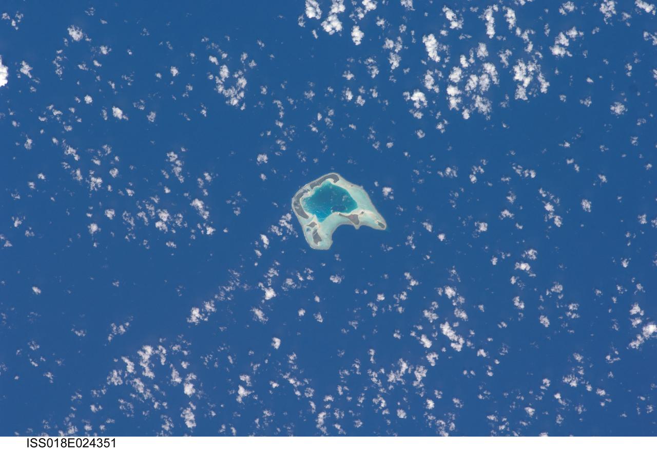
ISS018-E-024351 (27 Jan. 2009) --- Tetiaroa Island in French Polynesia is featured in this image photographed by an Expedition 18 crewmember on the International Space Station. This island, part of the Society Islands archipelago in the southern Pacific Ocean, is also known as ?Marlon Brando?s Island?. The late film star purchased the island ? more correctly, an atoll comprised of thirteen small islets (or motus) from the French Polynesian government for a total of 70,000 over 1966-1967. While the motus were his property, the government retained the rights to the coral reefs and lagoons to preserve control of marine resources. Following Brando?s death in 2004, ownership of the approximately 8 kilometers?wide atoll passed into other private hands, and there are now plans to build a luxury resort amongst the islets. This view illustrates the typical circular appearance of a fully-developed atoll. The ring of islands ? covered in green vegetation and white to tan sandy beaches ? develops on coral reefs, which originally form around a volcanic island. As the volcanic island gradually disappears due to subsidence and erosion, the coral reefs continue to grow upwards. Over time, the central volcanic island is completely submerged, leaving a ring of coral reefs and islands that surround a lagoon. The shallow lagoon waters appear blue-green in this image, and contrast with darker ? and deeper ? Pacific Ocean waters surrounding the atoll. One of the motus in the southern portion of the atoll, Tahuna Rahi, is a protected bird sanctuary, and is the nesting site of red- and brown-footed boobies, frigatebirds, and terns (among other species). Access to the atoll is via boat, as the airstrip was closed in 2004 due to safety and security concerns.
There was a time when the Northwest Passage was a sort of maritime Holy Grail, a route so desired and sought after, but so elusive. For most of the recorded history of North America, the Passage has been nearly impassable and often deadly. But with the modernization of ships and the warming of the Earth, cruising and sailing through the Canadian Archipelago from Baffin Bay to the Beaufort Sea has grown more common and easier. But it’s not necessarily easy. The top image above shows the Northwest Passage as it appeared on August 31, 2015, to the Visible Infrared Imaging Radiometer Suite (VIIRS) on the Suomi-NPP satellite. Read more: <a href="http://earthobservatory.nasa.gov/IOTD/view.php?id=86589" rel="nofollow">earthobservatory.nasa.gov/IOTD/view.php?id=86589</a> NASA Earth Observatory images by Jesse Allen, using VIIRS data from the Suomi National Polar-orbiting Partnership. Suomi NPP is the result of a partnership between NASA, the National Oceanic and Atmospheric Administration, and the Department of Defense. <b><a href="http://www.nasa.gov/audience/formedia/features/MP_Photo_Guidelines.html" rel="nofollow">NASA image use policy.</a></b> <b><a href="http://www.nasa.gov/centers/goddard/home/index.html" rel="nofollow">NASA Goddard Space Flight Center</a></b> enables NASA’s mission through four scientific endeavors: Earth Science, Heliophysics, Solar System Exploration, and Astrophysics. Goddard plays a leading role in NASA’s accomplishments by contributing compelling scientific knowledge to advance the Agency’s mission. <b>Follow us on <a href="http://twitter.com/NASAGoddardPix" rel="nofollow">Twitter</a></b> <b>Like us on <a href="http://www.facebook.com/pages/Greenbelt-MD/NASA-Goddard/395013845897?ref=tsd" rel="nofollow">Facebook</a></b> <b>Find us on <a href="http://instagrid.me/nasagoddard/?vm=grid" rel="nofollow">Instagram</a></b>

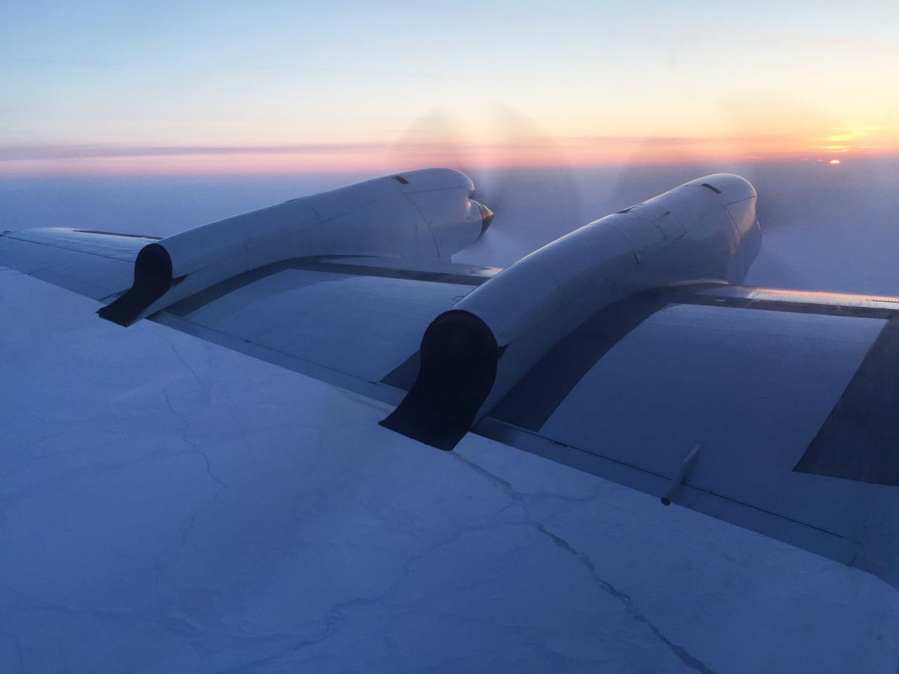
For the past eight years, Operation IceBridge, a NASA mission that conducts aerial surveys of polar ice, has produced unprecedented three-dimensional views of Arctic and Antarctic ice sheets, providing scientists with valuable data on how polar ice is changing in a warming world. Now, for the first time, the campaign will expand its reach to explore the Arctic’s Eurasian Basin through two research flights based out of Svalbard, a Norwegian archipelago in the northern Atlantic Ocean. More: <a href="http://go.nasa.gov/2ngAxX2" rel="nofollow">go.nasa.gov/2ngAxX2</a> Caption: Ellesmere Island mountain tops bathed in light as the sun began to peak over the horizon during Operation IceBridge’s first flight of its 2017 Arctic campaign, on March 9, 2017. Credits: NASA/Nathan Kurtz <b><a href="http://www.nasa.gov/audience/formedia/features/MP_Photo_Guidelines.html" rel="nofollow">NASA image use policy.</a></b> <b><a href="http://www.nasa.gov/centers/goddard/home/index.html" rel="nofollow">NASA Goddard Space Flight Center</a></b> enables NASA’s mission through four scientific endeavors: Earth Science, Heliophysics, Solar System Exploration, and Astrophysics. Goddard plays a leading role in NASA’s accomplishments by contributing compelling scientific knowledge to advance the Agency’s mission. <b>Follow us on <a href="http://twitter.com/NASAGoddardPix" rel="nofollow">Twitter</a></b> <b>Like us on <a href="http://www.facebook.com/pages/Greenbelt-MD/NASA-Goddard/395013845897?ref=tsd" rel="nofollow">Facebook</a></b> <b>Find us on <a href="http://instagrid.me/nasagoddard/?vm=grid" rel="nofollow">Instagram</a></b>
For the past eight years, Operation IceBridge, a NASA mission that conducts aerial surveys of polar ice, has produced unprecedented three-dimensional views of Arctic and Antarctic ice sheets, providing scientists with valuable data on how polar ice is changing in a warming world. Now, for the first time, the campaign will expand its reach to explore the Arctic’s Eurasian Basin through two research flights based out of Svalbard, a Norwegian archipelago in the northern Atlantic Ocean. More: <a href="http://go.nasa.gov/2ngAxX2" rel="nofollow">go.nasa.gov/2ngAxX2</a> Credits: NASA/Nathan Kurtz <b><a href="http://www.nasa.gov/audience/formedia/features/MP_Photo_Guidelines.html" rel="nofollow">NASA image use policy.</a></b> <b><a href="http://www.nasa.gov/centers/goddard/home/index.html" rel="nofollow">NASA Goddard Space Flight Center</a></b> enables NASA’s mission through four scientific endeavors: Earth Science, Heliophysics, Solar System Exploration, and Astrophysics. Goddard plays a leading role in NASA’s accomplishments by contributing compelling scientific knowledge to advance the Agency’s mission. <b>Follow us on <a href="http://twitter.com/NASAGoddardPix" rel="nofollow">Twitter</a></b> <b>Like us on <a href="http://www.facebook.com/pages/Greenbelt-MD/NASA-Goddard/395013845897?ref=tsd" rel="nofollow">Facebook</a></b> <b>Find us on <a href="http://instagrid.me/nasagoddard/?vm=grid" rel="nofollow">Instagram</a></b>

Typhoon Kilo continues to thrive in the Northwestern Pacific and imagery from NASA's Terra satellite late on September 7 showed that the storm still maintained a clear eye. The MODIS or Moderate Resolution Imaging Spectroradiometer instrument that flies aboard Terra provided a visible-light image of Kilo on September 7 at 23:50 UTC (7:50 p.m. EDT). The image showed thick bands of thunderstorms wrapping around the eastern and northern quadrants of the visible eye. At 0900 UTC (5 a.m. EDT) on September 9, Typhoon Kilo had maximum sustained winds near 65 knots (74.8 mph/120.4 kph). Kilo is expected to strengthen to 75 knots (86.3 mph/ 138.9 kph) later in the day before weakening. It was centered near 26.8 North latitude and 158.5 East longitude, about 289 nautical miles northeast of Minami Tori Shima, Japan. Kilo was moving to the west-northwest at 18 knots (20.7 mph/33.3 kph). The Joint Typhoon Warning Center noted that Kilo is expected to take more of a northerly track by September 10. Thereafter, Kilo is expected to become extra-tropical and curve to the northeast near the Kuril Islands in Russia's Sakhalin Oblast region. The islands form an 808 mile (1,300 kilometer) volcanic archipelago that stretches northeast from Hokkaido, Japan, to Kamchatka, Russia. For updated watches and warnings from the Japan Meteorological Agency, visit: <a href="http://www.jma.go.jp/en/warn/" rel="nofollow">www.jma.go.jp/en/warn/</a> <b><a href="http://www.nasa.gov/audience/formedia/features/MP_Photo_Guidelines.html" rel="nofollow">NASA image use policy.</a></b> <b><a href="http://www.nasa.gov/centers/goddard/home/index.html" rel="nofollow">NASA Goddard Space Flight Center</a></b> enables NASA’s mission through four scientific endeavors: Earth Science, Heliophysics, Solar System Exploration, and Astrophysics. Goddard plays a leading role in NASA’s accomplishments by contributing compelling scientific knowledge to advance the Agency’s mission. <b>Follow us on <a href="http://twitter.com/NASAGoddardPix" rel="nofollow">Twitter</a></b> <b>Like us on <a href="http://www.facebook.com/pages/Greenbelt-MD/NASA-Goddard/395013845897?ref=tsd" rel="nofollow">Facebook</a></b> <b>Find us on <a href="http://instagrid.me/nasagoddard/?vm=grid" rel="nofollow">Instagram</a></b>
NASA image acquired May 10, 2001 In July 2008, the United Nations Educational, Scientific, and Cultural Organization (UNESCO) added 27 new areas to its list of World Heritage sites. One of those areas included the lagoons of New Caledonia. Some 1,200 kilometers (750 miles) east of Australia, this French-governed archipelago contains the world’s third-largest coral reef structure. The coral reefs enclose the waters near the islands in shallow lagoons of impressive biodiversity. On May 10, 2001, the Enhanced Thematic Mapper Plus on NASA’s Landsat 7 satellite captured this image of Île Balabio, off the northern tip of Grande Terra, New Caledonia’s main island. In this natural-color image, the islands appear in shades of green and brown—mixtures of vegetation and bare ground. The surrounding waters range in color from pale aquamarine to deep blue, and the color differences result from varying depths. Over coral reef ridges and sand bars, the water is shallowest and palest in color. Darker shades of blue characterize deeper waters. Reef-enclosed, shallow waters surround Île Balabio, and a larger, semi-enclosed lagoon appears immediately east of that island. Immediately north of Grande Terra, unenclosed, deeper waters predominate. The coral reefs around New Caledonia support an unusual diversity of species, including large numbers of predators and big fish, turtles, and the world’s third-largest dugong population. NASA image created by Jesse Allen, using Landsat data provided by the United States Geological Survey. Caption by Michon Scott. Instrument: Landsat 7 - ETM+ Credit: NASA/GSFC/Landsat <b><a href="http://www.nasa.gov/centers/goddard/home/index.html" rel="nofollow">NASA Goddard Space Flight Center</a></b> enables NASA’s mission through four scientific endeavors: Earth Science, Heliophysics, Solar System Exploration, and Astrophysics. Goddard plays a leading role in NASA’s accomplishments by contributing compelling scientific knowledge to advance the Agency’s mission. <b>Follow us on <a href="http://twitter.com/NASA_GoddardPix" rel="nofollow">Twitter</a></b> <b>Join us on <a href="http://www.facebook.com/pages/Greenbelt-MD/NASA-Goddard/395013845897?ref=tsd" rel="nofollow">Facebook</a></b>

The Visible Infrared Imaging Radiometer Suite (VIIRS) on the Suomi NPP satellite captured this view of extensive sea-ice fracturing off the northern coast of Alaska. The event began in late-January and spread west toward Banks Island throughout February and March 2013. Visualizations of the Arctic often give the impression that the ice cap is a continuous sheet of stationary, floating ice. In fact, it is a collection of smaller pieces that constantly shift, crack, and grind against one another as they are jostled by winds and ocean currents. Especially during the summer—but even during the height of winter—cracks—or leads—open up between pieces of ice. That was what was happening on the left side of the animation (seen here: <a href="http://bit.ly/10kE7sh" rel="nofollow">bit.ly/10kE7sh</a>) in late January. A high-pressure weather system was parked over the region, producing warmer temperatures and winds that flowed in a southwesterly direction. That fueled the Beaufort Gyre, a wind-driven ocean current that flows clockwise. The gyre was the key force pulling pieces of ice west past Point Barrow, the northern nub of Alaska that protrudes into the Beaufort Sea. “A fracturing event in this area is not unusual because the Beaufort Gyre tends to push ice away from Banks Island and the Canadian Archipelago,” explained Walt Meier of the National Snow & Ice Data Center (NSIDC). “Point Barrow can act like a ‘pin point’ where the ice catches and fractures to the north and east.” In February, however, a series of storms passing over central Alaska exacerbated the fracturing. Strong westerly winds prompted several large pieces of ice to break away in an arc-shaped wave that moved progressively east. By the end of February, large pieces of ice had fractured all the way to the western coast of Banks Island, a distance of about 1,000 kilometers (600 miles). The data used to create the animation came from the longwave infrared (thermal) portion of the electromagnetic spectrum, so the animation illustrates how much heat the surface was emitting as VIIRS surveyed the area. Cooler areas (sea ice) appear white, while warmer areas (open water) are dark. The light gray plume near the cracks is warmer, moister air escaping from the ocean and blowing downwind. Clouds do not show up well in the VIIRS thermal band, so the storms that fueled the fracturing are not readily visible. While fracturing events are common, few events sprawl across such a large area or produce cracks as long and wide as those seen here. The age of the sea ice in this area was one of the key reasons this event became so widespread. “The region is covered almost completely by seasonal or first-year ice—ice that has formed since last September,” said Meier. “This ice is thinner and weaker than the older, multi-year ice, so it responds more readily to winds and is more easily broken up.” NASA Earth Observatory images by Jesse Allen using VIIRS day-night band data from the Suomi National Polar-orbiting Partnership. Suomi NPP is the result of a partnership between NASA, the National Oceanic and Atmospheric Administration, and the Department of Defense. Caption by Adam Voiland. Instrument: Suomi NPP - VIIRS For more info go to: <a href="http://earthobservatory.nasa.gov/IOTD/view.php?id=80752" rel="nofollow">earthobservatory.nasa.gov/IOTD/view.php?id=80752</a> Credit: <b><a href="http://www.earthobservatory.nasa.gov/" rel="nofollow"> NASA Earth Observatory</a></b> <b><a href="http://www.nasa.gov/audience/formedia/features/MP_Photo_Guidelines.html" rel="nofollow">NASA image use policy.</a></b> <b><a href="http://www.nasa.gov/centers/goddard/home/index.html" rel="nofollow">NASA Goddard Space Flight Center</a></b> enables NASA’s mission through four scientific endeavors: Earth Science, Heliophysics, Solar System Exploration, and Astrophysics. Goddard plays a leading role in NASA’s accomplishments by contributing compelling scientific knowledge to advance the Agency’s mission. <b>Follow us on <a href="http://twitter.com/NASA_GoddardPix" rel="nofollow">Twitter</a></b> <b>Like us on <a href="http://www.facebook.com/pages/Greenbelt-MD/NASA-Goddard/395013845897?ref=tsd" rel="nofollow">Facebook</a></b> <b>Find us on <a href="http://instagram.com/nasagoddard?vm=grid" rel="nofollow">Instagram</a></b>

The Visible Infrared Imaging Radiometer Suite (VIIRS) on the Suomi NPP satellite captured this view of extensive sea-ice fracturing off the northern coast of Alaska. The event began in late-January and spread west toward Banks Island throughout February and March 2013. Visualizations of the Arctic often give the impression that the ice cap is a continuous sheet of stationary, floating ice. In fact, it is a collection of smaller pieces that constantly shift, crack, and grind against one another as they are jostled by winds and ocean currents. Especially during the summer—but even during the height of winter—cracks—or leads—open up between pieces of ice. That was what was happening on the left side of the animation (seen here: <a href="http://bit.ly/10kE7sh" rel="nofollow">bit.ly/10kE7sh</a>) in late January. A high-pressure weather system was parked over the region, producing warmer temperatures and winds that flowed in a southwesterly direction. That fueled the Beaufort Gyre, a wind-driven ocean current that flows clockwise. The gyre was the key force pulling pieces of ice west past Point Barrow, the northern nub of Alaska that protrudes into the Beaufort Sea. “A fracturing event in this area is not unusual because the Beaufort Gyre tends to push ice away from Banks Island and the Canadian Archipelago,” explained Walt Meier of the National Snow & Ice Data Center (NSIDC). “Point Barrow can act like a ‘pin point’ where the ice catches and fractures to the north and east.” In February, however, a series of storms passing over central Alaska exacerbated the fracturing. Strong westerly winds prompted several large pieces of ice to break away in an arc-shaped wave that moved progressively east. By the end of February, large pieces of ice had fractured all the way to the western coast of Banks Island, a distance of about 1,000 kilometers (600 miles). The data used to create the animation came from the longwave infrared (thermal) portion of the electromagnetic spectrum, so the animation illustrates how much heat the surface was emitting as VIIRS surveyed the area. Cooler areas (sea ice) appear white, while warmer areas (open water) are dark. The light gray plume near the cracks is warmer, moister air escaping from the ocean and blowing downwind. Clouds do not show up well in the VIIRS thermal band, so the storms that fueled the fracturing are not readily visible. While fracturing events are common, few events sprawl across such a large area or produce cracks as long and wide as those seen here. The age of the sea ice in this area was one of the key reasons this event became so widespread. “The region is covered almost completely by seasonal or first-year ice—ice that has formed since last September,” said Meier. “This ice is thinner and weaker than the older, multi-year ice, so it responds more readily to winds and is more easily broken up.” NASA Earth Observatory images by Jesse Allen using VIIRS day-night band data from the Suomi National Polar-orbiting Partnership. Suomi NPP is the result of a partnership between NASA, the National Oceanic and Atmospheric Administration, and the Department of Defense. Caption by Adam Voiland. Instrument: Suomi NPP - VIIRS For more info go to: <a href="http://earthobservatory.nasa.gov/IOTD/view.php?id=80752" rel="nofollow">earthobservatory.nasa.gov/IOTD/view.php?id=80752</a> Credit: <b><a href="http://www.earthobservatory.nasa.gov/" rel="nofollow"> NASA Earth Observatory</a></b> <b><a href="http://www.nasa.gov/audience/formedia/features/MP_Photo_Guidelines.html" rel="nofollow">NASA image use policy.</a></b> <b><a href="http://www.nasa.gov/centers/goddard/home/index.html" rel="nofollow">NASA Goddard Space Flight Center</a></b> enables NASA’s mission through four scientific endeavors: Earth Science, Heliophysics, Solar System Exploration, and Astrophysics. Goddard plays a leading role in NASA’s accomplishments by contributing compelling scientific knowledge to advance the Agency’s mission. <b>Follow us on <a href="http://twitter.com/NASA_GoddardPix" rel="nofollow">Twitter</a></b> <b>Like us on <a href="http://www.facebook.com/pages/Greenbelt-MD/NASA-Goddard/395013845897?ref=tsd" rel="nofollow">Facebook</a></b> <b>Find us on <a href="http://instagram.com/nasagoddard?vm=grid" rel="nofollow">Instagram</a></b>

The Visible Infrared Imaging Radiometer Suite (VIIRS) on the Suomi NPP satellite captured this view of extensive sea-ice fracturing off the northern coast of Alaska. The event began in late-January and spread west toward Banks Island throughout February and March 2013. Visualizations of the Arctic often give the impression that the ice cap is a continuous sheet of stationary, floating ice. In fact, it is a collection of smaller pieces that constantly shift, crack, and grind against one another as they are jostled by winds and ocean currents. Especially during the summer—but even during the height of winter—cracks—or leads—open up between pieces of ice. That was what was happening on the left side of the animation (seen here: <a href="http://bit.ly/10kE7sh" rel="nofollow">bit.ly/10kE7sh</a>) in late January. A high-pressure weather system was parked over the region, producing warmer temperatures and winds that flowed in a southwesterly direction. That fueled the Beaufort Gyre, a wind-driven ocean current that flows clockwise. The gyre was the key force pulling pieces of ice west past Point Barrow, the northern nub of Alaska that protrudes into the Beaufort Sea. “A fracturing event in this area is not unusual because the Beaufort Gyre tends to push ice away from Banks Island and the Canadian Archipelago,” explained Walt Meier of the National Snow & Ice Data Center (NSIDC). “Point Barrow can act like a ‘pin point’ where the ice catches and fractures to the north and east.” In February, however, a series of storms passing over central Alaska exacerbated the fracturing. Strong westerly winds prompted several large pieces of ice to break away in an arc-shaped wave that moved progressively east. By the end of February, large pieces of ice had fractured all the way to the western coast of Banks Island, a distance of about 1,000 kilometers (600 miles). The data used to create the animation came from the longwave infrared (thermal) portion of the electromagnetic spectrum, so the animation illustrates how much heat the surface was emitting as VIIRS surveyed the area. Cooler areas (sea ice) appear white, while warmer areas (open water) are dark. The light gray plume near the cracks is warmer, moister air escaping from the ocean and blowing downwind. Clouds do not show up well in the VIIRS thermal band, so the storms that fueled the fracturing are not readily visible. While fracturing events are common, few events sprawl across such a large area or produce cracks as long and wide as those seen here. The age of the sea ice in this area was one of the key reasons this event became so widespread. “The region is covered almost completely by seasonal or first-year ice—ice that has formed since last September,” said Meier. “This ice is thinner and weaker than the older, multi-year ice, so it responds more readily to winds and is more easily broken up.” NASA Earth Observatory images by Jesse Allen using VIIRS day-night band data from the Suomi National Polar-orbiting Partnership. Suomi NPP is the result of a partnership between NASA, the National Oceanic and Atmospheric Administration, and the Department of Defense. Caption by Adam Voiland. Instrument: Suomi NPP - VIIRS For more info go to: <a href="http://earthobservatory.nasa.gov/IOTD/view.php?id=80752" rel="nofollow">earthobservatory.nasa.gov/IOTD/view.php?id=80752</a> Credit: <b><a href="http://www.earthobservatory.nasa.gov/" rel="nofollow"> NASA Earth Observatory</a></b> <b><a href="http://www.nasa.gov/audience/formedia/features/MP_Photo_Guidelines.html" rel="nofollow">NASA image use policy.</a></b> <b><a href="http://www.nasa.gov/centers/goddard/home/index.html" rel="nofollow">NASA Goddard Space Flight Center</a></b> enables NASA’s mission through four scientific endeavors: Earth Science, Heliophysics, Solar System Exploration, and Astrophysics. Goddard plays a leading role in NASA’s accomplishments by contributing compelling scientific knowledge to advance the Agency’s mission. <b>Follow us on <a href="http://twitter.com/NASA_GoddardPix" rel="nofollow">Twitter</a></b> <b>Like us on <a href="http://www.facebook.com/pages/Greenbelt-MD/NASA-Goddard/395013845897?ref=tsd" rel="nofollow">Facebook</a></b> <b>Find us on <a href="http://instagram.com/nasagoddard?vm=grid" rel="nofollow">Instagram</a></b>