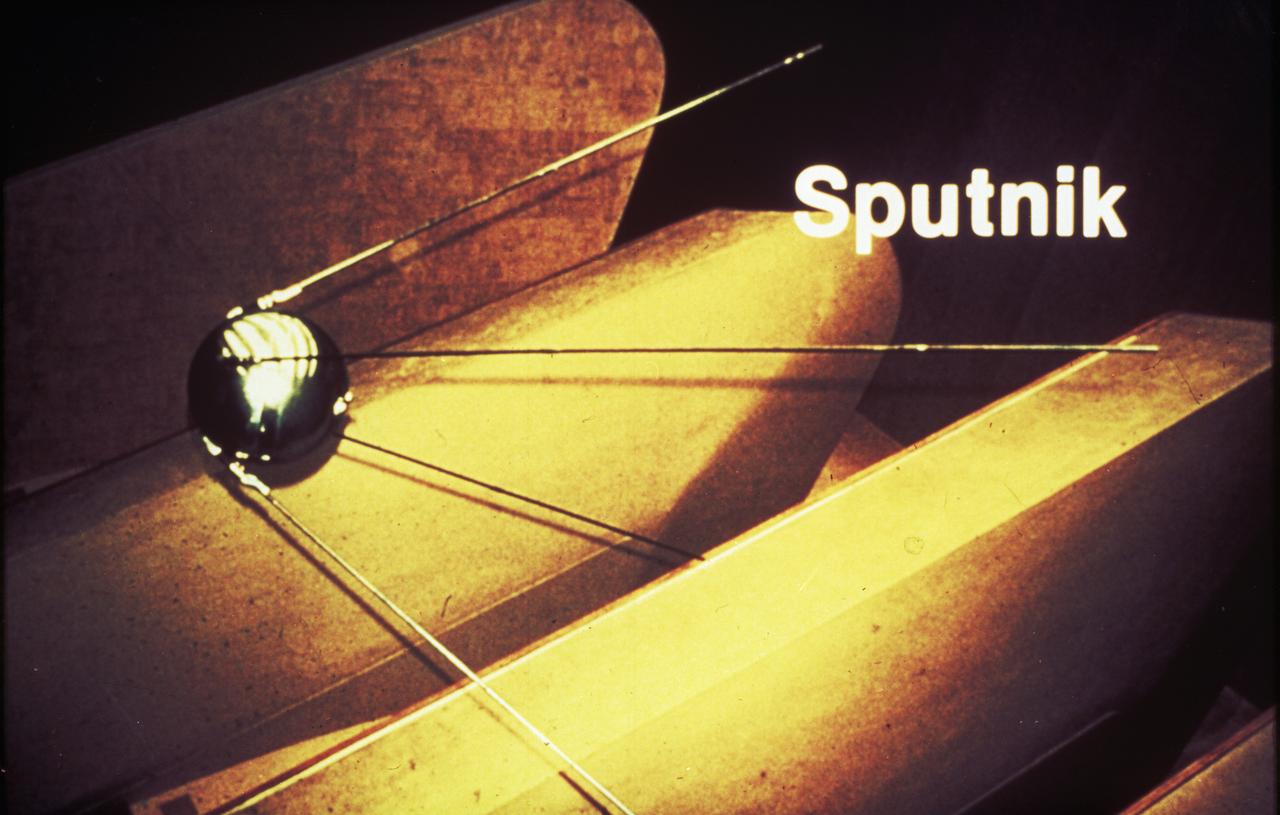
The Army Ballistic Missile Agency incorporated the von Braun team in key positions with Dr. von Braun as a head of the Development Operations Division. On October 4, 1957, the Nation was shocked when the Russians launched Sputnik, the world's first artificial satellite. Two months later, the United States suffered disappointment when a Navy Vanguard rocket, with its satellite payload, failed to develop sufficient thrust and toppled over on the launch pad.

The ringed planet sits in repose, the center of its own macrocosm of many rings and moons and one artificial NASA satellite named Cassini. Mimas 397 kilometers, or 247 miles across is visible at upper left.
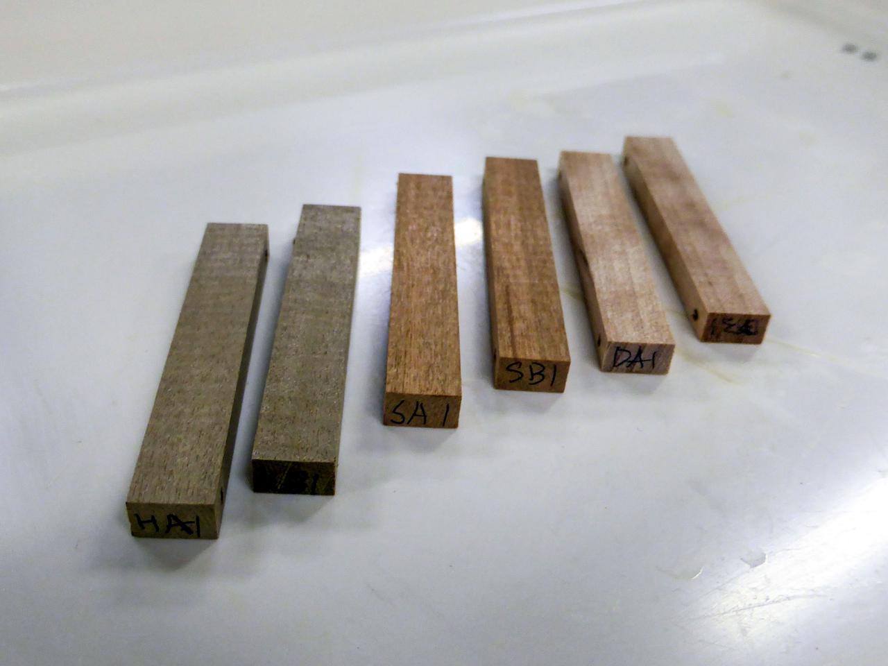
jsc2021e066968 (8/27/2021) --- A preflight view of materialtesting for the design of wooden artificial satellites (LignoSats). It is exposed to outer space of small pieces of three kinds of tree species (magnolia obovata, Cerasus jamasakura, and Betula ermanii). The aim of the Exposure Experiment of Wooden Specimen to Outer Space on the International Space Station (Exposure of Wood to Outer Space) investigation is to demonstrate if wood can be utilized as a building material for artificial satellites in space.
Artist concept shows the Tracking and Data Relay Satellite E (TDRS-E) augmenting a sophisticated TDRS system (TDRSS) communications network after deployment during STS-43 from Atlantis, Orbiter Vehicle (OV) 104. TDRS, built by TRW, will be placed in a geosynchronous orbit and after onorbit testing, which requires several weeks, will be designated TDRS-5. The communications satellite will replace TDRS-3 at 174 degrees West longitude. The backbone of NASA's space-to-ground communications, the TDRSs have increased NASA's ability to send and receive data to spacecraft in low-earth orbit to more than 85 percent of the time. Before TDRS, NASA relied solely on a system of ground stations that permitted communications only 15 percent of the time. Increased coverage has allowed onorbit repairs, live television broadcast from space and continuous dialogues between astronaut crews and ground control during critical periods such as Space Shuttle landings.

The first known proposal for a marned-satellite appeared in a story by Edward Everett Hale entitled "The Brick Moon." The story involved a group of young Bostonians who planned to put an artificial satellite into polar orbit for sailors to use to determine longitude accurately and easily.
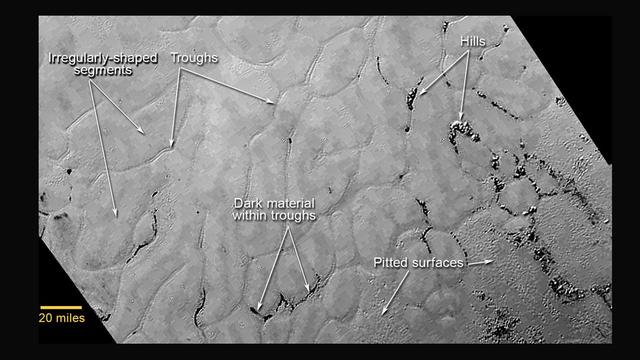
This annotated view of a portion of Pluto's Sputnik Planum (Sputnik Plain), named for Earth's first artificial satellite, shows an array of enigmatic features. The surface appears to be divided into irregularly shaped segments that are ringed by narrow troughs, some of which contain darker materials. Features that appear to be groups of mounds and fields of small pits are also visible. This image was acquired by the Long Range Reconnaissance Imager (LORRI) on July 14 from a distance of 48,000 miles (77,000 kilometers). Features as small as a half-mile (1 kilometer) across are visible. The blocky appearance of some features is due to compression of the image. http://photojournal.jpl.nasa.gov/catalog/PIA19714
41D-32-067 (31 Aug 1984) --- The Atlantic Oceans coastline of Angola forms the backdrop for this scene of the Syncom IV (Leasat-2) spacecraft as it and the Space Shuttle Discovery begin their relative separation on Day Two of a busy-six-day 41-D mission. Moments, earlier in a Frisbee-like fashion, the spacecraft departed the Discovery’s cargo bay, marking the second of three scheduled satellite placements for the spacecraft’s maiden voyage. The scene was photographed with a 70mm camera aimed through the aft windows on the flight deck.
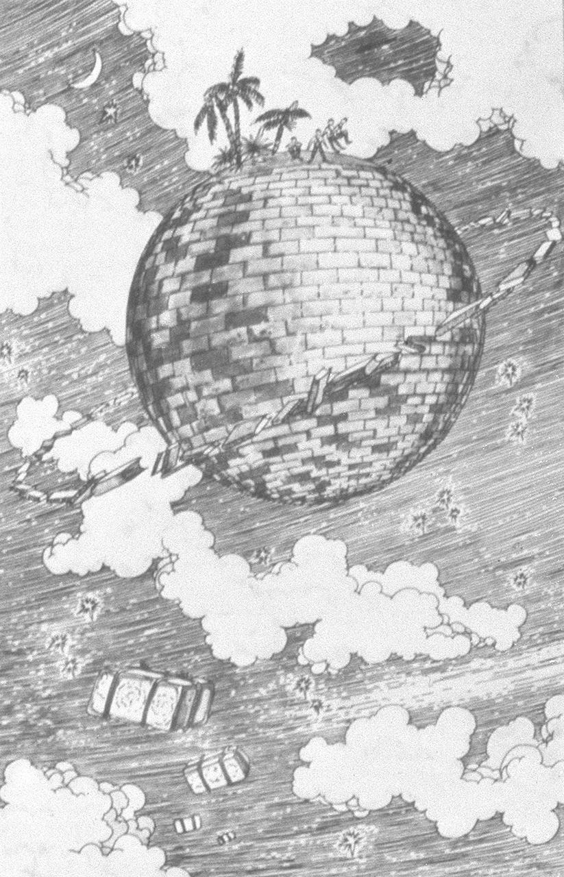
Science fiction writers, like Jules Verne in France and Edward Everett Hale in America, had discovered one of the most vital elements in the formula for space travel-a fertile imagination. The first known proposal for a marned-satellite appears in a story by Hale entitled "The Brick Moon" published in 1899. The story involved a group of young Bostonians who planned to put an artificial satellite into polar orbit for sailors to use to determine longitude accurately and easily. They planned to send a brick satellite into orbit because the satellite would have to withstand fire very well. The Satellite's 37 inhabitants signaled the Earth in morse code by jumping up and down on the outside of the satellite.
S94-30392 (16 Feb 1994) --- The Space Radar Laboratory-1 (SRL-1) is being transferred from the payload canister transporter into the payload bay of the Space Shuttle Endeavour. SRL-1 will be launched on STS-59 in April of this year.

Expedition 33/34 Flight Engineer Kevin Ford of NASA (left), Soyuz Commander Oleg Novitskiy (center) and Flight Engineer Evgeny Tarelkin (right) pose for pictures in front of a model of Sputnik 1, the world’s first artificial satellite, in the Korolev Museum at the Baikonur Cosmodrome in Kazakhstan October 18, 2012. The trio completed a final “fit check” dress rehearsal, preparing for launch October 23 in their Soyuz TMA-06M spacecraft from the Cosmodrome for a five-month mission on the International Space Station. NASA/Victor Zelentsov
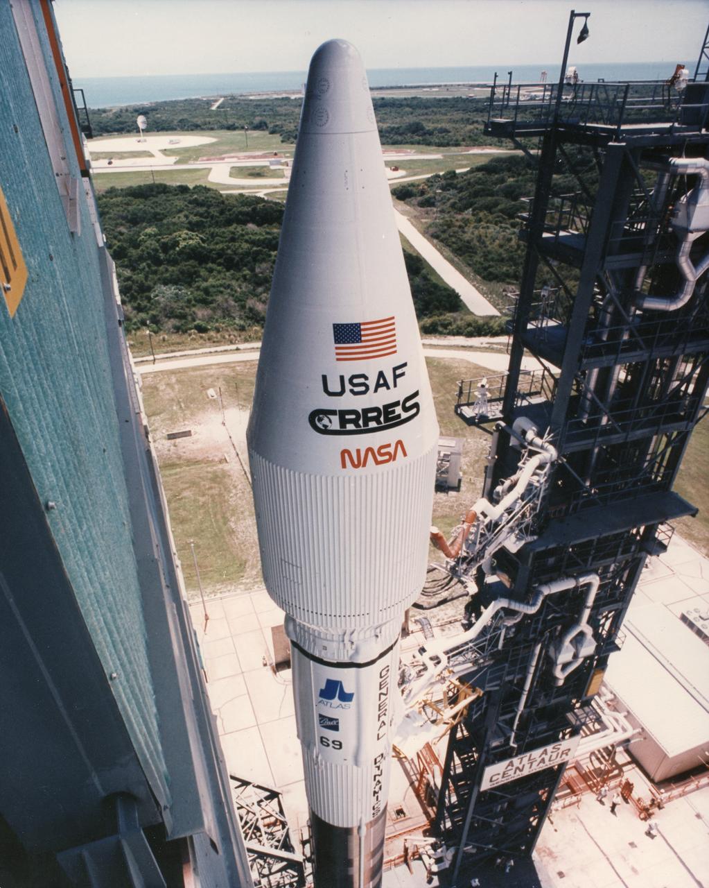
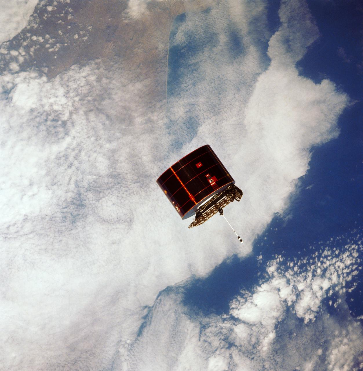
In July 1990, the Marshall Space Flight Center, in a joint project with the Department of Defense/Air Force Space Test Program, launched the Combined Release and Radiation Effects Satellite (CRRES) using an Atlas I launch vehicle. The mission was designed to study the effects of artificial ion clouds produced by chemical releases on the Earth's ionosphere and magnetosphere, and to monitor the effects of space radiation environment on sophisticated electronics.
STS044-71-011 (25 Nov. 1991) --- A 70mm frame shows pre-deployment view of the Defense Support Payload (DSP), backdropped against a blue and white Earth.

One of the STS-51 astronauts used a "fish-eye" lens on a 35mm cmaera to photograph this view of Hurricane Kenneth in the Pacific Ocean. The Orbiting Retrievable Far and Extreme Ultraviolet Spectrometer/Shuttle Pallet Satellite (ORFEUS/SPAS) is still in the cargo bay. The Remote Manipulator System (RMS) is extended towards the open payload bay.
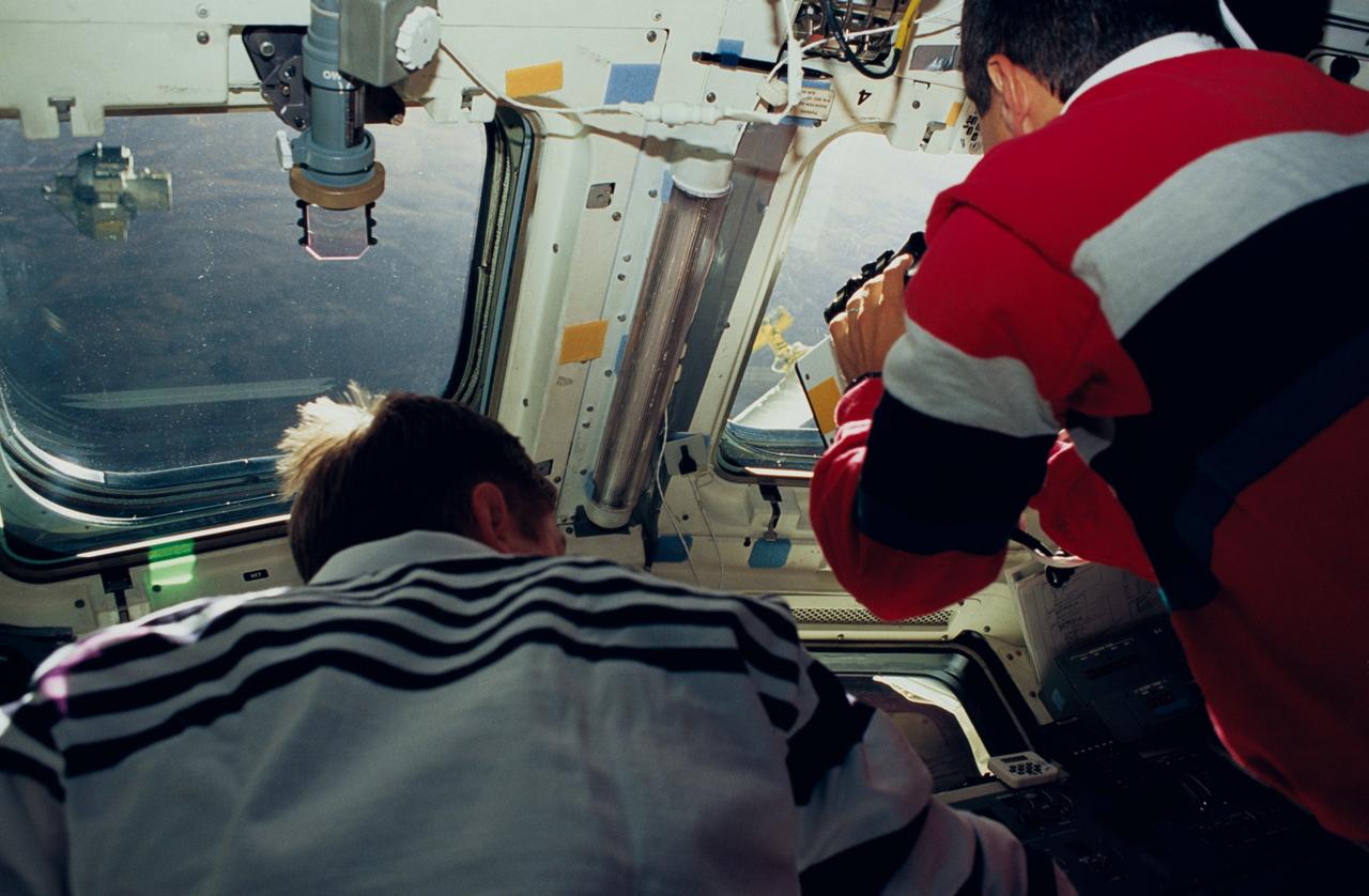
Astronauts Frank L. Culbertson Jr., STS-51 mission commander, and Daniel W. Bursch, mission specialist, are seen on Discovery's flight deck. The two were supporting operations free-flying Orbiting and Retrievable Far and Extreme Ultraviolet Spectrometer (ORFEUS) and its Shuttle Pallet Satellite (SPAS), pictured through the left window.
STS052-80-030 (23 Oct 1992) --- One of a series of three views of the deployment of the Laser Geodynamic Satellite (LAGEOS). The photograph was taken with a 70mm handheld camera aimed through the aft flight deck windows of the Earth-orbiting Space Shuttle Columbia. A crew of five NASA astronauts and a Canadian payload specialist spent ten days aboard Columbia for the STS-52 mission.
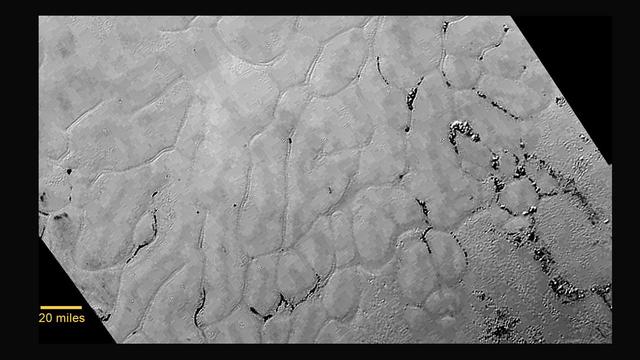
At center left of Pluto vast heart-shaped feature "Tombaugh Regio" -- lies a vast, craterless plain that appears to be no more than 100 million years old, and is possibly still being shaped by geologic processes as seen by NASA New Horizons spacecraft. This frozen region is north of Pluto's icy mountains and has been informally named Sputnik Planum (Sputnik Plain), after Earth's first artificial satellite. The surface appears to be divided into irregularly-shaped segments that are ringed by narrow troughs. Features that appear to be groups of mounds and fields of small pits are also visible. This image was acquired by the Long Range Reconnaissance Imager (LORRI) on July 14 from a distance of 48,000 miles (77,000 kilometers). Features as small as one-half mile (1 kilometer) across are visible. The blocky appearance of some features is due to compression of the image. http://photojournal.jpl.nasa.gov/catalog/PIA19841
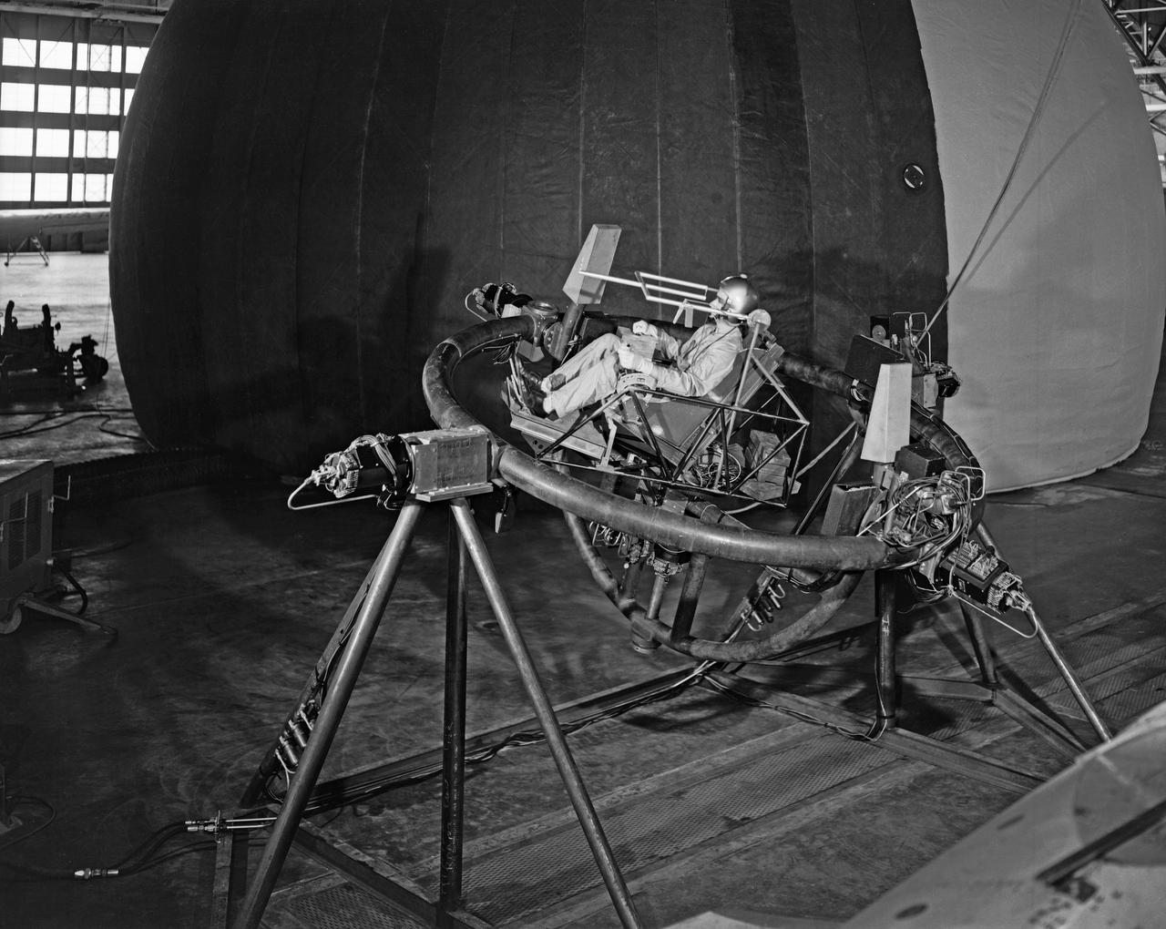
Lunar Take Off Simulator: This simulator is used by scientists at the Langley Research Center ... to help determine human ability to control a lunar launch vehicle in vertical alignment during takeoff from the moon for rendezvous with a lunar satellite vehicle on the return trip to earth. The three-axis chair, a concept which allows the pilot to sit upright during launch, gives the navigator angular motion (pitch, role, and yaw) cues as he operates the vehicle through a sidearm control system. The sight apparatus in front of the pilot's face enables him to align the vehicle on a course toward a chosen star, which will be followed as a guidance reference during the lunar launch. The pilot's right hand controls angular motions, while his left hand manipulates the thrust lever. The simulator is designed for operation inside an artificial planetarium, where a star field will be projected against the ceiling during "flights". The tests are part of an extensive NASA program at Langley in the study of problems relating to a manned lunar mission. (From a NASA Langley, photo release caption.)
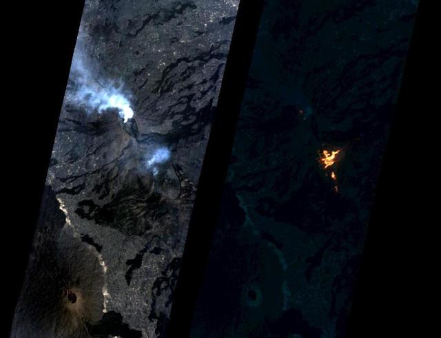
On Jan. 24, 2017, the Hyperion Imager on NASA's Earth Observing 1 (EO-1) spacecraft observed a new eruption at Erta'Ale volcano, Ethiopia, from an altitude of 438 miles (705 kilometers). Data were collected at a resolution of 98 feet (30 meters) per pixel at different visible and infrared wavelengths and were combined to create these images. A visible-wavelength image is on the left. An infrared image is shown on the right. The infrared image emphasizes the hottest areas and reveals a spectacular rift eruption, where a crack opens and lava gushes forth, fountaining into the air. The lava flows spread away from the crack. Erta'Ale is the location of a long-lived lava lake, and it remains to be seen if this survives this new eruption. The observation was scheduled via the Volcano Sensor Web, a network of sensors linked by artificial intelligence software to create an autonomous global monitoring program of satellite observations of volcanoes. The Volcano Sensor Web was alerted to this new activity by data from another spacecraft. http://photojournal.jpl.nasa.gov/catalog/PIA11239

NASA image acquired April 18 - October 23, 2012 This image of North and South America at night is a composite assembled from data acquired by the Suomi NPP satellite in April and October 2012. The new data was mapped over existing Blue Marble imagery of Earth to provide a realistic view of the planet. The nighttime view was made possible by the new satellite’s “day-night band” of the Visible Infrared Imaging Radiometer Suite. VIIRS detects light in a range of wavelengths from green to near-infrared and uses filtering techniques to observe dim signals such as city lights, gas flares, auroras, wildfires, and reflected moonlight. In this case, auroras, fires, and other stray light have been removed to emphasize the city lights. “Artificial lighting is a excellent remote sensing observable and proxy for human activity,” says Chris Elvidge, who leads the Earth Observation Group at NOAA’s National Geophysical Data Center. Social scientists and demographers have used night lights to model the spatial distribution of economic activity, of constructed surfaces, and of populations. Planners and environmental groups have used maps of lights to select sites for astronomical observatories and to monitor human development around parks and wildlife refuges. Electric power companies, emergency managers, and news media turn to night lights to observe blackouts. Named for satellite meteorology pioneer Verner Suomi, NPP flies over any given point on Earth's surface twice each day at roughly 1:30 a.m. and p.m. The polar-orbiting satellite flies 824 kilometers (512 miles) above the surface, sending its data once per orbit to a ground station in Svalbard, Norway, and continuously to local direct broadcast users distributed around the world. The mission is managed by NASA with operational support from NOAA and its Joint Polar Satellite System, which manages the satellite's ground system. NASA Earth Observatory image by Robert Simmon, using Suomi NPP VIIRS data provided courtesy of Chris Elvidge (NOAA National Geophysical Data Center). Suomi NPP is the result of a partnership between NASA, NOAA, and the Department of Defense. Caption by Mike Carlowicz. Instrument: Suomi NPP - VIIRS Credit: <b><a href="http://www.earthobservatory.nasa.gov/" rel="nofollow"> NASA Earth Observatory</a></b> <b>Click here to view all of the <a href="http://earthobservatory.nasa.gov/Features/NightLights/" rel="nofollow"> Earth at Night 2012 images </a></b> <b>Click here to <a href="http://earthobservatory.nasa.gov/NaturalHazards/view.php?id=79787" rel="nofollow"> read more </a> about this image </b> <b><a href="http://www.nasa.gov/audience/formedia/features/MP_Photo_Guidelines.html" rel="nofollow">NASA image use policy.</a></b> <b><a href="http://www.nasa.gov/centers/goddard/home/index.html" rel="nofollow">NASA Goddard Space Flight Center</a></b> enables NASA’s mission through four scientific endeavors: Earth Science, Heliophysics, Solar System Exploration, and Astrophysics. Goddard plays a leading role in NASA’s accomplishments by contributing compelling scientific knowledge to advance the Agency’s mission. <b>Follow us on <a href="http://twitter.com/NASA_GoddardPix" rel="nofollow">Twitter</a></b> <b>Like us on <a href="http://www.facebook.com/pages/Greenbelt-MD/NASA-Goddard/395013845897?ref=tsd" rel="nofollow">Facebook</a></b> <b>Find us on <a href="http://instagram.com/nasagoddard?vm=grid" rel="nofollow">Instagram</a></b>

ISS029-E-012564 (29 Sept. 2011) --- The Midwestern United States at night with Aurora Borealis is featured in this image photographed by an Expedition 29 crew member on the International Space Station. The night skies viewed from the space station are illuminated with light from many sources. For example, the Midwestern United States presents a night-time appearance not unlike a patchwork quilt when viewed from orbit. The artificial light from human settlements appears everywhere with a characteristic yellow tinge in this photograph. But green light of the Aurora Borealis also appears strongly in this view (top left)—even seeming to be reflected off Earth’s surface—in Canada—beneath the aurora. A small white patch of light is almost certainly lightning from a storm on the East coast (top right). Part of the International Space Station appears across the top of the image. This photograph highlights the Chicago, IL, metropolitan area as the largest cluster of lights at center, next to the dark patch of Lake Michigan. The other largest metropolitan areas include St. Louis, MO (lower right), Minneapolis–St. Paul, MN (left) and the Omaha–Council Bluffs region on the Nebraska–Iowa border (lower left). City light clusters give an immediate sense of relative city size; demographers have used night time satellite imagery to make estimates of city populations, especially in the developing world where city growth can be very rapid. The U.S. northeast seaboard lies in the most oblique (meaning viewed at an angle) part of the image at top right, just beyond the Appalachian Mts., a dark winding zone without major cities. Scales change significantly in oblique views: Omaha is only 200 kilometers from Des Moines, but appears roughly the same distance from Minneapolis—which is actually 375 kilometers to the north of Des Moines. In addition to the major metropolitan areas, the rectangular NS/EW-oriented pattern of townships is clearly visible in the rural, lower left part of the image. This pattern instantly gives the sense of north orientation (toward the top left corner) and is a distinctive characteristic of the United States, so that ISS crew members can quickly know which continent they are flying over even at night. In contrast to the regular township pattern, interstate highways converge on St. Louis (e.g. Hwy 44), Chicago and other large cities, much like wheel spokes around a central hub. Rivers—major visual features in daylight—become almost invisible at night. The course of the Mississippi River appears as a slightly meandering zone from Minneapolis through St. Louis (dashed line)—the river course continues out of the lower right corner of the image.