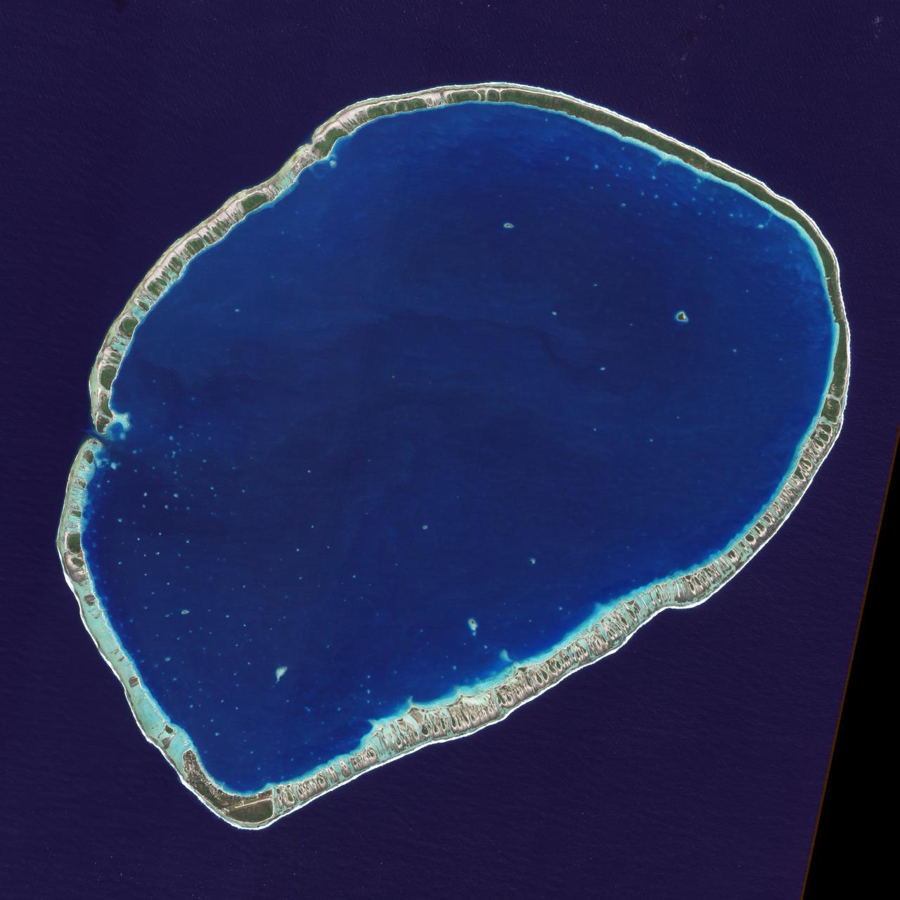
The islands and coral atolls of French Polynesia, located in the southern Pacific Ocean, epitomize the idea of tropical paradise: white sandy beaches, turquoise lagoons, and palm trees. Even from the distance of space, the view of these atolls is beautiful. This image from the Advanced Land Imager on NASA’s Earth Observing-1 (EO-1) satellite shows the southern part of Tikehau Atoll, one of the 78 coral atolls that make up the Tuamotu Archipelago. Patches of coral make star-like spots across the turquoise expanse of the lagoon. A line of tree-covered islets encircles the lagoon. At the southernmost tip of the atoll, a large islet accommodates a small village and an air strip. NASA image created by Jesse Allen, using EO-1 ALI data provided courtesy of the NASA EO-1 Team. Caption by Rebecca Lindsey. <b><a href="http://www.nasa.gov/audience/formedia/features/MP_Photo_Guidelines.html" rel="nofollow">NASA image use policy.</a></b> <b><a href="http://www.nasa.gov/centers/goddard/home/index.html" rel="nofollow">NASA Goddard Space Flight Center</a></b> enables NASA’s mission through four scientific endeavors: Earth Science, Heliophysics, Solar System Exploration, and Astrophysics. Goddard plays a leading role in NASA’s accomplishments by contributing compelling scientific knowledge to advance the Agency’s mission. <b>Follow us on <a href="http://twitter.com/NASAGoddardPix" rel="nofollow">Twitter</a></b> <b>Like us on <a href="http://www.facebook.com/pages/Greenbelt-MD/NASA-Goddard/395013845897?ref=tsd" rel="nofollow">Facebook</a></b> <b>Find us on <a href="http://instagrid.me/nasagoddard/?vm=grid" rel="nofollow">Instagram</a></b>
iss071e111610 (May 23, 2024) -- Nearly halfway between Madagascar and Mozambique lies the Bassas da India atoll in the Mozambique Channel. The uninhabited ring-shaped island spans roughly 330 feet (~100 meters) around a shallow lagoon. The International Space Station was soaring 260 miles above as this photo was taken.
iss072e094988 (Oct. 21, 2024) --- The French atoll of Bassas da India in the Mozambique Channel, halfway beween the African nations of Mozambiue and Madagascar, is pictured from the International Space Station as it orbited 264 miles above.
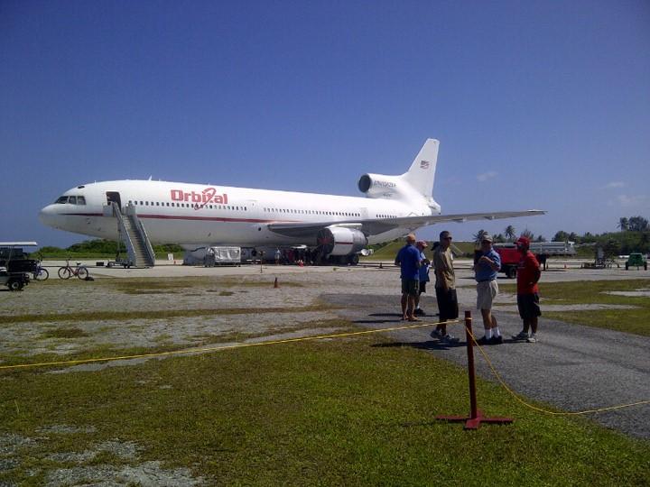
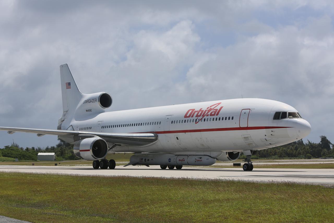
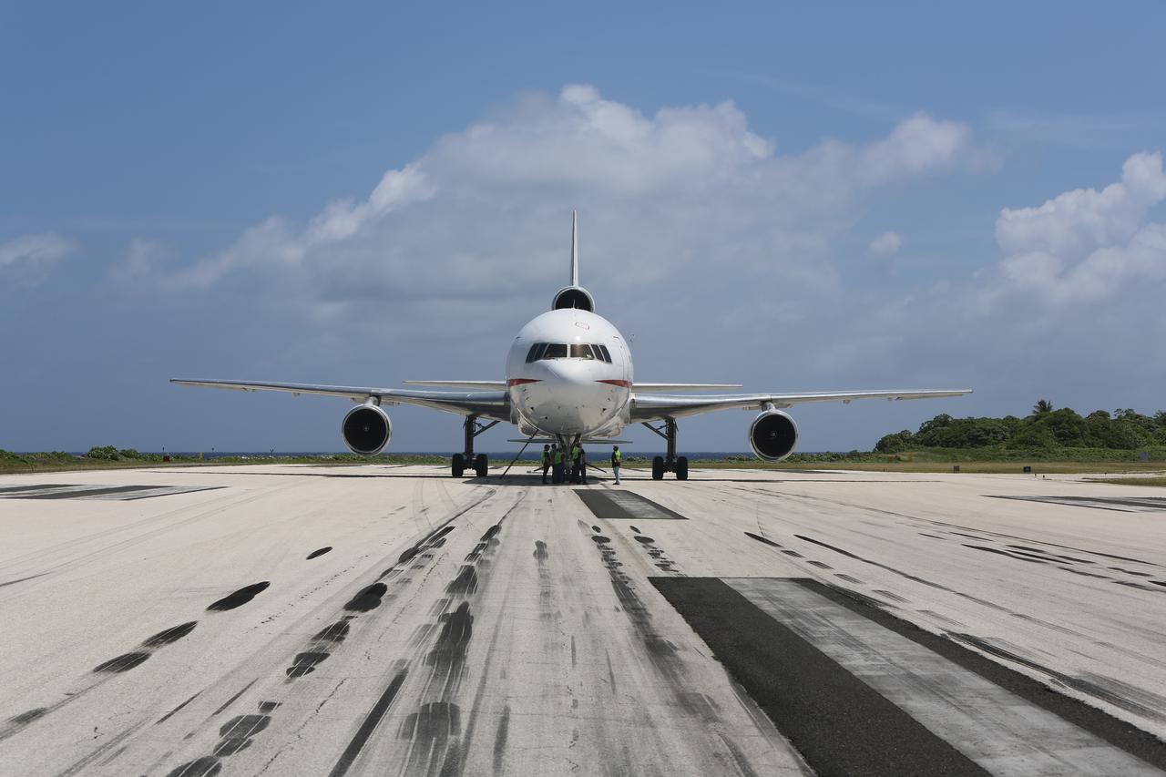
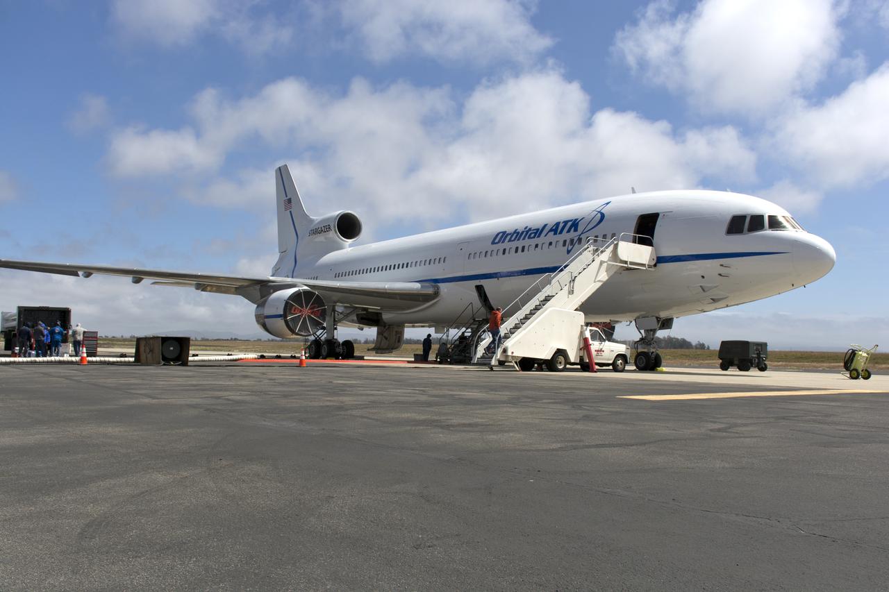
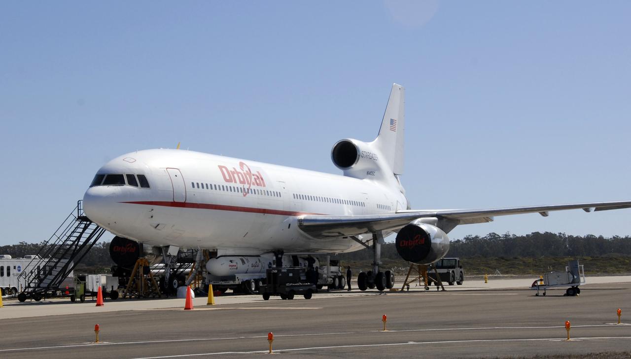
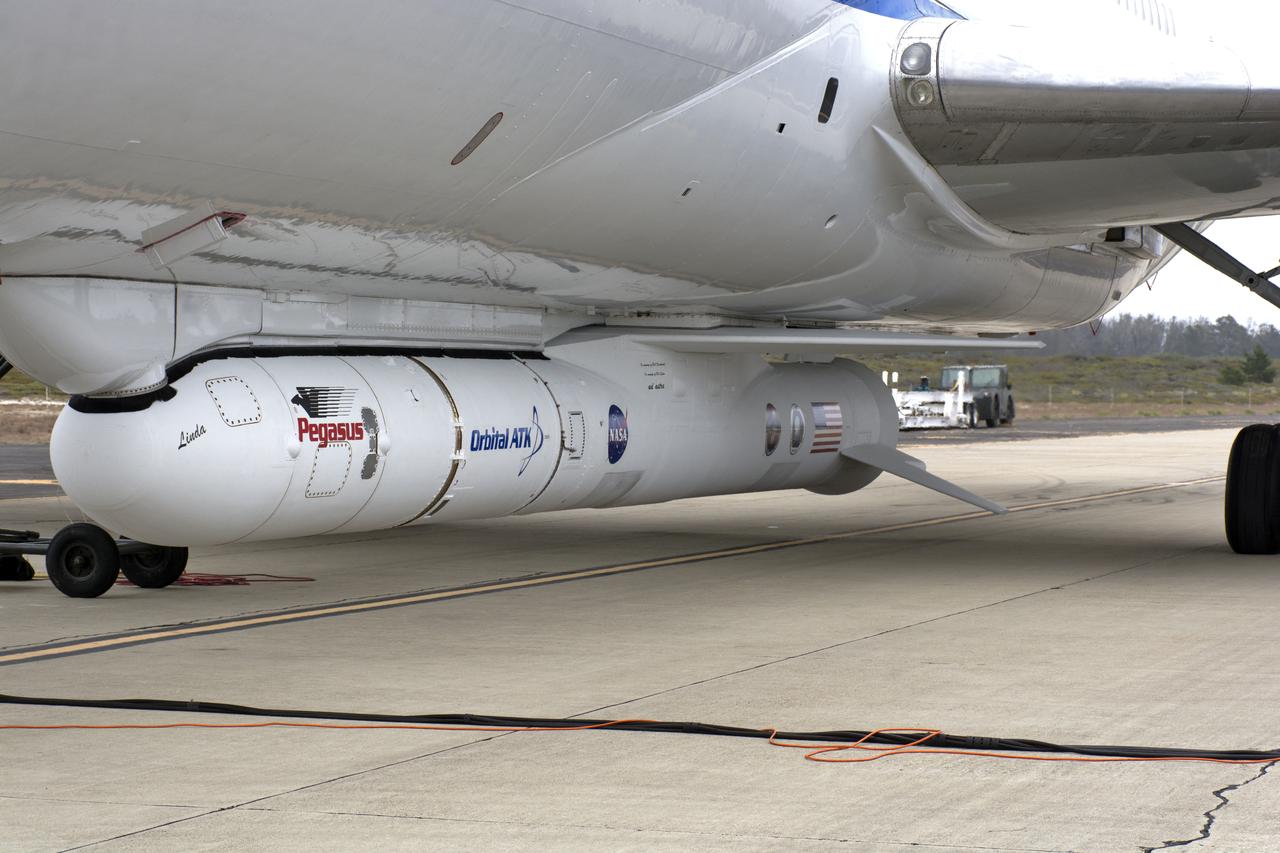
KWAJALEIN ATOLL, Marshall Islands - Orbital Science Corp.'s L-1011 aircraft "Stargazer" stands near the runway on Kwajalein Atoll with the company's Pegasus rocket slung underneath. The Pegasus was used to launch NASA's NuSTAR spacecraft mission on June 13, 2012, from the Pacific island chain. Photo credit: NASA
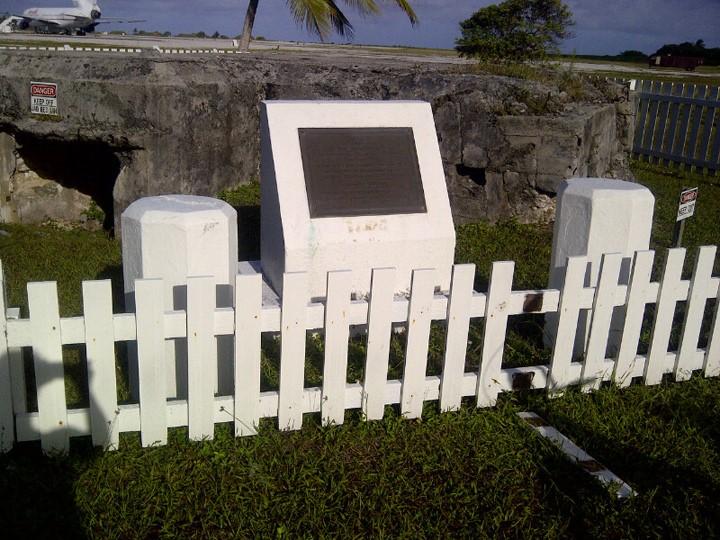
KWAJALEIN ATOLL, Marshall Islands - Orbital Science Corp.'s L-1011 aircraft "Stargazer" stands near the runway on Kwajalein Atoll with the company's Pegasus rocket slung underneath in the background near this World War II-era bunker built by the Japanese forces who occupied the island. Photo credit: NASA
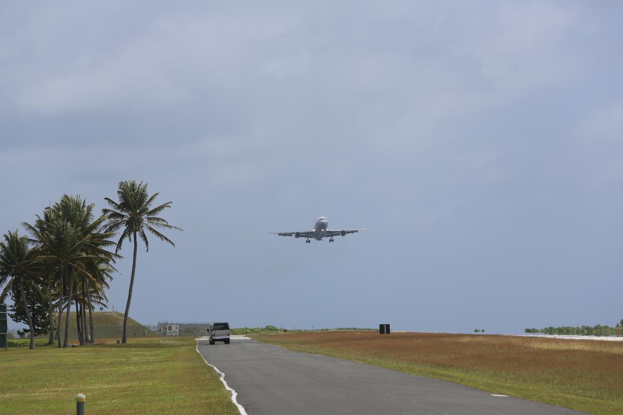
KWAJALEIN ATOLL, Marshall Islands - Orbital Science Corp.'s L-1011 aircraft "Stargazer" flies over the runway on Kwajalein Atoll with the company's Pegasus rocket slung underneath. Kwajalein is part of the Marshall Islands chain in the Pacific Ocean. It's also part of the Reagan Test Site and used for launches of NASA, commercial and military missions. Photo credit: NASA

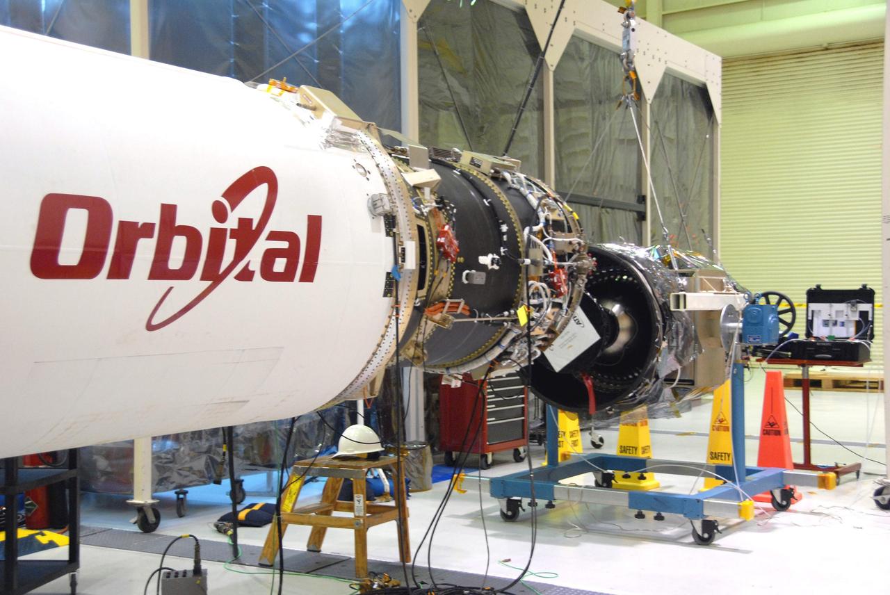
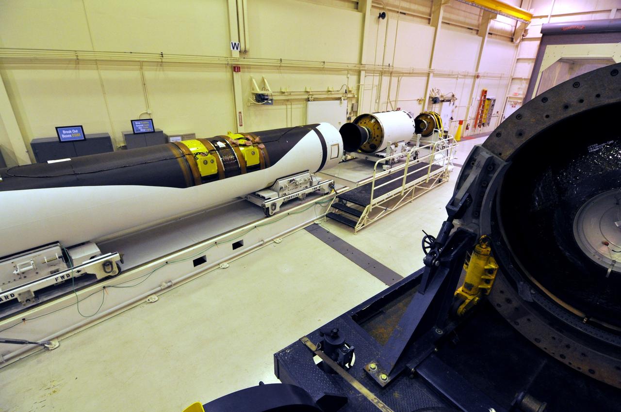
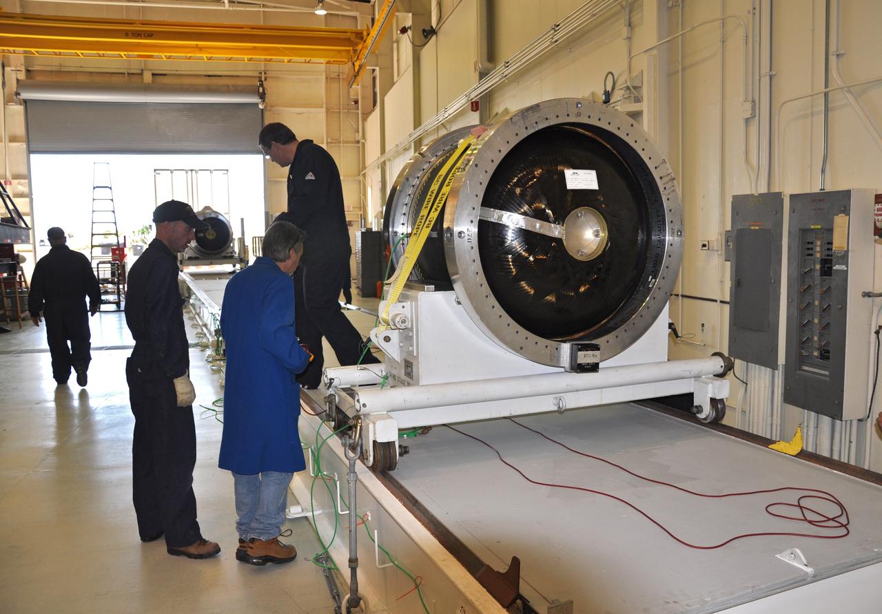
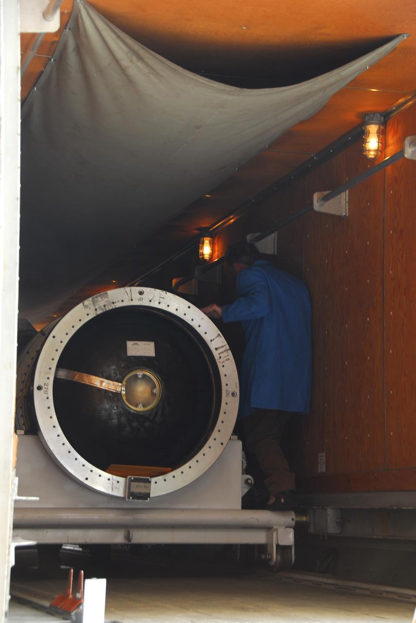
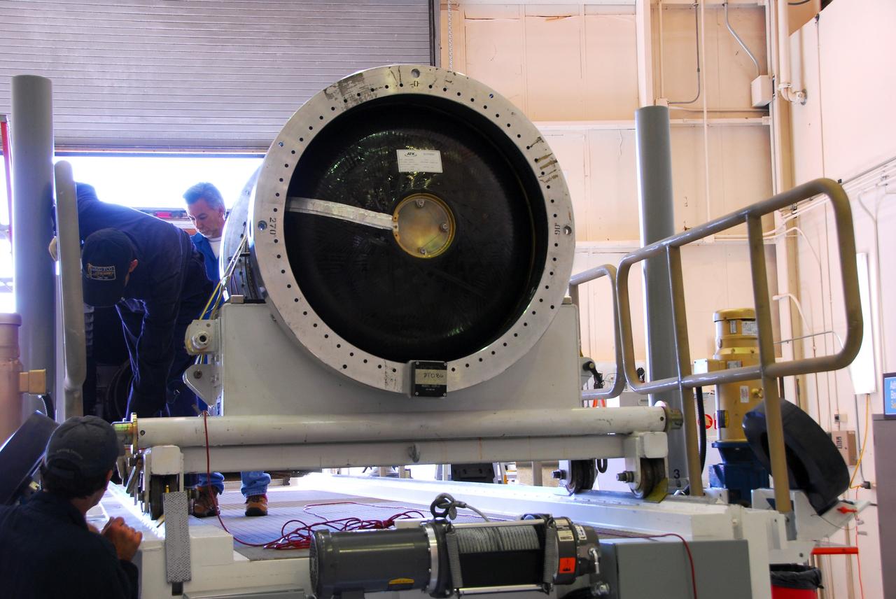
VANDENBERG AIR FORCE BASE, Calif. – In a clean room at Vandenberg Air Force Base in California, technicians complete a second fillet and wing fit check on the Pegasus XL launch vehicle. The Orbital Sciences Corp. Pegasus rocket will launch the Nuclear Spectroscopic Telescope Array (NuSTAR) into space. After the rocket and spacecraft are processed at Vandenberg, they will be flown on the Orbital Sciences’ L-1011 carrier aircraft to the Ronald Reagan Ballistic Missile Defense Test Site at the Pacific Ocean’s Kwajalein Atoll for launch. The high-energy X-ray telescope will conduct a census for black holes, map radioactive material in young supernovae remnants, and study the origins of cosmic rays and the extreme physics around collapsed stars. For more information, visit science.nasa.gov/missions/nustar/. Photo credit: NASA/Randy Beaudoin, VAFB

VANDENBERG AIR FORCE BASE, Calif. – In a clean room at Vandenberg Air Force Base in California, technicians prepare to do a fillet and wing fit check on the Pegasus XL launch vehicle. The Orbital Sciences Corp. Pegasus rocket will launch the Nuclear Spectroscopic Telescope Array (NuSTAR) into space. After the rocket and spacecraft are processed at Vandenberg, they will be flown on the Orbital Sciences’ L-1011 carrier aircraft to the Ronald Reagan Ballistic Missile Defense Test Site at the Pacific Ocean’s Kwajalein Atoll for launch. The high-energy X-ray telescope will conduct a census for black holes, map radioactive material in young supernovae remnants, and study the origins of cosmic rays and the extreme physics around collapsed stars. For more information, visit science.nasa.gov/missions/nustar/. Photo credit: NASA/Randy Beaudoin, VAFB

VANDENBERG AIR FORCE BASE, Calif. – In a clean room at Vandenberg Air Force Base in California, technicians perform a fillet and wing fit check on the Pegasus XL launch vehicle. The Orbital Sciences Corp. Pegasus rocket will launch the Nuclear Spectroscopic Telescope Array (NuSTAR) into space. After the rocket and spacecraft are processed at Vandenberg, they will be flown on the Orbital Sciences’ L-1011 carrier aircraft to the Ronald Reagan Ballistic Missile Defense Test Site at the Pacific Ocean’s Kwajalein Atoll for launch. The high-energy X-ray telescope will conduct a census for black holes, map radioactive material in young supernovae remnants, and study the origins of cosmic rays and the extreme physics around collapsed stars. For more information, visit science.nasa.gov/missions/nustar/. Photo credit: NASA/Randy Beaudoin, VAFB

VANDENBERG AIR FORCE BASE, Calif. – In a clean room at Vandenberg Air Force Base in California, technicians perform a fillet and wing fit check on the Pegasus XL launch vehicle. The Orbital Sciences Corp. Pegasus rocket will launch the Nuclear Spectroscopic Telescope Array (NuSTAR) into space. After the rocket and spacecraft are processed at Vandenberg, they will be flown on the Orbital Sciences’ L-1011 carrier aircraft to the Ronald Reagan Ballistic Missile Defense Test Site at the Pacific Ocean’s Kwajalein Atoll for launch. The high-energy X-ray telescope will conduct a census for black holes, map radioactive material in young supernovae remnants, and study the origins of cosmic rays and the extreme physics around collapsed stars. For more information, visit science.nasa.gov/missions/nustar/. Photo credit: NASA/Randy Beaudoin, VAFB

VANDENBERG AIR FORCE BASE, Calif. – In a clean room at Vandenberg Air Force Base in California, technicians prepare to do a fillet and wing fit check on the Pegasus XL launch vehicle. The Orbital Sciences Corp. Pegasus rocket will launch the Nuclear Spectroscopic Telescope Array (NuSTAR) into space. After the rocket and spacecraft are processed at Vandenberg, they will be flown on the Orbital Sciences’ L-1011 carrier aircraft to the Ronald Reagan Ballistic Missile Defense Test Site at the Pacific Ocean’s Kwajalein Atoll for launch. The high-energy X-ray telescope will conduct a census for black holes, map radioactive material in young supernovae remnants, and study the origins of cosmic rays and the extreme physics around collapsed stars. For more information, visit science.nasa.gov/missions/nustar/. Photo credit: NASA/Randy Beaudoin, VAFB

VANDENBERG AIR FORCE BASE, Calif. – In a clean room at Vandenberg Air Force Base in California, technicians complete a second fillet and wing fit check on the Pegasus XL launch vehicle. The Orbital Sciences Corp. Pegasus rocket will launch the Nuclear Spectroscopic Telescope Array (NuSTAR) into space. After the rocket and spacecraft are processed at Vandenberg, they will be flown on the Orbital Sciences’ L-1011 carrier aircraft to the Ronald Reagan Ballistic Missile Defense Test Site at the Pacific Ocean’s Kwajalein Atoll for launch. The high-energy X-ray telescope will conduct a census for black holes, map radioactive material in young supernovae remnants, and study the origins of cosmic rays and the extreme physics around collapsed stars. For more information, visit science.nasa.gov/missions/nustar/. Photo credit: NASA/Randy Beaudoin, VAFB

VANDENBERG AIR FORCE BASE, Calif. – In a clean room at Vandenberg Air Force Base in California, technicians prepare to complete a second fillet and wing fit check on the Pegasus XL launch vehicle. The Orbital Sciences Corp. Pegasus rocket will launch the Nuclear Spectroscopic Telescope Array (NuSTAR) into space. After the rocket and spacecraft are processed at Vandenberg, they will be flown on the Orbital Sciences’ L-1011 carrier aircraft to the Ronald Reagan Ballistic Missile Defense Test Site at the Pacific Ocean’s Kwajalein Atoll for launch. The high-energy X-ray telescope will conduct a census for black holes, map radioactive material in young supernovae remnants, and study the origins of cosmic rays and the extreme physics around collapsed stars. For more information, visit science.nasa.gov/missions/nustar/. Photo credit: NASA/Randy Beaudoin, VAFB

VANDENBERG AIR FORCE BASE, Calif. – In a clean room at Vandenberg Air Force Base in California, the Pegasus XL launch vehicle awaits a fillet and wing fit check. The Orbital Sciences Corp. Pegasus rocket will launch the Nuclear Spectroscopic Telescope Array (NuSTAR) into space. After the rocket and spacecraft are processed at Vandenberg, they will be flown on the Orbital Sciences’ L-1011 carrier aircraft to the Ronald Reagan Ballistic Missile Defense Test Site at the Pacific Ocean’s Kwajalein Atoll for launch. The high-energy X-ray telescope will conduct a census for black holes, map radioactive material in young supernovae remnants, and study the origins of cosmic rays and the extreme physics around collapsed stars. For more information, visit science.nasa.gov/missions/nustar/. Photo credit: NASA/Randy Beaudoin, VAFB

VANDENBERG AIR FORCE BASE, Calif. – In a clean room at Vandenberg Air Force Base in California, technicians prepare to complete a second fillet and wing fit check on the Pegasus XL launch vehicle. The Orbital Sciences Corp. Pegasus rocket will launch the Nuclear Spectroscopic Telescope Array (NuSTAR) into space. After the rocket and spacecraft are processed at Vandenberg, they will be flown on the Orbital Sciences’ L-1011 carrier aircraft to the Ronald Reagan Ballistic Missile Defense Test Site at the Pacific Ocean’s Kwajalein Atoll for launch. The high-energy X-ray telescope will conduct a census for black holes, map radioactive material in young supernovae remnants, and study the origins of cosmic rays and the extreme physics around collapsed stars. For more information, visit science.nasa.gov/missions/nustar/. Photo credit: NASA/Randy Beaudoin, VAFB

VANDENBERG AIR FORCE BASE, Calif. – In a clean room at Vandenberg Air Force Base in California, technicians complete a second fillet and wing fit check on the Pegasus XL launch vehicle. The Orbital Sciences Corp. Pegasus rocket will launch the Nuclear Spectroscopic Telescope Array (NuSTAR) into space. After the rocket and spacecraft are processed at Vandenberg, they will be flown on the Orbital Sciences’ L-1011 carrier aircraft to the Ronald Reagan Ballistic Missile Defense Test Site at the Pacific Ocean’s Kwajalein Atoll for launch. The high-energy X-ray telescope will conduct a census for black holes, map radioactive material in young supernovae remnants, and study the origins of cosmic rays and the extreme physics around collapsed stars. For more information, visit science.nasa.gov/missions/nustar/. Photo credit: NASA/Randy Beaudoin, VAFB

VANDENBERG AIR FORCE BASE, Calif. – In a clean room at Vandenberg Air Force Base in California, technicians prepare to do a fillet and wing fit check on the Pegasus XL launch vehicle. The Orbital Sciences Corp. Pegasus rocket will launch the Nuclear Spectroscopic Telescope Array (NuSTAR) into space. After the rocket and spacecraft are processed at Vandenberg, they will be flown on the Orbital Sciences’ L-1011 carrier aircraft to the Ronald Reagan Ballistic Missile Defense Test Site at the Pacific Ocean’s Kwajalein Atoll for launch. The high-energy X-ray telescope will conduct a census for black holes, map radioactive material in young supernovae remnants, and study the origins of cosmic rays and the extreme physics around collapsed stars. For more information, visit science.nasa.gov/missions/nustar/. Photo credit: NASA/Randy Beaudoin, VAFB

VANDENBERG AIR FORCE BASE, Calif. – In a clean room at Vandenberg Air Force Base in California, technicians complete a second fillet and wing fit check on the Pegasus XL launch vehicle. The Orbital Sciences Corp. Pegasus rocket will launch the Nuclear Spectroscopic Telescope Array (NuSTAR) into space. After the rocket and spacecraft are processed at Vandenberg, they will be flown on the Orbital Sciences’ L-1011 carrier aircraft to the Ronald Reagan Ballistic Missile Defense Test Site at the Pacific Ocean’s Kwajalein Atoll for launch. The high-energy X-ray telescope will conduct a census for black holes, map radioactive material in young supernovae remnants, and study the origins of cosmic rays and the extreme physics around collapsed stars. For more information, visit science.nasa.gov/missions/nustar/. Photo credit: NASA/Randy Beaudoin, VAFB

VANDENBERG AIR FORCE BASE, Calif. – In a clean room at Vandenberg Air Force Base in California, technicians perform a fillet and wing fit check on the Pegasus XL launch vehicle. The Orbital Sciences Corp. Pegasus rocket will launch the Nuclear Spectroscopic Telescope Array (NuSTAR) into space. After the rocket and spacecraft are processed at Vandenberg, they will be flown on the Orbital Sciences’ L-1011 carrier aircraft to the Ronald Reagan Ballistic Missile Defense Test Site at the Pacific Ocean’s Kwajalein Atoll for launch. The high-energy X-ray telescope will conduct a census for black holes, map radioactive material in young supernovae remnants, and study the origins of cosmic rays and the extreme physics around collapsed stars. For more information, visit science.nasa.gov/missions/nustar/. Photo credit: NASA/Randy Beaudoin, VAFB

VANDENBERG AIR FORCE BASE, Calif. – In a clean room at Vandenberg Air Force Base in California, technicians prepare to complete a second fillet and wing fit check on the Pegasus XL launch vehicle. The Orbital Sciences Corp. Pegasus rocket will launch the Nuclear Spectroscopic Telescope Array (NuSTAR) into space. After the rocket and spacecraft are processed at Vandenberg, they will be flown on the Orbital Sciences’ L-1011 carrier aircraft to the Ronald Reagan Ballistic Missile Defense Test Site at the Pacific Ocean’s Kwajalein Atoll for launch. The high-energy X-ray telescope will conduct a census for black holes, map radioactive material in young supernovae remnants, and study the origins of cosmic rays and the extreme physics around collapsed stars. For more information, visit science.nasa.gov/missions/nustar/. Photo credit: NASA/Randy Beaudoin, VAFB
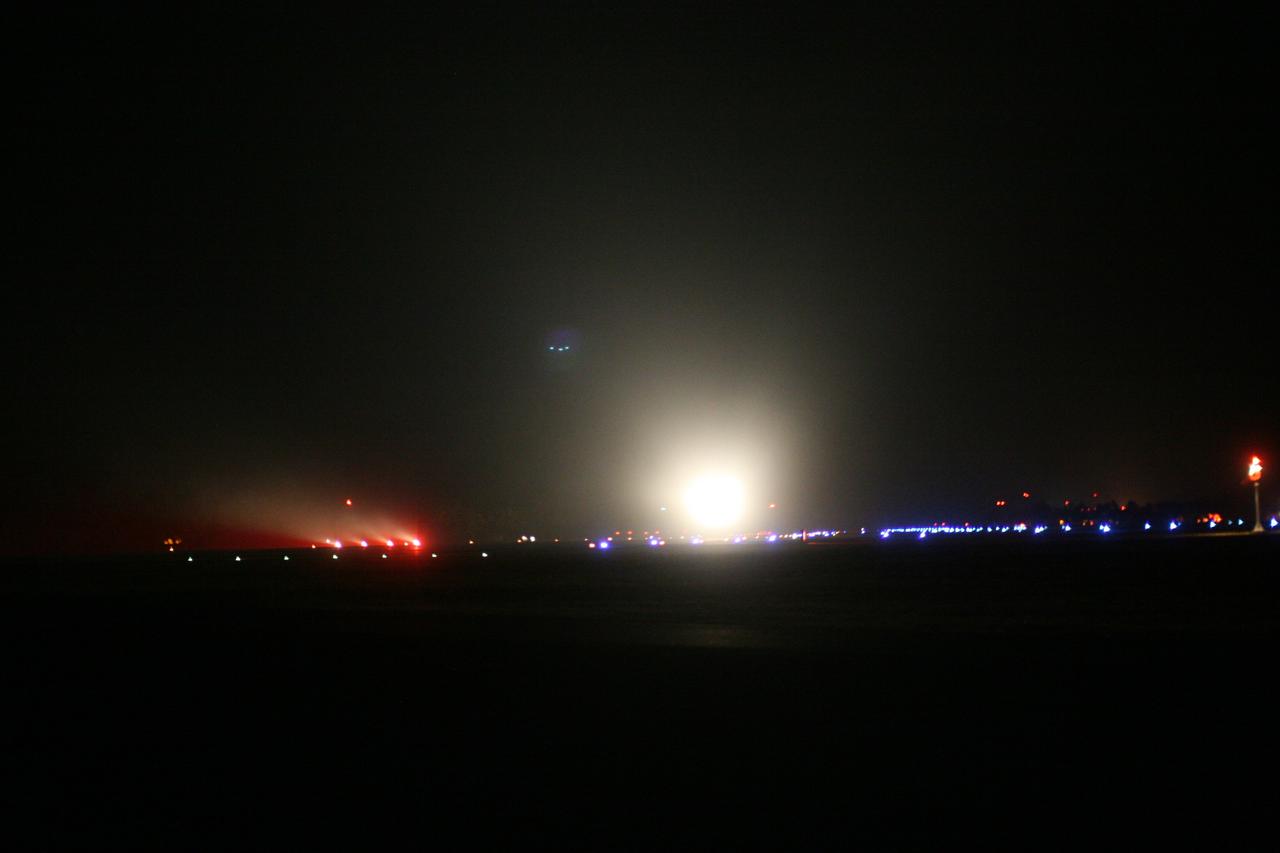
KWAJALEIN ATOLL, Marshall Islands - The lights of Orbital Sciences' L-1011 "Stargazer" aircraft illuminates the night sky as it takes off from the runway at Kwajalein Atoll with the company's Pegasus rocket to launch NASA's Nuclear Spectroscopic Telescope Array, or NuSTAR. The plane left Kwajalein one hour before launch. At 9:00:35 a.m. PDT 12:00:35 p.m. EDT), June 13, 2012, the rocket dropped with the NuSTAR payload 117 nautical miles south of Kwajalein. NuSTAR will use a unique set of “eyes” to see the highest energy X-ray light from the cosmos to reveal black holes lurking in our Milky Way galaxy, as well as those hidden in the hearts of faraway galaxies. Kwajalein is located in the Marshall Islands chain in the Pacific Ocean and is part of the Reagan Test Site and used for launches of NASA, commercial and military missions. For more information, visit http://www.nasa.gov/nustar. Photo credit: NASA
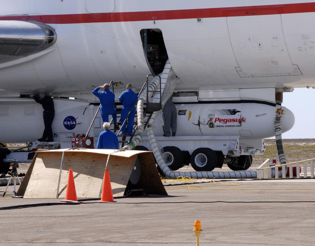
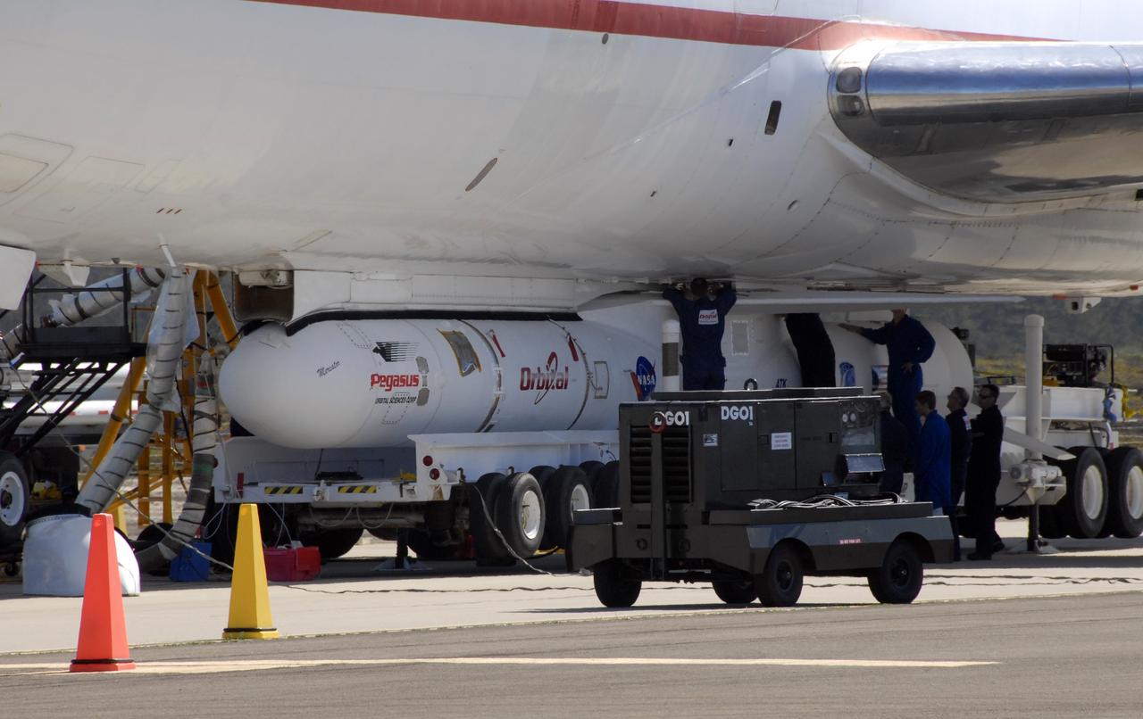
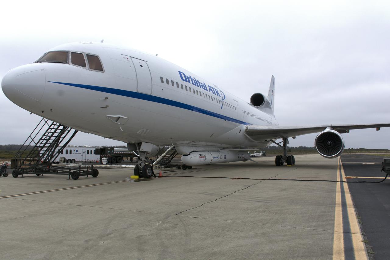
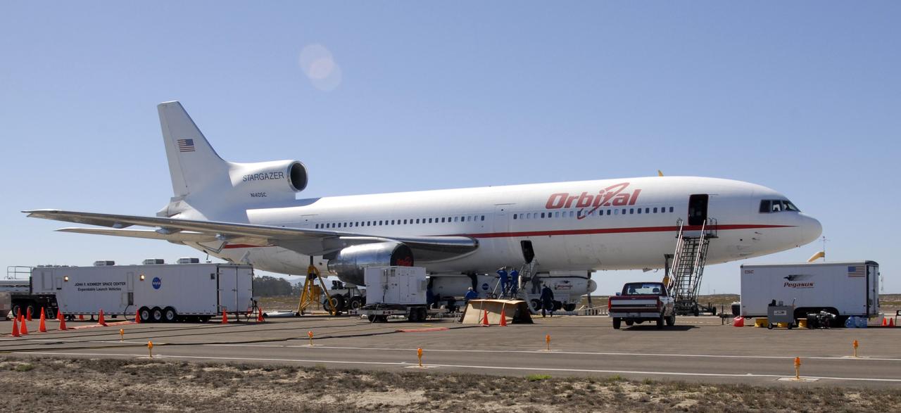
KWAJALEIN ATOLL, Marshall Islands – Orbital Sciences' L-1011 carrier aircraft approaches the runway at the U.S. Army's Ronald Reagan Ballistic Missile Defense Test Site on Kwajalein Atoll to deliver Orbital’s Pegasus rocket and NASA’s Nuclear Spectroscopic Telescope Array, or NuSTAR, for launch. The Pegasus, mated to its NuSTAR payload, will be launched from the carrier aircraft 117 nautical miles south of Kwajalein at latitude 6.75 degrees north of the equator. The high-energy X-ray telescope will conduct a census of black holes, map radioactive material in young supernovae remnants, and study the origins of cosmic rays and the extreme physics around collapsed stars. Launch and deployment of the telescope is scheduled for June 13. For more information, visit http://www.nasa.gov/nustar. Photo courtesy of Orbital Sciences Corp.
KWAJALEIN ATOLL, Marshall Islands – An Orbital Sciences’ Pegasus rocket and NASA’s Nuclear Spectroscopic Telescope Array, or NuSTAR, are delivered to the U.S. Army's Ronald Reagan Ballistic Missile Defense Test Site on Kwajalein Atoll secured beneath Orbital’s L-1011 carrier aircraft. The Pegasus, mated to its NuSTAR payload, will be launched from the carrier aircraft 117 nautical miles south of Kwajalein at latitude 6.75 degrees north of the equator. The high-energy X-ray telescope will conduct a census of black holes, map radioactive material in young supernovae remnants, and study the origins of cosmic rays and the extreme physics around collapsed stars. Launch and deployment of the telescope is scheduled for June 13. For more information, visit http://www.nasa.gov/nustar. Photo courtesy of Orbital Sciences Corp.
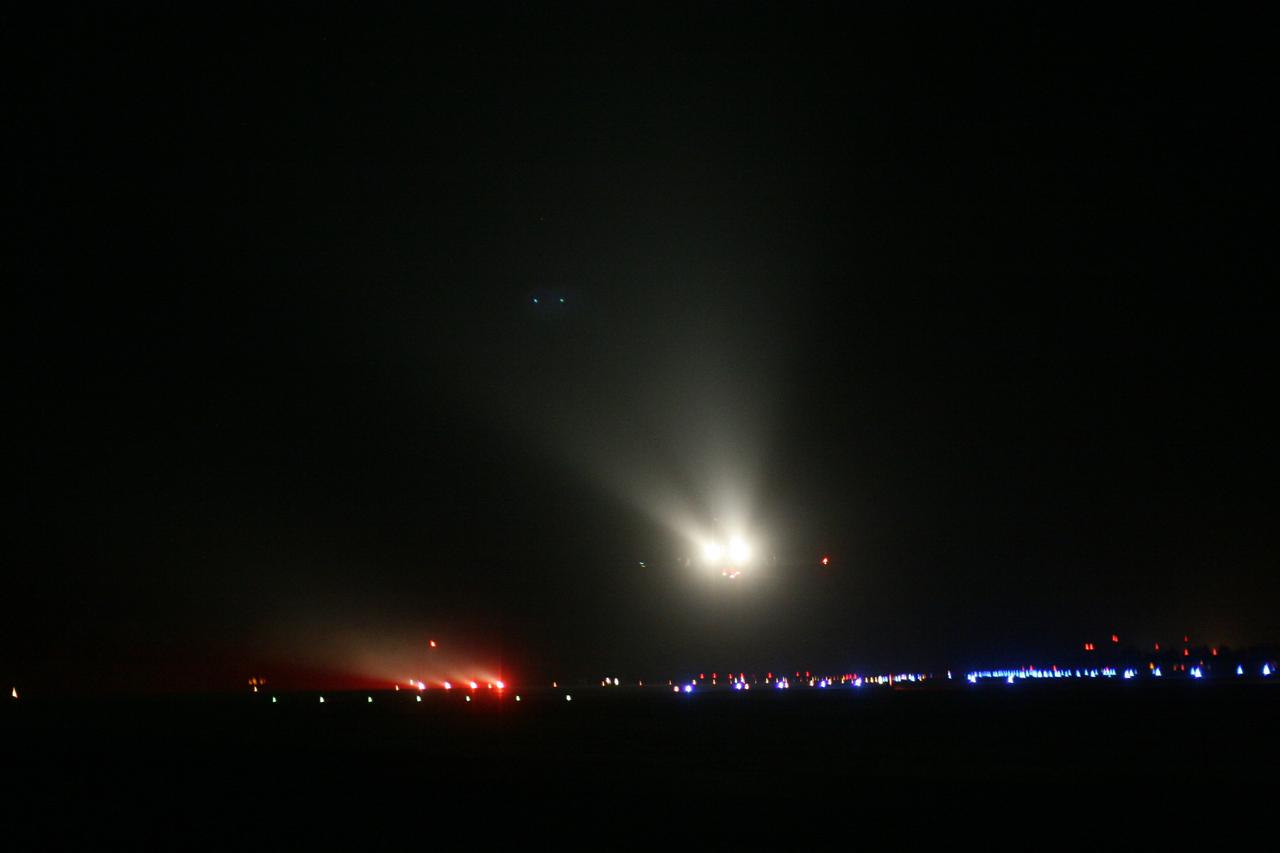
KWAJALEIN ATOLL, Marshall Islands - Orbital Sciences' L-1011 "Stargazer" aircraft takes off from the runway at Kwajalein Atoll with the company's Pegasus rocket to launch NASA's Nuclear Spectroscopic Telescope Array, or NuSTAR. The plane left Kwajalein one hour before launch. At 9:00:35 a.m. PDT 12:00:35 p.m. EDT), June 13, 2012, the rocket dropped with the NuSTAR payload 117 nautical miles south of Kwajalein. NuSTAR will use a unique set of “eyes” to see the highest energy X-ray light from the cosmos to reveal black holes lurking in our Milky Way galaxy, as well as those hidden in the hearts of faraway galaxies. Kwajalein is located in the Marshall Islands chain in the Pacific Ocean and is part of the Reagan Test Site and used for launches of NASA, commercial and military missions. For more information, visit http://www.nasa.gov/nustar. Photo credit: NASA
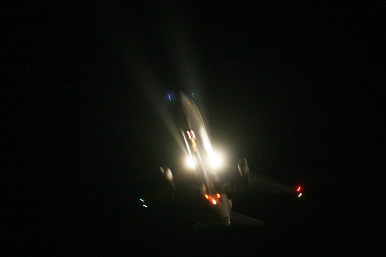
KWAJALEIN ATOLL, Marshall Islands - Orbital Sciences' L-1011 "Stargazer" aircraft takes off from the runway at Kwajalein Atoll with the company's Pegasus rocket to launch NASA's Nuclear Spectroscopic Telescope Array, or NuSTAR, payload strapped to the belly of the plane. The plane left Kwajalein one hour before launch. At 9:00:35 a.m. PDT 12:00:35 p.m. EDT), June 13, 2012, the rocket dropped with the NuSTAR payload 117 nautical miles south of Kwajalein. NuSTAR will use a unique set of “eyes” to see the highest energy X-ray light from the cosmos to reveal black holes lurking in our Milky Way galaxy, as well as those hidden in the hearts of faraway galaxies. Kwajalein is located in the Marshall Islands chain in the Pacific Ocean and is part of the Reagan Test Site and used for launches of NASA, commercial and military missions. For more information, visit http://www.nasa.gov/nustar. Photo credit: NASA
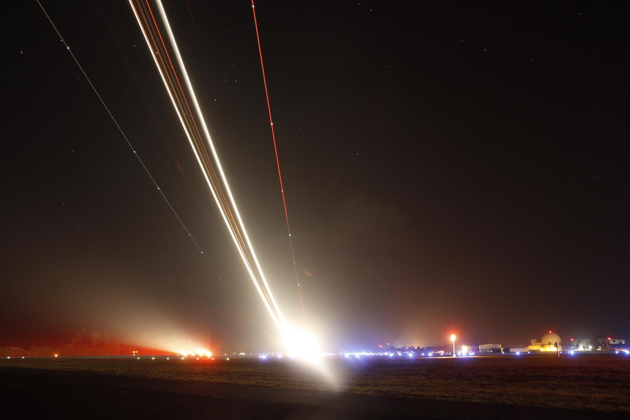
KWAJALEIN ATOLL, Marshall Islands - In this time-lapse image, the lights of Orbital Sciences' L-1011 "Stargazer" streak across the night sky as the aircraft takes off from the runway at Kwajalein Atoll with the company's Pegasus rocket to launch NASA's Nuclear Spectroscopic Telescope Array, or NuSTAR. The plane left Kwajalein one hour before launch. At 9:00:35 a.m. PDT 12:00:35 p.m. EDT), June 13, 2012, the rocket dropped with the NuSTAR payload 117 nautical miles south of Kwajalein. NuSTAR will use a unique set of “eyes” to see the highest energy X-ray light from the cosmos to reveal black holes lurking in our Milky Way galaxy, as well as those hidden in the hearts of faraway galaxies. Kwajalein is located in the Marshall Islands chain in the Pacific Ocean and is part of the Reagan Test Site and used for launches of NASA, commercial and military missions. For more information, visit http://www.nasa.gov/nustar. Photo credit: NASA
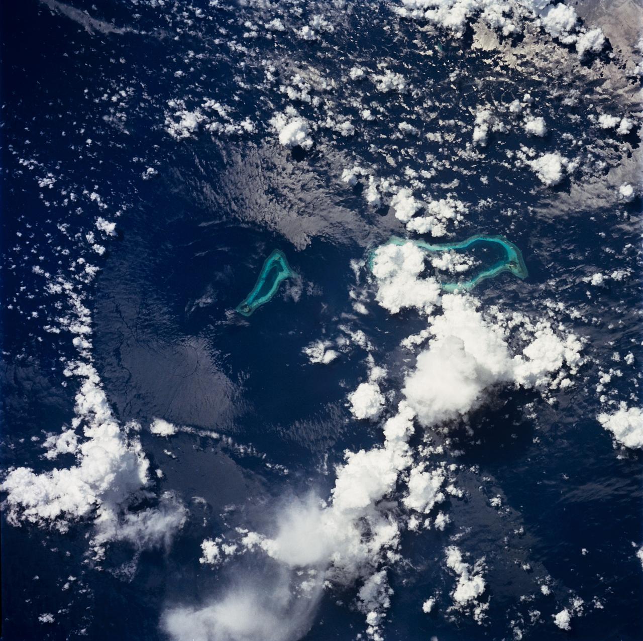
STS049-71-042 (8 May 1992) --- This photograph, taken from the Earth-orbiting Space Shuttle Endeavour, shows a collapsed thunderstorm in the southwestern Pacific Ocean. The clouds were pushed from this circular area of the ocean's surface by relatively cool air that spread downward and outward from a dying thunderstorm. Around the edges of the downdrafted air, new, though smaller, storms are developing. The photo was taken on May 8, 1992, between Borneo and the Philippine island of Mindoro. Two coral atolls can be seen near the center of the photograph. The crew members used a handheld Hasselblad camera, 250-mm lens, color film to expose the image.
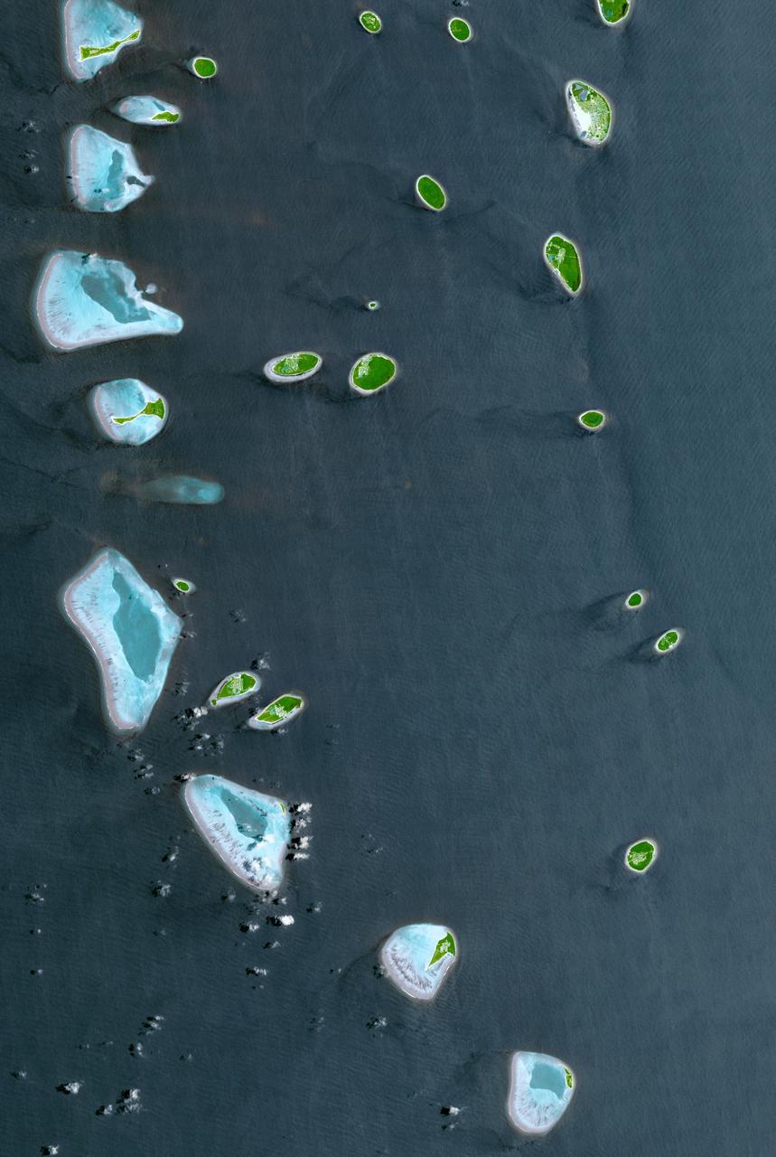
The Republic of Maldives is a country located in the Indian Ocean, southwest of India. It comprises twenty-six atolls, and 1192 coral islands, with an average ground elevation of 1.5 m. Tourism and fishing account for more than half of the country's GDP. Kulhudhuffushi, seen in the upper right corner, is the capital of Haa Dhaalu Atoll administrative division in the north of the Maldives. The image was acquired April 3, 2013, covers an area of 30.3 by 45.2 km, and is located at 6.5 degrees north, 73 degrees east. http://photojournal.jpl.nasa.gov/catalog/PIA21166
The image was acquired by NASA Terra satellite on March 11, 2002, and is centered west of the Marshall Islands. Enewetak Atoll is discernible through thin cloud as the turquoise band near the right-hand edge of the image.

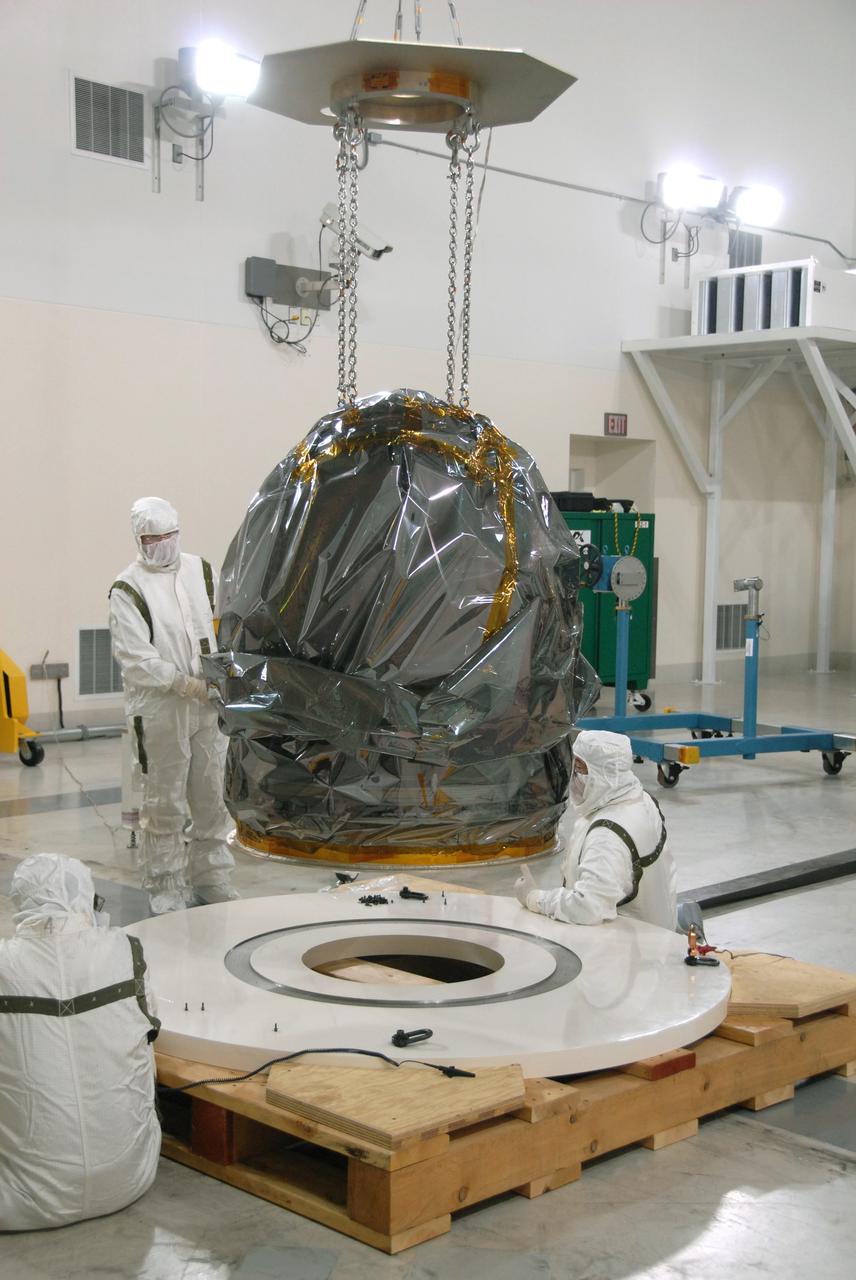
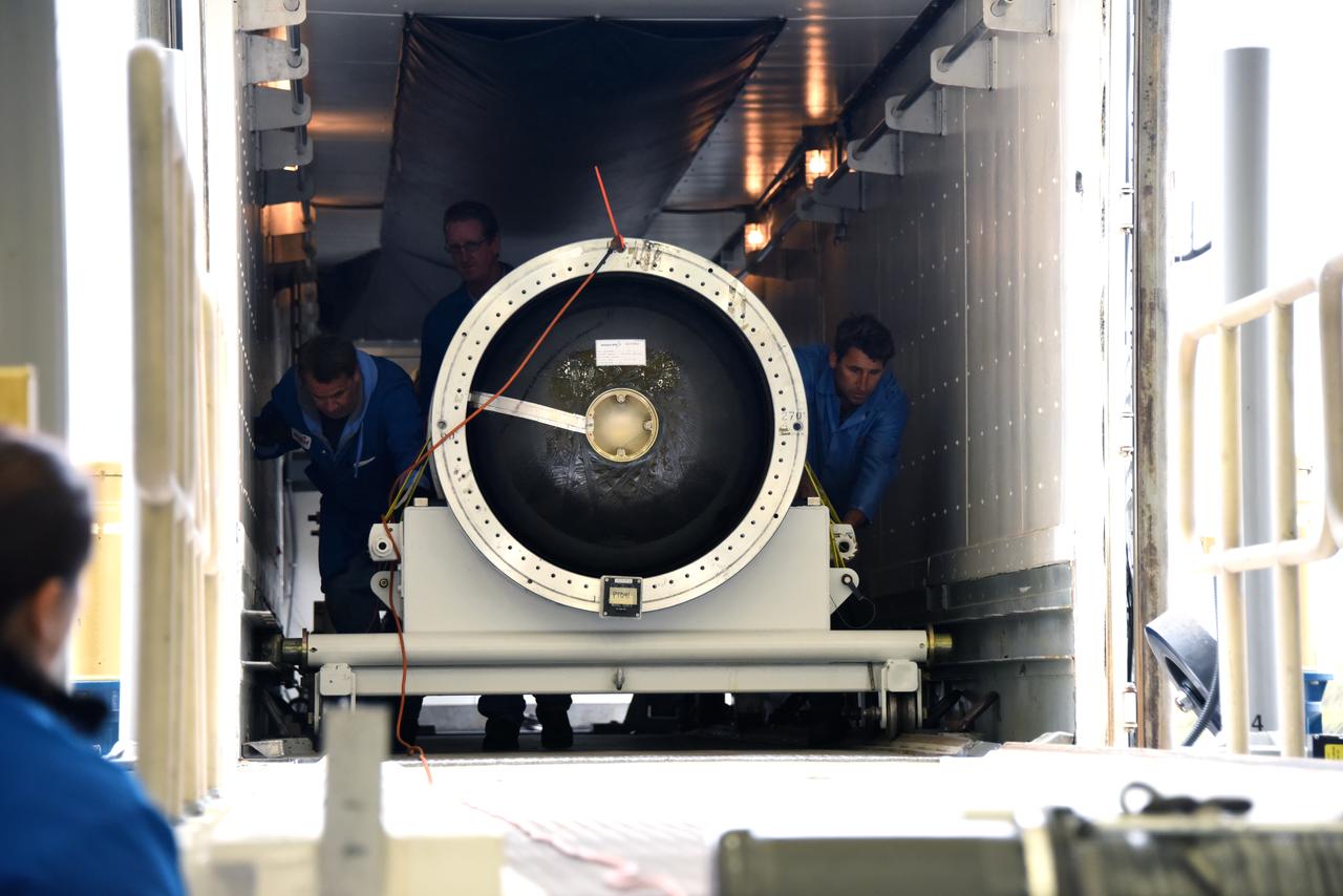
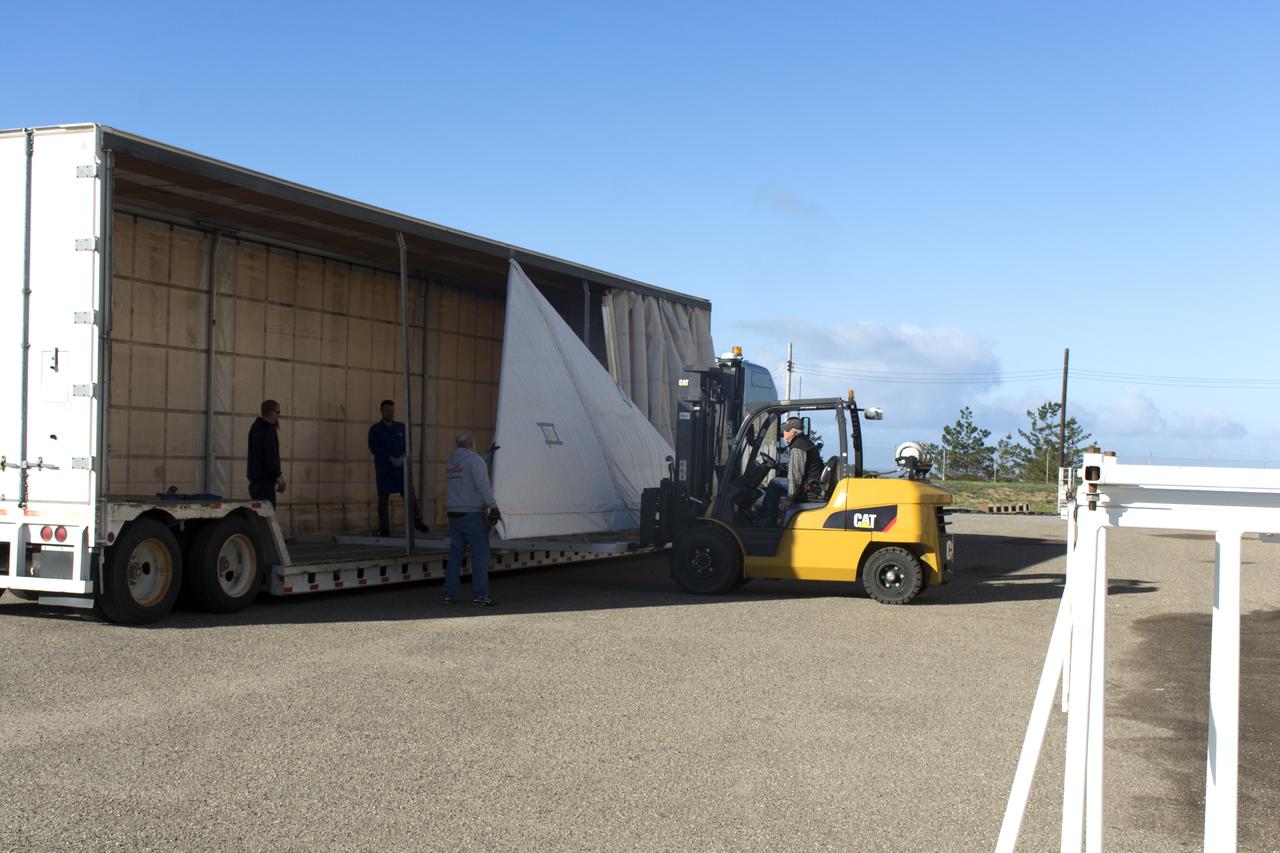
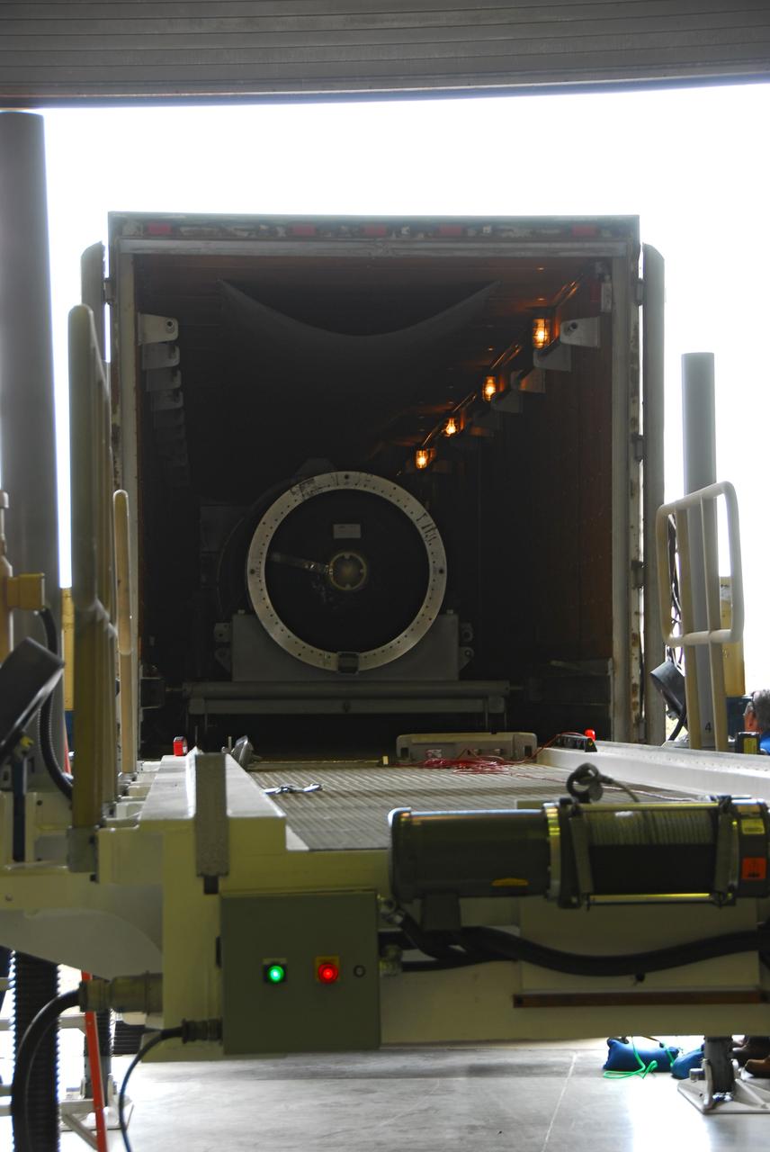
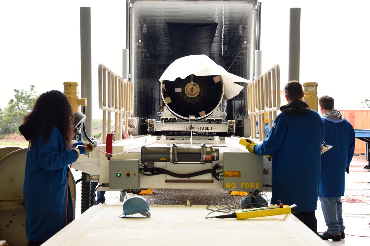
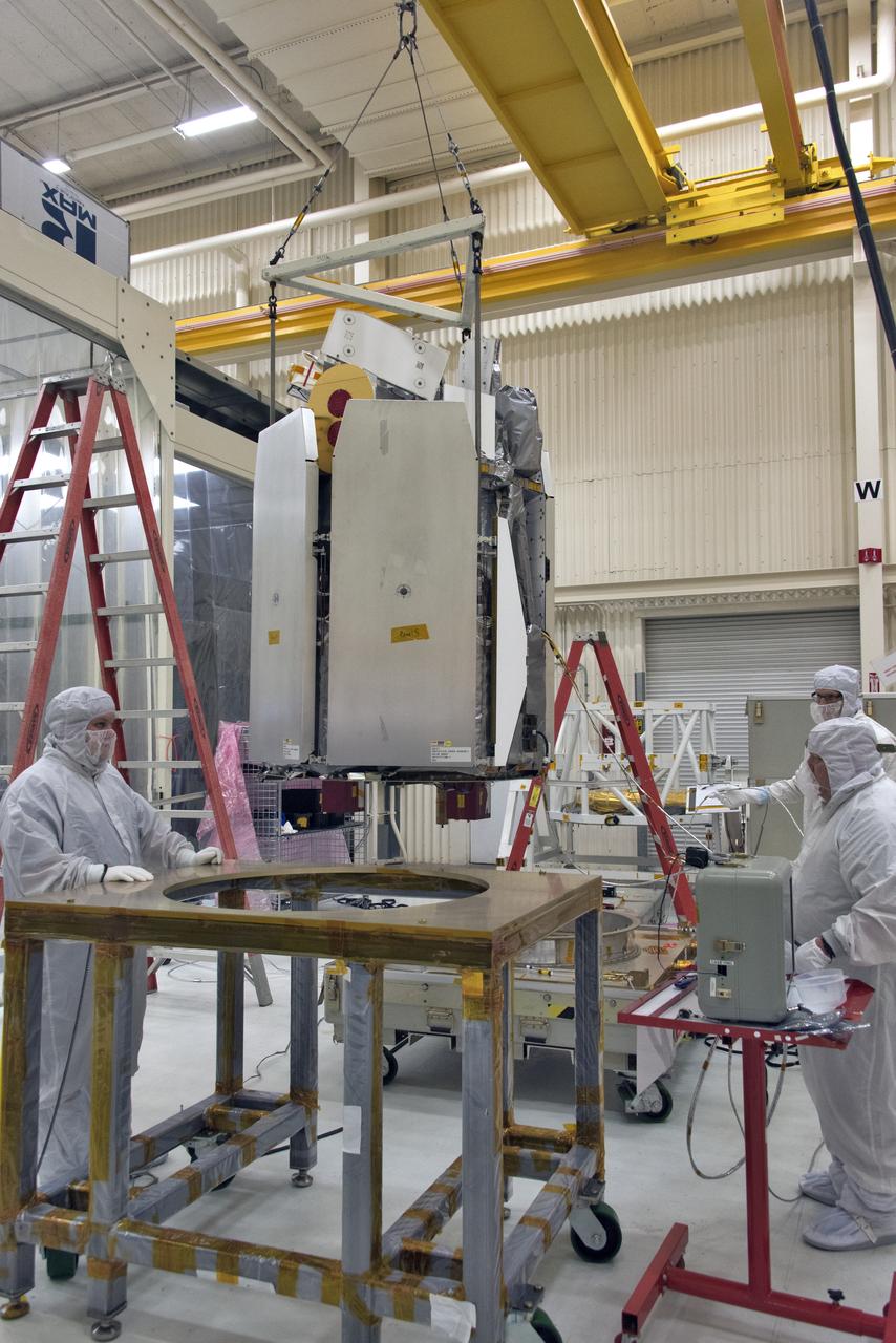
NASA Nuclear Spectroscopic Telescope Array, or NuSTAR, mission is lowered into its shipping container at Orbital Sciences Corporation in Dulles, Va. It is scheduled to launch from Kwajalein Atoll in the Marshall Islands on March 14, 2012.
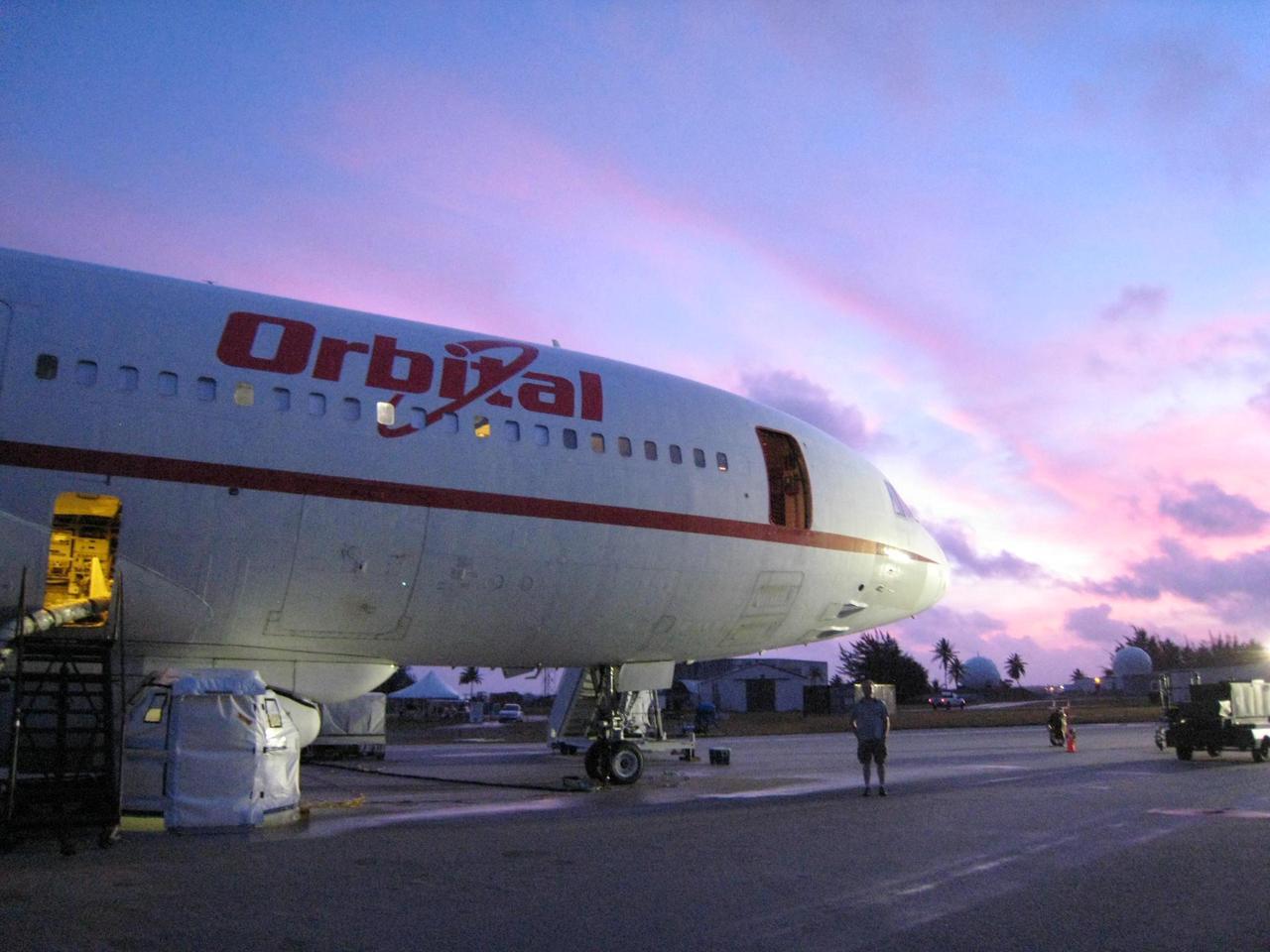
The carrier plane, L-1011 Stargazer, that will give NASA NuSTAR and its rocket a lift to their airborne launch site is seen here at sunrise on Kwajalein Atoll in the Pacific Ocean.
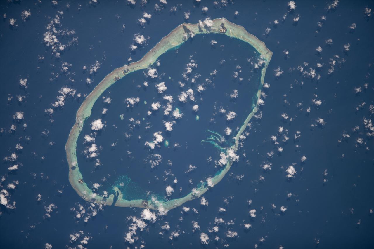
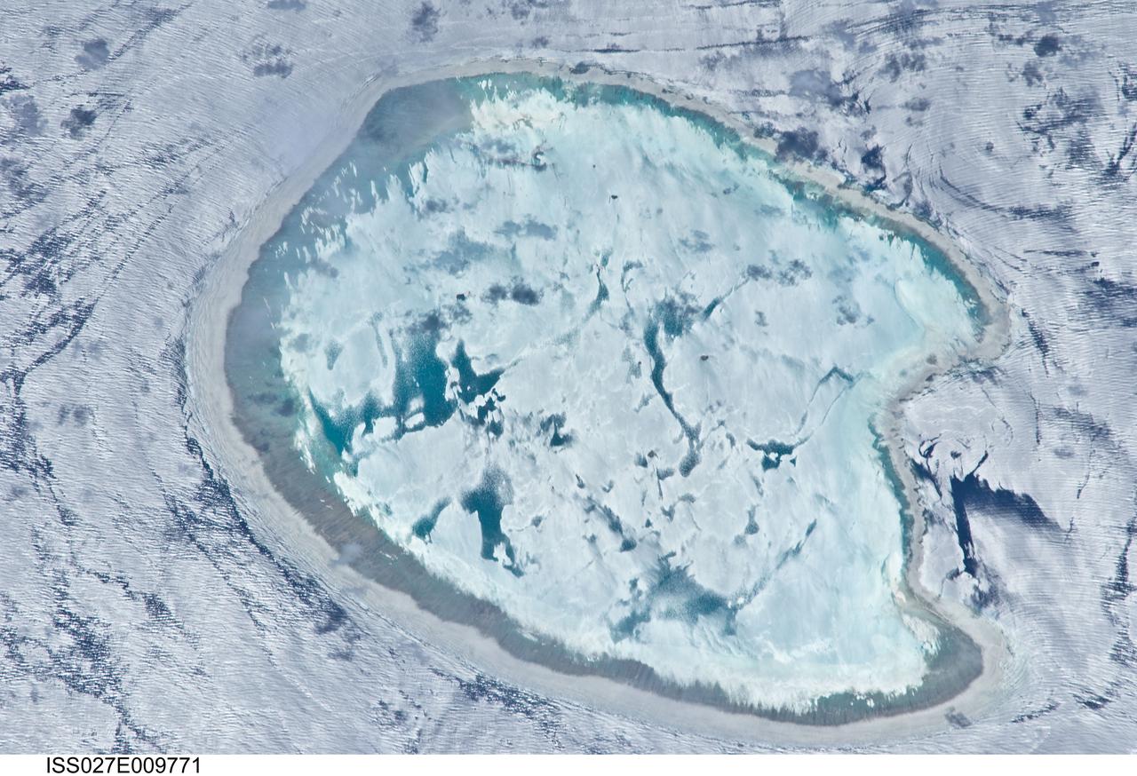
ISS018-E-018129 (6 Jan. 2009) --- Atafu Atoll in the Southern Pacific Ocean is featured in this image photographed by an Expedition 18 crewmember on the International Space Station. At roughly eight kilometers wide, Atafu Atoll is the smallest of three atolls (with Nukunonu and Fakaofo atolls to the southeast, not shown) comprising the Tokelau Islands group located in the southern Pacific Ocean. Swains Island to the south (not shown) is also considered part of the Tokelau group. The political entity of Tokelau is currently a territory of New Zealand. In recent years, public referendums on independence within the islands have been held, but have not received sufficient support to move forward. The primary settlement on Atafu is a village located at the northwestern corner of the atoll ? indicated by an area of light gray dots in this photograph. The typical ring shape of the atoll is the result of coral reefs building up around a former volcanic island. Over geologic time, the central volcano has subsided beneath the water surface, leaving the fringing reefs and a central lagoon that contains submerged coral reefs. Erosion and soil development on the surfaces of the exposed fringing reefs has lead to formation of tan to light brown beach deposits (southern and western sides of the atoll) and green vegetation cover (northern and eastern sides of the atoll). The Tokelau Islands, including Atafu Atoll, suffered significant inundation and erosion during Tropical Cyclone Percy in 2005. The approximate elevation of Atafu Atoll is only two meters above the tidal high water level. Vulnerability to tropical cyclones and potential sea level rise makes the long-term habitability of the atoll uncertain.
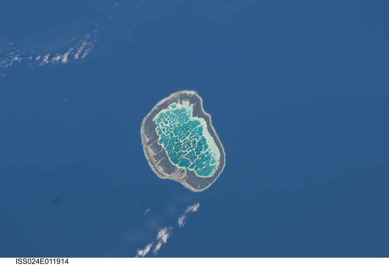
ISS024-E-011914 (13 Aug. 2010) --- Mataiva Atoll, Tuamotu Archipelago in the South Pacific Ocean is featured in this image photographed by an Expedition 24 crew member on the International Space Station. The Tuamotu Archipelago is part of French Polynesia, and forms the largest chain of atolls in the world. This photograph features Mataiva Atoll, the westernmost atoll of the Tuamotu chain. An atoll is a ring-shaped island that encloses a central lagoon. This distinctive morphology is usually associated with oceanic islands formed by volcanoes; coral reefs become established around the partially submerged volcanic cone. Over geologic time the central volcano becomes extinct, followed by erosion and subsidence beneath the sea surface, leaving the coral reefs as a ring around (or cap on) the submerged island remnant. Coral reefs exposed above the sea surface in turn experience erosion, sedimentation and soil formation, leading to the establishment of vegetation and complex ecosystems – including in many cases human habitation. Mataiva Atoll is notable in that its central lagoon includes a network of ridges (white, center) and small basins formed from eroded coral reefs. Mataiva means “nine eyes” in Tuamotuan, an allusion to nine narrow channels on the south-central portion of the island. The atoll is sparsely populated, with only a single village – Pahua – located on either side of the only pass providing constant connection between the shallow (light blue) water of the lagoon and the deeper (dark blue) adjacent Pacific Ocean. Much of the 10 kilometer-long atoll is covered with forest (greenish brown); vanilla and copra (dried coconut) are major exports from the atoll, but tourism is becoming a greater economic factor.
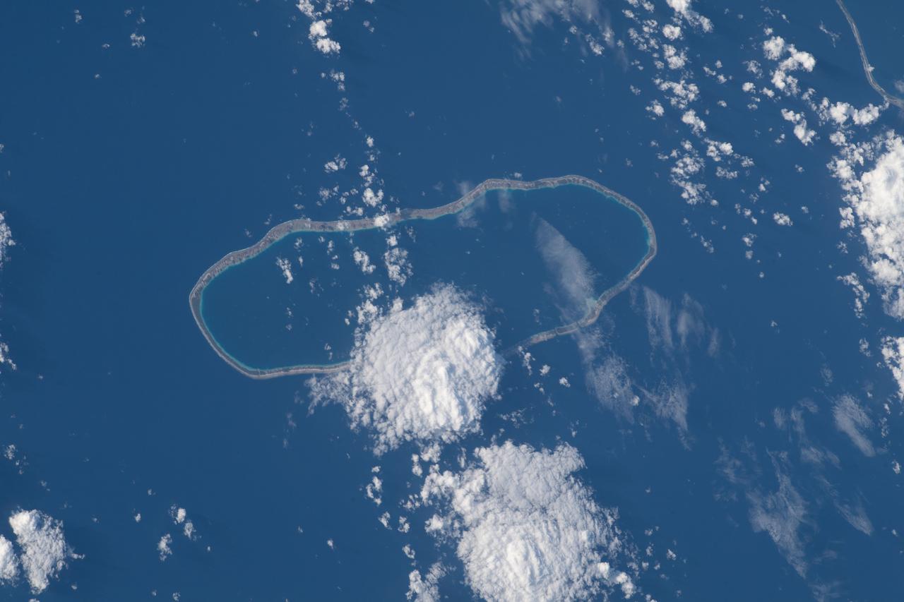
ISS040-E-007404 (4 June 2014) --- One of the Expedition 40 crew members aboard the International Space Station on June 4, 2014, recorded this vertical image of Fangataufa Atoll, a small coral atoll on the eastern side of the Tuamotu Archipelago in French Polynesia in the South Pacific Ocean.
ISS033-E-007873 (27 Sept. 2012) --- Wake Island is featured in this image photographed by an Expedition 33 crew member on the International Space Station. The atoll of Wake Island is located in the central Pacific Ocean approximately 4,000 kilometers to the west-southwest of Hawaii and 2,400 kilometers to the northwest of Guam. In addition to Wake Island, the atoll includes the smaller Peale and Wilkes Island for a total land surface area of 6.5 square kilometers. Like many atolls in the Pacific, the islands and associated reefs formed around a submerged volcano. The lagoon in the center of the islands—characterized by shallow, light blue water in contrast to the surrounding darker, deeper Pacific Ocean waters—marks the approximate location of the summit crater of the volcano.
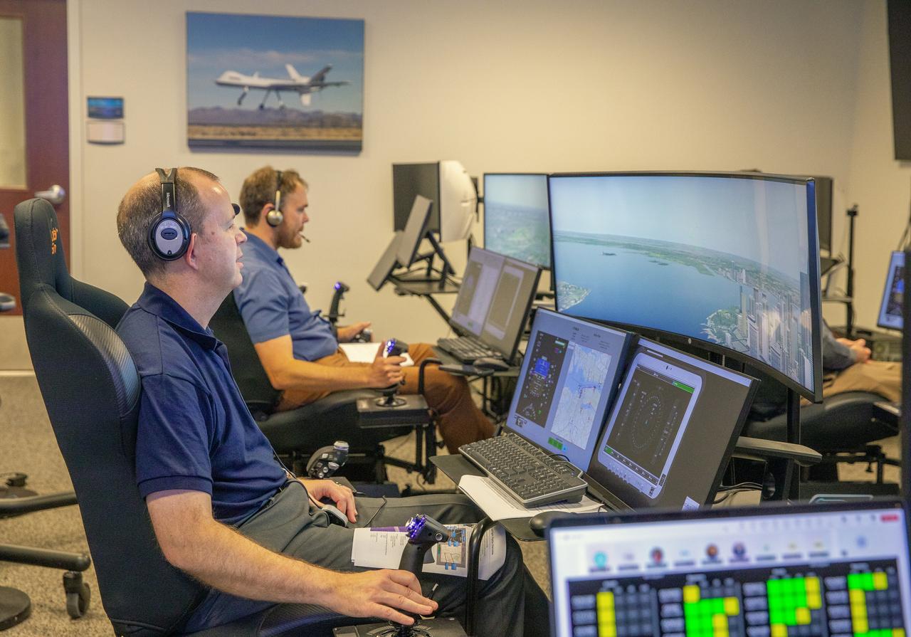
Focus on active photos –Class B Simulation Evaluation in the ATOL Lab at Langley (Also at FAA Tech Center) where team is working with one another in the lab, reviewing data on the monitors. Working the software, adjusting the software systems. Going over the shoulder to show the displays and screens as the software is running. Andy Burroughs (left) and Paul Friz in the roles of air taxi pilots running through air taxi integration simulations focusing on urban air space at NASA’s Langley Research in Hampton, Virginia on Sept. 25, 2024.
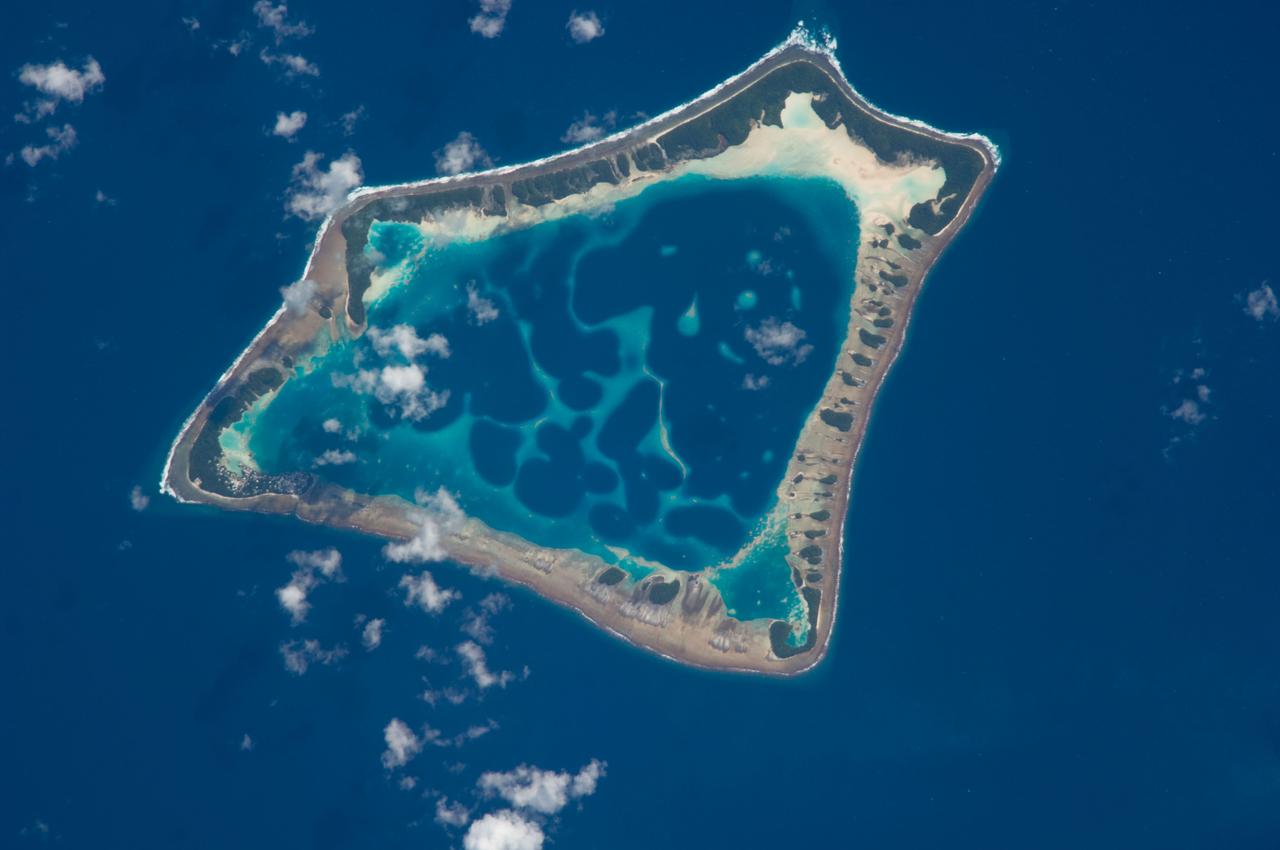
ISS037-E-022125 (28 Oct. 2013) --- The interesting color contrasts of the water surrounding the atolls of Pinaki (bottom) and Nukutavake in French Polynesia caught the eye of one of the Expedition 37 crew members aboard the Earth-orbiting International Space Station on Oct. 28. At first glance to a pair of sleepy eyes, the atolls might look somewhat like a bottle cap and a bottle opener.
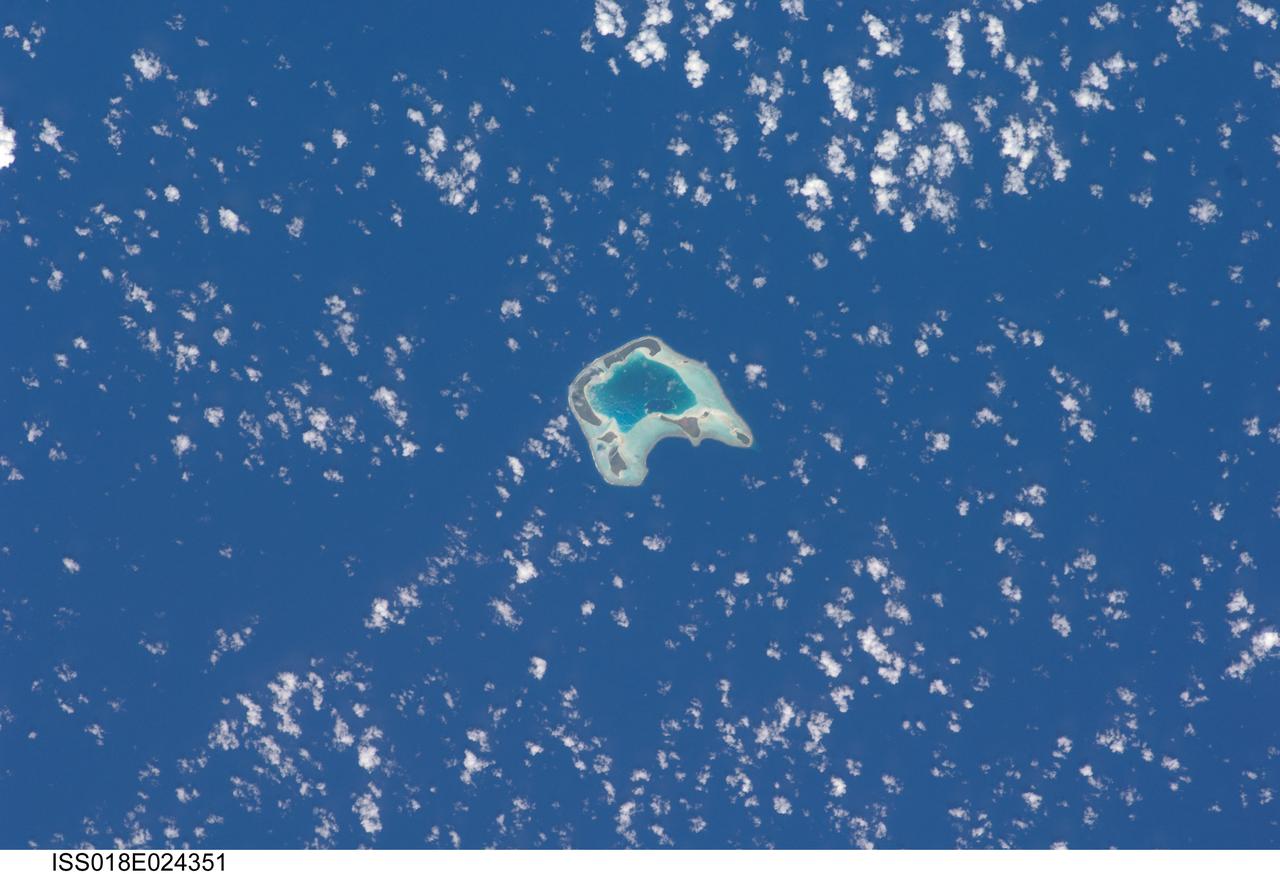
ISS018-E-024351 (27 Jan. 2009) --- Tetiaroa Island in French Polynesia is featured in this image photographed by an Expedition 18 crewmember on the International Space Station. This island, part of the Society Islands archipelago in the southern Pacific Ocean, is also known as ?Marlon Brando?s Island?. The late film star purchased the island ? more correctly, an atoll comprised of thirteen small islets (or motus) from the French Polynesian government for a total of 70,000 over 1966-1967. While the motus were his property, the government retained the rights to the coral reefs and lagoons to preserve control of marine resources. Following Brando?s death in 2004, ownership of the approximately 8 kilometers?wide atoll passed into other private hands, and there are now plans to build a luxury resort amongst the islets. This view illustrates the typical circular appearance of a fully-developed atoll. The ring of islands ? covered in green vegetation and white to tan sandy beaches ? develops on coral reefs, which originally form around a volcanic island. As the volcanic island gradually disappears due to subsidence and erosion, the coral reefs continue to grow upwards. Over time, the central volcanic island is completely submerged, leaving a ring of coral reefs and islands that surround a lagoon. The shallow lagoon waters appear blue-green in this image, and contrast with darker ? and deeper ? Pacific Ocean waters surrounding the atoll. One of the motus in the southern portion of the atoll, Tahuna Rahi, is a protected bird sanctuary, and is the nesting site of red- and brown-footed boobies, frigatebirds, and terns (among other species). Access to the atoll is via boat, as the airstrip was closed in 2004 due to safety and security concerns.
iss068e036653 (Jan. 1, 2022) --- The sun's glint beams off a partly cloudy Pacific Ocean in this photograph from the International Space Station as it orbited 260 miles above and northwest of Midway Atoll.
iss068e007434 (Oct. 2, 2022) --- Carteret Atoll, part of the independent nation of Papua New Guinea, is pictured from the International Space Station as it orbited 260 miles above the southwestern Pacific Ocean. Credit: ESA/Samantha Cristoforetti
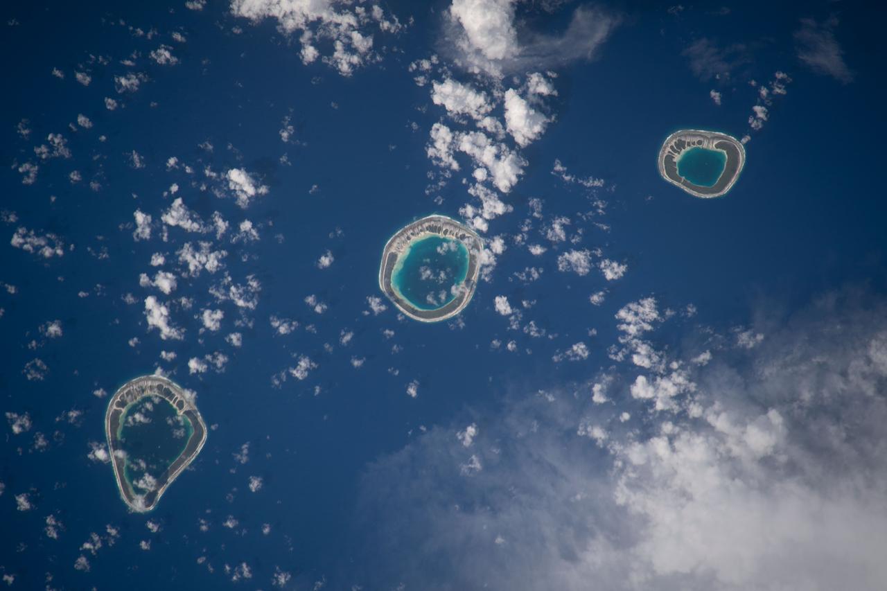
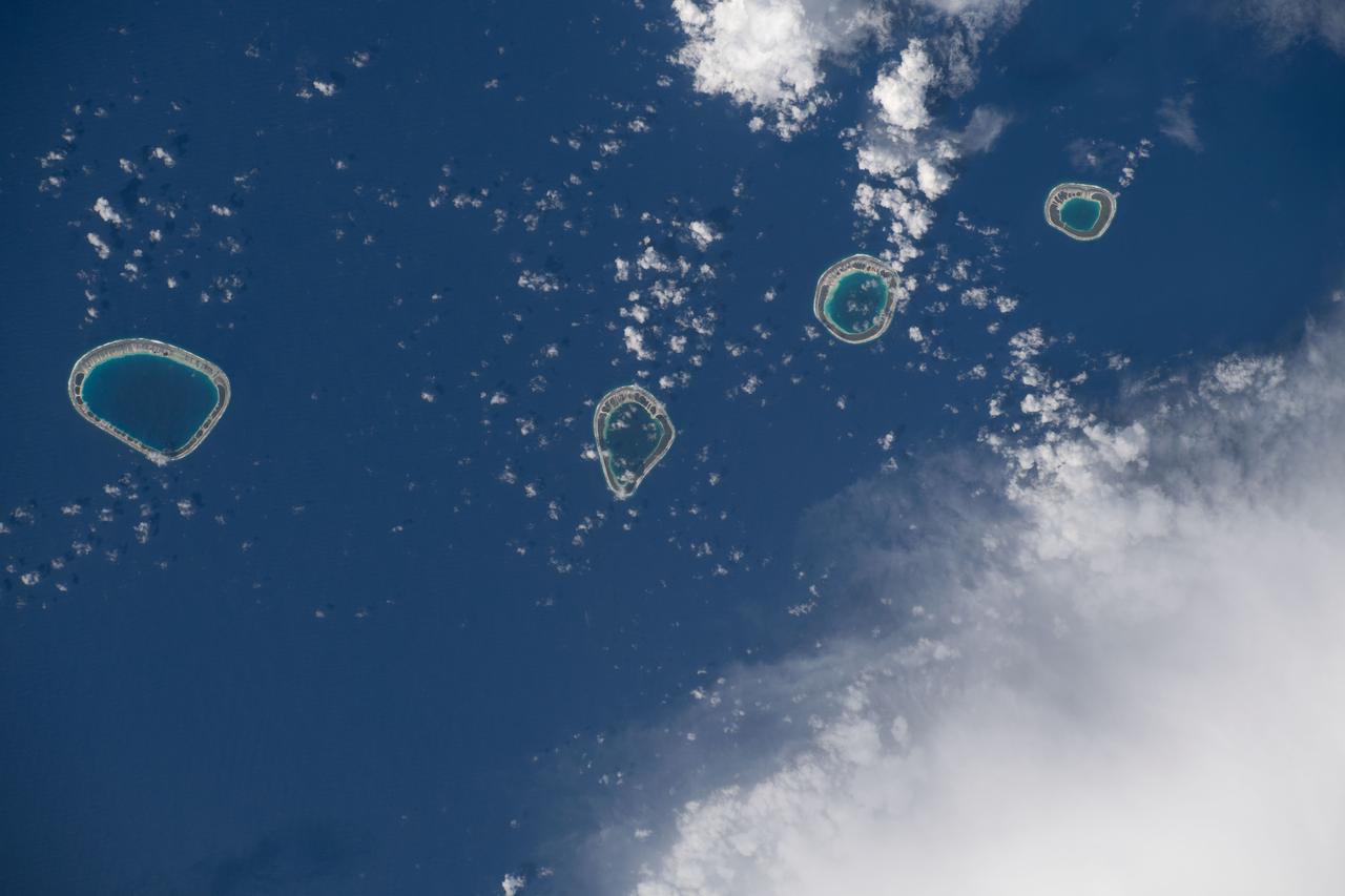
iss068e043869 (Jan. 30, 2023) --- The uninhabited atolls of (from left) Vahanga, Tenarungo, and Tenanaro, which are part of French Polynesia in the south Pacific Ocean, are pictured from the International Space Station as it orbited 260 miles above.
iss068e000304 (Sept. 29, 2022) --- Taongi Atoll, in the independent country of the Marshall Islands, is pictured from the International Space Station as it orbited 258 miles above the Pacific Ocean.
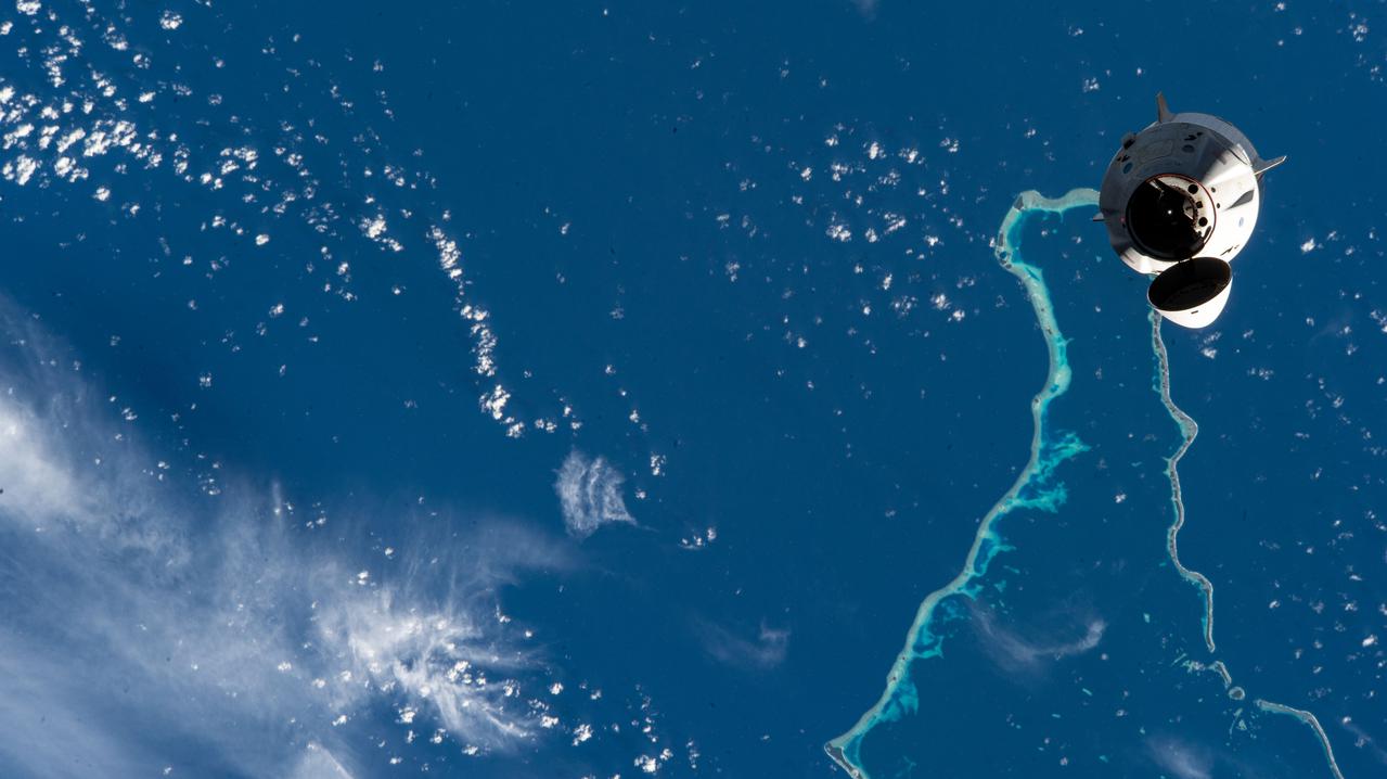
iss066e068896 (Nov. 8, 2021) --- The SpaceX Crew Dragon Endeavour carrying four commercial crew astronauts departs the International Space Station as both spacecraft were orbiting 259 miles above the Jaluit Atoll in the Marshall Islands.
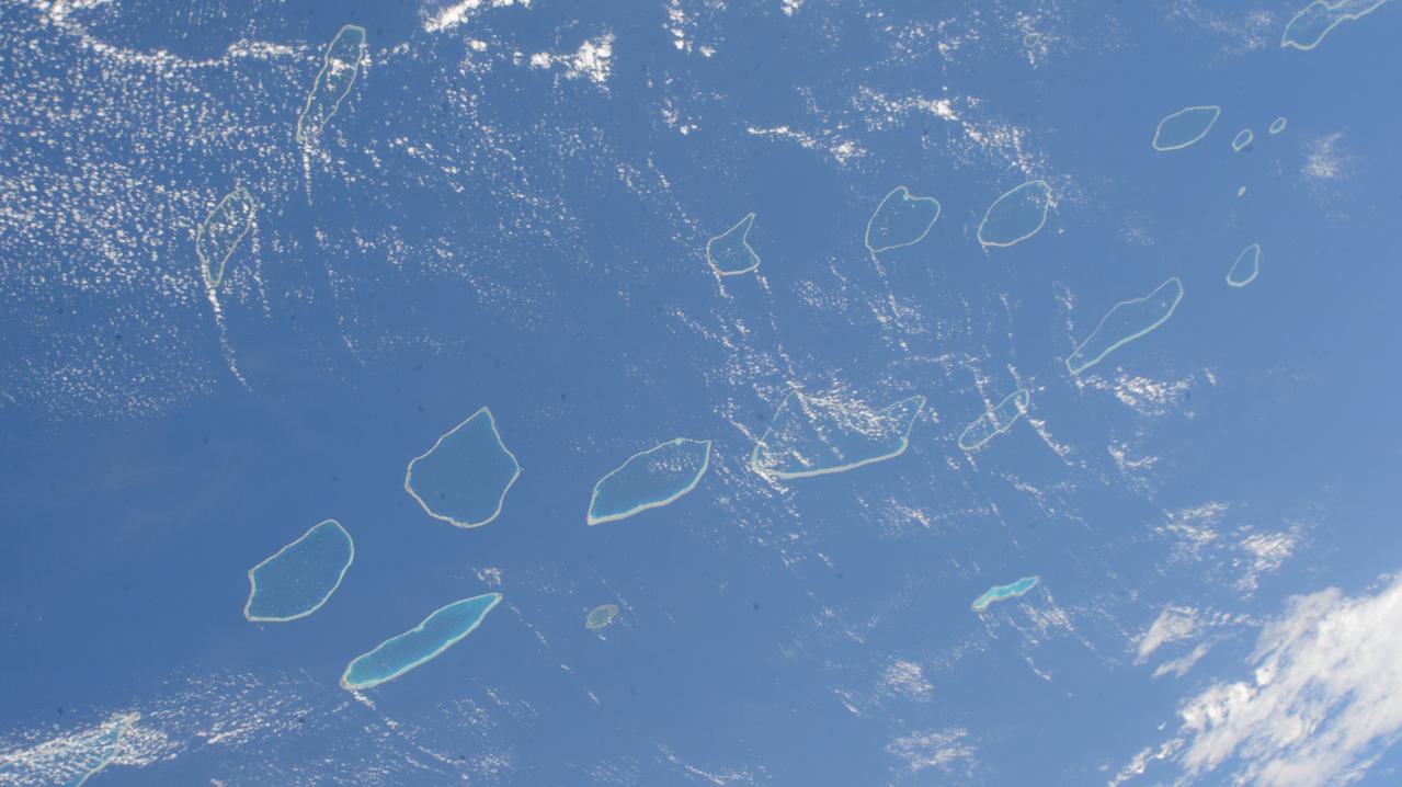
iss071e207656 (June 22, 2024) --- The Palliser Islands, atolls that are part of Fench Polynesia's Tuamotu Archipelago in the Pacific Ocean, are pictured from the International Space Station as it orbited 266 miles above.

iss053e180184 (Nov. 12, 2017) --- The islands of (from left) Abaiang, Tarawa and Maiana are part of the Gilbert Islands and make up part of the republic of Kiribati in the Pacific Ocean. Kiribati is comprised of a total of 33 coral atolls and isles.
iss064e026165 (Jan. 26, 2021) --- The Republic of China's Dongsha Atoll National Park is pictured from the International Space Station as it orbited 261 miles above the South China Sea.
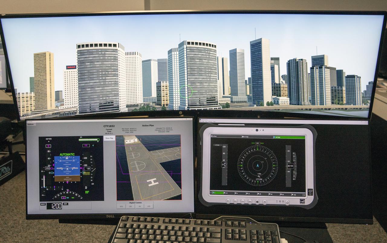
Focus on active photos –Class B Simulation Evaluation in the ATOL Lab at Langley (Also at FAA Tech Center) where team is working with one another in the lab, reviewing data on the monitors. Working the software, adjusting the software systems. Going over the shoulder to show the displays and screens as the software is running. A pilot’s point of view from the controls of the air taxi simulator. An out-the-window simulation appears on the top screen, the primary flight display on the lower left, the virtual moving map in the middle, and the detect and avoid display on the lower right at NASA’s Langley Research Center in Hampton, Virginia on Sept. 25, 2024.

Focus on active photos –Class B Simulation Evaluation in the ATOL Lab at Langley (Also at FAA Tech Center) where team is working with one another in the lab, reviewing data on the monitors. Working the software, adjusting the software systems. Going over the shoulder to show the displays and screens as the software is running. John Foster (left) in the role of an air taxi pilot in the simulator chair with Jim Chamberlain and Terence McClain at the flight manager stations running virtual air taxi integration simulations focusing on urban air space at NASA’s Langley Research Center in Hampton, Virginia on Sept. 25, 2024.

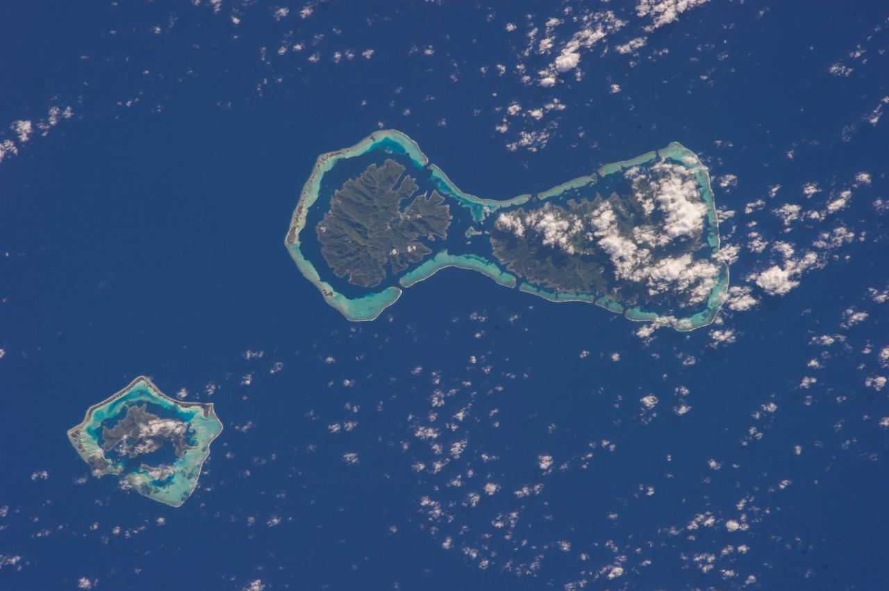
ISS006-E-22132 (January 2003) --- A portion of the Society Islands was captured with a digital still camera by one of the Expedition Six crewmembers on the International Space Station (ISS). The evolution of fringing reefs to atolls was captured in this one frame. As with the Hawaiian Islands, these volcanic hot spot islands become progressively older to the northwest. As these islands move away from their magma sources they erode and subside. The two large islands, Raiatea and Tahaa, share a single fringing reef. The next island to the northwest, Bora-Bora, consists of a highly eroded volcanic remnant with fringing reef. The last island, Tupai, has become an atoll with the central portion below sea level.

KWAJALEIN ATOLL, S. Pacific – The Orbital Sciences L-1011 carrier aircraft arrives at Kwajalein Atoll Oct. 12, 2008, with the Pegasus XL rocket and the Interstellar Boundary Explorer, or IBEX. The two-day ferry flight began from Vandenberg Air Force Base in California on Oct. 11. After an overnight stopover in Hawaii, the ferry flight to the South Pacific continued. Launch of IBEX aboard the Pegasus XL rocket successfully occurred over the Pacific Ocean Oct. 19 at a location 125 miles north of Kwajalein. Photo credit: Ivy Springer
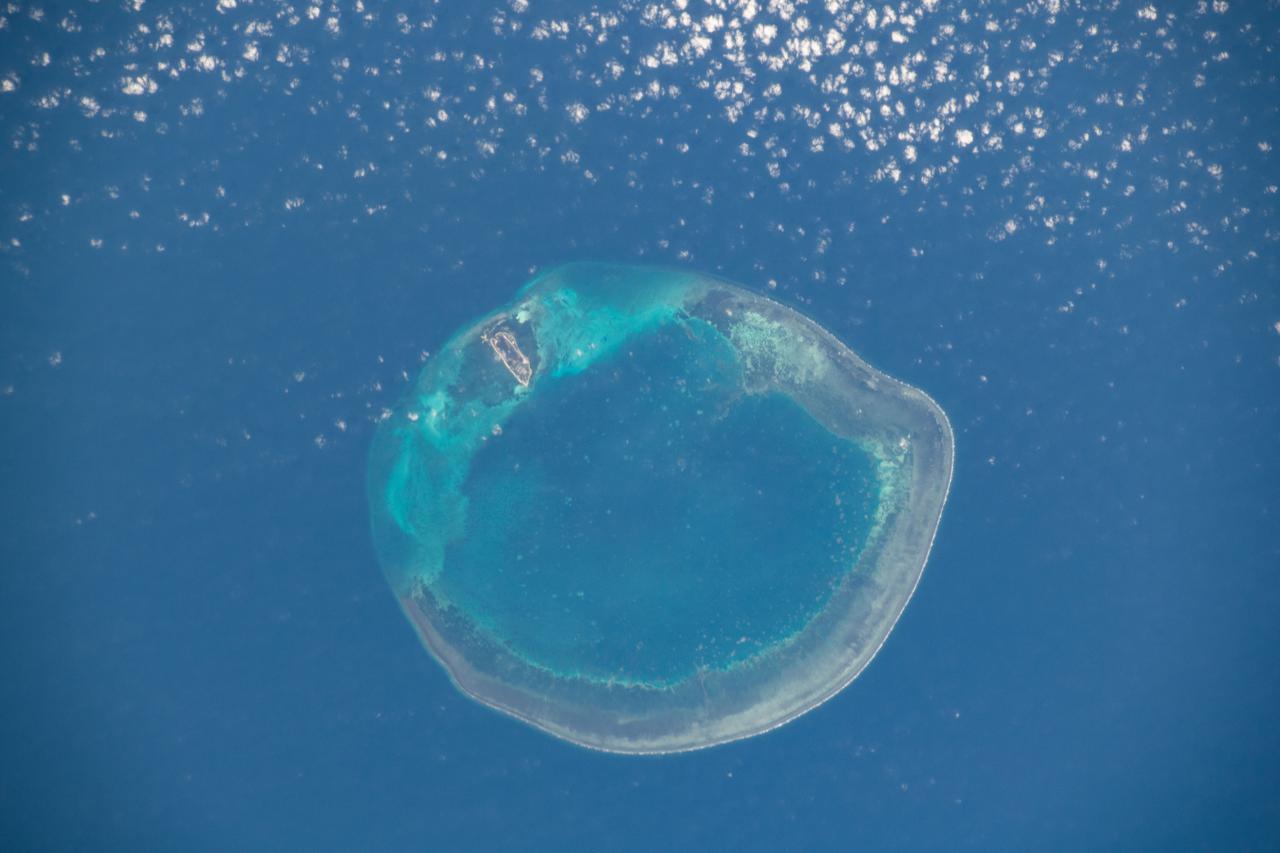
ISS027-E-009771 (2 April 2011) --- Bassas da India is featured in this image photographed by an Expedition 27 crew member on the International Space Station. The vantage point of crew members onboard the space station provides many dramatic views of Earth?s surface. This detailed photograph of the Bassas da India, an uninhabited atoll in the Indian Ocean (between the Mozambique coast of Africa and the island of Madagascar) has an almost surreal quality due to varying degrees of sunglint. Sunglint is an optical phenomena caused by light reflecting off of a water surface directly back towards the observer. Variations in the roughness of the water surface?presence or absence of waves due to wind and water currents?will cause differences in the intensity of the sunglint. The presence of other materials, such as oils or surfactants, can also change the properties of the water surface. Here the presence of currents is highlighted as darker patches or streaks (left and upper right). In contrast, shallow water in the lagoon (center) presents a more uniform, mirror-like appearance in sunglint suggesting that there are no subsurface currents present. Wave crests visible around the atoll are likely the result of both surface winds and subsurface currents. The Bassas da India atoll is part of the French Southern and Antarctic Lands. It is uninhabited due to its complete submergence during high tide ? there is no vegetation established on the atoll for the same reason. The atoll is approximately 10 kilometers in diameter, and covers an area (including the lagoon) of approximately 80 square kilometers.
iss068e043864 (Jan. 30, 2023) --- The uninhabited atolls of (from left) Maturei Vavao, Vahanga, Tenarungo, and Tenanaro, which make up French Polynesia in the south Pacific Ocean, are pictured from the International Space Station as it orbited 260 miles above.
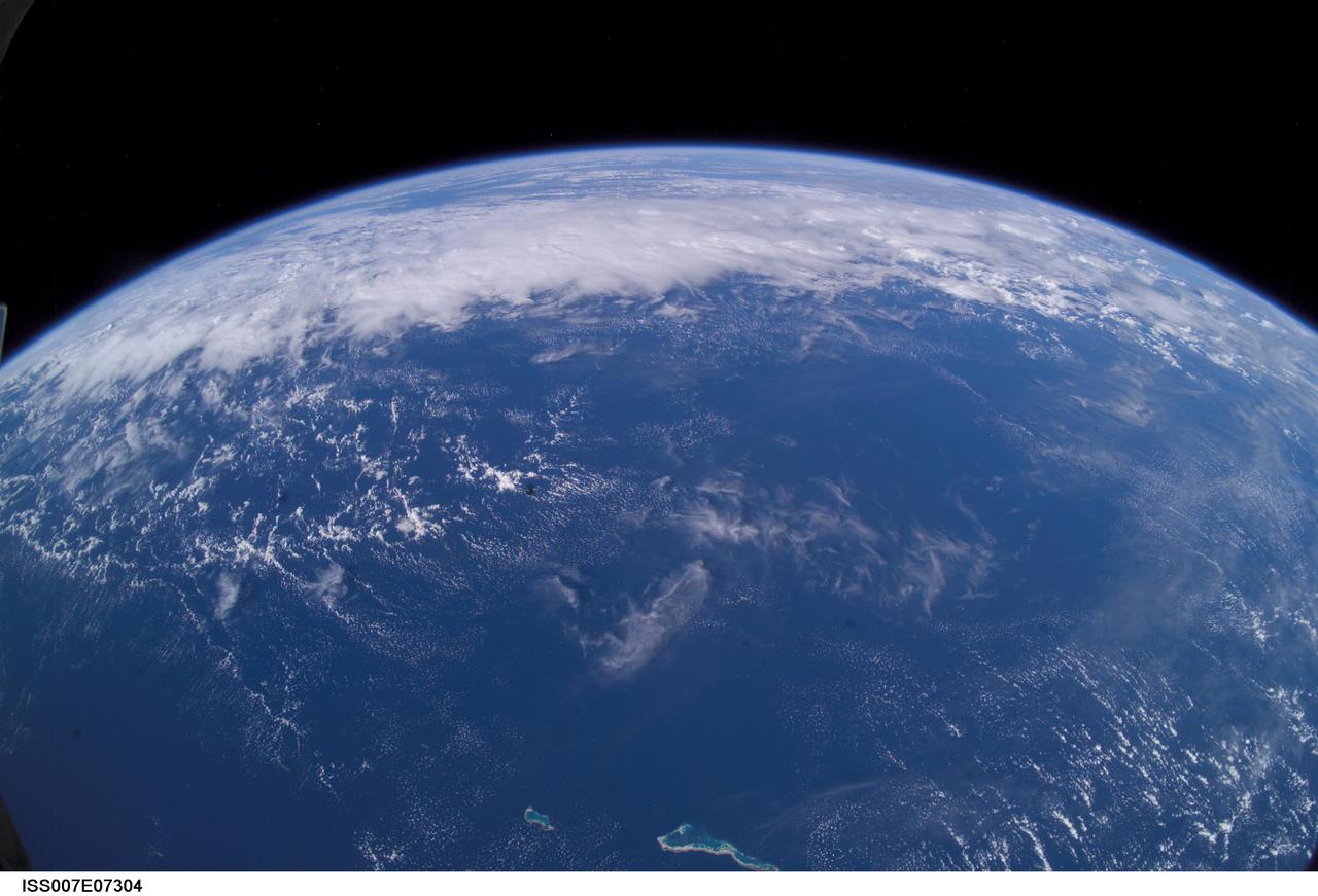
ISS007-E-07304 (13 June 2003) --- This view of Earth’s horizon was taken by an Expedition 7 crewmember onboard the International Space Station (ISS), using a wide-angle lens while the Station was over the Pacific Ocean. In the foreground are the atolls of Tabiteuea and Onotoa.
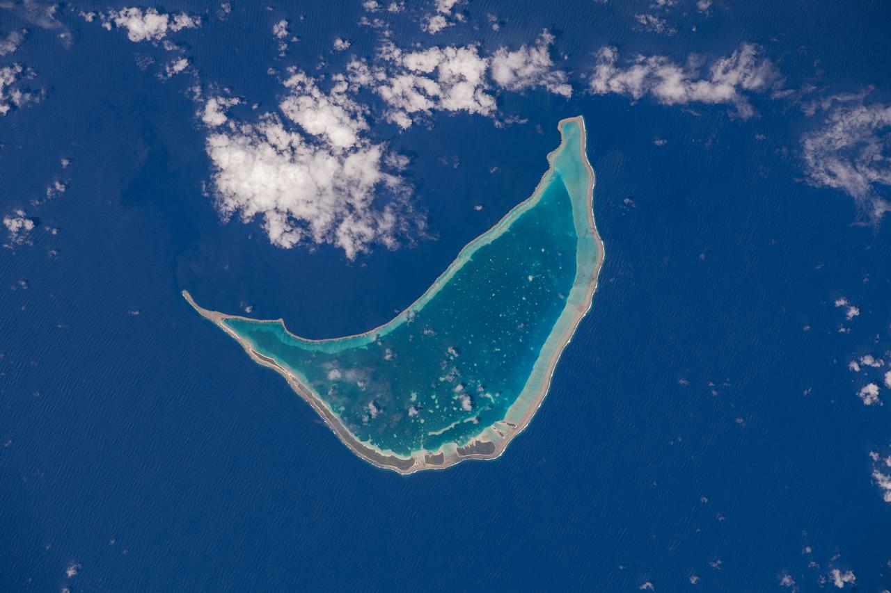
iss069e054648 (August 4, 2023) -- Amanu, a ring-shaped island—or an atoll—is roughly 560 miles (900 kilometers) from Tahiti. Only 10 miles (~15 kilometers) of its land is above water, creating a lagoon in its center. The International Space Station soared 261 miles above the Pacific Ocean as this image was taken.
KWAJALEIN ATOLL, Marshall Islands – Orbital Sciences' L-1011 carrier aircraft touches down at the U.S. Army's Ronald Reagan Ballistic Missile Defense Test Site on Kwajalein Atoll, delivering Orbital’s Pegasus rocket and NASA’s Nuclear Spectroscopic Telescope Array, or NuSTAR, from Vandenberg Air Force Base in California. The Pegasus, mated to its NuSTAR payload, will be launched from the carrier aircraft 117 nautical miles south of Kwajalein at latitude 6.75 degrees north of the equator. The high-energy X-ray telescope will conduct a census of black holes, map radioactive material in young supernovae remnants, and study the origins of cosmic rays and the extreme physics around collapsed stars. Launch and deployment of the telescope is scheduled for June 13. For more information, visit http:__www.nasa.gov_nustar. Photo courtesy of Orbital Sciences Corp.
KWAJALEIN ATOLL, Marshall Islands – Orbital Sciences' L-1011 carrier aircraft has arrived at the U.S. Army's Ronald Reagan Ballistic Missile Defense Test Site on Kwajalein Atoll, delivering Orbital’s Pegasus rocket and NASA’s Nuclear Spectroscopic Telescope Array, or NuSTAR, from Vandenberg Air Force Base in California. The Pegasus, mated to its NuSTAR payload, will be launched from the carrier aircraft 117 nautical miles south of Kwajalein at latitude 6.75 degrees north of the equator. The high-energy X-ray telescope will conduct a census of black holes, map radioactive material in young supernovae remnants, and study the origins of cosmic rays and the extreme physics around collapsed stars. Launch and deployment of the telescope is scheduled for June 13. For more information, visit http://www.nasa.gov/nustar. Photo courtesy of Orbital Sciences Corp.
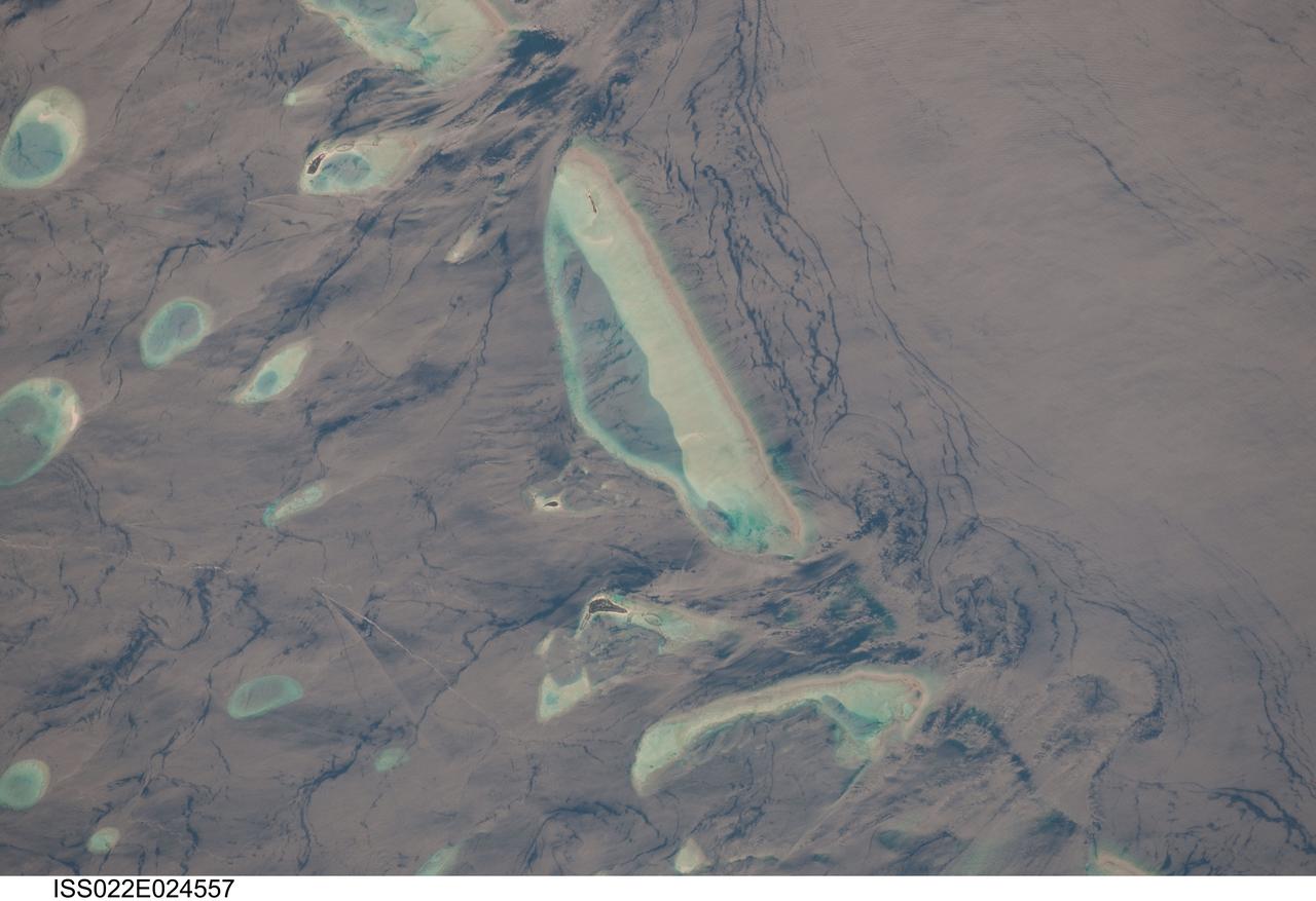
ISS022-E-024557 (12 Jan. 2010) --- Male Atoll and Maldive Islands in the Indian Ocean are featured in this image photographed by an Expedition 22 crew member on the International Space Station. This detailed photograph features one of the numerous atolls in the Maldive Island chain. The Maldives are an island nation, comprised of twenty-six atolls that stretch in a north-to-south chain for almost 900 kilometers southwest of the Indian subcontinent. The silvery, almost pink sheen on the normally blue water of the equatorial Indian Ocean is the result of sunglint. Sunglint occurs when sunlight is reflected off of a water surface directly back towards the observer ? in this case a crew member on the space station. Full sunglint in images typically results in bright silver to white coloration of the water surface. Sunglint images can have different hues depending on the roughness of the water surface and atmospheric conditions. They also can reveal numerous details of water circulation which are otherwise invisible. This image was taken during the Indian Ocean Northeast monsoon season - predominant winds in this area create sinuous surface water patterns on the leeward side, and between, the islets (left). A south-flowing current flows in the deeper water through the Maldives most of the year (right), with fan-shaped surface currents formed by local tides pulsing in and out of the shallow water near the islands (top and bottom). The largest island seen here (center) is 6 kilometers long, and is one of the outer ring of larger islands that make up the 70 kilometers-long, oval-shaped Male Atoll. Shores facing deeper water have well-defined beaches. Numerous small, elliptical coral reef islets are protected within the ring of shallow water to the northeast (left). These islets are mostly awash at high tide, with dry ground appearing in tiny patches only. A small boat was navigating between the islets at the time the image was taken as indicated by its v-shaped wake at bottom left. Images like these illustrate why the Republic of Maldives is one of the most outspoken countries in stressing the dangers of rising sea levels.
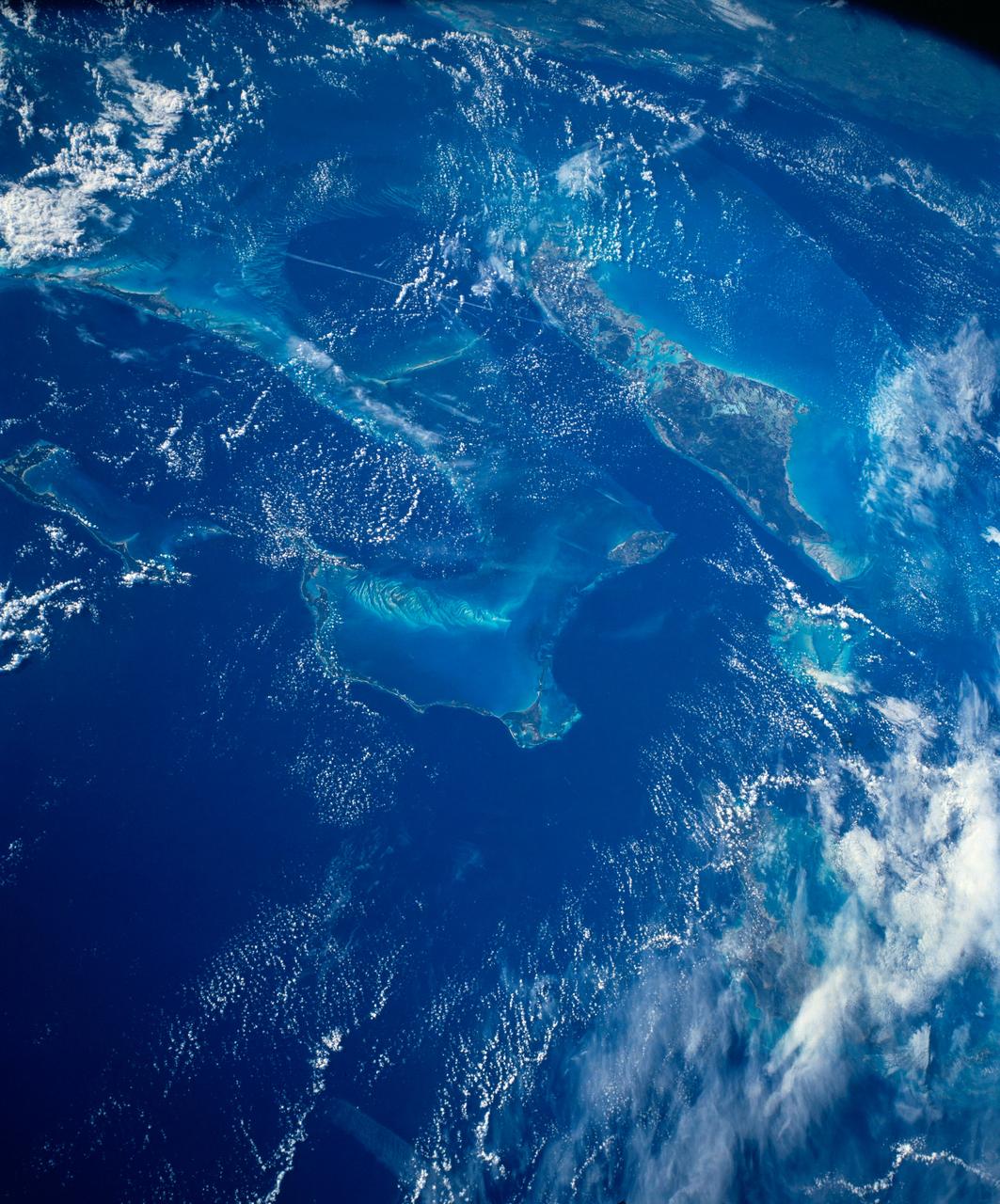
STS054-152-102 (13-19 Jan. 1993) --- This is a south-looking, wide angle view of the northern Bahamas, featuring the islands (from mid-foreground toward background) of Eleuthera, New Providence, and Andros. The northern shore of Cuba can be seen in the background. The resort city of Nassau occupies much of eastern New Providence. The Bahamas host some very distinctive features -- the deep blue channels and the shallow, light blue platforms, feathery sand bars at the edges of the deep water sounds, and colorful lakes and tidal channels like seen on Andros Island.
iss071e243431 (June 28, 2024) --- Pictured in the foreground, is Northrop Grumman's Cygnus space freighter, berthed to the International Space Station's Unity module, and one of two of its cymbal-shaped UltraFlex solar arrays. In the rear, is the Soyuz MS-25 crew ship docked to the Prichal docking module. The orbital outpost was soaring 263 miles above the Pacific Ocean south of Midway Atoll.
Vandenberg Air Force Base, Calif. – At Vandenberg Air Force Base, the Pegasus XL aircraft (left) is ready for mating to NASA's Interstellar Boundary Explorer, or IBEX, spacecraft and upper stage booster (right). The IBEX satellite will make the first map of the boundary between the Solar System and interstellar space. IBEX is the first mission designed to detect the edge of the Solar System. IBEX is targeted for launch from the Kwajalein Atoll, a part of the Marshall Islands in the Pacific Ocean, on Oct. 19. Photo credit: NASA/D. Kolkow, VAFB
Vandenberg Air Force Base, Calif. – At Vandenberg Air Force Base in California, NASA’s Interstellar Boundary Explorer, or IBEX, is covered with protective material for a move to the stand in the foreground. The overhead crane will be attached to make the move. Designed to detect the edge of the Solar System, the IBEX satellite will make the first map of the boundary between the Solar System and interstellar space. IBEX is targeted for launch from the Kwajalein Atoll, a part of the Marshall Islands in the Pacific Ocean, on Oct. 19. Photo credit: NASA/Mark Mackley, VAFB

ISS042eE01551 (01/06/2015) --- NASA astronaut Terry Virts tweeted this night image out with the twinkling city lights of the coast of India and the Maldives. The Maldives is a tropical nation in the Indian Ocean composed of 26 coral atolls, which stretch for hundreds of islands. It’s known for its beaches, blue lagoons and extensive reefs. Terry tweeted this comment along with the image: " Moonlit clouds over southeast #India coastline, with Chennai, Bangalore, and Hyderabad."
Vandenberg Air Force Base, Calif. – At Vandenberg Air Force Base in California, NASA’s Interstellar Boundary Explorer, or IBEX, waits to be covered so it can be moved to another facility for mating with the Pegasus XL rocket. Designed to detect the edge of the Solar System, the IBEX satellite will make the first map of the boundary between the Solar System and interstellar space. IBEX is targeted for launch from the Kwajalein Atoll, a part of the Marshall Islands in the Pacific Ocean, on Oct. 19. Photo credit: NASA/Mark Mackley, VAFB
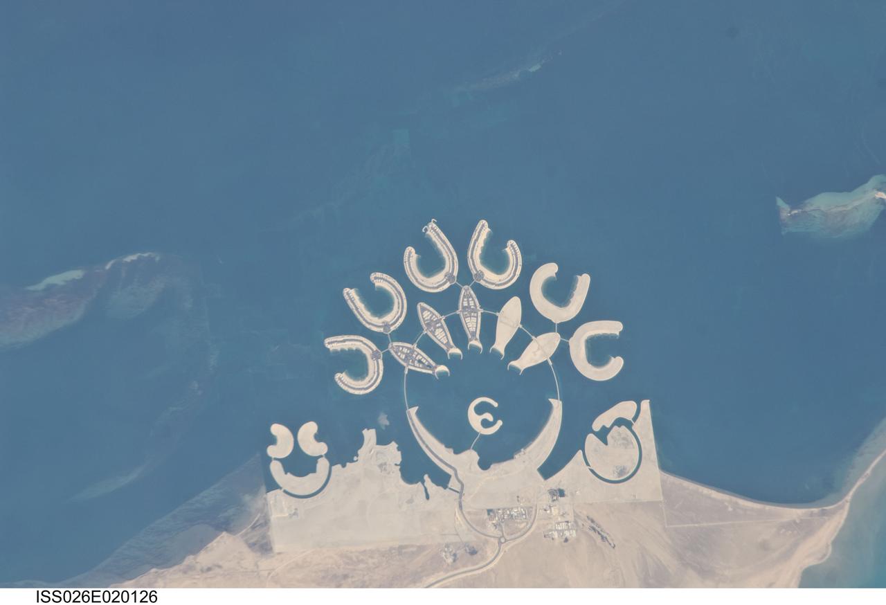
ISS026-E-020126 (23 Jan. 2011) --- Durrat Al Bahrain, Bahrain, is featured in this image photographed by an Expedition 26 crew member on the International Space Station. Set at the southern end of Bahrain Island, at the furthest point from the cities of the kingdom, is a new complex of 14 artificial islands designed for residential living and tourism with luxury hotels and shopping malls. Aimed at a cosmopolitan clientele, the Durrat Al Bahrain includes 21 square kilometers of new surface area—for more than 1,000 residences—that has been designed as The Islands (six “atolls” leading off five fish-shaped “petals”), The Crescent, Hotel Island in the center of the complex, and Durrat Marina in the north. The spectacular outline of this development, and others such as the Palm Jumeirah and World Islands developments in the Persian Gulf, are best appreciated from above. Views from jet liners at high altitude—and orbital platforms such as the International Space Station—are the only ways to fully appreciate these sights. This detailed photograph shows that construction on the southern two atolls and petals has yet to begin. Artificial beaches have been created on the inner shorelines of the Crescent and petals, with smaller beaches on the inner ends of the atolls and Hotel Island. The angular outline of the golf course, where many more residences are planned to line the fairways, can be seen between The Crescent and the marina. What may be a second marina at the south end of the complex mirrors the one on the north, appears to be part of the complex, but it does not figure in some earlier plans for the Durrat Al Bahrain.
Northrop Grumman's L-1011 Stargazer aircraft is at the hot pad at Vandenberg Air Force Base in California on May 26, 2018. Preparations are underway to attach the company's Pegasus XL rocket, containing NASA's Ionospheric Connection Explorer (ICON), beneath the aircraft. The explorer will launch on June 15, 2018, from Kwajalein Atoll in the Marshall Islands (June 14 in the continental United States). ICON will study the frontier of space - the dynamic zone high in Earth's atmosphere where terrestrial weather from below meets space weather above. The explorer will help determine the physics of Earth's space environment and pave the way for mitigating its effects on our technology, communications systems and society.
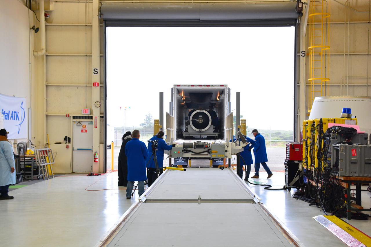
The first stage motor for the Orbital ATK Pegasus XL rocket was moved inside Building 1555 at Vandenberg Air Force Base in California. In the background are the second and third stage segments. The rocket is being prepared for NASA's Ionospheric Connection Explorer, or ICON, mission. ICON will launch from the Kwajalein Atoll aboard the Pegasus XL on Dec. 8, 2017. ICON will study the frontier of space - the dynamic zone high in Earth's atmosphere where terrestrial weather from below meets space weather above. The explorer will help determine the physics of Earth's space environment and pave the way for mitigating its effects on our technology, communications systems and society.

The first stage motor for the Orbital ATK Pegasus XL rocket is moved into Building 1555 at Vandenberg Air Force Base in California. The rocket is being prepared for NASA's Ionospheric Connection Explorer, or ICON, mission. ICON will launch from the Kwajalein Atoll aboard the Pegasus XL on Dec. 8, 2017. ICON will study the frontier of space - the dynamic zone high in Earth's atmosphere where terrestrial weather from below meets space weather above. The explorer will help determine the physics of Earth's space environment and pave the way for mitigating its effects on our technology, communications systems and society.
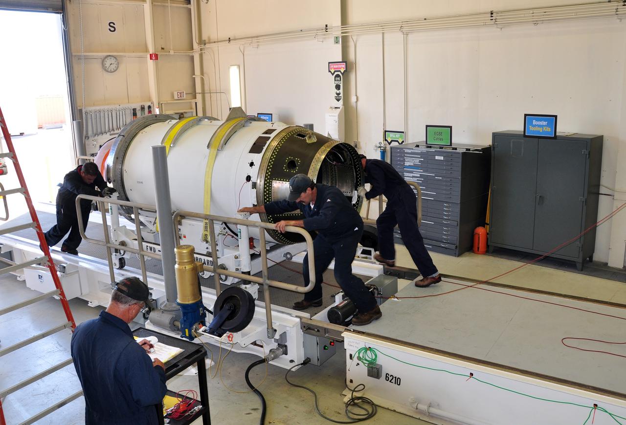
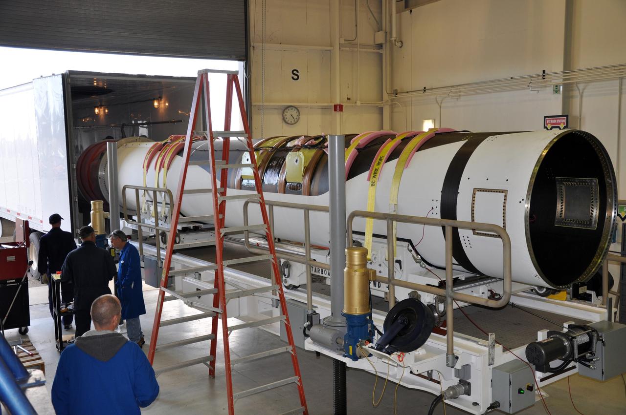
VANDENBERG AIR FORCE BASE, Calif. -- At Vandenberg Air Force Base in California, the Pegasus XL rocket that will launch the Nuclear Spectroscopic Telescope Array (NuSTAR) to orbit is coming together in the west high bay of Building 1555. After the rocket and spacecraft are processed at Vandenberg, they will be shipped to the Ronald Reagan Ballistic Missile Defense Test Site located at the Pacific Ocean’s Kwajalein Atoll for launch. The high-energy X-ray telescope will conduct a census for black holes, map radioactive material in young supernovae remnants, and study the origins of cosmic rays and the extreme physics around collapsed stars. Photo credit: NASA/Randy Beaudoin, VAFB

STS072-727-085 (11-20 Jan. 1996) --- The northern third of the Great Barrier Reef stretches 650 kilometers (km) along the coast of Queensland from south of Cairns to past Princess Charlotte Bay at the base of the Cape York Peninsula. The predominant westerly waves of the ocean create shallower (lighter-colored) convex-eastward rims to coral atolls along the outer edge of the barrier reef. In contrast, islands within the lagoon show the effect of predominant southerly, more-or-less offshore winds. Arcuate clouds suggest that winds were offshore at the time the photograph was taken.
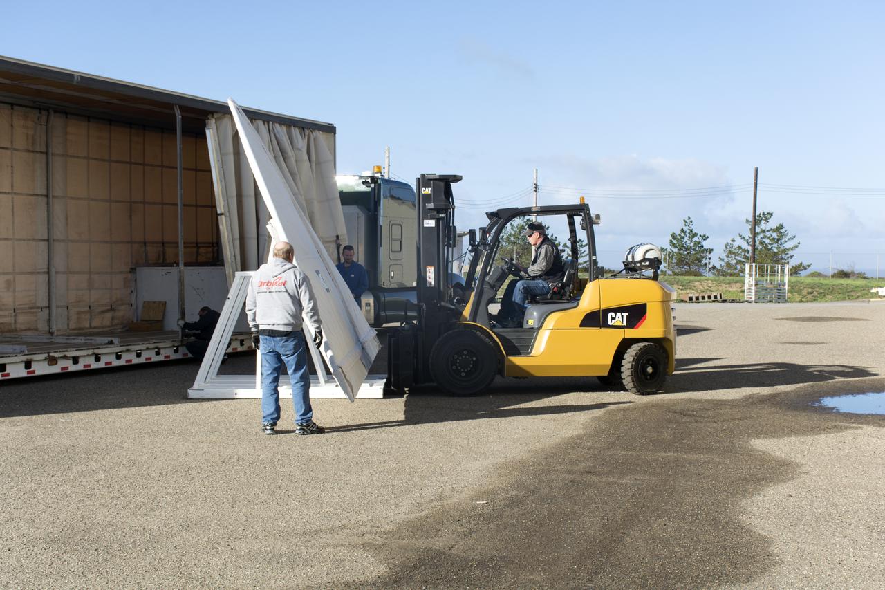
Workers transfer the wing for the Orbital ATK Pegasus XL rocket from a truck to a forklift at Building 1555 at Vandenberg Air Force Base in California. The rocket is being prepared for NASA's Ionospheric Connection Explorer, or ICON, mission. ICON will launch from the Kwajalein Atoll aboard the Pegasus XL on Dec. 8, 2017. ICON will study the frontier of space - the dynamic zone high in Earth's atmosphere where terrestrial weather from below meets space weather above. The explorer will help determine the physics of Earth's space environment and pave the way for mitigating its effects on our technology, communications systems and society.
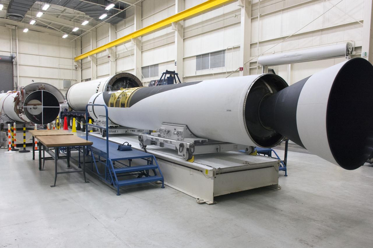
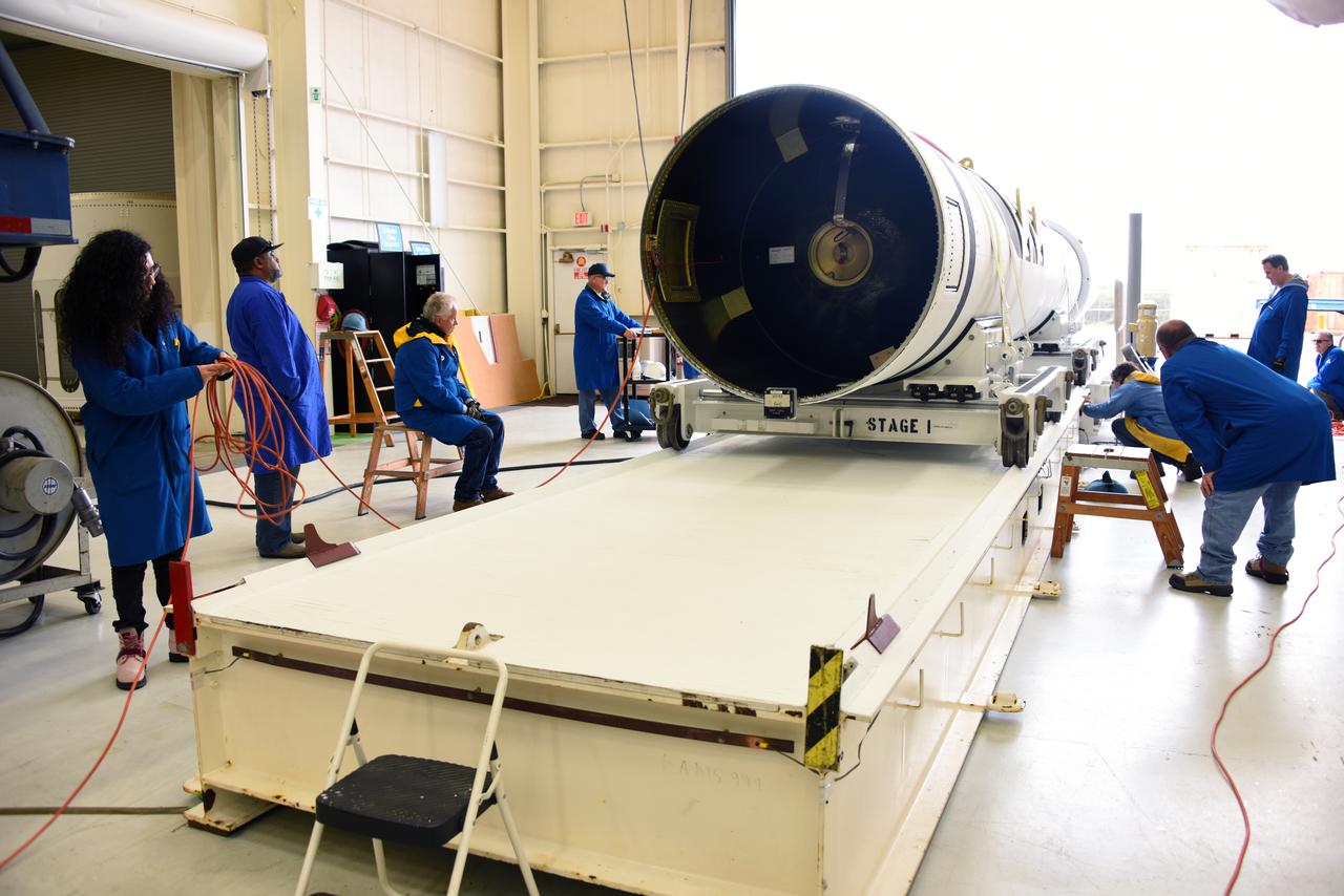
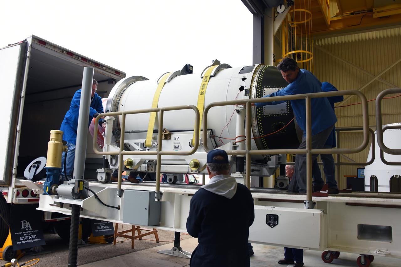
VANDENBERG AIR FORCE BASE, Calif. -- At Vandenberg Air Force Base in California, the first, second and third stages of the Pegasus XL rocket that will launch the Nuclear Spectroscopic Telescope Array (NuSTAR) to orbit are being processed in the west high bay of Building 1555. After the rocket and spacecraft are processed at Vandenberg, they will be shipped to the Ronald Reagan Ballistic Missile Defense Test Site located at the Pacific Ocean’s Kwajalein Atoll for launch. The high-energy X-ray telescope will conduct a census for black holes, map radioactive material in young supernovae remnants, and study the origins of cosmic rays and the extreme physics around collapsed stars. Photo credit: NASA/Randy Beaudoin, VAFB
VANDENBERG AIR FORCE BASE, Fla. -- NASA’s Interstellar Boundary Explorer, or IBEX, spacecraft and mated Pegasus XL rocket are being attached to Orbital Sciences’ L-1011 aircraft for launch. IBEX is targeted for launch from the Kwajalein Atoll, a part of the Marshall Islands in the Pacific Ocean, on Oct. 19. IBEX will be launched aboard the Pegasus rocket dropped from under the wing of the L-1011 aircraft flying over the Pacific Ocean. The Pegasus will carry the spacecraft approximately 130 miles above Earth and place it in orbit. The IBEX satellite will make the first map of the boundary between the Solar System and interstellar space. Photo credit: NASA/Mark Mackley, VAFB
The first stage motor for the Orbital ATK Pegasus XL rocket is moved inside Building 1555 at Vandenberg Air Force Base in California. In the background are the second and third stage segments. The rocket is being prepared for NASA's Ionospheric Connection Explorer, or ICON, mission. ICON will launch from the Kwajalein Atoll aboard the Pegasus XL on Dec. 8, 2017. ICON will study the frontier of space - the dynamic zone high in Earth's atmosphere where terrestrial weather from below meets space weather above. The explorer will help determine the physics of Earth's space environment and pave the way for mitigating its effects on our technology, communications systems and society.
The second and third stages of the Orbital ATK Pegasus XL rocket are offloaded from a transport vehicle at Building 1555 at Vandenberg Air Force Base in California. The rocket is being prepared for NASA's Ionospheric Connection Explorer, or ICON, mission. ICON will launch from the Kwajalein Atoll aboard the Pegasus XL on Dec. 8, 2017. ICON will study the frontier of space - the dynamic zone high in Earth's atmosphere where terrestrial weather from below meets space weather above. The explorer will help determine the physics of Earth's space environment and pave the way for mitigating its effects on our technology, communications systems and society.
The third stage of the Orbital ATK Pegasus XL rocket is offloaded from a transport vehicle at Building 1555 at Vandenberg Air Force Base in California. The rocket is being prepared for NASA's Ionospheric Connection Explorer, or ICON, mission. ICON will launch from the Kwajalein Atoll aboard the Pegasus XL on Dec. 8, 2017. ICON will study the frontier of space - the dynamic zone high in Earth's atmosphere where terrestrial weather from below meets space weather above. The explorer will help determine the physics of Earth's space environment and pave the way for mitigating its effects on our technology, communications systems and society.
The wing for the Orbital ATK Pegasus XL rocket was offloaded from a truck and transporter to Building 1555 at Vandenberg Air Force Base in California. The rocket is being prepared for NASA's Ionospheric Connection Explorer, or ICON, mission. ICON will launch from the Kwajalein Atoll aboard the Pegasus XL on Dec. 8, 2017. ICON will study the frontier of space - the dynamic zone high in Earth's atmosphere where terrestrial weather from below meets space weather above. The explorer will help determine the physics of Earth's space environment and pave the way for mitigating its effects on our technology, communications systems and society.
VANDENBERG AIR FORCE BASE, Fla. -- NASA’s Interstellar Boundary Explorer, or IBEX, spacecraft and mated Pegasus XL rocket are being attached to Orbital Sciences’ L-1011 aircraft for launch. IBEX is targeted for launch from the Kwajalein Atoll, a part of the Marshall Islands in the Pacific Ocean, on Oct. 19. IBEX will be launched aboard the Pegasus rocket dropped from under the wing of the L-1011 aircraft flying over the Pacific Ocean. The Pegasus will carry the spacecraft approximately 130 miles above Earth and place it in orbit. The IBEX satellite will make the first map of the boundary between the Solar System and interstellar space. Photo credit: NASA/Mark Mackley, VAFB
Workers unload the wing for the Orbital ATK Pegasus XL rocket from a truck at Building 1555 at Vandenberg Air Force Base in California. The rocket is being prepared for NASA's Ionospheric Connection Explorer, or ICON, mission. ICON will launch from the Kwajalein Atoll aboard the Pegasus XL on Dec. 8, 2017. ICON will study the frontier of space - the dynamic zone high in Earth's atmosphere where terrestrial weather from below meets space weather above. The explorer will help determine the physics of Earth's space environment and pave the way for mitigating its effects on our technology, communications systems and society.
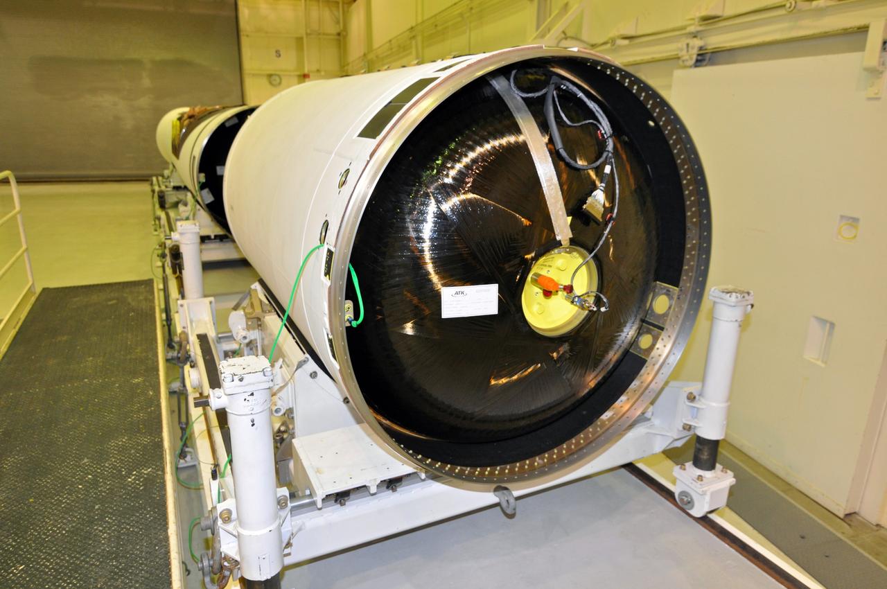
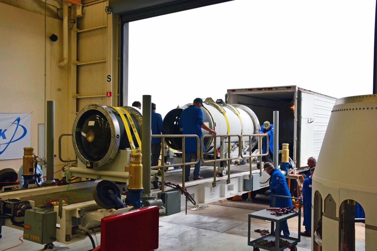
VANDENBERG AIR FORCE BASE, Calif. -- At Vandenberg Air Force Base in California, the third stage of the Pegasus XL rocket that will launch the Nuclear Spectroscopic Telescope Array (NuSTAR) to orbit arrives at Building 1555 for processing. After the rocket and spacecraft are processed at Vandenberg, they will be shipped to the Ronald Reagan Ballistic Missile Defense Test Site located at the Pacific Ocean’s Kwajalein Atoll for launch. The high-energy X-ray telescope will conduct a census for black holes, map radioactive material in young supernovae remnants, and study the origins of cosmic rays and the extreme physics around collapsed stars. Photo credit: NASA/Dan Liberotti, VAFB
VANDENBERG AIR FORCE BASE, Calif. -- At Vandenberg Air Force Base in California, the second stage of the Pegasus XL rocket that will launch the Nuclear Spectroscopic Telescope Array (NuSTAR) to orbit is moved to a stationary rail in Building 1555 for processing. After the rocket and spacecraft are processed at Vandenberg, they will be shipped to the Ronald Reagan Ballistic Missile Defense Test Site located at the Pacific Ocean’s Kwajalein Atoll for launch. The high-energy X-ray telescope will conduct a census for black holes, map radioactive material in young supernovae remnants, and study the origins of cosmic rays and the extreme physics around collapsed stars. Photo credit: NASA/Randy Beaudoin, VAFB
The first stage motor for the Orbital ATK Pegasus XL rocket is offloaded from a truck at Building 1555 at Vandenberg Air Force Base in California. The Pegasus rocket is being prepared for NASA's Ionospheric Connection Explorer, or ICON, mission. ICON will launch from the Kwajalein Atoll aboard the Pegasus XL on Dec. 8, 2017. ICON will study the frontier of space - the dynamic zone high in Earth's atmosphere where terrestrial weather from below meets space weather above. The explorer will help determine the physics of Earth's space environment and pave the way for mitigating its effects on our technology, communications systems and society.
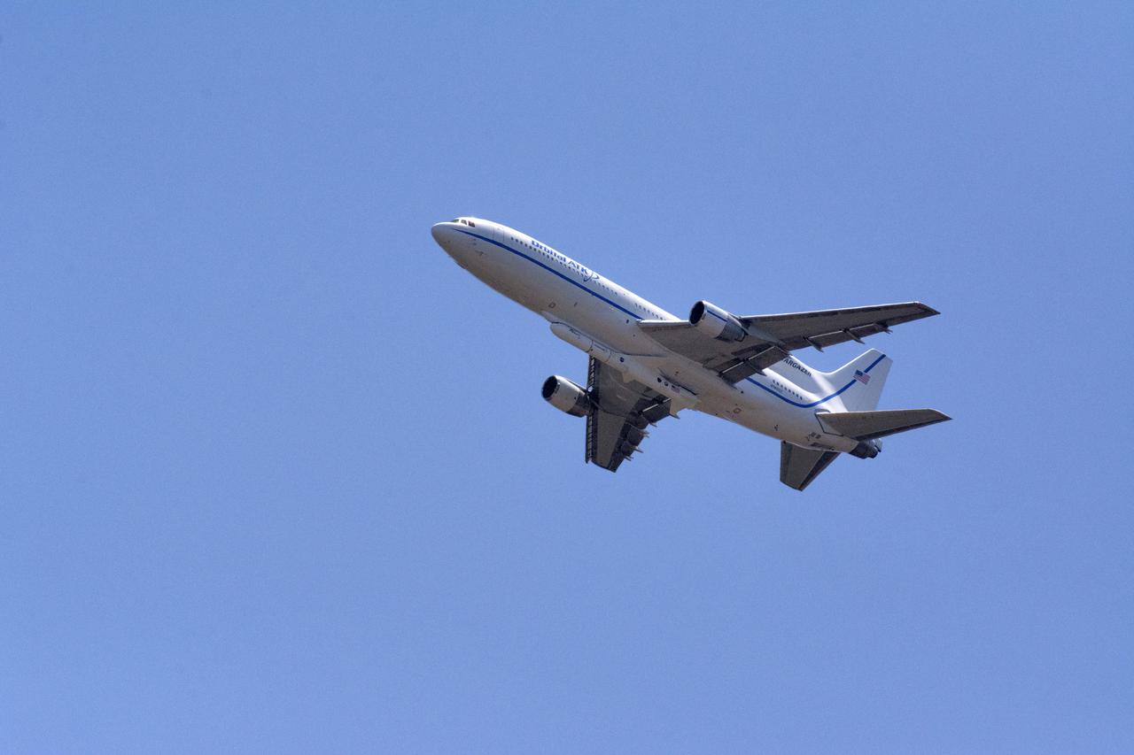
Northrop Grumman's L-1011 Stargazer takes off from the hot pad at Vandenberg Air Force Base in California on June 6, 2018. The company's Pegasus XL rocket, containing NASA's Ionospheric Connection Explorer (ICON), is attached beneath the aircraft. The explorer will launch on June 15, 2018, from Kwajalein Atoll in the Marshall Islands (June 14 in the continental United States). ICON will study the frontier of space - the dynamic zone high in Earth's atmosphere where terrestrial weather from below meets space weather above. The explorer will help determine the physics of Earth's space environment and pave the way for mitigating its effects on our technology, communications systems and society.

Yunjin Kim, NuSTAR project manager at the Jet Propulsion Laborartory (JPL), talks about NASA's Spectroscopic Telescope Array (NuStar) during a briefing, Wednesday, May 30, 2012, at NASA Headquarters in Washington. Imaging light in the high-energy, short-wavelength X-ray range, the telescope will aim to study how black holes form and evolve along with galaxies. The instrument, packed aboard an Orbital Sciences Pegasus XL rocket is set to launch from a plane in midair no earlier than June 13 from Kwajalein Atoll in the Marshall Islands. Photo Credit: (NASA/Paul E. Alers)
A crane lifts and moves NASA's Ionospheric Connection Explorer (ICON) to a work stand on May 1, 2018, inside Building 1555 at Vandenberg Air Force Base in California. The explorer will launch on June 15, 2018, from Kwajalein Atoll in the Marshall Islands (June 14 in the continental United States) on Orbital ATK's Pegasus XL rocket, which is attached to the company's L-1011 Stargazer aircraft. ICON will study the frontier of space - the dynamic zone high in Earth's atmosphere where terrestrial weather from below meets space weather above. The explorer will help determine the physics of Earth's space environment and pave the way for mitigating its effects on our technology, communications systems and society.
The third stage of the Orbital ATK Pegasus XL rocket is offloaded from a transport vehicle at Building 1555 at Vandenberg Air Force Base in California. The rocket is being prepared for NASA's Ionospheric Connection Explorer, or ICON, mission. ICON will launch from the Kwajalein Atoll aboard the Pegasus XL on Dec. 8, 2017. ICON will study the frontier of space - the dynamic zone high in Earth's atmosphere where terrestrial weather from below meets space weather above. The explorer will help determine the physics of Earth's space environment and pave the way for mitigating its effects on our technology, communications systems and society.
VANDENBERG AIR FORCE BASE, Calif. -- At Vandenberg Air Force Base in California, the first stage of the Pegasus XL rocket that will launch the Nuclear Spectroscopic Telescope Array (NuSTAR) to orbit is offloaded for processing in Building 1555. After the rocket and spacecraft are processed at Vandenberg, they will be shipped to the Ronald Reagan Ballistic Missile Defense Test Site located at the Pacific Ocean’s Kwajalein Atoll for launch. The high-energy X-ray telescope will conduct a census for black holes, map radioactive material in young supernovae remnants, and study the origins of cosmic rays and the extreme physics around collapsed stars. Photo credit: NASA/Randy Beaudoin, VAFB
VANDENBERG AIR FORCE BASE, Fla. -- NASA’s Interstellar Boundary Explorer, or IBEX, spacecraft and mated Pegasus XL rocket are being attached to Orbital Sciences’ L-1011 aircraft for launch. IBEX is targeted for launch from the Kwajalein Atoll, a part of the Marshall Islands in the Pacific Ocean, on Oct. 19. IBEX will be launched aboard the Pegasus rocket dropped from under the wing of the L-1011 aircraft flying over the Pacific Ocean. The Pegasus will carry the spacecraft approximately 130 miles above Earth and place it in orbit. The IBEX satellite will make the first map of the boundary between the Solar System and interstellar space. Photo credit: NASA/Mark Mackley, VAFB
Workers prepare to offload the second and third stages of the Orbital ATK Pegasus XL rocket from a transport vehicle at Building 1555 at Vandenberg Air Force Base in California. The rocket is being prepared for NASA's Ionospheric Connection Explorer, or ICON, mission. ICON will launch from the Kwajalein Atoll aboard the Pegasus XL on Dec. 8, 2017. ICON will study the frontier of space - the dynamic zone high in Earth's atmosphere where terrestrial weather from below meets space weather above. The explorer will help determine the physics of Earth's space environment and pave the way for mitigating its effects on our technology, communications systems and society.
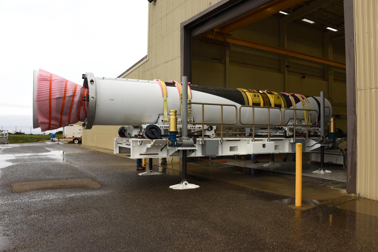
The first stage motor for the Orbital ATK Pegasus XL rocket is moved inside Building 1555 at Vandenberg Air Force Base in California. In the background are the second and third stage segments. The rocket is being prepared for NASA's Ionospheric Connection Explorer, or ICON, mission. ICON will launch from the Kwajalein Atoll aboard the Pegasus XL on Dec. 8, 2017. ICON will study the frontier of space - the dynamic zone high in Earth's atmosphere where terrestrial weather from below meets space weather above. The explorer will help determine the physics of Earth's space environment and pave the way for mitigating its effects on our technology, communications systems and society.
VANDENBERG AIR FORCE BASE, Calif. -- At Vandenberg Air Force Base in California, the second stage of the Pegasus XL rocket that will launch the Nuclear Spectroscopic Telescope Array (NuSTAR) to orbit is moved to a stationary rail in Building 1555 for processing. After the rocket and spacecraft are processed at Vandenberg, they will be shipped to the Ronald Reagan Ballistic Missile Defense Test Site located at the Pacific Ocean’s Kwajalein Atoll for launch. The high-energy X-ray telescope will conduct a census for black holes, map radioactive material in young supernovae remnants, and study the origins of cosmic rays and the extreme physics around collapsed stars. Photo credit: NASA/Randy Beaudoin, VAFB

VANDENBERG AIR FORCE BASE, Calif. -- At Vandenberg Air Force Base in California, the third stage of the Pegasus XL rocket that will launch the Nuclear Spectroscopic Telescope Array (NuSTAR) to orbit is offloaded for processing in Building 1555. After the rocket and spacecraft are processed at Vandenberg, they will be shipped to the Ronald Reagan Ballistic Missile Defense Test Site located at the Pacific Ocean’s Kwajalein Atoll for launch. The high-energy X-ray telescope will conduct a census for black holes, map radioactive material in young supernovae remnants, and study the origins of cosmic rays and the extreme physics around collapsed stars. Photo credit: NASA/Randy Beaudoin, VAFB
Northrop Grumman's L-1011 Stargazer is being readied for takeoff June 6, 2018, from the hot pad at Vandenberg Air Force Base in California. The company's Pegasus XL rocket, containing NASA's Ionospheric Connection Explorer (ICON), is attached beneath the aircraft. The explorer will launch on June 15, 2018, from Kwajalein Atoll in the Marshall Islands (June 14 in the continental United States). ICON will study the frontier of space - the dynamic zone high in Earth's atmosphere where terrestrial weather from below meets space weather above. The explorer will help determine the physics of Earth's space environment and pave the way for mitigating its effects on our technology, communications systems and society.
Northrop Grumman's L-1011 Stargazer is being readied for takeoff June 6, 2018, from the hot pad at Vandenberg Air Force Base in California. The company's Pegasus XL rocket, containing NASA's Ionospheric Connection Explorer (ICON), is attached beneath the aircraft. The explorer will launch on June 15, 2018, from Kwajalein Atoll in the Marshall Islands (June 14 in the continental United States). ICON will study the frontier of space - the dynamic zone high in Earth's atmosphere where terrestrial weather from below meets space weather above. The explorer will help determine the physics of Earth's space environment and pave the way for mitigating its effects on our technology, communications systems and society.
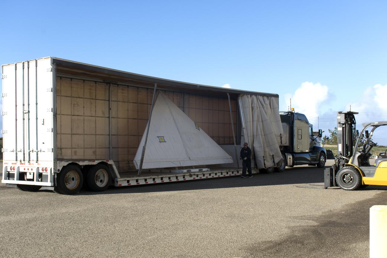
The wing for the Orbital ATK Pegasus XL rocket arrives by truck at Building 1555 at Vandenberg Air Force Base in California. The Pegasus rocket is being prepared for NASA's Ionospheric Connection Explorer, or ICON, mission. ICON will launch from the Kwajalein Atoll aboard the Pegasus XL on Dec. 8, 2017. ICON will study the frontier of space - the dynamic zone high in Earth's atmosphere where terrestrial weather from below meets space weather above. The explorer will help determine the physics of Earth's space environment and pave the way for mitigating its effects on our technology, communications systems and society.
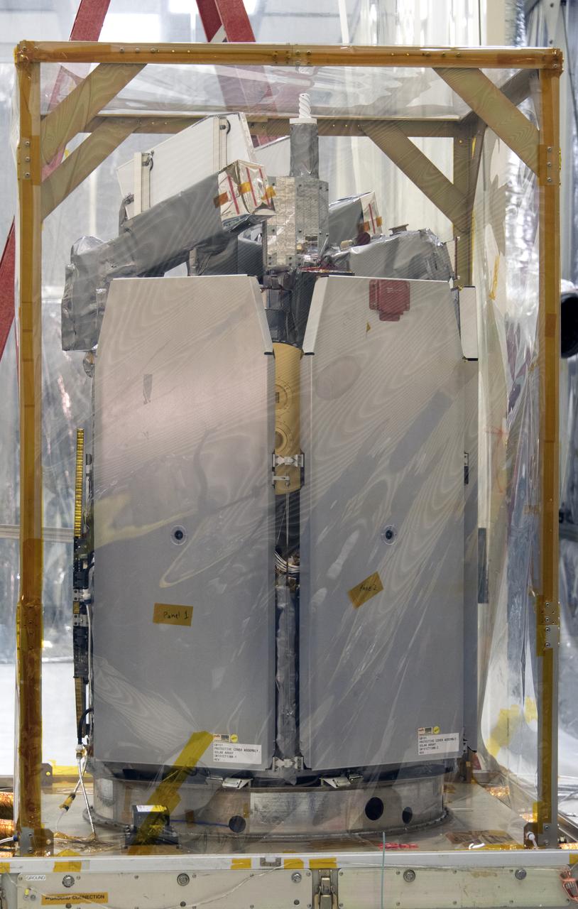
NASA's Ionospheric Connection Explorer (ICON) is uncrated from its shipping container on May 1, 2018, inside Building 1555 at Vandenberg Air Force Base in California. The explorer will launch on June 15, 2018, from Kwajalein Atoll in the Marshall Islands (June 14 in the continental United States) on Orbital ATK's Pegasus XL rocket, which is attached to the company's L-1011 Stargazer aircraft. ICON will study the frontier of space - the dynamic zone high in Earth's atmosphere where terrestrial weather from below meets space weather above. The explorer will help determine the physics of Earth's space environment and pave the way for mitigating its effects on our technology, communications systems and society.
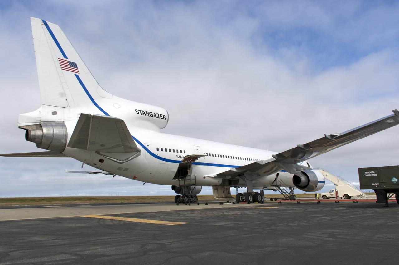
Northrop Grumman's L-1011 Stargazer aircraft is at the hot pad at Vandenberg Air Force Base in California on May 26, 2018. Preparations are underway to attach the company's Pegasus XL rocket, containing NASA's Ionospheric Connection Explorer (ICON), beneath the aircraft. The explorer will launch on June 15, 2018, from Kwajalein Atoll in the Marshall Islands (June 14 in the continental United States). ICON will study the frontier of space - the dynamic zone high in Earth's atmosphere where terrestrial weather from below meets space weather above. The explorer will help determine the physics of Earth's space environment and pave the way for mitigating its effects on our technology, communications systems and society.

VANDENBERG AIR FORCE BASE, Calif. – The Interstellar Boundary Explorer, or IBEX, spacecraft leaves the Astrotech building to head for Hangar 1555 on Vandenberg Air Force Base in California. In the hangar, IBEX will be mated with the Pegasus XL rocket for launch. The IBEX satellite will make the first map of the boundary between the Solar System and interstellar space. IBEX is targeted for launch from the Kwajalein Atoll, a part of the Marshall Islands in the Pacific Ocean, on Oct. 19 aboard the Pegasus rocket dropped from under the wing of an L-1011 aircraft flying over the Pacific Ocean. The Pegasus will carry the spacecraft approximately 130 miles above Earth and place it in orbit. Photo credit: NASA/Dan Liberotti, VAFB
VANDENBERG AIR FORCE BASE, Calif. -- At Vandenberg Air Force Base in California, the third stage of the Pegasus XL rocket that will launch the Nuclear Spectroscopic Telescope Array (NuSTAR) to orbit arrives at Building 1555 for processing. After the rocket and spacecraft are processed at Vandenberg, they will be shipped to the Ronald Reagan Ballistic Missile Defense Test Site located at the Pacific Ocean's Kwajalein Atoll for launch. The high-energy X-ray telescope will conduct a census for black holes, map radioactive material in young supernovae remnants, and study the origins of cosmic rays and the extreme physics around collapsed stars. Photo credit: NASA/Dan Liberotti, VAFB
VANDENBERG AIR FORCE BASE, Fla. -- NASA’s Interstellar Boundary Explorer, or IBEX, spacecraft and mated Pegasus XL rocket are being attached to Orbital Sciences’ L-1011 aircraft for launch. IBEX is targeted for launch from the Kwajalein Atoll, a part of the Marshall Islands in the Pacific Ocean, on Oct. 19. IBEX will be launched aboard the Pegasus rocket dropped from under the wing of the L-1011 aircraft flying over the Pacific Ocean. The Pegasus will carry the spacecraft approximately 130 miles above Earth and place it in orbit. The IBEX satellite will make the first map of the boundary between the Solar System and interstellar space. Photo credit: NASA/Mark Mackley, VAFB
VANDENBERG AIR FORCE BASE, Calif. -- At Vandenberg Air Force Base in California, the third stage of the Pegasus XL rocket that will launch the Nuclear Spectroscopic Telescope Array (NuSTAR) to orbit is moved onto a jackable rail for processing in Building 1555. After the rocket and spacecraft are processed at Vandenberg, they will be shipped to the Ronald Reagan Ballistic Missile Defense Test Site located at the Pacific Ocean’s Kwajalein Atoll for launch. The high-energy X-ray telescope will conduct a census for black holes, map radioactive material in young supernovae remnants, and study the origins of cosmic rays and the extreme physics around collapsed stars. Photo credit: NASA/Dan Liberotti, VAFB