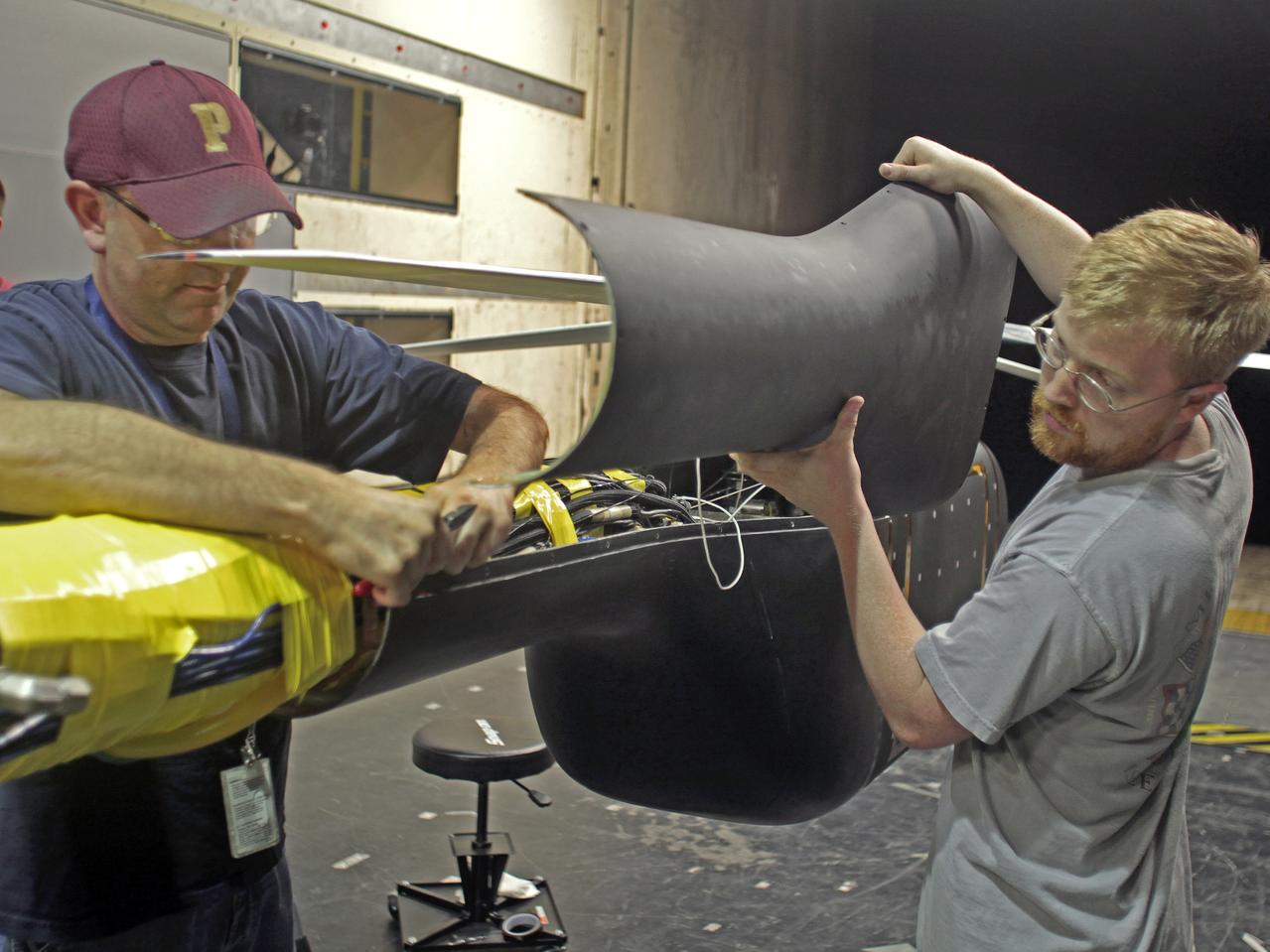
Helicopter active flow control tests in the 14X22 subsonic wind tunnel. Photos include preparation of the model before testing and the control room where testing is monitored and data collected
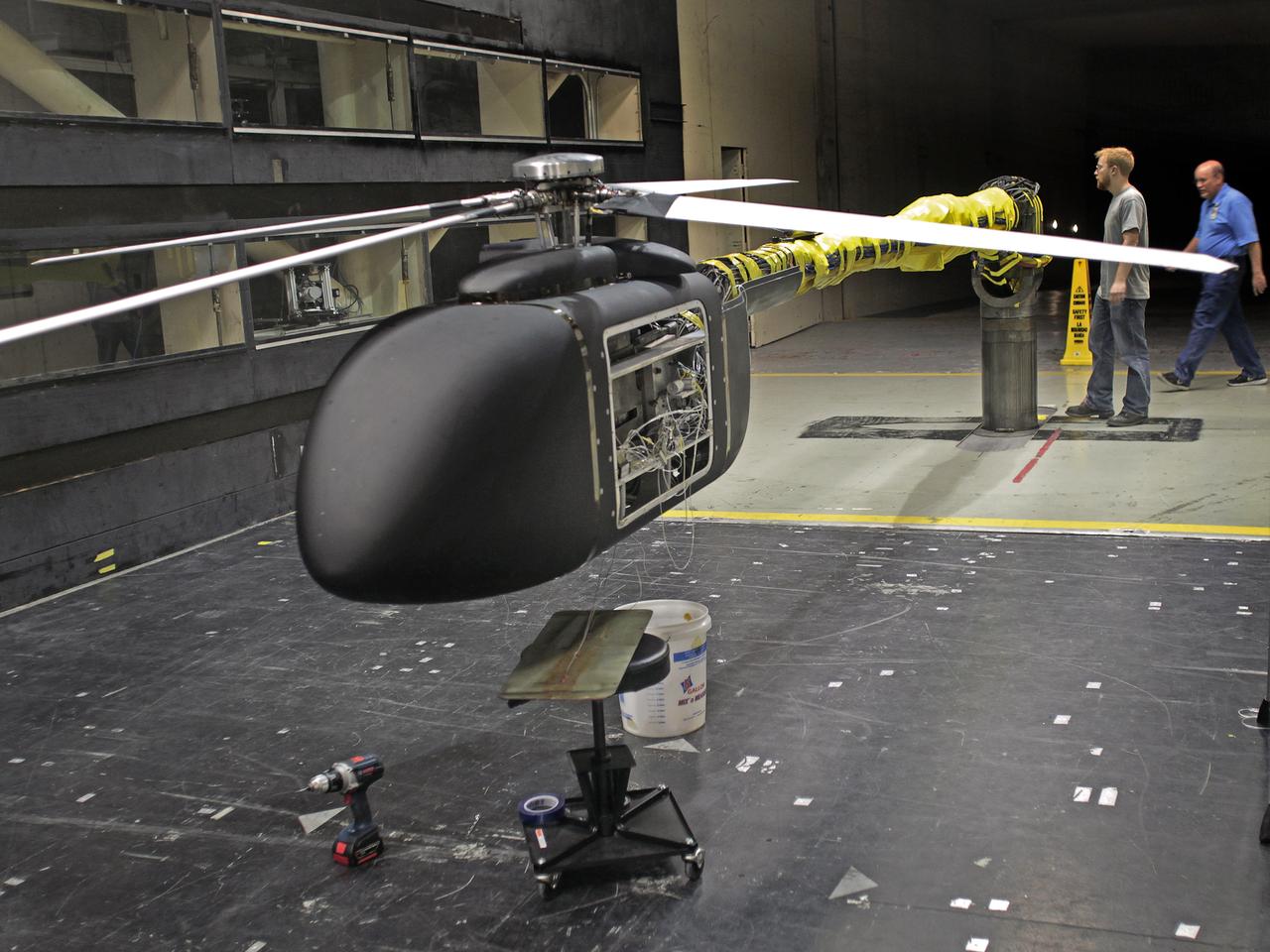
Helicopter active flow control tests in the 14X22 subsonic wind tunnel. Photos include preparation of the model before testing and the control room where testing is monitored and data collected
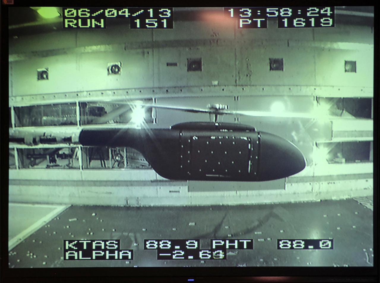
Helicopter active flow control tests in the 14X22 subsonic wind tunnel. Photos include preparation of the model before testing and the control room where testing is monitored and data collected
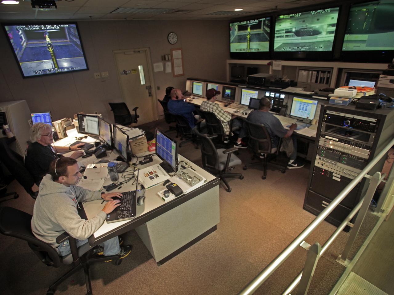
Helicopter active flow control tests in the 14X22 subsonic wind tunnel. Photos include preparation of the model before testing and the control room where testing is monitored and data collected

Helicopter active flow control tests in the 14X22 subsonic wind tunnel. Photos include preparation of the model before testing and the control room where testing is monitored and data collected
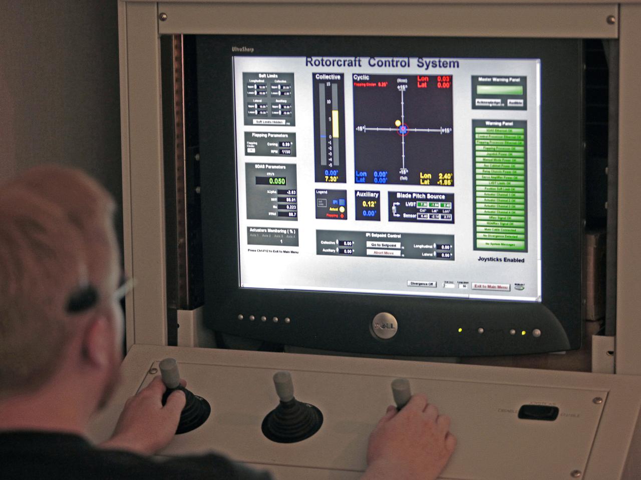
Helicopter active flow control tests in the 14X22 subsonic wind tunnel. Photos include preparation of the model before testing and the control room where testing is monitored and data collected
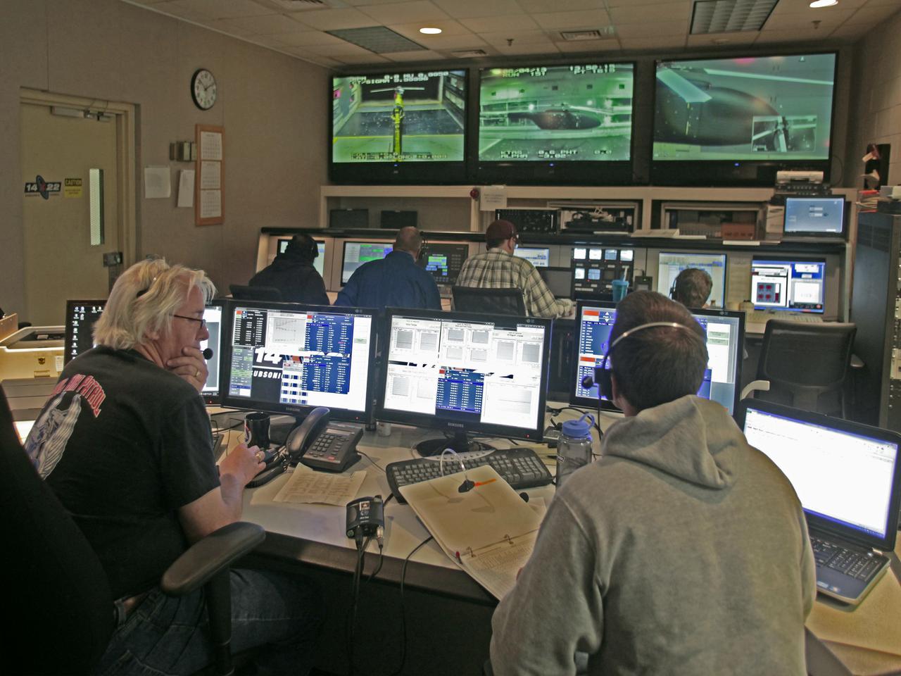
Helicopter active flow control tests in the 14X22 subsonic wind tunnel. Photos include preparation of the model before testing and the control room where testing is monitored and data collected
Amirani-Maui: Longest Known Active Lava Flow in the Solar System

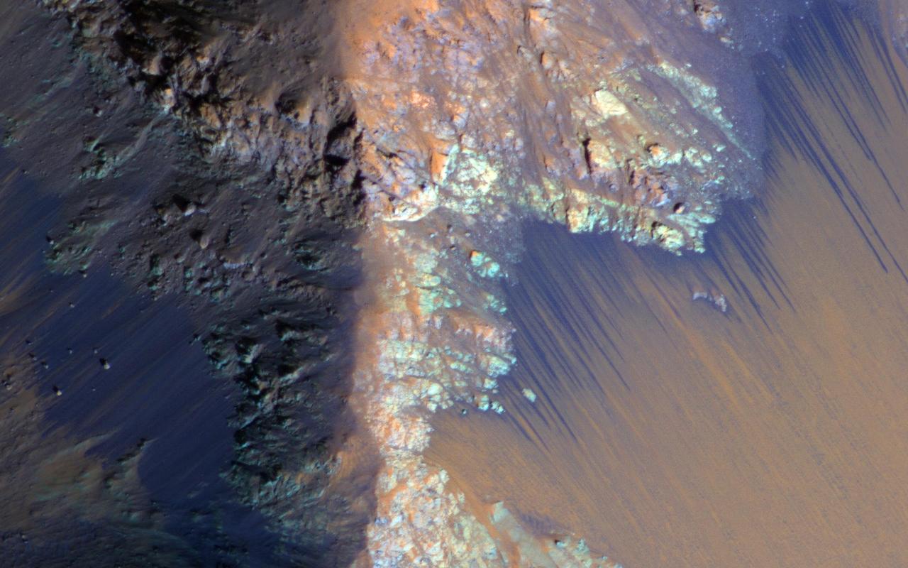
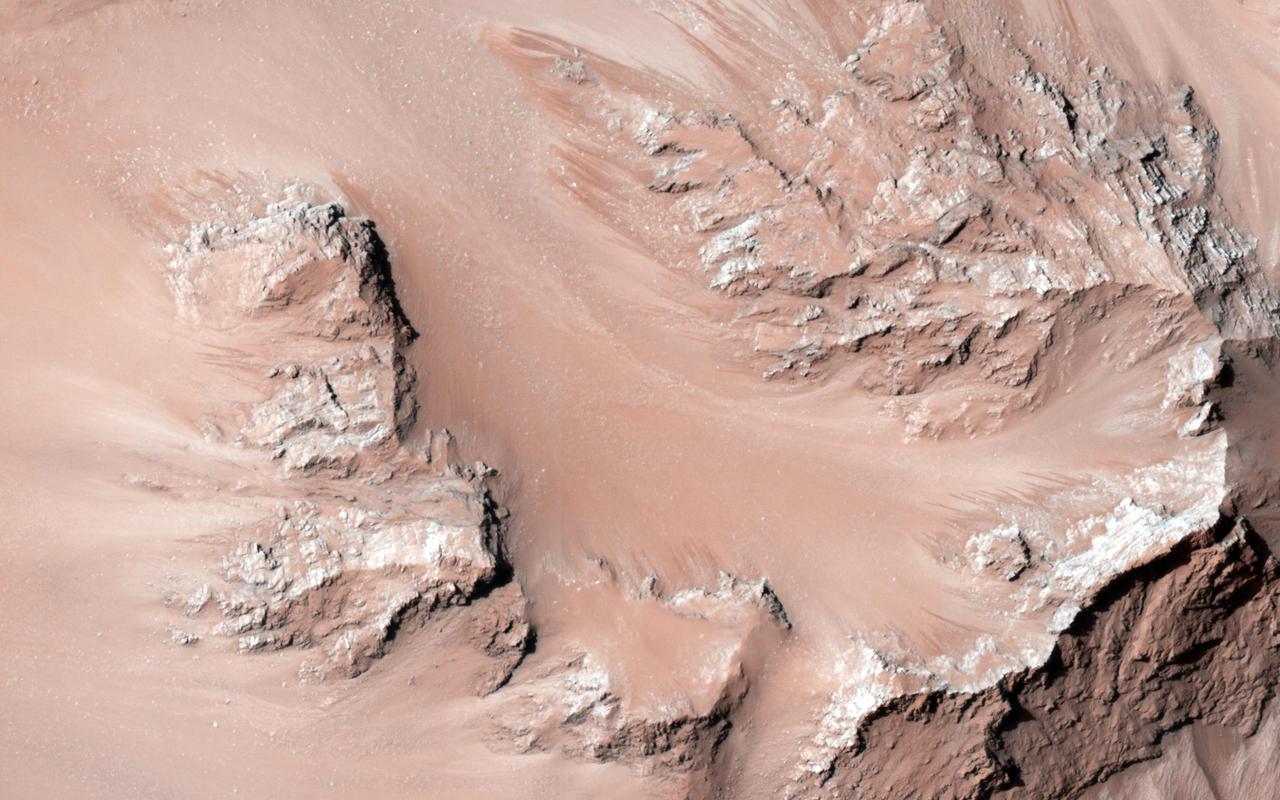
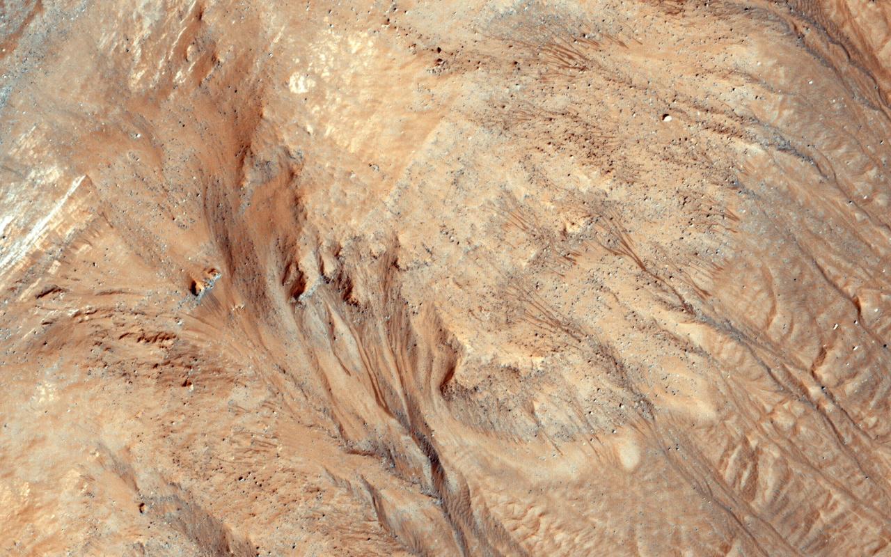
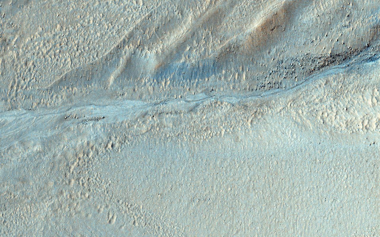
This image from NASA's Mars Reconnaissance Orbiter covers a steep west-facing slope in southwestern Ganges Chasma, north of the larger canyons of Valles Marineris. The spot was targeted both for the bedrock exposures and to look for active slope processes. We see two distinct flow deposits: lobate flows that are relatively bright, sometimes with dark fringes, and very thin brownish lines that resemble recurring slope lineae (or 'RSL'). Both flows emanate from rocky alcoves. The RSL are superimposed on the lobate deposits (perhaps rocky debris flows), so they are younger and more active. The possible role of water in forming the debris flows and RSL are the subjects of continuing debate among scientists. We will acquire more images here to see if the candidate RSL are active. https://photojournal.jpl.nasa.gov/catalog/PIA21651
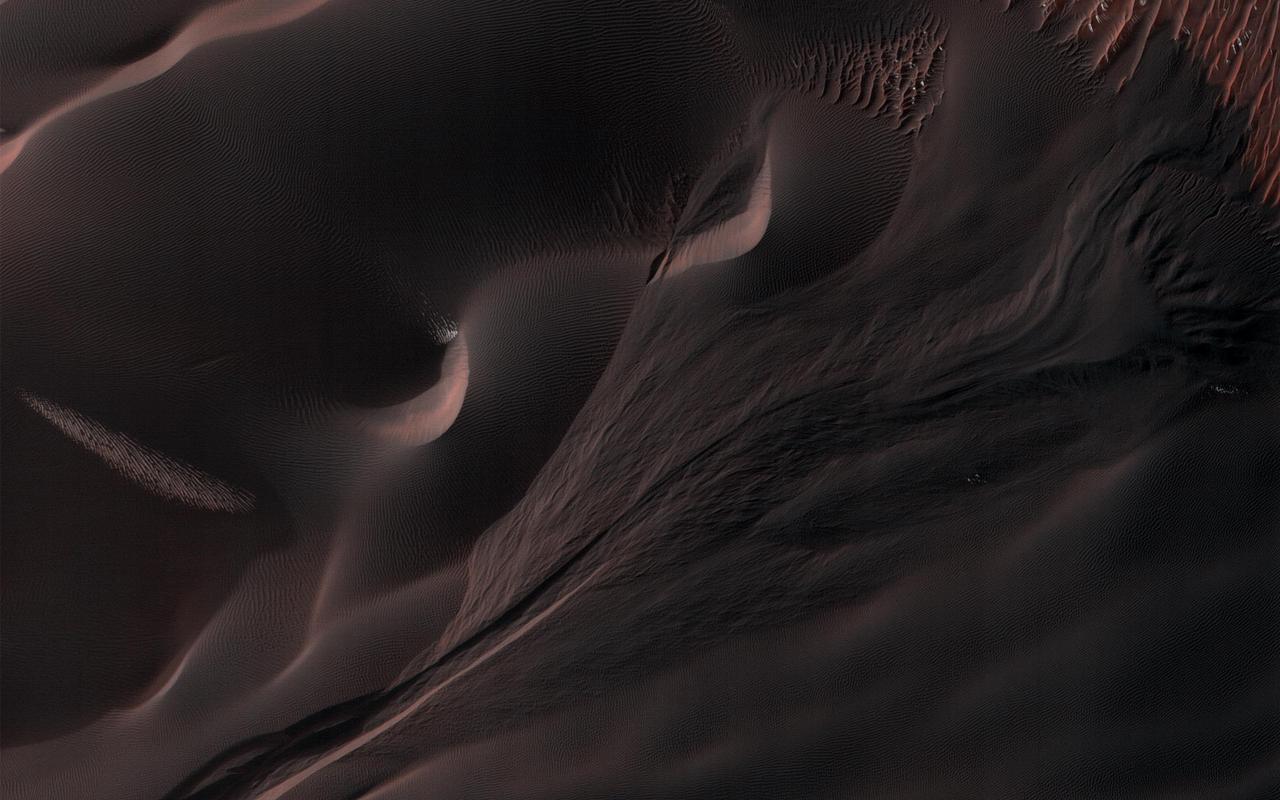
Seasonal flows on warm Martian slopes may be caused by the flow of salty water on Mars, active today when the surface is warm above the freezing point of the solution. This observation is from NASA Mars Reconnaissance Orbiter.
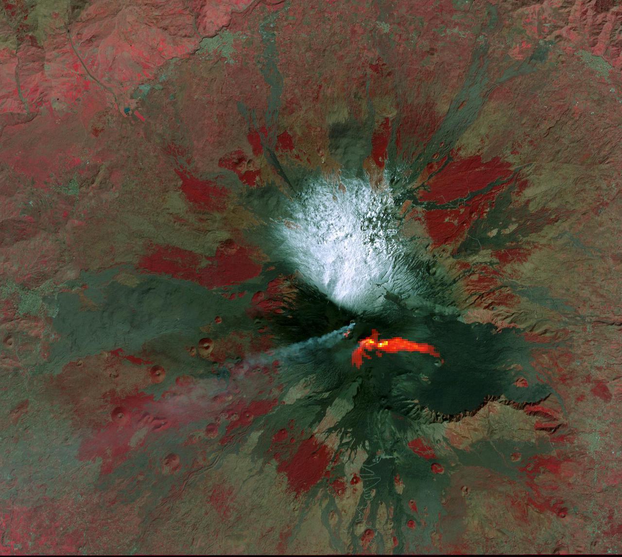
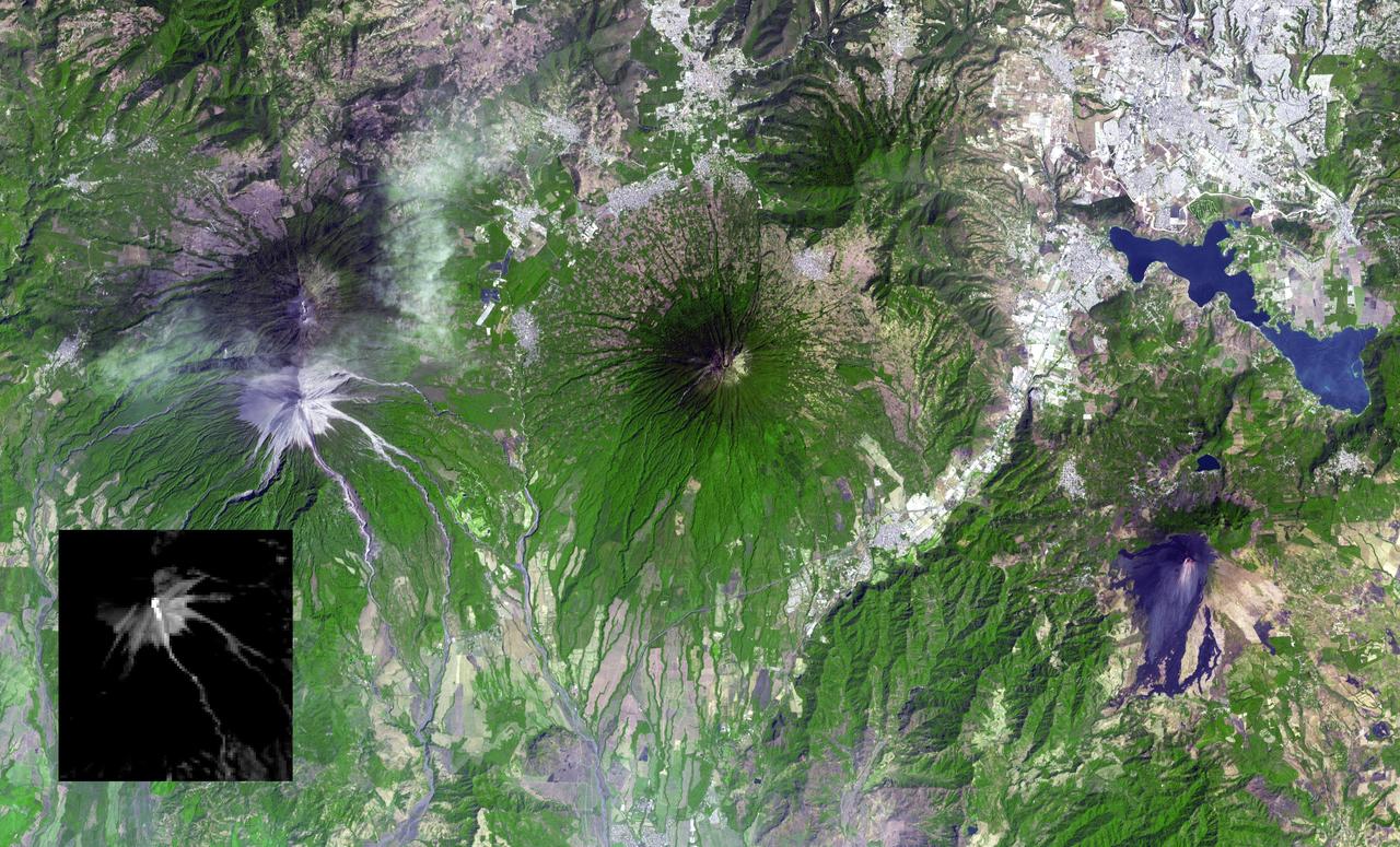
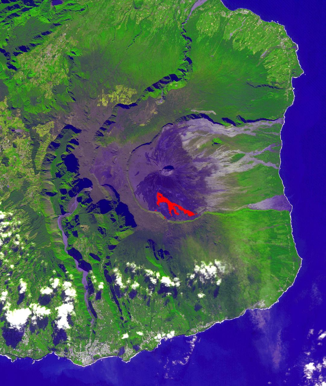
This image acquired by NASA Terra spacecraft is of Mt. Etna, Europe most active volcano, as it continued its latest eruptive activity with a new lava flow from the recently formed southeast crater.
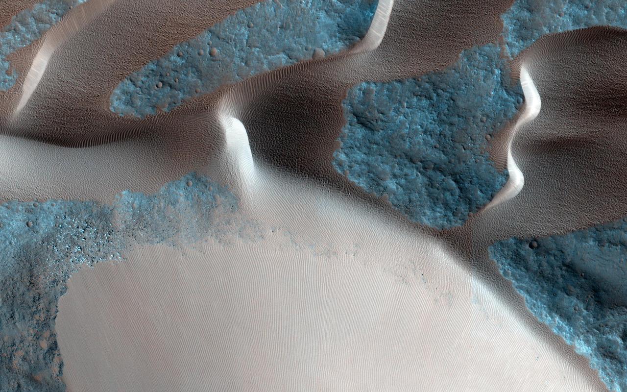
Gullies on Martian sand dunes, like these in Matara Crater, have been very active, with many flows in the last ten years. The flows typically occur when seasonal frost is present. In this image from NASA's Mars Reconnaissance Orbiter we see frost in and around two gullies, which have both been active before. There are no fresh flows so far this year, but HiRISE will keep watching. https://photojournal.jpl.nasa.gov/catalog/PIA22349
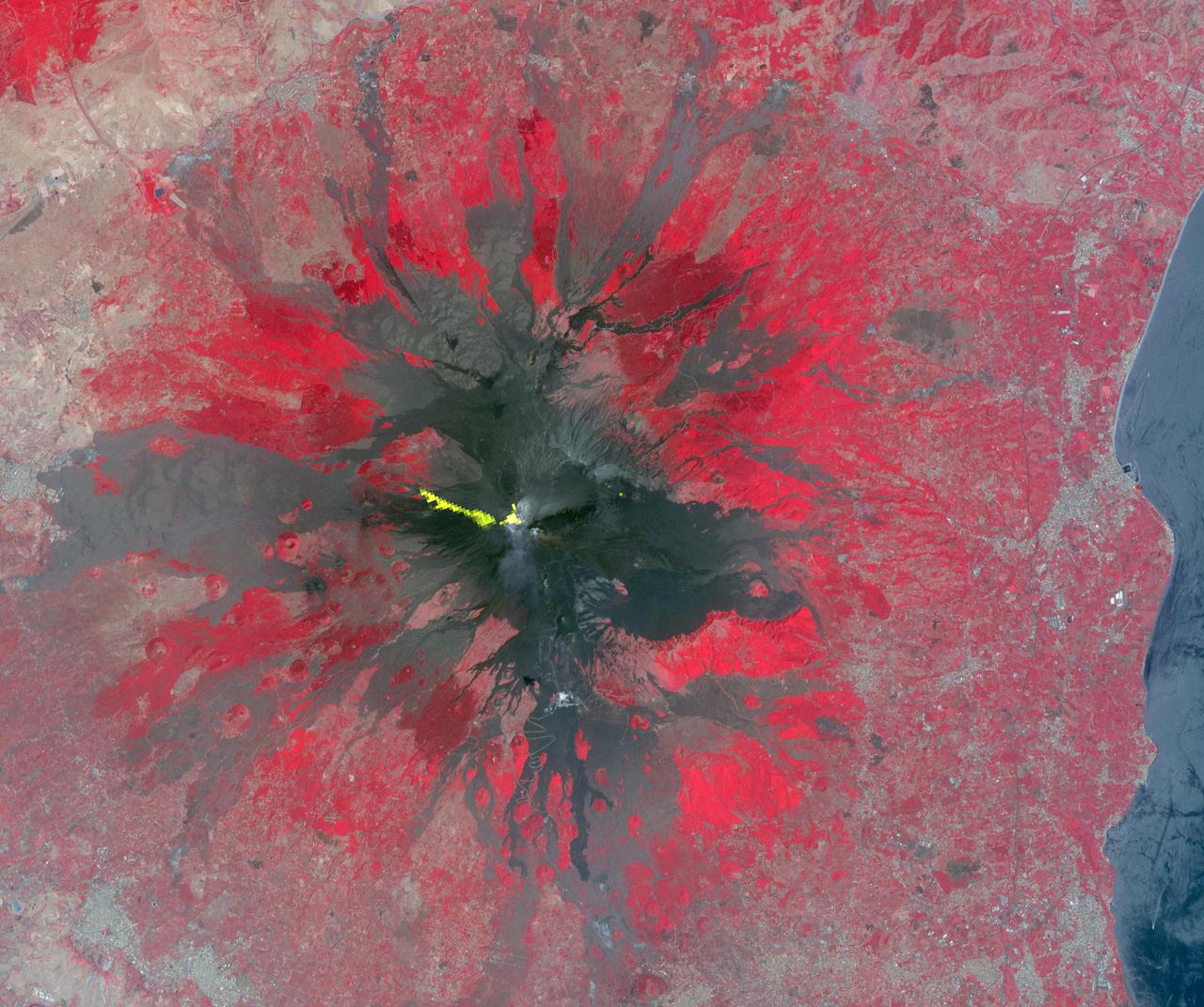
Mt. Etna, Sicily, Italy, is Europe most active volcano. In mid-May 2016, Mt. Etna put on a display of lava fountaining, ash clouds and lava flows. Three of the four summit craters were active. NASA Terra spacecraft acquired this image on May 26, 2016.
This image from NASA's Mars Reconnaissance Orbiter (MRO) shows Hale Crater, a large impact crater (more than 100 kilometers) with a suite of interesting features such as active gullies, active recurring slope lineae, and extensive icy ejecta flows. There are also exposed diverse (colorful) bedrock units. https://photojournal.jpl.nasa.gov/catalog/PIA22465
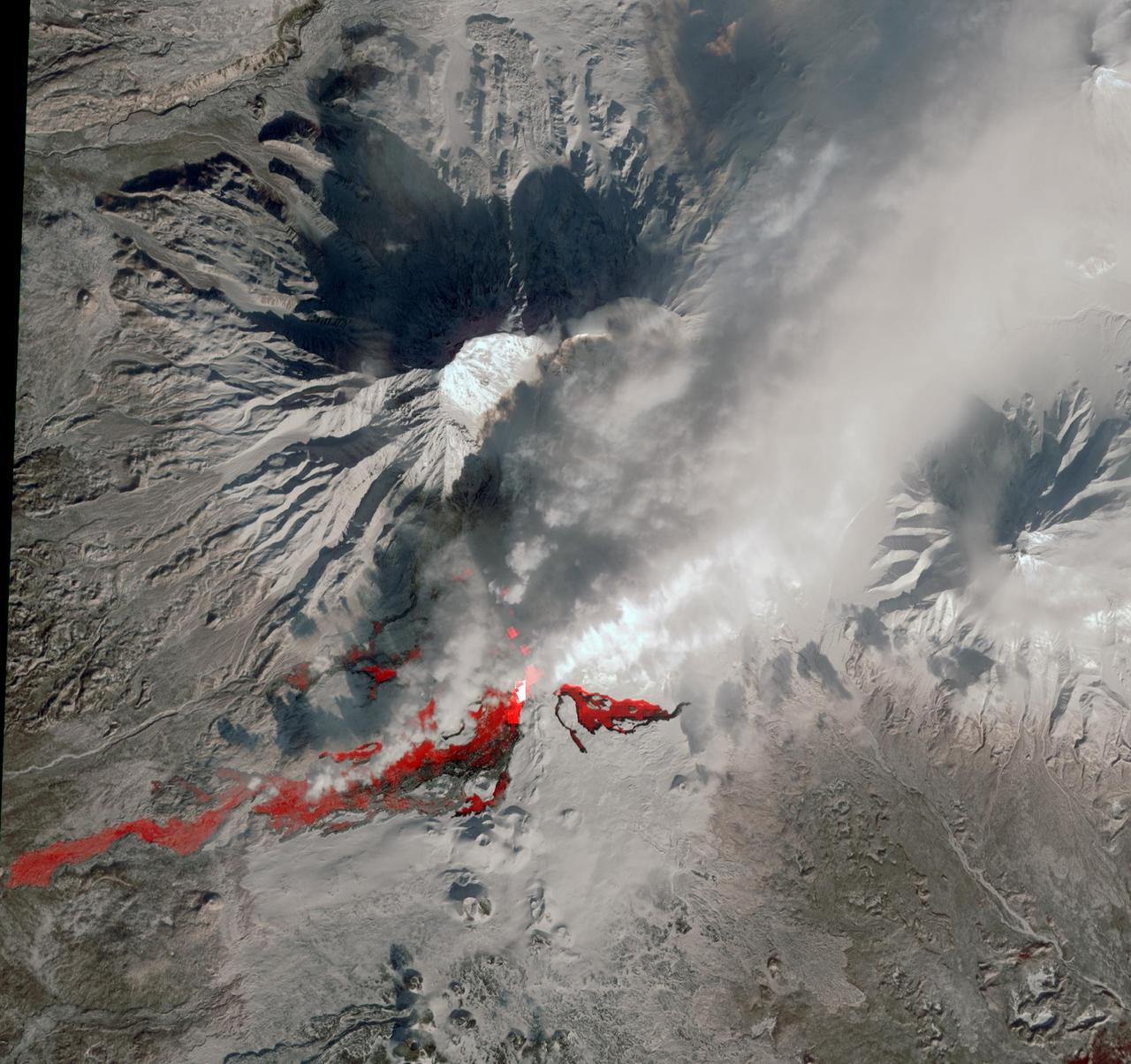
NASA Terra spacecraft reveals the still-active lava flows in the snowy winter landscape of Plosky Tolbachik volcano, which erupted for the first time in 35 years on Nov. 27, 2012, in Russia far eastern Kamchatka Peninsula.
Recurring slope lineae RSL may be due to active seeps of water. These dark flows are abundant along the steep slopes of ancient bedrock in Coprates Chasma as seen in this image from NASA Mars Reconnaissance Orbiter.
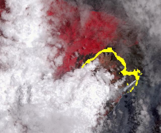
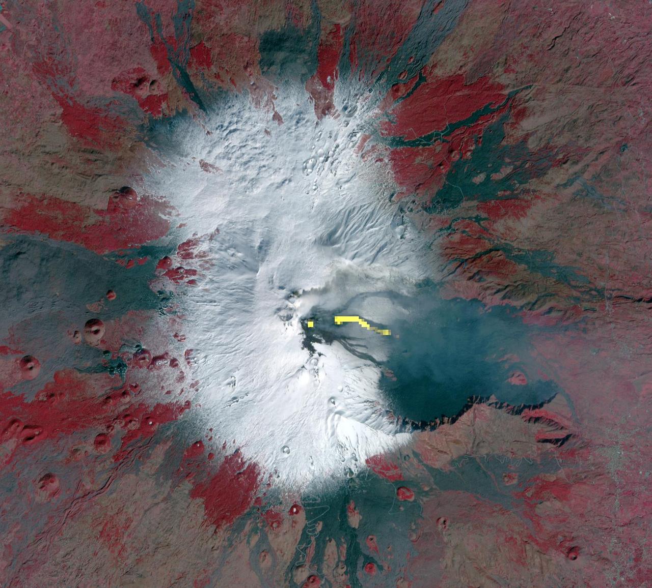
Hawaii's Kilauea volcano continues to create new land as flows from fissure 8, one of the most active to break ground since the eruption began in early May, reach the ocean. The Advanced Spaceborne Thermal Emission and Reflection (ASTER) radiometer instrument on NASA's Terra satellite detected the lava flow of fissure 8 -- which extends from Leilani Estates to the Pacific Ocean -- on July 25. In the image, vegetation is displayed in red, clouds are white and the hot lava flows, detected by ASTER's thermal infrared channels, are overlaid in yellow. The image covers an area of 9.5 by 11.5 miles (15.3 by 18.6 kilometers). https://photojournal.jpl.nasa.gov/catalog/PIA22489
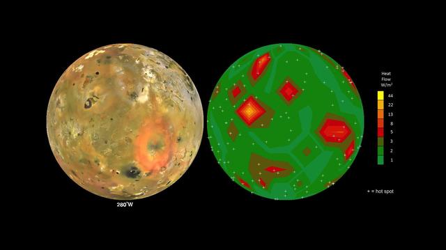
This frame from an animation shows Jupiter volcanic moon Io as seen by NASA Voyager and Galileo spacecraft (at left) and the pattern of heat flow from 242 active volcanoes (at right). The red and yellow areas are places where local heat flow is greatest -- the result of magma erupting from Io's molten interior onto the surface. The map is the result of analyzing decades of observations from spacecraft and ground-based telescopes. It shows Io's usual volcanic thermal emission, excluding the occasional massive but transient "outburst" eruption; in other words, this is what Io looks like most of the time. This heat flow map will be used to test models of interior heating. The map shows that areas of enhanced volcanic heat flow are not necessarily correlated with the number of volcanoes in a particular region and are poorly correlated with expected patterns of heat flow from current models of tidal heating -- something that is yet to be explained. This research is published in association with a 2015 paper in the journal Icarus by A. Davies et al., titled "Map of Io's Volcanic Heat Flow," (http://dx.doi.org/10.1016/j.icarus.2015.08.003.) http://photojournal.jpl.nasa.gov/catalog/PIA19655
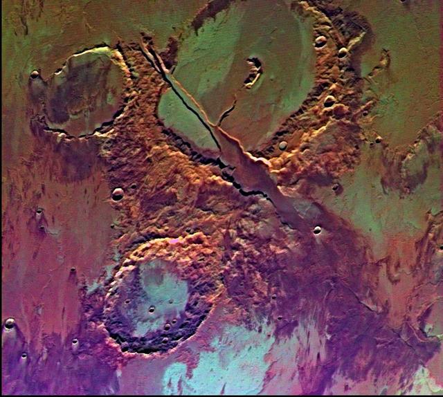
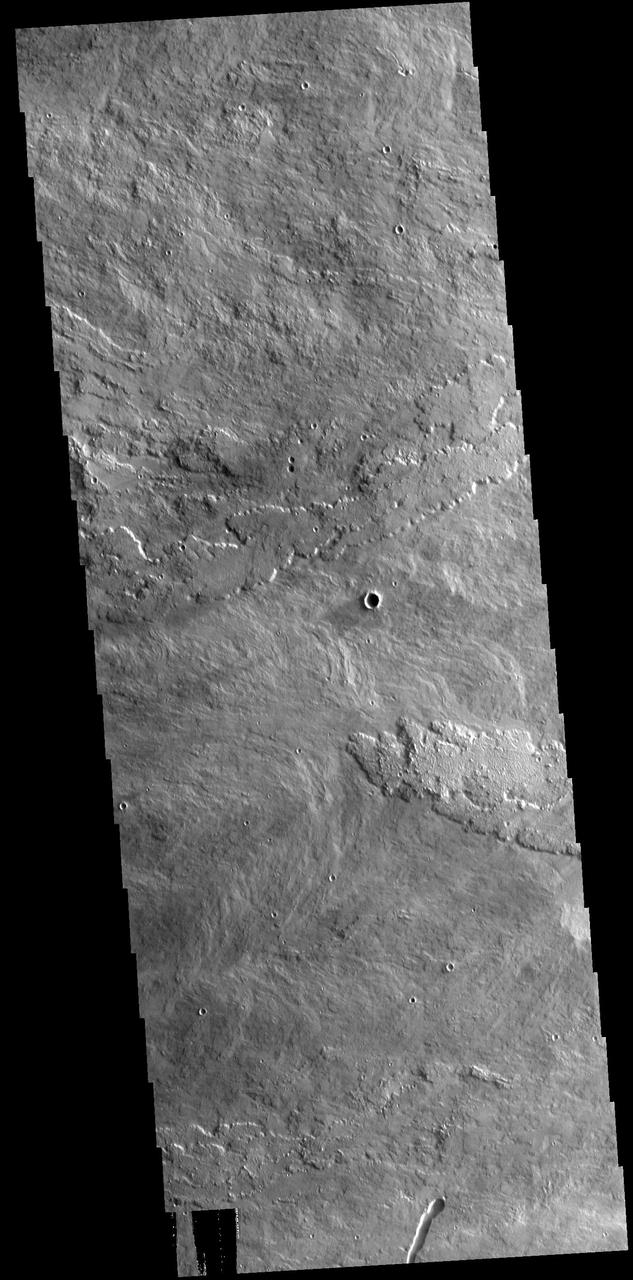
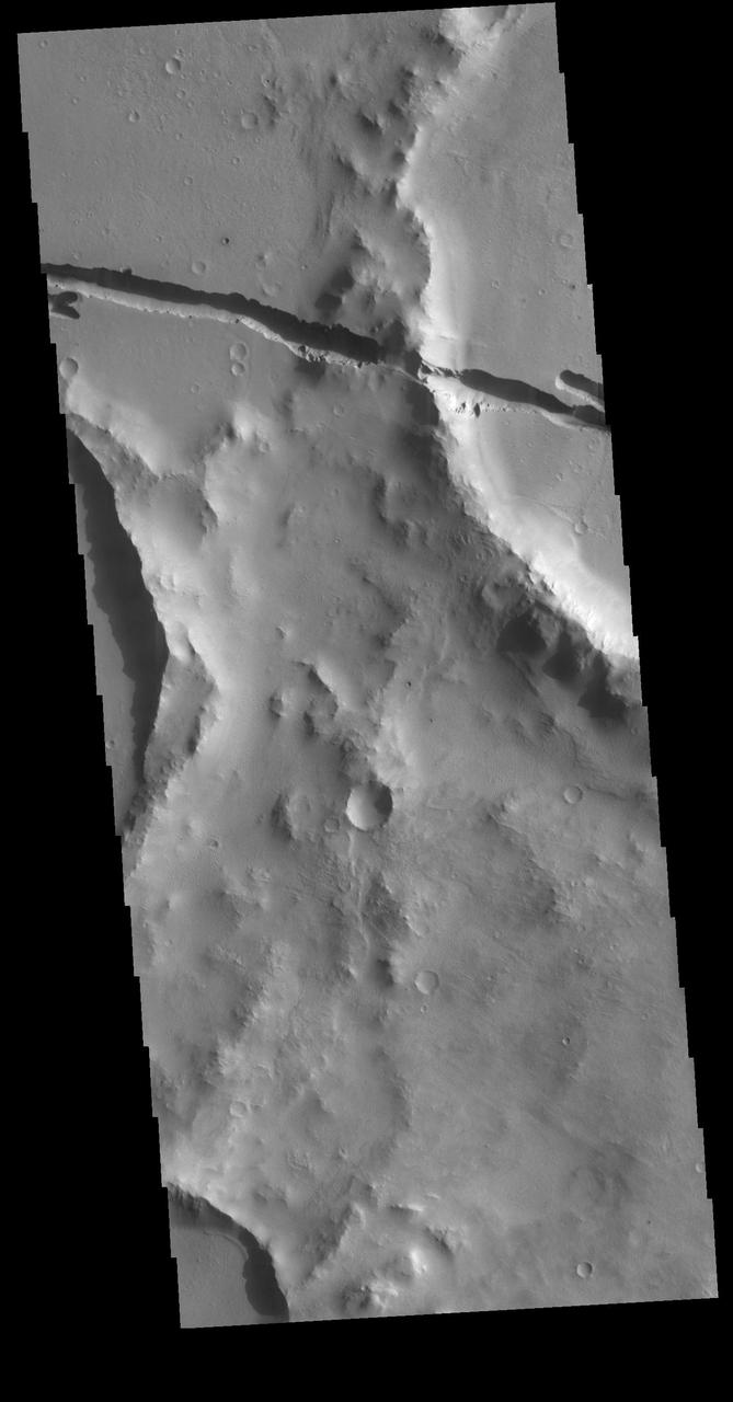
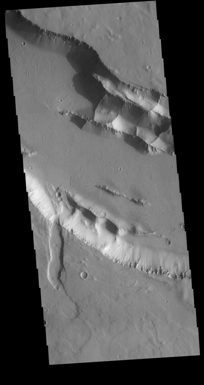
Tharsis-centered volcanic and tectonic activity resulted in the formation of radial grabens of Memnonia Fossae, which cut materials of the ancient cratered highlands and the relatively young, highland-embaying lava flows as seen by NASA's Viking Orbiter 2. http://photojournal.jpl.nasa.gov/catalog/PIA00151
![Recurring Slope Lineae (called "RSL") are seasonally-repeating dark flows that are active at the warmest times of the year. Some of these grow from the top of the steep slope downwards as expected for liquid or granular flows. Others show different darkening patterns, which suggests different processes. Although HiRISE has acquired many images to monitor RSL sites, it still is not certain how these features form. The map is projected here at a scale of 25 centimeters (9.8 inches) per pixel. [The original image scale is 25.8 centimeters (10.2 inches) per pixel (with 2 x 2 binning); objects on the order of 51.7 centimeters (20.4 inches) across are resolved.] North is up. http://photojournal.jpl.nasa.gov/catalog/PIA21558](https://images-assets.nasa.gov/image/PIA21558/PIA21558~medium.jpg)
Recurring Slope Lineae (called "RSL") are seasonally-repeating dark flows that are active at the warmest times of the year. Some of these grow from the top of the steep slope downwards as expected for liquid or granular flows. Others show different darkening patterns, which suggests different processes. Although HiRISE has acquired many images to monitor RSL sites, it still is not certain how these features form. The map is projected here at a scale of 25 centimeters (9.8 inches) per pixel. [The original image scale is 25.8 centimeters (10.2 inches) per pixel (with 2 x 2 binning); objects on the order of 51.7 centimeters (20.4 inches) across are resolved.] North is up. http://photojournal.jpl.nasa.gov/catalog/PIA21558
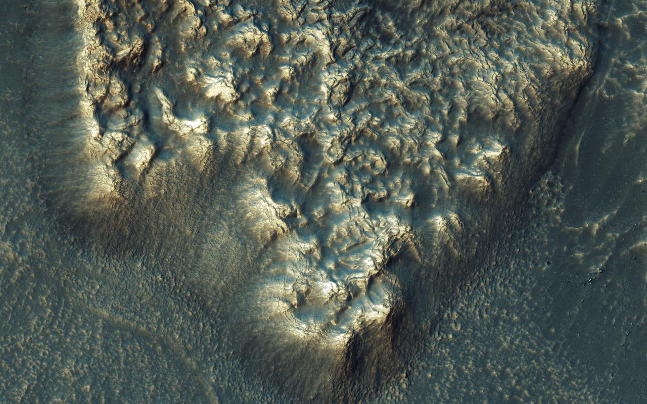
NASA's Mars Reconnaissance Orbiter observes many slopes in the middle latitudes of Mars showing icy flows or glaciers. The region shown here, in the south-facing slope of a crater, is unusual because the flows have bright highlights. The color and brightness variations are likely due to surface coatings of bright dust and dark sand. There is no evidence that these flows are currently active, but they may have been active only millions of years ago. These flows may well contain ice today in their interiors, as confirmed in places by the subsurface radar experiment on MRO. https://photojournal.jpl.nasa.gov/catalog/PIA21953
On July 21, 2007, the world most active volcano, Kilauea on Hawaii Big Island, produced a fissure eruption from the Puu Oo vent, which fed an open lava channel and lava flows toward the east. This image is from NASA Terra satellite.
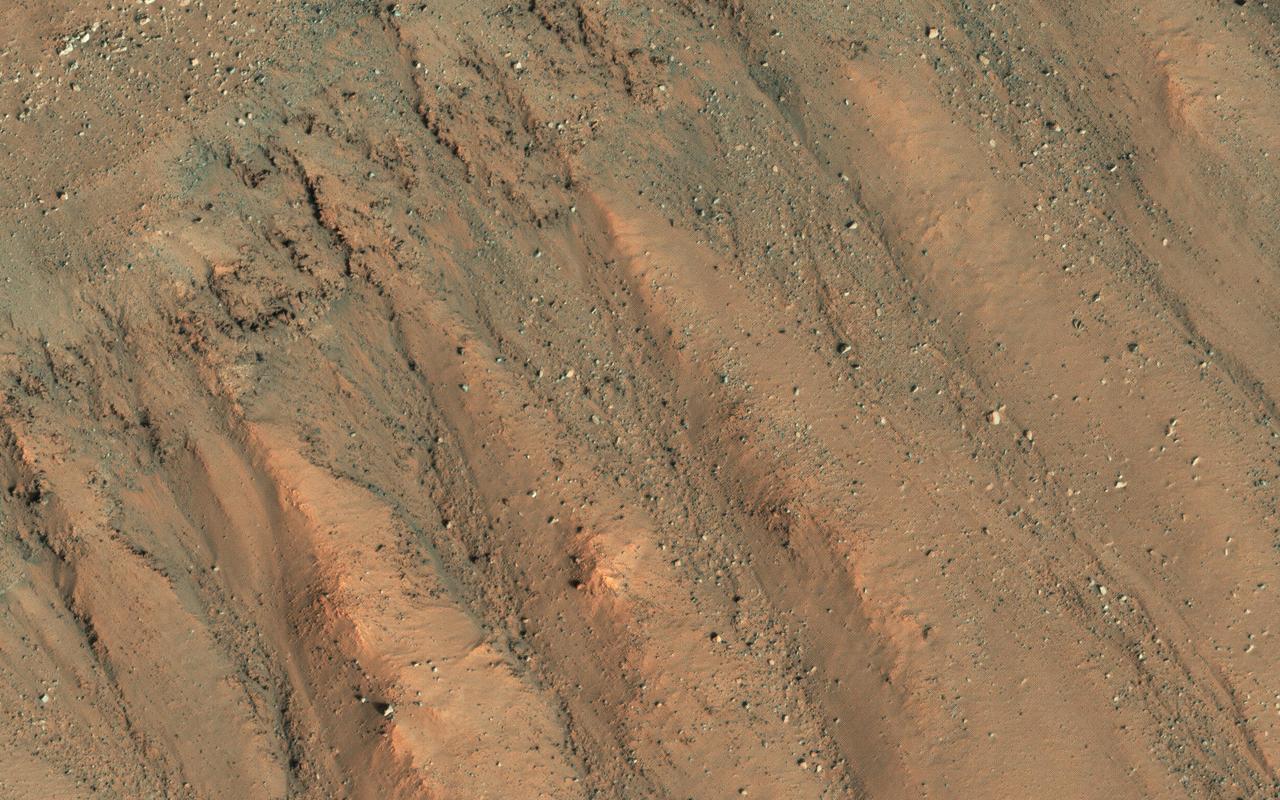
Recurring slope lineae are active flows on warm Martian slopes that might be caused by seeping water. One of the most active sites known is in the central peaks of Hale Crater as seen by NASA Mars Reconnaissance Orbiter. This image shows RSL extending downhill from bedrock cliffs, mostly towards the northwest (upper left). This image was acquired in middle summer when RSL are most active in the southern mid latitudes. The RSL in Hale have an unusually "reddish" color compared to most RSL, perhaps due to oxidized iron compounds, like rust. Since HiRISE color is shifted to infra-red wavelengths, they are actually especially bright the near-infrared just beyond the range of human vision. The Hale RSL are also unusual because they began activity much earlier than most RSL sites in the middle southern latitudes, and were well-developed in the early spring (see ESP_038073_1440). If seeping water causes RSL in Hale crater, it must be rich in salts to lower its freezing point significantly below the freezing point of pure water. http://photojournal.jpl.nasa.gov/catalog/PIA19359
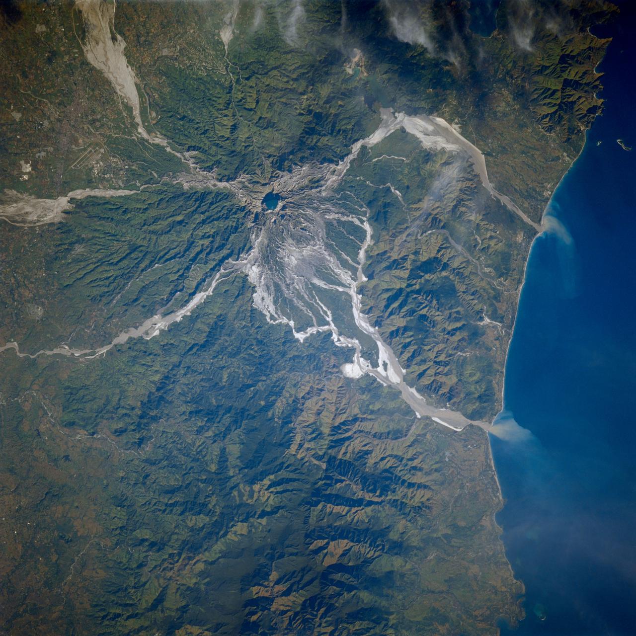
STS080-706-044 (19 Nov.-7 Dec. 1996) --- This view shows Mount Pinatubo, an active volcano in the Zambales Mountains range of western Luzon, the main island of the Philippines. Mud flows radiate out from the active volcano, which has erupted in recent years, coming down the mountain. After the eruption a lot of the vegetation was removed, causing the mountain to erode at a more rapid pace than an older mountain that has its vegetation in place. In two cases the flows reach the South China Sea, and flow down three valleys to the east. The now abandoned Clark Air Force Base is to the upper left corner. Pinatubo is about 80 miles northwest of Manila.
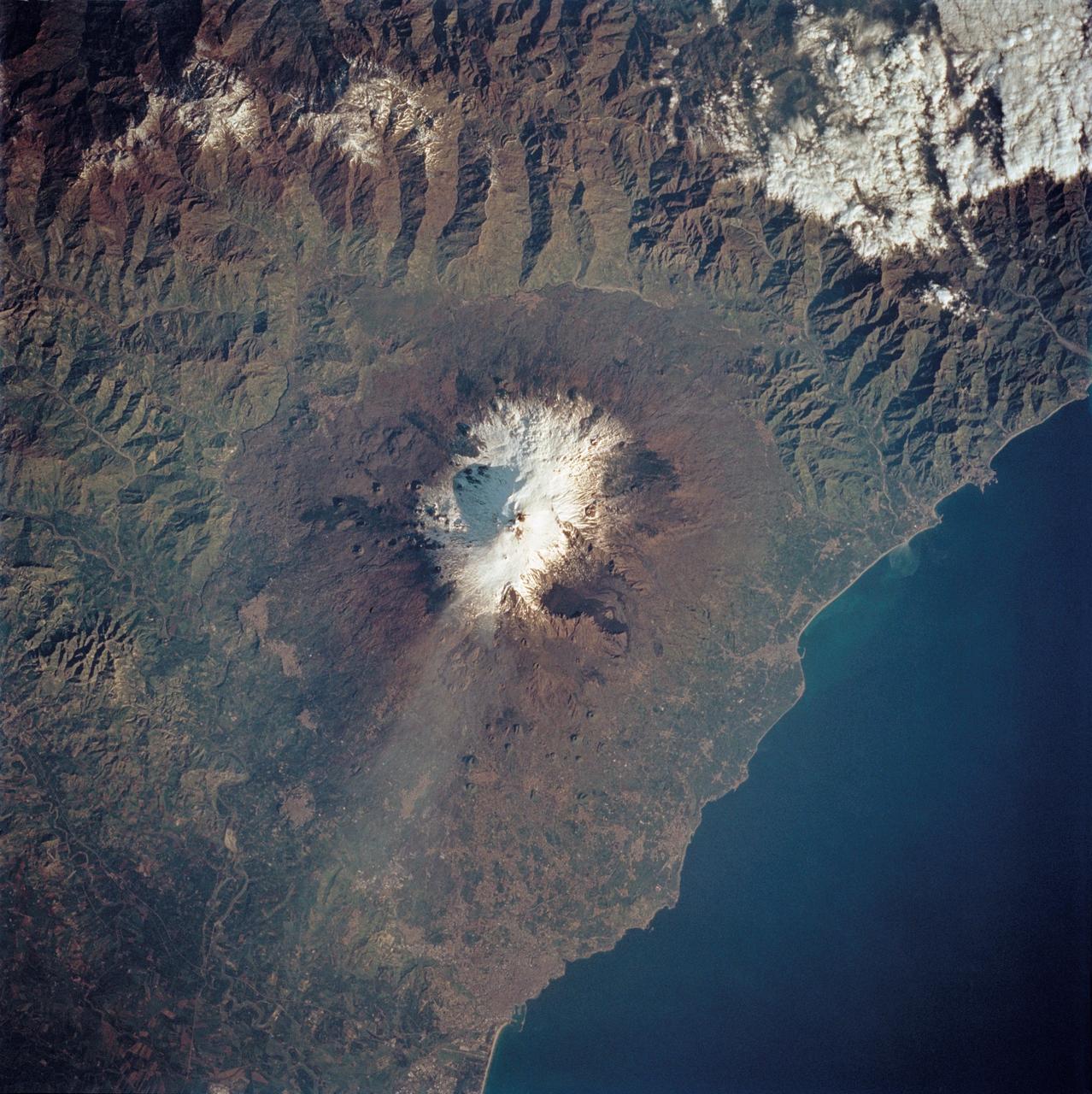
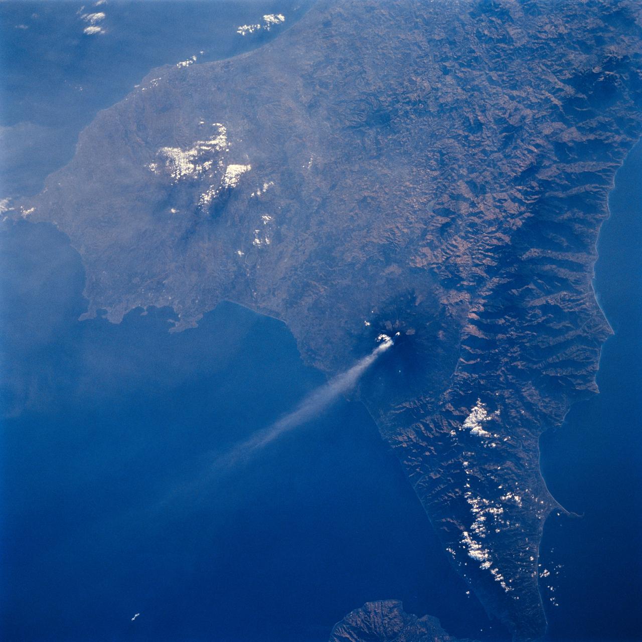
STS062-85-195 (4-18 March 1994) --- A thin plume of steam blows southward from the summit of Mt. Etna, the active volcano on the island of Sicily. The summit is capped with snow but the dark lava flow along the eastern flank (the 1991-93 flow) is clearly visible. The coastal city south of Etna is Catania.
This observation from NASA Mars Reconnaissance Orbiter shows the central hills in Hale Crater with thousands of seasonal flows on steep slopes below bedrock outcrops.
This image in Athabasca Valles shows lava flows originating from Elysium Mons to the northwest. A Context Camera image shows the lava flowed from the northwest to the southeast, diverting around obstacles as it settled. (The flow is outlined in blue with the flow direction shown in yellow, and the approximate location of the HiRISE image is represented by a white rectangle.) The lava appears to have flowed smoothly around obstructions, almost like water, forming streamlined islands. In the southern part of this image, a branch of the flow diverts around a small crater, and eventually rejoins the main part of the flow. Irregular-shaped ring structures appear on the northern end and are related to the volcanic activity that formed the flows. We also see a dense cluster of secondary craters that formed when material ejected from Corinto Crater (to the northwest) impacted the surface at high speed. At full-resolution, this terrain has the distinctive appearance of a field of numerous, small and closely-spaced craters. https://photojournal.jpl.nasa.gov/catalog/PIA23062
Arsia Mons is the southermost of the large aligned Tharsis volcanoes. Flows originating at Arsia Mons cover a vast region. The flows in this VIS image are part of the SW flow apron of Arsia Mons. The Tharsis trend runs NE/SW thru the centers of the volcanoes creating regions of greater tectonic and volcanic activities along this trend. Orbit Number: 77895 Latitude: -11.9896 Longitude: 236.892 Instrument: VIS Captured: 2019-07-07 04:22 https://photojournal.jpl.nasa.gov/catalog/PIA23395
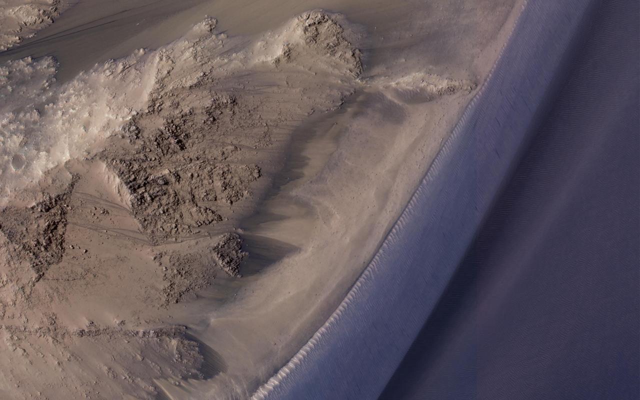
Recurring slope lineae (RSL) are seasonal flows on warm slopes, and are especially common in central and eastern Valles Marineris, as seen in this observation by NASA's Mars Reconnaissance Orbiter (MRO). This image covers a large area full of interesting features. Here, the RSL are active on east-facing slopes, extending from bouldery terrain and terminating on fans. Perhaps the fans themselves built up over time from the seasonal flows. Part of the fans with abundant RSL are dark, while the downhill portion of the fans are bright. The role of water in RSL activity is a matter of active debate. https://photojournal.jpl.nasa.gov/catalog/PIA21608
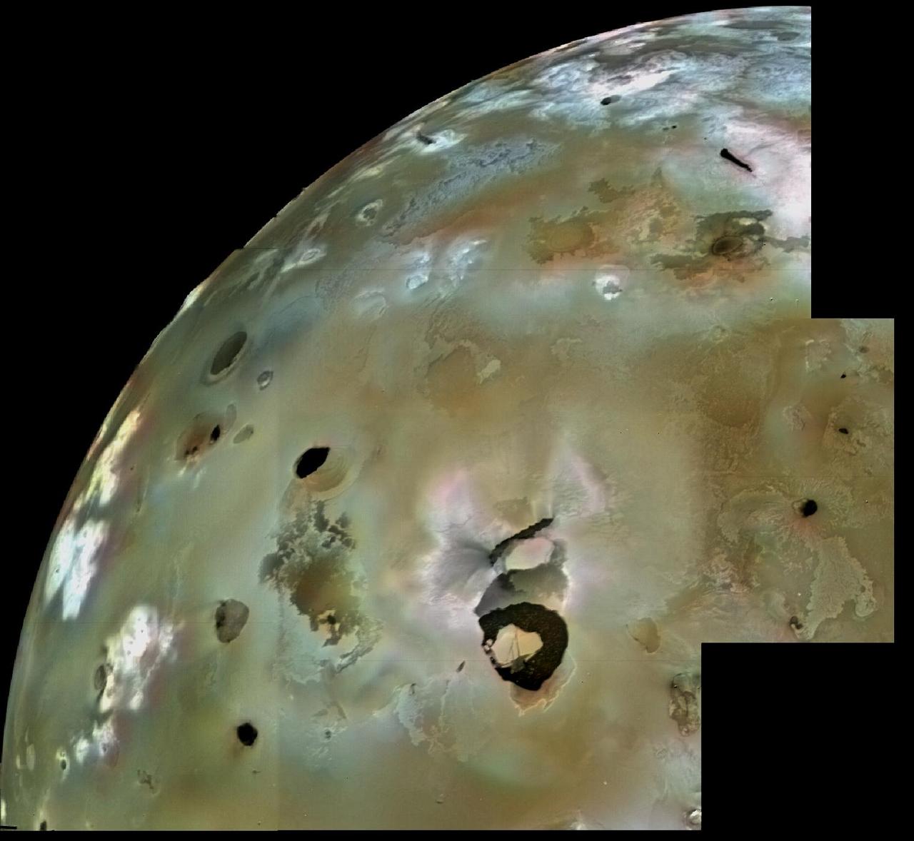
A huge area of Io's volcanic plains is shown in this Voyager 1 image mosaic. Numerous volcanic calderas and lava flows are visible here. Loki Patera, an active lava lake, is the large shield-shaped black feature. Heat emitted from Loki can be seen through telescopes all the way from Earth. These telescopic observations tell us that Loki has been active continuously (or at least every time astronomers have looked) since the Voyager 1 flyby in March 1979. The composition of Io's volcanic plains and lava flows has not been determined, but they could consist dominantly of sulfur with surface frosts of sulfur dioxide or of silicates (such as basalts) encrusted with sulfur and sulfur dioxide condensates. The bright whitish patches probably consist of freshly deposited SO2 frost. The black spots, including Loki, are probably hot sulfur lava, which may remain molten by intrusions of molten silicate magma, coming up from deeper within Io. The ultimate source of heat that keeps Io active is tidal frictional heating due to the continual flexure of Io by the gravity of Jupiter and Europa, another of Jupiter's satellites. http://photojournal.jpl.nasa.gov/catalog/PIA00320
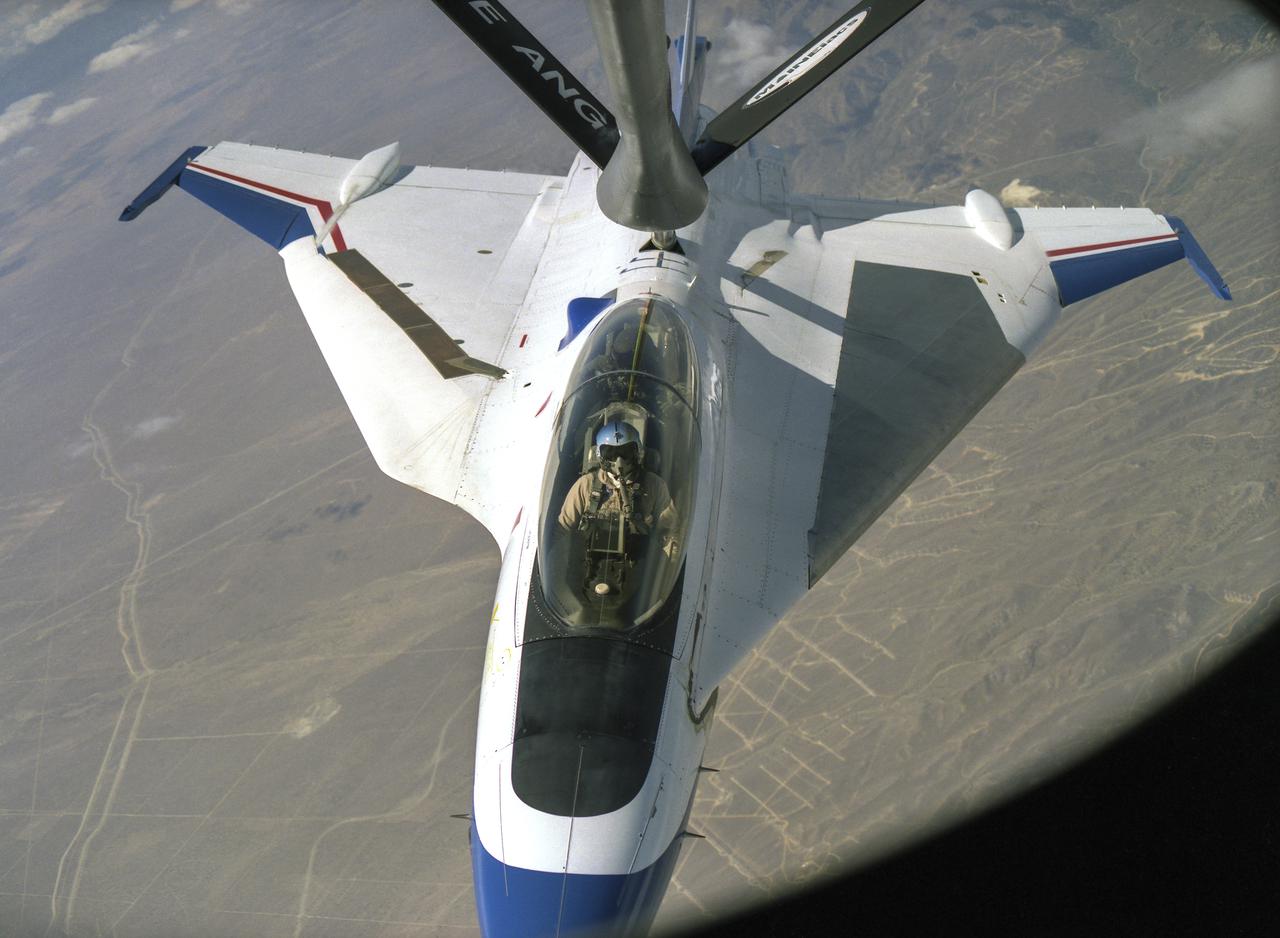
An F-16XL refuels in-flight. Only two XLs were built, and NASA eventually operated both for experimental purposes, including an active supersonic laminar flow experiment.
Mt. Etna, Italy erupted February 17, 2021, sending rivers of lave down the southeast flank of the volcano, and spewing ashes and volcanic stones over nearby villages. Sicily's Catania Airport was temporarily closed due to an ash plume that rose to 3700 m altitude. By the following week, the eruption had waned. The ASTER visible image shows the extent of the active lava flows (derived from the thermal infrared data). The image was acquired February 26, 2021, covers an area of 25.5 by 27.0 km, and is located at 37.8 degrees north, 15 degrees east. https://photojournal.jpl.nasa.gov/catalog/PIA24418
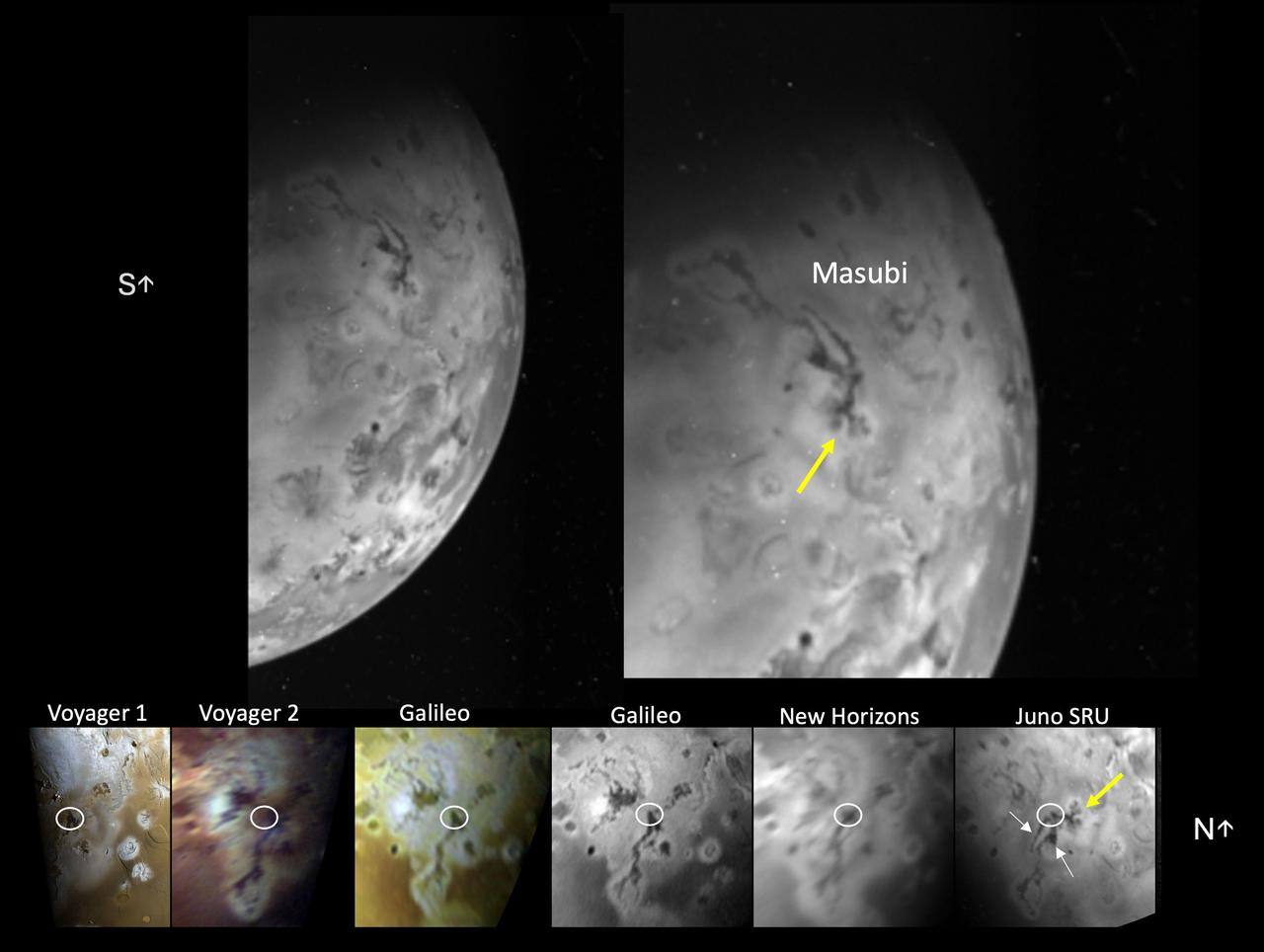
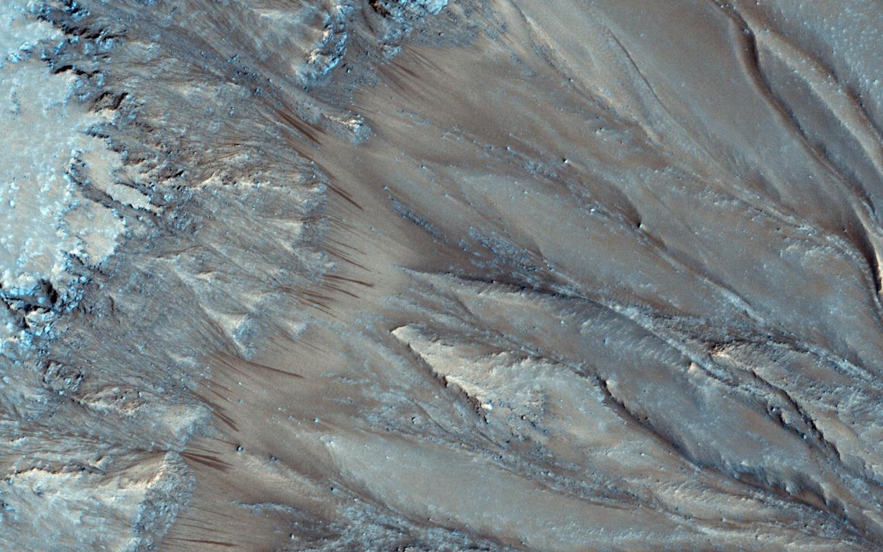
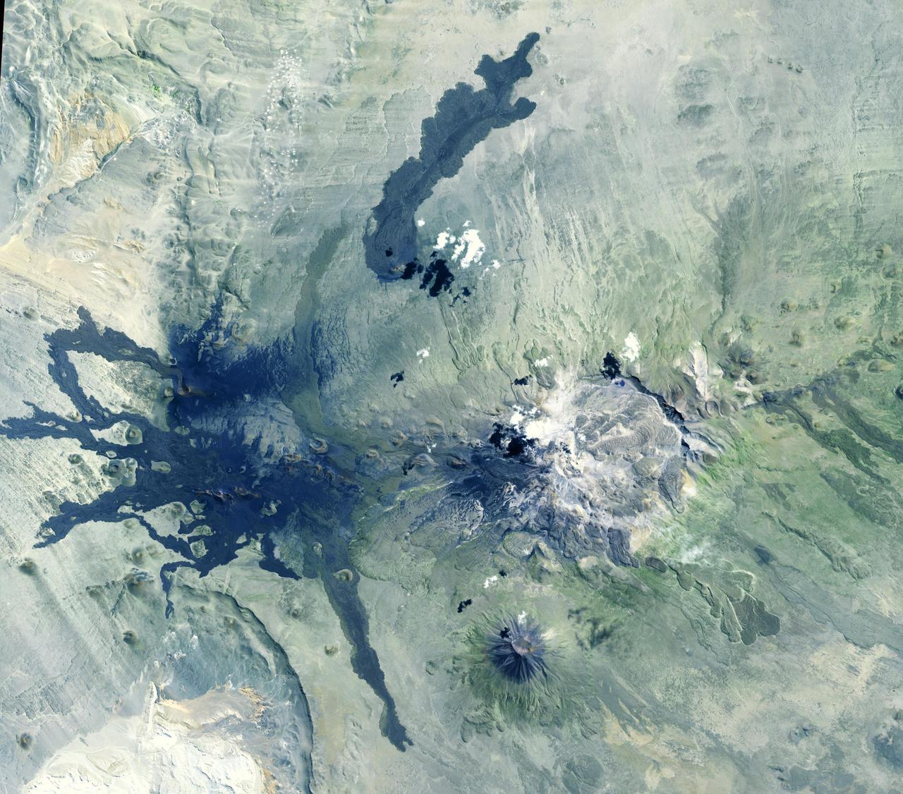
The Stellar Reference Unit (SRU) on NASA's Juno spacecraft collected this visible wavelength image of Io's night side while the surface was illuminated by Jupiter-shine on April 4, 2024. The image features the large compound flow field, Masubi, located on Io's southern hemisphere. Masubi was first observed by NASA's Voyager 1 in 1979 and has continued to expand ever since. A co-registered time sequence of Masubi observations covering 45 years is shown in the bottom panel. The location of the plume first observed by Galileo is circled in white in each image of the time sequence. The SRU observed even further expansion of pre-existing flows (white arrows) and two new flows with multiple lobes (yellow arrow). As of April 4, 2024, Masubi's total compound flow length is about 994 miles (1,600 kilometers), making it the longest currently active lava flow in the solar system. https://photojournal.jpl.nasa.gov/catalog/PIA26524
Ravines or very large gullies are actively forming on Mars during the coldest times of year, when carbon dioxide frost aids mass wasting as seen by NASA Mars Reconnaissance Orbiter. However, some of these ravines also show activity in the warmest time of year, in the form of recurring slope lineae (RSL); dark, narrow flows in some alcoves that flow part way down the channels. Few topographic changes have been seen in association with RSL, and they appear to be seeps of water that seasonally extend down slopes, then fade when inactive, and recur each warm season. Could the RSL activity carve the ravines? In some places the RSL extend to the ends of the fans and appear to match in scale, and perhaps gradually form the ravines. In other places, such as this image, the ravines are much larger than the RSL, so presently-observed RSL flow did not produce the larger landforms, but maybe the flow was greater in the past or maybe the RSL just follow the topography created by other processes. The largest ravines are on pole-facing slopes in the middle latitudes, where RSL have never been seen to form, unless the ravine creates a small equator-facing slope. http://photojournal.jpl.nasa.gov/catalog/PIA19458
STS077-740-029 (19-29 May 1996) --- In recent years, the most active peak in the High Altiplano of the central Andes Mountains has been Lascar, in northern Chile - featured in this 70mm frame. North is to the left in this picture. Lascar?s largest recent eruption was in April, 1993. The STS-55 crew photographed large dust plumes carrying the newly-deposited ash about one week after the eruption. Since then, astronauts have been closely monitoring Lascar, which remains active. This crew noticed and photographed Lascar?s plume, which is shown here as a steam plume rising from Lascar?s central summit crater. This level of activity is typical. This view also shows the extent of weathering as determined by the surface color of the 1993 flow from the crater. The flow traveled down the valley which is to the left (north) and then down (west) from the summit of this image. In earlier views the flow was a light gray, almost white feature in the valley. Today, the flow is close to the red-brown color of the surrounding rock.
This image from NASA Mars Reconnaissance Orbiter shows several seemingly active gullies and their associated fans near the Argyre region. As gullies form on slopes, sediment can become deposited to form lobe-shaped fans. Gullies can form with flowing water, but don't have to: sometimes they can be formed by the dry flow of sand and dust grains. This HiRISE image shows several seemingly active gullies and their associated fans. These particular gullies have many fine channels that are resolved nicely with a high resolution image. http://photojournal.jpl.nasa.gov/catalog/PIA19286
This image shows some faint traces of dark flows along the headwall of an impact crater. These are relics of seasonal recurring slope lineae (RSL) that formed on an equator-facing slope. They are not expected to be active yet, so we'll have to wait until later in the Martian spring for any changes. However, we like to monitor these sites as they progress through the seasons, and fully formed RSL have been identified at this site before. That's because RSL recur each Mars year at the same places, like this crater wall. RSL activity often happens at predicted temperatures approaching minus 20 degrees Celsius (or minus 4 degrees Fahrenheit). An intermittent flow of brines is possible but dry flow of granules is an alternative explanation to explain RSL formation. Because of this uncertainty, the science community is debating whether these regions should be regarded as "special regions" where rovers or others landers are restricted. https://photojournal.jpl.nasa.gov/catalog/PIA23951
The Advanced Spaceborne Thermal Emission and Reflection (ASTER) instrument onboard NASA's Terra spacecraft obtained near-infrared data of the ongoing Kilauea volcano eruption and its impact on the Leilani Estates area on May 15, 2018 (left) and June 23, 2018 (right). The current eruption began May 3. Red areas are vegetated, while white areas are clouds or volcanic plumes. The new dark areas show where the ground has been covered with lava flows. The lava seen here, flowing a high rate of volume from a vent designated Fissure 8, flowed eastward to the coast. In early June 2018, these rapidly moving flows destroying hundreds of homes in and around the towns of Vacationland and Kapoho, and filled in Kapoho Bay. The flows are now creating a new broad delta, extending the island of Hawaii. A plume has formed where incandescent lava flows into the Pacific. In the ASTER observation obtained on June 23, a well-developed leveed and perched lava channel flowing from left to right is clearly seen. For the month of June, flow activity was mostly confined to Fissure 8 and areas fed by this lava channel. The image was acquired June 23, 2018, covers an area of about 14 by 14 miles (23 by 23 kilometers), and is located at 19.6 degrees north, 154.9 degrees west. https://photojournal.jpl.nasa.gov/catalog/PIA22593
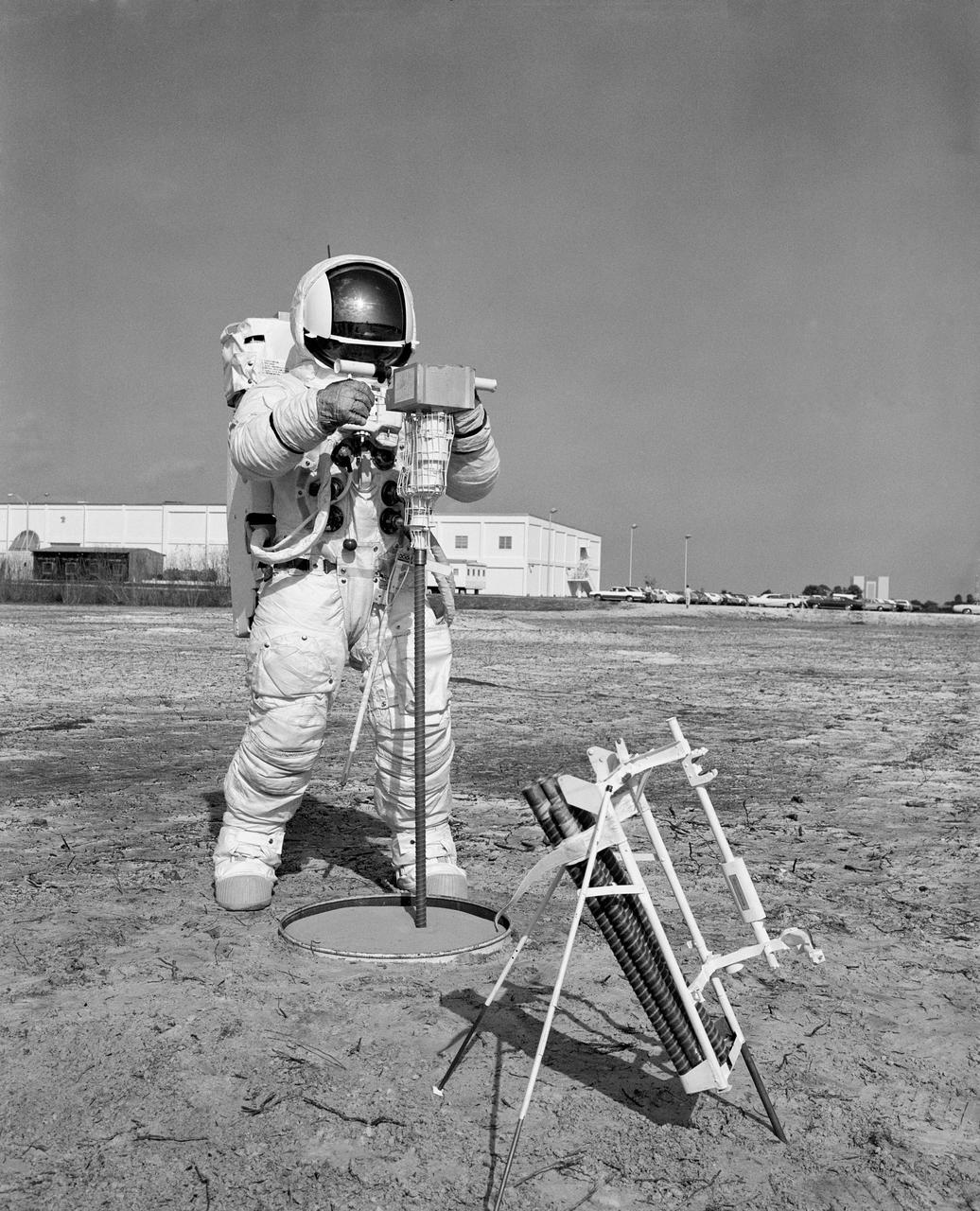
S70-29673 (28 Jan. 1970) --- Astronaut Fred W. Haise Jr., lunar module pilot of the Apollo 13 lunar landing mission, participates in a walk-through of the extravehicular activity timeline at the Kennedy Space Center. Here, Haise uses an Apollo Lunar Surface Drill to dig a three-meter heat flow probe hole. The heat flow experiment on Apollo 13 will have an electronic instrument which will measure the outward flux of heat from the moon?s interior.
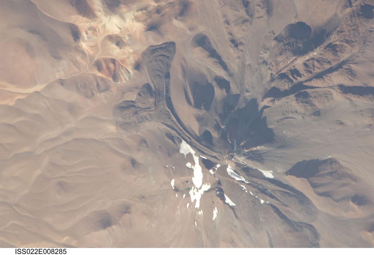
ISS022-E-008285 (9 Dec. 2009) --- Llullaillaco volcano on the Argentina-Chile border is featured in this image photographed by an Expedition 22 crew member on the International Space Station. The summit of Llullaillaco volcano has an elevation of 6,739 meters above sea level, making it the highest historically active volcano in the world. The current Llullaillaco stratovolcano ? a typically high, cone-shaped volcano built from successive layers of thick lava flows and eruption products like ash and rock fragments ? is built on top of an older stratovolcano. The last explosive eruption of the volcano occurred in 1877 based on historical records. This detailed photograph of Llullaillaco illustrates an interesting volcanic feature known as a coulee (top left). Coulees are formed from highly viscous, thick lavas that flow onto a steep surface; as they flow slowly downwards, the top of the flow cools and forms a series of parallel ridges oriented at 90 degrees to the direction of flow (somewhat similar in appearance to the pleats of an accordion). The sides of the flow can also cool faster than the center, leading to the formation of wall-like structures known as flow levees (center).
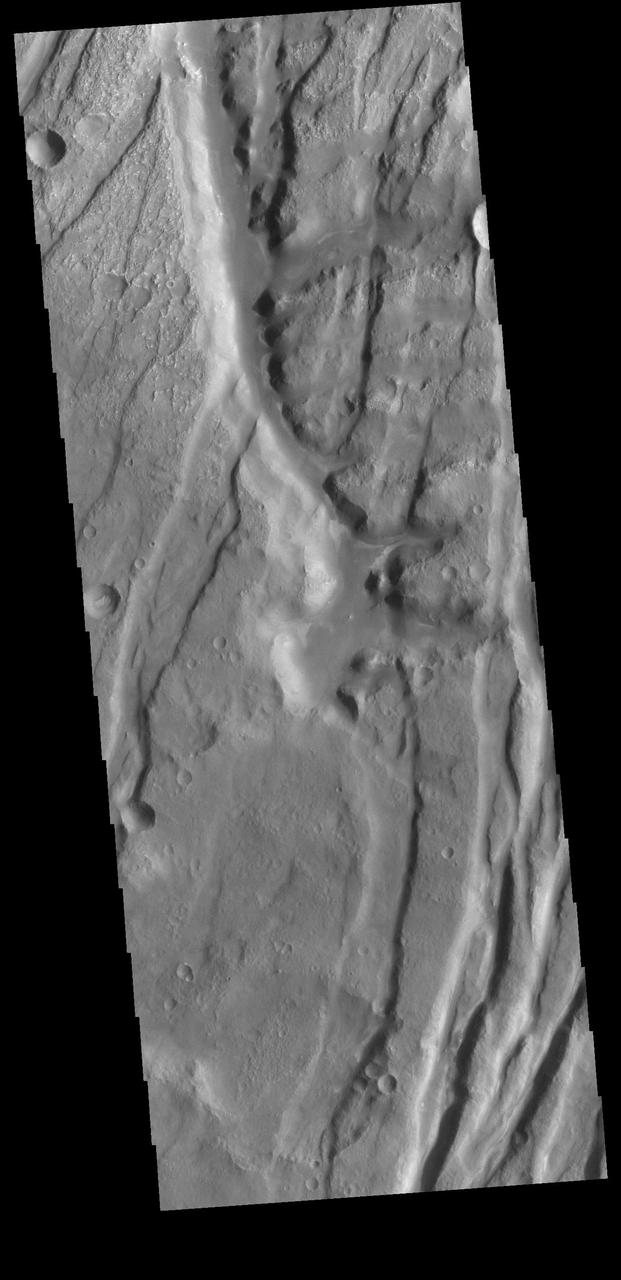
The Tharsis region of Mars is covered in vast lava flows, many with channels. Some channels, however, resemble features that may have been formed by water. In this image, we see a smooth, flat-bottomed channel within the roughly irregular edges of a possible lava flow. This long, winding channel runs for 115 kilometers (70 miles) from its source (shown in ESP_045091_2045), maintaining a nearly consistent width. There is also a streamlined island within the channel, which is 1.25 kilometers (about 3/4 mile) long. One possibility is that a lava flow formed, and later groundwater was released, preferentially flowing through and further eroding the pre-existing lava channel. Or, the original lava flow could have been a very low-viscosity lava. We look at the shape and profile of the channel, and the channel and lava flow edges, to understand the characteristics of the fluids at work. Although there are lava flows and rivers on Earth that we can observe to understand the processes at work, the interplay of the features on Mars may tell a more complicated story. We want to be able to understand the history of volcanic activity in Tharsis, as well as possible interaction with ground water release, to better understand some of the younger landforms on Mars. http://photojournal.jpl.nasa.gov/catalog/PIA21104
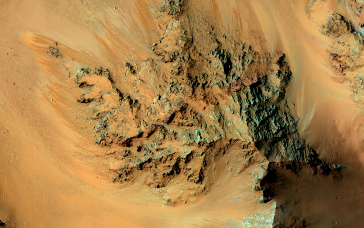
Among the many discoveries by NASA's Mars Reconnaissance Orbiter since the mission was launched on Aug. 12, 2005, are seasonal flows on some steep slopes. These flows have a set of characteristics consistent with shallow seeps of salty water. This July 21, 2015, image from the orbiter's High Resolution Imaging Science Experiment (HiRISE) camera shows examples of these flows on a slope within Coprates Chasma, which is part of the grandest canyon system on Mars, Valles Marineris. The image covers an area of ground one-third of a mile (536 meters) wide. These flows are called recurring slope lineae because they fade and disappear during cold seasons and reappear in warm seasons, repeating this pattern every Martian year. The flows seen in this image are on a north-facing slope, so they are active in northern-hemisphere spring. The flows emanate from the relatively bright bedrock and flow onto sandy fans, where they are remarkably straight, following linear channels. Valles Marineris contains more of these flows than everywhere else on Mars combined. At any season, some are active, though on different slope aspects at different seasons. Future human explorers (and settlers?) will need water to drink, grow food, produce oxygen to breath, and make rocket fuel. Bringing all of that water from Earth would be extremely expensive, so using water on Mars is essential. Although there is plenty of water ice at high latitudes, surviving the cold winters would be difficult. An equatorial source of water would be preferable, so Valles Marineris may be the best destination. However, the chemistry of this water must be understood before betting any lives on it. http://photojournal.jpl.nasa.gov/catalog/PIA19805

STS063-68-018 (3-11 Feb 1995) --- Russian cosmonaut Vladimir G. Titov, mission specialist, handles vials of samples for the Commercial Generic Bioprocessing Apparatus (CGBA) experiment in SpaceHab 3 Module onboard the Earth-orbiting Space Shuttle Discovery. Titov joined five NASA astronauts for eight days of research in Earth-orbit.

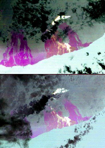
This black-and-white visible wavelength (450-1,100 nm) image of Io's surface was taken by the Stellar Reference Unit (SRU) aboard NASA's Juno spacecraft during a close flyby of the volcanic moon on Dec. 30, 2023. The image was taken from a distance of about 932 miles (1,500 kilometers) over the night side of Io in a region dimly illuminated by Jupiter-shine. It is Juno's highest resolution image of Io, at about half- to three-quarters of a mile (895 to 1,230 meters) per pixel. The image covers the Zal Montes-Patera complex (the two mountains and large dark patera at the center of the image) and the western portion of the Tonatiuh eruptive center (at left edge of left image and top edge of right image). The left panel is the raw SRU image, and the right panel shows the image projected onto the surface of Io with north up. The image reveals fresh new lava flows at Zal Patera (the large dark patera between the two mountains) with possible jets of sulfur dioxide gas at the flow fronts. The SRU's sensitivity at near-infrared wavelengths enabled detection of thermal emission signatures from multiple active lava breakouts in Zal Patera and at the base of South Zal Mons (the lower mountain in the image at right). An unprecedented elongated, curved emission feature is observed to the west of South Zal Mons and is suspected to be an active lava channel. The image also captures the first high-resolution view of Tonatiuh's geomorphology. The SRU observes a fresh (dark) crenulated lava flow at Tonatiuh (left edge of left image and top edge of right image), showing that this volcano's flows are consistent with an insulated Promethean-style compound flow field. The lava flow is 98 by 11 miles (158 by 18 kilometers). The SRU collects images of star fields to provide star positions used for attitude determination. Designed for low-light conditions, the camera has proved itself a valuable science tool, discovering shallow lightning in Jupiter's atmosphere, imaging the planet's enigmatic ring system, finding hints of recent surface activity on Europa, and now providing a view of Io's volcanoes in action. https://photojournal.jpl.nasa.gov/catalog/PIA26489
Italy's Mount Etna and the Aeolian Islands are the focus of this perspective view made from an Advanced Spaceborne Thermal and Emission Radiometer (ASTER) image from NASA's Terra spacecraft overlaid on Shuttle Radar Topography Mission (SRTM) topography. The image is looking south with the islands of Lipari and Vulcano in the foreground and Etna with its dark lava flows on the skyline. Vulcano also hosts an active volcano, the cone of which is prominent. In late October 2002, Etna erupted again, sending lava flows down the north and south sides of the volcano. The north flows are near the center of this view, but the ASTER image is from before the eruption. In addition to the terrestrial applications of these data for understanding active volcanoes and hazards associated with them such as lava flows and explosive eruptions, geologists studying Mars find these data useful as an analog to martian landforms and geologic processes. In late September 2002, a field conference with the theme of Terrestrial Analogs to Mars focused on Mount Etna allowing Mars geologists to see in person the types of features they can only sample remotely. http://photojournal.jpl.nasa.gov/catalog/PIA03370
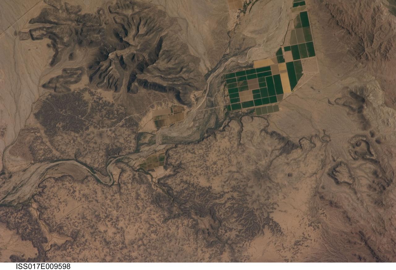
ISS017-E-009598 (18 June 2008) --- The Sentinel Volcanic Field in Arizona is featured in this image photographed by an Expedition 17 crewmember on the International Space Station. This detailed view depicts a portion of the Gila River channel (center) between the Sentinel Volcanic Field and Oatman Mountain in south-central Arizona. The northernmost boundary of the Sentinel field is visible in the image, recognizable by the irregular flow fronts, or leading edge, of thin basalt lava flows erupted from low volcanic cones approximately 3.3--1.3 million years ago, according to scientists. Coloration of the lava flow tops ranges from dark brown exposed rock to a tan, carbonate-rich soil cover. Active agricultural fields along the Gila River are a rich green set against the surrounding desert. In contrast to the gentle topography of the Sentinel Volcanic Field, Oatman Mountain (upper left) rises from the Gila River channel to an elevation of approximately 560 meters. While Oatman Mountain is located close to the Sentinel field, it represents an earlier phase of volcanic activity in the area. Volcanic rocks comprising Oatman Mountain were more viscous, leading to shorter, stronger flows that are weathered into stream channels and scarps on the mountain slopes. The mountain is a popular hang gliding destination due to abundant thermal currents rising from the surrounding desert floor and lava surfaces.
This image was acquired on May 13, 2018 by NASA's Mars Reconnaissance Orbiter. A hotspot for exploration on Mars centers on areas that were once, or are currently, next to a significant source of heat such as volcanoes. Martian volcanoes have not been active for the last couple million years, but beneath the shifting sands and dust of the Red Planet we find old lava flows frozen in time. These ancient lava flows may have provided a source of heat, along with liquid water or subsurface ice, to generate an environment conducive for the development of ancient life. Geological evidence for hot water interacting with rock is what we mean by hydrothermal: sites with these conditions are very difficult to identify from orbit. One closeup view shows sand dunes scouring what appears to be a highly-cratered, old lava flow in the Tempe Terra region, located in the Northern Hemisphere. The flat, dark areas are basaltic in composition, a rock commonly found around active volcanoes, and the lighter-toned material is covered in rusted Martian dust. The recently-launched InSight lander will reveal whether Mars is geologically active internally. More information is available at https://photojournal.jpl.nasa.gov/catalog/PIA22586
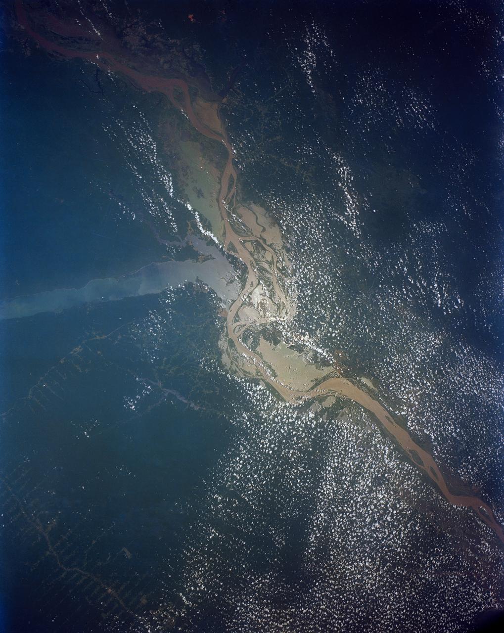
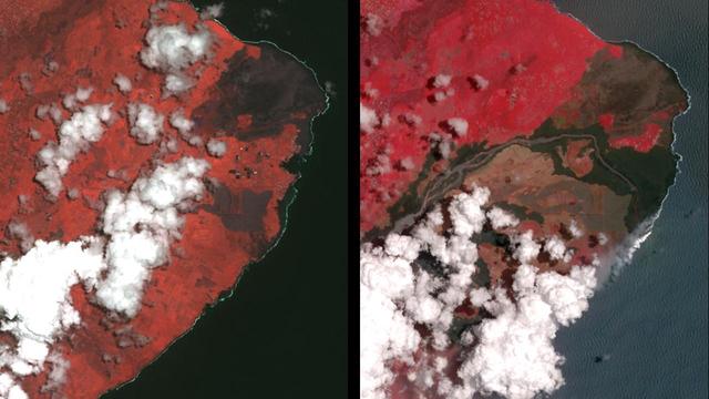
This view shows the confluence of the Amazon and the Topajos Rivers at Santarem, Brazil (2.0S, 55.0W). The Am,azon flows from lower left to upper right of the photo. Below the river juncture of the Amazon and Tapajos, there is considerable deforestation activity along the Trans-Amazon Highway.
STS039-151-179 (28 April-6 May 1991) --- A large format frame of one of the USSR's volcanic complex (Kamchatka area) with the active volcano Klyuchevskaya (Kloo-chevs'-ska-ya), 15,584 feet in elevation. The last reported eruption of the volcano was on April 8, but an ash and steam plume extending to the south was observed by the STS-39 crew almost three weeks later. The south side of the volcano is dirty from the ash fall and landslide activity. The summit is clearly visible, as is the debris flow from an earlier eruption. Just north of the Kamchatka River is Shiveluch, a volcano which was active in early April. There are more than 100 volcanic edifices recognized on Kamchatka, with 15 classified as active.
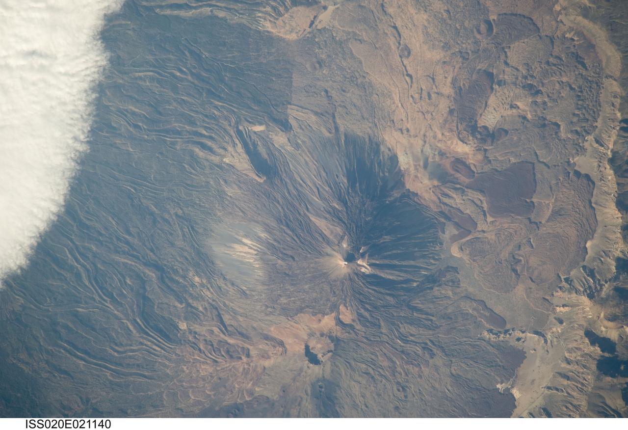
ISS020-E-021140 (15 July 2009) --- Teide Volcano on the Canary Islands of Spain is featured in this image photographed by an Expedition 20 crew member on the International Space Station. This detailed photograph features two stratovolcanoes ? Pico de Teide and Pico Viejo ? located on Tenerife Island, part of the Canary Islands of Spain. Stratovolcanoes are steep-sided; typically conical structures formed by interlayered lavas and fragmented rock material from explosive eruptions. Pico de Teide has a relatively sharp peak, whereas an explosion crater forms the summit of Pico Viejo. The two stratovolcanoes formed within an even larger volcanic structure known as the Las Ca?adas caldera ? a large collapse depression typically formed when a major eruption completely empties the underlying magma chamber of a volcano. The last eruption of Teide occurred in 1909. NASA scientists point out sinuous flow levees marking individual lava flows. The scientists consider the flow levees as perhaps the most striking volcanic features visible in the image. Flow levees are formed when the outer edges of a channelized lava flow cool and harden while the still-molten interior continues to flow downhill ? numerous examples radiate outwards from the peaks of both Pico de Teide and Pico Viejo. Brown to tan overlapping lava flows and domes are visible to the east-southeast of the Teide stratovolcano. Increased seismicity, carbon dioxide emissions, and fumarolic activity within the Las Ca?adas caldera and along the northwestern flanks of the volcano were observed in 2004. Monitoring of the volcano to detect renewal of activity is ongoing.
STS083-747-088 (4-8 April 1997)--- Mayon Volcano with a Plume, Luzon, the Philippines Mayon has the classic conical shape of a strato volcano. It is the most active volcano in the Philippines and continues to be active as demonstrated by the plume in the photo. Since 1616, Mayon has erupted 47 times. The most recent major eruption, in 1993, began unexpectedly with an explosion. The initial eruption lasted only 30 minutes but it generated pyroclastic flows that killed 68 people and prompted the evacuation of 60,000 others.
STS006-03-381 (4-9 April 1983) --- Astronaut F. Story Musgrave, STS-6 mission specialist, monitors the activity of a sample in the continuous flow electrophoresis system (CFES) aboard the Earth-orbiting space shuttle Challenger. Dr. Musgrave is in the middeck area of the spacecraft. He has mounted a 35mm camera to record the activity through the window of the experiment. This frame was also photographed with a 35mm camera. Photo credit: NASA
ISS015-E-16913 (10 July 2007) --- Shiveluch Volcano, Kamchatka, Russian Far East is featured in this image photographed by an Expedition 15 crewmember on the International Space Station. Shiveluch is one of the biggest and most active of a line of volcanoes along the spine of the Kamchatka peninsula in easternmost Russia. In turn the volcanoes and peninsula are part of the tectonically active "Ring of Fire" that almost surrounds the Pacific Ocean, denoted by active volcanoes and frequent earthquakes. Shiveluch occupies the point where the northeast-trending Kamchatka volcanic line intersects the northwest-trending Aleutian volcanic line. Junctions such as this are typically points of intense volcanic activity. According to scientists, the summit rocks of Shiveluch have been dated at approximately 65,000 years old. Lava layers on the sides of the volcano reveal at least 60 major eruptions in the last 10,000 years, making it the most active volcano in the 2,200 kilometer distance that includes the Kamchatka peninsula and the Kuril island chain. Shiveluch rises from almost sea level to well above 3,200 miles (summit altitude 3,283 miles) and is often capped with snow. In this summer image however, the full volcano is visible, actively erupting ash and steam in late June or early July, 2007. The dull brown plume extending from the north of the volcano summit is most likely a combination of ash and steam (top). The two larger white plumes near the summit are dominantly steam, a common adjunct to eruptions, as rain and melted snow percolate down to the hot interior of the volcano. The sides of the volcano show many eroded stream channels. The south slope also reveals a long sloping apron of collapsed material, or pyroclastic flows. Such debris flows have repeatedly slid down and covered the south side of the volcano during major eruptions when the summit lava domes explode and collapse (this occurred during major eruptions in 1854 and 1964). Regrowth of the forest on the south slope (note the contrast with the eastern slope) has been foiled by the combined effects of continued volcanic activity, instability of the debris flows and the short growing season.
Guatemala's Fuego volcano continued its frequent moderate eruptions in early February 2015. Pyroclastic flows from the eruptions descended multiple drainages, and the eruptions sent ash plumes spewing over Guatemala City 22 miles (35 kilometers) away, and forced closure of the international airport. The Advanced Spaceborne Thermal Emission and Reflection Radiometer (ASTER) instrument onboard NASA's Terra spacecraft captured a new image of the region on February 17. Fuego is on the left side of the image. The thermal infrared inset image shows the summit crater activity (white equals hot), and remnant heat in the flows on the flank. Other active volcanoes shown in the image are Acatenango close by to the north, Volcano de Agua in the middle of the image, and Pacaya volcano to the east. The image covers an area of 19 by 31 miles (30 by 49.5 kilometers), and is located at 14.5 degrees north, 90.9 degrees west. http://photojournal.jpl.nasa.gov/catalog/PIA19297
STS064-71-037 (9-20 Sept. 1994) --- Mt. Etna on Sicily displays a steam plume from its summit. Geologists attribute the volcano's existence to the collision of tectonic plates. Unlike the sudden, explosive eruption at Rabaul, Mt. Etna's activity is ongoing and is generally not explosive - Etna's slopes have been settled with villages and cultivated land for centuries. Other Mediterranean volcanoes (like Santorini) have experienced large catastrophic eruptions. Etna recently finished a two-year eruption (ending in 1993), marked by relatively gentle lava flows down the eastern flank. It has been continually degassing since then, according to the geologists, producing an omnipresent steam plume, as seen here. The 1993 flow is difficult to identify in this image because it lies within shadows on the eastern flank, but small cinder cones on the western flank mark earlier episodes of volcanic activity. Photo credit: NASA or National Aeronautics and Space Administration
Italy's Mount Etna is the focus of this perspective view made from an Advanced Spaceborne Thermal and Emission Radiometer (ASTER) image from NASA's Terra spacecraft overlaid on Shuttle Radar Topography Mission (SRTM) topography. The image is looking south with dark lava flows from the 1600's (center) to 1981 (long flow at lower right) visible in the foreground and the summit of Etna above. The city of Catania is barely visible behind Etna on the bay at the upper left. In late October 2002, Etna erupted again, sending lava flows down the north and south sides of the volcano. The north flows are near the center of this view, but the ASTER image is from before the eruption. In addition to the terrestrial applications of these data for understanding active volcanoes and hazards associated with them such as lava flows and explosive eruptions, geologists studying Mars find these data useful as an analog to martian landforms and geologic processes. In late September 2002, a field conference with the theme of Terrestrial Analogs to Mars focused on Mount Etna, allowing Mars geologists to see in person the types of features they can only sample remotely. http://photojournal.jpl.nasa.gov/catalog/PIA03371
Nishinoshima Volcano is a small volcanic island located about 1000 km south of Tokyo. Recent activity began in December 2019, and has continued. ASTER captured this image of an ash and steam plume emanating from the central crater. Thermal infrared data is superimposed on a visible-infrared color image to highlight the lave flows that have flowed down the volcano's flanks. The image was acquired March 22, 2020, covers an area of 12.6 by 12.3 km, and is located at 27.3 degrees east, 140.8 degrees east. https://photojournal.jpl.nasa.gov/catalog/PIA23846
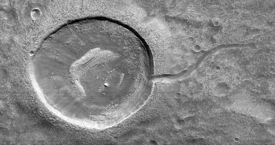
This image from NASA's Mars Reconnaissance Orbiter (MRO) shows an impact crater looking amusingly like a tadpole because of the valley that was carved by water that used to fill it. It is often difficult to differentiate between inlet and outlet channels, but water always flows downhill. In this particular case, we can infer that water is flowing outward because we have the necessary terrain-height information. When studying these images in detail, scientists can gain a better understanding of the strength of the flooding water that carved the channels, and better understand the history of water activity in this region of Mars. https://photojournal.jpl.nasa.gov/catalog/PIA22241
Nishinoshima is a small volcanic island located about 1000 km south of Tokyo, Japan. Eruptive activity began in December 2019, and has continued uninterrupted. ASTER captured this image of an ash and steam plume emanating from the central crater. Thermal infrared data is superposed in red on a visible-infrared color image to highlight the lava in the central crater and lava flows that have flowed down the volcano's flanks. The image was acquired July 28, 2020, covers an area of 15 by 21 km, and is located at 27.3 degrees north, 140.8 degrees east. https://photojournal.jpl.nasa.gov/catalog/PIA24017
Located west of the Elysium Volcanic complex, Hebrus Valles is a complex channel system that flowed to the north. In this VIS image the channel features have the appearance of a channel formed by liquid flow. In other portions of the valles, there are pits and collapse features which appear to have formed by material falling into subsurface voids. This is a common feature in regions of volcanic activity where lava tubes run below the surface. Both water and lava probably contributed to the formation of Hebrus Valles. Orbit Number: 71499 Latitude: 17.8884 Longitude: 127.923 Instrument: VIS Captured: 2018-01-26 09:17 https://photojournal.jpl.nasa.gov/catalog/PIA22398
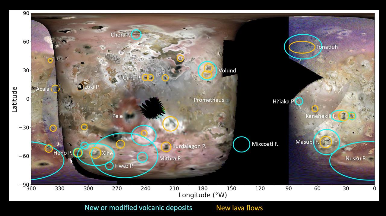
This global map of Jupiter's moon Io – derived from images acquired during the 55th, 57th, 58th, and 60th close passes of the gas giant by NASA's Juno spacecraft – shows the volcanic activity and other surface changes detected by the JunoCam instrument. Cyan ovals denote areas of new, faded, or shifted plume and/or volatile deposits. Yellow ovals denote areas of probable new lava flows. Comparing JunoCam images to Galileo and New Horizons data reveals at least 20 new dark deposits, likely fresh lava flows or dark silicate ash deposits. Of these, six appear to be intra-patera resurfacing, while 11 appear to be lava flows outside of paterae. Fourteen new diffuse deposits associated with volcanic centers were also found. https://photojournal.jpl.nasa.gov/catalog/PIA26486
Gullies in the sand dunes of Matara Crater are very active. One large gully in particular has had major changes in every Martian winter since HiRISE began monitoring, triggered by the seasonal dry ice frost that accumulates each year. This time there was an especially large change, depositing a huge mass of sand. The sand divided into many small toes near its end, or perhaps many individual flows descended near the same spot. Additionally, a long sinuous ridge of sand was deposited. This could be a "levee" that formed along one side of a flow, but there is not much sand past the end of the ridge, so it might also be the main body of a flow. How many changes can you see in the cutout? https://ppj2.jpl.nasa.gov/catalog/PIA23853
One of the major extended-mission objectives for HiRISE has been to re-image parts of the surface to look for changes. Such observations can tell us what processes are active today. This image was acquired as part of a series to look for sand movement in Meroe Patera, not far from the active sand dunes of Nili Patera. Our image shows that sand dunes are missing downwind (to the left) of a crater near the center of the observation, because sand falls into the crater and is trapped. Zooming in on the sand-coated crater wall and comparing it with older images revealed a surprise: several major sand flows slumped down into the crater (towards the upper left), leaving small ridges (called "levees") along their path and rounded piles of sand at the end. What caused these slumps? Dry ice, which is thought to cause flows in some gullies and the North polar dunes, does not occur this close to the equator. There is no sign of recurring slope lineae, the leading candidates for liquid on the Martian surface. Instead, it is most likely that these were dry flows. They are far larger than the avalanches commonly seen on sand dunes, typified by the shorter light streaks visible in the lower left part of the "after" image, so they might have been triggered by a Mars-quake or an unusually strong wind. http://photojournal.jpl.nasa.gov/catalog/PIA19305
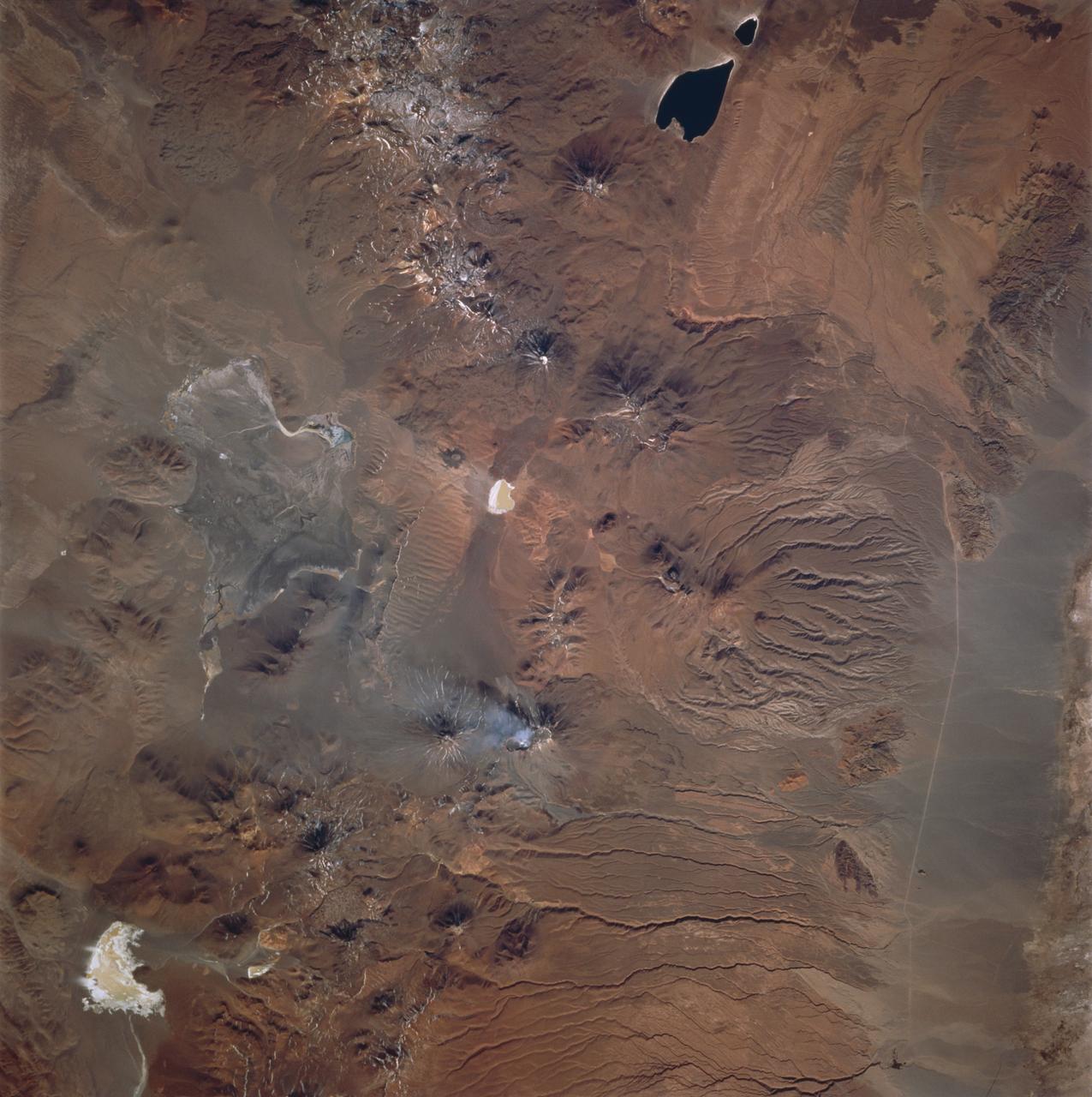
ISS033-E-006202 (20 Sept. 2012) --- Salar de Coipasa, Bolivia is featured in this image photographed by an Expedition 33 crew member on the International Space Station. The Salar de Coipasa, located in the Altiplano region of western Bolivia, covers an area of approximately 2,500 square kilometers. The word ?salar? describes arid closed basins in which evaporation of mineral-rich waters leads to the formation of thick, flat-laying salt deposits. Salar de Coipasa is located to the southwest of the saline Lake Poopo and northwest of the largest salt flat in the world, Salar de Uyuni. At Coipasa, a crust composed of halite?common table salt?provides the brilliant white coloration characteristic of the Altiplano salars (right). While the environment of Salar de Coipasa is arid, it does receive constant water from the Lauca River flowing from the north; this feeds Lake (Lago) Coipasa that fills the northern end of the basin with shallow water (center). However, the water flow can drop off sharply during periods of drought. The waters of Lake Coipasa, and the white salt crust of the salar, also serve to highlight dark river sediments flowing into the basin along the northeastern shore. Dark volcanic rocks contrast sharply with the surrounding salt crust at right. While the western Andes Mountains contain many active volcanoes, the nearby Tata Sabaya volcano has not been historically active.
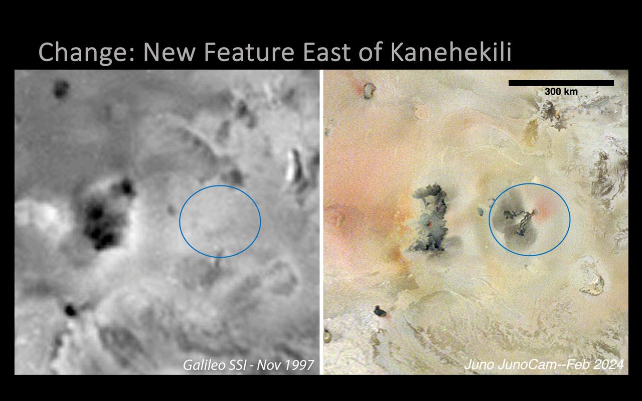
A new volcanic feature east of Kanehekili on Jupiter's moon Io was imaged by NASA's Juno mission during its 58th close flyby of the gas giant on Feb. 3, 2024. The image was captured in Jupiter-shine at 1.1 miles (1.8 kilometers) per pixel by the mission's JunoCam instrument. The feature is new since NASA's Galileo captured the area in 1997 (image at left), and consists of two thin, digitate flows, running roughly to the west and southwest from a common point at 17 degrees 2 minutes south latitude and 21 degrees 9 minutes west longitude. Dark gray diffuse deposits surround the ends of each flow, extending 25 to 34 miles (40 to 55 kilometers) out from the flow termini, perhaps from lava fragmentation during interaction with volatile frosts. A diffuse red deposit is seen wrapping from the eastern to the southern side of the flow field's source in the northeast, similar in appearance to features attributed to elemental sulfur deposits being actively ejected from a vent. https://photojournal.jpl.nasa.gov/catalog/PIA26487
Located between the lava plains of Daedalia Planum and Solis Planum, Claritas Fossae is a graben filled highland. Graben are formed by tectonic activity, where extensional forces stretch the surface allowing blocks of material to slide down between paired faults. These linear grabens are termed fossae. This region of Mars had very active tectonism and volcanism, resulting in the huge volcanos like Arsia Mons and deep chasmata of Valles Marineris. Claritas Fossae was formed prior to the large lava flows of the Tharsis region. Orbit Number: 92164 Latitude: -26.3031 Longitude: 253.828 Instrument: VIS Captured: 2022-09-24 01:20 https://photojournal.jpl.nasa.gov/catalog/PIA25757
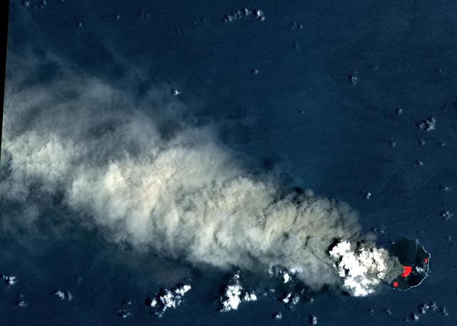
In July, 2018 an eruption began from Piton de la Fournaise volcano on Reunion Island in the western Indian Ocean. Activity continued through November, when these ASTER data were acquired. More than 150 eruptions have occurred since the 17th century. The active flow, derived from the thermal infrared band, is shown in red. The background is a pre-eruption image. The background image was acquired July 16, 2018, and the thermal image on November 1, 2018. The images cover an area of 18 miles by 21 miles (28.9 by 34.2 kilometers), and in the area of 21.3 degrees south, 55.8 degrees east. https://photojournal.jpl.nasa.gov/catalog/PIA22755
Two of Guatemala's active volcanoes, Fuego (upper left) and Pacaya (lower right) were erupting when the ASTER nighttime thermal infrared image was acquired on March 5, 2021. Pacaya's most recent eruption began Wednesday, with several lava flows and ash eruptions; surrounding villages were ordered evacuated. Since mid-February, Fuego continued to produce sporadic emissions of ash from its active central crater. In the ASTER image, the hottest areas are white, and coldest are black. The image covers an area of 29.8 by 40.3 km, and is centered at 14.4 degrees north, 90.8 degrees west. https://photojournal.jpl.nasa.gov/catalog/PIA24419
Located between the lava plains of Daedalia Planum and Solis Planum, Claritas Fossae is a graben filled highland. Graben are formed by tectonic activity, where extensional forces stretch the surface allowing blocks of material to slide down between paired faults. These linear grabens are termed fossae. This region of Mars had very active tectonism and volcanism, resulting in the huge volcanos like Arsia Mons and deep chasmata of Valles Marineris. Claritas Fossae was formed prior to the large lava flows of the Tharsis region. Orbit Number: 81376 Latitude: -35.6385 Longitude: 253.121 Instrument: VIS Captured: 2020-04-18 15:46 https://photojournal.jpl.nasa.gov/catalog/PIA23957
Located between the lava plains of Daedalia Planum and Solis Planum, Claritas Fossae is a graben filled highland. Graben are formed by tectonic activity, where extensional forces stretch the surface allowing blocks of material to slide down between paired faults. These linear grabens are termed fossae. This region of Mars had very active tectonism and volcanism, resulting in the huge volcanos like Arsia Mons and deep chasmata of Valles Marineris. Claritas Fossae was formed prior to the large lava flows of the Tharsis region. Orbit Number: 84439 Latitude: -41.4956 Longitude: 272.168 Instrument: VIS Captured: 2020-12-26 23:43 https://photojournal.jpl.nasa.gov/catalog/PIA24402
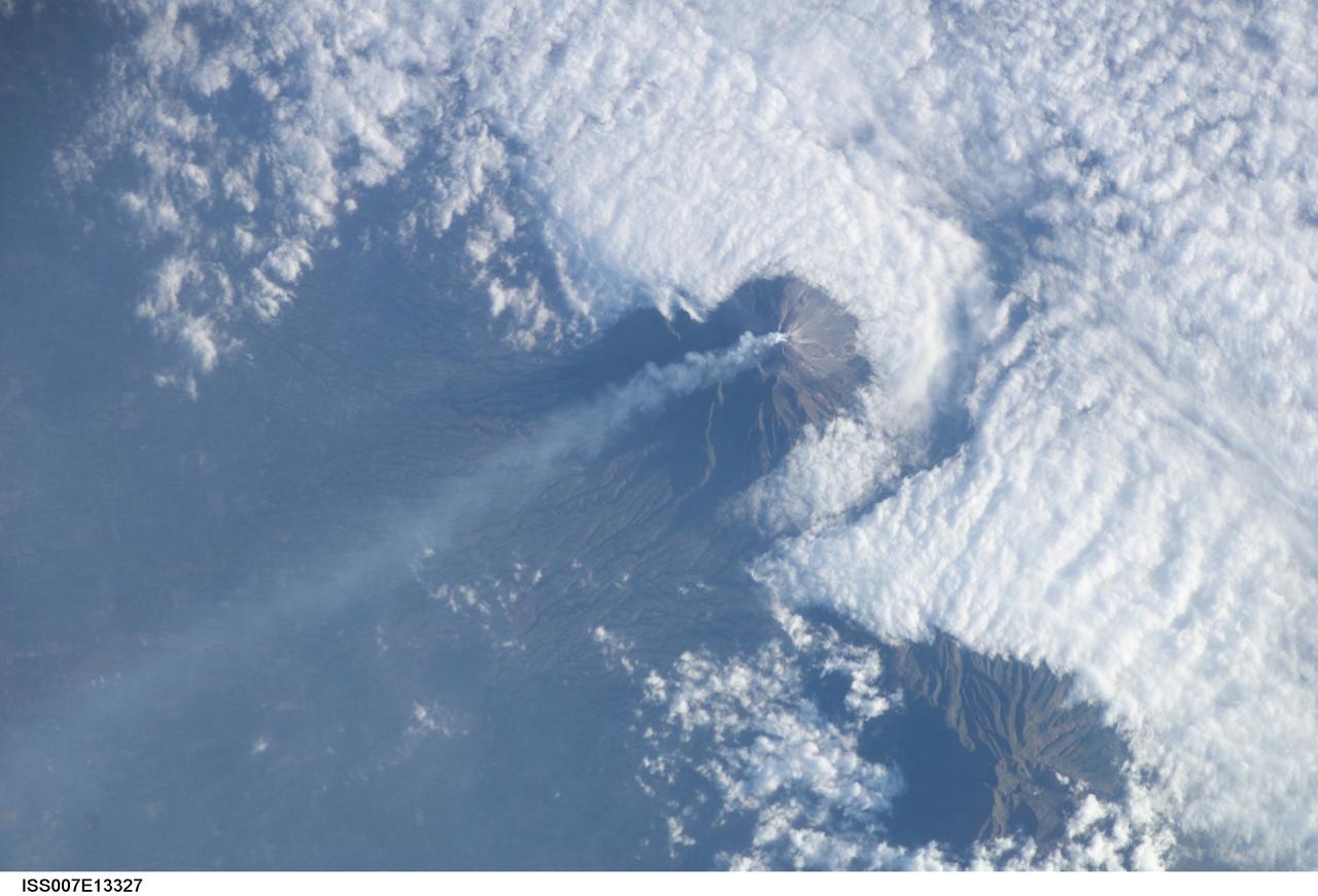
ISS007-E-13327 (24 August 2003) --- This view featuring Java’s Merapi volcano was photographed by one of the Expedition 7 crewmembers onboard the International Space Station (ISS). At 2,911 meters, the summit of Merapi and its vigorous steam plume rises above a bank of stratus clouds. One of Indonesia’s most active volcanoes, it has been almost continuously active for nearly ten years, including periodic pyroclastic flows and avalanches. The volcano is located less than 25 miles north of the city of Yogykarta in central Java.
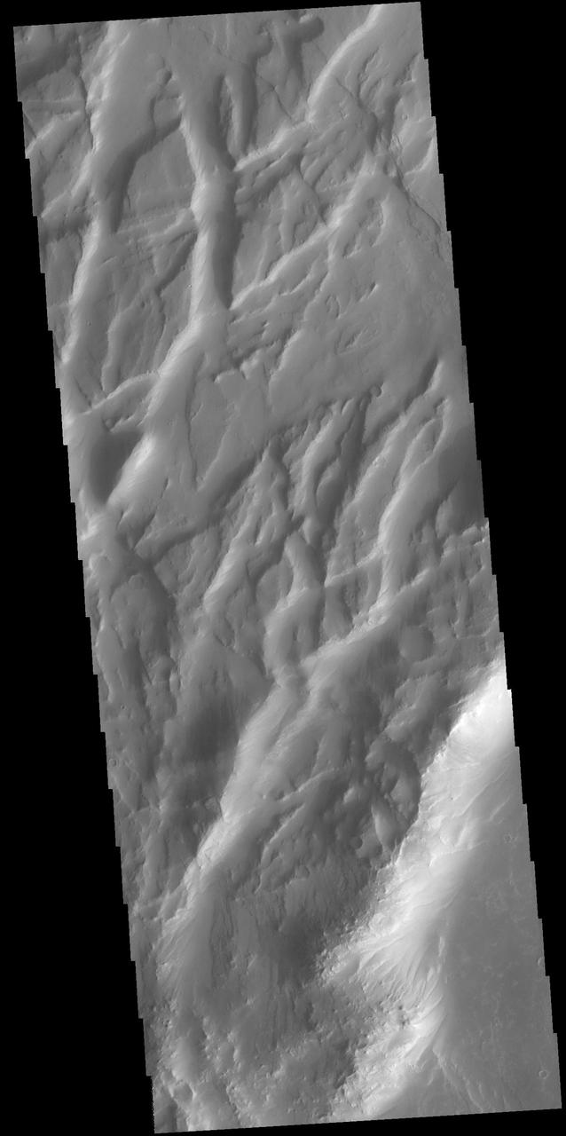
Located between the lava plains of Daedalia Planum and Solis Planum, Claritas Fossae is a graben filled highland. Graben are formed by tectonic activity. In this region of Mars extensive and long lived volcanic and tectonic activity created the largest volcanoes and the longest canyon system on Mars. Volcanic and tectonic forces coexist and tectonic faults are often utilized by subsurface magma to reach the surface. Claritas Fossae was formed prior to the large lava flows of the Tharsis region. Orbit Number: 74950 Latitude: -17.7366 Longitude: 252.095 Instrument: VIS Captured: 2018-11-06 15:40 https://photojournal.jpl.nasa.gov/catalog/PIA22974
Located between the lava plains of Daedalia Planum and Solis Planum, Claritas Fossae is a graben filled highland. Graben are formed by tectonic activity, where extensional forces stretch the surface allowing blocks of material to slide down between paired faults. These linear grabens are termed fossae. This region of Mars had very active tectonism and volcanism, resulting in the huge volcanos like Arsia Mons and deep chasmata of Valles Marineris. Claritas Fossae was formed prior to the large lava flows of the Tharsis region. Orbit Number: 91646 Latitude: -14.0577 Longitude: 249.123 Instrument: VIS Captured: 2022-08-12 10:26 https://photojournal.jpl.nasa.gov/catalog/PIA25612
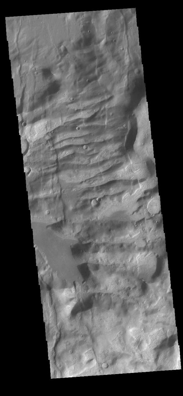
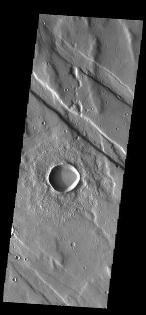
Today's VIS image shows a section of Cerberus Fossae. Located southeast of the Elysium Planitia volcanic complex, the linear graben near the top of the image was created by tectonic forces related to the volcanic activity. The graben are sources of both channels and significant volcanic flows. As seen in this image, the graben cuts across features such as hills, indicating the relative youth of the tectonic activity. Graben form where extensional tectonic forces allows blocks of material to subside between paired faults. Orbit Number: 79944 Latitude: 9.53204 Longitude: 158.706 Instrument: VIS Captured: 2019-12-22 21:50 https://photojournal.jpl.nasa.gov/catalog/PIA23743

Located between the lava plains of Daedalia Planum and Solis Planum, Claritas Fossae is a graben filled highland. Graben are formed by tectonic activity, where extensional forces stretch the surface allowing blocks of material to slide down between paired faults. These linear grabens are termed fossae. This region of Mars had very active tectonism and volcanism, resulting in the huge volcanos like Arsia Mons and deep chasmata of Valles Marineris. Claritas Fossae was formed prior to the large lava flows of the Tharsis region. Orbit Number: 91852 Latitude: -35.0327 Longitude: 253.577 Instrument: VIS Captured: 2022-08-29 08:49 https://photojournal.jpl.nasa.gov/catalog/PIA25713
Located between the lava plains of Daedalia Planum and Solis Planum, Claritas Fossae is a graben filled highland. Graben are formed by tectonic activity, where extensional forces stretch the surface allowing blocks of material to slide down between paired faults. These linear grabens are termed fossae. This region of Mars had very active tectonism and volcanism, resulting in the huge volcanos like Arsia Mons and deep chasmata of Valles Marineris. Claritas Fossae was formed prior to the large lava flows of the Tharsis region. Orbit Number: 91733 Latitude: -42.0473 Longitude: 263.442 Instrument: VIS Captured: 2022-08-19 14:12 https://photojournal.jpl.nasa.gov/catalog/PIA25620
Located between the lava plains of Daedalia Planum and Solis Planum, Claritas Fossae is a graben filled highland. Graben are formed by tectonic activity, where extensional forces stretch the surface allowing blocks of material to slide down between paired faults. These linear grabens are termed fossae. This region of Mars had very active tectonism and volcanism, resulting in the huge volcanos like Arsia Mons and deep chasmata of Valles Marineris. Claritas Fossae was formed prior to the large lava flows of the Tharsis region. Orbit Number: 92825 Latitude: -36.7944 Longitude: 262.701 Instrument: VIS Captured: 2022-11-17 11:37 https://photojournal.jpl.nasa.gov/catalog/PIA25801
Located between the lava plains of Daedalia Planum and Solis Planum, Claritas Fossae is a graben filled highland. Graben are formed by tectonic activity, where extensional forces stretch the surface allowing blocks of material to slide down between paired faults. These linear grabens are termed fossae. This region of Mars had very active tectonism and volcanism, resulting in the huge volcanos like Arsia Mons and deep chasmata of Valles Marineris. Claritas Fossae was formed prior to the large lava flows of the Tharsis region. Orbit Number: 91446 Latitude: -36.8955 Longitude: 262.397 Instrument: VIS Captured: 2022-07-26 23:05 https://photojournal.jpl.nasa.gov/catalog/PIA25572
Located between the lava plains of Daedalia Planum and Solis Planum, Claritas Fossae is a graben filled highland. Graben are formed by tectonic activity, where extensional forces stretch the surface allowing blocks of material to slide down between paired faults. These linear grabens are termed fossae. This region of Mars had very active tectonism and volcanism, resulting in the huge volcanos like Arsia Mons and deep chasmata of Valles Marineris. Claritas Fossae was formed prior to the large lava flows of the Tharsis region. Orbit Number: 84464 Latitude: -40.7803 Longitude: 271.084 Instrument: VIS Captured: 2020-12-29 01:07 https://photojournal.jpl.nasa.gov/catalog/PIA24403
Today's VIS image shows a section of Cerberus Fossae. Located southeast of the Elysium Planitia volcanic complex, the linear graben near the top of the image was created by tectonic forces related to the volcanic activity. The graben are sources of both channels and significant volcanic flows. Cerberus Fossae cuts across features such as hills, indicating the relative youth of the tectonic activity. Graben form where extensional tectonic forces allows blocks of material to subside between paired faults. Orbit Number: 89952 Latitude: 10.0355 Longitude: 157.294 Instrument: VIS Captured: 2022-03-25 22:57 https://photojournal.jpl.nasa.gov/catalog/PIA25465

Located between the lava plains of Daedalia Planum and Solis Planum, Claritas Fossae is a graben filled highland. Graben are formed by tectonic activity, where extensional forces stretch the surface allowing blocks of material to slide down between paired faults. These linear grabens are termed fossae. This region of Mars had very active tectonism and volcanism, resulting in the huge volcanos like Arsia Mons and deep chasmata of Valles Marineris. Claritas Fossae was formed prior to the large lava flows of the Tharsis region. Orbit Number: 91427 Latitude: -41.2195 Longitude: 273.629 Instrument: VIS Captured: 2022-07-25 08:59 https://photojournal.jpl.nasa.gov/catalog/PIA25580
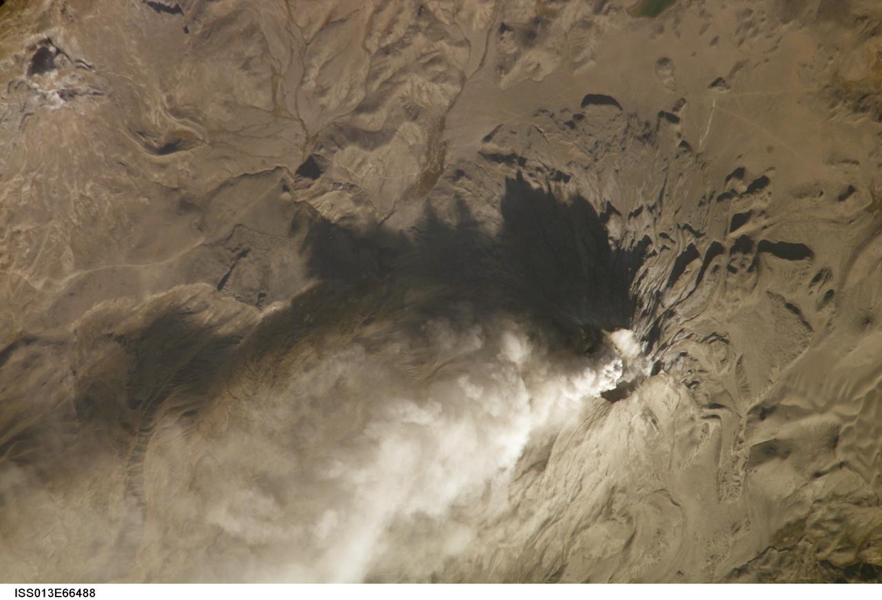
ISS013-E-66488 (14 Aug. 2006) --- Ash cloud from Ubinas Volcano, Peru is featured in this image photographed by an Expedition 13 crewmember on the International Space Station (ISS). Subduction of the Nazca tectonic plate along the western coast of South America forms the high Peruvian Andes, and also produces magma feeding a chain of historically active volcanoes along the western front of the mountains. The most active of these volcanoes in Peru is Ubinas. A typical steep-sided stratovolcano comprised primarily of layers of silica-rich lava flows, it has a summit elevation of 5,672 meters. The volcanic cone appears distinctively truncated or flat-topped in profile -- the result of a relatively small eruption that evacuated a magma reservoir near the summit. Following removal of the magma, the summit material collapsed downwards to form the current 1.4 kilometer-wide summit caldera. This oblique image (looking at an angle from the ISS) captures an ash cloud first observed on satellite imagery at 11:00 GMT on Aug. 14, 2006; this image was acquired one hour and 45 minutes later. The ash cloud resulted in the issuing of an aviation hazard warning by the Buenos Aires Volcanic Ash Advisory Center. Modern activity at Ubinas is characterized by these minor to moderate explosive eruptions of ash and larger pumice - a volcanic rock characterized by low density and high proportion of gas bubbles formed as the explosively-erupted parent lava cools during its transit through the air. These materials blanket the volcanic cone and surrounding area, giving this image an overall gray appearance. Shadowing of the western flank of Ubinas throws several lava flows into sharp relief, and highlights the steep slopes at the flow fronts -- a common characteristic of silica-rich, thick, and slow-moving lavas. NASA researchers note that the most recent major eruption of Ubinas occurred in 1969, however the historical record of activity extends back to the 16th century.
This VIS image crosses an unnamed crater in Terra Sabaea. The entire crater floor is covered by materials of unknown origin. Those materials are be eroded and appear to be forming chaos. The channel feature may be related to fluid activity, where the underlying material is losing water and the surface is collapsing – rather than the flow of a river over the surface. Orbit Number: 88009 Latitude: 2.76492 Longitude: 53.6692 Instrument: VIS Captured: 2021-10-16 23:10 https://photojournal.jpl.nasa.gov/catalog/PIA25109

The most recent eruption of Mt. Etna, Italy, began May 30, 2019. New fissure vents opened on the New Southeast Crater, feeding two lava flows that moved down into the Valle del Bove, accompanied by loud explosions. By June 4, when this nighttime ASTER thermal image was acquired, eruption activity had ended. https://photojournal.jpl.nasa.gov/catalog/PIA23235
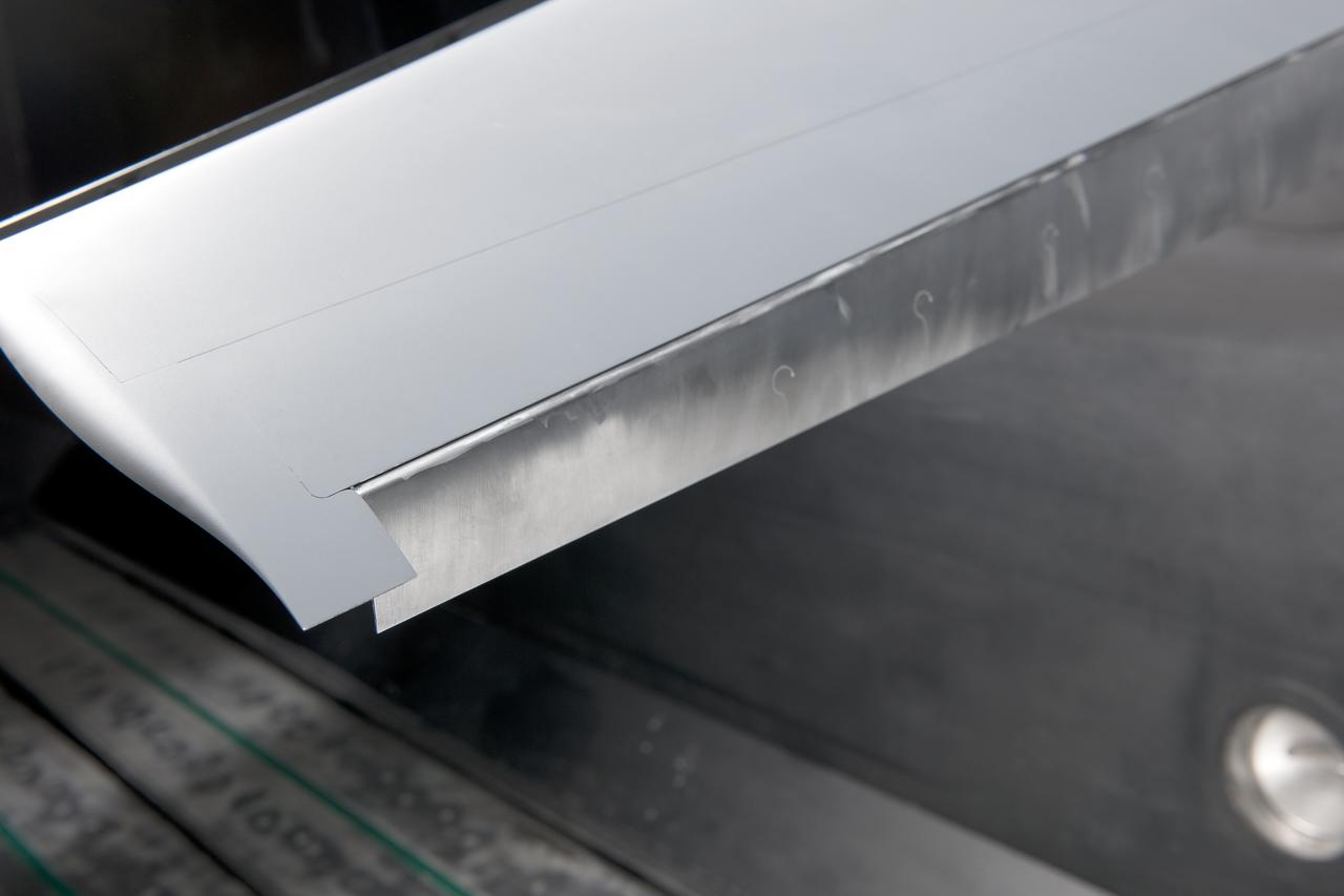
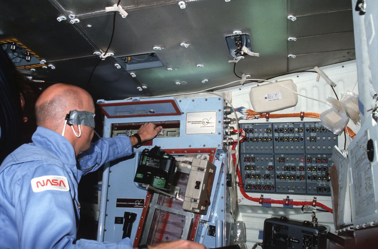
(NTF) National Transonic Facility Test 213-SFW Flow Control II, Fast-MAC Model: The fundamental Aerodynamics Subsonic Transonic-Modular Active Control (Fast-MAC) Model was tested for the 2nd time in the NTF. The objectives were to document the effects of Reynolds numbers on circulation control aerodynamics and to develop and open data set for CFD code validation. Image taken in building 1236, National Transonic Facility
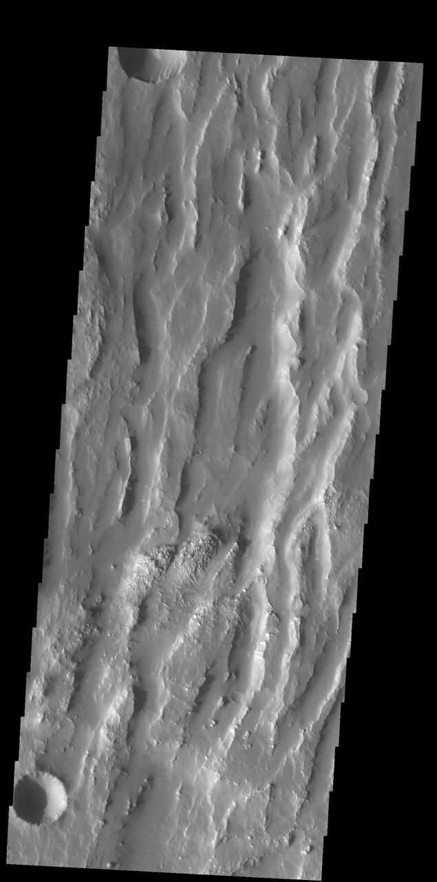
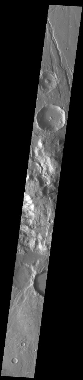
Today's VIS image shows part of Elysium Fossae, located on the western flank of the Elysium volcanic complex. The fossae have both a tectonic and a volcanic origin. The linear depressions, created by tectonic activity, are aligned southeast to northwest (the top of the image is north). The sinuous nature of the channel at the top of the image is due to the flow of a liquid, most likely lava in this case. Orbit Number: 78834 Latitude: 29.682 Longitude: 139.489 Instrument: VIS Captured: 2019-09-22 12:21 https://photojournal.jpl.nasa.gov/catalog/PIA23504
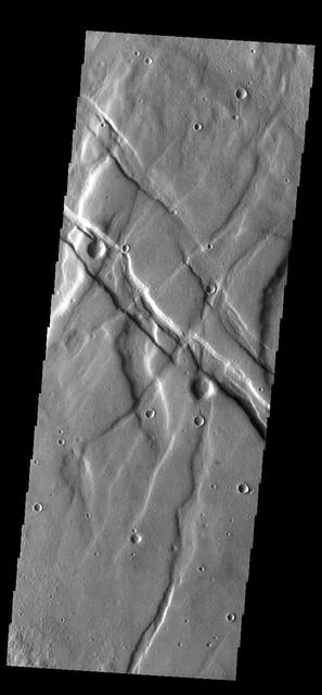
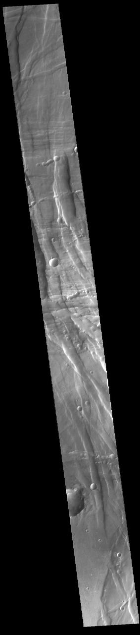
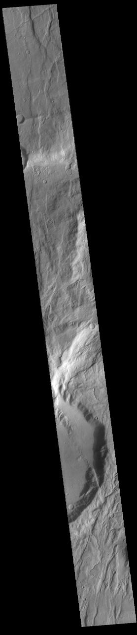
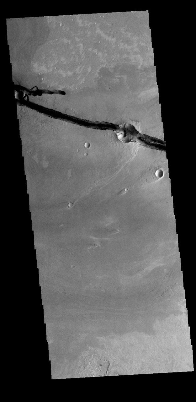
This VIS image shows part of the northern margin of Acheron Fossae. Multiple channels dissect the the higher elevation graben features at the bottom of the image. This higher topography feature is surrounded by lava flows and is thought to predate the majority of volcanic activity in the Tharsis region. Acheron Fossae is located 1,050 kilometers (650 miles) north of the large shield volcano Olympus Mons. Orbit Number: 79093 Latitude: 39.3864 Longitude: 225.573 Instrument: VIS Captured: 2019-10-13 20:15 https://photojournal.jpl.nasa.gov/catalog/PIA23566
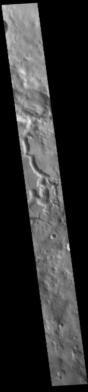
This VIS image shows a portion of Olympica Fossae. In this image several lava channels are visible, and it appears that lava has flowed in the larger depressions. The streamlined feature in the central part of the image also indicates that volcanic processes were active in this region. Orbit Number: 61654 Latitude: 24.8964 Longitude: 246.128 Instrument: VIS Captured: 2015-11-07 08:34. http://photojournal.jpl.nasa.gov/catalog/PIA20222

ISS019-E-012391 (29 April 2009) --- Astronaut Michael Barratt, Expedition 19/20 flight engineer, activates the Microgravity Science Glovebox (MSG) from its A31p laptop, initiates and conducts a session, the first of Increment 19, with the experiment Smoke Point In Co-flow Experiment (SPICE), performed in the MSG and controlled by its A31p with SPICE micro-drives in the Kibo laboratory of the International Space Station.
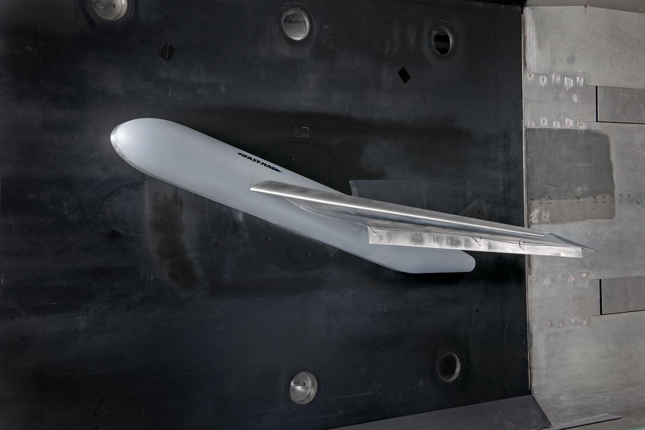
(NTF) National Transonic Facility Test 213-SFW Flow Control II, Fast-MAC Model: The fundamental Aerodynamics Subsonic Transonic-Modular Active Control (Fast-MAC) Model was tested for the 2nd time in the NTF. The objectives were to document the effects of Reynolds numbers on circulation control aerodynamics and to develop and open data set for CFD code validation. Image taken in building 1236, National Transonic Facility
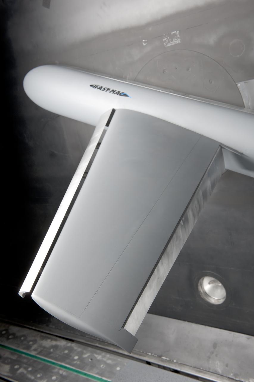
(NTF) National Transonic Facility Test 213-SFW Flow Control II, Fast-MAC Model: The fundamental Aerodynamics Subsonic Transonic-Modular Active Control (Fast-MAC) Model was tested for the 2nd time in the NTF. The objectives were to document the effects of Reynolds numbers on circulation control aerodynamics and to develop and open data set for CFD code validation. Image taken in building 1236, National Transonic Facility
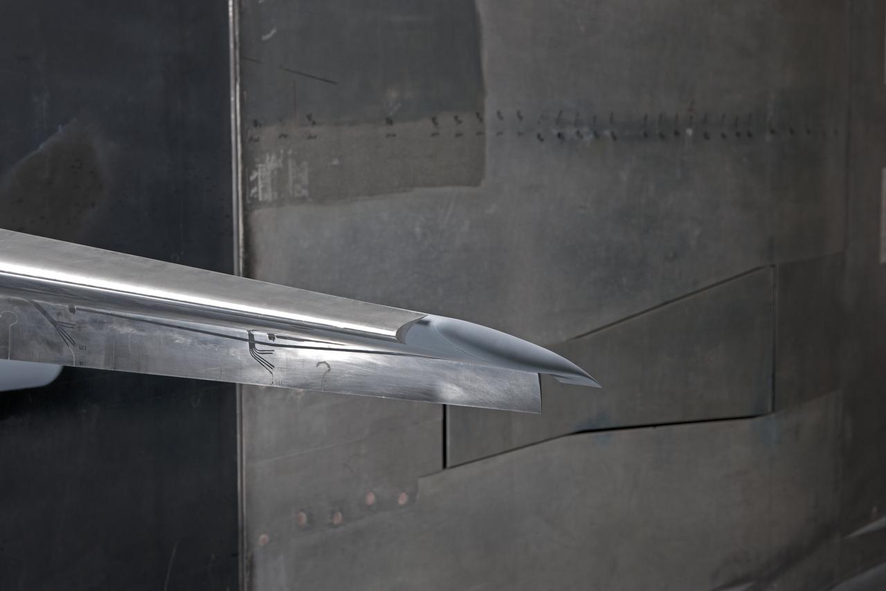
(NTF) National Transonic Facility Test 213-SFW Flow Control II, Fast-MAC Model: The fundamental Aerodynamics Subsonic Transonic-Modular Active Control (Fast-MAC) Model was tested for the 2nd time in the NTF. The objectives were to document the effects of Reynolds numbers on circulation control aerodynamics and to develop and open data set for CFD code validation. Image taken in building 1236, National Transonic Facility
Payun Matru is a large shield volcano capped by a caldera (right half of image), located in the Andean Volcanic Belt in Argentina. Nearby to the south is the high compound volcano Payun; to the west is a field of cinder cones and lava flows. The most recent volcanic activity occurred about 500 years ago. The image was acquired March 1, 2009, covers an area of 46.7 by 53.1 km, and is located at 36.4 degrees south, 69.3 degrees west. https://photojournal.jpl.nasa.gov/catalog/PIA23670

STS083-346-024 (4-8 April 1997) --- Payload specialist Roger K. Crouch performs the activation for the Mid Deck Glove Box (MGBX). Made to accommodate a variety of hardware and materials testing, the facility offers physical isolation and a negative air pressure environment so that items that are not suitable for handling in the open Spacelab can be protected. One experiment that was performed on STS-83 is the Internal Flows in a Free Drop (IFFD), an experiment that investigates rotation and position control of drops by varying acoustic pressures.
Today's VIS image shows part of one of the Elysium Fossae on the western flank of the Elysium volcanic complex. The fossae have both a tectonic and volcanic origin. The linear fractures, representing tectonic activity, are aligned southeast to northwest (the top of the image is north). The sinuous nature of the channel is due the flow of a liquid, most likely lava in this case. Orbit Number: 72434 Latitude: 28.0172 Longitude: 139.454 Instrument: VIS Captured: 2018-04-13 09:56 https://photojournal.jpl.nasa.gov/catalog/PIA22603
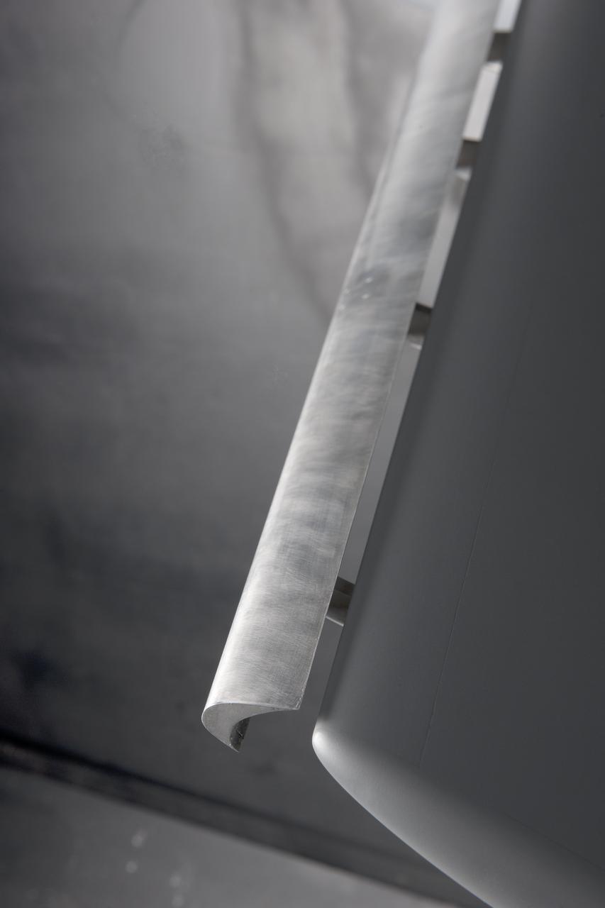
(NTF) National Transonic Facility Test 213-SFW Flow Control II, Fast-MAC Model: The fundamental Aerodynamics Subsonic Transonic-Modular Active Control (Fast-MAC) Model was tested for the 2nd time in the NTF. The objectives were to document the effects of Reynolds numbers on circulation control aerodynamics and to develop and open data set for CFD code validation. Image taken in building 1236, National Transonic Facility
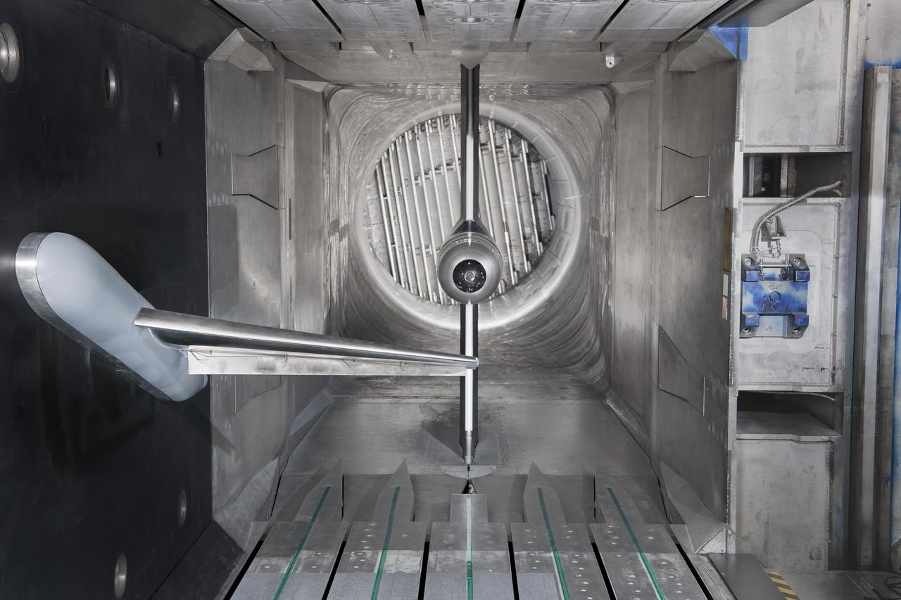
(NTF) National Transonic Facility Test 213-SFW Flow Control II, Fast-MAC Model: The fundamental Aerodynamics Subsonic Transonic-Modular Active Control (Fast-MAC) Model was tested for the 2nd time in the NTF. The objectives were to document the effects of Reynolds numbers on circulation control aerodynamics and to develop and open data set for CFD code validation. Image taken in building 1236, National Transonic Facility

Colored oil flow toy was part of a student-designed apparatus used in the second Dropping in a Microgravity Environment (DIME) competition held April 23-25, 2002, at NASA's Glenn Research Center. Competitors included two teams from Sycamore High School, Cincinnati, OH, and one each from Bay High School, Bay Village, OH, and COSI Academy, Columbus, OH. DIME is part of NASA's education and outreach activities. Details are on line at http://microgravity.grc.nasa.gov/DIME_2002.html.
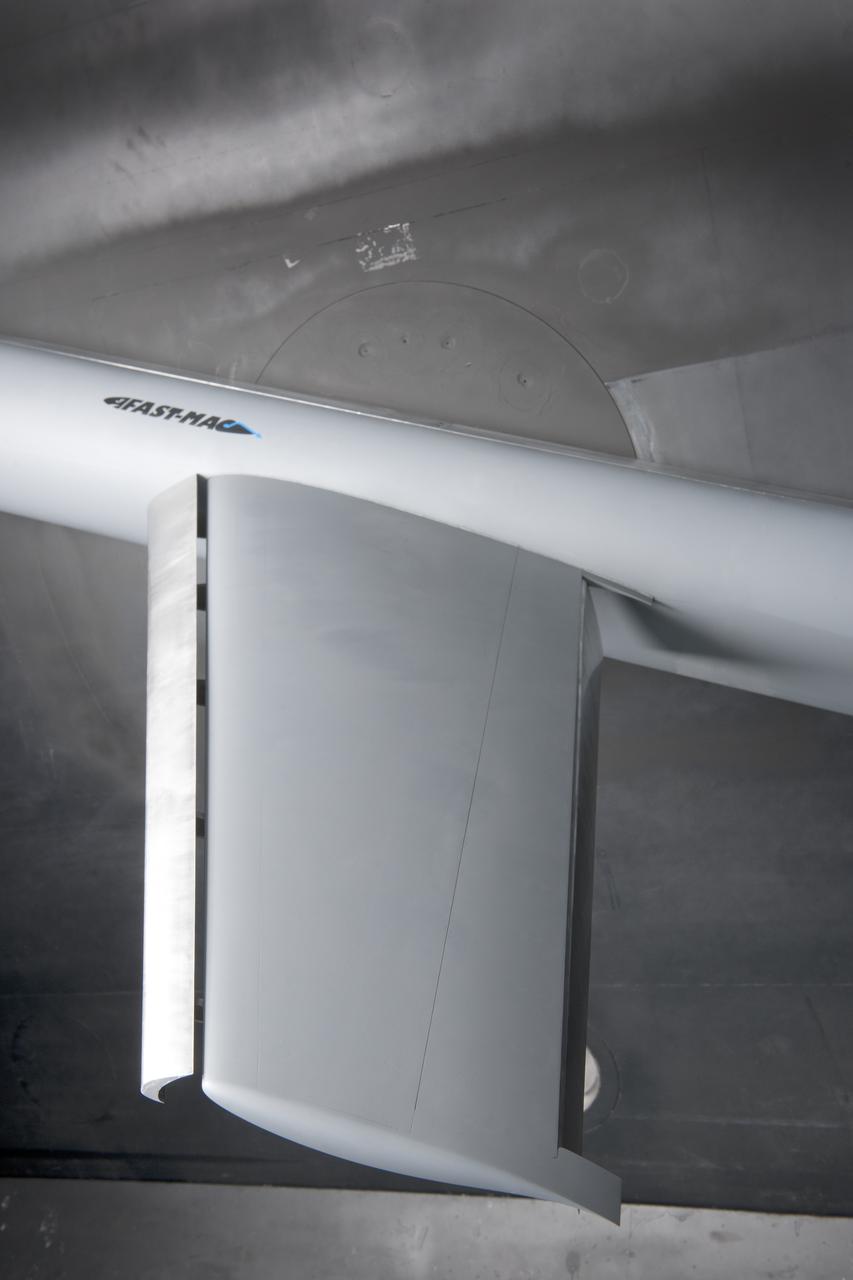
(NTF) National Transonic Facility Test 213-SFW Flow Control II, Fast-MAC Model: The fundamental Aerodynamics Subsonic Transonic-Modular Active Control (Fast-MAC) Model was tested for the 2nd time in the NTF. The objectives were to document the effects of Reynolds numbers on circulation control aerodynamics and to develop and open data set for CFD code validation. Image taken in building 1236, National Transonic Facility
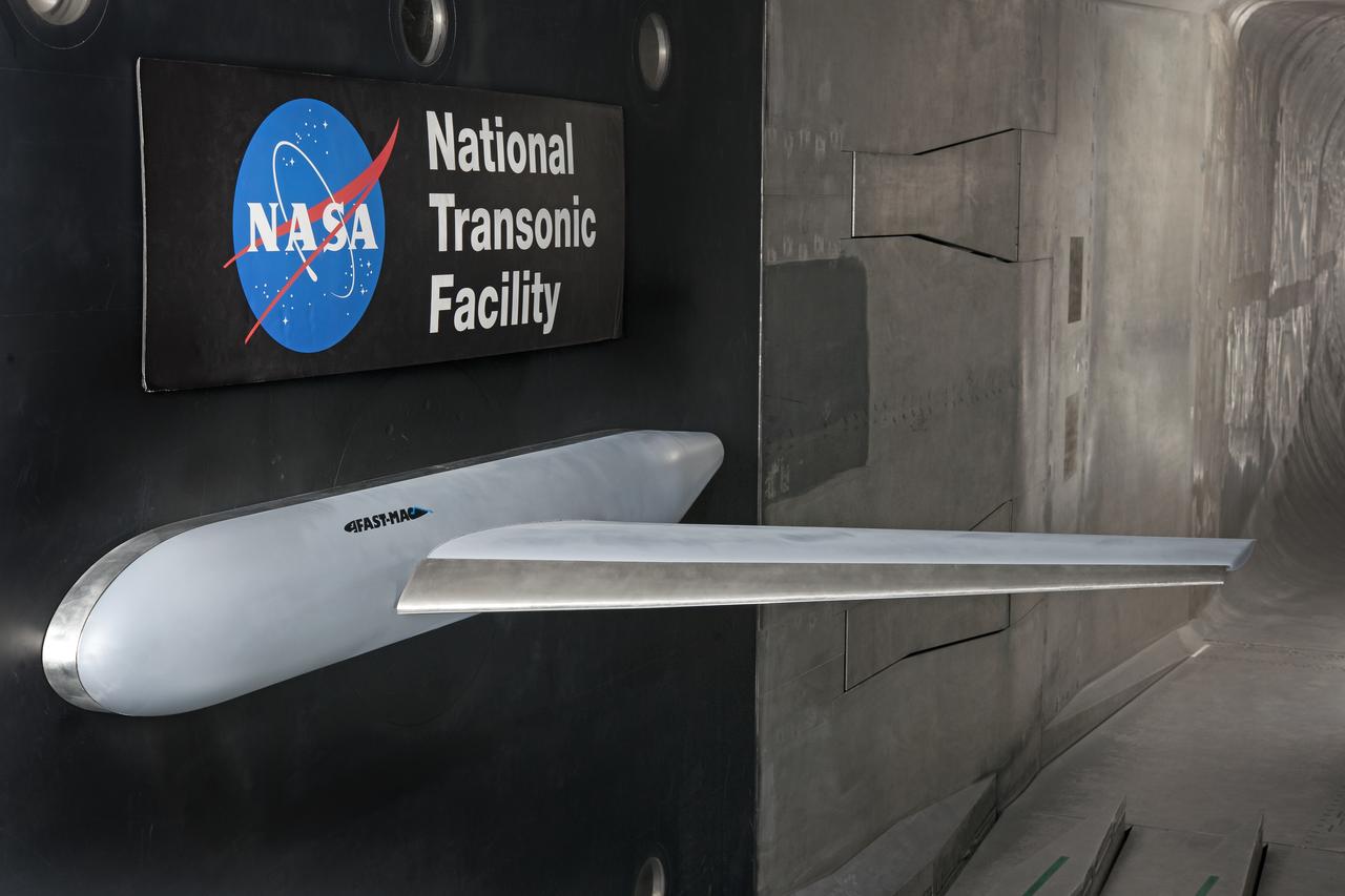
(NTF) National Transonic Facility Test 213-SFW Flow Control II, Fast-MAC Model: The fundamental Aerodynamics Subsonic Transonic-Modular Active Control (Fast-MAC) Model was tested for the 2nd time in the NTF. The objectives were to document the effects of Reynolds numbers on circulation control aerodynamics and to develop and open data set for CFD code validation. Image taken in building 1236, National Transonic Facility