
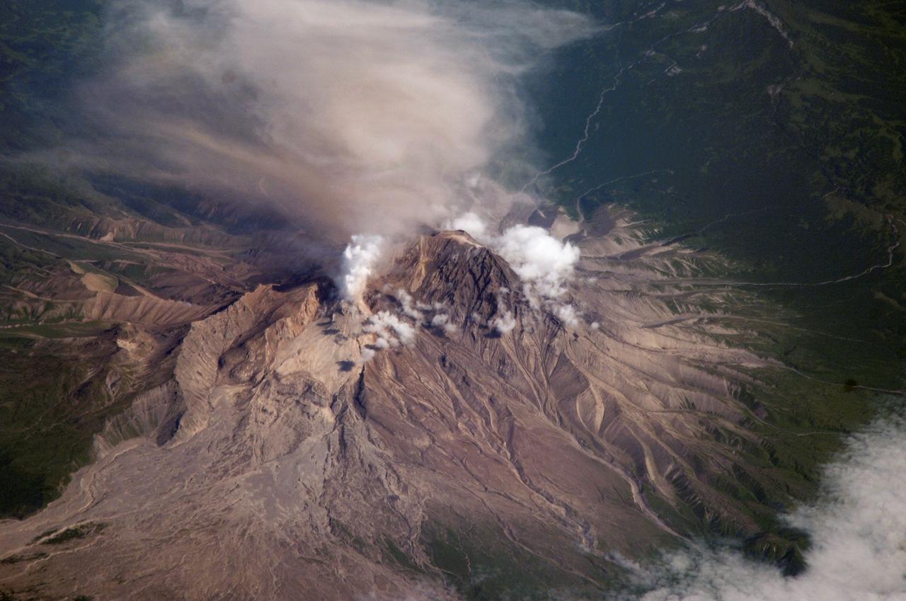
NASA image acquired Sept 7, 2010 Shiveluch (also spelled Sheveluch) is one of the largest and most active volcanoes on Russia’s Kamchatka Peninsula. It has been spewing ash and steam intermittently—with occasional dome collapses, pyroclastic flows, and lava flows, as well—for the past decade. Shiveluch is a stratovolcano, a steep-sloped formation of alternating layers of hardened lava, ash, and rocks thrown out by earlier eruptions. A lava dome has been growing southwest of the 3,283-meter (10,771-foot) summit. The Advanced Land Imager (ALI) on NASA’s Earth Observing-1 (EO-1) satellite acquired this image on September 7, 2010. Brown and tan debris—perhaps ash falls, perhaps mud from lahars—covers the southern landscape of the volcano, while the hills on the northern side remain covered in snow and ice. The Kamchatkan Volcanic Eruption Response Team (KVERT) reported that seismic activity at Shiveluch was "above background levels" from September 3-10. Ash plumes rose to an altitude of 6.5 kilometers (21,300 feet) on September 3-4, and gas-and-ash plumes were reported on September 7, when this image was acquired. According to the Smithsonian Institution's volcano program, at least 60 large eruptions of Shiveluch have occurred during the current Holocene Epoch of geological history. Intermittent explosive eruptions began in the 1990s, and the largest historical eruptions from Shiveluch occurred in 1854 and 1964. NASA Earth Observatory image created by Jesse Allen and Robert Simmon, using EO-1 ALI data provided courtesy of the NASA EO-1 team. Caption by Mike Carlowicz. Instrument: EO-1 - ALI Credit: NASA Earth Observatory NASA Goddard Space Flight Center contributes to NASA’s mission through four scientific endeavors: Earth Science, Heliophysics, Solar System Exploration, and Astrophysics. Goddard plays a leading role in NASA’s endeavors by providing compelling scientific knowledge to advance the Agency’s mission. Follow us on Twitter Join us on Facebook
This nighttime thermal infrared image from NASA Terra spacecraft shows Shiveluch volcano, one of the largest and most active volcanoes in Russia Kamchatka Peninsula; the bright, hot summit lava dome is evident in the center of the image.
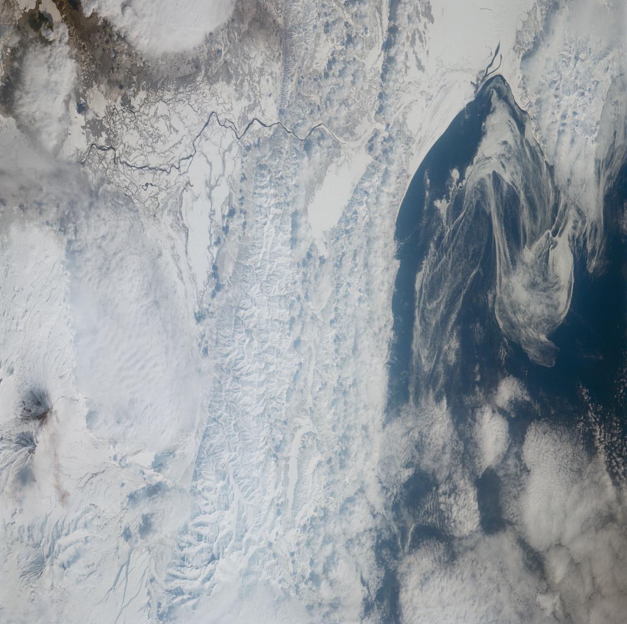
ISS015-E-16913 (10 July 2007) --- Shiveluch Volcano, Kamchatka, Russian Far East is featured in this image photographed by an Expedition 15 crewmember on the International Space Station. Shiveluch is one of the biggest and most active of a line of volcanoes along the spine of the Kamchatka peninsula in easternmost Russia. In turn the volcanoes and peninsula are part of the tectonically active "Ring of Fire" that almost surrounds the Pacific Ocean, denoted by active volcanoes and frequent earthquakes. Shiveluch occupies the point where the northeast-trending Kamchatka volcanic line intersects the northwest-trending Aleutian volcanic line. Junctions such as this are typically points of intense volcanic activity. According to scientists, the summit rocks of Shiveluch have been dated at approximately 65,000 years old. Lava layers on the sides of the volcano reveal at least 60 major eruptions in the last 10,000 years, making it the most active volcano in the 2,200 kilometer distance that includes the Kamchatka peninsula and the Kuril island chain. Shiveluch rises from almost sea level to well above 3,200 miles (summit altitude 3,283 miles) and is often capped with snow. In this summer image however, the full volcano is visible, actively erupting ash and steam in late June or early July, 2007. The dull brown plume extending from the north of the volcano summit is most likely a combination of ash and steam (top). The two larger white plumes near the summit are dominantly steam, a common adjunct to eruptions, as rain and melted snow percolate down to the hot interior of the volcano. The sides of the volcano show many eroded stream channels. The south slope also reveals a long sloping apron of collapsed material, or pyroclastic flows. Such debris flows have repeatedly slid down and covered the south side of the volcano during major eruptions when the summit lava domes explode and collapse (this occurred during major eruptions in 1854 and 1964). Regrowth of the forest on the south slope (note the contrast with the eastern slope) has been foiled by the combined effects of continued volcanic activity, instability of the debris flows and the short growing season.

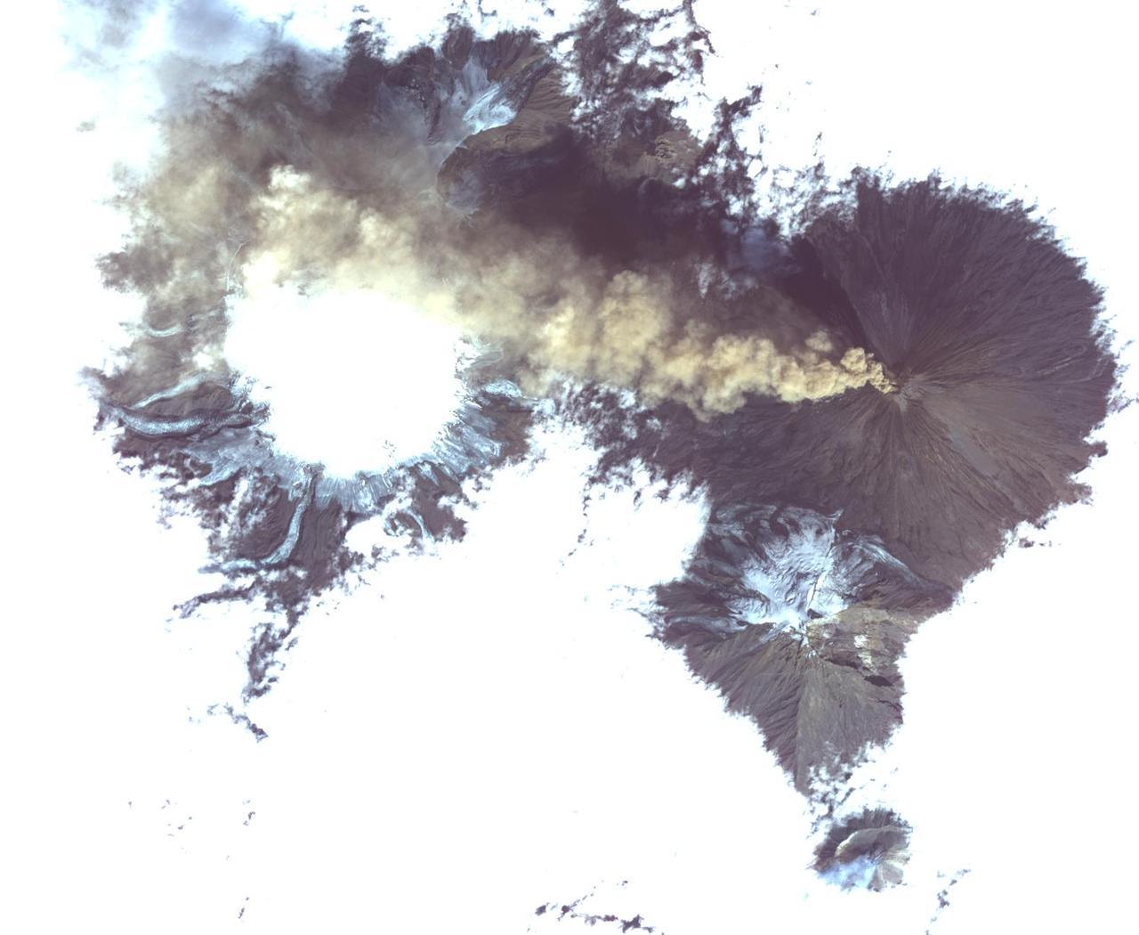
ISS014-E-17165 (21 March 2007) --- A plume at Shiveluch Volcano, Kamchatka Peninsula, Russia is featured in this image photographed by an Expedition 14 crewmember on the International Space Station. Shiveluch, one of Kamchatka's most active volcanoes, began its latest activity with gas and steam emissions in mid-late March 2007. This image was captured around mid-morning on or around March 21 2007, and shows a steam plume, probably containing minor amounts of ash, blowing westward from the summit of the volcano. The crewmembers were transiting the southern tip of Russia's Kamchatka Peninsula; with a clear view of the volcano about 5 degrees north of the ground track of the station. Subsequent eruptions on March 29 and 30 have been recorded by the Kamchatka Volcano Observatory and NASA. The volcano's southern flank, clearly visible in this northeast-looking oblique view, comprises a horseshoe-shaped caldera from a late Pleistocene eruption, subsequently blanketed by additional ash deposits, and highlighted by the snow cover. The peak of Shiveluch is a distinctive brown color due to the removal of snow, exposure of rock forming the summit, and deposits of new ash. The relatively smooth landscape of the south contrasts with the large, steep valleys on the northern slope of the volcano. Low clouds wrap around the eastern part of the mountain, obscuring the lower elevations.
STS039-151-179 (28 April-6 May 1991) --- A large format frame of one of the USSR's volcanic complex (Kamchatka area) with the active volcano Klyuchevskaya (Kloo-chevs'-ska-ya), 15,584 feet in elevation. The last reported eruption of the volcano was on April 8, but an ash and steam plume extending to the south was observed by the STS-39 crew almost three weeks later. The south side of the volcano is dirty from the ash fall and landslide activity. The summit is clearly visible, as is the debris flow from an earlier eruption. Just north of the Kamchatka River is Shiveluch, a volcano which was active in early April. There are more than 100 volcanic edifices recognized on Kamchatka, with 15 classified as active.
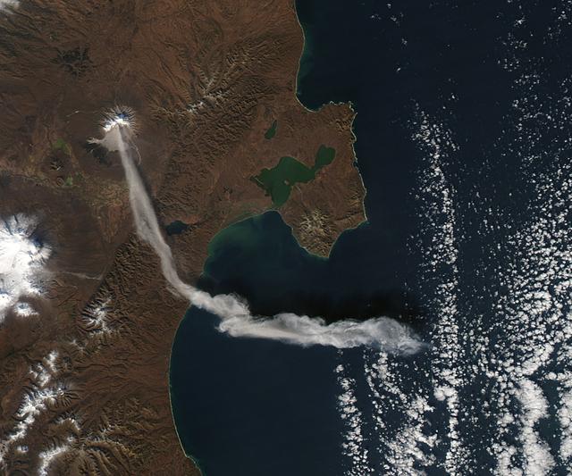
When NASA’s Terra satellite passed over Russia’s Kamchatka Peninsula at noon local time (00:00 Universal Time) on October 6, 2012, Shilveluch Volcano was quiet. By the time NASA’s Aqua satellite passed over the area two hours later (bottom image), the volcano had erupted and sent a plume of ash over the Kamchatskiy Zaliv. The plume traveled about 90 kilometers (55 miles) toward the south-southeast, where a change in wind direction began pushing the plume toward the east. On October 6, 2012, the Kamchatka Volcanic Emergency Response Team (KVERT) reported that the ash plume from Shiveluch reached an altitude of 3 kilometers (9,800 feet) above sea level, and had traveled some 220 kilometers (140 miles) from the volcano summit. Shiveluch (also spelled Sheveluch) ranks among the biggest and most active volcanoes on the Kamchatka Peninsula. Rising to 3,283 meters (10,771 feet) above sea level, Shiveluch is a stratovolcano composed of alternating layers of hardened lava, compacted ash, and rocks ejected by previous eruptions. The beige-colored expanse of rock on the volcano’s southern slopes (visible in both images) is due to an explosive eruption that occurred in 1964. Part of Shiveluch’s southern flank collapsed, and the light-colored rock is avalanche debris left by that event. High-resolution imagery of Shiveluch shows very little vegetation within that avalanche zone. On October 6, 2012, KVERT cited observations from the Moderate Resolution Imaging Spectroradiometer (MODIS) instruments on Terra and Aqua in detecting the Shiveluch eruption. This was not the first time that MODIS observed a Shiveluch eruption shortly after it started. In 2007, MODIS captured an image within minutes of the eruption’s start, before winds could blow the ash away from the summit. When NASA’s Terra satellite passed over Russia’s Kamchatka Peninsula at noon local time (00:00 Universal Time) on October 6, 2012, Shilveluch Volcano was quiet (top image). By the time NASA’s Aqua satellite passed over the area two hours later (bottom image), the volcano had erupted and sent a plume of ash over the Kamchatskiy Zaliv. The plume traveled about 90 kilometers (55 miles) toward the south-southeast, where a change in wind direction began pushing the plume toward the east. On October 6, 2012, the Kamchatka Volcanic Emergency Response Team (KVERT) reported that the ash plume from Shiveluch reached an altitude of 3 kilometers (9,800 feet) above sea level, and had traveled some 220 kilometers (140 miles) from the volcano summit. Shiveluch (also spelled Sheveluch) ranks among the biggest and most active volcanoes on the Kamchatka Peninsula. Rising to 3,283 meters (10,771 feet) above sea level, Shiveluch is a stratovolcano composed of alternating layers of hardened lava, compacted ash, and rocks ejected by previous eruptions. The beige-colored expanse of rock on the volcano’s southern slopes (visible in both images) is due to an explosive eruption that occurred in 1964. Part of Shiveluch’s southern flank collapsed, and the light-colored rock is avalanche debris left by that event. High-resolution imagery of Shiveluch shows very little vegetation within that avalanche zone. On October 6, 2012, KVERT cited observations from the Moderate Resolution Imaging Spectroradiometer (MODIS) instruments on Terra and Aqua in detecting the Shiveluch eruption. This was not the first time that MODIS observed a Shiveluch eruption shortly after it started. In 2007, MODIS captured an image within minutes of the eruption’s start, before winds could blow the ash away from the summit. Credit: <b><a href="http://www.earthobservatory.nasa.gov/" rel="nofollow"> NASA Earth Observatory</a></b> <b><a href="http://www.nasa.gov/audience/formedia/features/MP_Photo_Guidelines.html" rel="nofollow">NASA image use policy.</a></b> <b><a href="http://www.nasa.gov/centers/goddard/home/index.html" rel="nofollow">NASA Goddard Space Flight Center</a></b> enables NASA’s mission through four scientific endeavors: Earth Science, Heliophysics, Solar System Exploration, and Astrophysics. Goddard plays a leading role in NASA’s accomplishments by contributing compelling scientific knowledge to advance the Agency’s mission. <b>Follow us on <a href="http://twitter.com/NASA_GoddardPix" rel="nofollow">Twitter</a></b> <b>Like us on <a href="http://www.facebook.com/pages/Greenbelt-MD/NASA-Goddard/395013845897?ref=tsd" rel="nofollow">Facebook</a></b> <b>Find us on <a href="http://instagrid.me/nasagoddard/?vm=grid" rel="nofollow">Instagram</a></b>
STS039-77-010 (28 April 1991) --- The Kamchatka Peninsula, USSR. This oblique view of the eastern margin of the Kamchatka Peninsula shows pack-ice along the coast, which is drifting along with local currents and delineates the circulation patterns. Also visible are the Kamchatka River (left of center), and the volcanic complex with the active volcano Klyuchevskaya (Kloo-chevs'-ska-ya), 15,584 feet in elevation. The last reported eruption of the volcano was on April 8, but an ash and steam plume extending to the south can be seen in this photograph, taken almost three weeks later (April 28). On April 29, the crew observed and photographed the volcano again, and it was no longer visibly active. However, the flanks of the mountain are dirty from the ash fall. Just north of the Kamchatka River (to the left, just off frame) is Shiveluch, a volcano which was active in early April. There are more than 100 volcanic edifices recognized on Kamchatka, with 15 classified as active.

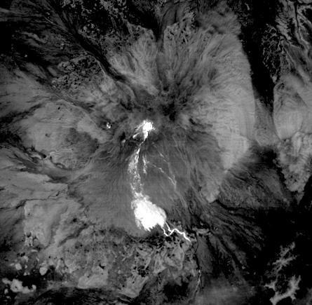
On the night of June 4, 2001, the Advanced Spaceborne Thermal Emission and Reflection Radiometer (ASTER) captured this thermal image of the erupting Shiveluch volcano. Located on Russia's Kamchatka Peninsula, Shiveluch rises to an altitude of 2,447 meters (8,028 feet). The active lava dome complex is seen as a bright (hot) area on the summit of the volcano. To the southwest, a second hot area is either a debris avalanche or hot ash deposit. Trailing to the west is a 25-kilometer (15-mile) ash plume, seen as a cold "cloud" streaming from the summit. At least 60 large eruptions have occurred here during the last 10,000 years; the largest historical eruptions were in 1854 and 1964. Because Kamchatka is located along the major aircraft routes between North America/Europe and Asia, this area is constantly monitored for potential ash hazards to aircraft. The area is part of the "Ring of Fire," a string of volcanoes that encircles the Pacific Ocean. The lower image is the same as the upper, except it has been color-coded: red is hot, light greens to dark green are progressively colder, and gray/black are the coldest areas. The image is located at 56.7 degrees north latitude, 161.3 degrees east longitude. http://photojournal.jpl.nasa.gov/catalog/PIA03514
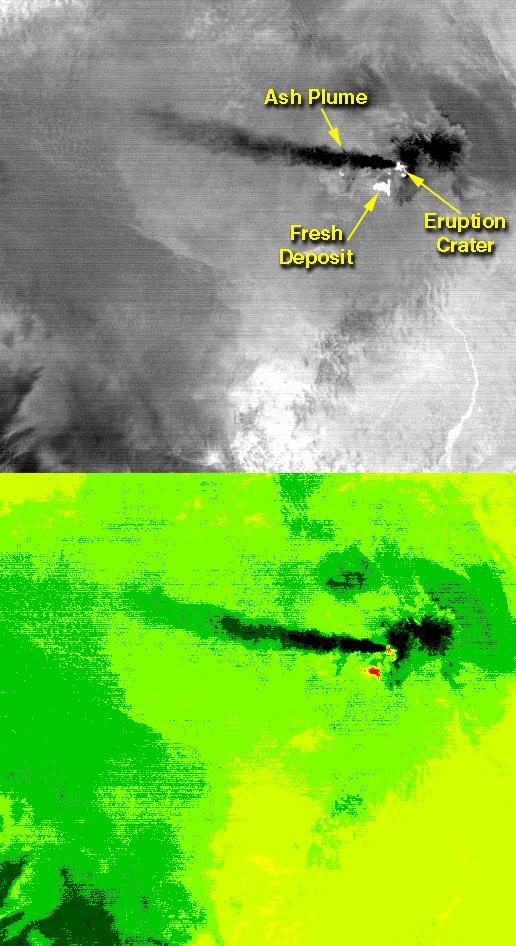
On the night of June 4, 2001 ASTER captured this thermal image of the erupting Shiveluch volcano. Located on Russia's Kamchatka Peninsula, Shiveluch rises to an altitude of 8028'. The active lava dome complex is seen as a bright (hot) area on the summit of the volcano. To the southwest, a second hot area is either a debris avalanche or hot ash deposit. Trailing to the west is a 25 km ash plume, seen as a cold "cloud" streaming from the summit. At least 60 large eruptions have occurred during the last 10,000 years; the largest historical eruptions were in 1854 and 1964. Because Kamchatka is located along the major aircraft routes between North America/Europe and the Far East, this area is constantly monitored for potential ash hazards to aircraft. The lower image is the same as the upper, except it has been color coded: red is hot, light greens to dark green are progressively colder, and gray/black are the coldest areas. The image is located at 56.7 degrees north latitude, 161.3 degrees east longitude. http://photojournal.jpl.nasa.gov/catalog/PIA02674
Klyuchevskoi, one of the world's most active volcanoes, is seen poking through above a solid cloud deck, with an ash plume streaming to the west. Located on the Kamchatka Peninsula in far eastern Russia, it is one of many active volcanoes on the Peninsula. Nearby, to the south, the smaller Bezymianny volcano can be seem with a small steam plume coming from its summit. The image was acquired Aug. 20, 2017, covers an area of 12 by 14 miles (19.5 by 22.7 kilometers), and is located at 56.1 degrees north, 160.6 degrees east. https://photojournal.jpl.nasa.gov/catalog/PIA21878