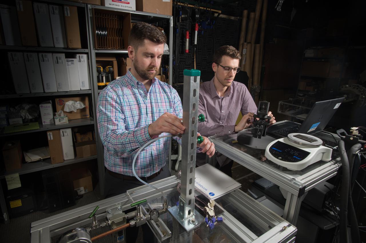
Advanced Thermal Management, High Power Density Core, Advanced Air Transport Technology,
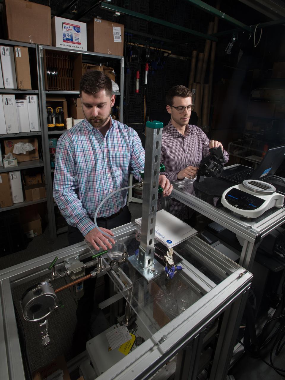
Advanced Thermal Management, High Power Density Core, Advanced Air Transport Technology,
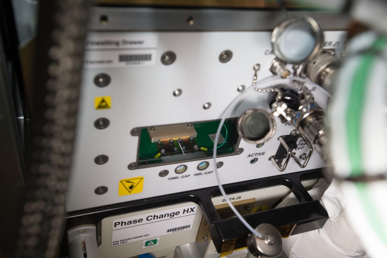
iss051e049793 (5/25/2017) --- A view of the Electrowetting Drawer taken during Passive Thermal Flight Experiment operations (OPS) in the Kibo Japanese Experiment Pressurized Module (JPM) aboard the International Space Station (ISS). The Advanced Passive Thermal eXperiment (APTx) tests three advanced thermal management technologies. It demonstrates the in-space performance of each, an important step toward improving these technologies for use on future space exploration missions.

iss051e041912 (5/13/2017) --- Photo documentation of a broken pipette that was to be used to dispense water droplets into the Electrowetting Drawer of ExPRESS (Expedite the Processing of Experiments to Space Station) Rack 8 for the Passive Thermal Flight Experiment. The Advanced Passive Thermal eXperiment (APTx) tests three advanced thermal management technologies. It demonstrates the in-space performance of each, an important step toward improving these technologies for use on future space exploration missions.
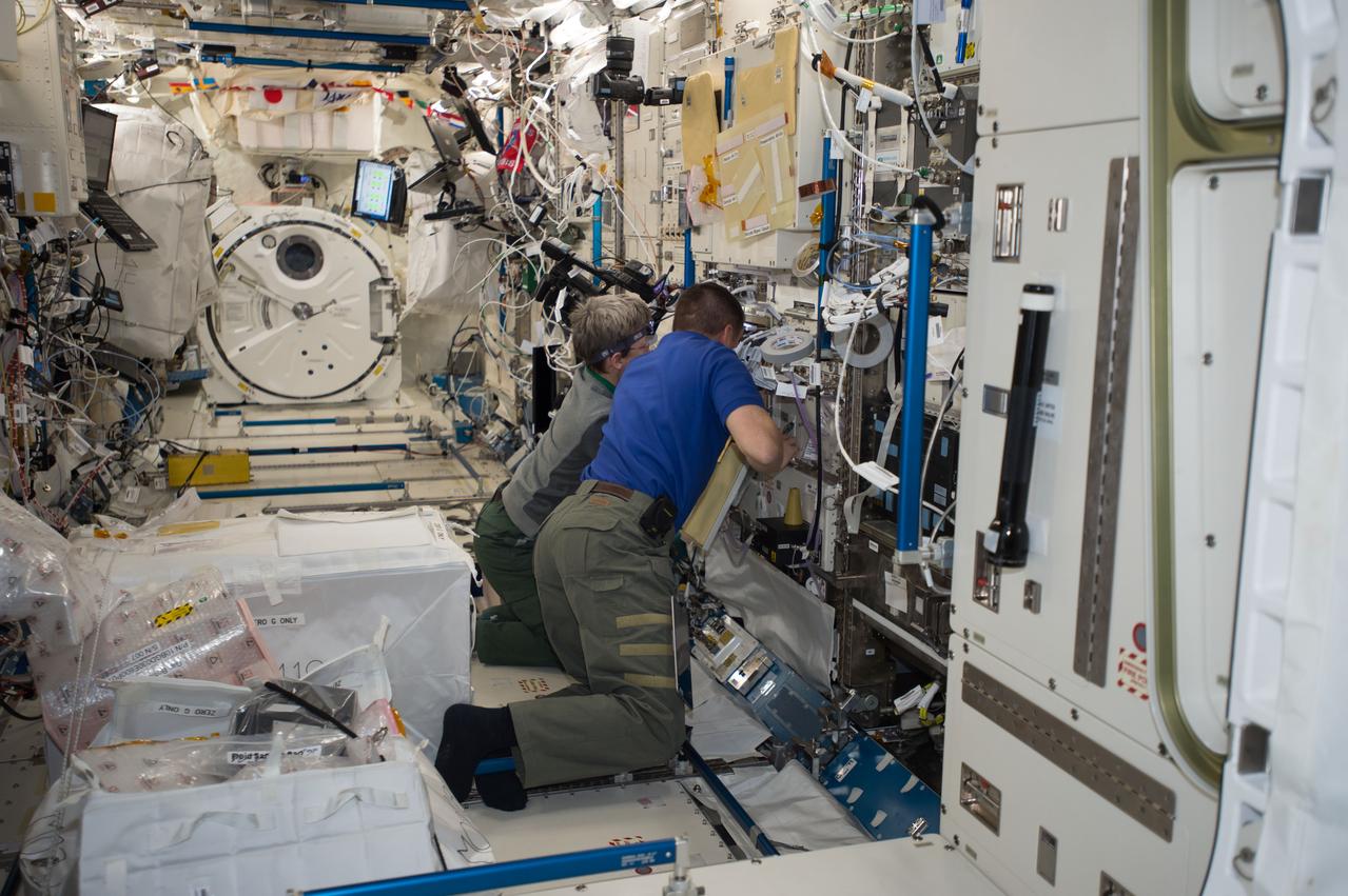
iss051e050849 (5/26/2017) --- NASA astronaut Peggy Whitson and Jack Fischer work to install a Gas Supply Hose Assembly and Gas Bottle Unit Air in the Electrostatic Levitation Furnace (ELF) in the Kibo Japanese Experiment Pressurized Module (JPM) aboard the International Space Station (ISS) in supprt of the Passive Thermal Flight Experiment.The Advanced Passive Thermal eXperiment (APTx) tests three advanced thermal management technologies. It demonstrates the in-space performance of each, an important step toward improving these technologies for use on future space exploration missions.
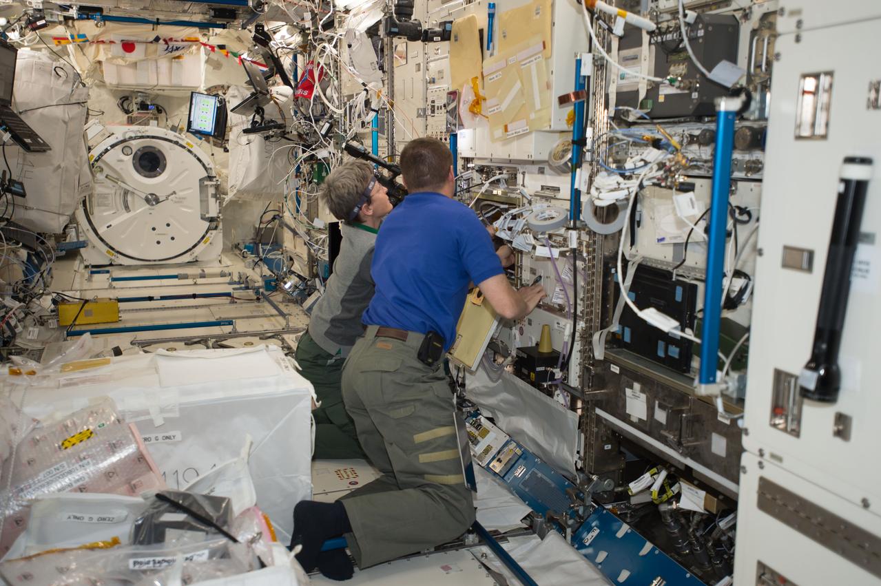
iss051e050850 (5/26/2017) --- NASA astronaut Peggy Whitson and Jack Fischer work to install a Gas Supply Hose Assembly and Gas Bottle Unit Air in the Electrostatic Levitation Furnace (ELF) in the Kibo Japanese Experiment Pressurized Module (JPM) aboard the International Space Station (ISS) in supprt of the Passive Thermal Flight Experiment.The Advanced Passive Thermal eXperiment (APTx) tests three advanced thermal management technologies. It demonstrates the in-space performance of each, an important step toward improving these technologies for use on future space exploration missions.
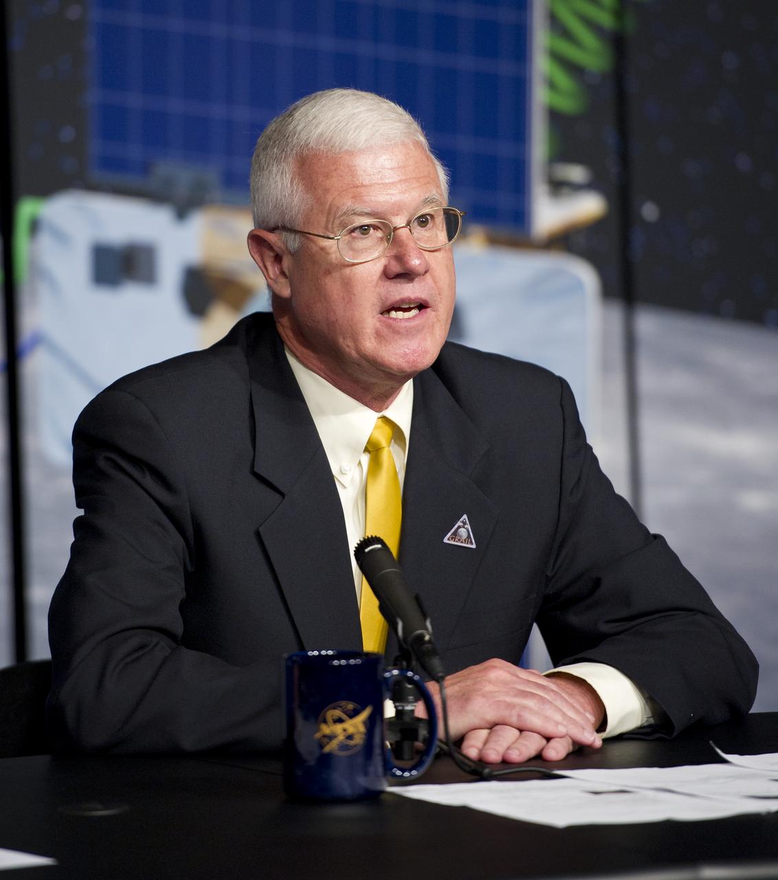
David Lehman, GRAIL project manager, NASA's Jet Propulsion Laboratory, Pasadena, Calif., speaks at a press conference about the upcoming launch to the moon of the Gravity Recovery and Interior Laboratory (GRAIL) mission, Thursday, Aug. 25, 2011 in Washington. GRAIL's primary science objectives are to determine the structure of the lunar interior, from crust to core, and to advance understanding of the thermal evolution of the moon. The mission will place two spacecraft into the same orbit around the moon which will gather information about the its gravitational field enabling scientists to create a high-resolution map. Photo Credit: (NASA/Carla Cioffi)
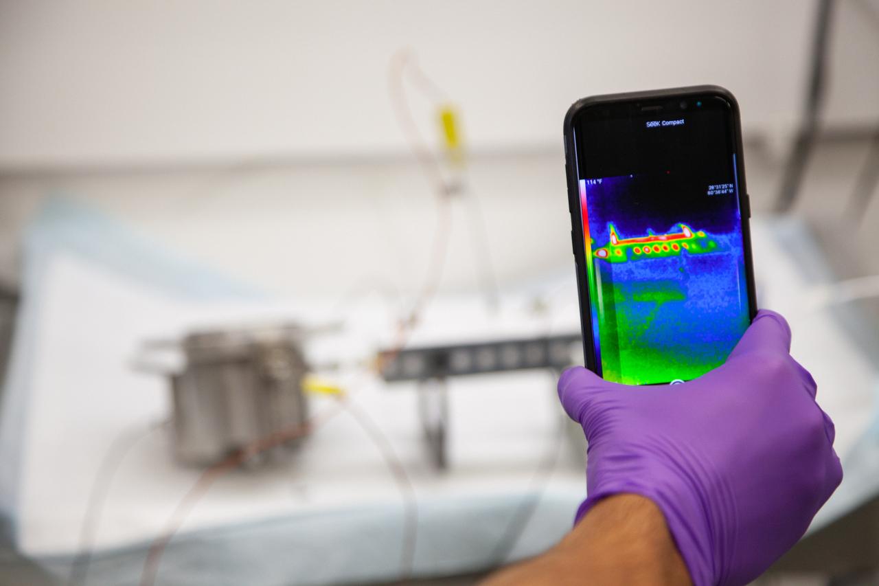
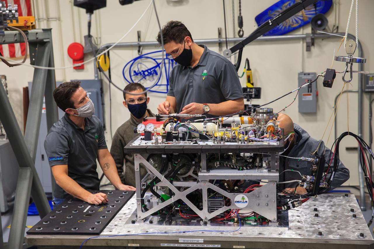
A Kennedy Space Center employee conducts thermal testing of NASA’s Orbital Syngas Commodity Augmentation Reactor, or OSCAR – an Early Career Initiative project at the Florida spaceport that studies technology to convert trash and human waste into useful gasses such as methane, hydrogen and carbon dioxide. By processing small pieces of trash in a high-temperature reactor, OSCAR is advancing new and innovative technology for managing waste in space. OSCAR would reduce the amount of space needed for waste storage within a spacecraft, turn some waste into gasses that have energy storage and life support applications and ensure waste is no longer biologically active. A prototype has already been developed, and a team of Kennedy employees are in the process of constructing a new rig for suborbital flight testing.
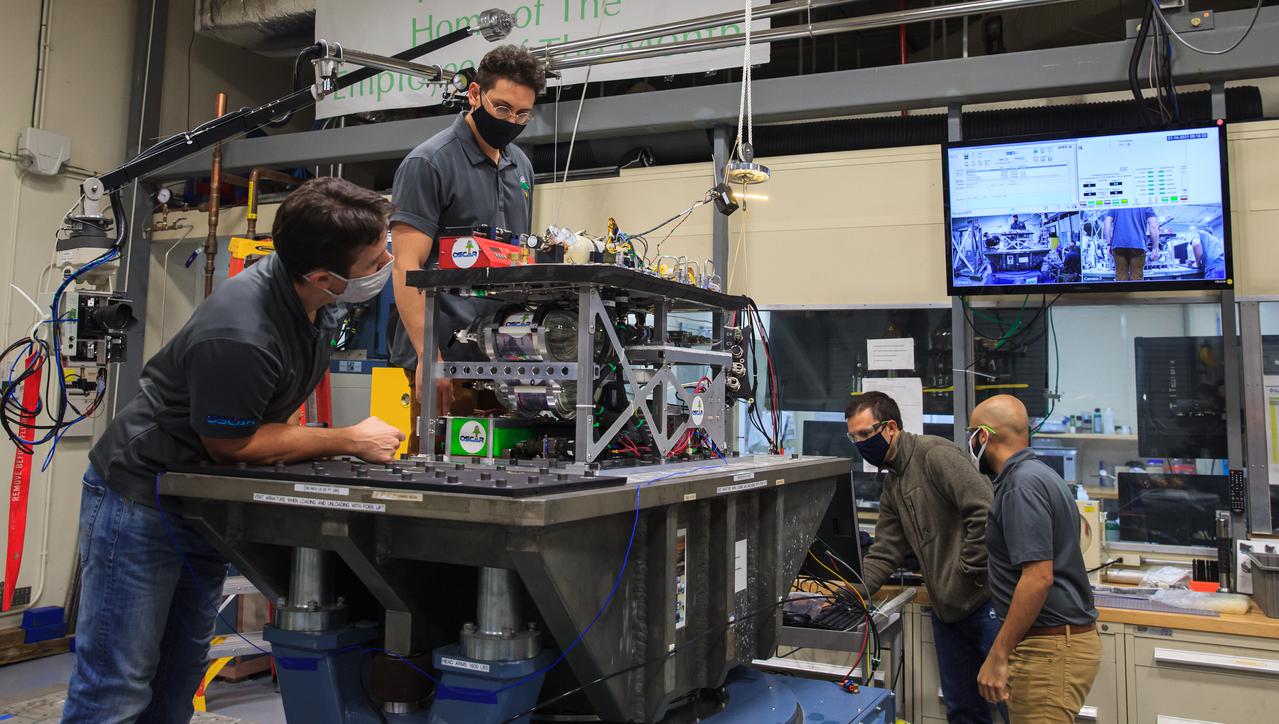
Kennedy Space Center engineers conduct vibration tests inside the Florida spaceport’s Vibration Test Lab on Jan. 14, 2021, in preparation for the suborbital flight of NASA’s Orbital Syngas Commodity Augmentation Reactor, or OSCAR, slated for later this year. From left are Gino Carro, a pressure vessels and systems engineer for the center’s Laboratory Support Services and Operations contract; Ray Pitts, co-principal investigator for OSCAR; David Rinderknecht, NASA chemical engineer; and Malay Shah, NASA thermal/fluid analysis engineer. Beginning as an Early Career Initiative project, OSCAR studies technology to convert trash and human waste into useful gasses such as methane, hydrogen, and carbon dioxide. By processing small pieces of trash in a high-temperature reactor, OSCAR is advancing new and innovative technology for managing waste in space.
Kennedy Space Center engineers conduct vibration tests inside the Florida spaceport’s Vibration Test Lab on Jan. 14, 2021, in preparation for the suborbital flight of NASA’s Orbital Syngas Commodity Augmentation Reactor, or OSCAR, slated for later this year. From left are Gino Carro, a pressure vessels and systems engineer for the center’s Laboratory Support Services and Operations contract; David Rinderknecht, NASA chemical engineer; Ray Pitts, co-principal investigator for OSCAR; and Malay Shah, NASA thermal/fluid analysis engineer. Beginning as an Early Career Initiative project, OSCAR studies technology to convert trash and human waste into useful gasses such as methane, hydrogen, and carbon dioxide. By processing small pieces of trash in a high-temperature reactor, OSCAR is advancing new and innovative technology for managing waste in space.
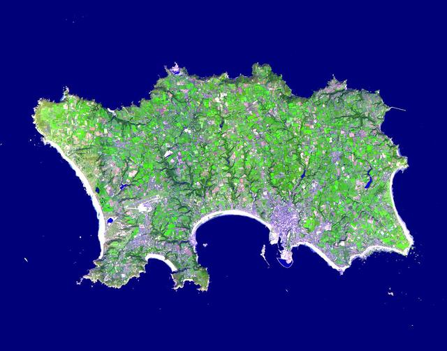
The Isle of Jersey (officially called the Bailiwick of Jersey) is the largest Channel Island, positioned in the Bay of Mont St Michel off the north-west coast of France. The island has a population of about 90,000, and covers about 90 square kilometers. The economy is based largely on international financial services, agriculture, and tourism. Called Caesaria in Roman times, Jersey becaame part of the Duchy of Normandy in 912. When William the Conqueror invaded and took the throne of England in 1066, the fortunes of Jersey then became linked to those in England, although the island manages its internal affairs through its own parliament, the States of Jersey. This image was acquired on September 23, 2000 by the Advanced Spaceborne Thermal Emission and Reflection Radiometer (ASTER) on NASA's Terra satellite. With its 14 spectral bands from the visible to the thermal infrared wavelength region, and its high spatial resolution of 15 to 90 meters (about 50 to 300 feet), ASTER images Earth to map and monitor the changing surface of our planet. http://photojournal.jpl.nasa.gov/catalog/PIA03879
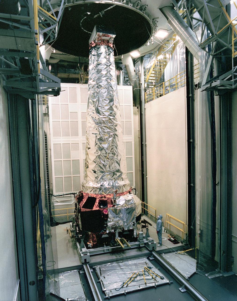
This photograph shows a TRW technician inspecting the completely assembled Chandra X-ray Observatory (CXO) in the Thermal Vacuum Chamber at TRW Space and Electronics Group of Redondo Beach, California. The CXO is formerly known as the Advanced X-Ray Astrophysics Facility (AXAF), which was renamed in honor of the late Indian-American Astronomer, Subrahmanyan Chandrasekhar in 1999. The CXO will help astronomers worldwide better understand the structure and evolution of the universe by studying powerful sources of x-rays such as exploding stars, matter falling into black holes and other exotic celestial objects. X-ray astronomy can only be done from space because Earth's atmosphere blocks x-rays from reaching the surface. The Observatory provides images that are 50 times more detailed than previous x-ray missions. At more than 45 feet in length and weighing more than 5 tons, it will be one of the largest objects ever placed in Earth orbit by the Space Shuttle. TRW, Inc. was the prime contractor and assembled and tested the observatory for NASA. The CXO program is managed by the Marshall Space Flight Center. The Observatory was launched on July 22, 1999 aboard the Space Shuttle Columbia, STS-93 mission. (Image courtesy of TRW)
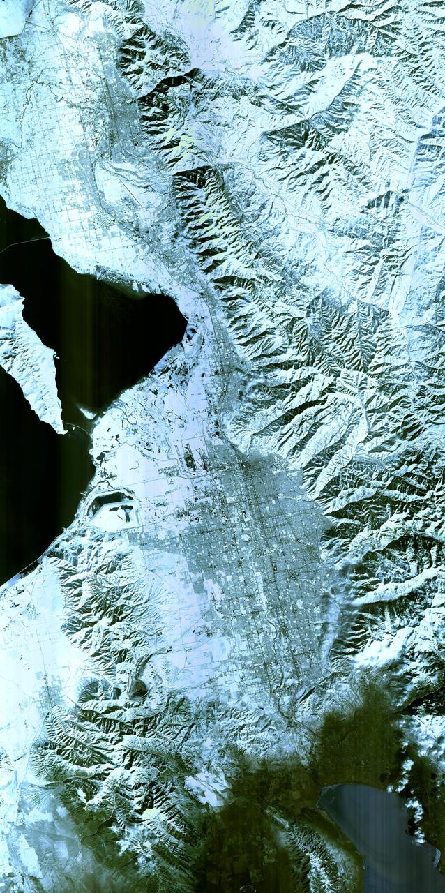
Salt Lake City, Utah, Winter 2001 The 2002 Winter Olympics are hosted by Salt Lake City at several venues within the city, in nearby cities, and within the adjacent Wasatch Mountains. This simulated natural color image presents a snowy, winter view of north central Utah that includes all of the Olympic sites. The image extends from Ogden in the north, to Provo in the south; and includes the snow-capped Wasatch Mountains and the eastern part of the Great Salt Lake. This image was acquired on February 8, 2001 by the Advanced Spaceborne Thermal Emission and Reflection Radiometer (ASTER) on NASA's Terra satellite. With its 14 spectral bands from the visible to the thermal infrared wavelength region, and its high spatial resolution of 15 to 90 meters (about 50 to 300 feet), ASTER will image Earth for the next 6 years to map and monitor the changing surface of our planet. ASTER is one of five Earth-observing instruments launched December 18,1999, on NASA's Terra satellite. The instrument was built by Japan's Ministry of Economy, Trade and Industry. A joint U.S./Japan science team is responsible for validation and calibration of the instrument and the data products. Dr. Anne Kahle at NASA's Jet Propulsion Laboratory, Pasadena, California, is the U.S. Science team leader; Bjorn Eng of JPL is the project manager. ASTER is the only high resolution imaging sensor on Terra. The Terra mission is part of NASA's Earth Science Enterprise, along-term research and technology program designed to examine Earth's land, oceans, atmosphere, ice and life as a total integrated system. The broad spectral coverage and high spectral resolution of ASTER will provide scientists in numerous disciplines with critical information for surface mapping, and monitoring dynamic conditions and temporal change. Example applications are: monitoring glacial advances and retreats; monitoring potentially active volcanoes; identifying crop stress; determining cloud morphology and physical properties; wetlands evaluation; thermal pollution monitoring; coral reef degradation; surface temperature mapping of soils and geology; and measuring surface heat balance. Image credit: NASA/GSFC/METI/ERSDAC/JAROS, and U.S./Japan ASTER Science Team Credit: <b><a href="http://www.earthobservatory.nasa.gov/" rel="nofollow"> NASA Earth Observatory</a></b> <b><a href="http://www.nasa.gov/audience/formedia/features/MP_Photo_Guidelines.html" rel="nofollow">NASA image use policy.</a></b> <b><a href="http://www.nasa.gov/centers/goddard/home/index.html" rel="nofollow">NASA Goddard Space Flight Center</a></b> enables NASA’s mission through four scientific endeavors: Earth Science, Heliophysics, Solar System Exploration, and Astrophysics. Goddard plays a leading role in NASA’s accomplishments by contributing compelling scientific knowledge to advance the Agency’s mission. <b>Follow us on <a href="http://twitter.com/NASAGoddardPix" rel="nofollow">Twitter</a></b> <b>Like us on <a href="http://www.facebook.com/pages/Greenbelt-MD/NASA-Goddard/395013845897?ref=tsd" rel="nofollow">Facebook</a></b> <b>Find us on <a href="http://instagram.com/nasagoddard?vm=grid" rel="nofollow">Instagram</a></b>
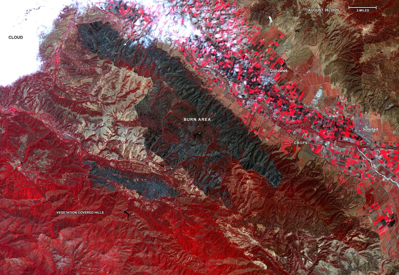
On Aug. 26, 2020, Advanced Spaceborne Thermal Emission and Reflection Radiometer (ASTER) instrument aboard NASA's Terra satellite passed over the River and Carmel fires in Monterey County, California, got a bird's eye view of the vast fire burn area. This false-color map shows the burn area as dark blue and gray, in the center of the image. Vegetation is in red, including agricultural crops along the Salinas River (bright red rectangles) surrounding the towns of Soledad and Gonzales; bare areas with no vegetation and rock are shown in tan and brown. The city of Salinas is in the upper left of the image, obscured by thick clouds. ASTER obtains high-resolution (15-90 square meters, or 161-969 square feet, per pixel) images of the Earth in 14 wavelengths of the electromagnetic spectrum, ranging from visible to thermal infrared light. Data from ASTER — which is managed by Japan Space Systems and NASA's Jet Propulsion Laboratory in Southern California — are used by scientists to create detailed maps of land surface temperature, how much infrared energy the land emits, how much light the land reflects and its elevation. On this occasion, ASTER was able to support NASA's Disaster Program response to the state's wildfires, providing data products that can be used by resources on the ground to fight the fires and for scientists to better understand their long-term effects. The area covered here is 21.4 by 31 miles (34.4 by 49.9 kilometers). https://photojournal.jpl.nasa.gov/catalog/PIA23800

NASA’s Aqua satellite captured a large area of smoke from the Long Valley Wildfire that was affecting Yosemite National Park. This natural-color satellite image was collected by the Moderate Resolution Imaging Spectroradiometer instrument that flies aboard the Aqua satellite. The image, taken July 20, showed actively burning areas in red, as detected by MODIS’s thermal bands. According to Inciweb, an interagency all-risk incident information management system that coordinates with federal, state and local agencies to manage wildfires, the fire started on Tuesday July 11, 2017. It is located about two miles north of Doyle, California and about 50 miles north of Reno, Nevada. As of July 21 the fire covered 83,733 acres and was 91 percent contained. NASA image courtesy NASA MODIS Rapid Response Team <b><a href="http://www.nasa.gov/audience/formedia/features/MP_Photo_Guidelines.html" rel="nofollow">NASA image use policy.</a></b> <b><a href="http://www.nasa.gov/centers/goddard/home/index.html" rel="nofollow">NASA Goddard Space Flight Center</a></b> enables NASA’s mission through four scientific endeavors: Earth Science, Heliophysics, Solar System Exploration, and Astrophysics. Goddard plays a leading role in NASA’s accomplishments by contributing compelling scientific knowledge to advance the Agency’s mission. <b>Follow us on <a href="http://twitter.com/NASAGoddardPix" rel="nofollow">Twitter</a></b> <b>Like us on <a href="http://www.facebook.com/pages/Greenbelt-MD/NASA-Goddard/395013845897?ref=tsd" rel="nofollow">Facebook</a></b> <b>Find us on <a href="http://instagrid.me/nasagoddard/?vm=grid" rel="nofollow">Instagram</a></b>
Aleksandra Bogunovic (left) and Veronica Otero (right) look on while Pete Steigner (in the middle) adds a flow tube that will make sure that nitrogen gas flows through the instrument while it's being shipped. The gas will keep contaminating particles from infiltrating the instrument. The Thermal Infrared Sensor (TIRS) will fly on the next Landsat satellite, the Landsat Data Continuity Mission (LDCM). TIRS was built on an accelerated schedule at NASA's Goddard Space Flight Center, Greenbelt, Md. and will now be integrated into the LDCM spacecraft at Orbital Science Corp. in Gilbert, Ariz. The Landsat Program is a series of Earth observing satellite missions jointly managed by NASA and the U.S. Geological Survey. Landsat satellites have been consistently gathering data about our planet since 1972. They continue to improve and expand this unparalleled record of Earth's changing landscapes for the benefit of all. For more information on Landsat, visit: <a href="http://www.nasa.gov/landsat" rel="nofollow">www.nasa.gov/landsat</a> Credit: NASA/GSFC/Rebecca Roth <b><a href="http://www.nasa.gov/audience/formedia/features/MP_Photo_Guidelines.html" rel="nofollow">NASA image use policy.</a></b> <b><a href="http://www.nasa.gov/centers/goddard/home/index.html" rel="nofollow">NASA Goddard Space Flight Center</a></b> enables NASA’s mission through four scientific endeavors: Earth Science, Heliophysics, Solar System Exploration, and Astrophysics. Goddard plays a leading role in NASA’s accomplishments by contributing compelling scientific knowledge to advance the Agency’s mission. <b>Follow us on <a href="http://twitter.com/NASA_GoddardPix" rel="nofollow">Twitter</a></b> <b>Like us on <a href="http://www.facebook.com/pages/Greenbelt-MD/NASA-Goddard/395013845897?ref=tsd" rel="nofollow">Facebook</a></b> <b>Find us on <a href="http://instagrid.me/nasagoddard/?vm=grid" rel="nofollow">Instagram</a></b>
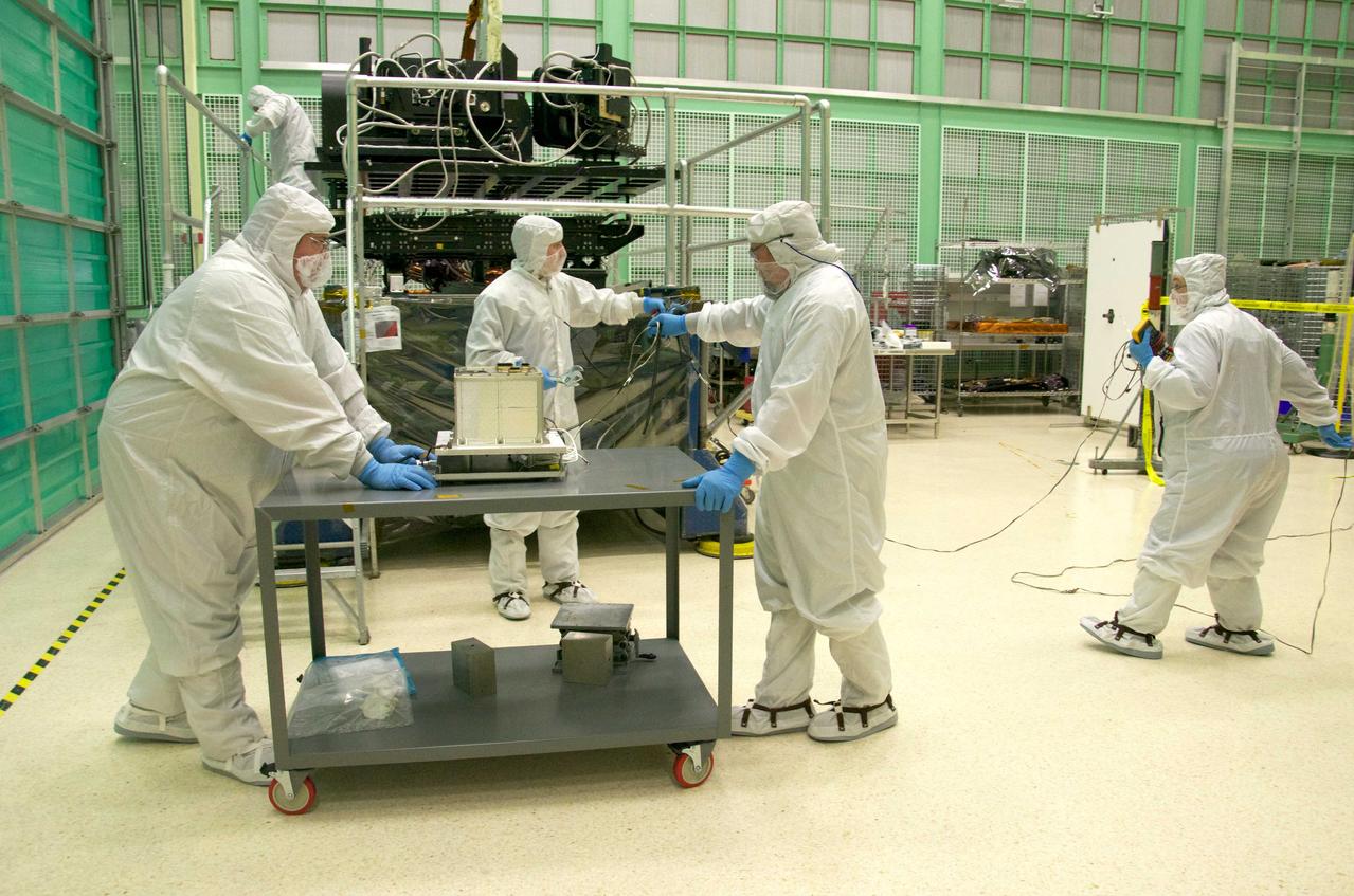
Pete Steigner, and Mike Golob (middle and right) assist an Chris Kolos in carefully moving a TIRS component across the clean room at Goddard. On the far right Robin Knight holds the component's 'grounding strap.' It's used to make sure that any static electricity that could possibly build up while the component is being moved doesn't affect the damage the sensitive electronics. The Thermal Infrared Sensor (TIRS) will fly on the next Landsat satellite, the Landsat Data Continuity Mission (LDCM). TIRS was built on an accelerated schedule at NASA's Goddard Space Flight Center, Greenbelt, Md. and will now be integrated into the LDCM spacecraft at Orbital Science Corp. in Gilbert, Ariz. The Landsat Program is a series of Earth observing satellite missions jointly managed by NASA and the U.S. Geological Survey. Landsat satellites have been consistently gathering data about our planet since 1972. They continue to improve and expand this unparalleled record of Earth's changing landscapes for the benefit of all. For more information on Landsat, visit: <a href="http://www.nasa.gov/landsat" rel="nofollow">www.nasa.gov/landsat</a> Credit: NASA/GSFC/Rebecca Roth <b><a href="http://www.nasa.gov/audience/formedia/features/MP_Photo_Guidelines.html" rel="nofollow">NASA image use policy.</a></b> <b><a href="http://www.nasa.gov/centers/goddard/home/index.html" rel="nofollow">NASA Goddard Space Flight Center</a></b> enables NASA’s mission through four scientific endeavors: Earth Science, Heliophysics, Solar System Exploration, and Astrophysics. Goddard plays a leading role in NASA’s accomplishments by contributing compelling scientific knowledge to advance the Agency’s mission. <b>Follow us on <a href="http://twitter.com/NASA_GoddardPix" rel="nofollow">Twitter</a></b> <b>Like us on <a href="http://www.facebook.com/pages/Greenbelt-MD/NASA-Goddard/395013845897?ref=tsd" rel="nofollow">Facebook</a></b> <b>Find us on <a href="http://instagrid.me/nasagoddard/?vm=grid" rel="nofollow">Instagram</a></b>
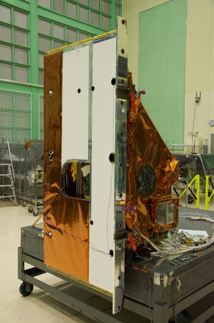
The Thermal Infrared Sensor (TIRS) will fly on the next Landsat satellite, the Landsat Data Continuity Mission (LDCM). The right side of the instrument is what's called the 'nadir side,' that's the side that points toward Earth when the instrument is in space. The black circle visible on the right side is where the optics for the instrument are located. In that area are the lens and the detectors. The white area is a radiator that radiates heat to keep the telescope and the detector cool. The black hole on the white area on the left is what the satellite operators point to deep space when they calibrate the instrument to the cold temperatures of space. TIRS was built on an accelerated schedule at NASA's Goddard Space Flight Center, Greenbelt, Md. and will now be integrated into the LDCM spacecraft at Orbital Science Corp. in Gilbert, Ariz. The Landsat Program is a series of Earth observing satellite missions jointly managed by NASA and the U.S. Geological Survey. Landsat satellites have been consistently gathering data about our planet since 1972. They continue to improve and expand this unparalleled record of Earth's changing landscapes for the benefit of all. For more information on Landsat, visit: <a href="http://www.nasa.gov/landsat" rel="nofollow">www.nasa.gov/landsat</a> Credit: NASA/GSFC/Rebecca Roth <b><a href="http://www.nasa.gov/audience/formedia/features/MP_Photo_Guidelines.html" rel="nofollow">NASA image use policy.</a></b> <b><a href="http://www.nasa.gov/centers/goddard/home/index.html" rel="nofollow">NASA Goddard Space Flight Center</a></b> enables NASA’s mission through four scientific endeavors: Earth Science, Heliophysics, Solar System Exploration, and Astrophysics. Goddard plays a leading role in NASA’s accomplishments by contributing compelling scientific knowledge to advance the Agency’s mission. <b>Follow us on <a href="http://twitter.com/NASA_GoddardPix" rel="nofollow">Twitter</a></b> <b>Like us on <a href="http://www.facebook.com/pages/Greenbelt-MD/NASA-Goddard/395013845897?ref=tsd" rel="nofollow">Facebook</a></b> <b>Find us on <a href="http://instagrid.me/nasagoddard/?vm=grid" rel="nofollow">Instagram</a></b>
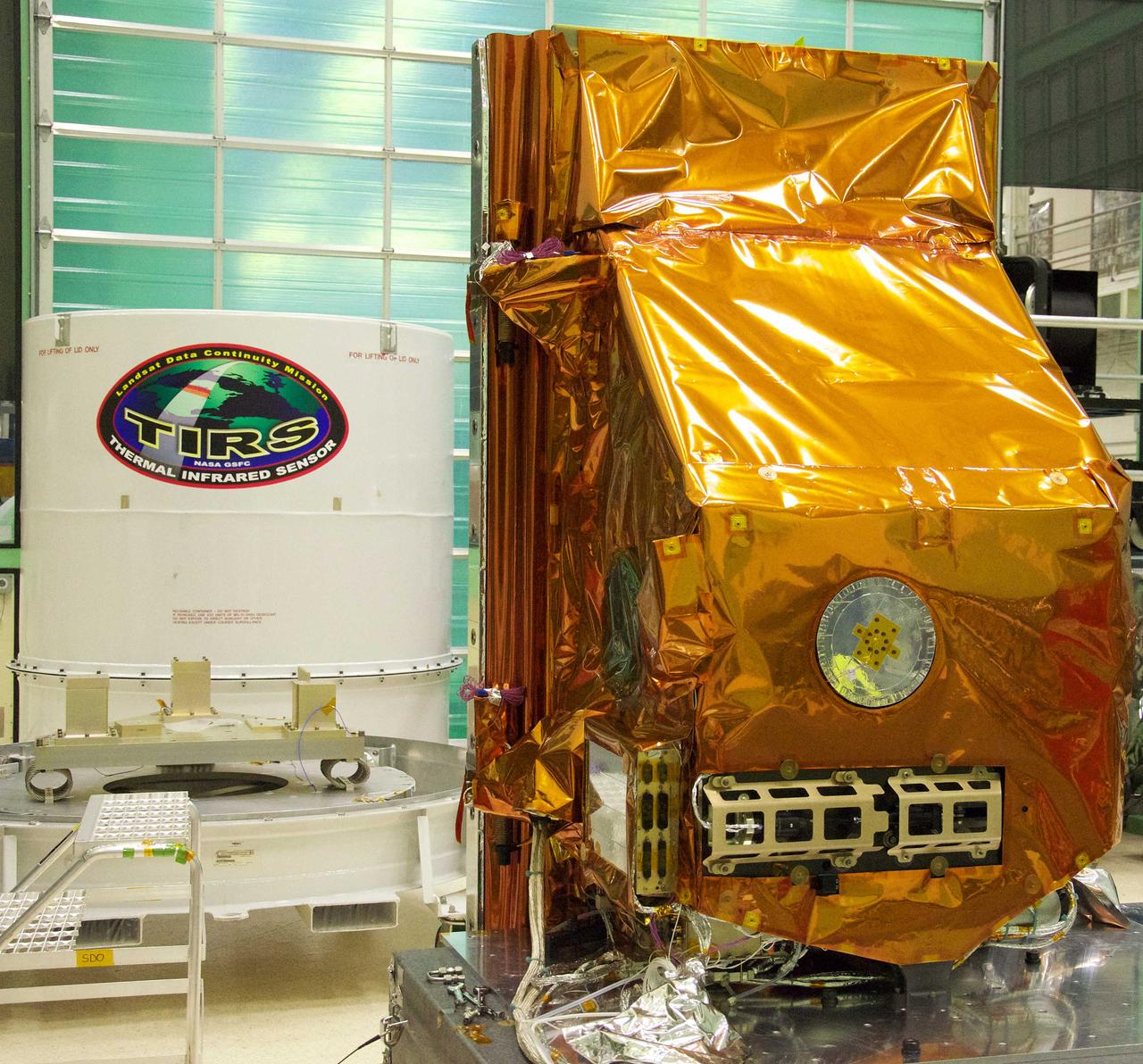
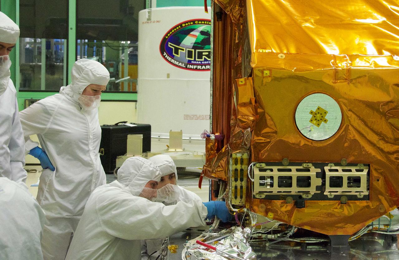
The TIRS instrument in the foreground with its shipping container waits in the background. The copper-color of TIRS is due to the gold-colored foil that coats the Multi-Layer Insulation blankets. The Thermal Infrared Sensor (TIRS) will fly on the next Landsat satellite, the Landsat Data Continuity Mission (LDCM). TIRS was built on an accelerated schedule at NASA's Goddard Space Flight Center, Greenbelt, Md. and will now be integrated into the LDCM spacecraft at Orbital Science Corp. in Gilbert, Ariz. The Landsat Program is a series of Earth observing satellite missions jointly managed by NASA and the U.S. Geological Survey. Landsat satellites have been consistently gathering data about our planet since 1972. They continue to improve and expand this unparalleled record of Earth's changing landscapes for the benefit of all. For more information on Landsat, visit: <a href="http://www.nasa.gov/landsat" rel="nofollow">www.nasa.gov/landsat</a> Credit: NASA/GSFC/Rebecca Roth <b><a href="http://www.nasa.gov/audience/formedia/features/MP_Photo_Guidelines.html" rel="nofollow">NASA image use policy.</a></b> <b><a href="http://www.nasa.gov/centers/goddard/home/index.html" rel="nofollow">NASA Goddard Space Flight Center</a></b> enables NASA’s mission through four scientific endeavors: Earth Science, Heliophysics, Solar System Exploration, and Astrophysics. Goddard plays a leading role in NASA’s accomplishments by contributing compelling scientific knowledge to advance the Agency’s mission. <b>Follow us on <a href="http://twitter.com/NASA_GoddardPix" rel="nofollow">Twitter</a></b> <b>Like us on <a href="http://www.facebook.com/pages/Greenbelt-MD/NASA-Goddard/395013845897?ref=tsd" rel="nofollow">Facebook</a></b> <b>Find us on <a href="http://instagrid.me/nasagoddard/?vm=grid" rel="nofollow">Instagram</a></b>
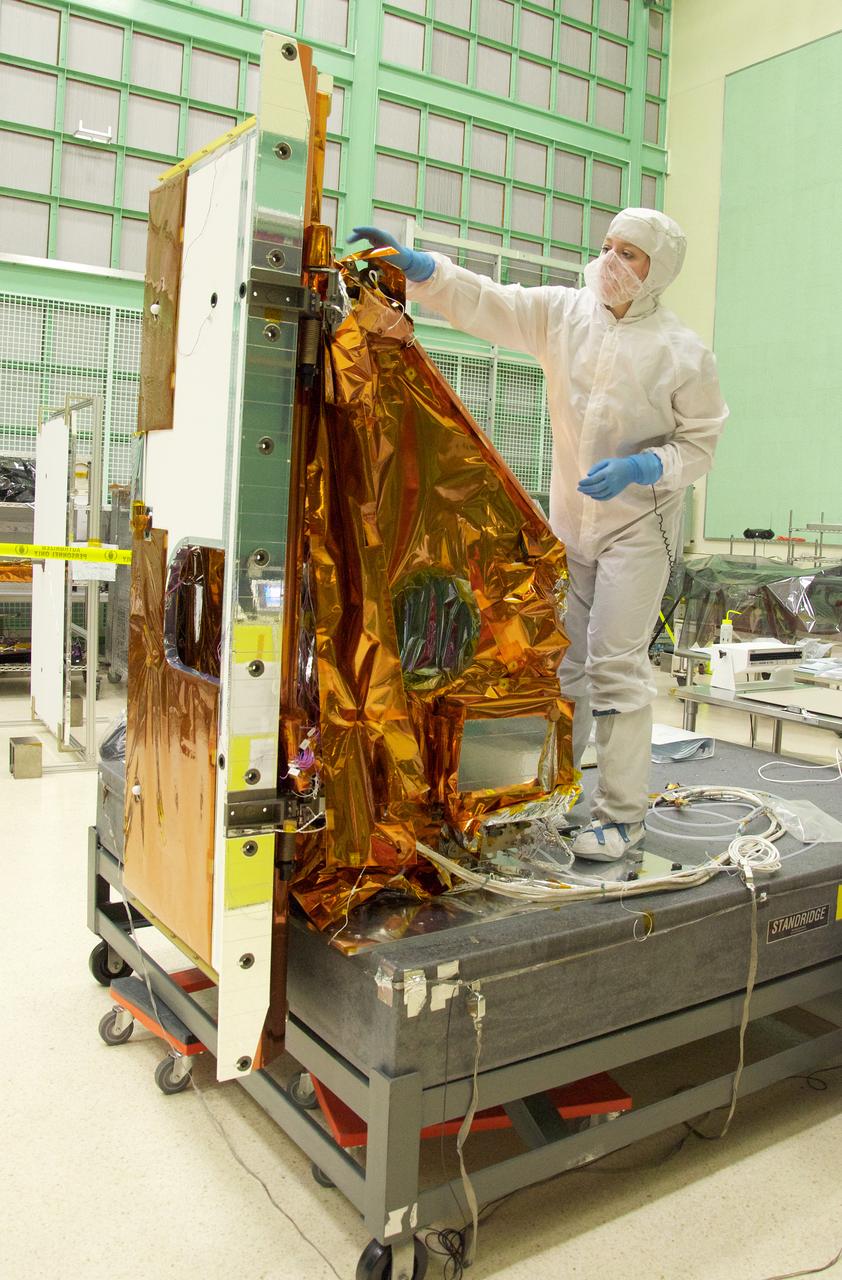
Aleksandra Bogunovic reaches across the instrument to affix the corners of a Multi-Layer Insulation blanket to the TIRS instrument. The Thermal Infrared Sensor (TIRS) will fly on the next Landsat satellite, the Landsat Data Continuity Mission (LDCM). TIRS was built on an accelerated schedule at NASA's Goddard Space Flight Center, Greenbelt, Md. and will now be integrated into the LDCM spacecraft at Orbital Science Corp. in Gilbert, Ariz. The Landsat Program is a series of Earth observing satellite missions jointly managed by NASA and the U.S. Geological Survey. Landsat satellites have been consistently gathering data about our planet since 1972. They continue to improve and expand this unparalleled record of Earth's changing landscapes for the benefit of all. For more information on Landsat, visit: <a href="http://www.nasa.gov/landsat" rel="nofollow">www.nasa.gov/landsat</a> Credit: NASA/GSFC/Rebecca Roth <b><a href="http://www.nasa.gov/audience/formedia/features/MP_Photo_Guidelines.html" rel="nofollow">NASA image use policy.</a></b> <b><a href="http://www.nasa.gov/centers/goddard/home/index.html" rel="nofollow">NASA Goddard Space Flight Center</a></b> enables NASA’s mission through four scientific endeavors: Earth Science, Heliophysics, Solar System Exploration, and Astrophysics. Goddard plays a leading role in NASA’s accomplishments by contributing compelling scientific knowledge to advance the Agency’s mission. <b>Follow us on <a href="http://twitter.com/NASA_GoddardPix" rel="nofollow">Twitter</a></b> <b>Like us on <a href="http://www.facebook.com/pages/Greenbelt-MD/NASA-Goddard/395013845897?ref=tsd" rel="nofollow">Facebook</a></b> <b>Find us on <a href="http://instagrid.me/nasagoddard/?vm=grid" rel="nofollow">Instagram</a></b>
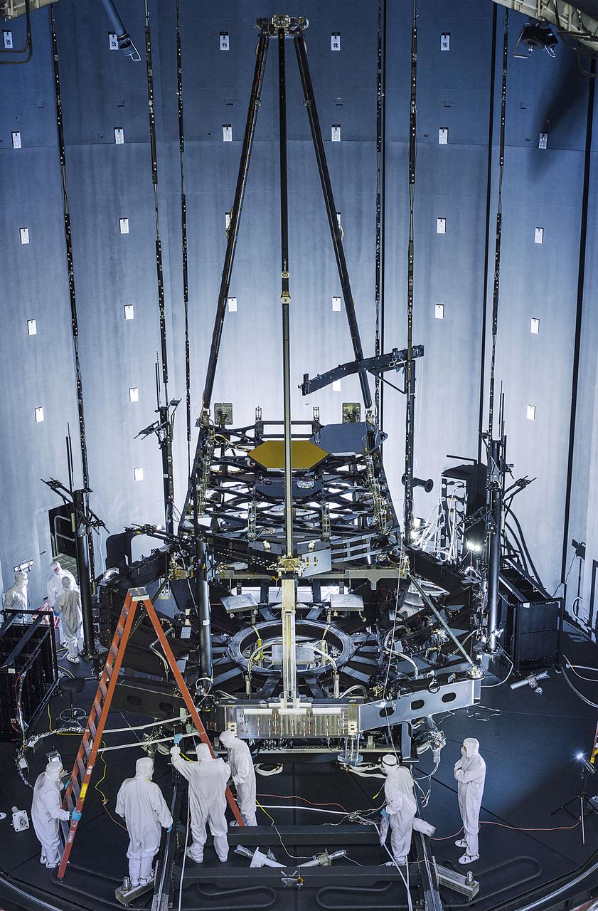
Inside NASA's giant thermal vacuum chamber, called Chamber A, at NASA's Johnson Space Center in Houston, the James Webb Space Telescope's Pathfinder backplane test model, is being prepared for its cryogenic test. Previously used for manned spaceflight missions, this historic chamber is now filled with engineers and technicians preparing for a crucial test. Exelis developed and installed the optical test equipment in the chamber. "The optical test equipment was developed and installed in the chamber by Exelis," said Thomas Scorse, Exelis JWST Program Manager. "The Pathfinder telescope gives us our first opportunity for an end-to-end checkout of our equipment." "This will be the first time on the program that we will be aligning two primary mirror segments together," said Lee Feinberg, NASA Optical Telescope Element Manager. "In the past, we have always tested one mirror at a time but this time we will use a single test system and align both mirrors to it as though they are a single monolithic mirror." The James Webb Space Telescope is the scientific successor to NASA's Hubble Space Telescope. It will be the most powerful space telescope ever built. Webb is an international project led by NASA with its partners, the European Space Agency and the Canadian Space Agency. Image credit: NASA/Chris Gunn Text credit: Laura Betz, NASA's Goddard Space Flight Center, Greenbelt, Maryland <b><a href="http://www.nasa.gov/audience/formedia/features/MP_Photo_Guidelines.html" rel="nofollow">NASA image use policy.</a></b> <b><a href="http://www.nasa.gov/centers/goddard/home/index.html" rel="nofollow">NASA Goddard Space Flight Center</a></b> enables NASA’s mission through four scientific endeavors: Earth Science, Heliophysics, Solar System Exploration, and Astrophysics. Goddard plays a leading role in NASA’s accomplishments by contributing compelling scientific knowledge to advance the Agency’s mission. <b>Follow us on <a href="http://twitter.com/NASAGoddardPix" rel="nofollow">Twitter</a></b> <b>Like us on <a href="http://www.facebook.com/pages/Greenbelt-MD/NASA-Goddard/395013845897?ref=tsd" rel="nofollow">Facebook</a></b> <b>Find us on <a href="http://instagrid.me/nasagoddard/?vm=grid" rel="nofollow">Instagram</a></b>
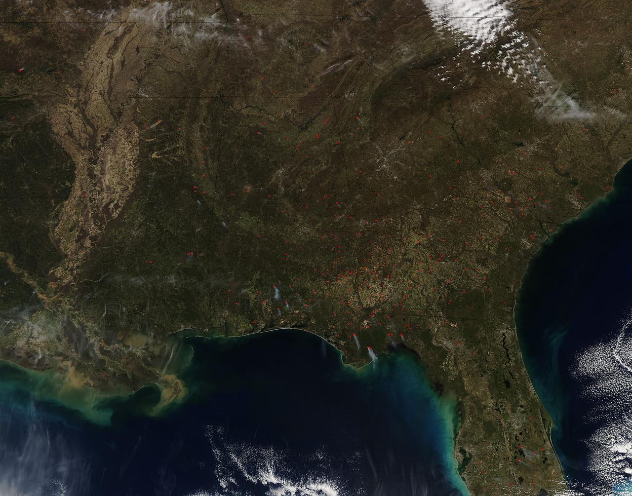
Fires both wild and prescribed dot the landscape of the southeastern portion of the United States. Wildfires are those that occur naturally with lightning strikes or are set by careless humans. Prescribed fires are those deliberately set by land management authorities to take out underlying brush and dead grass so that in the event of a wildfire there is not sufficient fuel for that fire to spread too far. The Southern Area Coordination Center for fire management has this information on its report for February 21, 2017. • Fires that have broken out recently (known as Initial Attack Activity): 198 fires for 2,292 acres • Ongoing Uncontained Large Fires: 3 fires for 5,947 acres • Other Fires reported through alternate channels: 56 fires for 1,400 acres • Prescribed Fire Activity: State and/or Federal Lands – 1,974 prescribed fires for 38,533 acres in AL, FL & GA The bulk of the fires seen in the image taken by the Aqua satellite using the onboard MODIS (Moderate Resolution Imaging Spectroradiometer) instrument on February 16, 2017 appear to be prescribed fires. Actively burning areas, detected by MODIS’s thermal bands, are outlined in red and when combined with smoke are indicative of fire. NASA image courtesy Jeff Schmaltz LANCE/EOSDIS MODIS Rapid Response Team, GSFC. Caption by Lynn Jenner with information from the Southern Area Coordination Center. <b><a href="http://www.nasa.gov/audience/formedia/features/MP_Photo_Guidelines.html" rel="nofollow">NASA image use policy.</a></b> <b><a href="http://www.nasa.gov/centers/goddard/home/index.html" rel="nofollow">NASA Goddard Space Flight Center</a></b> enables NASA’s mission through four scientific endeavors: Earth Science, Heliophysics, Solar System Exploration, and Astrophysics. Goddard plays a leading role in NASA’s accomplishments by contributing compelling scientific knowledge to advance the Agency’s mission. <b>Follow us on <a href="http://twitter.com/NASAGoddardPix" rel="nofollow">Twitter</a></b> <b>Like us on <a href="http://www.facebook.com/pages/Greenbelt-MD/NASA-Goddard/395013845897?ref=tsd" rel="nofollow">Facebook</a></b> <b>Find us on <a href="http://instagrid.me/nasagoddard/?vm=grid" rel="nofollow">Instagram</a></b>
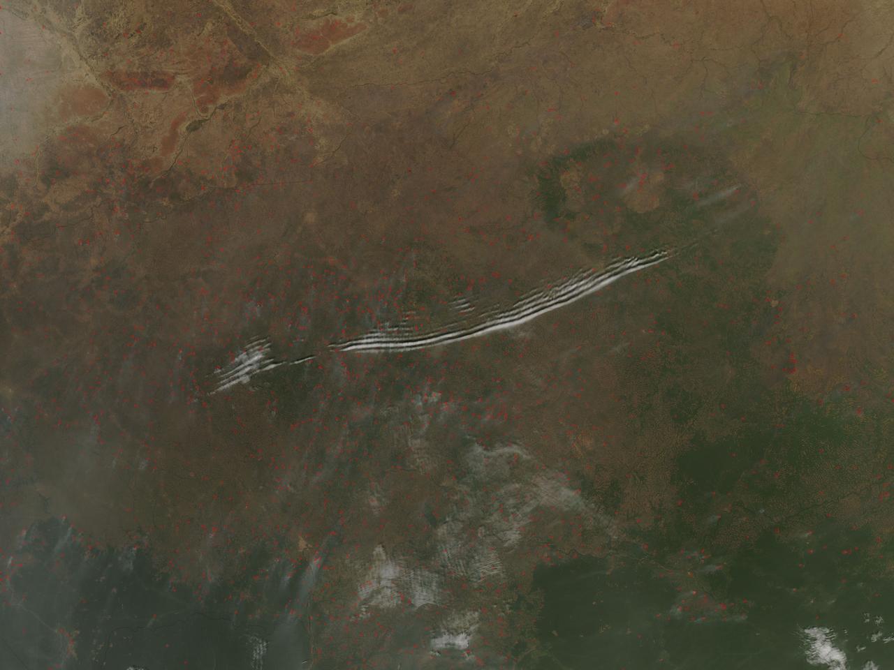
On January 27, 2016, the Moderate Resolution Imaging Spectroradiometer (MODIS) aboard NASA’s Aqua satellite passed over the Central African Republic and captured a true-color image of wave clouds rippling over a fire-speckled landscape. Wave clouds typically form when a mountain, island, or even another mass of air forces an air mass to rise, then fall again, in a wave pattern. The air cools as it rises, and if there is moisture in the air, the water condenses into clouds at the top of the wave. As the air begins to sink, the air warms and the cloud dissipates. The result is a line of clouds marking the crests of the wave separated by clear areas in the troughs of the wave. In addition to the long lines of clouds stretching across the central section of the country, clouds appear to line up in parallel rows near the border of the Democratic Republic of the Congo. In this area, small sets of grayish cloud appear to be lined up with the prevailing wind, judging by the plumes of smoke rising from red hotspots near each set of clouds. Clouds like this, that line in parallel rows parallel with the prevailing wind, are known as “cloud streets”. Each red “hotspot” marks an area where the thermal sensors on the MODIS instrument detected high temperatures. When accompanied by typical smoke, such hotspots are diagnostic for actively burning fires. Given the time of the year, the widespread nature, and the location of the fires, they are almost certainly agricultural fires that have been deliberately set to manage land. Image Credit: Jeff Schmaltz, MODIS Land Rapid Response Team, NASA GSFC <b><a href="http://www.nasa.gov/audience/formedia/features/MP_Photo_Guidelines.html" rel="nofollow">NASA image use policy.</a></b> <b><a href="http://www.nasa.gov/centers/goddard/home/index.html" rel="nofollow">NASA Goddard Space Flight Center</a></b> enables NASA’s mission through four scientific endeavors: Earth Science, Heliophysics, Solar System Exploration, and Astrophysics. Goddard plays a leading role in NASA’s accomplishments by contributing compelling scientific knowledge to advance the Agency’s mission. <b>Follow us on <a href="http://twitter.com/NASAGoddardPix" rel="nofollow">Twitter</a></b> <b>Like us on <a href="http://www.facebook.com/pages/Greenbelt-MD/NASA-Goddard/395013845897?ref=tsd" rel="nofollow">Facebook</a></b> <b>Find us on <a href="http://instagrid.me/nasagoddard/?vm=grid" rel="nofollow">Instagram</a></b>
The fire season in California has been anything but cooperative this year. Hot conditions combined with a state-wide drought and dry lightning makes for unpleasant conditions and leads to an abundance of forest fires. On August 12, lightning struck and started the fire that grew into the Happy Camp Complex. Currently over 113,000 acres have been affected and the fire is only 55% contained as of today. Strong winds tested fire lines yesterday (8/15), and are expected to do so again today. Despite the high winds, existing fire lines held with no spotting or expansion outside current containment lines. The south end of the fire continued backing slowly toward Elk Creek in the Marble Mountain Wilderness. The Man Fire joined with the Happy Camp Complex yesterday and will be managed by California Interagency Incident Management Team 4 as of 6:00am on Wednesday, September 17, 2014. Nearby the Happy Camp Complex, near Mt. Shasta and the town of Weed, another fire erupted that fire officials said quickly damaged or destroyed 100 structures Monday (8/15). Hundreds of firefighters were trying to contain that fire. A California Fire spokesman said more than 300 acres were scorched and more than 100 structures damaged or destroyed in just a few hours. The blaze, dubbed the Boles Fire, also led to the closure of Interstate 5 and U.S. 97. Weed is in Siskiyou County, about 50 miles south of the California-Oregon border. With strong winds, the fire was able to rage into the community before firefighters could get equipment to the blaze. About 1,500 to 2,000 residents were being evacuated to the Siskiyou County fairgrounds. An evacuation center was set up at the county fairgrounds in Yreka. NASA's Aqua satellite collected this natural-color image with the Moderate Resolution Imaging Spectroradiometer, MODIS, instrument on September 15, 2014. Actively burning areas, detected by MODIS’s thermal bands, are outlined in red. NASA image courtesy Jeff Schmaltz LANCE/EOSDIS MODIS Rapid Response Team, GSFC. Caption by Lynn Jenner with information from Inciweb and California Department of Forestry and Fire Protection. <b><a href="http://www.nasa.gov/audience/formedia/features/MP_Photo_Guidelines.html" rel="nofollow">NASA image use policy.</a></b> <b><a href="http://www.nasa.gov/centers/goddard/home/index.html" rel="nofollow">NASA Goddard Space Flight Center</a></b> enables NASA’s mission through four scientific endeavors: Earth Science, Heliophysics, Solar System Exploration, and Astrophysics. Goddard plays a leading role in NASA’s accomplishments by contributing compelling scientific knowledge to advance the Agency’s mission. <b>Follow us on <a href="http://twitter.com/NASAGoddardPix" rel="nofollow">Twitter</a></b> <b>Like us on <a href="http://www.facebook.com/pages/Greenbelt-MD/NASA-Goddard/395013845897?ref=tsd" rel="nofollow">Facebook</a></b> <b>Find us on <a href="http://instagram.com/nasagoddard?vm=grid" rel="nofollow">Instagram</a></b>
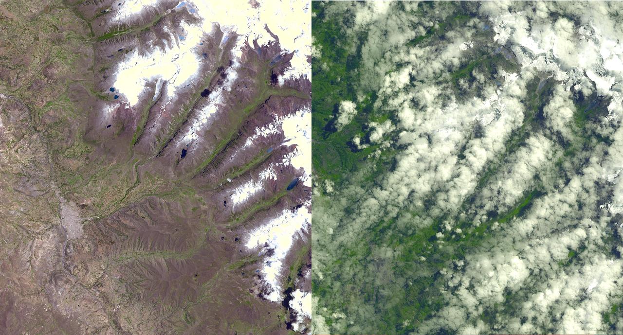
An Earth-monitoring instrument aboard NASA's Terra satellite is keeping a close eye on a potential glacial disaster in the making in Peru's spectacular, snow-capped Cordillera Blanca (White Mountains), the highest range of the Peruvian Andes. Data from NASA's Advanced Spaceborne Thermal Emission and Reflection Radiometer (Aster) is assisting Peruvian government officials and geologists in monitoring a glacier that feeds Lake Palcacocha, located high above the city of Huaraz, 270 kilometers (168 miles) north of Lima. An ominous crack has developed in the glacier. Should the large glacier chunk break off and fall into the lake, the ensuing flood could hurtle down the Cojup Valley into the Rio Santa Valley below, reaching Huaraz, population 60,000, in less than 15 minutes. "Glacial natural hazards like the one in Huaraz are an increasing threat to people in many parts of the world," said Dr. Michael Abrams, associate Aster team leader at NASA's Jet Propulsion Laboratory, Pasadena, Calif. "Remote sensing instruments like Aster can serve a vital role in mountain hazard management and disaster mapping by providing rapid access to data, even in regions not easily accessible by humans. Aster's unique vantage point from space gives scientists another tool with which to see early signs of potential glacial flood-burst events and to monitor changes in glacial behavior over time. In Huaraz, Peruvian authorities and scientists will incorporate Aster data along with data from ground-based monitoring techniques to better assess current conditions and take steps necessary to reduce risks to human lives and property." Comparison images of the area are available at: http://asterweb.jpl.nasa.gov . Huaraz can be seen in the images' left-center, with Lake Palcacocha in the images' upper right corners at the head of a valley, below the snow and glacier cap. The left image was acquired on November 5, 2001; the right on April 8, 2003. Glacial flood-bursts, known by Peruvians as "aluviones," occur periodically when water is released abruptly from a previously ice-dammed lake alongside, within, or above a glacier. The release can be caused by various triggering events. These flood-bursts typically arrive with little or no warning, carrying liquid mud, large rock boulders and blocks of ice. The Rio Santa Valley is no stranger to such disasters. Since 1702, floods caused by glaciological conditions have repeatedly caused death and destruction in the region. One particularly devastating event in 1941 destroyed approximately one-third of Huaraz, killing an estimated 5,000 to 7,000 people. Since then, the Peruvian government has emphasized control of the water level in Lake Palcacocha and other lakes in the region that pose similar threats. The efforts appear to have worked; since 1972, no destructive floods resulting from the breakout of glacial lakes have occurred. Nevertheless, officials are still monitoring the current situation closely. http://photojournal.jpl.nasa.gov/catalog/PIA03899

Engineer Erin Wilson adds aluminum tape to electrical cables to protect them from the cold during environmental testing of special optical equipment. These tests will verify the alignment of the actual flight instruments that will fly aboard NASA’s James Webb Space Telescope. "Because the flight science instruments detect infrared light, they must be extremely cold to work, and so the environment we test them in must be extremely cold too," Wilson says. Wilson is working in the Space Environment Simulator thermal-vacuum chamber at NASA's Goddard Space Flight Center in Greenbelt, Md. The subject of the testing is the Optical Telescope Element (OTE) Simulator, or OSIM. The hardware seen in the background is the Beam Image Analyzer, which will be used to measure OSIM. It sits above the OSIM, which is under the platform that Wilson is working on. The OSIM is about two stories tall and almost as wide as the whole test chamber. The job of the OSIM is to generate a beam of light just like the one that the real telescope optics will feed into the actual flight science instruments. Because the real flight science instruments will be used to test the real flight telescope, their alignment and performance have to be verified first, using OSIM, and before that can happen, the OSIM has to tested and verified. In space, the telescope optics act as Webb’s eye, and on the ground, the OSIM substitutes for the telescope optics, says Robert Rashford, manager for the OSIM as well as the Integrated Science Instrument Module (ISIM) Electronics Compartment. This hardware is being tested in an environment that mimics the hard vacuum and cold temperatures that Webb will experience in space. After Erin and others were done setting things up in the test chamber, Goddard engineers sealed it up, evacuated all the air and lowered the temperature of the equipment being tested to 42 Kelvin (-384-point-1 Fahrenheit or -231-point-1 Celsius). "It has taken a little over a month to get temperatures cold enough to duplicate the temperatures that Webb will see in operation in space," Rashford says. In the next couple weeks Rashford and the team of Goddard engineers will measure the OSIM with the Beam Image Analyzer. This extremely cold or “cryogenic” optical testing and verification process will likely take 90 days to complete. Laura Betz NASA's Goddard Space Flight Center, Greenbelt, Md. <b><a href="http://www.nasa.gov/audience/formedia/features/MP_Photo_Guidelines.html" rel="nofollow">NASA image use policy.</a></b> <b><a href="http://www.nasa.gov/centers/goddard/home/index.html" rel="nofollow">NASA Goddard Space Flight Center</a></b> enables NASA’s mission through four scientific endeavors: Earth Science, Heliophysics, Solar System Exploration, and Astrophysics. Goddard plays a leading role in NASA’s accomplishments by contributing compelling scientific knowledge to advance the Agency’s mission. <b>Follow us on <a href="http://twitter.com/NASA_GoddardPix" rel="nofollow">Twitter</a></b> <b>Like us on <a href="http://www.facebook.com/pages/Greenbelt-MD/NASA-Goddard/395013845897?ref=tsd" rel="nofollow">Facebook</a></b> <b>Find us on <a href="http://instagrid.me/nasagoddard/?vm=grid" rel="nofollow">Instagram</a></b>

California has been hit hard the past few weeks with storms. Storms bring lightning and lightning strikes cause wildfires. Currently there are at least five fire complexes in the area including River, Fork, South, Route and Mad River. The Mad River complex is a series of seven lightning fires that started on July 30th, 2015 after a lightning storm moved through Northern California. After initial firefighters responded, 25 fires were reported and most of the fires were contained. Some additional fires might be detected from the original lightning storms in the upcoming days and will be attacked once they are found. Damage assessment is ongoing and crews will determine the extent of structures and equipment damaged or destroyed. The River Complex is managing a total of 5 fires due to fires merging together on the Shasta-Trinity and the Six Rivers National Forests. Winds from the west are expected to lift the inversion today resulting in active fire behavior. The Fork Complex consists of over 40 fires, all of which were ignited by lightning between July 29 and 31, 2015. These fires are still being identified, assessed, and prioritized. Updated acreage and information about specific fires will be published as it is known. Fire activity moderated throughout last night (8/4) with the smoke inversion layer remaining in place today. Hopefully this will create favorable conditions for fire crews to take direct fire attack on the fires edge, construct dozer line and scout for best firefighting locations on all fires in the complex. The South Complex consists of approximately nine known fires, five of which are currently over 100 acres. The fires are active and defense of structures and point protection are in progress. The weather is trapping smoke in the valley causing very poor air quality. As the smoke lifts the fire activity increases. Firefighters will continue to provide point protection on structures and to look for opportunities to build direct and indirect containment lines. The Route Complex currently stands at 12,164 acres from seven separate fires and is at 2% containment. The overall acreage has been reduced because the South Fire on the nearby South Complex is merging with the Johnson Fire in the Route Complex resulting in decreased and revised fire perimeter acreage. This natural-color satellite image collected by the Moderate Resolution Imaging Spectroradiometer (MODIS) aboard the Terra satellite shows smoke rising and drifting northwest from the various fire complexes. It was captured on August 04, 2015. Actively burning areas, detected by MODIS’s thermal bands, are outlined in red. NASA image courtesy Jeff Schmaltz, MODIS Rapid Response Team. <b><a href="http://www.nasa.gov/audience/formedia/features/MP_Photo_Guidelines.html" rel="nofollow">NASA image use policy.</a></b> <b><a href="http://www.nasa.gov/centers/goddard/home/index.html" rel="nofollow">NASA Goddard Space Flight Center</a></b> enables NASA’s mission through four scientific endeavors: Earth Science, Heliophysics, Solar System Exploration, and Astrophysics. Goddard plays a leading role in NASA’s accomplishments by contributing compelling scientific knowledge to advance the Agency’s mission. <b>Follow us on <a href="http://twitter.com/NASAGoddardPix" rel="nofollow">Twitter</a></b> <b>Like us on <a href="http://www.facebook.com/pages/Greenbelt-MD/NASA-Goddard/395013845897?ref=tsd" rel="nofollow">Facebook</a></b> <b>Find us on <a href="http://instagrid.me/nasagoddard/?vm=grid" rel="nofollow">Instagram</a></b>