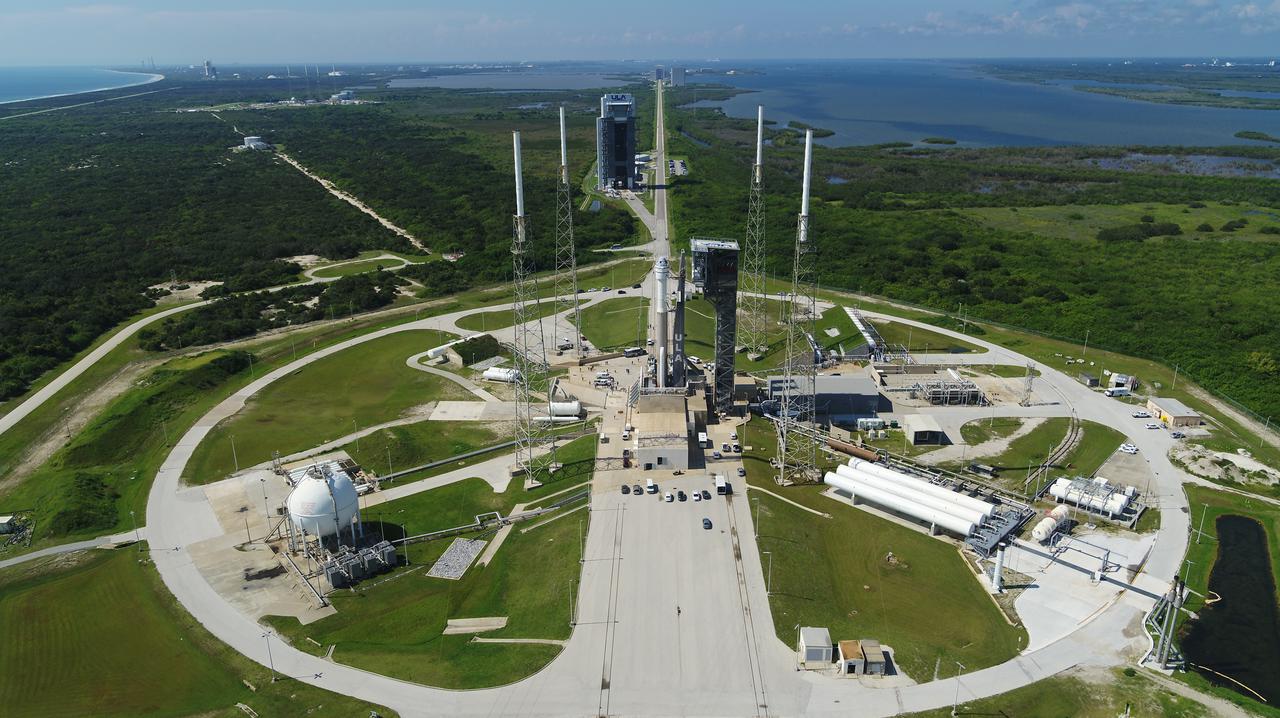
On July 29, 2021, Boeing’s CST-100 Starliner spacecraft and the United Launch Alliance Atlas V rocket rolled out of the Vertical Integration Facility to the launch pad at Space Launch Complex-41 on Cape Canaveral Space Force Station in Florida. Starliner will launch on the Atlas V for Boeing’s second uncrewed Orbital Flight Test (OFT-2) for NASA’s Commercial Crew Program. OFT-2 is an important uncrewed mission designed to test the end-to-end capabilities of the new system for NASA’s Commercial Crew Program.
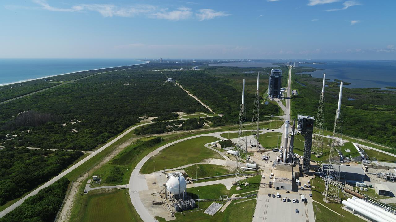
On July 29, 2021, Boeing’s CST-100 Starliner spacecraft and the United Launch Alliance Atlas V rocket rolled out of the Vertical Integration Facility to the launch pad at Space Launch Complex-41 on Cape Canaveral Space Force Station in Florida. Starliner will launch on the Atlas V for Boeing’s second uncrewed Orbital Flight Test (OFT-2) for NASA’s Commercial Crew Program. OFT-2 is an important uncrewed mission designed to test the end-to-end capabilities of the new system for NASA’s Commercial Crew Program.
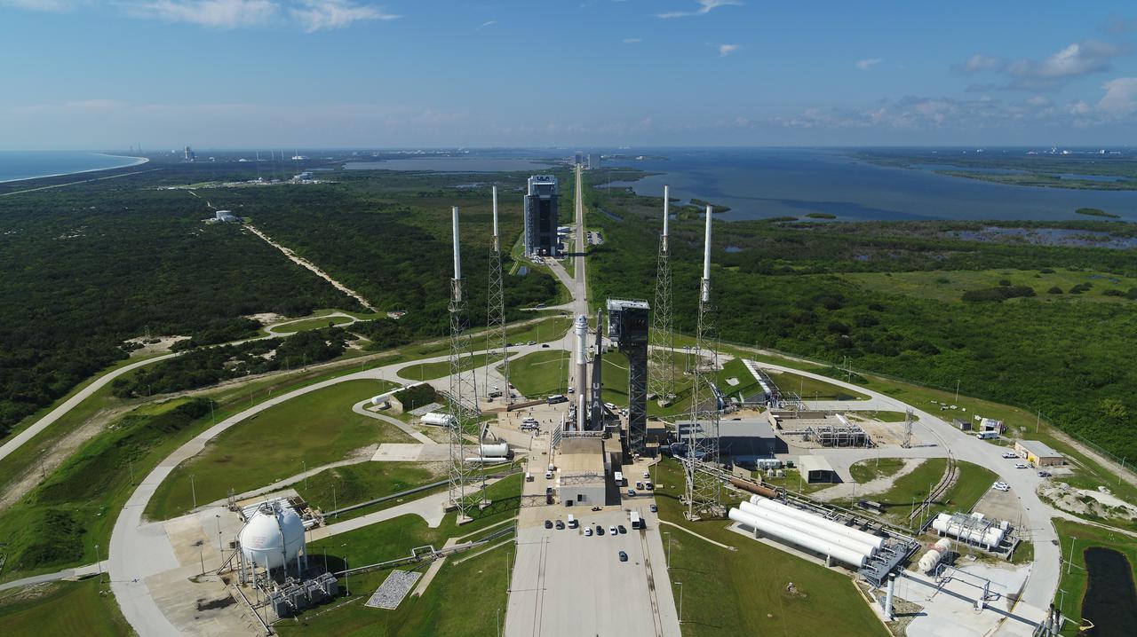
On July 29, 2021, Boeing’s CST-100 Starliner spacecraft and the United Launch Alliance Atlas V rocket rolled out of the Vertical Integration Facility to the launch pad at Space Launch Complex-41 on Cape Canaveral Space Force Station in Florida. Starliner will launch on the Atlas V for Boeing’s second uncrewed Orbital Flight Test (OFT-2) for NASA’s Commercial Crew Program. OFT-2 is an important uncrewed mission designed to test the end-to-end capabilities of the new system for NASA’s Commercial Crew Program.
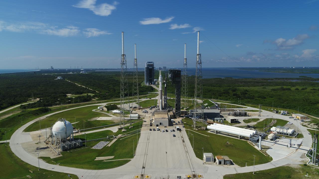
On July 29, 2021, Boeing’s CST-100 Starliner spacecraft and the United Launch Alliance Atlas V rocket rolled out of the Vertical Integration Facility to the launch pad at Space Launch Complex-41 on Cape Canaveral Space Force Station in Florida. Starliner will launch on the Atlas V for Boeing’s second uncrewed Orbital Flight Test (OFT-2) for NASA’s Commercial Crew Program. OFT-2 is an important uncrewed mission designed to test the end-to-end capabilities of the new system for NASA’s Commercial Crew Program.
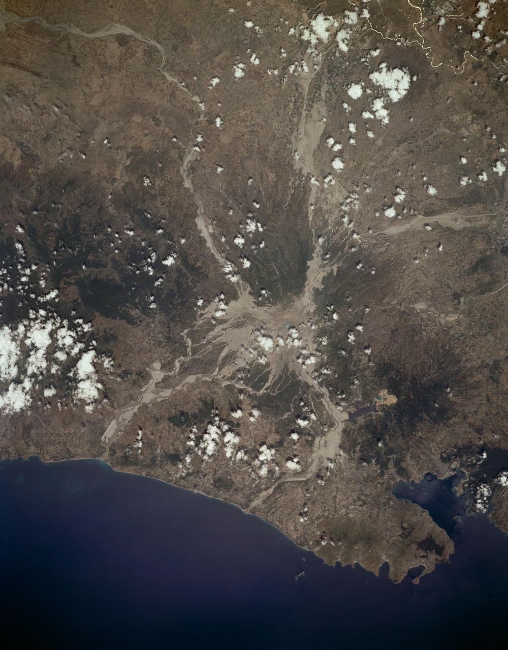
STS059-L14-170 (9-20 April 1994) --- Orient with the sea at the left. Then Subic Bay is at the lower left corner, and Clark Air Force Base (abandoned after the eruption) is to the lower right of the volcano. A turquoise lake occupies the caldera just below the center of the photograph. Mount Pinatubo erupted in June, 1991 after several hundred years of quiescence. Eruptive activity has nearly ceased, but every torrential rain in this monsoonal climate causes renewed mud flows of a viscous slurry composed of volcanic ash and pumice. Shuttle crews have been photographing the mountain at every opportunity, to add documentation to unmanned-satellite, aerial, and ground-based observations of changes. SRL scientists will use the excellent radar imagery obtained during STS-59 to help discriminate among different kinds of volcanic material, and to extend their observations to other volcanoes around the world using future, perhaps unmanned, radar satellites. Linhof photograph.

An oil slick from naturally occurring oil seeps off the coast of Santa Barbara, California. The NASA-NOAA Marine Oil Spill Thickness (MOST) project is using the area to test the ability of a radar instrument called UAVSAR to detect the thickness of oil in oil slicks – important information for first responders to oil spills. Having concluded their second field campaign in Santa Barbara at the end of October, 2021, the MOST team is working to develop a way for NOAA – the lead federal agency for detecting and tracking coastal oil spills – to use remote sensing data to determine not just where oil is, but where the thickest parts of it are. NASA's UAVSAR, or Uninhabited Aerial Vehicle Synthetic Aperture Radar, attaches to the fuselage of an airplane that collects a roughly 12-mile-wide (19-kilometer-wide) image of the area. The instrument sends radar pulses down to the surface of the ocean, and the signals that bounce back are used to detect roughness, caused by waves, at the ocean's surface. Oil dampens the waves, creating areas of smoother water that appear darker than the surrounding clean water in the SAR imagery – the thicker the oil, the darker the area appears. When the project concludes, likely in 2023, scientists hope to have a prototype system for detecting oil spill thickness that can be deployed in emergencies. https://photojournal.jpl.nasa.gov/catalog/PIA23699
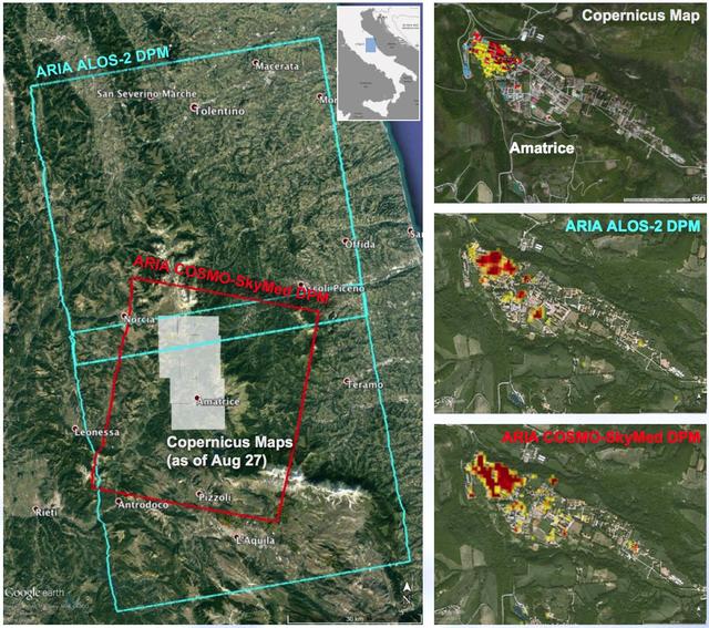
A NASA-funded program provided valuable information for responders and groups supporting the recovery efforts for the Aug. 24, 2016, magnitude 6.2 earthquake that struck central Italy. The earthquake caused significant loss of life and property damage in the town of Amatrice. To assist in the disaster response efforts, scientists at NASA's Jet Propulsion Laboratory and Caltech, both in Pasadena, California, obtained and used radar imagery of the earthquake's hardest-hit region to discriminate areas of damage from that event. The views indicate the extent of damage caused by the earthquake and subsequent aftershocks in and around Amatrice, based on changes to the ground surface detected by radar. The color variations from yellow to red indicate increasingly more significant ground surface change. The damage maps were created from data obtained before and after the earthquake by satellites belonging to the Italian Space Agency (ASI) and the Japan Aerospace Exploration Agency (JAXA). The radar-derived damage maps compare well with a damage map produced by the European Commission Copernicus Emergency Management Service based upon visual inspection of high-resolution pre-earthquake aerial photographs and post-earthquake satellite optical imagery, and provide broader geographic coverage of the earthquake's impact in the region. The X-band COSMO-SkyMed (CSK) data were provided through a research collaboration with ASI and were acquired on July 3, August 20, and August 28, 2016. The L-band ALOS/PALSAR-2 data were provided by JAXA through its science research program and were acquired on September 9, 2015, January 27, 2016, and August 24, 2016. The radar data were processed by the Advanced Rapid Imaging and Analysis (ARIA) team at JPL and Caltech. ARIA is a NASA-funded project that is building an automated system for demonstrating the ability to rapidly and reliably provide GPS and satellite data to support the local, national and international hazard monitoring and response communities. Using space-based imagery of disasters, ARIA data products can provide rapid assessments of the geographic region impacted by a disaster, as well as detailed imaging of the locations where damage occurred. Radar can "see" through clouds day and night and measure centimeter-level ground movements. NASA is partnering with the Indian Space Research Organization (ISRO) to develop the NASA ISRO Synthetic Aperture Radar (NISAR) mission that will routinely provide systematic SAR observations of Earth's land and ice-covered surfaces at least twice every 12 days, enabling greater scientific understanding of the dynamic processes that drive the Earth system and natural hazards, as well as providing actionable support for disaster response and recovery. http://photojournal.jpl.nasa.gov/catalog/PIA21091
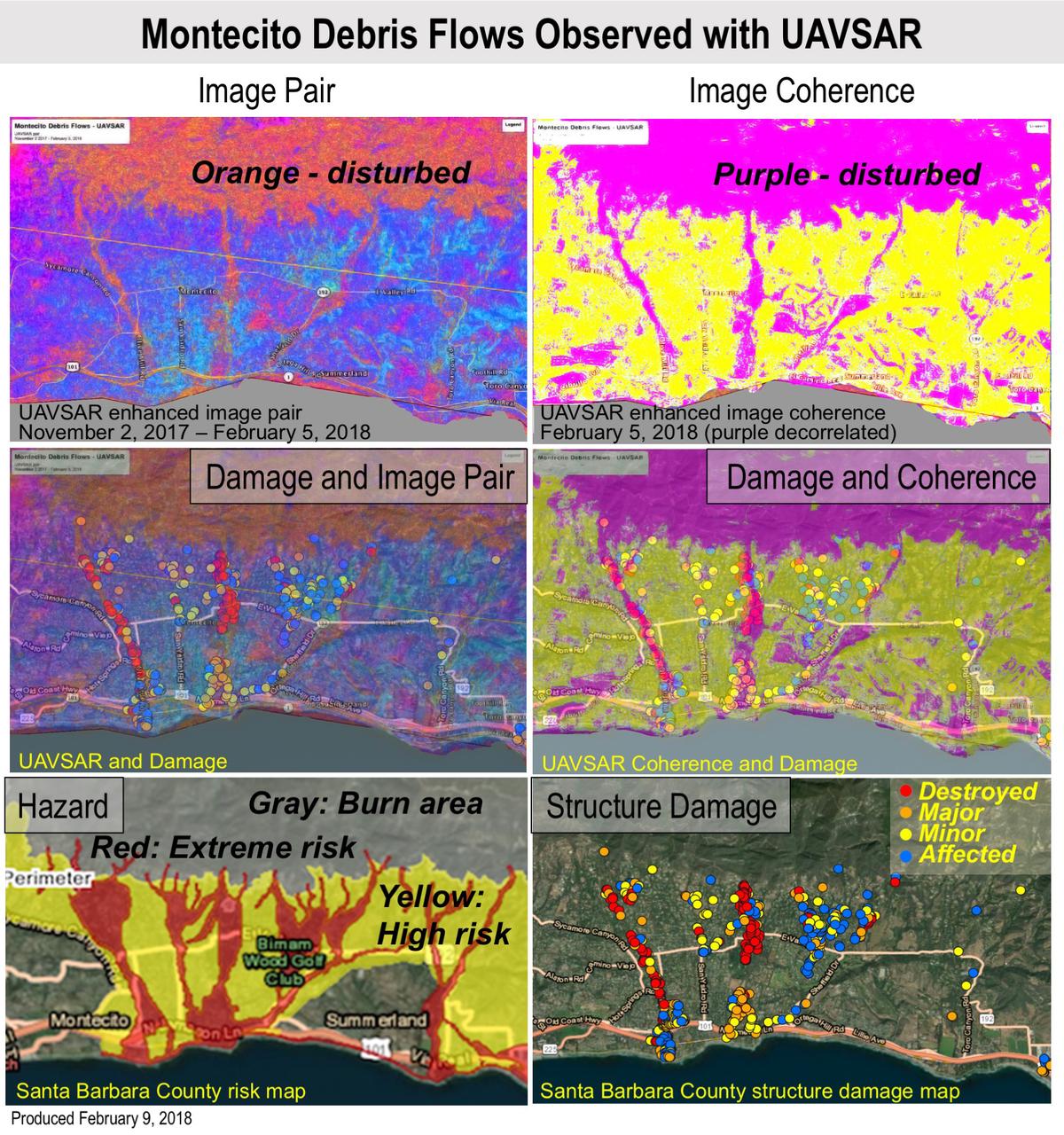
Extreme winter rains in January 2018 following the Thomas Fire in Ventura and Santa Barbara Counties caused severe debris flows, resulting in significant loss of life and considerable property damage in the town on Montecito, just east of Santa Barbara. NASA's Uninhabited Aerial Vehicle Synthetic Aperture Radar (UAVSAR) airborne radar platform detected changes caused by the debris flows between two images acquired on Nov. 2, 2017, and Feb. 5, 2018. An enhanced image pair (top left) shows disturbed areas in orange. In areas of severe surface disruption from the fire scar and debris flows the two image pairs can't be matched and decorrelate (top right). In the middle panels, the radar images are overlaid on the structure damage map produced by the County of Santa Barbara. The fire scars and damage correspond well with the risk map (lower left) and damage map (lower right). With an operational system, products such as these have the potential to augment information available for search and rescue, and for damage assessment for government agencies or the insurance industry. Radar has the advantage of being available in all weather conditions, as it can image through clouds. NASA's Uninhabited Aerial Vehicle Synthetic Aperture Radar (UAVSAR), developed and managed by the Jet Propulsion Laboratory, Pasadena, California, can record changes on the ground beneath the aircraft that occur between multiple flights, which take exactly the same flight path. The instrument is used to monitor how volcanoes, earthquakes, and other natural hazards are changing Earth. The JPL UAVSAR team collected and processed the imagery for Principal Investigator Andrea Donnellan who performed the analysis. She has been conducting ground change research using UAVSAR in this and other regions of California since 2009. https://photojournal.jpl.nasa.gov/catalog/PIA22243
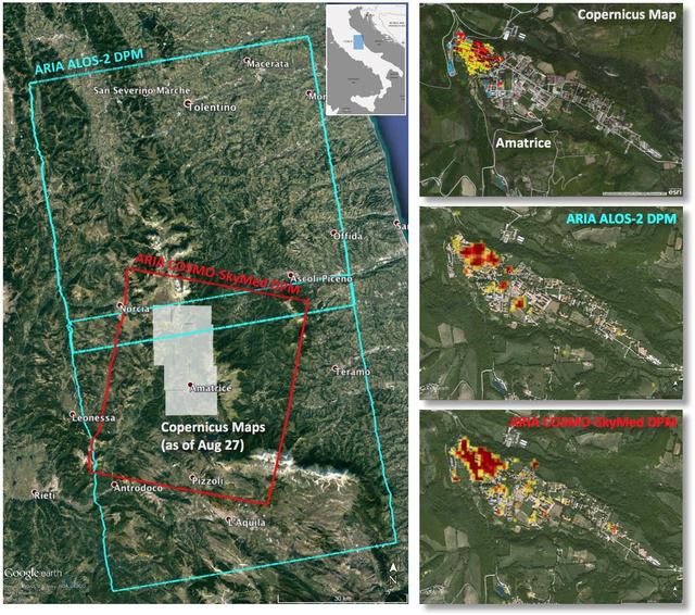
Italy earthquake. The quake has caused significant damage in the historic town of Amatrice. To assist in the disaster response efforts, scientists at NASA's Jet Propulsion Laboratory, Pasadena, California, and the California Institute of Technology in Pasadena, in collaboration with the Italian Space Agency (ASI), generated this image of the earthquake's hardest-hit region. The 40-by-75 mile (65-by-120 kilometer) Damage Proxy Map (DPM) was derived from two consecutive frames of the Japan Aerospace Exploration Agency's (JAXA's) L-band interferometric synthetic aperture radar (InSAR) data from the ALOS-2 satellite (cyan rectangles), and the 25-by-31 mile (40-by-50 kilometer) DPM was derived from InSAR data from the Agenzia Spaciale Italiana's (ASI's) X-band COSMO-SkyMed satellite (red rectangle). Both DPMs cover the historic town of Amatrice, revealing severe damage in the western side of the town (right panels). The time span of the data for the change is Jan. 27, 2016 to Aug. 24, 2016 for ALOS-2 and Aug. 20, 2016 to Aug. 28, 2016 for COSMO-SkyMed. Each pixel in the damage proxy map is about 100 feet (30 meters) across. The SAR data were processed by the Advanced Rapid Imaging and Analysis (ARIA) team at JPL and Caltech. The technique uses a prototype algorithm to rapidly detect surface changes caused by natural or human-produced damage. The assessment technique is most sensitive to destruction of the built environment. When the radar images areas with little to no destruction, its image pixels are transparent. Increased opacity of the radar image pixels reflects damage, with areas in red reflecting the heaviest damage to cities and towns. The color variations from yellow to red indicate increasingly more significant ground surface change. Preliminary validation was done by comparing the DPMs to a damage assessment map produced by the Copernicus Emergency Management Service, which is based on visual inspection of before and after high-resolution aerial imagery -- the extent indicated with gray boxes in the left panel. http://photojournal.jpl.nasa.gov/catalog/PIA20897
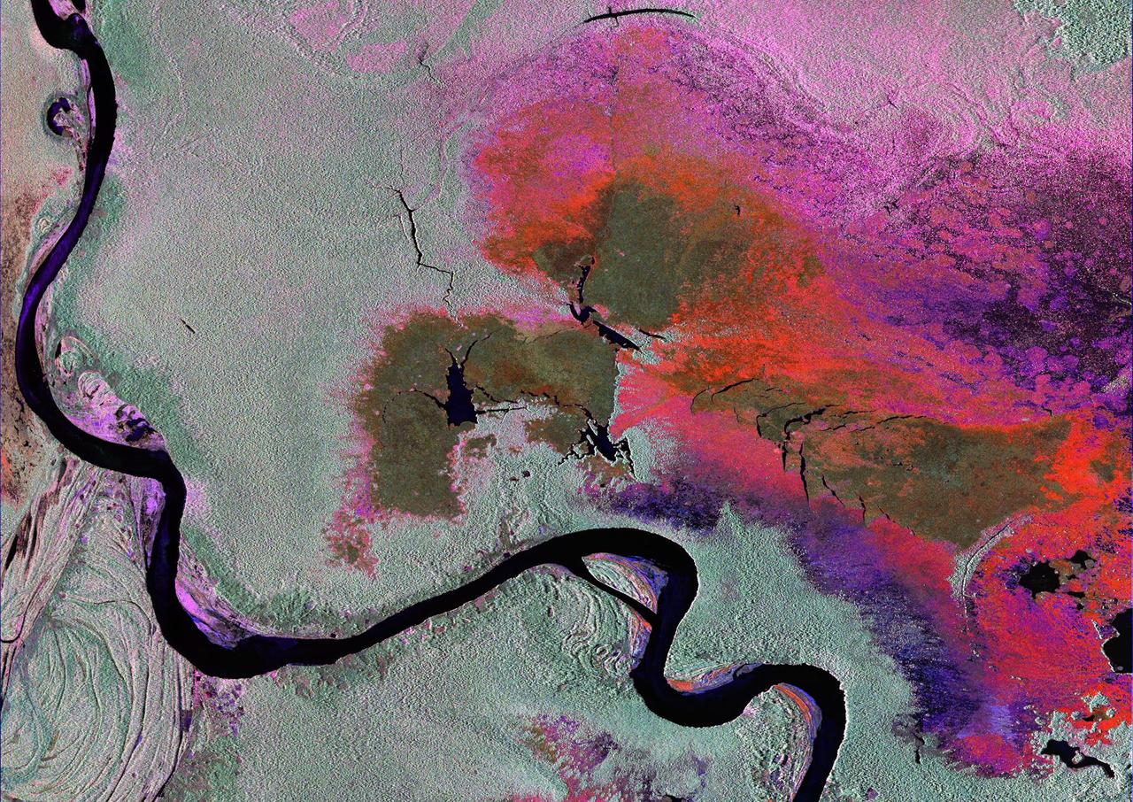
To show the kind of imagery that data from the NISAR (NASA-ISRO Synthetic Aperture Radar) satellite mission will be used to produce, researchers pointed to a 2013 image of flooding extent in the Pacaya-Samaria National Reserve that used data from the Uninhabited Aerial Vehicle Synthetic Aperture Radar (UAVSAR), an airborne system. In the image of this flood-prone area of the Amazonian jungle in Peru, black indicates open water, grayish-green is tropical forest, dark green is low-lying or floating vegetation, and red and pink are two different types of flooded vegetation. NISAR will offer detailed insights into the flooding patterns of the planet's wetland ecosystems, which will help researchers understand how these areas are being affected by climate change and human activity and the role they play in the global carbon cycle. NISAR is a joint mission of the U.S. and Indian space agencies. When in orbit, its sophisticated L- and S-band radar systems will scan nearly all of Earth's land and ice surfaces twice every 12 days with exquisite precision. Scheduled to launch in early 2024, NISAR is an equal collaboration between NASA and the Indian Space Research Organisation and marks the first time the two agencies have cooperated on hardware development for an Earth-observing mission. NASA's Jet Propulsion Laboratory, which is managed for the agency by Caltech in Pasadena, leads the U.S. component of the project and is providing the mission's L-band SAR. NASA is also providing the radar reflector antenna, the deployable boom, a high-rate communication subsystem for science data, GPS receivers, a solid-state recorder, and payload data subsystem. ISRO's U R Rao Satellite Centre in Bengaluru, which is leading the ISRO component of the mission, is providing the spacecraft bus, the S-band SAR electronics, the launch vehicle, and associated launch services and satellite mission operations. https://photojournal.jpl.nasa.gov/catalog/PIA26112