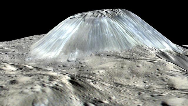
Ceres' lonely mountain, Ahuna Mons, is seen in this simulated perspective view. The elevation has been exaggerated by a factor of two. The view was made using enhanced-color images from NASA's Dawn mission. Images taken using blue (440 nanometers), green (750 nanometers) and infrared (960 nanometers) spectral filters were combined to create the view. The spacecraft's framing camera took the images from Dawn's low-altitude mapping orbit, from an altitude of 240 miles (385 kilometers) in August 2016. The resolution of the component images is 120 feet (35 meters) per pixel. http://photojournal.jpl.nasa.gov/catalog/PIA20915
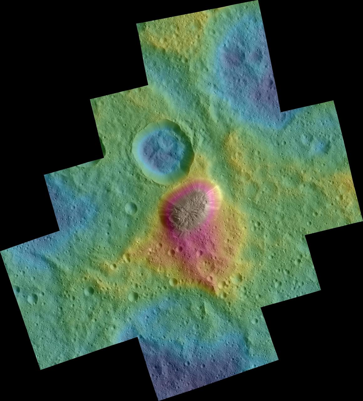
These color topographic views show variations in surface height around Ahuna Mons, a mysterious mountain on Ceres. The views are colorized versions of PIA20348 and PIA20349. They represent an update to the view in PIA19976, which showed the mountain using data from an earlier, higher orbit. Both views were made using images taken by NASA's Dawn spacecraft during its low-altitude mapping orbit, at a distance of about 240 miles (385 kilometers) from the surface. The resolution of the component images is about 120 feet (35 meters) per pixel. Elevations span a range of about 5.5 miles (9 kilometers) from the lowest places in the region to the highest terrains. Blue represents the lowest elevation, and brown is the highest. The streaks running down the side of the mountain, which appear white in the grayscale view, are especially bright parts of the surface (the brightness does not relate to elevation). The elevations are from a shape model generated using images taken at varying sun and viewing angles during Dawn's lower-resolution, high-altitude mapping orbit (HAMO) phase. The side perspective view was generated by draping the image mosaics over the shape model. http://photojournal.jpl.nasa.gov/catalog/PIA20399
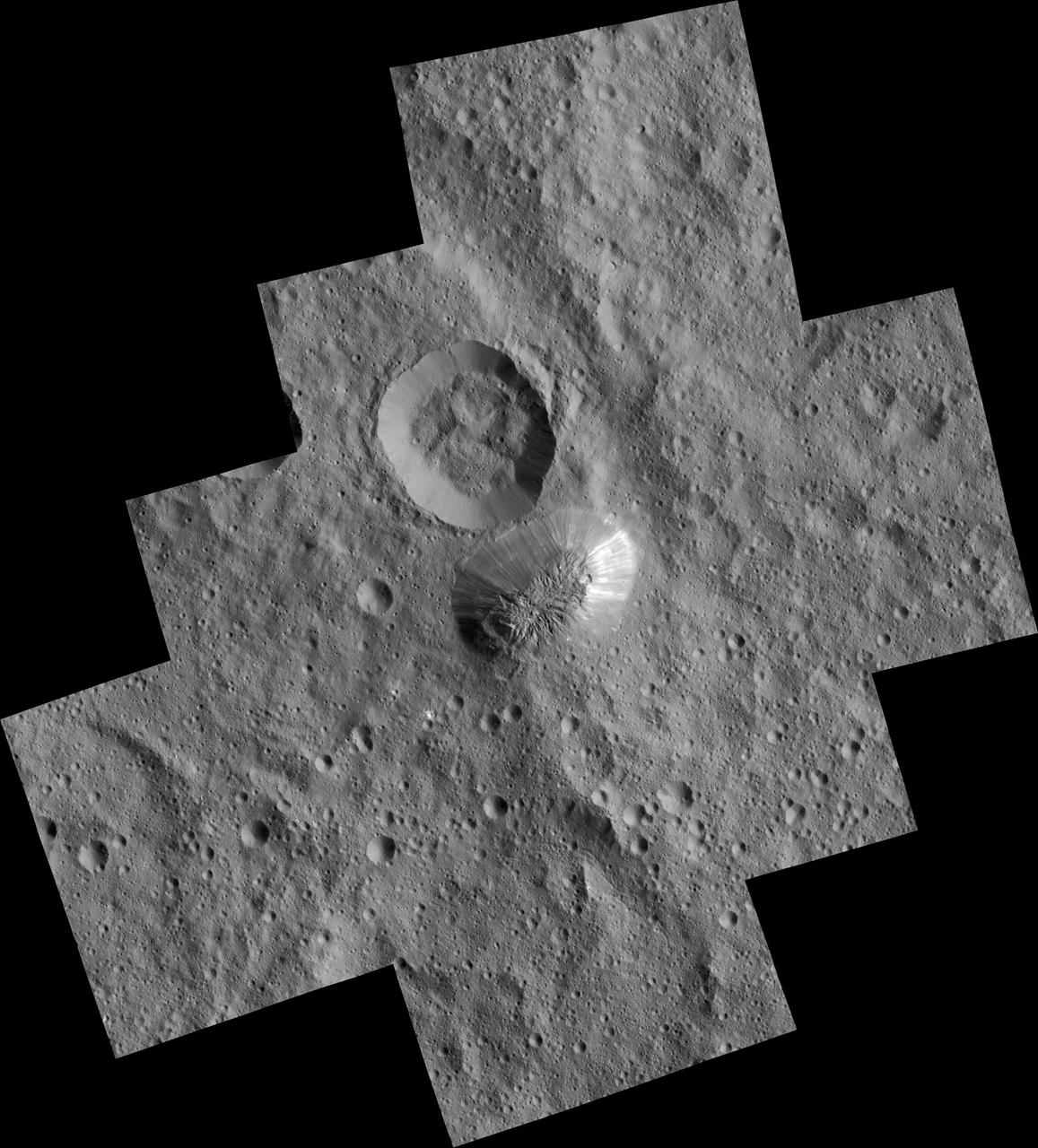
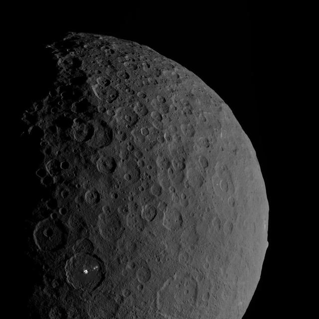
Ceres mysterious mountain Ahuna Mons is seen in this mosaic of images from NASA Dawn spacecraft, taken in December 2015.
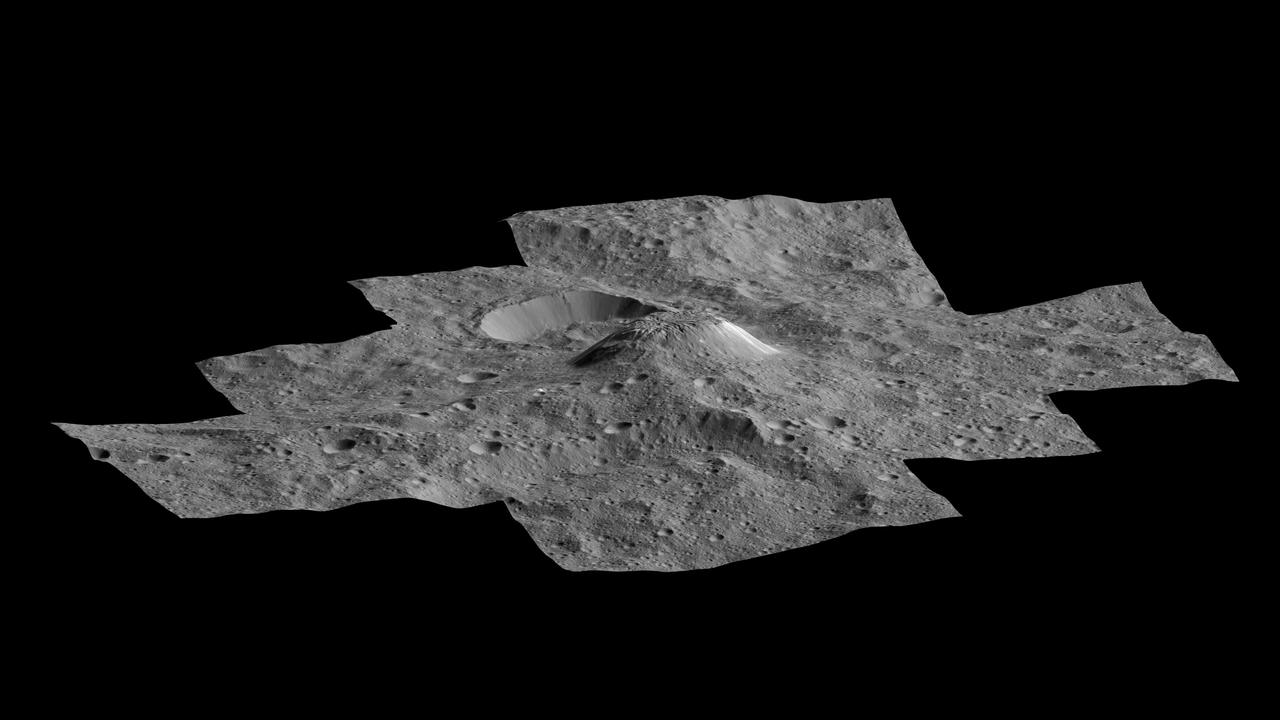
This side-perspective view of Ceres mysterious mountain Ahuna Mons was made with images from NASA Dawn spacecraft. Dawn took these images in December 2015.
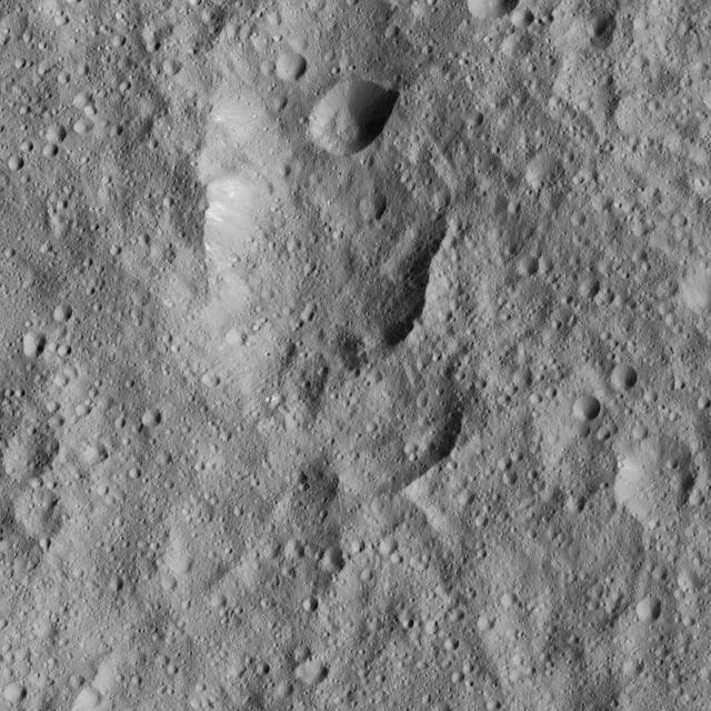
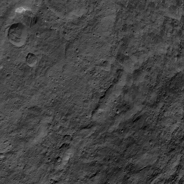
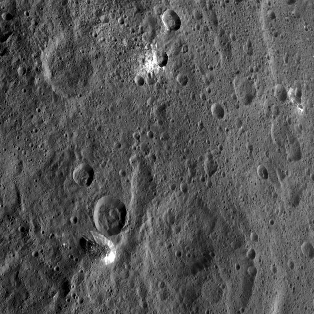
This image from NASA's Dawn spacecraft shows cratered terrain to the west of Ahuna Mons. In this area there are chains of craters called Uhola Catenae. The image is centered at 7 degrees south latitude, 304 degrees east longitude. Dawn took this image on June 13, 2016, from its low-altitude mapping orbit, at a distance of about 240 miles (385 kilometers) above the surface. The image resolution is 120 feet (35 meters) per pixel. http://photojournal.jpl.nasa.gov/catalog/PIA20967
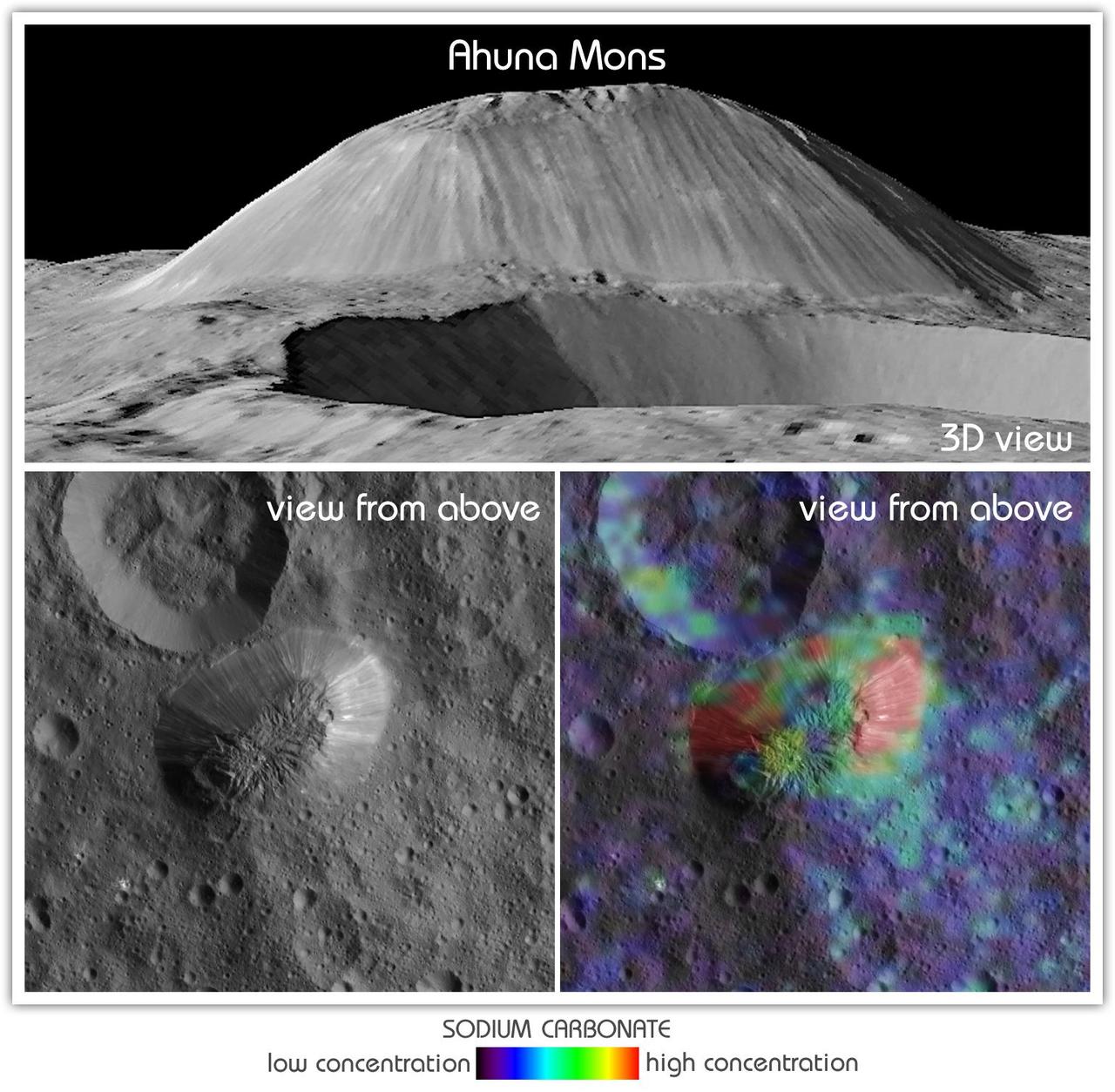
This view from NASA's Dawn mission shows Ceres' tallest mountain, Ahuna Mons, 2.5 miles (4 kilometers) high and 11 miles (17 kilometers) wide. This is one of the few sites on Ceres at which a significant amount of sodium carbonate has been found, shown in green and red colors in the lower right image. The top and lower left images were collected by Dawn's framing camera. The top image is a 3D view reconstructed with the help of topography data. A non-annotated version is available at https://photojournal.jpl.nasa.gov/catalog/PIA21919
This photo of Ceres and one of its key landmarks, Ahuna Mons, was one of the last views Dawn transmitted before it depleted its remaining hydrazine and completed its mission. This view, which faces south, was captured on Sept. 1, 2018 at an altitude of 2,220 miles (3,570 kilometers) as the spacecraft was ascending in its elliptical orbit. At its lowest point, the orbit dipped down to only about 22 miles (35 kilometers), which allowed Dawn to acquire very high-resolution images in this final phase of its mission. Some of the close-up images of Ceres are shown here. Ahuna Mons is about 12 miles (20 kilometers) across and 2.5 miles (4 kilometers) high and displays sodium carbonate along its flanks. This is the most recent of a potential two dozen cryovolcanoes whose remnants are found across Ceres' surface. https://photojournal.jpl.nasa.gov/catalog/PIA22769
The tall, cone-shaped mountain Ahuna Mons is seen in this image taken by NASA's Dawn spacecraft. Ahuna Mons, named for the traditional post-harvest festival of the Sumi tribe of Nagaland in India, is about 4 miles (6 kilometers) tall and 12 miles (20 kilometers) in diameter. Dawn took this image on Oct. 14, 2015, from an altitude of 915 miles (1,470 kilometers). It has a resolution of 450 feet (140 meters) per pixel. http://photojournal.jpl.nasa.gov/catalog/PIA20130
Occator Crater and Ahuna Mons appear together in this view obtained by NASA Dawn spacecraft on Feb. 11, 2017. Ahuna Mons, on the limb at right, is a mountain 2.5 miles (4 kilometers) tall. Occator hosts the mysterious "bright spots" (called faculae) that were revealed by Dawn to be evaporite deposits. Both features are relatively young, share a similar composition -- different from Ceres' average composition -- and hint at recent internal activity in the dwarf planet. Dawn took this image during its third extended-mission science orbit (XMO3), from a distance of about 4,700 miles (7,500 kilometers) above the surface of Ceres. The image resolution is about 2,300 feet (700 meters) per pixel. http://photojournal.jpl.nasa.gov/catalog/PIA11240
This image, taken by NASA's Dawn spacecraft, shows the surface of dwarf planet Ceres from an altitude of 915 miles (1,470 kilometers) around mid-latitudes. The image was taken on Sept. 28, 2015, and has a resolution of 450 feet (140 meters) per pixel. The unusual mountain Ahuna Mons is featured in this image, named for the traditional post-harvest festival of the Sumi tribe of Nagaland, India. It is 4 miles (6 kilometers) tall and 12 miles (20 kilometers) in diameter. http://photojournal.jpl.nasa.gov/catalog/PIA19995
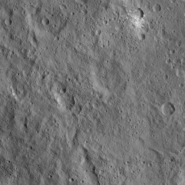
This view of Ceres from NASA Dawn spacecraft shows cratered terrain located immediately to the west of the intriguing mountain feature called Ahuna Mons. North on Ceres is up. A linear feature cuts across the scene from south to north-northwest. A small crater in the northern portion of the image is surrounded by asymmetric ejecta, composed of a mixture of light and dark material. A small crater at center right (east) displays steep flanks and a hummocky floor. The image was taken from a spacecraft altitude of 915 miles (1,470 kilometers) in Dawn's High Altitude Mapping Orbit phase (HAMO) on Oct. 7, 2015. Image resolution is 450 feet (140 meters) per pixel. The image is located at 2 degrees north latitude, 304 degrees east longitude. http://photojournal.jpl.nasa.gov/catalog/PIA20147

This map from NASA's Dawn mission shows locations of bright material on dwarf planet Ceres. There are more than 300 bright areas, called "faculae," on Ceres. Scientists have divided them into four categories: bright areas on the floors of crater (red), on the rims or walls of craters (green), in the ejecta blankets of craters (blue), and on the flanks of the mountain Ahuna Mons (yellow). https://photojournal.jpl.nasa.gov/catalog/PIA21914
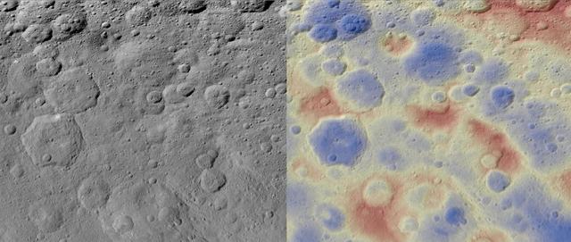
These images show a subtle feature on Ceres called Kwanzaa Tholus. Kwanzaa, meaning "first fruits" in Swahili, is an African-American festival based on ancient African harvest celebrations, and takes place from December 26 to January 1. A tholus is a type of small mountain. Kwanzaa Tholus measures about 22 by 12 miles (35 by 19 kilometers) and is elevated about 2 miles (3 km) above its surroundings. Because the mountain does not rise sharply above the ground, it is difficult to see in the mosaic on the left, although a small crescent-shaped shadow stands out. The image on the right, which is an elevation map of the area, shows where Kwanzaa Tholus is more prominently. The rounded shape of Kwanzaa Tholus is typical of tholi (plural of tholus) in general, but is different than other examples found on Ceres (like Dalien Tholus) and Mars. This region is particularly rich in this type of feature: The current Ceres map shows six named tholi and montes (slightly bigger mountains) in the region (centered around 32 degrees north, 327 degrees east) and several others including Ahuna Mons farther south. Scientists say Kwanzaa Tholus may have once been as prominent as Ahuna Mons, the tallest and most noticeable mountain on Ceres. Ahuna Mons is likely a cryovolcano, a volcano formed by the gradual accumulation of thick, slowly flowing icy materials. Because ice https://www.nasa.gov/feature/goddard/2016/ceres-cryo-volcano/is not strong enough to preserve an elevated structure for extended periods, cryovolcanoes on Ceres are expected to gradually collapse over tens of millions of years. This means Kwanzaa Tholus and other tholi in that area could be degraded mountains, which also formed from cryovolcanic activity. The mosaic on the left combines images taken by NASA's Dawn spacecraft in its high-altitude mapping orbit (HAMO) at about 915 miles (1,470 kilometers) above the surface. The spatial resolution is 450 feet (140 meters) per pixel. https://photojournal.jpl.nasa.gov/catalog/PIA21916

Ceres' lonely mountain, Ahuna Mons, is seen in this simulated perspective view. The elevation has been exaggerated by a factor of two. The view was made using enhanced-color images from NASA's Dawn mission. Images taken using blue (440 nanometers), green (750 nanometers) and infrared (960 nanometers) spectral filters were combined to create the view. The spacecraft's framing camera took the images from Dawn's low-altitude mapping orbit, from an altitude of 240 miles (385 kilometers) in August 2016. The resolution of the component images is 120 feet (35 meters) per pixel. http://photojournal.jpl.nasa.gov/catalog/PIA20915
Xevioso Crater is the small (5.3 miles, 8.5 kilometers in diameter) crater associated with bright ejecta toward the top of this image, taken by NASA's Dawn spacecraft. It is one of the newly named craters on Ceres. Xevioso is located in the vicinity of Ahuna Mons, the tall, lonely mountain seen toward the bottom of the picture. Given that the small impact that formed Xevioso was able to excavate bright material, scientists suspect the material may be found at shallow depth. Its nature and relationship to other bright regions on Ceres is under analysis. The asymmetrical distribution of this bright ejecta indicates Xevioso formed via an oblique impact. Another view of Xevioso can be found here. Xevioso is named for the Fon god of thunder and fertility from the Kingdom of Dahomey, which was located in a region that is now the west African country of Benin. Dawn acquired this picture on October 15, 2015, from its high altitude mapping orbit at about 915 miles (1,470 kilometers) above the surface. The center coordinates of this image are 3.8 degrees south latitude, 314 degrees east longitude, and its resolution is 450 feet (140 meters) per pixel. https://photojournal.jpl.nasa.gov/catalog/PIA21907
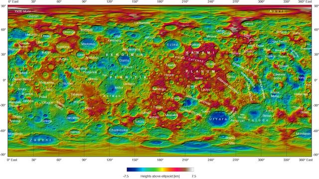
This topographical map of Ceres, made with images from NASA's Dawn spacecraft, shows all of the dwarf planet's named features as of September 2016. Dawn celebrated nine years since launch on September 27, 2016. To date, more than 110 places on Ceres have been named. These include craters such as Occator Crater, home of the brightest areas on the dwarf planet, as well as crater chains called catenae, mountains such as Ahuna Mons, and other geological features Among the most recently named features is Kwanzaa Tholus, named after the African-American winter holiday Kwanzaa, which is based on ancient African harvest festivals. A tholus is a small dome-shaped mountain or hill. There are a total of seven tholi named on Ceres. The latest list of features on Ceres can be found at the USGS Planetary Nomenclature website. http://photojournal.jpl.nasa.gov/catalog/PIA20918

This collage shows some of the most interesting geological sites that NASA's Dawn spacecraft has revealed at dwarf planet Ceres. Images were acquired with the spacecraft's framing camera during various phases of the mission: Survey orbit at a distance of about 2,700 miles (4,400 kilometers); high-altitude mapping orbit (HAMO) at a distance of 915 miles (1,470 kilometers) from Ceres; and low-altitude mapping orbit (LAMO) at an altitude of 240 miles (385 kilometers). In the first row, from left to right: Ceres in shown in false color, roughly centered on Occator Crater, home of the brightest area on Ceres. This picture combines color images obtained by Dawn in its survey orbit. Red corresponds to a wavelength range around 980 nanometers (near infrared), green to a wavelength range around 750 nanometers (red, visible light) and blue to a wavelength range of around 430 nanometers (blue, visible light). This picture illustrates the diversity of terrains on Ceres where the bluish material points to recently emplaced material and the brownish background material is associated with older terrains. Juling Crater (12 miles, 20 kilometers in diameter) as seen in LAMO. Central coordinates are 36 degrees south latitude, 168 degrees east longitude. It is named after the Sakai/Orang Asli (Malaysia) spirit of the crops. This crater displays evidence for the presence of ice -- for example, in the form of a large flow feature seen at the top of the image. Oxo Crater (6 miles, 10 kilometers in diameter) as seen in LAMO. Center coordinates are 42 degrees north latitude, 0 degrees east longitude. It is named after the god of agriculture in Afro-Brazilian beliefs of Yoruba derivation. Oxo hosts the first site at which Dawn detected ice on Ceres, exposed by a landslide. Ahuna Mons is not only a volcano, but also the tallest mountain on Ceres. It is about 2.5 miles (4 kilometers) high and 11 miles (17 kilometers) wide. Center coordinates are 10 degrees south latitude, 316 degrees east longitude. This view combines images obtained in LAMO in blue (430 nanometers), green (750 nanometers) and infrared (980 nanometers) color filters. Ahuna is named after the Sumi tribe (Nagaland, northeastern India) traditional post-harvest thanksgiving festival. Second Row Occator Crater (57 miles, 92 kilometers across) is seen in LAMO images. Center coordinates are 20 degrees north latitude, 239 degrees east longitude. Named after the Roman agricultural deity of the harrowing. This image shows a "Type I" flow feature with a thick "toe" typical of rock glaciers and icy landslides on Earth as viewed in LAMO. The flow feature, found in Ghanan Crater (77 degrees north latitude, 31 degrees east longitude), is one of the most voluminous on Ceres. Enhanced color view of Haulani Crater (21 miles, 34 kilometers in diameter) in color observed in HAMO. Central coordinates: 6 degrees north latitude, 11 degrees east longitude. Named after the Hawaiian plant goddess. Kokopelli Crater (21 miles, 34 kilometers in diameter) seen in LAMO. Central coordinates: 18 degrees north latitude, 125 degrees east longitude. Named after the Pueblo (SW USA) fertility deity, who presides over agriculture. This crater displays a nice arrangement of scarps that likely formed when the crater partly collapsed during its formation. Third Row Central region of Occator Crater, called Cerealia Facula, seen in color. The facula -- or "bright spot" -- is about 9 miles (14 kilometers) in diameter. Center coordinates: 20 N, 240 E. Cerealia refers to the major festival in Ancient Rome that celebrates the grain goddess Ceres (8 days in mid- to late April). The view was produced by combining the highest resolution images of Occator obtained in LAMO (at image scales of 35 meters, or 115 feet, per pixel) with color images obtained in HAMO (at image scales of 135 meters, or about 440 feet, per pixel). The three images used to produce the color were taken using filters centered at 430, 750 and 980 nanometers (the last being slightly beyond the range of human vision, in the near-infrared). North part of Nar Sulcus seen in LAMO. The full feature is about 39 miles (63 km) in length and is located around 42 degrees south latitude, 280 degrees east longitude. Nar is a Azerbaijani festival of pomegranate harvest held in October-November in Goychay city, center of pomegranate cultivation in Azerbaijan. A sulcus is a set of parallel furrows or ridges. Ikapati Crater (31 miles, 50 kilometers in diameter) seen in LAMO. Central coordinates: 34 degrees north latitude, 46 degrees east longitude. Ikapati is named after the Philippine goddess of the cultivated lands. The crater has a smooth floor, probably because heat from the impact that formed Ikapati caused ice in the ground to melt, and then refreeze. This view of Ceres, taken in LAMO, shows an area located at approximately 86 degrees south longitude, 177 degrees east longitude. This part of Ceres, near the south pole, has such long shadows because, from the perspective of this location, the sun is near the horizon. At the time this image was taken, the sun was 4 degrees north of the equator. If you were standing this close to Ceres' south pole, the sun would never get high in the sky during the course of a nine-hour Cerean day. https://photojournal.jpl.nasa.gov/catalog/PIA22090