
Students learn about research model aircraft and spacecraft built in the Aerospace Composite and Model Development Section during a visit to NASA Langley Research Center, Wednesday, April 29, 2026. Photo Credit (NASA/ Mark L. Knopp)

Students learn about research model aircraft and spacecraft built in the Aerospace Composite and Model Development Section during a visit to NASA Langley Research Center, Wednesday, April 29, 2026. Photo Credit (NASA/ Mark L. Knopp)

Students learn about research model aircraft and spacecraft built in the Aerospace Composite and Model Development Section during a visit to NASA Langley Research Center, Wednesday, April 29, 2026. Photo Credit (NASA/Ryan H. Hill)

Students learn about research model aircraft and spacecraft built in the Aerospace Composite and Model Development Section during a visit to NASA Langley Research Center, Wednesday, April 29, 2026. Photo Credit (NASA/Ryan H. Hill)

Students learn about research model aircraft and spacecraft built in the Aerospace Composite and Model Development Section during a visit to NASA Langley Research Center, Wednesday, April 29, 2026. Photo Credit (NASA/Ryan H. Hill)

Students learn about research model aircraft and spacecraft built in the Aerospace Composite and Model Development Section during a visit to NASA Langley Research Center, Wednesday, April 29, 2026. Photo Credit (NASA/Ryan H. Hill)

Students learn about research model aircraft and spacecraft built in the Aerospace Composite and Model Development Section during a visit to NASA Langley Research Center, Wednesday, April 29, 2026. Photo Credit (NASA/Ryan H. Hill)

Students learn about research model aircraft and spacecraft built in the Aerospace Composite and Model Development Section during a visit to NASA Langley Research Center, Wednesday, April 29, 2026. Photo Credit (NASA/Ryan H. Hill)
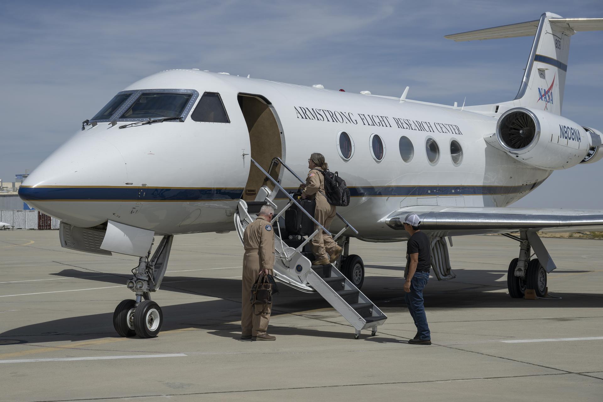
NASA pilot Carrie Worth, center, and Tracy Phelps, left, board the Gulfstream G-III aircraft on Friday, March 27, 2026, at NASA’s Armstrong Flight Research Center in Edwards, California. Manny Rodriguez, crew chief, prepares the aircraft for flight. The G-III will join other NASA aircraft to capture imagery of the Orion spacecraft’s heat shield during Artemis II reentry. The mission is part of NASA’s Scientifically Calibrated In-Flight Imagery (SCIFLI) project, based at NASA’s Langley Research Center in Hampton, Virginia.
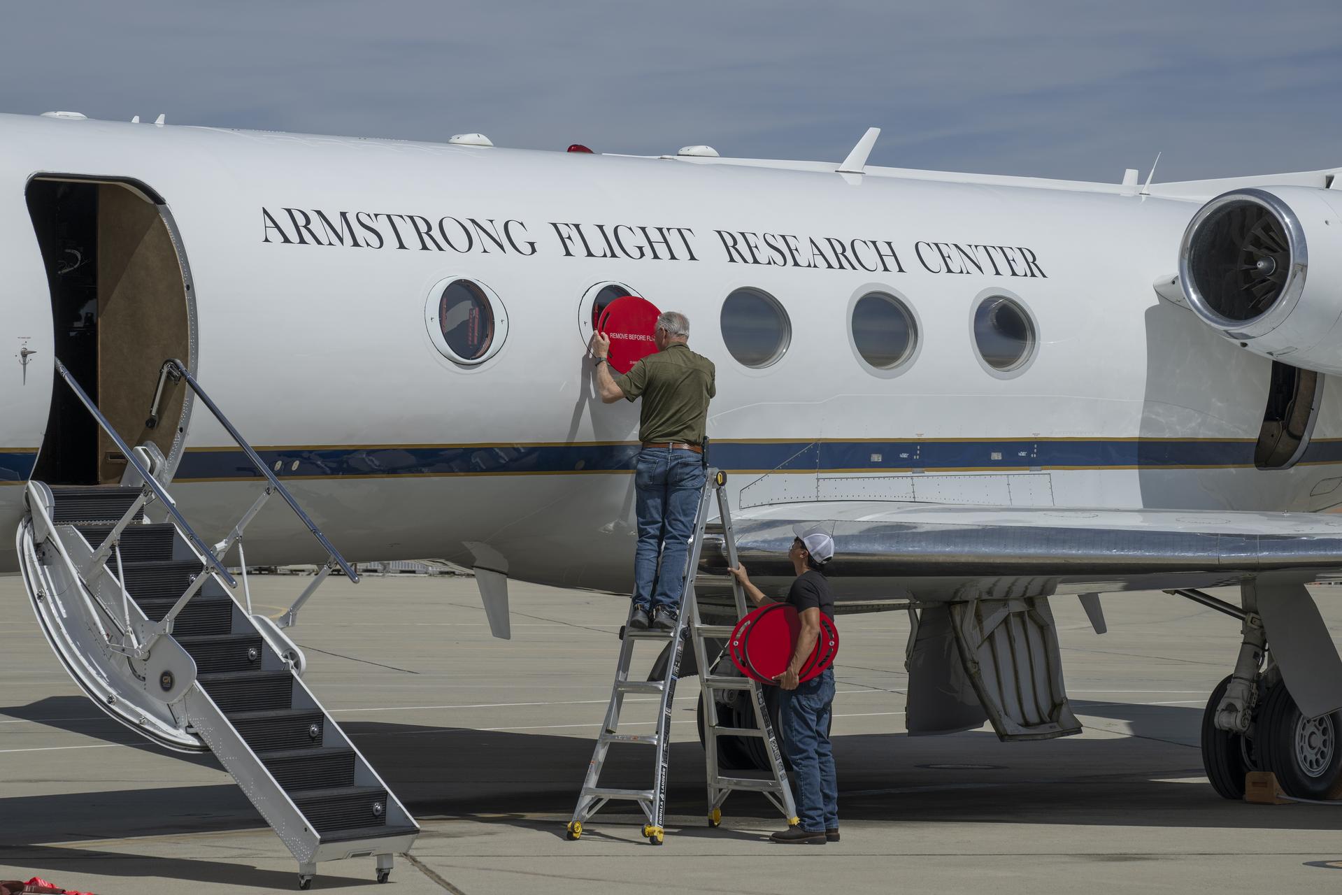
Scott Erickson, left, a quality assurance inspector, and Manny Rodriguez, Gulfstream G-III aircraft crew chief, remove window coverings from the aircraft on Friday, March 27, 2026, at NASA’s Armstrong Flight Research Center in Edwards, California. The G-III will join other NASA aircraft to capture imagery of the Orion spacecraft’s heat shield during Artemis II reentry. The mission is part of NASA’s Scientifically Calibrated In-Flight Imagery (SCIFLI) project, based at NASA’s Langley Research Center in Hampton, Virginia.

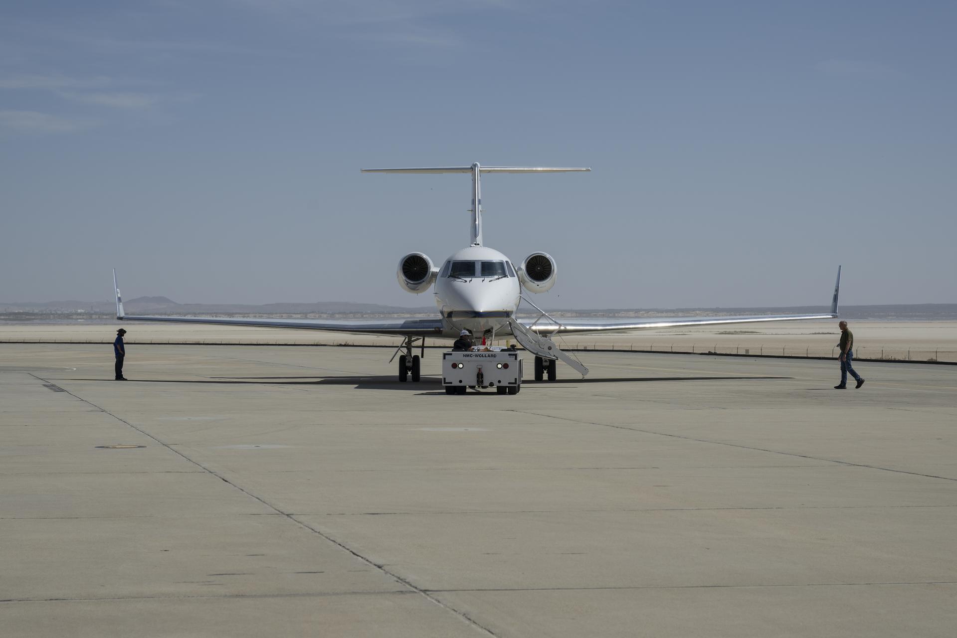
The Dryden Aeronautical Test Range at NASA’s Armstrong Flight Research Center in California uses radars, such as those in the photo, for tracking aircraft and spacecraft.

The Dryden Aeronautical Test Range at NASA’s Armstrong Flight Research Center in California uses radars, such as those in the photo, for tracking aircraft and spacecraft.
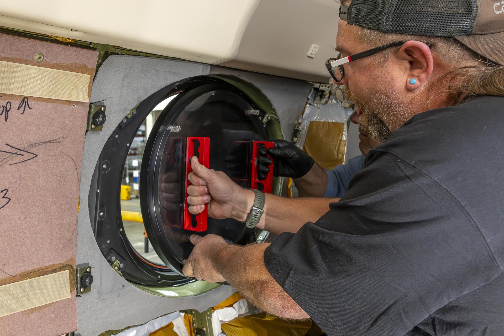
Aircraft mechanic Brian Harness, left, and mechanic Eric Apikian install a temporary aircraft window on a NASA Gulfstream G-III aircraft on Wednesday, Jan. 7, 2026, at NASA’s Armstrong Flight Research Center in Edwards, California. The modifications prepare the aircraft to join three others flying at different altitudes to capture a complete view of the Orion spacecraft’s heat shield during Artemis II reentry. This effort is part of NASA’s Scientifically Calibrated In-Flight Imagery project.
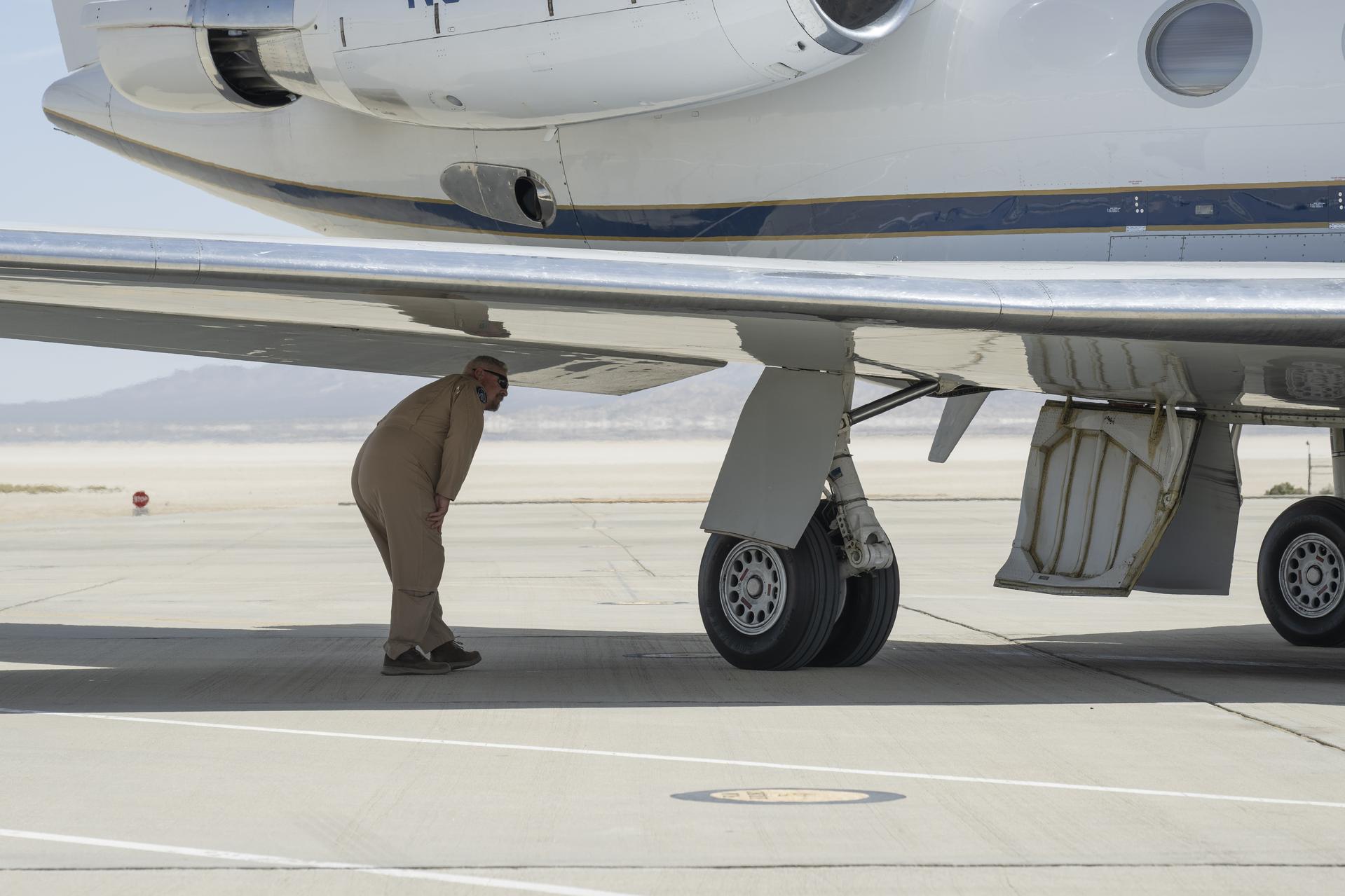
NASA pilot Tracy Phelps inspects the Gulfstream G-III aircraft on Friday, March 27, 2026, at NASA’s Armstrong Flight Research Center in Edwards, California. The G-III will join other NASA aircraft to capture imagery of the Orion spacecraft’s heat shield during Artemis II reentry. The mission is part of NASA’s Scientifically Calibrated In-Flight Imagery (SCIFLI) project, based at NASA’s Langley Research Center in Hampton, Virginia.
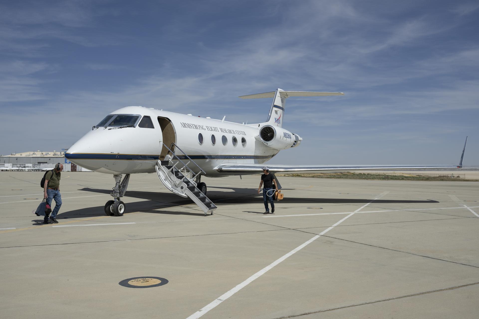
Scott Erickson, left, a quality assurance inspector, and Manny Rodriguez, Gulfstream G-III crew chief, prepare the aircraft for flight on Friday, March 27, 2026, at NASA’s Armstrong Flight Research Center in Edwards, California. The G-III will join other NASA aircraft to capture imagery of the Orion spacecraft’s heat shield during Artemis II reentry. The mission is part of NASA’s Scientifically Calibrated In-Flight Imagery (SCIFLI) project, based at NASA’s Langley Research Center in Hampton, Virginia.
Manny Rodriguez, center, Gulfstream G-III aircraft crew chief, drives a tug while mechanic Marlon Espinoza, left, and Scott Erickson, a quality assurance inspector, prepare the aircraft for takeoff on Friday, March 27, 2026, at NASA’s Armstrong Flight Research Center in Edwards, California. The G-III will join other NASA aircraft to capture imagery of the Orion spacecraft’s heat shield during Artemis II reentry. The mission is part of NASA’s Scientifically Calibrated In-Flight Imagery (SCIFLI) project, based at NASA’s Langley Research Center in Hampton, Virginia.
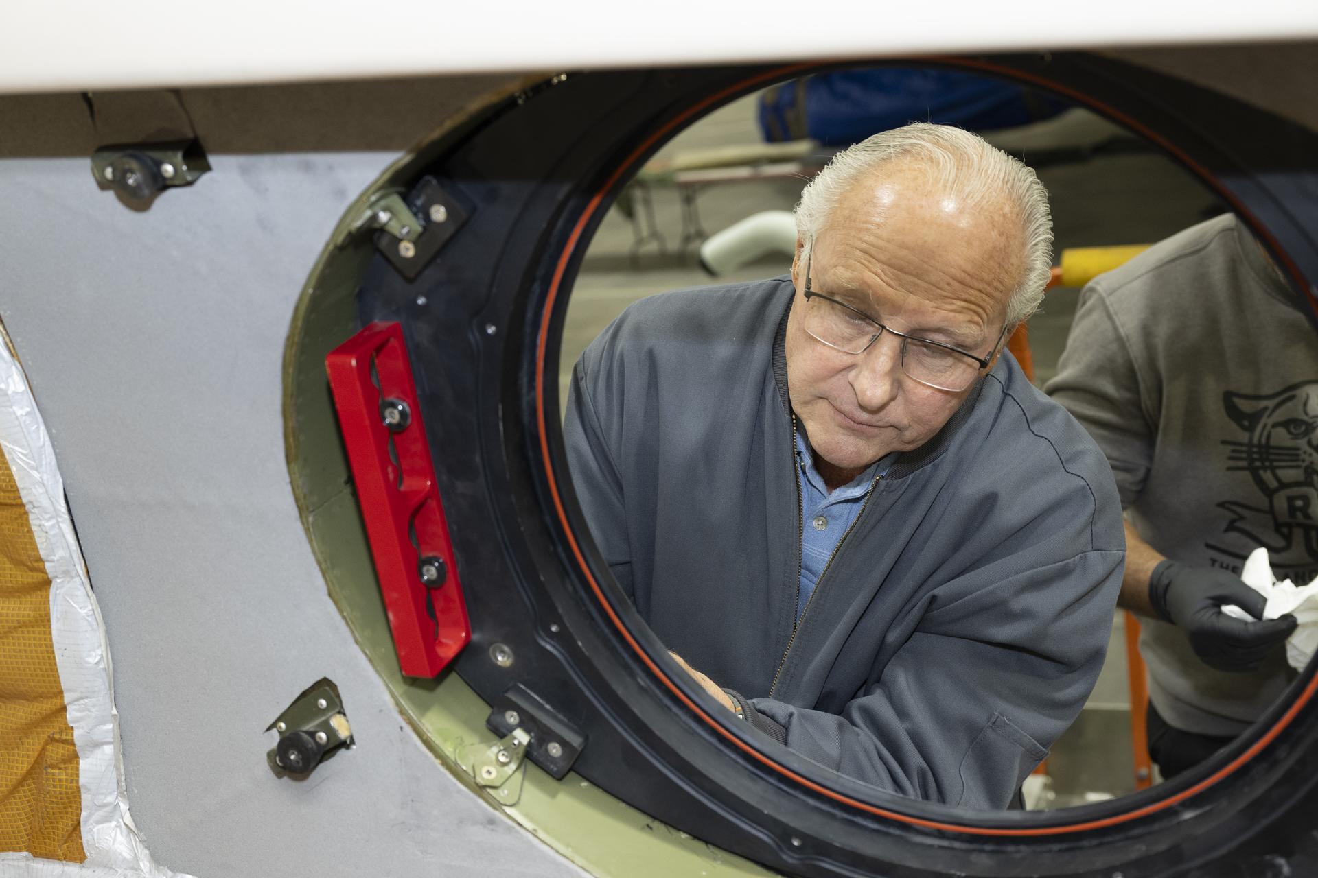
Scott Erickson, a quality assurance inspector, reviews installation of a temporary aircraft window on a NASA Gulfstream G-III aircraft on Wednesday, Jan. 7, 2026, at NASA’s Armstrong Flight Research Center in Edwards, California. The modifications prepare the aircraft to join three others flying at different altitudes to capture a complete view of the Orion spacecraft’s heat shield during Artemis II reentry. This effort is part of NASA’s Scientifically Calibrated In-Flight Imagery project.
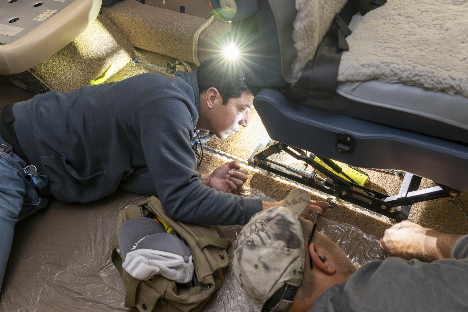
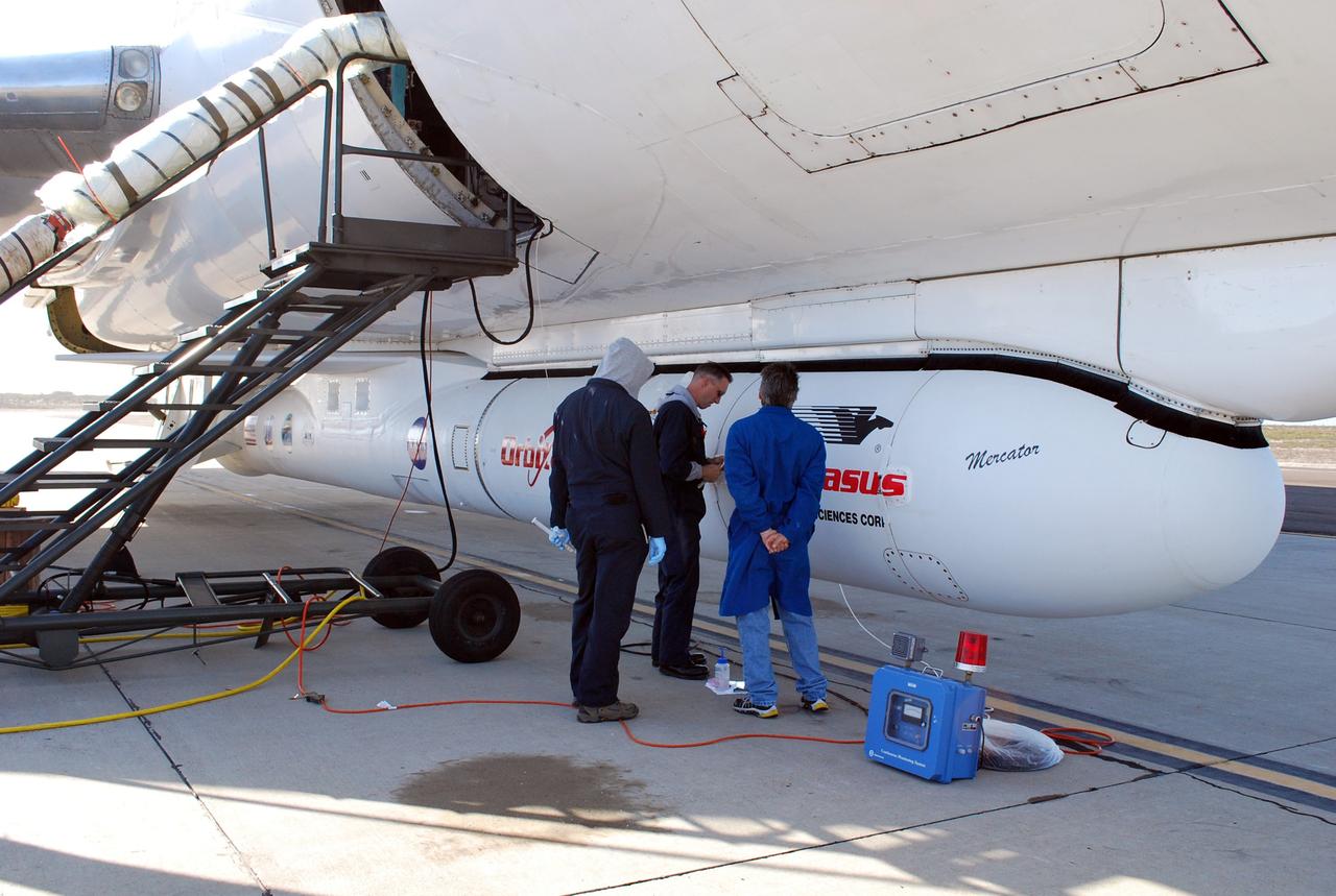
Manny Rodriguez, Gulfstream G-III aircraft crew chief, left, and Eric Apikian, aircraft mechanic, attach an instrumented seat onto a G-III on Wednesday, Jan. 7, 2026, at NASA’s Armstrong Flight Research Center in Edwards, California. The modifications prepare the aircraft to join three others flying at different altitudes to capture a complete view of the Orion spacecraft’s heat shield during Artemis II reentry. This effort is part of NASA’s Scientifically Calibrated In-Flight Imagery project.
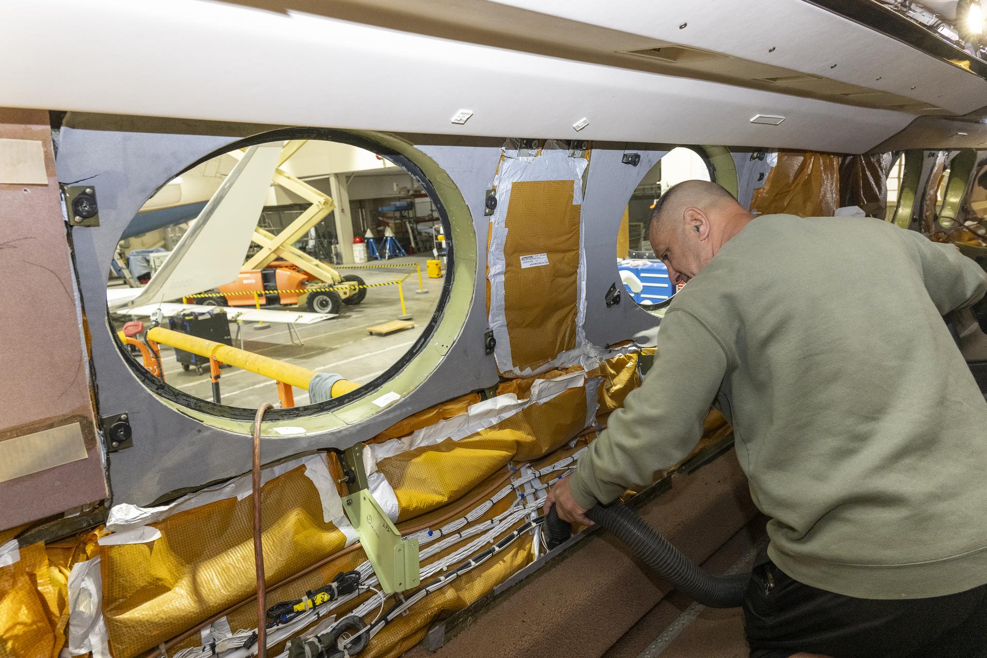
Eric Apikian, an aircraft mechanic, vacuums a NASA Gulfstream G-III aircraft compartment after wiring was added for sensors on Wednesday, Jan. 7, 2026, at NASA’s Armstrong Flight Research Center in Edwards, California. The modifications prepare the aircraft to join three others flying at different altitudes to capture a complete view of the Orion spacecraft’s heat shield during Artemis II reentry. This effort is part of NASA’s Scientifically Calibrated In-Flight Imagery project.
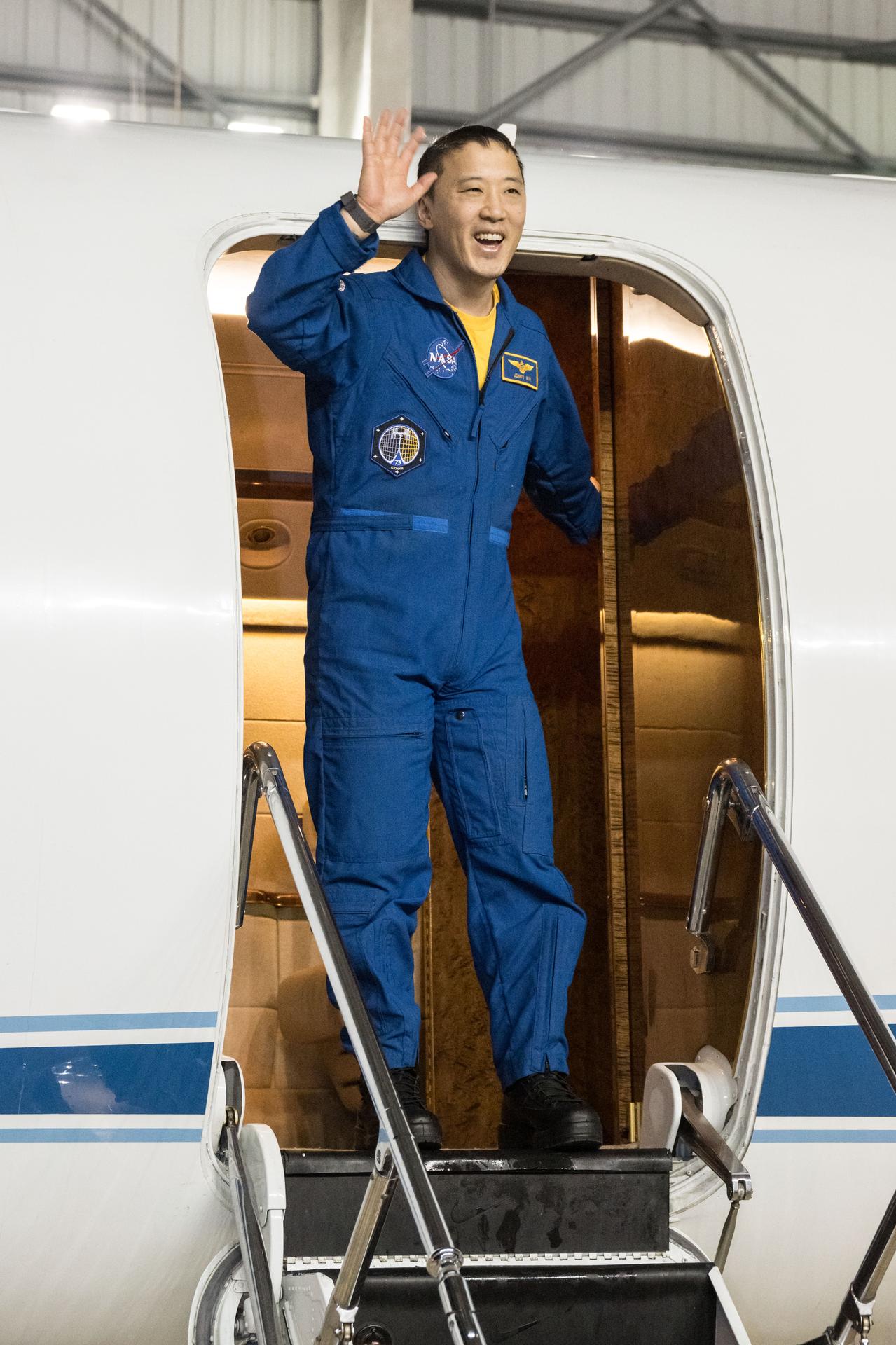
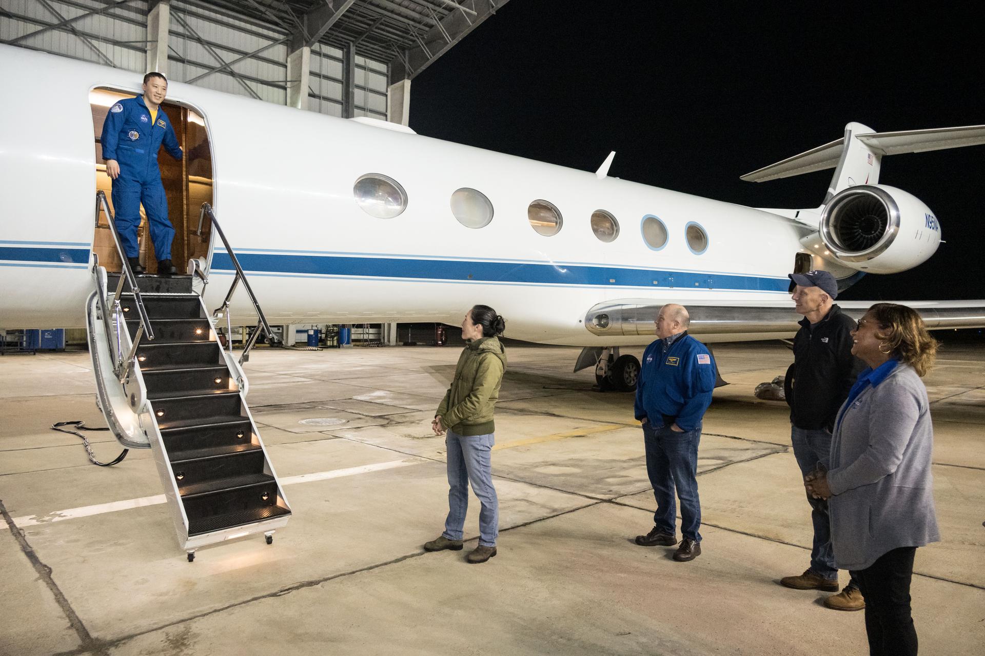
jsc2025e089530 (Dec. 10, 2025) --- NASA astronaut Jonny Kim waves to NASA personnel at Ellington Field after exiting the Gulfstream V aircraft that returned him to Houston, Texas, from Kazakhstan in Central Asia. The day before, Kim had landed in Kazakhstan aboard the Soyuz MS-27 crew spacecraft with Roscosmos cosmonauts Sergey Ryzhikov and Alexey Zubritsky after completing a 245-day research mission aboard the International Space Station. Credit: NASA/Robert Markowitz
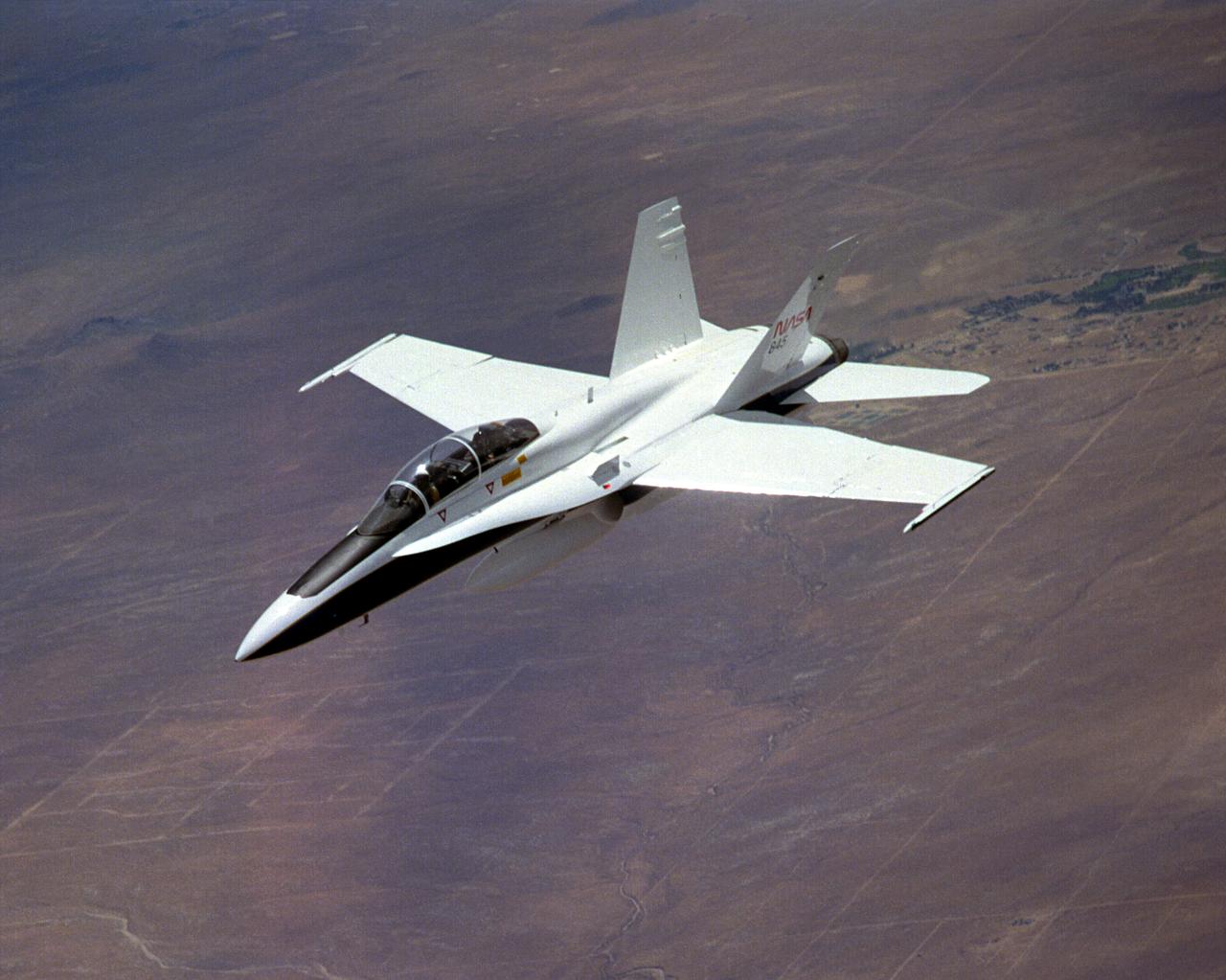
The National Aeronautics and Space Administration's Systems Research Aircraft (SRA), a highly modified F-18 jet fighter, during a research flight. The former Navy aircraft was flown by NASA's Dryden Flight Research Center at Edwards Air Force Base, California, to evaluate a number of experimental aerospace technologies in a multi-year, joint NASA/DOD/industry program. Among the more than 20 experiments flight-tested were several involving fiber optic sensor systems. Experiments developed by McDonnell-Douglas and Lockheed-Martin centered on installation and maintenace techniques for various types of fiber-optic hardware proposed for use in military and commercial aircraft, while a Parker-Hannifin experiment focused in alternative fiber-optic designs for position measurement sensors as well as operational experience in handling optical sensor systems. Other experiments flown on this testbed aircraft included electronically-controlled control surface actuators, flush air data collection systems, "smart" skin antennae and laser-based systems. Incorporation of one or more of these technologies in future aircraft and spacecraft could result in signifigant savings in weight, maintenance and overall cost.
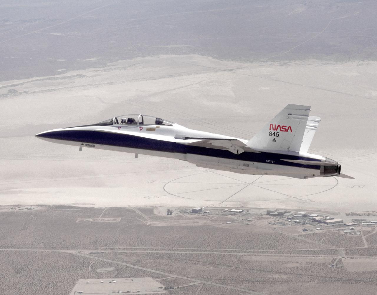
The National Aeronautics and Space Administration's Systems Research Aircraft (SRA), a highly modified F-18 jet fighter, on an early research flight over Rogers Dry Lake. The former Navy aircraft was flown by NASA's Dryden Flight Research Center at Edwards Air Force Base, California, to evaluate a number of experimental aerospace technologies in a multi-year, joint NASA/DOD/industry program. Among the more than 20 experiments flight-tested were several involving fiber optic sensor systems. Experiments developed by McDonnell-Douglas and Lockheed-Martin centered on installation and maintenace techniques for various types of fiber-optic hardware proposed for use in military and commercial aircraft, while a Parker-Hannifin experiment focused on alternative fiber-optic designs for postion measurement sensors as well as operational experience in handling optical sensor systems. Other experiments flown on this testbed aircraft included electronically-controlled control surface actuators, flush air data collection systems, "smart" skin antennae and laser-based systems. Incorporation of one or more of these technologies in future aircraft and spacecraft could result in signifigant savings in weight, maintenance and overall cost.
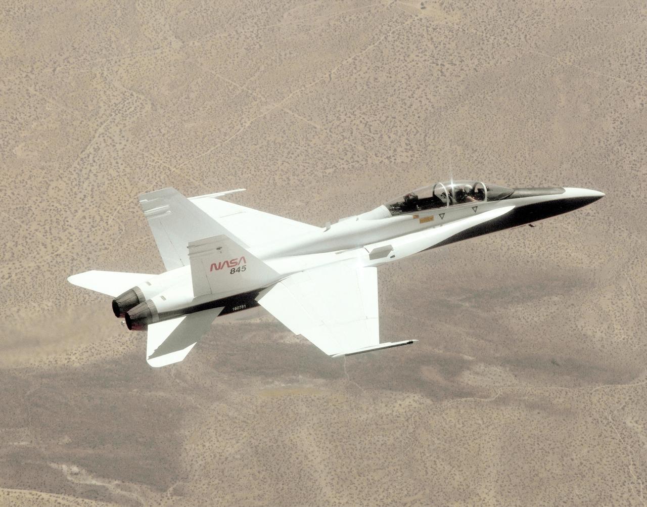
A NASA F/A-18, specially modified to test the newest and most advanced system technologies, on its first research flight on May 21, 1993, at NASA's Dryden Flight Research Facility, Edwards, California. Flown by Dryden in a multi-year, joint NASA/DOD/industry program, the F/A-18 former Navy fighter was modified into a unique Systems Research Aircraft (SRA) to investigate a host of new technologies in the areas of flight controls, airdata sensing and advanced computing. The primary goal of the SRA program was to validate through flight research cutting-edge technologies which could benefit future aircraft and spacecraft by improving efficiency and performance, reducing weight and complexity, with a resultant reduction on development and operational costs.
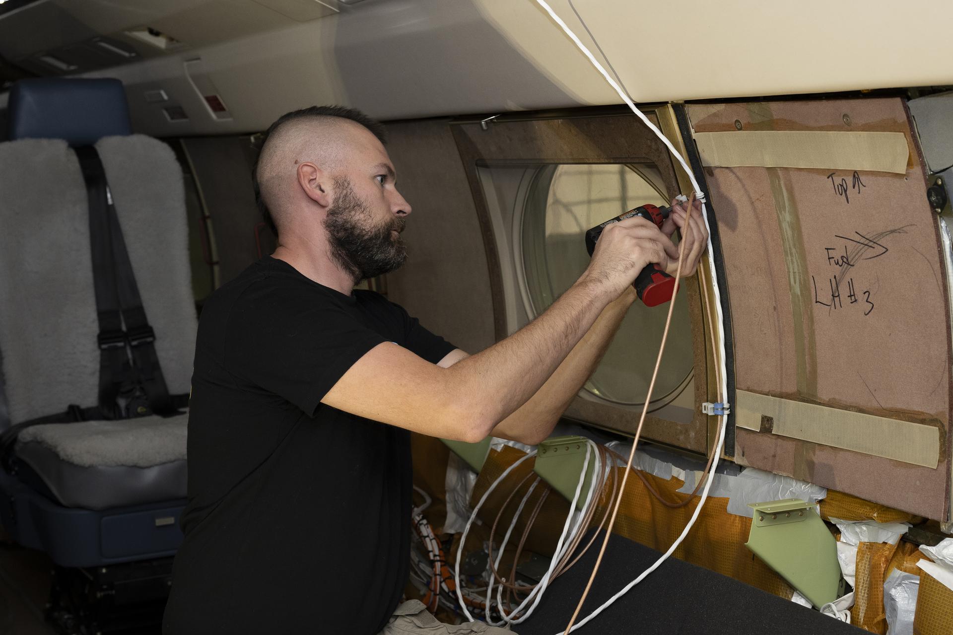
Kelly Jellison, an avionics lead, installs a clip to secure wiring installed on a NASA Gulfstream G-III aircraft on Wednesday, Jan. 7, 2026, at NASA’s Armstrong Flight Research Center in Edwards, California. The modifications prepare the aircraft to join three others flying at different altitudes to capture a complete view of the Orion spacecraft’s heat shield during Artemis II reentry. This effort is part of NASA’s Scientifically Calibrated In-Flight Imagery project.
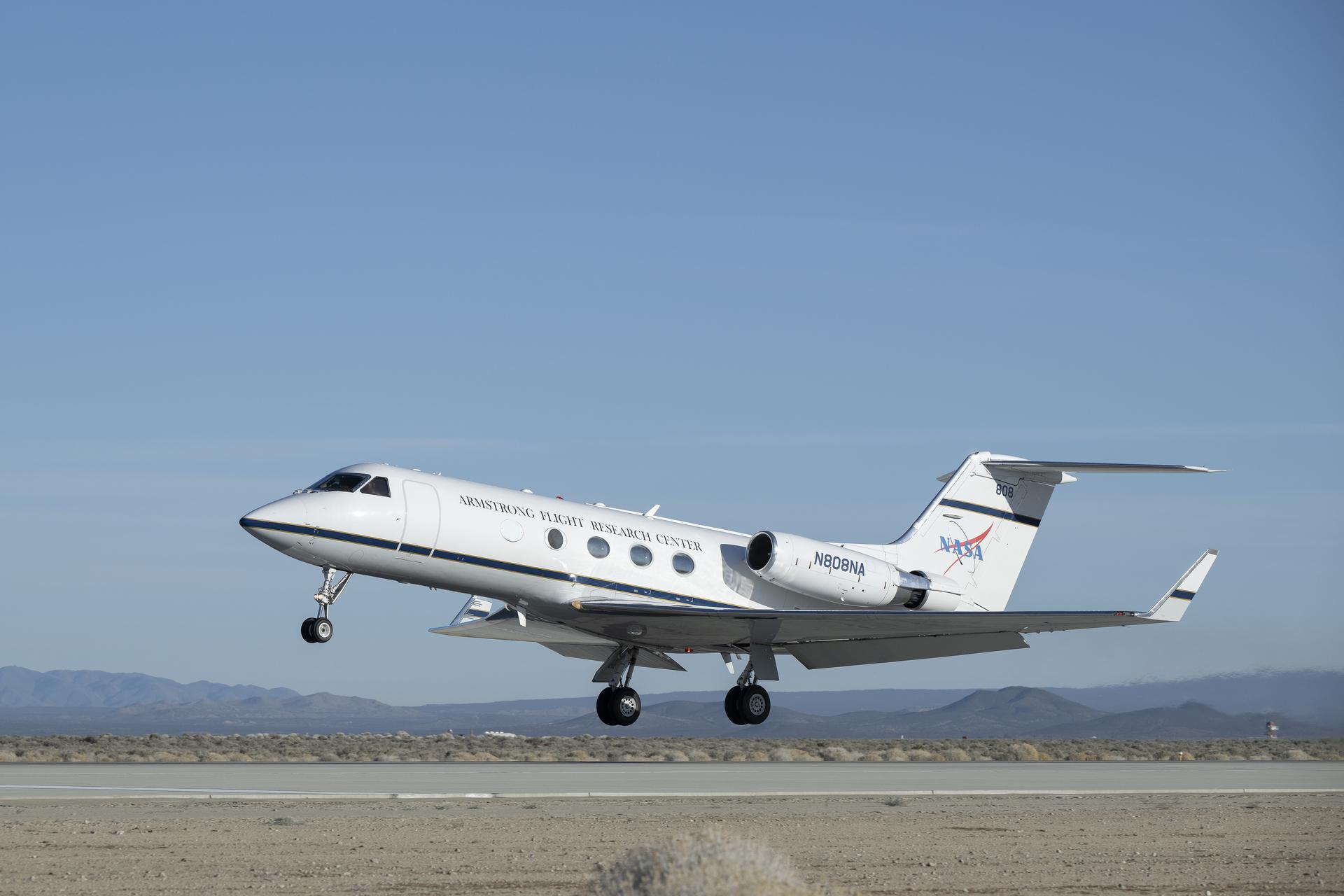
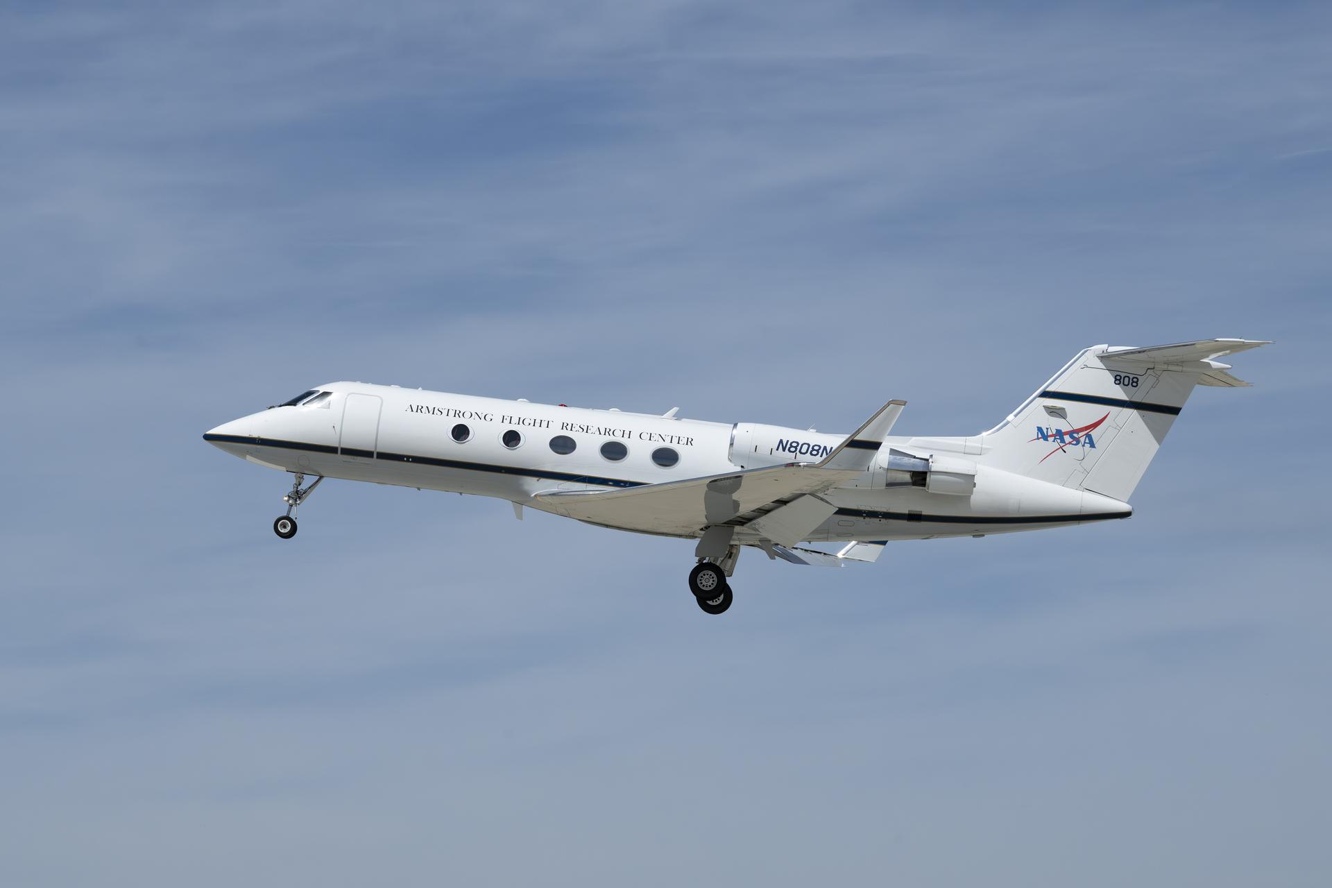
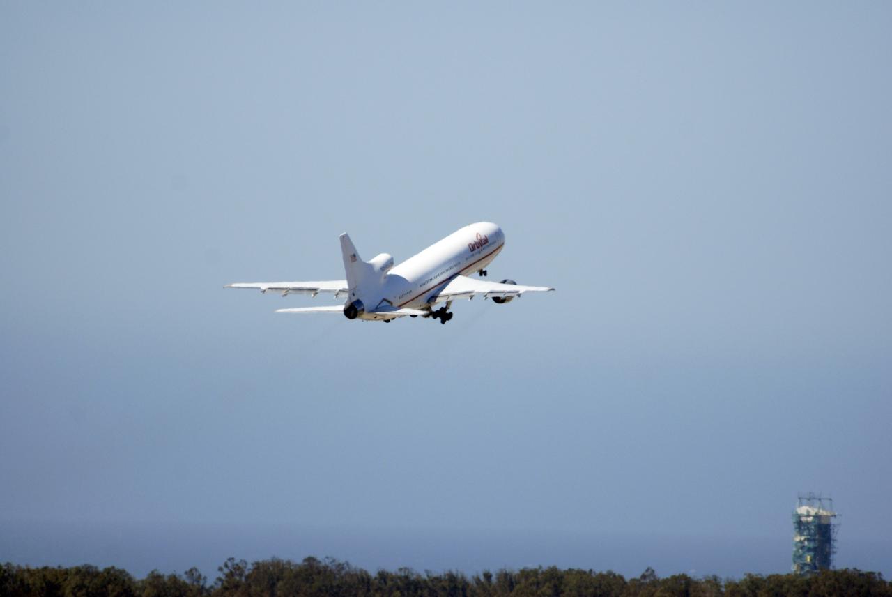
A NASA Gulfstream G-III aircraft lifts off from NASA’s Armstrong Flight Research Center in Edwards, California, on Tuesday, Jan. 20, 2026. Modifications were made to the aircraft to enable it to join three others flying at different altitudes to capture a complete view of the Orion spacecraft’s heat shield during Artemis II reentry. This effort is part of NASA’s Scientifically Calibrated In-Flight Imagery project.
A NASA Gulfstream G-III aircraft lifts off from NASA’s Armstrong Flight Research Center in Edwards, California, on Tuesday, Jan. 20, 2026. Modifications were made to the aircraft to enable it to join three others flying at different altitudes to capture a complete view of the Orion spacecraft’s heat shield during Artemis II reentry. This effort is part of NASA’s Scientifically Calibrated In-Flight Imagery project.
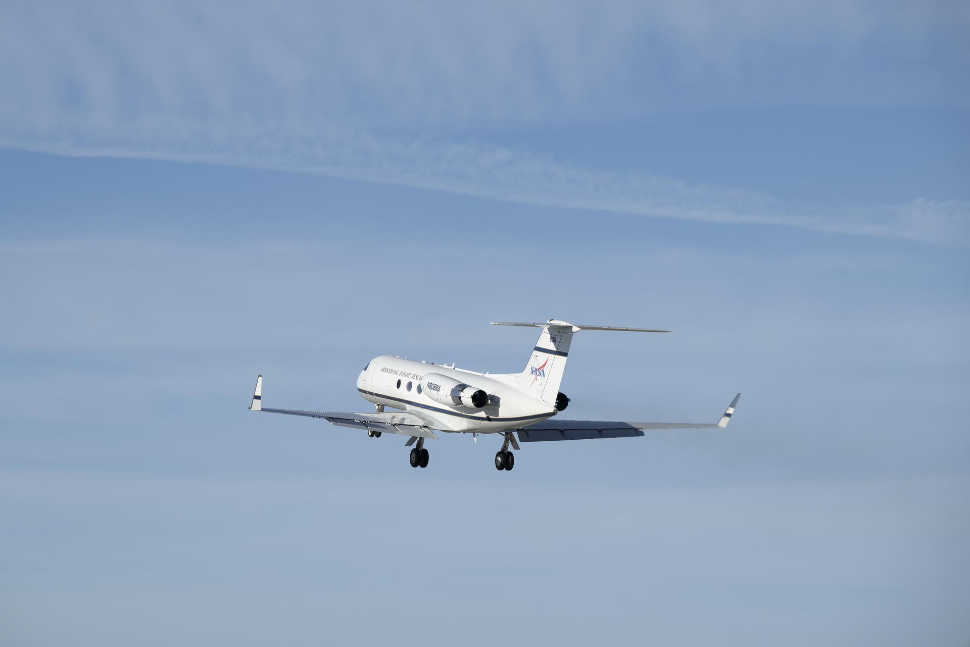
A Gulfstream G-III takes off Friday, March 27, 2026, from NASA’s Armstrong Flight Research Center in Edwards, California. The G-III will join other NASA aircraft to capture imagery of the Orion spacecraft’s heat shield during Artemis II reentry. The mission is part of NASA’s Scientifically Calibrated In-Flight Imagery (SCIFLI) project, based at NASA’s Langley Research Center in Hampton, Virginia.
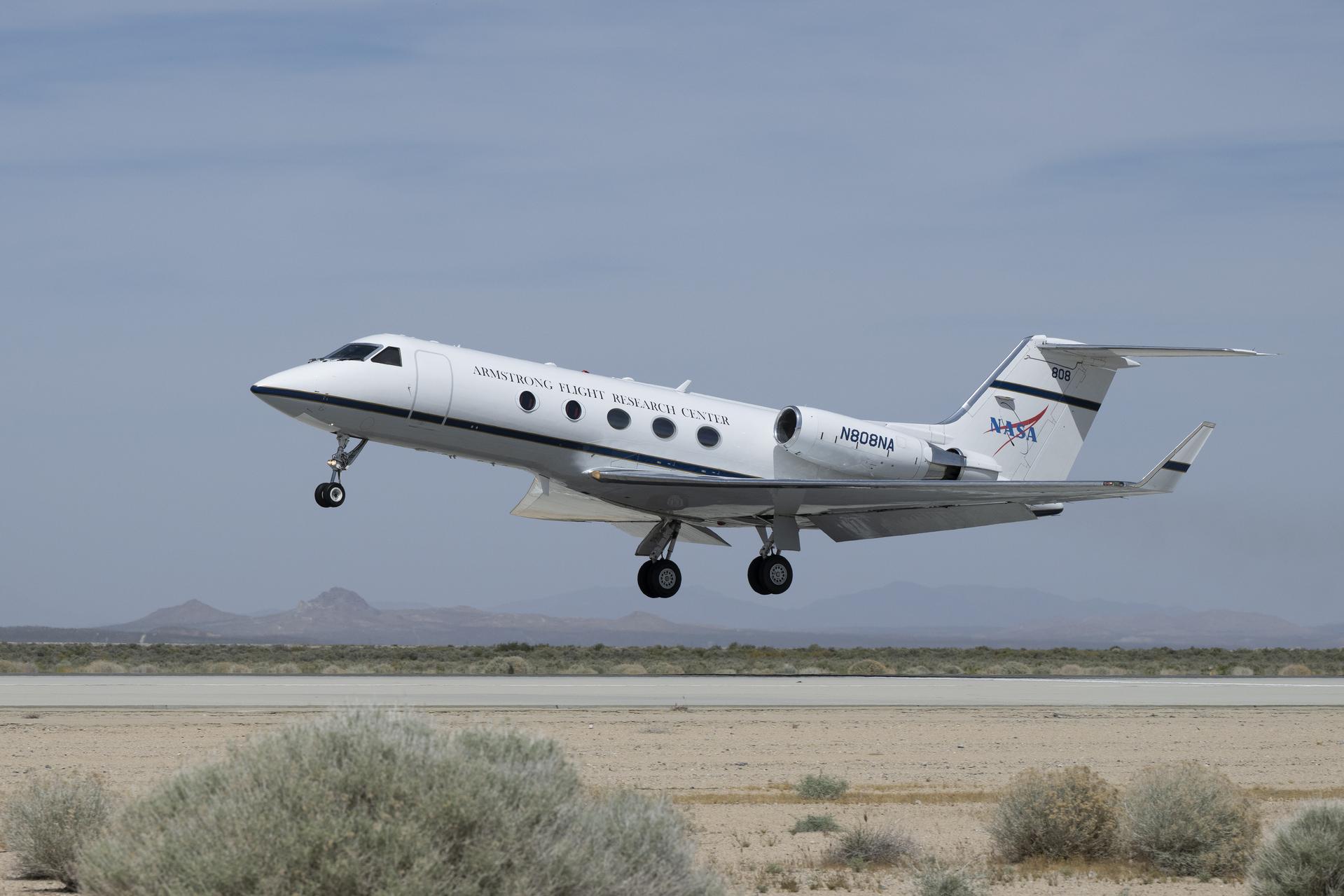
A Gulfstream G-III takes off Friday, March 27, 2026, from NASA’s Armstrong Flight Research Center in Edwards, California. The G-III will join other NASA aircraft to capture imagery of the Orion spacecraft’s heat shield during Artemis II reentry. The mission is part of NASA’s Scientifically Calibrated In-Flight Imagery (SCIFLI) project, based at NASA’s Langley Research Center in Hampton, Virginia.
Manny Rodriguez, Gulfstream G-III crew chief, completes flight control checks with the pilots on Friday, March 27, 2026, at NASA’s Armstrong Flight Research Center in Edwards, California. The G-III will join other NASA aircraft to capture imagery of the Orion spacecraft’s heat shield during Artemis II reentry. The mission is part of NASA’s Scientifically Calibrated In-Flight Imagery (SCIFLI) project, based at NASA’s Langley Research Center in Hampton, Virginia.
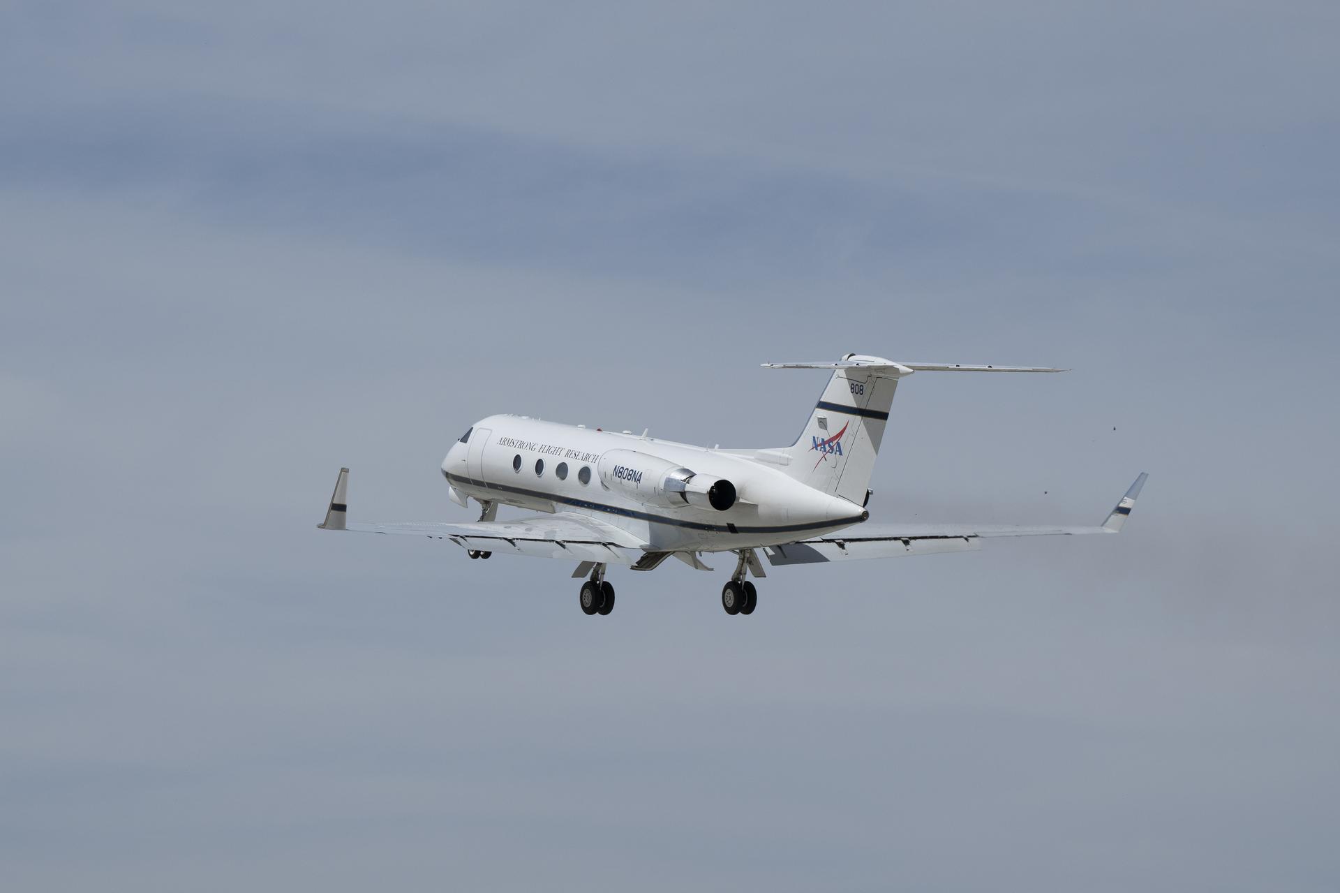
A Gulfstream G-III takes off Friday, March 27, 2026, from NASA’s Armstrong Flight Research Center in Edwards, California. The G-III will join other NASA aircraft to capture imagery of the Orion spacecraft’s heat shield during Artemis II reentry. The mission is part of NASA’s Scientifically Calibrated In-Flight Imagery (SCIFLI) project, based at NASA’s Langley Research Center in Hampton, Virginia.
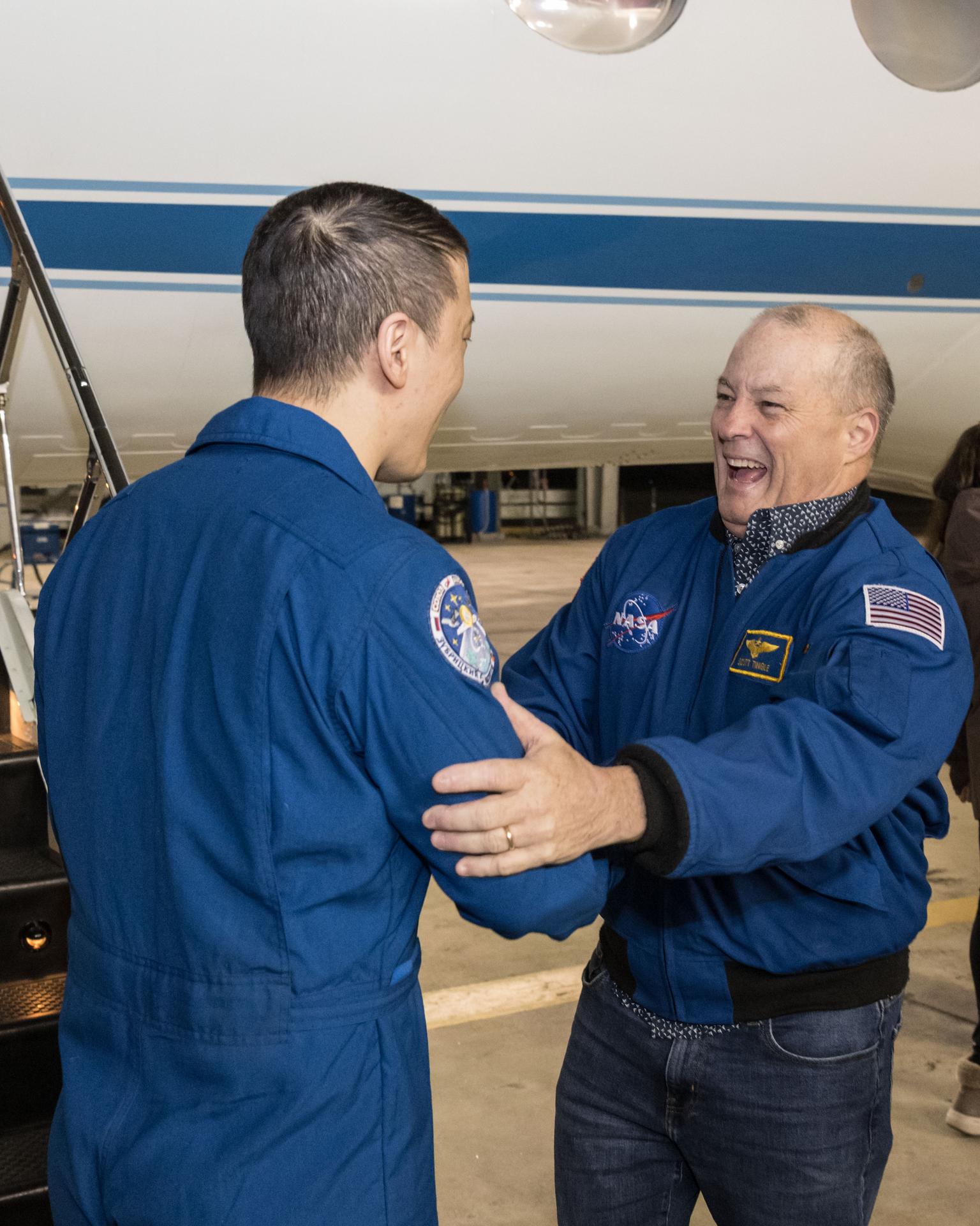
jsc2025e089533 (Dec. 10, 2025) --- NASA astronaut Jonny Kim, greeted by NASA astronaut and Chief of the Astronaut Office Scott Tingle, is pictured at Ellington Field outside the Gulfstream V aircraft that returned him to Houston, Texas, from Kazakhstan in Central Asia. The day before, Kim had landed in Kazakhstan aboard the Soyuz MS-27 crew spacecraft with Roscosmos cosmonauts Sergey Ryzhikov and Alexey Zubritsky after completing a 245-day research mission aboard the International Space Station. In the background (from left), is a NASA employee and NASA astronaut Scott Tingle. Credit: NASA/Robert Markowitz
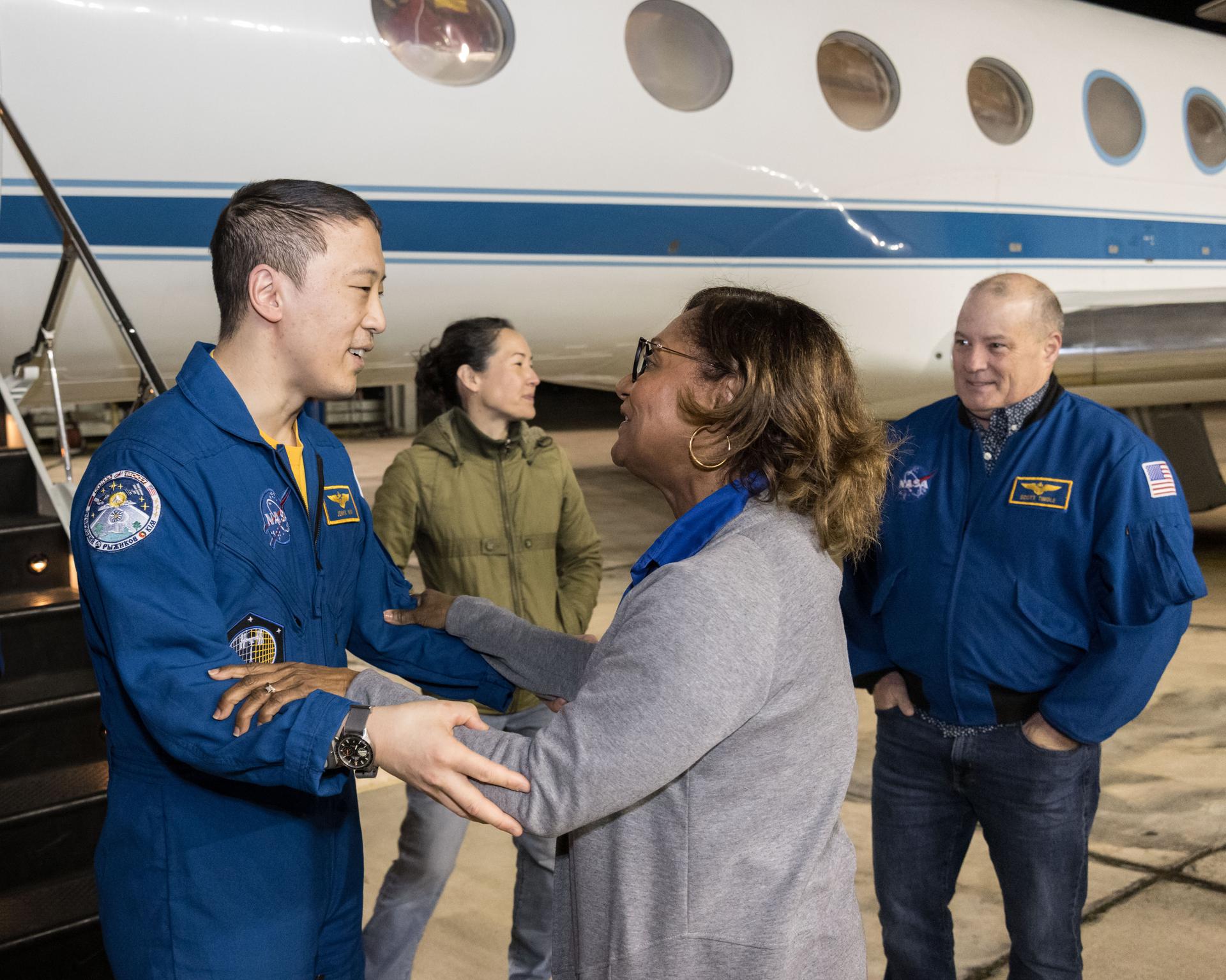
jsc2025e089531 (Dec. 10, 2025) --- NASA astronaut Jonny Kim exits the Gulfstream V aircraft that returned him to Houston, Texas, from Kazakhstan in Central Asia. Waiting to greet Kim are (from left), NASA astronauts Nicole Mann and Scott, Johnson Space Center (JSC) Deputy Director Stephen Koerner, and JSC Director Vanessa Wyche. The day before, Kim had landed in Kazakhstan aboard the Soyuz MS-27 crew spacecraft with Roscosmos cosmonauts Sergey Ryzhikov and Alexey Zubritsky after completing a 245-day research mission aboard the International Space Station. Credit: NASA/Robert Markowitz
jsc2025e089532 (Dec. 10, 2025) --- NASA astronaut Jonny Kim, greeted by Johnson Space Center Director Vanessa Wyche, is pictured at Ellington Field outside the Gulfstream V aircraft that returned him to Houston, Texas, from Kazakhstan in Central Asia. The day before, Kim had landed in Kazakhstan aboard the Soyuz MS-27 crew spacecraft with Roscosmos cosmonauts Sergey Ryzhikov and Alexey Zubritsky after completing a 245-day research mission aboard the International Space Station. In the background (from left), is a NASA employee and NASA astronaut and Chief of the Astronaut Scott Tingle. Credit: NASA/Robert Markowitz

NASA's F/A-18 Hornet is seen here in a banked turn over Rogers Dry Lake in the Mojave desert on an early research flight. It was flown by NASA's Dryden Flight Research Center, Edwards, California, in a multi-year, joint NASA/DOD/industry program, the former Navy fighter was modified into a unique Systems Research Aircraft (SRA) to investigate a host of new technologies in the areas of flight controls, airdata sensing and advanced computing. One of the more than 20 experiments tested aboard the SRA F-18 was an advanced air data sensing system which used a group of pressure taps flush-mounted on the forward fuselage to measure both altitude and wind speed and direction--critical data for flight control and research investigations. The Real-Time Flush Air Data Sensing system concept was evaluated for possible use on the X-33 and X-34 resuable space-launch vehicles. The primary goal of the SRA program was to validate through flight research cutting-edge technologies which could benefit future aircraft and spacecraft by improving efficiency and performance, reducing weight and complexity, with a resultant reduction on development and operational costs.
Pilot Earle Boyer and researcher Henry Brandhorst prepare for a solar cell calibration flight in a Martin B-57B Canberra at the National Aeronautics and Space Administration (NASA) Lewis Research Center. Lewis was in the early stages of decades-long energy conversion and space power research effort. Brandhorst, a member of the Chemistry and Energy Conversion Division, led a team of Lewis researchers in a quest to develop new power sources to sustain spacecraft in orbit. Solar cells proved to be an important source of energy, but researchers discovered that their behavior varied at different atmospheric levels. Their standardization and calibration were critical. Brandhorst initiated a standardized way to calibrate solar cells in the early 1960s using the B-57B aircraft. The pilots would take the aircraft up into the troposphere and open the solar cell to the sunlight. The aircraft would steadily descend while instruments recorded how much energy was being captured by the solar cell. From this data, Brandhorst could determine the estimated power for a particular solar cell at any altitude. Pilot Earle Boyer joined NASA Lewis in October 1962. He had flown Convair F-102 Delta Dagger fighters in the Air Force and served briefly in the National Guard before joining the Langley Research Center. Boyer was only at Langley a few months before he transferred to Cleveland. He flew the B-57B, a Convair F-106 Delta Dart, Gulfstream G-1 with an experimental turboprop, Learjet and many other aircraft over the next 32 years at Lewis.
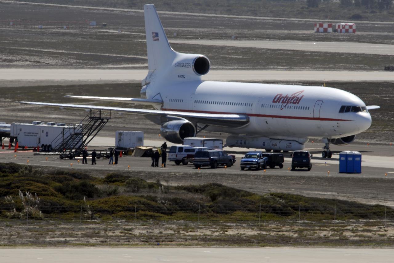
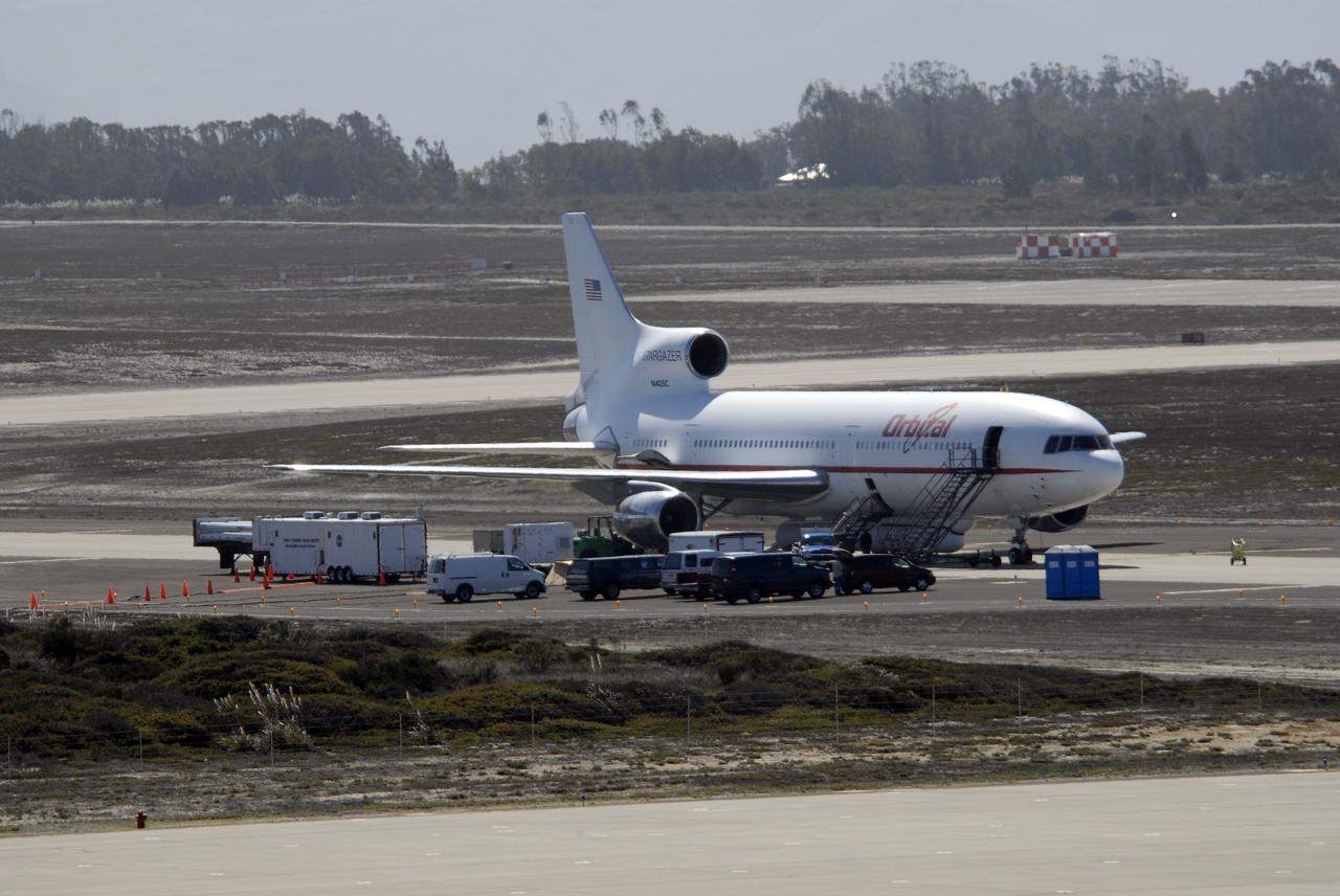
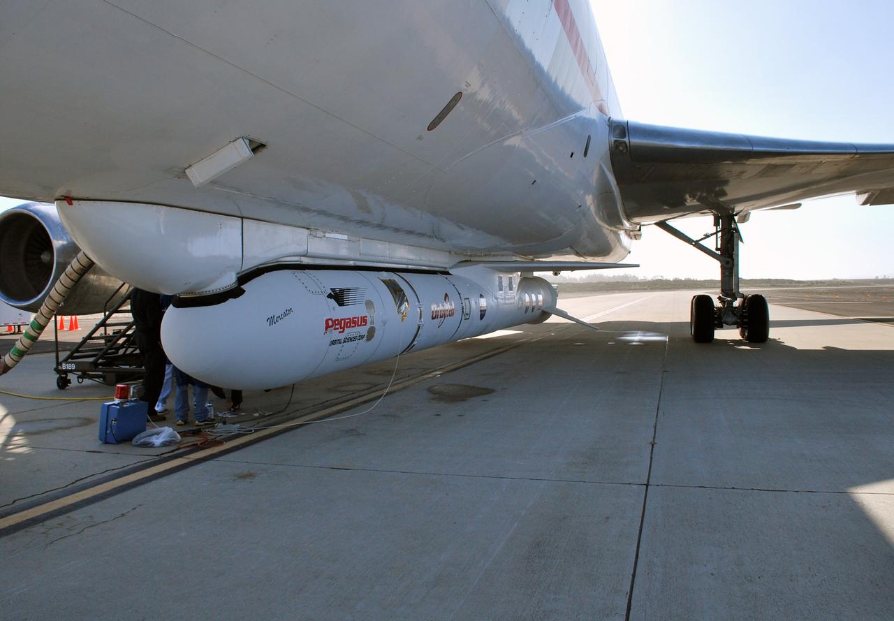
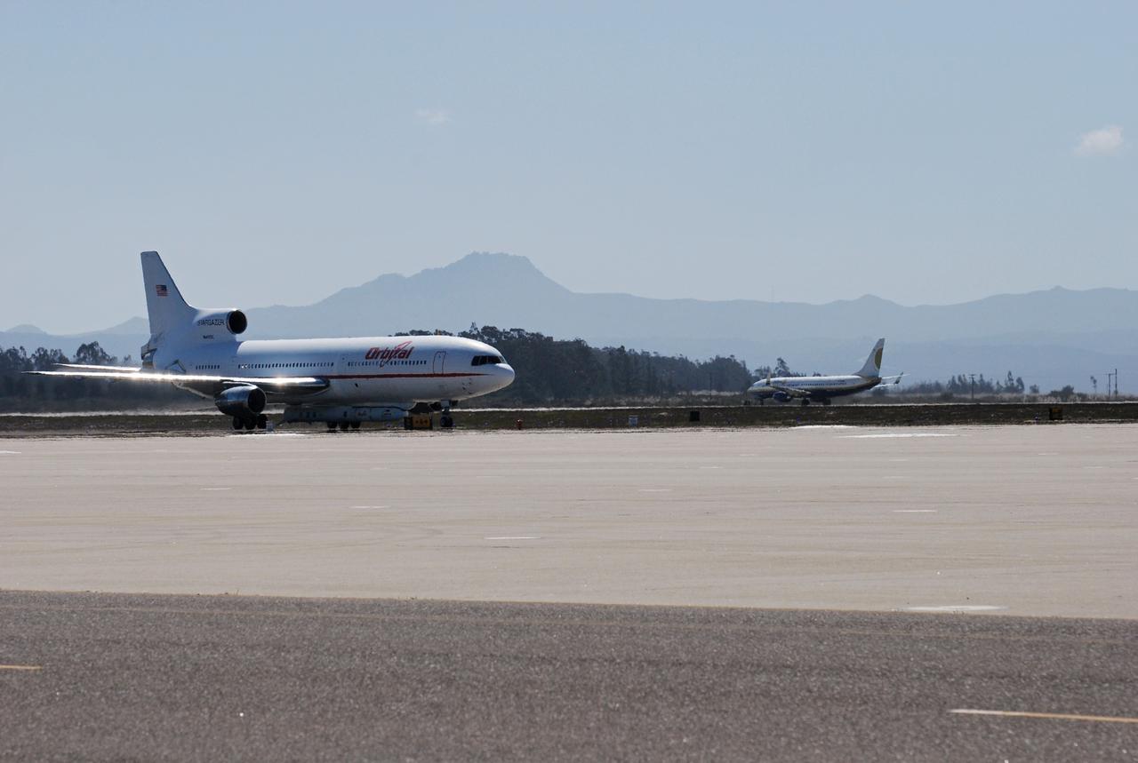
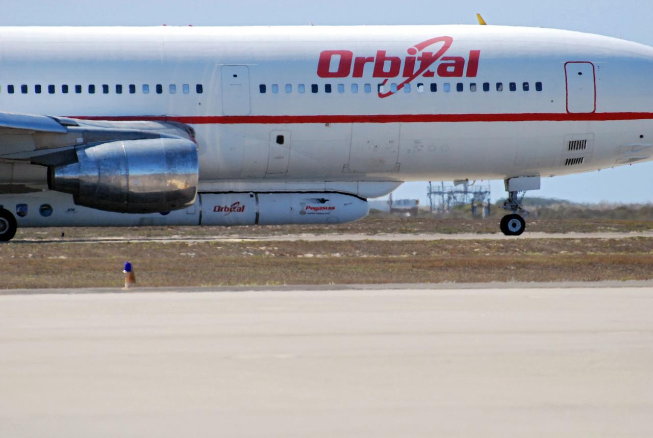
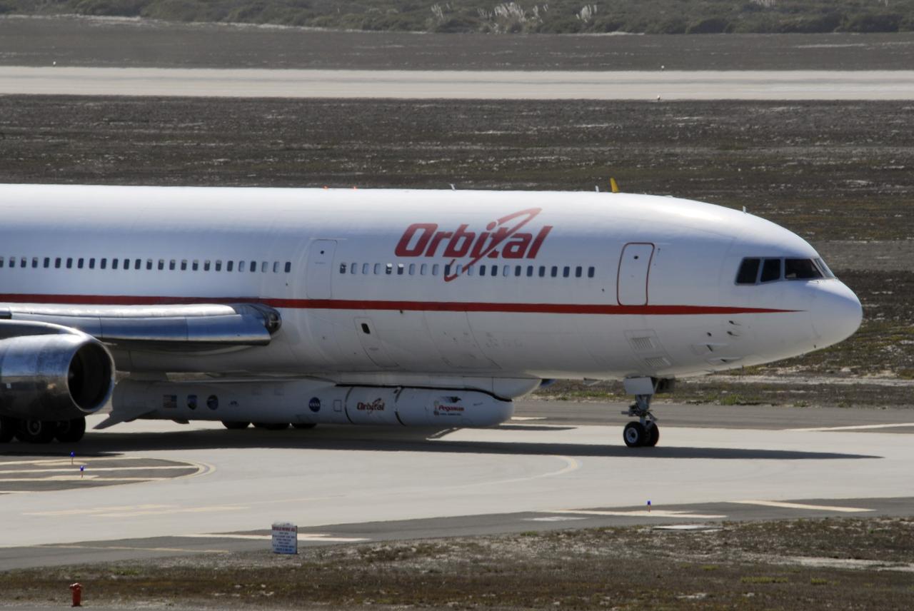
VANDENBERG AIR FORCE BASE, Calif. – On the ramp of Vandenberg Air Force Base in California, Orbital Sciences’ L-1011 aircraft awaits departure for the Kwajalein Atoll, a part of the Marshall Islands in the Pacific Ocean, with NASA’s Interstellar Boundary Explorer, or IBEX, spacecraft and Pegasus XL rocket. The Pegasus is attached under the wing of the aircraft for launch. Departing from Kwajalein, the Pegasus rocket will be dropped from under the wing of the L-1011 over the Pacific Ocean to carry the spacecraft approximately 130 miles above Earth and place it in orbit. Then, the spacecraft’s own engine will boost it to its final high-altitude orbit (about 200,000 miles high) — most of the way to the Moon. The IBEX satellite will make the first map of the boundary between the Solar System and interstellar space. IBEX science will be led by the Southwest Research Institute of San Antonio, Texas. IBEX is targeted for launch over the Pacific Oct. 19. Photo credit: NASA/CIV USAF/Daniel Liberotti
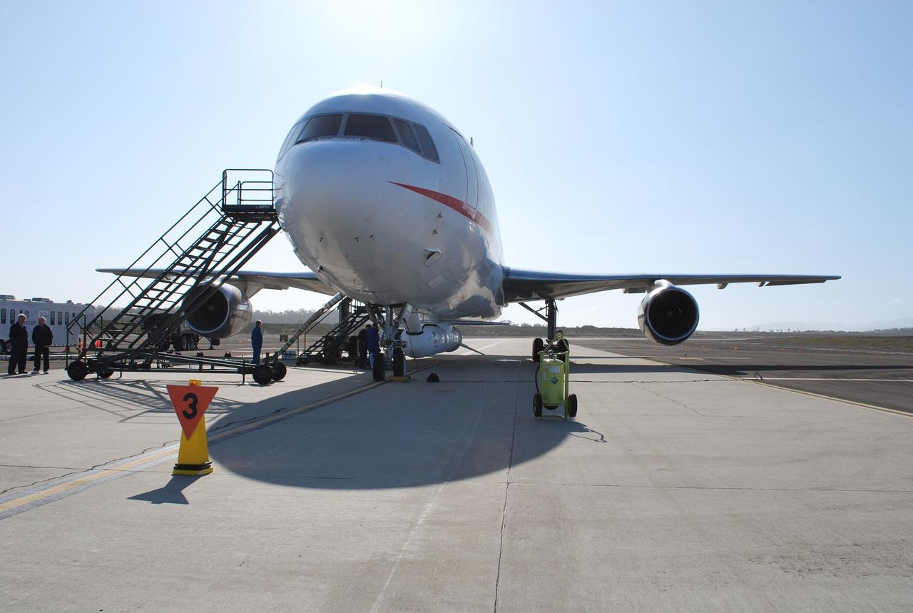
VANDENBERG AIR FORCE BASE, Calif. – On the ramp of Vandenberg Air Force Base in California, Orbital Sciences’ L-1011 aircraft awaits departure for the Kwajalein Atoll, a part of the Marshall Islands in the Pacific Ocean, with NASA’s Interstellar Boundary Explorer, or IBEX, spacecraft and Pegasus XL rocket. The Pegasus is attached under the wing of the aircraft for launch. Departing from Kwajalein, the Pegasus rocket will be dropped from under the wing of the L-1011 over the Pacific Ocean to carry the spacecraft approximately 130 miles above Earth and place it in orbit. Then, the spacecraft’s own engine will boost it to its final high-altitude orbit (about 200,000 miles high) — most of the way to the Moon. The IBEX satellite will make the first map of the boundary between the Solar System and interstellar space. IBEX science will be led by the Southwest Research Institute of San Antonio, Texas. IBEX is targeted for launch over the Pacific Oct. 19. Photo credit: NASA/Randy Beaudoin, VAFB
VANDENBERG AIR FORCE BASE, Calif. – On the ramp of Vandenberg Air Force Base in California, Orbital Sciences’ L-1011 aircraft awaits departure for the Kwajalein Atoll, a part of the Marshall Islands in the Pacific Ocean, with NASA’s Interstellar Boundary Explorer, or IBEX, spacecraft and Pegasus XL rocket. The Pegasus is attached under the wing of the aircraft for launch. Departing from Kwajalein, the Pegasus rocket will be dropped from under the wing of the L-1011 over the Pacific Ocean to carry the spacecraft approximately 130 miles above Earth and place it in orbit. Then, the spacecraft’s own engine will boost it to its final high-altitude orbit (about 200,000 miles high) — most of the way to the Moon. The IBEX satellite will make the first map of the boundary between the Solar System and interstellar space. IBEX science will be led by the Southwest Research Institute of San Antonio, Texas. IBEX is targeted for launch over the Pacific Oct. 19. Photo credit: NASA/CIV USAF/Daniel Liberotti
VANDENBERG AIR FORCE BASE, Calif. – On the ramp of Vandenberg Air Force Base in California, Orbital Sciences’ L-1011 aircraft awaits departure for the Kwajalein Atoll, a part of the Marshall Islands in the Pacific Ocean, with NASA’s Interstellar Boundary Explorer, or IBEX, spacecraft and Pegasus XL rocket. The Pegasus is attached under the wing of the aircraft for launch. Departing from Kwajalein, the Pegasus rocket will be dropped from under the wing of the L-1011 over the Pacific Ocean to carry the spacecraft approximately 130 miles above Earth and place it in orbit. Then, the spacecraft’s own engine will boost it to its final high-altitude orbit (about 200,000 miles high) — most of the way to the Moon. The IBEX satellite will make the first map of the boundary between the Solar System and interstellar space. IBEX science will be led by the Southwest Research Institute of San Antonio, Texas. IBEX is targeted for launch over the Pacific Oct. 19. Photo credit: NASA/Randy Beaudoin, VAFB
![KENNEDY SPACE CENTER, FLA. -- The L-1011 aircraft soars through the sky over the Atlantic Ocean with a Pegasus XL rocket, containing NASA's Solar Radiation and Climate Experiment (SORCE), attached underneath. The rocket will be dropped from the aircraft at 3:14 p.m. EST. Over the next few days, the mission team will insure that the spacecraft is functioning properly. The SORCE science instruments will then be turned on and their health verified. Approximately 21 days after launch, if all is going well, the instruments will start initial science data collection and calibration will begin. The spacecraft will study the Sun's influence on our Earth and will measure from space how the Sun affects the Earth's ozone layer, atmospheric circulation, clouds, and oceans. This mission is a joint partnership between NASA and the University of Colorado's Laboratory for Atmospheric and Space Physics in Boulder, Colorado. [Photo courtesy of Jeff Caplan, Langley Research]](https://images-assets.nasa.gov/image/KSC-03pd0178/KSC-03pd0178~medium.jpg)
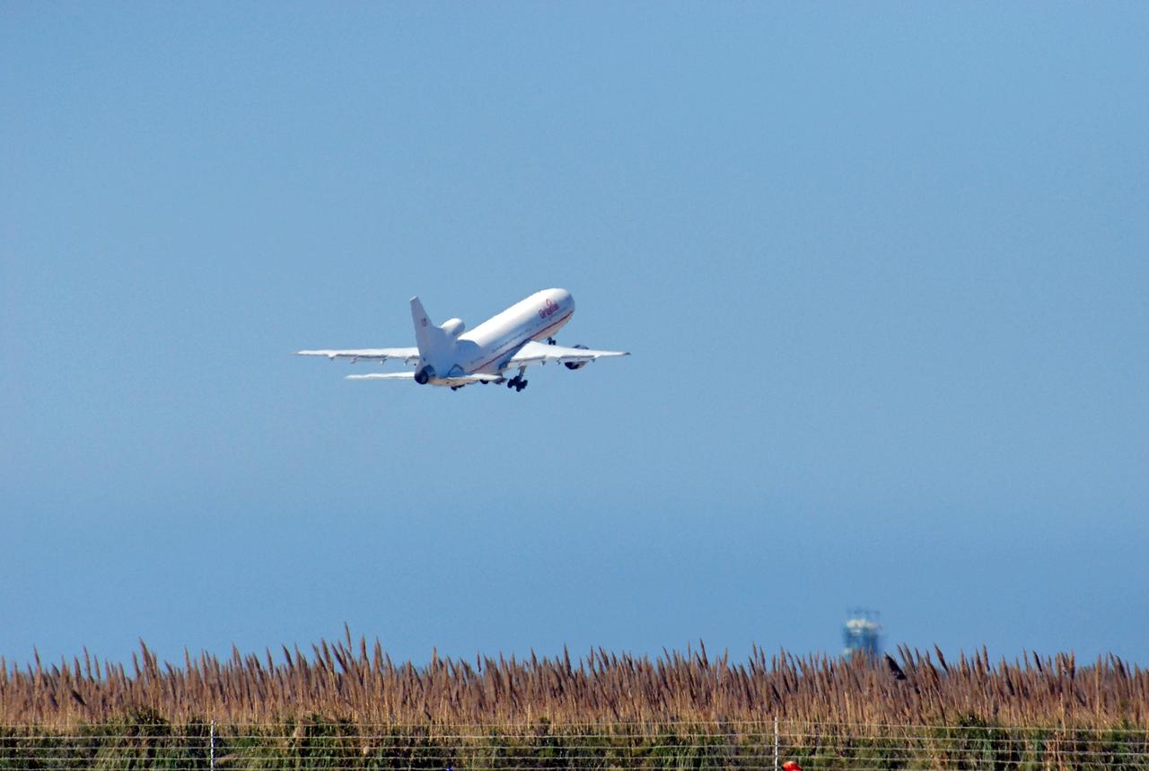
KENNEDY SPACE CENTER, FLA. -- The L-1011 aircraft soars through the sky over the Atlantic Ocean with a Pegasus XL rocket, containing NASA's Solar Radiation and Climate Experiment (SORCE), attached underneath. The rocket will be dropped from the aircraft at 3:14 p.m. EST. Over the next few days, the mission team will insure that the spacecraft is functioning properly. The SORCE science instruments will then be turned on and their health verified. Approximately 21 days after launch, if all is going well, the instruments will start initial science data collection and calibration will begin. The spacecraft will study the Sun's influence on our Earth and will measure from space how the Sun affects the Earth's ozone layer, atmospheric circulation, clouds, and oceans. This mission is a joint partnership between NASA and the University of Colorado's Laboratory for Atmospheric and Space Physics in Boulder, Colorado. [Photo courtesy of Jeff Caplan, Langley Research]
![KENNEDY SPACE CENTER, FLA. - The L-1011 aircraft soars through the sky over the Atlantic Ocean with a Pegasus XL rocket, containing NASA's Solar Radiation and Climate Experiment (SORCE), attached underneath. The rocket will be dropped from the aircraft at 3:14 p.m. EST. Over the next few days, the mission team will insure that the spacecraft is functioning properly. The SORCE science instruments will then be turned on and their health verified. Approximately 21 days after launch, if all is going well, the instruments will start initial science data collection and calibration will begin. The spacecraft will study the Sun's influence on our Earth and will measure from space how the Sun affects the Earth's ozone layer, atmospheric circulation, clouds, and oceans. This mission is a joint partnership between NASA and the University of Colorado's Laboratory for Atmospheric and Space Physics in Boulder, Colorado. [Photo courtesy of Jeff Caplan, Langley Research]](https://images-assets.nasa.gov/image/KSC-03pd0177/KSC-03pd0177~medium.jpg)
KENNEDY SPACE CENTER, FLA. - The L-1011 aircraft soars through the sky over the Atlantic Ocean with a Pegasus XL rocket, containing NASA's Solar Radiation and Climate Experiment (SORCE), attached underneath. The rocket will be dropped from the aircraft at 3:14 p.m. EST. Over the next few days, the mission team will insure that the spacecraft is functioning properly. The SORCE science instruments will then be turned on and their health verified. Approximately 21 days after launch, if all is going well, the instruments will start initial science data collection and calibration will begin. The spacecraft will study the Sun's influence on our Earth and will measure from space how the Sun affects the Earth's ozone layer, atmospheric circulation, clouds, and oceans. This mission is a joint partnership between NASA and the University of Colorado's Laboratory for Atmospheric and Space Physics in Boulder, Colorado. [Photo courtesy of Jeff Caplan, Langley Research]
VANDENBERG AIR FORCE BASE, Calif. – On the ramp of Vandenberg Air Force Base in California, Orbital Sciences’ L-1011 aircraft awaits departure for the Kwajalein Atoll, a part of the Marshall Islands in the Pacific Ocean, with NASA’s Interstellar Boundary Explorer, or IBEX, spacecraft and Pegasus XL rocket. The Pegasus is attached under the wing of the aircraft for launch. In the background at right is the Pathfinder aircraft that will accompany the L-1011 with a contingency crew and launch team members. Departing from Kwajalein, the Pegasus rocket will be dropped from under the wing of the L-1011 over the Pacific Ocean to carry the spacecraft approximately 130 miles above Earth and place it in orbit. Then, the spacecraft’s own engine will boost it to its final high-altitude orbit (about 200,000 miles high) — most of the way to the Moon. The IBEX satellite will make the first map of the boundary between the Solar System and interstellar space. IBEX science will be led by the Southwest Research Institute of San Antonio, Texas. IBEX is targeted for launch over the Pacific Oct. 19. Photo credit: NASA/Randy Beaudoin, VAFB
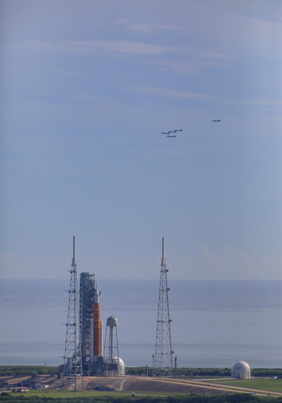
Ahead of NASA’s Artemis I launch, a flight of T-38 supersonic trainer aircraft from the Johnson Space Center Aircraft Operations Division flies in formation over the agency’s Space Launch System and Orion spacecraft on the pad at Launch Complex 39B at Kennedy Space Center in Florida, on Aug. 23, 2022. Pilots and passengers of the five aircraft include NASA Research Pilot Chris Condon and NASA Astronaut Zena Cardman in the lead plane, followed by NASA astronaut candidate Nicole Ayers and NASA astronaut Christina Koch in the second plane, Canadian Space Agency astronaut Jeremy Hansen and NASA astronaut Drew Morgan in the third plane, NASA astronaut Reid Wiseman and NASA astronaut Joe Acaba in the fourth plane, and NASA astronaut candidate Jack Hathaway and Josh Valcarcel, NASA photographer, in the chase plane. Artemis I is scheduled to launch at 8:33 a.m. EDT on Aug. 29, 2022. The first in a series of increasingly complex missions, Artemis I will provide a foundation for human deep space exploration and demonstrate our commitment and capability to extend human presence to the Moon and beyond. The primary goal of Artemis I is to thoroughly test the integrated systems before crewed missions by operating the spacecraft in a deep space environment, testing Orion’s heat shield, and recovering the crew module after reentry, descent, and splashdown.
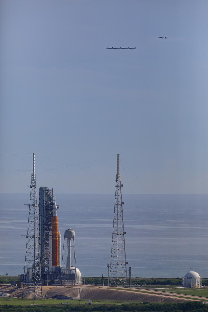
Ahead of NASA’s Artemis I launch, a flight of T-38 supersonic trainer aircraft from the Johnson Space Center Aircraft Operations Division flies in formation over the agency’s Space Launch System and Orion spacecraft on the pad at Launch Complex 39B at Kennedy Space Center in Florida, on Aug. 23, 2022. Pilots and passengers of the five aircraft include NASA Research Pilot Chris Condon and NASA Astronaut Zena Cardman in the lead plane, followed by NASA astronaut candidate Nicole Ayers and NASA astronaut Christina Koch in the second plane, Canadian Space Agency astronaut Jeremy Hansen and NASA astronaut Drew Morgan in the third plane, NASA astronaut Reid Wiseman and NASA astronaut Joe Acaba in the fourth plane, and NASA astronaut candidate Jack Hathaway and Josh Valcarcel, NASA photographer, in the chase plane. Artemis I is scheduled to launch at 8:33 a.m. EDT on Aug. 29, 2022. The first in a series of increasingly complex missions, Artemis I will provide a foundation for human deep space exploration and demonstrate our commitment and capability to extend human presence to the Moon and beyond. The primary goal of Artemis I is to thoroughly test the integrated systems before crewed missions by operating the spacecraft in a deep space environment, testing Orion’s heat shield, and recovering the crew module after reentry, descent, and splashdown.
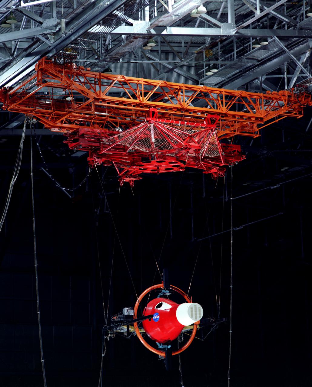
Gemini Rendezvous Docking Simulator suspended from the roof of the Langley Research Center s aircraft hangar. Francis B. Smith wrote: The rendezvous and docking operation of the Gemini spacecraft with the Agena and of the Apollo Command Module with the Lunar Excursion Module have been the subject of simulator studies for several years. This figure illustrates the Gemini-Agena rendezvous docking simulator at Langley. The Gemini spacecraft was supported in a gimbal system by an overhead crane and gantry arrangement which provided 6 degrees of freedom - roll, pitch, yaw, and translation in any direction - all controllable by the astronaut in the spacecraft. Here again the controls fed into a computer which in turn provided an input to the servos driving the spacecraft so that it responded to control motions in a manner which accurately simulated the Gemini spacecraft. -- Published in Barton C. Hacker and James M. Grimwood, On the Shoulders of Titans: A History of Project Gemini, NASA SP-4203 Francis B. Smith, Simulators for Manned Space Research, Paper presented at the 1966 IEEE International convention, March 21-25, 1966.

The Space Shuttle Enterprise, the nation's prototype space shuttle orbiter, before departing NASA's Dryden Flight Research Center, Edwards, California, at 11:00 a.m., 16 May 1983, on the first leg of its trek to the Paris Air Show at Le Bourget Airport, Paris, France. Seen here atop the huge 747 Shuttle Carrier Aircraft (SCA), the first stop for the Enterprise was Peterson AFB, Colorado Springs, Colorado. Piloting the 747 on the Europe trip were Joe Algranti, Johnson Space Center Chief Pilot, Astronaut Dick Scobee, and NASA Dryden Chief Pilot Tom McMurtry. Flight engineers for that portion of the flight were Dryden's Ray Young and Johnson Space Center's Skip Guidry. The Enterprise, named after the spacecraft of Star Trek fame, was originally carried and launched by the 747 during the Approach and Landing Tests (ALT) at Dryden Flight Research Center.

The Space Shuttle Enterprise, the nation's prototype space shuttle orbiter, departed NASA's Dryden Flight Research Center, Edwards, California, at 11:00 a.m., 16 May 1983, on the first leg of its trek to the Paris Air Show at Le Bourget Airport, Paris, France. Carried by the huge 747 Shuttle Carrier Aircraft (SCA), the first stop for the Enterprise was Peterson AFB, Colorado Springs, Colorado. Piloting the 747 on the Europe trip were Joe Algranti, Johnson Space Center Chief Pilot, Astronaut Dick Scobee, and NASA Dryden Chief Pilot Tom McMurtry. Flight engineers for that portion of the flight were Dryden's Ray Young and Johnson Space Center's Skip Guidry. The Enterprise, named after the spacecraft of Star Trek fame, was originally carried and launched by the 747 during the Approach and Landing Tests (ALT) at Dryden Flight Research Center.
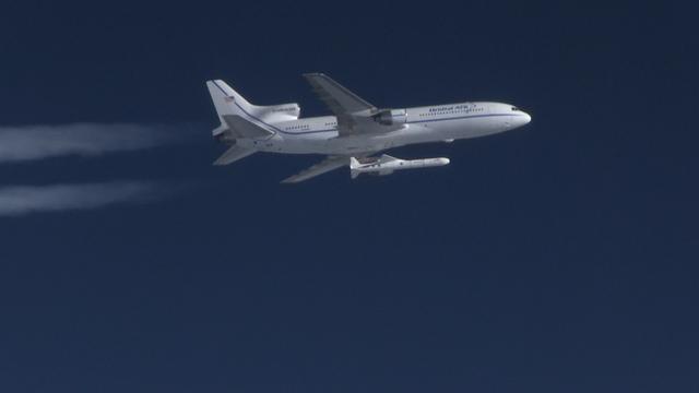
The Orbital ATK Pegasus XL rocket carrying NASA's Cyclone Global Navigation Satellite System, or CYGNSS, spacecraft is released and the first stage ignites at 8:37 a.m. EST. The rocket was released from the Orbital ATK L-1011 Stargazer aircraft flying over the Atlantic Ocean offshore from Daytona Beach, Florida following takeoff from the Skid Strip at Cape Canaveral Air Force Station. This image was taken from a NASA F-18 chase plane provided by Armstrong Flight Research Center in California. The CYGNSS satellites will make frequent and accurate measurements of ocean surface winds throughout the life cycle of tropical storms and hurricanes.
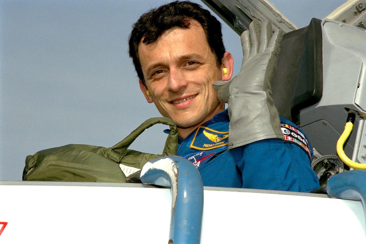
STS-95 Payload Specialist Pedro Duque of Spain, who represents the European Space Agency (ESA), waves after arriving in a T-38 jet aircraft at the Shuttle Landing Facility at KSC. He is joining other STS-95 crew members in a familiarization tour of the SPACEHAB module and the equipment that will fly with them on the Space Shuttle Discovery scheduled to launch Oct. 29, 1998. The mission includes research payloads such as the Spartan solar-observing deployable spacecraft, the Hubble Space Telescope Orbital Systems Test Platform, the International Extreme Ultraviolet Hitchhiker, as well as the SPACEHAB single module with experiments on space flight and the aging process
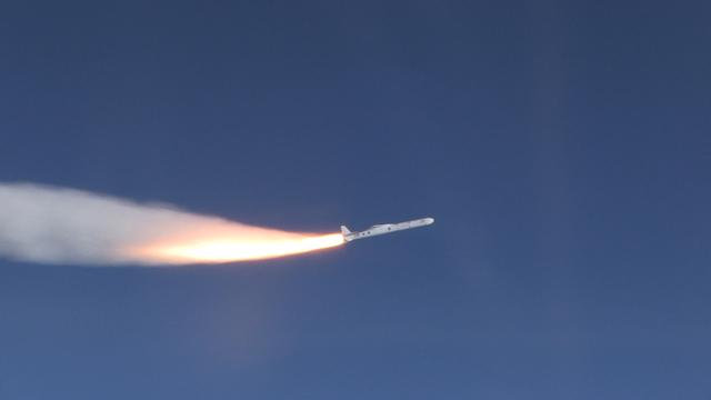
The Orbital ATK Pegasus XL rocket carrying NASA's Cyclone Global Navigation Satellite System, or CYGNSS, spacecraft is released and the first stage ignites at 8:37 a.m. EST. The rocket was released from the Orbital ATK L-1011 Stargazer aircraft flying over the Atlantic Ocean offshore from Daytona Beach, Florida following takeoff from the Skid Strip at Cape Canaveral Air Force Station. This image was taken from a NASA F-18 chase plane provided by Armstrong Flight Research Center in California. The CYGNSS satellites will make frequent and accurate measurements of ocean surface winds throughout the life cycle of tropical storms and hurricanes.
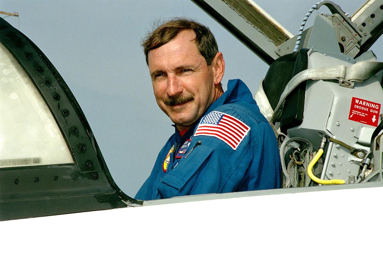
STS-95 Mission Commander Curtis L. Brown Jr. arrives aboard a T-38 jet aircraft at the Shuttle Landing Facility at KSC. The STS-95 crew is at KSC to look at the SPACEHAB module and the equipment that will fly with them on the Space Shuttle Discovery scheduled to launch Oct. 29, 1998. The mission includes research payloads such as the Spartan solar-observing deployable spacecraft, the Hubble Space Telescope Orbital Systems Test Platform, the International Extreme Ultraviolet Hitchhiker, as well as the SPACEHAB single module with experiments on space flight and the aging process
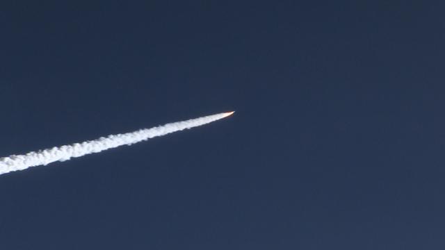
The Orbital ATK Pegasus XL rocket carrying NASA's Cyclone Global Navigation Satellite System, or CYGNSS, spacecraft is released and the first stage ignites at 8:37 a.m. EST. The rocket was released from the Orbital ATK L-1011 Stargazer aircraft flying over the Atlantic Ocean offshore from Daytona Beach, Florida following takeoff from the Skid Strip at Cape Canaveral Air Force Station. This image was taken from a NASA F-18 chase plane provided by Armstrong Flight Research Center in California. The CYGNSS satellites will make frequent and accurate measurements of ocean surface winds throughout the life cycle of tropical storms and hurricanes.
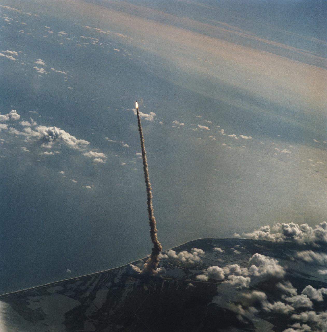
STS058-S-122 (18 Oct 1993) --- This distant shot of Columbia on its way to Earth-orbit was captured on film from the Shuttle Training Aircraft (STA) assigned to advance launch range screening. Onboard the spacecraft were six NASA astronauts, a veterinarian from the private sector and the Spacelab Life Sciences (SLS-2) science module. The crew will spend two weeks in Earth-orbiting devoting all its on-duty time to life sciences research. Launch occurred at 10:53 a.m. (EDT), October 18, 1993, from the Kennedy Space Center (KSC).
The Orbital ATK Pegasus XL rocket carrying NASA's Cyclone Global Navigation Satellite System, or CYGNSS, spacecraft is released and the first stage ignites at 8:37 a.m. EST. The rocket was released from the Orbital ATK L-1011 Stargazer aircraft flying over the Atlantic Ocean offshore from Daytona Beach, Florida following takeoff from the Skid Strip at Cape Canaveral Air Force Station. This image was taken from a NASA F-18 chase plane provided by Armstrong Flight Research Center in California. The CYGNSS satellites will make frequent and accurate measurements of ocean surface winds throughout the life cycle of tropical storms and hurricanes.
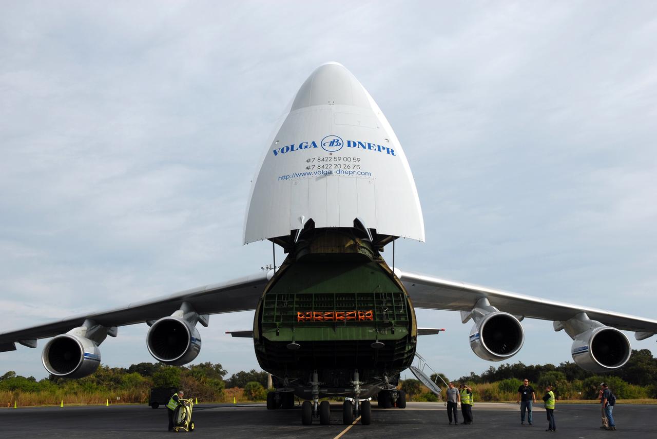
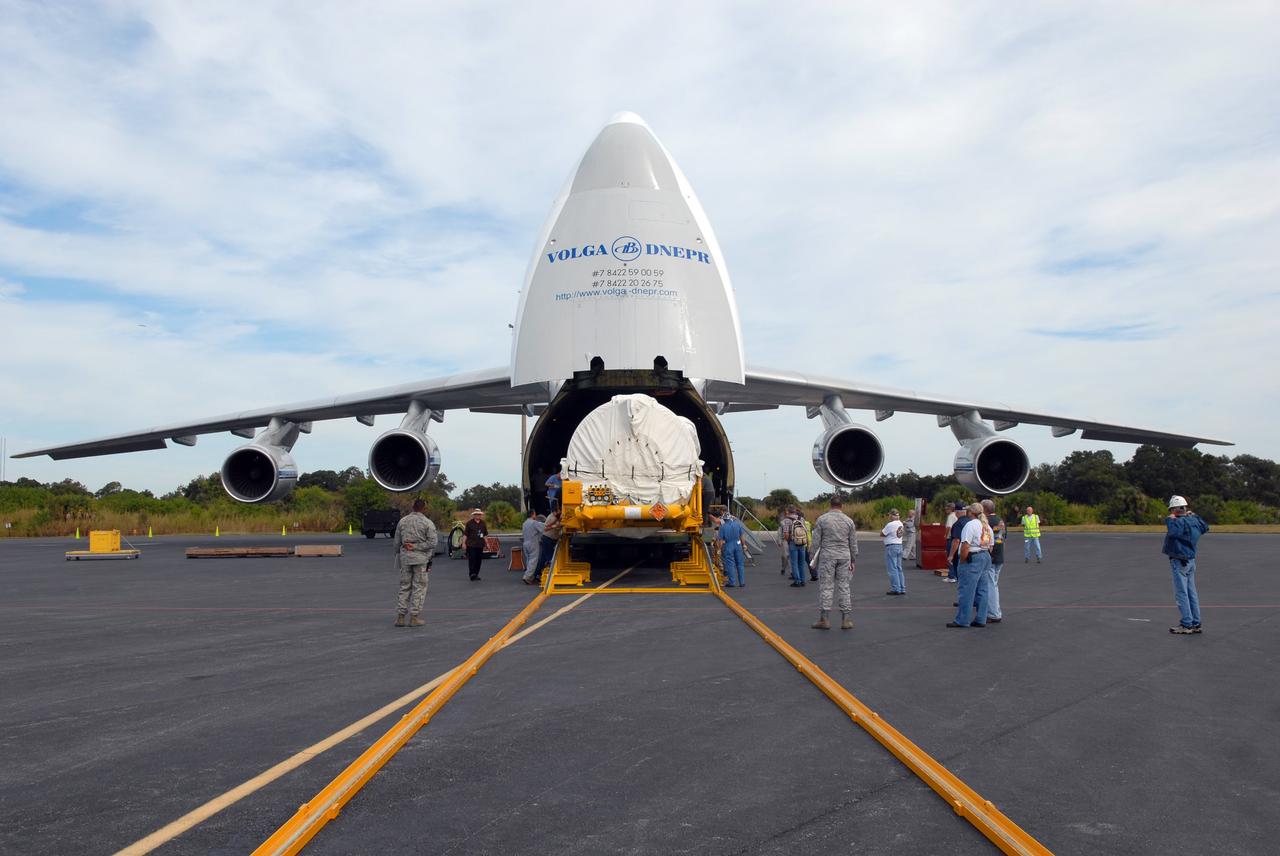
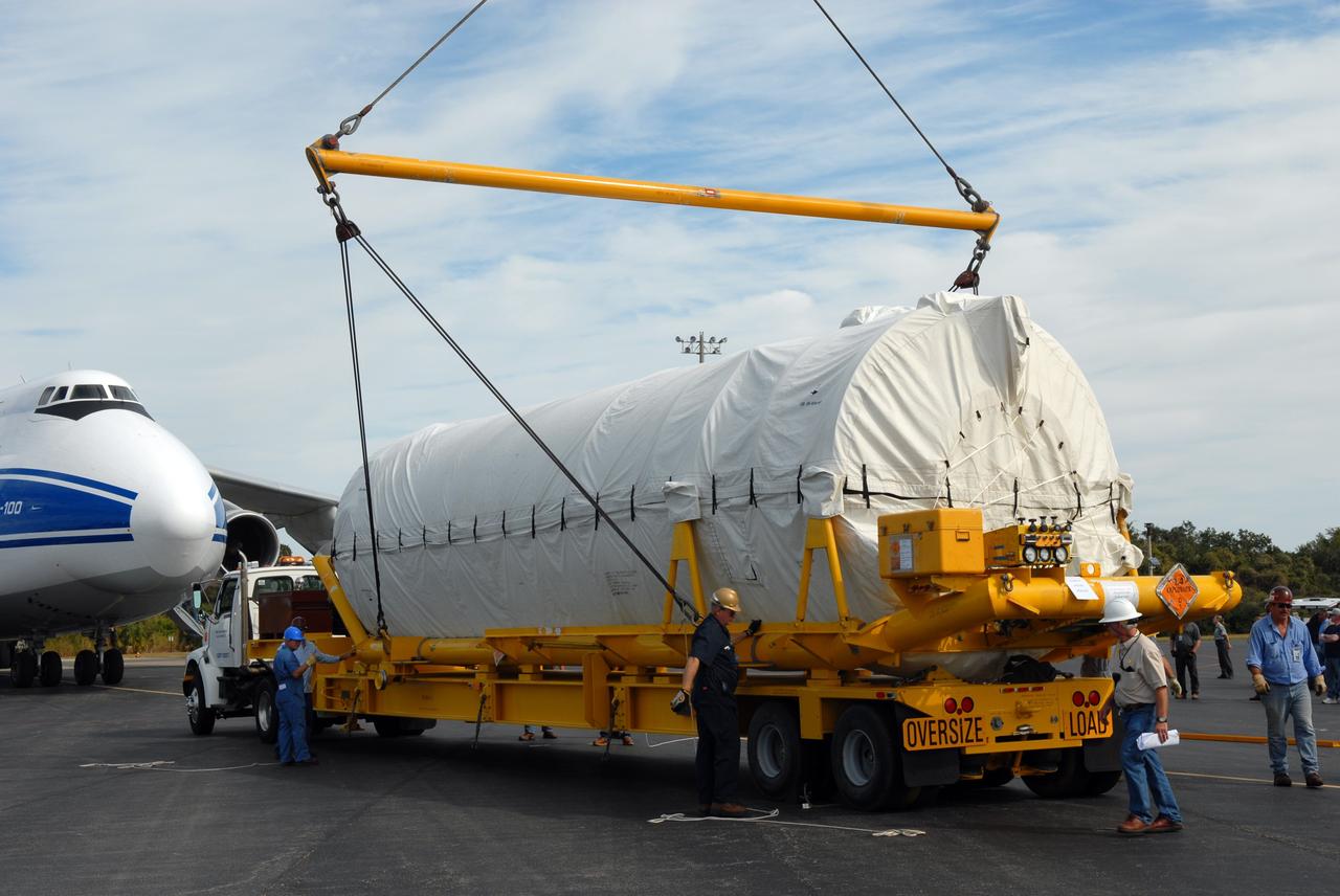
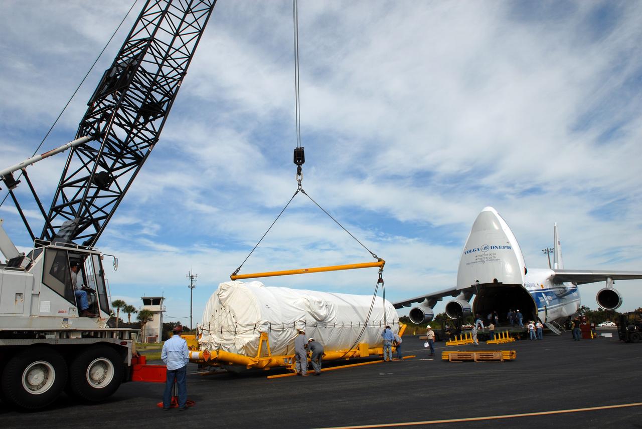
CAPE CANAVERAL, Fla. – At the Skid Strip on Cape Canaveral Air Force Station in Florida, a Volga-Dnepr Antonov AN-124-100, a Ukranian/Russian aircraft, delivers the Centaur second stage for the Atlas V rocket slated to launch NASA's Solar Dynamics Observatory, or SDO. SDO is the first space weather research network mission in NASA's Living With a Star Program. The spacecraft's long-term measurements will give solar scientists in-depth information about changes in the sun's magnetic field and insight into how they affect Earth. Liftoff on the United Launch Alliance Atlas V is scheduled for Feb. 3, 2010. For information on SDO, visit http://www.nasa.gov/sdo. Photo credit: NASA/Jim Grossmann
VANDENBERG AIR FORCE BASE, Calif. – From the runway of Vandenberg Air Force Base in California, a Pathfinder aircraft takes off. The Pathfinder will accompany Orbital Sciences’ L-1011 aircraft carrying NASA’s Interstellar Boundary Explorer, or IBEX, spacecraft and Pegasus XL rocket on its flight to the Kwajalein Atoll, a part of the Marshall Islands in the Pacific Ocean. The Pathfinder will carry the contingency crew and launch team members. Departing from Kwajalein, the Pegasus rocket will be dropped from under the wing of the L-1011 over the Pacific Ocean to carry the spacecraft approximately 130 miles above Earth and place it in orbit. Then, the spacecraft’s own engine will boost it to its final high-altitude orbit (about 200,000 miles high) — most of the way to the Moon. The IBEX satellite will make the first map of the boundary between the Solar System and interstellar space. IBEX science will be led by the Southwest Research Institute of San Antonio, Texas. IBEX is targeted for launch over the Pacific Oct. 19. Photo credit: NASA/CIV USAF/Daniel Liberotti
VANDENBERG AIR FORCE BASE, Calif. – On the runway of Vandenberg Air Force Base in California, a Pathfinder aircraft taxis down the runway for takeoff. The Pathfinder will accompany Orbital Sciences’ L-1011 aircraft carrying NASA’s Interstellar Boundary Explorer, or IBEX, spacecraft and Pegasus XL rocket on its flight to the Kwajalein Atoll, a part of the Marshall Islands in the Pacific Ocean. The Pathfinder will carry the contingency crew and launch team members. Departing from Kwajalein, the Pegasus rocket will be dropped from under the wing of the L-1011 over the Pacific Ocean to carry the spacecraft approximately 130 miles above Earth and place it in orbit. Then, the spacecraft’s own engine will boost it to its final high-altitude orbit (about 200,000 miles high) — most of the way to the Moon. The IBEX satellite will make the first map of the boundary between the Solar System and interstellar space. IBEX science will be led by the Southwest Research Institute of San Antonio, Texas. IBEX is targeted for launch over the Pacific Oct. 19. Photo credit: NASA/CIV USAF/Daniel Liberotti
VANDENBERG AIR FORCE BASE, Calif. – Orbital Sciences’ L-1011 aircraft (right) taxis on the runway for takeoff from Vandenberg Air Force Base in California to the Kwajalein Atoll, a part of the Marshall Islands in the Pacific Ocean. Under its wing is NASA’s Interstellar Boundary Explorer, or IBEX, spacecraft and Pegasus XL rocket. At left is the Pathfinder aircraft that will accompany the L-1011, carrying the contingency crew and launch team members. Departing from Kwajalein, the Pegasus rocket will be dropped from under the wing of the L-1011 over the Pacific Ocean to carry the spacecraft approximately 130 miles above Earth and place it in orbit. Then, the spacecraft’s own engine will boost it to its final high-altitude orbit (about 200,000 miles high) — most of the way to the Moon. The IBEX satellite will make the first map of the boundary between the Solar System and interstellar space. IBEX science will be led by the Southwest Research Institute of San Antonio, Texas. IBEX is targeted for launch over the Pacific Oct. 19. Photo credit: NASA/VAFB
VANDENBERG AIR FORCE BASE, Calif. – On the ramp of Vandenberg Air Force Base in California, the contingency crew and launch team members for NASA’s Interstellar Boundary Explorer, or IBEX, spacecraft embark on the Pathfinder aircraft that will accompany Orbital Sciences’ L-1011 aircraft. The L-1011 will carry IBEX and Pegasus XL rocket on its flight to the Kwajalein Atoll, a part of the Marshall Islands in the Pacific Ocean. Departing from Kwajalein, the Pegasus rocket will be dropped from under the wing of the L-1011 over the Pacific Ocean to carry the spacecraft approximately 130 miles above Earth and place it in orbit. Then, the spacecraft’s own engine will boost it to its final high-altitude orbit (about 200,000 miles high) — most of the way to the Moon. The IBEX satellite will make the first map of the boundary between the Solar System and interstellar space. IBEX science will be led by the Southwest Research Institute of San Antonio, Texas. IBEX is targeted for launch over the Pacific Oct. 19. Photo credit: NASA/CIV USAF/Daniel Liberotti
VANDENBERG AIR FORCE BASE, Calif. – On the ramp of Vandenberg Air Force Base in California, a Pathfinder aircraft waits for its passengers to arrive before takeoff. The Pathfinder will accompany Orbital Sciences’ L-1011 aircraft carrying NASA’s Interstellar Boundary Explorer, or IBEX, spacecraft and Pegasus XL rocket on its flight to the Kwajalein Atoll, a part of the Marshall Islands in the Pacific Ocean. The Pathfinder will carry the contingency crew and launch team members. Departing from Kwajalein, the Pegasus rocket will be dropped from under the wing of the L-1011 over the Pacific Ocean to carry the spacecraft approximately 130 miles above Earth and place it in orbit. Then, the spacecraft’s own engine will boost it to its final high-altitude orbit (about 200,000 miles high) — most of the way to the Moon. The IBEX satellite will make the first map of the boundary between the Solar System and interstellar space. IBEX science will be led by the Southwest Research Institute of San Antonio, Texas. IBEX is targeted for launch over the Pacific Oct. 19. Photo credit: NASA/CIV USAF/Daniel Liberotti
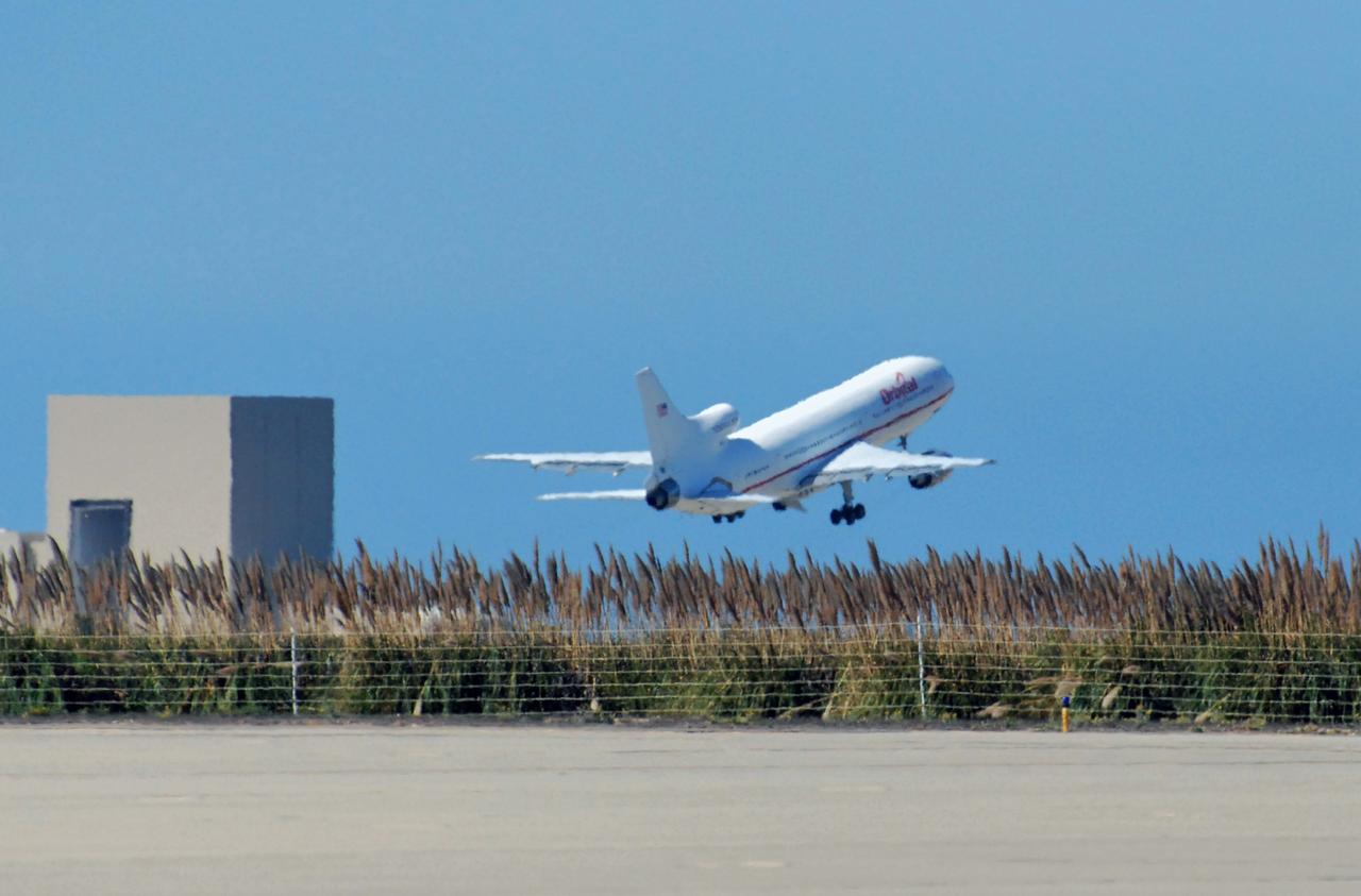
VANDENBERG AIR FORCE BASE, Calif. – Orbital Sciences’ L-1011 aircraft takes off from Vandenberg Air Force Base in California for the Kwajalein Atoll, a part of the Marshall Islands in the Pacific Ocean. Under its wing is NASA’s Interstellar Boundary Explorer, or IBEX, spacecraft and Pegasus XL rocket. Departing from Kwajalein, the Pegasus rocket will be dropped from under the wing of the L-1011 over the Pacific Ocean to carry the spacecraft approximately 130 miles above Earth and place it in orbit. Then, the spacecraft’s own engine will boost it to its final high-altitude orbit (about 200,000 miles high) — most of the way to the Moon. The IBEX satellite will make the first map of the boundary between the Solar System and interstellar space. IBEX science will be led by the Southwest Research Institute of San Antonio, Texas. IBEX is targeted for launch over the Pacific Oct. 19. Photo credit: NASA/Randy Beaudoin, VAFB
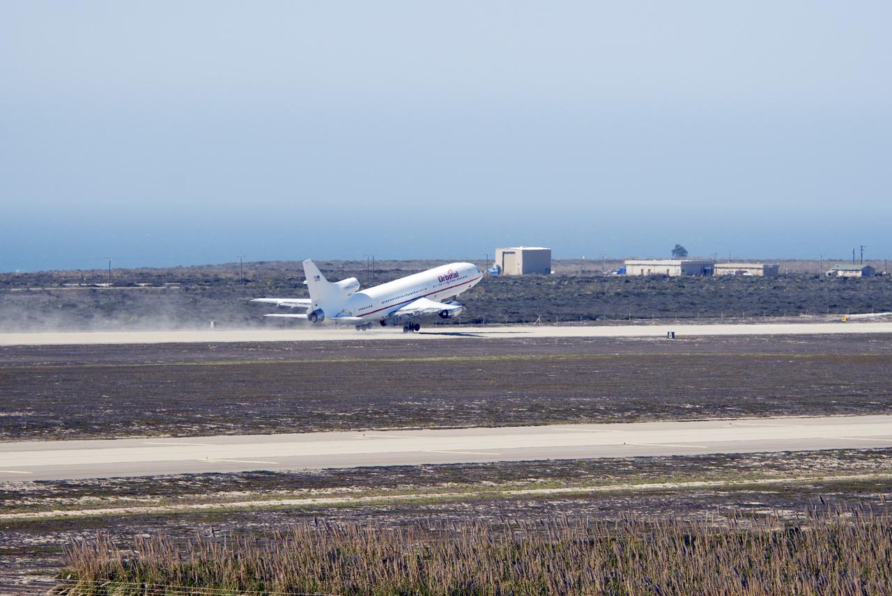
VANDENBERG AIR FORCE BASE, Calif. – Orbital Sciences’ L-1011 aircraft takes off from Vandenberg Air Force Base in California for the Kwajalein Atoll, a part of the Marshall Islands in the Pacific Ocean. Under its wing is NASA’s Interstellar Boundary Explorer, or IBEX, spacecraft and Pegasus XL rocket. Departing from Kwajalein, the Pegasus rocket will be dropped from under the wing of the L-1011 over the Pacific Ocean to carry the spacecraft approximately 130 miles above Earth and place it in orbit. Then, the spacecraft’s own engine will boost it to its final high-altitude orbit (about 200,000 miles high) — most of the way to the Moon. The IBEX satellite will make the first map of the boundary between the Solar System and interstellar space. IBEX science will be led by the Southwest Research Institute of San Antonio, Texas. IBEX is targeted for launch over the Pacific Oct. 19. Photo credit: NASA/Randy Beaudoin, VAFB
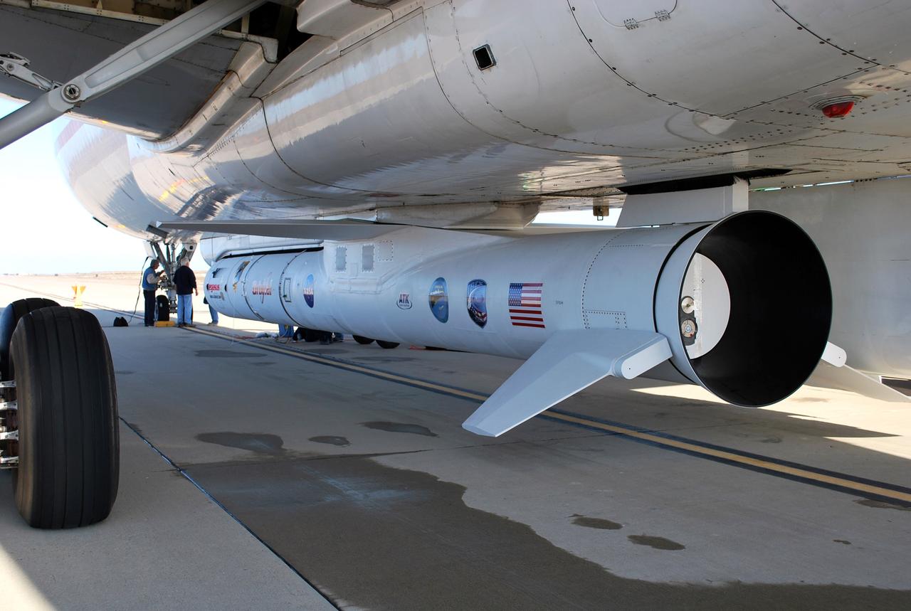
VANDENBERG AIR FORCE BASE, Calif. – On the ramp of Vandenberg Air Force Base in California, workers make final checks of the Pegasus XL rocket before departure for the Kwajalein Atoll, a part of the Marshall Islands in the Pacific Ocean. Mated to NASA’s Interstellar Boundary Explorer, or IBEX, spacecraft, the Pegasus is attached under the wing of the aircraft for launch. Departing from Kwajalein, the Pegasus rocket will be dropped from under the wing of the L-1011 over the Pacific Ocean to carry the spacecraft approximately 130 miles above Earth and place it in orbit. Then, the spacecraft’s own engine will boost it to its final high-altitude orbit (about 200,000 miles high) — most of the way to the Moon. The IBEX satellite will make the first map of the boundary between the Solar System and interstellar space. IBEX science will be led by the Southwest Research Institute of San Antonio, Texas. IBEX is targeted for launch over the Pacific Oct. 19. Photo credit: NASA/Randy Beaudoin, VAFB
VANDENBERG AIR FORCE BASE, Calif. – Orbital Sciences’ L-1011 aircraft takes off from Vandenberg Air Force Base in California for the Kwajalein Atoll, a part of the Marshall Islands in the Pacific Ocean. Under its wing is NASA’s Interstellar Boundary Explorer, or IBEX, spacecraft and Pegasus XL rocket. Departing from Kwajalein, the Pegasus rocket will be dropped from under the wing of the L-1011 over the Pacific Ocean to carry the spacecraft approximately 130 miles above Earth and place it in orbit. Then, the spacecraft’s own engine will boost it to its final high-altitude orbit (about 200,000 miles high) — most of the way to the Moon. The IBEX satellite will make the first map of the boundary between the Solar System and interstellar space. IBEX science will be led by the Southwest Research Institute of San Antonio, Texas. IBEX is targeted for launch over the Pacific Oct. 19. Photo credit: NASA/Randy Beaudoin, VAFB
VANDENBERG AIR FORCE BASE, Calif. – On the ramp of Vandenberg Air Force Base in California, workers make final checks of the Pegasus XL rocket before departure for the Kwajalein Atoll, a part of the Marshall Islands in the Pacific Ocean. Mated to NASA’s Interstellar Boundary Explorer, or IBEX, spacecraft, the Pegasus is attached under the wing of the aircraft for launch. Departing from Kwajalein, the Pegasus rocket will be dropped from under the wing of the L-1011 over the Pacific Ocean to carry the spacecraft approximately 130 miles above Earth and place it in orbit. Then, the spacecraft’s own engine will boost it to its final high-altitude orbit (about 200,000 miles high) — most of the way to the Moon. The IBEX satellite will make the first map of the boundary between the Solar System and interstellar space. IBEX science will be led by the Southwest Research Institute of San Antonio, Texas. IBEX is targeted for launch over the Pacific Oct. 19. Photo credit: NASA/Randy Beaudoin, VAFB
VANDENBERG AIR FORCE BASE, Calif. – Orbital Sciences’ L-1011 aircraft begins rolling for takeoff from Vandenberg Air Force Base in California to the Kwajalein Atoll, a part of the Marshall Islands in the Pacific Ocean. Under its wing is NASA’s Interstellar Boundary Explorer, or IBEX, spacecraft and Pegasus XL rocket. Departing from Kwajalein, the Pegasus rocket will be dropped from under the wing of the L-1011 over the Pacific Ocean to carry the spacecraft approximately 130 miles above Earth and place it in orbit. Then, the spacecraft’s own engine will boost it to its final high-altitude orbit (about 200,000 miles high) — most of the way to the Moon. The IBEX satellite will make the first map of the boundary between the Solar System and interstellar space. IBEX science will be led by the Southwest Research Institute of San Antonio, Texas. IBEX is targeted for launch over the Pacific Oct. 19. Photo credit: NASA/Randy Beaudoin, VAFB
VANDENBERG AIR FORCE BASE, Calif. – Orbital Sciences’ L-1011 aircraft takes off from Vandenberg Air Force Base in California for the Kwajalein Atoll, a part of the Marshall Islands in the Pacific Ocean. Under its wing is NASA’s Interstellar Boundary Explorer, or IBEX, spacecraft and Pegasus XL rocket. Departing from Kwajalein, the Pegasus rocket will be dropped from under the wing of the L-1011 over the Pacific Ocean to carry the spacecraft approximately 130 miles above Earth and place it in orbit. Then, the spacecraft’s own engine will boost it to its final high-altitude orbit (about 200,000 miles high) — most of the way to the Moon. The IBEX satellite will make the first map of the boundary between the Solar System and interstellar space. IBEX science will be led by the Southwest Research Institute of San Antonio, Texas. IBEX is targeted for launch over the Pacific Oct. 19. Photo credit: NASA/Randy Beaudoin, VAFB
VANDENBERG AIR FORCE BASE, Calif. – Orbital Sciences’ L-1011 aircraft begins rolling for takeoff from Vandenberg Air Force Base in California to the Kwajalein Atoll, a part of the Marshall Islands in the Pacific Ocean. Under its wing is NASA’s Interstellar Boundary Explorer, or IBEX, spacecraft and Pegasus XL rocket. Departing from Kwajalein, the Pegasus rocket will be dropped from under the wing of the L-1011 over the Pacific Ocean to carry the spacecraft approximately 130 miles above Earth and place it in orbit. Then, the spacecraft’s own engine will boost it to its final high-altitude orbit (about 200,000 miles high) — most of the way to the Moon. The IBEX satellite will make the first map of the boundary between the Solar System and interstellar space. IBEX science will be led by the Southwest Research Institute of San Antonio, Texas. IBEX is targeted for launch over the Pacific Oct. 19. Photo credit: NASA/Randy Beaudoin, VAFB
VANDENBERG AIR FORCE BASE, Calif. – Orbital Sciences’ L-1011 aircraft begins to taxi for takeoff from Vandenberg Air Force Base in California to the Kwajalein Atoll, a part of the Marshall Islands in the Pacific Ocean. Under its wing is NASA’s Interstellar Boundary Explorer, or IBEX, spacecraft and Pegasus XL rocket. Departing from Kwajalein, the Pegasus rocket will be dropped from under the wing of the L-1011 over the Pacific Ocean to carry the spacecraft approximately 130 miles above Earth and place it in orbit. Then, the spacecraft’s own engine will boost it to its final high-altitude orbit (about 200,000 miles high) — most of the way to the Moon. The IBEX satellite will make the first map of the boundary between the Solar System and interstellar space. IBEX science will be led by the Southwest Research Institute of San Antonio, Texas. IBEX is targeted for launch over the Pacific Oct. 19. Photo credit: NASA/CIV USAF/Daniel Liberotti
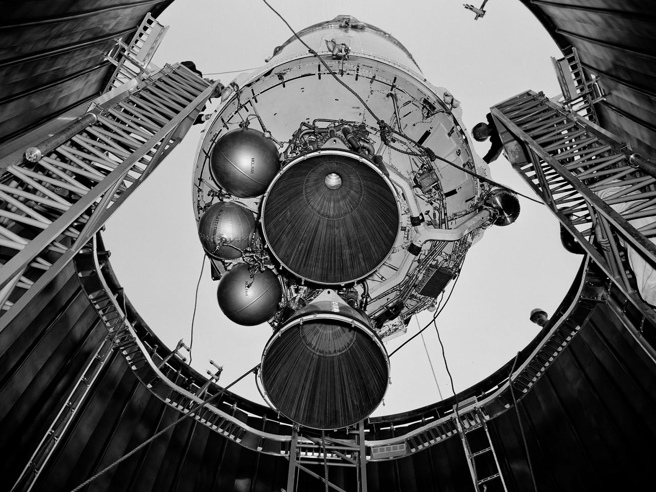
A Centaur second-stage rocket is lowered into the vacuum tank inside the Space Power Chambers at NASA’s Lewis Research Center. Centaur was to be paired with an Atlas booster to send the Surveyor spacecraft to the moon as a precursor to the Apollo landings. Lewis was assigned responsibility for the Centaur Program after the failure of its first developmental flight in May 1962. Lewis’ Altitude Wind Tunnel was converted into two large test chambers—the Space Power Chambers. The facility’s vacuum chamber, seen here, allowed the Centaur to be stood up vertically and subjected to atmospheric conditions-- pressures, temperature, and radiation--similar to those it would encounter in space. The Centaur for these tests was delivered to Cleveland in a C‒130 aircraft on September 27, 1963. The rocket was set up in the facility’s high bay where Lewis technicians and General Dynamics consultants updated its flight systems to match the upcoming Atlas-Centaur‒4 mission. Months were spent reharnessing the Centaur’s electronics, learning about the systems, and being taught how to handle flight hardware. By early spring 1964, the extensive setup of both the spacecraft and the chamber was finally completed. On March 19 the Centaur was rolled out from the shop, hoisted high into the air by a crane, and lowered into the waiting space tank. Researchers were able to verify that the Centaur’s electronics and electrical systems functioned reliably in a space environment.
A researcher prepares a Centaur 6A second-stage rocket for a series of tests in the Space Power Chambers’ vacuum tank at the National Aeronautics and Space Administration (NASA) Lewis Research Center. Lewis was assigned oversight of the Centaur Program in the fall of 1962. Prior to that, Centaur’s only launch had failed shortly after liftoff. Lewis engineers undertook an expansive effort to quickly resolve Centaur’s problems and prepare it for its planned missions to send Surveyor spacecraft to land on the moon. For one test program, a complete Centaur vehicle was lowered into the vacuum chamber at the Space Power Chambers to verify that its electronics and electrical systems functioned reliably in a space environment. At the time, electronic malfunctions were one of the most likely causes of failures in space. Studying these systems during long soaks inside the space tank helped the Lewis team calibrate them and facilitate the monitoring of the spacecraft during an actual flight. The Centaur for the tests was delivered to Cleveland in a C-130 aircraft on September 27, 1963. The rocket was set up in the facility’s high bay where Lewis technicians and General Dynamics consultants updated its flight systems to match the upcoming Atlas-Centaur-4 mission, as seen in this photograph.

Mark Pestana is a research pilot and project manager at the NASA Dryden Flight Research Center, Edwards, Calif. He is a pilot for the Beech B200 King Air, the T-34C and the Predator B. He flies the F-18 Hornet as a co-pilot and flight test engineer. Pestana has accumulated more than 4,000 hours of military and civilian flight experience. He was also a flight engineer on the NASA DC-8 flying laboratory. Pestana was the project manager and pilot for the Hi–rate Wireless Airborne Network Demonstration flown on the NASA B200 research aircraft. He flew B200 research missions for the X-38 Space Integrated Inertial Navigation Global Positioning System experiment. Pestana also participated in several deployments of the DC-8, including Earth science expeditions ranging from hurricane research over the Caribbean Sea to ozone studies over the North Pole, atmospheric chemistry over the South Pacific, rain forest health in Central America, Rocky Mountain ice pack assessment, and volcanic and tectonic activity around the Pacific Rim. He came to Dryden as a DC-8 mission manager in June 1998 from NASA Johnson Space Center, Houston, where he served as the Earth and Space Science discipline manager for the International Space Station Program at Johnson. Pestana also served as a flight crew operations engineer in the Astronaut Office, developing the controls, displays, tools, crew accommodations and procedures for on-orbit assembly, test, and checkout of the International Space Station. He led the analysis and technical negotiations for modification of the Russian Soyuz spacecraft as an emergency crew return vehicle for space station crews. He joined the U.S. Air Force Reserve in 1991 and held various positions as a research and development engineer, intelligence analyst, and Delta II launch vehicle systems engineer. He retired from the U.S. Air Force Reserve with the rank of colonel in 2005. Prior to 1990, Pestana was on active duty with the U.S. Air Force as the director of mi
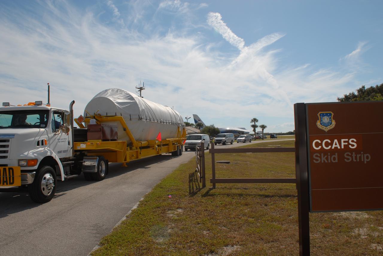
CAPE CANAVERAL, Fla. – The Centaur second stage for the Atlas V rocket slated to launch NASA's Solar Dynamics Observatory, or SDO, is transported from the Skid Strip on Cape Canaveral Air Force Station in Florida to the Atlas Spaceflight Operations Center. The stage was delivered aboard the Volga-Dnepr Antonov AN-124-100, a Ukranian/Russian aircraft, in the background. SDO is the first space weather research network mission in NASA's Living With a Star Program. The spacecraft's long-term measurements will give solar scientists in-depth information about changes in the sun's magnetic field and insight into how they affect Earth. Liftoff on the United Launch Alliance Atlas V is scheduled for Feb. 3, 2010. For information on SDO, visit http://www.nasa.gov/sdo. Photo credit: NASA/Jim Grossmann
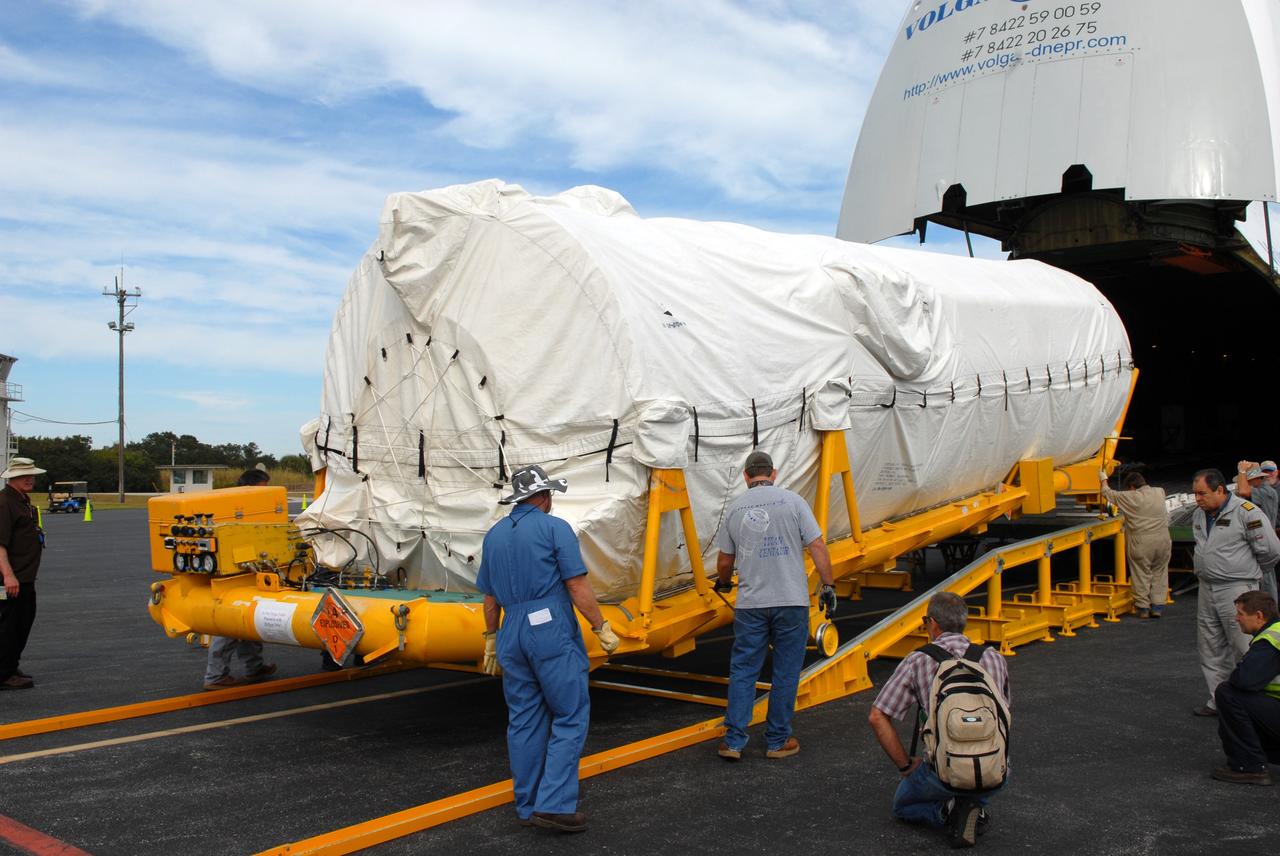
CAPE CANAVERAL, Fla. – At the Skid Strip on Cape Canaveral Air Force Station in Florida, workers roll the Centaur second stage for the Atlas V rocket slated to launch NASA's Solar Dynamics Observatory, or SDO, off a Volga-Dnepr Antonov AN-124-100, a Ukranian/Russian aircraft. SDO is the first space weather research network mission in NASA's Living With a Star Program. The spacecraft's long-term measurements will give solar scientists in-depth information about changes in the sun's magnetic field and insight into how they affect Earth. Liftoff on the United Launch Alliance Atlas V is scheduled for Feb. 3, 2010. For information on SDO, visit http://www.nasa.gov/sdo. Photo credit: NASA/Jim Grossmann
CAPE CANAVERAL, Fla. – At the Skid Strip on Cape Canaveral Air Force Station in Florida, the Centaur second stage for the Atlas V rocket slated to launch NASA's Solar Dynamics Observatory, or SDO, has been offloaded from Volga-Dnepr Antonov AN-124-100, a Ukranian/Russian aircraft, in which it was delivered. SDO is the first space weather research network mission in NASA's Living With a Star Program. The spacecraft's long-term measurements will give solar scientists in-depth information about changes in the sun's magnetic field and insight into how they affect Earth. Liftoff on the United Launch Alliance Atlas V is scheduled for Feb. 3, 2010. For information on SDO, visit http://www.nasa.gov/sdo. Photo credit: NASA/Jim Grossmann
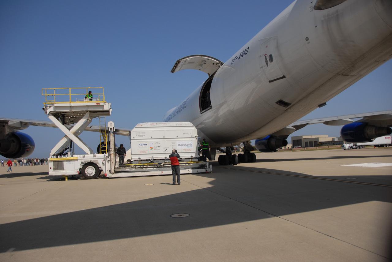
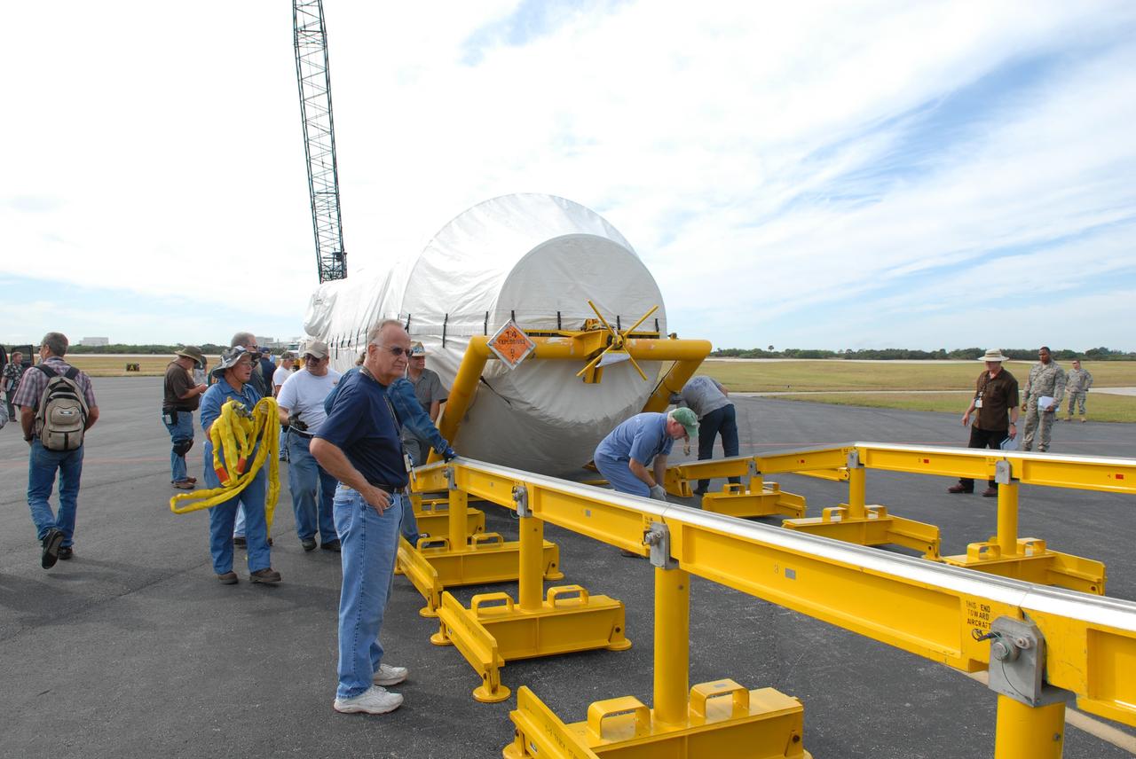
VANDENBERG AIR FORCE BASE, Calif. -- The shipping container with the OSTM/Jason-2 spacecraft inside is offloaded from the aircraft at Vandenberg Air Force Base in California. The OSTM, or Ocean Topography Mission, on the Jason-2 satellite is a follow-on to Jason-1. It will take oceanographic studies of sea surface height into an operational mode for continued climate forecasting research and science and industrial applications. This satellite altimetry data will help determine ocean circulation, climate change and sea-level rise. OSTM is a joint effort by the National Oceanic and Atmospheric Administration, NASA, France’s Centre National d’Etudes Spatiales and the European Meteorological Satellite Organisation. OSTM/Jason-2 will be launched aboard a United Launch Alliance Delta II 7320 from Vandenberg on June 15. Photo credit: NASA/Dan Liberotti
VANDENBERG AIR FORCE BASE, Calif. -- The shipping container with the OSTM/Jason-2 spacecraft inside is offloaded from the aircraft at Vandenberg Air Force Base in California. The OSTM, or Ocean Topography Mission, on the Jason-2 satellite is a follow-on to Jason-1. It will take oceanographic studies of sea surface height into an operational mode for continued climate forecasting research and science and industrial applications. This satellite altimetry data will help determine ocean circulation, climate change and sea-level rise. OSTM is a joint effort by the National Oceanic and Atmospheric Administration, NASA, France’s Centre National d’Etudes Spatiales and the European Meteorological Satellite Organisation. OSTM/Jason-2 will be launched aboard a United Launch Alliance Delta II 7320 from Vandenberg on June 15. Photo credit: NASA/Dan Liberotti
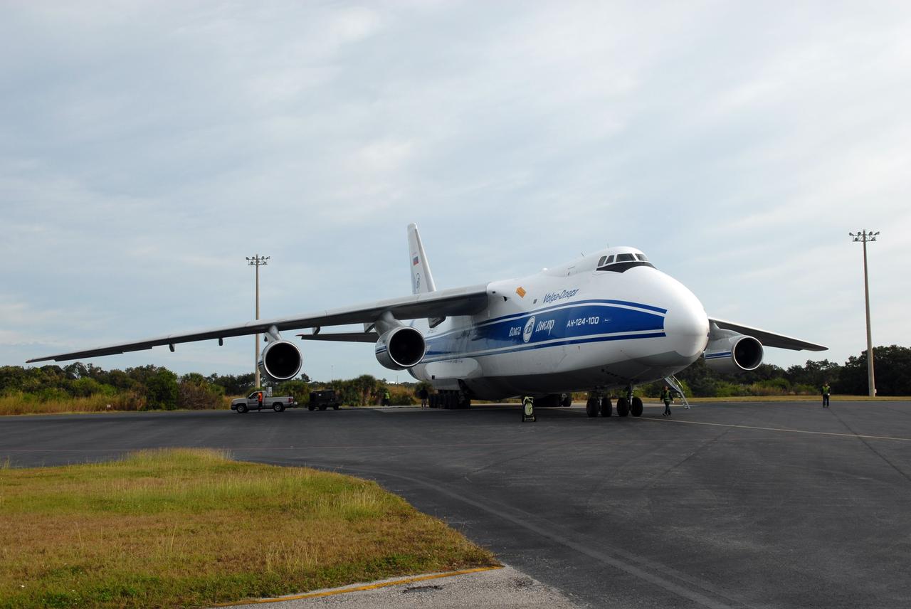
CAPE CANAVERAL, Fla. – A Volga-Dnepr Antonov AN-124-100, a Ukranian/Russian aircraft, lands at the Skid Strip on Cape Canaveral Air Force Station in Florida, delivering the Centaur second stage for the Atlas V rocket slated to launch NASA's Solar Dynamics Observatory, or SDO. SDO is the first space weather research network mission in NASA's Living With a Star Program. The spacecraft's long-term measurements will give solar scientists in-depth information about changes in the sun's magnetic field and insight into how they affect Earth. Liftoff on the United Launch Alliance Atlas V is scheduled for Feb. 3, 2010. For information on SDO, visit http://www.nasa.gov/sdo. Photo credit: NASA/Jim Grossmann
CAPE CANAVERAL, Fla. – At the Skid Strip on Cape Canaveral Air Force Station in Florida, workers roll the Centaur second stage for the Atlas V rocket slated to launch NASA's Solar Dynamics Observatory, or SDO, from Volga-Dnepr Antonov AN-124-100, a Ukranian/Russian aircraft, in which it was delivered. SDO is the first space weather research network mission in NASA's Living With a Star Program. The spacecraft's long-term measurements will give solar scientists in-depth information about changes in the sun's magnetic field and insight into how they affect Earth. Liftoff on the United Launch Alliance Atlas V is scheduled for Feb. 3, 2010. For information on SDO, visit http://www.nasa.gov/sdo. Photo credit: NASA/Jim Grossmann
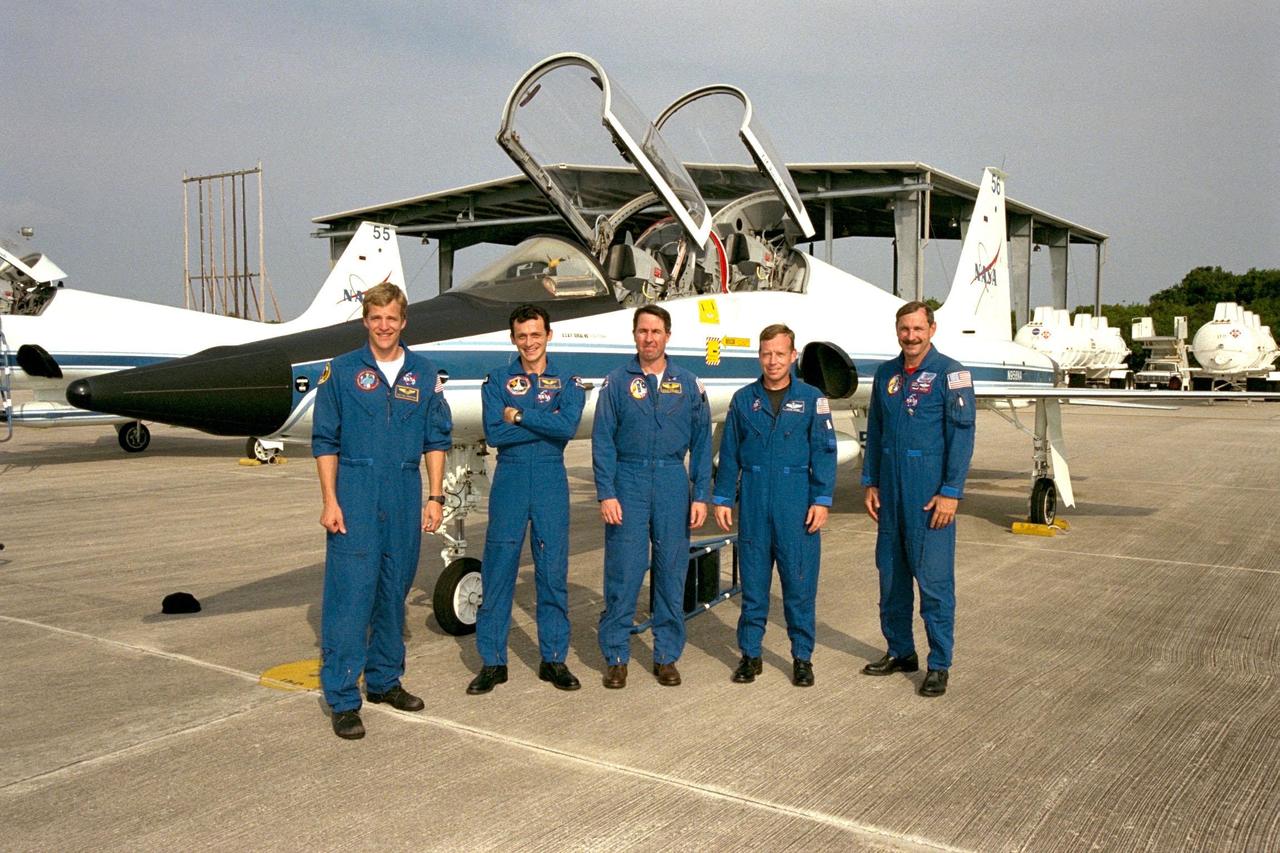
Members of the STS-95 crew pose in front of one of the T-38 jet aircraft that brought them to the Shuttle Landing Facility at KSC. From left, the members are Mission Specialist Scott E. Parazynski, M.D.; Pedro Duque of Spain, representing the European Space Agency (ESA); Mission Specialist Stephen K. Robinson, Ph.D.; Pilot Steven W. Lindsey; and Commander Curtis L. Brown Jr. The crew is participating in a familiarization tour of the SPACEHAB module and the equipment that will fly with them on the Space Shuttle Discovery scheduled to launch Oct. 29, 1998. The mission includes research payloads such as the Spartan solar-observing deployable spacecraft, the Hubble Space Telescope Orbital Systems Test Platform, the International Extreme Ultraviolet Hitchhiker, as well as the SPACEHAB single module with experiments on space flight and the aging process
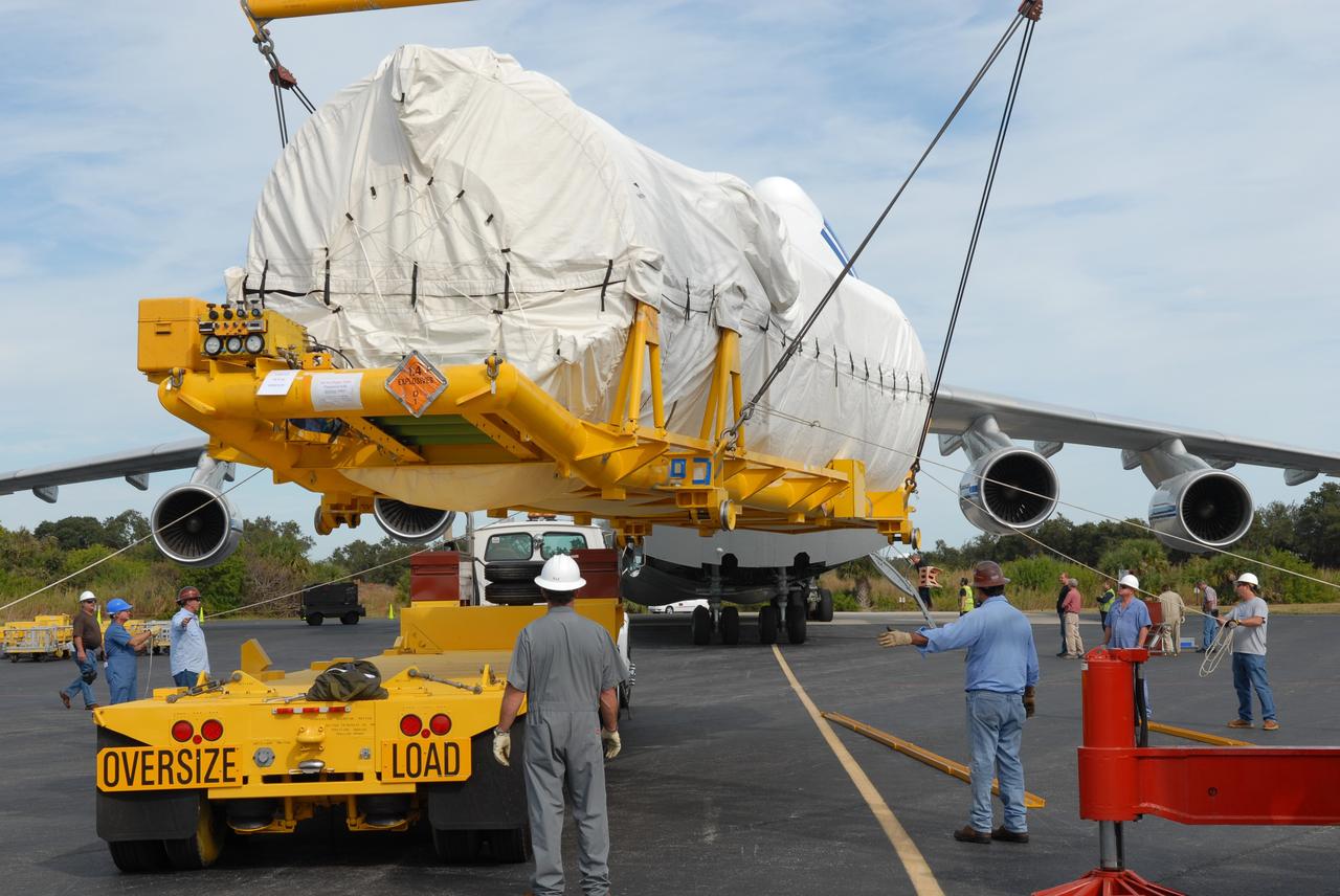
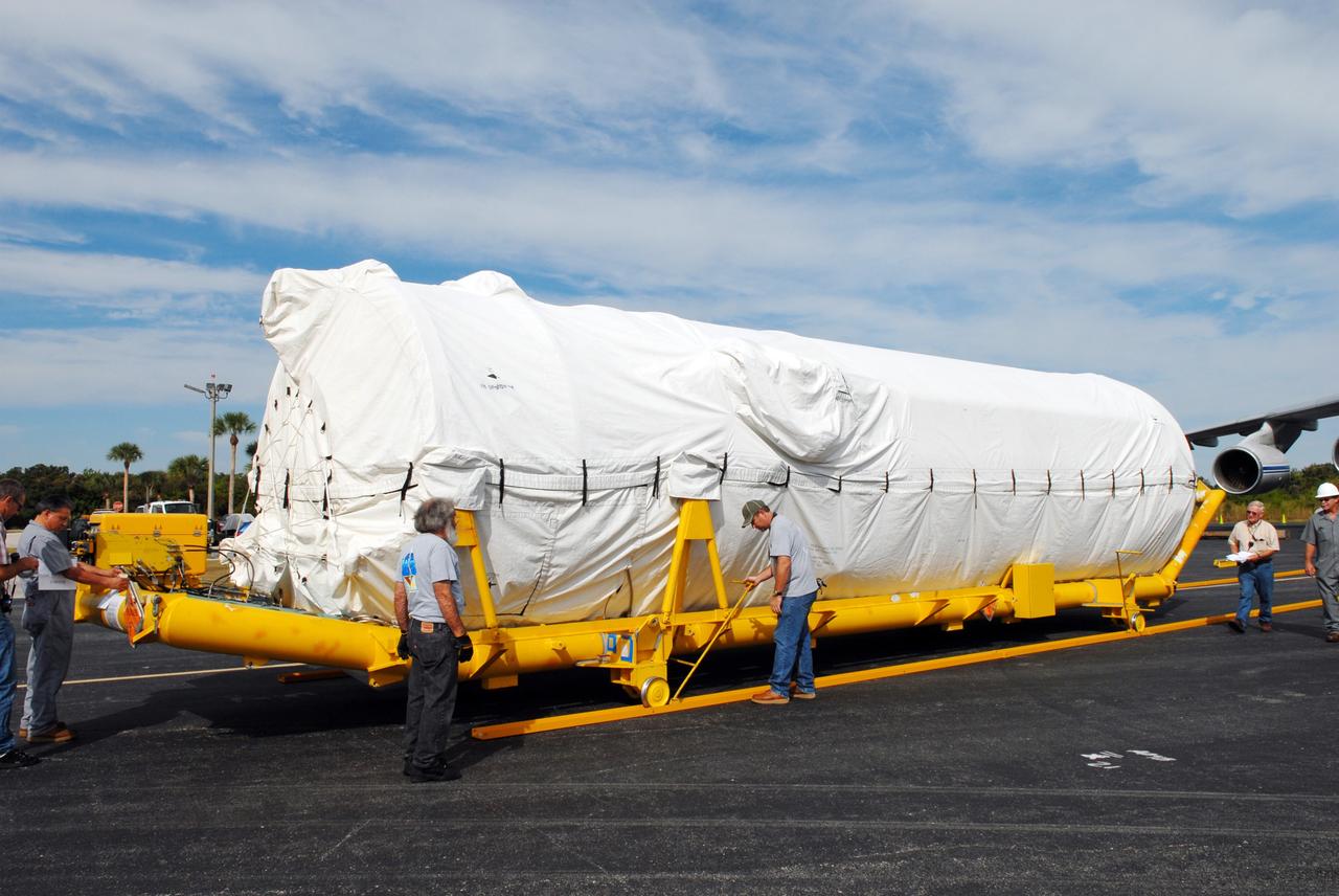
CAPE CANAVERAL, Fla. – At the Skid Strip on Cape Canaveral Air Force Station in Florida, a crane lifts the Centaur second stage for the Atlas V rocket slated to launch NASA's Solar Dynamics Observatory, or SDO, onto a transporter. The stage was delivered aboard the Volga-Dnepr Antonov AN-124-100, a Ukranian/Russian aircraft, behind it. SDO is the first space weather research network mission in NASA's Living With a Star Program. The spacecraft's long-term measurements will give solar scientists in-depth information about changes in the sun's magnetic field and insight into how they affect Earth. Liftoff on the United Launch Alliance Atlas V is scheduled for Feb. 3, 2010. For information on SDO, visit http://www.nasa.gov/sdo. Photo credit: NASA/Jim Grossmann
CAPE CANAVERAL, Fla. – At the Skid Strip on Cape Canaveral Air Force Station in Florida, workers offload the Centaur second stage for the Atlas V rocket slated to launch NASA's Solar Dynamics Observatory, or SDO, from a Volga-Dnepr Antonov AN-124-100, a Ukranian/Russian aircraft. SDO is the first space weather research network mission in NASA's Living With a Star Program. The spacecraft's long-term measurements will give solar scientists in-depth information about changes in the sun's magnetic field and insight into how they affect Earth. Liftoff on the United Launch Alliance Atlas V is scheduled for Feb. 3, 2010. For information on SDO, visit http://www.nasa.gov/sdo. Photo credit: NASA/Jim Grossmann
CAPE CANAVERAL, Fla. – At the Skid Strip on Cape Canaveral Air Force Station in Florida, workers prepare to offload the Centaur second stage for the Atlas V rocket slated to launch NASA's Solar Dynamics Observatory, or SDO, from a Volga-Dnepr Antonov AN-124-100, a Ukranian/Russian aircraft. SDO is the first space weather research network mission in NASA's Living With a Star Program. The spacecraft's long-term measurements will give solar scientists in-depth information about changes in the sun's magnetic field and insight into how they affect Earth. Liftoff on the United Launch Alliance Atlas V is scheduled for Feb. 3, 2010. For information on SDO, visit http://www.nasa.gov/sdo. Photo credit: NASA/Jim Grossmann
VANDENBERG AIR FORCE BASE, Calif. – The shipping container with the OSTM/Jason-2 spacecraft inside is offloaded from the aircraft at Vandenberg Air Force Base in California. The OSTM, or Ocean Topography Mission, on the Jason-2 satellite is a follow-on to Jason-1. It will take oceanographic studies of sea surface height into an operational mode for continued climate forecasting research and science and industrial applications. This satellite altimetry data will help determine ocean circulation, climate change and sea-level rise. OSTM is a joint effort by the National Oceanic and Atmospheric Administration, NASA, France’s Centre National d’Etudes Spatiales and the European Meteorological Satellite Organisation. OSTM/Jason-2 will be launched aboard a United Launch Alliance Delta II 7320 from Vandenberg on June 15. Photo credit: NASA/Steve Greenberg, JPL
VANDENBERG AIR FORCE BASE, Calif. – The shipping container with the OSTM/Jason-2 spacecraft inside is offloaded from the aircraft at Vandenberg Air Force Base in California. The OSTM, or Ocean Topography Mission, on the Jason-2 satellite is a follow-on to Jason-1. It will take oceanographic studies of sea surface height into an operational mode for continued climate forecasting research and science and industrial applications. This satellite altimetry data will help determine ocean circulation, climate change and sea-level rise. OSTM is a joint effort by the National Oceanic and Atmospheric Administration, NASA, France’s Centre National d’Etudes Spatiales and the European Meteorological Satellite Organisation. OSTM/Jason-2 will be launched aboard a United Launch Alliance Delta II 7320 from Vandenberg on June 15. Photo credit: NASA/Steve Greenberg, JPL
VANDENBERG AIR FORCE BASE, Calif. – The aircraft carrying the OSTM/Jason-2 spacecraft taxis past the Astrotech processing facility at Vandenberg Air Force Base in California. The OSTM, or Ocean Topography Mission, on the Jason-2 satellite is a follow-on to Jason-1. It will take oceanographic studies of sea surface height into an operational mode for continued climate forecasting research and science and industrial applications. This satellite altimetry data will help determine ocean circulation, climate change and sea-level rise. OSTM is a joint effort by the National Oceanic and Atmospheric Administration, NASA, France’s Centre National d’Etudes Spatiales and the European Meteorological Satellite Organisation. OSTM/Jason-2 will be launched aboard a United Launch Alliance Delta II 7320 from Vandenberg on June 15. Photo credit: NASA/Stephen Greenberg, JPL
CAPE CANAVERAL, Fla. – At the Skid Strip on Cape Canaveral Air Force Station in Florida, a crane lowers the Centaur second stage for the Atlas V rocket slated to launch NASA's Solar Dynamics Observatory, or SDO, onto a transporter. The stage was delivered aboard the Volga-Dnepr Antonov AN-124-100, a Ukranian/Russian aircraft, at left. SDO is the first space weather research network mission in NASA's Living With a Star Program. The spacecraft's long-term measurements will give solar scientists in-depth information about changes in the sun's magnetic field and insight into how they affect Earth. Liftoff on the United Launch Alliance Atlas V is scheduled for Feb. 3, 2010. For information on SDO, visit http://www.nasa.gov/sdo. Photo credit: NASA/Jim Grossmann
CAPE CANAVERAL, Fla. – At the Skid Strip on Cape Canaveral Air Force Station in Florida, a crane prepares to lift the Centaur second stage for the Atlas V rocket slated to launch NASA's Solar Dynamics Observatory, or SDO, onto a transporter. The stage was delivered aboard the Volga-Dnepr Antonov AN-124-100, a Ukranian/Russian aircraft, at right. SDO is the first space weather research network mission in NASA's Living With a Star Program. The spacecraft's long-term measurements will give solar scientists in-depth information about changes in the sun's magnetic field and insight into how they affect Earth. Liftoff on the United Launch Alliance Atlas V is scheduled for Feb. 3, 2010. For information on SDO, visit http://www.nasa.gov/sdo. Photo credit: NASA/Jim Grossmann

VANDENBERG AIR FORCE BASE, Calif. – The aircraft carrying the OSTM/Jason-2 spacecraft arrives at Vandenberg Air Force Base in California. The OSTM, or Ocean Topography Mission, on the Jason-2 satellite is a follow-on to Jason-1. It will take oceanographic studies of sea surface height into an operational mode for continued climate forecasting research and science and industrial applications. This satellite altimetry data will help determine ocean circulation, climate change and sea-level rise. OSTM is a joint effort by the National Oceanic and Atmospheric Administration, NASA, France’s Centre National d’Etudes Spatiales and the European Meteorological Satellite Organisation. OSTM/Jason-2 will be launched aboard a United Launch Alliance Delta II 7320 from Vandenberg on June 15. Photo credit: NASA/Steve Greenberg, JPL
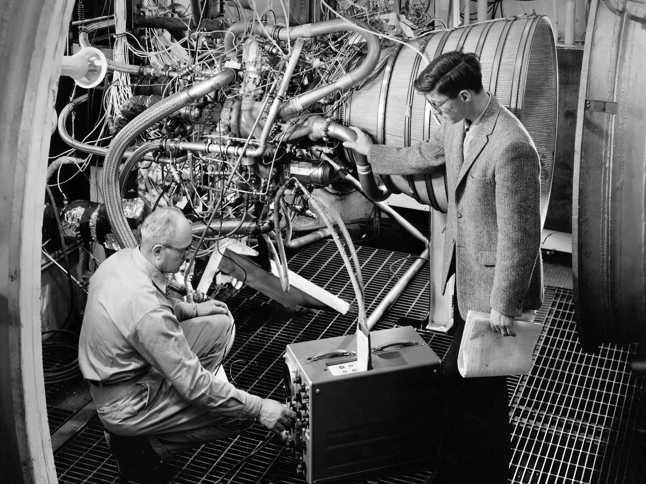
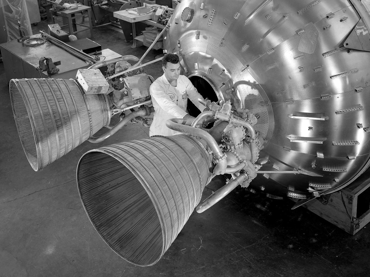
Lead Test Engineer John Kobak (right) and a technician use an oscilloscope to test the installation of a Pratt and Whitney RL-10 engine in the Propulsion Systems Laboratory at the National Aeronautics and Space Administration (NASA) Lewis Research Center. In 1955 the military asked Pratt and Whitney to develop hydrogen engines specifically for aircraft. The program was canceled in 1958, but Pratt and Whitney decided to use the experience to develop a liquid-hydrogen rocket engine, the RL-10. Two of the 15,000-pound-thrust RL-10 engines were used to power the new Centaur second-stage rocket. Centaur was designed to carry the Surveyor spacecraft on its mission to soft-land on the Moon. Pratt and Whitney ran into problems while testing the RL-10 at their facilities. NASA Headquarters assigned Lewis the responsibility for investigating the RL-10 problems because of the center’s long history of liquid-hydrogen development. Lewis’ Chemical Rocket Division began a series of tests to study the RL-10 at its Propulsion Systems Laboratory in March 1960. The facility contained two test chambers that could study powerful engines in simulated altitude conditions. The first series of RL-10 tests in early 1961 involved gimballing the engine as it fired. Lewis researchers were able to yaw and pitch the engine to simulate its behavior during a real flight.
Crews at March Air Reserve Base in Riverside County, California, on Oct. 15, 2024, load a specialized shipping container carrying the NISAR (NASA ISRO Synthetic Aperture Radar) mission's radar antenna reflector into the hold of NASA's C-130 Hercules plane. The aircraft later departed on a multistage journey to Bengaluru, India, arriving on Oct. 22. A key piece of science hardware for the mission, which is a joint effort of NASA and the Indian Space Research Organisation, the reflector had been undergoing work at a specialized facility in California. Engineers there applied reflective tape and took other precautionary measures to mitigate temperature increases that could potentially have affected the deployment of the reflector from its stowed configuration. Drum-shaped and about 39 feet (12 meters) across, the reflector is among NASA's contributions to the mission. The reflector is designed to transmit and receive microwave signals to and from Earth's surface, enabling NISAR to scan nearly all the planet's land and ice surfaces twice every 12 days to collect science data. Once NISAR is in operation, its observations will benefit humanity by helping researchers around the world better understand changes in the planet's surface, including its ice sheets, glaciers, and sea ice. The spacecraft will also capture changes in forest and wetland ecosystems as well as movement and deformation of our planet's crust. https://photojournal.jpl.nasa.gov/catalog/PIA26419
![KENNEDY SPACE CENTER, FLA. -- The Pegasus XL rocket is dropped from the L-1011 aircraft at 3:14 p.m. EST, propelling NASA's Solar Radiation and Climate Experiment (SORCE) toward its orbit. Separation of the spacecraft from the rocket occurred 10 minutes and 46 seconds after launch at about 3:24 p.m. Initial contact with the satellite was made seven seconds after separation via a NASA communications satellite network. Over the next few days, the mission team will insure that the spacecraft is functioning properly. The SORCE science instruments will then be turned on and their health verified. Approximately 21 days after launch, if all is going well, the instruments will start initial science data collection and calibration will begin. The spacecraft will study the Sun's influence on our Earth and will measure from space how the Sun affects the Earth's ozone layer, atmospheric circulation, clouds, and oceans. This mission is a joint partnership between NASA and the University of Colorado's Laboratory for Atmospheric and Space Physics in Boulder, Colorado. [Photo courtesy of Jeff Caplan, Langley Research]](https://images-assets.nasa.gov/image/KSC-03pd0180/KSC-03pd0180~medium.jpg)
KENNEDY SPACE CENTER, FLA. -- The Pegasus XL rocket is dropped from the L-1011 aircraft at 3:14 p.m. EST, propelling NASA's Solar Radiation and Climate Experiment (SORCE) toward its orbit. Separation of the spacecraft from the rocket occurred 10 minutes and 46 seconds after launch at about 3:24 p.m. Initial contact with the satellite was made seven seconds after separation via a NASA communications satellite network. Over the next few days, the mission team will insure that the spacecraft is functioning properly. The SORCE science instruments will then be turned on and their health verified. Approximately 21 days after launch, if all is going well, the instruments will start initial science data collection and calibration will begin. The spacecraft will study the Sun's influence on our Earth and will measure from space how the Sun affects the Earth's ozone layer, atmospheric circulation, clouds, and oceans. This mission is a joint partnership between NASA and the University of Colorado's Laboratory for Atmospheric and Space Physics in Boulder, Colorado. [Photo courtesy of Jeff Caplan, Langley Research]
![KENNEDY SPACE CENTER, FLA. -- After being dropped from the L-1011 aircraft at 3:14 p.m. EST over the Atlantic Ocean, the Pegasus XL rocket fires, propelling NASA's Solar Radiation and Climate Experiment (SORCE) toward its orbit. Separation of the spacecraft from the rocket occurred 10 minutes and 46 seconds after launch at about 3:24 p.m. Initial contact with the satellite was made seven seconds after separation via a NASA communications satellite network. Over the next few days, the mission team will insure that the spacecraft is functioning properly. The SORCE science instruments will then be turned on and their health verified. Approximately 21 days after launch, if all is going well, the instruments will start initial science data collection and calibration will begin. The spacecraft will study the Sun's influence on our Earth and will measure from space how the Sun affects the Earth's ozone layer, atmospheric circulation, clouds, and oceans. This mission is a joint partnership between NASA and the University of Colorado's Laboratory for Atmospheric and Space Physics in Boulder, Colorado. [Photo courtesy of Jeff Caplan, Langley Research]](https://images-assets.nasa.gov/image/KSC-03pd0179/KSC-03pd0179~medium.jpg)
KENNEDY SPACE CENTER, FLA. -- After being dropped from the L-1011 aircraft at 3:14 p.m. EST over the Atlantic Ocean, the Pegasus XL rocket fires, propelling NASA's Solar Radiation and Climate Experiment (SORCE) toward its orbit. Separation of the spacecraft from the rocket occurred 10 minutes and 46 seconds after launch at about 3:24 p.m. Initial contact with the satellite was made seven seconds after separation via a NASA communications satellite network. Over the next few days, the mission team will insure that the spacecraft is functioning properly. The SORCE science instruments will then be turned on and their health verified. Approximately 21 days after launch, if all is going well, the instruments will start initial science data collection and calibration will begin. The spacecraft will study the Sun's influence on our Earth and will measure from space how the Sun affects the Earth's ozone layer, atmospheric circulation, clouds, and oceans. This mission is a joint partnership between NASA and the University of Colorado's Laboratory for Atmospheric and Space Physics in Boulder, Colorado. [Photo courtesy of Jeff Caplan, Langley Research]
NASA image acquired October 23, 2009. At NASA’s Dryden Research Center in California, a group of engineers, scientists, and aviation technicians have set up camp in a noisy, chilly hangar on Edwards Air Force base. For the past two weeks, they have been working to mount equipment—from HD video cameras to ozone sensors—onto NASA’s Global Hawk, a remote-controlled airplane that can fly for up to 30 hours at altitudes up to 65,000 feet. The team is gearing up for the Global Hawk Pacific campaign, a series of four or five scientific research flights that will take the Global Hawk over the Pacific Ocean and Arctic regions. The 44-foot-long aircraft, with its comically large nose and 116-foot wingspan is pictured in the photograph above, banking for landing over Rogers Dry Lake in California at the end of a test flight on October 23, 2009. The long wings carry the plane’s fuel, and the bulbous nose is one of the payload bays, which house the science instruments. For the Global Hawk Pacific campaign, the robotic aircraft will carry ten science instruments that will sample the chemical composition of air in the troposphere (the atmospheric layer closest to Earth) and the stratosphere (the layer above the troposphere). The mission will also observe clouds and aerosol particles in the troposphere. The primary purpose of the mission is to collect observations that can be used to check the accuracy of simultaneous observations collected by NASA’s Aura satellite. Co-lead scientist Paul Newman from Goddard Space Flight Center is writing about the ground-breaking mission for the Earth Observatory’s Notes from the Field blog. NASA Photograph by Carla Thomas. <b><a href="http://www.nasa.gov/centers/goddard/home/index.html" rel="nofollow">NASA Goddard Space Flight Center</a></b> is home to the nation's largest organization of combined scientists, engineers and technologists that build spacecraft, instruments and new technology to study the Earth, the sun, our solar system, and the universe. To learn more about this image go to: <a href="http://earthobservatory.nasa.gov/IOTD/view.php?id=43291" rel="nofollow">earthobservatory.nasa.gov/IOTD/view.php?id=43291</a>

The mural was created to celebrate the achievements of Wilbur and Orville Wright and to commemorate a century of powered flight. Central to the composition is the 1903 Wright Flyer. "On Dec. 17, 1903, the Wright brothers inaugurated the aerial age with their successful first flights of a heavier-than-air flying machine at Kitty Hawk, N.C. This airplane, known as the Wright Flyer, sometimes referred to as the Kitty Hawk Flyer, was the product of a sophisticated four-year program of research and development conducted by Wilbur and Orville Wright beginning in 1899. During the Wrights' design and construction of their experimental aircraft, they also pioneered many of the basic tenets and techniques of modern aeronautical engineering, such as the use of a wind tunnel and flight testing as design tools. Their seminal accomplishment encompassed not only the breakthrough first flight of an airplane, but also the equally important achievement of establishing the foundation of aeronautical engineering." Dr. Peter Jakab, Curator of Aviation, National Air and Space Museum, Smithsonian Institution "Celebrating One Hundred Years of Powered Flight, 1903-2003", documents many significant achievements in aeronautics and space flight from the dawn of powered flight to the present. Historic aircraft and spacecraft serve as the backdrop, highlighting six figures representing the human element that made these milestones possible. These figures stand, symbolically supported by the words of Wilbur Wright, "It is my belief that flight is possible…" The quote was taken from a letter written to his father on September 3rd, 1900, announcing Wilbur's intention to make "some experiments with a flying machine" at Kitty Hawk, North Carolina. "This year, Bob is helping us commemorate the Centennial of Flight with a beautiful mural slated for placement in our Dryden Flight Research Center that documents the history of flight from the Wright Flyer to the International Space Station. We should
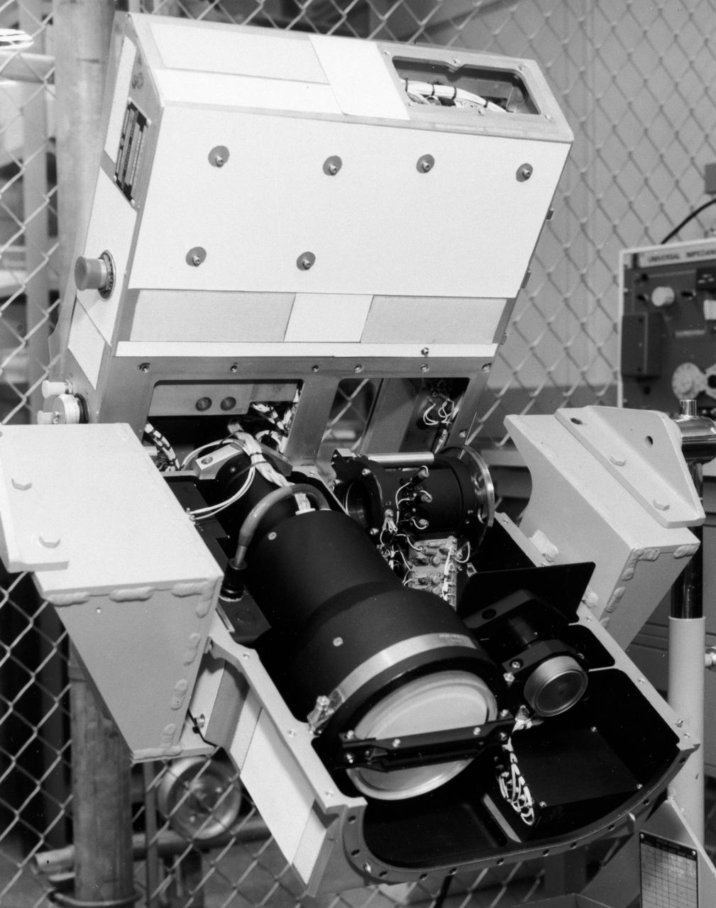
S72-49482 (November 1972) --- The Optical Recorder of the Lunar Sounder Experiment (S-209) which will be mounted in the SIM bay of the Apollo 17 Service Module. The three functional parts of the Lunar Sounder are the optical recorder, the coherent synthetic aperture radar, and the antennas, a retractable dipole for HF and a yagi for VHF. The Lunar Sounder will probe three-quarters of a mile below the moon's surface from the orbiting Apollo 17 spacecraft. Electronic data recorded on film will be retrieved by the crew during trans-Earth EVA. Geologic information on the lunar interior obtained by the sounder will permit scientific investigation of underground rock layers, lava flow patterns, rille (canyon) structures, mascon properties, and any areas containing water. A prototype lunar sounder has been flight tested in aircraft over selected Earth sites to confirm the equipment design and develop scientific analysis techniques. The Lunar Sounder Experiment was developed by North American Rockwell's (NR) Space Division for NASA's Manned Spacecraft Center to provide data for a scientific investigation team with representatives from the Jet Propulsion Laboratory, University of Utah, University of Michigan, U.S. Geological Survey, and NASA Ames Research Center.
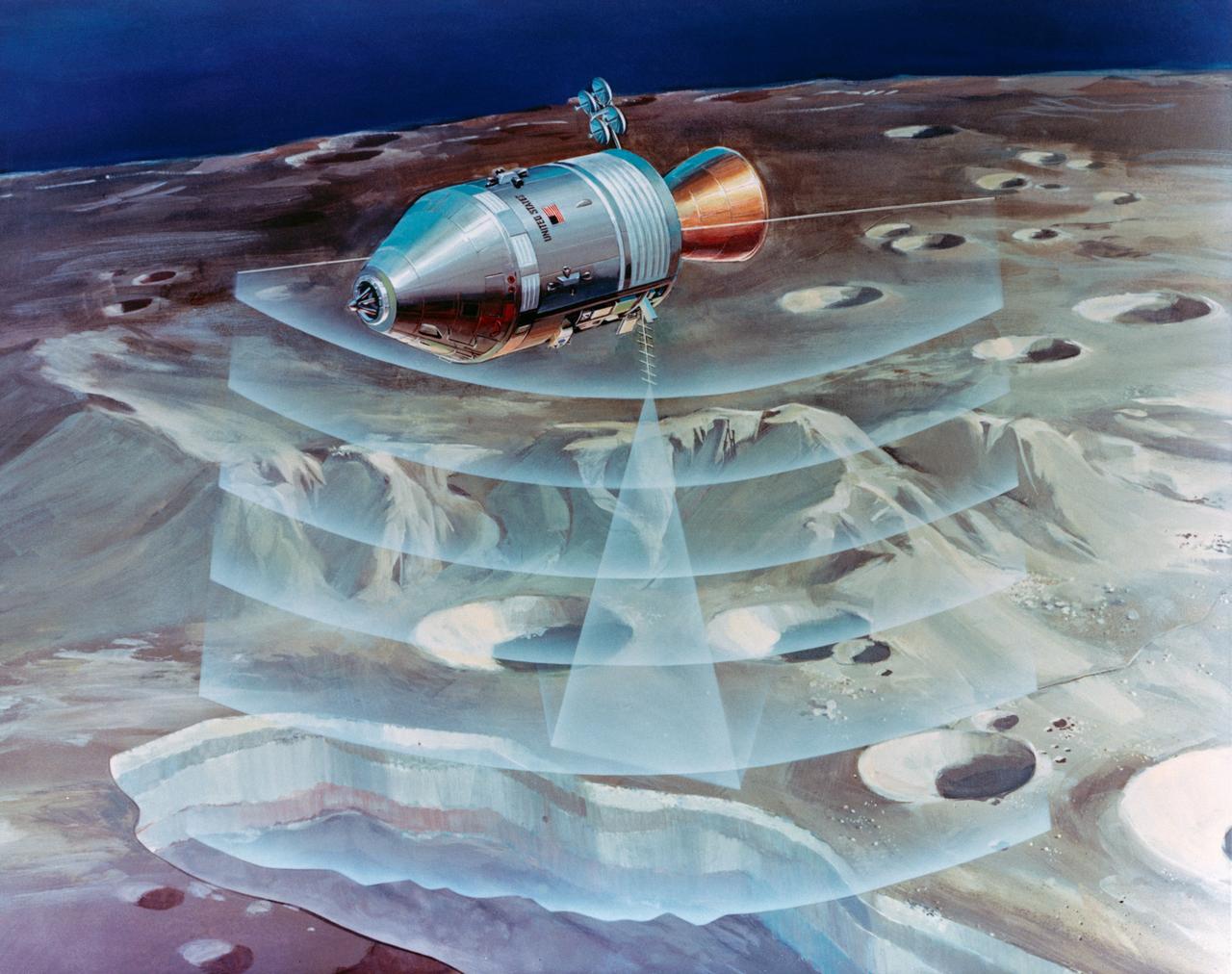
S72-53472 (November 1972) --- An artist's concept illustrating how radar beams of the Apollo 17 lunar sounder experiment will probe three-quarters of a mile below the moon's surface from the orbiting spacecraft. The Lunar Sounder will be mounted in the SIM bay of the Apollo 17 Service Module. Electronic data recorded on film will be retrieved by the crew during trans-Earth EVA. Geologic information on the lunar interior obtained by the sounder will permit scientific investigation of underground rock layers, lava flow patterns, rille (canyon) structures, mascon properties, and any areas containing water. A prototype lunar sounder has been flight tested in aircraft over selected Earth sites to confirm the equipment design and develop scientific analysis techniques. The Lunar Sounder Experiment (S-209) was developed by North American Rockwell's (NR) Space Division for NASA's Manned Spacecraft Center to provide data for a scientific investigation team with representatives from the Jet Propulsion Laboratory, University of Utah, University of Michigan, U.S. Geological Survey, and NASA Ames Research Center.
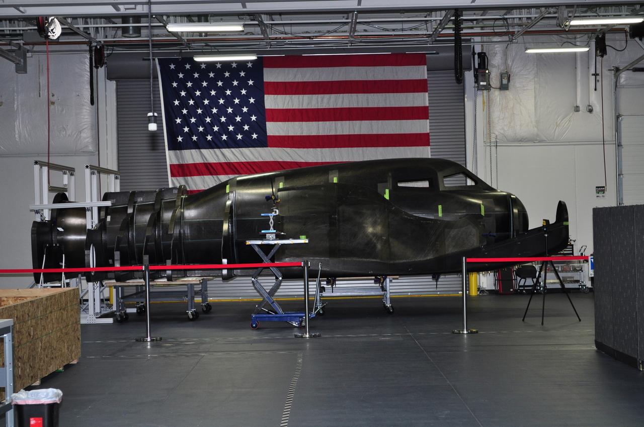
LOUISVILLE, Colo. – During NASA's Commercial Crew Development Round 2 CCDev2) activities for the Commercial Crew Program CCP, Sierra Nevada Corp. SNC delivered the primary structure of its Dream Chaser flight test vehicle to the company’s office in Louisville, Colo. SNC engineers currently are assembling the full-scale prototype, which includes the integration of secondary structures and subsystems. This all-composite structure of the company's planned winged spacecraft, the Dream Chaser, will be used to carry out several remaining CCDev2 milestones including a captive carry flight and the first approach and landing test of the spacecraft. During the captive carry flight, a carrier aircraft will the Dream Chaser vehicle over NASA's Dryden Flight Research Center in Edwards, Calif. Sierra Nevada is one of seven companies NASA entered into Space Act Agreements SAAs with during CCDev2 to aid in the innovation and development of American-led commercial capabilities for crew transportation and rescue services to and from the International Space Station and other low Earth orbit destinations. For information about CCP, visit www.nasa.gov/commercialcrew. Photo credit: Sierra Nevada Corp.

CAPE CANAVERAL, Fla. – At the Kennedy Space Center in Florida, the new space shuttle, Atlantis, arrives at the Shuttle Landing Facility. The shuttle is mounted atop the Shuttle Carrier Aircraft, a modified Boeing 747. Over the next seven months Atlantis will be prepared for its maiden voyage, STS-51J. Atlantis, NASA's fourth space-rated shuttle, was named after the two-masted boat that served as the primary research vessel for the Woods Hole Oceanographic Institute in Massachusetts from 1930 to 1966. The boat had a 17-member crew and accommodated up to five scientists who worked in two onboard laboratories, examining water samples and marine life. Like its predecessors, Atlantis was constructed by Rockwell International in Palmdale, Calif. The spacecraft was transported over land from Palmdale to Edwards Air Force Base on April 3, 1985 for the cross-country ferry flight to Kennedy. For more: http://www.nasa.gov/centers/kennedy/shuttleoperations/orbiters/atlantis-info.html Photo credit: NASA/Louie Rochefort
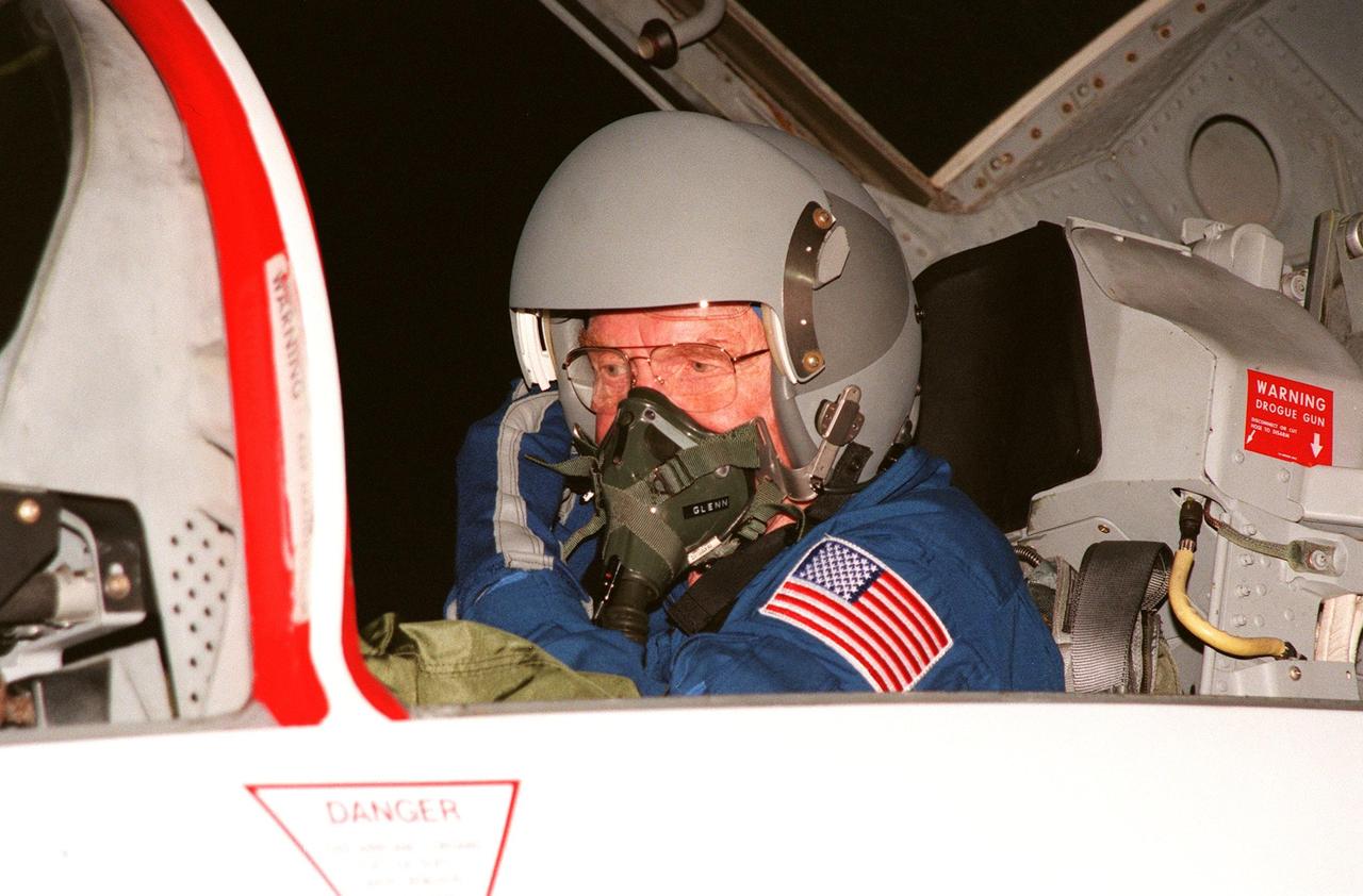
STS-95 Payload Specialist John H. Glenn Jr. arrives aboard a T-38 jet aircraft at the Shuttle Landing Facility at KSC to participate in a Terminal Countdown Demonstration Test (TCDT) for the launch scheduled for liftoff on Oct. 29, 1998. The TCDT includes activities to familiarize them with the mission, training in emergency exit from the orbiter and launch pad, and a simulated main engine cut-off exercise. Other crew members on the mission are Mission Commander Curtis L. Brown , Pilot Steven W. Lindsey; Mission Specialists Scott E. Parazynski, Stephen K. Robinson, and Pedro Duque of Spain, representing the European Space Agency (ESA); and Payload Specialist Chiaki Mukai, representing the National Space Development Agency of Japan (NASDA). The STS-95 mission includes research payloads such as the Spartan solar-observing deployable spacecraft, the Hubble Space Telescope Orbital Systems Test Platform, the International Extreme Ultraviolet Hitchhiker, as well as the SPACEHAB single module with experiments on space flight and the aging process