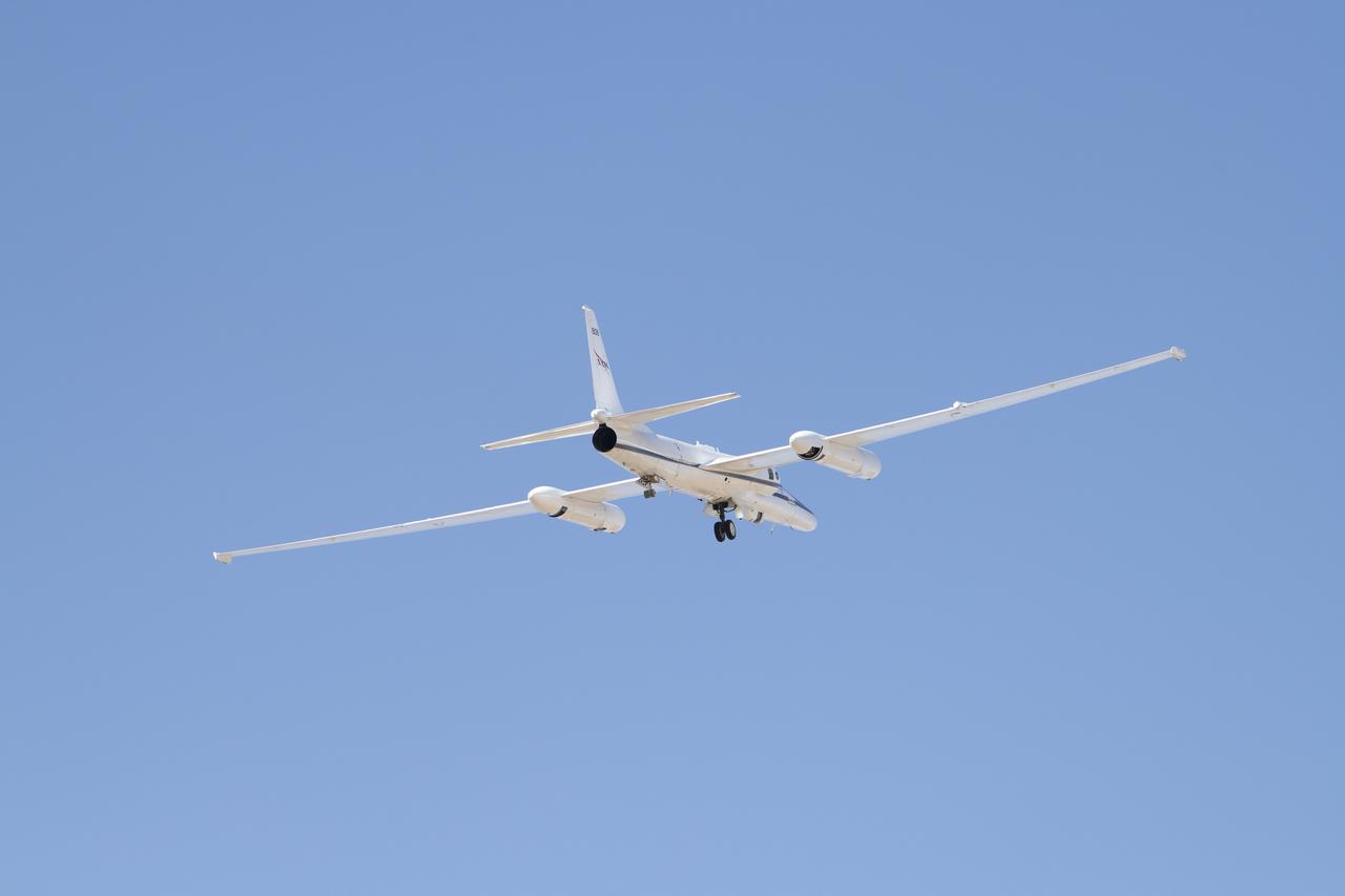
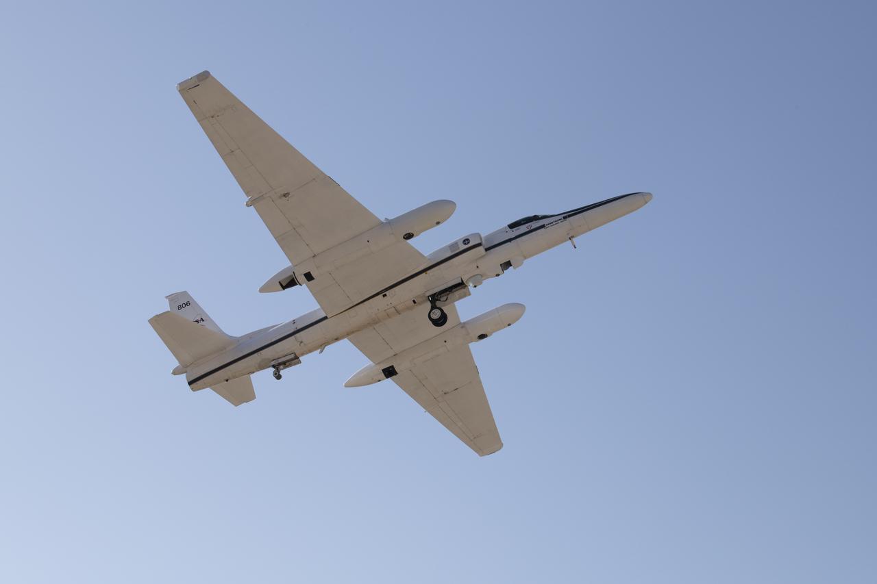
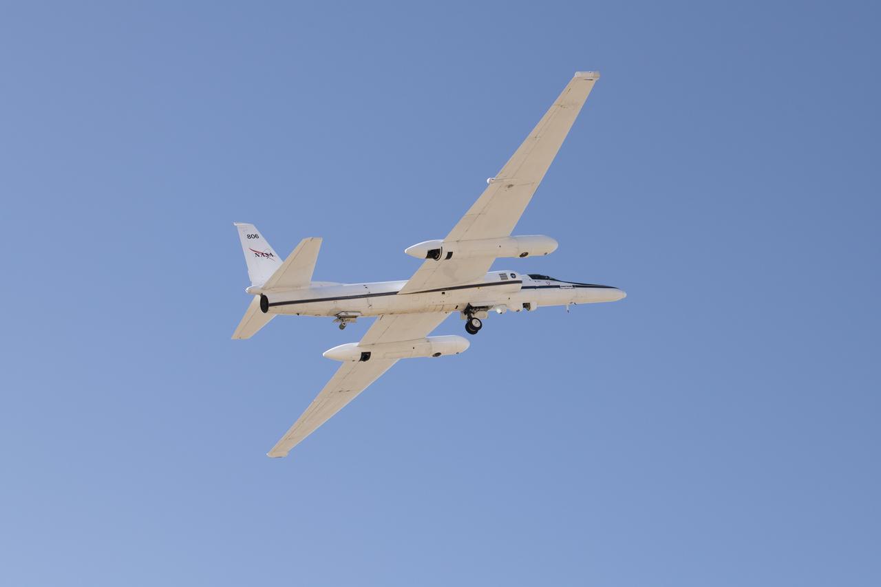
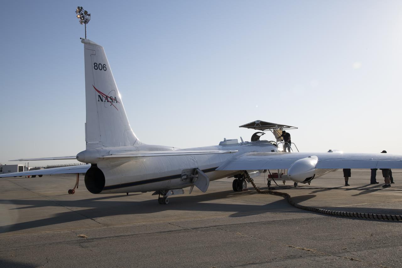
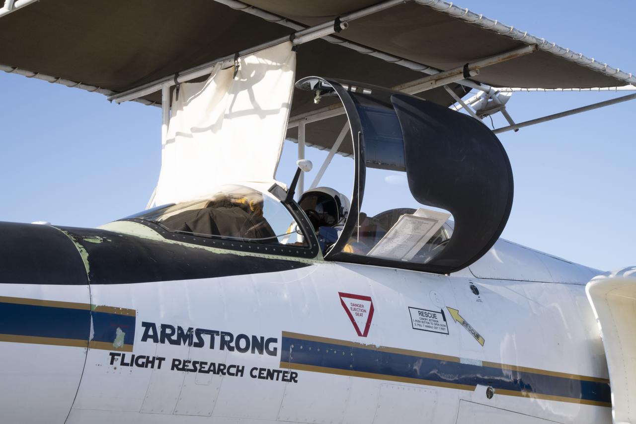
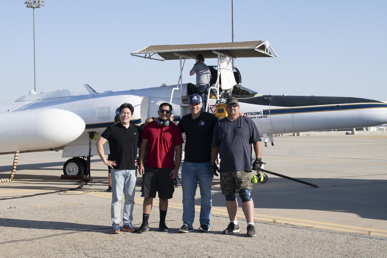
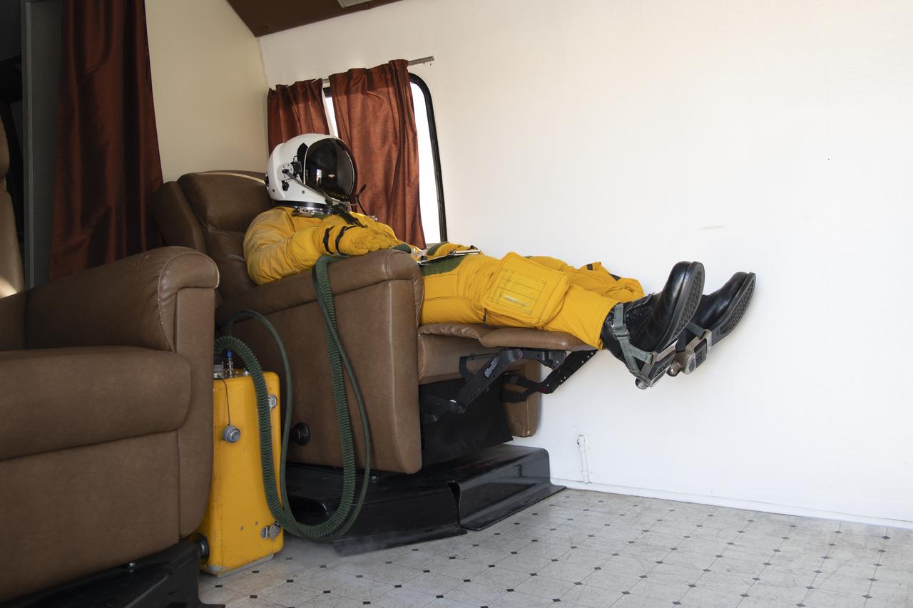
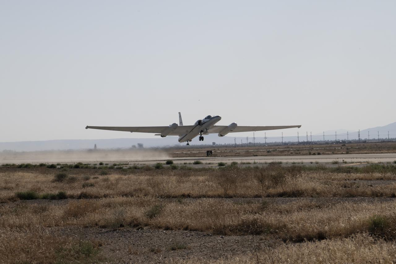
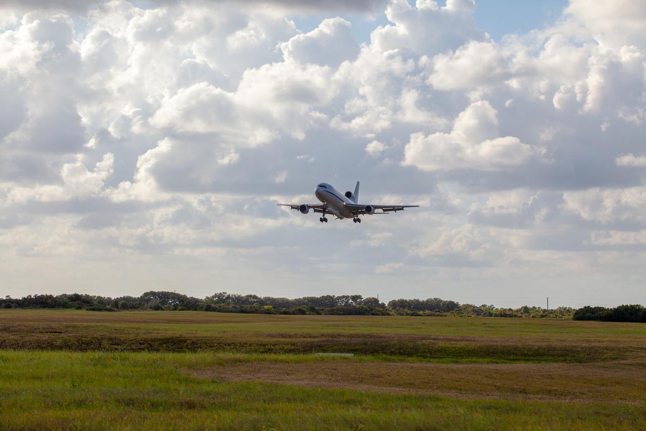
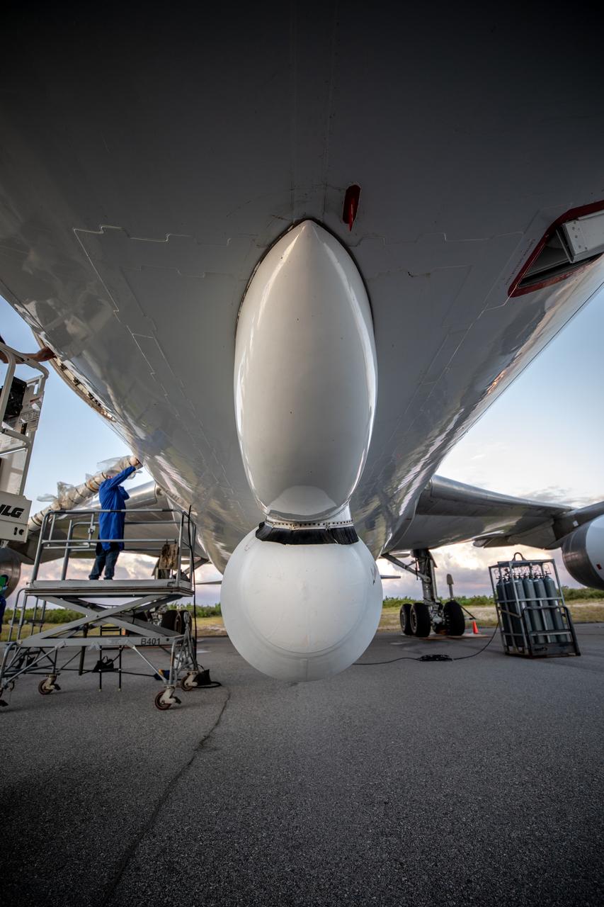
NASA Armstrong’s ER-2 aircraft deploys for its ALOFT mission. The ER-2 will fly at high altitudes above the Floridian coastline to collect data about the energetic characteristics and behavior of lightning and thunderclouds. A NASA pilot will operate the aircraft while scientists from the University of Bergen, Norway will interpret the data from the ground.
NASA Armstrong’s ER-2 aircraft deploys for its ALOFT mission. The ER-2 will fly at high altitudes above the Floridian coastline to collect data about the energetic characteristics and behavior of lightning and thunderclouds. A NASA pilot will operate the aircraft while scientists from the University of Bergen, Norway will interpret the data from the ground.
NASA Armstrong’s ER-2 aircraft deploys for its ALOFT mission. The ER-2 will fly at high altitudes above the Floridian coastline to collect data about the energetic characteristics and behavior of lightning and thunderclouds. A NASA pilot will operate the aircraft while scientists from the University of Bergen, Norway will interpret the data from the ground.
NASA Armstrong’s ER-2 aircraft deploys for its ALOFT mission. The ER-2 will fly at high altitudes above the Floridian coastline to collect data about the energetic characteristics and behavior of lightning and thunderclouds. A NASA pilot will operate the aircraft while scientists from the University of Bergen, Norway will interpret the data from the ground.
NASA Armstrong’s ER-2 aircraft deploys for its ALOFT mission. The ER-2 will fly at high altitudes above the Floridian coastline to collect data about the energetic characteristics and behavior of lightning and thunderclouds. A NASA pilot will operate the aircraft while scientists from the University of Bergen, Norway will interpret the data from the ground.
NASA Armstrong’s ER-2 aircraft deploys for its ALOFT mission. The ER-2 will fly at high altitudes above the Floridian coastline to collect data about the energetic characteristics and behavior of lightning and thunderclouds. A NASA pilot will operate the aircraft while scientists from the University of Bergen, Norway will interpret the data from the ground.
NASA Armstrong’s ER-2 aircraft deploys for its ALOFT mission. The ER-2 will fly at high altitudes above the Floridian coastline to collect data about the energetic characteristics and behavior of lightning and thunderclouds. A NASA pilot will operate the aircraft while scientists from the University of Bergen, Norway will interpret the data from the ground.
NASA Armstrong’s ER-2 aircraft deploys for its ALOFT mission. The ER-2 will fly at high altitudes above the Floridian coastline to collect data about the energetic characteristics and behavior of lightning and thunderclouds. A NASA pilot will operate the aircraft while scientists from the University of Bergen, Norway will interpret the data from the ground.
NASA Armstrong’s ER-2 aircraft deploys for its ALOFT mission. The ER-2 will fly at high altitudes above the Floridian coastline to collect data about the energetic characteristics and behavior of lightning and thunderclouds. A NASA pilot will operate the aircraft while scientists from the University of Bergen, Norway will interpret the data from the ground.
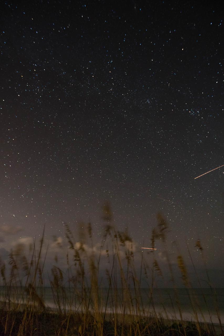
Sea oats are backdropped by the night sky and the Milky Way in this view from the Atlantic shoreline at NASA’s Kennedy Space Center in Florida on Oct. 31, 2019. Lights from aircraft create illuminated streaks above the horizon and at right.
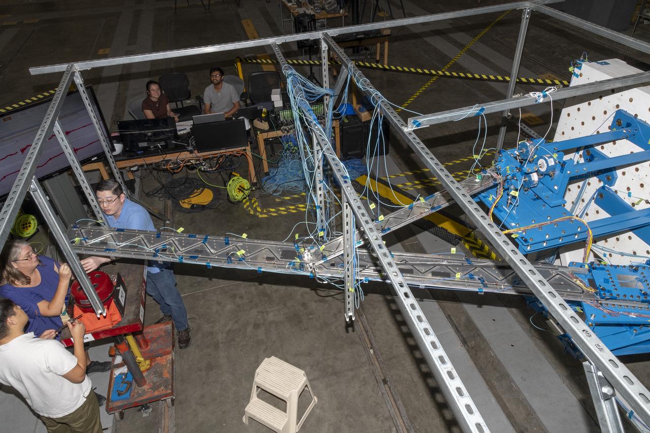
Researchers test a 10-foot Mock Truss-Braced Wing at NASA’s Armstrong Flight Research Center in Edwards, California. A view from above shows the test structure, the wing, and the strut. The aircraft concept involves a wing braced on an aircraft using diagonal struts that also add lift and could result in significantly improved aerodynamics.
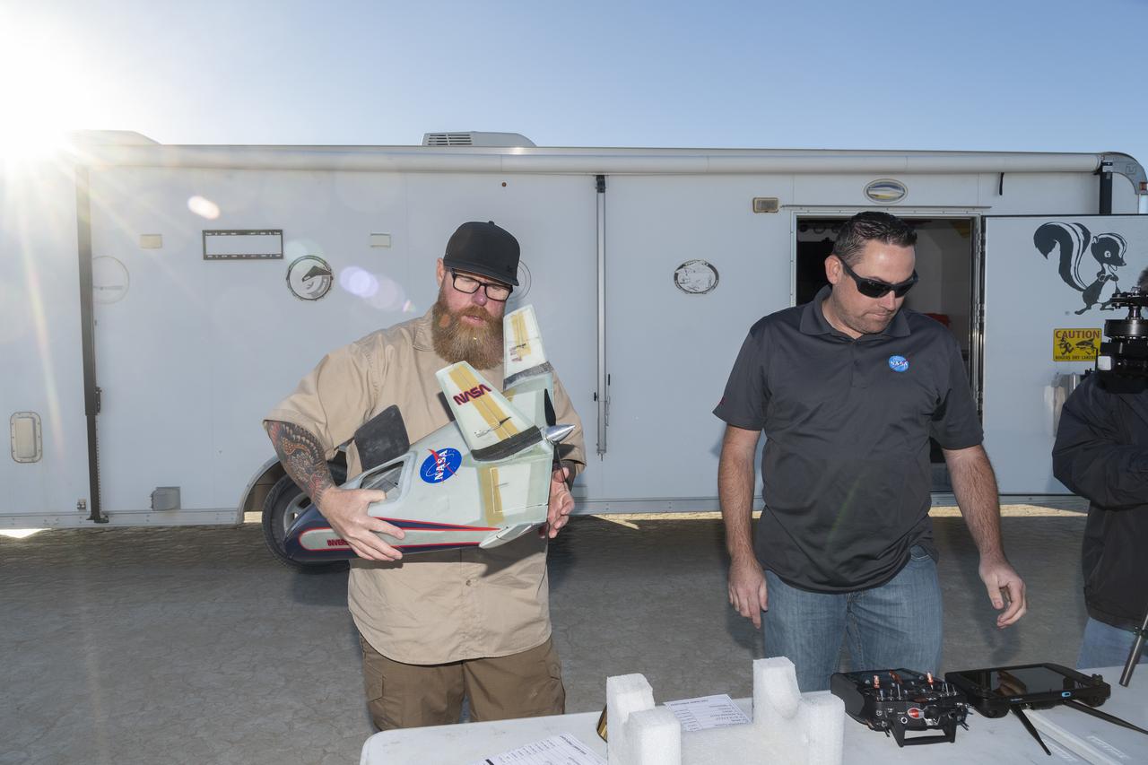
Justin Hall, left, chief pilot of small unmanned aircraft systems, carries the atmospheric probe at NASA’s Armstrong Flight Research Center in Edwards, California. The probe, which was designed and built at the center, flew after release from a quad rotor remotely piloted aircraft on Oct. 22, 2024, above Rogers Dry Lake, a flight area adjacent to the NASA center. At right, Justin Link, unmanned aircraft systems pilot, checks out the controllers for the two aircraft.
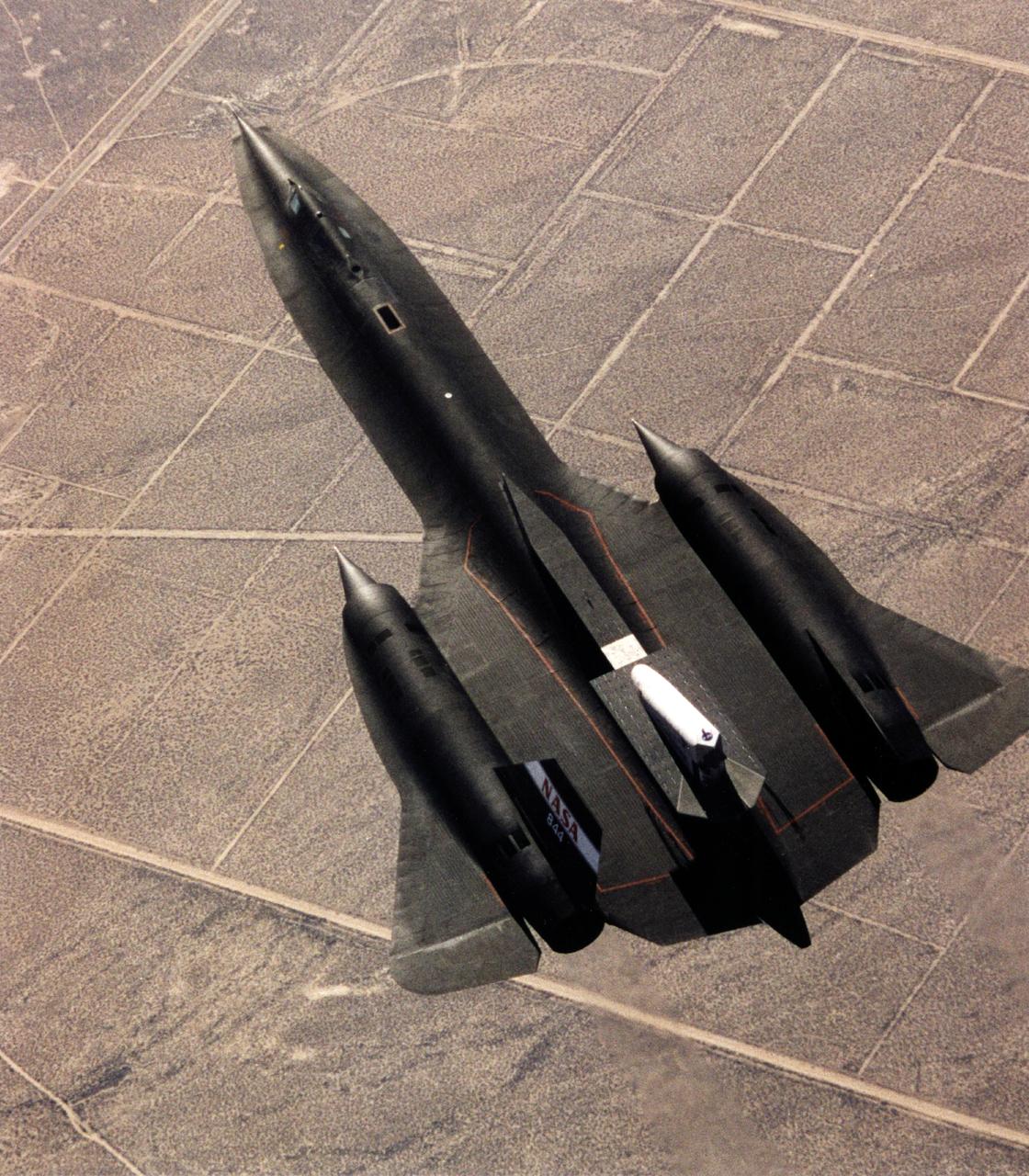
This photograph shows the SR-71 with the Linear Aerospike SR-71 Experiment on the rear fuselage as seen from above. The photo was taken on the first flight of the aircraft with the experiment aboard, which took place on 31 October 1997.
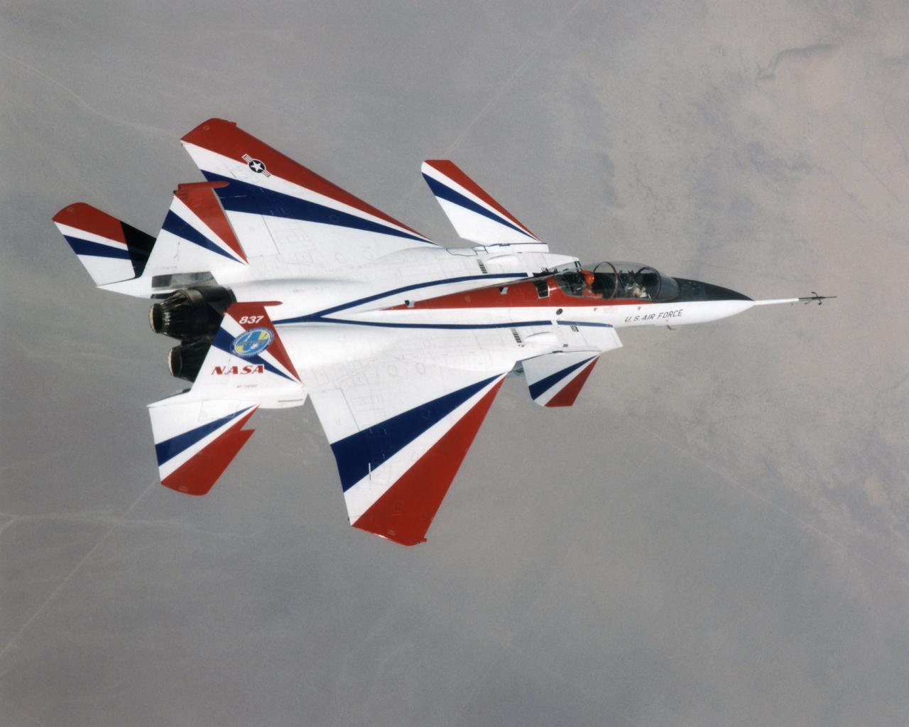
The F-15 ACTIVE in flight above the Mojave desert on April 14, 1998. The overhead shot shows the aircraft's striking red and while paint scheme/ The large forward canards are actually the tail surfaces from an F-18.
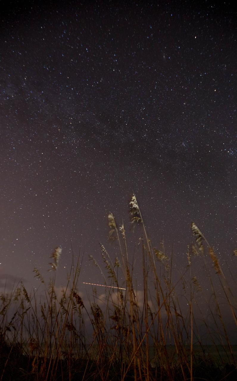
Sea oats are backdropped by the night sky and the Milky Way in this view from the Atlantic shoreline at NASA’s Kennedy Space Center in Florida on Oct. 31, 2019. The lights of an aircraft create an illuminated streak above the horizon.
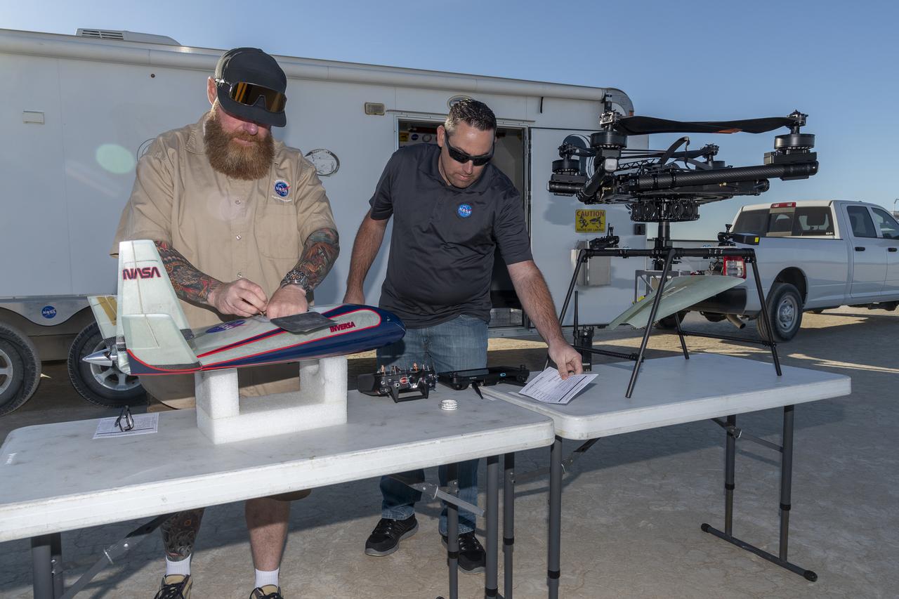
Justin Hall, chief pilot of small unmanned aircraft systems, prepares the atmospheric probe for flight above Rogers Dry Lake, a flight area adjacent NASA’s Armstrong Flight Research Center in Edwards, California. At right, Justin Link, small unmanned aircraft systems pilot, assists. The probe, designed and built at the center, flew after release from a quad rotor remotely piloted aircraft on Oct. 22, 2024.
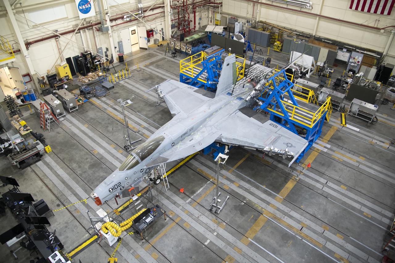
This view from above shows the vertical tail loads testing on a Navy F/A-18E that concluded in May, wrapping up the third phase of research at NASA’s Armstrong Flight Research Center in Edwards, California. The first two phases included loads calibration testing focused on the aircraft’s horizontal tails and wings. The aircraft is from the Naval Air Systems Command (NAVAIR) in Patuxent River, Maryland. NAVAIR retired its previous loads test aircraft and NASA Armstrong staff are assisting to prepare the new aircraft for its role to help safely manage flight maneuvers and determine how the F/A-18E fleet will perform if proposed upgrades are incorporated.
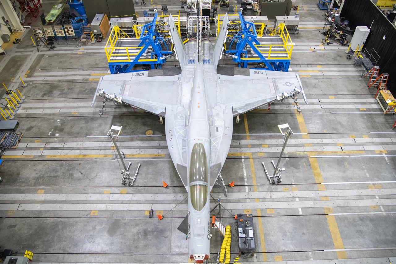
This view from above shows the vertical tail loads testing on a Navy F/A-18E that concluded in May, wrapping up the third phase of research at NASA’s Armstrong Flight Research Center in Edwards, California. The first two phases included loads calibration testing focused on the aircraft’s horizontal tails and wings. The aircraft is from the Naval Air Systems Command (NAVAIR) in Patuxent River, Maryland. NAVAIR retired its previous loads test aircraft and NASA Armstrong staff are assisting to prepare the new aircraft for its role to help safely manage flight maneuvers and determine how the F/A-18E fleet will perform if proposed upgrades are incorporated.
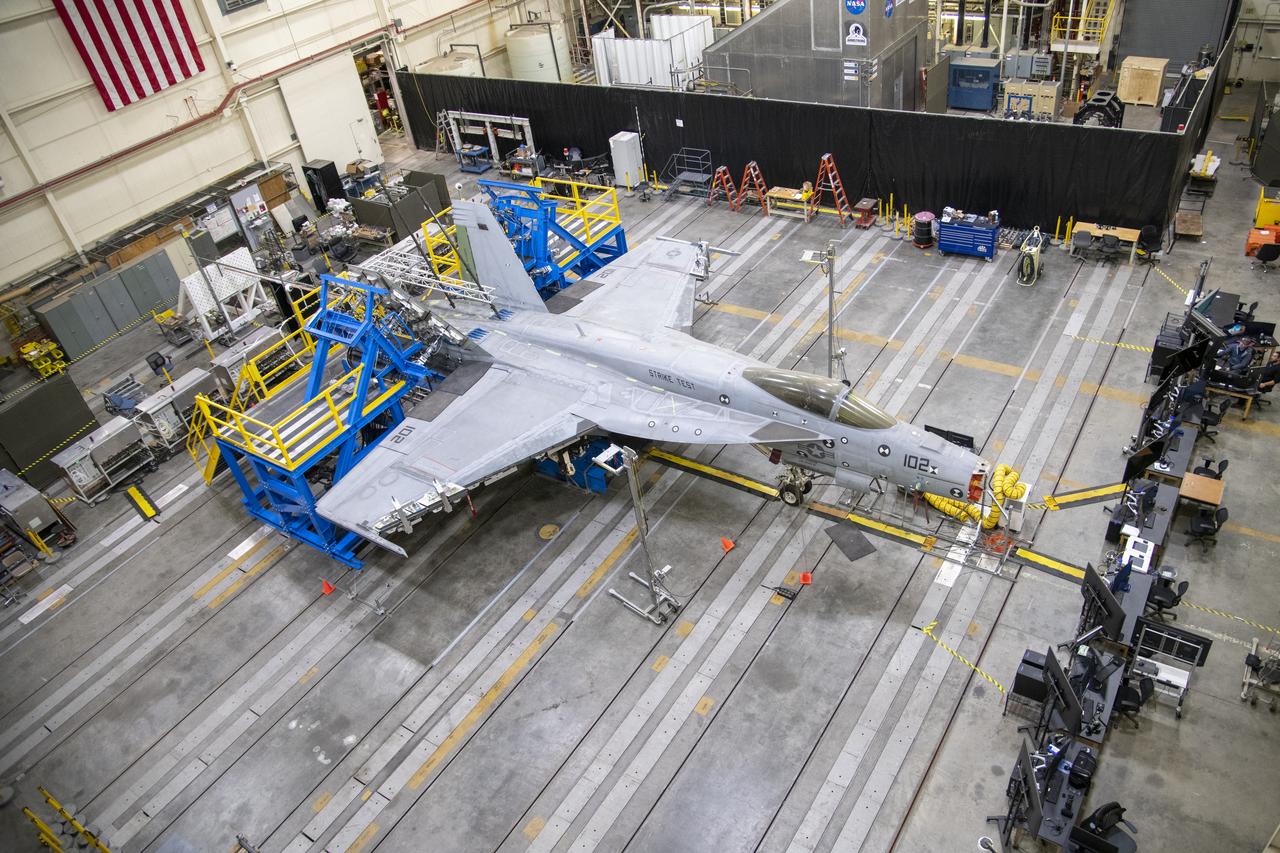
This view from above shows the vertical tail loads testing on a Navy F/A-18E that concluded in May, wrapping up the third phase of research at NASA’s Armstrong Flight Research Center in Edwards, California. The first two phases included loads calibration testing focused on the aircraft’s horizontal tails and wings. The aircraft is from the Naval Air Systems Command (NAVAIR) in Patuxent River, Maryland. NAVAIR retired its previous loads test aircraft and NASA Armstrong staff are assisting to prepare the new aircraft for its role to help safely manage flight maneuvers and determine how the F/A-18E fleet will perform if proposed upgrades are incorporated.
The atmospheric probe model on a stand is prepped for flight and release from a quad rotor remotely piloted aircraft. The probe successfully flew on Oct. 22, 2024, above Rogers Dry Lake, a flight area adjacent to NASA’s Armstrong Flight Research Center in Edwards, California. The probe was designed and built at the center. In the background from left are Justin Hall, chief pilot of small, unmanned aircraft systems; Justin Link, small unmanned aircraft systems pilot; communications writer Jay Levine; and John Bodylski, atmospheric probe principal investigator.
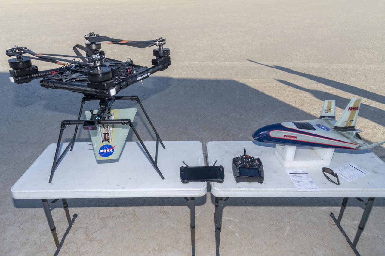
The atmospheric probe, right, flew after release from a quad rotor remotely piloted aircraft, left, on Oct. 22, 2024, above Rogers Dry Lake, a flight area adjacent to NASA’s Armstrong Flight Research Center in Edwards, California. The probe was designed and built at the center.
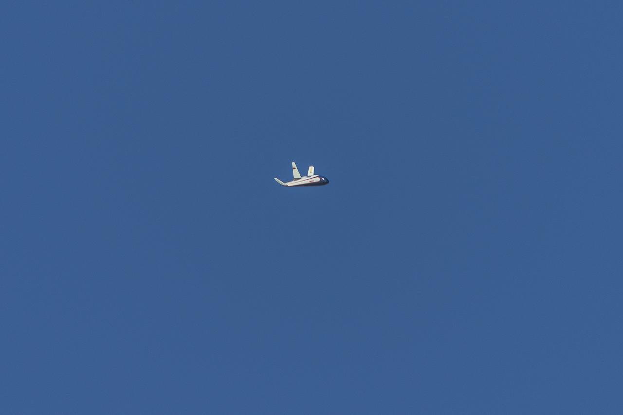
The atmospheric probe model flies free after release from a quad rotor remotely piloted aircraft above Rogers Dry Lake, a flight area adjacent NASA’s Armstrong Flight Research Center in Edwards, California, on Oct. 22, 2024. The probe was designed and built at the center.
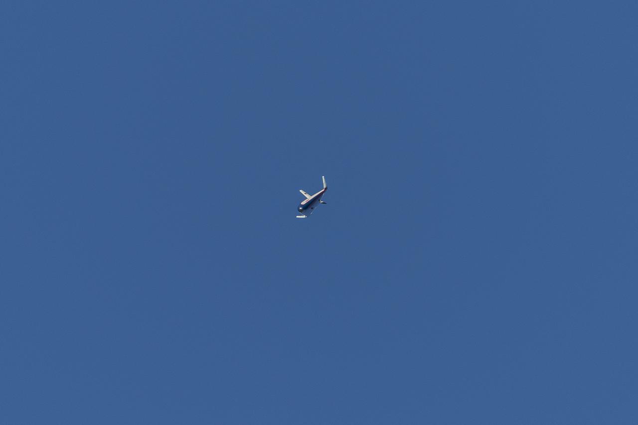
The atmospheric probe model flies free after release from a quad rotor remotely piloted aircraft above Rogers Dry Lake, a flight area adjacent NASA’s Armstrong Flight Research Center in Edwards, California, on Oct. 22, 2024. The probe was designed and built at the center.
This overhead shot of the X-59 assembly during Spring 2021 shows assembly with technicians working at the engine inlet section where the engine will be located on the aircraft. Lockheed Martin Photography By Garry Tice 1011 Lockheed Way, Palmdale, Ca. 93599 Event: Manufacture Area From Above Date: 3/30/2021
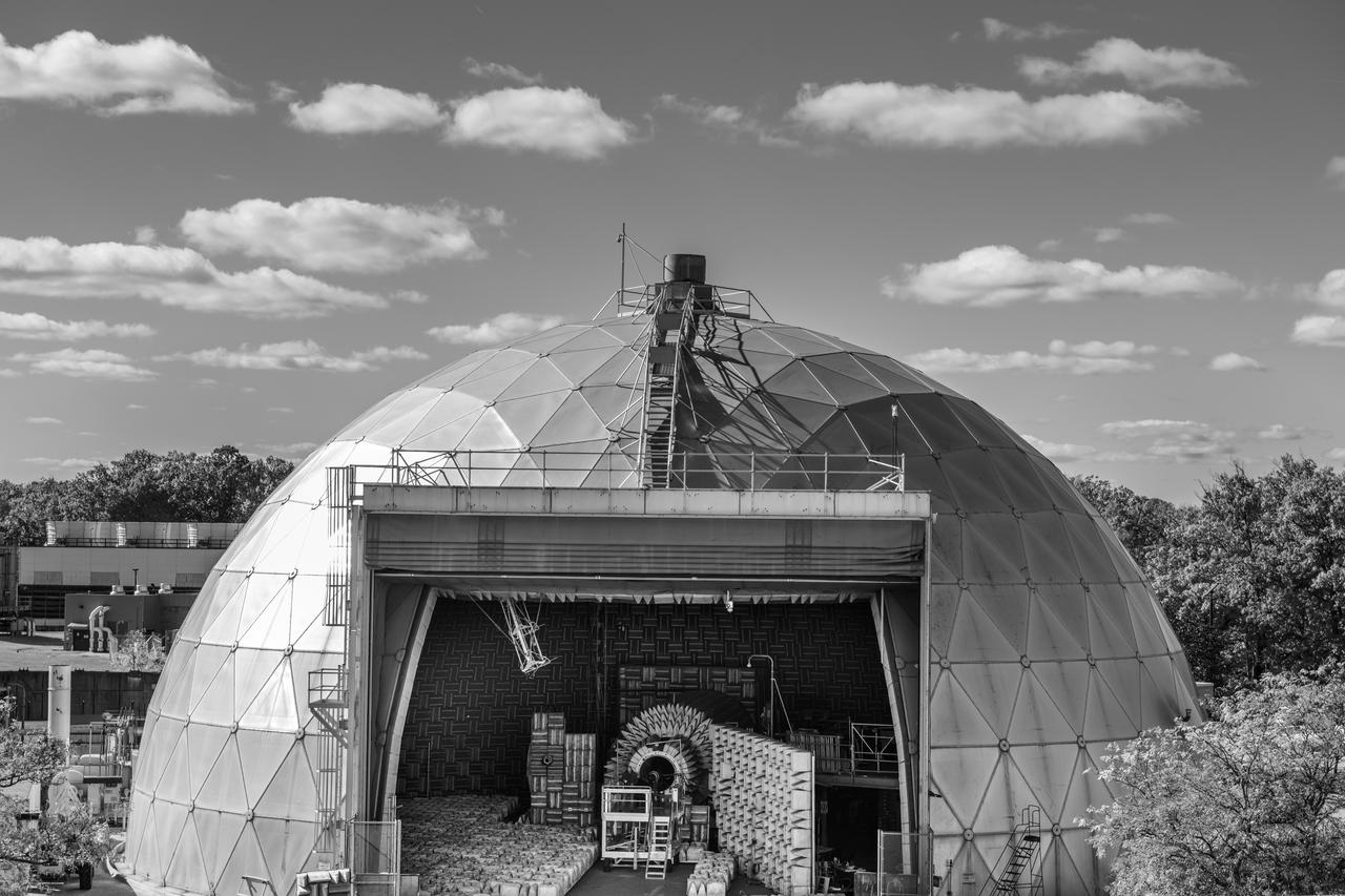
The Aero-Acoustic Propulsion Laboratory (AAPL) photographed on October 24, 2024 as seen from above. This facility provides world class testing for aircraft propulsion acoustic noise reduction and is 65 ft high by 130 ft in diameter. Photo Credit: (NASA/Sara Lowthian-Hanna)
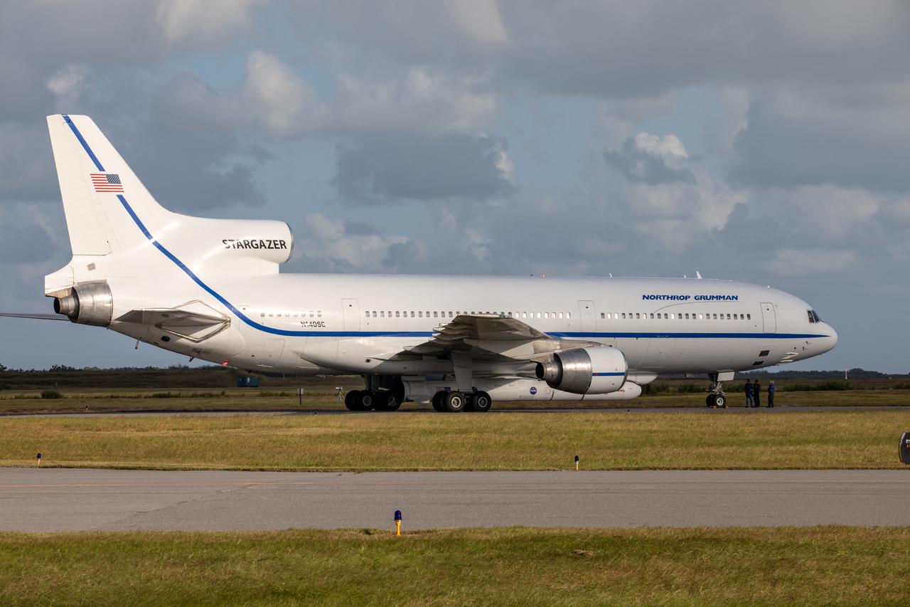
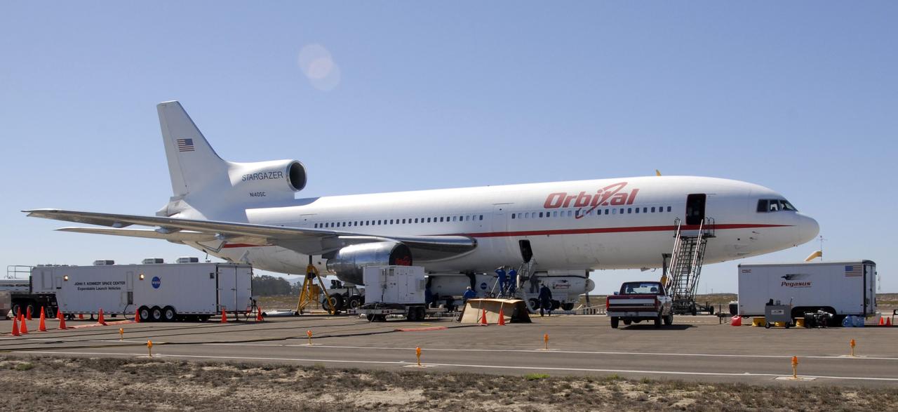
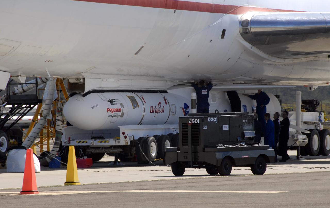
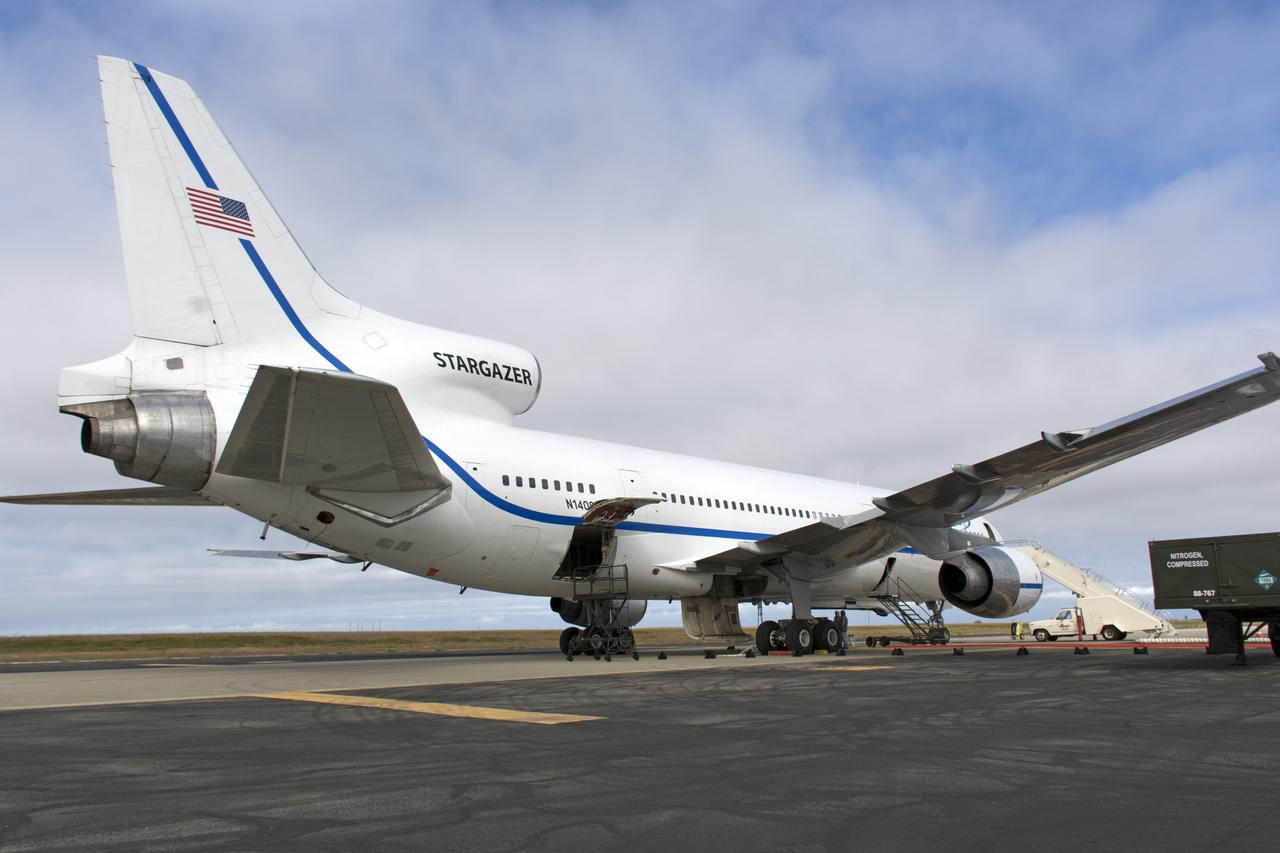
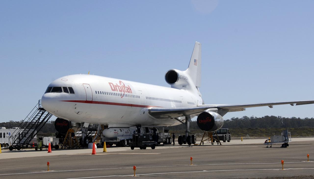
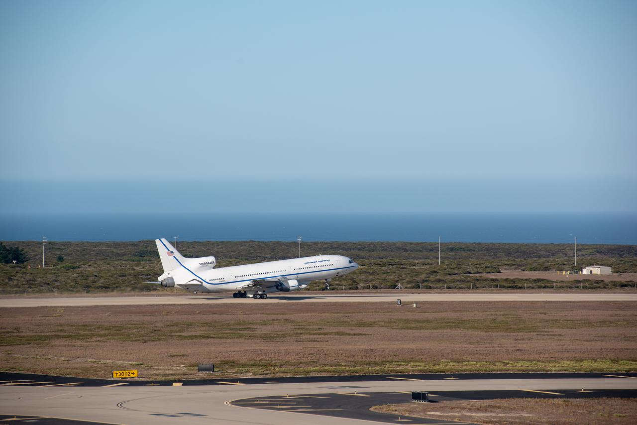
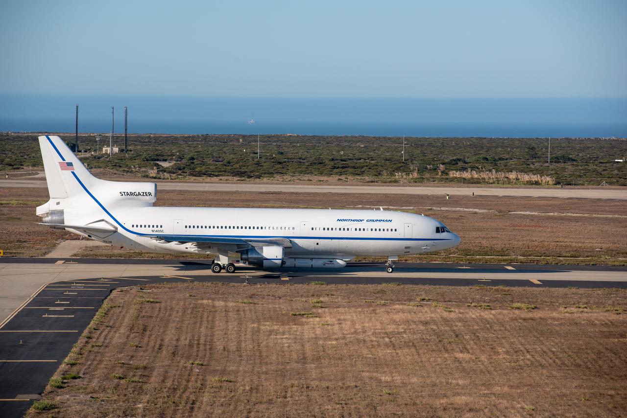
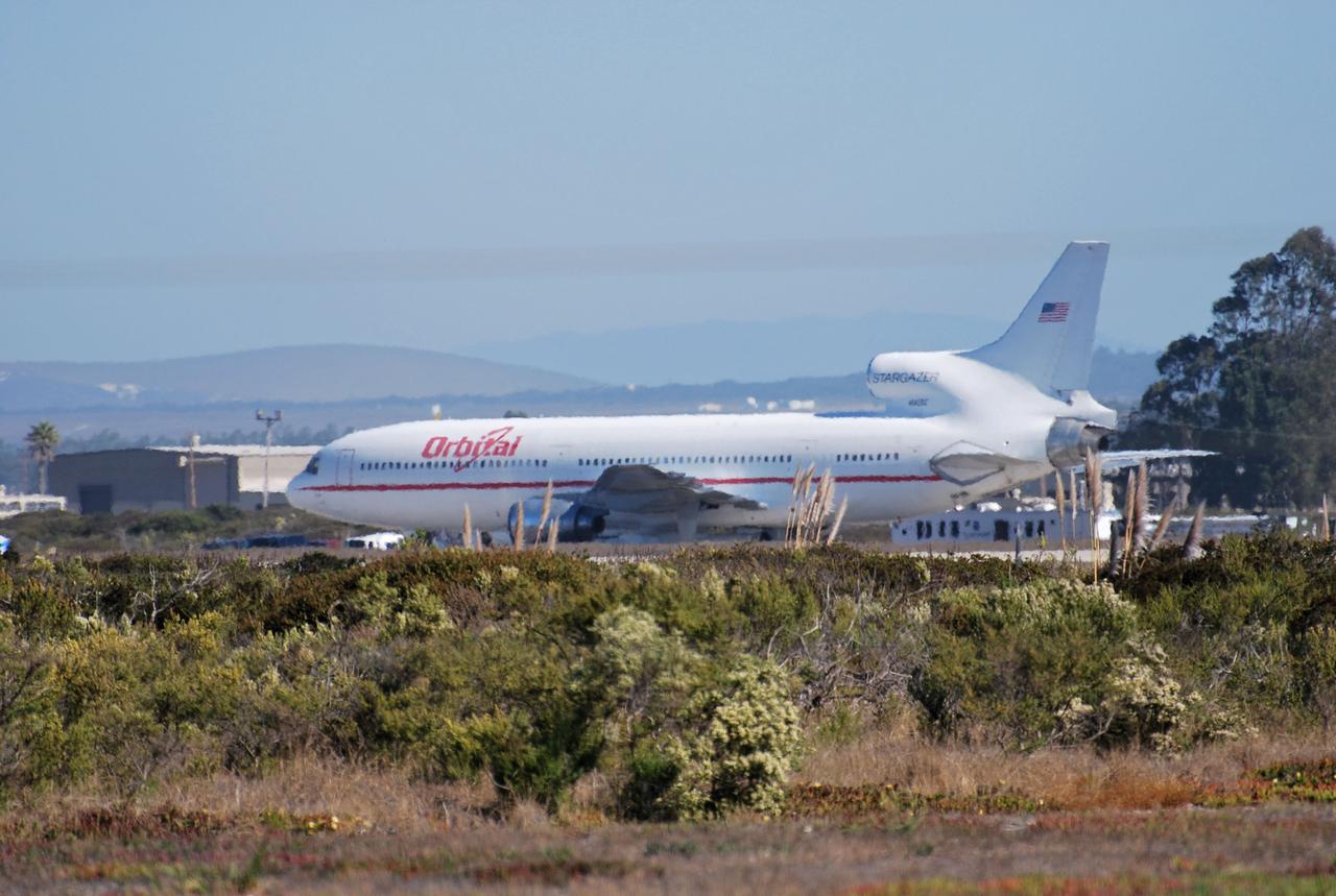
Northrop Grumman's L-1011 Stargazer aircraft has arrived at the Skid Strip at Cape Canaveral Air Force Station in Florida on Oct. 1, 2019. The company's Pegasus XL rocket, containing NASA's Ionospheric Connection Explorer (ICON), is attached beneath the aircraft. ICON will study the frontier of space - the dynamic zone high in Earth's atmosphere where terrestrial weather from below meets space weather above.

This overview shot of the X-59 Quiet Supersonic Technology or QueSST aircraft shows the vehicle before a major merger of three major aircraft sections – the fuselage, the wing, and the tail assembly – together, making it looks more like an airplane. Lockheed Martin Photography By Garry Tice 1011 Lockheed Way, Palmdale, Ca. 93599 Event: Manufacture Area From Above Date: 3/30/2021
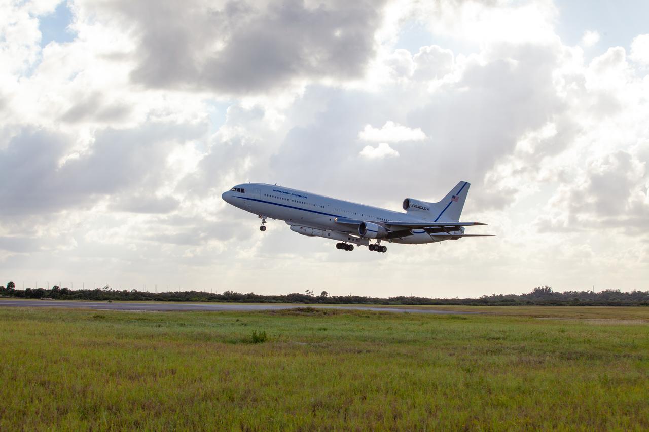
Northrop Grumman's L-1011 Stargazer aircraft descends toward the Skid Strip at Cape Canaveral Air Force Station in Florida on Oct. 1, 2019. The company's Pegasus XL rocket, containing NASA's Ionospheric Connection Explorer (ICON), is attached beneath the aircraft. ICON will study the frontier of space - the dynamic zone high in Earth's atmosphere where terrestrial weather from below meets space weather above.
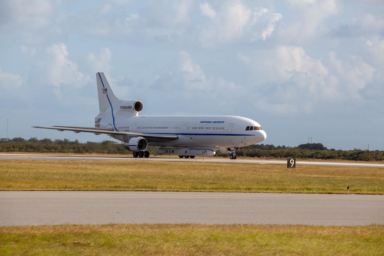
Northrop Grumman's L-1011 Stargazer aircraft has arrived at the Skid Strip at Cape Canaveral Air Force Station in Florida on Oct. 1, 2019. The company's Pegasus XL rocket, containing NASA's Ionospheric Connection Explorer (ICON), is attached beneath the aircraft. ICON will study the frontier of space - the dynamic zone high in Earth's atmosphere where terrestrial weather from below meets space weather above.
Northrop Grumman's L-1011 Stargazer aircraft has arrived at the Skid Strip at Cape Canaveral Air Force Station in Florida on Oct. 1, 2019. The company's Pegasus XL rocket, containing NASA's Ionospheric Connection Explorer (ICON), is attached beneath the aircraft. ICON will study the frontier of space - the dynamic zone high in Earth's atmosphere where terrestrial weather from below meets space weather above.

This overhead shot of the X-59 Quiet SuperSonic Technology or QueSST aircraft shows the assembly progress of the vehicle during Spring 2021. In the left side of the picture, the fuselage which contains the cockpit is shown and the right side of the photo shows the wing and the tail section of the aircraft. Lockheed Martin Photography By Garry Tice 1011 Lockheed Way, Palmdale, Ca. 93599 Event: Manufacture Area From Above Date: 3/30/2021
Northrop Grumman's L-1011 Stargazer aircraft descends toward the Skid Strip at Cape Canaveral Air Force Station in Florida on Oct. 1, 2019. The company's Pegasus XL rocket, containing NASA's Ionospheric Connection Explorer (ICON), is attached beneath the aircraft. ICON will study the frontier of space - the dynamic zone high in Earth's atmosphere where terrestrial weather from below meets space weather above.

Event: Manufacturing Area From Above A overhead view of the X-59 with its nose on. The X-59’s nose is 38-feet long – approximately one third of the length of the entire aircraft. The aircraft, under construction at Lockheed Martin Skunk Works in Palmdale, California, will demonstrate the ability to fly supersonic while reducing the loud sonic boom to a quiet sonic thump.
X-15A-2 with full scale ablative and external tanks installed parked in front of hangar. In June 1967, the X-15A-2 rocket-powered research aircraft received a full-scale ablative coating to protect the craft from the high temperatures associated with hypersonic flight (above Mach 5). This pink eraser-like substance, applied to the X-15A-2 aircraft (56-6671), was then covered with a white sealant coat before flight. This coating would help the #2 aircraft reach the record speed of 4,520 mph (Mach 6.7).
X-15A-2 is rolled out of the paint shop after having the full scale ablative applied. In June 1967, the X-15A-2 rocket-powered research aircraft received a full-scale ablative coating to protect the craft from the high temperatures associated with hypersonic flight (above Mach 5). This pink eraser-like substance, applied to the X-15A-2 aircraft (56-6671), was then covered with a white sealant coat before flight. This coating would help the #2 aircraft reach the record speed of 4,520 mph (Mach 6.7).
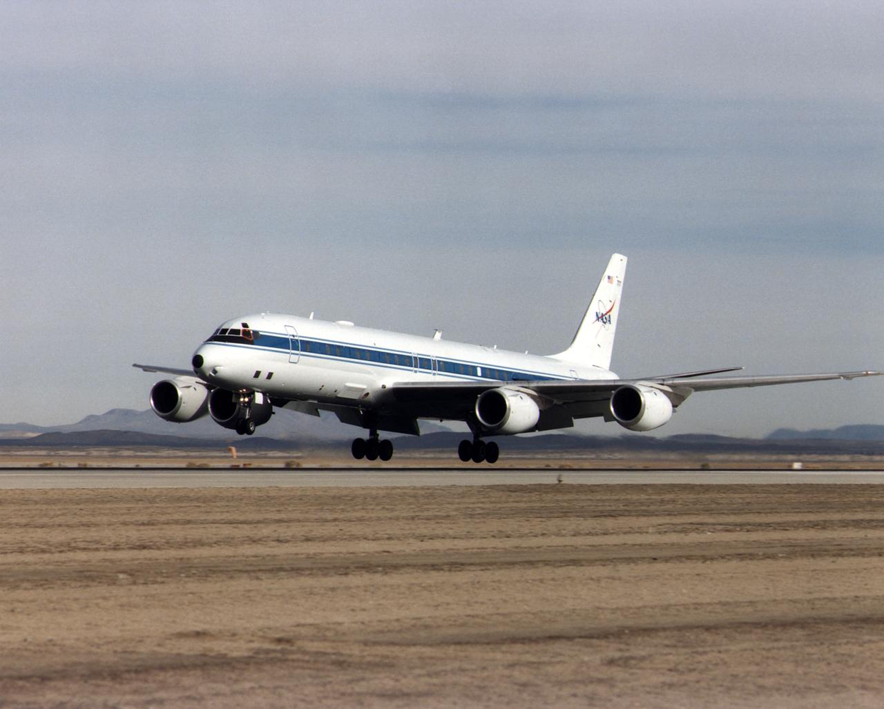
NASA's DC-8 Airborne Science platform landed at Edwards Air Force Base, California, to join the fleet of aircraft at NASA's Dryden Flight Research Center. The white aircraft with a blue stripe running horizontally from the nose to the tail is shown with its main landing gear just above the runway. The former airliner is a "dash-72" model and has a range of 5,400 miles. The craft can stay airborne for 12 hours and has an operational speed range between 300 and 500 knots. The research flights are made at between 500 and 41,000 feet. The aircraft can carry up to 30,000 lbs of research/science payload equipment installed in 15 mission-definable spaces.
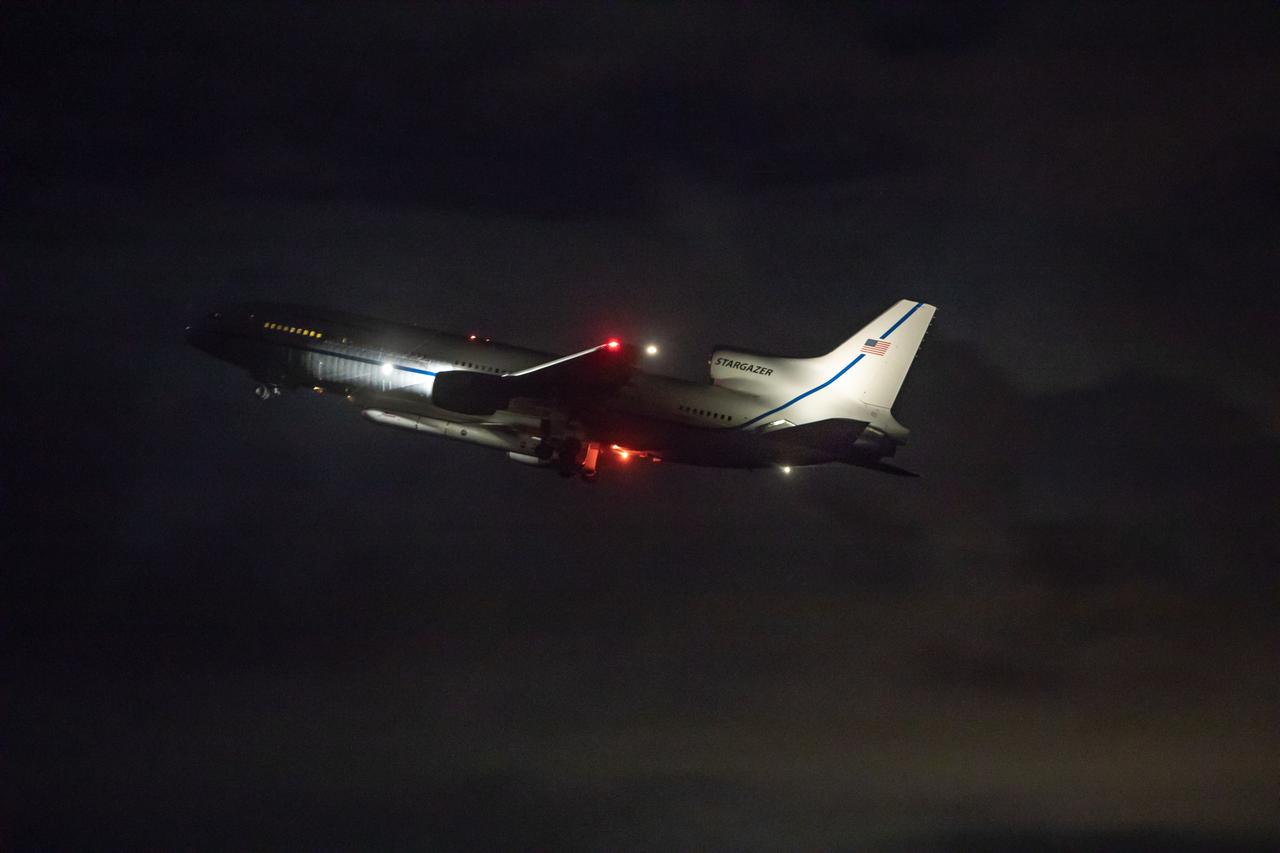
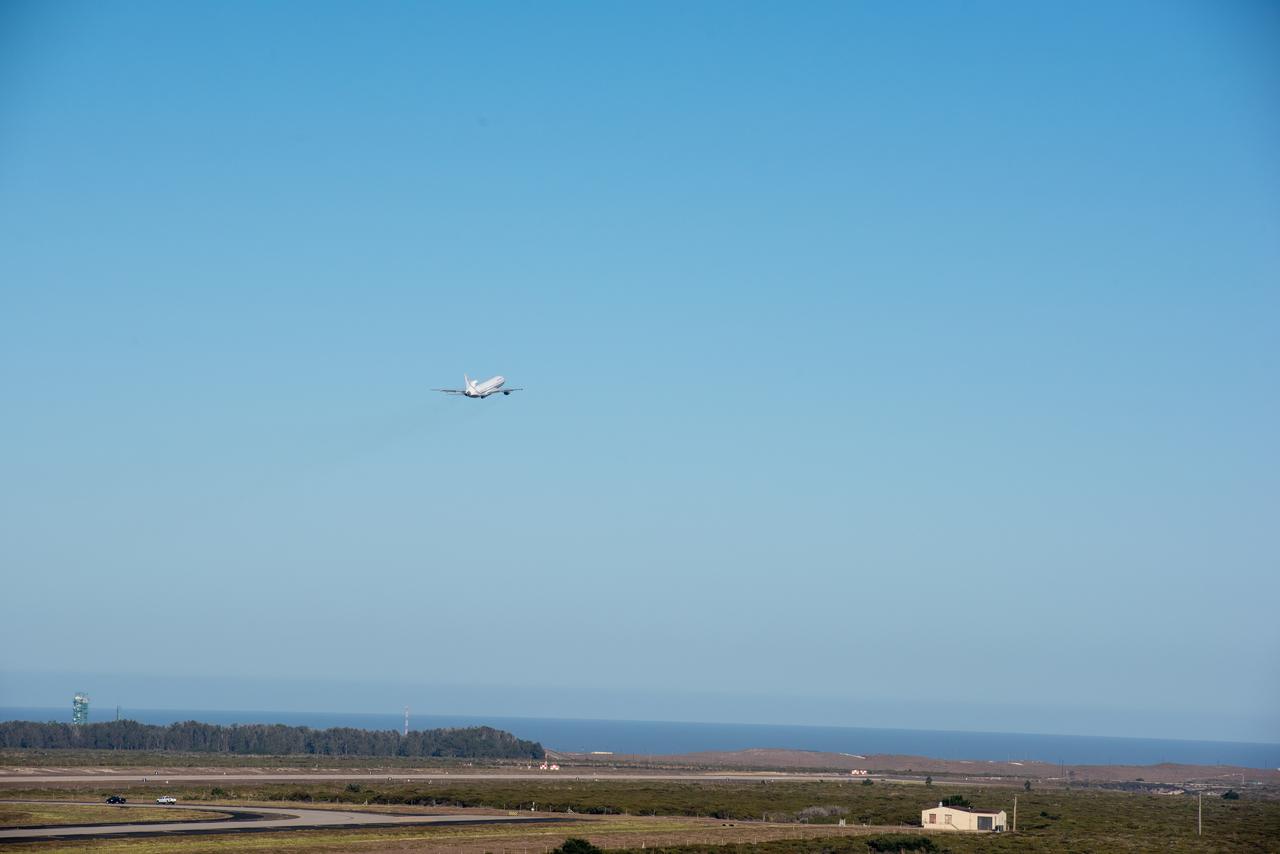
Northrop Grumman’s L-1011 Stargazer aircraft, with the company’s Pegasus XL rocket attached beneath, takes off from the Skid Strip runway at Cape Canaveral Air Force Station in Florida on Oct. 10, 2019. NASA's Ionospheric Connection Explorer (ICON) is secured inside the rocket's payload fairing. The air-launched Pegasus XL was released from the aircraft at 9:59 p.m. EDT to start ICON’s journey to space. The explorer will study the frontier of space - the dynamic zone high in Earth's atmosphere where terrestrial weather from below meets space weather above.
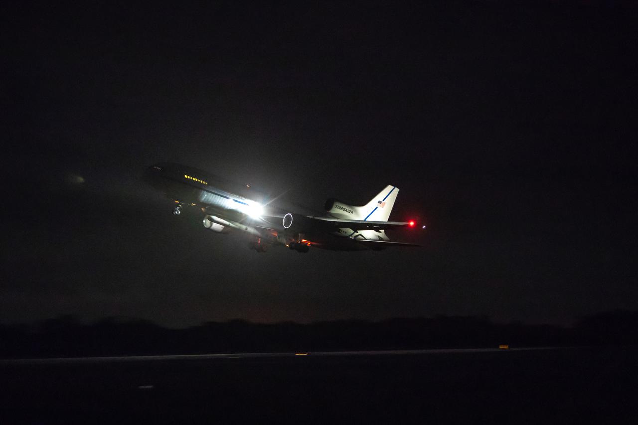
Northrop Grumman’s L-1011 Stargazer aircraft, with the company’s Pegasus XL rocket attached beneath, takes off from the Skid Strip runway at Cape Canaveral Air Force Station in Florida on Oct. 10, 2019. NASA's Ionospheric Connection Explorer (ICON) is secured inside the rocket's payload fairing. The air-launched Pegasus XL was released from the aircraft at 9:59 p.m. EDT to start ICON’s journey to space. The explorer will study the frontier of space - the dynamic zone high in Earth's atmosphere where terrestrial weather from below meets space weather above.
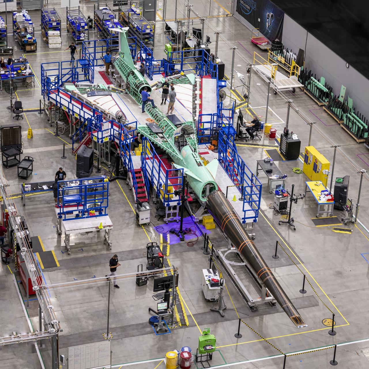
The X-59 Quiet SuperSonic Technology (QueSST) aircraft is taking shape at the Lockheed Martin Skunk Works facility in Palmdale, California. The team positioned the X-59 QueSST's nose at the front of the aircraft. As one of the more recognizable features of the X-59, the nose makes up almost a third of the aircraft length and will be essential in shaping shock waves during supersonic flight, resulting in quiet sonic thumps instead of loud sonic booms. The nose was attached and then removed from the front of the aircraft in preparation for its shipment to Fort Worth, Texas where it will undergo additional testing. The X-59 will fly at supersonic speeds above communities as part of the Low-Boom Flight Demonstration mission, during which NASA will gather community feedback to the sound of quiet supersonic flight. These findings will be shared with regulators to inform decisions on current restrictions of supersonic flight over land. Lockheed Martin Photography By Garry Tice 1011 Lockheed Way, Palmdale, Ca. 93599 Event: Manufacturing Area From Above Date: 8/18/2021 Additional Info:
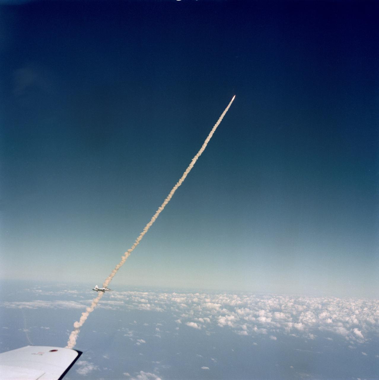
S81-39527 (12 Nov. 1981) --- This photograph of the STS-2 crew and the space shuttle Columbia soaring toward Earth orbit was captured with a hand-held 70mm camera (using an 80mm lens) operated from the rear station of a T-38 jet aircraft. Mission specialist-astronaut Kathryn D. Sullivan took the picture, and part of the wing tip of her aircraft can be seen in lower left corner. Astronaut John W. Young piloting NASA?s shuttle training aircraft (STA) was taking pictures from a higher angle. A close look can delineate his craft above the orbiter and supportive elements, almost perpendicular to them from this point of view. Another T-38 jet, with a TV camera operator as back-seat passenger, can be seen at lower left corner near the smoke trails from the shuttle. Photo credit: NASA
VANDENBERG AIR FORCE BASE, Fla. -- NASA’s Interstellar Boundary Explorer, or IBEX, spacecraft and mated Pegasus XL rocket are being attached to Orbital Sciences’ L-1011 aircraft for launch. IBEX is targeted for launch from the Kwajalein Atoll, a part of the Marshall Islands in the Pacific Ocean, on Oct. 19. IBEX will be launched aboard the Pegasus rocket dropped from under the wing of the L-1011 aircraft flying over the Pacific Ocean. The Pegasus will carry the spacecraft approximately 130 miles above Earth and place it in orbit. The IBEX satellite will make the first map of the boundary between the Solar System and interstellar space. Photo credit: NASA/Mark Mackley, VAFB
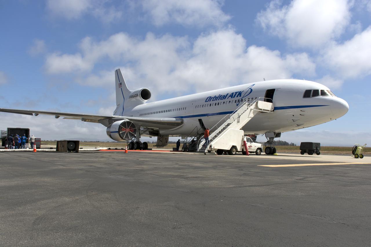
Northrop Grumman's L-1011 Stargazer aircraft is at the hot pad at Vandenberg Air Force Base in California on May 26, 2018. Preparations are underway to attach the company's Pegasus XL rocket, containing NASA's Ionospheric Connection Explorer (ICON), beneath the aircraft. The explorer will launch on June 15, 2018, from Kwajalein Atoll in the Marshall Islands (June 14 in the continental United States). ICON will study the frontier of space - the dynamic zone high in Earth's atmosphere where terrestrial weather from below meets space weather above. The explorer will help determine the physics of Earth's space environment and pave the way for mitigating its effects on our technology, communications systems and society.
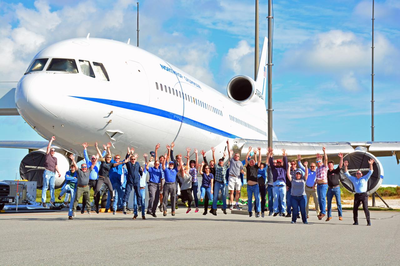
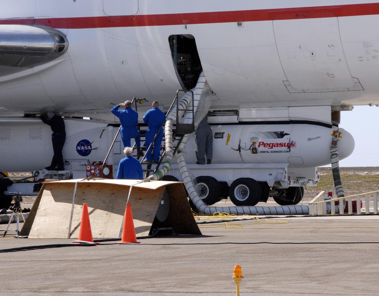
Members of the launch team for NASA’s Ionospheric Connection Explorer (ICON) gather for a joyous group photo in front of the Northrop Grumman L-1011 Stargazer aircraft carrying the Pegasus XL rocket at the Skid Strip at Florida’s Cape Canaveral Air Force Station, Nov. 10, 2019. Hours later, the rocket containing ICON air-launched from beneath the aircraft off the coast of Daytona Beach. ICON will study the frontier of space - the dynamic zone high in Earth's atmosphere where terrestrial weather from below meets space weather above. The explorer will help determine the physics of Earth's space environment and pave the way for mitigating its effects on our technology, communications systems and society.
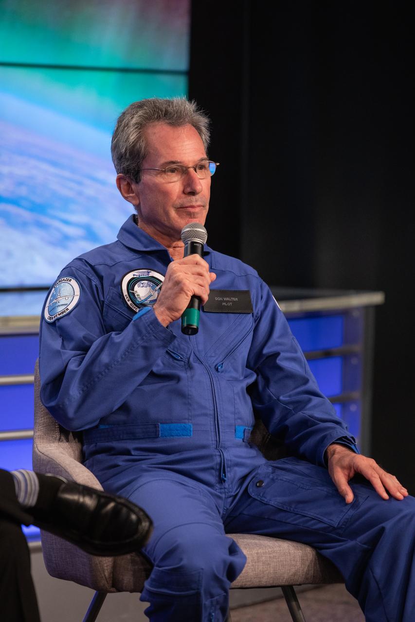
Don Walters, chief pilot of the L-1011 Stargazer aircraft for Northrop Grumman Innovation Systems, speaks to news media during a prelaunch mission briefing for NASA’s Ionospheric Connection Explorer (ICON), on Oct. 8, 2019, in the News Center auditorium at the agency’s Kennedy Space Center in Florida. ICON is targeted to launch from Cape Canaveral Air Force Station in Florida on Oct. 9, 2019, aboard a Northrop Grumman Pegasus XL rocket carried aloft by the company’s Stargazer L-1011 aircraft. The explorer will study the frontier of space - the dynamic zone high in Earth's atmosphere where terrestrial weather from below meets space weather above.
VANDENBERG AIR FORCE BASE, Fla. -- NASA’s Interstellar Boundary Explorer, or IBEX, spacecraft and mated Pegasus XL rocket are being attached to Orbital Sciences’ L-1011 aircraft for launch. IBEX is targeted for launch from the Kwajalein Atoll, a part of the Marshall Islands in the Pacific Ocean, on Oct. 19. IBEX will be launched aboard the Pegasus rocket dropped from under the wing of the L-1011 aircraft flying over the Pacific Ocean. The Pegasus will carry the spacecraft approximately 130 miles above Earth and place it in orbit. The IBEX satellite will make the first map of the boundary between the Solar System and interstellar space. Photo credit: NASA/Mark Mackley, VAFB
VANDENBERG AIR FORCE BASE, Fla. -- NASA’s Interstellar Boundary Explorer, or IBEX, spacecraft and mated Pegasus XL rocket are being attached to Orbital Sciences’ L-1011 aircraft for launch. IBEX is targeted for launch from the Kwajalein Atoll, a part of the Marshall Islands in the Pacific Ocean, on Oct. 19. IBEX will be launched aboard the Pegasus rocket dropped from under the wing of the L-1011 aircraft flying over the Pacific Ocean. The Pegasus will carry the spacecraft approximately 130 miles above Earth and place it in orbit. The IBEX satellite will make the first map of the boundary between the Solar System and interstellar space. Photo credit: NASA/Mark Mackley, VAFB
Northrop Grumman's L-1011 Stargazer aircraft is at the hot pad at Vandenberg Air Force Base in California on May 26, 2018. Preparations are underway to attach the company's Pegasus XL rocket, containing NASA's Ionospheric Connection Explorer (ICON), beneath the aircraft. The explorer will launch on June 15, 2018, from Kwajalein Atoll in the Marshall Islands (June 14 in the continental United States). ICON will study the frontier of space - the dynamic zone high in Earth's atmosphere where terrestrial weather from below meets space weather above. The explorer will help determine the physics of Earth's space environment and pave the way for mitigating its effects on our technology, communications systems and society.
VANDENBERG AIR FORCE BASE, Fla. -- NASA’s Interstellar Boundary Explorer, or IBEX, spacecraft and mated Pegasus XL rocket are being attached to Orbital Sciences’ L-1011 aircraft for launch. IBEX is targeted for launch from the Kwajalein Atoll, a part of the Marshall Islands in the Pacific Ocean, on Oct. 19. IBEX will be launched aboard the Pegasus rocket dropped from under the wing of the L-1011 aircraft flying over the Pacific Ocean. The Pegasus will carry the spacecraft approximately 130 miles above Earth and place it in orbit. The IBEX satellite will make the first map of the boundary between the Solar System and interstellar space. Photo credit: NASA/Mark Mackley, VAFB
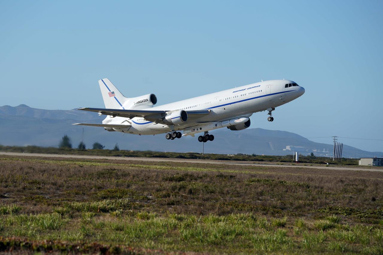
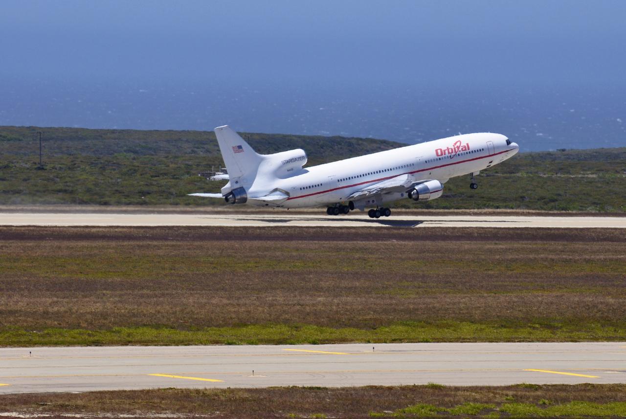
Northrop Grumman's L-1011 Stargazer takes off from Vandenberg Air Force Base in California on Oct. 1, 2019. The company's Pegasus XL rocket, containing NASA's Ionospheric Connection Explorer (ICON), is attached beneath the aircraft. The explorer is targeted to launch on Oct. 9, 2019, from Cape Canaveral Air Force Station in Florida. ICON will study the frontier of space - the dynamic zone high in Earth's atmosphere where terrestrial weather from below meets space weather above.
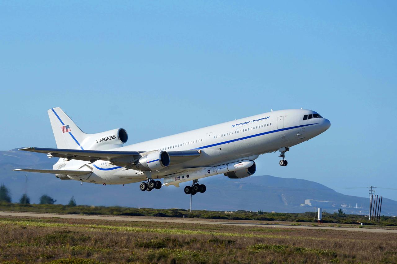
Northrop Grumman's L-1011 Stargazer takes off from Vandenberg Air Force Base in California on Oct. 1, 2019. The company's Pegasus XL rocket, containing NASA's Ionospheric Connection Explorer (ICON), is attached beneath the aircraft. The explorer is targeted to launch on Oct. 9, 2019, from Cape Canaveral Air Force Station in Florida. ICON will study the frontier of space - the dynamic zone high in Earth's atmosphere where terrestrial weather from below meets space weather above.
Northrop Grumman's L-1011 Stargazer takes off from Vandenberg Air Force Base in California on Oct. 1, 2019. The company's Pegasus XL rocket, containing NASA's Ionospheric Connection Explorer (ICON), is attached beneath the aircraft. The explorer is targeted to launch on Oct. 9, 2019, from Cape Canaveral Air Force Station in Florida. ICON will study the frontier of space - the dynamic zone high in Earth's atmosphere where terrestrial weather from below meets space weather above.
Northrop Grumman's L-1011 Stargazer takes off from Vandenberg Air Force Base in California on Oct. 1, 2019. The company's Pegasus XL rocket, containing NASA's Ionospheric Connection Explorer (ICON), is attached beneath the aircraft. The explorer is targeted to launch on Oct. 9, 2019, from Cape Canaveral Air Force Station in Florida. ICON will study the frontier of space - the dynamic zone high in Earth's atmosphere where terrestrial weather from below meets space weather above.
Northrop Grumman's L-1011 Stargazer takes off from Vandenberg Air Force Base in California on Oct. 1, 2019. The company's Pegasus XL rocket, containing NASA's Ionospheric Connection Explorer (ICON), is attached beneath the aircraft. The explorer is targeted to launch on Oct. 9, 2019, from Cape Canaveral Air Force Station in Florida. ICON will study the frontier of space - the dynamic zone high in Earth's atmosphere where terrestrial weather from below meets space weather above.
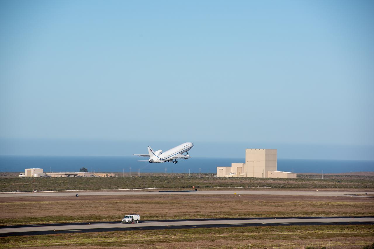
Northrop Grumman's L-1011 Stargazer takes off from Vandenberg Air Force Base in California on Oct. 1, 2019. The company's Pegasus XL rocket, containing NASA's Ionospheric Connection Explorer (ICON), is attached beneath the aircraft. The explorer is targeted to launch on Oct. 9, 2019, from Cape Canaveral Air Force Station in Florida. ICON will study the frontier of space - the dynamic zone high in Earth's atmosphere where terrestrial weather from below meets space weather above.
Northrop Grumman's L-1011 Stargazer is undergoing final preparations prior to its takeoff from Vandenberg Air Force Base in California on Oct. 1, 2019. The company's Pegasus XL rocket, containing NASA's Ionospheric Connection Explorer (ICON), is attached beneath the aircraft. The explorer is targeted to launch on Oct. 9, 2019, from Cape Canaveral Air Force Station in Florida. ICON will study the frontier of space - the dynamic zone high in Earth's atmosphere where terrestrial weather from below meets space weather above.
Northrop Grumman's L-1011 Stargazer awaits takeoff from Vandenberg Air Force Base in California on Oct. 1, 2019. The company's Pegasus XL rocket, containing NASA's Ionospheric Connection Explorer (ICON), is attached beneath the aircraft. The explorer is targeted to launch on Oct. 9, 2019, from Cape Canaveral Air Force Station in Florida. ICON will study the frontier of space - the dynamic zone high in Earth's atmosphere where terrestrial weather from below meets space weather above.
VANDENBERG AIR FORCE BASE, Calif. – Orbital Sciences’ L-1011 carrier aircraft appears to hover above the runway as it departs from Vandenberg Air Force Base in California. The aircraft is transporting Orbital’s Pegasus rocket and NASA’s Nuclear Spectroscopic Telescope Array, or NuSTAR, to the U.S. Army's Ronald Reagan Ballistic Missile Defense Test Site on Kwajalein Atoll, part of the Marshall Islands in the Pacific Ocean. The Pegasus, mated to its NuSTAR payload, will be launched from the carrier aircraft 117 nautical miles south of Kwajalein at latitude 6.75 degrees north of the equator. The high-energy X-ray telescope will conduct a census of black holes, map radioactive material in young supernovae remnants, and study the origins of cosmic rays and the extreme physics around collapsed stars. Launch is scheduled for June 13. For more information, visit http://www.nasa.gov/nustar. Photo credit: NASA/Randy Beaudoin, VAFB
VANDENBERG AIR FORCE BASE, Calif. – On the runway of Vandenberg Air Force Base in California, Orbital Sciences’ L-1011 aircraft waits for the arrival of NASA’s Interstellar Boundary Explorer, or IBEX, spacecraft and Pegasus XL rocket. The Pegasus will be attached to the aircraft for launch. The IBEX satellite will make the first map of the boundary between the Solar System and interstellar space. IBEX is targeted for launch from the Kwajalein Atoll, a part of the Marshall Islands in the Pacific Ocean, on Oct. 19 aboard the Pegasus rocket dropped from under the wing of an L-1011 aircraft flying over the Pacific Ocean. The Pegasus will carry the spacecraft approximately 130 miles above Earth and place it in orbit. Photo credit: NASA/Randy Beaudoin, VAFB
VANDENBERG AIR FORCE BASE, Calif. – In On the runway of Vandenberg Air Force Base in California, Orbital Sciences’ L-1011 aircraft waits for the arrival of NASA’s Interstellar Boundary Explorer, or IBEX, spacecraft and Pegasus XL rocket. The Pegasus will be attached to the aircraft for launch. The IBEX satellite will make the first map of the boundary between the Solar System and interstellar space. IBEX is targeted for launch from the Kwajalein Atoll, a part of the Marshall Islands in the Pacific Ocean, on Oct. 19 aboard the Pegasus rocket dropped from under the wing of an L-1011 aircraft flying over the Pacific Ocean. The Pegasus will carry the spacecraft approximately 130 miles above Earth and place it in orbit. Photo credit: NASA/Randy Beaudoin, VAFB
VANDENBERG AIR FORCE BASE, Calif. – On the ramp of Vandenberg Air Force Base in California, Orbital Sciences’ L-1011 aircraft is ready for departure with NASA’s Interstellar Boundary Explorer, or IBEX, spacecraft and Pegasus XL rocket. The Pegasus is attached under the wing of the aircraft for launch. The IBEX satellite will make the first map of the boundary between the Solar System and interstellar space. IBEX is targeted for launch Oct. 19. The Pegasus rocket will be dropped from under the wing of the L-1011 over the Pacific Ocean to carry the spacecraft approximately 130 miles above Earth and place it in orbit. Photo credit: NASA/Randy Beaudoin, VAFB
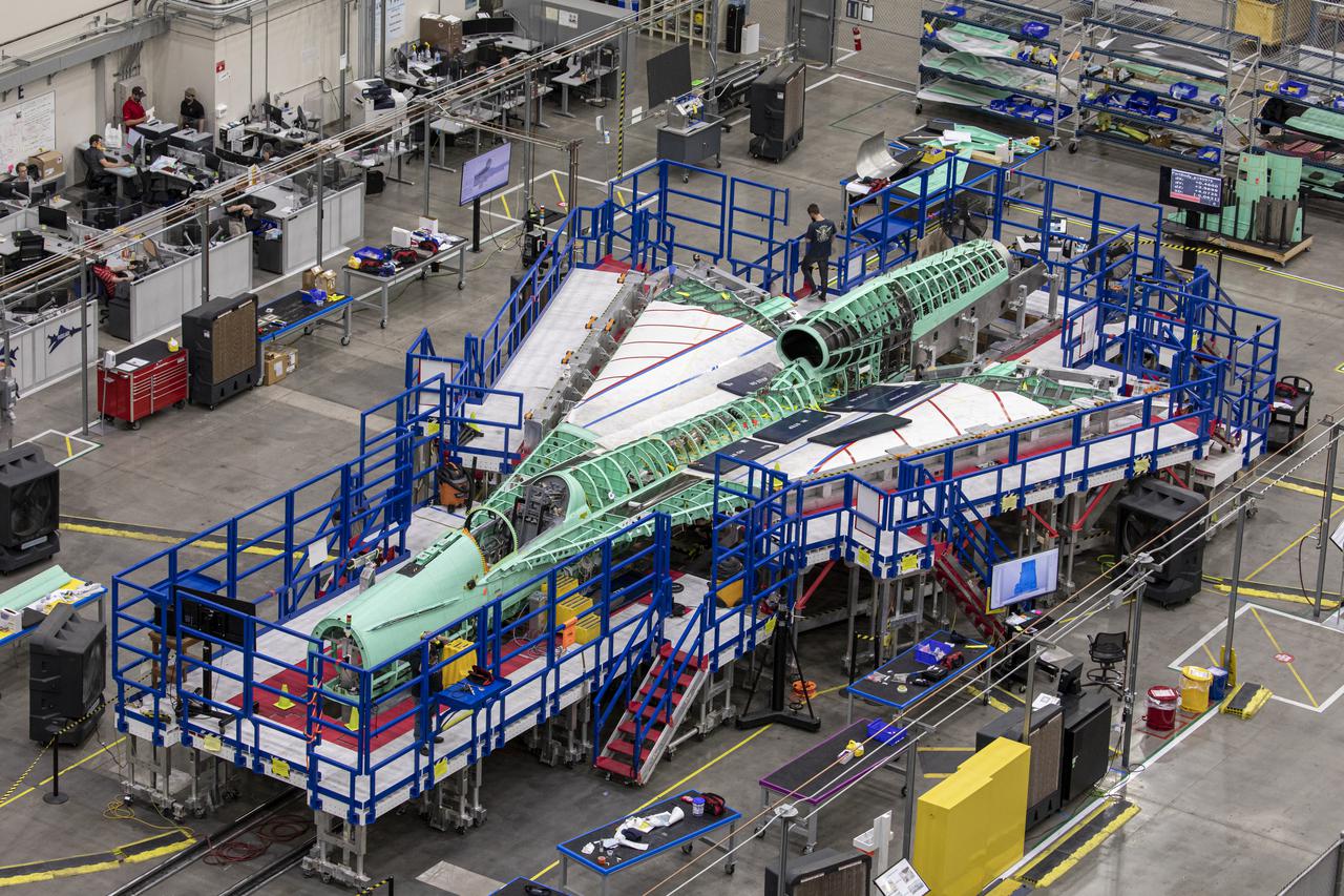
The team at Lockheed Martin Skunk Works in Palmdale, California, merged the major sections of the X-59 Quiet SuperSonic Technology aircraft, which includes the wing, tail assembly, and fuselage or forward section. This marks the first time the X-59 resembles an actual aircraft. (Pictured here is a overhead view of the X-59 as it comes together for the major assembly merger in summer 2021.) Lockheed Martin Photography By Garry Tice 1011 Lockheed Way, Palmdale, Ca. 93599 Event: Manufacturing Area From Above Date: 5/26/2021
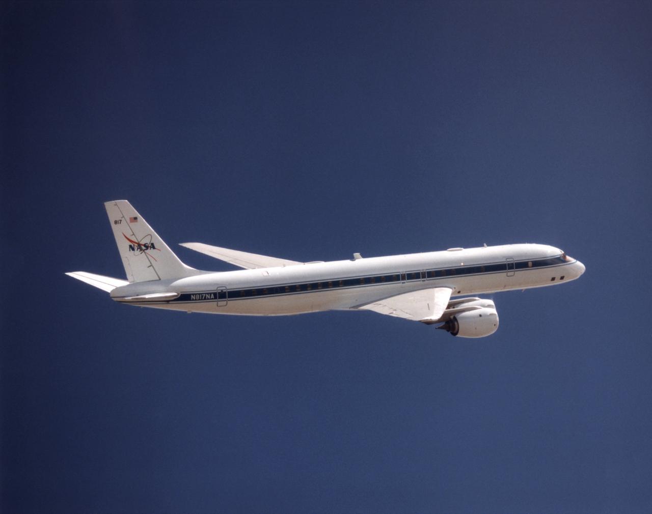
NASA's DC-8 Airborne Science platform shown against a background of a dark blue sky on February 20, 1998. The aircraft is shown from the right rear, slightly above its plane, with the right wing in the foreground and the left wing and horizontal tail in the background. The former airliner is a "dash-72" model and has a range of 5,400 miles. The craft can stay airborne for 12 hours and has an operational speed range between 300 and 500 knots. The research flights are made at between 500 and 41,000 feet. The aircraft can carry up to 30,000 lbs of research/science payload equipment installed in 15 mission-definable spaces.

VANDENBERG AIR FORCE BASE, Calif. – On the ramp of Vandenberg Air Force Base in California, Orbital Sciences’ L-1011 aircraft is ready for departure with NASA’s Interstellar Boundary Explorer, or IBEX, spacecraft and Pegasus XL rocket. The Pegasus is attached under the wing of the aircraft for launch. The IBEX satellite will make the first map of the boundary between the Solar System and interstellar space. IBEX is targeted for launch Oct. 19. The Pegasus rocket will be dropped from under the wing of the L-1011 over the Pacific Ocean to carry the spacecraft approximately 130 miles above Earth and place it in orbit. Photo credit: NASA/Randy Beaudoin, VAFB
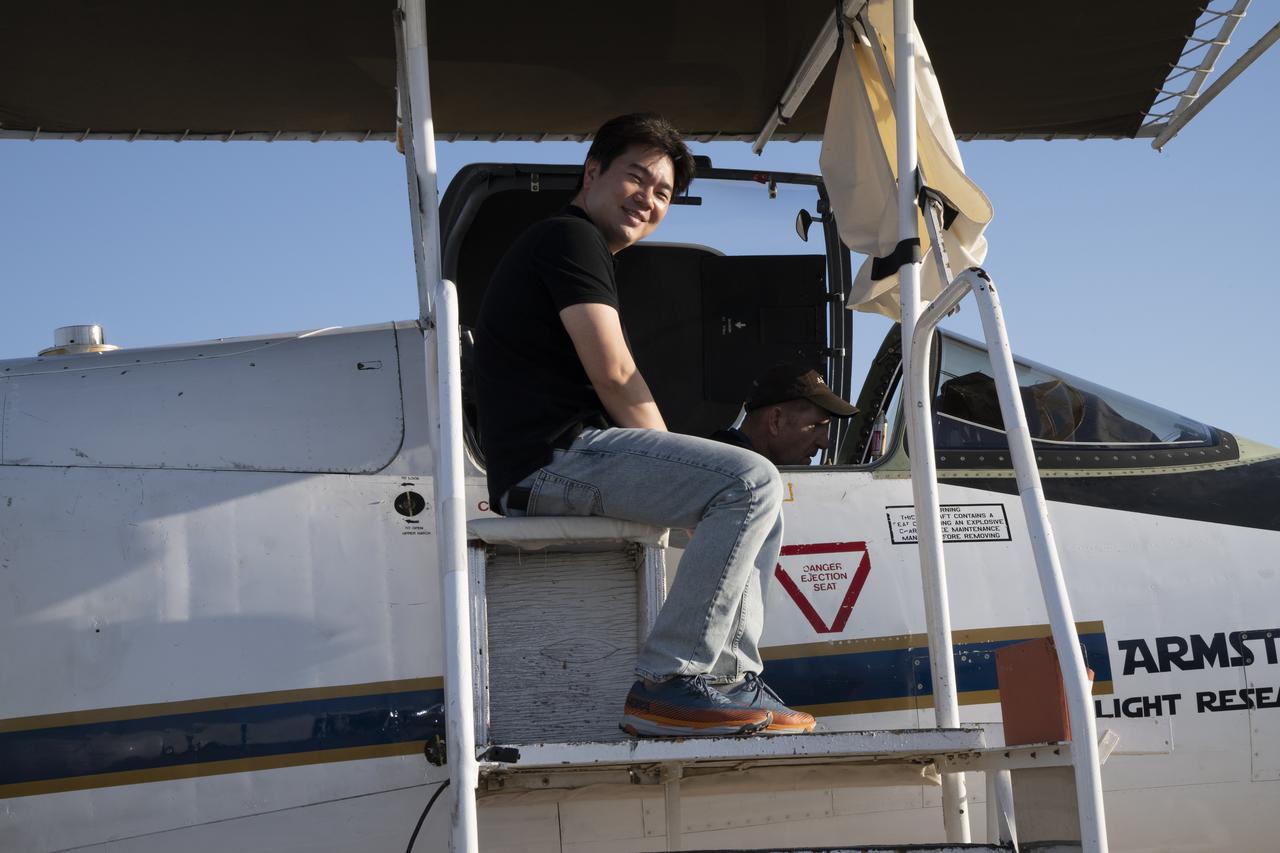
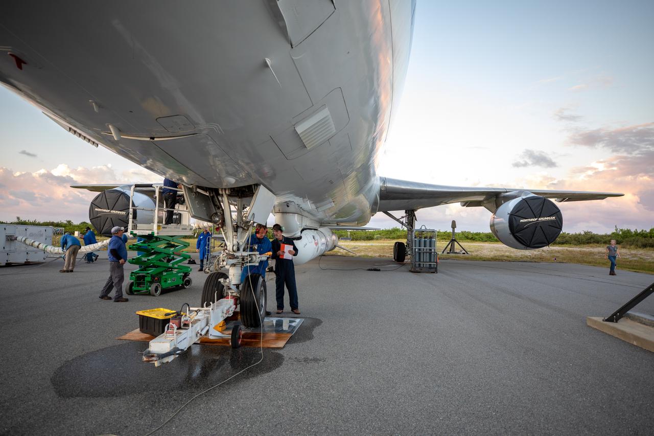
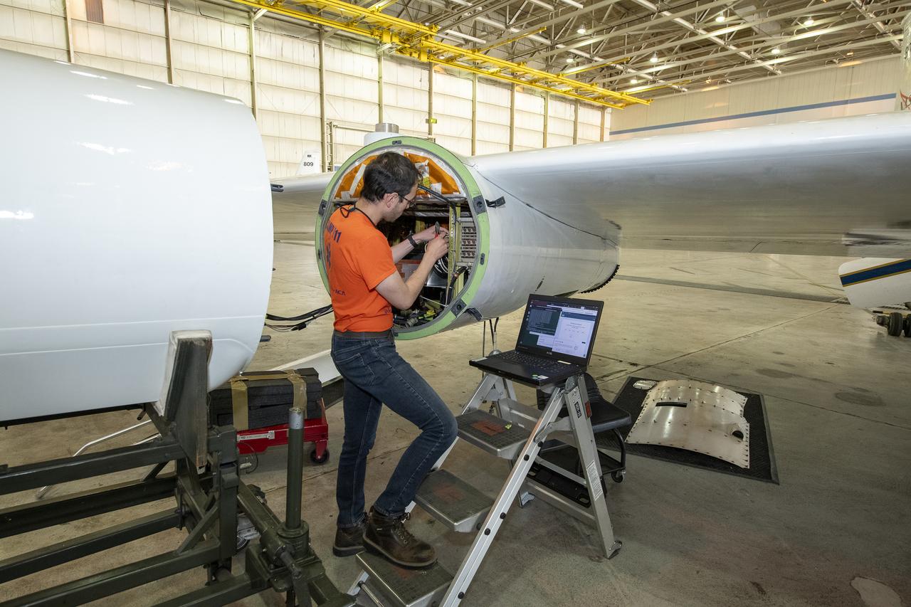
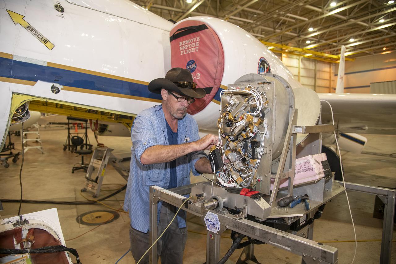
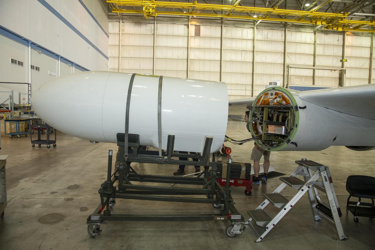
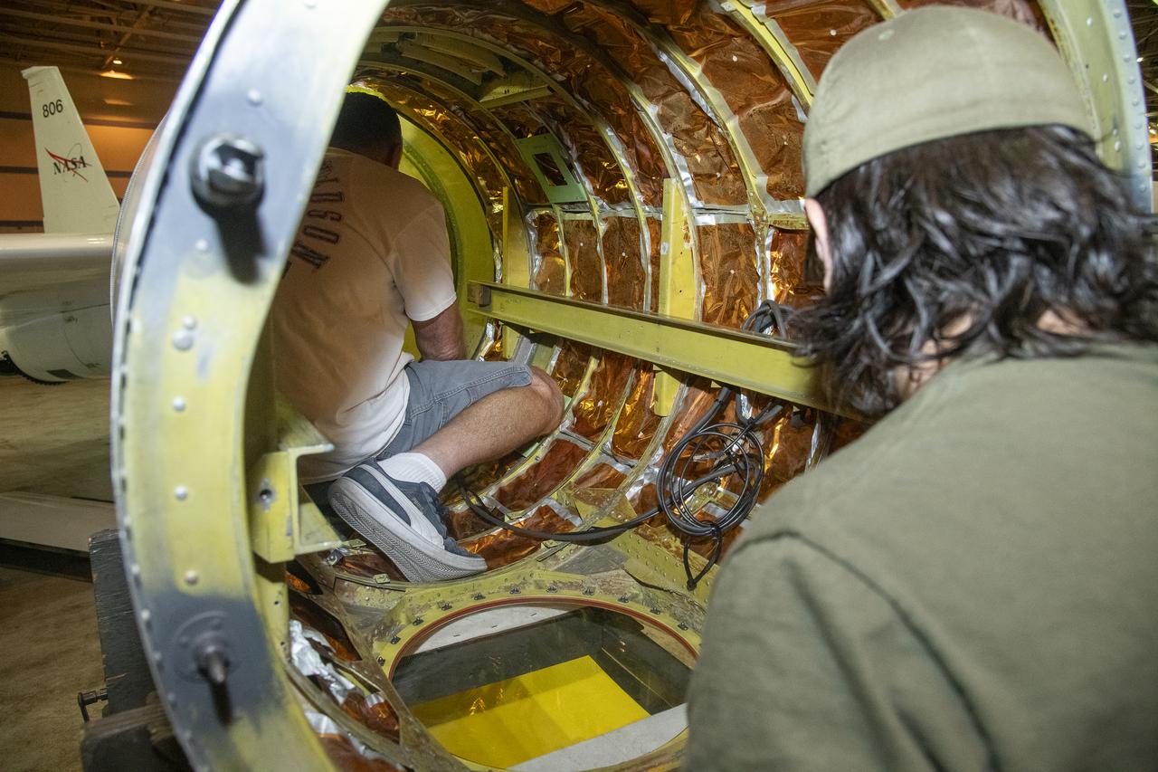
NASA Armstrong’s ER-2 aircraft is uploaded with instruments for its ALOFT mission. The ER-2 will fly at high altitudes above the Floridian coastline to collect data about the energetic characteristics and behavior of lightning and thunderclouds. Scientists from the University of Bergen, Norway will interpret that data from the ground and collaborate with NASA pilots to safely collect the most accurate data for this project about the power of lightning.
NASA Armstrong’s ER-2 aircraft is uploaded with instruments for its ALOFT mission. The ER-2 will fly at high altitudes above the Floridian coastline to collect data about the energetic characteristics and behavior of lightning and thunderclouds. Scientists from the University of Bergen, Norway will interpret that data from the ground and collaborate with NASA pilots to safely collect the most accurate data for this project about the power of lightning.
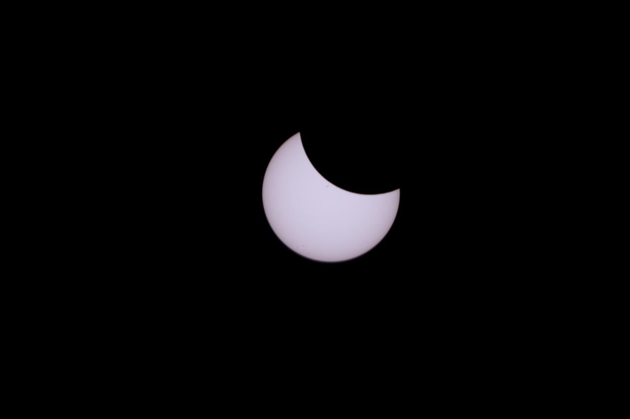
The Moon is seen passing in front of the Sun during a total solar eclipse on Monday, August 21, 2017 from onboard a NASA Gulfstream III aircraft flying 25,000 feet above the Oregon coast. A total solar eclipse swept across a narrow portion of the contiguous United States from Lincoln Beach, Oregon to Charleston, South Carolina. A partial solar eclipse was visible across the entire North American continent along with parts of South America, Africa, and Europe. Photo Credit: (NASA/Carla Thomas)
NASA Armstrong’s ER-2 aircraft is uploaded with instruments for its ALOFT mission. The ER-2 will fly at high altitudes above the Floridian coastline to collect data about the energetic characteristics and behavior of lightning and thunderclouds. Scientists from the University of Bergen, Norway will interpret that data from the ground and collaborate with NASA pilots to safely collect the most accurate data for this project about the power of lightning.
NASA Armstrong’s ER-2 aircraft is uploaded with instruments for its ALOFT mission. The ER-2 will fly at high altitudes above the Floridian coastline to collect data about the energetic characteristics and behavior of lightning and thunderclouds. Scientists from the University of Bergen, Norway will interpret that data from the ground and collaborate with NASA pilots to safely collect the most accurate data for this project about the power of lightning.
NASA Armstrong’s ER-2 aircraft is uploaded with instruments for its ALOFT mission. The ER-2 will fly at high altitudes above the Floridian coastline to collect data about the energetic characteristics and behavior of lightning and thunderclouds. Scientists from the University of Bergen, Norway will interpret that data from the ground and collaborate with NASA pilots to safely collect the most accurate data for this project about the power of lightning.
NASA Armstrong’s ER-2 aircraft is uploaded with instruments for its ALOFT mission. The ER-2 will fly at high altitudes above the Floridian coastline to collect data about the energetic characteristics and behavior of lightning and thunderclouds. Scientists from the University of Bergen, Norway will interpret that data from the ground and collaborate with NASA pilots to safely collect the most accurate data for this project about the power of lightning.
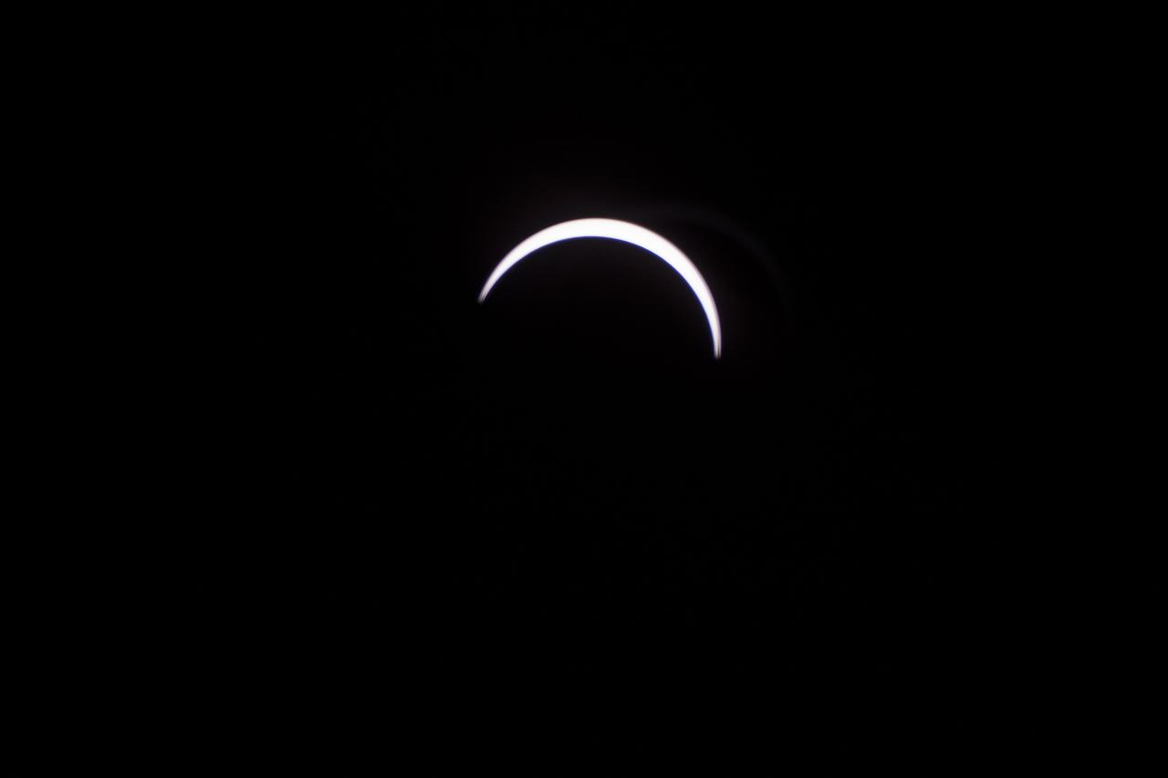
The Moon is seen passing in front of the Sun during a total solar eclipse on Monday, August 21, 2017 from onboard a NASA Gulfstream III aircraft flying 25,000 feet above the Oregon coast. A total solar eclipse swept across a narrow portion of the contiguous United States from Lincoln Beach, Oregon to Charleston, South Carolina. A partial solar eclipse was visible across the entire North American continent along with parts of South America, Africa, and Europe. Photo Credit: (NASA/Carla Thomas)
NASA Armstrong’s ER-2 aircraft is uploaded with instruments for its ALOFT mission. The ER-2 will fly at high altitudes above the Floridian coastline to collect data about the energetic characteristics and behavior of lightning and thunderclouds. Scientists from the University of Bergen, Norway will interpret that data from the ground and collaborate with NASA pilots to safely collect the most accurate data for this project about the power of lightning.
NASA Armstrong’s ER-2 aircraft is uploaded with instruments for its ALOFT mission. The ER-2 will fly at high altitudes above the Floridian coastline to collect data about the energetic characteristics and behavior of lightning and thunderclouds. Scientists from the University of Bergen, Norway will interpret that data from the ground and collaborate with NASA pilots to safely collect the most accurate data for this project about the power of lightning.

NASA Armstrong’s ER-2 aircraft is uploaded with instruments for its ALOFT mission. The ER-2 will fly at high altitudes above the Floridian coastline to collect data about the energetic characteristics and behavior of lightning and thunderclouds. Scientists from the University of Bergen, Norway will interpret that data from the ground and collaborate with NASA pilots to safely collect the most accurate data for this project about the power of lightning.
NASA Armstrong’s ER-2 aircraft is uploaded with instruments for its ALOFT mission. The ER-2 will fly at high altitudes above the Floridian coastline to collect data about the energetic characteristics and behavior of lightning and thunderclouds. Scientists from the University of Bergen, Norway will interpret that data from the ground and collaborate with NASA pilots to safely collect the most accurate data for this project about the power of lightning.
NASA Armstrong’s ER-2 aircraft is uploaded with instruments for its ALOFT mission. The ER-2 will fly at high altitudes above the Floridian coastline to collect data about the energetic characteristics and behavior of lightning and thunderclouds. Scientists from the University of Bergen, Norway will interpret that data from the ground and collaborate with NASA pilots to safely collect the most accurate data for this project about the power of lightning.
NASA Armstrong’s ER-2 aircraft is uploaded with instruments for its ALOFT mission. The ER-2 will fly at high altitudes above the Floridian coastline to collect data about the energetic characteristics and behavior of lightning and thunderclouds. Scientists from the University of Bergen, Norway will interpret that data from the ground and collaborate with NASA pilots to safely collect the most accurate data for this project about the power of lightning.
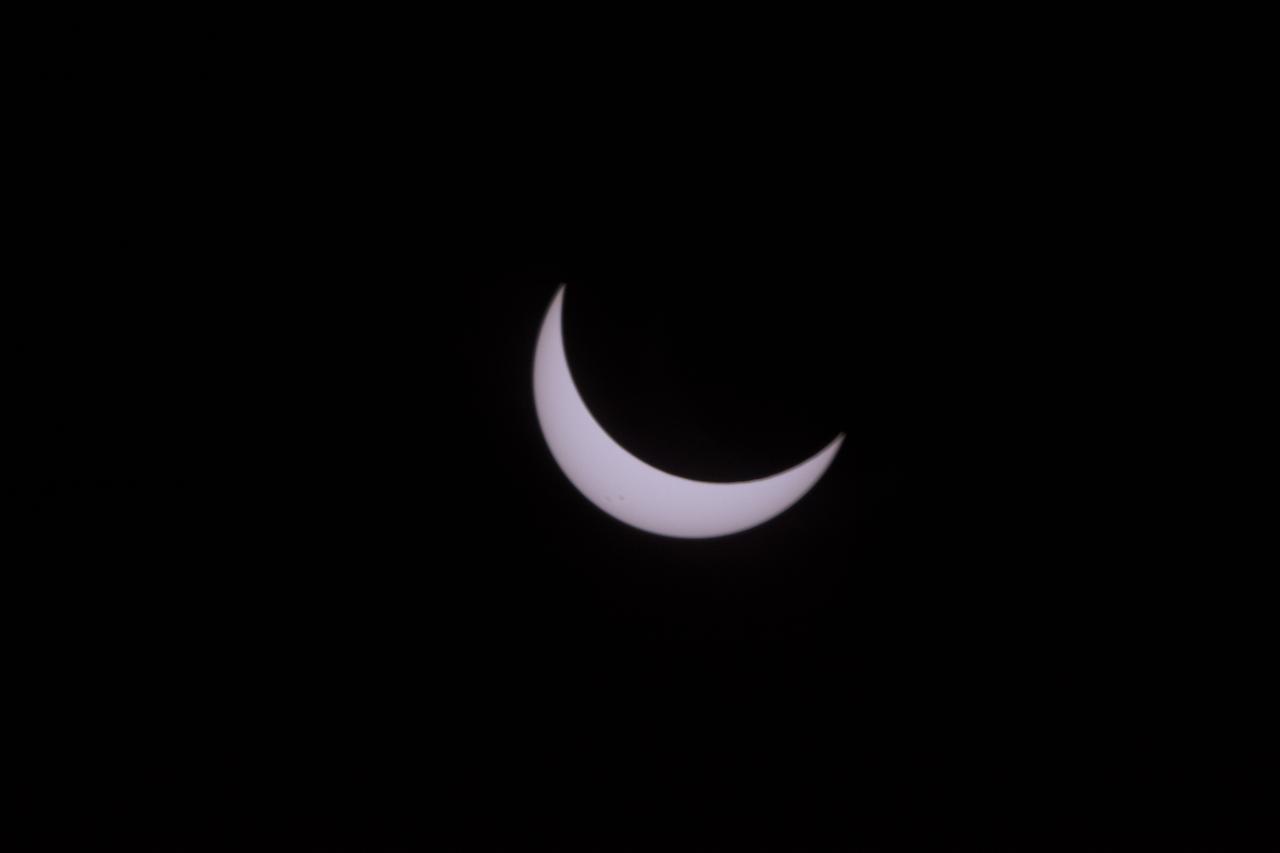
The Moon is seen passing in front of the Sun during a total solar eclipse on Monday, August 21, 2017 from onboard a NASA Gulfstream III aircraft flying 25,000 feet above the Oregon coast. A total solar eclipse swept across a narrow portion of the contiguous United States from Lincoln Beach, Oregon to Charleston, South Carolina. A partial solar eclipse was visible across the entire North American continent along with parts of South America, Africa, and Europe. Photo Credit: (NASA/Carla Thomas)

The Moon is seen passing in front of the Sun during a total solar eclipse on Monday, August 21, 2017 from onboard a NASA Gulfstream III aircraft flying 25,000 feet above the Oregon coast. A total solar eclipse swept across a narrow portion of the contiguous United States from Lincoln Beach, Oregon to Charleston, South Carolina. A partial solar eclipse was visible across the entire North American continent along with parts of South America, Africa, and Europe. Photo Credit: (NASA/Carla Thomas)
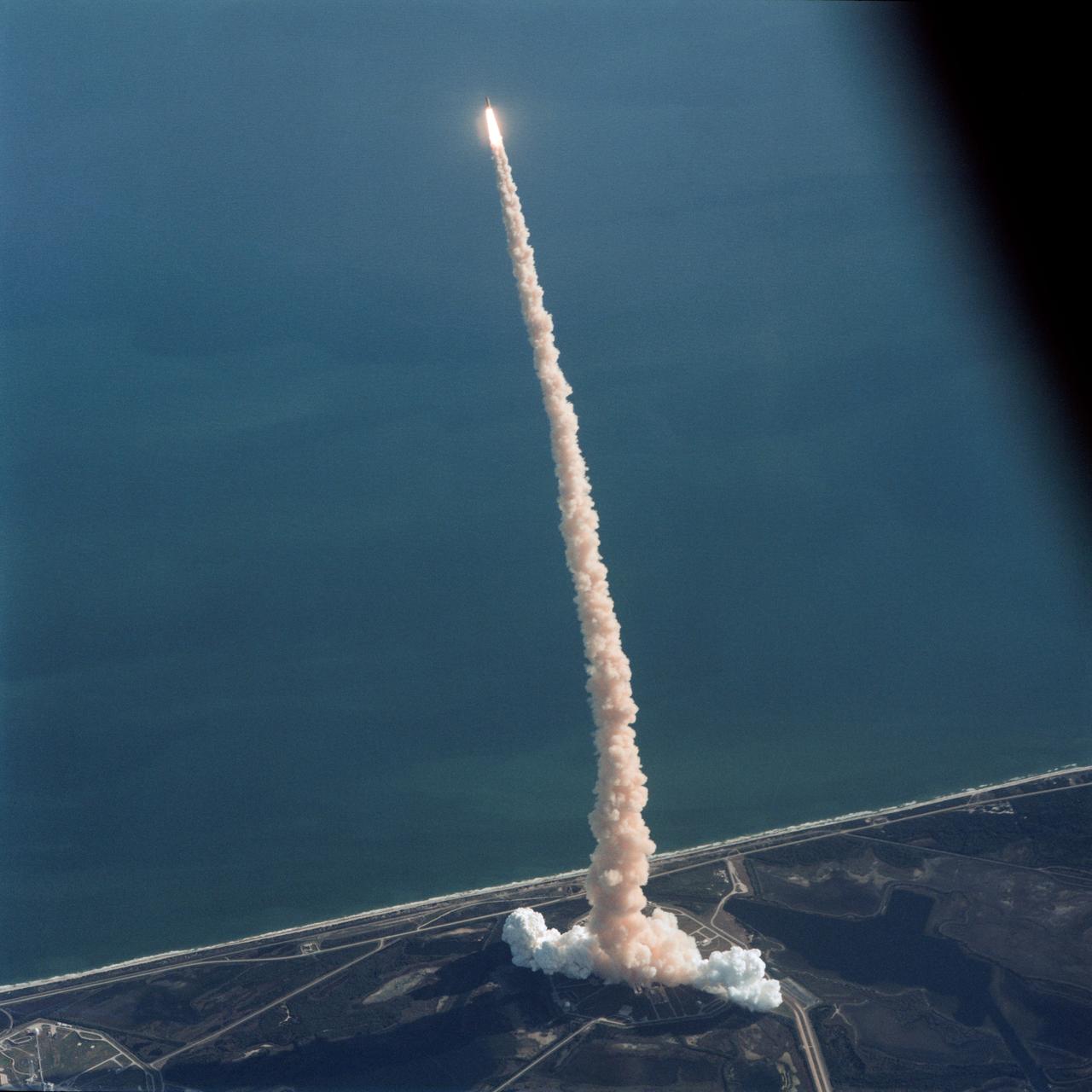
Air-to-air view, taken from the weather-monitoring Shuttle Training Aircraft (STA), shows STS-42 Discovery, Orbiter Vehicle (OV) 103, as it soars above the Atlantic Ocean after liftoff from a Kennedy Space Center (KSC) Launch Complex (LC) Pad at 9:52:33 am (Eastern Standard Time (EST)). The exhaust plume traces OV-103's flight path.
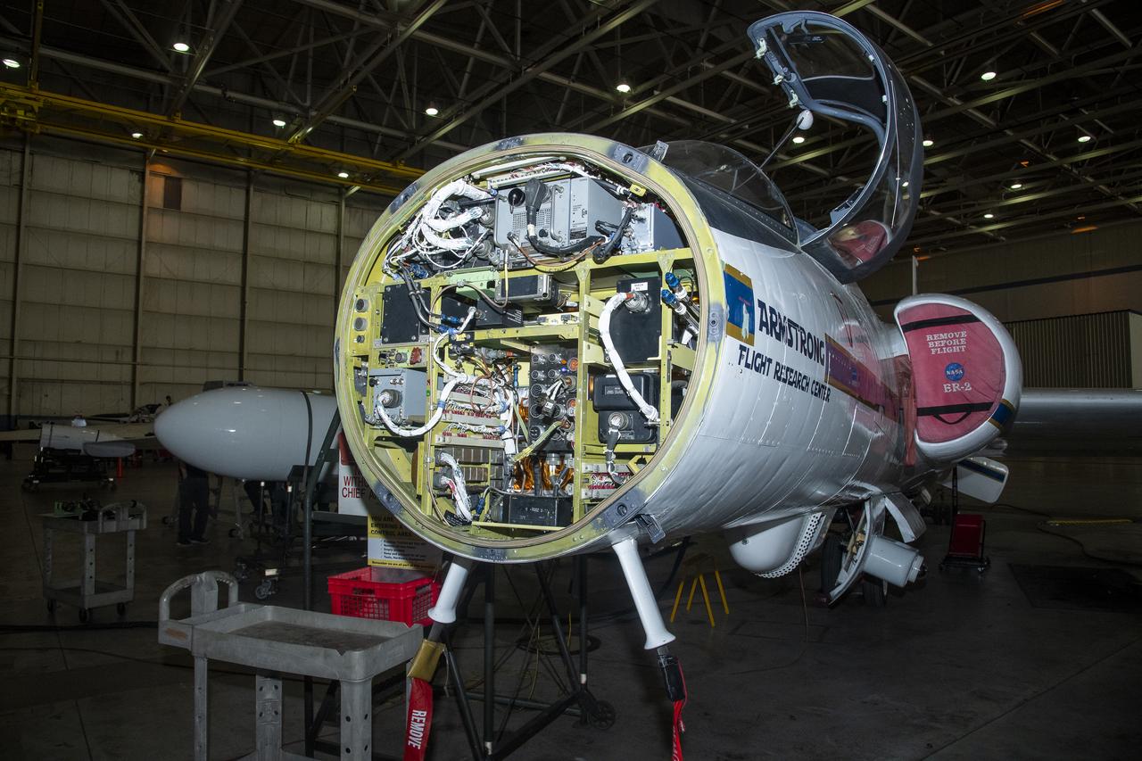
NASA Armstrong’s ER-2 aircraft is uploaded with instruments for its ALOFT mission. The ER-2 will fly at high altitudes above the Floridian coastline to collect data about the energetic characteristics and behavior of lightning and thunderclouds. Scientists from the University of Bergen, Norway will interpret that data from the ground and collaborate with NASA pilots to safely collect the most accurate data for this project about the power of lightning.
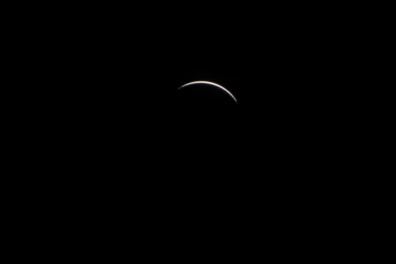
The Moon is seen passing in front of the Sun during a total solar eclipse on Monday, August 21, 2017 from onboard a NASA Gulfstream III aircraft flying 25,000 feet above the Oregon coast. A total solar eclipse swept across a narrow portion of the contiguous United States from Lincoln Beach, Oregon to Charleston, South Carolina. A partial solar eclipse was visible across the entire North American continent along with parts of South America, Africa, and Europe. Photo Credit: (NASA/Carla Thomas)
NASA Armstrong’s ER-2 aircraft is uploaded with instruments for its ALOFT mission. The ER-2 will fly at high altitudes above the Floridian coastline to collect data about the energetic characteristics and behavior of lightning and thunderclouds. Scientists from the University of Bergen, Norway will interpret that data from the ground and collaborate with NASA pilots to safely collect the most accurate data for this project about the power of lightning.
NASA Armstrong’s ER-2 aircraft is uploaded with instruments for its ALOFT mission. The ER-2 will fly at high altitudes above the Floridian coastline to collect data about the energetic characteristics and behavior of lightning and thunderclouds. Scientists from the University of Bergen, Norway will interpret that data from the ground and collaborate with NASA pilots to safely collect the most accurate data for this project about the power of lightning.
NASA Armstrong’s ER-2 aircraft is uploaded with instruments for its ALOFT mission. The ER-2 will fly at high altitudes above the Floridian coastline to collect data about the energetic characteristics and behavior of lightning and thunderclouds. Scientists from the University of Bergen, Norway will interpret that data from the ground and collaborate with NASA pilots to safely collect the most accurate data for this project about the power of lightning.
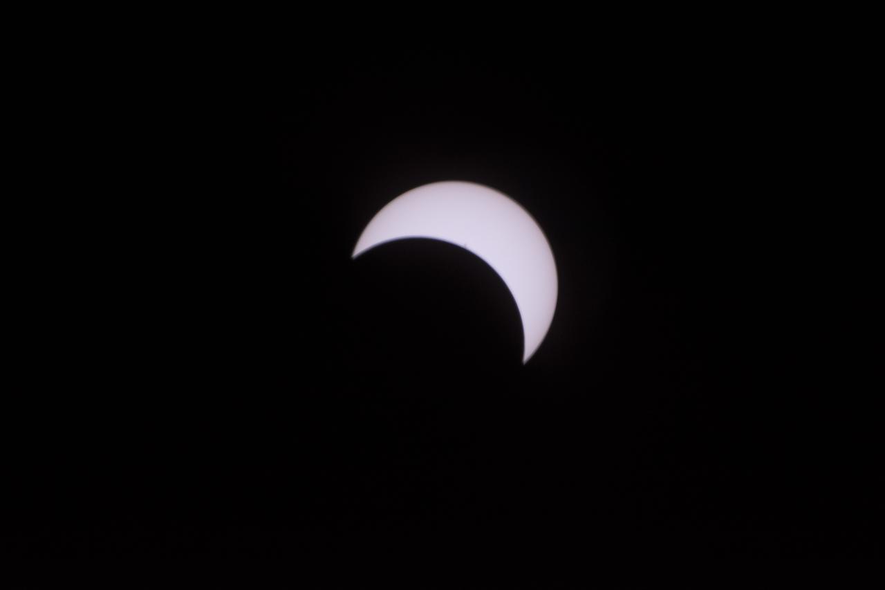
The Moon is seen passing in front of the Sun during a total solar eclipse on Monday, August 21, 2017 from onboard a NASA Gulfstream III aircraft flying 25,000 feet above the Oregon coast. A total solar eclipse swept across a narrow portion of the contiguous United States from Lincoln Beach, Oregon to Charleston, South Carolina. A partial solar eclipse was visible across the entire North American continent along with parts of South America, Africa, and Europe. Photo Credit: (NASA/Carla Thomas)
NASA Armstrong’s ER-2 aircraft is uploaded with instruments for its ALOFT mission. The ER-2 will fly at high altitudes above the Floridian coastline to collect data about the energetic characteristics and behavior of lightning and thunderclouds. Scientists from the University of Bergen, Norway will interpret that data from the ground and collaborate with NASA pilots to safely collect the most accurate data for this project about the power of lightning.
Although the new fiber optic sensors on the Ikhana, which are located on fibers that are the diameter of a human hair, are not visible, the sealant used to cover them can be seen in this view from above the left wing. NASA Dryden Flight Research Center is evaluating an advanced fiber optic-based sensing technology installed on the wings of NASA's Ikhana aircraft. The fiber optic system measures and displays the shape of the aircraft's wings in flight. There are other potential safety applications for the technology, such as vehicle structural health monitoring. If an aircraft structure can be monitored with sensors and a computer can manipulate flight control surfaces to compensate for stresses on the wings, structural control can be established to prevent situations that might otherwise result in a loss of control.
A C-17 aircraft flies above the U.S. Army’s Yuma Proving Ground in Arizona during testing of the Boeing CST-100 Starliner’s parachute system on June 26, 2019. This test, known as a “high Q” test, involved releasing a dart-shaped device – functioning as a Starliner weight simulant – from the aircraft and intentionally inflating the parachutes at higher pressures than expected during missions. The data gathered from this parachute test will help validate the system is safe to carry astronauts to and from the International Space Station as part of NASA’s Commercial Crew Program. Boeing is targeting an uncrewed Orbital Flight Test to the space station this summer, followed by its Crew Flight Test. Starliner will launch atop a United Launch Alliance Atlas V rocket from Space Launch Complex 41 at Cape Canaveral Air Force Station in Florida.

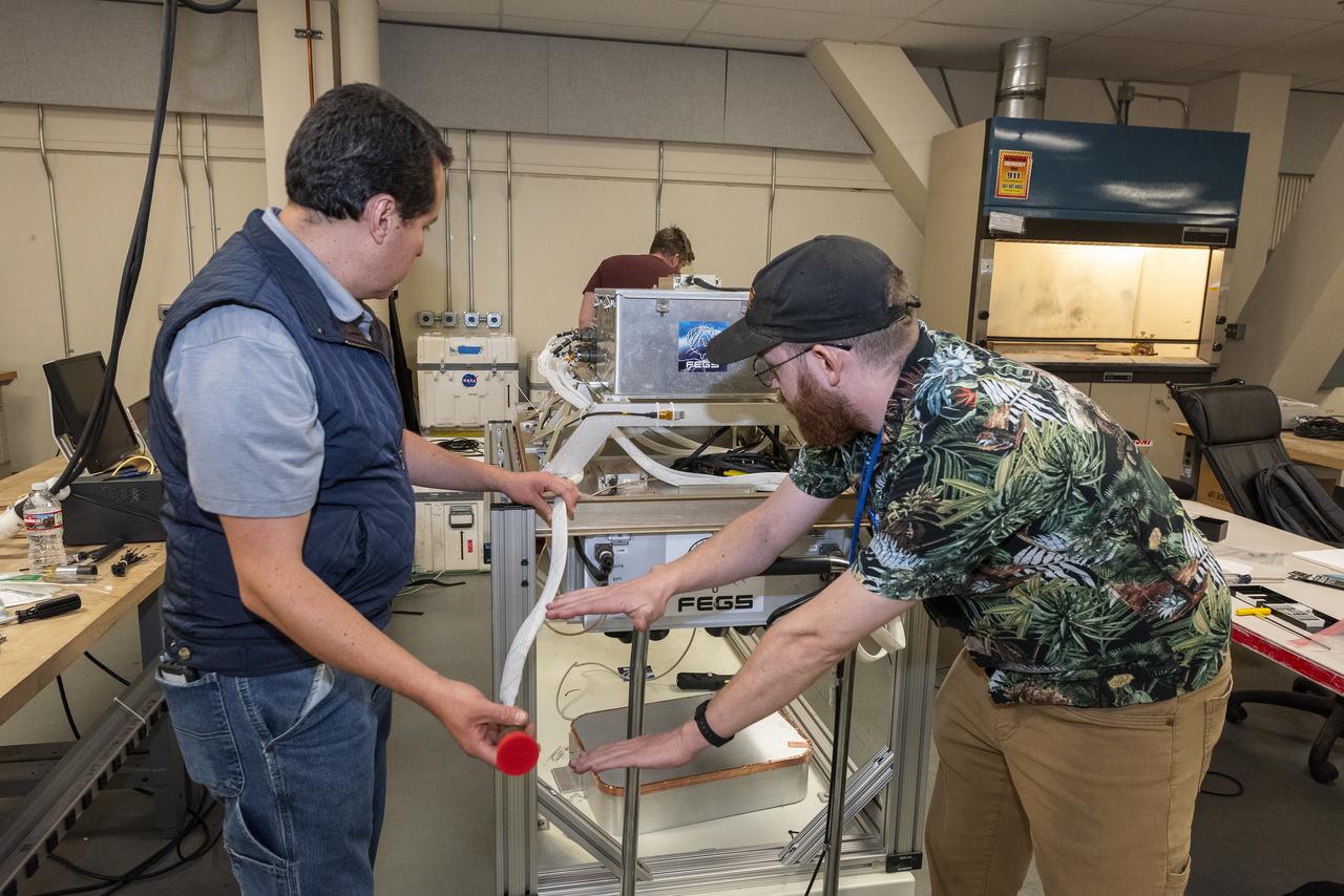
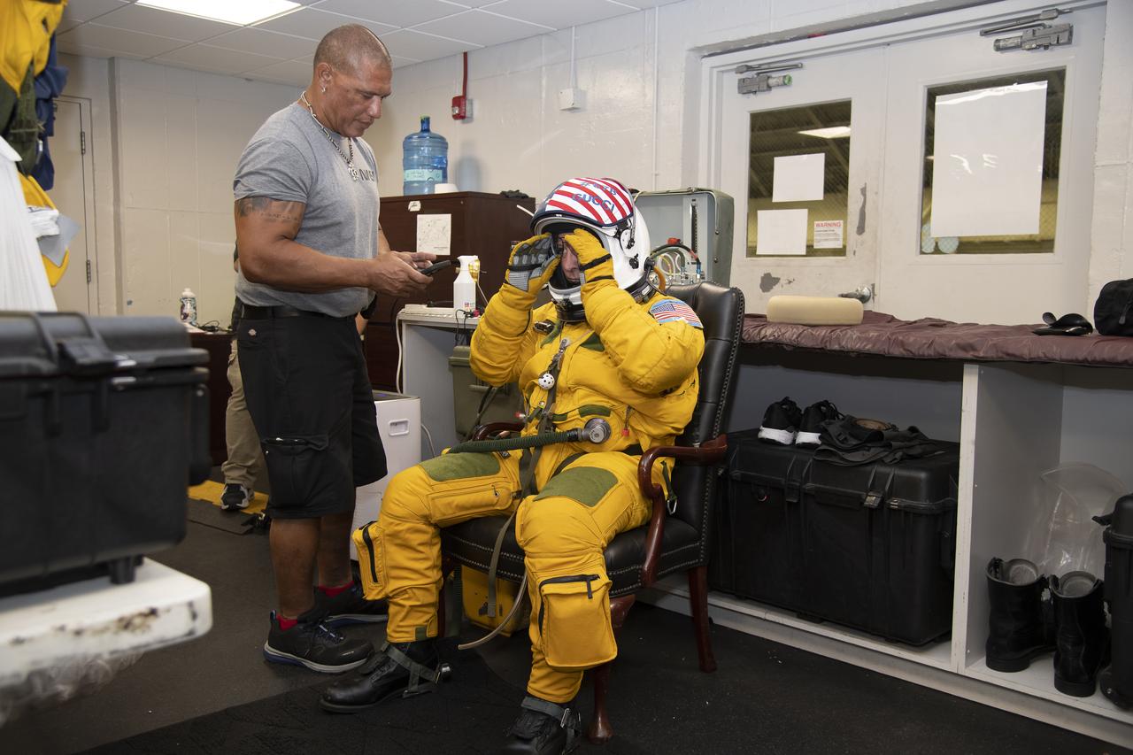
The ALOFT mission, Airborne Lightning Observatory for Fly’s eye simulator and Terrestrial gamma ray flashes, is a collaboration between NASA and the University of Bergen, Norway. NASA Armstrong Flight Research Center’s ER-2 aircraft flies just above the height of thunderclouds over the Floridian and Caribbean coastlines to collect data about lightning glows and terrestrial gamma ray flashes. Scientists expect to collect more accurate data than ever before that can advance the study of high-energy radiation emissions from thunderstorms.
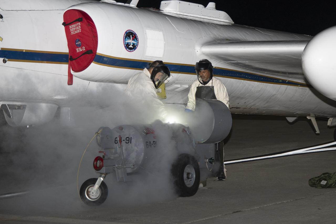
The ALOFT mission, Airborne Lightning Observatory for Fly’s eye simulator and Terrestrial gamma ray flashes, is a collaboration between NASA and the University of Bergen, Norway. NASA Armstrong Flight Research Center’s ER-2 aircraft flies just above the height of thunderclouds over the Floridian and Caribbean coastlines to collect data about lightning glows and terrestrial gamma ray flashes. Scientists expect to collect more accurate data than ever before that can advance the study of high-energy radiation emissions from thunderstorms.
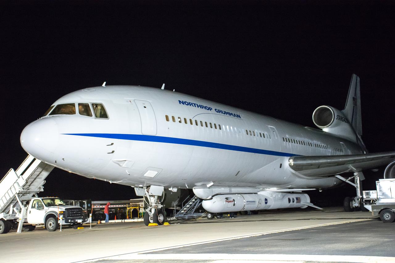
The Northrop Grumman Pegasus XL rocket, carrying NASA’s Ionospheric Connection Explorer (ICON), has arrived at the Skid Strip at Cape Canaveral Air Force Station in Florida on Oct. 1, 2019. The rocket is attached beneath the company’s L-1011 Stargazer aircraft. ICON will study the frontier of space - the dynamic zone high in Earth's atmosphere where terrestrial weather from below meets space weather above.
The ALOFT mission, Airborne Lightning Observatory for Fly’s eye simulator and Terrestrial gamma ray flashes, is a collaboration between NASA and the University of Bergen, Norway. NASA Armstrong Flight Research Center’s ER-2 aircraft flies just above the height of thunderclouds over the Floridian and Caribbean coastlines to collect data about lightning glows and terrestrial gamma ray flashes. Scientists expect to collect more accurate data than ever before that can advance the study of high-energy radiation emissions from thunderstorms.
The ALOFT mission, Airborne Lightning Observatory for Fly’s eye simulator and Terrestrial gamma ray flashes, is a collaboration between NASA and the University of Bergen, Norway. NASA Armstrong Flight Research Center’s ER-2 aircraft flies just above the height of thunderclouds over the Floridian and Caribbean coastlines to collect data about lightning glows and terrestrial gamma ray flashes. Scientists expect to collect more accurate data than ever before that can advance the study of high-energy radiation emissions from thunderstorms.

The ALOFT mission, Airborne Lightning Observatory for Fly’s eye simulator and Terrestrial gamma ray flashes, is a collaboration between NASA and the University of Bergen, Norway. NASA Armstrong Flight Research Center’s ER-2 aircraft flies just above the height of thunderclouds over the Floridian and Caribbean coastlines to collect data about lightning glows and terrestrial gamma ray flashes. Scientists expect to collect more accurate data than ever before that can advance the study of high-energy radiation emissions from thunderstorms.
The ALOFT mission, Airborne Lightning Observatory for Fly’s eye simulator and Terrestrial gamma ray flashes, is a collaboration between NASA and the University of Bergen, Norway. NASA Armstrong Flight Research Center’s ER-2 aircraft flies just above the height of thunderclouds over the Floridian and Caribbean coastlines to collect data about lightning glows and terrestrial gamma ray flashes. Scientists expect to collect more accurate data than ever before that can advance the study of high-energy radiation emissions from thunderstorms.

The ALOFT mission, Airborne Lightning Observatory for Fly’s eye simulator and Terrestrial gamma ray flashes, is a collaboration between NASA and the University of Bergen, Norway. NASA Armstrong Flight Research Center’s ER-2 aircraft flies just above the height of thunderclouds over the Floridian and Caribbean coastlines to collect data about lightning glows and terrestrial gamma ray flashes. Scientists expect to collect more accurate data than ever before that can advance the study of high-energy radiation emissions from thunderstorms.
This overhead shot of the X-59 Quiet SuperSonic Technology or QueSST aircraft shows the assembly progress of the vehicle during Spring 2021. Pictured here you can see the nose (far left) which will later be mounted to the middle section in the photo known as the fuselage and the last section is the wing and tail in the far right of the photo. Lockheed Martin Photography By Garry Tice 1011 Lockheed Way, Palmdale, Ca. 93599 Event: Manufacture Area From Above Date: 3/30/2021