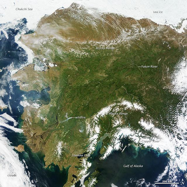
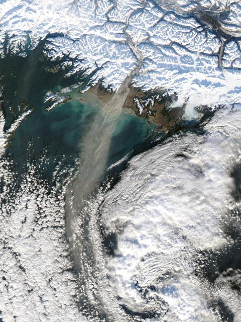
On most days, relentless rivers of clouds wash over Alaska, obscuring most of the state’s 6,640 miles (10,690 kilometers) of coastline and 586,000 square miles (1,518,000 square kilometers) of land. The south coast of Alaska even has the dubious distinction of being the cloudiest region of the United States, with some locations averaging more than 340 cloudy days per year. That was certainly not the case on June 17, 2013, the date that the Moderate Resolution Imaging Spectroradiometer (MODIS) on NASA’s Terra satellite acquired this rare, nearly cloud-free view of the state. The absence of clouds exposed a striking tapestry of water, ice, land, forests, and even wildfires. Snow-covered mountains such as the Alaska Range and Chugach Mountains were visible in southern Alaska, while the arc of mountains that make up the Brooks Range dominated the northern part of the state. The Yukon River—the longest in Alaska and the third longest in the United States—wound its way through the green boreal forests that inhabit the interior of the state. Plumes of sediment and glacial dust poured into the Gulf of Alaska from the Copper River. And Iliamna Lake, the largest in Alaska, was ice free. The same ridge of high pressure that cleared Alaska’s skies also brought stifling temperatures to many areas accustomed to chilly June days. Talkeetna, a town about 100 miles north of Anchorage, saw temperatures reach 96°F (36°C) on June 17. Other towns in southern Alaska set all-time record highs, including Cordova, Valez, and Seward. The high temperatures also helped fuel wildfires and hastened the breakup of sea ice in the Chukchi Sea. NASA image courtesy Jeff Schmaltz, LANCE MODIS Rapid Response Team at NASA GSFC. Caption by Adam Voiland. Instrument: Terra - MODIS More info: <a href="http://1.usa.gov/102MAEj" rel="nofollow">1.usa.gov/102MAEj</a> Credit: <b><a href="http://www.earthobservatory.nasa.gov/" rel="nofollow"> NASA Earth Observatory</a></b> <b><a href="http://www.nasa.gov/audience/formedia/features/MP_Photo_Guidelines.html" rel="nofollow">NASA image use policy.</a></b> <b><a href="http://www.nasa.gov/centers/goddard/home/index.html" rel="nofollow">NASA Goddard Space Flight Center</a></b> enables NASA’s mission through four scientific endeavors: Earth Science, Heliophysics, Solar System Exploration, and Astrophysics. Goddard plays a leading role in NASA’s accomplishments by contributing compelling scientific knowledge to advance the Agency’s mission. <b>Follow us on <a href="http://twitter.com/NASA_GoddardPix" rel="nofollow">Twitter</a></b> <b>Like us on <a href="http://www.facebook.com/pages/Greenbelt-MD/NASA-Goddard/395013845897?ref=tsd" rel="nofollow">Facebook</a></b> <b>Find us on <a href="http://instagram.com/nasagoddard?vm=grid" rel="nofollow">Instagram</a></b>

The spring bloom in the Gulf of Alaska was well underway on April 12, 2017, when the Aqua/MODIS and Suomi-NPP/VIIRS data from which the above image was created were collected. Credit: NASA/Goddard/NPP <b><a href="http://www.nasa.gov/audience/formedia/features/MP_Photo_Guidelines.html" rel="nofollow">NASA image use policy.</a></b> <b><a href="http://www.nasa.gov/centers/goddard/home/index.html" rel="nofollow">NASA Goddard Space Flight Center</a></b> enables NASA’s mission through four scientific endeavors: Earth Science, Heliophysics, Solar System Exploration, and Astrophysics. Goddard plays a leading role in NASA’s accomplishments by contributing compelling scientific knowledge to advance the Agency’s mission. <b>Follow us on <a href="http://twitter.com/NASAGoddardPix" rel="nofollow">Twitter</a></b> <b>Like us on <a href="http://www.facebook.com/pages/Greenbelt-MD/NASA-Goddard/395013845897?ref=tsd" rel="nofollow">Facebook</a></b> <b>Find us on <a href="http://instagrid.me/nasagoddard/?vm=grid" rel="nofollow">Instagram</a></b>
On most days, relentless rivers of clouds wash over Alaska, obscuring most of the state’s 6,640 miles (10,690 kilometers) of coastline and 586,000 square miles (1,518,000 square kilometers) of land. The south coast of Alaska even has the dubious distinction of being the cloudiest region of the United States, with some locations averaging more than 340 cloudy days per year. That was certainly not the case on June 17, 2013, the date that the Moderate Resolution Imaging Spectroradiometer (MODIS) on NASA’s Terra satellite acquired this rare, nearly cloud-free view of the state. The absence of clouds exposed a striking tapestry of water, ice, land, forests, and even wildfires. Snow-covered mountains such as the Alaska Range and Chugach Mountains were visible in southern Alaska, while the arc of mountains that make up the Brooks Range dominated the northern part of the state. The Yukon River—the longest in Alaska and the third longest in the United States—wound its way through the green boreal forests that inhabit the interior of the state. Plumes of sediment and glacial dust poured into the Gulf of Alaska from the Copper River. And Iliamna Lake, the largest in Alaska, was ice free. The same ridge of high pressure that cleared Alaska’s skies also brought stifling temperatures to many areas accustomed to chilly June days. Talkeetna, a town about 100 miles north of Anchorage, saw temperatures reach 96°F (36°C) on June 17. Other towns in southern Alaska set all-time record highs, including Cordova, Valez, and Seward. The high temperatures also helped fuel wildfires and hastened the breakup of sea ice in the Chukchi Sea. NASA image courtesy Jeff Schmaltz, LANCE MODIS Rapid Response Team at NASA GSFC. Caption by Adam Voiland. Instrument: Terra - MODIS More info: <a href="http://1.usa.gov/102MAEj" rel="nofollow">1.usa.gov/102MAEj</a> Credit: <b><a href="http://www.earthobservatory.nasa.gov/" rel="nofollow"> NASA Earth Observatory</a></b> <b><a href="http://www.nasa.gov/audience/formedia/features/MP_Photo_Guidelines.html" rel="nofollow">NASA image use policy.</a></b> <b><a href="http://www.nasa.gov/centers/goddard/home/index.html" rel="nofollow">NASA Goddard Space Flight Center</a></b> enables NASA’s mission through four scientific endeavors: Earth Science, Heliophysics, Solar System Exploration, and Astrophysics. Goddard plays a leading role in NASA’s accomplishments by contributing compelling scientific knowledge to advance the Agency’s mission. <b>Follow us on <a href="http://twitter.com/NASA_GoddardPix" rel="nofollow">Twitter</a></b> <b>Like us on <a href="http://www.facebook.com/pages/Greenbelt-MD/NASA-Goddard/395013845897?ref=tsd" rel="nofollow">Facebook</a></b> <b>Find us on <a href="http://instagram.com/nasagoddard?vm=grid" rel="nofollow">Instagram</a></b>
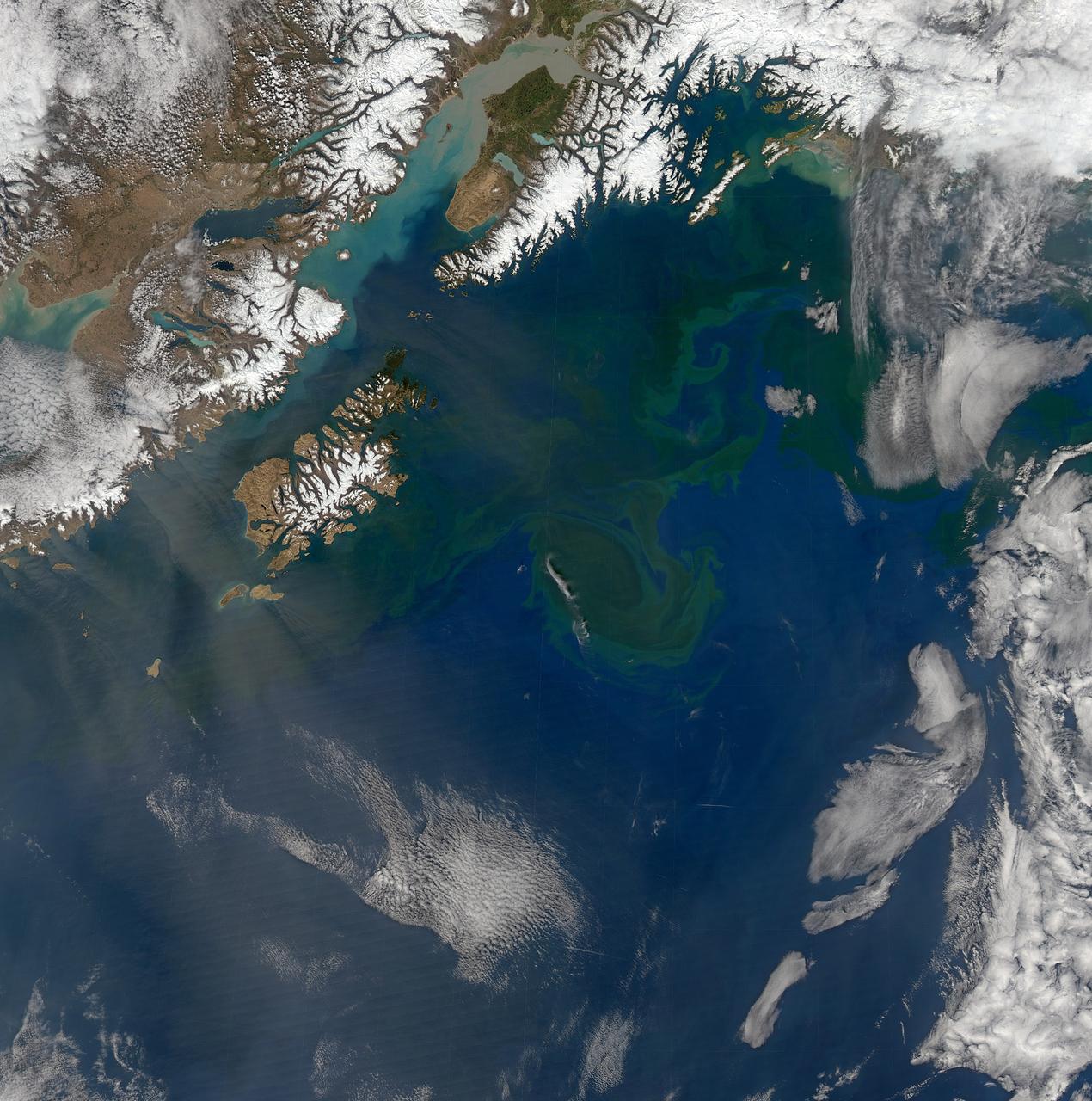
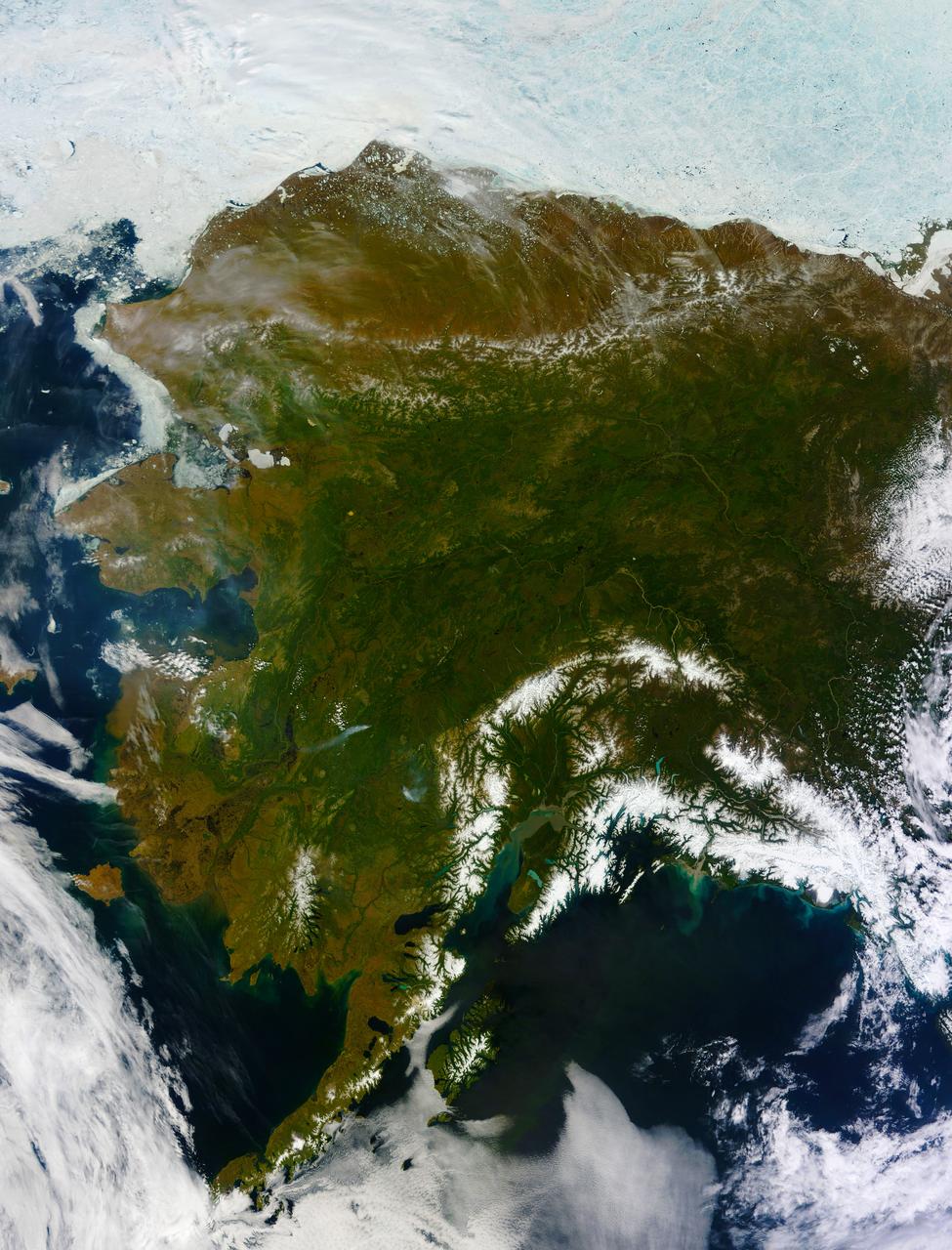
Increasing solar illumination brings increased phytoplankton growth to the Gulf of Alaska every spring, and this year is no exception. This image was collected on May 9, 2014 during a single orbit of Aqua-MODIS. High res: <a href="http://oceancolor.gsfc.nasa.gov/FEATURE/IMAGES/A2014129224500.GulfOfAlaska.half.jpg" rel="nofollow">oceancolor.gsfc.nasa.gov/FEATURE/IMAGES/A2014129224500.Gu...</a> Credit: NASA/Goddard/OceanColor/MODIS <b><a href="http://www.nasa.gov/audience/formedia/features/MP_Photo_Guidelines.html" rel="nofollow">NASA image use policy.</a></b> <b><a href="http://www.nasa.gov/centers/goddard/home/index.html" rel="nofollow">NASA Goddard Space Flight Center</a></b> enables NASA’s mission through four scientific endeavors: Earth Science, Heliophysics, Solar System Exploration, and Astrophysics. Goddard plays a leading role in NASA’s accomplishments by contributing compelling scientific knowledge to advance the Agency’s mission. <b>Follow us on <a href="http://twitter.com/NASAGoddardPix" rel="nofollow">Twitter</a></b> <b>Like us on <a href="http://www.facebook.com/pages/Greenbelt-MD/NASA-Goddard/395013845897?ref=tsd" rel="nofollow">Facebook</a></b> <b>Find us on <a href="http://instagram.com/nasagoddard?vm=grid" rel="nofollow">Instagram</a></b>
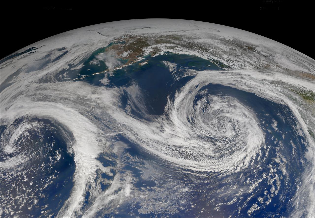
Increasing solar illumination brings increased phytoplankton growth to the Gulf of Alaska every spring, and this year is no exception. The above image was collected on May 2, 2014 several orbits of Aqua-MODIS. High res: <a href="http://oceancolor.gsfc.nasa.gov/FEATURE/IMAGES/A2014122.GulfOfAlaska.half.jpg" rel="nofollow">oceancolor.gsfc.nasa.gov/FEATURE/IMAGES/A2014122.GulfOfAl...</a> Credit: NASA/Goddard/OceanColor/MODIS <b><a href="http://www.nasa.gov/audience/formedia/features/MP_Photo_Guidelines.html" rel="nofollow">NASA image use policy.</a></b> <b><a href="http://www.nasa.gov/centers/goddard/home/index.html" rel="nofollow">NASA Goddard Space Flight Center</a></b> enables NASA’s mission through four scientific endeavors: Earth Science, Heliophysics, Solar System Exploration, and Astrophysics. Goddard plays a leading role in NASA’s accomplishments by contributing compelling scientific knowledge to advance the Agency’s mission. <b>Follow us on <a href="http://twitter.com/NASAGoddardPix" rel="nofollow">Twitter</a></b> <b>Like us on <a href="http://www.facebook.com/pages/Greenbelt-MD/NASA-Goddard/395013845897?ref=tsd" rel="nofollow">Facebook</a></b> <b>Find us on <a href="http://instagram.com/nasagoddard?vm=grid" rel="nofollow">Instagram</a></b>
Dust storm in Alaska captured by Aqua/MODIS on Nov. 17, 2013 at 21:45 UTC. When glaciers grind against underlying bedrock, they produce a silty powder with grains finer than sand. Geologists call it “glacial flour” or “rock flour.” This iron- and feldspar-rich substance often finds its ways into rivers and lakes, coloring the water brown, grey, or aqua. When river or lake levels are low, the flour accumulates on drying riverbanks and deltas, leaving raw material for winds to lift into the air and create plumes of dust. Scientists are monitoring Arctic dust for a number of reasons. Dust storms can reduce visibility enough to disrupt air travel, and they can pose health hazards to people on the ground. Dust is also a key source of iron for phytoplankton in regional waters. Finally, there is the possibility that dust events are becoming more frequent and severe due to ongoing recession of glaciers in coastal Alaska. To read more about dust storm in this region go to: <a href="http://earthobservatory.nasa.gov/IOTD/view.php?id=79518" rel="nofollow">earthobservatory.nasa.gov/IOTD/view.php?id=79518</a> Credit: NASA/GSFC/Jeff Schmaltz/MODIS Land Rapid Response Team <b><a href="http://www.nasa.gov/audience/formedia/features/MP_Photo_Guidelines.html" rel="nofollow">NASA image use policy.</a></b> <b><a href="http://www.nasa.gov/centers/goddard/home/index.html" rel="nofollow">NASA Goddard Space Flight Center</a></b> enables NASA’s mission through four scientific endeavors: Earth Science, Heliophysics, Solar System Exploration, and Astrophysics. Goddard plays a leading role in NASA’s accomplishments by contributing compelling scientific knowledge to advance the Agency’s mission. <b>Follow us on <a href="http://twitter.com/NASA_GoddardPix" rel="nofollow">Twitter</a></b> <b>Like us on <a href="http://www.facebook.com/pages/Greenbelt-MD/NASA-Goddard/395013845897?ref=tsd" rel="nofollow">Facebook</a></b> <b>Find us on <a href="http://instagram.com/nasagoddard?vm=grid" rel="nofollow">Instagram</a></b>
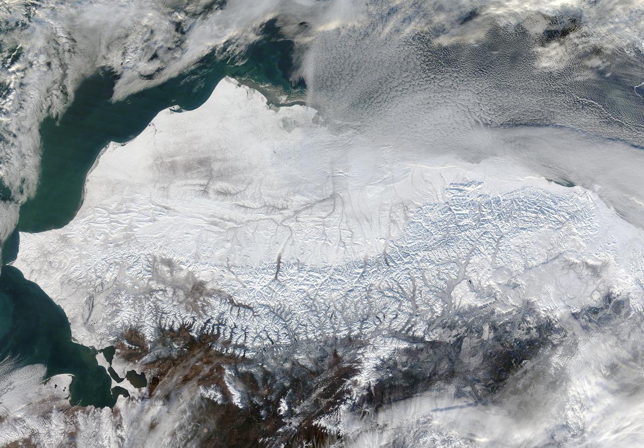
As autumn colors moved across much of the lower forty-eight states in mid-October 2015, winter weather had already arrived in Alaska. The Moderate Resolution Imaging Spectroradiometer (MODIS) aboard NASA’s Terra satellite captured this true-color image of the icy scene on October 16 as it passed over the region. Point Barrow, the northern-most location in the United States sits between the Chukchi Sea (west) and the Beaufort Sea on the east. The rugged peaks of the Brooks Range can be seen along the southern section of the image. North of the Brooks Range the land is almost entirely covered with snow; to the south the tan and browns visible between snow marks uncovered land. Sea ice lies over the waters near the coasts of much of Alaska’s North Slope, especially east of Point Barrow. White cloud banks are notable in the northeast and southeast sections of the image. Credit: NASA/GSFC/Jeff Schmaltz/MODIS Land Rapid Response Team <b><a href="http://www.nasa.gov/audience/formedia/features/MP_Photo_Guidelines.html" rel="nofollow">NASA image use policy.</a></b> <b><a href="http://www.nasa.gov/centers/goddard/home/index.html" rel="nofollow">NASA Goddard Space Flight Center</a></b> enables NASA’s mission through four scientific endeavors: Earth Science, Heliophysics, Solar System Exploration, and Astrophysics. Goddard plays a leading role in NASA’s accomplishments by contributing compelling scientific knowledge to advance the Agency’s mission. <b>Follow us on <a href="http://twitter.com/NASAGoddardPix" rel="nofollow">Twitter</a></b> <b>Like us on <a href="http://www.facebook.com/pages/Greenbelt-MD/NASA-Goddard/395013845897?ref=tsd" rel="nofollow">Facebook</a></b> <b>Find us on <a href="http://instagrid.me/nasagoddard/?vm=grid" rel="nofollow">Instagram</a></b>
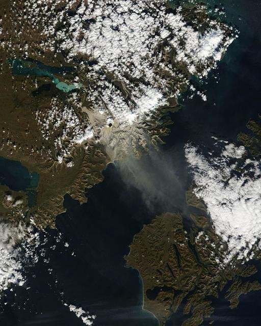
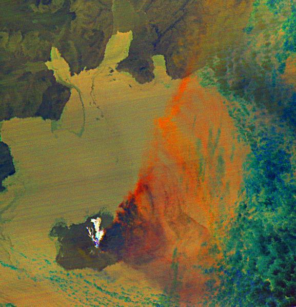
Fires have raged throughout Alaska in 2015. The Moderate Resolution Imaging Spectroradiometer (MODIS) on NASA’s Aqua satellite acquired this image on July 14, 2015. Actively burning areas, detected by the thermal bands on MODIS, are outlined in red. According to the most recent update (July 16, 2015) from the Alaska Interagency Coordination Center, about 304 fires were actively burning when MODIS imaged the area. To date, fires have charred a total of 4,854,924 acres in Alaska. The worst fire season in Alaska's history was in 2004. At this point in time, 2015 is a month ahead of the totals in 2004 putting it on track surpass the fire totals in 2004. The amount of acreage burned in Alaska during June 2015 shattered the previous acreage record set in June 2004 by more than 700,000 acres delivering a sobering piece of news for Alaskan residents. Credit: NASA/GSFC/Jeff Schmaltz/MODIS Land Rapid Response Team <b><a href="http://www.nasa.gov/audience/formedia/features/MP_Photo_Guidelines.html" rel="nofollow">NASA image use policy.</a></b> <b><a href="http://www.nasa.gov/centers/goddard/home/index.html" rel="nofollow">NASA Goddard Space Flight Center</a></b> enables NASA’s mission through four scientific endeavors: Earth Science, Heliophysics, Solar System Exploration, and Astrophysics. Goddard plays a leading role in NASA’s accomplishments by contributing compelling scientific knowledge to advance the Agency’s mission. <b>Follow us on <a href="http://twitter.com/NASAGoddardPix" rel="nofollow">Twitter</a></b> <b>Like us on <a href="http://www.facebook.com/pages/Greenbelt-MD/NASA-Goddard/395013845897?ref=tsd" rel="nofollow">Facebook</a></b> <b>Find us on <a href="http://instagrid.me/nasagoddard/?vm=grid" rel="nofollow">Instagram</a></b>
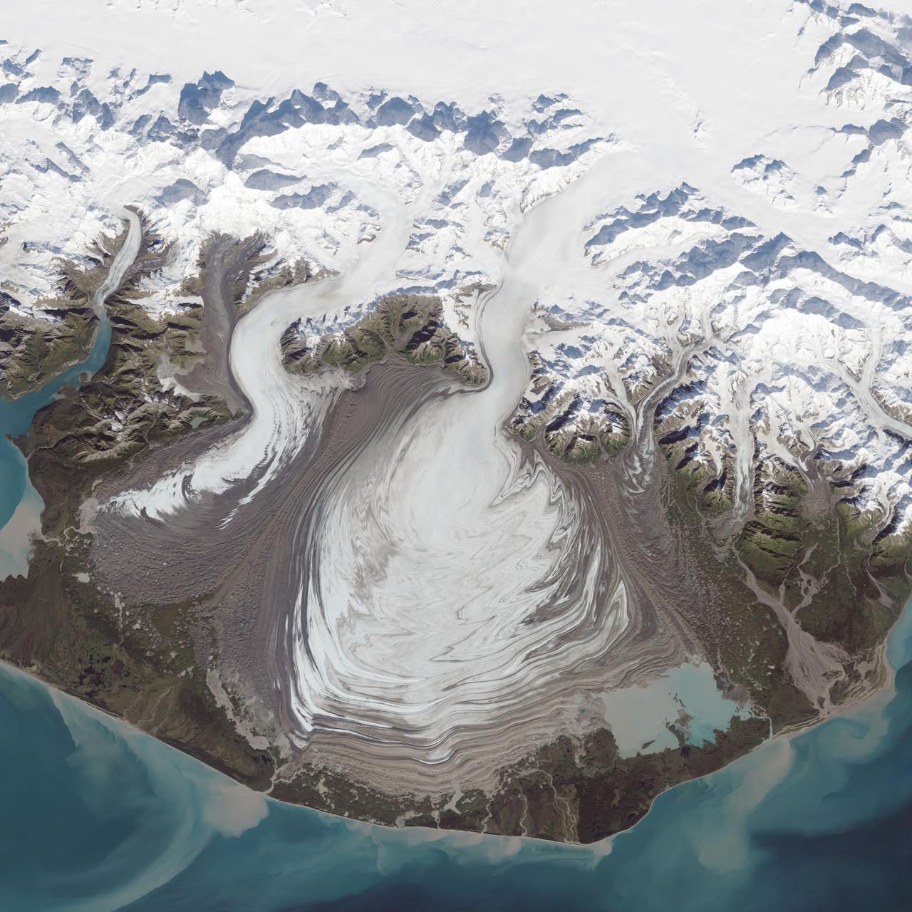
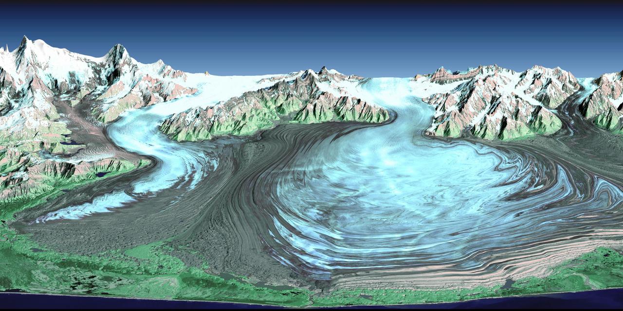
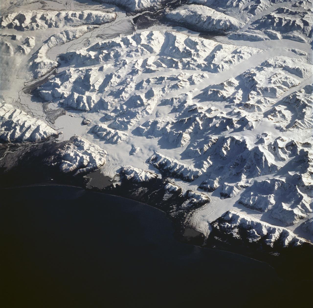
The ice of a piedmont glacier spills from a steep valley onto a relatively flat plain, where it spreads out unconstrained like pancake batter. Elephant Foot Glacier in northeastern Greenland is an excellent example; it is particularly noted for its symmetry. But the largest piedmont glacier in North America (and possibly the world) is Malaspina in southeastern Alaska. On September 24, 2014, the Operational Land Imager (OLI) on Landsat 8 acquired this image of Malaspina Glacier. The main source of ice comes from Seward Glacier, located at the top-center of this image. The Agassiz and Libbey glaciers are visible on the left side, and the Hayden and Marvine glaciers are on the right. The brown lines on the ice are moraines—areas where soil, rock, and other debris have been scraped up by the glacier and deposited at its sides. Where two glaciers flow together, the moraines merge to form a medial moraine. Glaciers that flow at a steady speed tend to have moraines that are relatively straight. But what causes the dizzying pattern of curves, zigzags, and loops of Malaspina’s moraines? Glaciers in this area of Alaska periodically “surge,”meaning they lurch forward quickly for one to several years. As a result of this irregular flow, the moraines at the edges and between glaciers can become folded, compressed, and sheared to form the characteristic loops seen on Malaspina. For instance, a surge in 1986 displaced moraines on the east side of Malaspina by as much as 5 kilometers (3 miles). NASA Earth Observatory image by Jesse Allen, using Landsat data from the U.S. Geological Survey. Caption by Kathryn Hansen. Credit: <b><a href="http://www.earthobservatory.nasa.gov/" rel="nofollow"> NASA Earth Observatory</a></b> <b><a href="http://www.nasa.gov/audience/formedia/features/MP_Photo_Guidelines.html" rel="nofollow">NASA image use policy.</a></b> <b><a href="http://www.nasa.gov/centers/goddard/home/index.html" rel="nofollow">NASA Goddard Space Flight Center</a></b> enables NASA’s mission through four scientific endeavors: Earth Science, Heliophysics, Solar System Exploration, and Astrophysics. Goddard plays a leading role in NASA’s accomplishments by contributing compelling scientific knowledge to advance the Agency’s mission. <b>Follow us on <a href="http://twitter.com/NASAGoddardPix" rel="nofollow">Twitter</a></b> <b>Like us on <a href="http://www.facebook.com/pages/Greenbelt-MD/NASA-Goddard/395013845897?ref=tsd" rel="nofollow">Facebook</a></b> <b>Find us on <a href="http://instagrid.me/nasagoddard/?vm=grid" rel="nofollow">Instagram</a></b>
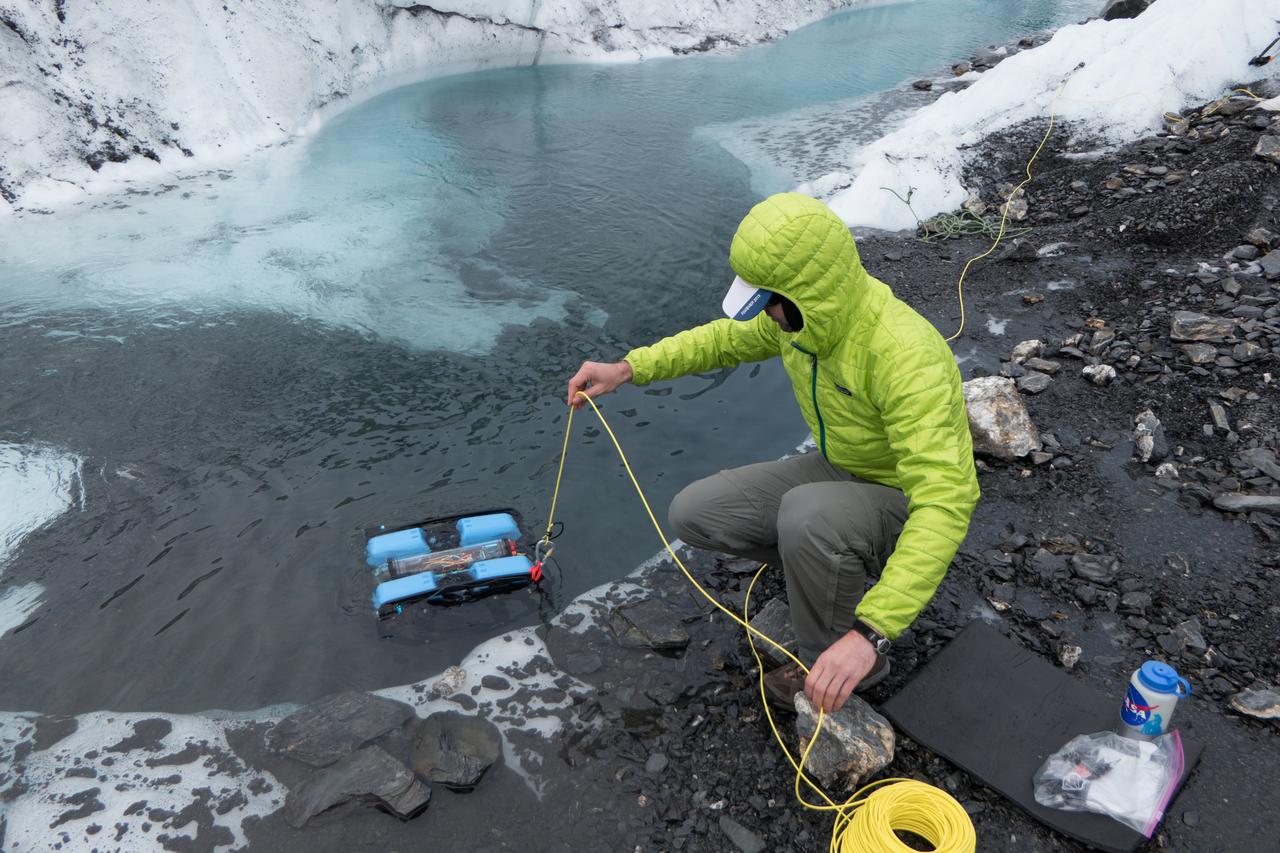
JPL engineer Andy Klesh lowers a robotic submersible into a moulin. Klesh and JPL's John Leichty used robots and probes to explore the Matanuska Glacier in Alaska this past July. Image Credit: NASA/JPL-Caltech

The city of Nome lies on the southern Seward Peninsula coast of Alaska, on the Bering Sea, as shown in this image from NASA Terra spacecraft.

On February 4, 2014 the Moderate Resolution Imaging Spectroradiometer (MODIS) flying aboard NASA’s Aqua satellite captured a true-color image of sea ice off of western Alaska. In this true-color image, the snow and ice covered land appears bright white while the floating sea ice appears a duller grayish-white. Snow over the land is drier, and reflects more light back to the instrument, accounting for the very bright color. Ice overlying oceans contains more water, and increasing water decreases reflectivity of ice, resulting in duller colors. Thinner ice is also duller. The ocean waters are tinted with green, likely due to a combination of sediment and phytoplankton. Alaska lies to the east in this image, and Russia to the west. The Bering Strait, covered with ice, lies between to two. South of the Bering Strait, the waters are known as the Bering Sea. To the north lies the Chukchi Sea. The bright white island south of the Bering Strait is St. Lawrence Island. Home to just over 1200 people, the windswept island belongs to the United States, but sits closer to Russia than to Alaska. To the southeast of the island a dark area, loosely covered with floating sea ice, marks a persistent polynya – an area of open water surrounded by more frozen sea ice. Due to the prevailing winds, which blow the sea ice away from the coast in this location, the area rarely completely freezes. The ice-covered areas in this image, as well as the Beaufort Sea, to the north, are critical areas for the survival of the ringed seal, a threatened species. The seals use the sea ice, including ice caves, to rear their young, and use the free-floating sea ice for molting, raising the young and breeding. In December 2014, the National Oceanic and Atmospheric Administration (NOAA) proposed that much of this region be set aside as critical, protected habitat for the ringed seal. Credit: NASA/GSFC/Jeff Schmaltz/MODIS Land Rapid Response Team <b><a href="http://www.nasa.gov/audience/formedia/features/MP_Photo_Guidelines.html" rel="nofollow">NASA image use policy.</a></b> <b><a href="http://www.nasa.gov/centers/goddard/home/index.html" rel="nofollow">NASA Goddard Space Flight Center</a></b> enables NASA’s mission through four scientific endeavors: Earth Science, Heliophysics, Solar System Exploration, and Astrophysics. Goddard plays a leading role in NASA’s accomplishments by contributing compelling scientific knowledge to advance the Agency’s mission. <b>Follow us on <a href="http://twitter.com/NASAGoddardPix" rel="nofollow">Twitter</a></b> <b>Like us on <a href="http://www.facebook.com/pages/Greenbelt-MD/NASA-Goddard/395013845897?ref=tsd" rel="nofollow">Facebook</a></b> <b>Find us on <a href="http://instagram.com/nasagoddard?vm=grid" rel="nofollow">Instagram</a></b>
Takawangha is a 1450 m stratovolcano on Tanaga Island, Alaska. On November 18, the Alaska Volcano Observatory raised the Volcano Alert Level to Advisory based on increased seismicity. The image was acquired September 13, 2021, covers an area of 40.8 by 44.9 km, and is located at 51.9N, 178W. https://photojournal.jpl.nasa.gov/catalog/PIA25560

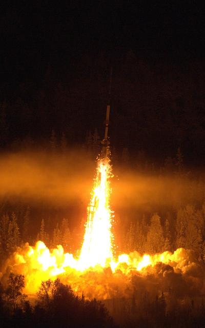
Caption: Composite shot of all four rockets for the M-TeX and MIST experiments is made up of 30 second exposures. The rocket salvo began at 4:13 a.m. EST, Jan. 26, 2015, from the Poker Flat Research Range, Alaska. Credit: NASA/Jamie Adkins More info: The Mesosphere-Lower Thermosphere Turbulence Experiment, or M-TeX, and the Mesospheric Inversion-layer Stratified Turbulence, or MIST, experiment were successfully conducted the morning of Jan. 26, 2015, from the Poker Flat Research Range, Alaska. The first M-Tex rocket, a NASA Terrier-Improved Malemute sounding rocket, was launched at 4:13 a.m. EST and was followed one-minute later by the first MIST experiment payload on a NASA Terrier-Improved Orion. The second M-TeX payload was launched at 4:46 a.m. EST and also was followed one minute later by the second MIST payload. Preliminary data show that all four payloads worked as planned and the trimethyl aluminum, or TMA, vapor trails were seen at the various land-based observation sites in Alaska. A fifth rocket carrying the Auroral Spatial Structures Probe remains ready on the launch pad. The launch window for this experiment runs through Jan. 27. <b><a href="http://www.nasa.gov/audience/formedia/features/MP_Photo_Guidelines.html" rel="nofollow">NASA image use policy.</a></b> <b><a href="http://www.nasa.gov/centers/goddard/home/index.html" rel="nofollow">NASA Goddard Space Flight Center</a></b> enables NASA’s mission through four scientific endeavors: Earth Science, Heliophysics, Solar System Exploration, and Astrophysics. Goddard plays a leading role in NASA’s accomplishments by contributing compelling scientific knowledge to advance the Agency’s mission. <b>Follow us on <a href="http://twitter.com/NASAGoddardPix" rel="nofollow">Twitter</a></b> <b>Like us on <a href="http://www.facebook.com/pages/Greenbelt-MD/NASA-Goddard/395013845897?ref=tsd" rel="nofollow">Facebook</a></b> <b>Find us on <a href="http://instagram.com/nasagoddard?vm=grid" rel="nofollow">Instagram</a></b>
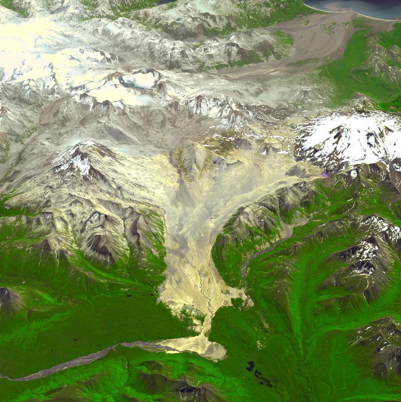
NASA image acquired August 27, 2009 Like rivers of liquid water, glaciers flow downhill, with tributaries joining to form larger rivers. But where water rushes, ice crawls. As a result, glaciers gather dust and dirt, and bear long-lasting evidence of past movements. Alaska’s Susitna Glacier revealed some of its long, grinding journey when the Advanced Spaceborne Thermal Emission and Reflection Radiometer (ASTER) on NASA’s Terra satellite passed overhead on August 27, 2009. This satellite image combines infrared, red, and green wavelengths to form a false-color image. Vegetation is red and the glacier’s surface is marbled with dirt-free blue ice and dirt-coated brown ice. Infusions of relatively clean ice push in from tributaries in the north. The glacier surface appears especially complex near the center of the image, where a tributary has pushed the ice in the main glacier slightly southward. A photograph taken by researchers from the U.S. Geological Survey (archived by the National Snow and Ice Data Center) shows an equally complicated Susitna Glacier in 1970, with dirt-free and dirt-encrusted surfaces forming stripes, curves, and U-turns. Susitna flows over a seismically active area. In fact, a 7.9-magnitude quake struck the region in November 2002, along a previously unknown fault. Geologists surmised that earthquakes had created the steep cliffs and slopes in the glacier surface, but in fact most of the jumble is the result of surges in tributary glaciers. Glacier surges—typically short-lived events where a glacier moves many times its normal rate—can occur when melt water accumulates at the base and lubricates the flow. This water may be supplied by meltwater lakes that accumulate on top of the glacier; some are visible in the lower left corner of this image. The underlying bedrock can also contribute to glacier surges, with soft, easily deformed rock leading to more frequent surges. NASA Earth Observatory image created by Jesse Allen and Robert Simmon, using data provided courtesy of NASA/GSFC/METI/ERSDAC/JAROS, and U.S./Japan ASTER Science Team. Caption by Michon Scott. Instrument: Terra - ASTER Credit: <b><a href="http://www.earthobservatory.nasa.gov/" rel="nofollow"> NASA Earth Observatory</a></b> <b><a href="http://www.nasa.gov/centers/goddard/home/index.html" rel="nofollow">NASA Goddard Space Flight Center</a></b> enables NASA’s mission through four scientific endeavors: Earth Science, Heliophysics, Solar System Exploration, and Astrophysics. Goddard plays a leading role in NASA’s accomplishments by contributing compelling scientific knowledge to advance the Agency’s mission. <b>Follow us on <a href="http://twitter.com/NASA_GoddardPix" rel="nofollow">Twitter</a></b> <b>Join us on <a href="http://www.facebook.com/pages/Greenbelt-MD/NASA-Goddard/395013845897?ref=tsd" rel="nofollow">Facebook</a></b>
This image from NASA Terra spacecraft shows St. Matthew Island, a remote island in the Bering Sea in Alaska.
A NASA Oriole IV sounding rocket with the Aural Spatial Structures Probe leaves the launch pad on Jan. 28, 2015, from the Poker Flat Research Range in Alaska. Credit: NASA/Lee Wingfield More info: On count day number 15, the Aural Spatial Structures Probe, or ASSP, was successfully launched on a NASA Oriole IV sounding rocket at 5:41 a.m. EST on Jan. 28, 2015, from the Poker Flat Research Range in Alaska. Preliminary data show that all aspects of the payload worked as designed and the principal investigator Charles Swenson at Utah State University described the mission as a “raging success.” “This is likely the most complicated mission the sounding rocket program has ever undertaken and it was not easy by any stretch," said John Hickman, operations manager of the NASA sounding rocket program office at the Wallops Flight Facility, Virginia. "It was technically challenging every step of the way.” “The payload deployed all six sub-payloads in formation as planned and all appeared to function as planned. Quite an amazing feat to maneuver and align the main payload, maintain the proper attitude while deploying all six 7.3-pound sub payloads at about 40 meters per second," said Hickman. Read more: <a href="http://www.nasa.gov/content/assp-sounding-rocket-launches-successfully-from-alaska/#.VMkOnEhpEhJ" rel="nofollow">www.nasa.gov/content/assp-sounding-rocket-launches-succes...</a> <b><a href="http://www.nasa.gov/audience/formedia/features/MP_Photo_Guidelines.html" rel="nofollow">NASA image use policy.</a></b> <b><a href="http://www.nasa.gov/centers/goddard/home/index.html" rel="nofollow">NASA Goddard Space Flight Center</a></b> enables NASA’s mission through four scientific endeavors: Earth Science, Heliophysics, Solar System Exploration, and Astrophysics. Goddard plays a leading role in NASA’s accomplishments by contributing compelling scientific knowledge to advance the Agency’s mission. <b>Follow us on <a href="http://twitter.com/NASAGoddardPix" rel="nofollow">Twitter</a></b> <b>Like us on <a href="http://www.facebook.com/pages/Greenbelt-MD/NASA-Goddard/395013845897?ref=tsd" rel="nofollow">Facebook</a></b> <b>Find us on <a href="http://instagram.com/nasagoddard?vm=grid" rel="nofollow">Instagram</a></b>
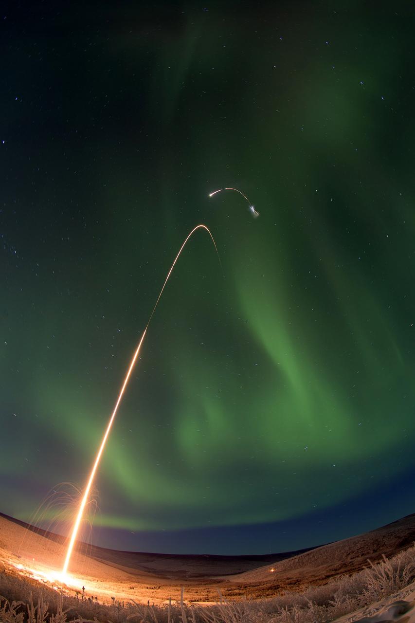
Caption: Time lapse photo of the NASA Oriole IV sounding rocket with Aural Spatial Structures Probe as an aurora dances over Alaska. All four stages of the rocket are visible in this image. Credit: NASA/Jamie Adkins More info: On count day number 15, the Aural Spatial Structures Probe, or ASSP, was successfully launched on a NASA Oriole IV sounding rocket at 5:41 a.m. EST on Jan. 28, 2015, from the Poker Flat Research Range in Alaska. Preliminary data show that all aspects of the payload worked as designed and the principal investigator Charles Swenson at Utah State University described the mission as a “raging success.” “This is likely the most complicated mission the sounding rocket program has ever undertaken and it was not easy by any stretch," said John Hickman, operations manager of the NASA sounding rocket program office at the Wallops Flight Facility, Virginia. "It was technically challenging every step of the way.” “The payload deployed all six sub-payloads in formation as planned and all appeared to function as planned. Quite an amazing feat to maneuver and align the main payload, maintain the proper attitude while deploying all six 7.3-pound sub payloads at about 40 meters per second," said Hickman. Read more: <a href="http://www.nasa.gov/content/assp-sounding-rocket-launches-successfully-from-alaska/#.VMkOnEhpEhJ" rel="nofollow">www.nasa.gov/content/assp-sounding-rocket-launches-succes...</a> <b><a href="http://www.nasa.gov/audience/formedia/features/MP_Photo_Guidelines.html" rel="nofollow">NASA image use policy.</a></b> <b><a href="http://www.nasa.gov/centers/goddard/home/index.html" rel="nofollow">NASA Goddard Space Flight Center</a></b> enables NASA’s mission through four scientific endeavors: Earth Science, Heliophysics, Solar System Exploration, and Astrophysics. Goddard plays a leading role in NASA’s accomplishments by contributing compelling scientific knowledge to advance the Agency’s mission. <b>Follow us on <a href="http://twitter.com/NASAGoddardPix" rel="nofollow">Twitter</a></b> <b>Like us on <a href="http://www.facebook.com/pages/Greenbelt-MD/NASA-Goddard/395013845897?ref=tsd" rel="nofollow">Facebook</a></b> <b>Find us on <a href="http://instagram.com/nasagoddard?vm=grid" rel="nofollow">Instagram</a></b>
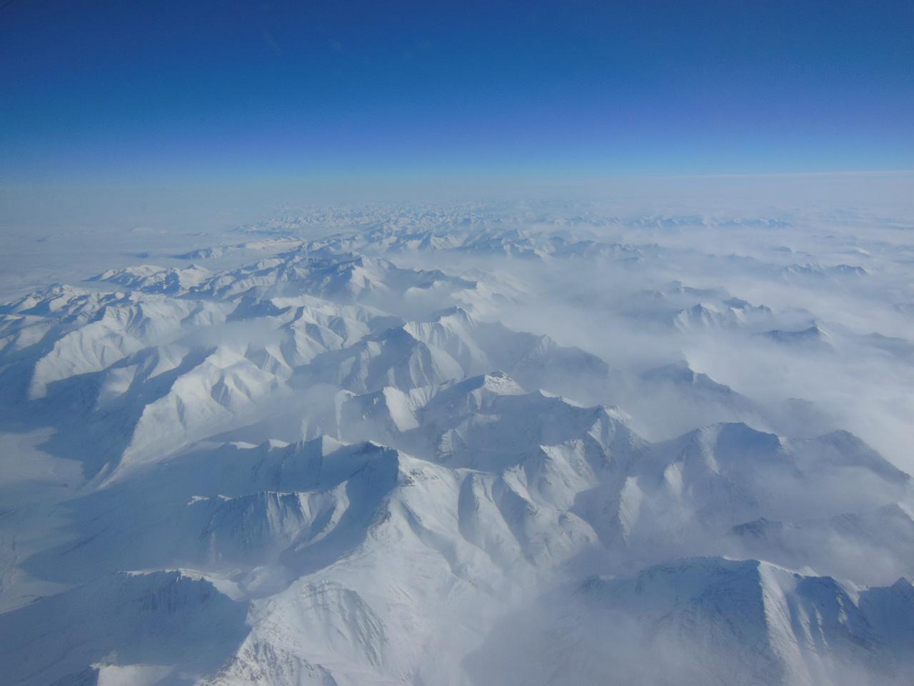
Alaskan mountains seen from high altitude aboard the NASA P-3B during the IceBridge transit flight from Thule to Fairbanks on Mar. 21, 2013. NASA's Operation IceBridge is an airborne science mission to study Earth's polar ice. For more information about IceBridge, visit: <a href="http://www.nasa.gov/icebridge" rel="nofollow">www.nasa.gov/icebridge</a> Credit: NASA/Goddard/Christy Hansen <b><a href="http://www.nasa.gov/audience/formedia/features/MP_Photo_Guidelines.html" rel="nofollow">NASA image use policy.</a></b> <b><a href="http://www.nasa.gov/centers/goddard/home/index.html" rel="nofollow">NASA Goddard Space Flight Center</a></b> enables NASA’s mission through four scientific endeavors: Earth Science, Heliophysics, Solar System Exploration, and Astrophysics. Goddard plays a leading role in NASA’s accomplishments by contributing compelling scientific knowledge to advance the Agency’s mission. <b>Follow us on <a href="http://twitter.com/NASA_GoddardPix" rel="nofollow">Twitter</a></b> <b>Like us on <a href="http://www.facebook.com/pages/Greenbelt-MD/NASA-Goddard/395013845897?ref=tsd" rel="nofollow">Facebook</a></b> <b>Find us on <a href="http://instagram.com/nasagoddard?vm=grid" rel="nofollow">Instagram</a></b>
As part of the Arctic Boreal Vulnerability Experiment (ABoVE), NASA scientists are flying over Alaska and Canada, measuring the elevation of rivers and lakes to study how thawing permafrost affects hydrology in the landscape. This view of was taken from NASA’s DC-8 “flying laboratory” as part of the Active Sensing of CO2 Emissions over Nights, Days and Seasons (ASCENDS) experiment. Scientists on NASA’s Air Surface, Water and Ocean Topography (AirSWOT) mission have been flying over the same location, investigating how water levels in the Arctic landscape change as permafrost thaws. Under typical conditions, the frozen layer of soil keeps water from sinking into the ground and percolating away. As permafrost thaws, the water has new ways to move between rivers and lakes, which can raise or lower the elevation of the bodies of water. These changes in water levels will have effects on Arctic life— plants, animals, and humans—in the near future. Credit: NASA/Peter Griffith <b><a href="http://www.nasa.gov/audience/formedia/features/MP_Photo_Guidelines.html" rel="nofollow">NASA image use policy.</a></b> <b><a href="http://www.nasa.gov/centers/goddard/home/index.html" rel="nofollow">NASA Goddard Space Flight Center</a></b> enables NASA’s mission through four scientific endeavors: Earth Science, Heliophysics, Solar System Exploration, and Astrophysics. Goddard plays a leading role in NASA’s accomplishments by contributing compelling scientific knowledge to advance the Agency’s mission. <b>Follow us on <a href="http://twitter.com/NASAGoddardPix" rel="nofollow">Twitter</a></b> <b>Like us on <a href="http://www.facebook.com/pages/Greenbelt-MD/NASA-Goddard/395013845897?ref=tsd" rel="nofollow">Facebook</a></b> <b>Find us on <a href="http://instagrid.me/nasagoddard/?vm=grid" rel="nofollow">Instagram</a></b>
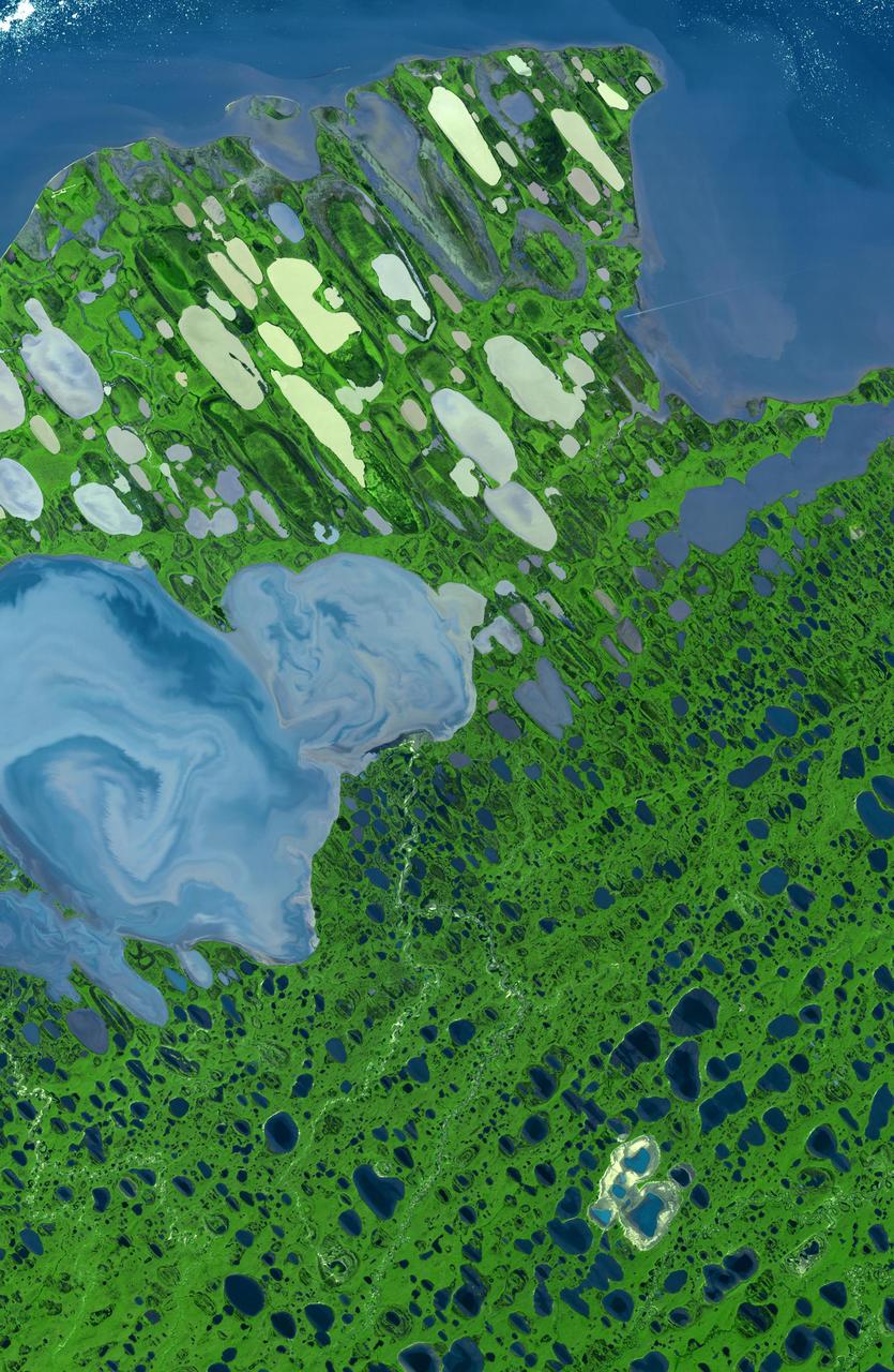
This image of Teshekpuk Lake on Alaska North Slope, within the National Petroleum Reserve, was acquired on August 15, 2000 by NASA Terra spacecraft.
The Valley of Ten Thousand Smokes, located in Katmai National Park, forms a unique and ashen landscape. Encircled by volcanoes – both active and inactive – it has served as a perfect collection area for huge amounts of volcanic ash. According to the Alaska Historical Society (AHS), 2012 marked the centennial anniversary of the volcanic eruption that formed the valley, and led to the establishment, in 1918, of Katmai National Park. A massive eruption rocked the region on June 6, 1912 as the then-unknown volcano, Novarupta, became suddenly and violently active. According to the AHS, it erupted with “such force that mountains collapsed, ash darkened summer skies, earthquakes rocked population centers and were recorded as far away as Washington, D.C.” Glowing hot ash was reported to have smothered an area covering 40 square miles, and up to 700 feet deep. While the active volcanoes surrounding the valley - Novarupta, Mt. Mageik, Trident Volcano, Mt. Griggs, Mt. Martin and Mt. Katmai - have remained relatively quiescent, their ashen legacy continues to affect the landscape – and air traffic - even a century after it was laid down. The Moderate Resolution Imaging Spectroradiometer (MODIS) aboard NASA’s Terra satellite captured this true-color image on September 29, 2014. Volcanic ash from the Katmai region has been lifted aloft by strong winds, and is blowing to the southeast, over Shelikof Strait, Kodiak Island, and the Gulf of Alaska. Although such clouds are not from active volcanoes, the remobilized volcanic ash still provides a potential hazard to aircraft flying through the region. Credit: NASA/GSFC/Jeff Schmaltz/MODIS Land Rapid Response Team <b><a href="http://www.nasa.gov/audience/formedia/features/MP_Photo_Guidelines.html" rel="nofollow">NASA image use policy.</a></b> <b><a href="http://www.nasa.gov/centers/goddard/home/index.html" rel="nofollow">NASA Goddard Space Flight Center</a></b> enables NASA’s mission through four scientific endeavors: Earth Science, Heliophysics, Solar System Exploration, and Astrophysics. Goddard plays a leading role in NASA’s accomplishments by contributing compelling scientific knowledge to advance the Agency’s mission. <b>Follow us on <a href="http://twitter.com/NASAGoddardPix" rel="nofollow">Twitter</a></b> <b>Like us on <a href="http://www.facebook.com/pages/Greenbelt-MD/NASA-Goddard/395013845897?ref=tsd" rel="nofollow">Facebook</a></b> <b>Find us on <a href="http://instagram.com/nasagoddard?vm=grid" rel="nofollow">Instagram</a></b>
Since last spring, the U.S. Geological Survey Alaska Volcano Observatory AVO has detected increasing volcanic unrest at Augustine Volcano in Cook Inlet, Alaska near Anchorage. This image is from NASA Terra spacecraft.
Since last spring, the U.S. Geological Survey Alaska Volcano Observatory AVO has detected increasing volcanic unrest at Augustine Volcano in Cook Inlet, Alaska near Anchorage. This image is from NASA Terra spacecraft.
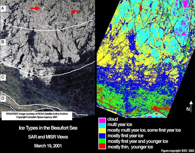
Sea ice in the Beaufort Sea off the north coast of Alaska was classified and mapped in these concurrent images acquired March 19, 2001 by NASA Terra spacecraft.
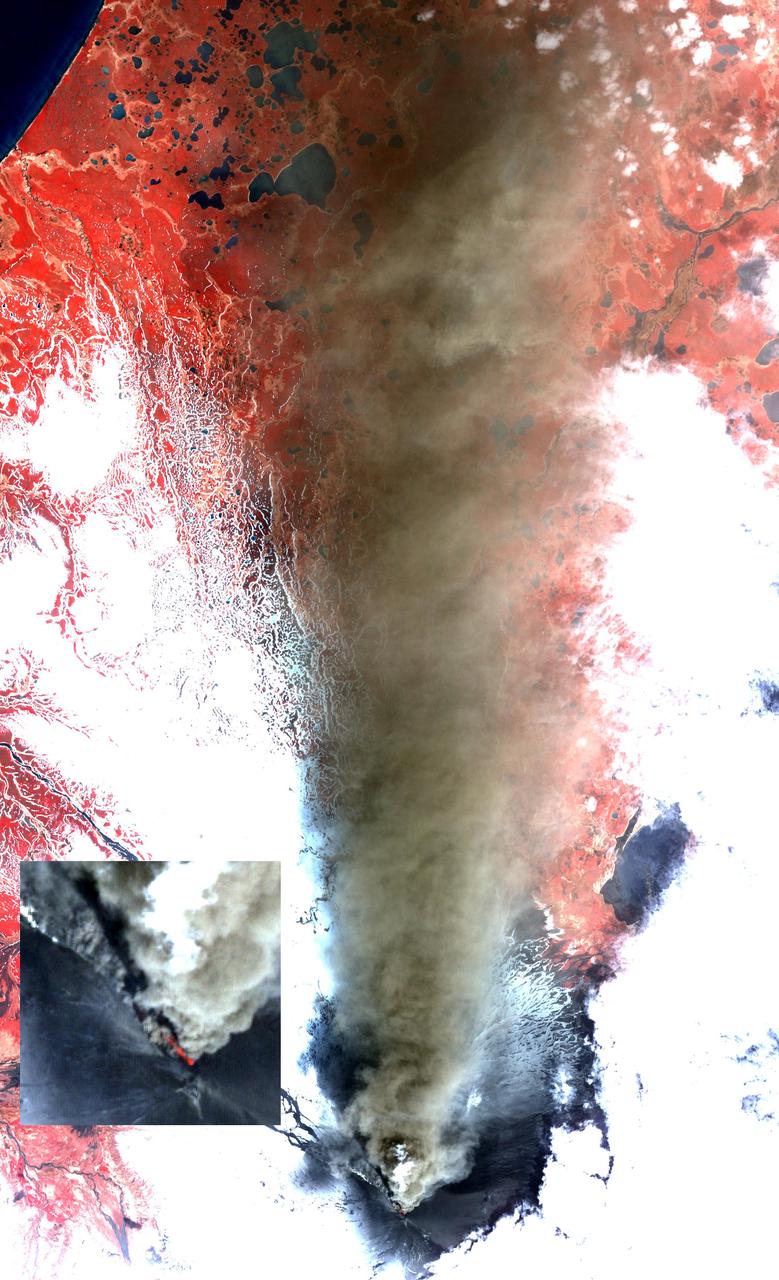
Alaska Pavlof volcano, located along Alaska Aleutian Peninsula, sent a low-level ash plume north-northeast about 37.3 miles 60 kilometers on May 19, 2013, when this image was acquired NASA Terra spacecraft.
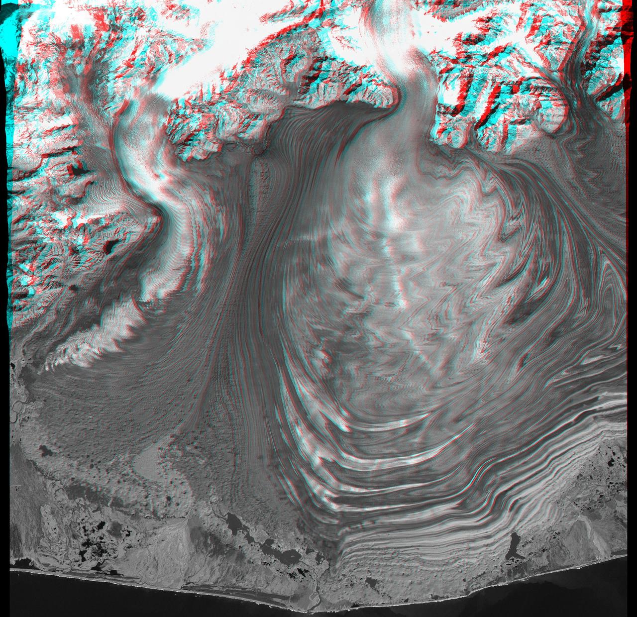
This anaglyph, from NASA Shuttle Radar Topography Mission, is of Malaspina Glacier in southeastern Alaska. 3D glasses are necessary to view this image.
Folds in the lower reaches of valley glaciers can be caused by powerful surges of tributary ice streams. This phenomenon is spectacularly displayed by the Sustina Glacier in the Alaska Range as seen by NASA Terra spacecraft.
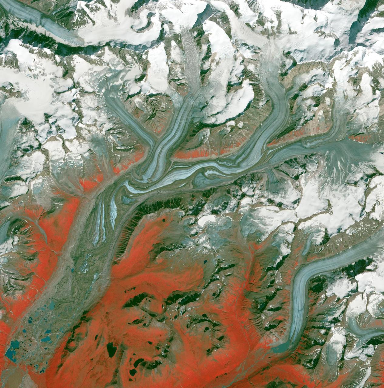
Malaspina Glacier in southeastern Alaska is considered the classic example of a piedmont glacier. Piedmont glaciers occur where valley glaciers exit a mountain range onto broad lowlands, are no longer laterally confined, and spread to become wide lobes.
Point Barrow or Nuvuk, Alaska is the northernmost point of all territory of the United States. It also marks the limit between the Chukchi Sea to the west, and the Beaufort Sea to the east. Archaeological evidence indicates that Point Barrow was occupied about 500 CE, probably as hunting camps for whales. The image covers an area of 32 by 38 km, was acquired July 29, 2015, and is located at 71.6 degrees north, 156.45 degrees west. http://photojournal.jpl.nasa.gov/catalog/PIA19775
Large lightning-induced fires were active in Alaska and the Yukon Territory from mid-June to mid-July, 2004 as seen by NASA Terra spacecraft.
This image acquired by NASA Terra spacecraft is of the Valley of Ten Thousand Smokes. Located in Katmai National Park, Alaska, the park is filled with ash flows from the 1912 eruption of Novarupta.
This image from the Advanced Spaceborne Thermal Emission and Reflection Radiometer (ASTER) instrument on NASA's Terra satellite covers an area of 55 by 40 kilometers (34 by 25 miles) over the southwest part of the Malaspina Glacier and Icy Bay in Alaska. The composite of infrared and visible bands results in the snow and ice appearing light blue, dense vegetation is yellow-orange and green, and less vegetated, gravelly areas are in orange. According to Dr. Dennis Trabant (U.S. Geological Survey, Fairbanks, Alaska), the Malaspina Glacier is thinning. Its terminal moraine protects it from contact with the open ocean; without the moraine, or if sea level rises sufficiently to reconnect the glacier with the ocean, the glacier would start calving and retreat significantly. ASTER data are being used to help monitor the size and movement of some 15,000 tidal and piedmont glaciers in Alaska. Evidence derived from ASTER and many other satellite and ground-based measurements suggests that only a few dozen Alaskan glaciers are advancing. The overwhelming majority of them are retreating. This ASTER image was acquired on June 8, 2001. With its 14 spectral bands from the visible to the thermal infrared wavelength region, and its high spatial resolution of 15 to 90 meters (about 50 to 300 feet), ASTER will image Earth for the next six years to map and monitor the changing surface of our planet. http://photojournal.jpl.nasa.gov/catalog/PIA03475
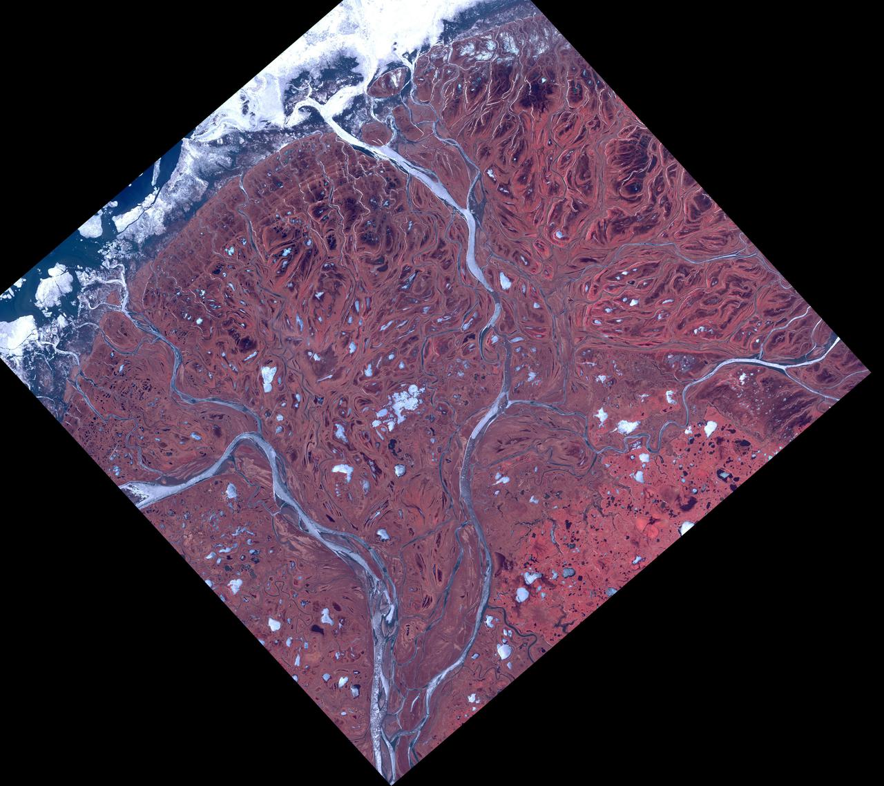
The Yukon River Delta (along with the Kuskokwim River) is one of the largest in the world. Emptying into the Bering Sea on the west coast of Alaska, it is over 130,000 square kilometers in size. The combined delta has about 25,000 Alaska Native residents. The image was acquired May 10, 2017, covers an area of 60 by 60 km, and is located at 62.9 degrees north, 164.3 degrees east. https://photojournal.jpl.nasa.gov/catalog/PIA25124
STS066-117-014 (3-14 Nov. 1994) --- Malaspina Glacier can be seen in this north-northeastern photograph taken in November, 1994. The glacier, located in the south shore of Alaska is a classic example of a piedmont glacier lying along the foot of a mountain range. The principal source of ice for the glacier is provided by the Seward Ice Field to the north (top portion of the view) which flows through three narrow outlets onto the coastal plain. The glacier moves in surges that rush earlier-formed moraines outward into the expanding concentric patterns along the flanks of the ice mass.
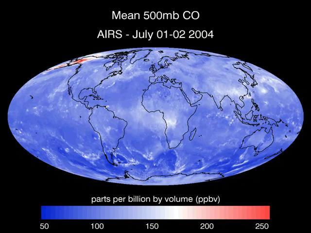
A series of maps of the transport of carbon monoxide generated by Alaska Fires, July 2004, created by data from the Atmospheric Infrared Sounder AIRS on NASA Aqua satellite.
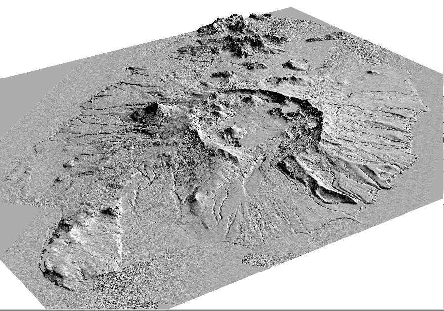
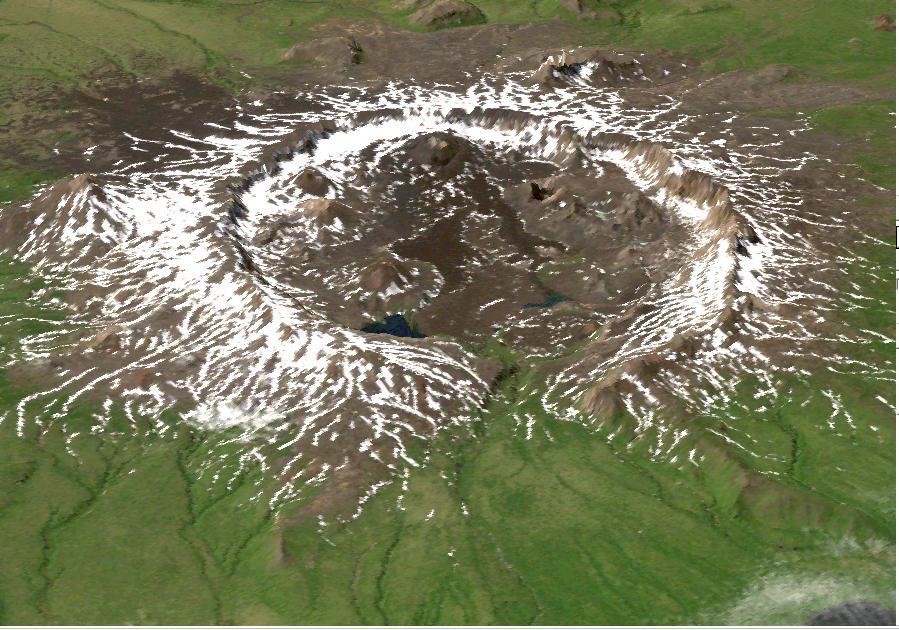
This perspective view shows the caldera of the Okmok volcano in Alaska Aleutian Islands acquired by NASA Airborne Synthetic Aperture Radar AIRSAR in 2001.
This perspective view shows the caldera of the Okmok volcano in Alaska Aleutian Islands acquired by NASA Airborne Synthetic Aperture Radar AIRSAR in 2001.
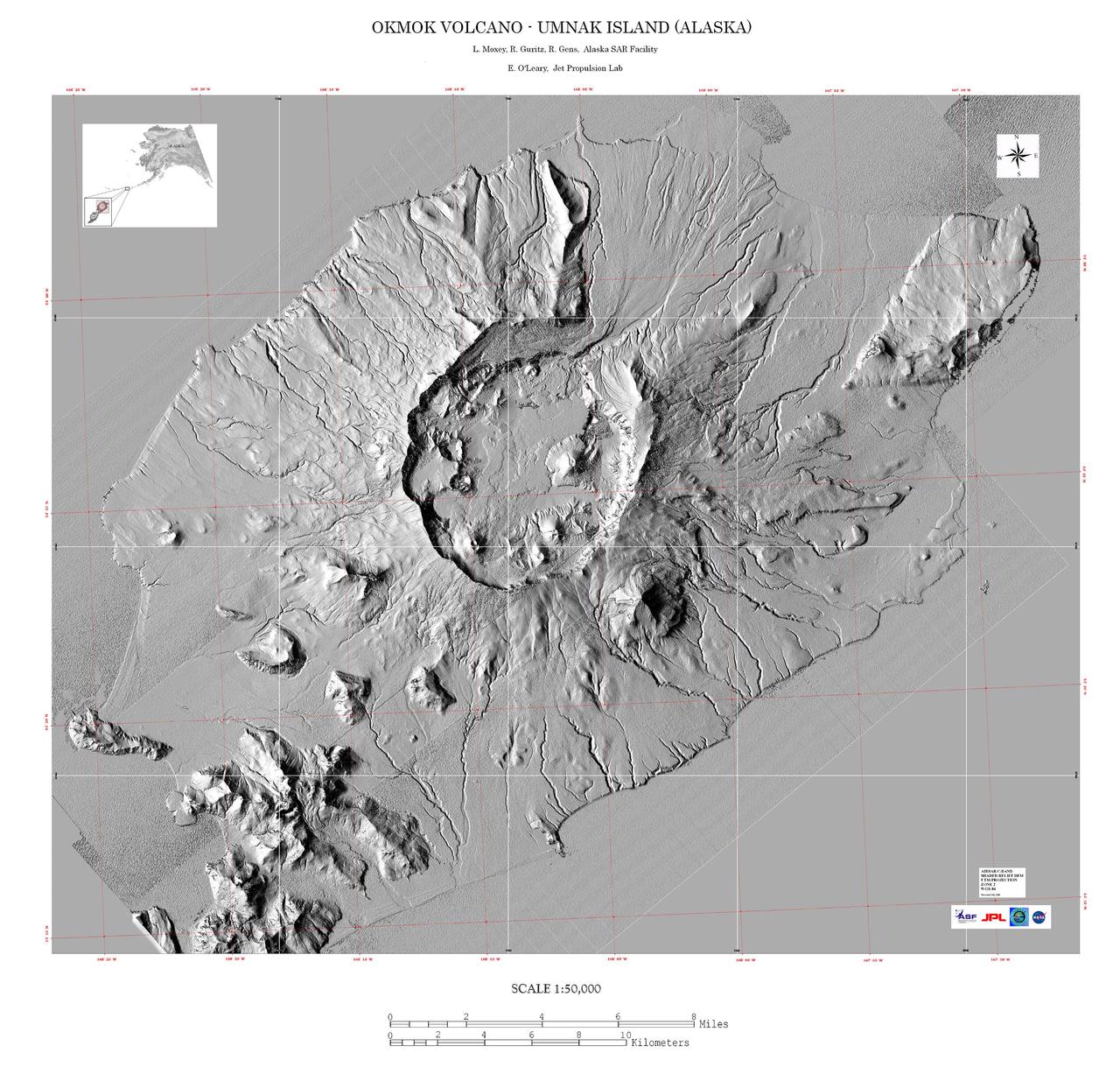
This image is a shaded relief mosaic of Umnak Island in Alaska Aleutian Islands acquired by NASA Airborne Synthetic Aperture Radar AIRSAR in 2001.
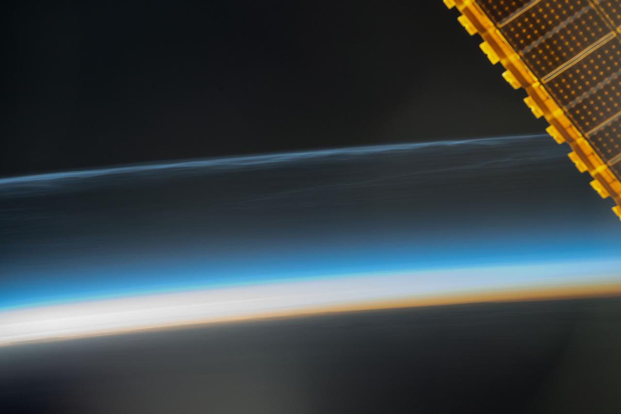
iss071e364425 (July 16, 2024) --- Noctilucent clouds, high-altutude clouds visible during the summer months and illuminated when the sun is below Earth's horizon, are pictured from the International Space Station as it orbited 259 miles above the Pacific Ocean south of Alaska.

Clark University student Christie Wood lowers a water sampler into a borehole on July 4, 2010, to collect water samples from below the Arctic sea ice off the north coast of Alaska. The research is part of NASA's ICESCAPE oceanographic mission to sample the physical, chemical and biological characteristics of the ocean and sea ice. Impacts of Climate change on the Eco-Systems and Chemistry of the Arctic Pacific Environment (ICESCAPE) is a multi-year NASA shipborne project. The bulk of the research will take place in the Beaufort and Chukchi Sea’s in summer of 2010 and fall of 2011. Photo Credit: (NASA/Kathryn Hansen)

The InciWeb Incident Information System is following 18 fires in Alaska that are contributing, along with 49 uncontrolled fires under surveillance by the Canadian Wildland Fire Information System, to vast areas of visible smoke throughout Canadian provinces and stretching into northern U.S. states. This image from the Suomi NPP satellite's VIIRS instrument was taken from NOAA View on June 28, 2015. The smoke from these fires can also be seen in NOAA View as Aerosol Optical Thickness, a measure of how aerosols, such as smoke from wildfires, scatter and absorb sunlight. <b><a href="http://goes.gsfc.nasa.gov/" rel="nofollow">Credit: NOAA/NASA GOES Project</a></b> <b><a href="http://www.nasa.gov/audience/formedia/features/MP_Photo_Guidelines.html" rel="nofollow">NASA image use policy.</a></b> <b><a href="http://www.nasa.gov/centers/goddard/home/index.html" rel="nofollow">NASA Goddard Space Flight Center</a></b> enables NASA’s mission through four scientific endeavors: Earth Science, Heliophysics, Solar System Exploration, and Astrophysics. Goddard plays a leading role in NASA’s accomplishments by contributing compelling scientific knowledge to advance the Agency’s mission. <b>Follow us on <a href="http://twitter.com/NASAGoddardPix" rel="nofollow">Twitter</a></b> <b>Like us on <a href="http://www.facebook.com/pages/Greenbelt-MD/NASA-Goddard/395013845897?ref=tsd" rel="nofollow">Facebook</a></b> <b>Find us on <a href="http://instagrid.me/nasagoddard/?vm=grid" rel="nofollow">Instagram</a></b>
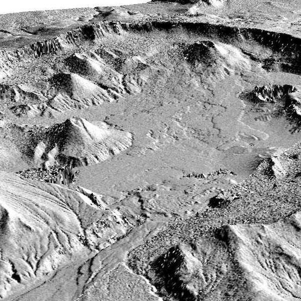
This image is a perspective view acquired by NASA Airborne Synthetic Aperture Radar AIRSAR in 2001, is of Umnak Island, one of Alaska Aleutian Islands. The active Okmok volcano appears in the center of the island.

iss058e001534 (Dec. 28, 2018) --- The SpaceX Dragon cargo craft is pictured attached to the International Space Station's Harmony module as the orbital complex flew 256 miles above Alaska's Aleutian Islands in the Bering Sea.
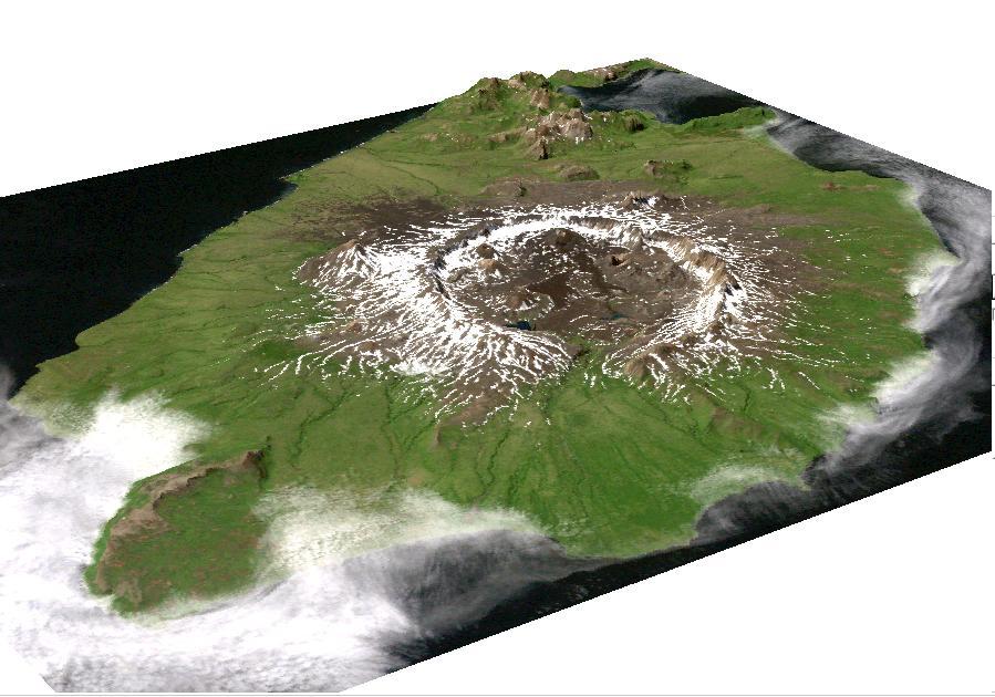
This image is a perspective view acquired by NASA Airborne Synthetic Aperture Radar AIRSAR in 2001, is of Umnak Island, one of Alaska Aleutian Islands. The active Okmok volcano appears in the center of the island.
This image shows how the partial solar eclipse darkened clouds over Alaska. It was taken on Oct. 23 at 21:10 UTC (5:10 p.m. EDT) by the Moderate Resolution Imaging Spectroradiometer instrument that flies aboard NASA's Aqua satellite. Credit: NASA Goddard MODIS Rapid Response Team <b><a href="http://www.nasa.gov/audience/formedia/features/MP_Photo_Guidelines.html" rel="nofollow">NASA image use policy.</a></b> <b><a href="http://www.nasa.gov/centers/goddard/home/index.html" rel="nofollow">NASA Goddard Space Flight Center</a></b> enables NASA’s mission through four scientific endeavors: Earth Science, Heliophysics, Solar System Exploration, and Astrophysics. Goddard plays a leading role in NASA’s accomplishments by contributing compelling scientific knowledge to advance the Agency’s mission. <b>Follow us on <a href="http://twitter.com/NASAGoddardPix" rel="nofollow">Twitter</a></b> <b>Like us on <a href="http://www.facebook.com/pages/Greenbelt-MD/NASA-Goddard/395013845897?ref=tsd" rel="nofollow">Facebook</a></b> <b>Find us on <a href="http://instagram.com/nasagoddard?vm=grid" rel="nofollow">Instagram</a></b>

Scientists on the sea ice in the Chukchi Sea off the north coast of Alaska disperse equipment on July 4, 2010, as they prepare to collect data on and below the ice. The research is part of NASA's ICESCAPE mission onboard the U.S. Coast Guard icebreaker Healy to sample the physical, chemical and biological characteristics of the ocean and sea ice. Impacts of Climate change on the Eco-Systems and Chemistry of the Arctic Pacific Environment (ICESCAPE) is a multi-year NASA shipborne project. The bulk of the research will take place in the Beaufort and Chukchi Sea’s in summer of 2010 and fall of 2011. Photo Credit: (NASA/Kathryn Hansen)
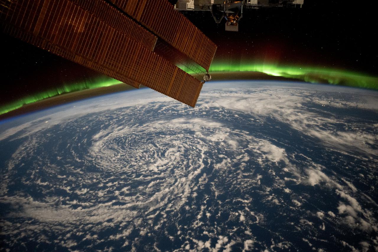
iss072e820937 (March 12, 2025) --- Clouds swirl over the Gulf of Alaska and underneath the aurora borealis blanketing Earth's horizon in this photograph from the International Space Station as it orbited 261 miles above.
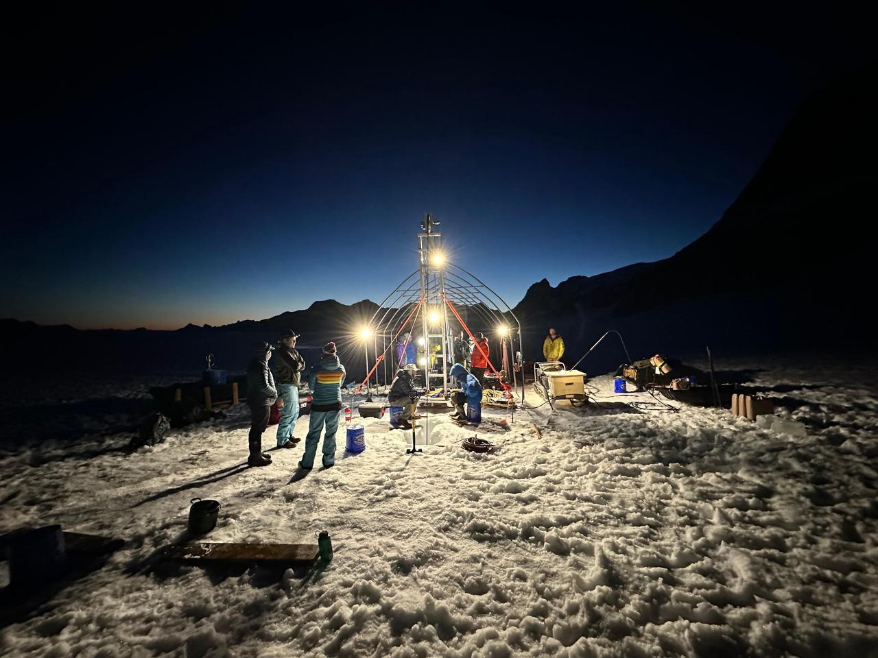
A group of researchers from NASA's Jet Propulsion Laboratory and other institutions spent two weeks on a glacier in Alaska in July 2023 for a project called ORCAA (Ocean Worlds Reconnaissance and Characterization of Astrobiological Analogs). Known as an analog mission, the project is working to answer science questions and test technology in preparation for a potential future mission to explore the surface or subsurface of icy moons like Jupiter's Europa and Saturn's Enceladus. Working at the Juneau Icefield, in coordination with the Juneau Icefield Research Project, the team used a hot-water drill to make a narrow hole in the glacier, melting its way progressively deeper. After three days, the drill reached bedrock, 890 feet (272 meters) below the surface. Science instruments were then sent down the borehole to take a variety of measurements and characterize the water environment. In 2025, the ORCAA team will return to the icefield and target a subglacial lake (a body of water inside the glacier) that has similarities to a reservoir scientists believe exists a few kilometers beneath the icy surface of Europa. ORCAA is funded by NASA's Planetary Science and Technology from Analog Research (PSTAR) program. https://photojournal.jpl.nasa.gov/catalog/PIA26345
iss074e0008922 (Dec. 12, 2025) --- Snow-capped mountain tops of Alaska's Aleutian Islands pierce through the clouds, disturbing the air and creating wave-like patterns known as altocumulus clouds. This photograph was taken from the International Space Station as it orbited 264 miles above the North Pacific Ocean.

Benny Hopson from the Barrow (Alaska) Arctic Science Consortium drills a core sample from sea ice in the Chukchi Sea on July 4, 2010. The core is sliced up into puck-sized sections and stored onboard the U.S. Coast Guard Healy for analysis in the ship's lab. Impacts of Climate change on the Eco-Systems and Chemistry of the Arctic Pacific Environment (ICESCAPE) is a multi-year NASA shipborne project. The bulk of the research will take place in the Beaufort and Chukchi Sea’s in summer of 2010 and fall of 2011. Photo Credit: (NASA/Kathryn Hansen)
STS059-228-094 (9-20 April 1994) --- The spring thaw along the coast of the Gulf of Alaska has not touched the St. Elias Mountains, southeast of Yakutat Bay and Malaspina Glacier. A prominent glacier flows from Mt. Fairweather (15,300 feet) at right center, to form Cape Fairweather. Another glacier to the northwest almost reaches the sea; the valley of the Alsek River forms a broad, braided plan at upper left. The low sun elevation and oblique angle of this photograph provide a striking 3-dimensional appearance to the black-and-white landscape. SRL investigators will study microwave response to varying depths and conditions of ice and snow along this coast, in Spring and Summer. Hasselblad photograph.

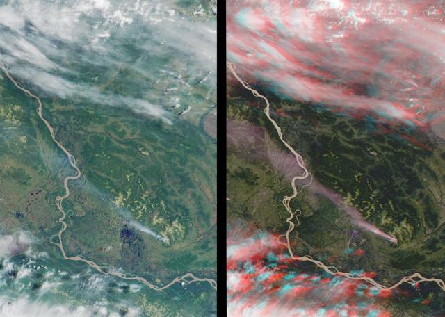
The mighty Yukon River and nearby lakes appear in red in this image produced using data recorded on June 18, 2023, by the international Surface Water and Ocean Topography (SWOT) satellite as it passed over Alaska. The satellite measures the height of nearly all the water on Earth's surface, providing one of the most detailed, comprehensive views yet of the planet's ocean and fresh water. The mission is a collaboration between NASA and the French space agency, CNES (Centre National d'Études Spatiales). SWOT will address some of the most pressing climate change questions of our time, offering insights into areas including how a warming world is accelerating Earth's water cycle, leading to more volatile precipitation patterns. SWOT will also help researchers better understand how climate change affects water storage in lakes, rivers, and reservoirs, and how communities can better manage water resources and prepare for floods and other disasters. SWOT passed over the Yukon River and recorded this data during a period called calibration and validation, when the mission confirms the accuracy of its data. Calibration involved ensuring SWOT's software and hardware – including its main scientific instrument, the Ka-band Radar Interferometer (KaRIn) and its antenna – operate as designed. During validation activities, dozens of research teams headed into the field to measure water levels and the slope of rivers, including the Yukon. Mission scientists then compared field measurements to the data taken by the satellite to ensure SWOT's accuracy. In mid-June, the team of freshwater researchers tasked with gathering data on the Yukon drifted down the waterway around midnight – the same time as SWOT passed overhead, collecting its own data on the river. Launched on Dec. 16, 2022, from Vandenberg Space Force Base in central California, SWOT is now in its operations phase, collecting data that will be used for research and other purposes. https://photojournal.jpl.nasa.gov/catalog/PIA25780

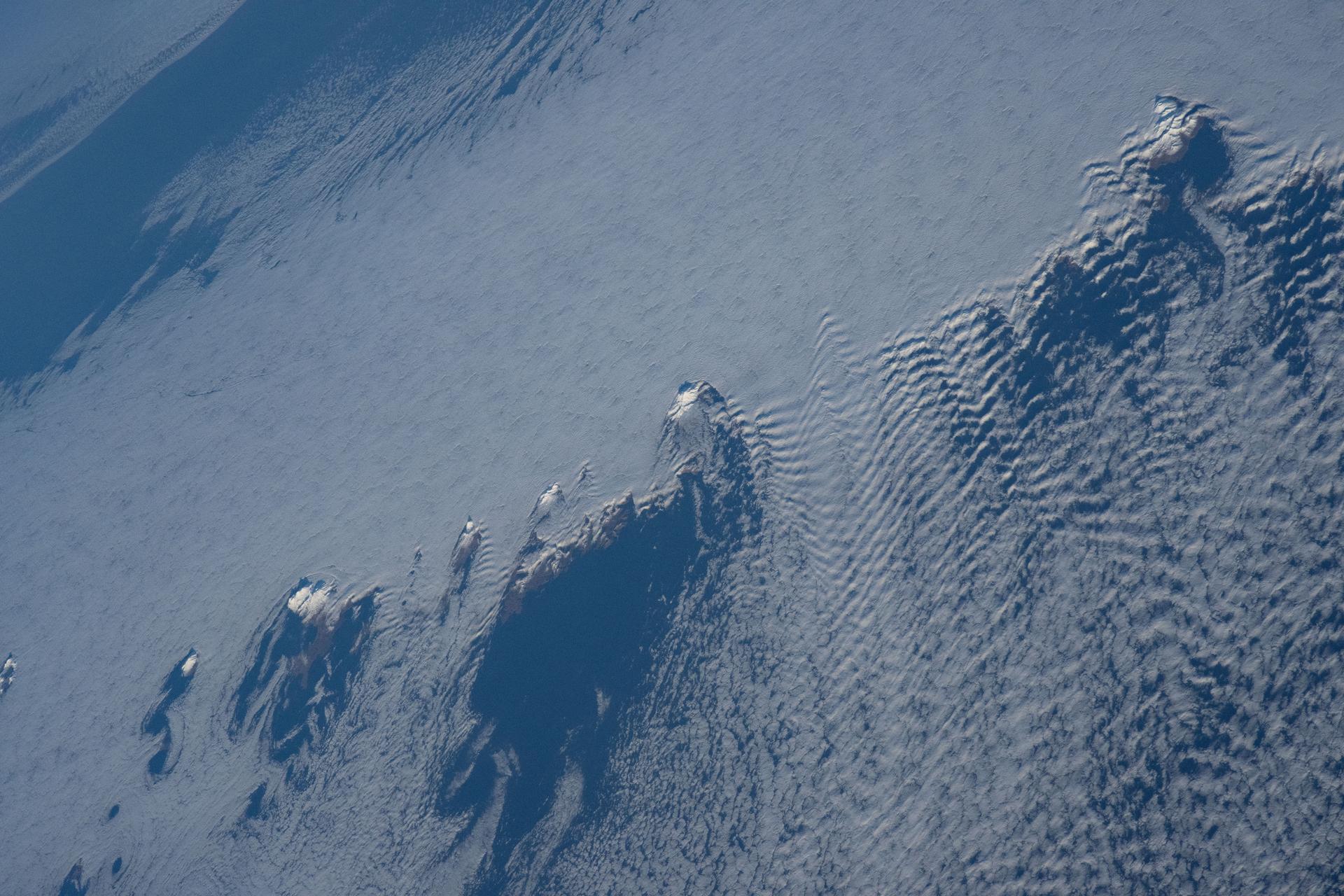
SL4-140-4111 (14 Jan. 1974) --- The Aleutian Islands area of Alaska, as photographed from the Skylab space station in Earth orbit by one of the Skylab 4 crewmen. The camera used was a hand-held Hasselblad, with SO-368 medium-speed Ektachrome. Here is another macro scale phenomenon which is difficult to observe except from a space platform. The Aleutian Islands and clouds with very elaborate van Karman vortices was photographed on Jan. 14, 1974. In addition to the vortices the waves in the clouds due to the mountains on the islands are very evident. In fact, the easiest way to find the mountains is to start with their atmospheric disturbance and work back to the mountain. Photo credit: NASA
This stereo view of western Alaska was acquired by NASA Terra satellite on June 25, 2000. 3D glasses are necessary to view this image.

A model of a tiny, wedge-shaped robot designed to explore subsurface oceans of icy moons, right, sits beside a large waterproof capsule containing electronics and sensors for testing below glacial ice at the Juneau Icefield in Alaska in July 2023. The model, about 5 inches (12 centimeters) long, was 3D-printed to show the final envisioned size of a futuristic NASA mission concept called SWIM, short for Sensing With Independent Micro-swimmers. Led by NASA's Jet Propulsion Laboratory from spring 2021 to fall 2024, SWIM envisions a swarm of dozens of self-propelled, cellphone-size robots exploring the waters of icy moons like Jupiter's Europa and Saturn's Enceladus. Delivered to the subsurface ocean by an ice-melting cryobot, the tiny robots would zoom away to look for chemical and temperature signals that could point to life. The capsule shown here contains the first generation of an ocean composition sensor built for the SWIM robots by a team at Georgia Tech. The final version of the sensor would enable each robot to simultaneously measure temperature, pressure, acidity or alkalinity, conductivity, and chemical makeup. During the Alaska field test, the team lowered the capsule through a borehole in the ice and measured pressure and conductivity down to a depth of 164 feet (50 meters). This field test was conducted as part of a JPL-managed project called ORCAA (Ocean Worlds Reconnaissance and Characterization of Astrobiological Analogs). Known as an analog mission, ORCAA is working to answer science questions and test technology in preparation for a potential future mission to explore the surface or subsurface of icy moons. ORCAA is funded by NASA's Planetary Science and Technology from Analog Research program. SWIM was supported by Phase I and II funding from NASA's Innovative Advanced Concepts program under the agency's Space Technology Mission Directorate. JPL is managed for NASA by Caltech in Pasadena, California. https://photojournal.jpl.nasa.gov/catalog/PIA26424
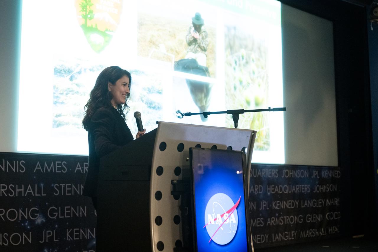
Jackie Encinas speaks about her project, Alaska Ecological Conservation II, Tuesday, August 6, 2024, at the Mary W. Jackson NASA Headquarters building in Washington. Every summer early career researchers from NASA’s DEVELOP National Program come to NASA Headquarters and present their research projects. DEVELOP is a training and development program where early career researchers work on Earth science projects, mentored by science advisors from NASA and partner agencies, and provide research results to local communities. Photo Credit: (NASA/Aubrey Gemignani)

Jackie Encinas speaks about her project, Alaska Ecological Conservation II, Tuesday, August 6, 2024, at the Mary W. Jackson NASA Headquarters building in Washington. Every summer early career researchers from NASA’s DEVELOP National Program come to NASA Headquarters and present their research projects. DEVELOP is a training and development program where early career researchers work on Earth science projects, mentored by science advisors from NASA and partner agencies, and provide research results to local communities. Photo Credit: (NASA/Aubrey Gemignani)

iss065e376897 (Sept. 13, 2021) --- The International Space Station orbits 266 miles above the north Pacific Ocean off the coast of British Columbia, Canada, looking across the city lights of northwest America into a sunrise highlighted by an aurora.

Attu, the westernmost Aleutian island, is nearly 1760 km from the Alaskan mainland and 1200 km northeast of the northernmost of the Japanese Kurile Islands. This image was acquired July 4, 2000 by NASA Terra spacecraft.
This image from NASA Terra satellite, acquired on August 18, 2000 during Terra orbit 3562, show the Bering Strait, with Seward Peninsula of Alaska to the east, and Chukotskiy Poluostrov of Siberia to the west.
The Diomede Islands consisting of the western island Big Diomede, and the eastern island Little Diomede are two rocky islands located in the middle of the Bering Strait between Russia and Alaska. This image was acquired by NASA Terra satellite.
JPL-led study shows bromine explosion on March 13, 2008 across the western Northwest Territories in Canada looking toward the Mackenzie Mountains at the horizon, which prevented the bromine from crossing over into Alaska.
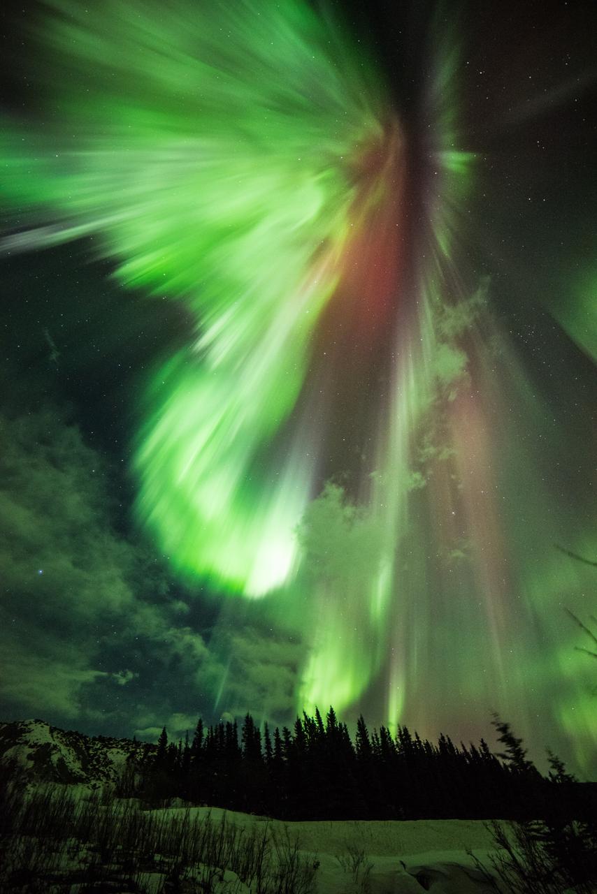
Geomagnetic Storms Sometimes during the solar magnetic events, solar explosions hurl clouds of magnetized particles into space. Traveling more than a million miles per hour, these coronal mass ejections, or CMEs, made up of hot material called plasma take up to three days to reach Earth. Spacecraft and satellites in the path of CMEs can experience glitches as these plasma clouds pass by. In near-Earth space, magnetic reconnection incites explosions of energy driving charged solar particles to collide with atoms in Earth’s upper atmosphere. We see these collisions near Earth’s polar regions as the aurora. The prevalence of specific gases in the atmosphere determines the color of the aurora. For example, if charged particles strike oxygen atoms, the aurora will appear green. Excited nitrogen closer to 60 miles above Earth’s surface will produce a blood red color. Three spacecraft from NASA’s Time History of Events and Macroscale Interactions during Substorms (THEMIS) mission, observe these outbursts known as substorms. Substorms can intensify aurora’s near Earth’s poles. To learn more about the aurora, go to NASA’s THEMIS mission: <a href="http://www.nasa.gov/mission_pages/themis/main/index.html" rel="nofollow">www.nasa.gov/mission_pages/themis/main/index.html</a> ---------- Original caption: How about a little something green for St. Patrick's Day? "St. Patrick's Aurora" was taken at Donnelly Creek, Alaska at 1:30 am, March 17, 2015 by our good friend Sebastian Saarloos! You can see more images from Sebastian here: <a href="http://www.facebook.com/SebastianSaarloos" rel="nofollow">www.facebook.com/SebastianSaarloos</a> Credit: Sebastian Saarloos <b><a href="http://www.nasa.gov/audience/formedia/features/MP_Photo_Guidelines.html" rel="nofollow">NASA image use policy.</a></b> <b><a href="http://www.nasa.gov/centers/goddard/home/index.html" rel="nofollow">NASA Goddard Space Flight Center</a></b> enables NASA’s mission through four scientific endeavors: Earth Science, Heliophysics, Solar System Exploration, and Astrophysics. Goddard plays a leading role in NASA’s accomplishments by contributing compelling scientific knowledge to advance the Agency’s mission. <b>Follow us on <a href="http://twitter.com/NASAGoddardPix" rel="nofollow">Twitter</a></b> <b>Like us on <a href="http://www.facebook.com/pages/Greenbelt-MD/NASA-Goddard/395013845897?ref=tsd" rel="nofollow">Facebook</a></b> <b>Find us on <a href="http://instagram.com/nasagoddard?vm=grid" rel="nofollow">Instagram</a></b>
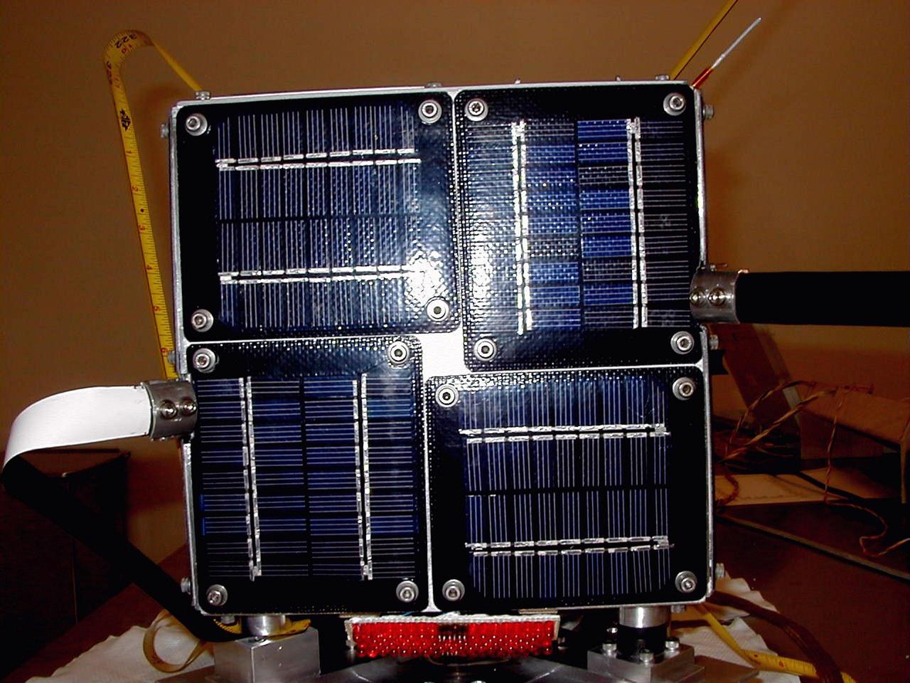
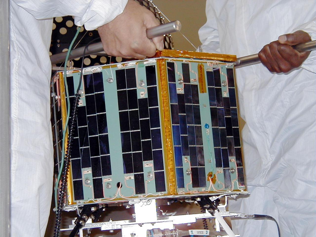
KODIAK ISLAND, Alaska -- The PCSat payload waits for its launch aboard the Athena 1 launch vehicle at Kodiak Island, Alaska, as preparations to launch Kodiak Star proceed. The first orbital launch to take place from Alaska's Kodiak Launch Complex, Kodiak Star is scheduled to lift off on a Lockheed Martin Athena I launch vehicle on Sept. 17 during a two-hour window that extends from 5 p.m. to 7 p.m. p.m. ADT. The payloads aboard include the Starshine 3, sponsored by NASA, and the PICOSat, PCSat and Sapphire, sponsored by the Department of Defense (DoD) Space Test Program.
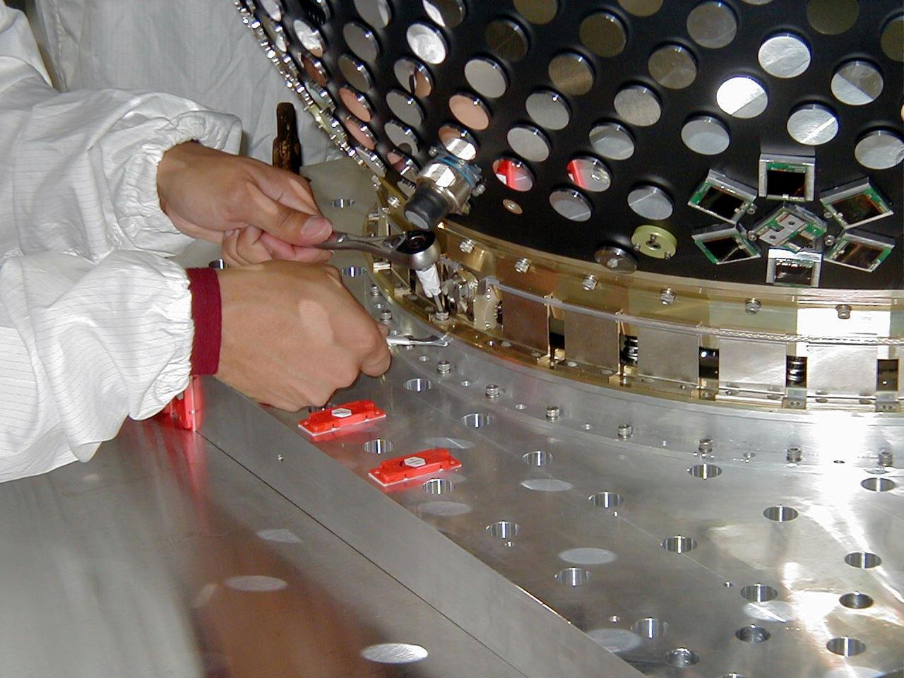
KODIAK ISLAND, Alaska -- Technicians prepare the Starshine 3 payload for its launch aboard the Athena 1 launch vehicle at Kodiak Island, Alaska, as preparations to launch Kodiak Star proceed. The first orbital launch to take place from Alaska's Kodiak Launch Complex, Kodiak Star is scheduled to lift off on a Lockheed Martin Athena I launch vehicle on Sept. 17 during a two-hour window that extends from 5:00 to 7:00 p.m. ADT. The payloads aboard include the Starshine 3, sponsored by NASA, and the PICOSat, PCSat and Sapphire, sponsored by the Department of Defense (DoD) Space Test Program.

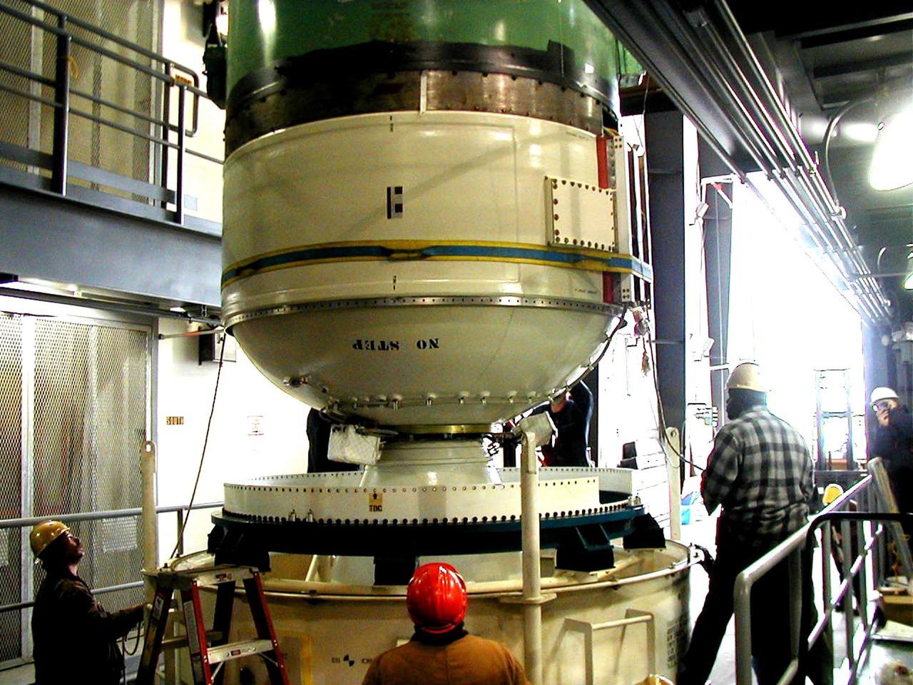
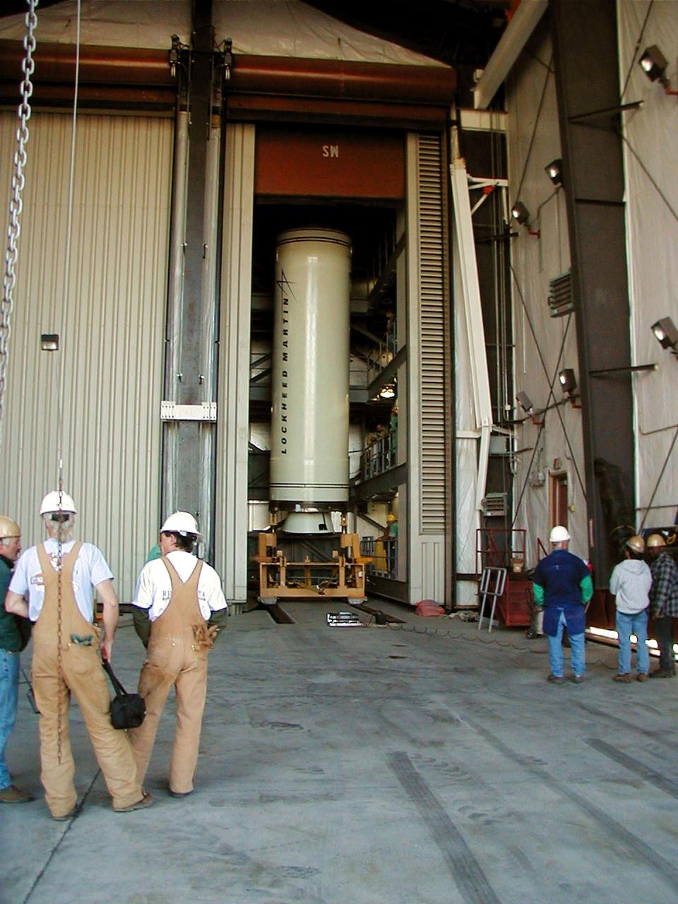
KODIAK ISLAND, Alaska -- Technicians inspect and secure Castor 120, the first stage of the Athena 1 launch vehicle, on the launch mount at Kodiak Island, Alaska, as processing for the launch of Kodiak Star proceeds. The first orbital launch to take place from Alaska's Kodiak Launch Complex, Kodiak Star is scheduled to lift off on a Lockheed Martin Athena I launch vehicle on Sept. 17 during a two-hour window that extends from 5:00 to 7:00 p.m. ADT. The payloads aboard include the Starshine 3, sponsored by NASA, and the PICOSat, PCSat and Sapphire, sponsored by the Department of Defense (DoD) Space Test Program.
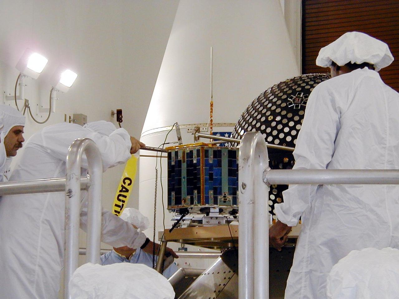
KODIAK ISLAND, Alaska -- The Sapphire payload is moved into position next to the Starshine 3 payload at Kodiak Island, Alaska, as preparations to launch Kodiak Star proceed. The first orbital launch to take place from Alaska's Kodiak Launch Complex, Kodiak Star is scheduled to lift off on a Lockheed Martin Athena I launch vehicle on Sept. 17 during a two-hour window that extends from 5 p.m. to 7 p.m. p.m. ADT. The payloads aboard include the Starshine 3, sponsored by NASA, and the PICOSat, PCSat and Sapphire, sponsored by the Department of Defense (DoD) Space Test Program.

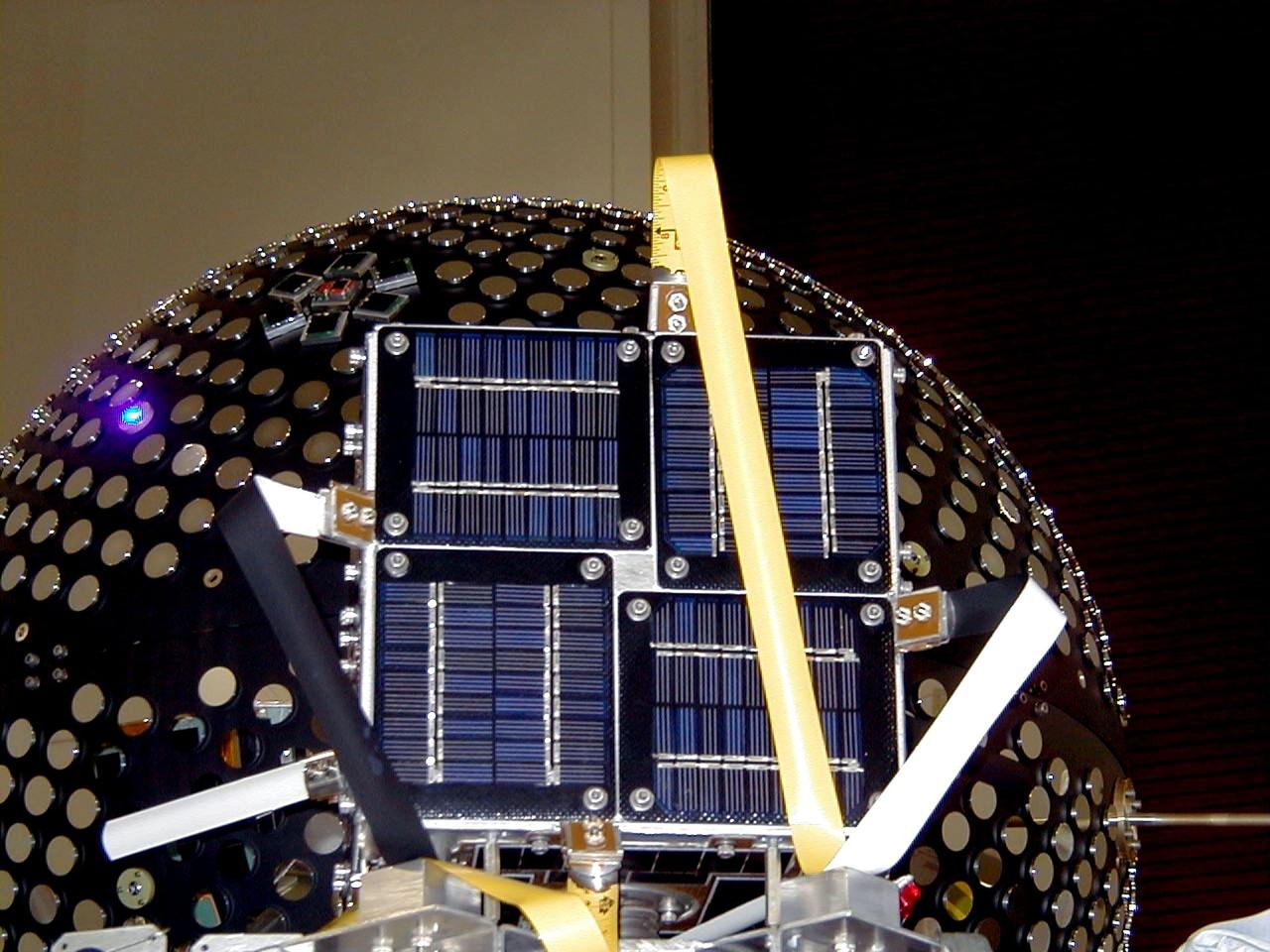
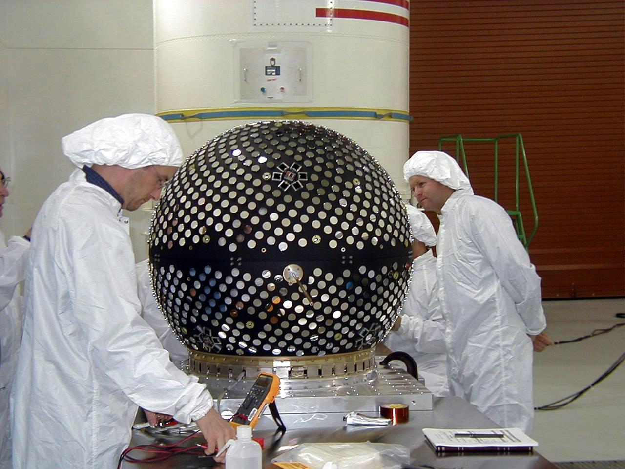
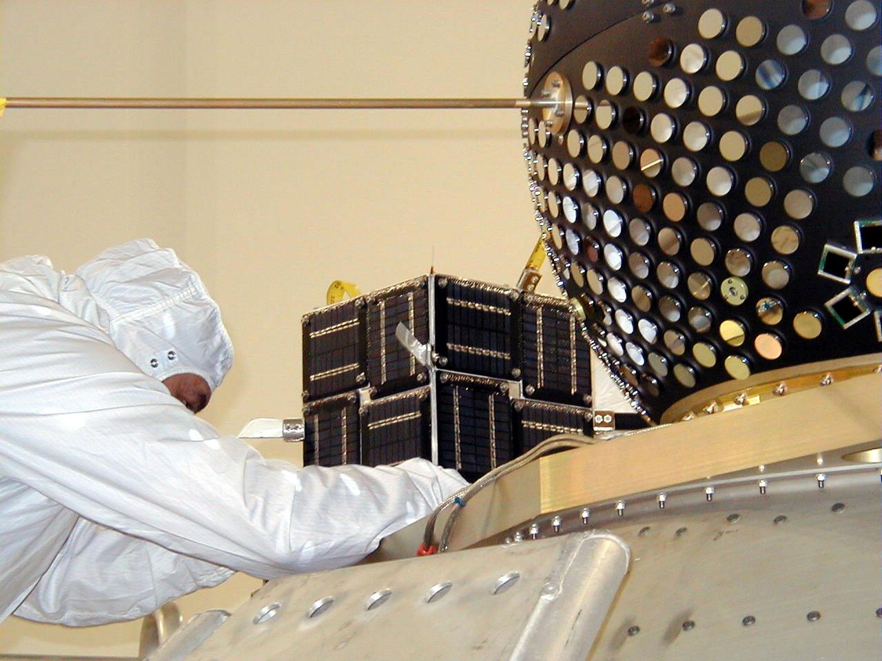
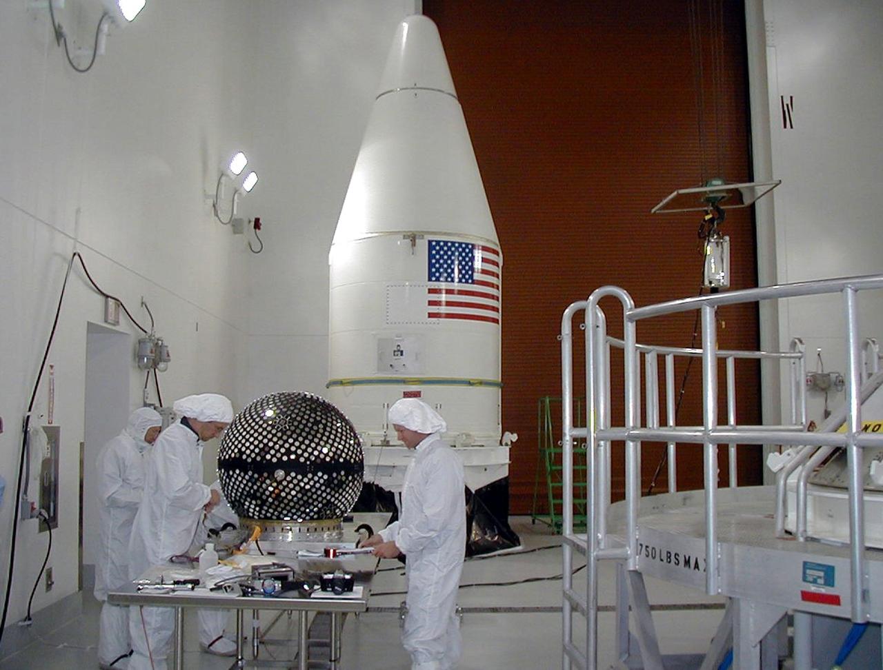
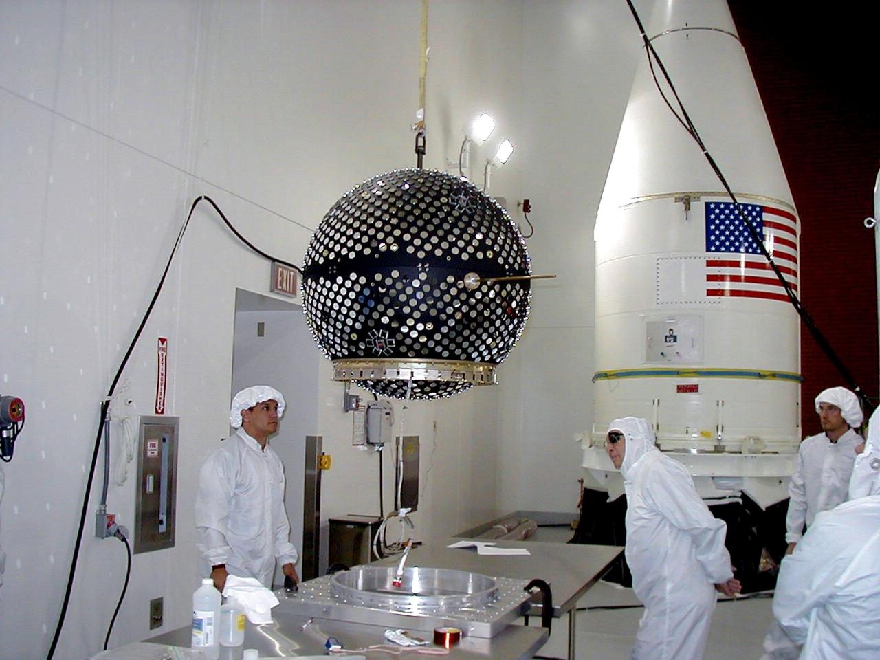
KODIAK ISLAND, Alaska -- A technician performs final testing on Starshine 3 at the Naval Research Laboratory in Washington, D.C., to prepare for the launch of the Kodiak Star at Kodiak Island, Alaska. The first orbital launch to take place from Alaska's Kodiak Launch Complex, Kodiak Star is scheduled to lift off on a Lockheed Martin Athena I launch vehicle on Sept. 17 during a two-hour window that extends from 5:00 to 7:00 p.m. ADT. The payloads aboard include the Starshine 3, sponsored by NASA, and the PICOSat, PCSat and Sapphire, sponsored by the Department of Defense (DoD) Space Test Program.
KODIAK ISLAND, Alaska -- The PICSat and Starshine 3 (back) payloads wait for their launch aboard the Athena 1 launch vehicle at Kodiak Island, Alaska, as preparations to launch Kodiak Star proceed. The first orbital launch to take place from Alaska's Kodiak Launch Complex, Kodiak Star is scheduled to lift off on a Lockheed Martin Athena I launch vehicle on Sept. 17 during a two-hour window that extends from 5 p.m. to 7 p.m. p.m. ADT. The payloads aboard include the Starshine 3, sponsored by NASA, and the PICOSat, PCSat and Sapphire, sponsored by the Department of Defense (DoD) Space Test Program.
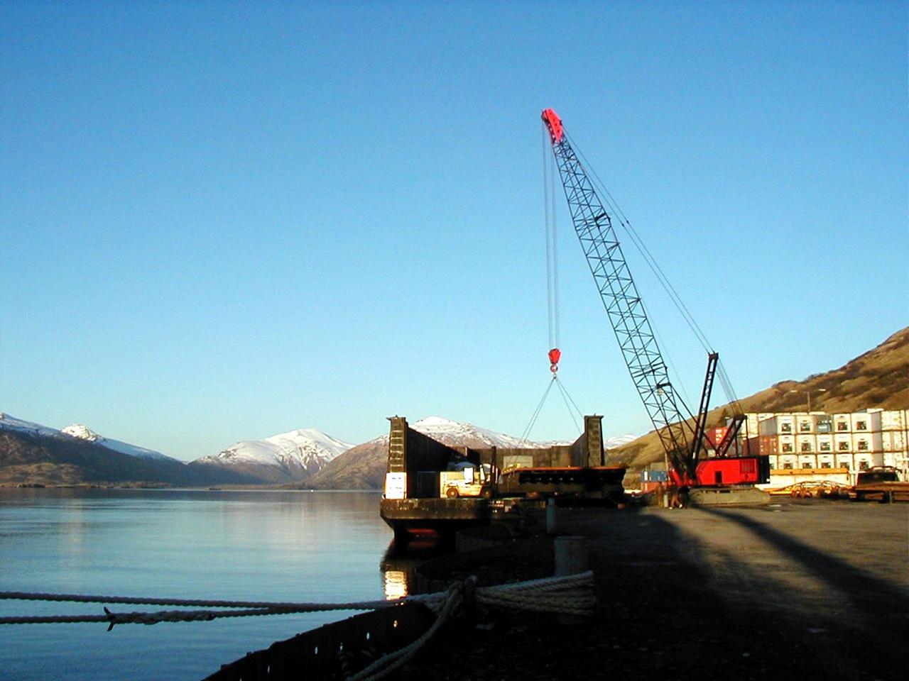
KODIAK ISLAND, Alaska -- A special platform connects the barge with a ramp to allow Castor 120, the first stage of the Athena 1 launch vehicle, to safely move onto the dock at Kodiak Island, Alaska, as preparations to launch Kodiak Star proceed. The first orbital launch to take place from Alaska's Kodiak Launch Complex, Kodiak Star is scheduled to lift off on a Lockheed Martin Athena I launch vehicle on Sept. 17 during a two-hour window that extends from 5:00 to 7:00 p.m. ADT. The payloads aboard include the Starshine 3, sponsored by NASA, and the PICOSat, PCSat and Sapphire, sponsored by the Department of Defense (DoD) Space Test Program.
KODIAK ISLAND, Alaska -- Technicians prepare the Starshine 3 payload for its launch aboard the Athena 1 launch vehicle at Kodiak Island, Alaska, as preparations to launch Kodiak Star proceed. The first orbital launch to take place from Alaska's Kodiak Launch Complex, Kodiak Star is scheduled to lift off on a Lockheed Martin Athena I launch vehicle on Sept. 17 during a two-hour window that extends from 5:00 to 7:00 p.m. ADT. The payloads aboard include the Starshine 3, sponsored by NASA, and the PICOSat, PCSat and Sapphire, sponsored by the Department of Defense (DoD) Space Test Program.

KODIAK ISLAND, Alaska -- Technicians inspect Castor 120, the first stage of the Athena 1 launch vehicle, at Kodiak Island, Alaska, as preparations to launch Kodiak Star proceed. The first orbital launch to take place from Alaska's Kodiak Launch Complex, Kodiak Star is scheduled to lift off on a Lockheed Martin Athena I launch vehicle on Sept. 17 during a two-hour window that extends from 5:00 to 7:00 p.m. ADT. The payloads aboard include the Starshine 3, sponsored by NASA, and the PICOSat, PCSat and Sapphire, sponsored by the Department of Defense (DoD) Space Test Program.

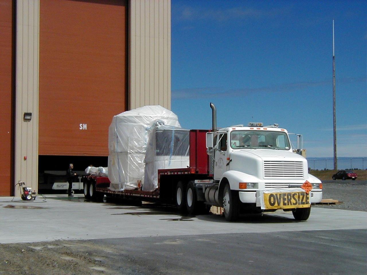
KODIAK ISLAND, Alaska -- A convoy of trucks transports the stages of an Athena launch vehicle and supporting launch equipment to the pad at Kodiak Island, Alaska, as preparations to launch the Kodiak Star continue. The first orbital launch to take place from Alaska's Kodiak Launch Complex, Kodiak Star is scheduled to lift off on a Lockheed Martin Athena I launch vehicle on Sept. 17 during a two-hour window that extends from 5:00 to 7:00 p.m. ADT. The payloads aboard include the Starshine 3, sponsored by NASA, and the PICOSat, PCSat and Sapphire, sponsored by the Department of Defense (DoD) Space Test Program.

KODIAK ISLAND, Alaska -- Technicians prepare the Starshine 3 payload for its launch aboard the Athena 1 launch vehicle, while the payload fairing awaits processing, at Kodiak Island, Alaska, as preparations to launch Kodiak Star proceed. The first orbital launch to take place from Alaska's Kodiak Launch Complex, Kodiak Star is scheduled to lift off on a Lockheed Martin Athena I launch vehicle on Sept. 17 during a two-hour window that extends from 5:00 to 7:00 p.m. ADT. The payloads aboard include the Starshine 3, sponsored by NASA, and the PICOSat, PCSat and Sapphire, sponsored by the Department of Defense (DoD) Space Test Program.
KODIAK ISLAND, Alaska -- Castor 120, the first stage of the Athena 1 launch vehicle, is raised off a truck at the launch pad at Kodiak Island, Alaska, as preparations to launch Kodiak Star proceed. The first orbital launch to take place from Alaska's Kodiak Launch Complex, Kodiak Star is scheduled to lift off on a Lockheed Martin Athena I launch vehicle on Sept. 17 during a two-hour window that extends from 5:00 to 7:00 p.m. ADT. The payloads aboard include the Starshine 3, sponsored by NASA, and the PICOSat, PCSat and Sapphire, sponsored by the Department of Defense (DoD) Space Test Program.

KODIAK ISLAND, Alaska -- The PCSat payload waits for its launch aboard the Athena 1 launch vehicle at Kodiak Island, Alaska, as preparations to launch Kodiak Star proceed. The first orbital launch to take place from Alaska's Kodiak Launch Complex, Kodiak Star is scheduled to lift off on a Lockheed Martin Athena I launch vehicle on Sept. 17 during a two-hour window that extends from 5 p.m. to 7 p.m. p.m. ADT. The payloads aboard include the Starshine 3, sponsored by NASA, and the PICOSat, PCSat and Sapphire, sponsored by the Department of Defense (DoD) Space Test Program.
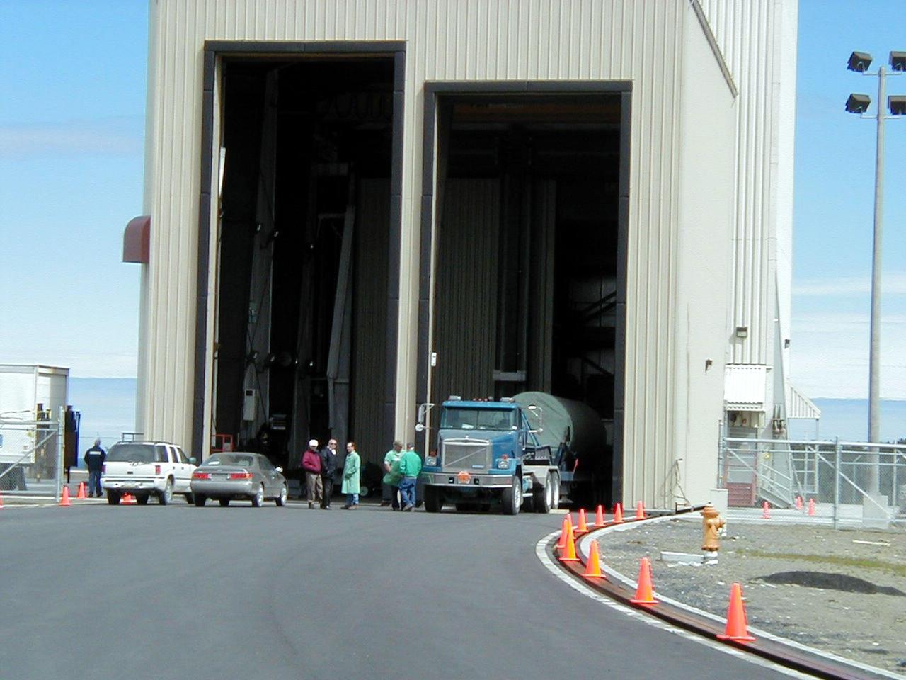
KODIAK ISLAND, Alaska -- Trucks transporting Castor 120, the first stage of the Athena 1 launch vehicle, arrive at Kodiak Island, Alaska, as preparations to launch Kodiak Star proceed. The first orbital launch to take place from Alaska's Kodiak Launch Complex, Kodiak Star is scheduled to lift off on a Lockheed Martin Athena I launch vehicle on Sept. 17 during a two-hour window that extends from 5:00 to 7:00 p.m. ADT. The payloads aboard include the Starshine 3, sponsored by NASA, and the PICOSat, PCSat and Sapphire, sponsored by the Department of Defense (DoD) Space Test Program.
KODIAK ISLAND, Alaska -- Castor 120, the first stage of the Athena 1 launch vehicle, is lowered into place at Kodiak Island, Alaska, as preparations to launch Kodiak Star proceed. The first orbital launch to take place from Alaska's Kodiak Launch Complex, Kodiak Star is scheduled to lift off on a Lockheed Martin Athena I launch vehicle on Sept. 17 during a two-hour window that extends from 5:00 to 7:00 p.m. ADT. The payloads aboard include the Starshine 3, sponsored by NASA, and the PICOSat, PCSat and Sapphire, sponsored by the Department of Defense (DoD) Space Test Program.
KODIAK ISLAND, Alaska -- Technicians inspect and secure Castor 120, the first stage of the Athena 1 launch vehicle, on the launch mount at Kodiak Island, Alaska, as processing for the launch of Kodiak Star proceeds. The first orbital launch to take place from Alaska's Kodiak Launch Complex, Kodiak Star is scheduled to lift off on a Lockheed Martin Athena I launch vehicle on Sept. 17 during a two-hour window that extends from 5:00 to 7:00 p.m. ADT. The payloads aboard include the Starshine 3, sponsored by NASA, and the PICOSat, PCSat and Sapphire, sponsored by the Department of Defense (DoD) Space Test Program.
KODIAK ISLAND, Alaska -- A technician performs final testing on Starshine 3 at the Naval Research Laboratory in Washington, D.C., to prepare for the launch of the Kodiak Star at Kodiak Island, Alaska. The first orbital launch to take place from Alaska's Kodiak Launch Complex, Kodiak Star is scheduled to lift off on a Lockheed Martin Athena I launch vehicle on Sept. 17 during a two-hour window that extends from 5:00 to 7:00 p.m. ADT. The payloads aboard include the Starshine 3, sponsored by NASA, and the PICOSat, PCSat and Sapphire, sponsored by the Department of Defense (DoD) Space Test Program.
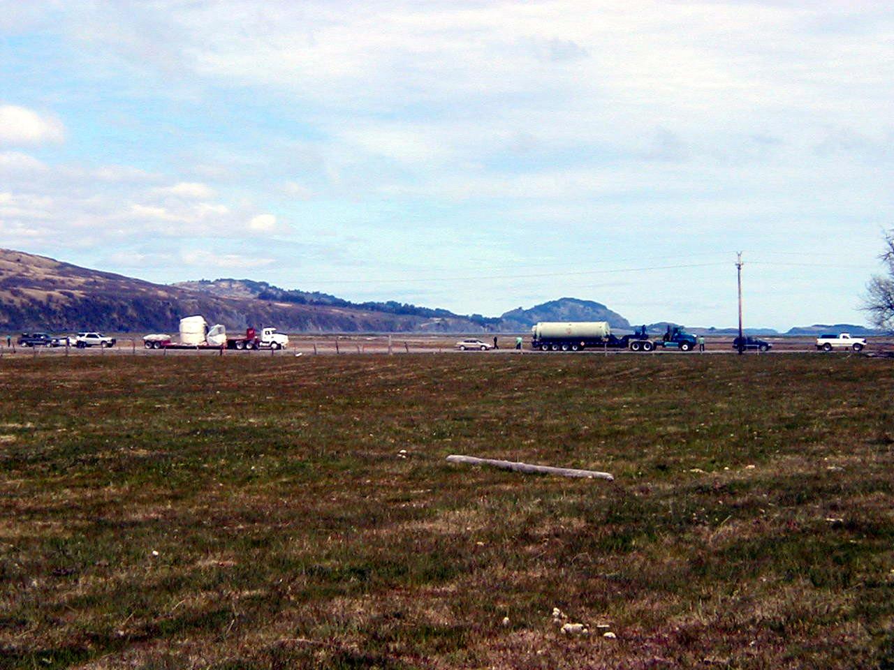
KODIAK ISLAND, Alaska -- A convoy of trucks transports the stages of an Athena launch vehicle and supporting launch equipment to the pad at Kodiak Island, Alaska, as preparations to launch the Kodiak Star continue. The first orbital launch to take place from Alaska's Kodiak Launch Complex, Kodiak Star is scheduled to lift off on a Lockheed Martin Athena I launch vehicle on Sept. 17 during a two-hour window that extends from 5:00 to 7:00 p.m. ADT. The payloads aboard include the Starshine 3, sponsored by NASA, and the PICOSat, PCSat and Sapphire, sponsored by the Department of Defense (DoD) Space Test Program.

KODIAK ISLAND, Alaska -- The Sapphire payload is moved into position next to the Starshine 3 payload at Kodiak Island, Alaska, as preparations to launch Kodiak Star proceed. The first orbital launch to take place from Alaska's Kodiak Launch Complex, Kodiak Star is scheduled to lift off on a Lockheed Martin Athena I launch vehicle on Sept. 17 during a two-hour window that extends from 5 p.m. to 7 p.m. p.m. ADT. The payloads aboard include the Starshine 3, sponsored by NASA, and the PICOSat, PCSat and Sapphire, sponsored by the Department of Defense (DoD) Space Test Program.
KODIAK ISLAND, Alaska -- A technician prepares the Starshine 3 and PICSat payloads for their launch aboard the Athena 1 launch vehicle at Kodiak Island, Alaska, as preparations to launch Kodiak Star proceed. The first orbital launch to take place from Alaska's Kodiak Launch Complex, Kodiak Star is scheduled to lift off on a Lockheed Martin Athena I launch vehicle on Sept. 17 during a two-hour window that extends from 5 p.m. to 7 p.m. p.m. ADT. The payloads aboard include the Starshine 3, sponsored by NASA, and the PICOSat, PCSat and Sapphire, sponsored by the Department of Defense (DoD) Space Test Program.

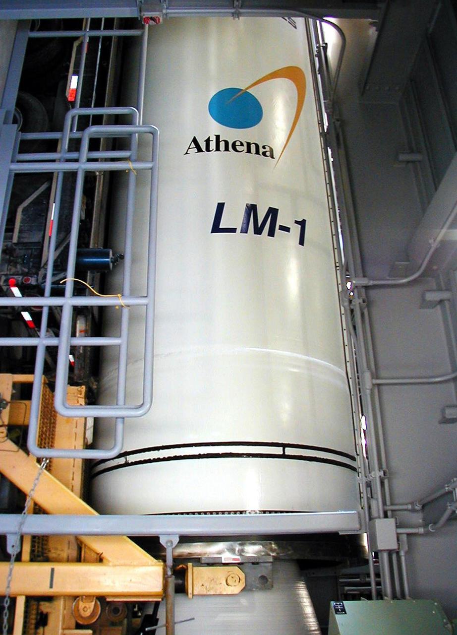
KODIAK ISLAND, Alaska -- Technicians prepare the Athena I launch vehicle for flight at Kodiak Island, Alaska, as processing for the launch of Kodiak Star proceeds. The first orbital launch to take place from Alaska's Kodiak Launch Complex, Kodiak Star is scheduled to lift off on a Lockheed Martin Athena I launch vehicle on Sept. 17 during a two-hour window that extends from 5:00 to 7:00 p.m. ADT. The payloads aboard include the Starshine 3, sponsored by NASA, and the PICOSat, PCSat and Sapphire, sponsored by the Department of Defense (DoD) Space Test Program.

KODIAK ISLAND, Alaska -- Technicians prepare the Starshine 3 payload, while the payload fairing of the Athena 1 launch vehicle awaits servicing at Kodiak Island, Alaska, as preparations to launch Kodiak Star proceed. The first orbital launch to take place from Alaska's Kodiak Launch Complex, Kodiak Star is scheduled to lift off on a Lockheed Martin Athena I launch vehicle on Sept. 17 during a two-hour window that extends from 5:00 to 7:00 p.m. ADT. The payloads aboard include the Starshine 3, sponsored by NASA, and the PICOSat, PCSat and Sapphire, sponsored by the Department of Defense (DoD) Space Test Program
KODIAK ISLAND, Alaska -- Technicians prepare the Starshine 3 payload for its launch aboard the Athena 1 launch vehicle, while the payload fairing awaits processing, at Kodiak Island, Alaska, as preparations to launch Kodiak Star proceed. The first orbital launch to take place from Alaska's Kodiak Launch Complex, Kodiak Star is scheduled to lift off on a Lockheed Martin Athena I launch vehicle on Sept. 17 during a two-hour window that extends from 5:00 to 7:00 p.m. ADT. The payloads aboard include the Starshine 3, sponsored by NASA, and the PICOSat, PCSat and Sapphire, sponsored by the Department of Defense (DoD) Space Test Program.

KODIAK ISLAND, Alaska -- Technicians install Orbis 21D Equipment Section Boost Motor, the second stage of the Athena 1 launch vehicle, at Kodiak Island, Alaska, as processing for the launch of Kodiak Star proceeds. The first orbital launch to take place from Alaska's Kodiak Launch Complex, Kodiak Star is scheduled to lift off on a Lockheed Martin Athena I launch vehicle on Sept. 17 during a two-hour window that extends from 5:00 to 7:00 p.m. ADT. The payloads aboard include the Starshine 3, sponsored by NASA, and the PICOSat, PCSat and Sapphire, sponsored by the Department of Defense (DoD) Space Test Program.
KODIAK ISLAND, Alaska -- Technicians install Orbis 21D Equipment Section Boost Motor, the second stage of the Athena 1 launch vehicle, at Kodiak Island, Alaska, as processing for the launch of Kodiak Star proceeds. The first orbital launch to take place from Alaska's Kodiak Launch Complex, Kodiak Star is scheduled to lift off on a Lockheed Martin Athena I launch vehicle on Sept. 17 during a two-hour window that extends from 5:00 to 7:00 p.m. ADT. The payloads aboard include the Starshine 3, sponsored by NASA, and the PICOSat, PCSat and Sapphire, sponsored by the Department of Defense (DoD) Space Test Program.
KODIAK ISLAND, Alaska -- Technicians transport the Sapphire payload at Kodiak Island, Alaska, as preparations to launch Kodiak Star proceed. The first orbital launch to take place from Alaska's Kodiak Launch Complex, Kodiak Star is scheduled to lift off on a Lockheed Martin Athena I launch vehicle on Sept. 17 during a two-hour window that extends from 5 p.m. to 7 p.m. p.m. ADT. The payloads aboard include the Starshine 3, sponsored by NASA, and the PICOSat, PCSat and Sapphire, sponsored by the Department of Defense (DoD) Space Test Program.
KODIAK ISLAND, Alaska -- Technicians prepare the Athena I launch vehicle for flight at Kodiak Island, Alaska, as processing for the launch of Kodiak Star proceeds. The first orbital launch to take place from Alaska's Kodiak Launch Complex, Kodiak Star is scheduled to lift off on a Lockheed Martin Athena I launch vehicle on Sept. 17 during a two-hour window that extends from 5:00 to 7:00 p.m. ADT. The payloads aboard include the Starshine 3, sponsored by NASA, and the PICOSat, PCSat and Sapphire, sponsored by the Department of Defense (DoD) Space Test Program.
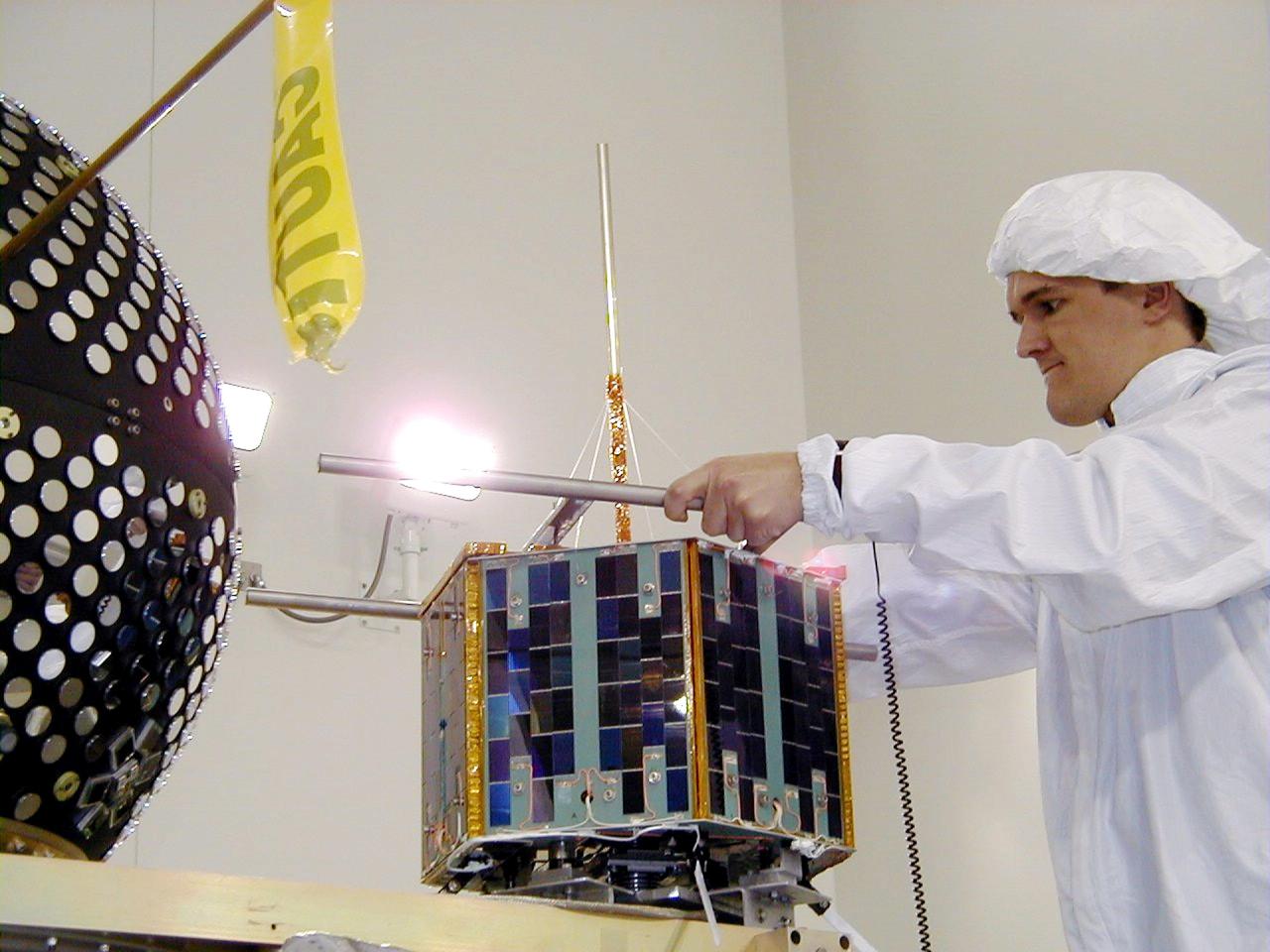
KODIAK ISLAND, Alaska -- The Sapphire payload is moved into position next to the Starshine 3 payload at Kodiak Island, Alaska, as preparations to launch Kodiak Star proceed. The first orbital launch to take place from Alaska's Kodiak Launch Complex, Kodiak Star is scheduled to lift off on a Lockheed Martin Athena I launch vehicle on Sept. 17 during a two-hour window that extends from 5 p.m. to 7 p.m. p.m. ADT. The payloads aboard include the Starshine 3, sponsored by NASA, and the PICOSat, PCSat and Sapphire, sponsored by the Department of Defense (DoD) Space Test Program.
KODIAK ISLAND, Alaska -- Trucks transporting Orbis 21D Equipment Section Boost Motor, the second stage of the Athena 1 launch vehicle, arrive at Kodiak Island, Alaska, as preparations to launch Kodiak Star proceed. The first orbital launch to take place from Alaska's Kodiak Launch Complex, Kodiak Star is scheduled to lift off on a Lockheed Martin Athena I launch vehicle on Sept. 17 during a two-hour window that extends from 5:00 to 7:00 p.m. ADT. The payloads aboard include the Starshine 3, sponsored by NASA, and the PICOSat, PCSat and Sapphire, sponsored by the Department of Defense (DoD) Space Test Program.
KODIAK ISLAND, Alaska -- Technicians prepare the Starshine 3 payload, while the payload fairing of the Athena 1 launch vehicle awaits servicing at Kodiak Island, Alaska, as preparations to launch Kodiak Star proceed. The first orbital launch to take place from Alaska's Kodiak Launch Complex, Kodiak Star is scheduled to lift off on a Lockheed Martin Athena I launch vehicle on Sept. 17 during a two-hour window that extends from 5:00 to 7:00 p.m. ADT. The payloads aboard include the Starshine 3, sponsored by NASA, and the PICOSat, PCSat and Sapphire, sponsored by the Department of Defense (DoD) Space Test Program
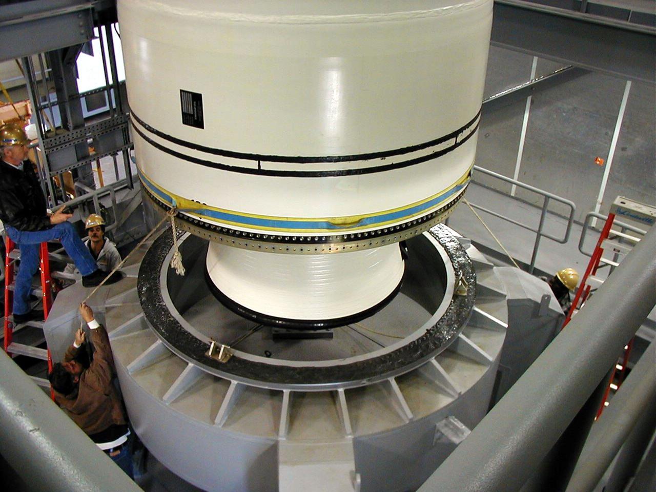
KODIAK ISLAND, Alaska -- Castor 120, the first stage of the Athena 1 launch vehicle, is lowered onto launch mount at Kodiak Island, Alaska, as preparations to launch Kodiak Star proceed. The first orbital launch to take place from Alaska's Kodiak Launch Complex, Kodiak Star is scheduled to lift off on a Lockheed Martin Athena I launch vehicle on Sept. 17 during a two-hour window that extends from 5:00 to 7:00 p.m. ADT. The payloads aboard include the Starshine 3, sponsored by NASA, and the PICOSat, PCSat and Sapphire, sponsored by the Department of Defense (DoD) Space Test Program.
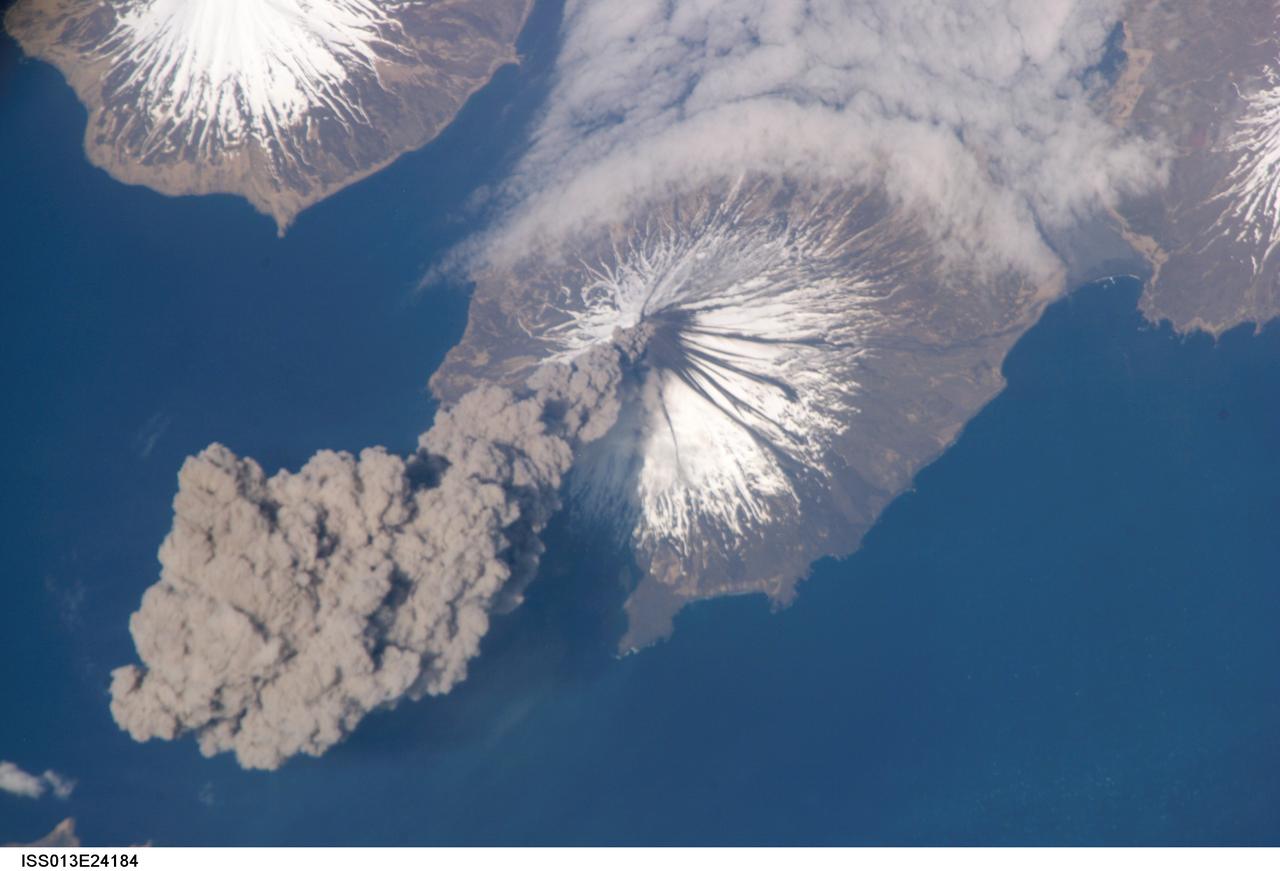
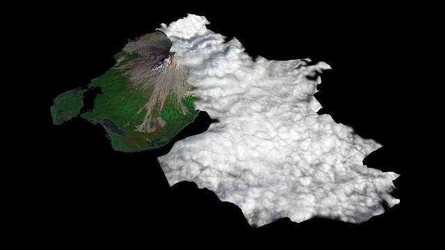
ISS013-E-24184 (23 May 2006) --- Eruption of Cleveland Volcano, Aleutian Islands, Alaska is featured in this image photographed by an Expedition 13 crewmember on the International Space Station. This most recent eruption was first reported to the Alaska Volcano Observatory by astronaut Jeffrey N. Williams, NASA space station science officer and flight engineer, at 3:00 p.m. Alaska Daylight Time (23:00 GMT). This image, acquired shortly after the beginning of the eruption, captures the ash plume moving west-southwest from the summit vent. The eruption was short-lived; the plume had completely detached from the volcano summit two hours later.
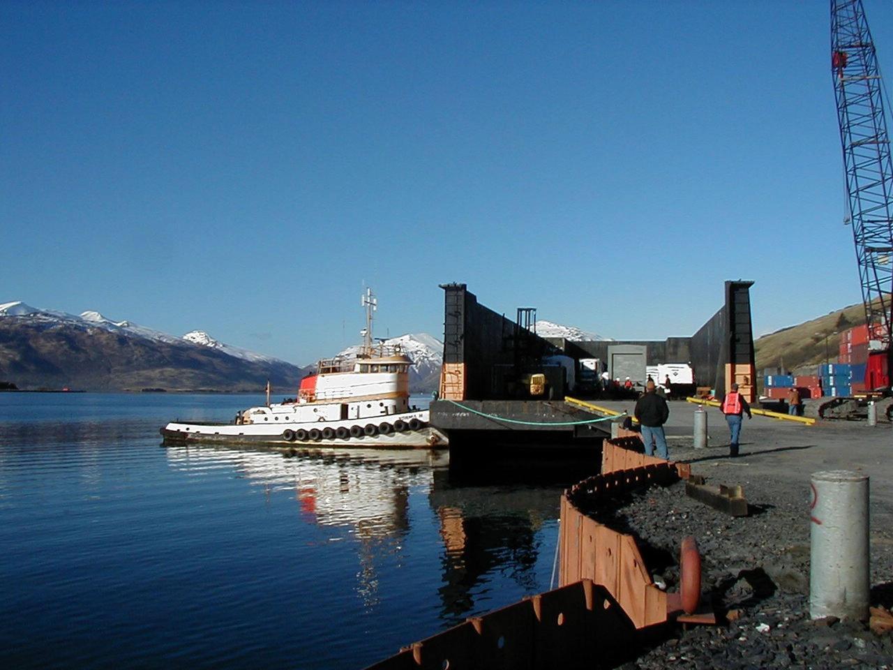
KODIAK ISLAND, Alaska -- A boat moves a ramp into place that will allow Castor 120, the first stage of the Athena 1 launch vehicle, to safely move onto the dock at Kodiak Island, Alaska, as preparations to launch Kodiak Star proceed. The first orbital launch to take place from Alaska's Kodiak Launch Complex, Kodiak Star is scheduled to lift off on a Lockheed Martin Athena I launch vehicle on Sept. 17 during a two-hour window that extends from 5:00 to 7:00 p.m. ADT. The payloads aboard include the Starshine 3, sponsored by NASA, and the PICOSat, PCSat and Sapphire, sponsored by the Department of Defense (DoD) Space Test Program.
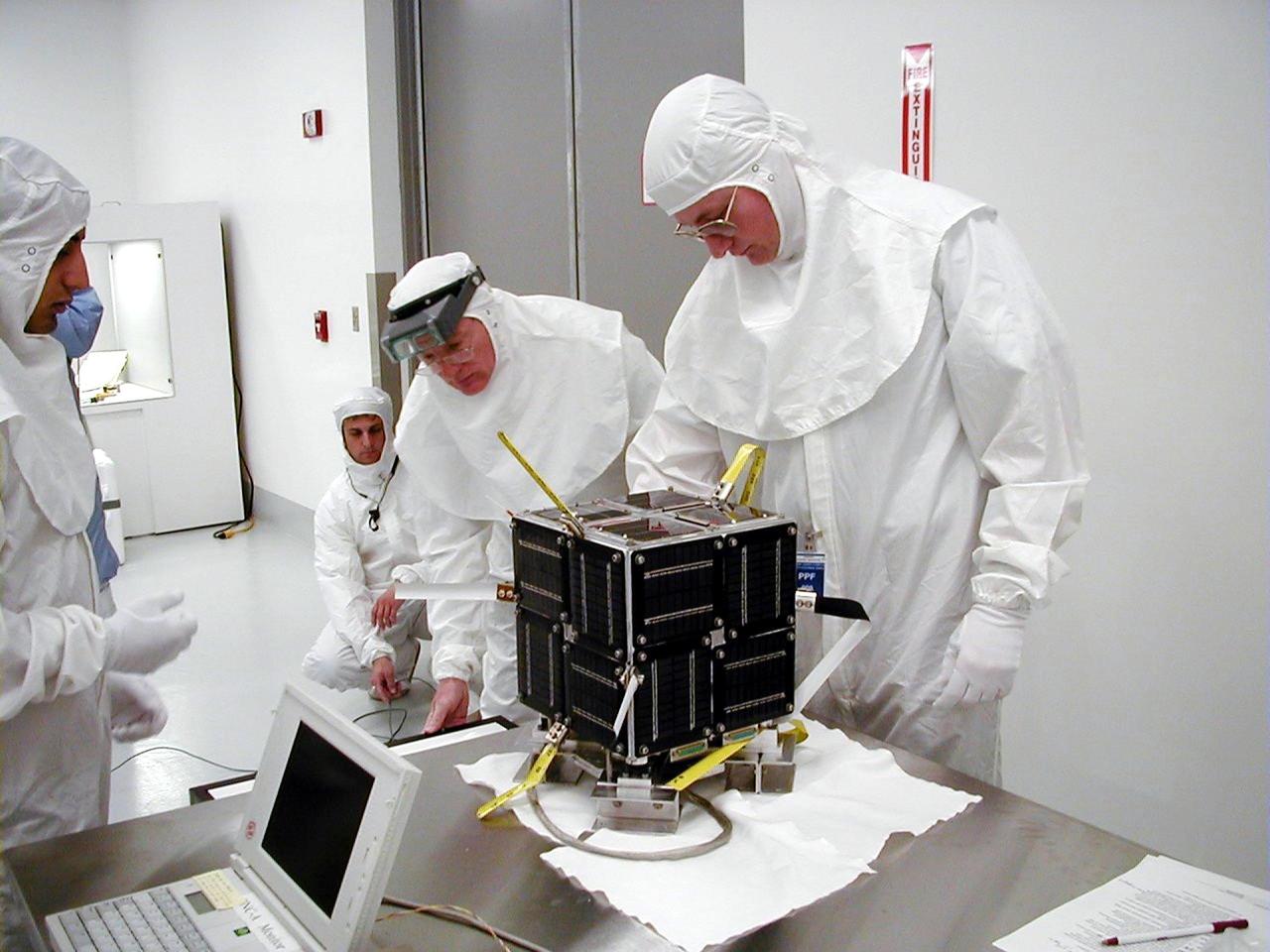
KODIAK ISLAND, Alaska -- Technicians prepare the PICSat payload for its launch aboard the Athena 1 launch vehicle at Kodiak Island, Alaska, as preparations to launch Kodiak Star proceed. The first orbital launch to take place from Alaska's Kodiak Launch Complex, Kodiak Star is scheduled to lift off on a Lockheed Martin Athena I launch vehicle on Sept. 17 during a two-hour window that extends from 5 p.m. to 7 p.m. p.m. ADT. The payloads aboard include the Starshine 3, sponsored by NASA, and the PICOSat, PCSat and Sapphire, sponsored by the Department of Defense (DoD) Space Test Program.

KODIAK ISLAND, Alaska -- Castor 120, the first stage of the Athena 1 launch vehicle, is lowered into place at Kodiak Island, Alaska, as preparations to launch Kodiak Star proceed. The first orbital launch to take place from Alaska's Kodiak Launch Complex, Kodiak Star is scheduled to lift off on a Lockheed Martin Athena I launch vehicle on Sept. 17 during a two-hour window that extends from 5:00 to 7:00 p.m. ADT. The payloads aboard include the Starshine 3, sponsored by NASA, and the PICOSat, PCSat and Sapphire, sponsored by the Department of Defense (DoD) Space Test Program.
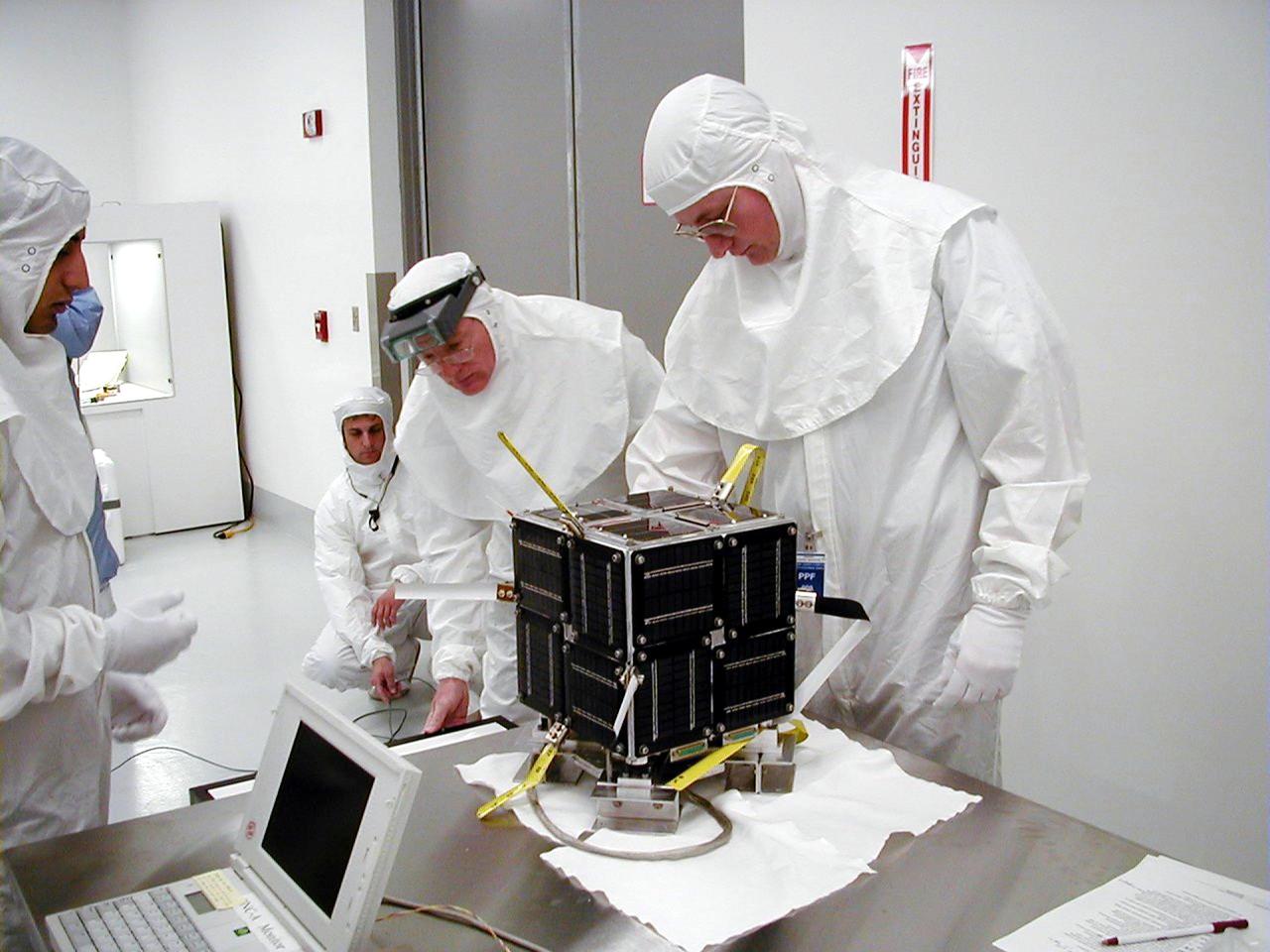
KODIAK ISLAND, Alaska -- Technicians prepare the PICSat payload for its launch aboard the Athena 1 launch vehicle at Kodiak Island, Alaska, as preparations to launch Kodiak Star proceed. The first orbital launch to take place from Alaska's Kodiak Launch Complex, Kodiak Star is scheduled to lift off on a Lockheed Martin Athena I launch vehicle on Sept. 17 during a two-hour window that extends from 5 p.m. to 7 p.m. p.m. ADT. The payloads aboard include the Starshine 3, sponsored by NASA, and the PICOSat, PCSat and Sapphire, sponsored by the Department of Defense (DoD) Space Test Program.