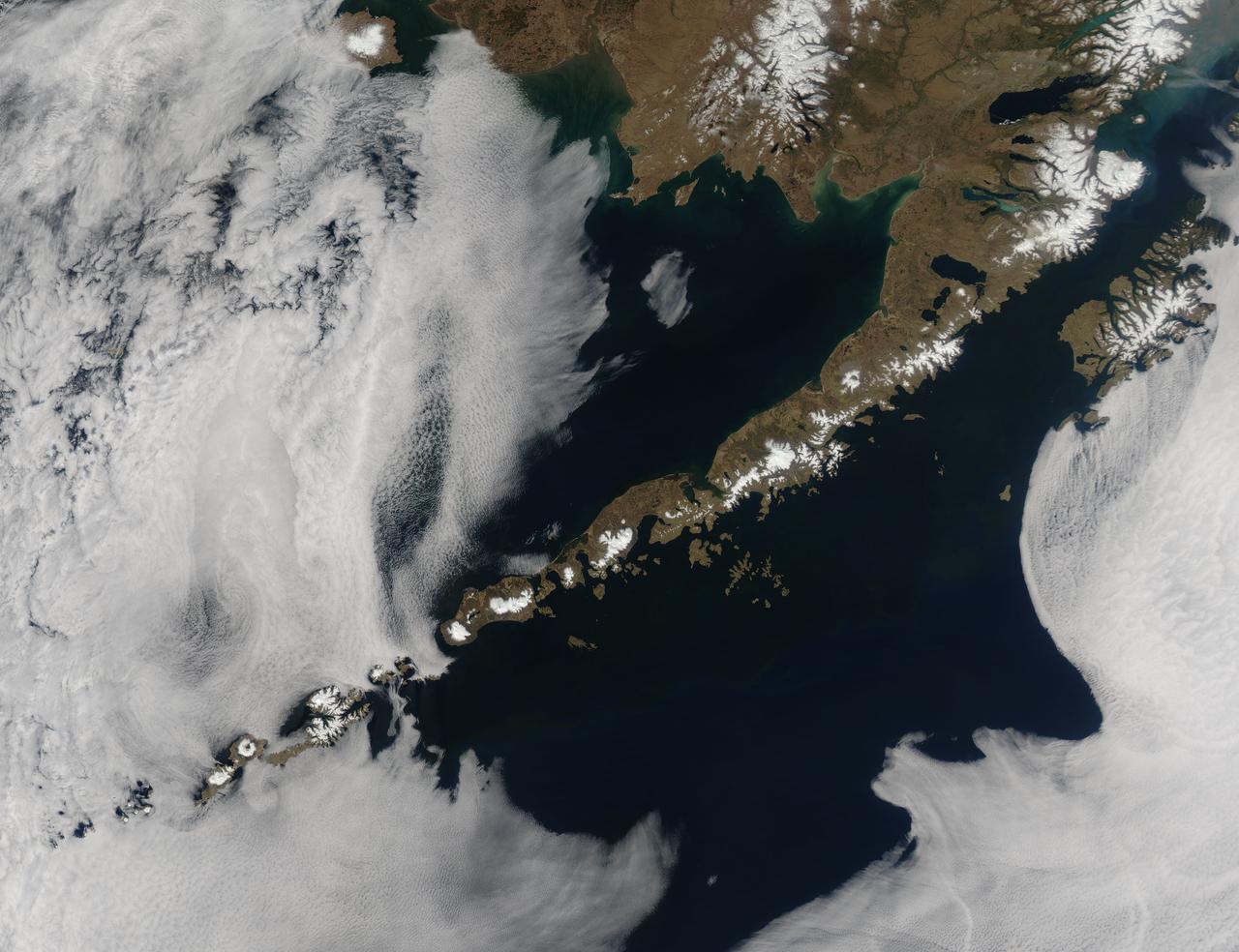
Remote, rugged and extraordinarily beautiful, Alaska’s Aleutian Islands are best known for wildlife reserves, military bases, fishing, furs and fog. The sprawling volcanic archipelago was brought into the spotlight by the Russian-supported expedition of Alexey Chirikov and Vitus Bering in 1741, and soon became controlled by the Russian-American Fur Company. In 1867 the United States purchased Alaska, including the Aleutian Islands, from Russia. By 1900 the port in Unalaska was well established as a shipping port for Alaska gold. The archipelago sweeps about 1,200 miles (1,800 km) from the tip of the Alaskan Peninsula to Attu, the most westward island. Four major island groups hold 14 large islands, about 55 smaller islands, and a large number of islets, adding up to roughly 150 islands/islets in total. This chain separates the Bering Sea (north) from the Pacific Ocean (south) and the islands are connected by the Marine Highway Ferry – at least as far as Unalaska. For the most remote islands, such as birding paradise of Attu, the western-most Aleutian Island, travel becomes trickier and relies primarily on custom charter. The Moderate Resolution Imaging Spectroradiometer (MODIS) flew over the region and captured this spectacular true-color image of the eastern Aleutian Islands on May 15, 2014. In this image, the Alaskan Peninsula protrudes from the mainland and sweeps to the southwest. The first set of islands are called the Fox Island group. Unalaska Island is part of this group and can be identified, with some imagination, as an island formed in the shape of a flying cherub, with two arms (peninsulas) outstretched towards the northeast, seemingly reaching for the round “balls” of Akutan and Akun Islands. The smallest islands in the west of the image belong to the group known as the Islands of Four Mountains. The Aleutians continue far to the west of this image. Fog surrounds the Aleutians, stretching from just off the southwestern Alaska mainland to the western Fox Islands group, then further southwest across the Pacific Ocean. It appears to give way to marine stratocumulus clouds in the west. Fog is common in the area, and can be a hazard to shipping. Credit: NASA/GSFC/Jeff Schmaltz/MODIS Land Rapid Response Team <b><a href="http://www.nasa.gov/audience/formedia/features/MP_Photo_Guidelines.html" rel="nofollow">NASA image use policy.</a></b> <b><a href="http://www.nasa.gov/centers/goddard/home/index.html" rel="nofollow">NASA Goddard Space Flight Center</a></b> enables NASA’s mission through four scientific endeavors: Earth Science, Heliophysics, Solar System Exploration, and Astrophysics. Goddard plays a leading role in NASA’s accomplishments by contributing compelling scientific knowledge to advance the Agency’s mission. <b>Follow us on <a href="http://twitter.com/NASAGoddardPix" rel="nofollow">Twitter</a></b> <b>Like us on <a href="http://www.facebook.com/pages/Greenbelt-MD/NASA-Goddard/395013845897?ref=tsd" rel="nofollow">Facebook</a></b> <b>Find us on <a href="http://instagram.com/nasagoddard?vm=grid" rel="nofollow">Instagram</a></b>

March 23, 2010 - Clouds off the Aleutian Islands Interesting cloud patterns were visible over the Aleutian Islands in this image, captured by the MODIS on the Aqua satellite on March 14, 2010. Turbulence, caused by the wind passing over the highest points of the islands, is producing the pronounced eddies that swirl the clouds into a pattern called a vortex "street". In this image, the clouds have also aligned in parallel rows or streets. Cloud streets form when low-level winds move between and over obstacles causing the clouds to line up into rows (much like streets) that match the direction of the winds. At the point where the clouds first form streets, they're very narrow and well-defined. But as they age, they lose their definition, and begin to spread out and rejoin each other into a larger cloud mass. The Aleutians are a chain of islands that extend from Alaska toward the Kamchatka Peninsula in Russia. For more information related to this image go to: <a href="http://modis.gsfc.nasa.gov/gallery/individual.php?db_date=2010-03-23" rel="nofollow">modis.gsfc.nasa.gov/gallery/individual.php?db_date=2010-0...</a> For more information about Goddard Space Flight Center go here: <a href="http://www.nasa.gov/centers/goddard/home/index.html" rel="nofollow">www.nasa.gov/centers/goddard/home/index.html</a>
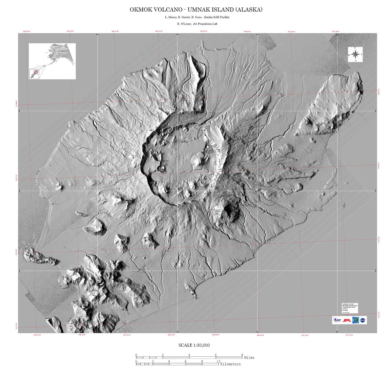
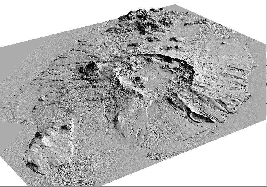
This image is a shaded relief mosaic of Umnak Island in Alaska Aleutian Islands acquired by NASA Airborne Synthetic Aperture Radar AIRSAR in 2001.
This image is a perspective view acquired by NASA Airborne Synthetic Aperture Radar AIRSAR in 2001, is of Umnak Island, one of Alaska Aleutian Islands. The active Okmok volcano appears in the center of the island.
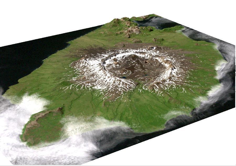
This image is a perspective view acquired by NASA Airborne Synthetic Aperture Radar AIRSAR in 2001, is of Umnak Island, one of Alaska Aleutian Islands. The active Okmok volcano appears in the center of the island.
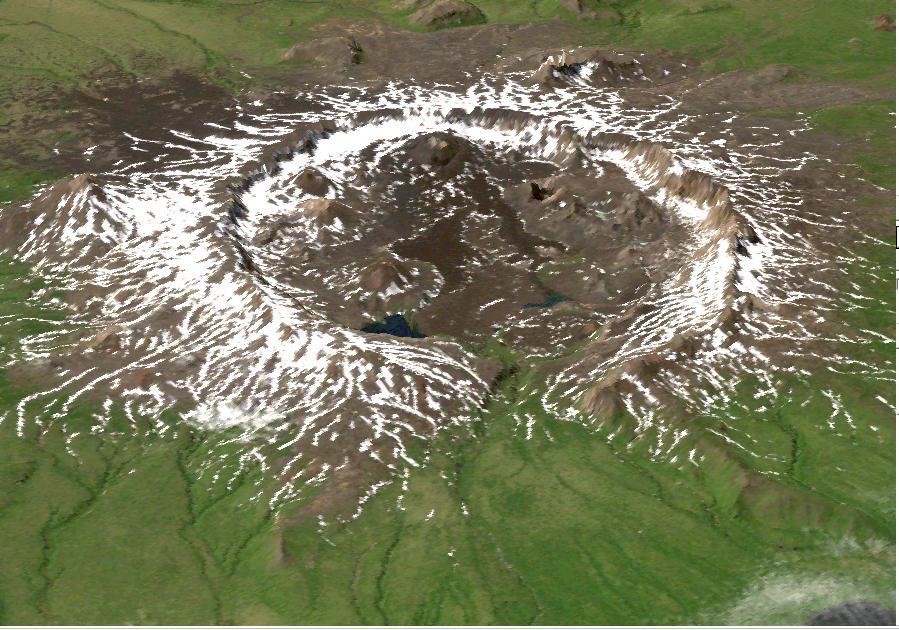
This perspective view shows the caldera of the Okmok volcano in Alaska Aleutian Islands acquired by NASA Airborne Synthetic Aperture Radar AIRSAR in 2001.
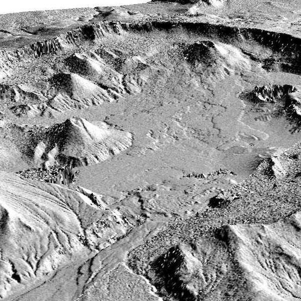
This perspective view shows the caldera of the Okmok volcano in Alaska Aleutian Islands acquired by NASA Airborne Synthetic Aperture Radar AIRSAR in 2001.

iss058e001534 (Dec. 28, 2018) --- The SpaceX Dragon cargo craft is pictured attached to the International Space Station's Harmony module as the orbital complex flew 256 miles above Alaska's Aleutian Islands in the Bering Sea.

SL4-140-4111 (14 Jan. 1974) --- The Aleutian Islands area of Alaska, as photographed from the Skylab space station in Earth orbit by one of the Skylab 4 crewmen. The camera used was a hand-held Hasselblad, with SO-368 medium-speed Ektachrome. Here is another macro scale phenomenon which is difficult to observe except from a space platform. The Aleutian Islands and clouds with very elaborate van Karman vortices was photographed on Jan. 14, 1974. In addition to the vortices the waves in the clouds due to the mountains on the islands are very evident. In fact, the easiest way to find the mountains is to start with their atmospheric disturbance and work back to the mountain. Photo credit: NASA
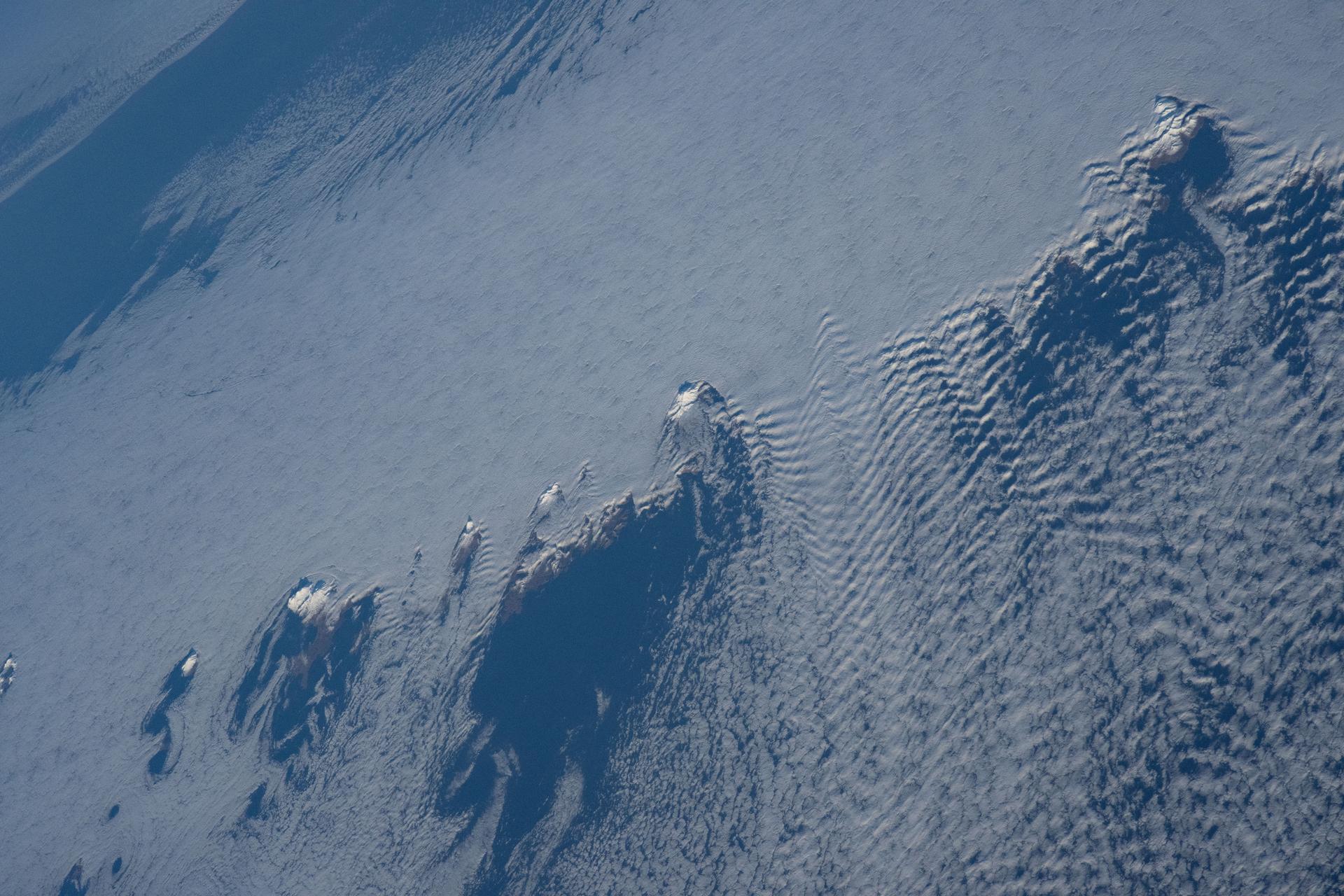
iss074e0008922 (Dec. 12, 2025) --- Snow-capped mountain tops of Alaska's Aleutian Islands pierce through the clouds, disturbing the air and creating wave-like patterns known as altocumulus clouds. This photograph was taken from the International Space Station as it orbited 264 miles above the North Pacific Ocean.

Attu, the westernmost Aleutian island, is nearly 1760 km from the Alaskan mainland and 1200 km northeast of the northernmost of the Japanese Kurile Islands. This image was acquired July 4, 2000 by NASA Terra spacecraft.
A sunset over the Aleutian Islands,with noctilucent clouds,as documented by the Expedition 36 crew. Per Twitter message: Sunrise and moonrise.
iss064e059496 (April 14, 2021) --- A cloud formation swirls in the Atlantic Ocean south of Alaska's Aleutian Islands as the International Space Station soared 265 miles above.
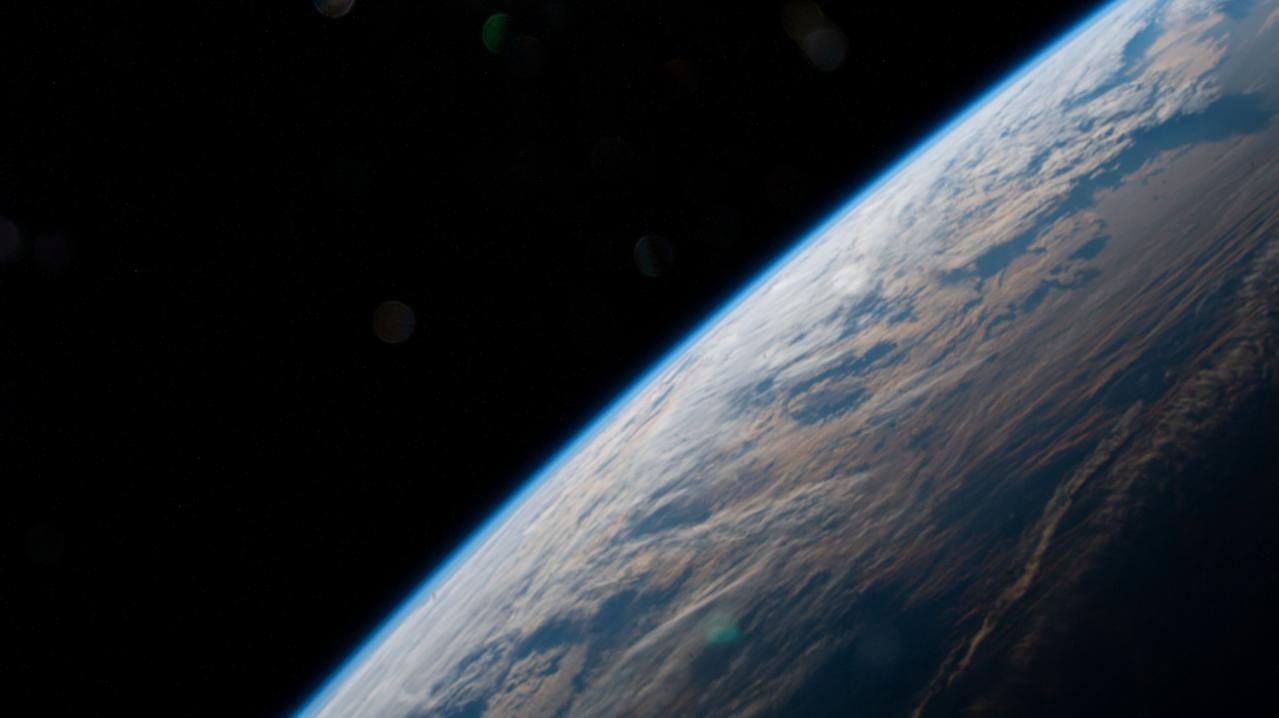
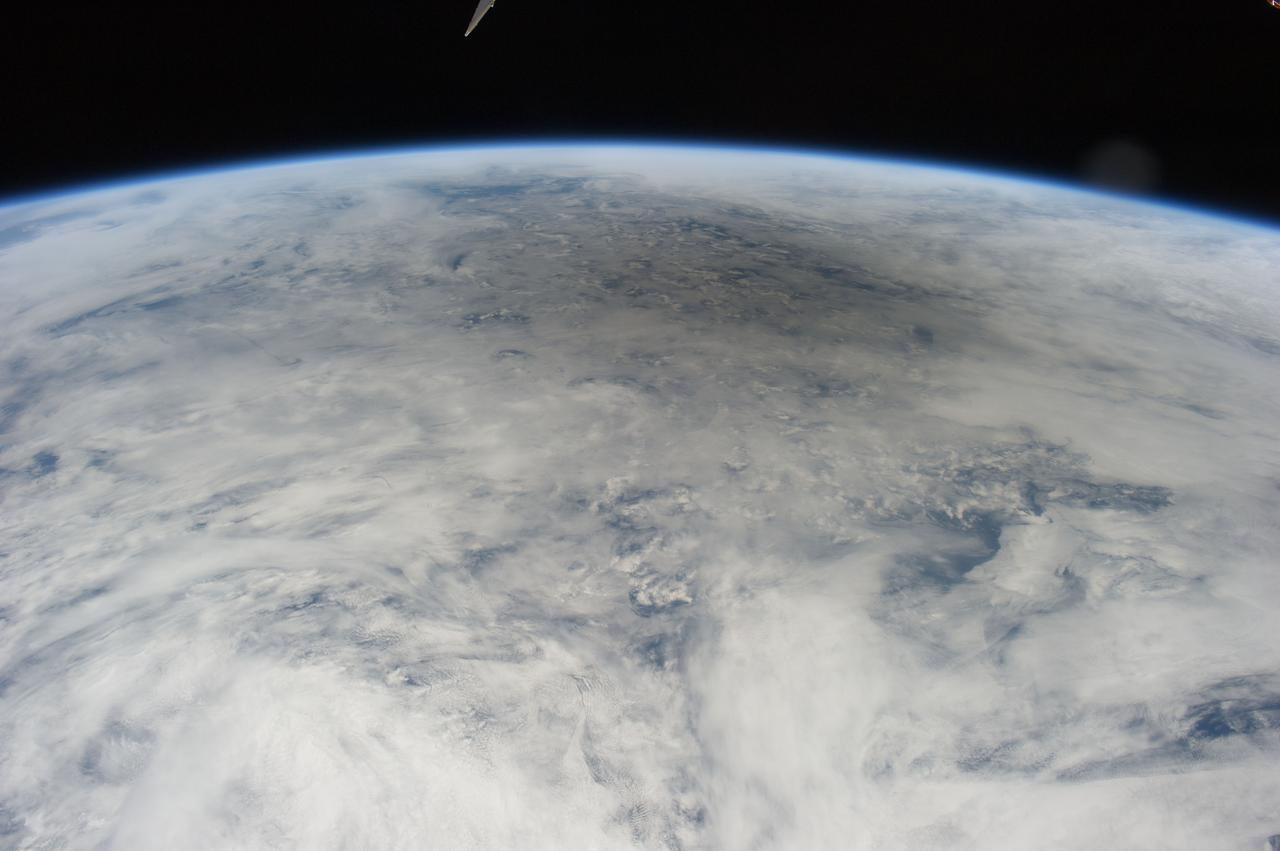
iss064e002941 (Nov. 1, 2020) --- The Earth's limb, or horizon, is pictured as the International Space Station orbited above the north Pacific near Alaska's Aleutian Islands.
The tiny Aleutian island of Bogoslof in Alaska, erupting regularly since December 2016, produced fresh activity on Sunday, May 28, 2017. Bogoslof is a stratovolcano fueled by the subduction of the Pacific Plate under the North American Plate and forms part of the larger Aleutian Arc, which includes more than 60 volcanoes on the Aleutian Islands and the Aleutian Range on the Alaska mainland. Previous to its recent period of activity, Bogoslof had last erupted in 1992, and its above-water surface area was a mere 0.11 square miles (0.29 square kilometers). As of March 11, the most recent data available, the area of the island had tripled to 0.38 square miles (0.98 square kilometers). The event on May 28 produced an ash cloud that reached 40,000 feet (12 km) in altitude, causing the Alaskan Volcano Observatory to issue a red alert for air travel in the area. Volcanic ash can cause major damage to aircraft engines, and the region is close to several major air routes between North America and Asia. On May 28, 2017, at approximately 2:23 p.m. local time, NASA's Terra satellite passed over Bogoslof, less than 10 minutes after the eruption began. MISR has nine cameras that view Earth at different angles. It takes slightly less than seven minutes for all nine cameras to view the same location on Earth. An animation made from the images from the nine MISR cameras, captured between 2:19 and 2:26 p.m., demonstrates how the angled views give a glimpse of the underside of the growing plume of volcanic ash, showing the eruption column widening into the cloud at the top. The animation is available at https://photojournal.jpl.nasa.gov/catalog/PIA21655
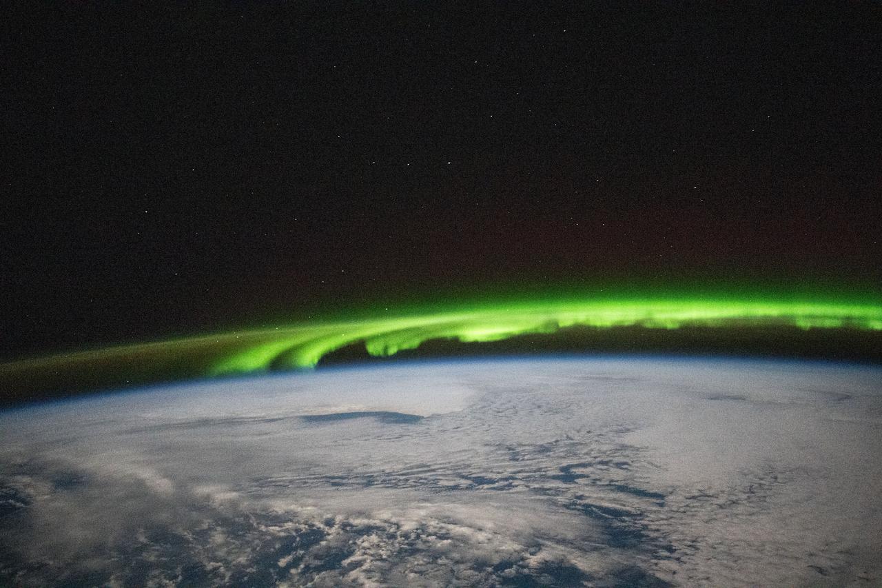
iss072e188141 (Nov. 15, 2024) --- A bright green aurora borealis streams above Earth's surface as the International Space Station orbited 269 miles above a cloudy North Pacific Ocean south of Alaska's Aleutian Islands.
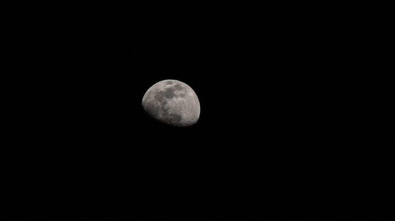
iss059e021191 (April 11, 2019) --- The moon is photographed in its waxing gibbous phase as the International Space Station orbited 256 miles above the North Pacific Ocean south of Alaska's Aleutian Islands.
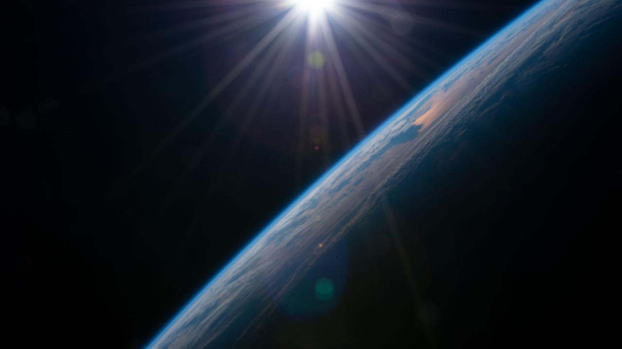
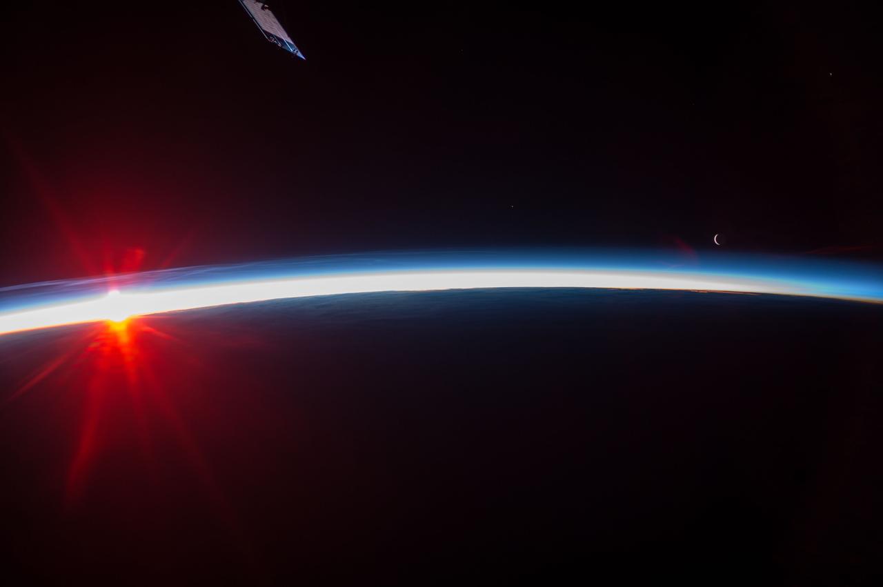
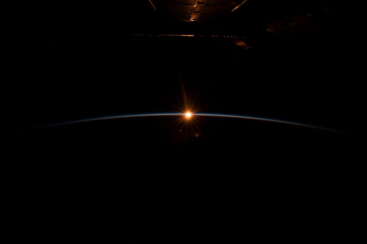
iss066e152100 (Feb. 22, 2022) --- The sun rises above the horizon illuminating the Earth in this photograph from the International Space Station as it orbited 262 above the Pacific Ocean south of Alaska's Aleutian Islands.
iss067e249774 (Aug. 9, 2022) --- The waxing gibbous Moon is pictured from the International Space Station as it orbited 260 miles above the Pacific Ocean south of Alaska's Aleutian Islands.
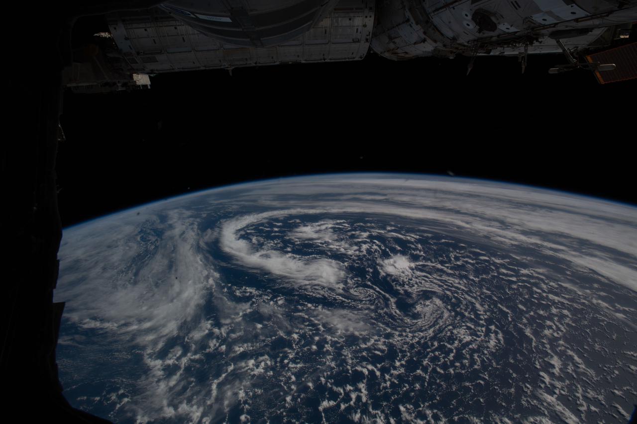
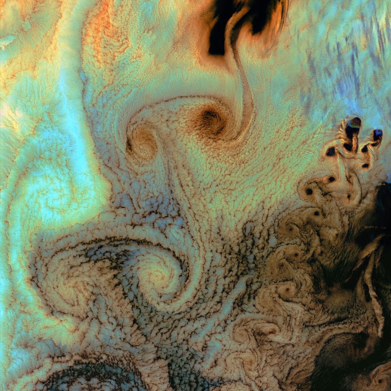
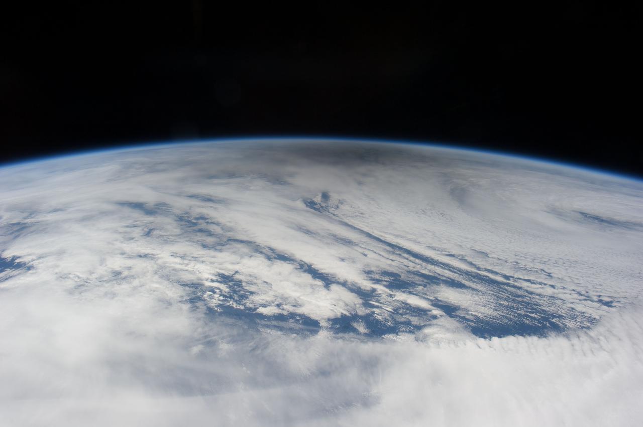
iss059e036736 (April 28, 2019) --- The International Space Station was orbiting 257 miles above the North Pacific Ocean when an Expedition 59 crewmember photographed these cloud patterns south of the Aleutian Islands.

iss069e086332 (Aug. 31, 2023) --- The Moon's image is refracted due to Earth's atmosphere in this photograph from the International Space Station as it orbited 262 miles above the Pacific Ocean south of Alaska's Aleutian islands.
iss066e152101 (Feb. 22, 2022) --- The Earth is illuminated shortly after an orbital sunrise in this photograph from the International Space Station as it orbited 262 above the Pacific Ocean south of Alaska's Aleutian Islands.
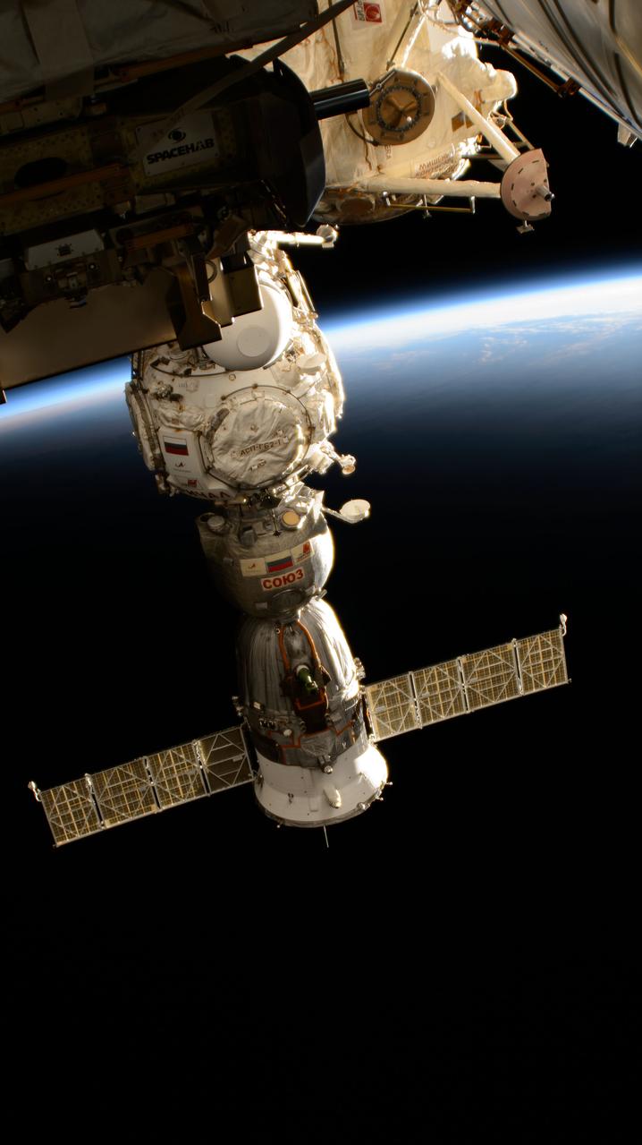
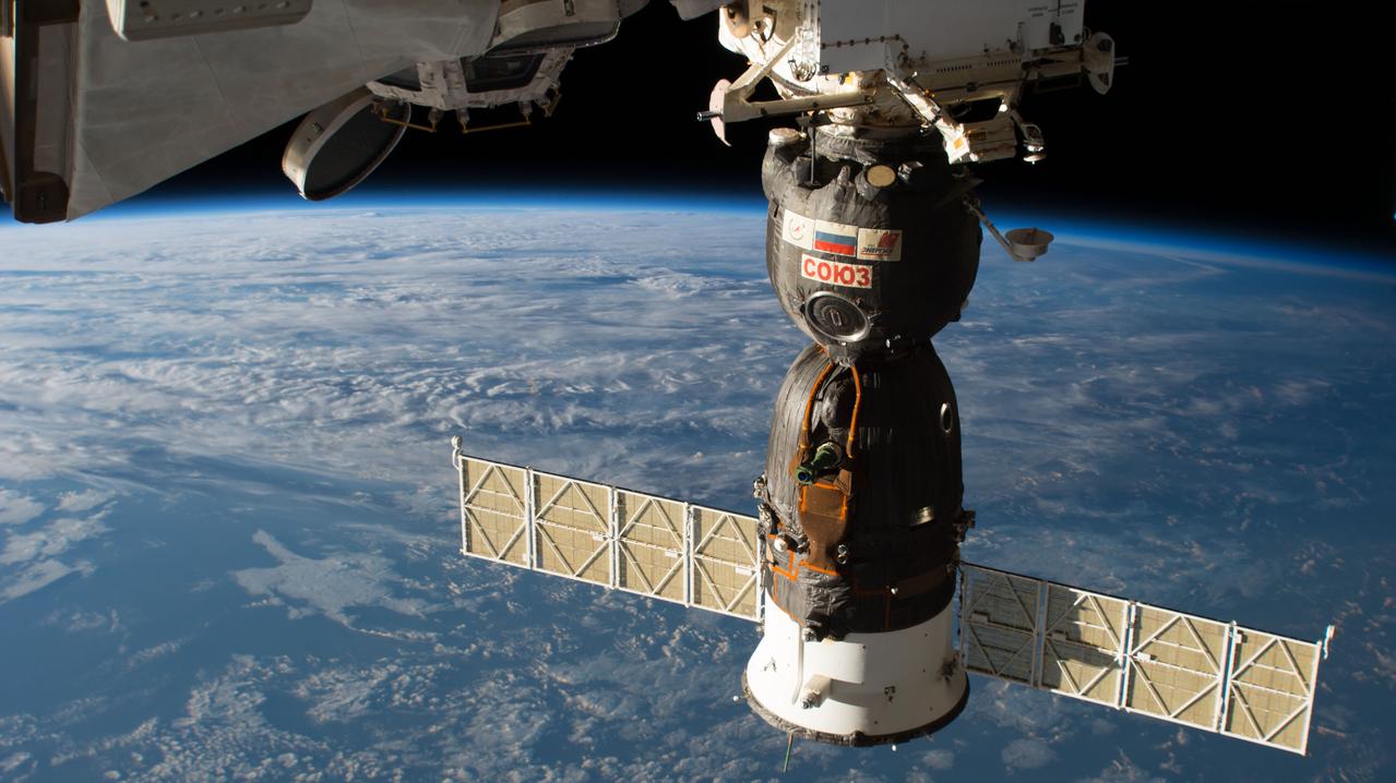
iss071e364253 (July 17, 2024) --- The Soyuz MS-25 crew ship is pictured docked to the Prichal docking module on the Roscosmos segment of the International Space Station while orbiting into a sunset 259 miles above Alaska's Aleutian Islands.
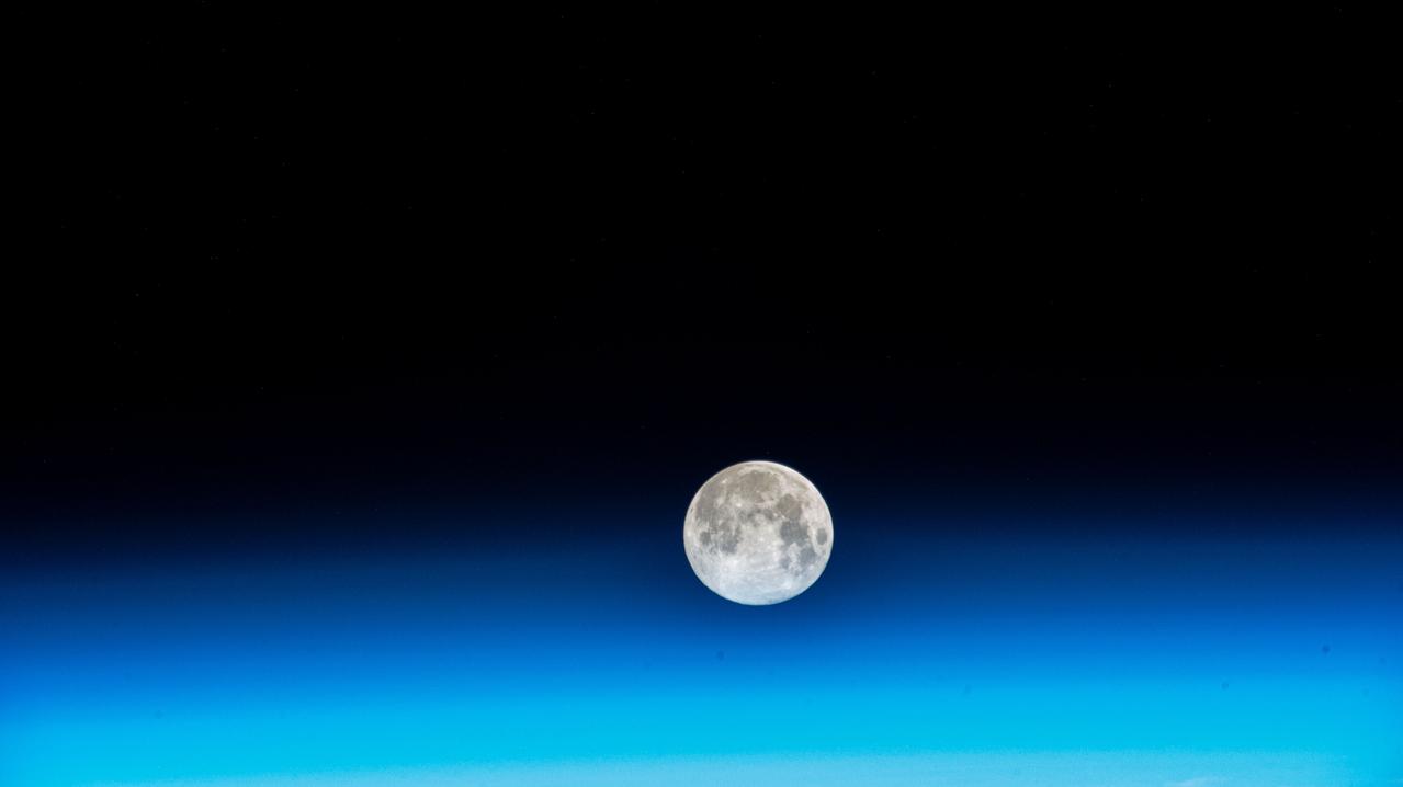
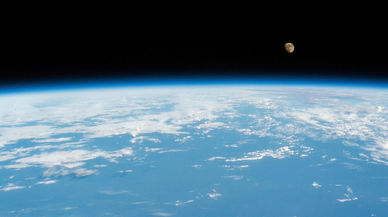
iss070e048478 (Dec. 26, 2023) --- The near Full Moon is pictured just above Earth's atmosphere in this photograph from the International Space Station as it orbited 262 miles above the north Pacific Ocean south of Alaska's Aleutian Islands.
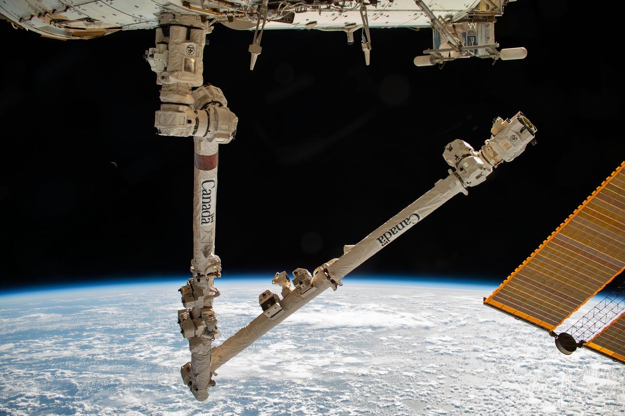
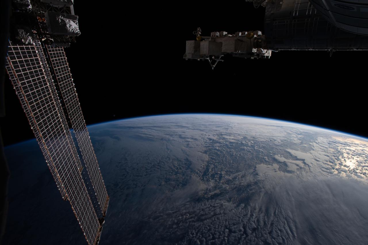
iss070e006089 (Oct. 18, 2023) --- The Canadarm2 robotic arm is pictured extending from the International Space Station while orbiting 260 miles above the Pacific Ocean near the Aleutian Islands.
iss059e039843 (May 2, 2019) --- The International Space Station was orbiting 258 miles above the Aleutian Islands when an Expedition 59 crewmember photographed the snow-capped Kiska Volcano on Kiska Island which is part of the Alaska Maritime National Wildlife Refuge.
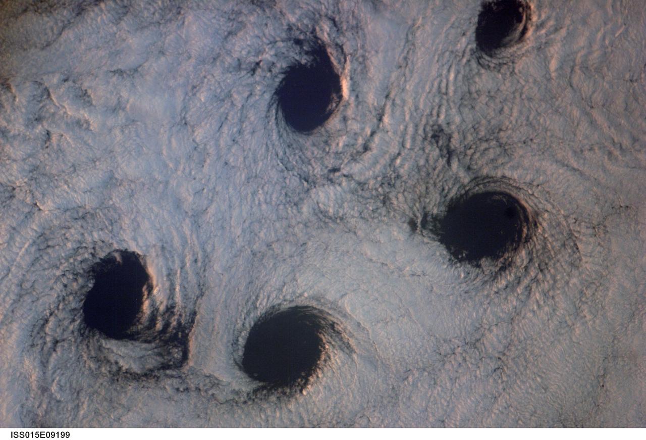
ISS015-E-09199 (23 May 2007) --- Von Karman cloud vortices near the Aleutian Islands are featured in this image photographed by an Expedition 15 crewmember on the International Space Station. The vortices are created by the wind encountering a barrier such as an island, changing direction and velocity and forming eddies in the wind and cloud pattern on the lee side of the island. The nadir point of the space station when the image was taken was 51.1 degrees north latitude and 178.8 degrees west longitude.
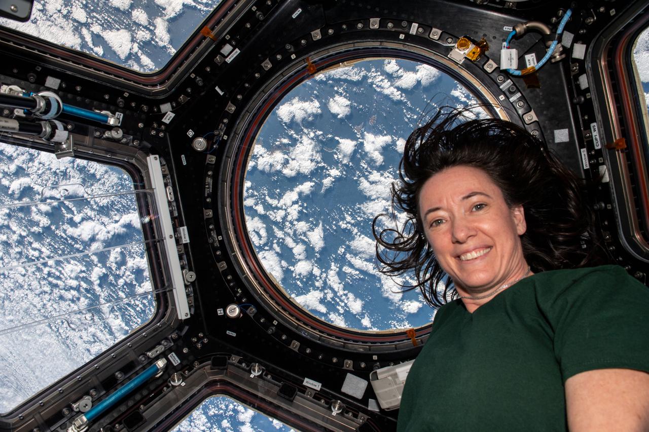
iss066e008177 (Oct. 21, 2021) --- NASA astronaut and Expedition 66 Flight Engineer Megan McArthur is pictured inside the cupola as the International Space Station orbited 263 miles above Alaska's Aleutian Islands in between the Bering Sea and the Pacific Ocean.
iss056e159412 (Aug. 29, 2018) --- The Soyuz MS-09 spacecraft is pictured docked to the Rassvet module on the Russian segment of the International Space Station as the orbital complex was flying 253 miles above the North Pacific Ocean south of Alaska's Aleutian Islands.
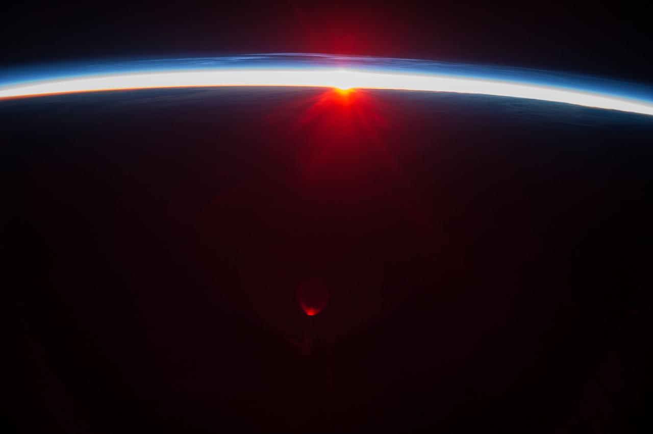
iss068e038496 (Dec. 31, 2022) --- The first rays of an orbital sunrise begin to illuminate the Earth's atmosphere and reflect off the Earth-facing portion of the International Space Station as it orbited 263 miles above the northern Pacific Ocean south of Alaska's Aleutian Island's.

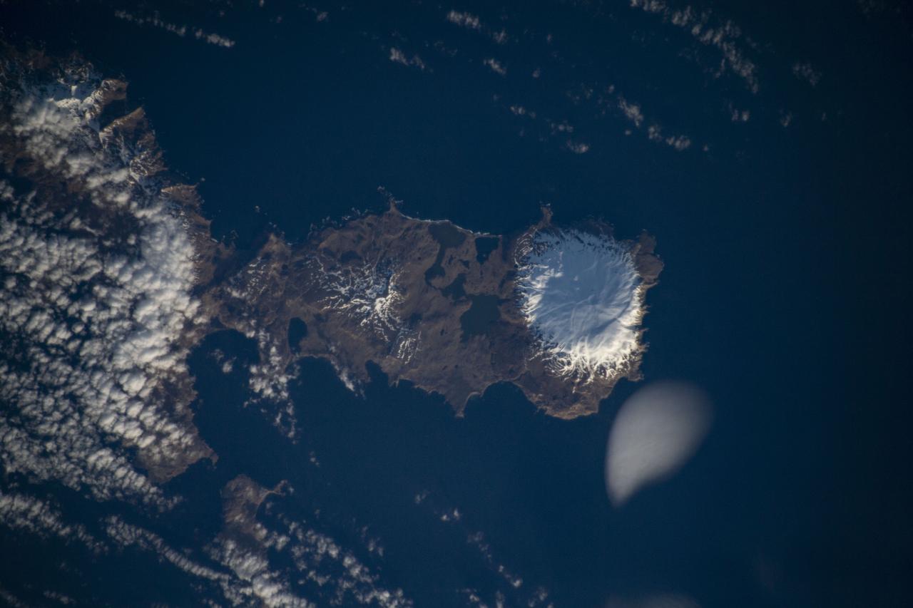
ISS038-E-003612 (15 Nov. 2013) --- Islands of the Four Mountains are featured in this image photographed by an Expedition 38 crew member on the International Space Station. Morning sunlight illuminates the southeast-facing slopes of the islands in the photograph. The islands, part of the Aleutian Island chain, are actually the upper slopes of volcanoes rising from the sea floor; Carlisle, Cleveland, Herbert, and Tana. Carlisle and Herbert volcanoes are distinct cones and form separate islands. Cleveland volcano and the Tana volcanic complex form the eastern and western ends respectively of Chuginadak Island; a cloud bank obscures the connecting land mass in this image. Cleveland volcano (peak elevation 1,730 meters above sea level) is one of the most active in the Aleutian chain, with its most recent activity--eruptions and lava flow emplacement--taking place in May of 2013. The northernmost of the islands, Carlisle volcano's (peak elevation 1,620 meters above sea level) last confirmed eruption occurred in 1828, with unconfirmed reports of activity in 1987. Herbert volcano (peak elevation 1,280 meters above sea level) to the southwest displays a classic cone structure breached by a two-kilometer wide summit caldera (upper right), but there are no historical records of volcanic activity. The easternmost peak, Tana (1,170 meters above sea level) is a volcanic complex comprised of two east-west trending volcanoes and associated younger cinder cones; like Herbert volcano, there is no historical record of activity at Tana. A layer of low clouds and/or fog obscures much of the lower elevations of the islands and the sea surface, but the clouds also indicate the general airflow pattern around and through the islands. Directly to the south-southeast of Cleveland volcano a Von Karman vortex "street" is visible. Shadows cast by the morning sun extend from the peaks towards the northwest. The peaks of all of the Four Islands have snow cover; this is distinct from the clouds due to both higher brightness (white versus gray) and specific location on the landscape.
July 4th, 2002: Description: As air flows over and around objects in its path, spiraling eddies, known as Von Karman vortices, may form. The vortices in this image were created when prevailing winds sweeping east across the northern Pacific Ocean encountered Alaska’s Aleutian Islands. Source: Landsat 7 To learn more about the Landsat satellite go to: <a href="http://landsat.gsfc.nasa.gov/" rel="nofollow">landsat.gsfc.nasa.gov/</a>

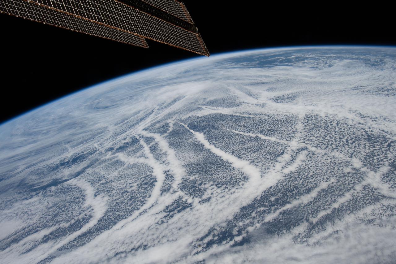
iss057e056725 (Oct. 25, 2018) --- The International Space Station was orbiting 256 miles above the North Pacific Ocean and about 600 miles south of Alaska's Aleutian Islands. In the foreground, are portions of two major space station robotic systems. At right, is the Japanese robotic manipulator system which is attached to the Kibo laboratory module. At upper left, is part of the Canadian robotic manipulator system which can maneuver along various points on the space station.

STS099-749-089 (11-22 February 2000) ---As evidenced by this 70mm frame from the Space Shuttle Endeavour, the Alaska Peninsula and Aleutian Islands form a long arc that intervenes between the Bering Sea and the northern Pacific Ocean. This view is of the snowy south coast of the peninsula, from Chignik Bay and Cape Kumliun (on the triangular peninsula) northeastward to Chiginagak Bay and David Island. Port Heiden is the darker area of little ice on the north coast. Within the rim of the Aniakchak volcanic crater (4,450 feet at highest point) the frozen waters of Surprise Lake are visible. The North American and Pacific tectonic plates are converging in this region at a rate of about 5 centimeters a year. The Pacific plate descends beneath North America, producing a deep trench along the south coast; the Aleutian Trench reaches depths greater than 25,000 ft. In such regions (subduction zones) volcanoes form on the overriding plate -- the North American plate in this instance; Aniakchak is one of the many young volcanoes in this arc.
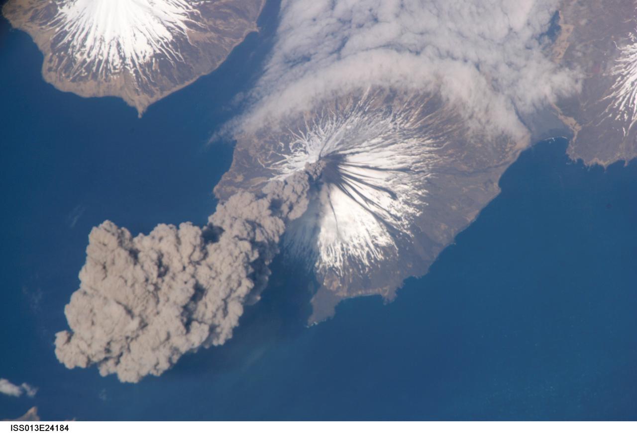
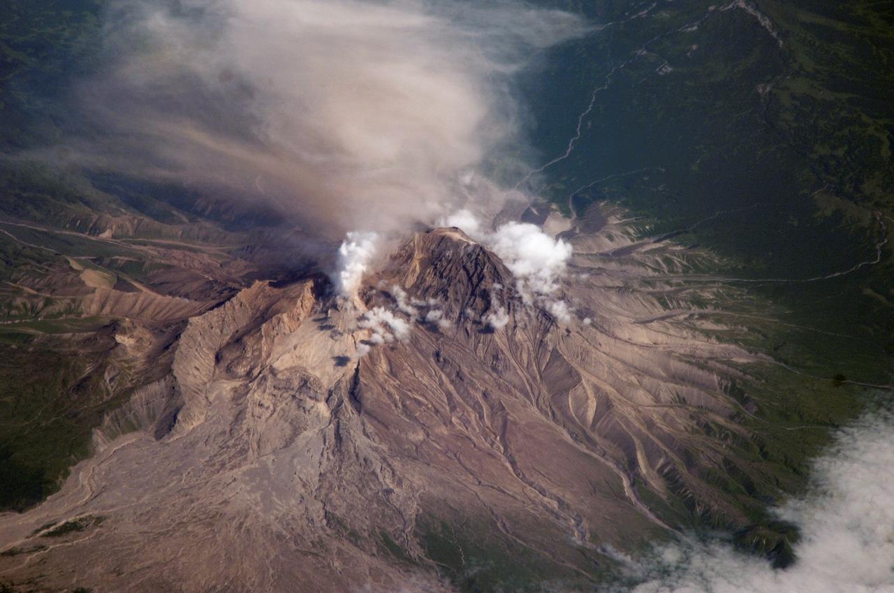
ISS013-E-24184 (23 May 2006) --- Eruption of Cleveland Volcano, Aleutian Islands, Alaska is featured in this image photographed by an Expedition 13 crewmember on the International Space Station. This most recent eruption was first reported to the Alaska Volcano Observatory by astronaut Jeffrey N. Williams, NASA space station science officer and flight engineer, at 3:00 p.m. Alaska Daylight Time (23:00 GMT). This image, acquired shortly after the beginning of the eruption, captures the ash plume moving west-southwest from the summit vent. The eruption was short-lived; the plume had completely detached from the volcano summit two hours later.
ISS036-E-028913 (4 Aug. 2013) --- A sunset over the Aleutian Islands, with noctilucent clouds, is featured in this image photographed by an Expedition 36 crew member on the International Space Station. The crew member took this panoramic view looking north from the Aleutian Islands when the space station was flying east at ?the top of the orbit,? the northernmost latitude reached by the orbital complex (51.6 degrees north). If the sun had been higher, the string of Aleutian Islands would have been visible in the foreground. Here the islands are on the dark side of the day-night line. From their vantage point at 222 kilometers altitude on this day, crew members were able to see as far north as the Arctic Ocean and the midnight sun. This image was taken just 20 minutes after local midnight in early August 2013. The midnight sun makes the red, diamond-shaped teardrop reflection (lower center)?perhaps a reflection within the camera lens, or from the window frame, or some item inside the ISS. Long blue-white stringers can be seen in the atmosphere above the midnight sun. These are known as noctilucent clouds (night-shining clouds). Some crew members say these wispy, rippling, iridescent clouds are the most beautiful phenomena they see from orbit. Noctilucents are thin so that they are best seen after sunset when the viewer is on the night side of the day-night line, but while these high clouds are still lit by the sun. Crews are trained in this somewhat complicated geometry?of clouds being lit from beneath, with the spacecraft in sunlight though the ground directly beneath is in darkness. Noctilucent clouds are also known as polar mesospheric clouds (PMCs) as they appear in the summer hemisphere over polar latitudes. Some data suggest that they are becoming brighter, and appearing at lower latitudes, perhaps as an effect of global warming. A comparison of noctilucent cloud formation from 2012 and 2013 has been compiled using data from NASA?s Aeronomy of Ice in the Mesosphere (AIM) shows an earlier start and an increase in the area covered by these clouds in 2013. Polar mesospheric clouds are interesting to scientists because they form much higher in the atmosphere (75-90 kilometers) compared with altitudes of normal rainclouds that form in the lowest, densest ?weather-layer? below approximately 15 kilometers. The weather layer, or troposphere, is most distinct in this image as a thin orange line along the left horizon.
ISS031-E-041657 (20 May 2012) --- Photographed by the Expedition 31 crew aboard the International Space Station and easily spotted at top center in this image is the smoky gray shadow of the moon, cast on bright clouds of the northern Pacific Ocean. The eclipse is seen obliquely, with its center more than 1600 kilometers away, so it appears as a flattened circle. Images taken three minutes earlier near the point of closest approach (slightly more than 600 kilometers) to the track of the eclipse, show the shadow as a rounder shape. The crew onboard the station looked due north towards the Aleutian Islands, where the solar eclipse was near total. Twenty-three minutes later, as they approached Antarctica in the other hemisphere, the crew members saw the sun set as they passed onto the dark side of the planet. The edge of the shadow looks diffused because of the partial eclipse zone—the wide area where more or less of the sun can be seen around the edge of the moon. The zone of partial eclipse covers a far wider area than the area covered by the total eclipse.
ISS015-E-16913 (10 July 2007) --- Shiveluch Volcano, Kamchatka, Russian Far East is featured in this image photographed by an Expedition 15 crewmember on the International Space Station. Shiveluch is one of the biggest and most active of a line of volcanoes along the spine of the Kamchatka peninsula in easternmost Russia. In turn the volcanoes and peninsula are part of the tectonically active "Ring of Fire" that almost surrounds the Pacific Ocean, denoted by active volcanoes and frequent earthquakes. Shiveluch occupies the point where the northeast-trending Kamchatka volcanic line intersects the northwest-trending Aleutian volcanic line. Junctions such as this are typically points of intense volcanic activity. According to scientists, the summit rocks of Shiveluch have been dated at approximately 65,000 years old. Lava layers on the sides of the volcano reveal at least 60 major eruptions in the last 10,000 years, making it the most active volcano in the 2,200 kilometer distance that includes the Kamchatka peninsula and the Kuril island chain. Shiveluch rises from almost sea level to well above 3,200 miles (summit altitude 3,283 miles) and is often capped with snow. In this summer image however, the full volcano is visible, actively erupting ash and steam in late June or early July, 2007. The dull brown plume extending from the north of the volcano summit is most likely a combination of ash and steam (top). The two larger white plumes near the summit are dominantly steam, a common adjunct to eruptions, as rain and melted snow percolate down to the hot interior of the volcano. The sides of the volcano show many eroded stream channels. The south slope also reveals a long sloping apron of collapsed material, or pyroclastic flows. Such debris flows have repeatedly slid down and covered the south side of the volcano during major eruptions when the summit lava domes explode and collapse (this occurred during major eruptions in 1854 and 1964). Regrowth of the forest on the south slope (note the contrast with the eastern slope) has been foiled by the combined effects of continued volcanic activity, instability of the debris flows and the short growing season.
ISS031-E-041635 (20 May 2012) --- Photographed by the Expedition 31 crew aboard the International Space Station and easily spotted at top center in this image is the gray shadow of the moon, cast on bright clouds of the northern Pacific Ocean, as the May 20 solar eclipse point tracked towards the Aleutian Islands and then on to northern California. The eclipse is seen obliquely so it appears as a flattened circle. The eclipse was visible for about 3.5 hours, and since the ISS orbits Earth every 90 minutes there was a chance that the ISS crew would see (if not the total eclipse by looking directly overhead), some evidence at least in the form of a partial eclipse. Only since the start of human spaceflight could such an image have been shot, looking back at the moon’s shadow projected against Earth. As it happened, say NASA scientists, the timing was almost as good as if it had been planned. The space station passed “behind” the eclipse on May 20, that is, the shadow of the eclipse passed the point in the Northwest Pacific Ocean only three minutes before the station crossed the same point. But the crew was still able to see the densest part of the shadow a little more than 600 kilometers to the northeast of their position when they shot this photograph. The edge of the shadow looks diffused because of the partial eclipse zone—the wide area where more or less of the sun can be seen around the edge of the moon. The zone of partial eclipse covers a far wider area than the area covered by the total eclipse. Twenty-six minutes later, as they approached Antarctica in the other hemisphere, the six-member crew saw the sun set as they passed onto the dark side of the planet.