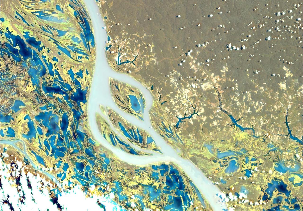
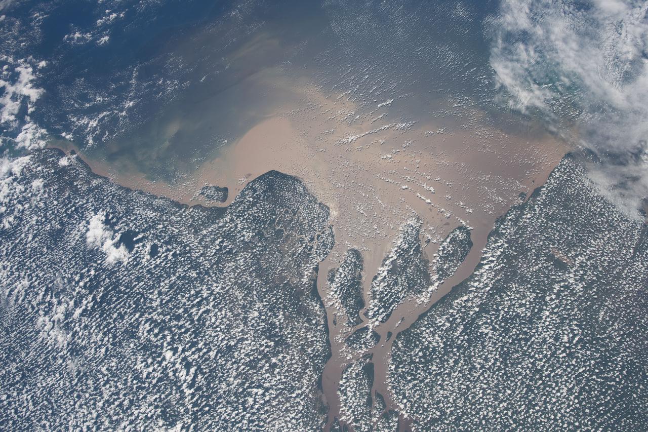
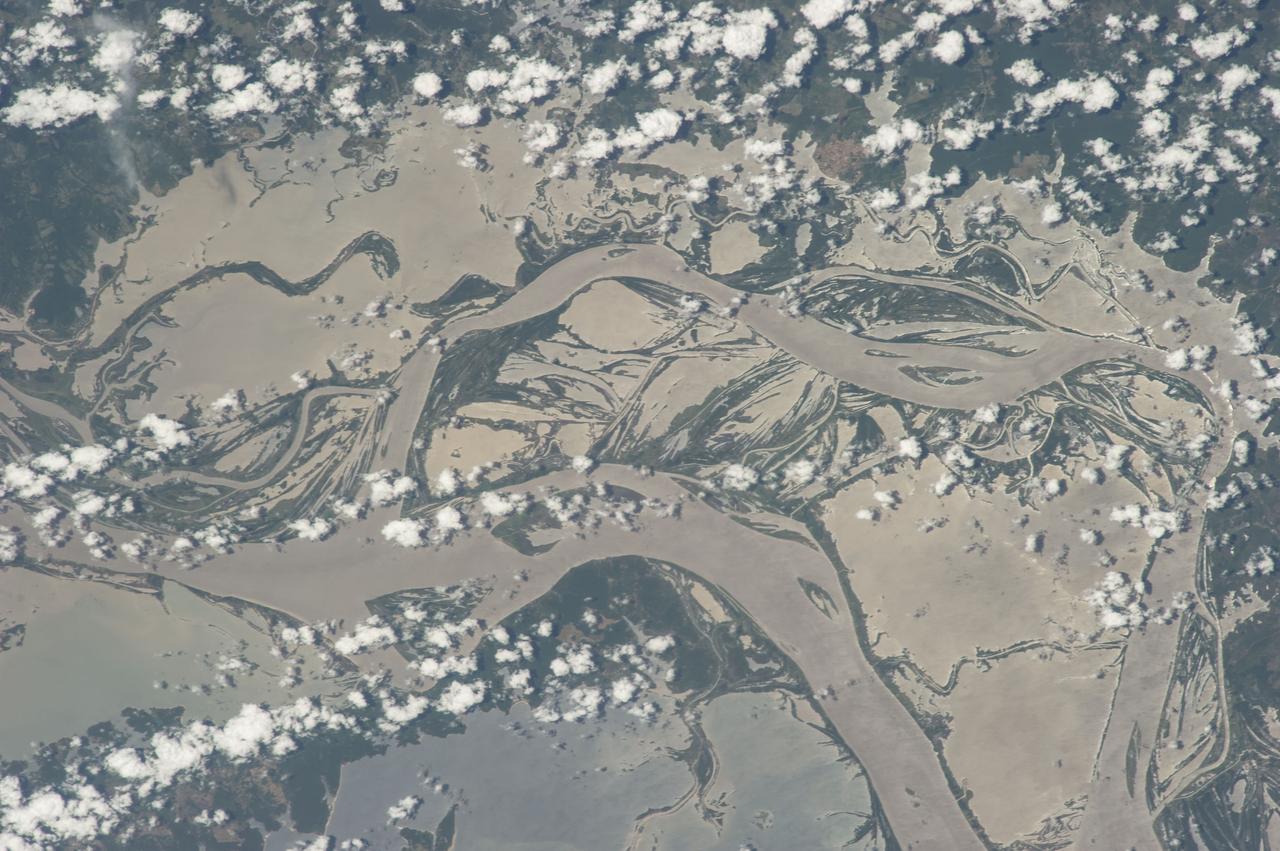
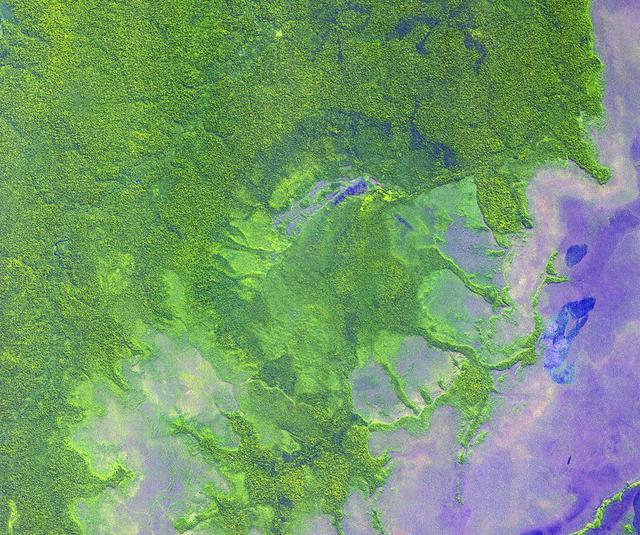
This view shows the confluence of the Amazon and the Topajos Rivers at Santarem, Brazil (2.0S, 55.0W). The Am,azon flows from lower left to upper right of the photo. Below the river juncture of the Amazon and Tapajos, there is considerable deforestation activity along the Trans-Amazon Highway.

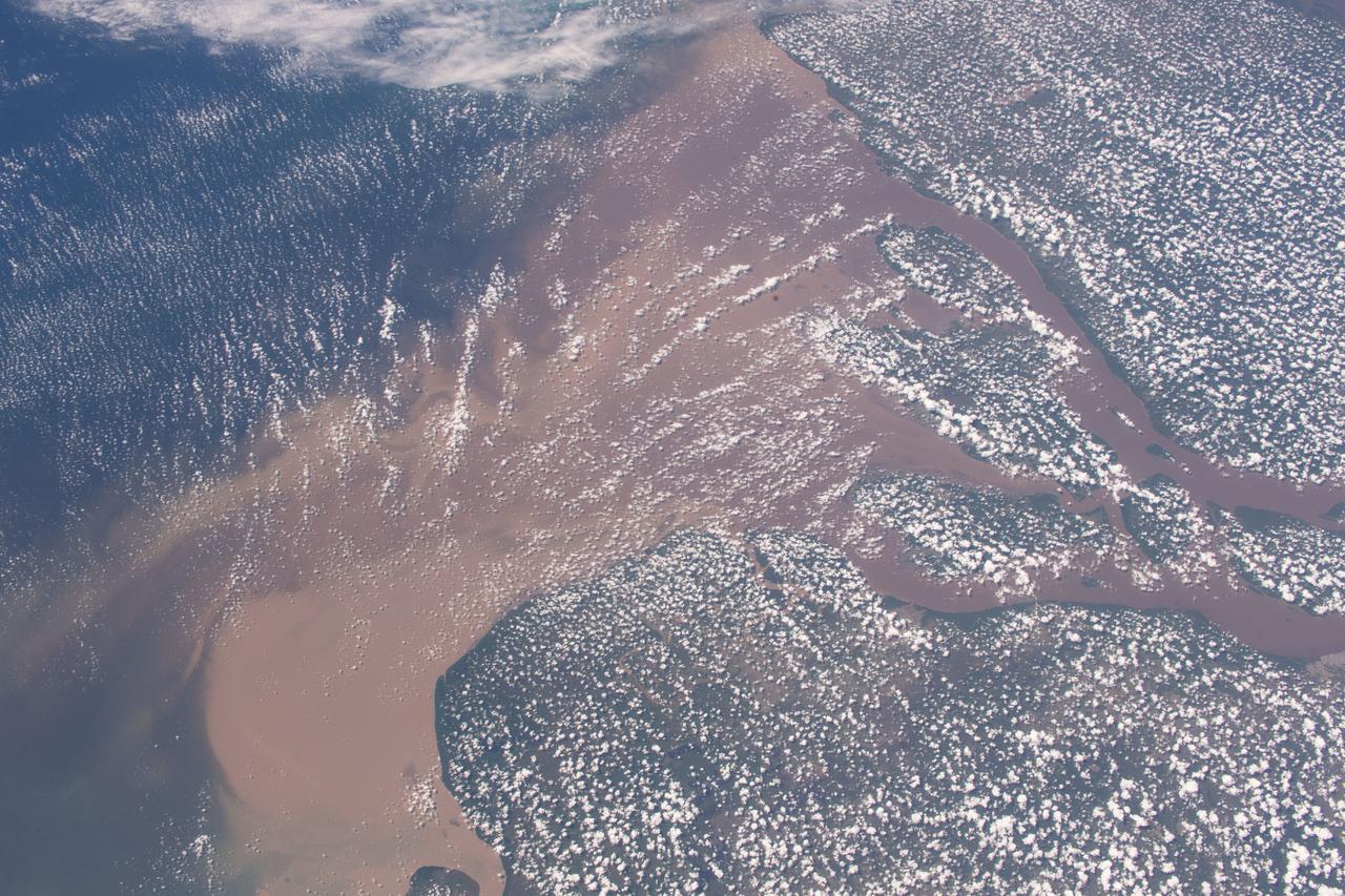
A severe drought in the Amazon is disrupting transportation, isolating communities and putting wildlife at risk. The Amazon and its tributaries, including the Rio Negro that joins the Amazon at Manaus (2023 image), fell to their lowest level in over a century. The images were acquired October 9, 2023 and August 15, 2020. They cover an area of 30 by 45 km, and are located at 2.8 degrees south, 60.7 degrees west. https://photojournal.jpl.nasa.gov/catalog/PIA26196
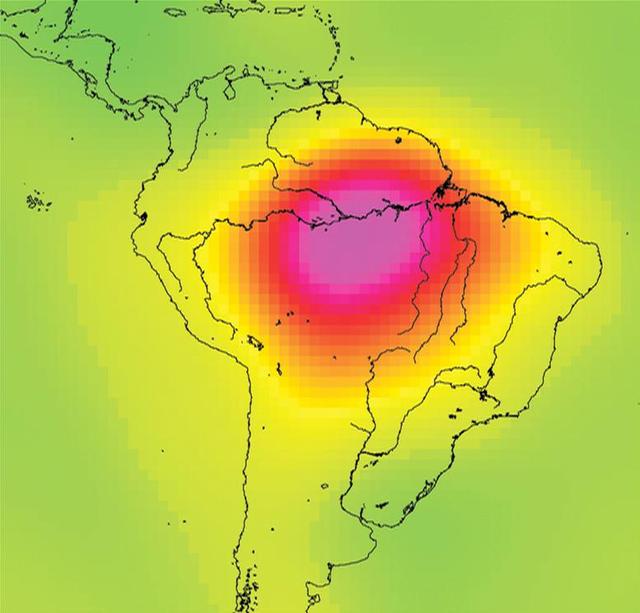
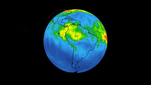
This image is from data taken by NASA Gravity Recovery and Climate Experiment showing the Amazon basin in South America. The amount of water stored in the Amazon basin varies from month to month. Animations are available at the Photojournal.
Flowing over 6450 kilometers eastward across Brazil, the Amazon River originates in the Peruvian Andes as tiny mountain streams that eventually combine to form one of the world mightiest rivers as shown in this image from NASA Terra satellite.
El Niño conditions in 2015 and early 2016 altered rainfall patterns around the world. In the Amazon, El Niño reduced rainfall during the wet season, leaving the region drier at the start of the 2016 dry season than any year since 2002, according to NASA satellite data. Wildfire risk for the dry season months of July to October this year now exceeds fire risk in 2005 and 2010, drought years when wildfires burned large areas of Amazon rainforest, said Doug Morton, an Earth scientist at NASA’s Goddard Space Flight Center who helped create the fire forecast. "Severe drought conditions at the start of the dry season set the stage for extreme fire risk in 2016 across the southern Amazon," Morton said. The Amazon fire forecast uses the relationship between climate and active fire detections from NASA satellites to predict fire season severity during the region’s dry season. Developed in 2011 by scientists at University of California, Irvine and NASA’s Goddard Space Flight Center, the forecast model is focused particularly on the link between sea surface temperatures and fire activity. Warmer sea surface temperatures in the tropical Pacific (El Niño) and Atlantic oceans shift rainfall away from the Amazon region, increasing the risk of fires during dry season months. Read more: <a href="http://go.nasa.gov/2937ADt" rel="nofollow">go.nasa.gov/2937ADt</a> <b><a href="http://www.nasa.gov/audience/formedia/features/MP_Photo_Guidelines.html" rel="nofollow">NASA image use policy.</a></b> <b><a href="http://www.nasa.gov/centers/goddard/home/index.html" rel="nofollow">NASA Goddard Space Flight Center</a></b> enables NASA’s mission through four scientific endeavors: Earth Science, Heliophysics, Solar System Exploration, and Astrophysics. Goddard plays a leading role in NASA’s accomplishments by contributing compelling scientific knowledge to advance the Agency’s mission. <b>Follow us on <a href="http://twitter.com/NASAGoddardPix" rel="nofollow">Twitter</a></b> <b>Like us on <a href="http://www.facebook.com/pages/Greenbelt-MD/NASA-Goddard/395013845897?ref=tsd" rel="nofollow">Facebook</a></b> <b>Find us on <a href="http://instagrid.me/nasagoddard/?vm=grid" rel="nofollow">Instagram</a></b>
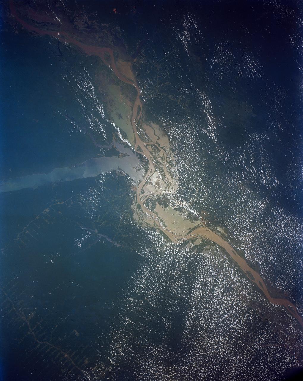
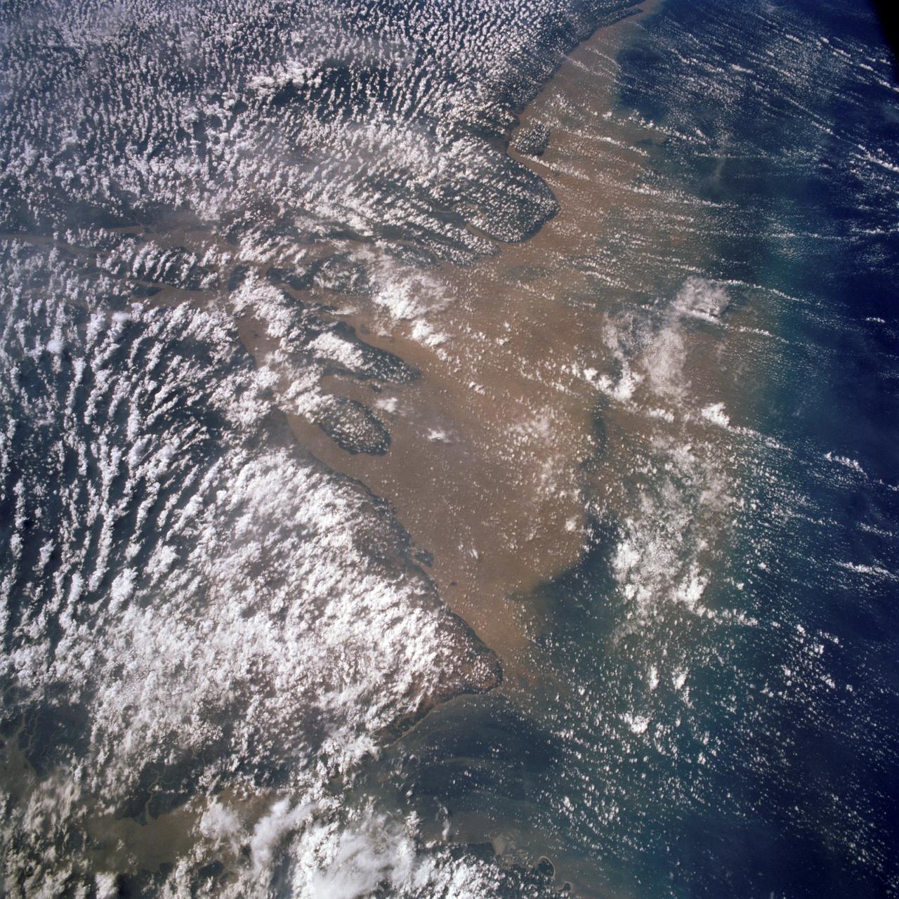
STS046-80-009 (31 July-8 Aug. 1992) --- A view of the mouth of the Amazon River and the Amazon Delta shows a large sediment plume expanding outward into the Atlantic Ocean. The sediment plume can be seen hugging the coast north of the Delta. This is caused by the west-northwest flowing Guyana Current. The large island of Marajo is partially visible through the clouds.
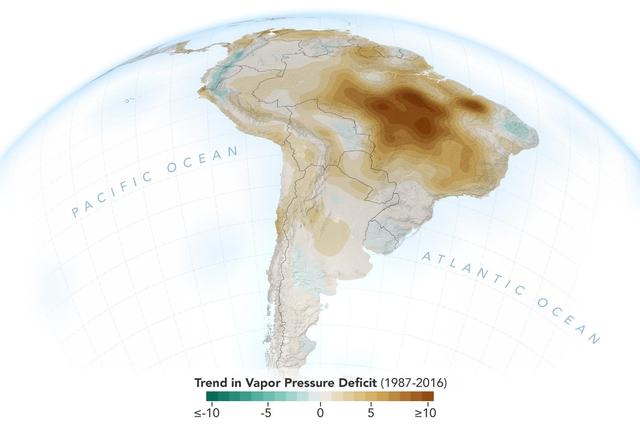
The image shows the trend of vapor pressure deficit over the Amazon rainforest during the dry season months — August through October — from 1987 to 2016. The measurements are shown in millibars — a standard unit of measure for atmospheric pressure. Vapor pressure deficit is the ratio of how much moisture is present in the atmosphere compared to how much moisture the atmosphere can hold. The trend shows the decline of moisture in the air, particularly across the south and southeastern Amazon, which is caused by a combination of human activities, including changes in land use, forest burning and its byproduct, black carbon, along with activities that have increased carbon monoxide and carbon dioxide levels in the region. https://photojournal.jpl.nasa.gov/catalog/PIA23425
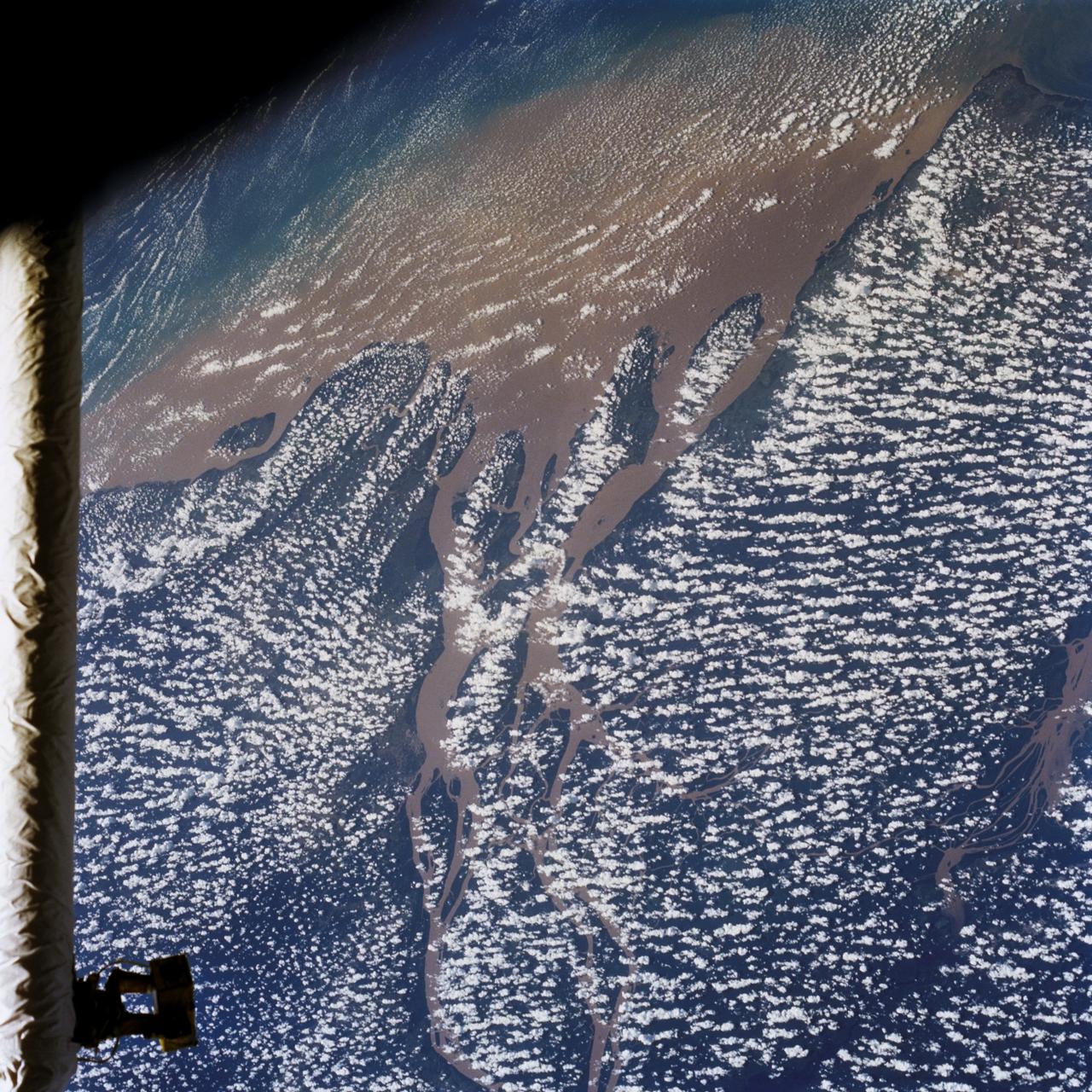
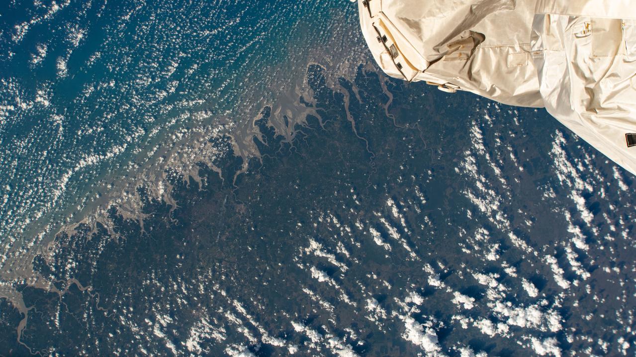
Huge sediment loads from the interior of the country flow through the Mouths of the Amazon River, Brazil (0.5S, 50.0W). The river current carries hundreds of tons of sediment through the multiple outlets of the great river over 100 miles from shore before it is carried northward by oceanic currents. The characteristic "fair weather cumulus" pattern of low clouds over the land but not over water may be observed in this scene.
iss069e033689 (July 19, 2023) -- Curves of the Amazon River are pictured from the International Space Station as it orbited 260 miles above Bolivia.
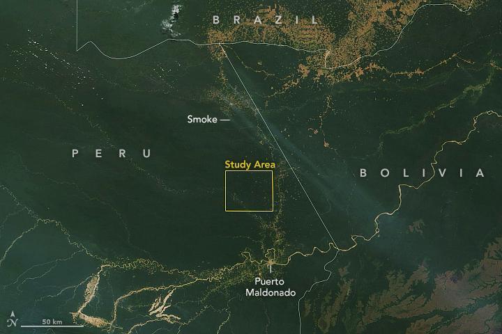
This satellite image, taken by NASA's Earth-observing Terra satellite on Aug. 18, 2019, shows the ECOSTRESS study area in the Amazon Basin and smoke from active fires in the rainforest. ECOSTRESS also captured an image of the Amazon rainforest, PIA23432, revealing water-stressed and non-stressed forest in the area. The water-stressed areas of the forest look as green and healthy as these cooler areas, making them invisible except to a radiometer that can measure thermal infrared energy from the surface. https://photojournal.jpl.nasa.gov/catalog/PIA23546
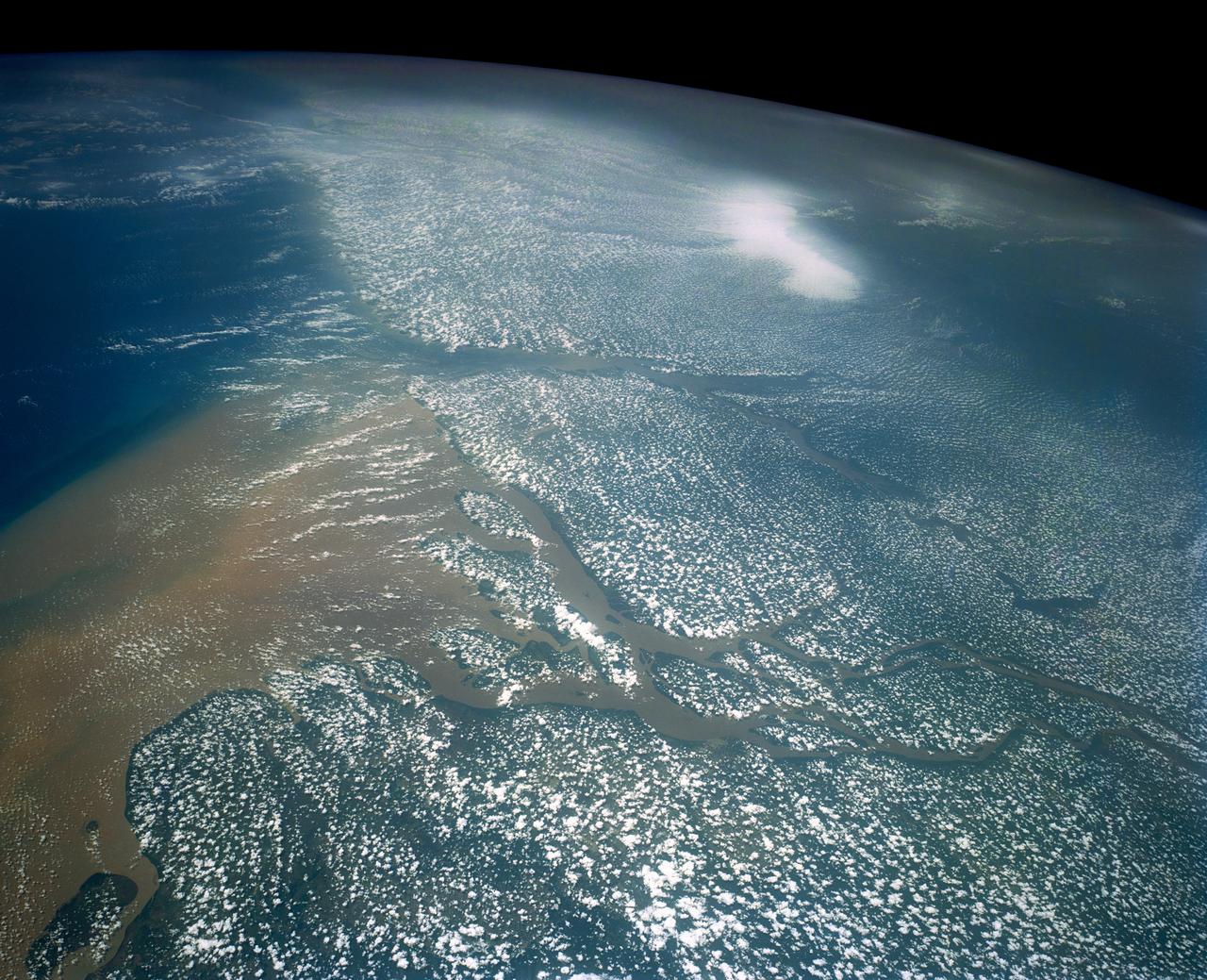
STS058-107-083 (18 Oct.-1 Nov. 1993) --- A near-nadir view of the mouth of the Amazon River, that shows all signs of being a relatively healthy system, breathing and exhaling. The well-developed cumulus field over the forested areas on both the north and south sides of the river (the view is slightly to the west) shows that good evapotranspiration is underway. The change in the cloud field from the moisture influx from the Atlantic (the cloud fields over the ocean are parallel to the wind direction) to perpendicular cloud fields over the land surface are normal. This change in direction is caused by the increased surface roughness over the land area. The plume of the river, although turbid, is no more or less turbid than it has been reported since the Portuguese first rounded Brasil's coast at the end of the 15th Century.
iss074e0492148 (April 15, 2026) --- The Ucayali River in central Peru—home to a wide array of wildlife including dolphins, manatees, reptiles, and birds—is a major tributary and main headstream of the Amazon River. The International Space Station was orbiting 264 miles above the lowland Amazon rainforest when this photograph was taken. Credit: NASA/Jessica Meir
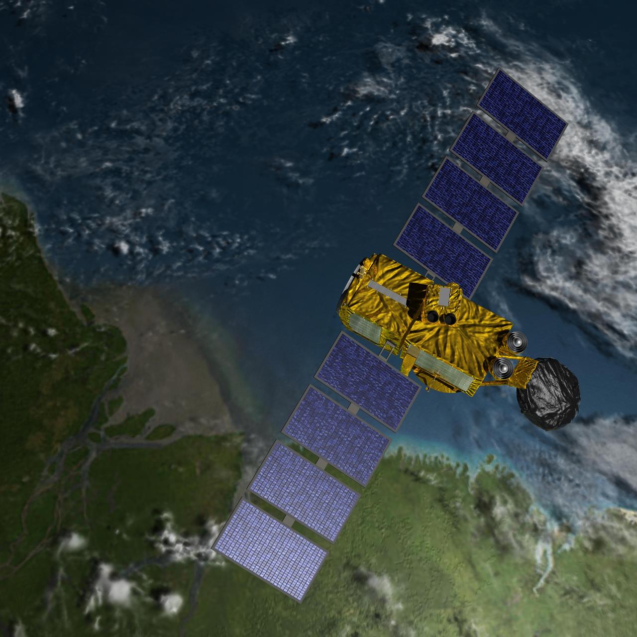
Artist concept of U.S.-European Jason-3 Ocean Altimetry Satellite over the Amazon
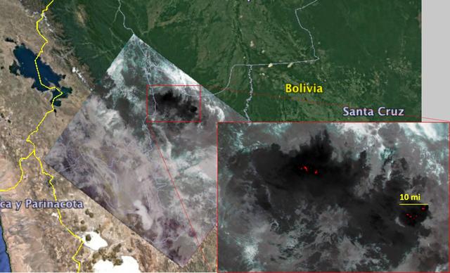
NASA's Ecosystem Spaceborne Thermal Radiometer Experiment on Space Station (ECOSTRESS) captured new imagery of fires in the Amazon regions of Brazil and Bolivia on Aug. 23, 2019. The red areas are where surface temperatures exceeded the maximum measureable temperature of the instrument's sensor (approximately 220 degrees Fahrenheit or 104 degrees Celsius), highlighting the burning areas along the fire fronts. The dark wispy areas indicate thick smoke — thick enough that it obscures much of the fire from view. The measurements cover areas of about 77 by 77 yards (70 by 70 meters) each, or about the size of a football field. https://photojournal.jpl.nasa.gov/catalog/PIA23357
What connects Earth's largest, hottest desert to its largest tropical rainforest? The Sahara Desert is a near-uninterrupted brown band of sand and scrub across the northern third of Africa. The Amazon rainforest is a dense green mass of humid jungle that covers northeast South America. But after strong winds sweep across the Sahara, a tan cloud rises in the air, stretches between the continents, and ties together the desert and the jungle. It’s dust. And lots of it. For the first time, a NASA satellite has quantified in three dimensions how much dust makes this trans-Atlantic journey. Scientists have not only measured the volume of dust, they have also calculated how much phosphorus – a natural plant fertilizer present in Saharan sands from part of the desert’s past as a lake bed – gets carried across the ocean from one of the planet’s most desolate places to one of its most fertile. <b><a href="http://www.nasa.gov/audience/formedia/features/MP_Photo_Guidelines.html" rel="nofollow">NASA image use policy.</a></b> <b><a href="http://www.nasa.gov/centers/goddard/home/index.html" rel="nofollow">NASA Goddard Space Flight Center</a></b> enables NASA’s mission through four scientific endeavors: Earth Science, Heliophysics, Solar System Exploration, and Astrophysics. Goddard plays a leading role in NASA’s accomplishments by contributing compelling scientific knowledge to advance the Agency’s mission. <b>Follow us on <a href="http://twitter.com/NASAGoddardPix" rel="nofollow">Twitter</a></b> <b>Like us on <a href="http://www.facebook.com/pages/Greenbelt-MD/NASA-Goddard/395013845897?ref=tsd" rel="nofollow">Facebook</a></b> <b>Find us on <a href="http://instagram.com/nasagoddard?vm=grid" rel="nofollow">Instagram</a></b>
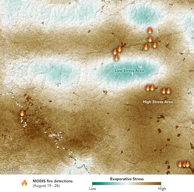
NASA's ECOsystem Spaceborne Thermal Radiometer Experiment on Space Station (ECOSTRESS) sensor measured the water-stress levels of plants when it passed over the Peruvian Amazon rainforest on Aug. 7, 2019, before the fires there began. The map shows areas of plants in distress (brown) and areas of less stress (blue). Water-stressed plants released measurably less water vapor into the air at the time of the summer fires. The fire icons represent fires imaged by NASA's Terra satellite between Aug. 19 and 26. The burn pattern reveals that the fires were concentrated in areas of highly water-stressed plants, pointing to how water-stressed plants can impact the spread of fires. The data may one day help NASA's Earth-observing missions predict the path of future forest or brush fires. https://photojournal.jpl.nasa.gov/catalog/PIA23432
S66-38191 (4 June 1966) --- The mouth of the Amazon River on the northern coast of Brazil, looking southwest, as seen from the Gemini-9A spacecraft during its 18th revolution of Earth. The image was taken with a 70mm Hasselblad camera, using Eastman Kodak, Ektachrome MS (S.O. 217) color film. Photo credit: NASA
STS058-76-041 (18 Oct-1 Nov 1993) --- Backdropped against the Peru-Bolivia border and part of the Amazon basin, the Spacelab Life Sciences (SLS-2) laboratory module was captured with a 70mm camera, by one of the seven crew members inside the Space Shuttle Columbia's cabin. Part of the tunnel-like passageway is visible in the foreground. Six NASA astronauts and a veterinarian from the private sector spent two weeks devoted to medical research in Earth-orbit. Lake Titicaca, the largest high-altitude lake in the world lies in the Altiplano of Bolivia and Peru. Space Shuttle photography has been used to document fluctuations of several meters of the level of Lake Titicaca during the past decade, as well as to document the eutrophication of the north end of the lake, which is primarily due to increased population in the Peruvian shoreline areas. This view shows the effect of abnormally heavy precipitation of the region for the third successive year. Meteorologists feel this precipitation increase, which may portend another increase of the lake level, is due to the third successive El Nino - Southern Oscillation phenomenon in the 1993 - 94 southern hemisphere summertime. This global phenomenon is now resulting in major weather disturbances in Indonesia, California, Texas and elsewhere.
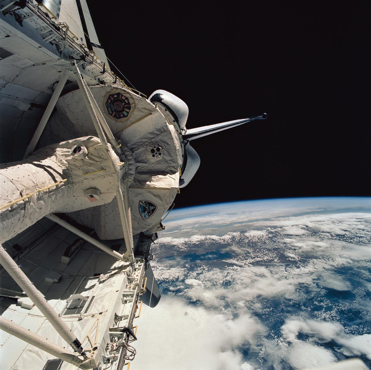
This striking image of Skylab was photographed by Astronaut Jack Lousma (Skylab-3), as the second crew reached the orbiting laboratory over the delta of the mighty Amazon River. Skylab's solar arrays were exposed directly to the Sun's rays. Solar energy was transformed into electrical power for operation of all spacecraft systems. The proper operation of these solar arrays was vital to the mission.
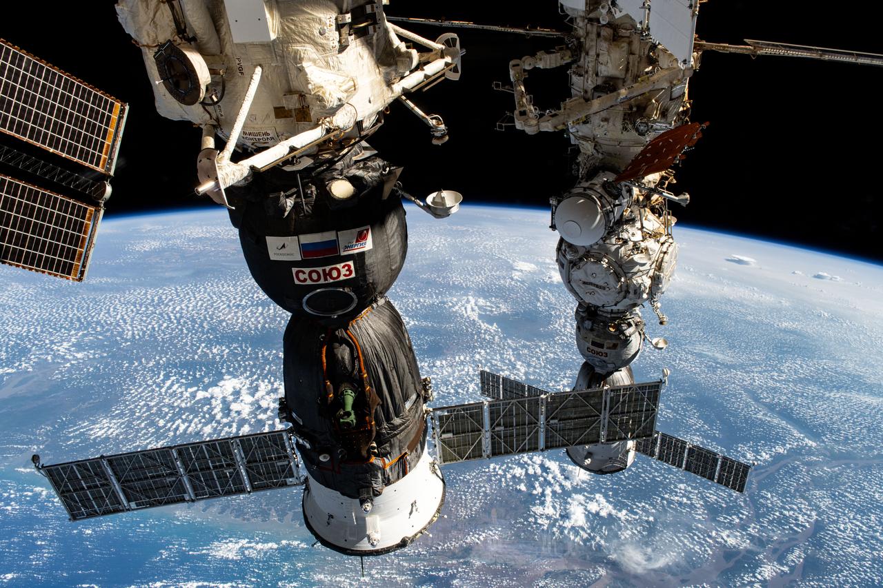
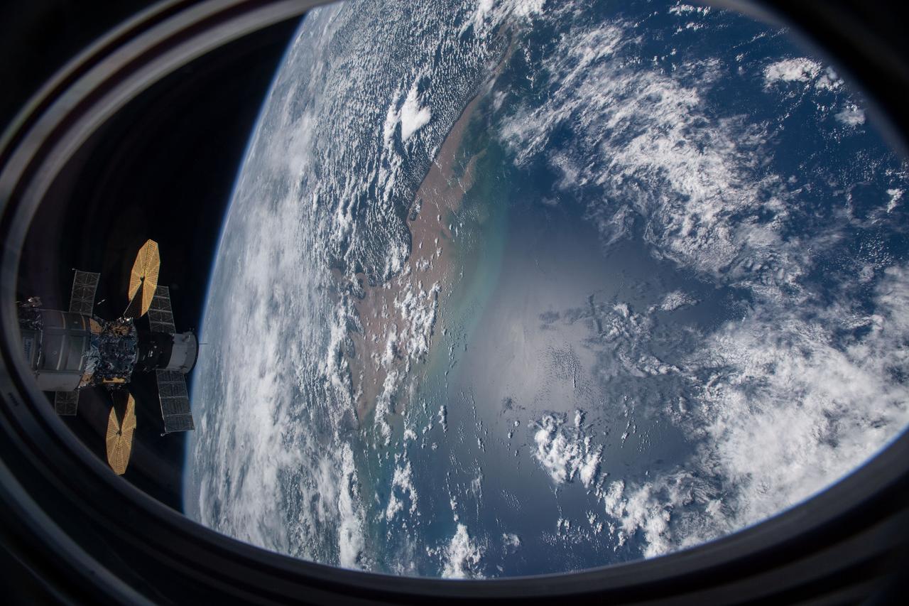
iss071e665075 (Sept. 16, 2024) --- Two Roscosmos crew ships, the Soyuz MS-26 docked to the Rassvet module (foreground) and the Soyuz MS-25 (background) docked to the Prichal docking module, are pictured parked at the International Space Station as it orbited 257 miles above the Atlantic Ocean near Brazil's Amazon Delta.
NASA's Earth Surface Mineral Dust Source Investigation (EMIT) collected this hyperspectral image of the Amazon River in the northern Brazilian state of Pará on June 30, 2024. The tan and yellow colors represent vegetated land, while the blue and turquoise hues signify water. Clouds are white. This image is part of a new dataset providing new information on global ecosystem biodiversity. EMIT, installed on the International Space Station in 2022, was originally tasked with mapping minerals over Earth's desert regions to help determine the cooling and heating effects that dust can have on regional and global climate. Since early 2024 the instrument has been on an extended mission in which its data is being used in research on a diverse range of topics including agricultural practices, snow hydrology, wildflower blooming, phytoplankton and carbon dynamics in inland waters, ecosystem biodiversity, and functional traits of forests. Imaging spectrometers like EMIT detect the light reflected from Earth and then separate visible and infrared light into hundreds of wavelength bands. Scientists use patterns of reflection and absorption at different wavelengths to determine the composition of whatever the instrument is observing. EMIT is laying the groundwork for NASA's future Surface Biology and Geology-Visible Shortwave Infrared satellite mission. SBG-VSWIR will cover Earth's land and coasts more frequently than EMIT, with finer spatial resolution. https://photojournal.jpl.nasa.gov/catalog/PIA26417
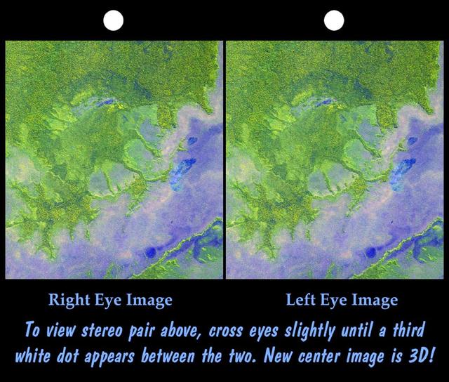
An 8-kilometer 5-mile wide crater of possible impact origin is shown in this stereoscopic view of an isolated part of the Bolivian Amazon.

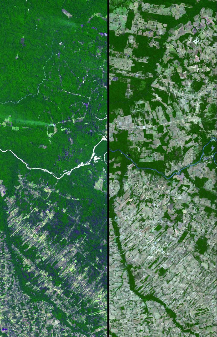
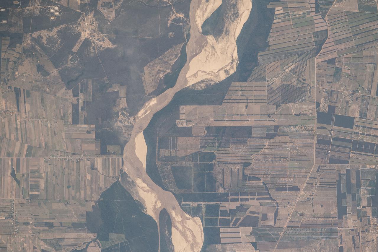
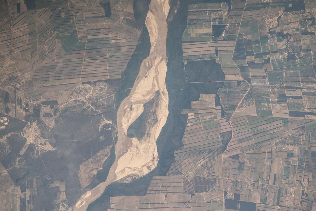
This view of deforestation in Rondonia, far western Brazil, (10.0S, 63.0W) is part of an agricultural resettlement project which ultimately covers an area about 80% the size of France. The patterns of deforestation in this part of the Amazon River Basin are usually aligned adjacent to highways, secondary roads, and streams for ease of access and transportation. Compare this view with the earlier 51G-37-062 for a comparison of deforestation in the region.
Dense green vegetation gives way to pale fields in these satellite images of deforestation in Brazil Amazon rainforest. This image is from NASA Terra satellite.

Close to the city of Manaus, Brazil the Rio Solimoes and the Rio Negro converge to form the Amazon River. This image from NASA Terra satellite was acquired on July 23, 2000 during Terra orbit 3178.
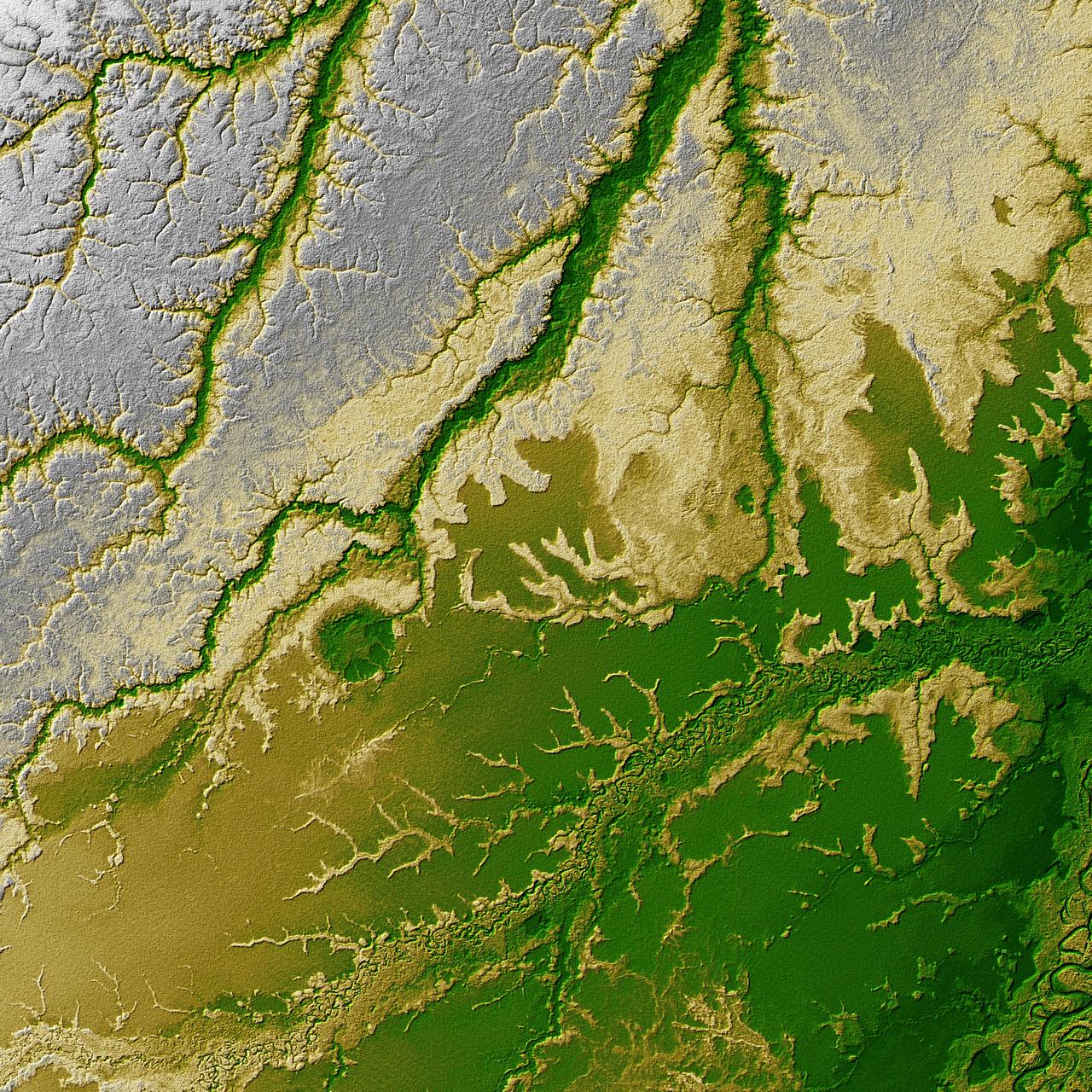
An 8-kilometer 5-mile wide crater of possible impact origin is shown in this view of an isolated part of the Bolivian Amazon from NASA Shuttle Radar Topography Mission.
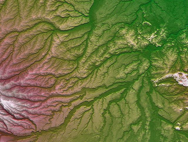
Pando Province, Bolivia, and adjacent parts of Brazil and Peru are seen in this visualization of NASA Shuttle Radar Topography Mission SRTM elevation data covering part of the Amazon Basin.
The junctions of the Amazon and the Rio Negro Rivers at Manaus, Brazil. The Rio Negro flows 2300 km from Columbia, and is the dark current forming the north side of the river. It gets its color from the high tannin content in the water. The Amazon is sediment laden, appearing brown in this simulated natural color image. Manaus is the capital of Amazonas state, and has a population in excess of one million. The ASTER image covers an area of 60 x 45 km. This image was acquired on July 16, 2000 by the Advanced Spaceborne Thermal Emission and Reflection Radiometer (ASTER) on NASA's Terra satellite. With its 14 spectral bands from the visible to the thermal infrared wavelength region, and its high spatial resolution of 15 to 90 meters (about 50 to 300 feet), ASTER will image Earth for the next 6 years to map and monitor the changing surface of our planet. http://photojournal.jpl.nasa.gov/catalog/PIA03851
GMT362_00_58_Terry Virts_chile andes central south america amazon start in mountains_123
GMT362_00_58_Terry Virts_chile andes central south america amazon start in mountains_123
GMT362_00_58_Terry Virts_chile andes central south america amazon start in mountains_123
GMT350_20_59_For Huntsville_Terry Virts_SSRMS MSG amazon south america arm movie_128
GMT362_00_58_Terry Virts_chile andes central south america amazon start in mountains_123
GMT362_00_58_Terry Virts_chile andes central south america amazon start in mountains_123

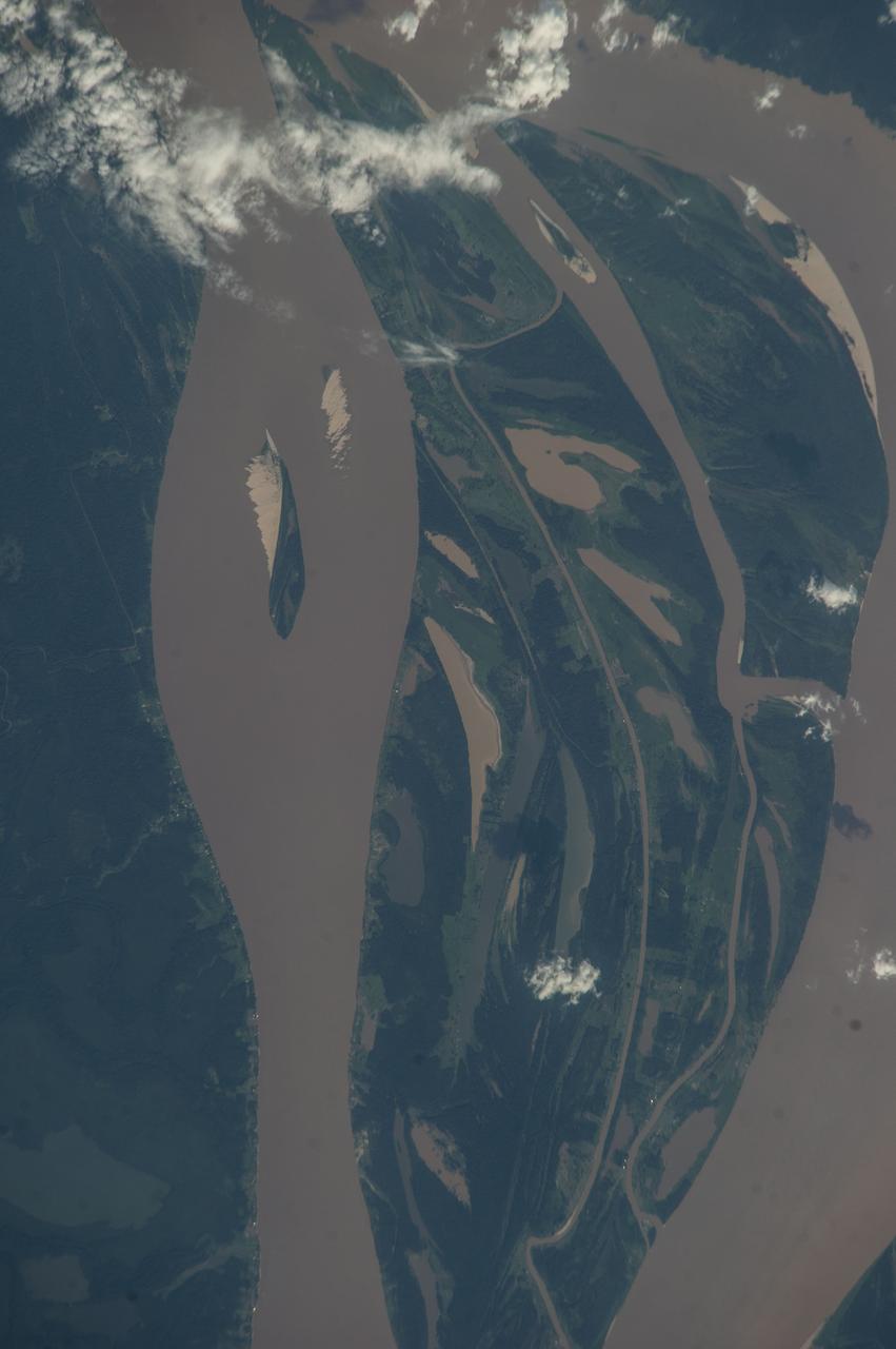
ISS017-E-013856 (19 Aug. 2008) --- Amazon River, Brazil is featured in this image photographed by an Expedition 17 crewmember on the International Space Station. This image shows the huge sunglint zone, common to oblique views from space, of the setting sun shining off the Amazon River and numerous lakes on its floodplain. About 150 kilometers of the sinuous Amazon course is shown here, as it appears about 1,000 kilometers from the Atlantic Ocean. The Uatuma River enters on the north side of the Amazon (top). A small side channel of the very large Madeira River enters the view from the left. Tupinambarama Island occupies the swampy wetlands between the Amazon and Madeira rivers. Sunglint images reveal great detail in waterbodies -- in this case the marked difference between the smooth outline of the Amazon and the jagged shoreline of the Uatuma River. The jagged shoreline results from valley sides being eroded in relatively hard rocks. The Uatuma River has since been dammed up by the sediment mass of the Amazon floodplain. Because the Amazon flows in its own soft sediment, its huge water discharge smooths the banks. Another dammed valley (known as a ria) is visible beneath the cirrus cloud of a storm (bottom). Although no smoke plumes from forest fires are visible in the view, two kinds of evidence show that there is smoke in the atmosphere. The coppery color of the sunglint is typically produced by smoke particles and other aerosols scattering yellow and red light. Second, a small patch of cloud (top right) casts a distinct shadow. The shadow, say scientists, is visible because so many particles in the surrounding sunlit parts of the atmosphere reflect light to the camera.
iss056e085377 (July 7, 2018) --- Altocumulus clouds blanket the northeast coast of Brazil where the Amazon River flows into the Atlantic Ocean.
iss055e086505 (May 25, 2018) --- The Amazon River, and its surrounding lakes, cuts through the South American country of Brazil.
iss056e084566 (July 7, 2018) --- Altocumulus clouds blanket the northeast coast of Brazil where the Amazon River flows into the Atlantic Ocean.
This time series shows carbon monoxide associated with fires from the Amazon region in Brazil from Aug. 8-22, 2019. The images show carbon monoxide at an hPA — a common unit of measurement for atmospheric pressure — of 500, or approximately 18,000 feet (5,500 meters) altitude, made with data collected from the Atmospheric Infrared Sounder (AIRS) on NASA's Aqua satellite. Each "day" in the series is made by averaging three day's-worth of measurements, a technique used to eliminate data gaps. As the series progresses, the carbon monoxide plume blooms in the northwest Amazon region then drifts south and east in a more concentrated plume toward Sao Paulo. Green indicates concentrations of carbon monoxide at approximately 100 parts per billion by volume (ppbv), yellow at approximately 120 ppbv, and dark red at approximately 160 ppbv. It must be noted that local values can be significantly higher. Carbon monoxide is a pollutant that can be transported large distances and persist in the atmosphere for about one month. It plays a role in both air pollution and climate change. Movie available at https://photojournal.jpl.nasa.gov/catalog/PIA23356
iss064e014990 (Dec. 23, 2020) --- The Amazon River is pictured from the International Space Station as it orbited 260 miles above Brazil in South America.
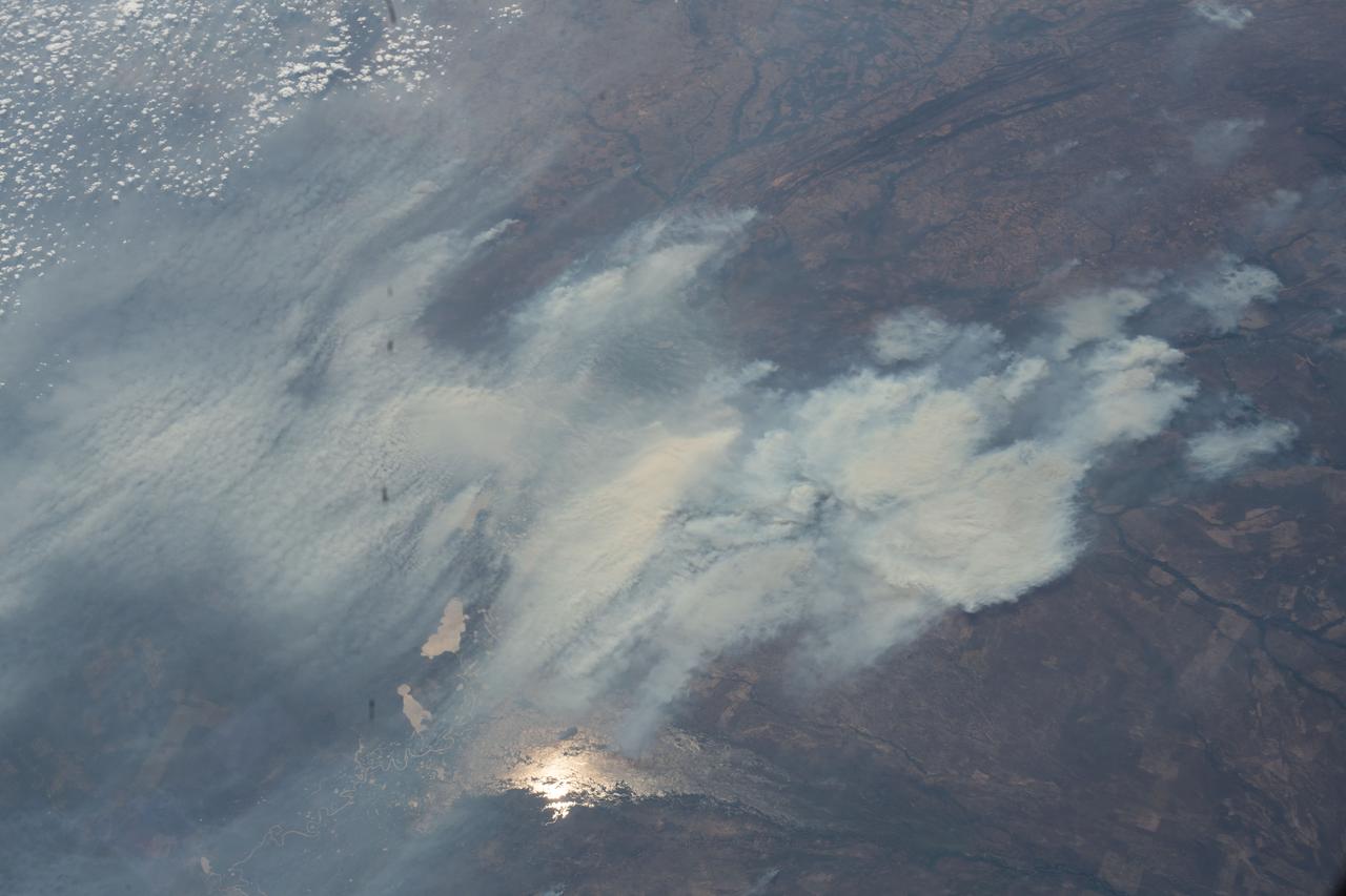
iss063e080404 (Aug. 29, 2020) --- Wildfires are pictured in the Amazon rainforest as the International Space Station orbited above the border between Bolivia and Brazil.
iss070e015233 (Oct. 29, 2023) --- A portion of the Amazon River in northwestern Brazil is pictured from the International Space Station as it orbited 260 miles above.

iss070e099548 (Feb. 23, 2024) --- The Amazon River and its tributaries flow through Brazil in this photograph from the International Space Station as it orbited 259 miles above the South American nation.
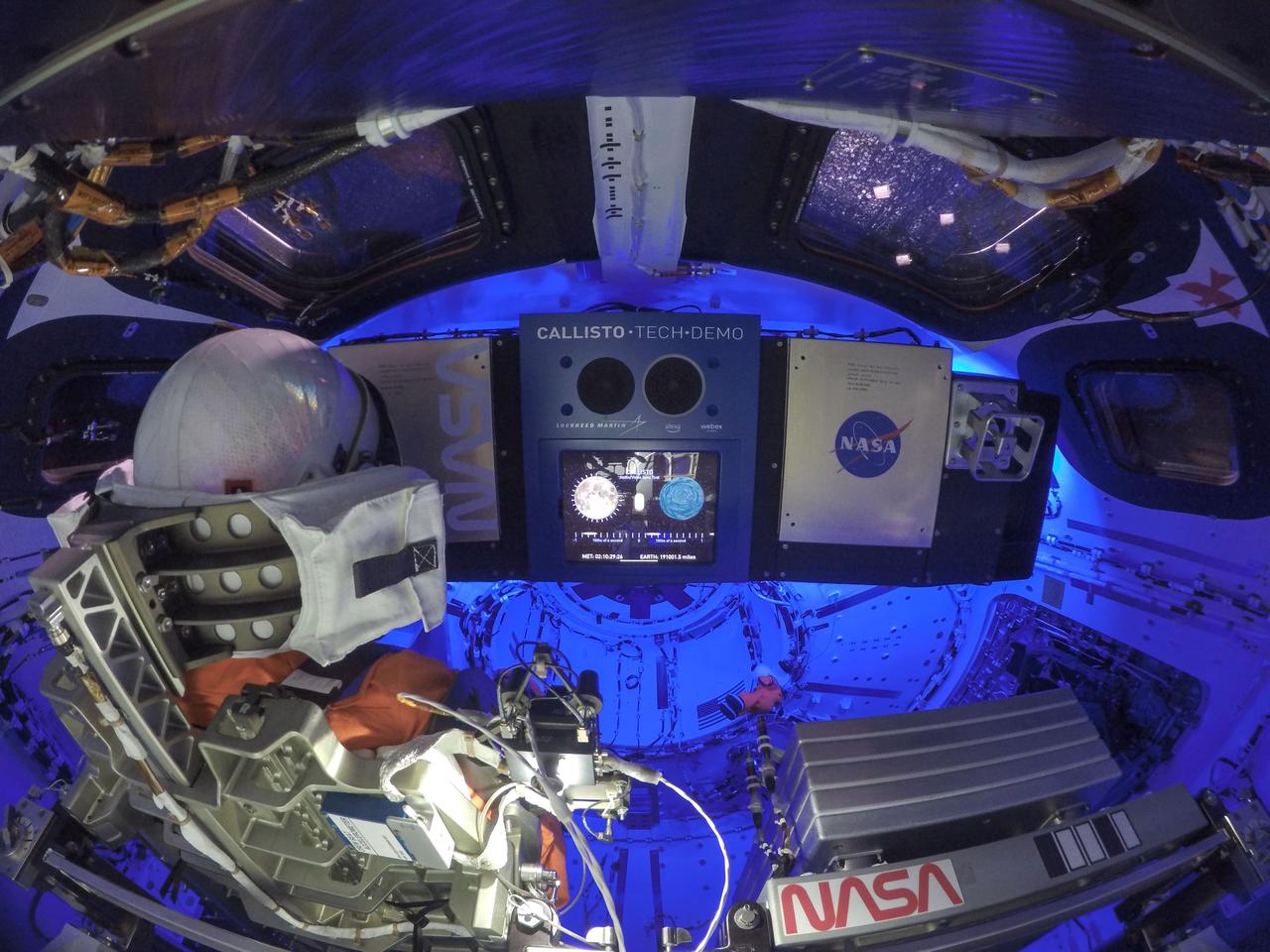
Engineers activated the Callisto payload, Lockheed Martin’s technology demonstration in collaboration with Amazon and Cisco. Callisto will test voice-activated and video technology that may assist future astronauts on deep space missions.
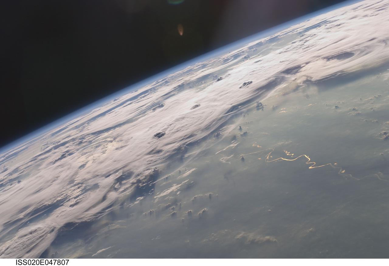
ISS020-E-047807 (6 Oct. 2009) --- Thunderstorms on the Brazilian horizon are featured in this image photographed by an Expedition 20 crew member on the International Space Station. A picturesque line of thunderstorms and numerous circular cloud patterns filled the view as the station crew members looked out at the limb and atmosphere (blue line on the horizon) of Earth. This region displayed in the photograph (top) includes an unstable, active atmosphere forming a large area of cumulonimbus clouds in various stages of development. The crew was looking west southwestward from the Amazon Basin, along the Rio Madeira, toward Bolivia when the image was taken. The distinctive circular patterns of the clouds in this view are likely caused by the aging of thunderstorms. Such ring structures often form during the final stages of a storm?s development as their centers collapse. Sunglint is visible on the waters of the Rio Madeira and Lago Acara in the Amazon Basin. Widespread haze over the basin gives the reflected light an orange hue. The Rio Madeira flows northward and joins the Amazon River on its path to the Atlantic Ocean. Scientists believe that a large smoke plume near the bottom center of the image may explain one source of the haze.
iss056e094532 (July 10, 2018) --- This portion of Bolivia's Rio Grande is about 27 miles east of downtown Santa Cruz de la Sierra, the country's largest city. The river in the Amazon Basin and the sub-tropical climate support navigation, fishing and agriculture.

art001e001451 (Nov. 27, 2022) On flight day 12, the inside of Orion shows the display of the Callisto payload. Callisto is Lockheed Martin’s technology demonstration in collaboration with Amazon and Cisco, testing voice-activated and video technology that may assist future astronauts on deep space missions.
iss056e094533 (July 10, 2018) --- This portion of Bolivia's Rio Grande is about 27 miles east of downtown Santa Cruz de la Sierra, the country's largest city. The river in the Amazon Basin and the sub-tropical climate support navigation, fishing and agriculture.
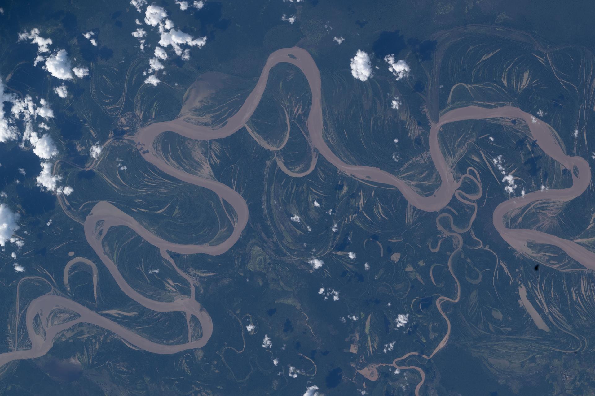
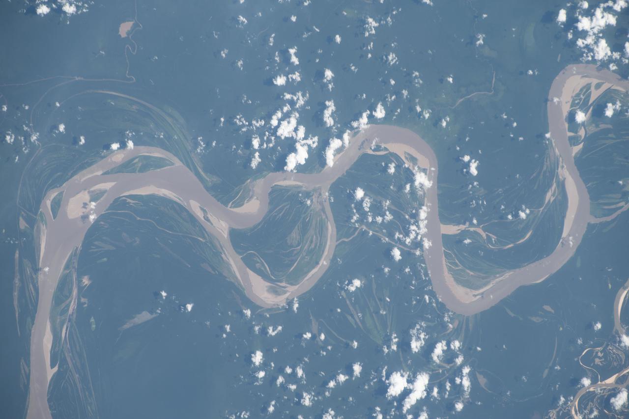
ISS038e014408 (10 Dec. 2013) --- What at first glance might appear to be a piece of modern art is actually a nadir perspective of part of the Amazon River system in South America, as photographed by one of the Expedition 38 crew members aboard the International Space Station. The astronaut used an 800mm lens to record the image on Dec. 10, 2013.
iss063e077259 (Aug. 21, 2020) --- The International Space Station was orbiting above Brazil when an external high-definition camera pictured the Marine Extractive Reserve of Tracuateua near the mouth of the Amazon River located on the northeast coast of the South American nation.

iss067e300317 (Aug. 30, 2022) --- Clouds border the Amazon River as it empties into the Atlantic Ocean in this photograph from the International Space Station taken from 258 miles above Brazil. As the sun rises, the land heats up faster than the river preventing the formulation of small cumulus clouds above the cooler water.
S88-E-5028 (12-05-98) --- Partial cloud cover above the mouth of the Amazon was captured with an electronic still camera by the astronauts aboard the Space Shuttle Endeavour. The image was recorded at 16:41:42 GMT, Dec. 5.

art001e001450 (Nov. 27, 2022) On flight day 12, the inside of Orion shows the display of the Callisto payload. Callisto is Lockheed Martin’s technology demonstration in collaboration with Amazon and Cisco, testing voice-activated and video technology that may assist future astronauts on deep space missions.
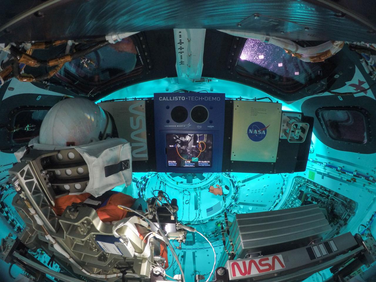
art001e000607 (Nov. 24, 2022) On flight day 9, the inside of Orion shows the display of the Callisto payload. Callisto is Lockheed Martin’s technology demonstration in collaboration with Amazon and Cisco, testing voice-activated and video technology that may assist future astronauts on deep space missions.
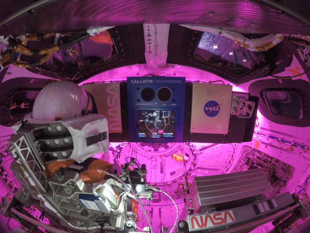
art001e000606 (Nov. 24, 2022) On flight day 9, the inside of Orion shows the display of the Callisto payload. Callisto is Lockheed Martin’s technology demonstration in collaboration with Amazon and Cisco, testing voice-activated and video technology that may assist future astronauts on deep space missions.
iss056e094531 (July 10, 2018) --- This portion of Bolivia's Rio Grande in the Amazon Basin is about 27 miles east of downtown Santa Cruz de la Sierra, the country's largest city. The river and the region's sub-tropical climate support navigation, fishing and agriculture.

A paper led by researchers at NASA's Jet Propulsion Laboratory estimates the total volume of water in Earth's rivers – called river storage – on average between 1980 and 2009, and maps out the results for the planet's major hydrological regions. This graphic, adapted from data gathered for the paper, indicates the amount of storage by hydrologic regions that contain one or more river basins, with shades of blue deepening as the amount of storage increases. The paper, published in Nature Geoscience in April 2024, calculated Earth's river storage at about 539 cubic miles (2,246 cubic kilometers), and found that the Amazon River basin, shown in dark blue in South America, was the region with the most storage, with 204 cubic miles (850 cubic kilometers), or about 38% of the global total. The study also estimated the flow of water through more than 3 million segments of river around the world and identified several locations marked by intense human water use, including parts of the Colorado River basin in the United States, portions of the Amazon basin in South America, the Orange River basin in southern Africa, and the Murray-Darling basin in southeastern Australia. https://photojournal.jpl.nasa.gov/catalog/PIA26119
ISS009-E-15488 (7 July 2004) --- Solimoes-Negro River confluence at Manaus, Amazonia is featured in this image photographed by an Expedition 9 crewmember on the International Space Station (ISS). The largest river on the planet, the Amazon, forms from the confluence of the Solimoes (the upper Amazon River) and the Negro at the Brazilian city of Manaus in central Amazonas. At the river conjunction, the muddy, tan colored waters of the Solimoes meet the “black” water of the Negro River. The unique mixing zone where the waters meet extends downstream through the rainforest for hundreds of kilometers, and is a famous attraction for tourists all over the world. It is the vast quantity of sediment eroded from the Andes Mountains that gives the Solimoes its tan color. By comparison, water in the Negro derives from the low jungles where reduced physical erosion of rock precludes mud entering the river. In place of sediment, organic matter from the forest floor stains the river the color of black tea.
STS043-151-159 (2-11 August 1991) --- This photograph looks westward over the high plateau of the southern Peruvian Andes west and north of Lake Titicaca (not in field of view). Lima, Peru lies under the clouds just north of the clear coastal area. Because the high Andes have been uplifted 10,000 to 13,000 feet during the past 20 million years, the rivers which cut down to the Pacific Ocean have gorges almost that deep, such as the Rio Ocona at the bottom of the photograph. The eastern slopes of the Andes are heavily forested, forming the headwaters of the Amazon system. Smoke from burning in the Amazon basin fills river valleys on the right side of the photograph. A Linhof camera was used to take this view.
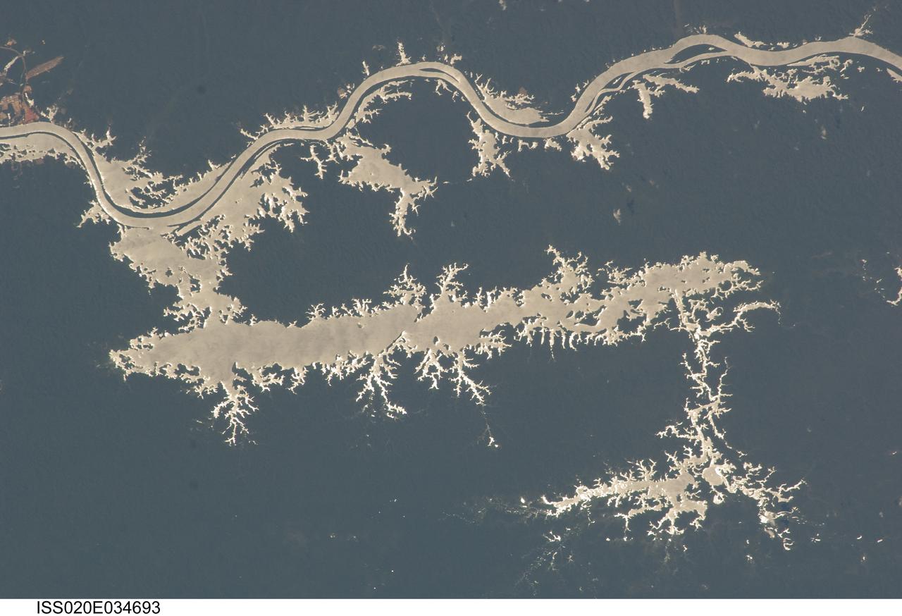
ISS020-E-034693 (25 Aug. 2009) --- Lake Erepecu and Rio Trombetas in Brazil are featured in this sun glint image photographed by an Expedition 20 crew member on the International Space Station. The 38 kilometers long Lake Erepecu runs parallel to the lower Rio (river) Trombetas which snakes along the lower half of this photograph. Waterbodies in the Amazon rainforest are often so dark they can be difficult to distinguish. In this image, however, the lake and river stand out from the uniform green of the forest in great detail as a result of sun glint on the water surface. Sun glint is light reflected off of a surface directly back towards the viewer, in this case a crew member onboard the space station. Soil color beneath the forest is red, as shown by airfield clearings near Porto Trombetas (upper left), a river port on the south side of the Trombetas River. The Trombetas flows into the Amazon River from the north about 800 kilometers from the Amazon mouth. Despite being so far from the sea, seagoing ore ships export most of Brazil?s bauxite from Porto Trombetas. Bauxite is the raw material formed in these tropical soils for the production of aluminum (the Trombetas bauxite mine is outside the upper margin of the image). Central Amazonia has many lakes like Erepecu?relatively straight, large waterbodies located just off the main axis of the large rivers. These lakes, as distinct from smaller floodplain lakes next to the large rivers, were created as rivers cut down during the repeated low global sea levels of the recent geological past (according to scientists, related to the ice ages of the last 1.7 million years). River water filled the valleys to form lakes during intervening periods of high sea level. Many larger rivers like the Trombetas and Amazon carried enough sediment to fill their immediate valleys?rivers flowing in unconsolidated sediment produce sinuous courses like those along the upper part of the image?but not enough to fill tributary valleys further from the axis of flow, so that lakes like Erepecu are formed.
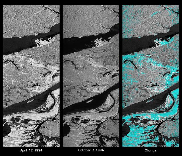
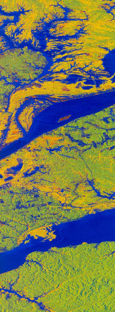
These L-band images of the Manaus region of Brazil were acquired by the Spaceborne Imaging Radar-C and X-band Synthetic Aperture Radar (SIR-C/X-SAR) aboard the space shuttle Endeavour. The left image was acquired on April 12, 1994, and the middle image was acquired on October 3, 1994. The area shown is approximately 8 kilometers by 40 kilometers (5 miles by 25 miles). The two large rivers in this image, the Rio Negro (top) and the Rio Solimoes (bottom), combine at Manaus (west of the image) to form the Amazon River. The image is centered at about 3 degrees south latitude and 61 degrees west longitude. North is toward the top left of the images. The differences in brightness between the images reflect changes in the scattering of the radar channel. In this case, the changes are indicative of flooding. A flooded forest has a higher backscatter at L-band (horizontally transmitted and received) than an unflooded river. The extent of the flooding is much greater in the April image than in the October image, and corresponds to the annual, 10-meter (33-foot) rise and fall of the Amazon River. A third image at right shows the change in the April and October images and was created by determining which areas had significant decreases in the intensity of radar returns. These areas, which appear blue on the third image at right, show the dramatic decrease in the extent of flooded forest, as the level of the Amazon River falls. The flooded forest is a vital habitat for fish and floating meadows are an important source of atmospheric methane. This demonstrates the capability of SIR-C/X-SAR to study important environmental changes that are impossible to see with optical sensors over regions such as the Amazon, where frequent cloud cover and dense forest canopies obscure monitoring of floods. Field studies by boat, on foot and in low-flying aircraft by the University of California at Santa Barbara, in collaboration with Brazil's Instituto Nacional de Pesguisas Estaciais, during the first and second flights of the SIR-C/X-SAR system have validated the interpretation of the radar images. http://photojournal.jpl.nasa.gov/catalog/PIA01740
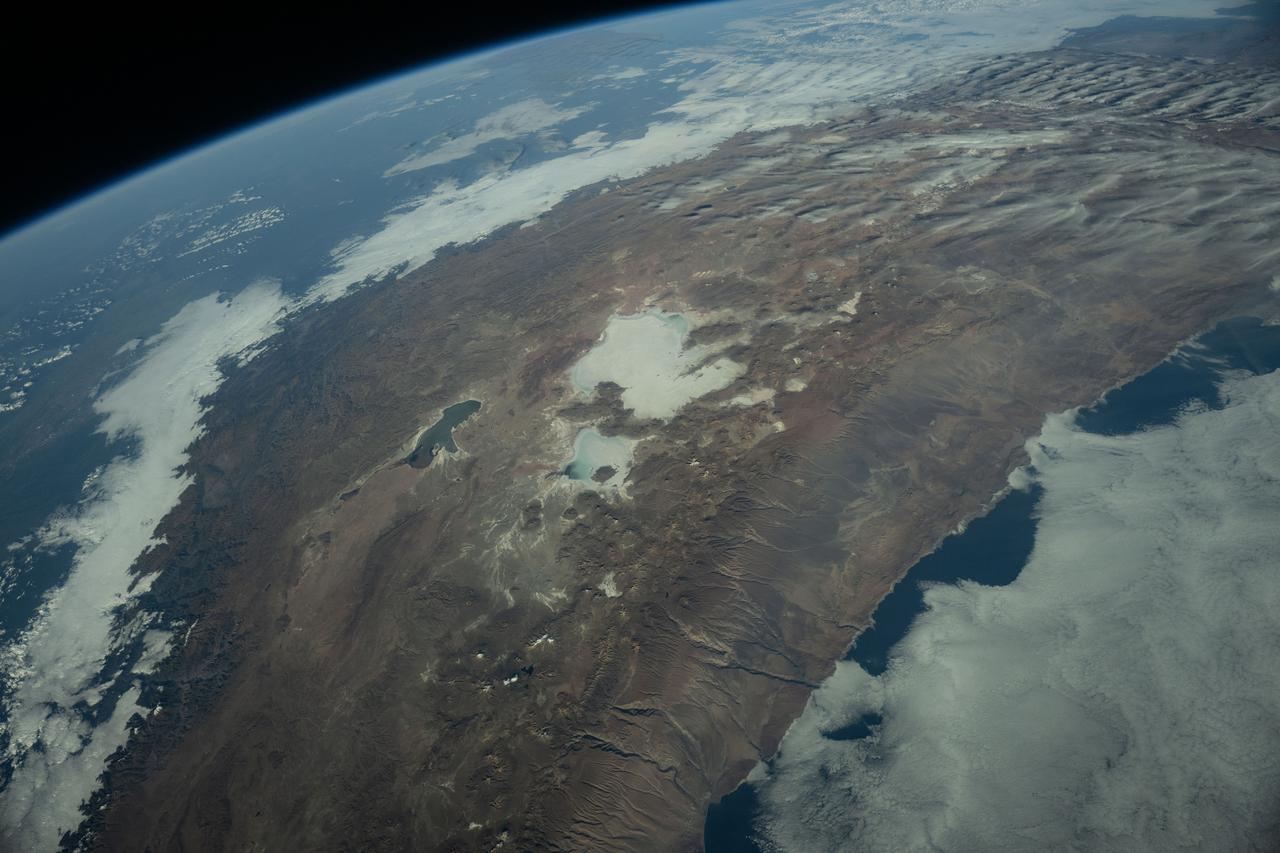
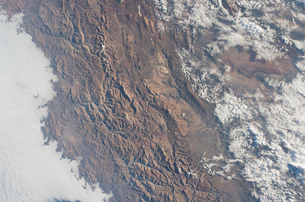
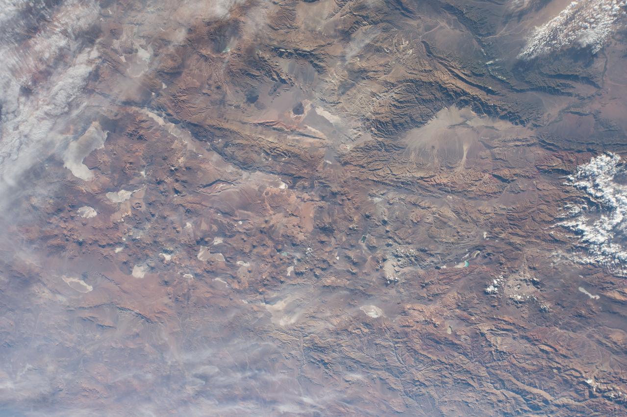
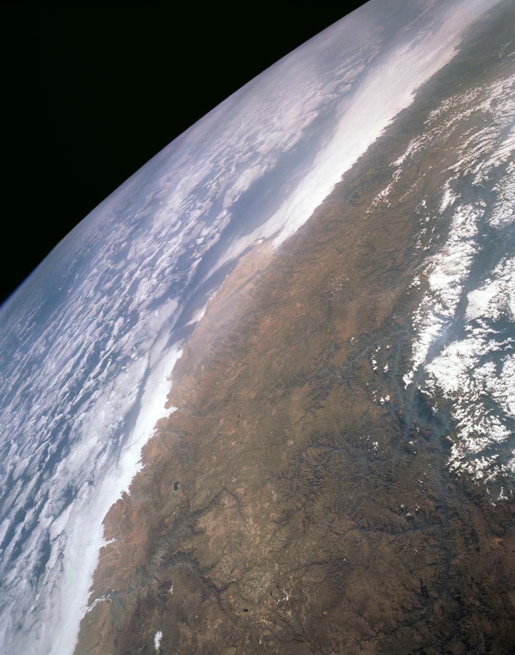
iss073e0384067 (July 12, 2025) --- The Andes Mountains run through Chile and Bolivia on the South American continent. The eastern slope of the Andes in Bolivia captures moisture from the Amazon basin creating more rainfall on that side of the nation and contributes to an arid climate on South America's Pacific coast. The International Space Station was orbiting 260 miles above Chile when this photograph was taken.

From left to right, moderator and Washington Post design reporter Shelly Tan, creator of the NASA worm logotype Richard Danne, Pentagram designer Michael Bierut, NASA entertainment and branding liaison Bert Ulrich, and Amazon Music head of live event merchandise Julia Heiser, participate in a panel discussion during a Richard Danne dedication event, Monday, Nov. 6, 2023, at the Mary W. Jackson NASA Headquarters building in Washington. Photo Credit: (NASA/Keegan Barber)
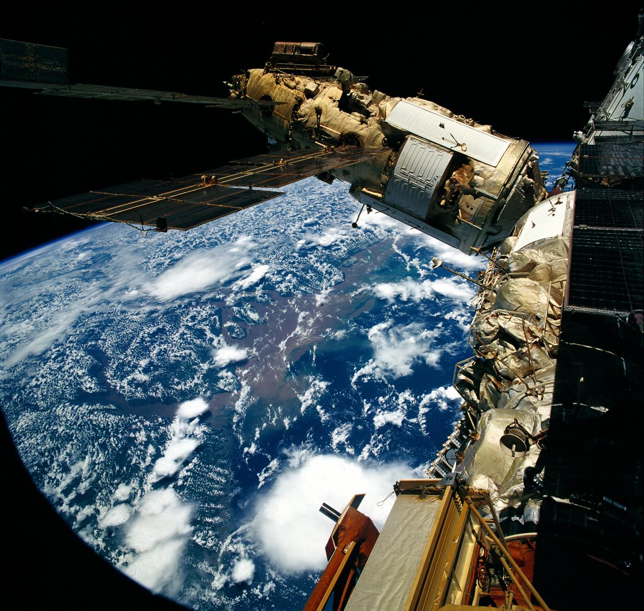
STS076-708-031 (22 - 31 March 1996) --- Clouds over Brazil form the backdrop for this 70mm image showing the Spektr Module and other components of Russia's Mir Space Station. The photograph was taken after Space Shuttle Atlantis docked with the Mir Space Station on March 23, 1996. The delta of the giant Amazon River is at frame center.

STS006-46-617 (4-9 April 1983) --- This view of sunset over the Amazon Basin was photographed with a 35mm camera from the Earth-orbiting space shuttle Challenger. The reusable vehicle was making its first trip into space and carried a crew of astronauts Paul J. Weitz, Karol J. Bobko, F. Story Musgrave and Donald H. Peterson. Photo credit: NASA

From left to right, moderator and Washington Post design reporter Shelly Tan, creator of the NASA worm logotype Richard Danne, Pentagram designer Michael Bierut, NASA entertainment and branding liaison Bert Ulrich, and Amazon Music head of live event merchandise Julia Heiser, participate in a panel discussion during a Richard Danne dedication event, Monday, Nov. 6, 2023, at the Mary W. Jackson NASA Headquarters building in Washington. Photo Credit: (NASA/Keegan Barber)

From left to right, Pentagram designer Michael Bierut, NASA entertainment and branding liaison Bert Ulrich, and Amazon Music head of live event merchandise Julia Heiser, participate in a panel discussion during a Richard Danne dedication event, Monday, Nov. 6, 2023, at the Mary W. Jackson NASA Headquarters building in Washington. Photo Credit: (NASA/Keegan Barber)
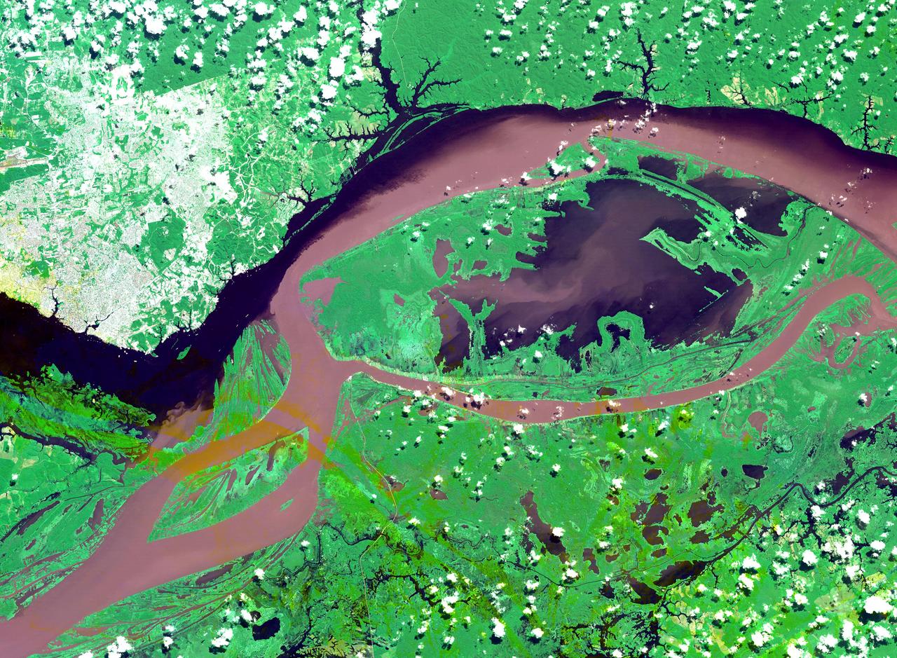
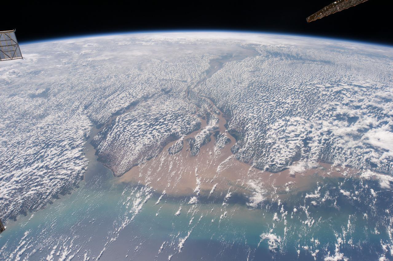
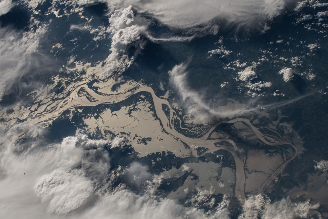
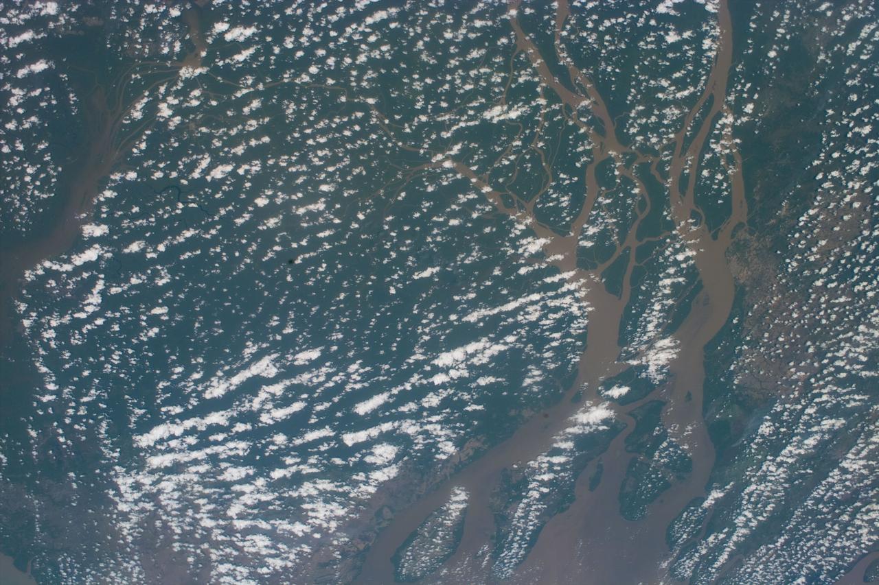
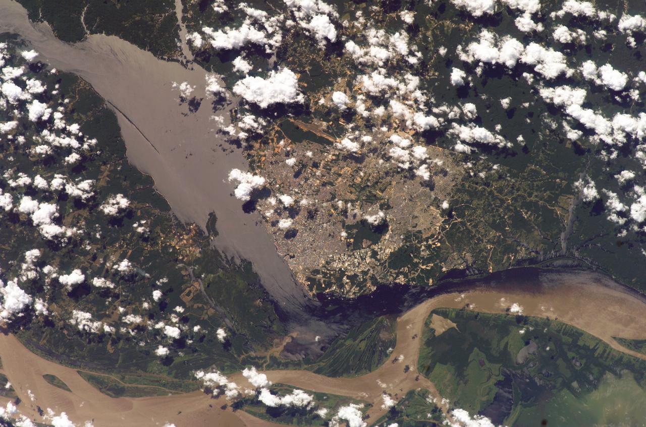
ISS037-E-001606 (18 Sept. 2013) --- What at first glance might appear to be a piece of abstract art is actually a photo made using a 180mm lens from approximately 226 nautical miles above Earth featuring the very wide Amazon River floodplain at Santarem, Brazil. One of the Expedition 37 crew members aboard the International Space Station took the photograph on Sept. 18, 2013. Center coordinates of the area pictured are located at approximately 2.1 degrees south latitude and 54.9 degrees west longitude.
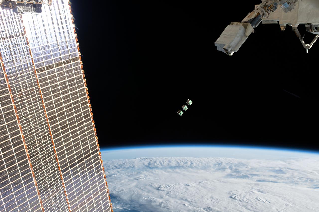
iss059e104296 (June 17, 2019) --- A set of three CubeSats are ejected from the Japanese Small Satellite Orbital Deployer attached to a robotic arm outside of the Japan Aerospace Exploration Agency's Kibo laboratory module. The tiny satellites from Nepal, Sri Lanka and Japan were released into Earth orbit for technology demonstrations. The International Space Station was orbiting 256 miles above the Amazon River in Brazil when an Expedition 59 crewmember took this photograph.
iss064e006446 (Nov. 27, 2020) --- This picture was taken from a window on the SpaceX Crew Dragon vehicle as the International Space Station orbited above the Atlantic Ocean just off the coast of Brazil near the mouth of the Amazon River. Two other spacecraft, including the Cygnus cargo craft with its two prominent cymbal-shaped solar arrays, and behind it, Russia's Soyuz MS-17 crew ship with its rectangular solar arrays, are also pictured docked to the orbiting lab.
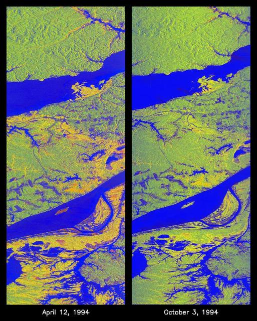
These two false-color images of the Manaus region of Brazil in South America were acquired by the Spaceborne Imaging Radar-C and X-band Synthetic Aperture Radar on board the space shuttle Endeavour. The image at left was acquired on April 12, 1994, and the image at right was acquired on October 3, 1994. The area shown is approximately 8 kilometers by 40 kilometers (5 miles by 25 miles). The two large rivers in this image, the Rio Negro (at top) and the Rio Solimoes (at bottom), combine at Manaus (west of the image) to form the Amazon River. The image is centered at about 3 degrees south latitude and 61 degrees west longitude. North is toward the top left of the images. The false colors were created by displaying three L-band polarization channels: red areas correspond to high backscatter, horizontally transmitted and received, while green areas correspond to high backscatter, horizontally transmitted and vertically received. Blue areas show low returns at vertical transmit/receive polarization; hence the bright blue colors of the smooth river surfaces can be seen. Using this color scheme, green areas in the image are heavily forested, while blue areas are either cleared forest or open water. The yellow and red areas are flooded forest or floating meadows. The extent of the flooding is much greater in the April image than in the October image and appears to follow the 10-meter (33-foot) annual rise and fall of the Amazon River. The flooded forest is a vital habitat for fish, and floating meadows are an important source of atmospheric methane. These images demonstrate the capability of SIR-C/X-SAR to study important environmental changes that are impossible to see with optical sensors over regions such as the Amazon, where frequent cloud cover and dense forest canopies block monitoring of flooding. Field studies by boat, on foot and in low-flying aircraft by the University of California at Santa Barbara, in collaboration with Brazil's Instituto Nacional de Pesguisas Estaciais, during the first and second flights of the SIR-C/X-SAR system have validated the interpretation of the radar images. http://photojournal.jpl.nasa.gov/catalog/PIA01735

This high-resolution image captures the inside of the Orion crew module on flight day one of the Artemis I mission. At left is Commander Moonikin Campos, a purposeful passenger equipped with sensors to collect data that will help scientists and engineers understand the deep-space environment for future Artemis missions. At center is the Callisto payload, a technology demonstration of voice-activated audio and video technology from Lockheed Martin in collaboration with Amazon and Cisco. Callisto could assist future astronauts on deep-space missions. Below and to the right of Callisto is the Artemis I zero-gravity indicator, astronaut Snoopy.

ISS007-E-15177 (21 September 2003) --- This view, photographed by an Expedition 7 crewmember onboard the International Space Station (ISS), features a small part of the coastal dune field which is now protected as the Lencois Maranhenses National Park, on Brazil’s north coast, about 700 kilometers east of the Amazon River mouth. Persistent winds blow off the equatorial Atlantic Ocean onto Brazil from the east, driving white sand inland from 100 kilometers stretch of coast, to form a large field of dunes. The dark areas between the white dunes are fresh water ponds that draw fishermen to this newly established park.
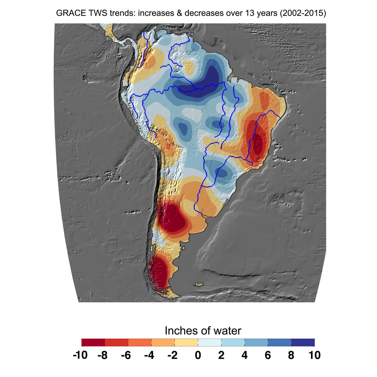
Cumulative total freshwater losses in South America from 2002 to 2015 (in inches) observed by NASA's Gravity Recovery and Climate Experiment (GRACE) mission. Total water refers to all of the snow, surface water, soil water and groundwater combined. Much of the Amazon River basin experienced increasing total water storage during this time period, though the persistent Brazilian drought is apparent to the east. Groundwater depletion strongly impacted total water losses in the Guarani aquifer of Argentina and neighboring countries. Significant water losses due to the melting ice fields of Patagonia are also observed. http://photojournal.jpl.nasa.gov/catalog/PIA20205

STS054-86-001 (13-19 Jan. 1993) --- This 70mm view shows a spectacular multiple spit on the coast of Brazil, about halfway between Rio de Janeiro and the mouth of the Amazon River. Over a few thousand years, according to NASA scientists, shifting regimes of wave and current patterns piled up sand onto a series of beach ridges and tidal lagoons. The present swirls of sediment along the coast evidently were derived from beach erosion, because streams flowing into the Atlantic contain dark, clear water. Offshore, reefs and sandbanks parallel the coast. The largest is the Recife da Pedra Grande (Big Rocks Reef).

Amazon Senior Sales Manager, Jamie Baker, left, awards a large boarding pass to Alex Mather, the student whose submission, Perseverance, was chosen as the official name of the Mars 2020 rover, to get him and his family to NASA’s Kennedy Space Center to watch the launch of the rover, Thursday, March 5, 2020, at Lake Braddock Secondary School in Burke, Va. The final selection of the new name was made by Associate Administrator of NASA's Science Mission Directorate, Thomas Zurbuchen, following a nationwide naming contest conducted in 2019 that drew more than 28,000 essays by K-12 students from every U.S. state and territory. The rover is currently at NASA's Kennedy Space Center in Florida being prepared for launch this summer. Photo Credit: (NASA/Aubrey Gemignani)
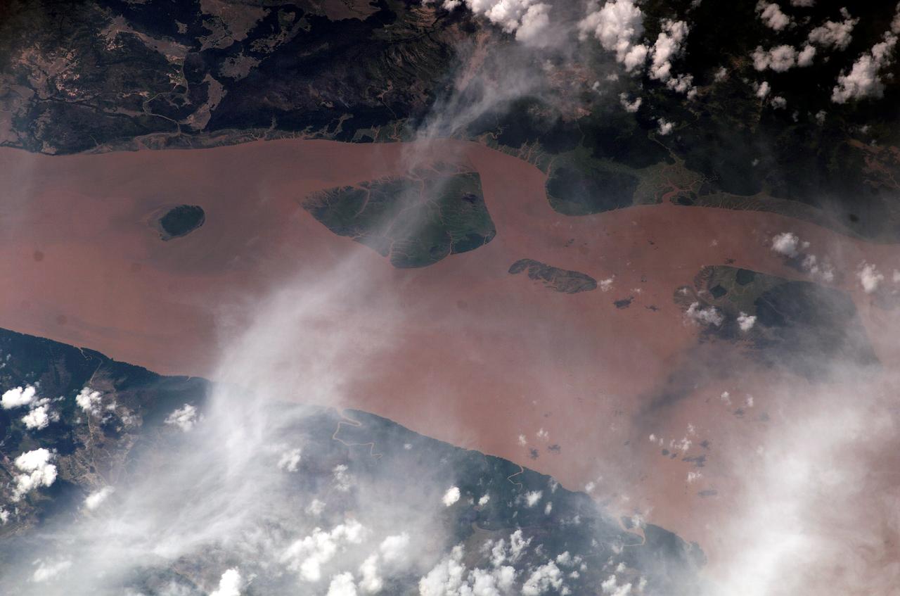
ISS010-E-13029 (13 January 2005) --- The Perigoso Channel and Amazon River mouth are featured in this image photographed by an Expedition 10 crewmember on the International Space Station (ISS). According to NASA scientists studying the Expedition 10 imagery, between 2000 and 2005 the channel on the west side of the island has shifted to the northwest – by eroding ~200 meters of the mainland shoreline and accreting sediment on the west side of the island, broadly maintaining the width of the channel. The North Channel (right) has been significantly widened. This has resulted in the erosional removal of almost 1 kilometer of the north end of the island, as well narrowing of a smaller island downstream (lower right). A more important but subtler visual effect has been the accumulation of sediment on the upstream (left) two-thirds of the island, accompanied by the establishment of permanent vegetation (dark green).
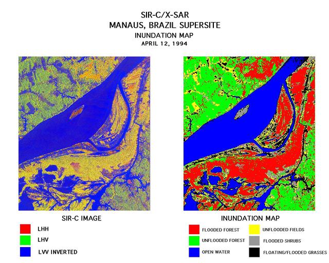
These two images were created using data from the Spaceborne Imaging Radar-C/X-Band Synthetic Aperture Radar (SIR-C/X-SAR). On the left is a false-color image of Manaus, Brazil acquired April 12, 1994, onboard space shuttle Endeavour. In the center of this image is the Solimoes River just west of Manaus before it combines with the Rio Negro to form the Amazon River. The scene is around 8 by 8 kilometers (5 by 5 miles) with north toward the top. The radar image was produced in L-band where red areas correspond to high backscatter at HH polarization, while green areas exhibit high backscatter at HV polarization. Blue areas show low backscatter at VV polarization. The image on the right is a classification map showing the extent of flooding beneath the forest canopy. The classification map was developed by SIR-C/X-SAR science team members at the University of California,Santa Barbara. The map uses the L-HH, L-HV, and L-VV images to classify the radar image into six categories: Red flooded forest Green unflooded tropical rain forest Blue open water, Amazon river Yellow unflooded fields, some floating grasses Gray flooded shrubs Black floating and flooded grasses Data like these help scientists evaluate flood damage on a global scale. Floods are highly episodic and much of the area inundated is often tree-covered. http://photojournal.jpl.nasa.gov/catalog/PIA01712
ISS018-E-008064 (9 Nov. 2008) --- Progressive forest clearing in Bolivia is featured in this image photographed by an Expedition 18 crewmember on the International Space Station. The eastern half of Bolivia is covered with tropical rainforest. In the 1990s, Bolivia initiated a large-scale effort to increase the rate of logging and create tracts of land for commercial agriculture (primarily soy and sugar cane, but also coca) on the Amazon Basin side of the Andean highlands. Today, the commercial fields are well-established and easily mapped from space as large, rectangular clearings in the forest. The agricultural developments are still growing today. The clearings start off as small rectangles arranged perpendicular to an access road; early clearings take on a herring-bone pattern when viewed from above. The uncleared (dark forest) areas are gradually logged and cultivated, filling in the pattern to make a larger cleared area. Astronauts aboard the space station routinely observe intensive land use and document their observations through imagery so that changes can be identified.
ISS010-E-05070 (25 October 2004) --- Corrientes, Argentina, and the Parana River are featured in this image photographed by an Expedition 10 crewmember on the International Space Station (ISS). Corrientes, Argentina sits on the east bank of the Parana River, South America’s third largest river (after the Negro and Amazon Rivers). From its headwaters in southeastern Brazil, the river flows southwestward around southern Paraguay, and then into Argentina. Corrientes is located just inside Argentina, across the river from the southwestern tip of Paraguay. The bridge over the Parana, built in the 1970s, connects Corrientes to its sister city, Resistencia, (beyond the left edge of image) on the western bank of the river. Sun glint on the river gives it a silvery glow and emphasizes channel islands in the river, side channels, and meander scars on the floodplain opposite the city, and even reveals the pattern of disturbed flow downstream of the bridge pylons. The old part of the city appears as a zone of smaller, more densely clustered city blocks along the river to the north of a major highway, which runs through Corrientes from the General Belgrano Bridge to the northeast (upper right of image). Larger blocks of the younger cityscape, with more green space, surround these core neighborhoods.
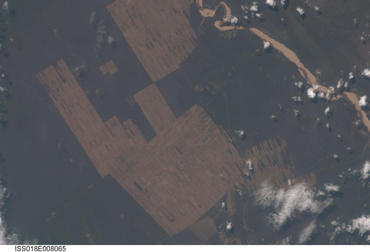
ISS018-E-008065 (9 Nov. 2008) --- Progressive forest clearing in Bolivia is featured in this image photographed by an Expedition 18 crewmember on the International Space Station. The eastern half of Bolivia is covered with tropical rainforest. In the 1990s, Bolivia initiated a large-scale effort to increase the rate of logging and create tracts of land for commercial agriculture (primarily soy and sugar cane, but also coca) on the Amazon Basin side of the Andean highlands. Today, the commercial fields are well-established and easily mapped from space as large, rectangular clearings in the forest. The agricultural developments are still growing today. The clearings start off as small rectangles arranged perpendicular to an access road; early clearings take on a herring-bone pattern when viewed from above. The uncleared (dark forest) areas are gradually logged and cultivated, filling in the pattern to make a larger cleared area. Astronauts aboard the space station routinely observe intensive land use and document their observations through imagery so that changes can be identified.
NASA scientists will venture into an isolated part of the Bolivian Amazon to try and uncover the origin of a 5 mile (8 kilometer) diameter crater there known as the Iturralde Crater. Traveling to this inhospitable forest setting, the Iturralde Crater Expedition 2002 will seek to determine if the unusual circular crater was created by a meteor or comet. Organized by Dr. Peter Wasilewski of NASA's Goddard Space Flight Center, Greenbelt, Md., the Iturralde Crater Expedition 2002 will be led by Dr. Tim Killeen of Conservation International, which is based in Bolivia. Killeen will be assisted by Dr. Compton Tucker of Goddard. The team intends to collect and analyze rocks and soil, look for glass particles that develop from meteor impacts and study magnetic properties in the area to determine if the Iturralde site was indeed created by a meteor. This image was acquired on June 29, 2001 by the Advanced Spaceborne Thermal Emission and Reflection Radiometer (ASTER) on NASA's Terra satellite. With its 14 spectral bands from the visible to the thermal infrared wavelength region, and its high spatial resolution of 15 to 90 meters (about 50 to 300 feet), ASTER will image Earth for the next 6 years to map and monitor the changing surface of our planet. http://photojournal.jpl.nasa.gov/catalog/PIA03859
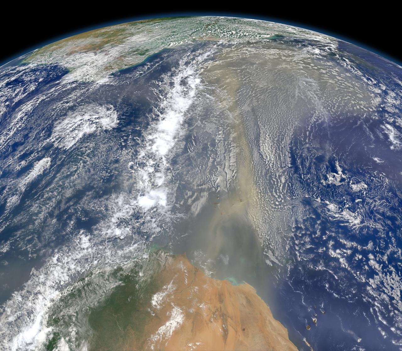
A piece of Africa—actually lots of them—began to arrive in the Americas in June 2014. On June 23, a lengthy river of dust from western Africa began to push across the Atlantic Ocean on easterly winds. A week later, the influx of dust was affecting air quality as far away as the southeastern United States. This composite image, made with data from the Visible Infrared Imaging Radiometer Suite (VIIRS) on Suomi NPP, shows dust heading west toward South America and the Gulf of Mexico on June 25, 2014. The dust flowed roughly parallel to a line of clouds in the intertropical convergence zone, an area near the equator where the trade winds come together and rain and clouds are common. In imagery captured by the Moderate Resolution Imaging Spectroradiometer (MODIS), the dust appeared to be streaming from Mauritania, Senegal, and Western Sahara, though some of it may have originated in countries farther to the east. Saharan dust has a range of impacts on ecosystems downwind. Each year, dust events like the one pictured here deliver about 40 million tons of dust from the Sahara to the Amazon River Basin. The minerals in the dust replenish nutrients in rainforest soils, which are continually depleted by drenching, tropical rains. Research focused on peat soils in the Everglades show that African dust has been arriving regularly in South Florida for thousands of years as well. In some instances, the impacts are harmful. Infusion of Saharan dust, for instance, can have a negative impact on air quality in the Americas. And scientists have linked African dust to outbreaks of certain types of toxic algal blooms in the Gulf of Mexico and southern Florida. Read more: <a href="http://1.usa.gov/1snkzmS" rel="nofollow">1.usa.gov/1snkzmS</a> NASA images by Norman Kuring, NASA’s Ocean Color web. Caption by Adam Voiland. Credit: <b><a href="http://www.earthobservatory.nasa.gov/" rel="nofollow"> NASA Earth Observatory</a></b> <b><a href="http://www.nasa.gov/audience/formedia/features/MP_Photo_Guidelines.html" rel="nofollow">NASA image use policy.</a></b> <b><a href="http://www.nasa.gov/centers/goddard/home/index.html" rel="nofollow">NASA Goddard Space Flight Center</a></b> enables NASA’s mission through four scientific endeavors: Earth Science, Heliophysics, Solar System Exploration, and Astrophysics. Goddard plays a leading role in NASA’s accomplishments by contributing compelling scientific knowledge to advance the Agency’s mission. <b>Follow us on <a href="http://twitter.com/NASAGoddardPix" rel="nofollow">Twitter</a></b> <b>Like us on <a href="http://www.facebook.com/pages/Greenbelt-MD/NASA-Goddard/395013845897?ref=tsd" rel="nofollow">Facebook</a></b> <b>Find us on <a href="http://instagram.com/nasagoddard?vm=grid" rel="nofollow">Instagram</a></b>

ISS013-E-74843 (2 Sept. 2006) --- Rio Negro in Amazonia, Brazil is featured in this image photographed by an Expedition 13 crewmember onboard the International Space Station. The wide, multi-island zone in the Rio Negro (Black River) shown in this image is one of two, long "archipelagoes" upstream of the city of Manaus (not shown) in central Amazonia. Ninety kilometers of the total 120 kilometers length of this archipelago appear in this view. On the day the photo was taken, air temperatures over the cooler river water of the archipelago were just low enough to prevent cloud formation. Over the neighboring rainforest, temperatures were warm enough to produce small convection-related clouds, known to pilots as "popcorn" cumulus. Several zones of deforestation, represented by lighter green zones along the river banks, are also visible. Two different types of river appear in this image. Flowing east-southeast (left to right) is the multi-island, Rio Negro, 20 kilometers wide near the right of the view. Two other "black" rivers, Rio Caures and Rio Jufari, join Rio Negro downstream. The second river type is the Rio Branco (White River; right) which is the largest tributary of the Rio Negro. The difference in water color is controlled by the source regions: black-water rivers derive entirely from soils of lowland forests. Water in these rivers has the color of weak tea, which appears black in images from space. By contrast, white-water rivers like the Branco carry a load of sand and mud particles, mudding the waters. The reason for the tan color is that white-water rivers rise in mountainous country where headwater streams erode exposed rock. The Amazon itself rises in the Andes Mts., where very high erosion occurs, and it is thus the most famous white river in Amazonia. This image was taken in September, near low-water stage. Pictures taken at other times show the channels much wider during high-water season (May--July) when water levels rise several meters. It was discovered recently, from high resolution GPS measurements at Manaus, that the land surface actually rises vertically a small amount in compensation when this vast mass of water drains away each season. Although small, the vertical displacement--50-70 mm--was unexpectedly large according to the scientists who performed the study.
STS059-S-068 (13 April 1994) --- This false-color L-Band image of the Manaus region of Brazil was acquired by the Spaceborne Imaging Radar-C and X-Band Synthetic Aperture Radar (SIR-C/X-SAR) aboard the Space Shuttle Endeavour on orbit 46 of the mission. The area shown is approximately 8 kilometers by 40 kilometers (5 by 25 miles). At the top of the image are the Solimoes and Rio Negro Rivers just before they combine at Manaus to form the Amazon River. The image is centered at about 3 degrees south latitude, and 61 degrees west longitude. The false colors are created by displaying three L-Band polarization channels; red areas correspond to high backscatter at HH polarization, while green areas exhibit high backscatter at HV polarization. Blue areas show low returns at VV polarization; hence the bright blue colors of the smooth river surfaces. Using this color scheme, green areas in the image are heavily forested, while blue areas are either cleared forest or open water. The yellow and red areas are flooded forest. Between Rio Solimoes and Rio Negro a road can be seen running from some cleared areas (visible as blue rectangles north of Rio Solimoes) north towards a tributary of Rio Negro. SIR-C/X-SAR is part of NASA's Mission to Planet Earth (MTPE). SIR-C/X-SAR radars illuminate Earth with microwaves allowing detailed observations at any time, regardless of weather or sunlight conditions. SIR-C/X-SAR uses three microwave wavelengths: L-Band (24 cm), C-Band (6 cm), and X-Band (3 cm). The multi-frequency data will be used by the international scientific community to better understand the global environment and how it is changing. The SIR-C/X-SAR data, complemented by aircraft and ground studies, will give scientists clearer insights into those environmental changes which are caused by nature and those changes which are induced by human activity. SIR-C was developed by NASA's Jet Propulsion Laboratory (JPL). X-SAR was developed by the Dornire and Alenia Spazio Companies for the German Space Agency, Deutsche Agentur fuer Raumfahrtangelegenheiten (DARA), and the Italian Space Agency, Agenzia Spaziale Italiana (ASI). JPL Photo ID: P-43895