
The 2019 National Disability Awareness Month program was held in Marshall Space Flight Center's P110 conference room with guest speaker and former NASA Scientist Kantis Simmons. Master of Ceremonies was Matt McSaveney and the National Anthem was performed by MSFC student intern Andrea Brown. Additional remarks were presented by MSFC Associate Director Steve Miley. Additional songs were performed by Georgia Aplin, Cassidie Gorig' Worrell, Danay Jackson, Charli Grace Strawn from the Alabama Institute for the Deaf and Blind. Former NASA scientist Kantis Simmons, an author and speaker, addresses NASA’s Marshall Space Flight Center team members Oct. 29 during the National Disability Awareness Month presentation, “The Right Talent, Right Now.” Simmons’ humorous discussion focused on growing up with a birth defect and overcoming the self-doubts that can bring. “Quit looking at what you don’t have and think about all the amazing things you do have,” Simmons said.
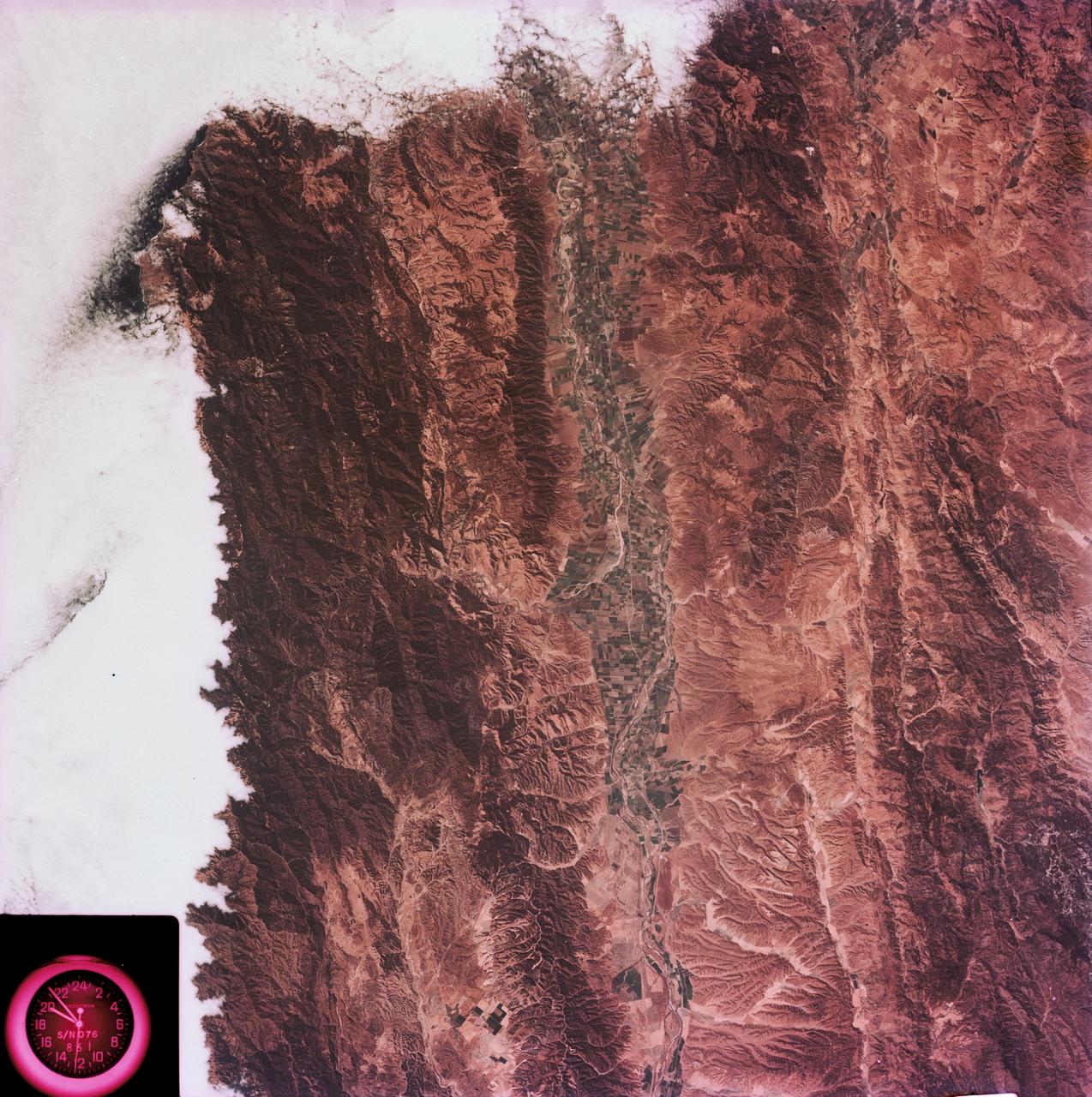
SL3-88-004 (July-September 1973) --- A vertical view of the Salinas River Valley area south of Monterey Bay, California area is seen in this Skylab 3 Earth Resources Experiments Package S190-B (five-inch Earth terrain camera) photograph taken from the Skylab space station in Earth orbit. The valley is an irrigated agricultural area, and is indicated by the dark-green and light-gray rectangular patterns in the centre of the picture. The city of Salinas is barely visible under the cloud cover at the top (north) end of the valley. The dark mass on the left (west) side of the valley is the Santa Lucia mountain range. The Big Sur area is on the left and partly covered by clouds. The Diablo Range forms the dark mass in the lower right (southeast) corner of the photograph. The town of Hollister is the gray area in the dark-green rectangular farm tracts which occupy the floor of the San Benito Valley in the upper right (northeast) corner of the photograph. The Salinas River flows northwestward toward Monterey Bay. The towns of Soledad, Greenfield and King City appear as gray areas along U.S. 101 in the Salinas Valley. The geology of the area is complex, and has been racked by several earthquakes resulting from movement along the San Andreas and subsidiary faults. Here, the surface expression of the San Andreas Fault can be traced from a point just west of Hollister at the contrast of dark brown and tan to a point about one inch left of the lower right (southeast) corner of the picture. Subsidiary faults are indicated by the curving trend of the rocks along the right side. The photograph will provide detailed information on land use patterns (Dr. R. Colwell, University of California, Berkeley) and fault tectonics (Dr. P. Merifield, Earth Science Res., Inc. and Dr. M. Abdel-Gawad, Rockwell International). Federal agencies participating with NASA on the EREP project are the Departments of Agriculture, Commerce, Interior, the Environmental Protection Agency and the Corps of Engineers. All EREP photography is available to the public through the Department of Interior’s Earth Resources Observations Systems Data Center, Sioux Falls, South Dakota, 57198. Photo credit: NASA

ISS015-E-07928 (13 May 2007) --- Isla San Lorenzo and Isla Las Animas are featured in this image photographed by an Expedition 15 crewmember on the International Space Station. Located in the northern Gulf of California, Isla (island) San Lorenzo and Isla Las Animas -- part of the Midriff Islands -- record geologic processes involved in the creation of the Baja California peninsula over several hundred million years, according to scientists. A geologist walking along the 17-kilometer long central ridge of Isla San Lorenzo from the southeastern to the northwestern end would first encounter Cretaceous granitic rock in the southeastern third of the island (light tan, center left). The central third of the island is comprised mainly of older Paleozoic metamorphic rocks (brown, center; directly above "Isla San Lorenzo"). Together, these very old rocks form the crystalline "basement" of the island. The northwestern third of Isla San Lorenzo, and much of adjacent Isla Las Animas, is composed of much more recent volcanic and marine sedimentary rocks (yellow-brown to light brown, center right). According to scientists, these rocks were formed by volcanoes and fissure eruptions in and around basins in the growing Gulf of California between 5-8 million years ago. The islands themselves were formed as a result of uplift of crustal blocks along the southeastward-trending San Andreas Fault. This image illustrates the largely pristine nature of these islands. The islands are located in the rain shadow of mountains on the Baja Peninsula to the west, and arid conditions prevail through much of the year. The scarcity of water has limited human presence on the islands, and allowed flora and fauna unique to each island (known as endemic species) to flourish -- particularly reptiles. The islands are also home to colonies of seabirds and seals, both of which take advantage of deep productive waters adjacent to the eastern Baja coast. Shallow waters and high levels of nutrients can also lead to blooms of green phytoplankton; two such blooms can be seen along the coastline of Isla Las Animas (center right, in north and west-facing embayments). Surface water patterns around the islands -- enhanced by sunlight reflectance off the water surface -- are due to wind- and current-induced roughness (silver-gray regions). Regions of dark blue water are indicative of calm surface conditions, or the presence of oils and surfactants that decrease surface tension.
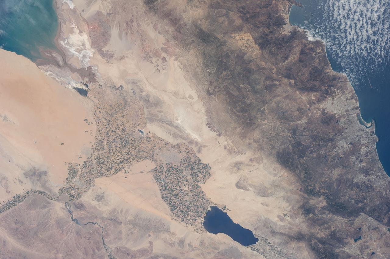
ISS036-E-011034 (21 June 2013) --- The Salton Trough is featured in this image photographed by an Expedition 36 crew member on the International Space Station. The Imperial and Coachella Valleys of southern California – and the corresponding Mexicali Valley and Colorado River Delta in Mexico – are part of the Salton Trough, a large geologic structure known to geologists as a graben or rift valley that extends into the Gulf of California. The trough is a geologically complex zone formed by interaction of the San Andreas transform fault system that is, broadly speaking, moving southern California towards Alaska; and the northward motion of the Gulf of California segment of the East Pacific Rise that continues to widen the Gulf of California by sea-floor spreading. According to scientists, sediments deposited by the Colorado River have been filling the northern rift valley (the Salton Trough) for the past several million years, excluding the waters of the Gulf of California and providing a fertile environment – together with irrigation—for the development of extensive agriculture in the region (visible as green and yellow-brown fields at center). The Salton Sea, a favorite landmark of astronauts in low Earth orbit, was formed by an irrigation canal rupture in 1905, and today is sustained by agricultural runoff water. A wide array of varying landforms and land uses in the Salton Trough are visible from space. In addition to the agricultural fields and Salton Sea, easily visible metropolitan areas include Yuma, AZ (lower left); Mexicali, Baja California, Mexico (center); and the San Diego-Tijuana conurbation on the Pacific Coast (right). The approximately 72-kilometer-long Algodones Dunefield is visible at lower left.
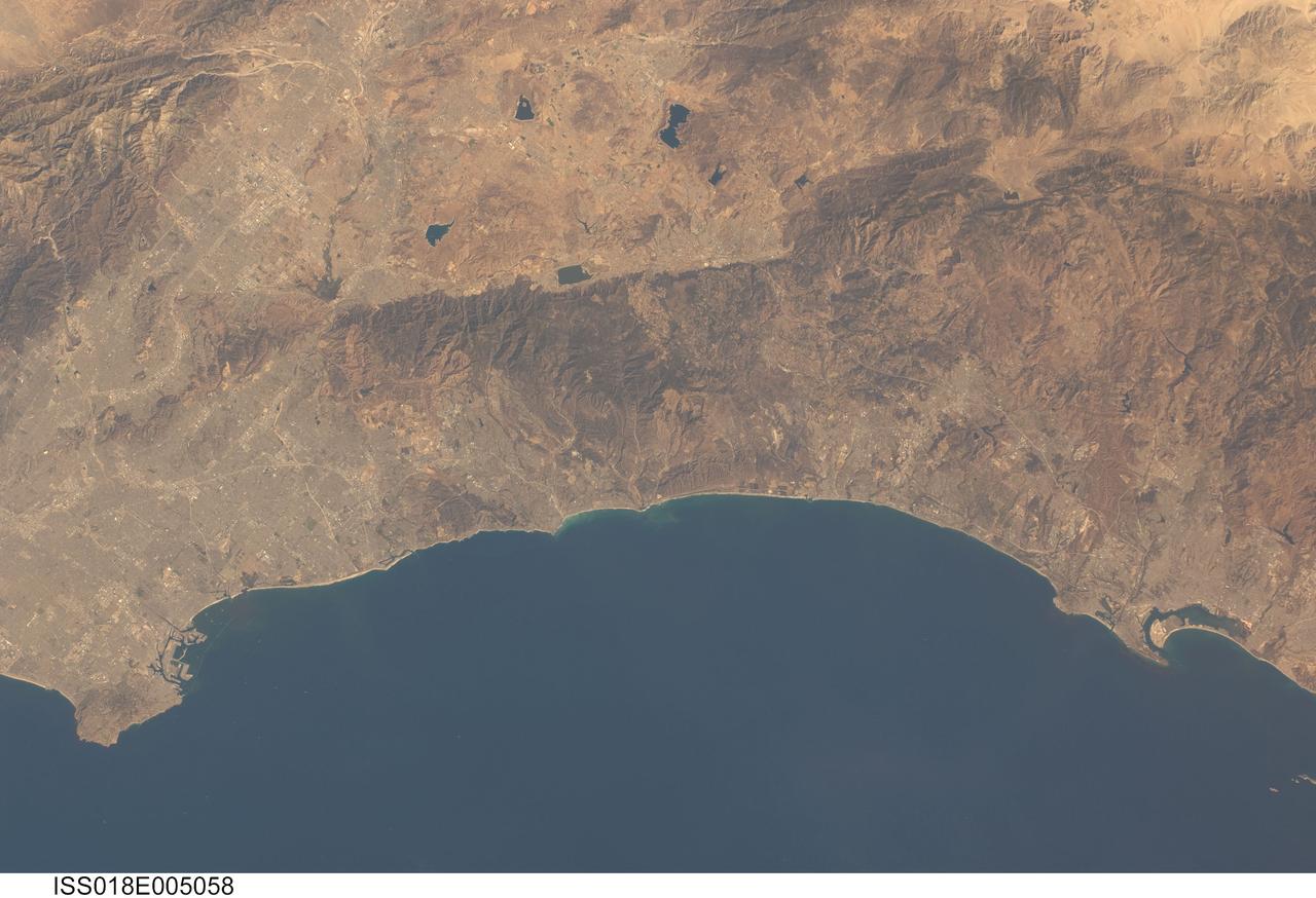
ISS018-E-005058 (24 Oct. 2008) --- Southern California's coastline, from southern Los Angeles to Tijuana in Mexico, a distance of about 225 kilometers, is featured in this image photographed by an Expedition 18 crewmember on the International Space Station. Port facilities of Los Angeles Harbor give much detail to the coastline at the north end and arcuate San Diego Bay is highly recognizable at the south end (right bottom). The image includes much of one of the most densely populated parts of the USA, with approximately 20 million people within the parts of five counties shown here. The dense urban areas appear gray, with the largest conurbation in the north of the view, in the region Long Beach--Los Angeles--San Bernardino. A smaller zone appears around San Diego--Tijuana in the south. Major highways with their associated strip development snake through these dense urban areas. The geography and geomorphology of Southern California is defined by long linear features that are surface traces of large transform faults. These faults, including the Elsinore fault and San Jacinto fault seen here, are generally considered part of the San Andreas system, and make up the broad zone comprising the tectonic plate boundary between North America to the east and the Pacific plate to the west. The Elsinore fault marks the steep eastern scarp of the Santa Ana Mountains, as well as the precipitation boundary between the wetter mountains and the drier deserts to the east. The rainfall difference is reflected in the darker appearance (more vegetation) of the mountains and coastal regions. Inland of the mountains, climates are far drier, and the natural vegetation is scrubby and much less dense which allows brown and yellow soils to show through. However, the entire region is arid; water management is a critical issue for the large urban areas of the state. Several reservoirs that are visible east of the Santa Ana Mountains provide water for both cities and agriculture in southern California.