
Andrew Chaikin, author of "A Man on the Moon" speaks during a press conference, Monday, July 20, 2009, announcing the launch of Moon in Google Earth, an immersive 3D atlas of the Moon, accessible within Google Earth 5.0, Monday, July 20, 2009, at the Newseum in Washington. Photo Credit: (NASA/Bill Ingalls)
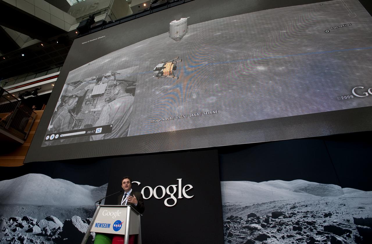
Andrew Chaikin, author of "A Man on the Moon" speaks during a press conference, Monday, July 20, 2009, announcing the launch of Moon in Google Earth, an immersive 3D atlas of the Moon, accessible within Google Earth 5.0, Monday, July 20, 2009, at the Newseum in Washington. Photo Credit: (NASA/Bill Ingalls)

ANDREW CHAIKIN AUTHOR VISITS AMES FOR LECTURE & BOOK SIGNING @ AMES LIBRARY
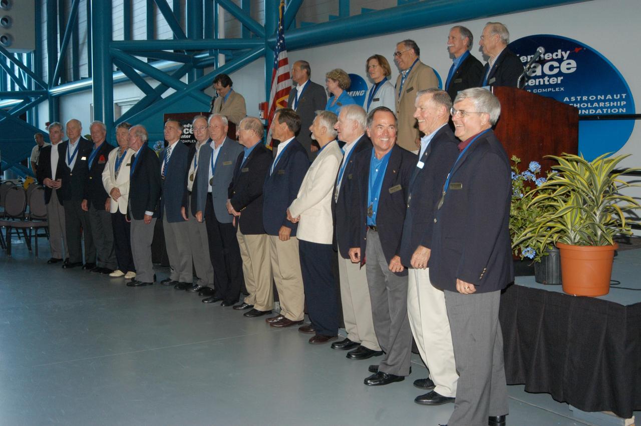
KENNEDY SPACE CENTER, FLA. -- Following the induction ceremony welcoming five new space program heroes in the U.S. Astronaut Hall of Fame, the members line up for a commemorative photo. From left, in front, are John Young, John Glenn Jr., Scott Carpenter, Wally Schirra, Gordon Cooper, Walt Cunningham, Ed Mitchell, Al Worden, Rick Hauck, Ed Gibson, Owen Garriott, Vance Brand, Robert Crippen, Joe Engle, Dan Brandenstein. In back are space author Andrew Chaikin, at the podium; and Norm Thagard, June Scobee representing her late husband Dick Scobee, Kathryn Sullivan, Fred Gregory, Richard Covey and Jim Lovell. The induction ceremony was held at the Apollo/Saturn V Center at KSC. The U.S. Astronaut Hall of Fame opened in 1990 to provide a place where space travelers could be remembered for their participation and accomplishments in the U.S. space program. The five inductees join 52 previously honored astronauts from the ranks of the Gemini, Apollo, Skylab, Apollo-Soyuz, and Space Shuttle programs.
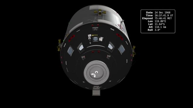
In December of 1968, the crew of Apollo 8 became the first people to leave our home planet and travel to another body in space. But as crew members Frank Borman, James Lovell, and William Anders all later recalled, the most important thing they discovered was Earth. Using photo mosaics and elevation data from Lunar Reconnaissance Orbiter (LRO), this video commemorates the 45th anniversary of Apollo 8's historic flight by recreating the moment when the crew first saw and photographed the Earth rising from behind the Moon. Narrator Andrew Chaikin, author of A Man on the Moon, sets the scene for a three-minute visualization of the view from both inside and outside the spacecraft accompanied by the onboard audio of the astronauts. The visualization draws on numerous historical sources, including the actual cloud pattern on Earth from the ESSA-7 satellite and dozens of photographs taken by Apollo 8, and it reveals new, historically significant information about the Earthrise photographs. It has not been widely known, for example, that the spacecraft was rolling when the photos were taken, and that it was this roll that brought the Earth into view. The visualization establishes the precise timing of the roll and, for the first time ever, identifies which window each photograph was taken from. The key to the new work is a set of vertical stereo photographs taken by a camera mounted in the Command Module's rendezvous window and pointing straight down onto the lunar surface. It automatically photographed the surface every 20 seconds. By registering each photograph to a model of the terrain based on LRO data, the orientation of the spacecraft can be precisely determined. Credit: NASA's Scientific Visualization Studio <b><a href="http://www.nasa.gov/audience/formedia/features/MP_Photo_Guidelines.html" rel="nofollow">NASA image use policy.</a></b> <b><a href="http://www.nasa.gov/centers/goddard/home/index.html" rel="nofollow">NASA Goddard Space Flight Center</a></b> enables NASA’s mission through four scientific endeavors: Earth Science, Heliophysics, Solar System Exploration, and Astrophysics. Goddard plays a leading role in NASA’s accomplishments by contributing compelling scientific knowledge to advance the Agency’s mission. <b>Follow us on <a href="http://twitter.com/NASA_GoddardPix" rel="nofollow">Twitter</a></b> <b>Like us on <a href="http://www.facebook.com/pages/Greenbelt-MD/NASA-Goddard/395013845897?ref=tsd" rel="nofollow">Facebook</a></b> <b>Find us on <a href="http://instagram.com/nasagoddard?vm=grid" rel="nofollow">Instagram</a></b>
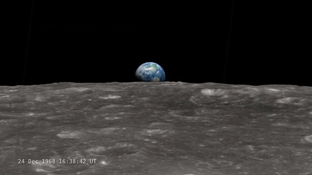
<b>Join NASA's Google+ Hangout on Friday, December 20th 2:00 - 3:00 PM (EST) at <a href="http://go.nasa.gov/18S2TbC" rel="nofollow">go.nasa.gov/18S2TbC</a> </b> It was 45 years ago, on December 24, 1968 when Apollo 8 astronauts captured 'Earthrise' – the first color photograph of Earth taken by a person in lunar orbit. NASA announces a new simulation of the events leading to the creation of 'Earthrise,' one of the iconic photographs of the 20th Century – Earth seen from the moon captured by the crew of Apollo 8. This new simulation allows anyone to virtually ride with the astronauts and experience the awe they felt at the vista in front of them. Apollo 8 Commander Frank Borman and crew members William A. Anders and James A. Lovell photographed the stunning scene as their spacecraft orbited the moon on December 24, 1968. The new computer simulation was created using data from NASA's Lunar Reconnaissance Orbiter, or LRO, spacecraft and includes details not seen in the previous visualization released last year. Participants in this Hangout include: * John Keller, project scientist for the Lunar Reconnaissance Orbiter project * Ernie Wright, project lead with the Scientific Visualization Studio at NASA Goddard Space Flight Center * Andrew Chaikin, space historian, author of the book A Man on the Moon "This will also be the first time we've released a video that's synchronized with the onboard audio recording of the astronauts,", says Ernie Wright. "The new visualization tells us not only what time the photos were taken, but also exactly which way the spacecraft was pointing and therefore which window each photo was taken from." Earthrise is the cover photo of TIME's Great Images of the 20th Century and is among photos on the cover of LIFE's 100 Photographs That Changed the World. <b><a href="http://www.nasa.gov/audience/formedia/features/MP_Photo_Guidelines.html" rel="nofollow">NASA image use policy.</a></b> <b><a href="http://www.nasa.gov/centers/goddard/home/index.html" rel="nofollow">NASA Goddard Space Flight Center</a></b> enables NASA’s mission through four scientific endeavors: Earth Science, Heliophysics, Solar System Exploration, and Astrophysics. Goddard plays a leading role in NASA’s accomplishments by contributing compelling scientific knowledge to advance the Agency’s mission. <b>Follow us on <a href="http://twitter.com/NASA_GoddardPix" rel="nofollow">Twitter</a></b> <b>Like us on <a href="http://www.facebook.com/pages/Greenbelt-MD/NASA-Goddard/395013845897?ref=tsd" rel="nofollow">Facebook</a></b> <b>Find us on <a href="http://instagram.com/nasagoddard?vm=grid" rel="nofollow">Instagram</a></b>