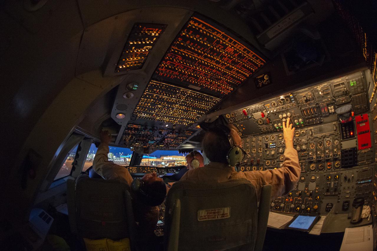
SOFIA’s flight crew prepare to takeoff from the U.S. Antarctic Program facility at Christchurch International Airport in Christchurch, New Zealand, to observe the Southern Hemisphere’s skies. Pilot: Manny Antimisiaris, Co-Pilot: Jim Less, Flight Engineer: Marty Trout
The second of three missions as part of NASA’s Antarctica Long Duration Balloon Flight Campaign was successfully launched at 8:10 a.m. EDT, Dec. 2. The Antarctic Impulsive Transient Antenna (ANITA) from the University of Hawaii at Manoa was launched from Antarctica’s Ross Ice Shelf near McMurdo Station with support from the National Science Foundation’s United States Antarctic Program. Scientists will use ANITA’s instruments to study the reactions in the core of stars and as they explode via the release of neutrinos that travel to Earth and interact with the Antarctica ice. More: <a href="http://go.nasa.gov/2ghR6Le" rel="nofollow">go.nasa.gov/2ghR6Le</a>
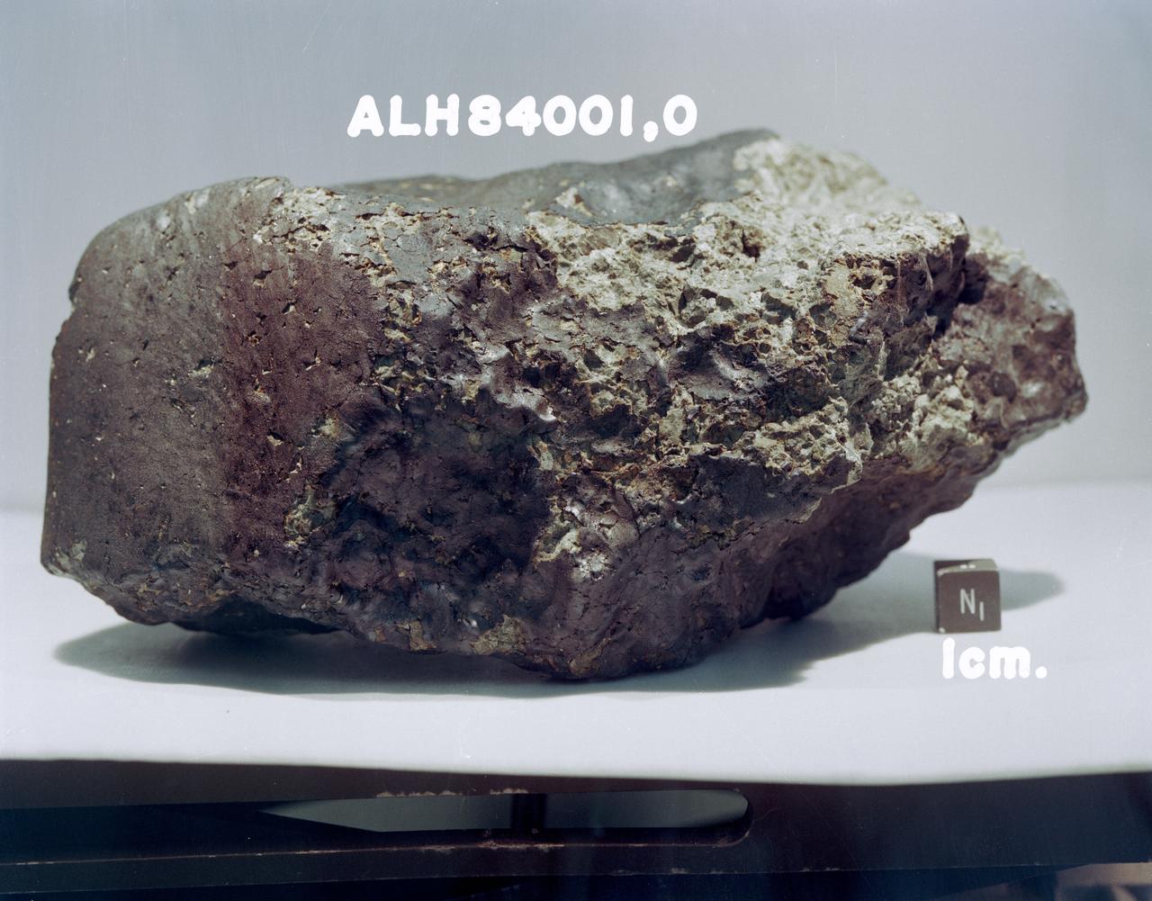
S85-39565 (For release August 1996) --- According to scientists, this 4.5 billion year old rock, labeled meteorite ALH84001, is believed to have once been a part of Mars and to contain fossil evidence that primitive life may have existed on Mars more than 3.6 billion years ago. The rock is a portion of a meteorite that was dislodged from Mars by a huge impact about 16 million years ago and that fell to Earth in Antarctica 13,000 years ago. The meteorite was found in Allan Hills ice field, Antarctica, by an annual expedition of the National Science Foundation?s Antarctic Meteorite Program in 1984. It is preserved for study at the Johnson Space Center?s (JSC) Meteorite Processing Laboratory in Houston, Texas.

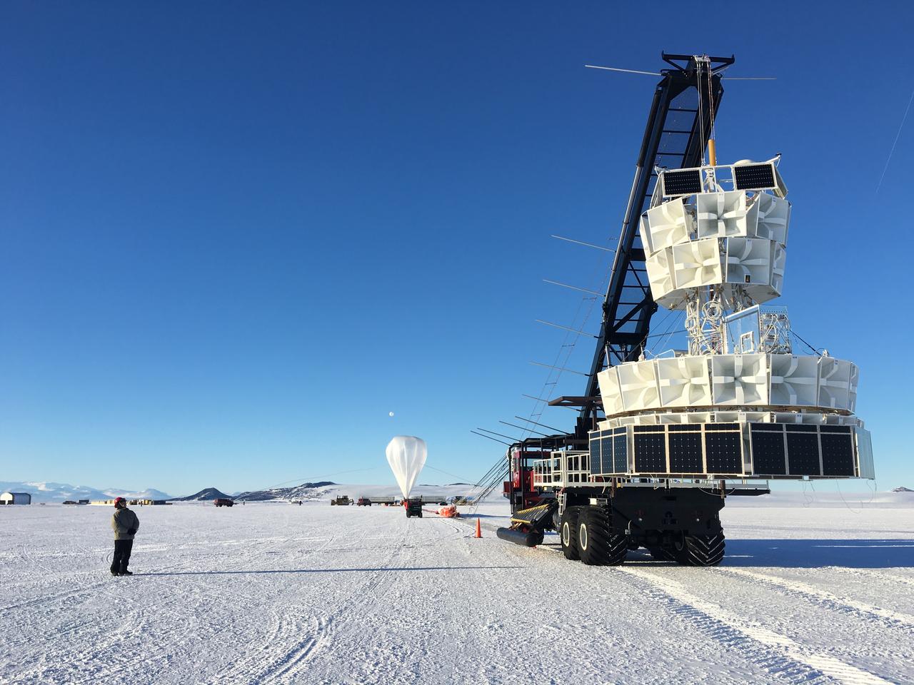
Caption: A NASA Super Pressure Balloon with the COSI payload is ready for launch from McMurdo, Antarctica. Credit: NASA More info: NASA’s globetrotting Balloon Program Office is wrapping up its 2014-2015 Antarctic campaign while prepping for an around-the-world flight launching out of Wanaka, New Zealand, in March. After 16 days, 12 hours, and 56 minutes of flight, operators successfully conducted a planned flight termination of the Suborbital Polarimeter for Inflation Dust and the Epoch of Reionization (SPIDER) mission Saturday, Jan. 18, the final mission of the campaign. Other flights in the 2014-2015 Antarctic campaign included the Antarctic Impulsive Transient Antenna (ANITA-III) mission as well as the Compton Spectrometer and Imager (COSI) payload flown on the developmental Super Pressure Balloon (SPB). ANITA-III successfully wrapped up Jan. 9 after 22 days, 9 hours, and 14 minutes of flight. Flight controllers terminated the COSI flight 43 hours into the mission after detecting a small gas leak in the balloon. Crews are now working to recover all three instruments from different locations across the continent. The 6,480-pound SPIDER payload is stationary at a position about 290 miles from the United Kingdom’s Sky Blu Logistics Facility in Antarctica. The 4,601 pound ANITA-III payload, located about 100 miles from Australia’s Davis Station, and the 2,866 pound COSI payload, located about 340 miles from the United States McMurdo Station both had numerous key components recovered in the past few days. Beginning in late January, the Balloon Program Office will deploy a team to Wanaka, New Zealand, to begin preparations for an SPB flight, scheduled to launch in March. The Program Office seeks to fly the SPB more than 100 days, which would shatter the current flight duration record of 55 days, 1 hour, and 34 minutes for a large scientific balloon. “We’re looking forward to the New Zealand campaign and hopefully a history-making flight with the Super Pressure Balloon,” said Debbie Fairbrother, NASA’s Balloon Program Office Chief. Most scientific balloons see altitude variances based on temperature changes in the atmosphere at night and during the day. The SPB is capable of missions on the order of 100 days or more at constant float altitudes due to the pressurization of the balloon. “Stable, long-duration flights at near-space altitudes above more than 99 percent of the atmosphere are highly desirable in the science community, and we’re ready to deliver,” said Fairbrother. In addition to the SPB flight in March, the Balloon Program Office has 10 more balloon missions planned through September 2015 to include scheduled test flights of the Low-Density Supersonic Decelerator, which is testing new technologies for landing larger, heavier payloads on Mars. NASA’s Wallops Flight Facility manages the agency’s Scientific Balloon Program with 10 to 15 flights each year from launch sites worldwide. The balloons are massive in volume; the average-sized balloon could hold the volume of nearly 200 blimps. Previous work on balloons have contributed to confirming the Big Bang Theory. For more information on NASA’s Scientific Balloon Program, see: <a href="http://sites.wff.nasa.gov/code820/index.html" rel="nofollow">sites.wff.nasa.gov/code820/index.html</a> <b><a href="http://www.nasa.gov/audience/formedia/features/MP_Photo_Guidelines.html" rel="nofollow">NASA image use policy.</a></b> <b><a href="http://www.nasa.gov/centers/goddard/home/index.html" rel="nofollow">NASA Goddard Space Flight Center</a></b> enables NASA’s mission through four scientific endeavors: Earth Science, Heliophysics, Solar System Exploration, and Astrophysics. Goddard plays a leading role in NASA’s accomplishments by contributing compelling scientific knowledge to advance the Agency’s mission. <b>Follow us on <a href="http://twitter.com/NASAGoddardPix" rel="nofollow">Twitter</a></b> <b>Like us on <a href="http://www.facebook.com/pages/Greenbelt-MD/NASA-Goddard/395013845897?ref=tsd" rel="nofollow">Facebook</a></b> <b>Find us on <a href="http://instagram.com/nasagoddard?vm=grid" rel="nofollow">Instagram</a></b>
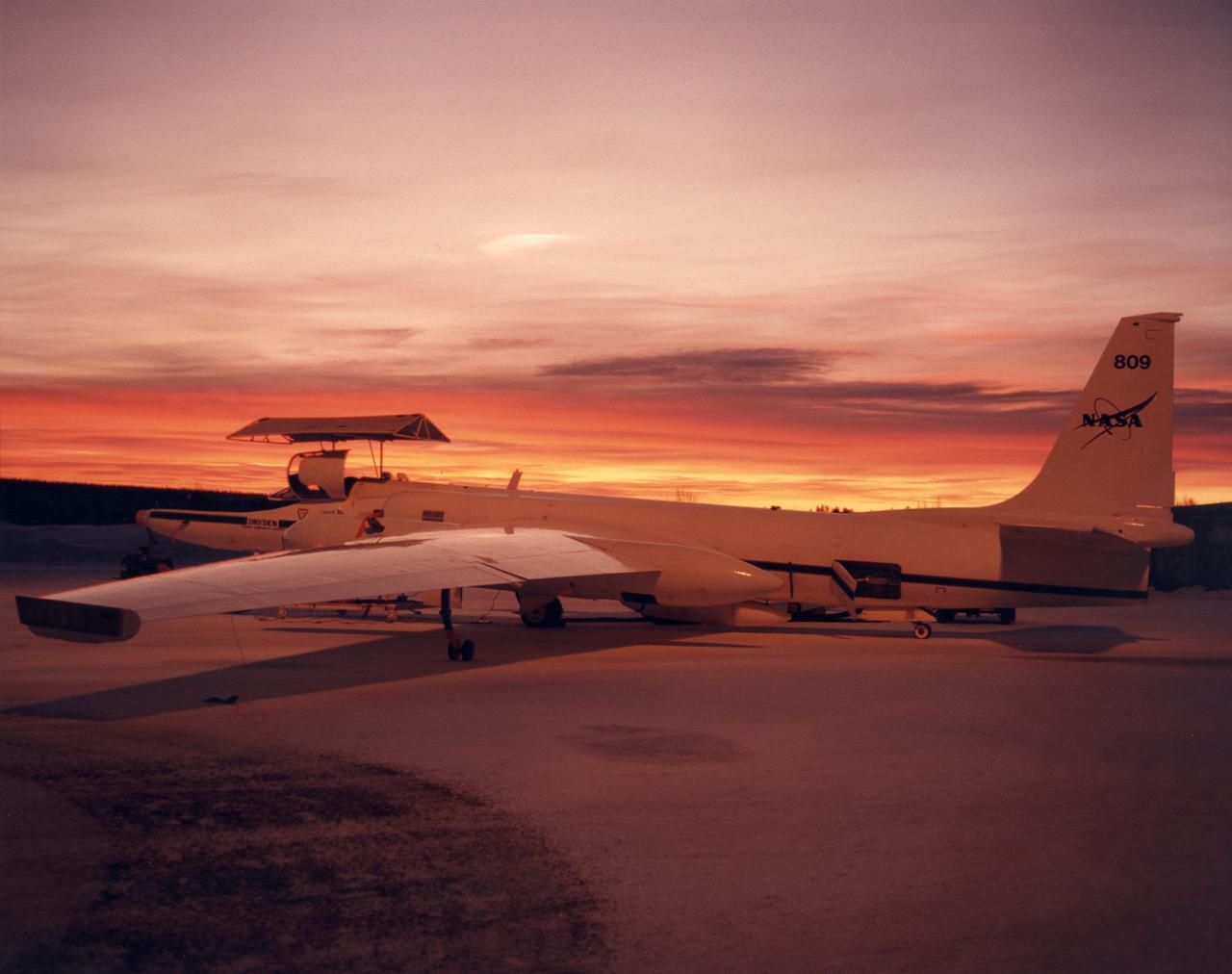
ER-2 #809 awaiting pilot entry for the third flight of the SAGE III Ozone Loss and Validation Experiment (SOLVE). The ER-2, a civilian variant of Lockheed's U-2, and another NASA flying laboratory, Dryden's DC-8, were based north of the Arctic Circle in Kiruna, Sweden during the winter of 2000 to study ozone depletion as part of SOLVE. A large hangar built especially for research, "Arena Arctica" housed the instrumented aircraft and the scientists. Scientists have observed unusually low levels of ozone over the Arctic during recent winters, raising concerns that ozone depletion there could become more widespread as in the Antarctic ozone hole. The NASA-sponsored international mission took place between November 1999 and March 2000 and was divided into three phases. The DC-8 was involved in all three phases returning to Dryden between each phase. The ER-2 flew sample collection flights between January and March, remaining in Sweden from Jan. 9 through March 16. "The collaborative campaign will provide an immense new body of information about the Arctic stratosphere," said program scientist Dr. Michael Kurylo, NASA Headquarters. "Our understanding of the Earth's ozone will be greatly enhanced by this research."
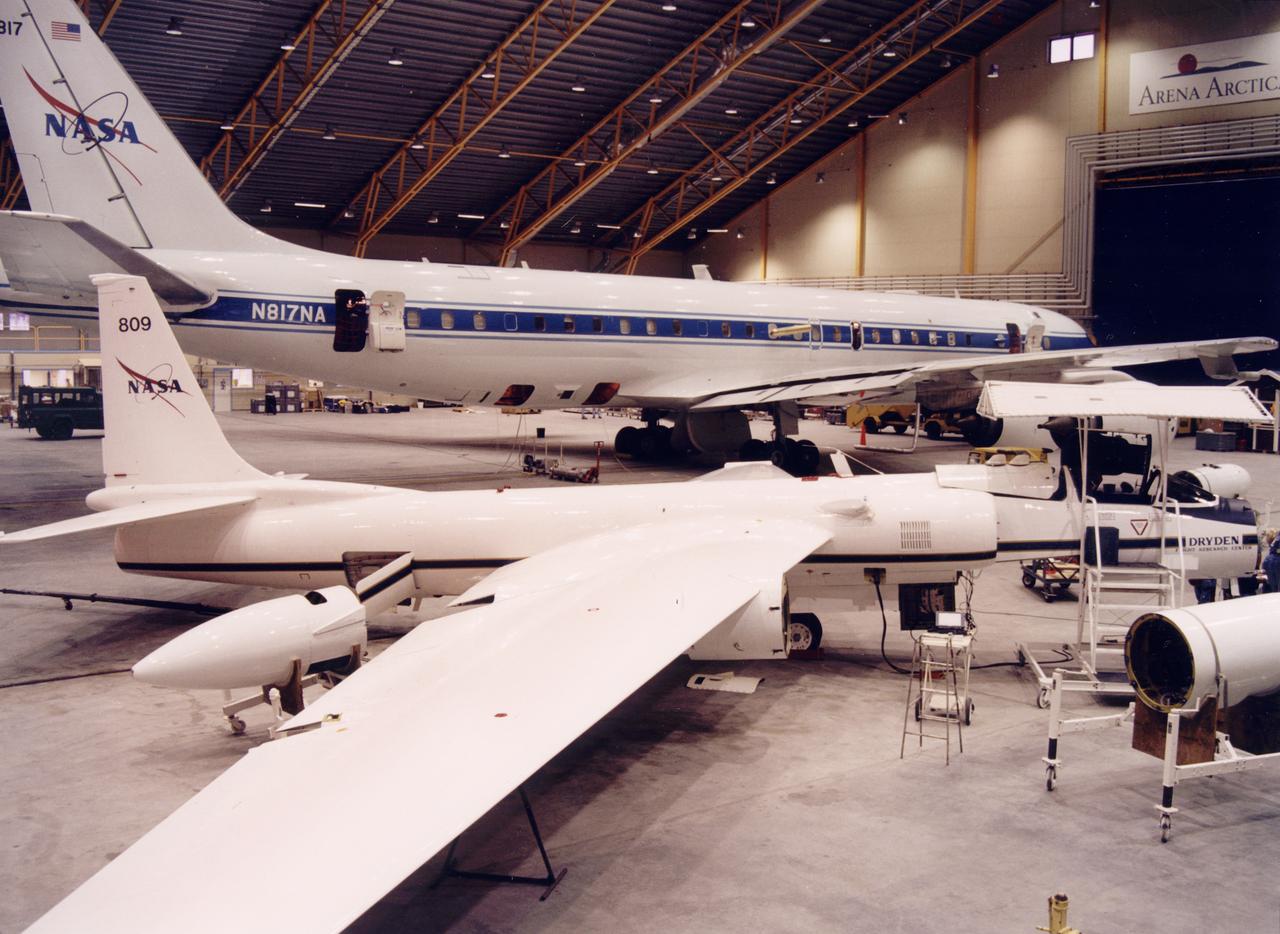
NASA ER-2 # 809 and its DC-8 shown in Arena Arctica before the SAGE III Ozone Loss and Validation Experiment (SOLVE). The two airborne science platforms were based north of the Arctic Circle in Kiruna, Sweden, during the winter of 2000 to study ozone depletion as part of SOLVE. A large hangar built especially for research, "Arena Arctica" housed the instrumented aircraft and the scientists. Scientists have observed unusually low levels of ozone over the Arctic during recent winters, raising concerns that ozone depletion there could become more widespread as in the Antarctic ozone hole. The NASA-sponsored international mission took place between November 1999 and March 2000 and was divided into three phases. The DC-8 was involved in all three phases returning to Dryden between each phase. The ER-2 flew sample collection flights between January and March, remaining in Sweden from Jan. 9 through March 16. "The collaborative campaign will provide an immense new body of information about the Arctic stratosphere," said program scientist Dr. Michael Kurylo, NASA Headquarters. "Our understanding of the Earth's ozone will be greatly enhanced by this research."

Operation IceBridge team members board a U.S. Air Force C-17 transport aircraft for a flight from Christchurch, New Zealand, to the U.S. Antarctic Program's McMurdo Station in Antarctica on Nov. 12, 2013. The C-17s that ferry people, equipment and supplies to Antarctica are operated by the U.S. Air Force's 62nd and 446th Airlift Wings based at Joint Base Lewis-McChord near Seattle, Wash. NASA's Operation IceBridge is an airborne science mission to study Earth's polar ice. In 2013, IceBridge is conducting its first field campaign directly from Antarctica. For more information about IceBridge, visit: <a href="http://www.nasa.gov/icebridge" rel="nofollow">www.nasa.gov/icebridge</a> Credit: NASA/Goddard/Jefferson Beck <b><a href="http://www.nasa.gov/audience/formedia/features/MP_Photo_Guidelines.html" rel="nofollow">NASA image use policy.</a></b> <b><a href="http://www.nasa.gov/centers/goddard/home/index.html" rel="nofollow">NASA Goddard Space Flight Center</a></b> enables NASA’s mission through four scientific endeavors: Earth Science, Heliophysics, Solar System Exploration, and Astrophysics. Goddard plays a leading role in NASA’s accomplishments by contributing compelling scientific knowledge to advance the Agency’s mission. <b>Follow us on <a href="http://twitter.com/NASA_GoddardPix" rel="nofollow">Twitter</a></b> <b>Like us on <a href="http://www.facebook.com/pages/Greenbelt-MD/NASA-Goddard/395013845897?ref=tsd" rel="nofollow">Facebook</a></b> <b>Find us on <a href="http://instagram.com/nasagoddard?vm=grid" rel="nofollow">Instagram</a></b>

NASA image captured December 25, 2011 A NASA scientific balloon awaits launch in McMurdo, Antarctica. The balloon, carrying Indiana University's Cosmic Ray Electron Synchrotron Telescope (CREST), was launched on December 25. After a circum-navigational flight around the South Pole, the payload landed on January 5. The CREST payload is one of two scheduled as part of this seasons' annual NASA Antarctic balloon Campaign which is conducted in cooperation with the National Science Foundation's Office of Polar Programs. The campaign's second payload is the University of Arizona's Stratospheric Terahertz Observatory (STO). You can follow the flights at the Columbia Scientific Balloon Facility's web site at <a href="http://www.csbf.nasa.gov/antarctica/ice.htm" rel="nofollow">www.csbf.nasa.gov/antarctica/ice.htm</a> Credit: NASA <b><a href="http://www.nasa.gov/audience/formedia/features/MP_Photo_Guidelines.html" rel="nofollow">NASA image use policy.</a></b> <b><a href="http://www.nasa.gov/centers/goddard/home/index.html" rel="nofollow">NASA Goddard Space Flight Center</a></b> enables NASA’s mission through four scientific endeavors: Earth Science, Heliophysics, Solar System Exploration, and Astrophysics. Goddard plays a leading role in NASA’s accomplishments by contributing compelling scientific knowledge to advance the Agency’s mission. <b>Follow us on <a href="http://twitter.com/NASA_GoddardPix" rel="nofollow">Twitter</a></b> <b>Like us on <a href="http://www.facebook.com/pages/Greenbelt-MD/NASA-Goddard/395013845897?ref=tsd" rel="nofollow">Facebook</a></b> <b>Find us on <a href="http://instagrid.me/nasagoddard/?vm=grid" rel="nofollow">Instagram</a></b>

Cosmic rays and the chemicals and atoms that make up the interstellar space between stars are the focus of this year’s NASA Antarctica Long Duration Balloon Flight Campaign, which kicked into high gear with the launch of the Boron And Carbon Cosmic rays in the Upper Stratosphere (BACCUS) payload Nov. 28. The University of Maryland’s BACCUS mission is the first of three payloads taking flight from a balloon launch site on Antarctica’s Ross Ice Shelf near McMurdo Station with support from the National Science Foundation’s United States Antarctic Program. Read more: <a href="http://go.nasa.gov/2gCMtyP" rel="nofollow">go.nasa.gov/2gCMtyP</a> <b><a href="http://www.nasa.gov/audience/formedia/features/MP_Photo_Guidelines.html" rel="nofollow">NASA image use policy.</a></b> <b><a href="http://www.nasa.gov/centers/goddard/home/index.html" rel="nofollow">NASA Goddard Space Flight Center</a></b> enables NASA’s mission through four scientific endeavors: Earth Science, Heliophysics, Solar System Exploration, and Astrophysics. Goddard plays a leading role in NASA’s accomplishments by contributing compelling scientific knowledge to advance the Agency’s mission. <b>Follow us on <a href="http://twitter.com/NASAGoddardPix" rel="nofollow">Twitter</a></b> <b>Like us on <a href="http://www.facebook.com/pages/Greenbelt-MD/NASA-Goddard/395013845897?ref=tsd" rel="nofollow">Facebook</a></b> <b>Find us on <a href="http://instagrid.me/nasagoddard/?vm=grid" rel="nofollow">Instagram</a></b>

Photo taken aboard a U.S. Air Force C-17 transport aircraft during a flight from Christchurch, New Zealand, to the U.S. Antarctic Program's McMurdo Station in Antarctica on Nov. 12, 2013. The C-17s that ferry people, equipment and supplies to Antarctica are operated by the U.S. Air Force's 62nd and 446th Airlift Wings based at Joint Base Lewis-McChord near Seattle, Wash. NASA's Operation IceBridge is an airborne science mission to study Earth's polar ice. In 2013, IceBridge is conducting its first field campaign directly from Antarctica. For more information about IceBridge, visit: <a href="http://www.nasa.gov/icebridge" rel="nofollow">www.nasa.gov/icebridge</a> Credit: NASA/Goddard/Jefferson Beck <b><a href="http://www.nasa.gov/audience/formedia/features/MP_Photo_Guidelines.html" rel="nofollow">NASA image use policy.</a></b> <b><a href="http://www.nasa.gov/centers/goddard/home/index.html" rel="nofollow">NASA Goddard Space Flight Center</a></b> enables NASA’s mission through four scientific endeavors: Earth Science, Heliophysics, Solar System Exploration, and Astrophysics. Goddard plays a leading role in NASA’s accomplishments by contributing compelling scientific knowledge to advance the Agency’s mission. <b>Follow us on <a href="http://twitter.com/NASA_GoddardPix" rel="nofollow">Twitter</a></b> <b>Like us on <a href="http://www.facebook.com/pages/Greenbelt-MD/NASA-Goddard/395013845897?ref=tsd" rel="nofollow">Facebook</a></b> <b>Find us on <a href="http://instagram.com/nasagoddard?vm=grid" rel="nofollow">Instagram</a></b>

NASA image captured December 25, 2011 A NASA scientific balloon awaits launch in McMurdo, Antarctica. The balloon, carrying Indiana University's Cosmic Ray Electron Synchrotron Telescope (CREST), was launched on December 25. After a circum-navigational flight around the South Pole, the payload landed on January 5. The CREST payload is one of two scheduled as part of this seasons' annual NASA Antarctic balloon Campaign which is conducted in cooperation with the National Science Foundation's Office of Polar Programs. The campaign's second payload is the University of Arizona's Stratospheric Terahertz Observatory (STO). You can follow the flights at the Columbia Scientific Balloon Facility's web site at <a href="http://www.csbf.nasa.gov/antarctica/ice.htm" rel="nofollow">www.csbf.nasa.gov/antarctica/ice.htm</a> Credit: NASA <b><a href="http://www.nasa.gov/audience/formedia/features/MP_Photo_Guidelines.html" rel="nofollow">NASA image use policy.</a></b> <b><a href="http://www.nasa.gov/centers/goddard/home/index.html" rel="nofollow">NASA Goddard Space Flight Center</a></b> enables NASA’s mission through four scientific endeavors: Earth Science, Heliophysics, Solar System Exploration, and Astrophysics. Goddard plays a leading role in NASA’s accomplishments by contributing compelling scientific knowledge to advance the Agency’s mission. <b>Follow us on <a href="http://twitter.com/NASA_GoddardPix" rel="nofollow">Twitter</a></b> <b>Like us on <a href="http://www.facebook.com/pages/Greenbelt-MD/NASA-Goddard/395013845897?ref=tsd" rel="nofollow">Facebook</a></b> <b>Find us on <a href="http://instagrid.me/nasagoddard/?vm=grid" rel="nofollow">Instagram</a></b>

NASA Operation IceBridge pilot Michael Anderson chats with Lt. Colonel Brent Keenan aboard a U.S. Air Force C-17 transport aircraft during a flight from Christchurch, New Zealand, to the U.S. Antarctic Program's McMurdo Station in Antarctica on Nov. 12, 2013. The C-17s that ferry people, equipment and supplies to Antarctica are operated by the U.S. Air Force's 62nd and 446th Airlift Wings based at Joint Base Lewis-McChord near Seattle, Wash. NASA's Operation IceBridge is an airborne science mission to study Earth's polar ice. In 2013, IceBridge is conducting its first field campaign directly from Antarctica. For more information about IceBridge, visit: <a href="http://www.nasa.gov/icebridge" rel="nofollow">www.nasa.gov/icebridge</a> Credit: NASA/Goddard/Jefferson Beck <b><a href="http://www.nasa.gov/audience/formedia/features/MP_Photo_Guidelines.html" rel="nofollow">NASA image use policy.</a></b> <b><a href="http://www.nasa.gov/centers/goddard/home/index.html" rel="nofollow">NASA Goddard Space Flight Center</a></b> enables NASA’s mission through four scientific endeavors: Earth Science, Heliophysics, Solar System Exploration, and Astrophysics. Goddard plays a leading role in NASA’s accomplishments by contributing compelling scientific knowledge to advance the Agency’s mission. <b>Follow us on <a href="http://twitter.com/NASA_GoddardPix" rel="nofollow">Twitter</a></b> <b>Like us on <a href="http://www.facebook.com/pages/Greenbelt-MD/NASA-Goddard/395013845897?ref=tsd" rel="nofollow">Facebook</a></b> <b>Find us on <a href="http://instagram.com/nasagoddard?vm=grid" rel="nofollow">Instagram</a></b>
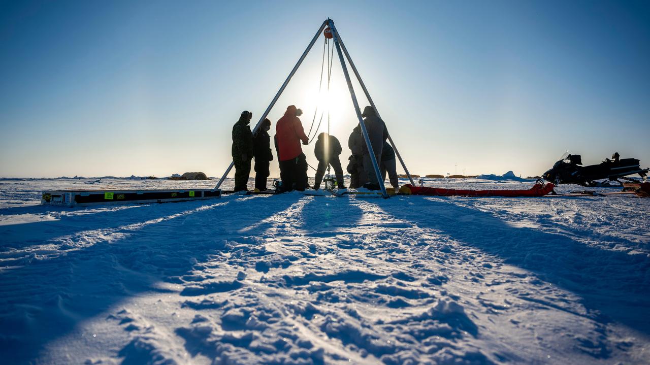
A prototype of an autonomous robot, part of a project called IceNode being developed at NASA's Jet Propulsion Laboratory, was tested in the Beaufort Sea north of Alaska in March 2024. The project envisions a fleet of such robots to venture beneath Antarctic ice shelves and gather data that would help scientists calculate how rapidly the ice shelves there are melting – and how fast that melting could cause global sea levels to rise. This image, as well as Figures A and B, shows the team lowering the prototype through a borehole in the sea ice. During this Arctic field test, the robot descended on a tether about 330 feet (100 meters) into the ocean, where its instruments gathered salinity, temperature, and flow data. The team also conducted tests to determine adjustments that would enable them to take the robot off-tether. Each about 8 feet (2.4 meters) long and 10 inches (25 centimeters) in diameter, the robots use three-legged "landing gear" that springs out from one end to attach the robot to the underside of the ice. Rather than using propulsion, the robots would autonomously position themselves with the help of novel algorithms based on models of ocean currents. Released from a borehole or a vessel in the open ocean, the robots would ride those currents on a long journey beneath an ice shelf. They would target the underwater area known as the "grounding zone," where floating ice shelves, ocean, and land meet, deep inside unmapped cavities where the ice may be melting the fastest. Each robot would detach a ballast and rise up to affix itself to the underside of the ice, where their suite of sensors would measure how fast warm, salty ocean water is circulating up to melt the ice, and how quickly cold meltwater is sinking. As conceived, the IceNode fleet would operate for up to a year, continuously capturing data, including seasonal fluctuations. Then the robots would detach themselves from the ice, drift back out to open ocean, and transmit their data via satellite. This test was conducted through the U.S. Navy Arctic Submarine Laboratory's biennial Ice Camp, a three-week operation that provides researchers a temporary base camp from which to conduct field work in the harsh Arctic environment. IceNode has been funded through JPL's internal research and technology development program and its Earth Science and Technology Directorate. JPL is managed for NASA by Caltech in Pasadena, California. https://photojournal.jpl.nasa.gov/catalog/PIA26349
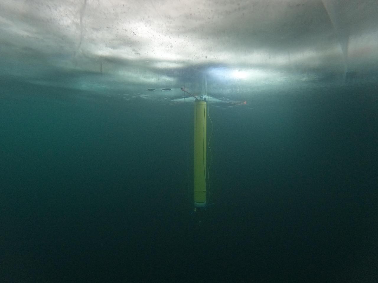
A prototype of an autonomous robot, part of a project called IceNode being developed at NASA's Jet Propulsion Laboratory, is seen from beneath the frozen surface of Lake Superior, off Michigan's Upper Peninsula. The three thin legs of the robot's "landing gear" affix it to the icy ceiling. A remote camera captured the image during a field test in 2022. The IceNode project envisions a fleet of such robots to venture beneath Antarctic ice shelves and gather data that would help scientists calculate how rapidly the ice shelves there are melting – and how fast that melting could cause global sea levels to rise. Each about 8 feet (2.4 meters) long and 10 inches (25 centimeters) in diameter, the robots use three-legged "landing gear" that springs out from one end to attach the robot to the underside of the ice. Rather than using propulsion, the robots would autonomously position themselves with the help of novel algorithms based on models of ocean currents. Released from a borehole or a vessel in the open ocean, the robots would ride those currents on a long journey beneath an ice shelf. They would target the underwater area known as the "grounding zone," where floating ice shelves, ocean, and land meet, deep inside unmapped cavities where the ice may be melting the fastest. Each robot would detach a ballast and rise up to affix itself to the underside of the ice, where their suite of sensors would measure how fast warm, salty ocean water is circulating up to melt the ice, and how quickly cold meltwater is sinking. As conceived, the IceNode fleet would operate for up to a year, continuously capturing data, including seasonal fluctuations. Then the robots would detach themselves from the ice, drift back out to open ocean, and transmit their data via satellite. This test was conducted through the U.S. Navy Arctic Submarine Laboratory's biennial Ice Camp, a three-week operation that provides researchers a temporary base camp from which to conduct field work in the harsh Arctic environment. IceNode has been funded through JPL's internal research and technology development program and its Earth Science and Technology Directorate. JPL is managed for NASA by Caltech in Pasadena, California. https://photojournal.jpl.nasa.gov/catalog/PIA26421
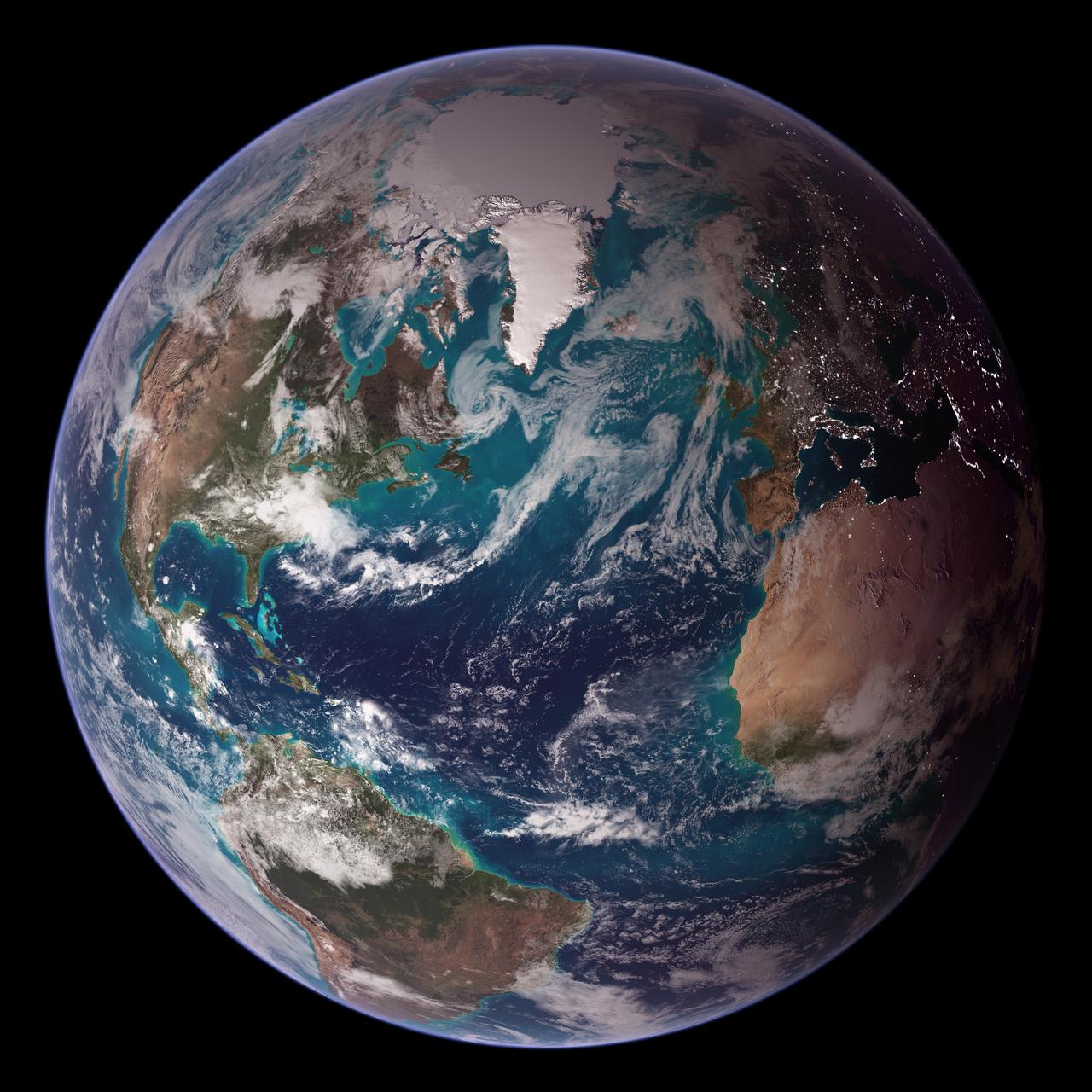
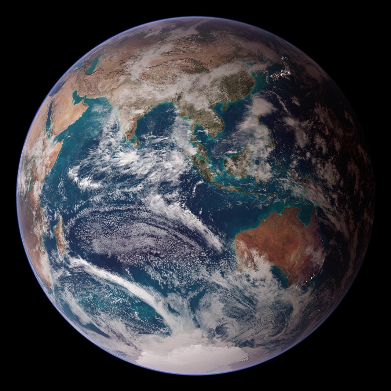
<b>RELEASE DATE: OCTOBER 9, 2007</b> <b>Credit: NASA/Goddard Space Flight Center/Reto Stöckli</b> A day’s clouds. The shape and texture of the land. The living ocean. City lights as a beacon of human presence across the globe. This amazingly beautiful view of Earth from space is a fusion of science and art, a showcase for the remote-sensing technology that makes such views possible, and a testament to the passion and creativity of the scientists who devote their careers to understanding how land, ocean, and atmosphere—even life itself—interact to generate Earth’s unique (as far as we know!) life-sustaining environment. Drawing on data from multiple satellite missions (not all collected at the same time), a team of NASA scientists and graphic artists created layers of global data for everything from the land surface, to polar sea ice, to the light reflected by the chlorophyll in the billions of microscopic plants that grow in the ocean. They wrapped these layers around a globe, set it against a black background, and simulated the hazy edge of the Earth’s atmosphere (the limb) that appears in astronaut photography of the Earth. The land surface layer is based on photo-like surface reflectance observations (reflected sunlight) measured by the Moderate Resolution Imaging Spectroradiometer (MODIS) on NASA’s Terra satellite in July 2004. The sea ice layer near the poles comes from Terra MODIS observations of daytime sea ice observed between August 28 and September 6, 2001. The ocean layer is a composite. In shallow water areas, the layer shows surface reflectances observed by Terra MODIS in July 2004. In the open ocean, the photo-like layer is overlaid with observations of the average ocean chlorophyll content for 2004. NASA’s Aqua MODIS collected the chlorophyll data. The cloud layer shows a single-day snapshot of clouds observed by Terra MODIS across the planet on July 29, 2001. City lights on Earth’s night side are visualized from data collected by the Defense Meteorological Satellite Program mission between 1994–1995. The topography layer is based on radar data collected by the Space Shuttle Endeavour during an 11-day mission in February of 2000. Topography over Antarctica comes from the Radarsat Antarctic Mapping Project, version 2. Most of the data layers in this visualization are available as monthly composites as part of NASA’s Blue Marble Next Generation image collection. The images in the collection appear in cylindrical projection (rectangular maps), and they are available at 500-meter resolution. The large images provided above are the full-size versions of these globes. In their hope that these images will inspire people to appreciate the beauty of our home planet and to learn about the Earth system, the developers of these images encourage readers to re-use and re-publish the images freely. NASA images by Reto Stöckli, based on data from NASA and NOAA. To learn the history of the Blue Marble go here: <a href="http://earthobservatory.nasa.gov/Features/BlueMarble/BlueMarble_history.php" rel="nofollow">earthobservatory.nasa.gov/Features/BlueMarble/BlueMarble_...</a> To learn more about the Blue Marble go here: <a href="http://earthobservatory.nasa.gov/IOTD/view.php?id=8108" rel="nofollow">earthobservatory.nasa.gov/IOTD/view.php?id=8108</a> <b><a href="http://www.nasa.gov/centers/goddard/home/index.html" rel="nofollow">NASA Goddard Space Flight Center</a></b> is home to the nation's largest organization of combined scientists, engineers and technologists that build spacecraft, instruments and new technology to study the Earth, the sun, our solar system, and the universe. <b>Follow us on <a href="http://twitter.com/NASA_GoddardPix" rel="nofollow">Twitter</a></b> <b>Join us on <a href="http://www.facebook.com/pages/Greenbelt-MD/NASA-Goddard/395013845897?ref=tsd" rel="nofollow">Facebook</a><b> </b></b>
<b>RELEASE DATE: OCTOBER 9, 2007</b> <b>Credit: NASA/Goddard Space Flight Center/Reto Stöckli</b> A day’s clouds. The shape and texture of the land. The living ocean. City lights as a beacon of human presence across the globe. This amazingly beautiful view of Earth from space is a fusion of science and art, a showcase for the remote-sensing technology that makes such views possible, and a testament to the passion and creativity of the scientists who devote their careers to understanding how land, ocean, and atmosphere—even life itself—interact to generate Earth’s unique (as far as we know!) life-sustaining environment. Drawing on data from multiple satellite missions (not all collected at the same time), a team of NASA scientists and graphic artists created layers of global data for everything from the land surface, to polar sea ice, to the light reflected by the chlorophyll in the billions of microscopic plants that grow in the ocean. They wrapped these layers around a globe, set it against a black background, and simulated the hazy edge of the Earth’s atmosphere (the limb) that appears in astronaut photography of the Earth. The land surface layer is based on photo-like surface reflectance observations (reflected sunlight) measured by the Moderate Resolution Imaging Spectroradiometer (MODIS) on NASA’s Terra satellite in July 2004. The sea ice layer near the poles comes from Terra MODIS observations of daytime sea ice observed between August 28 and September 6, 2001. The ocean layer is a composite. In shallow water areas, the layer shows surface reflectances observed by Terra MODIS in July 2004. In the open ocean, the photo-like layer is overlaid with observations of the average ocean chlorophyll content for 2004. NASA’s Aqua MODIS collected the chlorophyll data. The cloud layer shows a single-day snapshot of clouds observed by Terra MODIS across the planet on July 29, 2001. City lights on Earth’s night side are visualized from data collected by the Defense Meteorological Satellite Program mission between 1994–1995. The topography layer is based on radar data collected by the Space Shuttle Endeavour during an 11-day mission in February of 2000. Topography over Antarctica comes from the Radarsat Antarctic Mapping Project, version 2. Most of the data layers in this visualization are available as monthly composites as part of NASA’s Blue Marble Next Generation image collection. The images in the collection appear in cylindrical projection (rectangular maps), and they are available at 500-meter resolution. The large images provided above are the full-size versions of these globes. In their hope that these images will inspire people to appreciate the beauty of our home planet and to learn about the Earth system, the developers of these images encourage readers to re-use and re-publish the images freely. NASA images by Reto Stöckli, based on data from NASA and NOAA. To learn the history of the Blue Marble go here: <a href="http://earthobservatory.nasa.gov/Features/BlueMarble/BlueMarble_history.php" rel="nofollow">earthobservatory.nasa.gov/Features/BlueMarble/BlueMarble_...</a> To learn more about the Blue Marble go here: <a href="http://earthobservatory.nasa.gov/IOTD/view.php?id=8108" rel="nofollow">earthobservatory.nasa.gov/IOTD/view.php?id=8108</a> To learn more about NASA's Goddard Space Flight Center go here: <a href="http://www.nasa.gov/centers/goddard/home/index.html" rel="nofollow">www.nasa.gov/centers/goddard/home/index.html</a> <b><a href="http://www.nasa.gov/centers/goddard/home/index.html" rel="nofollow">NASA Goddard Space Flight Center</a></b> is home to the nation's largest organization of combined scientists, engineers and technologists that build spacecraft, instruments and new technology to study the Earth, the sun, our solar system, and the universe. <b><a href="http://www.nasa.gov/centers/goddard/home/index.html" rel="nofollow">NASA Goddard Space Flight Center</a></b> is home to the nation's largest organization of combined scientists, engineers and technologists that build spacecraft, instruments and new technology to study the Earth, the sun, our solar system, and the universe. <b>Follow us on <a href="http://twitter.com/NASA_GoddardPix" rel="nofollow">Twitter</a></b> <b>Join us on <a href="http://www.facebook.com/pages/Greenbelt-MD/NASA-Goddard/395013845897?ref=tsd" rel="nofollow">Facebook</a><b> </b></b>