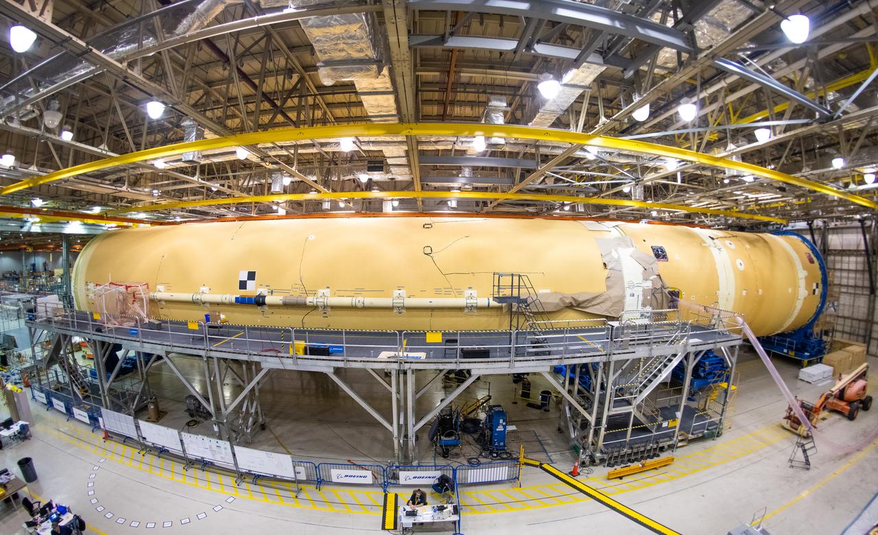
Technicians at NASA’s Michoud Assembly Facility in New Orleans completed the “forward join,” which connects structures to form the top part of NASA’s Space Launch System (SLS) rocket’s core stage. The first core stage will send Exploration Mission-1, the first integrated flight of SLS and NASA’s Orion spacecraft, out beyond the Moon. The forward join mated three structures: the forward skirt, liquid oxygen tank and intertank. This milestone marks the beginning of integration and assembly of the massive, 212-foot-tall SLS core stage, which will include the rocket’s four RS-25 rocket engines, propellant tanks and flight computers. Now, NASA and Boeing, the SLS prime contractor, will continue to integrate various systems inside the forward part of the core stage and prepare for structural joining of the liquid hydrogen tank and engine section to form the bottom of the stage. These two parts of the core stage will then be assembled to form the largest stage NASA has ever built.
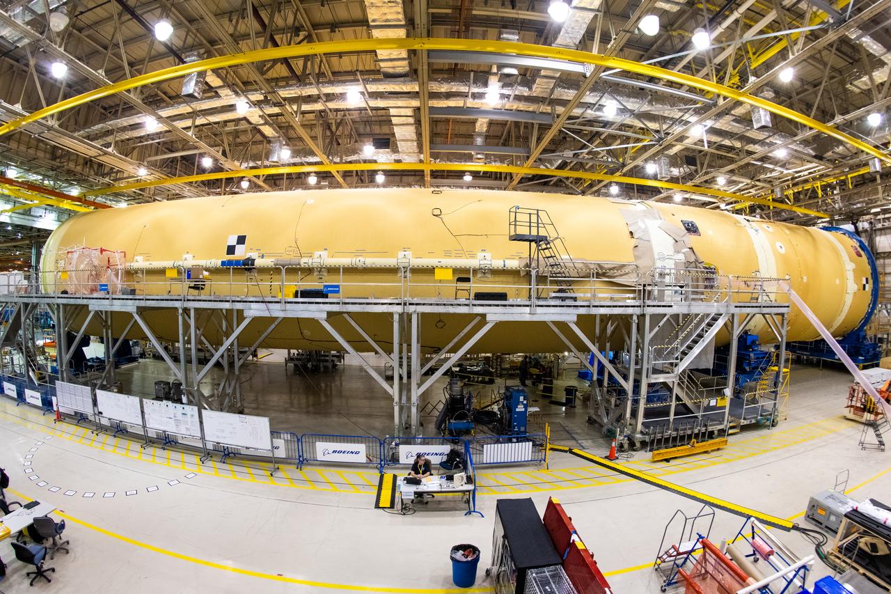
Technicians at NASA’s Michoud Assembly Facility in New Orleans completed the “forward join,” which connects structures to form the top part of NASA’s Space Launch System (SLS) rocket’s core stage. The first core stage will send Exploration Mission-1, the first integrated flight of SLS and NASA’s Orion spacecraft, out beyond the Moon. The forward join mated three structures: the forward skirt, liquid oxygen tank and intertank. This milestone marks the beginning of integration and assembly of the massive, 212-foot-tall SLS core stage, which will include the rocket’s four RS-25 rocket engines, propellant tanks and flight computers. Now, NASA and Boeing, the SLS prime contractor, will continue to integrate various systems inside the forward part of the core stage and prepare for structural joining of the liquid hydrogen tank and engine section to form the bottom of the stage. These two parts of the core stage will then be assembled to form the largest stage NASA has ever built.
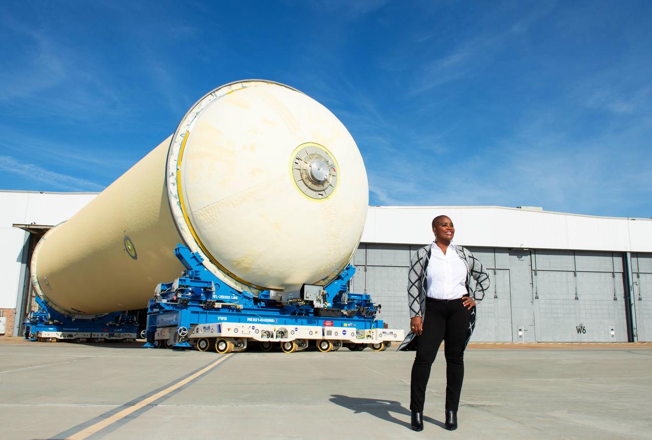
CS1 LH2 Move into Area 47
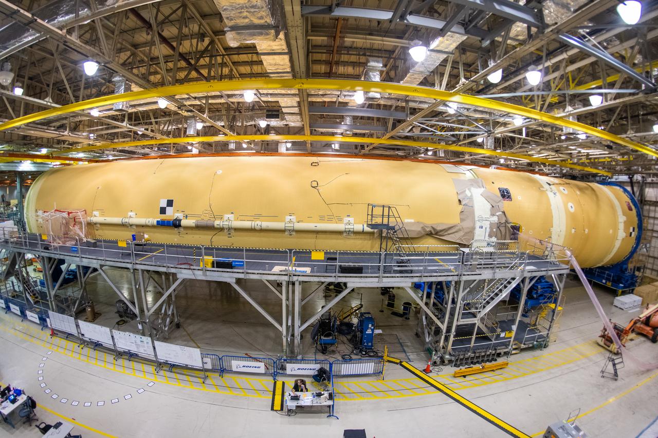
Technicians at NASA’s Michoud Assembly Facility in New Orleans completed the “forward join,” which connects structures to form the top part of NASA’s Space Launch System (SLS) rocket’s core stage. The first core stage will send Exploration Mission-1, the first integrated flight of SLS and NASA’s Orion spacecraft, out beyond the Moon. The forward join mated three structures: the forward skirt, liquid oxygen tank and intertank. This milestone marks the beginning of integration and assembly of the massive, 212-foot-tall SLS core stage, which will include the rocket’s four RS-25 rocket engines, propellant tanks and flight computers. Now, NASA and Boeing, the SLS prime contractor, will continue to integrate various systems inside the forward part of the core stage and prepare for structural joining of the liquid hydrogen tank and engine section to form the bottom of the stage. These two parts of the core stage will then be assembled to form the largest stage NASA has ever built.
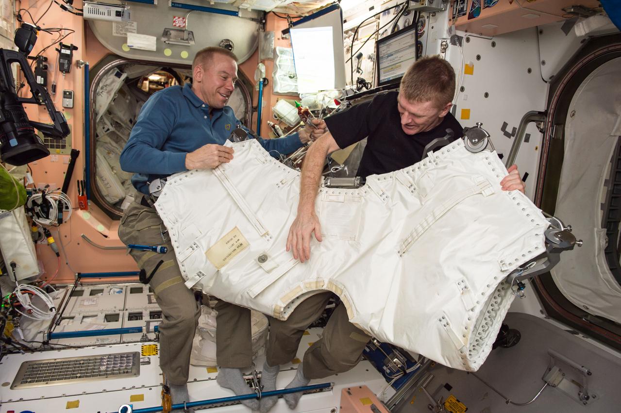
ISS047e028518 (03/26?2016) --- NASA astronaut Tim Kopra, Expedition 47 Commander, and ESA (European Space Agency) astronaut Tim Peake, Expedition 47 Flight Engineer gather hardware to outfit the area between Orbital ATK’s Cygnus cargo vehicle and the Unity Module.
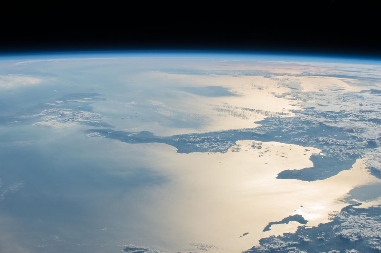
ISS47e141893 (06/02/2016) --- This Earth observation image of the southern Mediterranean area was taken by the crew of Expedition 47 aboard the International Space Station. The image looks from the coastline of Greece (bottom left) across the Ionian sea to the bottom "heel" of Italy. The tip of the toe reaches toward Sicily.
This 39 by 47 km ASTER sub-scene was acquired on May 20, 2000 and shows an area along the west side of the Cascade Range in west central Oregon. Bands 4, 3, and 2 were combined as red, green, and blue. In this composite, snow appears blue, forests are green, and clear-cut areas are orange-pink. The magnitude of logging operations is quite obvious, appearing as a checker board pattern. The image is centered at 44.6 degrees north latitude, 122.2 degrees west longitude. http://photojournal.jpl.nasa.gov/catalog/PIA11165
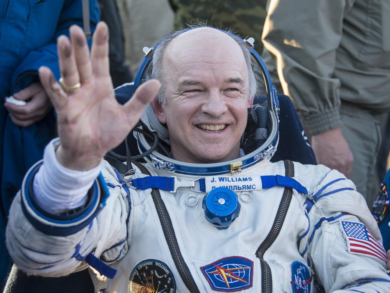
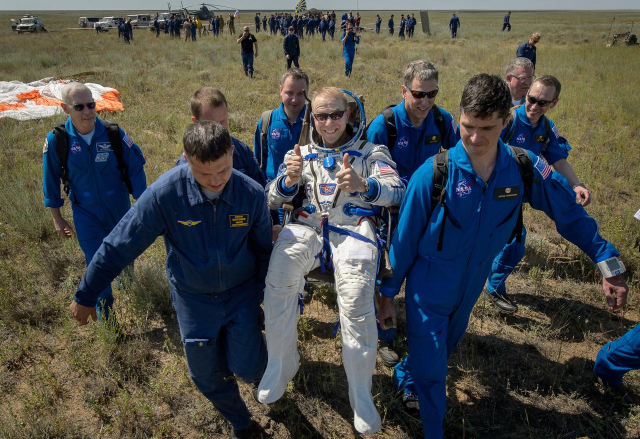
Expedition 48 NASA astronaut Jeff Williams rest in a chairs outside the Soyuz TMA-20M spacecraft a few moments after he and Russian cosmonauts Alexey Ovchinin and Oleg Skripochka of Roscosmos landed in a remote area near the town of Zhezkazgan, Kazakhstan on Wednesday, Sept. 7, 2016(Kazakh time). Williams, Ovchinin, and Skripochka are returning after 172 days in space where they served as members of the Expedition 47 and 48 crews onboard the International Space Station. Photo Credit: (NASA/Bill Ingalls)
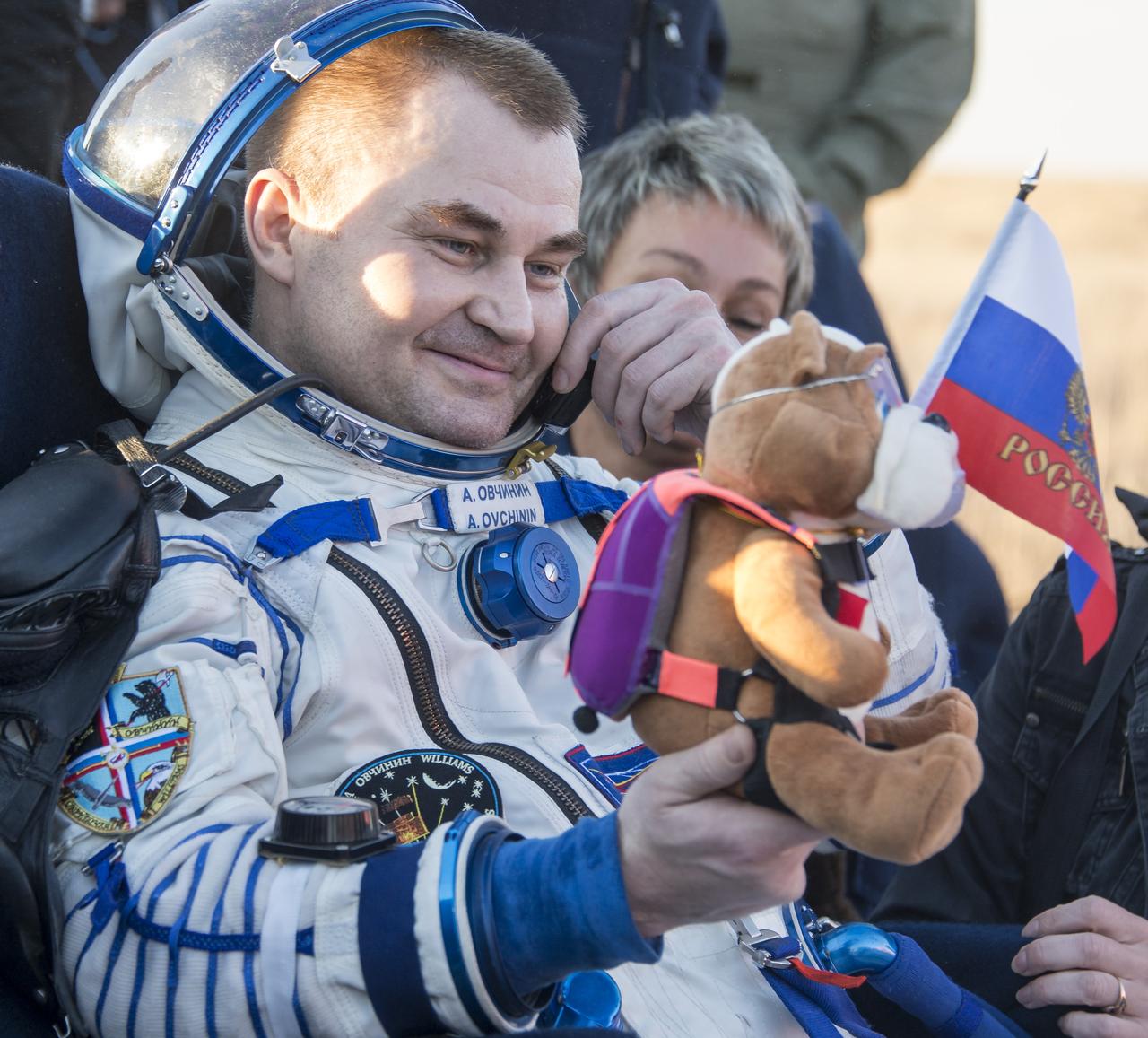
Russian cosmonaut Alexey Ovchinin of Roscosmos rest in a chair outside the Soyuz TMA-20M spacecraft a few moments after he and NASA astronaut Jeff Williams, and Russian cosmonaut Oleg Skripochka of Roscosmos landed in a remote area near the town of Zhezkazgan, Kazakhstan on Wednesday, Sept. 7, 2016(Kazakh time). Williams, Ovchinin, and Skripochka are returning after 172 days in space where they served as members of the Expedition 47 and 48 crews onboard the International Space Station. Photo Credit: (NASA/Bill Ingalls)
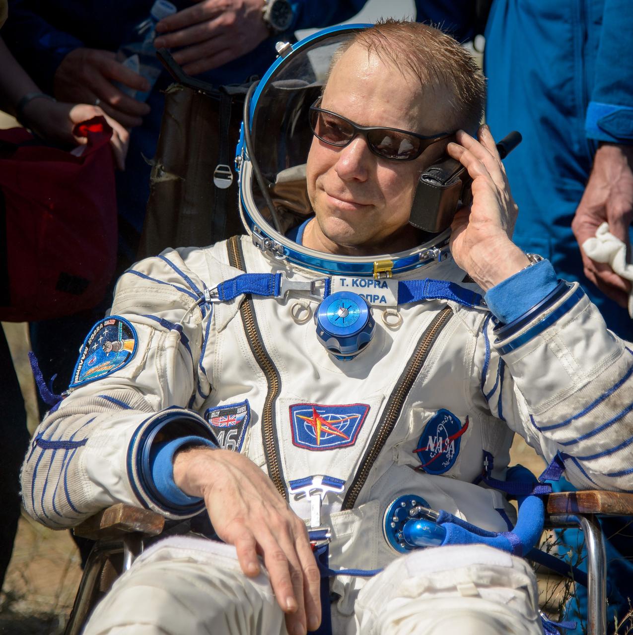
Tim Kopra of NASA talks on a satellite phone outside the Soyuz TMA-19M spacecraft just minutes after he and Yuri Malenchenko of Roscosmos and Tim Peake of the European Space Agency landed in a remote area near the town of Zhezkazgan, Kazakhstan on Saturday, June 18, 2016. Kopra, Peake, and Malenchenko are returning after six months in space where they served as members of the Expedition 46 and 47 crews onboard the International Space Station. Photo Credit: (NASA/Bill Ingalls)
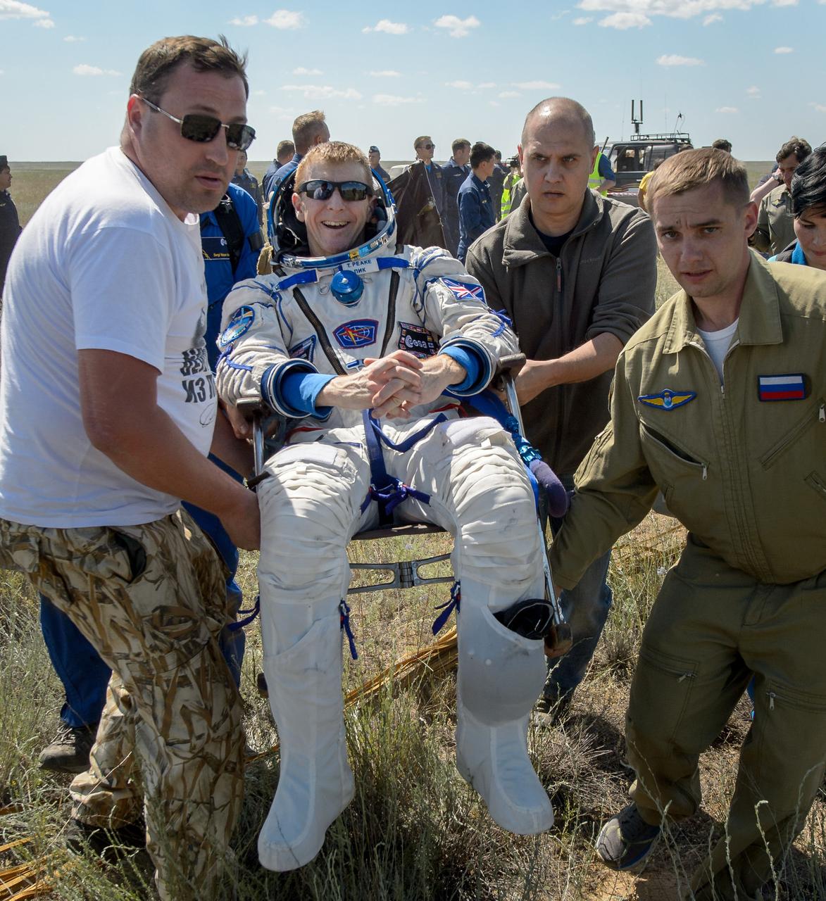
Tim Peake of the European Space Agency is carried to a medical tent after he and Tim Kopra of NASA and Yuri Malenchenko of Roscosmos landed in their Soyuz TMA-19M spacecraft in a remote area near the town of Zhezkazgan, Kazakhstan on Saturday, June 18, 2016. Kopra, Peake, and Malenchenko are returning after six months in space where they served as members of the Expedition 46 and 47 crews onboard the International Space Station. Photo Credit: (NASA/Bill Ingalls)
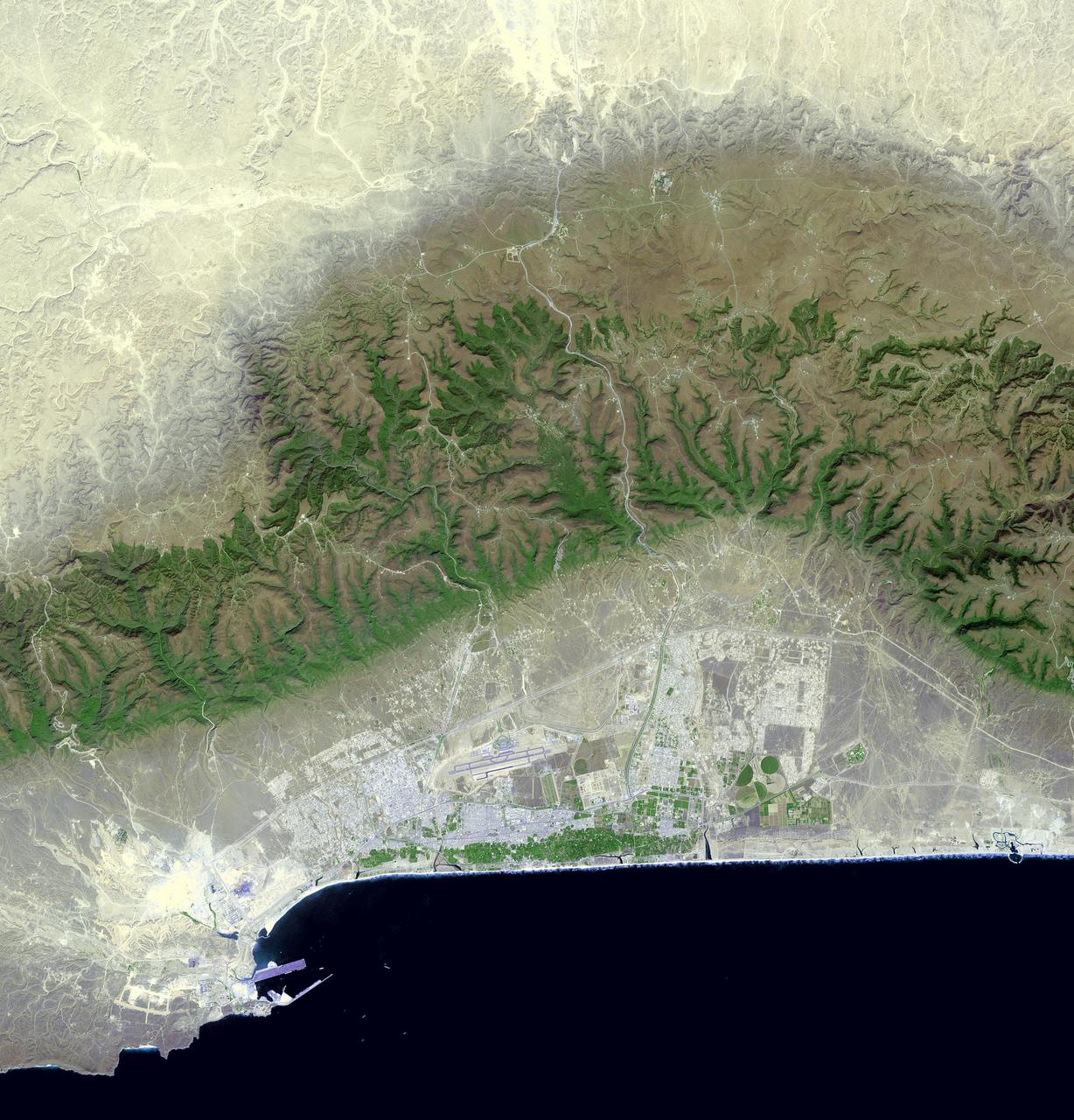
Salalah is the second largest city in the Sultanate of Oman, located in the far southern tip of the country. Salalah reached its peak in the 13th century, thanks to the trade in frankincense and myrrh. From 1932 to 1970, it was the capital of the Sultanate of Muscat and Oman. The Port of Salalah is one of the most vital on the Arabian Peninsula. The image was acquired October 15, 2016, covers an area of 47 by 49 km, and is located at 17.1 north, 54.1 east. https://photojournal.jpl.nasa.gov/catalog/PIA21803
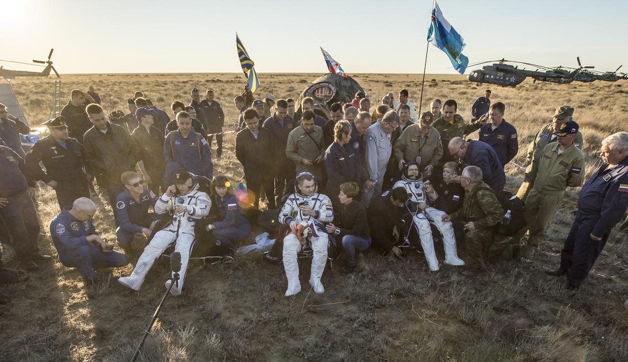
NASA astronaut Jeff Williams, left, Russian cosmonaut Alexey Ovchinin of Roscosmos, center, and Russian cosmonaut Oleg Skripochka of Roscosmos sit in chairs outside the Soyuz TMA-20M spacecraft a few moments after they landed in a remote area near the town of Zhezkazgan, Kazakhstan on Wednesday, Sept. 7, 2016(Kazakh time). Williams, Ovchinin, and Skripochka are returning after 172 days in space where they served as members of the Expedition 47 and 48 crews onboard the International Space Station. Photo Credit: (NASA/Bill Ingalls)
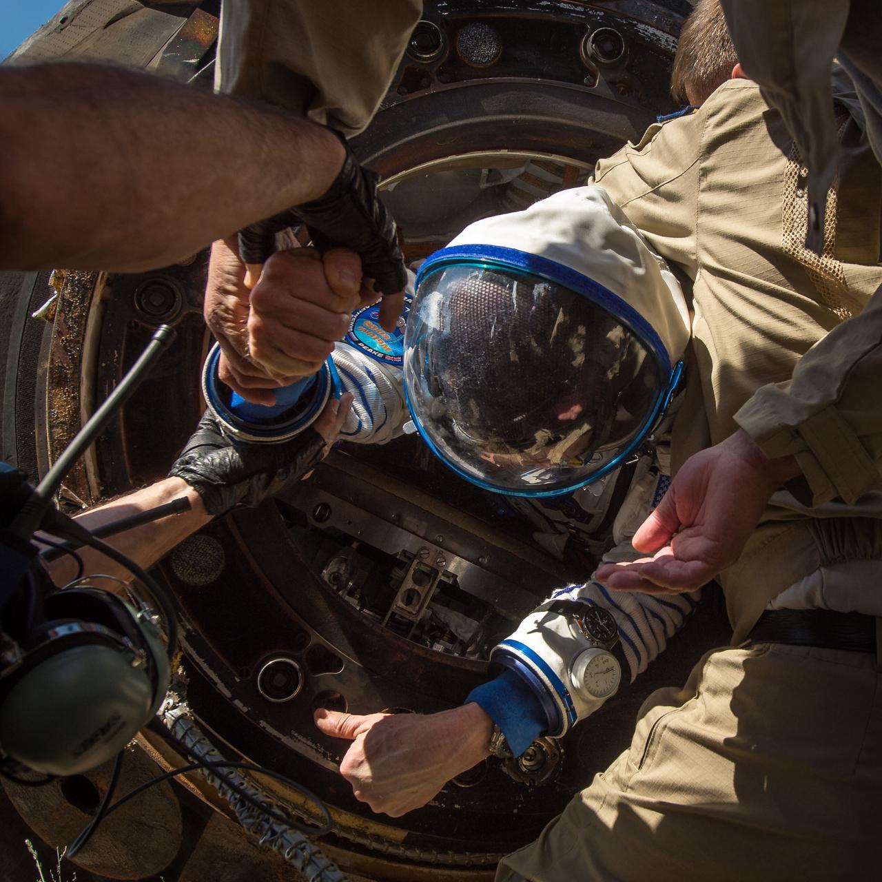
Tim Kopra of NASA is helped out of the Soyuz TMA-19M spacecraft just minutes after he and Yuri Malenchenko of Roscosmos and Tim Peake of the European Space Agency landed in a remote area near the town of Zhezkazgan, Kazakhstan on Saturday, June 18, 2016. Kopra, Peake, and Malenchenko are returning after six months in space where they served as members of the Expedition 46 and 47 crews onboard the International Space Station. Photo Credit: (NASA/Bill Ingalls)
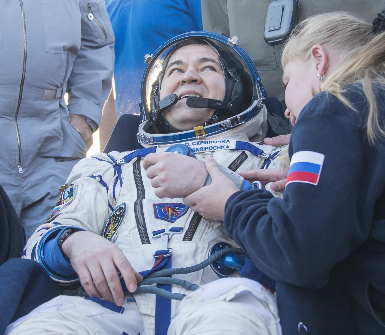
Russian cosmonaut Oleg Skripochka of Roscosmos rest in a chair outside the Soyuz TMA-20M spacecraft a few moments after he and NASA astronaut Jeff Williams, and Russian cosmonaut Alexey Ovchinin of Roscosmos landed in a remote area near the town of Zhezkazgan, Kazakhstan on Wednesday, Sept. 7, 2016(Kazakh time). Williams, Ovchinin, and Skripochka are returning after 172 days in space where they served as members of the Expedition 47 and 48 crews onboard the International Space Station. Photo Credit: (NASA/Bill Ingalls)
S92-44307 (25 July 1992) --- Technicians, engineers and flight crewmembers look on as the Spacelab-J laboratory module and experiment canister bridge are lowered into Endeavour's cargo bay. The STS-47 crewmembers visited Endeavour, currently undergoing pre-flight processing in a high bay area of the Orbiter Processing Facility at the Kennedy Space Center. The Spacelab-J mission is currently scheduled for September of this year.
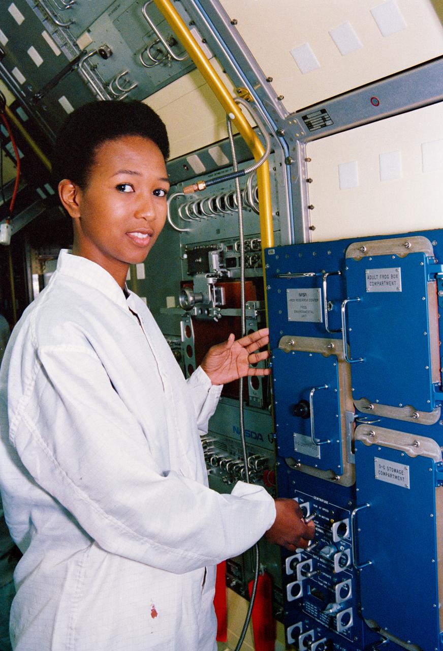
S92-44302 (25 July 1992) --- Astronaut Mae C. Jemison, mission specialist, examines the interior of the Spacelab-J laboratory module installed in Endeavour's cargo bay. The STS-47 crewmembers visited Endeavour, currently undergoing pre-flight processing in a high bay area of the Orbiter Processing Facility at the Kennedy Space Center. The Spacelab-J mission is currently scheduled for September of this year.
Tim Kopra of NASA is carried to a medical tent after he and Tim Peake of the European Space Agency and Yuri Malenchenko of Roscosmos landed in their Soyuz TMA-19M spacecraft in a remote area near the town of Zhezkazgan, Kazakhstan on Saturday, June 18, 2016. Kopra, Peake, and Malenchenko are returning after six months in space where they served as members of the Expedition 46 and 47 crews onboard the International Space Station. Photo Credit: (NASA/Bill Ingalls)
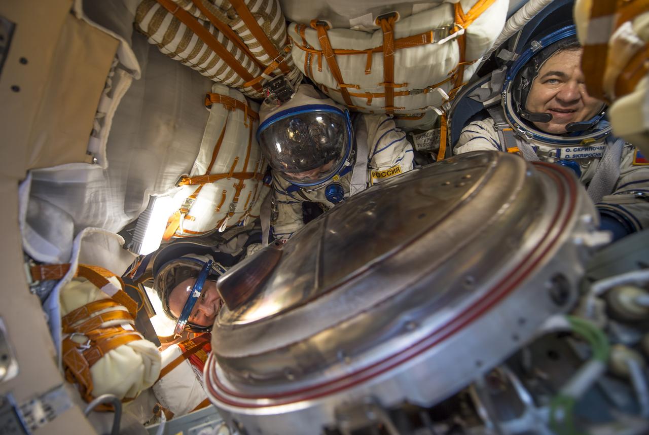
NASA astronaut Jeff Williams, left, Russian cosmonaut Alexey Ovchinin of Roscosmos, center, and Russian cosmonaut Oleg Skripochka of Roscosmos are seen inside the Soyuz TMA-20M spacecraft a few moments after they landed in a remote area near the town of Zhezkazgan, Kazakhstan on Wednesday, Sept. 7, 2016(Kazakh time). Williams, Ovchinin, and Skripochka are returning after 172 days in space where they served as members of the Expedition 47 and 48 crews onboard the International Space Station. Photo Credit: (NASA/Bill Ingalls)
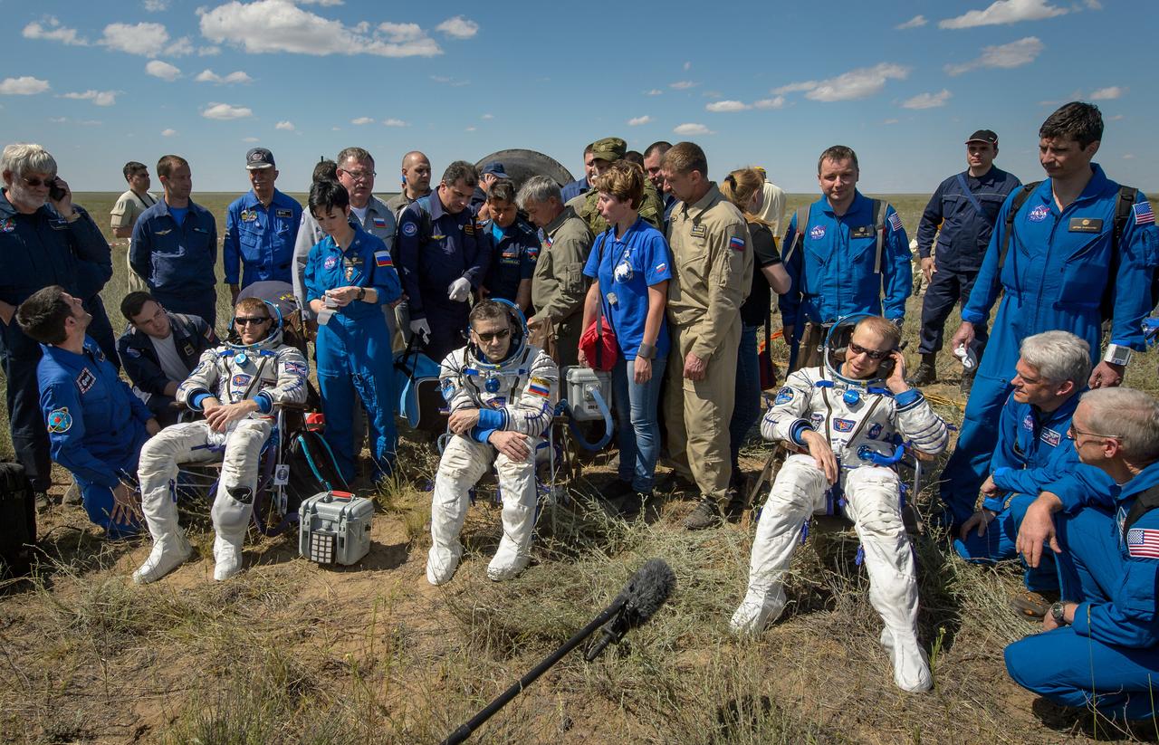
Tim Peake of the European Space Agency, left, Yuri Malenchenko of Roscosmos center, and Tim Kopra of NASA sit in chairs outside the Soyuz TMA-19M spacecraft just minutes after they landed in a remote area near the town of Zhezkazgan, Kazakhstan on Saturday, June 18, 2016. Kopra, Peake, and Malenchenko are returning after six months in space where they served as members of the Expedition 46 and 47 crews onboard the International Space Station. Photo Credit: (NASA/Bill Ingalls)
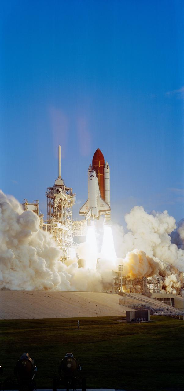
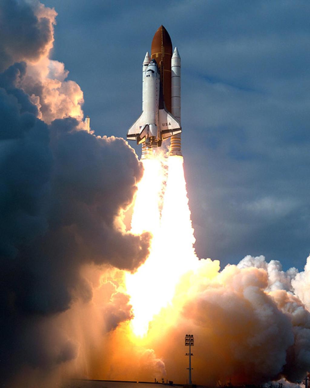
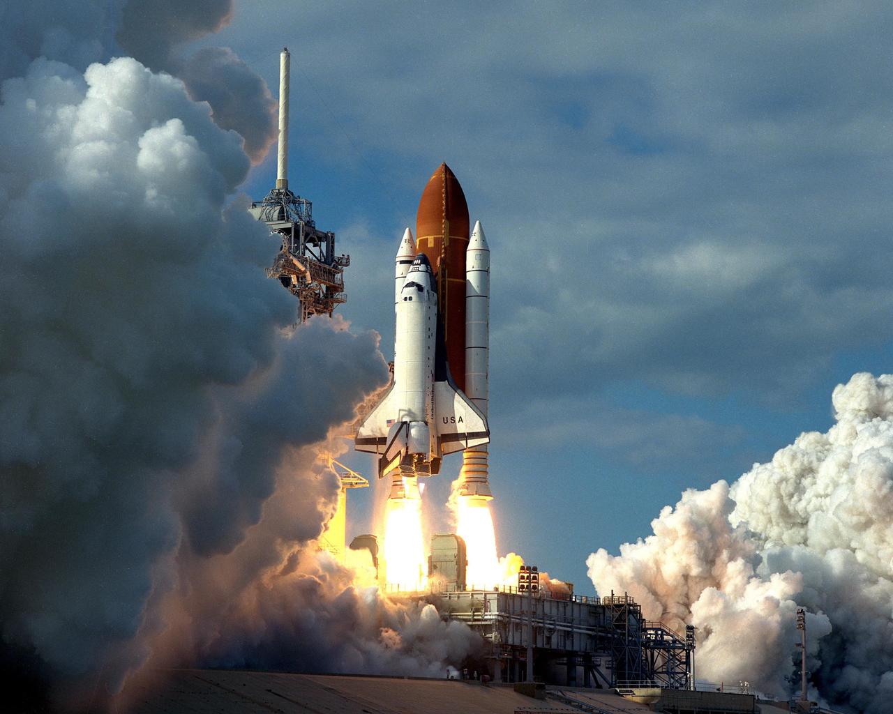
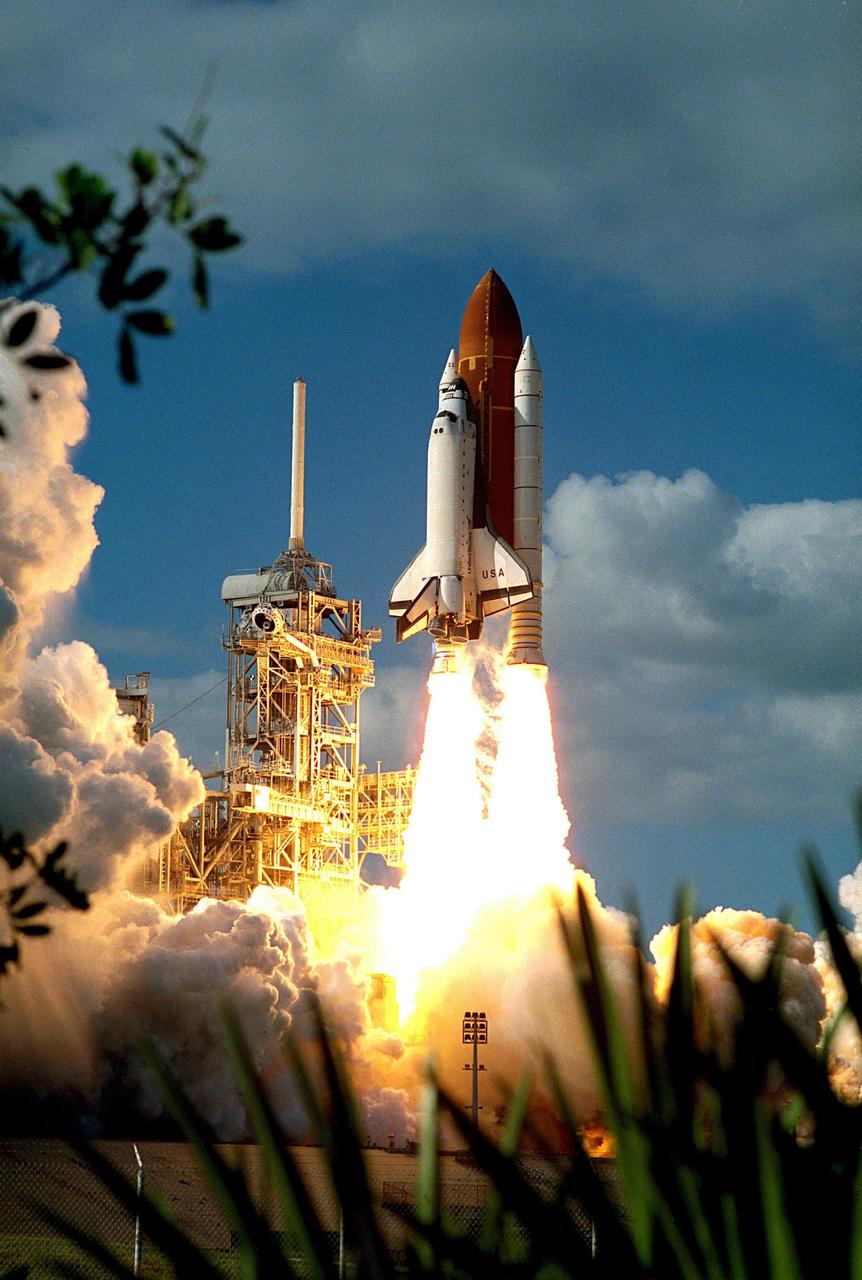
STS-41 Discovery, Orbiter Vehicle (OV) 103, lifts off from the Kennedy Space Center (KSC) Launch Complex (LC) Pad 39 mobile launcher platform at 7:47 am (Eastern Daylight Time (EDT)). OV-103 riding atop the external tank (ET) and flanked by two solid rocket boosters (SRBs), is captured just moments after liftoff. Not yet clear of the fixed service structure (FSS) tower, OV-103 is highlighted against the cloudless morning sky. Exhaust smoke billows from the SRBs and the space shuttle main engines (SSMEs) creating a cloud over the launch pad area.
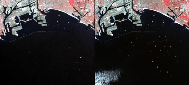
In southern California, the combined ports of Los Angeles and Long Beach account for 33% of the nation containerized imports. This image from NASA Terra spacecraft shows the large backlog of waiting cargo ships being slowly unloaded. The left image was acquired July 4, 2014 during normal operations: 14 ships are being unloaded, while 7 wait their turns near the facilities. The right image was acquired on March 8, 2015: 19 ships are moored at unloading docks, while 47 ships wait their turns. The images cover an area of 16.7 x 18.6 km, and are located at 33.7 degrees north, 118.2 degrees west. http://photojournal.jpl.nasa.gov/catalog/PIA19249
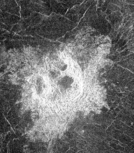
This Magellan image shows an irregular crater of approximately 14- kilometer (8.7-mile) mean diameter. The crater is actually a cluster of four separate craters that are in rim contact. The noncircular rims and multiple, hummocky floors are probably the result of the breakup and dispersion of an incoming meteoroid during passage through the dense Venusian atmosphere. After breaking up, the meteoroid fragments impacted nearly simultaneously, creating the crater cluster. The area shown is 40 kilometers (25 miles) in width and 76 kilometers (47 miles) in length, it is centered at -21.4 degrees latitude, 335.2 degrees longitude in the northern Lavinia Region of Venus. http://photojournal.jpl.nasa.gov/catalog/PIA00476
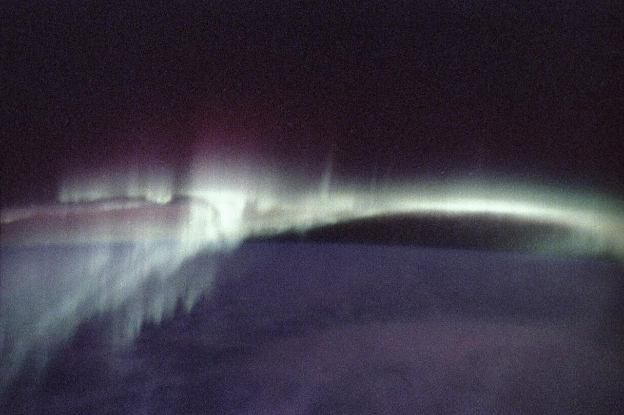
This photograph of aurora borealis, northern aurora, was taken during the Spacelab-J (SL-J) mission (STS-47). People who live in the northernmost areas like Alaska or work in the southernmost regions like Antarctica often see colorful lights produced by Earth's natural electromagnetic generator; these shimmering expanses of light are auroras, commonly called the northern and southern lights. Charged particles from the magnetosphere follow magnetic fields and are accelerated toward Earth at the magnetic poles where they strike molecules in the upper atmosphere, staining the sky with the red and green lights of oxygen and hydrogen, and the purples and pinks of nitrogen. The altitude and inclination of the Spacelab will give scientists unique views of auroras, which occur at altitudes ranging from about 90 to 300 kilometers (56 to 186 miles). Most views of the auroras have been from the ground where only limited parts can be seen. These Skylab views will give scientists information on their complex structure and chemical composition. The Spacelab-J was a joint mission of NASA and the National Space Development Agency of Japan (NASDA) utilizing a marned Spacelab module. The mission conducted microgravity investigations in materials and life sciences. The SL-J was launched aboard the Space Shuttle Orbiter Endeavour (STS-47) on September 12, 1992.

This photograph of aurora borealis, northern aurora, was taken during the Spacelab-J (SL-J) mission (STS-47). People who live in the northernmost areas like Alaska or work in the southernmost regions like Antarctica often see colorful lights produced by Earth's natural electromagnetic generator; these shimmering expanses of light are auroras, commonly called the northern and southern lights. Charged particles from the magnetosphere follow magnetic fields and are accelerated toward Earth at the magnetic poles where they strike molecules in the upper atmosphere, staining the sky with the red and green lights of oxygen and hydrogen, and the purples and pinks of nitrogen. The altitude and inclination of the Spacelab will give scientists unique views of auroras, which occur at altitudes ranging from about 90 to 300 kilometers (56 to 186 miles). Most views of the auroras have been from the ground where only limited parts can be seen. These Spacelab views will give scientists information on their complex structure and chemical composition. The Spacelab-J was a joint mission of NASA and the National Space Development Agency of Japan (NASDA) utilizing a marned Spacelab module. The mission conducted microgravity investigations in materials and life sciences. The SL-J was launched aboard the Space Shuttle Orbiter Endeavour (STS-47) on September 12, 1992.
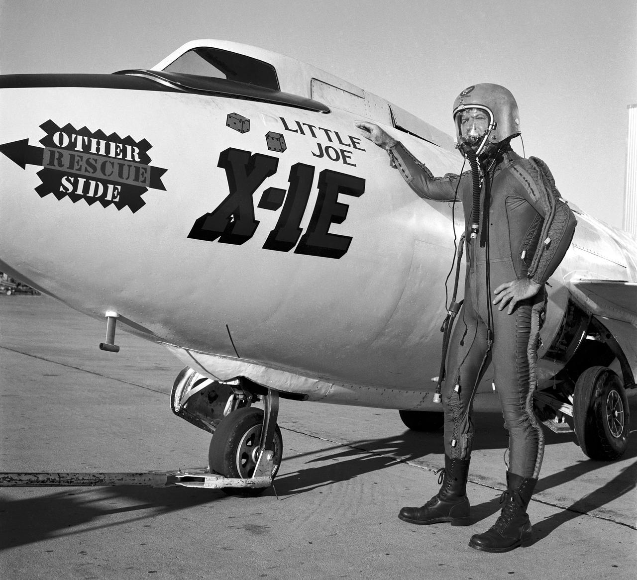
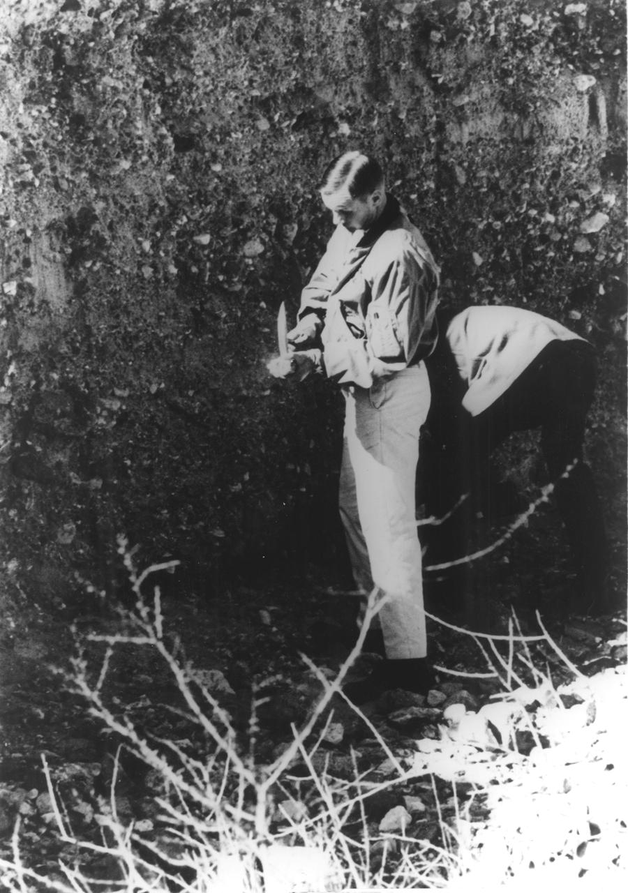
Joe Walker in a pressure suit beside the X-1E at the NASA High-Speed Flight Station, Edwards,California. The dice and "Little Joe" are prominently displayed under the cockpit area. (Little Joe is a dice players slang term for two deuces.) Walker is shown in the photo wearing an early Air Force partial pressure suit. This protected the pilot if cockpit pressure was lost above 50,000 feet. Similar suits were used in such aircraft as B-47s, B-52s, F-104s, U-2s, and the X-2 and D-558-II research aircraft. Five years later, Walker reached 354,200 feet in the X-15. Similar artwork - reading "Little Joe the II" - was applied for the record flight. These cases are two of the few times that research aircraft carried such nose art.
AS09-26A-3792A (11 March 1969) --- Color infrared photograph of the Atlanta, Georgia area taken on March 11, 1969, by one of the four synchronized cameras of the Apollo 9 Earth Resources Survey (SO-65) experiment. At 11:21 a.m. (EST) when this picture was taken, the Apollo 9 spacecraft was at an altitude of 106 nautical miles, and the sun elevation was 47 degrees above the horizon. The location of the point on Earth's surface at which the four-camera combination was aimed was 33 degrees 10 minutes north latitude, and 84 degrees and 40 minutes west longitude. The other three cameras used: (B) black and white film with a red filter; (C) black and white infrared film; and (D) black and white film with a green filter.
Anchorage, Alaska and Cook Inlet are seen in this 30 by 30 km (19 by 19 miles) sub-image, acquired May 12, 2000 by the Advanced Spaceborne Thermal Emission and Reflection Radiometer (ASTER). Orbiting at an altitude of 705 km (430 miles) on board NASA's Terra satellite, ASTER provides data at a resolution of 15 m (47 feet) and allows creation of this simulated natural color image. At the center of the image is the Ted Stevens Anchorage International Airport; in the upper right corner is Elmendorf Air Force Base. Dark green coniferous forests are seen in the northwest part of the image. A golf course, with its lush green fairways, is just south of the Air Force Base. The image covers an area of 30 by 30 km, was acquired May 12, 2000, and is located at 61.2 degrees north latitude and 149.9 degrees west longitude. http://photojournal.jpl.nasa.gov/catalog/PIA02675
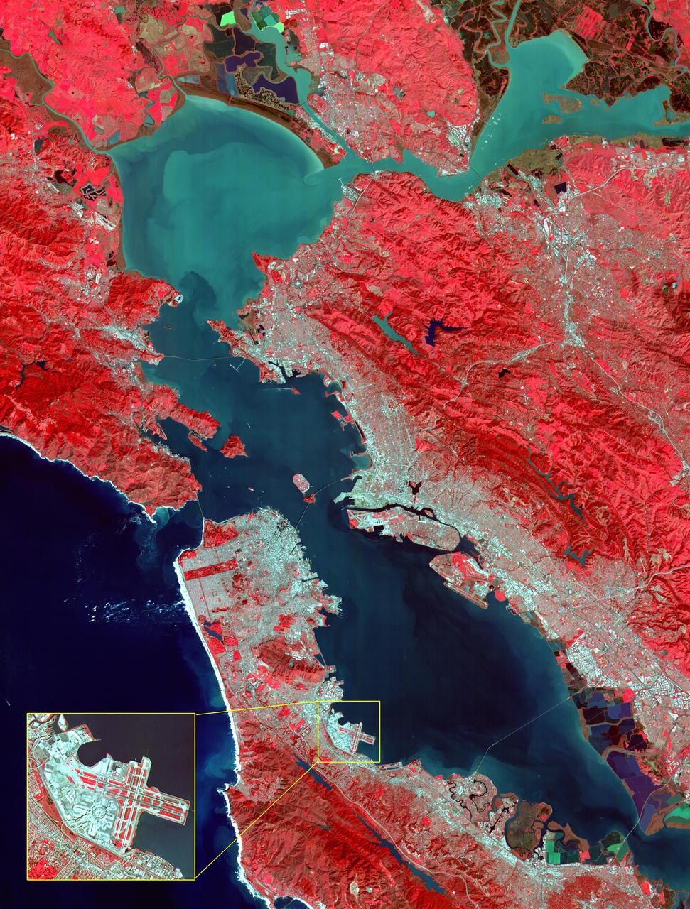
This image of the San Francisco Bay region was acquired on March 3, 2000 by the Advanced Spaceborne Thermal Emission and Reflection Radiometer (ASTER) on NASA's Terra satellite. With its 14 spectral bands from the visible to the thermal infrared wavelength region, and its high spatial resolution of 15 to 90 meters about 50 to 300 feet ), ASTER will image Earth for the next 6 years to map and monitor the changing surface of our planet. Image: This image covers an area 60 kilometers (37 miles) wide and 75 kilometers (47 miles) long in three bands of the reflected visible and infrared wavelength region. The combination of bands portrays vegetation in red, and urban areas in gray. Sediment in the Suisun Bay, San Pablo Bay, San Francisco Bay, and the Pacific Ocean shows up as lighter shades of blue. Along the west coast of the San Francisco Peninsula, strong surf can be seen as a white fringe along the shoreline. A powerful rip tide is visible extending westward from Daly City into the Pacific Ocean. In the lower right corner, the wetlands of the South San Francisco Bay National Wildlife Refuge appear as large dark blue and brown polygons. The high spatial resolution of ASTER allows fine detail to be observed in the scene. The main bridges of the area (San Mateo, San Francisco-Oakland Bay, Golden Gate, Richmond-San Rafael, Benicia-Martinez, and Carquinez) are easily picked out, connecting the different communities in the Bay area. Shadows of the towers along the Bay Bridge can be seen over the adjacent bay water. With enlargement the entire road network can be easily mapped; individual buildings are visible, including the shadows of the high-rises in downtown San Francisco. Inset: This enlargement of the San Francisco Airport highlights the high spatial resolution of ASTER. With further enlargement and careful examination, airplanes can be seen at the terminals. http://photojournal.jpl.nasa.gov/catalog/PIA02606
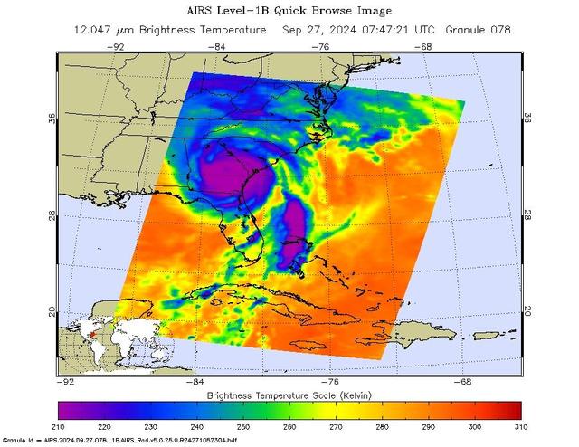
NASA's Atmospheric Infrared Sounder (AIRS) captured an infrared image of Hurricane Helene on Friday, Sept. 27, 2024, at 3:47 a.m. local time, nearly five hours after it made landfall on the Florida coast. One of the largest storms to develop in the Gulf of Mexico in the last century, Helene made landfall as a Category 4 hurricane in the Big Bend area on Sept. 26, at about 11:10 p.m. In the infrared images, the large purple areas indicate very cold clouds carried high into the atmosphere by deep thunderstorms and associated with heavy rainfall. Warmer areas with shallower rain clouds are shown in blue and green. The orange and red areas represent mostly cloud-free air. The eye of the hurricane can be seen as a small blue dot in the middle of the large purple patch. AIRS, in conjunction with the Advanced Microwave Sounding Unit (AMSU), senses emitted infrared and microwave radiation from Earth to provide a 3D look at Earth's weather and climate. Working in tandem, the two instruments make simultaneous observations down to Earth's surface. With more than 2,000 channels sensing different regions of the atmosphere, the system creates a global, 3D map of atmospheric temperature and humidity, cloud amounts and heights, greenhouse gas concentrations and many other atmospheric phenomena. Launched into Earth orbit in 2002, the AIRS and AMSU instruments fly onboard NASA's Aqua spacecraft and are managed by NASA's Jet Propulsion Laboratory in Southern California under contract to NASA. JPL is a division of the Caltech. https://photojournal.jpl.nasa.gov/catalog/PIA26413
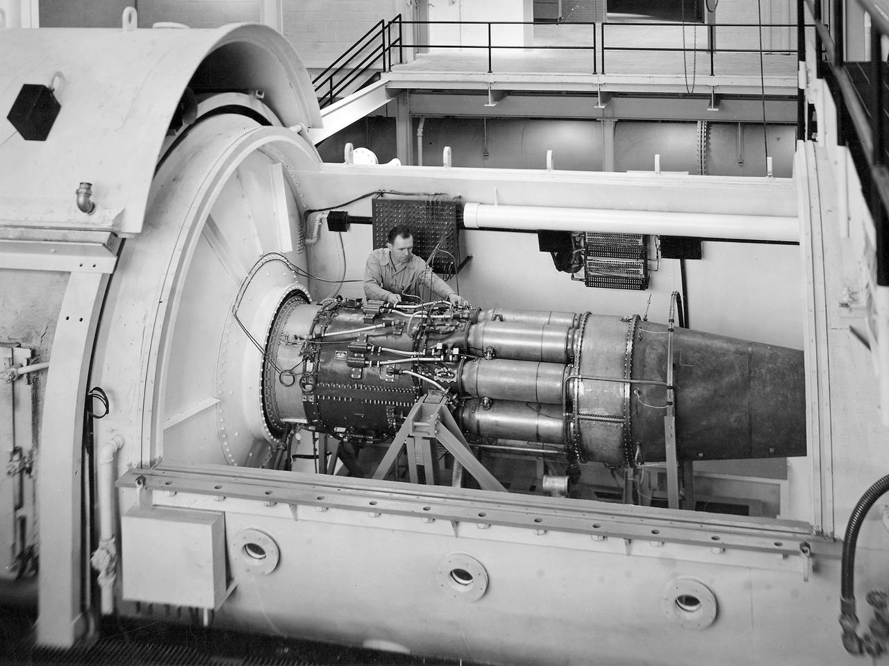
One of the two altitude simulating-test chambers in Engine Research Building at the National Advisory Committee for Aeronautics (NACA) Lewis Flight Propulsion Laboratory. The two chambers were collectively referred to as the Four Burner Area. NACA Lewis’ Altitude Wind Tunnel was the nation’s first major facility used for testing full-scale engines in conditions that realistically simulated actual flight. The wind tunnel was such a success in the mid-1940s that there was a backlog of engines waiting to be tested. The Four Burner chambers were quickly built in 1946 and 1947 to ease the Altitude Wind Tunnel’s congested schedule. The Four Burner Area was located in the southwest wing of the massive Engine Research Building, across the road from the Altitude Wind Tunnel. The two chambers were 10 feet in diameter and 60 feet long. The refrigeration equipment produced the temperatures and the exhauster equipment created the low pressures present at altitudes up to 60,000 feet. In 1947 the Rolls Royce Nene was the first engine tested in the new facility. The mechanic in this photograph is installing a General Electric J-35 engine. Over the next ten years, a variety of studies were conducted using the General Electric J-47 and Wright Aeronautical J-65 turbojets. The two test cells were occasionally used for rocket engines between 1957 and 1959, but other facilities were better suited to the rocket engine testing. The Four Burner Area was shutdown in 1959. After years of inactivity, the facility was removed from the Engine Research Building in late 1973 in order to create the High Temperature and Pressure Combustor Test Facility.
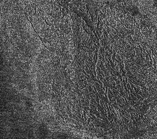
This synthetic-aperture radar image was obtained by NASA's Cassini spacecraft during its T-120 pass over Titan's southern latitudes on June 7, 2016. The image is centered near 47 degrees south, 153 degrees west. It covers an area of 87 by 75 miles (140 by 120 kilometers) and has a resolution of about 1,300 feet (400 meters). Radar illuminates the scene from the left at a 35-degree incidence angle. The features seen here are an excellent example of "labyrinth terrain." Labyrinth terrains on Titan are thought to be higher areas that have been cut apart by rivers of methane, eroded or dissolved as they were either lifted up or left standing above as the region around them lowered. (Other examples of labyrinth terrain can be seen in PIA10219.) In this image, several obvious valley systems have developed, draining liquids from methane rainfall toward the southeast (at top). Several of these systems are near parallel (running from upper left to lower right), suggesting that either the geological structure of the surface or the local topographic gradient (the general slope across the area) may be influencing their direction. Also presented here is an annotated version of the image, along with an aerial photograph of a region in southern Java known as Gunung Kidul that resembles this Titan labyrinth. This region is limestone that has been dissolved and eroded by water, creating a system of canyons called polygonal karst. Like on Titan, the canyons show a trend from upper left to lower right, in this case controlled by faults or joints. (Java photo from Haryono and Day, Journal of Cave and Karst Studies 66 (2004) 62-69, courtesy of Eko Haryono.) http://photojournal.jpl.nasa.gov/catalog/PIA20708
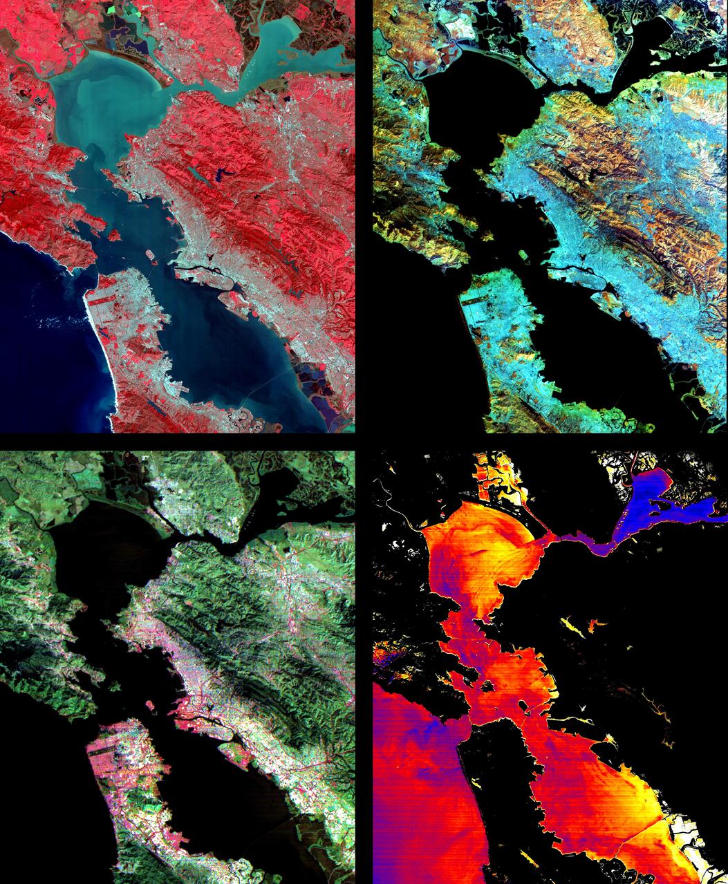
These images of the San Francisco Bay region were acquired on March 3, 2000 by the Advanced Spaceborne Thermal Emission and Reflection Radiometer (ASTER) on NASA's Terra satellite. Each covers an area 60 kilometers (37 miles) wide and 75 kilometers (47 miles) long. With its 14 spectral bands from the visible to the thermal infrared wavelength region, and its high spatial resolution of 15 to 90 meters (about 50 to 300 feet), ASTER will image the Earth for the next 6 years to map and monitor the changing surface of our planet. Upper Left: The color infrared composite uses bands in the visible and reflected infrared. Vegetation is red, urban areas are gray; sediment in the bays shows up as lighter shades of blue. Thanks to the 15 meter (50-foot) spatial resolution, shadows of the towers along the Bay Bridge can be seen. Upper right: A composite of bands in the short wave infrared displays differences in soils and rocks in the mountainous areas. Even though these regions appear entirely vegetated in the visible, enough surface shows through openings in the vegetation to allow the ground to be imaged. Lower left: This composite of multispectral thermal bands shows differences in urban materials in varying colors. Separation of materials is due to differences in thermal emission properties, analogous to colors in the visible. Lower right: This is a color coded temperature image of water temperature, derived from the thermal bands. Warm waters are in white and yellow, colder waters are blue. Suisun Bay in the upper right is fed directly from the cold Sacramento River. As the water flows through San Pablo and San Francisco Bays on the way to the Pacific, the waters warm up. http://photojournal.jpl.nasa.gov/catalog/PIA02605

ISS01-E-5107 (December 2000) --- This nadir view of a Chilean glaciated area was provided by one of the early December digital still camera images down linked from the International Space Station (ISS) to ground controllers in Houston. The remote headwaters of the Rio de la Colonia are located on the eastern flank of the Cerro Pared Norte, a high, coastal range of the Andes in southern Chile. This is but a portion of a larger glaciated region of the Chilean coast located at only 47 degrees south latitude. The river actually begins its flow just off the top of this scene at the foot of the two large, converging, valley glaciers near the center. Some of the numerous lakes visible are tinted by the fine glacial sediments suspended in their waters. Note the shards of ice that have calved from the glaciers into the lakes on the left. Also note the shadows of the crest of the over 14,000-foot mountains (lower center). The remote headwaters of the Rio de la Colonia are located on the eastern flank of the Cerro Pared Norte, a high, coastal range of the Andes in southern Chile. This is a but a portion of a larger glaciated region of the Chilean coast located at only 47 degrees south latitude. The river actually begins its flow just off the top of this scene at the foot of the two large, converging, valley glaciers near the center. Some of the numerous lakes visible are tinted by the fine glacial sediments suspended in their waters. Note the shards of ice that have calved from the glaciers into the lakes on the left. Also note the shadows of the crest of the over 14,000-foot mountains (lower center).
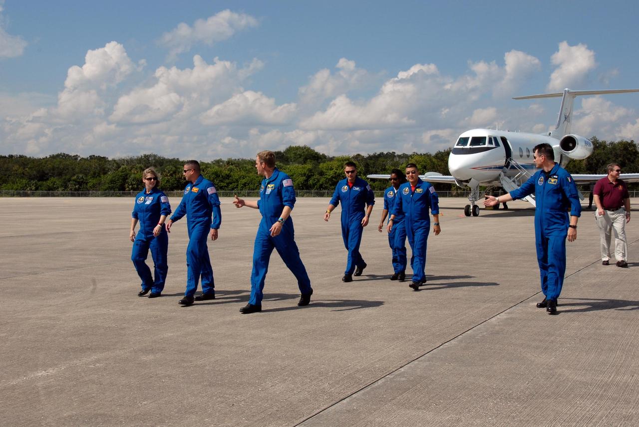
KENNEDY SPACE CENTER, FLA. -- The STS-120 crew walks across the parking area of the Shuttle Landing Facility after arrival at NASA's Kennedy Space Center. From left are Commander Pamela Melroy, Pilot George Zamka and Mission Specialists Scott Parazynski, Doug Wheelock, Stephanie Wilson, Daniel Tani and Paolo Nespoli, who represents the European Space Agency. Tani will be remaining on the International Space Station to join the Expedition 16 crew after the mission is complete. The crew has returned to Kennedy to prepare for launch aboard space shuttle Discovery at 11:38 a.m. EDT on Oct. 23. The mission will be the 23rd shuttle flight to the International Space Station, delivering the Italian-built U.S. Node 2, called Harmony. The 14-day mission includes five spacewalks -- four by shuttle crew members and one by the station’s Expedition 16 crew -- to install Harmony and move the P6 solar arrays to their permanent position and deploy them. Discovery is expected to complete its mission and return home at 4:47 a.m. EST on Nov. 6. Photo credit: NASA/Kim Shiflett
Two mosaicked pieces of Magellan image strips display the area east of the Rhea Mons volcano on Venus. This image is centered at about 32.5 degrees north latitude and 286.6 degrees east longitude. The mosaic is 47 km (28 mi.) wide and 135 km (81 mi.) long. This region has been previously identified as 'tessera'from Earth-based radar (Arecibo) images. The center of the image is dominated by a network of intersection ridges and valleys. The radar-bright north-south trending features in this image range from 1 km (0.6 mi.) to 3 km (1.8 mi.) in length. The average spacing between these ridges is about 1.5 km (0.9 mi.). The dark patches at the top of the image are smooth surfaces and may be lava flows located in lowlands between the higher ridge and the valley terrain. This image is a mosaic of two orbits obtained in the first Magellan stations near Goldstone, CA and Canberra, Australia. The resolution of this image is approx. 120 meters (400 feet).
KENNEDY SPACE CENTER, FLA. -- A diversified mission of astronomy, commercial space research and International Space Station preparation gets under way as the Space Shuttle Columbia climbs into orbit from Launch Pad 39B at 2:55:47 p.m. EST, Nov. 19, 1996. During Mission STS- 80, Columbia’s five-person crew will deploy and retrieve two free-flying spacecraft, conduct two spacewalks and perform a variety of microgravity research experiments in the Shuttle’s middeck area. The veteran crew is led by Commander Kenneth D. Cockrell; Kent V. Rominger is the pilot and the three mission specialists are Tamara E. Jernigan, Story Musgrave and Thomas D. Jones. At age 61, Musgrave becomes the oldest person ever to fly in space; he also ties astronaut John Young’s record for most number of spaceflights by a human being, and in embarking on his sixth Shuttle flight Musgrave has logged the most flights ever aboard NASA’s reusable space vehicle. The two primary payloads for STS-80 are the Wake Shield Facility-3 (WSF-3) and the Orbiting and Retrievable Far and Extreme Ultraviolet Spectrometer-Shuttle Pallet Satellite II (ORFEUS-SPAS II).
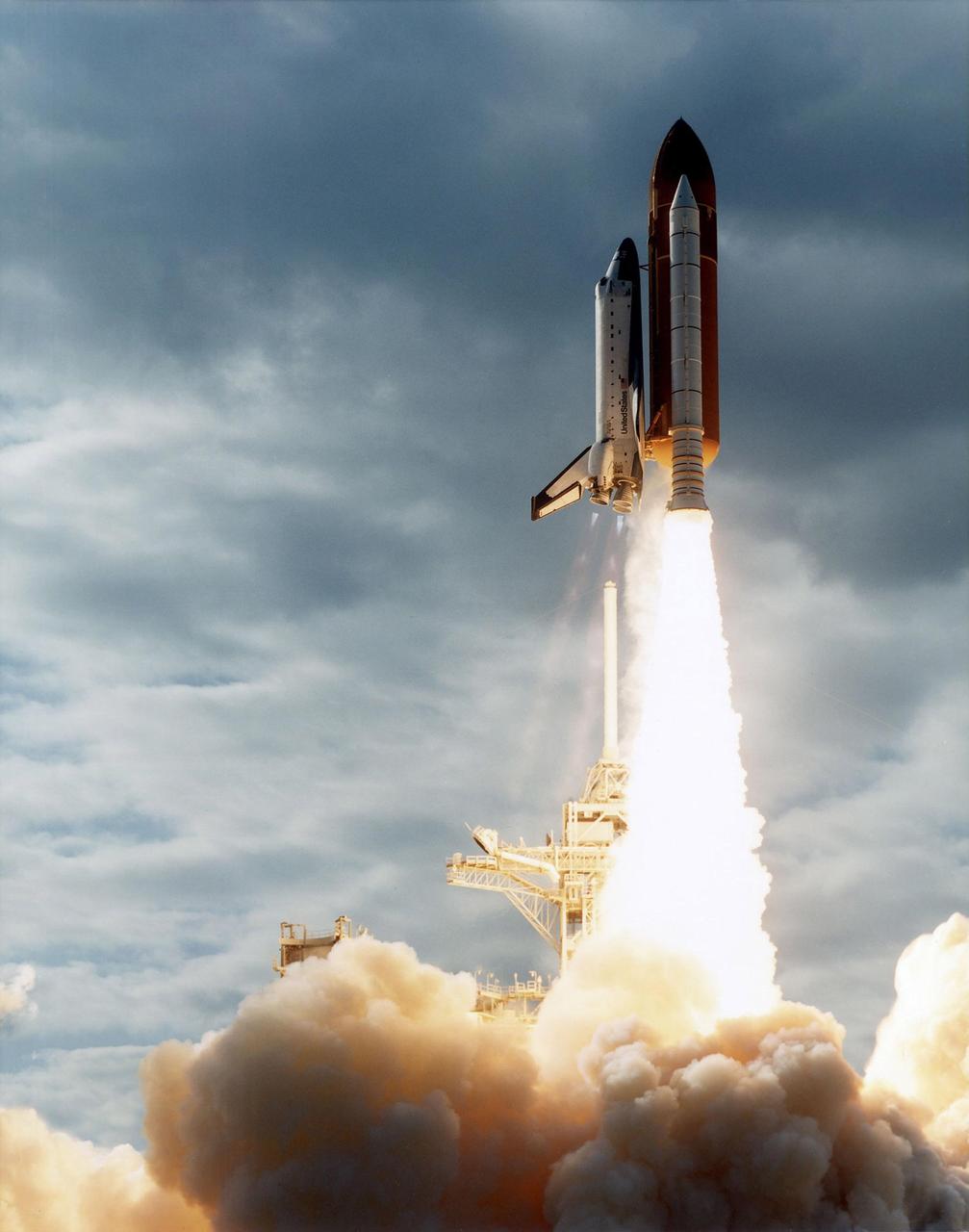
KENNEDY SPACE CENTER, FLA. -- A diversified mission of astronomy, commercial space research and International Space Station preparation gets under way as the Space Shuttle Columbia climbs into orbit from Launch Pad 39B at 2:55:47 p.m. EST, Nov. 19, 1996. During Mission STS- 80, Columbia’s five-person crew will deploy and retrieve two free-flying spacecraft, conduct two spacewalks and perform a variety of microgravity research experiments in the Shuttle’s middeck area. The veteran crew is led by Commander Kenneth D. Cockrell; Kent V. Rominger is the pilot and the three mission specialists are Tamara E. Jernigan, Story Musgrave and Thomas D. Jones. At age 61, Musgrave becomes the oldest person ever to fly in space; he also ties astronaut John Young’s record for most number of spaceflights by a human being, and in embarking on his sixth Shuttle flight Musgrave has logged the most flights ever aboard NASA’s reusable space vehicle. The two primary payloads for STS-80 are the Wake Shield Facility-3 (WSF-3) and the Orbiting and Retrievable Far and Extreme Ultraviolet Spectrometer-Shuttle Pallet Satellite II (ORFEUS-SPAS II).
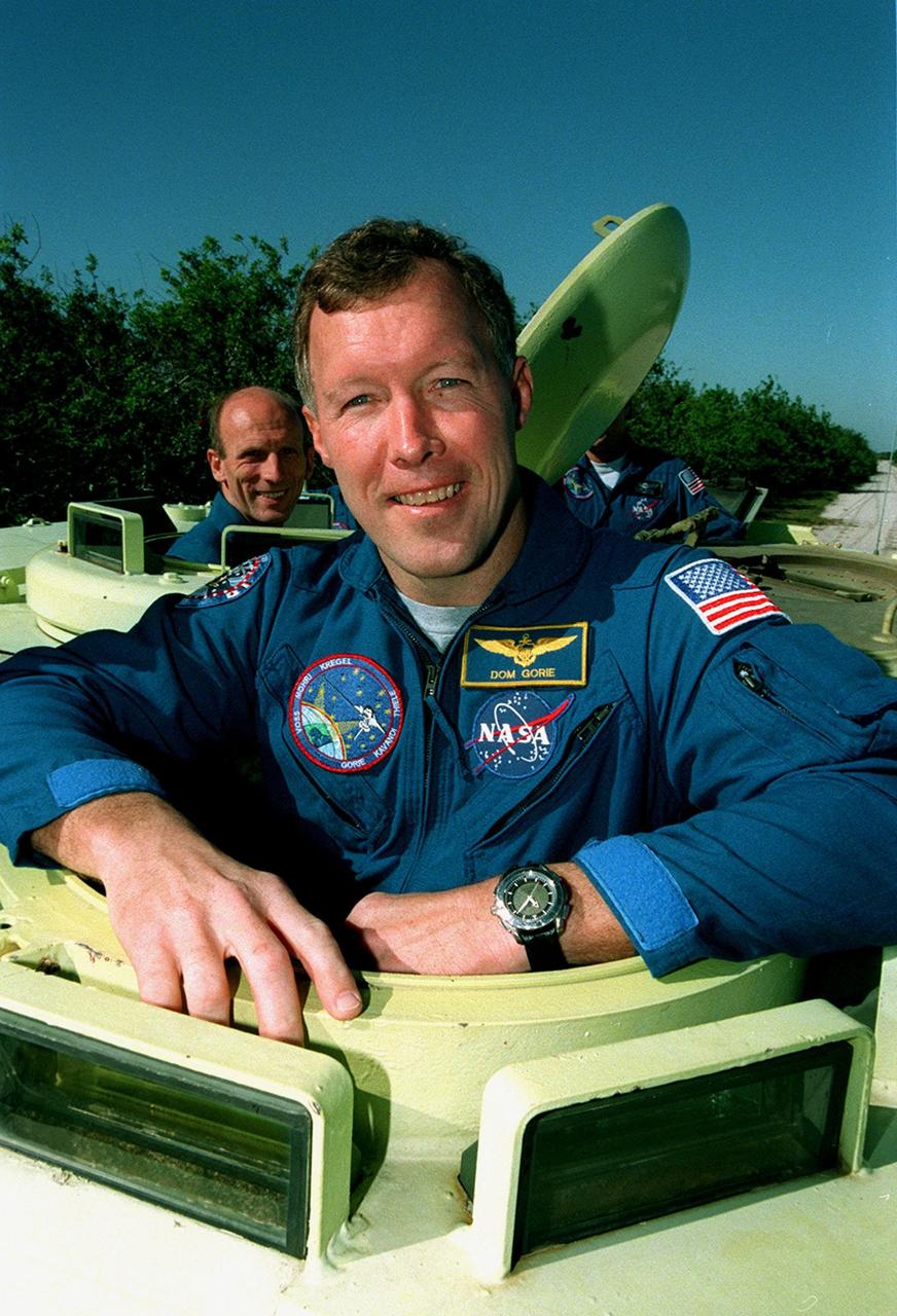
STS-99 Pilot Dominic Gorie, under the watchful eye of Capt. George Hoggard, a trainer with the KSC Fire Department, practices driving the M-113, an armored personnel carrier. Part of Terminal Countdown Demonstration Test (TCDT) activities, the M-113 could be used by the crew in the event of an emergency at the pad during which the crew must make a quick exit from the area. Riding in the rear are Mission Specialists Mamoru Mohri, who is with the National Space Development Agency (NASDA) of Japan, Janet Lynn Kavandi (Ph.D.) and Janice Voss (Ph.D.). TCDT provides the crew with simulated countdown exercises, emergency egress training, and opportunities to inspect the mission payloads in the orbiter's payload bay. STS-99 is the Shuttle Radar Topography Mission, which will chart a new course, using two antennae and a 200-foot-long section of space station-derived mast protruding from the payload bay to produce unrivaled 3-D images of the Earth's surface. The result of the Shuttle Radar Topography Mission could be close to 1 trillion measurements of the Earth's topography. Besides contributing to the production of better maps, these measurements could lead to improved water drainage modeling, more realistic flight simulators, better locations for cell phone towers, and enhanced navigation safety. Launch of Endeavour on the 11-day mission is scheduled for Jan. 31 at 12:47 p.m. EST
KENNEDY SPACE CENTER, FLA. -- A diversified mission of astronomy, commercial space research and International Space Station preparation gets under way as the Space Shuttle Columbia climbs into orbit from Launch Pad 39B at 2:55:47 p.m. EST, November 19, 1996. During Mission STS-80, Columbia's five-person crew will deploy and retrieve two free-flying spacecraft, conduct two spacewalks and perform a variety of microgravity research experiments in the Shuttle's middeck area. The veteran crew is led by Commander Kenneth D. Cockrell; Kent V. Rominger is the pilot and the three mission specialists are Tamara E. Jernigan, Story Musgrave and Thomas D. Jones. At age 61, Musgrave becomes the oldest person ever to fly in space; he also ties astronaut John Young's record for most number of spaceflights by a human being, and in embarking on his sixth Shuttle flight Musgrave has logged the most flights ever aboard NASA's reusable space vehicle. The two primary payloads for STS-80 are the Wake Shield Facility-3 (WSF-3) and the Orbiting and Retrievable Far and Extreme Ultraviolet Spectrometer-Shuttle Pallet Satellite II (ORFEUS-SPAS II).
During Terminal Countdown Demonstration Test (TCDT) activities, STS-99 Mission Specialist Gerhard Thiele, who is with the European Space Agency, is ready to practice driving an armored personnel carrier that is part of emergency egress training and could be used by the crew in the event of an emergency at the pad during which the crew must make a quick exit from the area. TCDT provides the crew with simulated countdown exercises, emergency egress training, and opportunities to inspect the mission payloads in the orbiter's payload bay. STS-99 is the Shuttle Radar Topography Mission, which will chart a new course, using two antennae and a 200-foot-long section of space station-derived mast protruding from the payload bay to produce unrivaled 3-D images of the Earth's surface. The result of the Shuttle Radar Topography Mission could be close to 1 trillion measurements of the Earth's topography. Besides contributing to the production of better maps, these measurements could lead to improved water drainage modeling, more realistic flight simulators, better locations for cell phone towers, and enhanced navigation safety. Launch of Endeavour on the 11-day mission is scheduled for Jan. 31 at 12:47 p.m. EST

STS-99 Pilot Dominic Gorie, under the watchful eye of Capt. George Hoggard, a trainer with the KSC Fire Department, practices driving the M-113, an armored personnel carrier. Part of Terminal Countdown Demonstration Test (TCDT) activities, the M-113 could be used by the crew in the event of an emergency at the pad during which the crew must make a quick exit from the area. Riding in the rear are Mission Specialists Mamoru Mohri, who is with the National Space Development Agency (NASDA) of Japan, Janet Lynn Kavandi (Ph.D.) and Janice Voss (Ph.D.). TCDT provides the crew with simulated countdown exercises, emergency egress training, and opportunities to inspect the mission payloads in the orbiter's payload bay. STS-99 is the Shuttle Radar Topography Mission, which will chart a new course, using two antennae and a 200-foot-long section of space station-derived mast protruding from the payload bay to produce unrivaled 3-D images of the Earth's surface. The result of the Shuttle Radar Topography Mission could be close to 1 trillion measurements of the Earth's topography. Besides contributing to the production of better maps, these measurements could lead to improved water drainage modeling, more realistic flight simulators, better locations for cell phone towers, and enhanced navigation safety. Launch of Endeavour on the 11-day mission is scheduled for Jan. 31 at 12:47 p.m. EST
KENNEDY SPACE CENTER, FLA. -- A diversified mission of astronomy, commercial space research and International Space Station preparation gets under way as the Space Shuttle Columbia climbs into orbit from Launch Pad 39B at 2:55:47 p.m. EST, Nov. 19, 1996. During Mission STS- 80, Columbia’s five-person crew will deploy and retrieve two free-flying spacecraft, conduct two spacewalks and perform a variety of microgravity research experiments in the Shuttle’s middeck area. The veteran crew is led by Commander Kenneth D. Cockrell; Kent V. Rominger is the pilot and the three mission specialists are Tamara E. Jernigan, Story Musgrave and Thomas D. Jones. At age 61, Musgrave becomes the oldest person ever to fly in space; he also ties astronaut John Young’s record for most number of spaceflights by a human being, and in embarking on his sixth Shuttle flight Musgrave has logged the most flights ever aboard NASA’s reusable space vehicle. The two primary payloads for STS-80 are the Wake Shield Facility-3 (WSF-3) and the Orbiting and Retrievable Far and Extreme Ultraviolet Spectrometer-Shuttle Pallet Satellite II (ORFEUS-SPAS II).
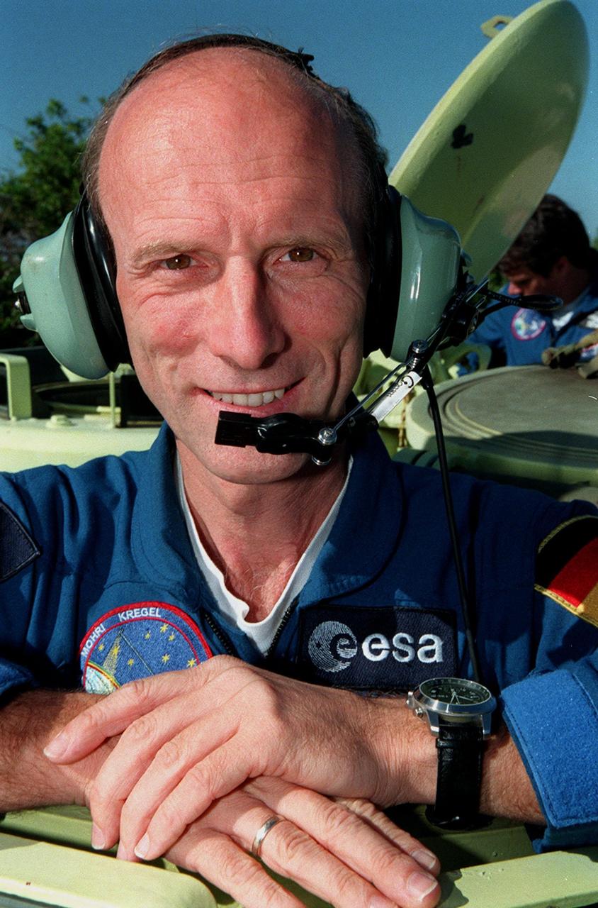
Under the watchful eye of Capt. George Hoggard, a trainer with the KSC Fire Department, STS-99 Commander Kevin Kregel practices driving the M-113, an armored personnel carrier. Part of Terminal Countdown Demonstration Test (TCDT) activities, the M-113 could be used by the crew in the event of an emergency at the pad during which the crew must make a quick exit from the area. TCDT provides the crew with simulated countdown exercises, emergency egress training, and opportunities to inspect the mission payloads in the orbiter's payload bay. STS-99 is the Shuttle Radar Topography Mission, which will chart a new course, using two antennae and a 200-foot-long section of space station-derived mast protruding from the payload bay to produce unrivaled 3-D images of the Earth's surface. The result of the Shuttle Radar Topography Mission could be close to 1 trillion measurements of the Earth's topography. Besides contributing to the production of better maps, these measurements could lead to improved water drainage modeling, more realistic flight simulators, better locations for cell phone towers, and enhanced navigation safety. Launch of Endeavour on the 11-day mission is scheduled for Jan. 31 at 12:47 p.m. EST
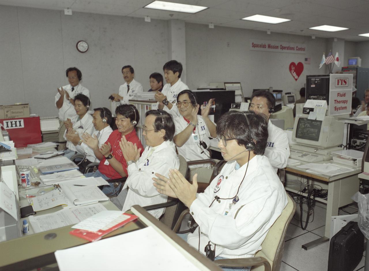
The science laboratory, Spacelab-J (SL-J), flown aboard the STS-47 flight was a joint venture between NASA and the National Space Development Agency of Japan (NASDA) utilizing a manned Spacelab module. The mission conducted 24 materials science and 20 life science experiments, of which 35 were sponsored by NASDA, 7 by NASA, and two collaborative efforts. Materials science investigations covered such fields as biotechnology, electronic materials, fluid dynamics and transport phenomena, glasses and ceramics, metals and alloys, and acceleration measurements. Life sciences included experiments on human health, cell separation and biology, developmental biology, animal and human physiology and behavior, space radiation, and biological rhythms. Test subjects included the crew, Japanese koi fish (carp), cultured animal and plant cells, chicken embryos, fruit flies, fungi and plant seeds, and frogs and frog eggs. Featured together in the Science Operation Area (SOA) are payload specialists’ first Materials Processing Test during NASA/NASDA joint ground activities at the Huntsville Operations Support Center (HOSC) Spacelab Payload Operations Control Center (SL POCC) at Marshall Space Flight Center (MSFC).

Under the watchful eye of Capt. George Hoggard, a trainer with the KSC Fire Department, STS-99 Commander Kevin Kregel practices driving the M-113, an armored personnel carrier. Part of Terminal Countdown Demonstration Test (TCDT) activities, the M-113 could be used by the crew in the event of an emergency at the pad during which the crew must make a quick exit from the area. TCDT provides the crew with simulated countdown exercises, emergency egress training, and opportunities to inspect the mission payloads in the orbiter's payload bay. STS-99 is the Shuttle Radar Topography Mission, which will chart a new course, using two antennae and a 200-foot-long section of space station-derived mast protruding from the payload bay to produce unrivaled 3-D images of the Earth's surface. The result of the Shuttle Radar Topography Mission could be close to 1 trillion measurements of the Earth's topography. Besides contributing to the production of better maps, these measurements could lead to improved water drainage modeling, more realistic flight simulators, better locations for cell phone towers, and enhanced navigation safety. Launch of Endeavour on the 11-day mission is scheduled for Jan. 31 at 12:47 p.m. EST
This full resolution mosaiced image covers an area of approximately 100 kilometers by 120 kilometers (62 by 74 miles) and is located in the Lakshmi region of Venus at 47 degrees north latitude and 334 east longitude. Due to the dense Venusian atmosphere, primary impact craters of less than a 3 kilometer (2 mile) diameter are nonexistent. The dark circular region and associated central bright feature in this image are thought to be the remnants of a meteoroid smaller than the size necessary to create an impact crater entering the atmosphere at a low velocity (approximately 350 meters/second.) The central bright feature appears to be a cluster of small secondary impacts, ejecta and debris from the original meteor that broke up in the atmosphere. Even though most of the meteorite did not hit the surface, the atmospheric shock wave could be great enough to modify the surrounding region. One explanation for this radar dark circular formation, called dark margins, could be that the shock wave was energetic enough to pulverize the surface (smooth surfaces generally appear radar dark.) Another explanation is that the surface could be blanketed by a fine material that was formed by the original meteor's breakup through the atmosphere. More than half of the impact craters on Venus have associated dark margins, and most of these are prominently located left of center of the crater. This is another effect which could be caused by the dense atmosphere of Venus. http://photojournal.jpl.nasa.gov/catalog/PIA00477
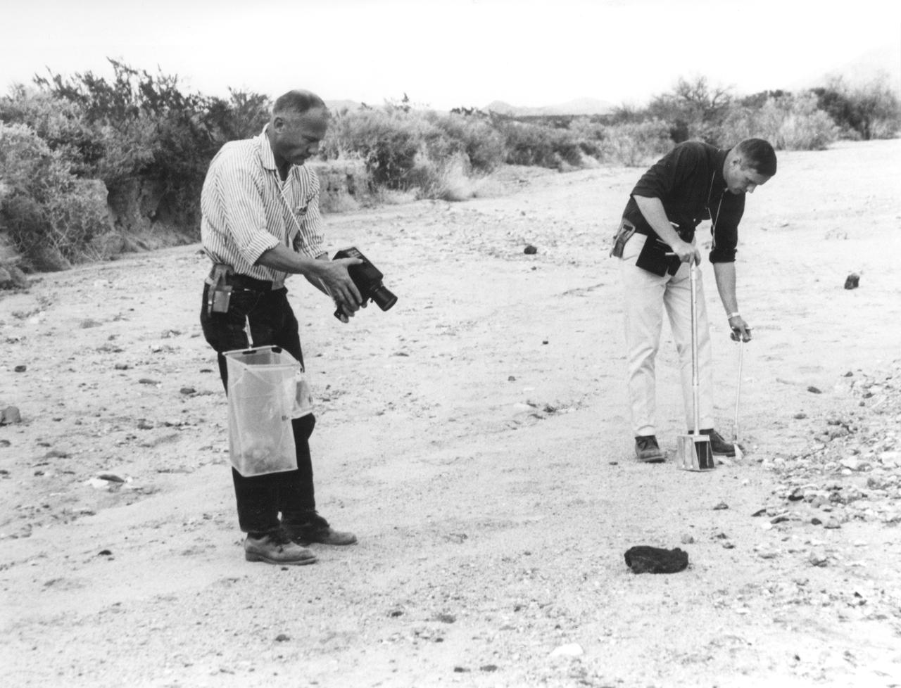
In this photograph, Apollo 11 astronauts Edwin (Buzz) Aldrin (left) and Neil A. Armstrong prepare for the first Lunar landing as they practice gathering rock specimens during a geological field trip to the Quitman Mountains area near the Fort Quitman ruins in far west Texas. They used special lunar geological tools to pick up samples and place them in bags.Their practice paid off in July of the same year. Aboard the Marshall Space Fight center (MSFC) developed Saturn V launch vehicle, the Apollo 11 mission launched from the Kennedy Space Center, Florida on July 16, 1969 and safely returned to Earth on July 24, 1969. The 3-man crew aboard the flight consisted of Armstrong, commander; Aldrin, Lunar Module pilot; and a third astronaut Michael Collins, Command Module pilot. Armstrong was the first human to ever stand on the lunar surface, followed by Aldrin, while Collins remained in lunar orbit. The crew collected 47 pounds of lunar surface material which was returned to Earth for analysis. The lunar surface exploration was concluded in 2½ hours.

STS-99 Mission Specialist Mamoru Mohri, who is with the National Space Development Agency (NASDA) of Japan, smiles during training on the M-113, an armored personnel carrier that is part of emergency egress training during Terminal Countdown Demonstration Test (TCDT) activities. The tracked vehicle could be used by the crew in the event of an emergency at the pad during which the crew must make a quick exit from the area. TCDT provides the crew with simulated countdown exercises, emergency egress training, and opportunities to inspect the mission payloads in the orbiter's payload bay. STS-99 is the Shuttle Radar Topography Mission, which will chart a new course, using two antennae and a 200-foot-long section of space station-derived mast protruding from the payload bay to produce unrivaled 3-D images of the Earth's surface. The result of the Shuttle Radar Topography Mission could be close to 1 trillion measurements of the Earth's topography. Besides contributing to the production of better maps, these measurements could lead to improved water drainage modeling, more realistic flight simulators, better locations for cell phone towers, and enhanced navigation safety. Launch of Endeavour on the 11-day mission is scheduled for Jan. 31 at 12:47 p.m. EST
One of the most important waterways in the world, the Suez Canal runs north to south across the Isthmus of Suez in northeastern Egypt. This image of the canal covers an area 36 kilometers (22 miles) wide and 60 kilometers (47 miles) long in three bands of the reflected visible and infrared wavelength region. It shows the northern part of the canal, with the Mediterranean Sea just visible in the upper right corner. The Suez Canal connects the Mediterranean Sea with the Gulf of Suez, an arm of the Red Sea. The artificial canal provides an important shortcut for ships operating between both European and American ports and ports located in southern Asia, eastern Africa, and Oceania. With a length of about 195 kilometers (121 miles) and a minimum channel width of 60 meters (197 feet), the Suez Canal is able to accommodate ships as large as 150,000 tons fully loaded. Because no locks interrupt traffic on this sea level waterway, the transit time only averages about 15 hours. ASTER acquired this scene on May 19, 2000. http://photojournal.jpl.nasa.gov/catalog/PIA02661
In this photograph, Apollo 11 astronaut Neil A. Armstrong uses a geologist’s hammer in selecting rock specimens during a geological field trip to the Quitman Mountains area near the Fort Quitman ruins in far west Texas. Armstrong, alongside astronaut Edwin (Buzz) Aldrin, practiced gathering rock specimens using special lunar geological tools in preparation for the first Lunar landing. Mission was accomplished in July of the same year. Aboard the Marshall Space Fight center (MSFC) developed Saturn V launch vehicle, the Apollo 11 mission launched from The Kennedy Space Center, Florida on July 16, 1969 and safely returned to Earth on July 24, 1969. The 3-man crew aboard the flight consisted of Armstrong, commander; Aldrin, Lunar Module pilot; and a third astronaut Michael Collins, Command Module pilot. Armstrong was the first human to ever stand on the lunar surface, followed by Aldrin, while Collins remained in lunar orbit. The crew collected 47 pounds of lunar surface material which was returned to Earth for analysis. The lunar surface exploration was concluded in 2½ hours.
KENNEDY SPACE CENTER, FLA. -- A diversified mission of astronomy, commercial space research and International Space Station preparation gets under way as the Space Shuttle Columbia climbs into orbit from Launch Pad 39B at 2:55:47 p.m. EST, Nov. 19, 1996. During Mission STS- 80, Columbia’s five-person crew will deploy and retrieve two free-flying spacecraft, conduct two spacewalks and perform a variety of microgravity research experiments in the Shuttle’s middeck area. The veteran crew is led by Commander Kenneth D. Cockrell; Kent V. Rominger is the pilot and the three mission specialists are Tamara E. Jernigan, Story Musgrave and Thomas D. Jones. At age 61, Musgrave becomes the oldest person ever to fly in space; he also ties astronaut John Young’s record for most number of spaceflights by a human being, and in embarking on his sixth Shuttle flight Musgrave has logged the most flights ever aboard NASA’s reusable space vehicle. The two primary payloads for STS-80 are the Wake Shield Facility-3 (WSF-3) and the Orbiting and Retrievable Far and Extreme Ultraviolet Spectrometer-Shuttle Pallet Satellite II (ORFEUS-SPAS II).
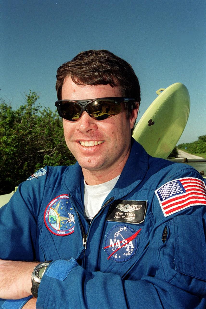
During Terminal Countdown Demonstration Test (TCDT) activities, STS-99 Commander Kevin Kregel is ready to practice driving the M-113, an armored personnel carrier. Part of Terminal Countdown Demonstration Test (TCDT) activities, the M-113 could be used by the crew in the event of an emergency at the pad during which the crew must make a quick exit from the area. TCDT provides the crew with simulated countdown exercises, emergency egress training, and opportunities to inspect the mission payloads in the orbiter's payload bay. STS-99 is the Shuttle Radar Topography Mission, which will chart a new course, using two antennae and a 200-foot-long section of space station-derived mast protruding from the payload bay to produce unrivaled 3-D images of the Earth's surface. The result of the Shuttle Radar Topography Mission could be close to 1 trillion measurements of the Earth's topography. Besides contributing to the production of better maps, these measurements could lead to improved water drainage modeling, more realistic flight simulators, better locations for cell phone towers, and enhanced navigation safety. Launch of Endeavour on the 11-day mission is scheduled for Jan. 31 at 12:47 p.m. EST
KENNEDY SPACE CENTER, FLA. -- A diversified mission of astronomy, commercial space research and International Space Station preparation gets under way as the Space Shuttle Columbia climbs into orbit from Launch Pad 39B at 2:55:47 p.m. EST, Nov. 19, 1996. During Mission STS- 80, Columbia’s five-person crew will deploy and retrieve two free-flying spacecraft, conduct two spacewalks and perform a variety of microgravity research experiments in the Shuttle’s middeck area. The veteran crew is led by Commander Kenneth D. Cockrell; Kent V. Rominger is the pilot and the three mission specialists are Tamara E. Jernigan, Story Musgrave and Thomas D. Jones. At age 61, Musgrave becomes the oldest person ever to fly in space; he also ties astronaut John Young’s record for most number of spaceflights by a human being, and in embarking on his sixth Shuttle flight Musgrave has logged the most flights ever aboard NASA’s reusable space vehicle. The two primary payloads for STS-80 are the Wake Shield Facility-3 (WSF-3) and the Orbiting and Retrievable Far and Extreme Ultraviolet Spectrometer-Shuttle Pallet Satellite II (ORFEUS-SPAS II).
KENNEDY SPACE CENTER, FLA. -- A diversified mission of astronomy, commercial space research and International Space Station preparation gets under way as the Space Shuttle Columbia climbs into orbit from Launch Pad 39B at 2:55:47 p.m. EST, November 19, 1996. During Mission STS-80, Columbia's five-person crew will deploy and retrieve two free-flying spacecraft, conduct two spacewalks and perform a variety of microgravity research experiments in the Shuttleþs middeck area. The veteran crew is led by Commander Kenneth D. Cockrell; Kent V. Rominger is the pilot and the three mission specialists are Tamara E. Jernigan, Story Musgrave and Thomas D. Jones. At age 61, Musgrave becomes the oldest person ever to fly in space; he also ties astronaut John Young's record for most number of spaceflights by a human being, and in embarking on his sixth Shuttle flight Musgrave has logged the most flights ever aboard NASA's reusable space vehicle. The two primary payloads for STS-80 are the Wake Shield Facility-3 (WSF-3) and the Orbiting and Retrievable Far and Extreme Ultraviolet Spectrometer-Shuttle Pallet Satellite II (ORFEUS-SPAS II).
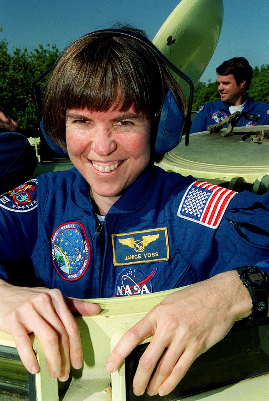
During Terminal Countdown Demonstration Test (TCDT) activities, STS-99 Mission Specialist Janice Voss (Ph.D.) is ready to practice driving the M-113, an armored personnel carrier. Part of Terminal Countdown Demonstration Test (TCDT) activities, the M-113 could be used by the crew in the event of an emergency at the pad during which the crew must make a quick exit from the area. In the rear (right) is Commander Kevin Kregel. TCDT provides the crew with simulated countdown exercises, emergency egress training, and opportunities to inspect the mission payloads in the orbiter's payload bay. STS-99 is the Shuttle Radar Topography Mission, which will chart a new course, using two antennae and a 200-foot-long section of space station-derived mast protruding from the payload bay to produce unrivaled 3-D images of the Earth's surface. The result of the Shuttle Radar Topography Mission could be close to 1 trillion measurements of the Earth's topography. Besides contributing to the production of better maps, these measurements could lead to improved water drainage modeling, more realistic flight simulators, better locations for cell phone towers, and enhanced navigation safety. Launch of Endeavour on the 11-day mission is scheduled for Jan. 31 at 12:47 p.m. EST
During Terminal Countdown Demonstration Test (TCDT) activities, STS-99 Pilot Dominic Gorie , is ready to practice driving an armored personnel carrier that is part of emergency egress training and could be used by the crew in the event of an emergency at the pad during which the crew must make a quick exit from the area. Behind him (left) is Mission Specialist Gerhard Thiele, who is with the European Space Agency. TCDT provides the crew with simulated countdown exercises, emergency egress training, and opportunities to inspect the mission payloads in the orbiter's payload bay. STS-99 is the Shuttle Radar Topography Mission, which will chart a new course, using two antennae and a 200-foot-long section of space station-derived mast protruding from the payload bay to produce unrivaled 3-D images of the Earth's surface. The result of the Shuttle Radar Topography Mission could be close to 1 trillion measurements of the Earth's topography. Besides contributing to the production of better maps, these measurements could lead to improved water drainage modeling, more realistic flight simulators, better locations for cell phone towers, and enhanced navigation safety. Launch of Endeavour on the 11-day mission is scheduled for Jan. 31 at 12:47 p.m. EST
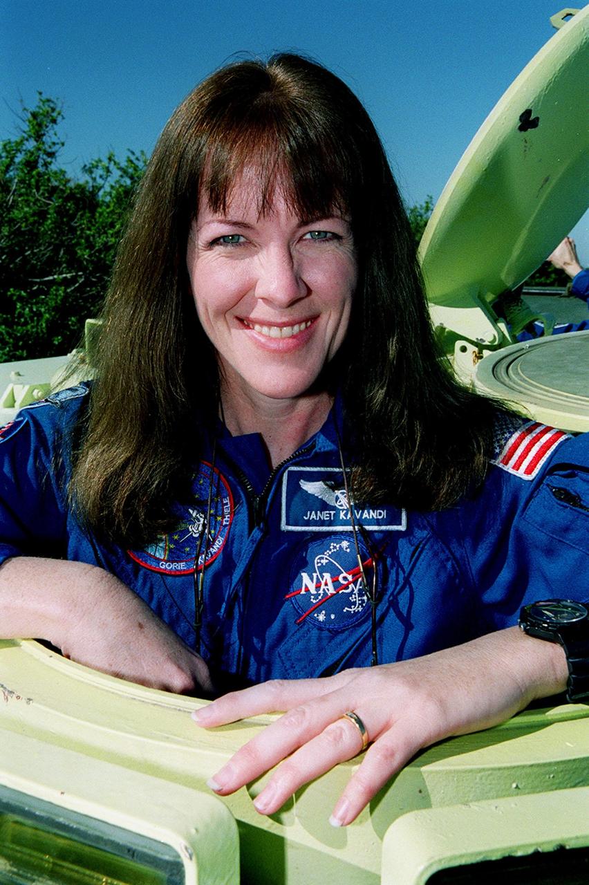
During Terminal Countdown Demonstration Test (TCDT) activities, STS-99 Mission Specialist Janet Lynn Kavandi (Ph.D.) is ready to practice driving the M-113, an armored personnel carrier. Part of Terminal Countdown Demonstration Test (TCDT) activities, the M-113 could be used by the crew in the event of an emergency at the pad during which the crew must make a quick exit from the area. TCDT provides the crew with simulated countdown exercises, emergency egress training, and opportunities to inspect the mission payloads in the orbiter's payload bay. STS-99 is the Shuttle Radar Topography Mission, which will chart a new course, using two antennae and a 200-foot-long section of space station-derived mast protruding from the payload bay to produce unrivaled 3-D images of the Earth's surface. The result of the Shuttle Radar Topography Mission could be close to 1 trillion measurements of the Earth's topography. Besides contributing to the production of better maps, these measurements could lead to improved water drainage modeling, more realistic flight simulators, better locations for cell phone towers, and enhanced navigation safety. Launch of Endeavour on the 11-day mission is scheduled for Jan. 31 at 12:47 p.m. EST
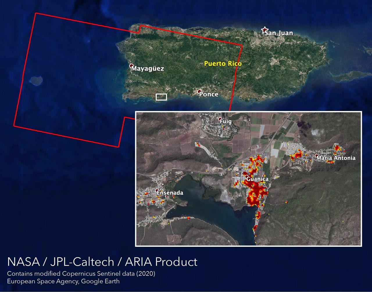
NASA scientists are helping local and federal agencies assess the extent of the damage in Puerto Rico following a 6.4-magnitude earthquake and hundreds of aftershocks. Using synthetic aperture radar data from the Copernicus Sentinel-1 satellites operated by the European Space Agency (ESA), the Advanced Rapid Imaging and Analysis (ARIA) team at NASA's Jet Propulsion Laboratory and Caltech in Pasadena, California created a new damage map that includes the southwestern coast near the main quake's epicenter. The ARIA team compared post-quake satellite data acquired on Jan. 14 with data as far back as Sept. 2019 to produce the map. The color variation from yellow to dark red indicates increasingly more significant damage. Their analysis shows that Guanica, west of the city of Ponce, was particularly hard hit. The map covers an area of 107 by 47 miles (172 by 76 kilometers), shown with the large red polygon, with each pixel measuring about 100 feet (30 meters) across. The data is most sensitive to building damage rather than small scale changes or partial structural damage. It is also less reliable over heavy vegetation. Even with these limitations, the map can still serve an important role in identifying the areas that may need help the most. The map contains modified Copernicus Sentinel data processed by ESA and analyzed by ARIA team scientists at NASA JPL and Caltech. https://photojournal.jpl.nasa.gov/catalog/PIA23429
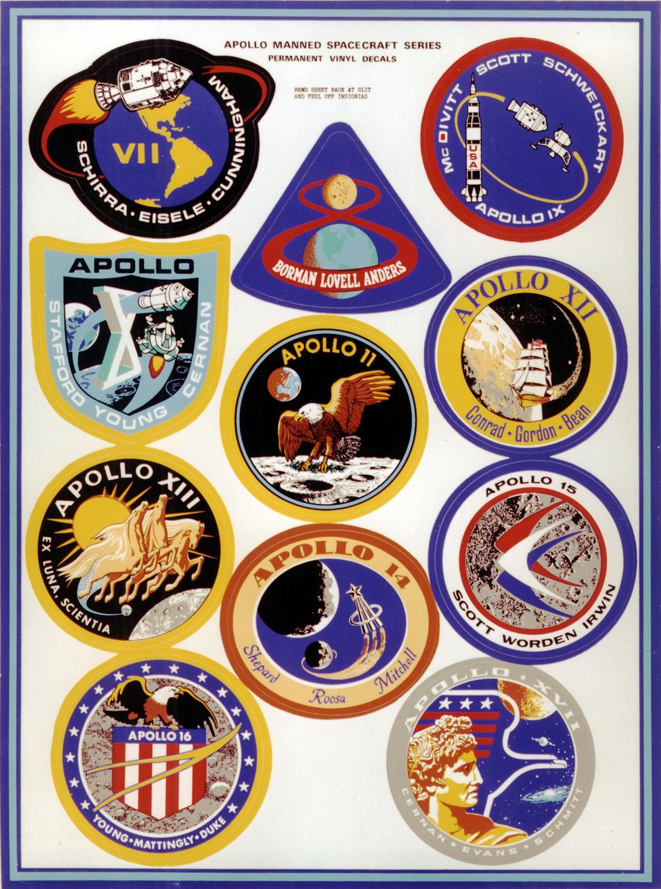
This montage depicts the flight crew patches for the manned Apollo 7 thru Apollo 17 missions. The Apollo 7 through 10 missions were basically manned test flights that paved the way for lunar landing missions. Primary objectives met included the demonstration of the Command Service Module (CSM) crew performance; crew/space vehicle/mission support facilities performance and testing during a manned CSM mission; CSM rendezvous capability; translunar injection demonstration; the first manned Apollo docking, the first Apollo Extra Vehicular Activity (EVA), performance of the first manned flight of the lunar module (LM); the CSM-LM docking in translunar trajectory, LM undocking in lunar orbit, LM staging in lunar orbit, and manned LM-CSM docking in lunar orbit. Apollo 11 through 17 were lunar landing missions with the exception of Apollo 13 which was forced to circle the moon without landing due to an onboard explosion. The craft was,however, able to return to Earth safely. Apollo 11 was the first manned lunar landing mission and performed the first lunar surface EVA. Landing site was the Sea of Tranquility. A message for mankind was delivered, the U.S. flag was planted, experiments were set up and 47 pounds of lunar surface material was collected for analysis back on Earth. Apollo 12, the 2nd manned lunar landing mission landed in the Ocean of Storms and retrieved parts of the unmanned Surveyor 3, which had landed on the Moon in April 1967. The Apollo Lunar Surface Experiments Package (ALSEP) was deployed, and 75 pounds of lunar material was gathered. Apollo 14, the 3rd lunar landing mission landed in Fra Mauro. ALSEP and other instruments were deployed, and 94 pounds of lunar materials were gathered, using a hand cart for first time to transport rocks. Apollo 15, the 4th lunar landing mission landed in the Hadley-Apennine region. With the first use of the Lunar Roving Vehicle (LRV), the crew was bale to gather 169 pounds of lunar material. Apollo 16, the 5th lunar landing mission, landed in the Descartes Highlands for the first study of highlands area. Selected surface experiments were deployed, the ultraviolet camera/spectrograph was used for first time on the Moon, and the LRV was used for second time for a collection of 213 pounds of lunar material. The Apollo program came to a close with Apollo 17, the 6th and final manned lunar landing mission that landed in the Taurus-Littrow highlands and valley area. This mission hosted the first scientist-astronaut, Schmitt, to land on the Moon. The 6th automated research station was set up, and 243 ponds of lunar material was gathered using the LRV.
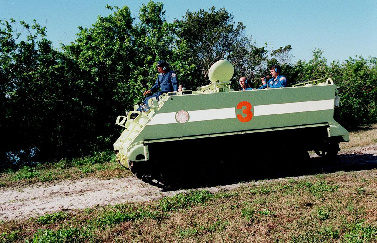
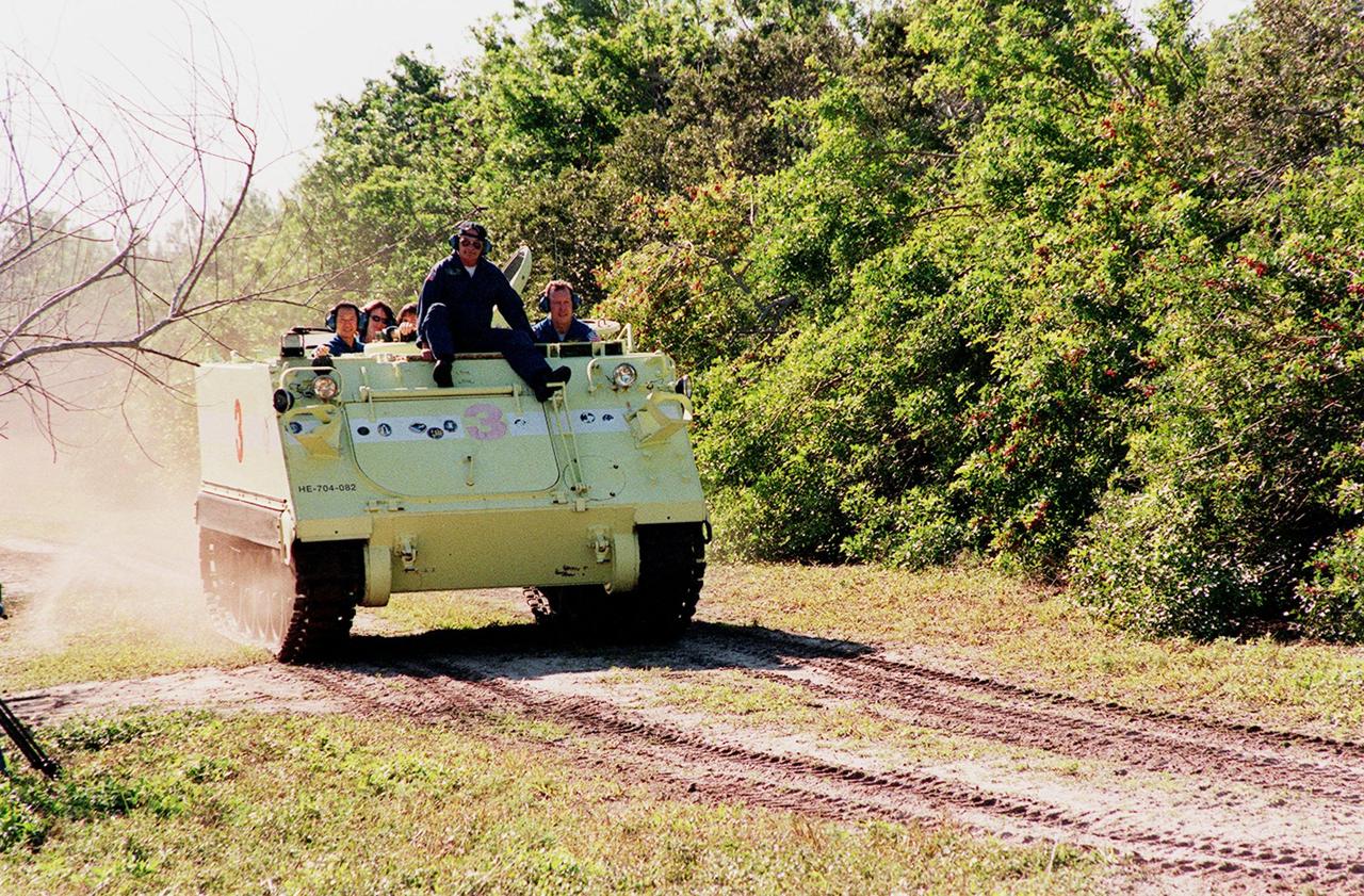
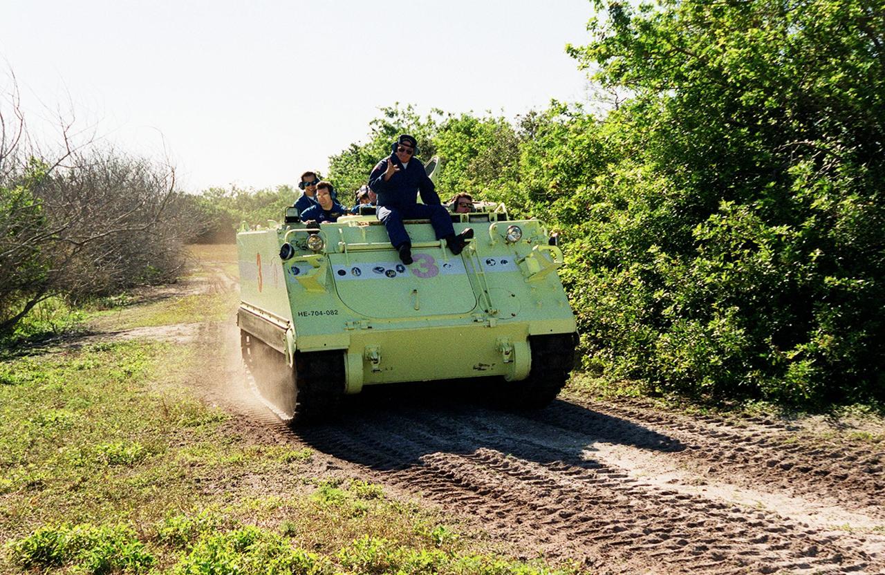
STS-99 Mission Specialist Mamoru Mohri, who is with the National Space Development Agency (NASDA) of Japan, practices driving an armored personnel carrier under the watchful eye of Capt. George Hoggard (riding on the front), trainer with the KSC Fire Department. The vehicle is part of emergency egress training during Terminal Countdown Demonstration Test (TCDT) activities and could be used by the crew in the event of an emergency at the pad during which the crew must make a quick exit from the area. Riding in the rear of the carrier are Mission Specialists Gerhard Thiele (center), Janice Voss (Ph.D.), and Commander Kevin Kregel. TCDT provides the crew with simulated countdown exercises, emergency egress training, and opportunities to inspect the mission payloads in the orbiter's payload bay. STS-99 is the Shuttle Radar Topography Mission, which will chart a new course, using two antennae and a 200-foot-long section of space station-derived mast protruding from the payload bay to produce unrivaled 3-D images of the Earth's surface. The result of the Shuttle Radar Topography Mission could be close to 1 trillion measurements of the Earth's topography. Besides contributing to the production of better maps, these measurements could lead to improved water drainage modeling, more realistic flight simulators, better locations for cell phone towers, and enhanced navigation safety. Launch of Endeavour on the 11-day mission is scheduled for Jan. 31 at 12:47 p.m. EST
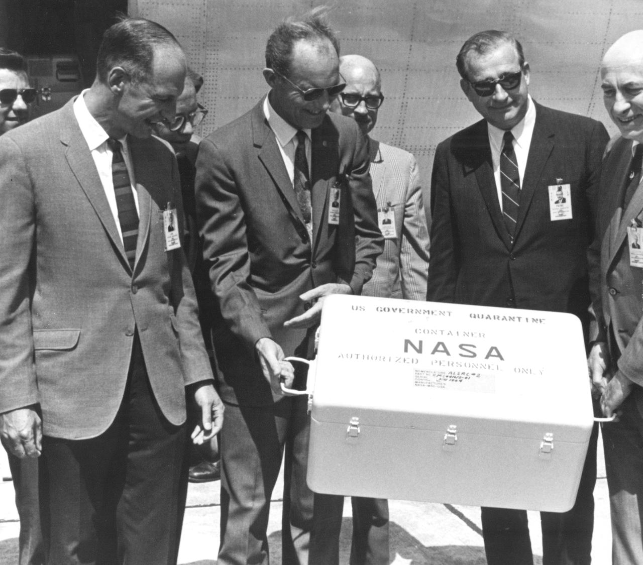
The Apollo 11 mission, the first manned lunar mission, launched from the Kennedy Space Center, Florida via the Marshall Space Flight Center (MSFC) developed Saturn V launch vehicle on July 16, 1969 and safely returned to Earth on July 24, 1969. Aboard the space craft were astronauts Neil A. Armstrong, commander; Michael Collins, Command Module (CM) pilot; and Edwin E. Aldrin Jr., Lunar Module (LM) pilot. The CM, piloted by Michael Collins remained in a parking orbit around the Moon while the LM, named “Eagle’’, carrying astronauts Neil Armstrong and Edwin Aldrin, landed on the Moon. During 2½ hours of surface exploration, the crew collected 47 pounds of lunar surface material for analysis back on Earth. This photograph was taken as the mission’s first loaded sample return container arrived at Ellington Air Force Base by air from the Pacific recovery area. The rock box was immediately taken to the Lunar Receiving Laboratory at the Manned Spacecraft Center (MSC) in Houston, Texas. Happily posing for the photograph with the rock container are (L-R) Richard S. Johnston (back), special assistant to the MSC Director; George M. Low, MSC Apollo Spacecraft Program manager; George S. Trimble (back), MSC Deputy Director; Lt. General Samuel C. Phillips, Apollo Program Director, Office of Manned Spaceflight at NASA headquarters; Eugene G. Edmonds, MSC Photographic Technology Laboratory; Dr. Thomas O. Paine, NASA Administrator; and Dr. Robert R. Gilruth, MSC Director.

STS-99 Mission Specialist Mamoru Mohri, who is with the National Space Development Agency (NASDA) of Japan, practices driving an armored personnel carrier under the watchful eye of Capt. George Hoggard (riding on the front), trainer with the KSC Fire Department. The vehicle is part of emergency egress training during Terminal Countdown Demonstration Test (TCDT) activities and could be used by the crew in the event of an emergency at the pad during which the crew must make a quick exit from the area. Riding in the rear of the carrier are Mission Specialists Gerhard Thiele (center), Janice Voss (Ph.D.), and Commander Kevin Kregel. TCDT provides the crew with simulated countdown exercises, emergency egress training, and opportunities to inspect the mission payloads in the orbiter's payload bay. STS-99 is the Shuttle Radar Topography Mission, which will chart a new course, using two antennae and a 200-foot-long section of space station-derived mast protruding from the payload bay to produce unrivaled 3-D images of the Earth's surface. The result of the Shuttle Radar Topography Mission could be close to 1 trillion measurements of the Earth's topography. Besides contributing to the production of better maps, these measurements could lead to improved water drainage modeling, more realistic flight simulators, better locations for cell phone towers, and enhanced navigation safety. Launch of Endeavour on the 11-day mission is scheduled for Jan. 31 at 12:47 p.m. EST