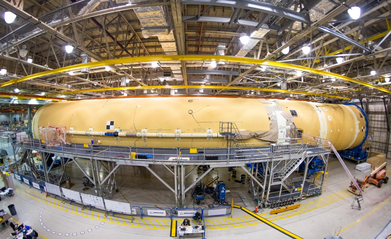
Technicians at NASA’s Michoud Assembly Facility in New Orleans completed the “forward join,” which connects structures to form the top part of NASA’s Space Launch System (SLS) rocket’s core stage. The first core stage will send Exploration Mission-1, the first integrated flight of SLS and NASA’s Orion spacecraft, out beyond the Moon. The forward join mated three structures: the forward skirt, liquid oxygen tank and intertank. This milestone marks the beginning of integration and assembly of the massive, 212-foot-tall SLS core stage, which will include the rocket’s four RS-25 rocket engines, propellant tanks and flight computers. Now, NASA and Boeing, the SLS prime contractor, will continue to integrate various systems inside the forward part of the core stage and prepare for structural joining of the liquid hydrogen tank and engine section to form the bottom of the stage. These two parts of the core stage will then be assembled to form the largest stage NASA has ever built.
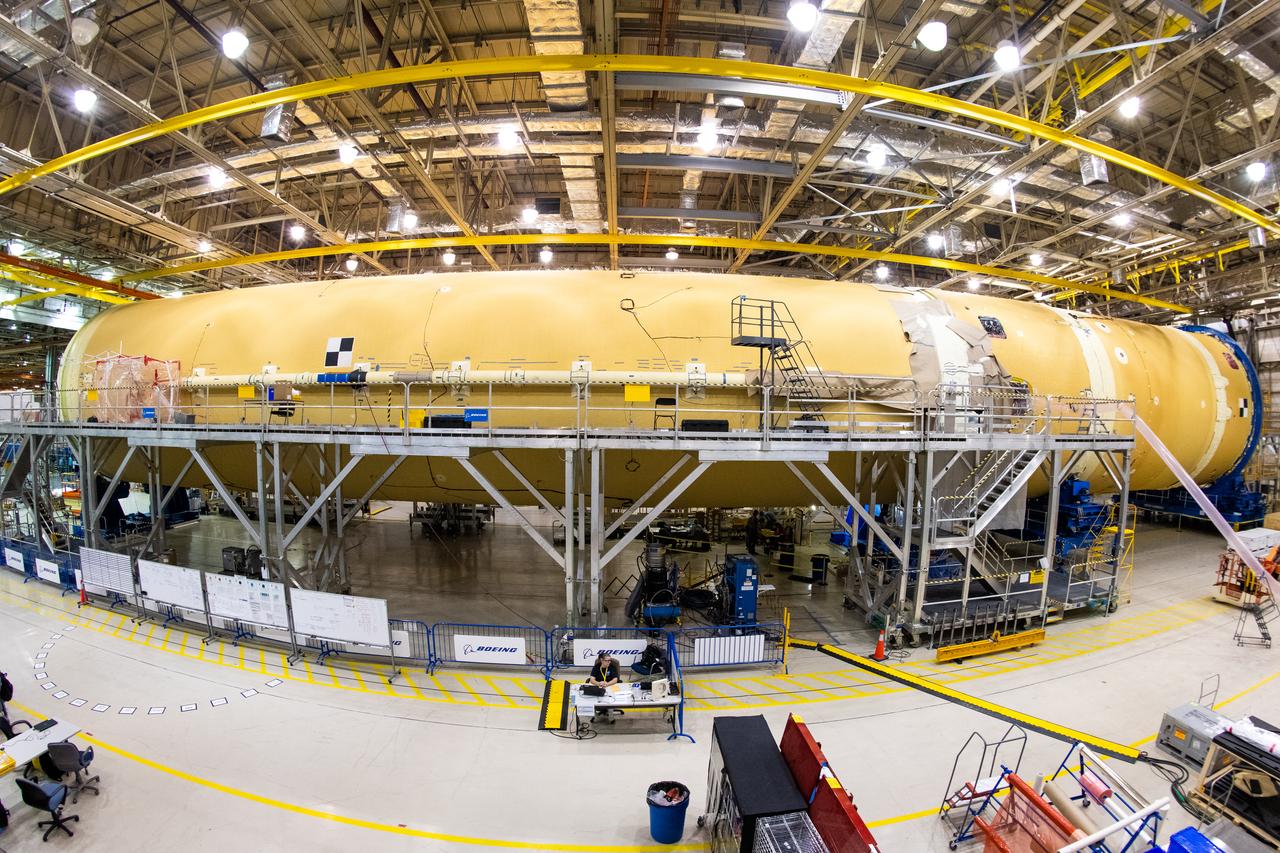
Technicians at NASA’s Michoud Assembly Facility in New Orleans completed the “forward join,” which connects structures to form the top part of NASA’s Space Launch System (SLS) rocket’s core stage. The first core stage will send Exploration Mission-1, the first integrated flight of SLS and NASA’s Orion spacecraft, out beyond the Moon. The forward join mated three structures: the forward skirt, liquid oxygen tank and intertank. This milestone marks the beginning of integration and assembly of the massive, 212-foot-tall SLS core stage, which will include the rocket’s four RS-25 rocket engines, propellant tanks and flight computers. Now, NASA and Boeing, the SLS prime contractor, will continue to integrate various systems inside the forward part of the core stage and prepare for structural joining of the liquid hydrogen tank and engine section to form the bottom of the stage. These two parts of the core stage will then be assembled to form the largest stage NASA has ever built.
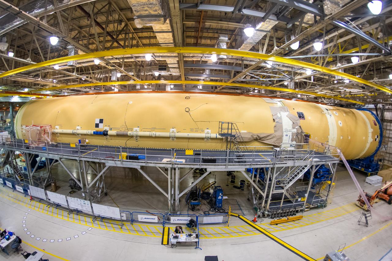
Technicians at NASA’s Michoud Assembly Facility in New Orleans completed the “forward join,” which connects structures to form the top part of NASA’s Space Launch System (SLS) rocket’s core stage. The first core stage will send Exploration Mission-1, the first integrated flight of SLS and NASA’s Orion spacecraft, out beyond the Moon. The forward join mated three structures: the forward skirt, liquid oxygen tank and intertank. This milestone marks the beginning of integration and assembly of the massive, 212-foot-tall SLS core stage, which will include the rocket’s four RS-25 rocket engines, propellant tanks and flight computers. Now, NASA and Boeing, the SLS prime contractor, will continue to integrate various systems inside the forward part of the core stage and prepare for structural joining of the liquid hydrogen tank and engine section to form the bottom of the stage. These two parts of the core stage will then be assembled to form the largest stage NASA has ever built.
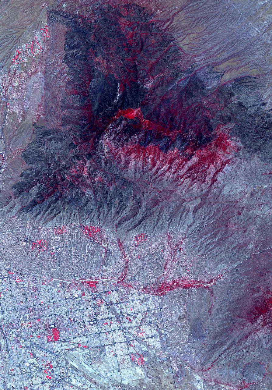
NASA's Advanced Spaceborne Thermal Emission and Reflection Radiometer (ASTER) instrument imaged areas burned by the Bighorn Fire north of Tucson, Arizona, on June 29. In the image, vegetation is shown in red and burned areas are shown in dark gray. It covers an area of 20 by 30 miles (33 by 48 kilometers). https://photojournal.jpl.nasa.gov/catalog/PIA23691

Expedition 48 NASA astronaut Jeff Williams rest in a chairs outside the Soyuz TMA-20M spacecraft a few moments after he and Russian cosmonauts Alexey Ovchinin and Oleg Skripochka of Roscosmos landed in a remote area near the town of Zhezkazgan, Kazakhstan on Wednesday, Sept. 7, 2016(Kazakh time). Williams, Ovchinin, and Skripochka are returning after 172 days in space where they served as members of the Expedition 47 and 48 crews onboard the International Space Station. Photo Credit: (NASA/Bill Ingalls)
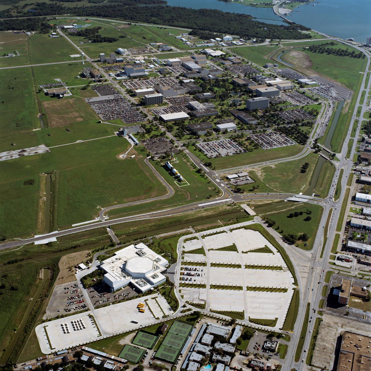
S93-45701 (1993) -- Aerial view of JSC with newly opened Space Center Houston in foreground. Photo credit: NASA

CAPE CANAVERAL, Fla. – Director of Launch Vehicle Processing Rita Willcoxon points out an area near the landing gear on space shuttle Endeavour to Associate Administrator for Space Operations William Gerstenmaier. Endeavour landed at 10:48 a.m. EDT, completing the 6.5-million mile journey on the STS-127 mission to the International Space Station. Endeavour's main gear touchdown was at 10:48:08 a.m. EDT. Nose gear touchdown was at 10:48:21 a.m. and wheels stop was at 10:49:13 a.m. Endeavour delivered the Japanese Experiment Module's Exposed Facility and the Experiment Logistics Module-Exposed Section to the International Space Station. The mission was the 29th flight to the station, the 23rd flight of Endeavour and the 127th in the Space Shuttle Program, as well as the 71st landing at Kennedy. Photo credit: NASA/Kim Shiflett
The Whitewater Fire in the Mount Jefferson Wilderness in Oregon was started by a lightning strike. As of Aug. 18, 2017, more than 117,000 acres and 30 miles (48 kilometers) of the Pacific Crest Trail are closed to the public in an area that had been expected to be popular with people there to view the August 21 solar eclipse. The smoke clouds sit over the burned area, just west-northwest of Mount Jefferson. The image was acquired Aug. 18, 2017, covers an area of 16 by 17 miles (26.1 by 27.2 kilometers), and is located at 44.7 degrees north, 121.8 degrees west. https://photojournal.jpl.nasa.gov/catalog/PIA21877
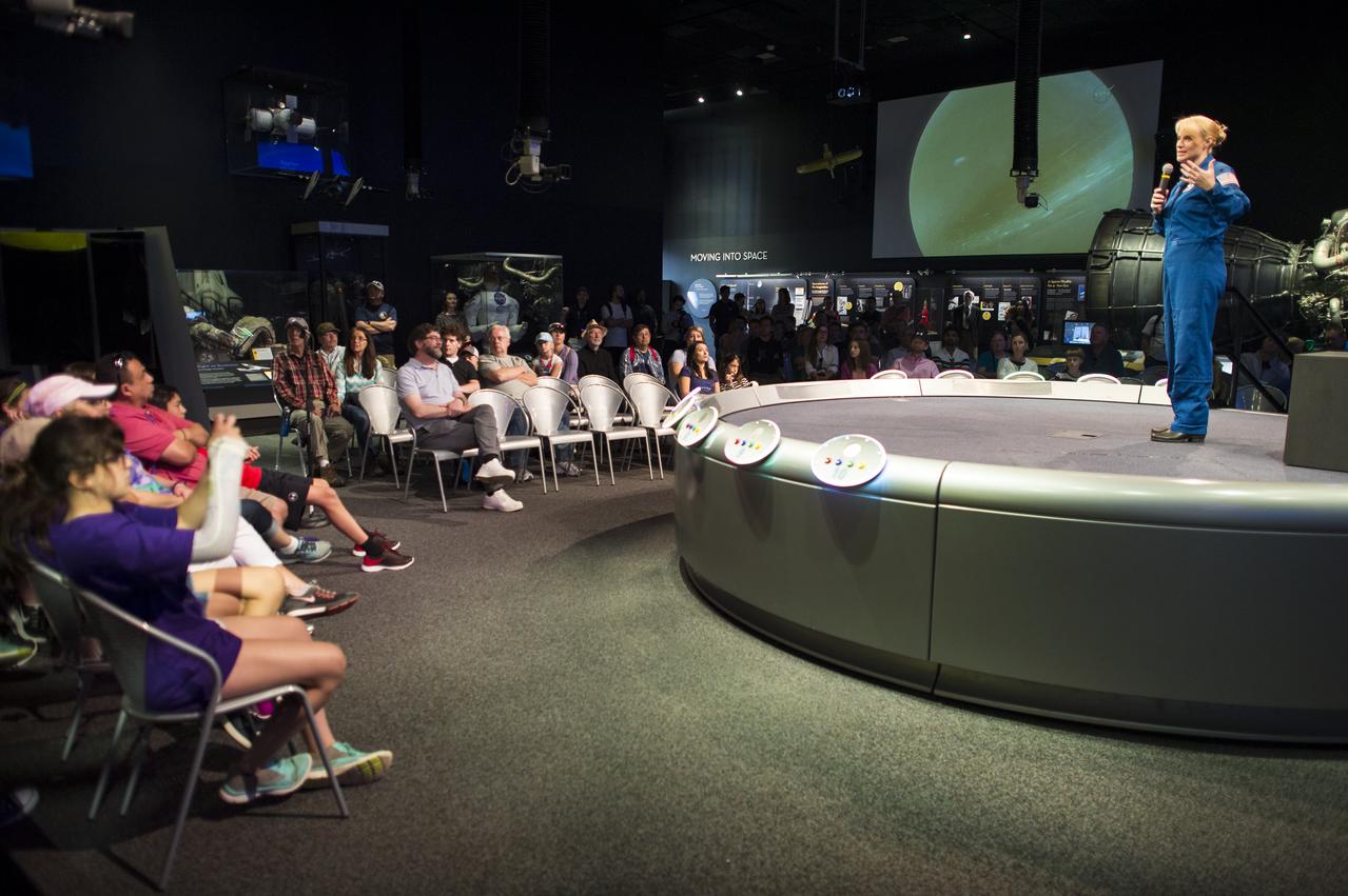
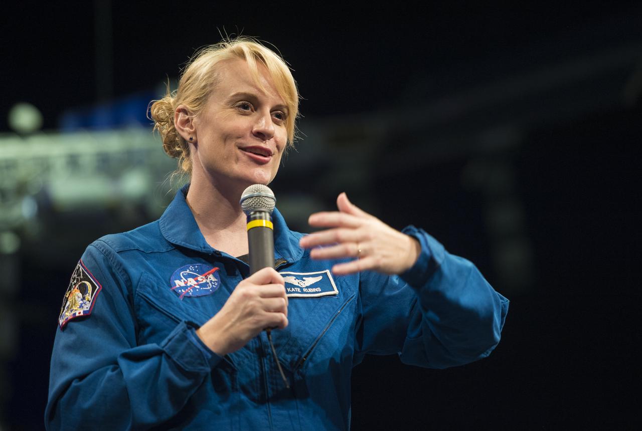
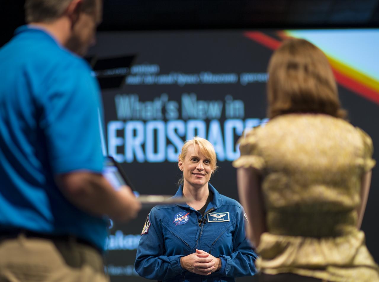
NASA Astronaut Kate Rubins answers a question from an audience member about her time onboard the International Space Station during Expeditions 48 and 49, Thursday, April 27, 2017 at Smithsonian's National Air and Space Museum in Washington. Rubins became the first person to sequence DNA in space and completed her first mission when she landed in a remote area near the town of Zhezkazgan, Kazakhstan in October 2016. Photo Credit: (NASA/Aubrey Gemignani)
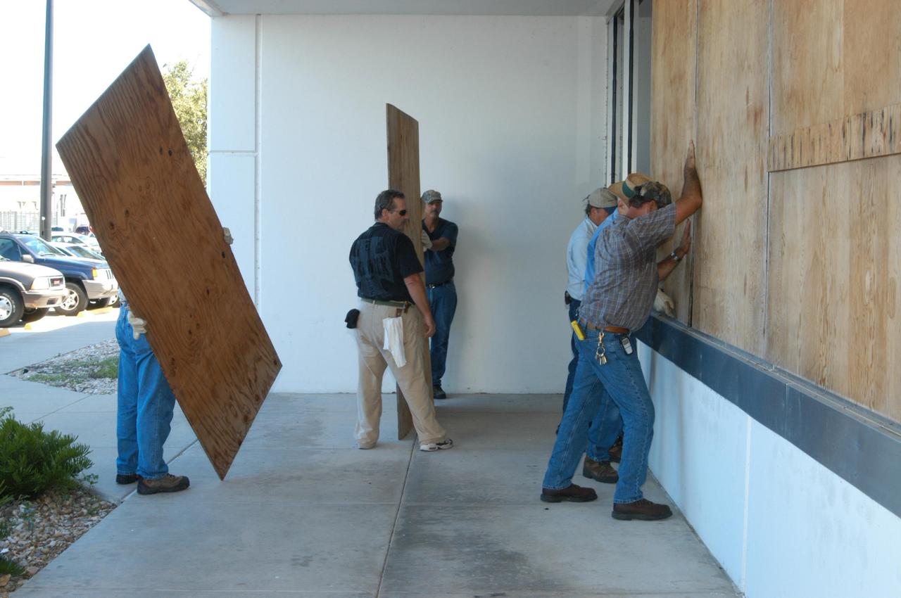
KENNEDY SPACE CENTER, FLA. - NASA's Kennedy Space Center has begun making preparations for the arrival of Tropical Storm Ernesto. Here workers are boarding up windows on the Operations and Support Building I in the Launch Complex 39 Area. The center has been in HURCON III status since Aug. 28, which means winds of 58 mph are expected within 48 hours. m. Photo credit: NASA/George Shelton

NASA Astronaut Kate Rubins speaks about her time onboard the International Space Station during Expeditions 48 and 49 Thursday, April 27, 2017 at Smithsonian's National Air and Space Museum in Washington. Rubins became the first person to sequence DNA in space and completed her first mission when she landed in a remote area near the town of Zhezkazgan, Kazakhstan in October 2016. Photo Credit: (NASA/Aubrey Gemignani)

NASA Astronaut Kate Rubins speaks about her time onboard the International Space Station during Expeditions 48 and 49 Thursday, April 27, 2017 at Smithsonian's National Air and Space Museum in Washington. Rubins became the first person to sequence DNA in space and completed her first mission when she landed in a remote area near the town of Zhezkazgan, Kazakhstan in October 2016. Photo Credit: (NASA/Aubrey Gemignani)
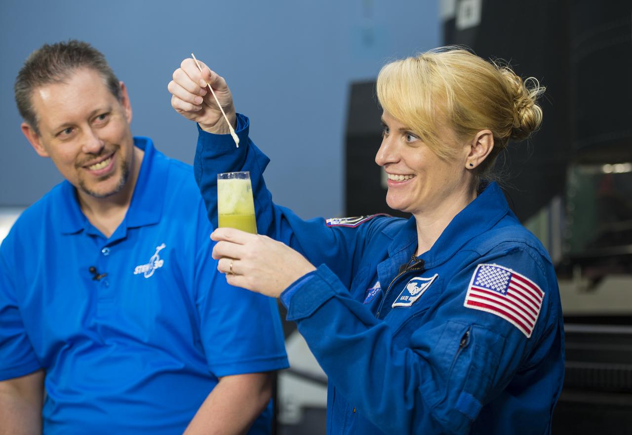
NASA Astronaut Kate Rubins conducts a DNA experiment for a STEM in 30 segment, Thursday, April 27, 2017 at Smithsonian's National Air and Space Museum in Washington. Rubins served on the International Space Station during Expeditions 48 and 49 and became the first person to sequence DNA in space. She completed her first mission when she landed in a remote area near the town of Zhezkazgan, Kazakhstan in October 2016. Photo Credit: (NASA/Aubrey Gemignani)
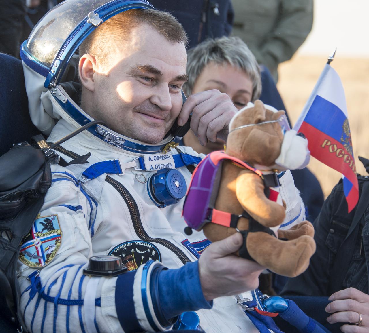
Russian cosmonaut Alexey Ovchinin of Roscosmos rest in a chair outside the Soyuz TMA-20M spacecraft a few moments after he and NASA astronaut Jeff Williams, and Russian cosmonaut Oleg Skripochka of Roscosmos landed in a remote area near the town of Zhezkazgan, Kazakhstan on Wednesday, Sept. 7, 2016(Kazakh time). Williams, Ovchinin, and Skripochka are returning after 172 days in space where they served as members of the Expedition 47 and 48 crews onboard the International Space Station. Photo Credit: (NASA/Bill Ingalls)

Adam's Bridge is a 48 km long chain of limestone shoals, that were formerly a land bridge between India and Sri Lanka. It was reportedly passable until the 15th century, when storms destroyed the integrity of the bridge. The geologic origin of the bridge is still controversial. The image was acquired March 25, 2020, covers an area of 39.6 by 61.7 km, and is located at 9.3 degrees north, 79.3 degrees east. https://photojournal.jpl.nasa.gov/catalog/PIA24949
KENNEDY SPACE CENTER, FLA. -- This aerial photo shows the storage area containing Launch Umbilical Towers that were used during the early years of the Space Program. In the lower left corner of the storage field is a Caterpillar excavator with a 48-inch shear demolishing LUT-1, used to launch Apollo 8, Apollo 11, Skylab manned missions and the Apollo-Soyuz Test Project. The shear is one used in the deconstruction of the Twin Towers in New York City after 9/11.

NASA Astronaut Kate Rubins participates in a Facebook Live, answering questions about her time onboard the International Space Station during Expeditions 48 and 49, Thursday, April 27, 2017 at Smithsonian's National Air and Space Museum in Washington. Rubins became the first person to sequence DNA in space and completed her first mission when she landed in a remote area near the town of Zhezkazgan, Kazakhstan in October 2016. Photo Credit: (NASA/Aubrey Gemignani)

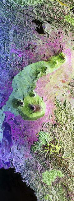
The Chaine des Puys, about 40 kilometers long, is a chain of 48 cinder cones, 8 lava domes and 15 maars (explosion craters) in central France, west of Clermont-Ferrand. The chaine is located on the Limagne Fault, related to formation of the Alps. The most recent eruption is thought to be 4040 BCE. The image was acquired April 21, 2015, covers an area of 22.5 by 30.6 km, and is located at 45.8 degrees north, 3 degrees east. https://photojournal.jpl.nasa.gov/catalog/PIA25798
KENNEDY SPACE CENTER, FLA. - NASA's Kennedy Space Center has begun making preparations for the arrival of Tropical Storm Ernesto. Here workers are boarding up windows on the Operations and Support Building I in the Launch Complex 39 Area. The center has been in HURCON III status since Aug. 28, which means winds of 58 mph are expected within 48 hours. m. Photo credit: NASA/George Shelton
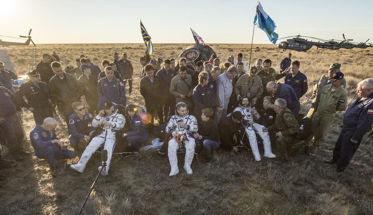
NASA astronaut Jeff Williams, left, Russian cosmonaut Alexey Ovchinin of Roscosmos, center, and Russian cosmonaut Oleg Skripochka of Roscosmos sit in chairs outside the Soyuz TMA-20M spacecraft a few moments after they landed in a remote area near the town of Zhezkazgan, Kazakhstan on Wednesday, Sept. 7, 2016(Kazakh time). Williams, Ovchinin, and Skripochka are returning after 172 days in space where they served as members of the Expedition 47 and 48 crews onboard the International Space Station. Photo Credit: (NASA/Bill Ingalls)
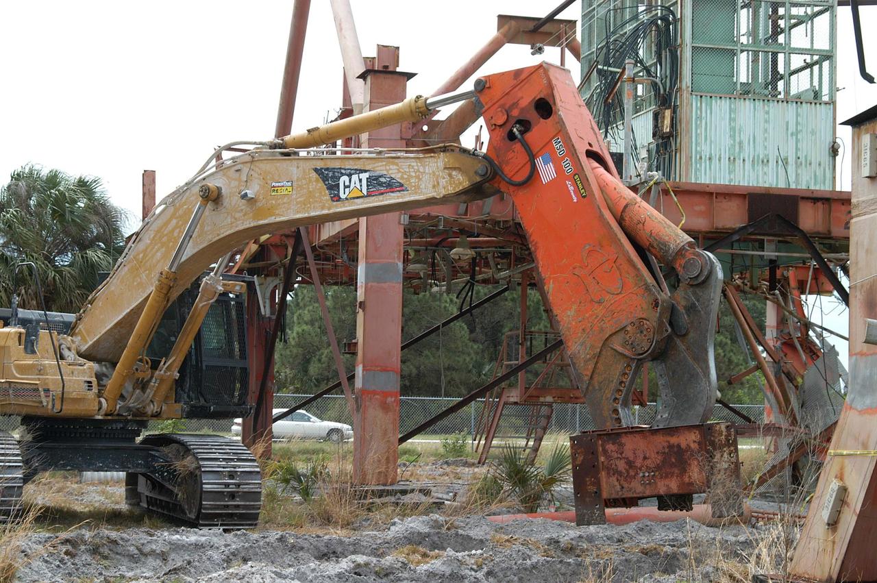
KENNEDY SPACE CENTER, FLA. -- Looking like a prehistoric monster crunching on its prey, the Caterpillar excavator and 48-inch shear attachment tear down Launch Umbilical Tower No. 1 (LUT-1) stored in the Industrial Area of KSC. The LUT-1 was part of the launch system used for Apollo-Saturn V, launching Apollo 8, Apollo 11, Skylab manned missions and the Apollo-Soyuz Test Project. The shear is one used in the deconstruction of the Twin Towers in New York City after 9/11.

Expedition 49 astronaut Takuya Onishi of the Japan Aerospace Exploration Agency (JAXA) is carried into a medical tent shortly after he, Russian cosmonaut Anatoly Ivanishin of Roscosmos, and NASA astronaut Kate Rubins landed in a remote area near the town of Zhezkazgan, Kazakhstan on Sunday, Oct. 30, 2016 (Kazakh time). Rubins, Ivanishin, and Onishi are returning after 115 days in space where they served as members of the Expedition 48 and 49 crews onboard the International Space Station. Photo Credit: (NASA/Bill Ingalls)
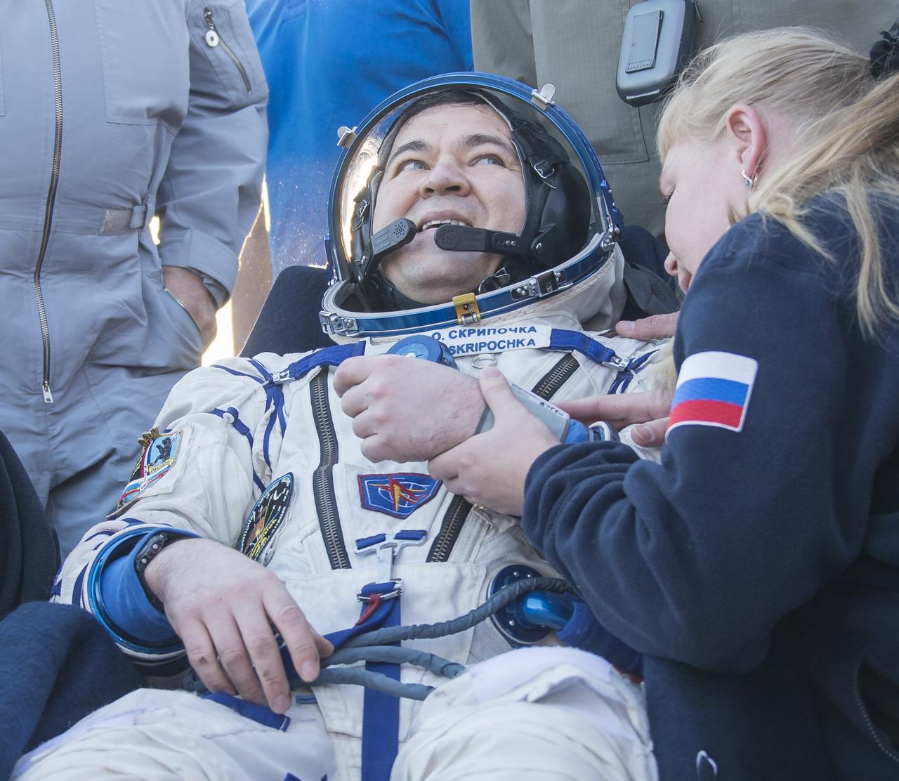
Russian cosmonaut Oleg Skripochka of Roscosmos rest in a chair outside the Soyuz TMA-20M spacecraft a few moments after he and NASA astronaut Jeff Williams, and Russian cosmonaut Alexey Ovchinin of Roscosmos landed in a remote area near the town of Zhezkazgan, Kazakhstan on Wednesday, Sept. 7, 2016(Kazakh time). Williams, Ovchinin, and Skripochka are returning after 172 days in space where they served as members of the Expedition 47 and 48 crews onboard the International Space Station. Photo Credit: (NASA/Bill Ingalls)
KENNEDY SPACE CENTER, FLA. -- This aerial photo shows the storage area containing Launch Umbilical Towers that were used during the early years of the Space Program. In the upper right corner of the storage field is a Caterpillar excavator with a 48-inch shear demolishing LUT-1, used to launch Apollo 8, Apollo 11, Skylab manned missions and the Apollo-Soyuz Test Project. The shear is one used in the deconstruction of the Twin Towers in New York City after 9/11.
KENNEDY SPACE CENTER, FLA. -- Looking like a prehistoric monster crunching on its prey, the Caterpillar excavator and 48-inch shear attachment tear down Launch Umbilical Tower No. 1 (LUT-1) stored in the Industrial Area of KSC. The LUT-1 was part of the launch system used for Apollo-Saturn V, launching Apollo 8, Apollo 11, Skylab manned missions and the Apollo-Soyuz Test Project. The shear is one used in the deconstruction of the Twin Towers in New York City after 9/11.
NASA Astronaut Kate Rubins speaks about her time onboard the International Space Station during Expeditions 48 and 49 Thursday, April 27, 2017 at Smithsonian's National Air and Space Museum in Washington. Rubins became the first person to sequence DNA in space and completed her first mission when she landed in a remote area near the town of Zhezkazgan, Kazakhstan in October 2016. Photo Credit: (NASA/Aubrey Gemignani)
NASA Astronaut Kate Rubins speaks about her time onboard the International Space Station during Expeditions 48 and 49 Thursday, April 27, 2017 at Smithsonian's National Air and Space Museum in Washington. Rubins became the first person to sequence DNA in space and completed her first mission when she landed in a remote area near the town of Zhezkazgan, Kazakhstan in October 2016. Photo Credit: (NASA/Aubrey Gemignani)

iss072e757257 (March 5, 2025) --- Bangkok, Thailand—with a metropolitan population of about 11.4 million and split by the Chao Phraya river—is pictured from the International Space Station at approximately 1:48 a.m. local time as it orbited 257 miles above the Southeast Asian nation. The dark area toward the center-right is part of the Phra Pradaeng District, a lush, green peninsula known as Bang Krachao. Preserved as an urban green space, it helps mitigate Bangkok’s pollution and urban density.
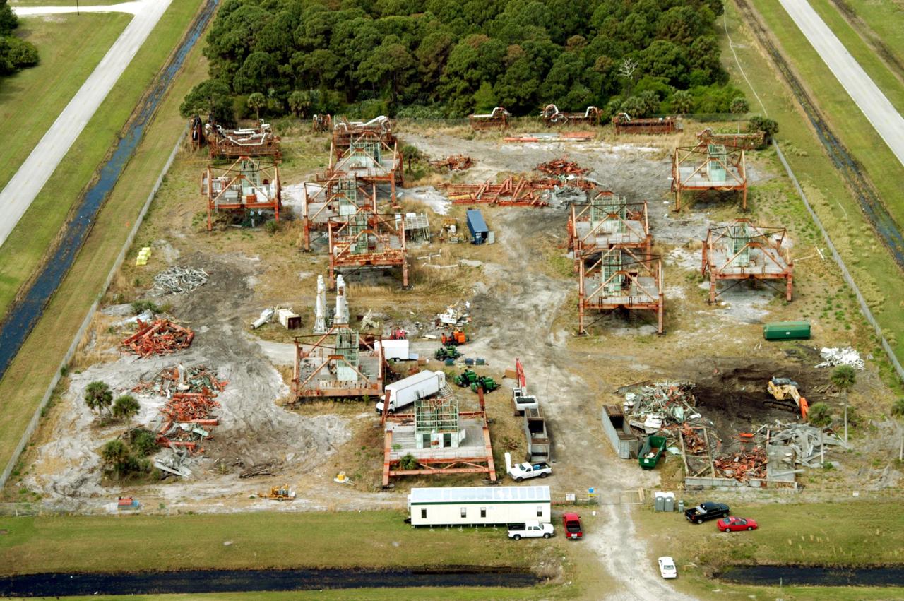
KENNEDY SPACE CENTER, FLA. -- This aerial photo shows the storage area containing Launch Umbilical Towers that were used during the early years of the Space Program. In the lower right corner of the storage field is a Caterpillar excavator with a 48-inch shear demolishing LUT-1, used to launch Apollo 8, Apollo 11, Skylab manned missions and the Apollo-Soyuz Test Project. The shear is one used in the deconstruction of the Twin Towers in New York City after 9/11.
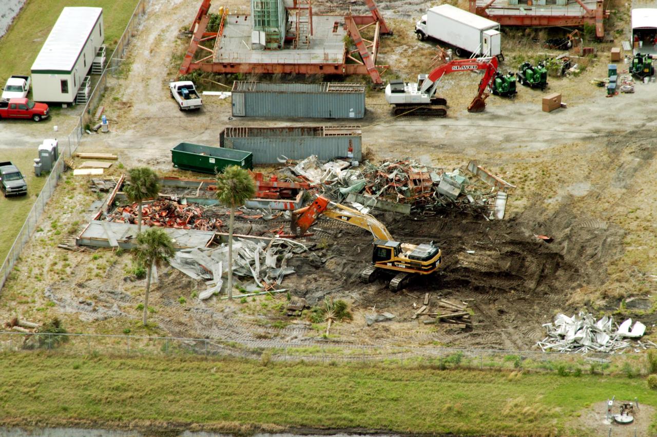
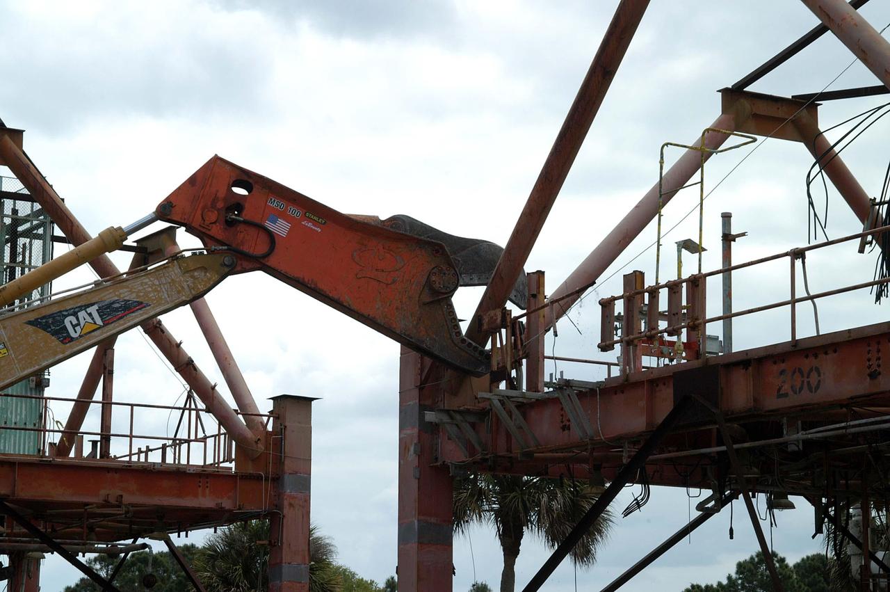
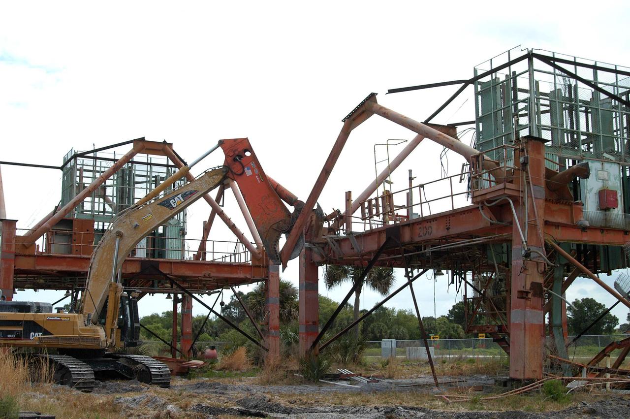
KENNEDY SPACE CENTER, FLA. -- This aerial photo shows the storage area containing Launch Umbilical Towers that were used during the early years of the Space Program. The central focus is a Caterpillar excavator with a 48-inch shear demolishing LUT-1, used to launch Apollo 8, Apollo 11, Skylab manned missions and the Apollo-Soyuz Test Project. The shear is one used in the deconstruction of the Twin Towers in New York City after 9/11.
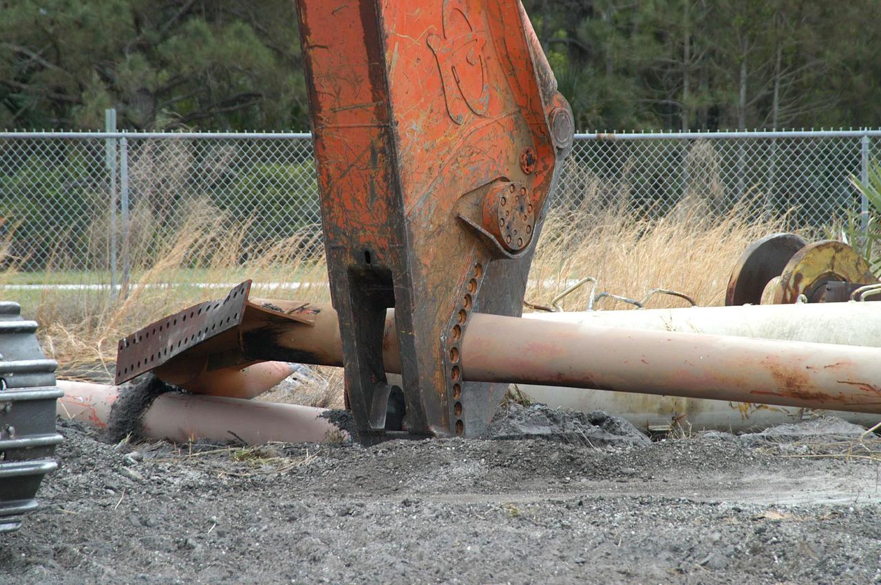
KENNEDY SPACE CENTER, FLA. -- Like a dinosaur crunching on its prey, the Caterpillar excavator and 48-inch shear attachment tear down Launch Umbilical Tower No. 1 (LUT-1) stored in the Industrial Area of KSC. The LUT-1 was part of the launch system used for Apollo-Saturn V, launching Apollo 8, Apollo 11, Skylab manned missions and the Apollo-Soyuz Test Project. The shear is one used in the deconstruction of the Twin Towers in New York City after 9/11.
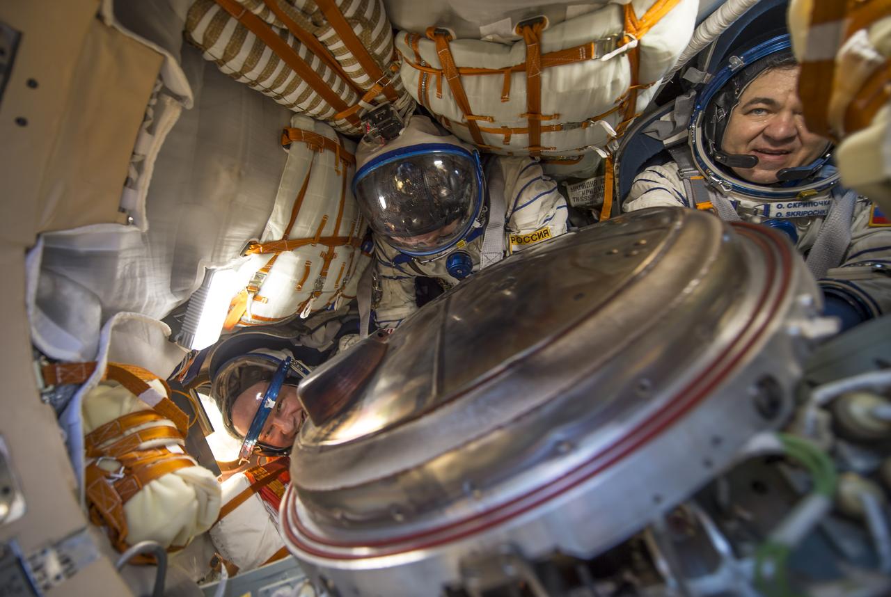
NASA astronaut Jeff Williams, left, Russian cosmonaut Alexey Ovchinin of Roscosmos, center, and Russian cosmonaut Oleg Skripochka of Roscosmos are seen inside the Soyuz TMA-20M spacecraft a few moments after they landed in a remote area near the town of Zhezkazgan, Kazakhstan on Wednesday, Sept. 7, 2016(Kazakh time). Williams, Ovchinin, and Skripochka are returning after 172 days in space where they served as members of the Expedition 47 and 48 crews onboard the International Space Station. Photo Credit: (NASA/Bill Ingalls)
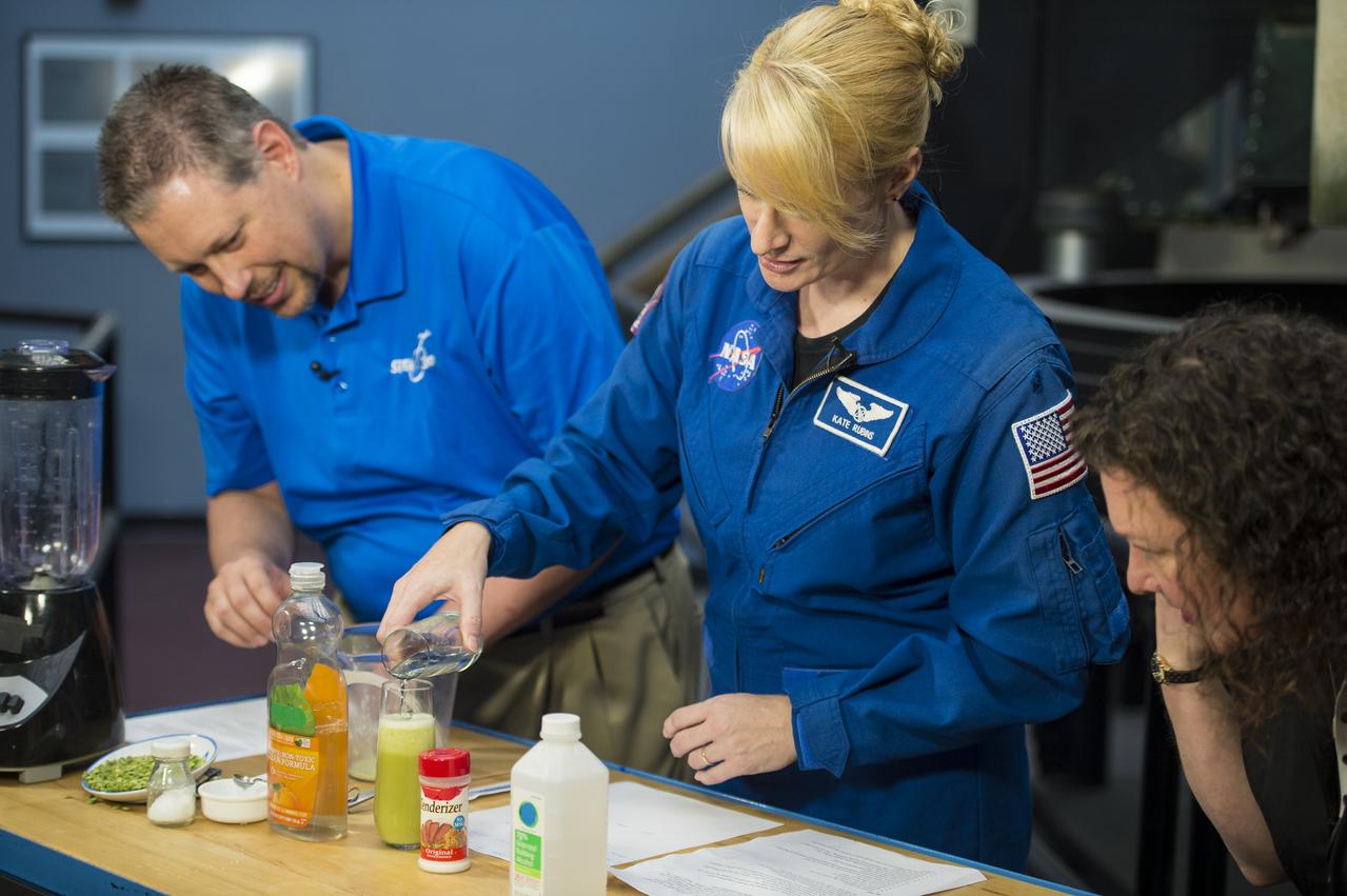
NASA Astronaut Kate Rubins conducts a DNA experiment for a STEM in 30 segment, Thursday, April 27, 2017 at Smithsonian's National Air and Space Museum in Washington. Rubins served on the International Space Station during Expeditions 48 and 49 and became the first person to sequence DNA in space. She completed her first mission when she landed in a remote area near the town of Zhezkazgan, Kazakhstan in October 2016. Photo Credit: (NASA/Aubrey Gemignani)
NASA Astronaut Kate Rubins participates in a Facebook Live, answering questions about her time onboard the International Space Station during Expeditions 48 and 49, Thursday, April 27, 2017 at Smithsonian's National Air and Space Museum in Washington. Rubins became the first person to sequence DNA in space and completed her first mission when she landed in a remote area near the town of Zhezkazgan, Kazakhstan in October 2016. Photo Credit: (NASA/Aubrey Gemignani)

iss073e0982081 (Oct. 25, 2025) --- Atlanta, Georgia—home to the world's busiest airport, Hartsfield-Jackson Atlanta International Airport (center left), which handles over 107 million passengers annually—is pictured at approximately 2:20 a.m. local time from the International Space Station as it orbited 261 miles above North America. Atlanta is also nicknamed the "City in a Forest," with approximately 48% of its area covered in trees.
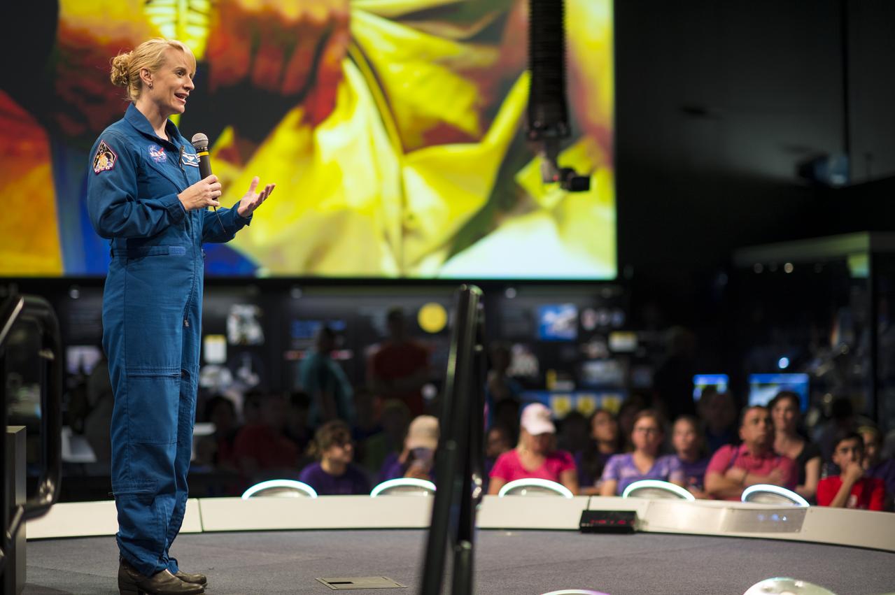
NASA Astronaut Kate Rubins speaks about her time onboard the International Space Station during Expeditions 48 and 49 Thursday, April 27, 2017 at Smithsonian's National Air and Space Museum in Washington. Rubins became the first person to sequence DNA in space and completed her first mission when she landed in a remote area near the town of Zhezkazgan, Kazakhstan in October 2016. Photo Credit: (NASA/Aubrey Gemignani)
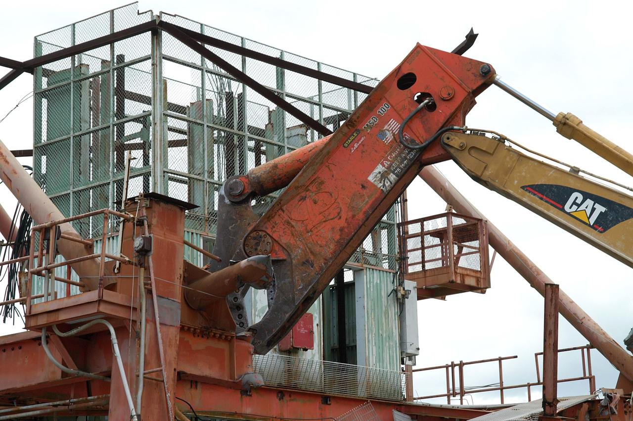
KENNEDY SPACE CENTER, FLA. -- Looking like a prehistoric monster crunching on its prey, the Caterpillar excavator and 48-inch shear attachment tear down Launch Umbilical Tower No. 1 (LUT-1) stored in the Industrial Area of KSC. The LUT-1 was part of the launch system used for Apollo-Saturn V, launching Apollo 8, Apollo 11, Skylab manned missions and the Apollo-Soyuz Test Project. The shear is one used in the deconstruction of the Twin Towers in New York City after 9/11.
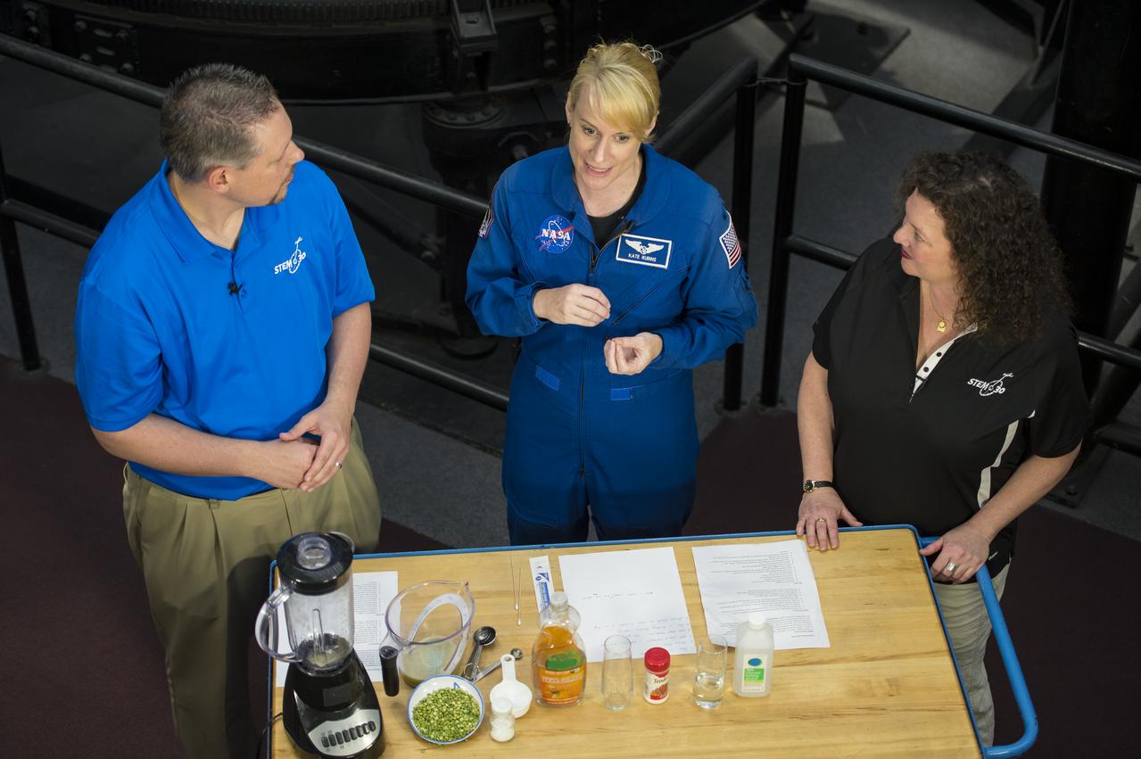
NASA Astronaut Kate Rubins conducts a DNA experiment for a STEM in 30 segment, Thursday, April 27, 2017 at Smithsonian's National Air and Space Museum in Washington. Rubins served on the International Space Station during Expeditions 48 and 49 and became the first person to sequence DNA in space. She completed her first mission when she landed in a remote area near the town of Zhezkazgan, Kazakhstan in October 2016. Photo Credit: (NASA/Aubrey Gemignani)
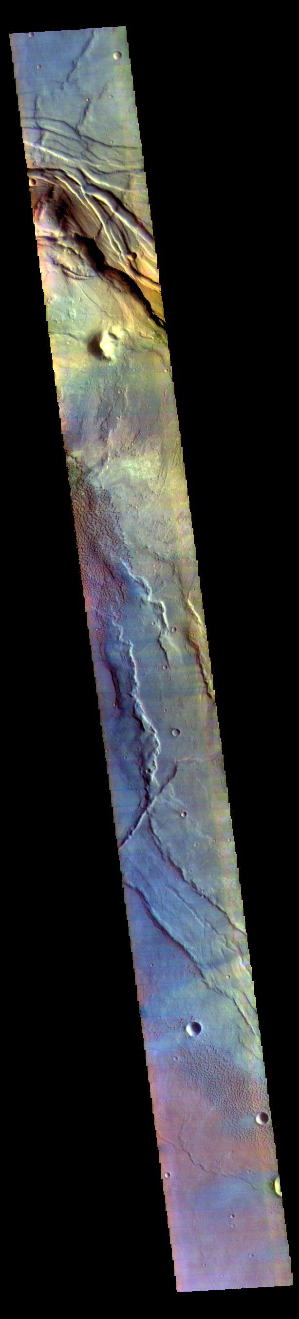
Today's false color image is located at Nili Patera in Syrtis Major Planum. There are regions of small dunes towards the top and the bottom of the image. The wide range of colors indicate the complexity of surface materials in this area. The THEMIS VIS camera contains 5 filters. The data from different filters can be combined in multiple ways to create a false color image. These false color images may reveal subtle variations of the surface not easily identified in a single band image. Orbit Number: 61810 Latitude: 8.37503 Longitude: 67.4659 Instrument: VIS Captured: 2015-11-20 04:48 https://photojournal.jpl.nasa.gov/catalog/PIA23071
The Soberanes fire, in northern California near Big Sur, had grown to more than 27,000 acres when the Advanced Spaceborne Thermal Emission and Reflection Radiometer (ASTER) instrument on NASA's Terra spacecraft captured this image on July 28, 2016. More than 3,000 personnel are battling the blaze, that is only 10 percent contained. The fire has destroyed 36 homes and caused one fatality. Evacuation orders were issued for a number of nearby communities. The image covers an area of 29 by 30 miles (46 by 48 kilometers), and is located at 36.4 degrees north, 121.8 degrees west. http://photojournal.jpl.nasa.gov/catalog/PIA20722
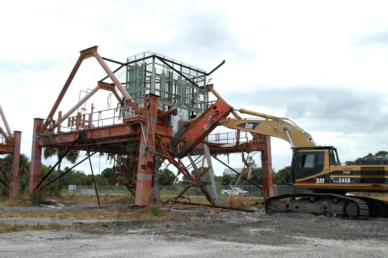
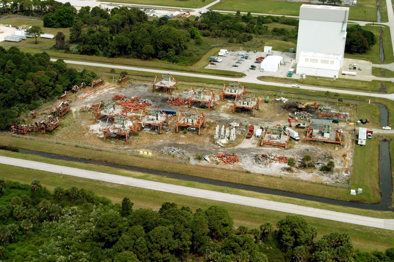
KENNEDY SPACE CENTER, FLA. -- Launch Umbilical Tower No. 1 (LUT-1), stored in the Industrial Area of KSC, is being demolished using a Caterpillar excavator and 48-inch shear attachment. Seen is the base of tower; the upright tower extended more than 398 feet above the launch pad. The LUT-1 was part of the launch system used for Apollo-Saturn V, launching Apollo 8, Apollo 11, Skylab manned missions and the Apollo-Soyuz Test Project. The shear being used for demolition is one used in the deconstruction of the Twin Towers in New York City after 9/11.
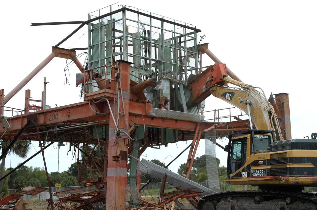
KENNEDY SPACE CENTER, FLA. -- Launch Umbilical Tower No. 1 (LUT-1) stored in the Industrial Area of KSC is being demolished with the Caterpillar excavator and 48-inch shear attachment. Seen is the base of tower; the upright tower extended more than 398 feet above the launch pad. The LUT-1 was part of the launch system used for Apollo-Saturn V, launching Apollo 8, Apollo 11, Skylab manned missions and the Apollo-Soyuz Test Project. The shear is one used in the deconstruction of the Twin Towers in New York City after 9/11.
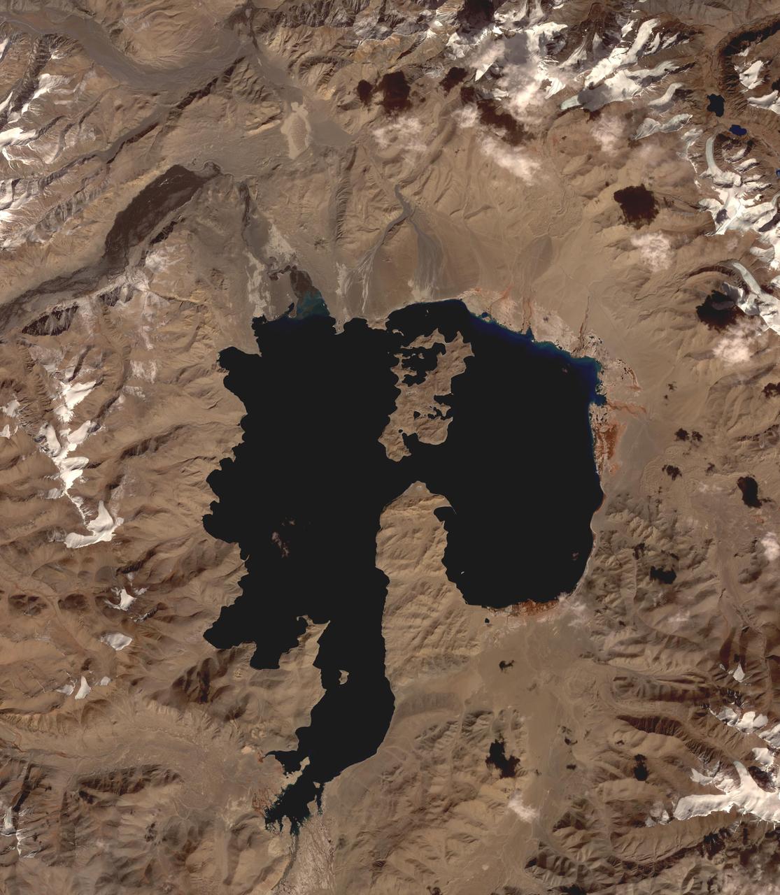
Lake Karakul in northeast Tajikistan is a hypersaline lake with no external drainage, receiving less than 3 cm precipitation per year. It is on the highest part of the fabled Pamir highway at 3900 m. In the local Kyrgyz language, the lake is called "The Black Lake". Recently, Russian scientists have suggested that the lake occupies a 200 million year old meteor impact crater. The image was acquired October 16, 2016, covers an area of 48 by 55 km, and is located at 39 degrees north, 73.4 degrees east. https://photojournal.jpl.nasa.gov/catalog/PIA23102

KENNEDY SPACE CENTER, FLA. -- Launch Umbilical Tower No. 1 (LUT-1) stored in the Industrial Area of KSC is being demolished with a Caterpillar excavator and 48-inch shear attachment. Seen is the base of tower; the upright tower extended more than 398 feet above the launch pad. The LUT-1 was part of the launch system used for Apollo-Saturn V, launching Apollo 8, Apollo 11, Skylab manned missions and the Apollo-Soyuz Test Project. The shear is one used in the deconstruction of the Twin Towers in New York City after 9/11.
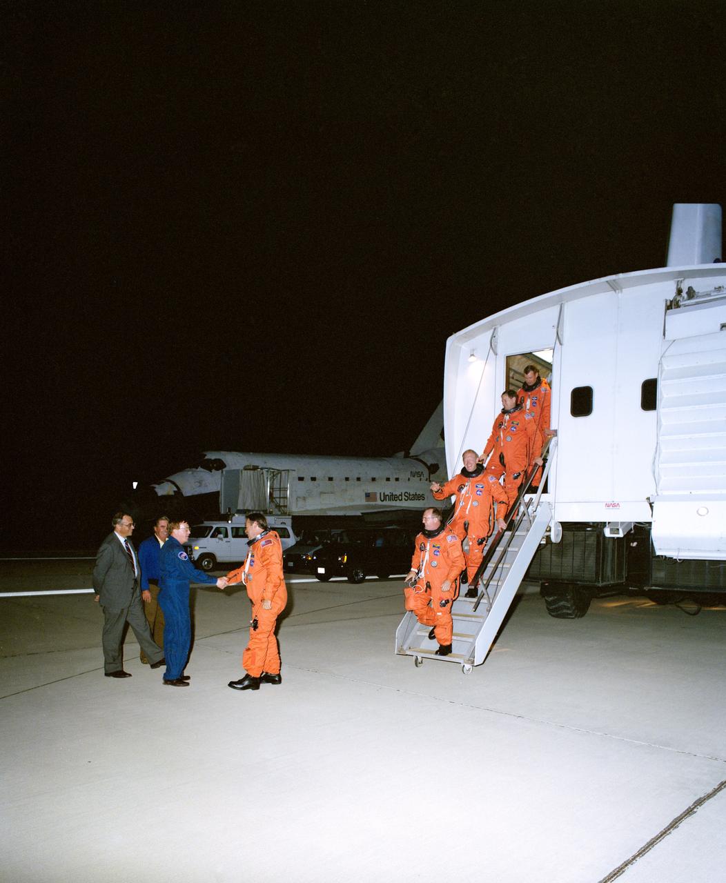
STS048-S-180 (18 Sept 1991) --- Having just completed a successful six day mission in Earth orbit, the five astronaut crewmembers for NASA's STS-48 spaceflight egress the crew transport vehicle (CTV). Astronaut John O. Creighton shakes hands with astronaut Richard N. Richards, who had earlier flown a NASA aircraft for weather checkout in the landing area. Following the mission commander are astronauts James F. Buchli, Charles D. (Sam) Gemar, Kenneth S. Reightler and Mark N. Brown. Discovery can be seen in the background. The Edwards Air Force Base landing occurred at 12:38:38 a.m. (PDT), September 18, 1991.
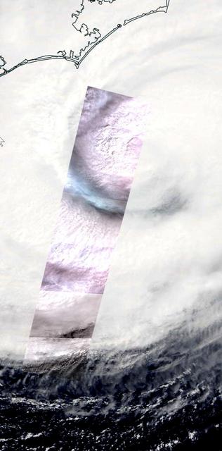
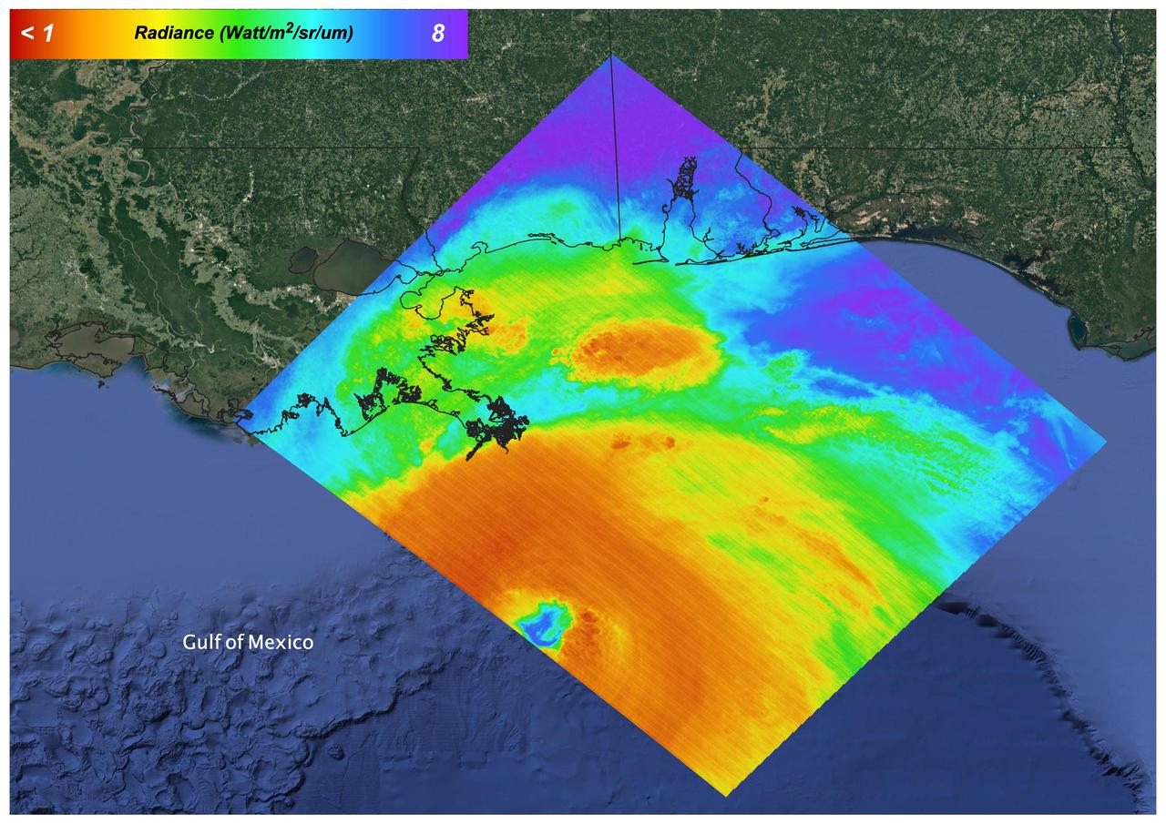
On Thursday, Sept. 13, 2018, the Advanced Spaceborne Thermal Emission and Reflection (ASTER) instrument onboard NASA's Terra spacecraft acquired this image swath over Hurricane Florence as the storm headed for the Eastern seaboard and the Carolinas. The image is a long strip of six individual ASTER scenes, taken in the visible wavelength region. The background is the simultaneously acquired MODIS visible image. The ASTER swath covers an area of 37 by 244 miles (60 by 360 kilometers) acquired at 11:48 am EDT, and is centered at 32.9 degrees north, 76.4 degrees west. https://photojournal.jpl.nasa.gov/catalog/PIA22651
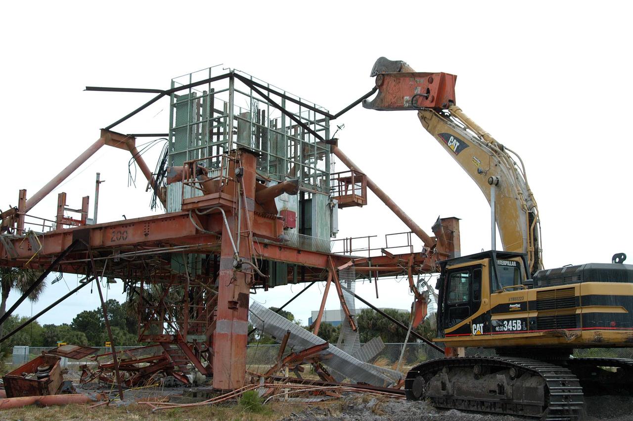
KENNEDY SPACE CENTER, FLA. -- Launch Umbilical Tower No. 1 (LUT-1) stored in the Industrial Area of KSC is being demolished with a Caterpillar excavator and 48-inch shear attachment. Seen is the base of tower; the upright tower extended more than 398 feet above the launch pad. The LUT-1 was part of the launch system used for Apollo-Saturn V, launching Apollo 8, Apollo 11, Skylab manned missions and the Apollo-Soyuz Test Project. The shear is one used in the deconstruction of the Twin Towers in New York City after 9/11.
KENNEDY SPACE CENTER, FLA. -- - Launch Umbilical Tower No. 1 (LUT-1) stored in the Industrial Area of KSC is being demolished with a Caterpillar excavator and 48-inch shear attachment. Seen is the base of tower; the upright tower extended more than 398 feet above the launch pad. The LUT-1 was part of the launch system used for Apollo-Saturn V, launching Apollo 8, Apollo 11, Skylab manned missions and the Apollo-Soyuz Test Project. The shear is one used in the deconstruction of the Twin Towers in New York City after 9/11.
This is a false-color radar image of Central Africa, showing the Virunga Volcano chain along the borders of Rwanda, Zaire and Uganda. This area is home to the endangered mountain gorillas. This C-band L-band image was acquired on April 12, 1994, on orbit 58 of space shuttle Endeavour by the Spaceborne Imaging Radar-C/X-band Synthetic Aperture Radar (SIR-C/X-SAR). The area is centered at about 1.75 degrees south latitude and 29.5 degrees east longitude. The image covers an area 58 kilometers by 178 kilometers (48 miles by 178 miles). The false-color composite is created by displaying the L-band HH return in red, the L-band HV return in green and the C-band HH return in blue. The dark area in the bottom of the image is Lake Kivu, which forms the border between Zaire (to the left) and Rwanda (to the right). The airport at Goma, Zaire is shown as a dark line just above the lake in the bottom left corner of the image. Volcanic flows from the 1977 eruption of Mt. Nyiragongo are shown just north of the airport. Mt. Nyiragongo is not visible in this image because it is located just to the left of the image swath. Very fluid lava flows from the 1977 eruption killed 70 people. http://photojournal.jpl.nasa.gov/catalog/PIA01724
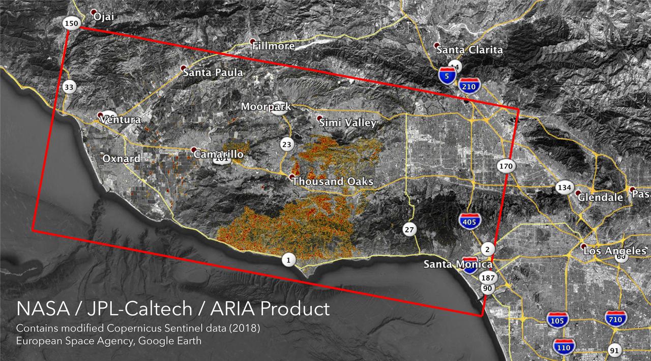
The Advanced Rapid Imaging and Analysis (ARIA) team at NASA's Jet Propulsion Laboratory in Pasadena, California, created these Damage Proxy Maps (DPMs) depicting areas in California likely damaged by the Woolsey and Camp Fires. They are derived from synthetic aperture radar (SAR) images from the Copernicus Sentinel-1 satellites, operated by the European Space Agency (ESA). The pre-event images for the Woolsey Fire in Southern California were taken before the fire on Oct. 30, 2018 and the post-event image was acquired during the fire on Nov. 11, 2018. The map covers an area of 50 miles x 25 miles (80 km x 40 km), indicated with the big red polygon. Each pixel measures about 33 yards x 33 yards (30 m x 30 m). The color variation from yellow to red indicates increasingly more significant ground surface change. The pre-event images for the Camp Fire in Northern California were taken on Nov. 4, 2018 and the post-event images were acquired during the fire on Nov. 10, 2018. The map covers an area of 55 miles x 48 miles (88 km x 77 km). As in the previous image, each pixel measures about 33 yards x 33 yards (30 m x 30 m). The color variation from yellow to red indicates increasingly more significant ground surface change. Preliminary validation for both maps was done by comparing approximate location data to Google's Crisismap. These damage proxy maps can be used as guidance to identify damaged areas with the understanding that they may be less reliable over vegetated areas including farmlands. For example, the scattered single colored pixels over vegetated areas may be false positives, and the lack of colored pixels over vegetated areas does not necessarily mean no damage. https://photojournal.jpl.nasa.gov/catalog/PIA22816

Suzhou is a major city located in southeastern Jiangsu Province of East China, about 100 km northwest of Shanghai. It is a major economic center and focal point of trade and commerce. The city is situated on the lower reaches of the Yangtze River and the shores of Lake Tai. Founded in 514 BCE, Suzhou has over 2,500 years of history, with an abundant display of relics and sites of historical interest. Since major economic reforms began in 1978, Suzhou has become one of the fastest growing major cities in the world. The population has grown from 0.9 million in 1990, 2.2 million in 2000, 4.1 million in 2010, to 5.3 million in 2017. The Landsat TM image was acquired August 4, 1984, and the Aster image was acquired August 2, 2015. The images cover an area of 48 by 53 km, and are located at 31.2 degrees north, 120.4 degrees east. https://photojournal.jpl.nasa.gov/catalog/PIA22266
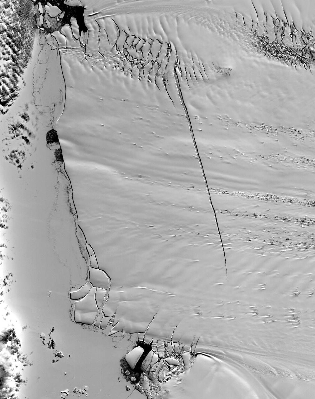
This ASTER image was acquired on December 12, 2000, and covers an area of 38 x 48 km. Pine Island Glacier has undergone a steady loss of elevation with retreat of the grounding line in recent decades. Now, space imagery has revealed a wide new crack that some scientists think will soon result in a calving event. Glaciologist Robert Bindschadler of NASA's Goddard Space Flight Center predicts this crack will result in the calving of a major iceberg, probably in less than 18 months. Discovery of the crack was possible due to multi-year image archives and high resolution imagery. This image is located at 74.1 degrees south latitude and 105.1 degrees west longitude. http://photojournal.jpl.nasa.gov/catalog/PIA11095
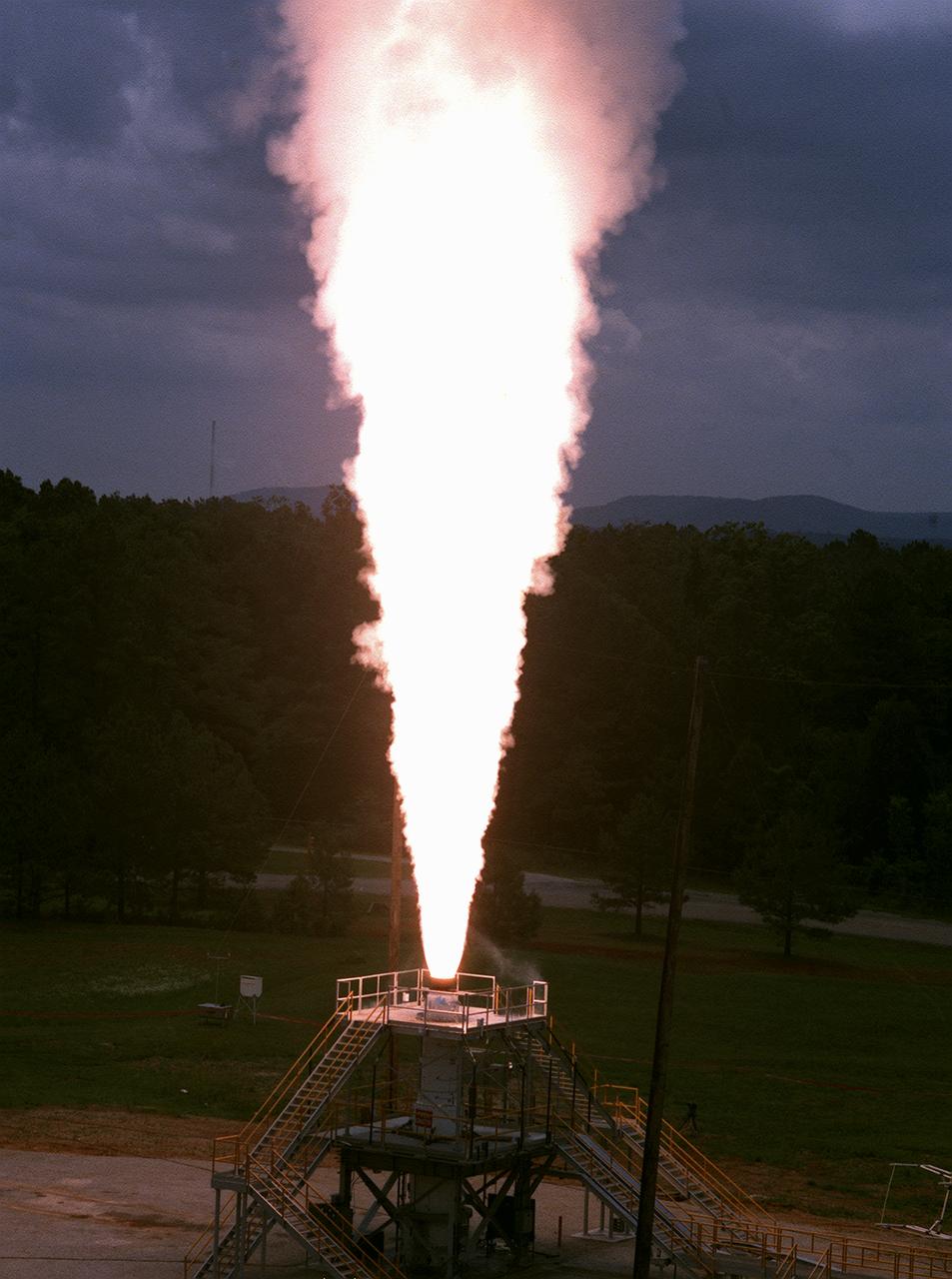
The Marshall Space Flight Center (MSFC) engineers test fired a 26-foot long, 100,000-pound-thrust solid rocket motor for 30 seconds at the MSFC east test area, the first test firing of the Modified NASA Motor (M-NASA Motor). The M-NASA Motor was fired in a newly constructed stand. The motor is 48-inches in diameter and was loaded with two propellant cartridges weighing a total of approximately 12,000 pounds. The purpose of the test was to learn more about solid rocket motor insulation and nozzle materials and to provide young engineers additional hands-on expertise in solid rocket motor technology. The test is a part of NASA's Solid Propulsion Integrity Program, that is to provide NASA engineers with the techniques, engineering tools, and computer programs to be able to better design, build, and verify solid rocket motors.

KENNEDY SPACE CENTER, FLA. -- Viewed from the top of the rotating service structure, Space Shuttle Discovery rests on the mobile launcher platform and towers over the landscape after rollout to Launch Pad 39B. In the background are portions of the Banana River and the Atlantic Ocean. The lighter spots on the top of the external tank are areas of hail damage that was recently repaired. The Shuttle had to be returned to the VAB for the repairs, making this the second rollout for the Shuttle. Discovery is scheduled for liftoff May 27 at 6:48 a.m. EDT on mission STS-96, the 94th launch in the Space Shuttle Program. A logistics and resupply mission for the International Space Station, STS-96 is carrying such payloads as a Russian crane, the Strela; a U.S.-built crane; the Spacehab Oceaneering Space System Box (SHOSS), a logistics items carrier; and STARSHINE, a student-shared experiment

These two false-color composite images of the Mammoth Mountain area in the Sierra Nevada Mountains, Calif., show significant seasonal changes in snow cover. The image at left was acquired by the Spaceborne Imaging Radar-C and X-band Synthetic Aperture Radar aboard the space shuttle Endeavour on its 67th orbit on April 13, 1994. The image is centered at 37.6 degrees north latitude and 119 degrees west longitude. The area is about 36 kilometers by 48 kilometers (22 miles by 29 miles). In this image, red is L-band (horizontally transmitted and vertically received) polarization data; green is C-band (horizontally transmitted and vertically received) polarization data; and blue is C-band (horizontally transmitted and received) polarization data. The image at right was acquired on October 3, 1994, on the space shuttle Endeavour's 67th orbit of the second radar mission. Crowley Lake appears dark at the center left of the image, just above or south of Long Valley. The Mammoth Mountain ski area is visible at the top right of the scene. The red areas correspond to forests, the dark blue areas are bare surfaces and the green areas are short vegetation, mainly brush. The changes in color tone at the higher elevations (e.g. the Mammoth Mountain ski area) from green-blue in April to purple in September reflect changes in snow cover between the two missions. The April mission occurred immediately following a moderate snow storm. During the mission the snow evolved from a dry, fine-grained snowpack with few distinct layers to a wet, coarse-grained pack with multiple ice inclusions. Since that mission, all snow in the area has melted except for small glaciers and permanent snowfields on the Silver Divide and near the headwaters of Rock Creek. On October 3, 1994, only discontinuous patches of snow cover were present at very high elevations following the first snow storm of the season on September 28, 1994. For investigations in hydrology and land-surface climatology, seasonal snow cover and alpine glaciers are critical to the radiation and water balances. SIR-C/X-SAR is a powerful tool because it is sensitive to most snowpack conditions and is less influenced by weather conditions than other remote sensing instruments, such as Landsat. In parallel with the operational SIR-C data processing, an experimental effort is being conducted to test SAR data processing using the Jet Propulsion Laboratory's massively parallel supercomputing facility, centered around the Cray Research T3D. These experiments will assess the abilities of large supercomputers to produce high throughput SAR processing in preparation for upcoming data-intensive SAR missions. The images released here were produced as part of this experimental effort. http://photojournal.jpl.nasa.gov/catalog/PIA01753
On August 27, 2021 Ida crossed over Cuba as a Category 1 Storm. 48 hours later the storm intensified to a Category 4 before making landfall on the coast of Louisiana. The storm was the second most destructive storm to ever make landfall on the Louisiana coast with sustained winds over 150 mph (240 km/h). The rapid intensification process that the storm system underwent is not well understood. Satellite images such as this are helpful as scientists attempt to understand new weather patterns that are emerging with Global Climate Change. Tasked with detecting plant water use and stress, ECOSTRESS's primary mission is to measure the temperature of plants heating up as they run out of water. But it can also measure and track heat-related phenomena like wildfires, heat waves, and volcanoes. ECOSTRESS observations have a spatial resolution of about 77 by 77 yards (70 by 70 meters), which enables researchers to study surface-temperature conditions down to the size of a football field. Due to the space station's unique orbit, the mission can acquire images of the same regions at different times of the day, as opposed to crossing over each area at the same time of day like satellites in other orbits do. This is advantageous when monitoring plant stress in the same area throughout the day, for example. https://photojournal.jpl.nasa.gov/catalog/PIA24210

Teams at NASA’s Michoud Assembly Facility in New Orleans move a liquid hydrogen tank for the agency’s SLS (Space Launch System) rocket into the factory’s final assembly area on April 22. Having recently completed application of the thermal protection system, teams will now continue outfitting the 130-foot-tall tank with critical systems to ready it for its designated Artemis III mission. The propellant tank is one of five major elements that make up the 212-foot-tall rocket stage. The core stage, along with its four RS-25 engines, produce more than two million pounds of thrust to help launch NASA’s Orion spacecraft, astronauts, and supplies beyond Earth’s orbit and to the lunar surface for Artemis.
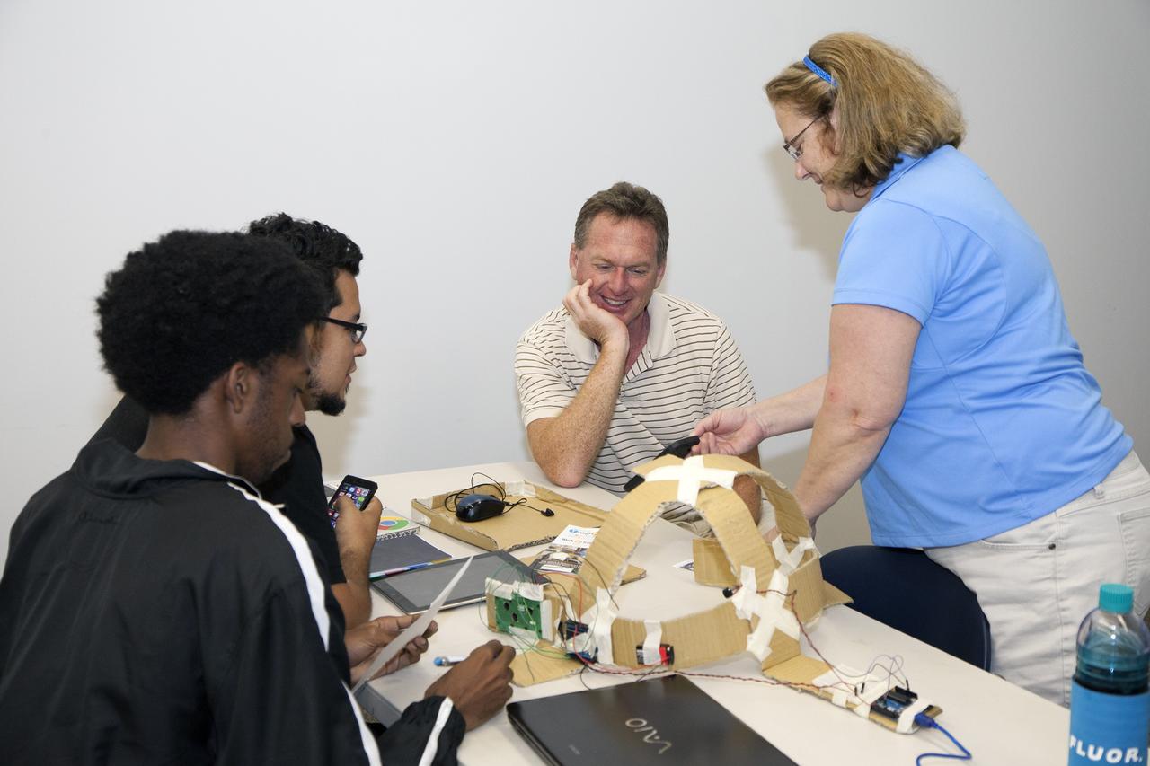
CAPE CANAVERAL, Fla. - SpaceWear team members Keith Hargett, left, and Alejandro Velasco demonstrate their entry in the International Space Apps Challenge to NASA Ground Systems Development and Operation Program Manager Michael Bolger and NASA's Lisa Singleton in the Center for Space Education at the Kennedy Space Center Visitor Complex in Florida. Kennedy Space Center hosted one of the over 90 locations around the world where participants congregated for the attempt to design innovative solutions for global challenges over a 48-hour period. This year's development marathon focused on five NASA mission areas: Asteroids, Earth Watch, Human Spaceflight, Robotics, and Technology in Space. Three of this year’s challenges were developed by KSC employees: Space Wearables: Fashion Designer to Astronauts, Growing Food for a Martian Table, and Asteroid Prospector. The winners selected in 2014 at Kennedy were Astronaut Resource Managing System, or ARMS, for Best Use of Data and SpaceWear for Best Use of Hardware. ARMS also took the People's Choice Award. For more information, visit https://2014.spaceappschallenge.org. Photo credit: NASA/Daniel Casper
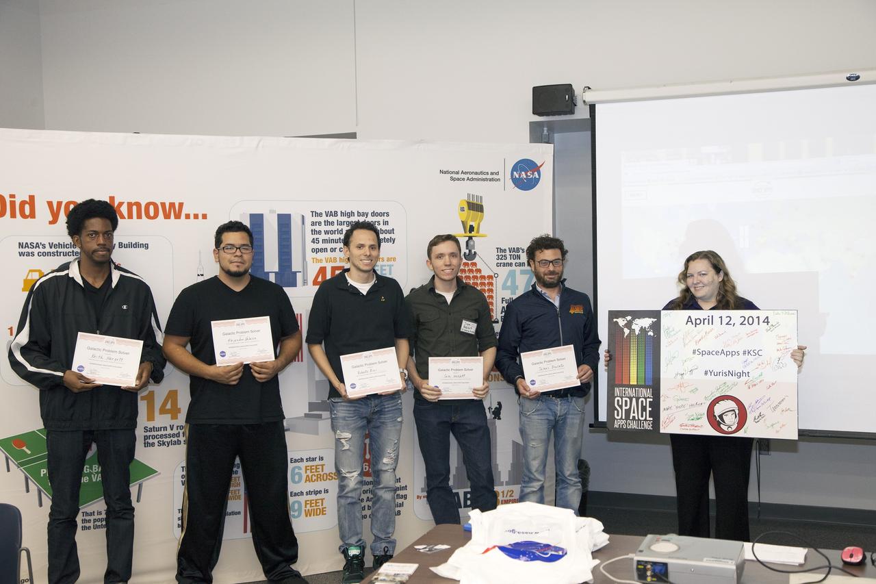
CAPE CANAVERAL, Fla. - Members of the winning teams in the International Space Apps Challenge display their Galactic Problem Solver certificates. From left are SpaceWear team members Keith Hargett and Alejandro Velasco, and Astronaut Resource Managing System team members Roberto Ricci, Sam Neblett, and James Brucato. Caley Burke, the NASA event organizer lead, is at right. Kennedy Space Center hosted one of the over 90 locations around the world where participants congregated for the attempt to design innovative solutions for global challenges over a 48-hour period. This year's development marathon focused on five NASA mission areas: Asteroids, Earth Watch, Human Spaceflight, Robotics, and Technology in Space. Three of this year’s challenges were developed by KSC employees: Space Wearables: Fashion Designer to Astronauts, Growing Food for a Martian Table, and Asteroid Prospector. The winners selected in 2014 at Kennedy were Astronaut Resource Managing System, or ARMS, for Best Use of Data and SpaceWear for Best Use of Hardware. ARMS also took the People's Choice Award. For more information, visit https://2014.spaceappschallenge.org. Photo credit: NASA/Daniel Casper
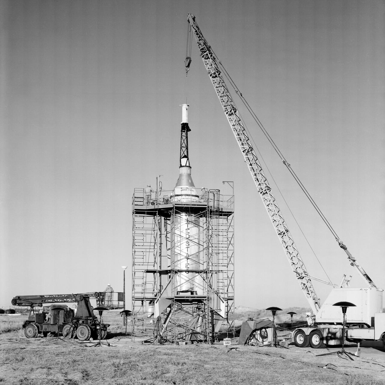
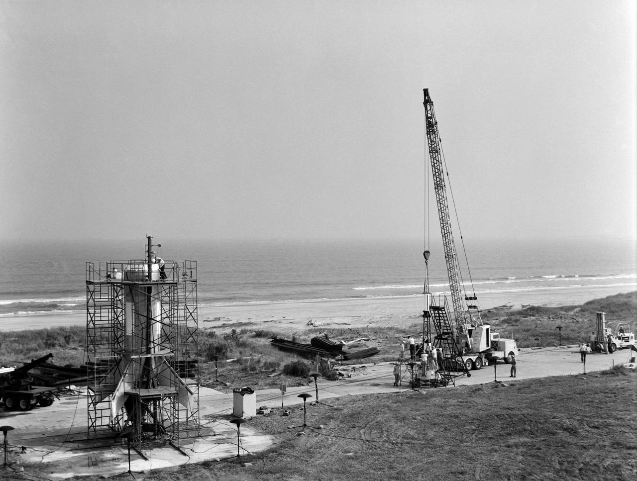
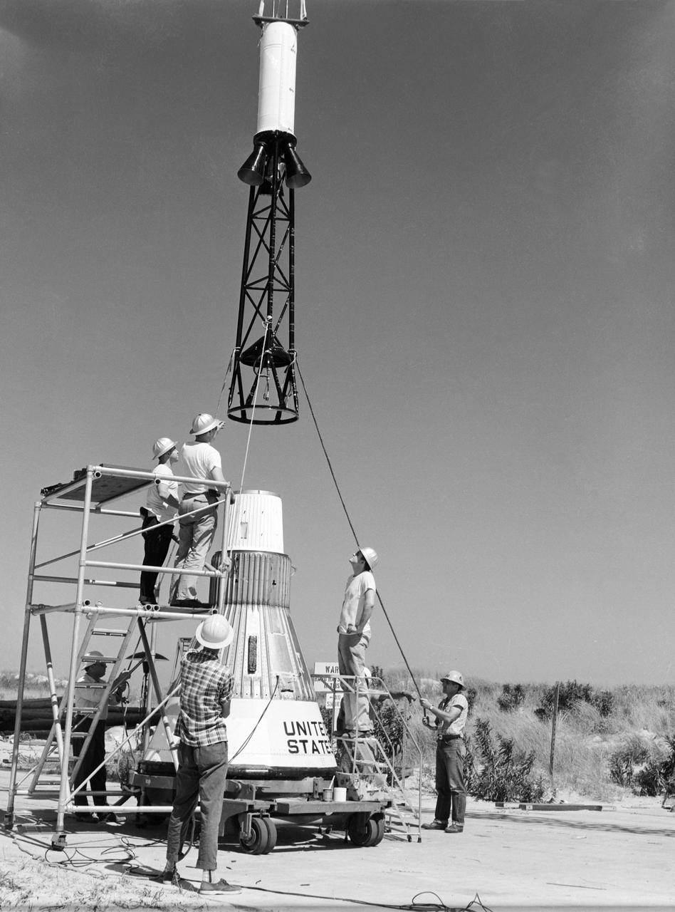
The Mercury capsule and escape tower are being lowered onto the Little Joe booster for launch on August 21, 1959. Joseph Shortal described this as follows (vol. 3, p. 33): The Little Joe booster was assembled at Wallops on its special launcher in a vertical attitude. It is shown in the on the left with the work platform in place. The launcher was located on a special concrete slab in Launching Area 1. The capsule was lowered onto the booster by crane.... After the assembly was completed, the scaffolding was disassembled and the launcher pitched over to its normal launch angle of 80 degrees.... Little Joe had a diameter of 80 inches and an overall length, including the capsule and escape tower of 48 feet. The total weight at launch was about 43,000 pounds. The overall span of the stabilizing fins was 21.3 feet. Although in comparison with the overall Mercury Project, Little Joe was a simple undertaking, the fact that an attempt was made to condense a normal two-year project into a 6-month one with in house labor turned it into a major undertaking for Langley. -- Published in Joseph A. Shortal, History of Wallops Station: Origins and Activities Through 1949, (Wallops Island, VA: National Aeronautics and Space Administration, Wallops Station, nd), Comment Edition.
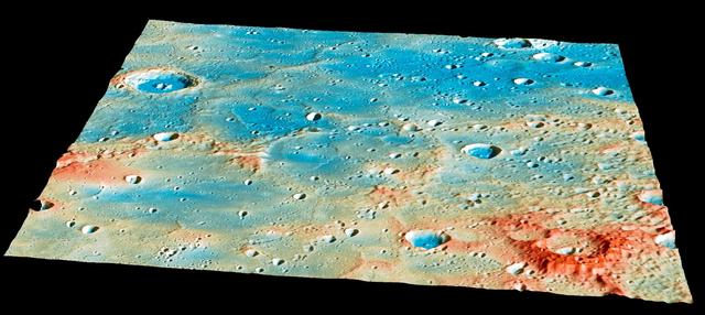
On April 30th, this region of Mercury's surface will have a new crater! Traveling at 3.91 kilometers per second (over 8,700 miles per hour), the MESSENGER spacecraft will collide with Mercury's surface, creating a crater estimated to be 16 meters (52 feet) in diameter. The large, 400-kilometer-diameter (250-mile-diameter), impact basin Shakespeare occupies the bottom left quarter of this image. Shakespeare is filled with smooth plains material, likely due to extensive lava flooding the basin in the past. As of 24 hours before the impact, the current best estimates predict that the spacecraft will strike a ridge slightly to the northeast of Shakespeare. View this image to see more details of the predicted impact site and time. Instrument: Mercury Dual Imaging System (MDIS) and Mercury Laser Altimeter (MLA) Latitude Range: 49°-59° N Longitude Range: 204°-217° E Topography: Exaggerated by a factor of 5.5. Colors: Coded by topography. The tallest regions are colored red and are roughly 3 kilometers (1.9 miles) higher than low-lying areas such as the floors of impact craters, colored blue. Scale: The large crater on the left side of the image is Janacek, with a diameter of 48 kilometers (30 miles) http://photojournal.jpl.nasa.gov/catalog/PIA19444
The Mercury capsule and escape tower are being lowered onto the Little Joe booster for launch on August 21, 1959. Joseph Shortal described this as follows (vol. 3, p. 33): The Little Joe booster was assembled at Wallops on its special launcher in a vertical attitude. It is shown in the on the left with the work platform in place. The launcher was located on a special concrete slab in Launching Area 1. The capsule was lowered onto the booster by crane.... After the assembly was completed, the scaffolding was disassembled and the launcher pitched over to its normal launch angle of 80 degrees.... Little Joe had a diameter of 80 inches and an overall length, including the capsule and escape tower of 48 feet. The total weight at launch was about 43,000 pounds. The overall span of the stabilizing fins was 21.3 feet. Although in comparison with the overall Mercury Project, Little Joe was a simple undertaking, the fact that an attempt was made to condense a normal two-year project into a 6-month one with in house labor turned it into a major undertaking for Langley. -- Published in Joseph A. Shortal, History of Wallops Station: Origins and Activities Through 1949, (Wallops Island, VA: National Aeronautics and Space Administration, Wallops Station, nd), Comment Edition.
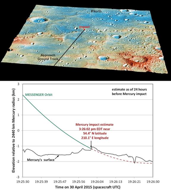
These graphics show the current best prediction of the location and time of NASA MESSENGER impact on Mercury surface. These current best estimates are: Date: 30 April 2015 Time: 3:26:02 pm EDT 19:26:02 UTC Latitude: 54.4° N Longitude: 210.1° E. Traveling at 3.91 kilometers per second (over 8,700 miles per hour), the MESSENGER spacecraft will collide with Mercury's surface, creating a crater estimated to be 16 meters (52 feet) in diameter. View this image to learn about the named features and geology of this region on Mercury. Instruments: Mercury Dual Imaging System (MDIS) and Mercury Laser Altimeter (MLA) Top Image Latitude Range: 49°-59° N Top Image Longitude Range: 204°-217° E Topography in Top Image: Exaggerated by a factor of 5.5. Colors in Top Image: Coded by topography. The tallest regions are colored red and are roughly 3 kilometers (1.9 miles) higher than low-lying areas such as the floors of impact craters, colored blue. Scale in Top Image: The large crater on the left side of the image is Janacek, with a diameter of 48 kilometers (30 miles) http://photojournal.jpl.nasa.gov/catalog/PIA19443
Testing of the Little Joe booster on its launcher. The launcher is positioned at its normal launch angle of 80 degrees. Joseph Shortal wrote (vol. 3, p. 33): The Little Joe booster was assembled at Wallops on its special launcher in a vertical attitude. It is shown in the on the left with the work platform in place. The launcher was located on a special concrete slab in Launching Area 1. The capsule was lowered onto the booster by crane.... After the assembly was completed, the scaffolding was disassembled and the launcher pitched over to its normal launch angle of 80 degrees.... Little Joe had a diameter of 80 inches and an overall length, including the capsule and escape tower of 48 feet. The total weight at launch was about 43,000 pounds. The overall span of the stabilizing fins was 21.3 feet. Although in comparison with the overall Mercury Project, Little Joe was a simple undertaking, the fact that an attempt was made to condense a normal two-year project into a 6-month one with in house labor turned it into a major undertaking for Langley. -- Published in Joseph A. Shortal, History of Wallops Station: Origins and Activities Through 1949, (Wallops Island, VA: National Aeronautics and Space Administration, Wallops Station, nd), Comment Edition.

CAPE CANAVERAL, Fla. - SpaceWear team members Keith Hargett, left, and Alejandro Velasco participate in the International Space Apps Challenge in the Center for Space Education at the Kennedy Space Center Visitor Complex in Florida. Kennedy Space Center hosted one of the over 90 locations around the world where participants congregated for the attempt to design innovative solutions for global challenges over a 48-hour period. This year's development marathon focused on five NASA mission areas: Asteroids, Earth Watch, Human Spaceflight, Robotics, and Technology in Space. Three of this year’s challenges were developed by KSC employees: Space Wearables: Fashion Designer to Astronauts, Growing Food for a Martian Table, and Asteroid Prospector. The winners selected in 2014 at Kennedy were Astronaut Resource Managing System, or ARMS, for Best Use of Data and SpaceWear for Best Use of Hardware. ARMS also took the People's Choice Award. For more information, visit https://2014.spaceappschallenge.org. Photo credit: NASA/Daniel Casper
CAPE CANAVERAL, Fla. - Astronaut Resource Managing System team members Sam Neblett of KSC Technik Inc., left, and Roberto Ricci participate in the International Space Apps Challenge in the Center for Space Education at the Kennedy Space Center Visitor Complex in Florida. Kennedy Space Center hosted one of the over 90 locations around the world where participants congregated for the attempt to design innovative solutions for global challenges over a 48-hour period. This year's development marathon focused on five NASA mission areas: Asteroids, Earth Watch, Human Spaceflight, Robotics, and Technology in Space. Three of this year’s challenges were developed by KSC employees: Space Wearables: Fashion Designer to Astronauts, Growing Food for a Martian Table, and Asteroid Prospector. The winners selected in 2014 at Kennedy were Astronaut Resource Managing System, or ARMS, for Best Use of Data and SpaceWear for Best Use of Hardware. ARMS also took the People's Choice Award. For more information, visit https://2014.spaceappschallenge.org. Photo credit: NASA/Daniel Casper
CAPE CANAVERAL, Fla. - SpaceWear team members Keith Hargett, left, and Alejandro Velasco explain their entry in the International Space Apps Challenge to an audience in the Center for Space Education at the Kennedy Space Center Visitor Complex in Florida. In the audience at left is NASA Ground Systems Development and Operations Program Manager Michael Bolger. Caley Burke, the NASA event organizer lead, is at right. Kennedy Space Center hosted one of the over 90 locations around the world where participants congregated for the attempt to design innovative solutions for global challenges over a 48-hour period. This year's development marathon focused on five NASA mission areas: Asteroids, Earth Watch, Human Spaceflight, Robotics, and Technology in Space. Three of this year’s challenges were developed by KSC employees: Space Wearables: Fashion Designer to Astronauts, Growing Food for a Martian Table, and Asteroid Prospector. The winners selected in 2014 at Kennedy were Astronaut Resource Managing System, or ARMS, for Best Use of Data and SpaceWear for Best Use of Hardware. ARMS also took the People's Choice Award. For more information, visit https://2014.spaceappschallenge.org. Photo credit: NASA/Daniel Casper
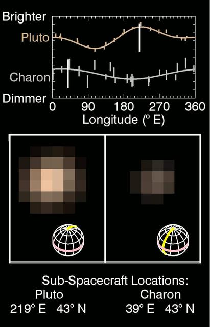
This series of images taken by NASA's New Horizons' Multispectral Visible Imaging Camera (MVIC) shows how Pluto and Charon change in brightness as they rotate over 6.4 Earth days.The central panel shows the true color of Pluto (left) and Charon (right) during nine epochs between May 29 May and June 3 2015, as the spacecraft approached the Pluto system from a range of 55 to 48 million km.The grids beneath the images show the orientations of Pluto and Charon, with 0° E longitude and the equator highlighted by the yellow and pink lines respectively.Sub-spacecraft locations on Pluto and Charon are listed at the bottom.The spatial resolution, at around 1000 km/pixel, is not yet sufficient in these images to reveal distinct surface features on either body. The top panel shows in graphical form how the brightness in MVIC's red channel (540-700 nm) varies with the sub-spacecraft longitude, including data from more distant images dating back to May 1.The moving white vertical lines indicate the observed central longitudes on Pluto and Charon as the images below rotate.These results are consistent with earlier Hubble Space Telescope observations of the lightcurves of Pluto and Charon.Pluto appears dimmest when the dark region on its trailing hemisphere (around 90° E) is oriented toward the observer and brighter when the dark area has rotated off the visible hemisphere and a bright region on the anti-Charon hemisphere is seen.A different, lower amplitude lightcurve variation is seen on Charon, where the Pluto-facing hemisphere (around 0° E) appears brighter than the anti-Pluto hemisphere. http://photojournal.jpl.nasa.gov/catalog/PIA19692
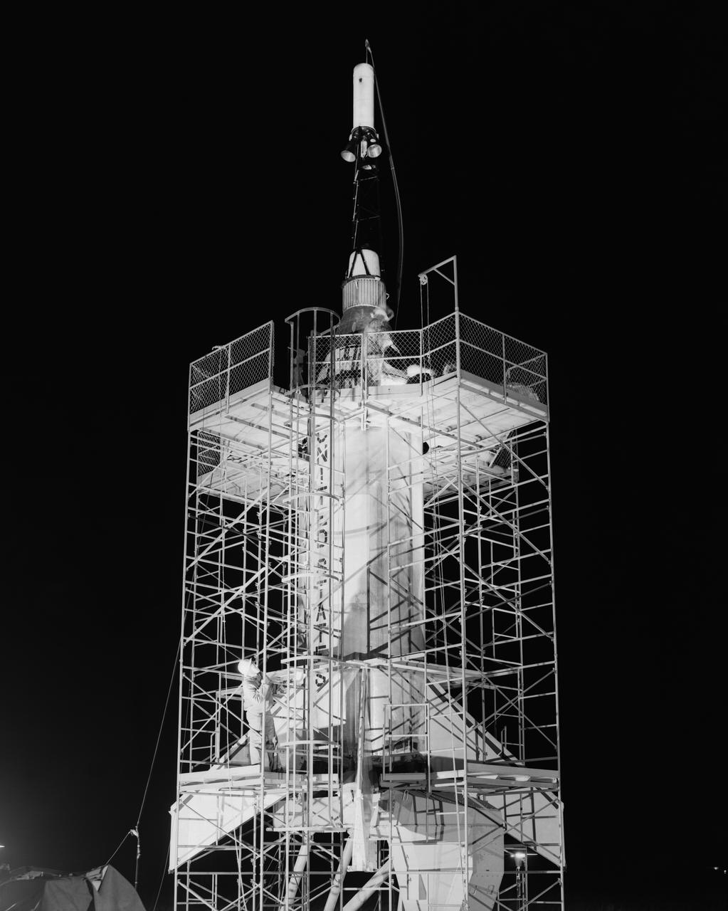
Technicians attach the escape tower to the Mercury capsule prior to assembly with Little Joe launcher, August 20, 1959. Joseph Shortal describe this as follows (vol. 3., p. 33): The escape tower and rocket motors were taken from the Mercury capsule production. The tower is shown being attached to the capsule.... The escape rocket was a Grand Central 1-KS-52000 motor with three canted nozzles. The tower-jettison motor was an Atlantic Research Corp. 1.4-KS-785 motor. This was the same design tested in a beach abort test...and had the offset thrust line as used in the beach abort test to insure that the capsule would get away from the booster in an emergency. The escape system weighed 1,015 pounds, including 236 pounds of ballast for stability. The Little Joe booster was assembled at Wallops on its special launcher in a vertical attitude. It is shown in the on the left with the work platform in place. The launcher was located on a special concrete slab in Launching Area 1. The capsule was lowered onto the booster by crane.... After the assembly was completed, the scaffolding was disassembled and the launcher pitched over to its normal launch angle of 80 degrees.... Little Joe had a diameter of 80 inches and an overall length, including the capsule and escape tower of 48 feet. The total weight at launch was about 43,000 pounds. The overall span of the stabilizing fins was 21.3 feet. Although in comparison with the overall Mercury Project, Little Joe was a simple undertaking, the fact that an attempt was made to condense a normal two-year project into a 6-month one with in house labor turned it into a major undertaking for Langley. -- Published in Joseph A. Shortal, History of Wallops Station: Origins and Activities Through 1949, (Wallops Island, VA: National Aeronautics and Space Administration, Wallops Station, nd), Comment Edition.
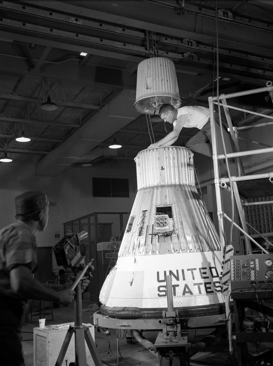
Technicians adjust the rocket motor during the attachment of the escape tower to the Mercury capsule prior to assembly with Little Joe launcher, August 20, 1959. Joseph Shortal wrote (vol. 3., p. 33): The escape tower and rocket motors were taken from the Mercury capsule production. The tower is shown being attached to the capsule.... The escape rocket was a Grand Central 1-KS-52000 motor with three canted nozzles. The tower-jettison motor was an Atlantic Research Corp. 1.4-KS-785 motor. This was the same design tested in a beach abort test...and had the offset thrust line as used in the beach abort test to insure that the capsule would get away from the booster in an emergency. The escape system weighed 1,015 pounds, including 236 pounds of ballast for stability. The Little Joe booster was assembled at Wallops on its special launcher in a vertical attitude. It is shown in the on the left with the work platform in place. The launcher was located on a special concrete slab in Launching Area 1. The capsule was lowered onto the booster by crane.... After the assembly was completed, the scaffolding was disassembled and the launcher pitched over to its normal launch angle of 80 degrees.... Little Joe had a diameter of 80 inches and an overall length, including the capsule and escape tower of 48 feet. The total weight at launch was about 43,000 pounds. The overall span of the stabilizing fins was 21.3 feet. Although in comparison with the overall Mercury Project, Little Joe was a simple undertaking, the fact that an attempt was made to condense a normal two-year project into a 6-month one with in house labor turned it into a major undertaking for Langley. -- Published in Joseph A. Shortal, History of Wallops Station: Origins and Activities Through 1949, (Wallops Island, VA: National Aeronautics and Space Administration, Wallops Station, nd), Comment Edition.
Technicians adjust the rocket motor during the attachment of the escape tower to the Mercury capsule prior to assembly with Little Joe launcher, August 20, 1959. Joseph Shortal wrote (vol. 3., p. 33): The escape tower and rocket motors were taken from the Mercury capsule production. The tower is shown being attached to the capsule.... The escape rocket was a Grand Central 1-KS-52000 motor with three canted nozzles. The tower-jettison motor was an Atlantic Research Corp. 1.4-KS-785 motor. This was the same design tested in a beach abort test...and had the offset thrust line as used in the beach abort test to insure that the capsule would get away from the booster in an emergency. The escape system weighed 1,015 pounds, including 236 pounds of ballast for stability. The Little Joe booster was assembled at Wallops on its special launcher in a vertical attitude. It is shown in the on the left with the work platform in place. The launcher was located on a special concrete slab in Launching Area 1. The capsule was lowered onto the booster by crane.... After the assembly was completed, the scaffolding was disassembled and the launcher pitched over to its normal launch angle of 80 degrees.... Little Joe had a diameter of 80 inches and an overall length, including the capsule and escape tower of 48 feet. The total weight at launch was about 43,000 pounds. The overall span of the stabilizing fins was 21.3 feet. Although in comparison with the overall Mercury Project, Little Joe was a simple undertaking, the fact that an attempt was made to condense a normal two-year project into a 6-month one with in house labor turned it into a major undertaking for Langley. -- Published in Joseph A. Shortal, History of Wallops Station: Origins and Activities Through 1949, (Wallops Island, VA: National Aeronautics and Space Administration, Wallops Station, nd), Comment Edition.
CAPE CANAVERAL, Fla. - Members of the winning Astronaut Resource Managing System and SpaceWear teams in the International Space Apps Challenge pose for a group portrait with the NASA volunteers, judges and event organizers. From left are Alejandro Velasco, NASA's Justin Treptow, Sam Neblett, Roberto Ricci, James Brucato, NASA's Suzanne Plantec, Keith Hargett, NASA's Cynthia Duffaut, NASA's Launa Maier, event organizer James Wood, event organizer lead Caley Burke, NASA's Lisa Singleton, event organizer David Miranda, NASA Ground Systems Development and Operation Program Manager Michael Bolger and NASA intern Brandi Burse. Kennedy Space Center hosted one of the over 90 locations around the world where participants congregated for the attempt to design innovative solutions for global challenges over a 48-hour period. This year's development marathon focused on five NASA mission areas: Asteroids, Earth Watch, Human Spaceflight, Robotics, and Technology in Space. Three of this year’s challenges were developed by KSC employees: Space Wearables: Fashion Designer to Astronauts, Growing Food for a Martian Table, and Asteroid Prospector. The winners selected in 2014 at Kennedy were Astronaut Resource Managing System, or ARMS, for Best Use of Data and SpaceWear for Best Use of Hardware. ARMS also took the People's Choice Award. For more information, visit https://2014.spaceappschallenge.org. Photo credit: NASA/Daniel Casper
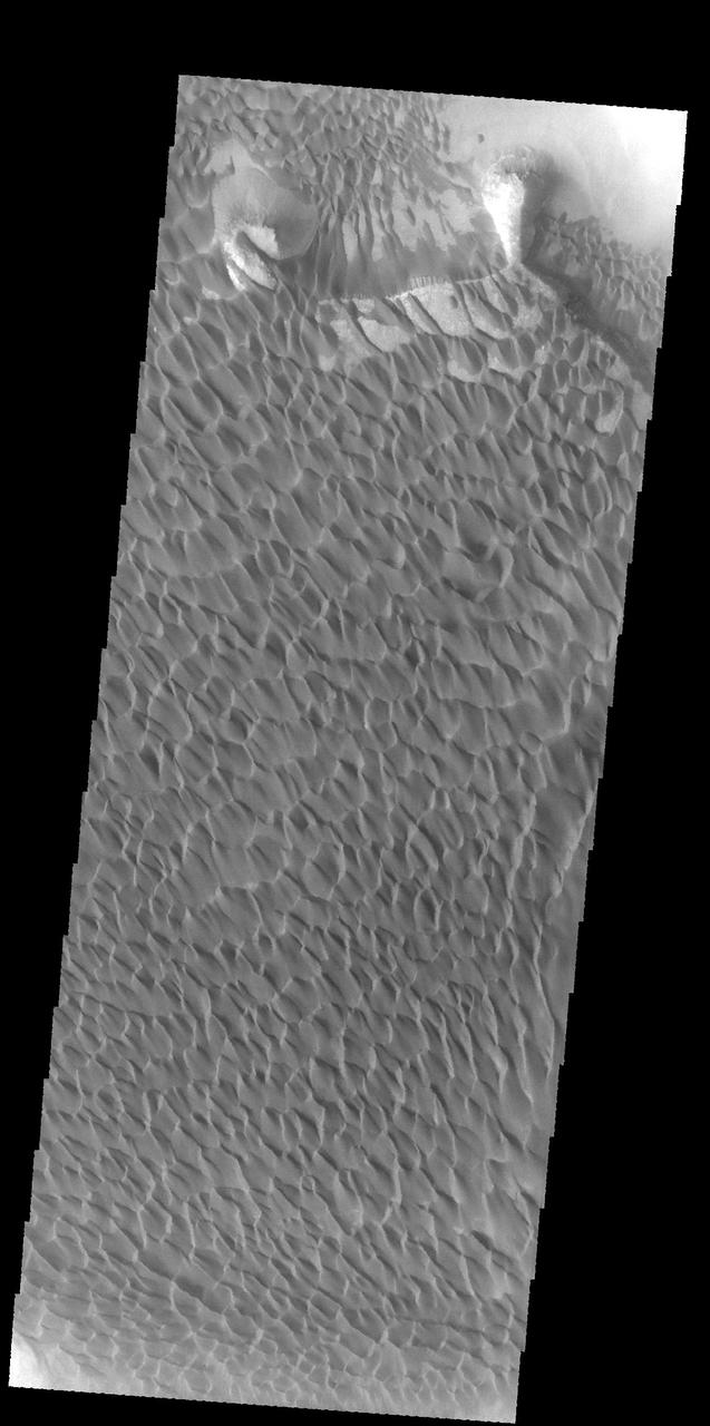
The majority of the dune field in Rabe Crater consists of a sand sheet with dune forms on the surface. The sand sheet is where a thick layer of sand has been concentrated. As continued winds blow across the sand surface it creates dune forms. The depth of the sand sheet prevents excavation to the crater floor and the dune forms all appear connected. Rabe Crater is 108 km (67 miles) across. Craters of similar size often have flat floors. Rabe Crater has some areas of flat floor, but also has a large complex pit occupying a substantial part of the floor. The interior fill of the crater is thought to be layered sediments created by wind and or water action. The pit is eroded into this material. The eroded materials appear to have stayed within the crater forming a large sand sheet with surface dune forms as well as individual dunes where the crater floor is visible. The dunes also appear to be moving from the upper floor level into the pit. The Odyssey spacecraft has spent over 15 years in orbit around Mars, circling the planet more than 69000 times. It holds the record for longest working spacecraft at Mars. THEMIS, the IR/VIS camera system, has collected data for the entire mission and provides images covering all seasons and lighting conditions. Over the years many features of interest have received repeated imaging, building up a suite of images covering the entire feature. From the deepest chasma to the tallest volcano, individual dunes inside craters and dune fields that encircle the north pole, channels carved by water and lava, and a variety of other feature, THEMIS has imaged them all. For the next several months the image of the day will focus on the Tharsis volcanoes, the various chasmata of Valles Marineris, and the major dunes fields. We hope you enjoy these images! Orbit Number: 58024 Latitude: -43.6954 Longitude: 34.8236 Instrument: VIS Captured: 2015-01-12 09:48 https://photojournal.jpl.nasa.gov/catalog/PIA22144
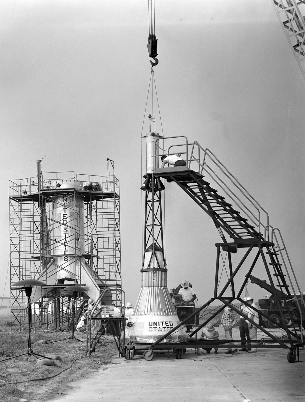
Technicians adjust the rocket motor during the attachment of the escape tower to the Mercury capsule prior to assembly with Little Joe launcher, August 20, 1959. Joseph Shortal wrote (vol. 3., p. 33): The escape tower and rocket motors were taken from the Mercury capsule production. The tower is shown being attached to the capsule.... The escape rocket was a Grand Central 1-KS-52000 motor with three canted nozzles. The tower-jettison motor was an Atlantic Research Corp. 1.4-KS-785 motor. This was the same design tested in a beach abort test...and had the offset thrust line as used in the beach abort test to insure that the capsule would get away from the booster in an emergency. The escape system weighed 1,015 pounds, including 236 pounds of ballast for stability. The Little Joe booster was assembled at Wallops on its special launcher in a vertical attitude. It is shown in the on the left with the work platform in place. The launcher was located on a special concrete slab in Launching Area 1. The capsule was lowered onto the booster by crane.... After the assembly was completed, the scaffolding was disassembled and the launcher pitched over to its normal launch angle of 80 degrees.... Little Joe had a diameter of 80 inches and an overall length, including the capsule and escape tower of 48 feet. The total weight at launch was about 43,000 pounds. The overall span of the stabilizing fins was 21.3 feet. Although in comparison with the overall Mercury Project, Little Joe was a simple undertaking, the fact that an attempt was made to condense a normal two-year project into a 6-month one with in house labor turned it into a major undertaking for Langley. -- Published in Joseph A. Shortal, History of Wallops Station: Origins and Activities Through 1949, (Wallops Island, VA: National Aeronautics and Space Administration, Wallops Station, nd), Comment Edition.
This image is the first view of Mars taken by the Mars Global Surveyor Orbiter Camera (MOC). It was acquired the afternoon of July 2, 1997 when the MGS spacecraft was 17.2 million kilometers (10.7 million miles) and 72 days from encounter. At this distance, the MOC's resolution is about 64 km per picture element, and the 6800 km (4200 mile) diameter planet is 105 pixels across. The observation was designed to show the Mars Pathfinder landing site at 19.4 N, 33.1 W approximately 48 hours prior to landing. The image shows the north polar cap of Mars at the top of the image, the dark feature Acidalia Planitia in the center with the brighter Chryse plain immediately beneath it, and the highland areas along the Martian equator including the canyons of the Valles Marineris (which are bright in this image owing to atmospheric dust). The dark features Terra Meridiani and Terra Sabaea can be seen at the 4 o`clock position, and the south polar hood (atmospheric fog and hazes) can be seen at the bottom of the image. Launched on November 7, 1996, Mars Global Surveyor will enter Mars orbit on Thursday, September 11 shortly after 6:00 PM PDT. After Mars Orbit Insertion, the spacecraft will use atmospheric drag to reduce the size of its orbit, achieving a circular orbit only 400 km (248 mi) above the surface in early March 1998, when mapping operations will begin. http://photojournal.jpl.nasa.gov/catalog/PIA00606
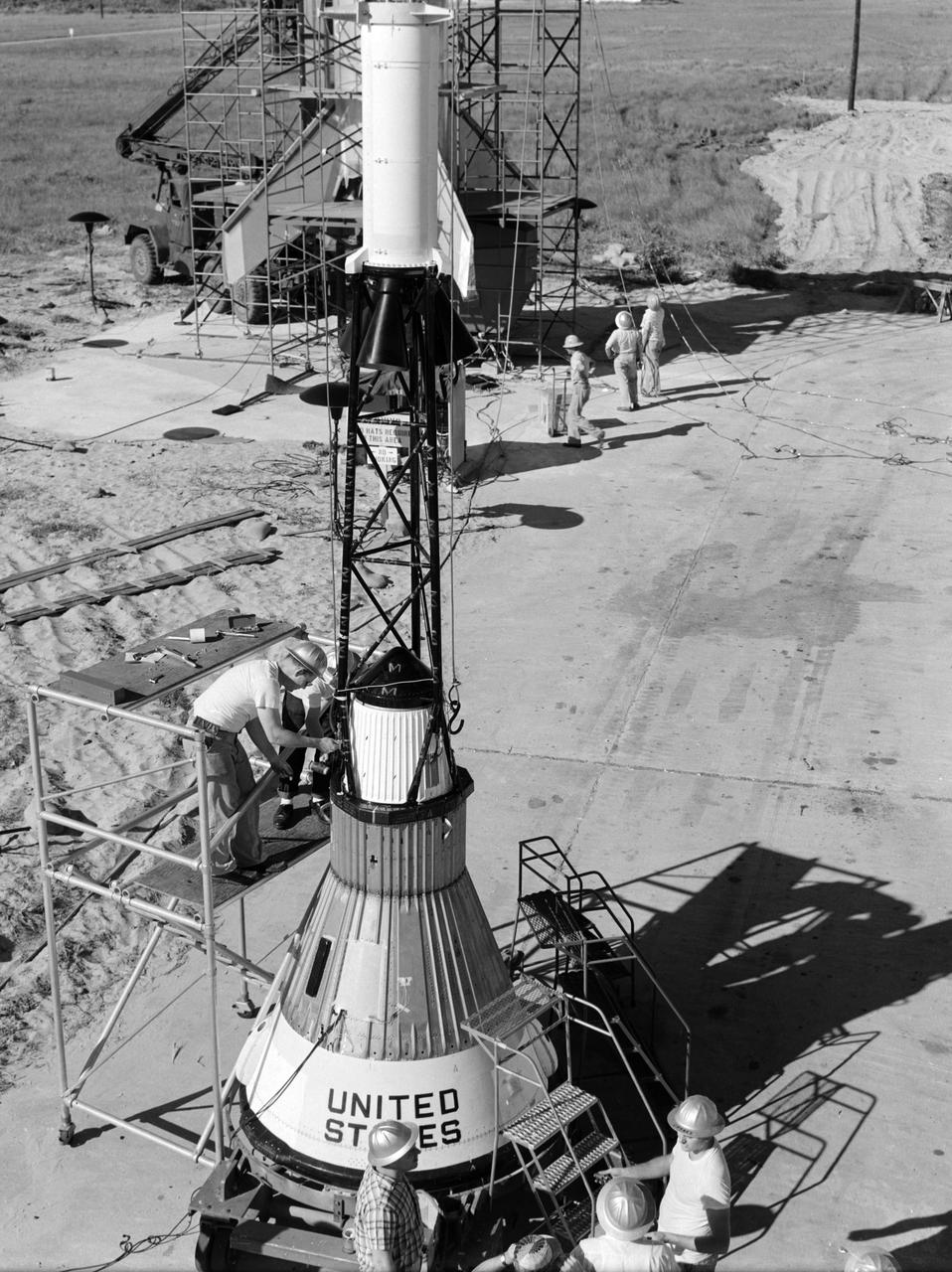
Technicians attach the escape tower to the Mercury capsule prior to assembly with Little Joe launcher, August 20, 1959. Joseph Shortal describe this as follows (vol. 3., p. 33): The escape tower and rocket motors were taken from the Mercury capsule production. The tower is shown being attached to the capsule.... The escape rocket was a Grand Central 1-KS-52000 motor with three canted nozzles. The tower-jettison motor was an Atlantic Research Corp. 1.4-KS-785 motor. This was the same design tested in a beach abort test...and had the offset thrust line as used in the beach abort test to insure that the capsule would get away from the booster in an emergency. The escape system weighed 1,015 pounds, including 236 pounds of ballast for stability. The Little Joe booster was assembled at Wallops on its special launcher in a vertical attitude. It is shown in the on the left with the work platform in place. The launcher was located on a special concrete slab in Launching Area 1. The capsule was lowered onto the booster by crane.... After the assembly was completed, the scaffolding was disassembled and the launcher pitched over to its normal launch angle of 80 degrees.... Little Joe had a diameter of 80 inches and an overall length, including the capsule and escape tower of 48 feet. The total weight at launch was about 43,000 pounds. The overall span of the stabilizing fins was 21.3 feet. Although in comparison with the overall Mercury Project, Little Joe was a simple undertaking, the fact that an attempt was made to condense a normal two-year project into a 6-month one with in house labor turned it into a major undertaking for Langley. -- Published in Joseph A. Shortal, History of Wallops Station: Origins and Activities Through 1949, (Wallops Island, VA: National Aeronautics and Space Administration, Wallops Station, nd), Comment Edition.

Technicians adjust the rocket motor during the attachment of the escape tower to the Mercury capsule prior to assembly with Little Joe launcher, August 20, 1959. Joseph Shortal wrote (vol. 3., p. 33): The escape tower and rocket motors were taken from the Mercury capsule production. The tower is shown being attached to the capsule.... The escape rocket was a Grand Central 1-KS-52000 motor with three canted nozzles. The tower-jettison motor was an Atlantic Research Corp. 1.4-KS-785 motor. This was the same design tested in a beach abort test...and had the offset thrust line as used in the beach abort test to insure that the capsule would get away from the booster in an emergency. The escape system weighed 1,015 pounds, including 236 pounds of ballast for stability. The Little Joe booster was assembled at Wallops on its special launcher in a vertical attitude. It is shown in the on the left with the work platform in place. The launcher was located on a special concrete slab in Launching Area 1. The capsule was lowered onto the booster by crane.... After the assembly was completed, the scaffolding was disassembled and the launcher pitched over to its normal launch angle of 80 degrees.... Little Joe had a diameter of 80 inches and an overall length, including the capsule and escape tower of 48 feet. The total weight at launch was about 43,000 pounds. The overall span of the stabilizing fins was 21.3 feet. Although in comparison with the overall Mercury Project, Little Joe was a simple undertaking, the fact that an attempt was made to condense a normal two-year project into a 6-month one with in house labor turned it into a major undertaking for Langley. -- Published in Joseph A. Shortal, History of Wallops Station: Origins and Activities Through 1949, (Wallops Island, VA: National Aeronautics and Space Administration, Wallops Station, nd), Comment Edition.
Technicians adjust the rocket motor during the attachment of the escape tower to the Mercury capsule prior to assembly with Little Joe launcher, August 20, 1959. Joseph Shortal wrote (vol. 3., p. 33): The escape tower and rocket motors were taken from the Mercury capsule production. The tower is shown being attached to the capsule.... The escape rocket was a Grand Central 1-KS-52000 motor with three canted nozzles. The tower-jettison motor was an Atlantic Research Corp. 1.4-KS-785 motor. This was the same design tested in a beach abort test...and had the offset thrust line as used in the beach abort test to insure that the capsule would get away from the booster in an emergency. The escape system weighed 1,015 pounds, including 236 pounds of ballast for stability. The Little Joe booster was assembled at Wallops on its special launcher in a vertical attitude. It is shown in the on the left with the work platform in place. The launcher was located on a special concrete slab in Launching Area 1. The capsule was lowered onto the booster by crane.... After the assembly was completed, the scaffolding was disassembled and the launcher pitched over to its normal launch angle of 80 degrees.... Little Joe had a diameter of 80 inches and an overall length, including the capsule and escape tower of 48 feet. The total weight at launch was about 43,000 pounds. The overall span of the stabilizing fins was 21.3 feet. Although in comparison with the overall Mercury Project, Little Joe was a simple undertaking, the fact that an attempt was made to condense a normal two-year project into a 6-month one with in house labor turned it into a major undertaking for Langley. -- Published in Joseph A. Shortal, History of Wallops Station: Origins and Activities Through 1949, (Wallops Island, VA: National Aeronautics and Space Administration, Wallops Station, nd), Comment Edition.
Technicians attach the escape tower to the Mercury capsule prior to assembly with Little Joe launcher, August 20, 1959. Joseph Shortal describe this as follows (vol. 3., p. 33): The escape tower and rocket motors were taken from the Mercury capsule production. The tower is shown being attached to the capsule.... The escape rocket was a Grand Central 1-KS-52000 motor with three canted nozzles. The tower-jettison motor was an Atlantic Research Corp. 1.4-KS-785 motor. This was the same design tested in a beach abort test...and had the offset thrust line as used in the beach abort test to insure that the capsule would get away from the booster in an emergency. The escape system weighed 1,015 pounds, including 236 pounds of ballast for stability. The Little Joe booster was assembled at Wallops on its special launcher in a vertical attitude. It is shown in the on the left with the work platform in place. The launcher was located on a special concrete slab in Launching Area 1. The capsule was lowered onto the booster by crane.... After the assembly was completed, the scaffolding was disassembled and the launcher pitched over to its normal launch angle of 80 degrees.... Little Joe had a diameter of 80 inches and an overall length, including the capsule and escape tower of 48 feet. The total weight at launch was about 43,000 pounds. The overall span of the stabilizing fins was 21.3 feet. Although in comparison with the overall Mercury Project, Little Joe was a simple undertaking, the fact that an attempt was made to condense a normal two-year project into a 6-month one with in house labor turned it into a major undertaking for Langley. -- Published in Joseph A. Shortal, History of Wallops Station: Origins and Activities Through 1949, (Wallops Island, VA: National Aeronautics and Space Administration, Wallops Station, nd), Comment Edition.
On Aug. 21, 2017, a total solar eclipse swept across the United States -- the first such eclipse in the contiguous 48 states since 1979, and the first cross-country eclipse since 1918. A partial eclipse was visible in all 50 states, and initial estimates suggest that upwards of 20 million people observed the Moon completely obscuring the Sun in the 70-mile-wide (113-kilometer-wide) path of totality. While viewing a total solar eclipse from the ground is an amazing experience, satellites orbiting Earth see the eclipse from a unique perspective. As the Moon's shadow passed through the United States, the Multi-angle Imaging SpectroRadiometer (MISR) instrument aboard NASA's Terra satellite was capturing images of eastern Wyoming and western Nebraska from its altitude of 438 miles (705 kilometers) above the surface. MISR gathers images on a strip about 249 miles (400 kilometers) wide directly below the path of the satellite. Incredibly, given that the shadow of the Moon took only 90 minutes to cross the entire United States, and Terra itself moves at a brisk 16,700 miles per hour from north to south, MISR happened to be in exactly the right place at the right time to capture totality. From the ground, the moment of totality appears suddenly, sweeping over the sky in just a few seconds. "I was unprepared for just how dark it actually was," says Mika Tosca, a researcher who works with MISR data and who observed the eclipse in Nebraska. "The streetlights even turned on. Everything fell silent, and I swear the temperature dropped." From the vantage point of space, however, it’s possible to see the entire shadow of the Moon, with the completely dark, circular umbra and the more diffuse penumbra. MISR contains nine cameras oriented at different angles, viewing forward, downward, and backward along the flight path, resulting in an approximate seven-minute interval for all nine cameras to image a single location on Earth's surface. This animation combines these nine images into a movie showing the motion of the Moon's shadow during this seven-minute period. In the first image, captured by the camera pointing farthest ahead of the satellite, totality has not quite begun in the area seen by MISR. From the second camera onward, totality sweeps across the image area from west to east, beginning just west of the town of Jay Em, Wyoming, and proceeding about halfway across the MISR swath to the town of Alliance, Nebraska. The motion of the lunar shadow in different pairs of images leads to estimates of the local ground speed ranging between 1,480 and 1,820 miles per hour (2,382 and 2,929 kilometers per hour). The spread in values is a measure of the uncertainty of the estimate. At this location, the predicted speed of the eclipse calculated from lunar orbital motion is about 1,658 miles per hour (2,668 kilometers per hour), which falls in the middle of the range estimated from the MISR images. Tosca's observation that the temperature dropped during the eclipse is a well-known phenomenon. The GLOBE Observer, a phone application dedicated to citizen science and sponsored by NASA, encouraged eclipse-goers to record the local air temperature at regular intervals. Data collected by nearby observers in the path of totality show that, on average, temperatures dropped by 9.3 degrees Fahrenheit (5.2 degrees Celsius) during the eclipse. This compares to an average of 5.4 degrees Fahrenheit drop measured at several Nebraska Mesonet weather stations within the path of totality. The decrease in the amount of sunlight reaching Earth affected more than temperatures. Areas that get a large portion of their power from solar energy were naturally concerned about shortages during the eclipse -- the state of California, though not in the path of totality, estimated that 6,000 megawatts of solar power would be lost during the eclipse. An animation is available at https://photojournal.jpl.nasa.gov/catalog/PIA21957
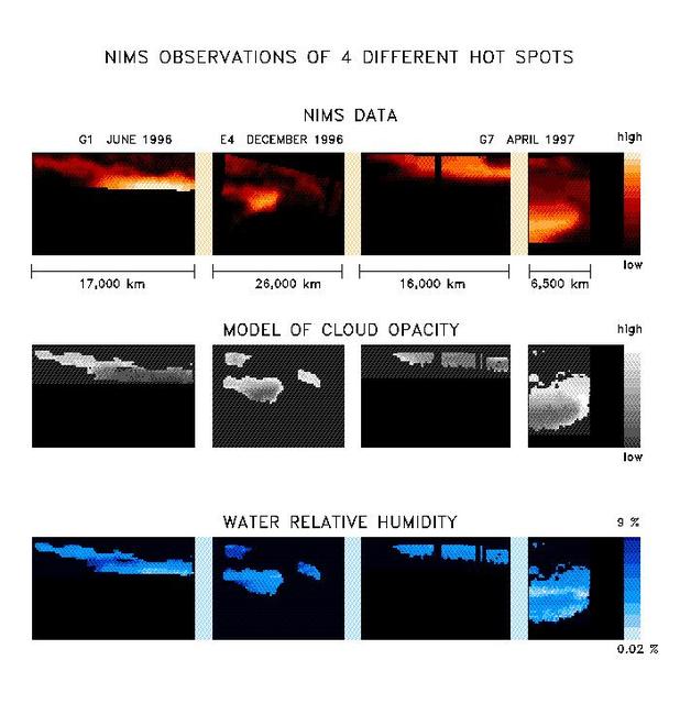
With the NIMS instrument high quality observations are being obtained from all parts of Jupiter. The images in the upper panel are taken at a wavelength of 4.8 microns. At this wavelength thermal radiation from about 100 km deep below the visible cloud deck is escaping, allowing us to study the deep atmospheric region. The overlying cloud deck absorbs a part of the radiation, but there are places where it is thin and more radiation can escape. These are called hot spot regions. Many hotspots regions occur in a zone between the equator and 15 degrees north latitude, the North Equatorial Belt (NEB), but thermal radiation is seen from much of the planet. The uniqueness of NIMS is that it is capable of observing the same spatial region at a maximum of 408 different wavelengths between 0.7 and 5.2 micron simultaneously. Every picture element (pixel) contains a spectrum of up to 408 wavelengths. The gases that compose the atmosphere leave there traces in the spectra. In this particular case, 48 wavelengths were available between 4.6 and 5.2 micron, and we see spectral signatures of water, ammonia, and phosphine. Also, the total amount of radiation is determined by the amount of overlying cloud, characterized by the cloud opacity. By means of model calculations, we can determine the amount of water and the cloud opacity for each individual spectrum. The amount ammonia and phosphine is more difficult to obtain because its influence on the spectra is weaker. The results of these calculations are shown in the form of maps in the next two panels. With NIMS, we can now have a detailed look at the spatial distribution of the water and ammonia amounts and the cloud opacity in the atmosphere. Not all the pixels from the observations have good spectra, so for some data points no reliable determination of the water and cloud opacity could be made. We find that the atmosphere is extremely dry in, and close to, the hot spot, with relative humidities between 0.02 % and 10 %, with the dryest places being inside the hot spot. This corroborates the in-situ Galileo Entry Probe measurements. The Probe entered the atmosphere, on December 5 1995, in a hot spot region. Whereas the Probe obtained only a very localized snapshot, with NIMS we can do observations of larger areas and over longer periods. The spatial distribution of water is more complex than expected. More detailed investigations will be necessary to fully understand these results. http://photojournal.jpl.nasa.gov/catalog/PIA01224

A March 2023 study by researchers at NASA's Jet Propulsion Laboratory in Southern California compared emissions from a belt of oil refineries across the South Bay area of Los Angeles during the first summer of the COVID-19 pandemic to those observed three years earlier. Using data from a NASA airborne instrument, researchers saw that most of the facilities they identified as methane sources in 2016-17 were no longer emitting the greenhouse gas in 2020, leading to a 73% reduction in measured emissions. The study uses measurements made by an imaging spectrometer called AVIRIS-NG (Airborne Visible/Infrared Imaging Spectrometer-Next Generation). Attached to the bottom of an aircraft, the instrument can detect greenhouse gas emissions from individual facilities or even pieces of equipment by looking at how the gases absorb sunlight. In 2016 and 2017, AVIRIS-NG was flown over 22,000 square miles (57,000 square kilometers) of the state as part of the California Methane Survey. From July to September 2020, researchers retraced some of those flight paths over refineries and power plants in Los Angeles County and over oil fields in central California's San Joaquin Valley. The flights were funded by NASA's Earth Science Division, the California Air Resources Board, and the California Energy Commission. The 2020 surveys over Los Angeles identified only 11 plumes from five refinery sources, with a total emissions rate of about 712 pounds (323 kilograms) methane per hour. The 2016 and 2017 flights had found 48 plumes from 33 sources, with a total emissions rate of roughly 2,639 pounds (1,197 kilograms) methane per hour. The drop correlates with an 18% decrease in monthly production in Southern California refineries between the two flight campaigns, the scientists noted, citing data from the California Energy Commission. The study also found that emissions from oil fields in and around the city of Bakersfield in central California fell 34.2%, correlating with a 24.2% drop in oil production. Reduced production during the pandemic due to lower demand for fuel and lower gas prices could have led to the drop in methane emissions, as oil fields and refineries emitted less methane as part of operations. However, researchers said, improved equipment maintenance and mitigation efforts at those facilities between 2016 and 2020 can't be ruled out as a factor. https://photojournal.jpl.nasa.gov/catalog/PIA25864
NASA image acquired January 30, 2011 at 23:20 UTC. Satellite: Terra <b> Click here to see the most recent image captured Feb. 1: <a href="http://www.flickr.com/photos/gsfc/5407540724/">www.flickr.com/photos/gsfc/5407540724/</a></b> Tropical Storm Anthony made landfall in Queensland, Australia this past weekend, and now the residents are watching a larger, more powerful cyclone headed their way. NASA's Terra satellite captured a visible image of the large Tropical Cyclone Yasi late yesterday as it makes its way west through the Coral Sea toward Queensland. The Moderate Resolution Imaging Spectroradiometer (MODIS) instrument that flies aboard NASA's Terra satellite captured an image of Cyclone Yasi on Jan. 30 at 23:20 UTC (6:20 p.m. EST/09:20 a.m., Monday, January 31 in Australia/Brisbane local time). Although the image did not reveal a visible eye, the storm appears to be well-formed and also appears to be strengthening. Warnings and watches are already in effect throughout the Coral Sea. The Solomon Islands currently have a Tropical Cyclone warning for the provinces of Temotu, Rennell & Bellona, Makira and Guadalcanal. The Australian Bureau of Meteorology has already posted a Tropical Cyclone Watch from Cooktown to Yeppoon and inland to between Georgetown and Moranbah in Queensland, Australia. The Australian Bureau of Meteorology expects damaging winds to develop in coastal and island communities between Cooktown and Yeppoon Wednesday morning, and inland areas on Wednesday afternoon. Updates from the Australian Bureau of Meteorology can be monitored at the Bureau's website at <a href="http://www.bom.gov.au" rel="nofollow">www.bom.gov.au</a>. On January 31 at 1500 UTC (10 a.m. EST/ 1:00 a.m. Tuesday February 1, 2011 in Australia/Brisbane local time), Tropical Cyclone Yasi had maximum sustained winds near 90 knots (103 mph/166 kmh). Yasi is a Category Two Cyclone on the Saffir-Simpson Scale. It was centered about 875 miles E of Cairns, Australia, near 13.4 South latitude and 160.4 East longitude. It was moving west near 19 knots (22 mph/35 kmh). Cyclone-force winds extend out to 30 miles (48 km) from the center. Animated infrared satellite imagery, such as that from the Atmospheric Infrared Sounder (AIRS) that flies on NASA's Aqua satellite, showed deep convective (thunderstorm) bands wrapping tighter into the low level circulation center. Wrapping bands of thunderstorms indicate strengthening. Yasi is forecast to move west then southwestward into an area of low vertical wind shear (strong wind shear can weaken a storm). Forecasters at the Joint Typhoon Warning Center (JTWC) expect Yasi to continue strengthening over the next 36 hours. JTWC forecasts a landfall just south of Cairns as a large 100-plus knot (115 mph/185 kmh)n system by Wednesday. Residents along the Queensland coast should now be making preparations now for the storm's arrival. Rob Gutro NASA's Goddard Space Flight Center Credit: NASA/GSFC/Jeff Schmaltz/MODIS Land Rapid Response Team Click here to see more images from <b><a href="http://rapidfire.sci.gsfc.nasa.gov/gallery/?latest" rel="nofollow">MODIS</a></b> <b><a href="http://www.nasa.gov/centers/goddard/home/index.html" rel="nofollow">NASA Goddard Space Flight Center</a></b> enables NASA’s mission through four scientific endeavors: Earth Science, Heliophysics, Solar System Exploration, and Astrophysics. Goddard plays a leading role in NASA’s accomplishments by contributing compelling scientific knowledge to advance the Agency’s mission. <b>Follow us on <a href="http://twitter.com/NASA_GoddardPix" rel="nofollow">Twitter</a></b> <b>Join us on <a href="http://www.facebook.com/pages/Greenbelt-MD/NASA-Goddard/395013845897?ref=tsd" rel="nofollow">Facebook</a></b>