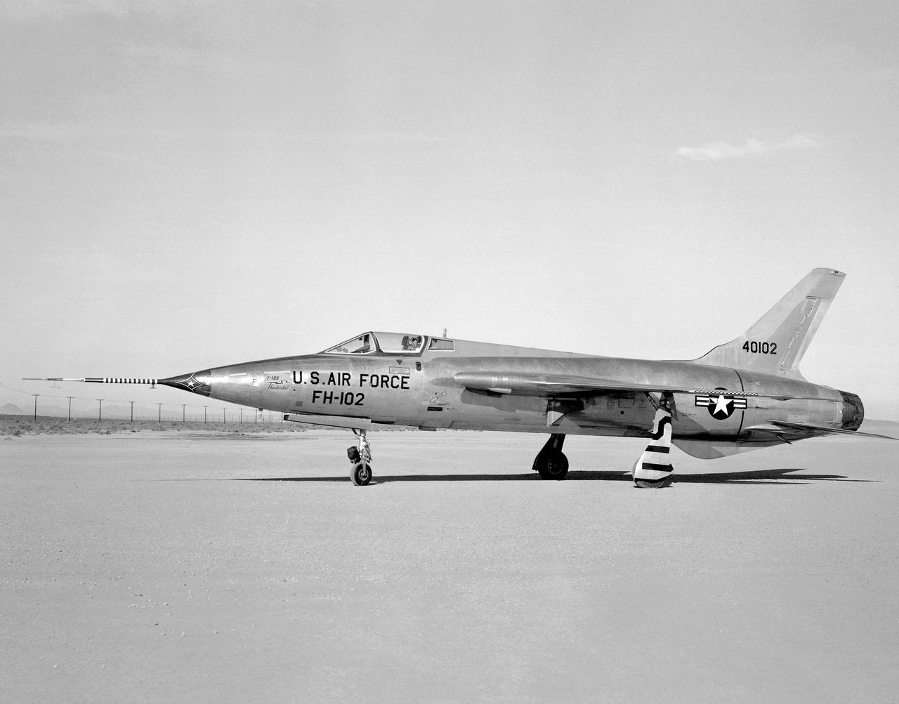
Side view of a F-105B (serial #54-0102) photographed on Rogers Dry Lakebed at Edwards Air Force Base, California in 1959. The black stripes across the left wheel-panel complete the lettering on the bottom of the wing when wheels are retracted. Two of the F-105B characteristics are fuselage length of 61 feet 1.33 inches and a wing area of 385.0 square feet.
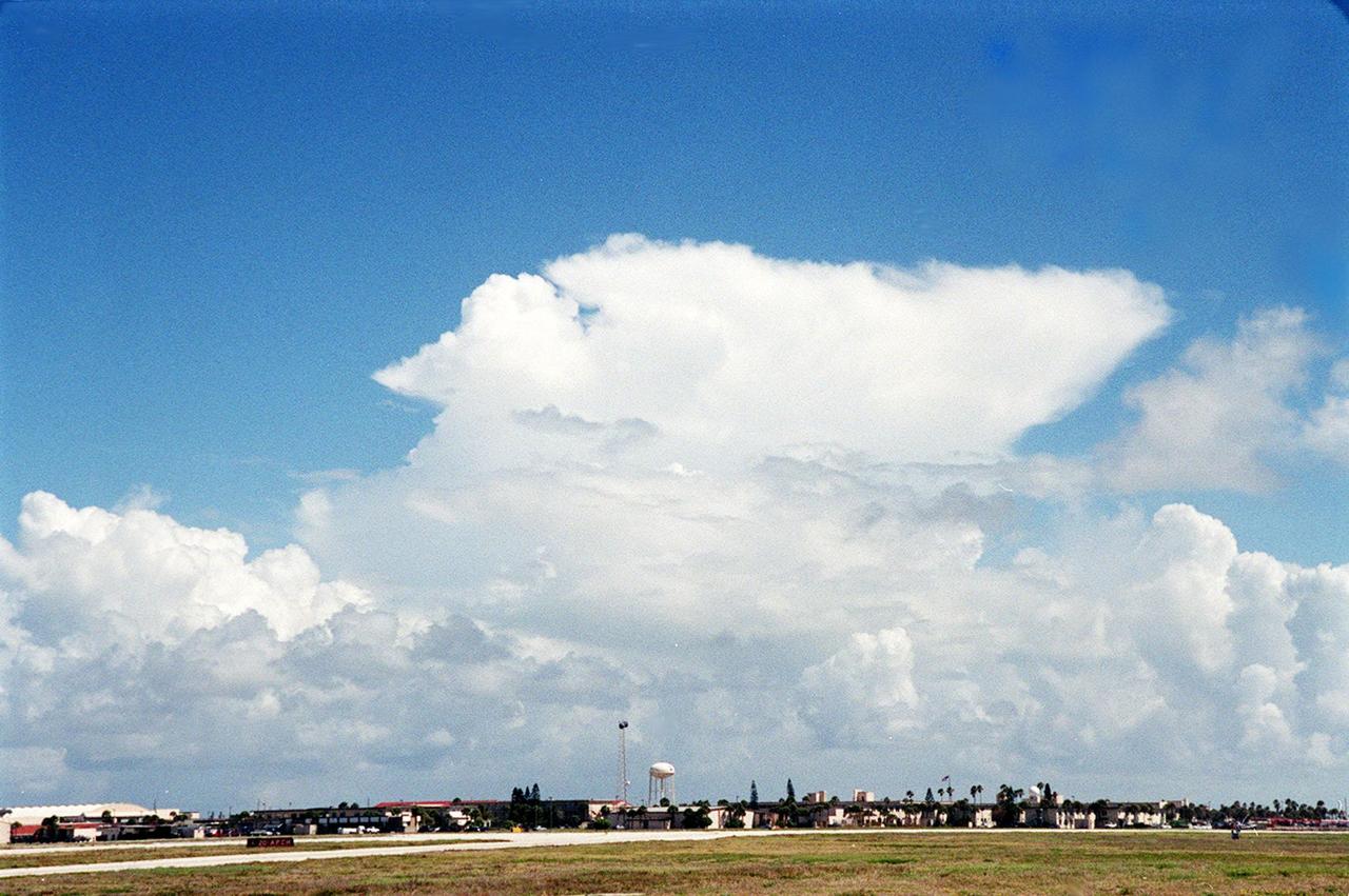
This anvil-shaped cloud over the Central Florida coast is part of a NASA study measuring electric fields in this type of cloud. A specially equipped Cessna Citation aircraft is being flown into anvil clouds in the KSC area . The weather study could lead to improved lightning avoidance rules and fewer launch scrubs for the Space Shuttle and other launch vehicles on the Eastern and Western ranges.; More information about the study can be found in <a href="http://www-pao.ksc.nasa.gov/kscpao/release/2000/56-00.htm">Release No. 56-00</a>
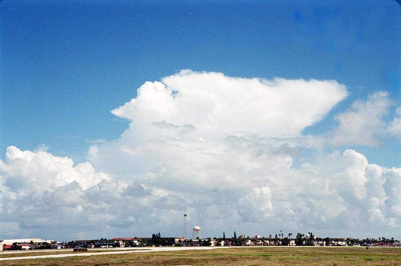
This anvil-shaped cloud over the Central Florida coast is part of a NASA study measuring electric fields in this type of cloud. A specially equipped Cessna Citation aircraft is being flown into anvil clouds in the KSC area . The weather study could lead to improved lightning avoidance rules and fewer launch scrubs for the Space Shuttle and other launch vehicles on the Eastern and Western ranges.; More information about the study can be found in <a href="http://www-pao.ksc.nasa.gov/kscpao/release/2000/56-00.htm">Release No. 56-00</a>
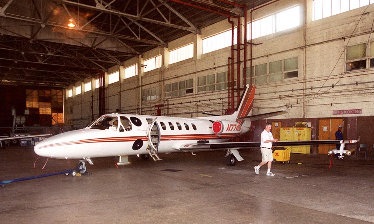
KENNEDY SPACE CENTER, FLA. -- At KSC's Shuttle Landing Facility, a specially equipped Cessna Citation aircraft flies over the runway to calibrate the Cesna's field mills with field mills on the ground (on the tripod at left) and on the car parked nearby (at center). Field mills measure electric fields. The aircraft is also equipped with cloud physics probes that measure the size, shape and number of ice and water particles in clouds. The plane is being flown into anvil clouds in the KSC area as part of a study to review and possibly modify lightning launch commit criteria. The weather study could lead to improved lightning avoidance rules and fewer launch scrubs for the Space Shuttle and other launch vehicles on the Eastern and Western ranges.
Attached to the wing of a Cessna Citation aircraft are cloud physics probes that measure the size, shape and number of ice and water particles in clouds. The plane is also equipped with field mills, used to measure electric fields. The plane is being flown into anvil clouds in the KSC area as part of a study to review and possibly modify lightning launch commit criteria. The weather study could lead to improved lightning avoidance rules and fewer launch scrubs for the Space Shuttle and other launch vehicles on the Eastern and Western ranges.; More information about the study can be found in <a href="http://www-pao.ksc.nasa.gov/kscpao/release/2000/56-00.htm">Release No. 56-00</a>
Attached to the wing of a Cessna Citation aircraft are cloud physics probes that measure the size, shape and number of ice and water particles in clouds. The plane is also equipped with field mills, used to measure electric fields. The plane is being flown into anvil clouds in the KSC area as part of a study to review and possibly modify lightning launch commit criteria. The weather study could lead to improved lightning avoidance rules and fewer launch scrubs for the Space Shuttle and other launch vehicles on the Eastern and Western ranges.; More information about the study can be found in <a href="http://www-pao.ksc.nasa.gov/kscpao/release/2000/56-00.htm">Release No. 56-00</a>
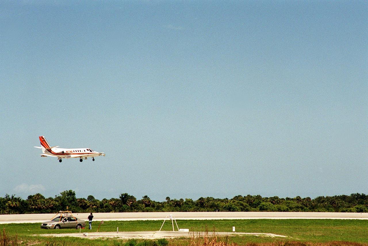
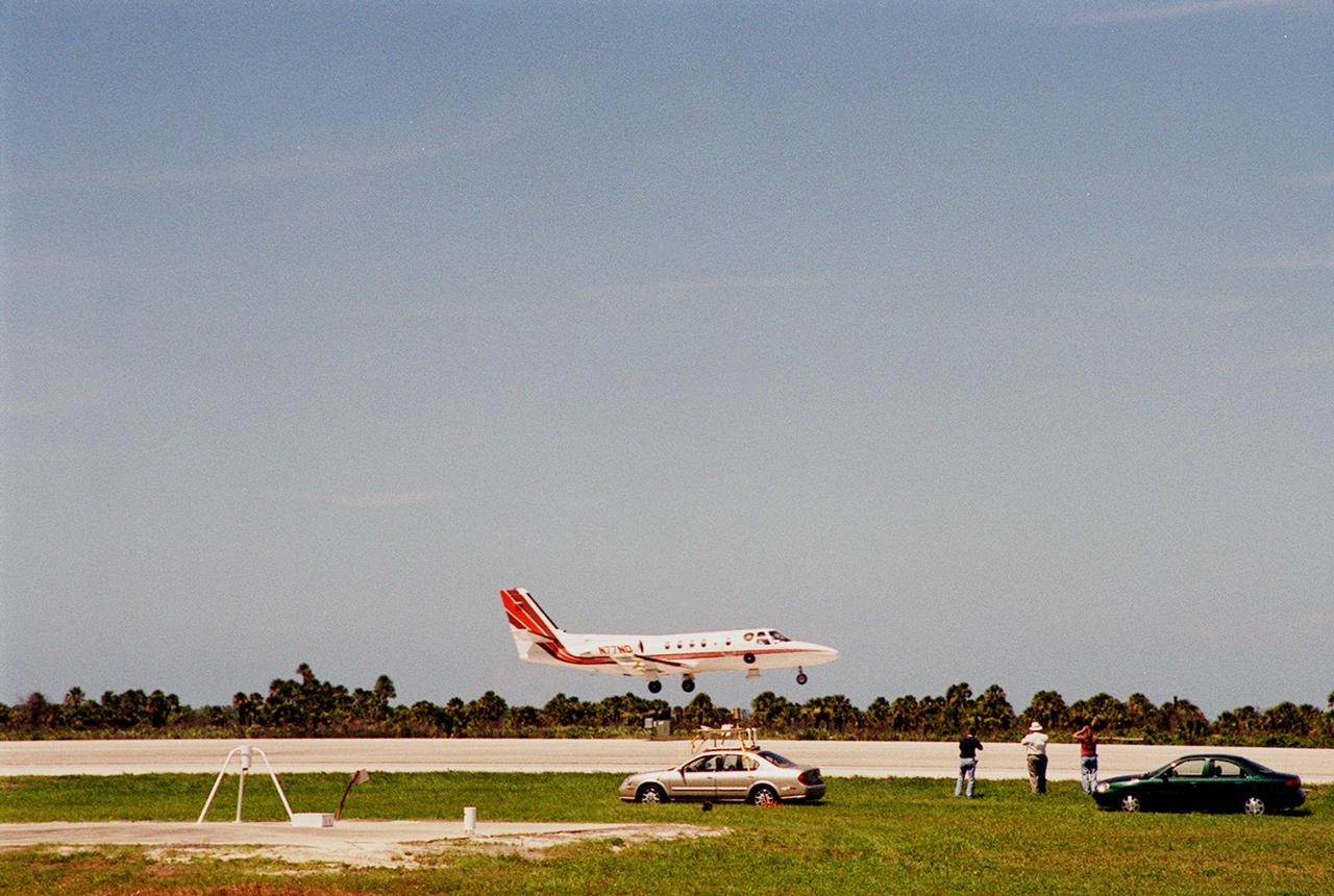
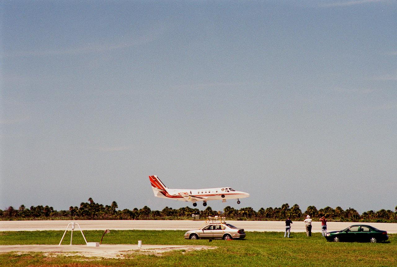
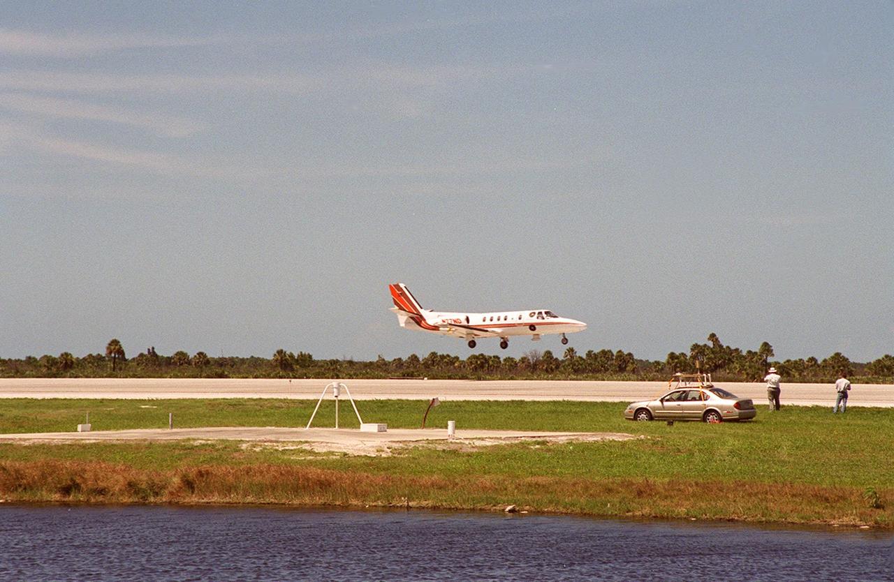
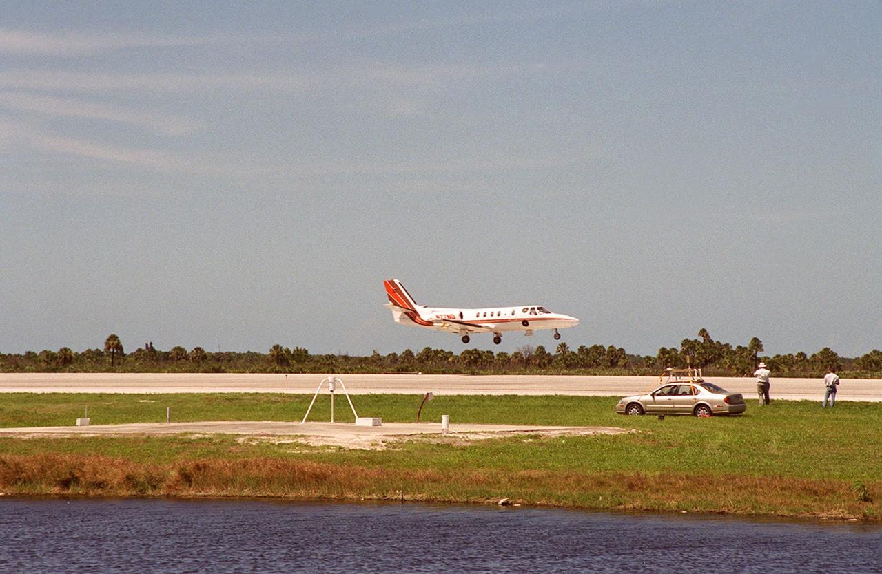
At KSC’s Shuttle Landing Facility, a specially equipped Cessna Citation aircraft approaches the runway to calibrate the Cessna’s field mills with field mills on the ground (on the tripod at left) and on the car parked nearby (at right). Field mills measure electric fields. The aircraft is also equipped with cloud physics probes that measure the size, shape and number of ice and water particles in clouds. The plane is being flown into anvil clouds in the KSC area as part of a study to review and possibly modify lightning launch commit criteria. The weather study could lead to improved lightning avoidance rules and fewer launch scrubs for the Space Shuttle and other launch vehicles on the Eastern and Western ranges.; More information on this study can be found in <a href="http://www-pao.ksc.nasa.gov/kscpao/release/2000/56-00.htm">Release No. 56-00</a>

A specially equipped Cessna Citation aircraft flies over KSC during a calibration test of field mills used to measure electric fields. The aircraft is also equipped with cloud physics probes that measure the size, shape and number of ice and water particles in clouds. The plane is being flown into anvil clouds in the KSC area as part of a study to review and possibly modify lightning launch commit criteria. The weather study could lead to improved lightning avoidance rules and fewer launch scrubs for the Space Shuttle and other launch vehicles on the Eastern and Western ranges.; More information on this study can be found in <a href="http://www-pao.ksc.nasa.gov/kscpao/release/2000/56-00.htm">Release No. 56-00</a>
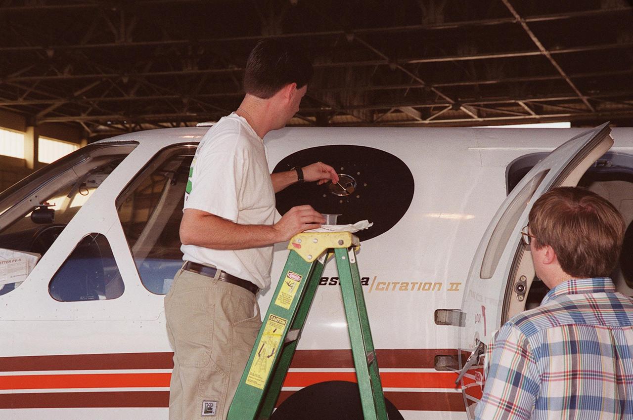
In a hangar at Cape Canaveral Air Force Station, a weather researcher checks a field mill measuring device on the Cessna Citation. The aircraft is being used for NASA’s airborne field mill study. The plane also carries cloud physics probes (under the body and wings) that measure the size, shape and number of ice and water particles in clouds. The plane is being flown into anvil clouds in the KSC area as part of a study to review and possibly modify lightning launch commit criteria. The weather study could lead to improved lightning avoidance rules and fewer launch scrubs for the Space Shuttle and other launch vehicles on the Eastern and Western ranges.; More information about the study can be found in <a href="http://www-pao.ksc.nasa.gov/kscpao/release/2000/56-00.htm">Release No. 56-00</a>
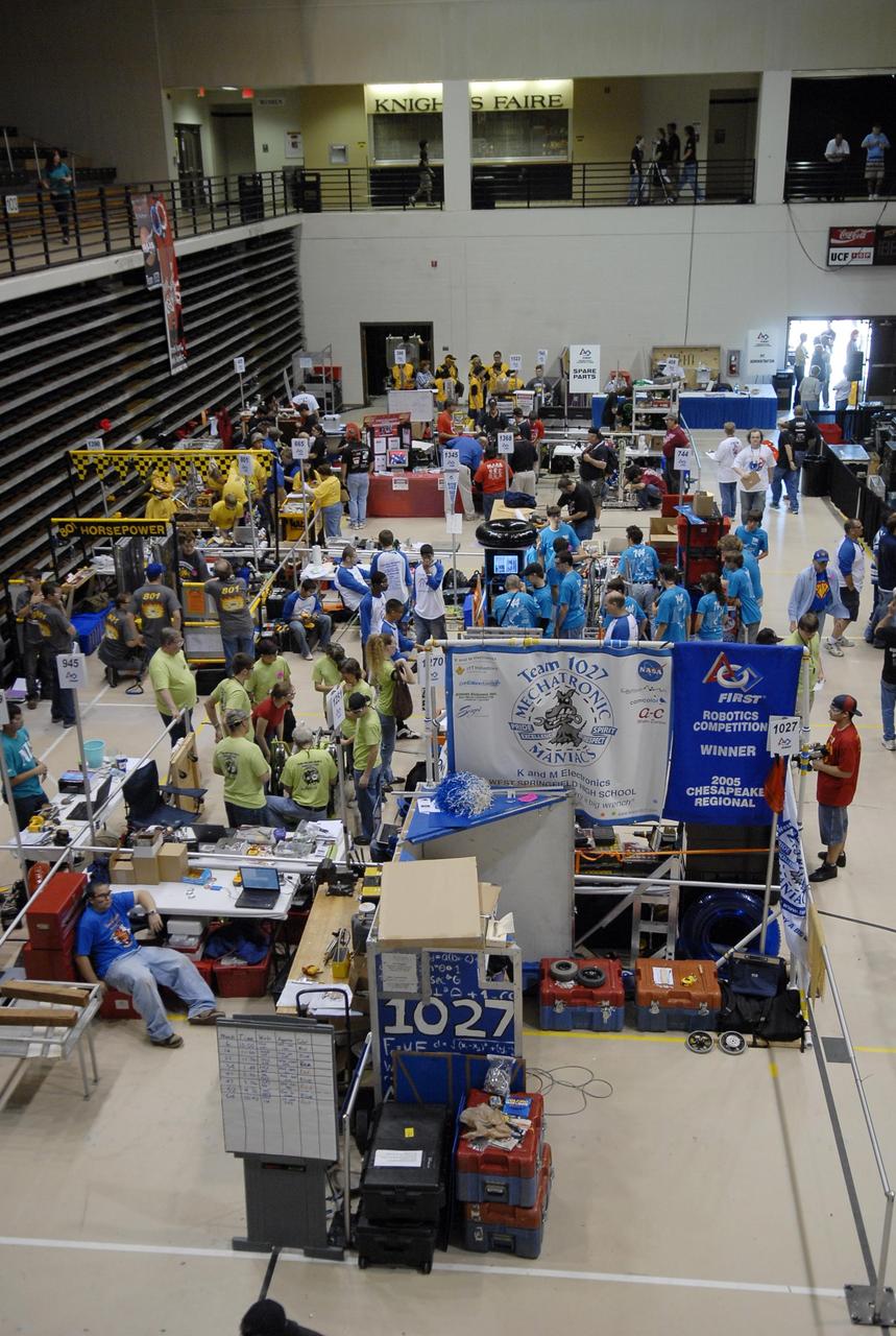
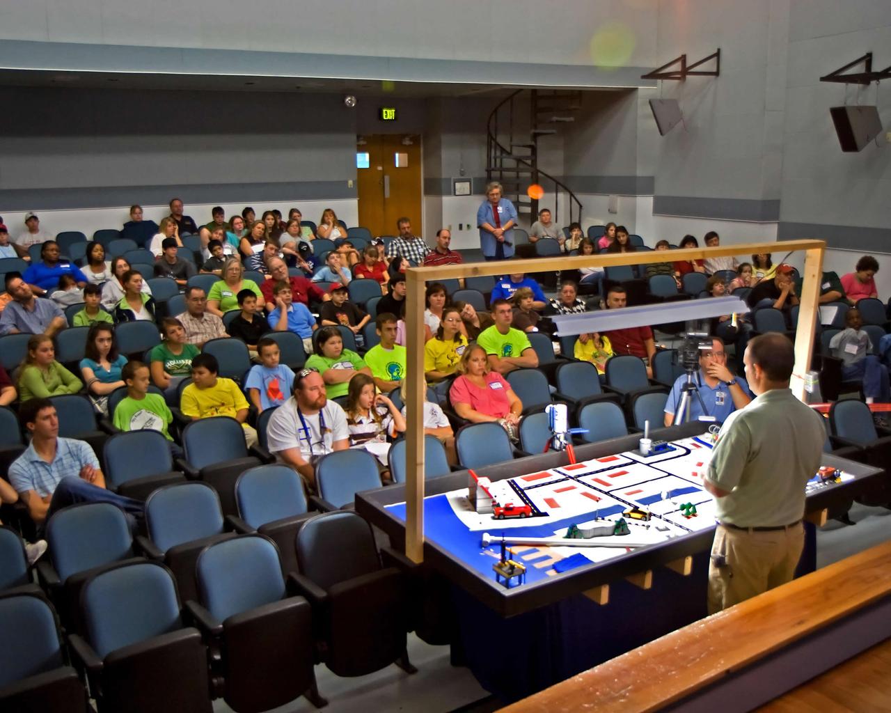
KENNEDY SPACE CENTER, FLA. -- Student teams representing Florida and several out-of-state areas display and work on their robots for the FIRST robotics event held at the University of Central Florida Arena March 8-10. The FIRST, or For Inspiration and Recognition of Science and Technology, Robotics Competition challenges teams of young people and their mentors to solve a common problem in a six-week timeframe using a standard "kit of parts" and a common set of rules. Teams build robots from the parts and enter them in a series of competitions designed by FIRST founder Dean Kamen and Dr. Woodie Flowers, chairman and vice chairman of the Executive Advisory Board respectively, and a committee of engineers and other professionals. FIRST redefines winning for these students. Teams are rewarded for excellence in design, demonstrated team spirit, gracious professionalism and maturity, and ability to overcome obstacles. Scoring the most points is a secondary goal. Winning means building partnerships that last. Photo credit: NASA/Kim Shiflett
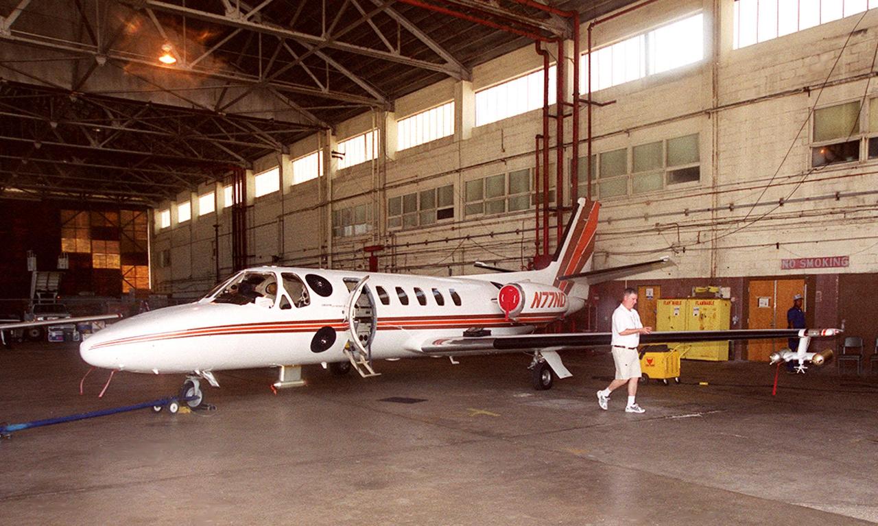
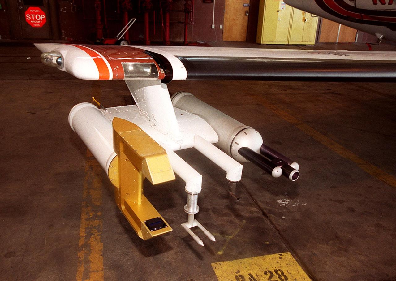
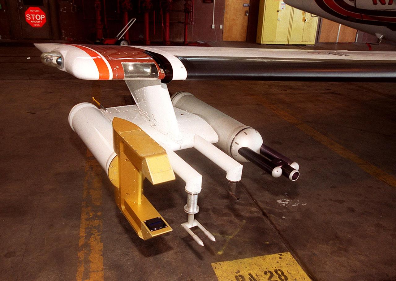
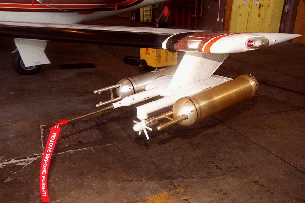
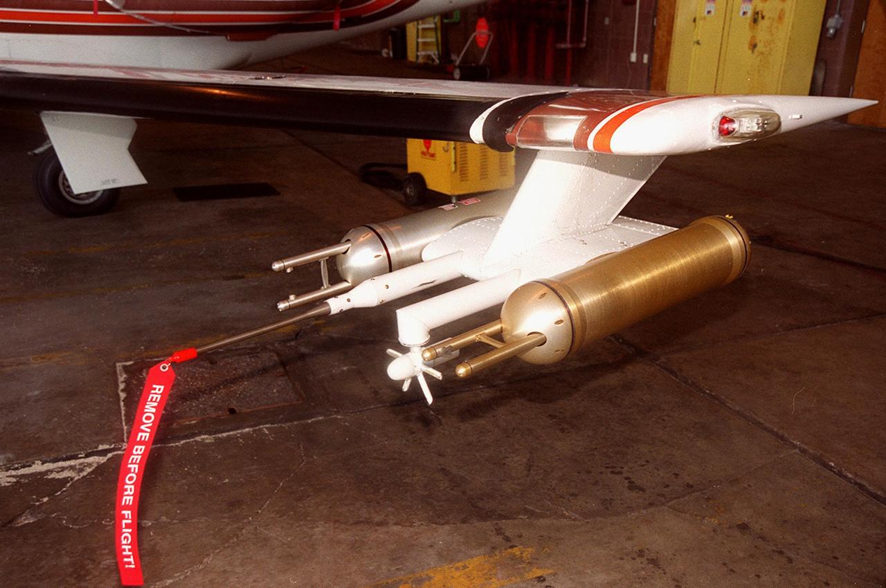
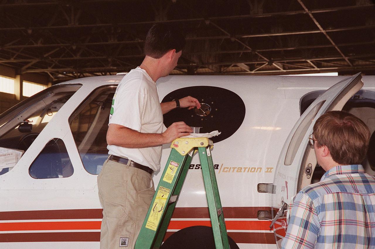
In a hangar at Cape Canaveral Air Force Station, a Cessna Citation aircraft has been fitted on the wings with devices that measure electric fields (black circles shown behind the open door) and with cloud physics probes (under the body and wings) that measure the size, shape and number of ice and water particles in clouds. The plane is being flown into anvil clouds in the KSC area as part of a study to review and possibly modify lightning launch commit criteria. The weather study could lead to improved lightning avoidance rules and fewer launch scrubs for the Space Shuttle and other launch vehicles on the Eastern and Western ranges.; More information about the study can be found in <a href="http://www-pao.ksc.nasa.gov/kscpao/release/2000/56-00.htm">Release No. 56-00</a>
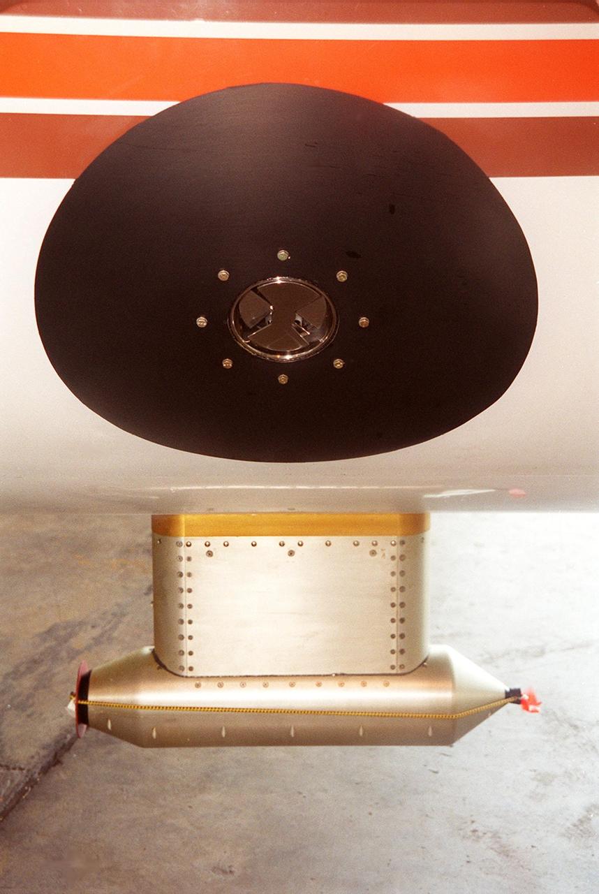
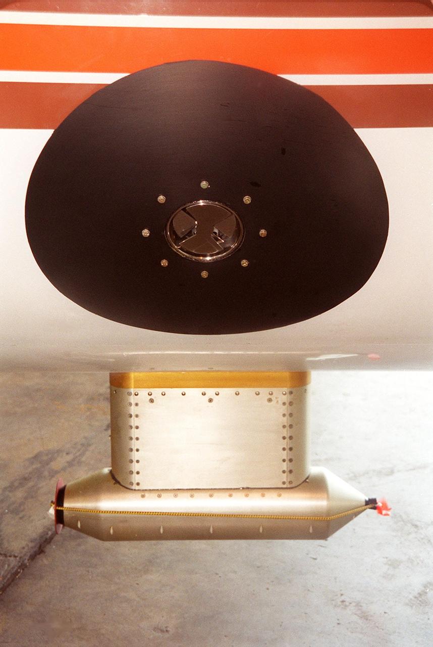
Lightning field study devices are visible on a Cessna Citation aircraft during flight over Central Florida. The center of the black circle contains one of six field mills, used to measure electric fields, located on the body of the plane. Below the circle is one of several cloud physics probes attached to the plane that measure the size, shape and number of ice and water particles in clouds. The Cessna is being flown into anvil clouds in the KSC area as part of a study to review and possibly modify lightning launch commit criteria. The weather study could lead to improved lightning avoidance rules and fewer launch scrubs for the Space Shuttle and other launch vehicles on the Eastern and Western ranges.; More information about the study can be found in <a href="http://www-pao.ksc.nasa.gov/kscpao/release/2000/56-00.htm">Release No. 56-00</a>
Lightning field study devices are visible on a Cessna Citation aircraft during flight over Central Florida. The center of the black circle contains one of six field mills, used to measure electric fields, located on the body of the plane. Below the circle is one of several cloud physics probes attached to the plane that measure the size, shape and number of ice and water particles in clouds. The Cessna is being flown into anvil clouds in the KSC area as part of a study to review and possibly modify lightning launch commit criteria. The weather study could lead to improved lightning avoidance rules and fewer launch scrubs for the Space Shuttle and other launch vehicles on the Eastern and Western ranges.; More information about the study can be found in <a href="http://www-pao.ksc.nasa.gov/kscpao/release/2000/56-00.htm">Release No. 56-00</a>
At KSC’s Shuttle Landing Facility, a specially equipped Cessna Citation aircraft flies over the runway to calibrate the Cessna’s field mills with field mills on the ground (on the tripod at left) and on the car parked nearby (at right). Field mills measure electric fields. The aircraft is also equipped with cloud physics probes that measure the size, shape and number of ice and water particles in clouds. The plane is being flown into anvil clouds in the KSC area as part of a study to review and possibly modify lightning launch commit criteria. The weather study could lead to improved lightning avoidance rules and fewer launch scrubs for the Space Shuttle and other launch vehicles on the Eastern and Western ranges.; More information about this study can be found in <a href="http://www-pao.ksc.nasa.gov/kscpao/release/2000/56-00.htm">Release No. 56-00</a>

At KSC’s Shuttle Landing Facility, a specially equipped Cessna Citation aircraft approaches the runway to calibrate the Cessna’s field mills with field mills on the ground (on the tripod at left) and on the car parked nearby (at right). Field mills measure electric fields. The aircraft is also equipped with cloud physics probes that measure the size, shape and number of ice and water particles in clouds. The plane is being flown into anvil clouds in the KSC area as part of a study to review and possibly modify lightning launch commit criteria. The weather study could lead to improved lightning avoidance rules and fewer launch scrubs for the Space Shuttle and other launch vehicles on the Eastern and Western ranges.; More information on this study can be found in <a href="http://www-pao.ksc.nasa.gov/kscpao/release/2000/56-00.htm">Release No. 56-00</a>
At KSC’s Shuttle Landing Facility, a specially equipped Cessna Citation aircraft flies over the runway to calibrate the Cessna’s field mills with field mills on the ground (on the tripod at left) and on the car parked nearby (at right). Field mills measure electric fields. The aircraft is also equipped with cloud physics probes that measure the size, shape and number of ice and water particles in clouds. The plane is being flown into anvil clouds in the KSC area as part of a study to review and possibly modify lightning launch commit criteria. The weather study could lead to improved lightning avoidance rules and fewer launch scrubs for the Space Shuttle and other launch vehicles on the Eastern and Western ranges.; More information about this study can be found in <a href="http://www-pao.ksc.nasa.gov/kscpao/release/2000/56-00.htm">Release No. 56-00</a>
In a hangar at Cape Canaveral Air Force Station, a Cessna Citation aircraft has been fitted on the wings with devices that measure electric fields (black circles shown behind the open door) and with cloud physics probes (under the body and wings) that measure the size, shape and number of ice and water particles in clouds. The plane is being flown into anvil clouds in the KSC area as part of a study to review and possibly modify lightning launch commit criteria. The weather study could lead to improved lightning avoidance rules and fewer launch scrubs for the Space Shuttle and other launch vehicles on the Eastern and Western ranges.; More information about the study can be found in <a href="http://www-pao.ksc.nasa.gov/kscpao/release/2000/56-00.htm">Release No. 56-00</a>
In a hangar at Cape Canaveral Air Force Station, a weather researcher checks a field mill measuring device on the Cessna Citation. The aircraft is being used for NASA’s airborne field mill study. The plane also carries cloud physics probes (under the body and wings) that measure the size, shape and number of ice and water particles in clouds. The plane is being flown into anvil clouds in the KSC area as part of a study to review and possibly modify lightning launch commit criteria. The weather study could lead to improved lightning avoidance rules and fewer launch scrubs for the Space Shuttle and other launch vehicles on the Eastern and Western ranges.; More information about the study can be found in <a href="http://www-pao.ksc.nasa.gov/kscpao/release/2000/56-00.htm">Release No. 56-00</a>
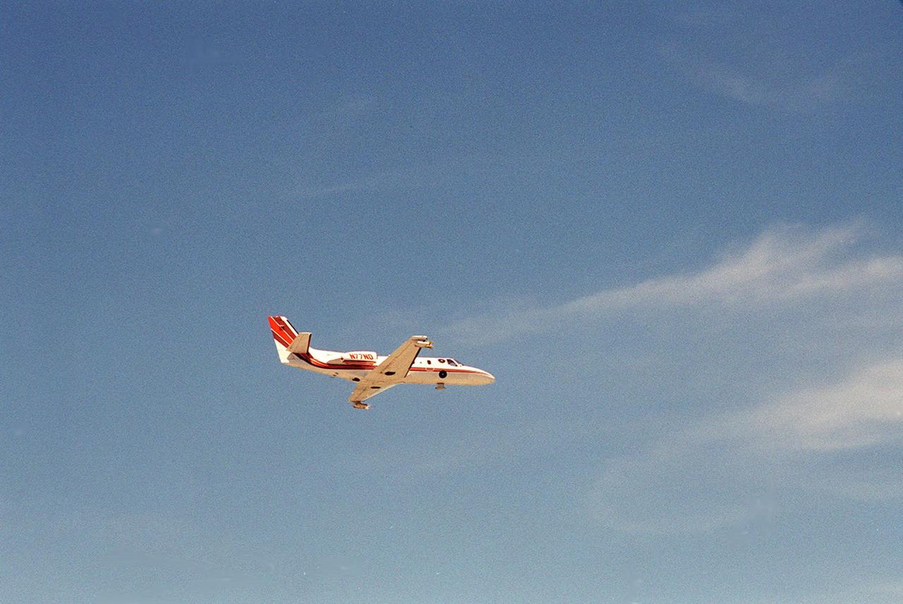
A specially equipped Cessna Citation aircraft flies over KSC during a calibration test of field mills used to measure electric fields. The aircraft is also equipped with cloud physics probes that measure the size, shape and number of ice and water particles in clouds. The plane is being flown into anvil clouds in the KSC area as part of a study to review and possibly modify lightning launch commit criteria. The weather study could lead to improved lightning avoidance rules and fewer launch scrubs for the Space Shuttle and other launch vehicles on the Eastern and Western ranges.; More information on this study can be found in <a href="http://www-pao.ksc.nasa.gov/kscpao/release/2000/56-00.htm">Release No. 56-00</a>
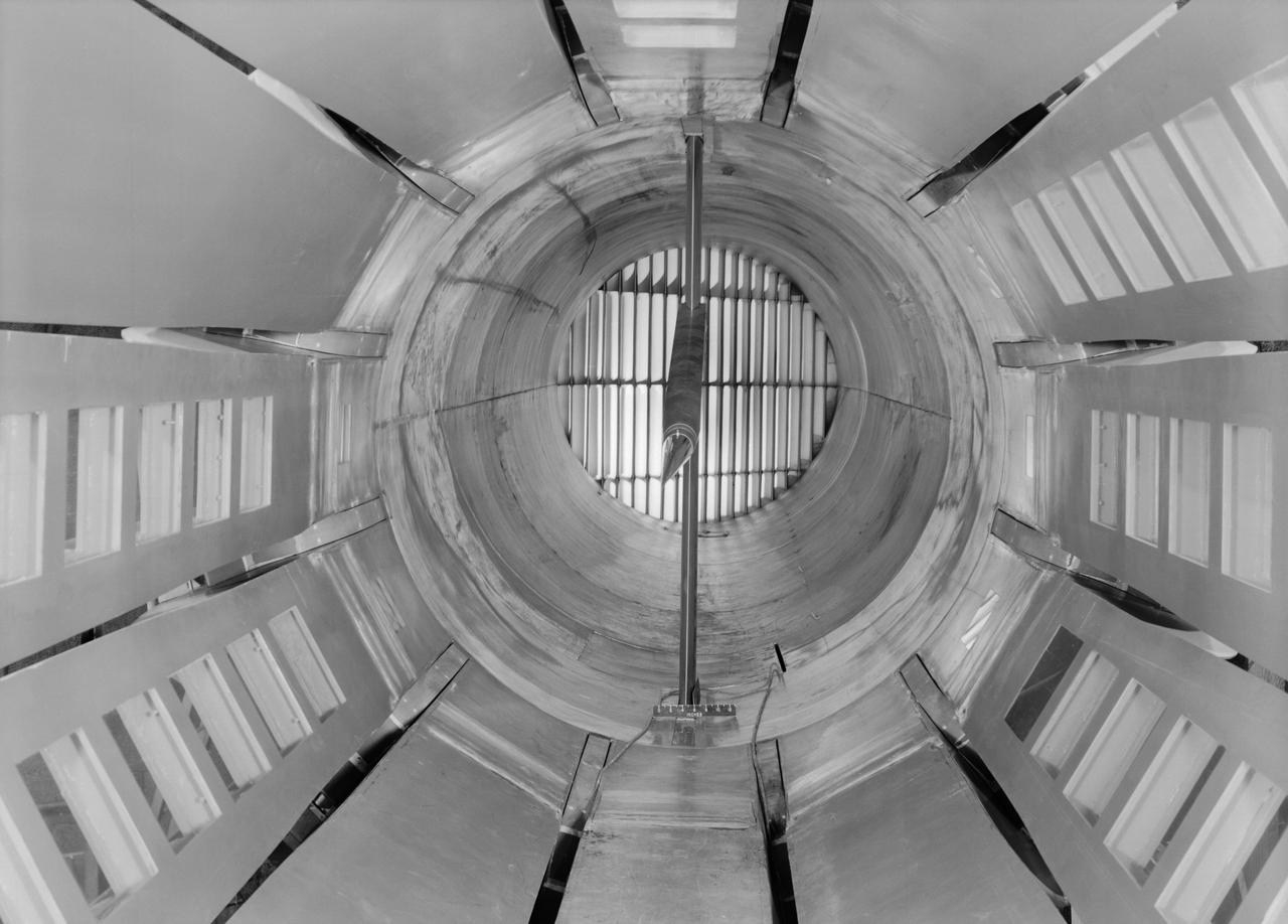
Interior view of the slotted throat test section installed in the 8-Foot High Speed Tunnel (HST) in 1950. The slotted region is about 160 inches in length. In this photograph, the sting-type model support is seen straight on. In a NASA report, the test section is described as follows: The test section of the Langley 8-foot transonic tunnel is dodecagonal in cross section and has a cross-sectional area of about 43 square feet. Longitudinal slots are located between each of the 12 wall panels to allow continuous operation through the transonic speed range. The slots contain about 11 percent of the total periphery of the test section. Six of the twelve panels have windows in them to allow for schlieren observations. The entire test section is enclosed in a hemispherical shaped chamber. John Becker noted that the tunnel s final achievement was the development and use in routine operations of the first transonic slotted throat. The investigations of wing-body shapes in this tunnel led to Whitcomb s discovery of the transonic area rule. James Hansen described the origins of the the slotted throat as follows: In 1946 Langley physicist Ray H. Wright conceived a way to do transonic research effectively in a wind tunnel by placing slots in the throat of the test section. The concept for what became known as the slotted-throat or slotted-wall tunnel came to Wright not as a solution to the chronic transonic problem, but as a way to get rid of wall interference (i.e., the mutual effect of two or more meeting waves or vibrations of any kind caused by solid boundaries) at subsonic speeds. For most of the year before Wright came up with this idea, he had been trying to develop a theoretical understanding of wall interference in the 8-Foot HST, which was then being repowered for Mach 1 capability. When Wright presented these ideas to John Stack, the response was enthusiastic but neither Wright nor Stack thought of slotted-throats as a solution to the transonic problem, only the wall interference problem. It was an accidental discovery which showed that slotted throats might solve the transonic problem. Most engineers were skeptical but Stack persisted. Initially, plans were to modify the 16-Foot tunnel but in the spring of 1948, Stack announced that the 8-Foot HST would also be modified. As Hansen notes: The 8-Foot HST began regular transonic operations for research purposes on 6 October 1950. The concept was a success and led to plans for a new wind tunnel which would be known as the 8-Foot Transonic Pressure Tunnel. -- Published in U.S., National Advisory Committee for Aeronautics, Characteristics of Nine Research Wind Tunnels of the Langley Aeronautical Laboratory, 1957, pp. 17, 22 James R. Hansen, Engineer in Charge, NASA SP-4305, p. 454 and Chapter 11, The Slotted Tunnel and the Area Rule.
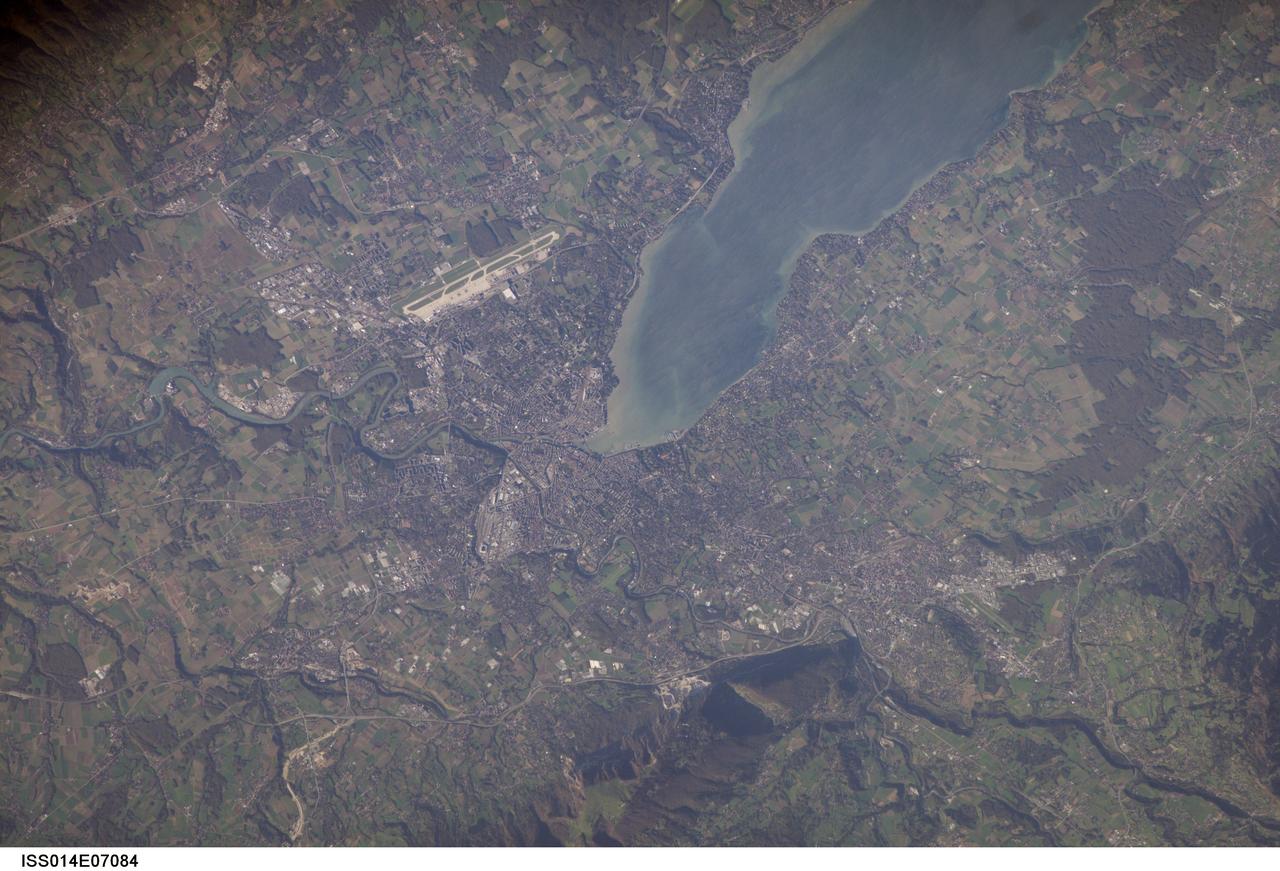
ISS014-E-07084 (2 Nov. 2006) --- Geneva, Switzerland is featured in this image photographed by an Expedition 14 crewmember on the International Space Station. The city is located at the southernmost tip of Lake Geneva (also known as Lac Leman) between two major mountain ranges, the Jura to the northwest (not shown) and the Alps to the southeast (the northern foothills of which are represented by Mount Saleve at bottom). The city's built area, roadways, and airport appear as white to grey surfaces in this view. Urbanized regions are interspersed with agricultural fields (bright green to light brown rectangular regions) and preserved forest stands (dark green) around the Lake. One of the defining moments in the city's history was the defeat of an attack by the dukedom of Savoy in 1602; the event -- known as "l'Escalade" is celebrated annually as a symbol of Geneva's independence. The city joined Switzerland as a canton (or state) in 1815. The city's recent history demonstrates its continuing importance to geopolitics. The League of Nations was headquartered here from 1919-1946, and the European headquarters of the United Nations is likewise located here. The Geneva Conventions, or "rules of war", were signed here from 1864 through 1949. The city also hosts the headquarters of numerous other international organizations and corporations - making it a "world city" of cultural, economic, and political significance.

The city of Calcutta appears in this 24 by 34 km (15 by 21 mile) sub-scene, acquired March 29, 2000. In 1690 the British East India Company founded Calcutta as a trading post on the marshy east bank of the Hugli River. Chosen for its easily defensible location and its access to the Bay of Bengal, the site developed into an important trading port. In 1773 Calcutta was made the capital of British India. As merchants and workers from all over the Indian subcontinent flocked to the city, British interests prospered, and British colonizers built mansions and palaces on land reclaimed from the marshes and swampland. In 1912, however, Calcutta lost its position as the colonial capital to Delhi. The end of British rule in India in 1947 cut off many of Calcutta's sources of trade and brought a deluge of immigrants to the city. The Bangladesh war in 1971 exacerbated the influx of refugees. Today this vibrant city has a population of over 5 million, and continues to sprawl to the north and south from the central grid of its old European section. This image was acquired on June 23, 2002, covers an area of 33 x 27 km, and is located at 22.6 degrees north latitude and 88.3 degrees east longitude. http://photojournal.jpl.nasa.gov/catalog/PIA11157
During the 1970s, the focus at Dryden shifted from high-speed and high-altitude flight to incremental improvements in technology and aircraft efficiency. One manifestation of this trend occurred in the winglet flight research carried out on a KC-135 during 1979 and 1980. Richard Whitcomb at the Langley Research Center had originated the idea of adding small vertical fins to an aircraft's wing tips. His wind tunnel tests indicated that winglets produced a forward thrust, which reduced the strength of the vortices generated by an aircraft's wing tips and resulted in a reduction of drag and an increase in aircraft range. Whitcomb, who had previously developed the area rule concept and the supercritical wing, selected the best winglet shape for flight tests on a KC-135 tanker. When the tests were completed, the data showed that the winglets provided a 7 percent improvement in range over the standard KC-135. The obvious economic advantage at a time of high fuel costs caused winglets to be adopted on business jets, airliners, and heavy military transports.
Randall Hicks (right), Jacobs Technology's Education Services manager at NASA John C. Stennis Space Center, answers questions about the playing field for FIRST (For Inspiration and Recognition of Science and Technology) LEGO League's 2007 Challenge, `Power Puzzle.' More than 140 teachers, mentors, parents and students from 15 schools attended the Sept. 15 FLL season kickoff at StenniSphere, the visitor center at SSC. The teams from southern and central Mississippi and Mobile, Ala., who came to SSC heard rules for and asked questions about `Power Puzzle,' and saw robot demonstrations by Gulfport and Picayune high schools' past FIRST Robotics competitions. Using LEGO Mindstorms NXT kits, FLL teams of children ages 9-14 will spend the next three months building and programming robots to perform 'Power Puzzle's' challenge tasks, then pit them in competitions. They also will submit a research project about how energy choices impact the environment and the economy. The season will culminate at the Mississippi Championship Tournament on Dec. 8 at the Mississippi Gulf Coast Community College. FLL, considered the `little league' of the FIRST Robotics Competition, partners FIRST and the LEGO Group. Competitions aim to inspire and celebrate science and technology using real-world context and hands-on experimentation. NASA recognizes FIRST activities as an excellent hands-on method to increase student knowledge of science, engineering, technology and mathematics. Schools represented in this year's kickoff were: Madison Avenue Upper Elementary, the Mississippi Band of Choctaw Indians' Conehatta Elementary, Hattiesburg's Lillie Burney Elementary, Pearl Upper Elementary, Long Beach Middle, Oktibehha Elementary, d'Iberville Middle, Saucier's West Wortham Middle, Picayune's Nicholson Elementary and Roseland Park Baptist Church Academy, Bay St. Louis' St. Stanislaus College and Mobile's Davidson High, as well as two home-school groups from the Jackson area.
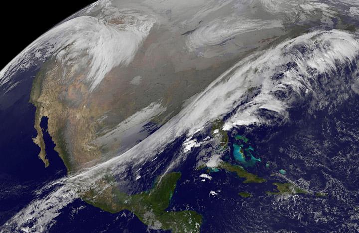
This NOAA's GOES satellite infrared image taken on Nov. 25 at 11:45 UTC (6:45 a.m. EST) shows two main weather systems over the U.S. Credit: NASA/NOAA GOES Project As the U.S. Thanksgiving holiday approaches this Thursday, November 27, NOAA's GOES-East and GOES-West satellites are keeping a weather eye out for storms that may affect early travelers. In an image from Nov. 25, the satellites show an active weather pattern is in place for travelers across the central and eastern U.S. NOAA's GOES-East satellite provides visible and infrared images over the eastern U.S. and the Atlantic Ocean, while NOAA's GOES-West satellite covers the western U.S. and Pacific Ocean from its fixed orbit in space. Data from both satellites were combined at NASA's GOES Project to create a full view of the U.S. on Nov. 25 at 11:45 UTC (6:45 a.m. EST). The image shows clouds associated with cold front stretching from the Gulf of Mexico over northern Florida and along the U.S. East coast to eastern Canada. Clouds associated with another area of low pressure are in the northern Rockies and northwestern U.S. To create the image, NASA/NOAA's GOES Project takes the cloud data from NOAA's GOES-East satellite and overlays it on a true-color image of land and ocean created by data from the Moderate Resolution Imaging Spectroradiometer, or MODIS, instrument that flies aboard NASA's Aqua and Terra satellites. Together, those data created the entire picture of the storm and show its movement. After the storm system passes, the snow on the ground becomes visible. NOAA's National Weather Service Weather Prediction Center said "a storm system will develop off the coast of the Carolinas early Wednesday (Nov. 25) and strengthen as it moves rapidly up the East Coast Wednesday into early Thursday (Nov. 26). Heavy snow is likely to begin in the central Appalachians early Wednesday morning, spreading northeast through the interior Mid-Atlantic into New England by Wednesday night. Winter Storm Watches are in effect for these areas." For travelers in the western U.S., the Northern Rocky Mountains are expected to receive more snow from the north side of a stationary frontal boundary. South of the boundary rain showers will affect the lower valley. The National Weather Service calls for cold weather to continue in the northern Plains and Upper Midwest as a Canadian surface high pressure rules the weather. The U.S. Southwest will experience nice weather for mid-week. In the Pacific Northwest, the National Weather Service noted that a warm front will bring rain, heavy at times, to the Cascades today and tonight. There will be a break in the heavier rains on Wednesday, then another period of heavy rain for the Cascades Wednesday night through Friday morning as a cold front slowly drags through the area. NOAA's GOES satellites provide the kind of continuous monitoring necessary for intensive data analysis. Geostationary describes an orbit in which a satellite is always in the same position with respect to the rotating Earth. This allows GOES to hover continuously over one position on Earth's surface, appearing stationary. As a result, GOES provide a constant vigil for the atmospheric triggers for severe weather conditions such as tornadoes, flash floods, hail storms and hurricanes.

A March 2023 study by researchers at NASA's Jet Propulsion Laboratory in Southern California compared emissions from a belt of oil refineries across the South Bay area of Los Angeles during the first summer of the COVID-19 pandemic to those observed three years earlier. Using data from a NASA airborne instrument, researchers saw that most of the facilities they identified as methane sources in 2016-17 were no longer emitting the greenhouse gas in 2020, leading to a 73% reduction in measured emissions. The study uses measurements made by an imaging spectrometer called AVIRIS-NG (Airborne Visible/Infrared Imaging Spectrometer-Next Generation). Attached to the bottom of an aircraft, the instrument can detect greenhouse gas emissions from individual facilities or even pieces of equipment by looking at how the gases absorb sunlight. In 2016 and 2017, AVIRIS-NG was flown over 22,000 square miles (57,000 square kilometers) of the state as part of the California Methane Survey. From July to September 2020, researchers retraced some of those flight paths over refineries and power plants in Los Angeles County and over oil fields in central California's San Joaquin Valley. The flights were funded by NASA's Earth Science Division, the California Air Resources Board, and the California Energy Commission. The 2020 surveys over Los Angeles identified only 11 plumes from five refinery sources, with a total emissions rate of about 712 pounds (323 kilograms) methane per hour. The 2016 and 2017 flights had found 48 plumes from 33 sources, with a total emissions rate of roughly 2,639 pounds (1,197 kilograms) methane per hour. The drop correlates with an 18% decrease in monthly production in Southern California refineries between the two flight campaigns, the scientists noted, citing data from the California Energy Commission. The study also found that emissions from oil fields in and around the city of Bakersfield in central California fell 34.2%, correlating with a 24.2% drop in oil production. Reduced production during the pandemic due to lower demand for fuel and lower gas prices could have led to the drop in methane emissions, as oil fields and refineries emitted less methane as part of operations. However, researchers said, improved equipment maintenance and mitigation efforts at those facilities between 2016 and 2020 can't be ruled out as a factor. https://photojournal.jpl.nasa.gov/catalog/PIA25864