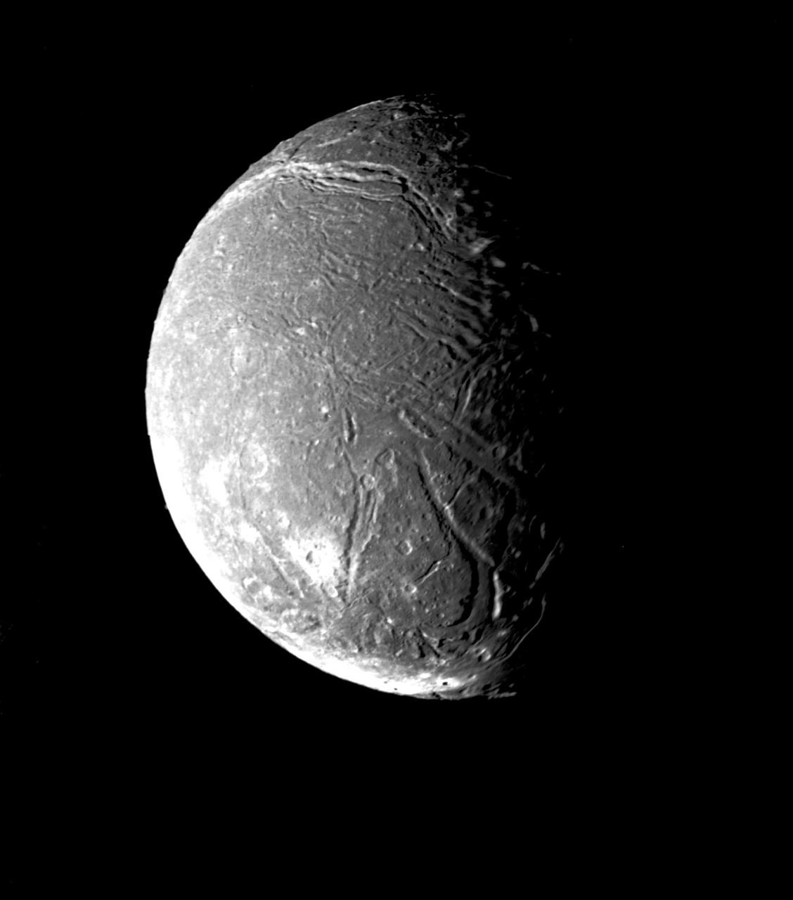
This picture is part of NASA Voyager 2 imaging sequence of Ariel, a moon of Uranus taken on January 24, 1986. The complexity of Ariel surface indicates that a variety of geologic processes have occurred. http://photojournal.jpl.nasa.gov/catalog/PIA00037
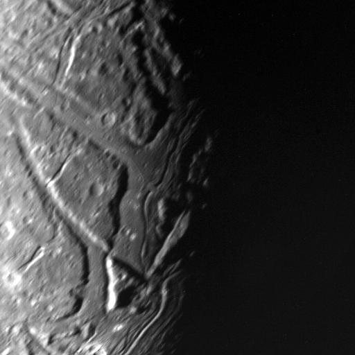
This NASA Voyager 2 view of Uranus moon Ariel terminator shows a complex array of transecting valleys with super-imposed impact craters.
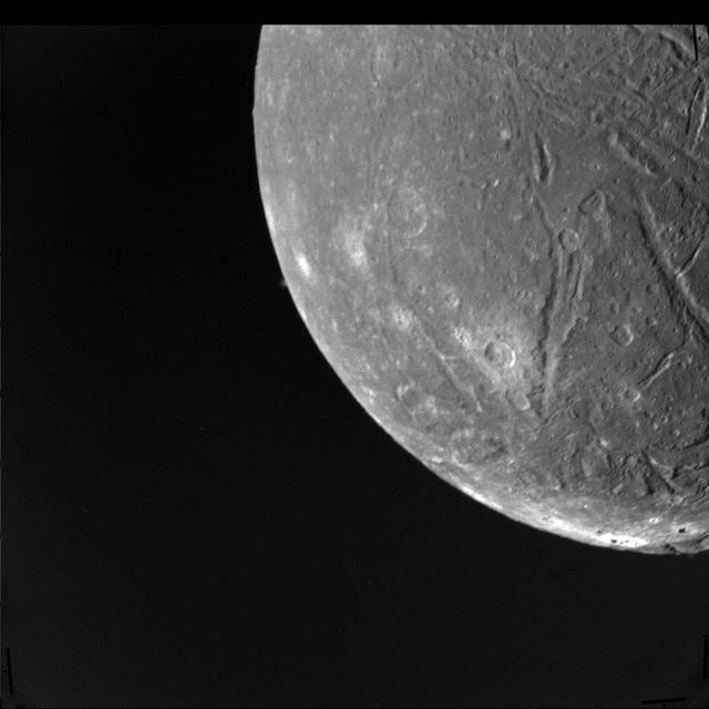
NASA Voyager 2 took this image on January 24, 1986, showing Ariel surface densely pitted with craters. Numerous valleys and fault scarps crisscross the highly pitted terrain.
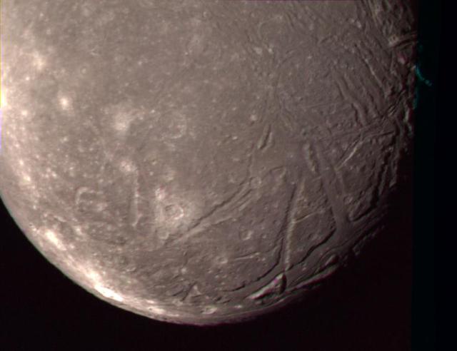
On Jan. 24, 1986, NASA Voyager 2 obtained this color picture of the Uranian moon, Ariel. Most of the visible surface consists of relatively intensely cratered terrain transected by fault scarps and fault-bounded valleys graben. http://photojournal.jpl.nasa.gov/catalog/PIA00041

Artemis II lunar science team member, Ariel Deutsch, reacts to the astronauts' verbal observations of the Moon during their flyby on April 6. The science team has spent years training the astronauts in geology and observation, both in the classroom and in the field. They also built the lunar targeting plan that, like a spacewalk plan, provides strong, detailed observation guidance, plus flexibility for the crew to make decisions based on what they’re seeing and experiencing in real time. The science team had many moments of celebration during the lunar flyby as the astronauts took pictures of the Moon and provided verbal descriptions of what they were seeing. This type of information reveals the geologic history of an area and will be critical to collect when future Artemis astronauts explore the Moon's surface. Credits: NASA/Luna Posadas Nava
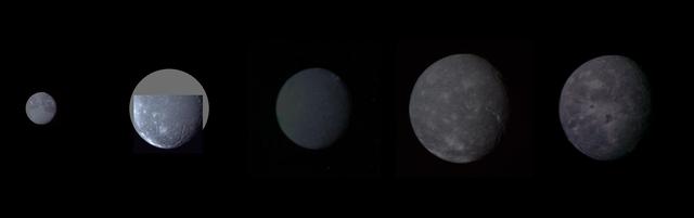
Montage of Uranus five largest satellites taken by NASA Voyager 2. From to right to left in order of decreasing distance from Uranus are Oberon, Titania, Umbriel, Ariel, and Miranda.
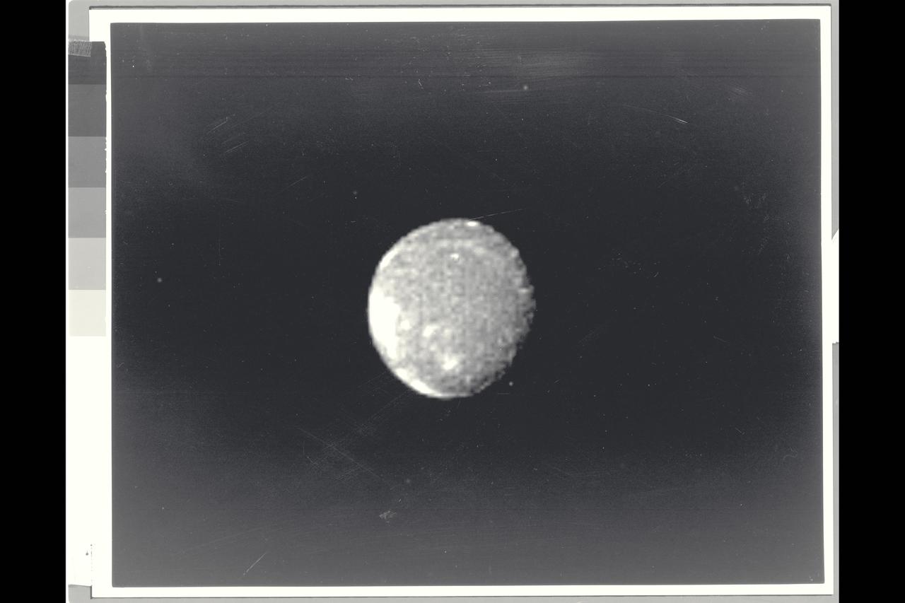
Range : 2.52 million miles (1.56 million miles) Resolution : 47km. ( 29 mi.) Closest Approach: 127,000 km. (79,000 mi.) P-29479B/W This Voyager 2 image of the brightest Uranian satellite of the five largest, Ariel, was shot through a clear filter with the narrow angle camera. Ariel is about 1,300 km. ( 800 mi. )in diameter. This image shows several distinct bright areas that reflect nearly 45 % of the incident sunlight. On average, the satellite displays reflectivity of about 25-30 %. The bright areas are probably fresh water ice, perhaps excavated by impacts. the south pole of Ariel is slightly off center of the disk in this view.
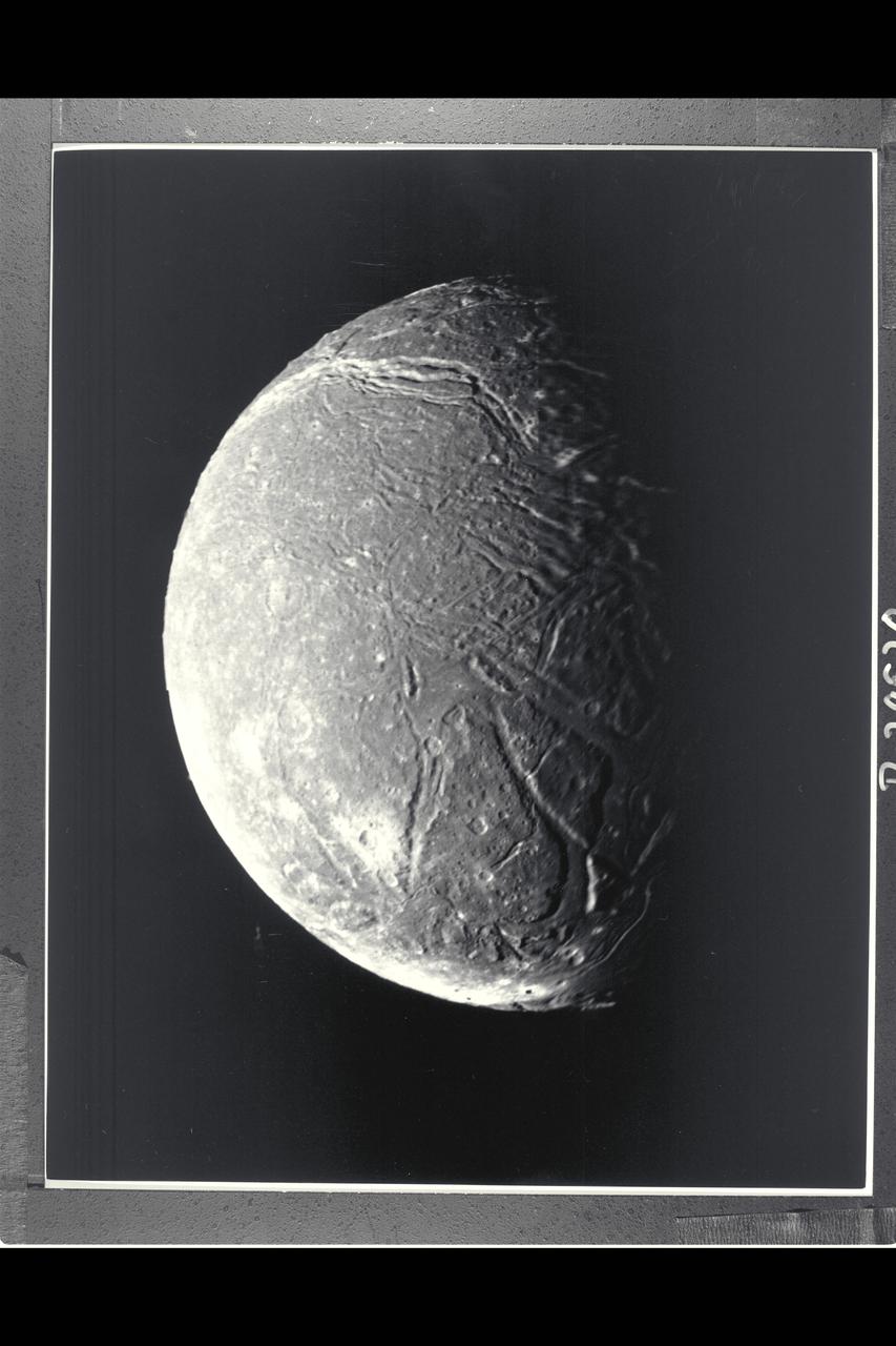
P-29520 BW Range: 130,000 kilometers (80,000 miles) This mosaic, taken through the clear-filter, narrow-angle camera, of the four highest-resolution images of Ariel represents the most detailed Voyager 2 picture of this satellite of Uranus. Ariel is about 1,200 km (750 mi) in diameter; the resolution here is 2.4 km (1.5 mi). Much of Ariel's surface is densely pitted with craters 5 to 10 km (3 to 6 mi) across. These craters are close to the threshold of detection in this picture. Numerous valleys and fault scarps crisscross the highly pitted terrain. voyager scientists believe the valleys have formed over down-dropped fault blocks (graben); apparently, extensive faulting has occured as a result of expansion and stretching of Ariel's crust. The largest fault valleys, near the terminator at right, as well as a smooth region near the center of this image, have been partly filled with deposits that are younger and less heavily cratered than the pitted terrain. Narrow, somewhat sinuous scarps and valleys have been formed, in turn, in these young deposits. It is not yet clear whether these sinuous features have been formed by faulting or by the flow of fluids.

Range : 170,000 km. ( 105,000 mi. ) Resolution : 3 km. ( 2 mi. ) P-29523C This Voyager 2 photograph of the Uranian Moon Ariel, is the best quality to date. This view of Ariel's southern hemisphere is a composite of photographs taken through green, blue, and violet filters from the narrow angle camera. Most of the visible surface consists of relatively intensely cratered terrain transected by fault scarps and fault bounded valleys (graben). Some of the largest valleys, which can be seen near the terminator (at right), are partly filled with younger deposits that are less heavily cratered. Bright spots near the limb and toward are chiefly the rims of small craters. Most of the brightly rimmed craters are too small to be resolved here, although one about 30 km. (20 mi.) in diameter can be easily distiguished near the center. These bright-rim craters, thogh the youngest features on Ariel, probably have formed over a long span of geological tome. Although Ariel has a diameter of abou 1,200 km. ( 750 mi. ), it clearly experienced a great deal of geological activity in the past.
P-29511 BW Range: 130,000 kilometers (80,000 miles) This clear-filter, narrow-angle picture is part of the high-resolution Voyager 2 imaging sequence of Ariel, a moon of Uranus about 1,300 kilometers (800 miles) in diameter. The complexity of Ariels' surface indicates that a variety of geologic processes have occured. The numerous craters, for example, are indications of an old surface bombarded by meteroids over a long periond. Also conspicuous at this resolution, about 2.4 km (1.5 mi), are linear grooves (evidence of tectonic activity that has broken up the surface) and smooth patches (indicative of deposition of material).
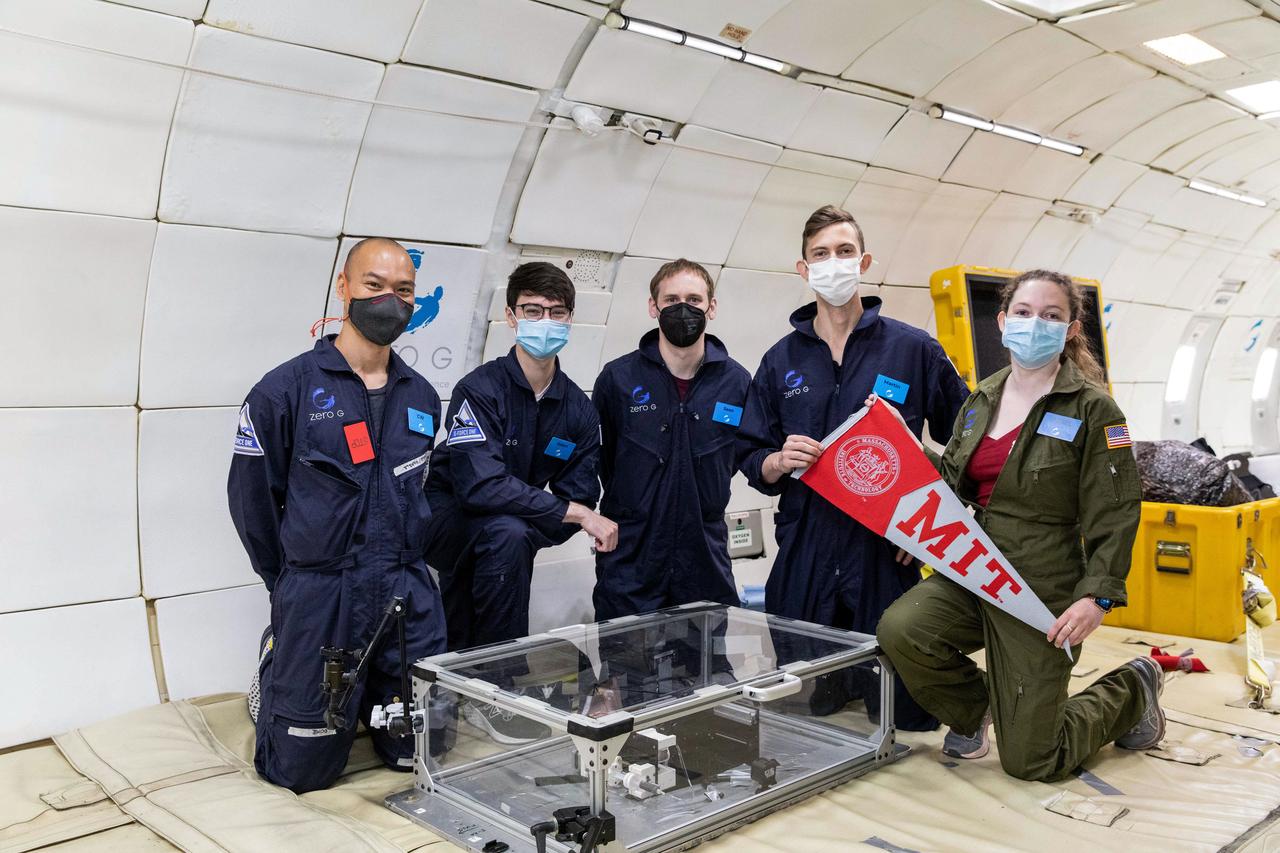
jsc2022e083565 (5/20/2022) --- The MIT Space Exploration Initiative team prior to an Extrusion payload flight test on a parabolic flight in May 2021. Left to Right: Che-Wei Wang, Aiden Padilla, Sean Auffinger, Martin Nisser, and Ariel Ekblaw. Image courtesy of the MIT Space Exploration Initiative.
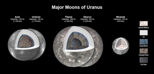
New modeling shows that there likely is an ocean layer in four of Uranus' major moons: Ariel, Umbriel, Titania, and Oberon. Salty – or briny – oceans lie under the ice and atop layers of water-rich rock and dry rock. Miranda is too small to retain enough heat for an ocean layer. The modeling, detailed in a paper published in the Journal of Geophysical Research, was informed by a re-analysis of data from NASA's Voyager spacecraft. Scientists have long thought that Titania, given its size, would be most likely to retain internal heat, caused by radioactive decay. The other moons had been widely considered too small to retain the heat necessary to keep an internal ocean from freezing, especially as heating created by the gravitational pull of Uranus is only a minor source of heat. https://photojournal.jpl.nasa.gov/catalog/PIA25500
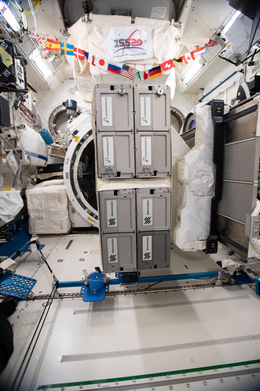
iss064e002782 (11/2/2020) --- Photo documentation of the Nanoracks CubeSat Deployer-Mission 19 (NRCSD-19) installed on the Multi-Purpose Experiment Platform Assembly (MPEP). NRCSD-19 includes: The Spectral Ocean Color (SPOC) Satellite, Ariel University First Nano Satellite, (SATLLA-1), Neutron-1, DESCENT, NanoRacks-LEMUR-2 and Bobcat-1. The photo was taken in the Kibo Japanese Experiment Module (JEM) aboard the International space station (ISS).

Marie Henderson, from NASA’s Goddard Space Flight Center, foreground, and Ariel Deutsch, from NASA Ames, follow the geology traverses during the JETT 5 field test. JETT 5 was a week-long field test in the lunar-like landscape of San Francisco Volcanic Field near Flagstaff, Arizona while a team of flight controllers and scientists at Johnson monitor and guide their activities. Credit: NASA/Helen Arase Vargas

Members of the Artemis lunar science team, from left, Ariel Deutsch, Amber Turner, and Wilfredo Garcia-Lopez, watch the Artemis II launch from the Science Evaluation Room (SER) in Mission Control at Johnson Space Center in Houston. The SER supports lunar science and planetary observations for the Artemis science officer in the mission’s main flight control room. Built specifically for Artemis missions with these science priorities in mind, the SER is equipped to support rapid data interpretation, collaborative analysis, real-time decision making, and seamless coordination between the science and operations teams. Credits: NASA/Mark Sowa.
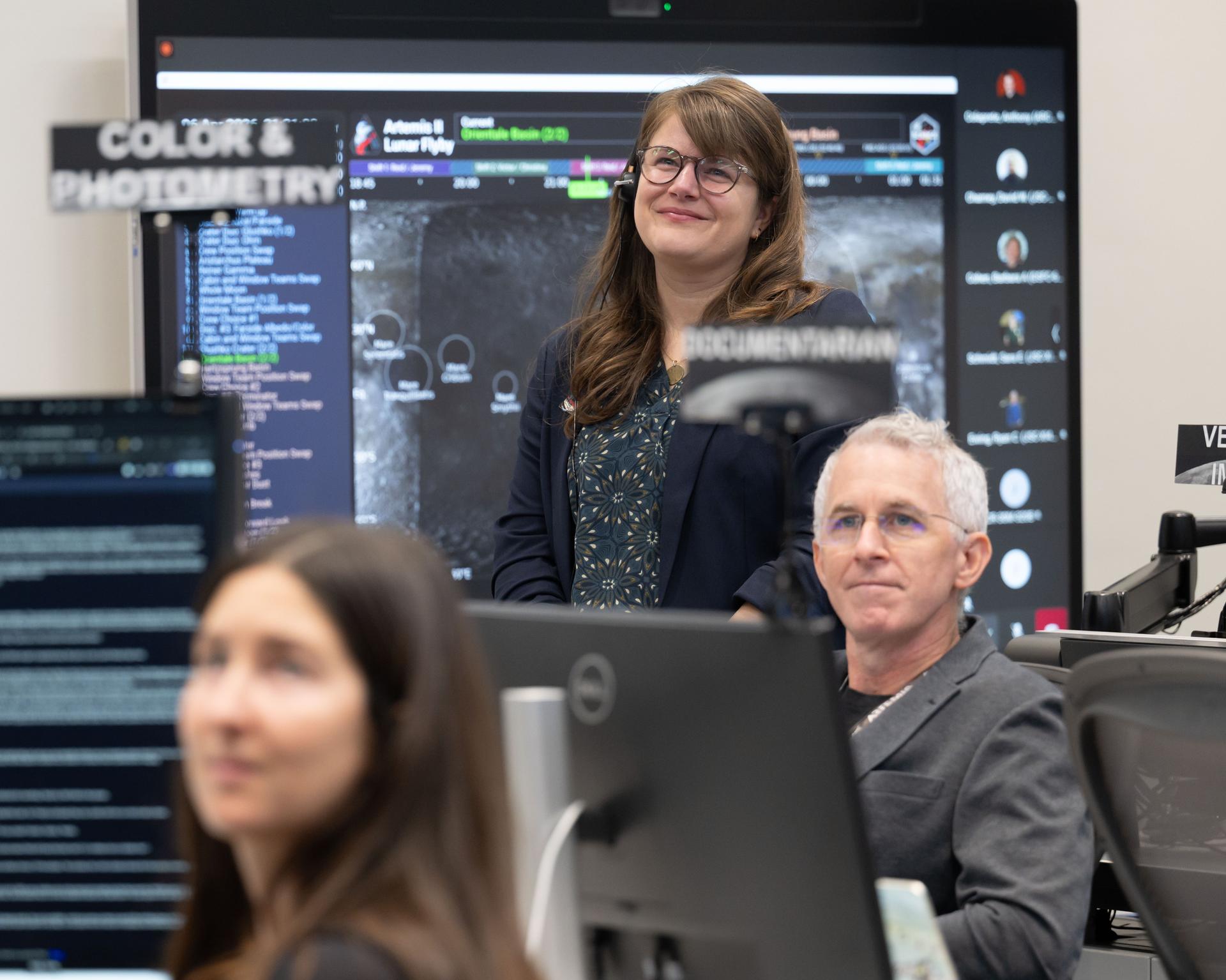
Artemis II deputy lunar science lead Marie Henderson, background, and lunar science team members, Ariel Deutsch, and Ryan Ewing, react to crew observations during the lunar flyby on April 6, 2026. The team worked in the Science Evaluation Room (SER) in Mission Control at NASA’s Johnson Space Center in Houston. Built specifically for Artemis missions with these science priorities in mind, the SER is equipped to support rapid data interpretation, collaborative analysis, real-time decision making, and seamless coordination between the science and operations teams. Credits: NASA/Luna Posadas Nava
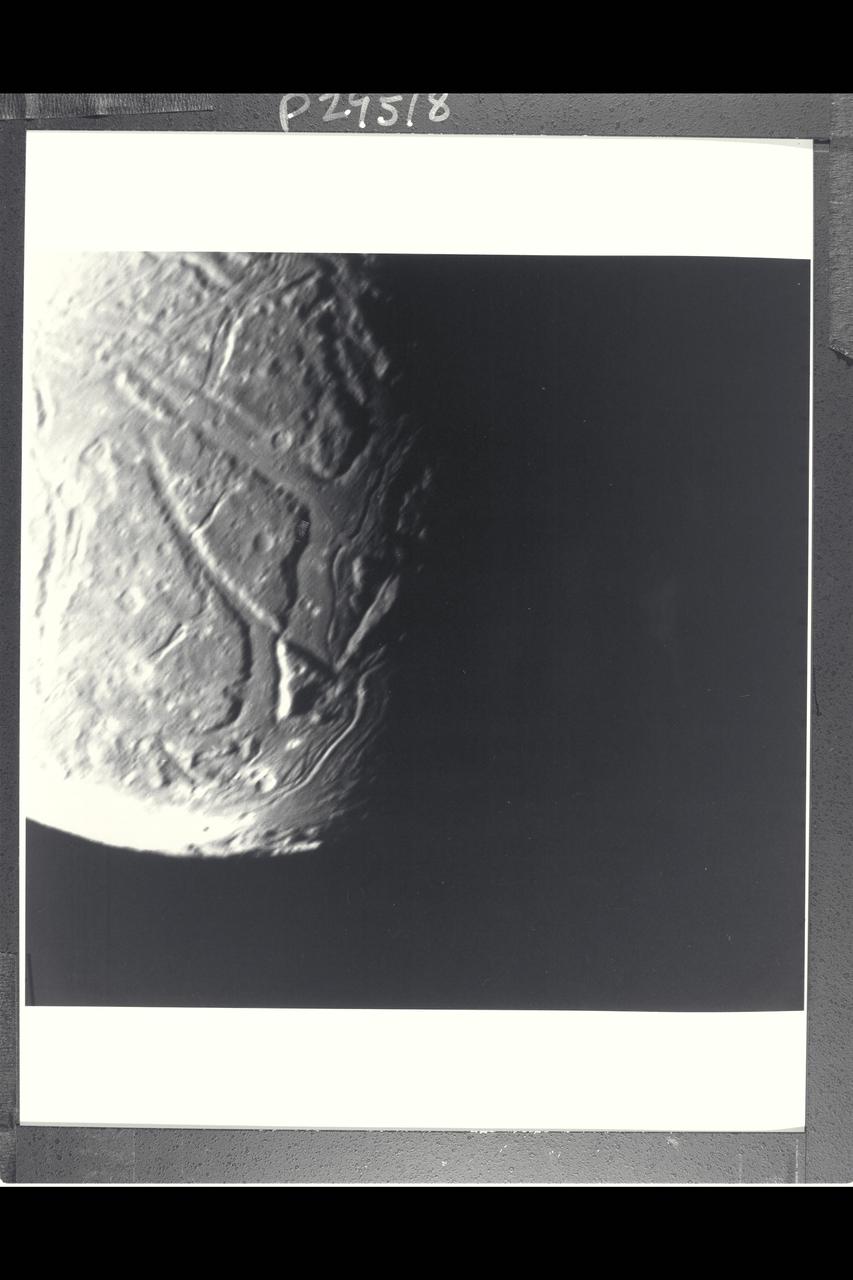
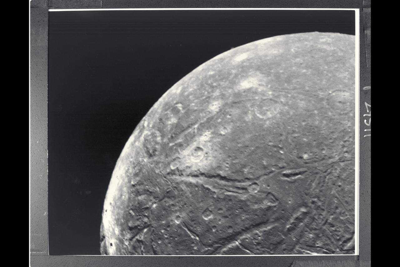
P-29518 BW Range: 130,000 kilometers (80,000 miles) This highest-resolution Voyager 2 view of Ariel's terminator shows a complex array of transecting valleys with superimposed impact craters. This clear-filter, narrow-angle view has a resolution of about 2.4 km (1.5 mi). Particularly striking to Voyager scientists is the fact that the faults that bound the linear valleys are not visible where they transect one another across the valleys. Apparently these valleys were filled with deposits sometime after they were formed by tectonic processes, leaving them flat and smooth. Sinuous rilles (trenches) later formed, probably by some flow process. Some type of fluid flow may well have been involved in their evolution.
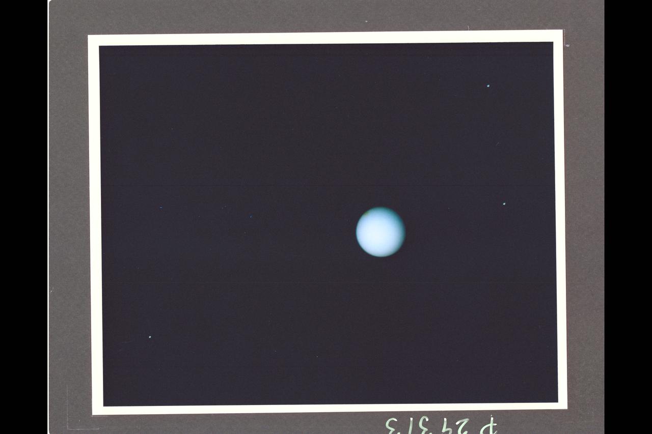
Range : 74 million km. ( 46 million miles ) P-29313CThis Voyager photograph of Uranus is a composite of for images taken by the narrow angle camera. At this range, clouds and other features in the atmosphere as small as 1,370 km. could be detected by Voyager 2. Yet, no such features are visible. This view is toward the illuminated south pole of Uranus. The predominant blue color is the result of atmospheric methane, which absorbs the red wavelengths from incoming sunlight. The spot at the upper left edge of the planet's disk reulted from the removal of a reseau mark used in making measurments on the photograph. Three of Uranus' five known satellites are visible; Miranda ( at far right, closest to the planet ), Ariel ( next out , at top), and Umbriel ( lower left ). Titania and Oberon are now outside the narrow angle camera's field of view when it centered on the planet. This color composite was made from images taken through blue, green, orange, and clear filters.

Artemis II deputy lunar science lead Marie Henderson, shown standing on the left, and lunar science team members, from the right foreground, Ariel Deutsch, Maria Banks behind her, Ryan Watkins to her right, and Sara Schmidt in the checkered jacket. In this image they are reacting to astronauts' observations of Moon features during their flyby on April 6, 2026. Leading up to the flight, the science team has been training the astronauts in in the classroom and in the field. They also built the lunar targeting plan that, like a spacewalk plan on the International Space Station, provides strong, detailed observation guidance, plus flexibility for the crew to make decisions based on what they’re seeing and experiencing in real time. The science team had many moments of celebration during the lunar flyby as the astronauts took images of the Moon and provided verbal descriptions of what they were seeing. This type of information reveals the geologic history of various lunar areas and will be critical to collect when future Artemis astronauts explore the Moon's surface. Credits: NASA/Luna Posadas Nava
NASA internship and Fellowship Participants, Spring, 2020